Embed Size (px)
Citation preview
ew-tis-dg02_forecastandrealtimeeventinformation_01-02-00.docx 01/01/2012 1/41
Traveller Information Services
FORECAST AND REAL TIME EVENT INFORMATION
Deployment guideline TIS-DG02 | VERSION 01-02-00 | JANUARY 2012
COORDINATOR: JAN BEMBENNEK
Contributors Coordinator Jan Bembennek, Ministry for the Environment, Construction and Transport of Bremen,
Germany, [email protected]
Coordinator support (name, organisation, country, email-address):
• Hanfried Albrecht, AlbrechtConsult GmbH, Aachen, Germany; [email protected]
Technical experts - revision process 2011 (company/organisation, country, name, email-address)
• MEDDTL, CETE Lyon, France, Sylvain Belloche; [email protected] • TRITEL – TECHNIKUM-TRACTEBEL ENGINEERING, Belgium, Dimitri Strobbe, [email protected]
Technical experts - revision process 2010 (company/organisation, country, name, email-address)
• Dimitri Strobbe, TRITEL, Belgium, [email protected] • Rudi Tegenbos, TRITEL Belgium, [email protected] • Steven Revill, IBI Group • Fred Zijderhand, ARST&TT, The Netherlands, [email protected] • Peter Cullen, Transport Scotland • Holger Bergmann, AS&P
Peer reviewers (role: name, organisation, country, email-address):
• EasyWay ESG6: Matthias Busch, Landesbetrieb für Strassenbau, Saarland, Germany, [email protected]
• Spain: Ricardo García, DGT, Spain,[email protected] • EasyWay ESG5: Jonas Jäderberg, EasyWay, [email protected] • TCT-PM: Stephanie Kleine, LandesBetrieb Mobilität Rheinland-Pfalz, Germany,
[email protected] • TISA: Dr. Christine Lotz, Federal Highway Research Institute (BASt), Germany; [email protected] • France: Alain Rème, CETE Méditerranée, [email protected]
3
ESG1 – EUROPE-WIDE TRAVELER INFORMATION CONTINUITY & CO-MODALITY
TIS-DG02 – FORECAST AND REAL TIME EVENT INFORMATION
COORDINATOR: JAN BEMBENNEK
ew-tis-dg02_forecastandrealtimeeventinformation_01-02-00.docx 01/01/2012 3/41
Service at a glance SERVICE DEFINITION
“Forecast and Real Time Event Information Services” are defined as the provision of information about both expected and unexpected events to road users on identified road segments of the TENT-T network and interfaces. This predictive or real-time information could be provided on-trip and pre-trip using different information channels, accessible by the road user via different end-user devices. The service may comprise common information as well as individual (personalised, on-demand) information.
“Events” are defined as - expected or unexpected – abnormal situations which may lead to adverse effects on the road as regards to traffic safety, efficiency and environmental effects.
SERVICE OBJECTIVE
The main objective of providing event information and warnings to the road user is improving the safety and the efficiency of the network and the travelling experience of road users.
A traffic disturbance can spontaneously develop into a traffic bottleneck, due to abrupt reactions of not-informed drivers. However, if those drivers knew the upcoming traffic situation in advance they would be prepared and could pro-actively adapt their speed and following distance, thus preserving smooth, stable and safe traffic flow.
Forecast and real time event information services allow traffic information to be factored into both pre- and on-trip journey planning. This can alter the departure times, assist the driver to take more effective routing decisions or even alter the decision to travel.
The provision of information to drivers improves the travelling experience even if the information does not directly impact on network efficiency or safety. Better-informed drivers tend to be calmer and hence more concentrated. Other impacts are the increased mode share of public transport and reduced air pollution.
SERVICE BENEFIT RADAR
4
ESG1 – EUROPE-WIDE TRAVELER INFORMATION CONTINUITY & CO-MODALITY
TIS-DG02 – FORECAST AND REAL TIME EVENT INFORMATION
COORDINATOR: JAN BEMBENNEK
ew-tis-dg02_forecastandrealtimeeventinformation_01-02-00.docx 01/01/2012 4/41
EUROPEAN DIMENSION
Forecast and real time event information influences the route chosen by the road users travelling both short and long distance and inter- and intra- national trips throughout Europe. Therefore, service providers should try to provide the information in different languages (if possible) or preferably in a language independent format (by using pictograms, symbols, etc.).
Existing deployments and road user information requirements across Europe are currently heterogeneous whilst differences in national policies and investment strategies will guide future deployment. Therefore stipulating minimum levels of service to be achieved is not practical. However, by defining the Levels of Service and criteria most important to the information service, future deployments can be made in line with this progression towards greater European harmonisation of service levels. Recommendations are given to provide this service in a more European context.
5
ESG1 – EUROPE-WIDE TRAVELER INFORMATION CONTINUITY & CO-MODALITY
TIS-DG02 – FORECAST AND REAL TIME EVENT INFORMATION
COORDINATOR: JAN BEMBENNEK
ew-tis-dg02_forecastandrealtimeeventinformation_01-02-00.docx 01/01/2012 5/41
Table of Content 1 Introduction ............................................................................................................................................ 8
1.1 The concept of the EasyWay Deployment Guidelines ......................................................................... 8
1.1.1 Preliminary note ............................................................................................................................ 8
1.1.2 Applying Deployment Guidelines – the “comply or explain” principle ............................................ 8
1.1.3 Use of Language in Part A .............................................................................................................. 8
1.2 ITS-Service Profile ............................................................................................................................ 10
1.2.1 ITS-Service Strategy ..................................................................................................................... 10
1.2.2 Contribution to EasyWay Objectives ............................................................................................ 12
1.2.3 State of the art............................................................................................................................. 12
1.2.4 European Dimension.................................................................................................................... 13
2 Part A: Harmonization Requirements.................................................................................................... 14
2.1 Service Definition ............................................................................................................................. 14
2.2 Functional Requirements ................................................................................................................. 14
2.2.1 Functional architecture ................................................................................................................ 14
2.2.2 Functional decomposition and interfaces .................................................................................... 15
2.3 Organisational Requirements ........................................................................................................... 16
2.4 Technical Requirements ................................................................................................................... 19
2.4.1 Required ICT Infrastructure .......................................................................................................... 19
2.4.2 Standards and Agreements: Existing and Required ...................................................................... 19
2.5 Common Look & Feel ....................................................................................................................... 26
2.6 Level of Service Definition ................................................................................................................ 27
2.6.1 Preliminary remark ...................................................................................................................... 27
2.6.2 Level of Service Criteria................................................................................................................ 27
2.6.3 Level of Service Criteria related to Operating Environment .......................................................... 29
3 Part B: Supplementary Information ...................................................................................................... 30
3.1 Examples of deployment .................................................................................................................. 30
3.1.1 INRIX Traffic application ............................................................................................................... 30
3.1.2 Traffic information via website in Flanders, Belgium .................................................................... 30
3.1.3 Traffic information via internet in Spain ....................................................................................... 31
3.1.4 Real time event information, provided by "Läget i Trafiken", Sweden .......................................... 32
3.1.5 VMS in France .............................................................................................................................. 33
3.2 Business Model ................................................................................................................................ 35
4 Annex A: Compliance Checklist ............................................................................................................. 36
4.1 Compliance checklist "must" ............................................................................................................ 36
4.2 Compliance checklist "should" ......................................................................................................... 38
4.3 Compliance checklist "may" ............................................................................................................. 39
5 Annex B: Bibliography ........................................................................................................................... 41
6 Annex C: Endnotes ................................................................................................................................ 41
6
ESG1 – EUROPE-WIDE TRAVELER INFORMATION CONTINUITY & CO-MODALITY
TIS-DG02 – FORECAST AND REAL TIME EVENT INFORMATION
COORDINATOR: JAN BEMBENNEK
ew-tis-dg02_forecastandrealtimeeventinformation_01-02-00.docx 01/01/2012 6/41
List of figures and tables Figure 1 - Service radar forecast and real time event information ..................................................................... 12
Figure 2: Functional architecture of the service and decomposition in three sub-functions .............................. 14
Figure 3: INRIX Traffic application on different smartphones ............................................................................ 30
Figure 4: Public traffic information (standard and mobile) websites in Flanders ................................................ 31
Figure 5: VMS panels with P+R information in Flanders on the E17 and E19 ..................................................... 31
Figure 6: e-Traffic service in Spain ..................................................................................................................... 32
Figure 7: "Läget i Trafiken" ................................................................................................................................ 33
Figure 7: VMS in France - example 1 ................................................................................................................. 33
Figure 7: VMS in France - example 2 ................................................................................................................. 34
Figure 7: VMS in France - example 3 ................................................................................................................. 34
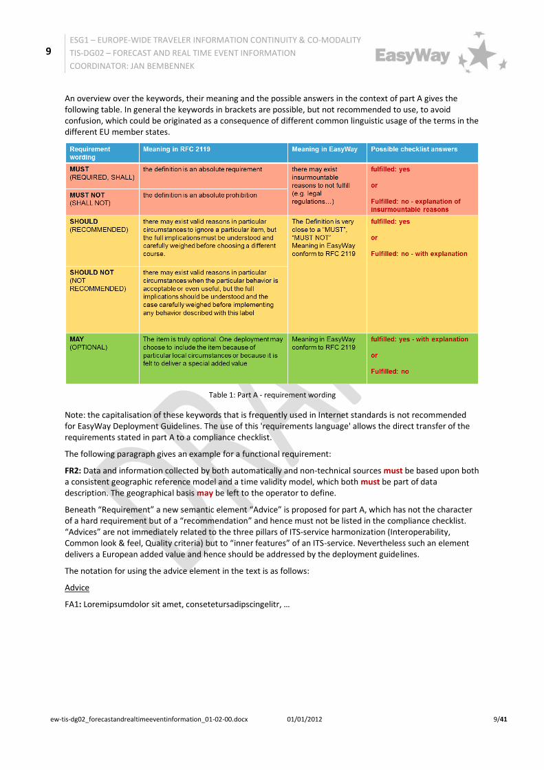
Table 1: Part A - requirement wording ................................................................................................................ 9
Table 2: Level of Service .................................................................................................................................... 27
Table 3: Levels of Quality .................................................................................................................................. 28
Table 4: Level of Service to Operating Environment mapping table ................................................................... 29
7
ESG1 – EUROPE-WIDE TRAVELER INFORMATION CONTINUITY & CO-MODALITY
TIS-DG02 – FORECAST AND REAL TIME EVENT INFORMATION
COORDINATOR: JAN BEMBENNEK
ew-tis-dg02_forecastandrealtimeeventinformation_01-02-00.docx 01/01/2012 7/41
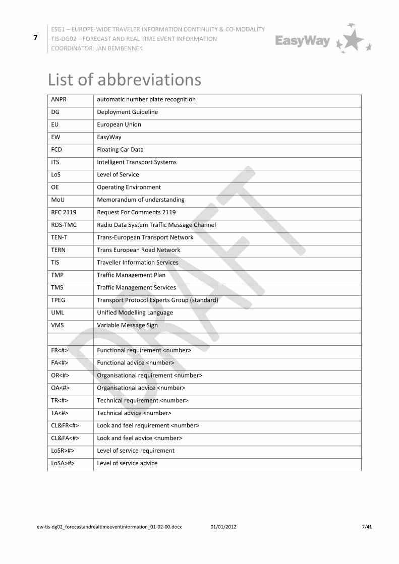
List of abbreviations ANPR automatic number plate recognition
DG Deployment Guideline
EU European Union
EW EasyWay
FCD Floating Car Data
ITS Intelligent Transport Systems
LoS Level of Service
OE Operating Environment
MoU Memorandum of understanding
RFC 2119 Request For Comments 2119
RDS-TMC Radio Data System Traffic Message Channel
TEN-T Trans-European Transport Network
TERN Trans European Road Network
TIS Traveller Information Services
TMP Traffic Management Plan
TMS Traffic Management Services
TPEG Transport Protocol Experts Group (standard)
UML Unified Modelling Language
VMS Variable Message Sign
FR<#> Functional requirement <number>
FA<#> Functional advice <number>
OR<#> Organisational requirement <number>
OA<#> Organisational advice <number>
TR<#> Technical requirement <number>
TA<#> Technical advice <number>
CL&FR<#> Look and feel requirement <number>
CL&FA<#> Look and feel advice <number>
LoSR>#> Level of service requirement
LoSA>#> Level of service advice
8
ESG1 – EUROPE-WIDE TRAVELER INFORMATION CONTINUITY & CO-MODALITY
TIS-DG02 – FORECAST AND REAL TIME EVENT INFORMATION
COORDINATOR: JAN BEMBENNEK
ew-tis-dg02_forecastandrealtimeeventinformation_01-02-00.docx 01/01/2012 8/41
1 Introduction 1.1 The concept of the EasyWay Deployment Guidelines
1.1.1 Preliminary note
This document is one in a set of documents created as part of the EasyWay project, a project for Europe-wide ITS deployment on main TERN corridors driven by national road authorities and operators with associated partners including the automotive industry, telecom operators and public transport stakeholders. It sets clear targets, identifies the set of necessary ITS European services to deploy (Traveller Information, Traffic Management and Freight and Logistic Services) and is an efficient platform that allows the European mobility stakeholders to achieve a coordinated and combined deployment of these pan-European services.
EasyWay has started in 2007 and has established a huge body of knowledge and consensus for harmonised deployment of these ITS services. This knowledge has been captured in documents providing guidance on service deployment, the EasyWay Deployment Guidelines.
The Deployment Guidelines had started with their first iteration mainly capturing best practice. This supported service deployment in EasyWay very strongly by
making EasyWay actors in deployment cognisant of the experiences made in other parts of Europe helping to avoid making errors others has already made speeding up deployment by highlighting important and critical issues to look at
Meanwhile, this best practice has successfully contributed to ITS deployments all over Europe, so it is possible now to take the logical next step and start actually recommending those elements of service deployment that have proven their contribution to both, the success of the local deployment as well as the European added value of harmonised deployment for seamless and interoperable services.
1.1.2 Applying Deployment Guidelines – the “comply or explain” principle
The step from descriptive best practice towards clear recommendations is reflected in the document structure used for this generation of the Deployment Guidelines. Besides this introduction and the annexes that cover specific additional material, the Deployment Guidelines consist of two main sections:
Part A – this part covers the recommendations and requirements that have proven to contribute to successful deployment and have been agreed by the EasyWay partners as elements that should be part of all deployments of this particular service in the scope of EasyWay. Thus, the content of this section is prescriptive by nature and EasyWay partners are expected to ensure that their deployments are compliant to the specifications in this section. Wherever concrete circumstances in a project do not allow fully following these recommendations, EasyWay partners are expected to provide a substantial explanation for the necessity for this deviation. This concept is known as the “comply or explain” principle.
Part B – this part offers an opportunity to provide more valuable but less prescriptive information. Such supplementary information may contained – but is not limited to – regional/national examples of deployment and business model aspects like stakeholder involvement or cost/benefit analysis results.
1.1.3 Use of Language in Part A
It is a mandatory requirement for every prescriptive document to provide specifications in a well-defined and unambiguous language. There are various specifications in the world of specifications that clarify the use of particular words in such prescriptive texts.
For the purpose of the EasyWay Deployment Guidelines, the well-established provisions of the RFC 2119 (http://www.ietf.org/rfc/rfc2119.txt, see (1)) are used, which is used to specify the basic Internet standards:
The key words "MUST", "MUST NOT", "REQUIRED", "SHALL", "SHALL NOT", "SHOULD", "SHOULD NOT", "RECOMMENDED", "MAY", and "OPTIONAL" in this document are to be interpreted as described in RFC 2119.
9
ESG1 – EUROPE-WIDE TRAVELER INFORMATION CONTINUITY & CO-MODALITY
TIS-DG02 – FORECAST AND REAL TIME EVENT INFORMATION
COORDINATOR: JAN BEMBENNEK
ew-tis-dg02_forecastandrealtimeeventinformation_01-02-00.docx 01/01/2012 9/41
An overview over the keywords, their meaning and the possible answers in the context of part A gives the following table. In general the keywords in brackets are possible, but not recommended to use, to avoid confusion, which could be originated as a consequence of different common linguistic usage of the terms in the different EU member states.
Table 1: Part A - requirement wording
Note: the capitalisation of these keywords that is frequently used in Internet standards is not recommended for EasyWay Deployment Guidelines. The use of this 'requirements language' allows the direct transfer of the requirements stated in part A to a compliance checklist.
The following paragraph gives an example for a functional requirement:
FR2: Data and information collected by both automatically and non-technical sources must be based upon both a consistent geographic reference model and a time validity model, which both must be part of data description. The geographical basis may be left to the operator to define.
Beneath “Requirement” a new semantic element “Advice” is proposed for part A, which has not the character of a hard requirement but of a “recommendation” and hence must not be listed in the compliance checklist. “Advices” are not immediately related to the three pillars of ITS-service harmonization (Interoperability, Common look & feel, Quality criteria) but to “inner features” of an ITS-service. Nevertheless such an element delivers a European added value and hence should be addressed by the deployment guidelines.
The notation for using the advice element in the text is as follows:
Advice
FA1: Loremipsumdolor sit amet, consetetursadipscingelitr, …
10
ESG1 – EUROPE-WIDE TRAVELER INFORMATION CONTINUITY & CO-MODALITY
TIS-DG02 – FORECAST AND REAL TIME EVENT INFORMATION
COORDINATOR: JAN BEMBENNEK
ew-tis-dg02_forecastandrealtimeeventinformation_01-02-00.docx 01/01/2012 10/41
1.2 ITS-Service Profile
1.2.1 ITS-Service Strategy
1.2.1.1 General Service Description
A general overarching description of TIS-services is outlined in the "Traveller Information Services REFERENCE DOCUMENT, TIS Deployment Guideline Annex, Version 01-02-00":
• Executive summary and • Chapter 2.1" General Service Description"
Specifically “Forecast and Real Time Event Information Services” means the provision of information about both expected and unexpected events to road users on identified road segments of the TENT-T network and interfaces.
“Events” are defined as - expected or unexpected – abnormal situations, which may lead to adverse effects on the road as regards to traffic safety, efficiency and the environment.
There are two categories of events:
• expected events, e.g.: o strikes, protest rallies, road works, traffic jams due to major events (sports games, concerts,
festivals...), parking rest area information, road/bridge/tunnel/lane/border closures... • unexpected events, e.g.:
o incidents, accidents, road/bridge/tunnel/lane closures, objects on the road (objects, animals, people), ghost-drivers, parking and rest area information, sudden end of slow or stationary traffic, reduced vision, slippery surface (aquaplaning, ice, oil…), sudden severe adverse weather, long delays at borders...
As part of a global information strategy, forecast and real-time event information services shall provide:
• Pre-trip warnings to drivers about upcoming expected events • On-trip warnings to drivers about expected and unexpected events
1.2.1.2 What is the Vision?
The main objective of providing forecast and real time event information and warnings to the road user is improving the safety and the efficiency of the network and the travelling experience of road users.
A traffic disturbance can spontaneously develop into a traffic bottleneck, due to abrupt reactions of not-informed drivers. However, if those drivers knew the upcoming traffic situation in advance they would be prepared and could pro-actively adapt their speed and following distance, thus preserving smooth, stable and safe traffic flow.
Forecast and real time event information services allow traffic information to be factored into both pre- and on-trip journey planning. This can alter the departure times, assist the driver to take more effective routing decisions or even alter the decision to travel.
The provision of information to drivers improves the travelling experience even if the information does not directly impact on network efficiency or safety. Better-informed drivers tend to be calmer and hence more concentrated. Other impacts are the increased mode share of public transport and reduced air pollution.
1.2.1.3 What are the Missions?
The main service mission is to inform the road user about expected or unexpected events in order to support him finding the best way to travel and that he can travel in a calmer and safer way.
• Expected events and their impacts should be communicated especially when providing forecast information with pre-trip warnings. This information contributes to the general traffic management
11
ESG1 – EUROPE-WIDE TRAVELER INFORMATION CONTINUITY & CO-MODALITY
TIS-DG02 – FORECAST AND REAL TIME EVENT INFORMATION
COORDINATOR: JAN BEMBENNEK
ew-tis-dg02_forecastandrealtimeeventinformation_01-02-00.docx 01/01/2012 11/41
goals of the road administrator. This can also help drivers on the road if they are planning to make a journey through the area affected.
• Real-time information about unexpected events and their impacts is generally more important for road users already making their journey, although this information can also influence road users planning their trip on a short basis (such as for a lane closure).
• Unexpected events are more commonly related to dangerous situations and are more important for on-trip warnings; information about these events is disseminated to prevent accidents and influence route choice and therefore make the road network safer and more efficient. In this case, it is important to provide the information as quickly as possible to the road user.
This predictive or real-time information could be provided on-trip and pre-trip using different information channels, accessible by the road user via different end-user devices. The service may comprise common information as well as individual (personalised, on-demand) information.
Problems to consider:
• to facilitate an easy information access to the road user • diversity of information portals with different presentations • incompleteness of information • diverging interpretation of the information by the road user
1.2.1.4 EasyWay harmonisation focus
One main focus of this EasyWay-deployment guideline is the internet-based pre-trip and on-trip traffic information in combination with static or dynamic maps, where events are allocated to a position in the road network by displaying there a specific event pictogram. This type of display is already used by many information providers.
A second main focus lies on providing such information on-trip on Variable Message Signs (VMS), which are operated along the route by road operators.
Another focus lies on the interfacing between road operators and national, regional or local broadcasters, which provide traffic event information to mass audiences like radio or on-board navigation devices. Through the rapid evolution of mobile phone technology based end user devices the provision of individual (personalised, on-demand) services is increasing.
1.2.1.5 Distinction to other ITS-services
Relevant information for this service is current changes in and forecast of events affecting the road users on its journey.
Relevant complementary information, which is not content of this Deployment Guideline and will be covered by other DG, is:
• causes and durations of traffic disturbances, e.g. incidents, accidents (see TMS-DG05-08 Incident warning and management services), weather (see TIS-DG06 weather information services)
• consequences on traffic conditions, e.g. speed limits (see TIS-DG04 speed limits services) or traffic conditions and delays (see TIS-DG03/05 traffic condition and travel time services)
• recommendation of alternatives (e.g. re-routing or modal shift, see TMS-DG07 traffic management plan services for corridor and networks)
• long or middle term forecast of traffic conditions based on historical data (not covered by EasyWay DGs)
The service is directed to the road user and may include general information as well as individual (personalised, on-demand) information. The information provision should be in accordance with any traffic management plans (TMP, see TMS-DG07), which are in operation by the specific road authorities or traffic management centres.
12
ESG1 – EUROPE-WIDE TRAVELER INFORMATION CONTINUITY & CO-MODALITY
TIS-DG02 – FORECAST AND REAL TIME EVENT INFORMATION
COORDINATOR: JAN BEMBENNEK
ew-tis-dg02_forecastandrealtimeeventinformation_01-02-00.docx 01/01/2012 12/41
1.2.2 Contribution to EasyWay Objectives
1.2.2.1 Service radar
A general overarching description of Contribution of TIS-services to EasyWay Objectives is outlined in the "Traveller Information Services REFERENCE DOCUMENT, TIS Deployment Guideline Annex, Version 01-02-00, Chapter 2.2 "Contribution to EasyWay Objectives"
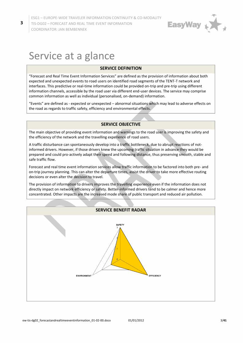
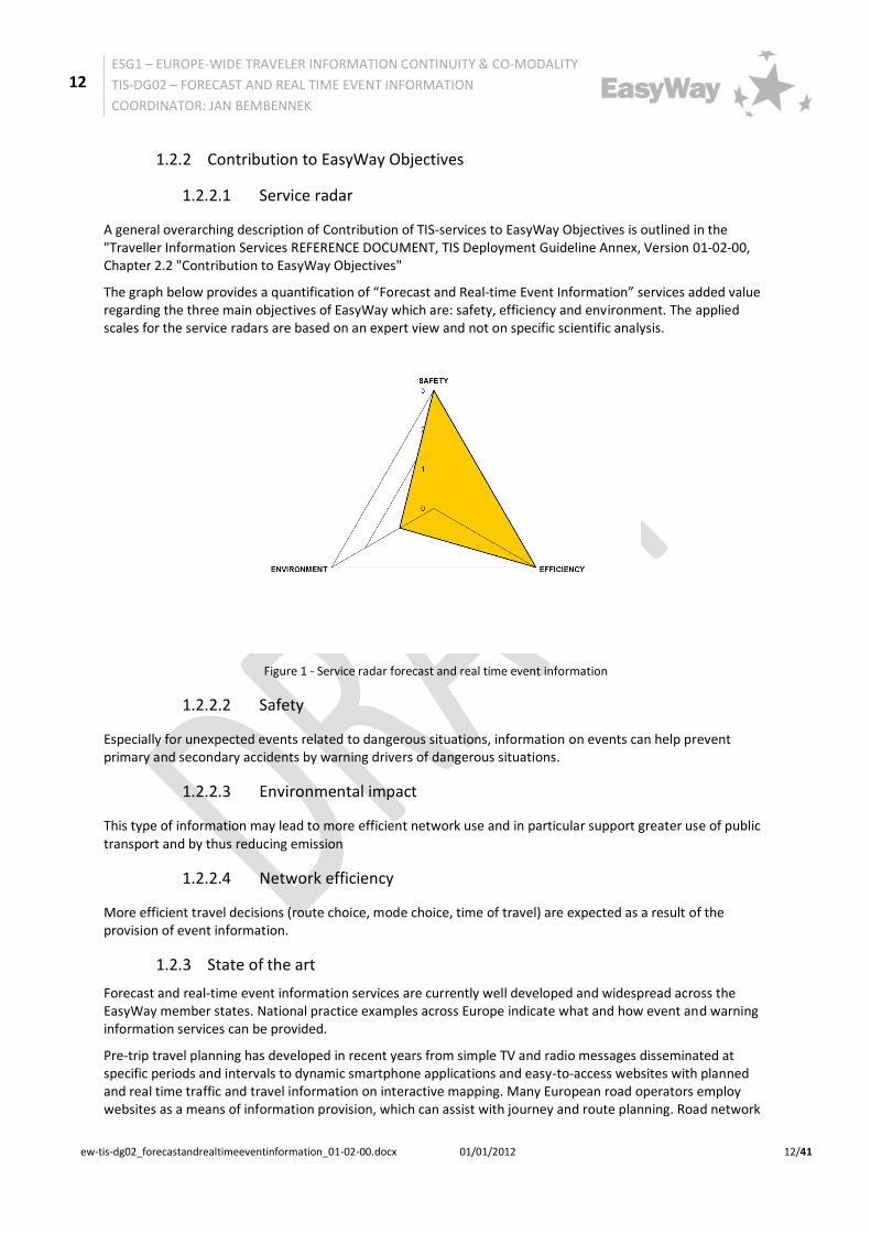
The graph below provides a quantification of “Forecast and Real-time Event Information” services added value regarding the three main objectives of EasyWay which are: safety, efficiency and environment. The applied scales for the service radars are based on an expert view and not on specific scientific analysis.
Figure 1 - Service radar forecast and real time event information
1.2.2.2 Safety
Especially for unexpected events related to dangerous situations, information on events can help prevent primary and secondary accidents by warning drivers of dangerous situations.
1.2.2.3 Environmental impact
This type of information may lead to more efficient network use and in particular support greater use of public transport and by thus reducing emission
1.2.2.4 Network efficiency
More efficient travel decisions (route choice, mode choice, time of travel) are expected as a result of the provision of event information.
1.2.3 State of the art
Forecast and real-time event information services are currently well developed and widespread across the EasyWay member states. National practice examples across Europe indicate what and how event and warning information services can be provided.
Pre-trip travel planning has developed in recent years from simple TV and radio messages disseminated at specific periods and intervals to dynamic smartphone applications and easy-to-access websites with planned and real time traffic and travel information on interactive mapping. Many European road operators employ websites as a means of information provision, which can assist with journey and route planning. Road network
13
ESG1 – EUROPE-WIDE TRAVELER INFORMATION CONTINUITY & CO-MODALITY
TIS-DG02 – FORECAST AND REAL TIME EVENT INFORMATION
COORDINATOR: JAN BEMBENNEK
ew-tis-dg02_forecastandrealtimeeventinformation_01-02-00.docx 01/01/2012 13/41
information combined with both historic and real time passenger information enables road users to make informed choices between private and public transport options and help impact on the mode choice of travel.
On-trip information using a Variable Messages Sign (VMS) exists extensively across much of Europe, with a high level of deployment on toll motorway networks (e.g. in France, Spain, Portugal and Italy) and on dense motorway networks where re-routing possibilities exist (e.g. in the Netherlands, Belgium, the UK, and Germany).
Traffic information (spoken word), most of the time both pre-trip and on-trip, is available on several radio stations throughout Europe. Additionally dedicated motorway radio frequencies exist in France, The Netherlands and Italy, with regular traffic broadcast tailored to the region in question.
RDS-TMC (Radio Data System Traffic Message Channel) has been deployed in most Western European countries and deployment is underway or planned in several Central and Eastern European countries. RDS-TMC Plus, available in Austria and free of charge, offers a qualification guaranteed and faster RDS-TMC service because only relevant near-by information is send out With the migration to digital broadcast bearers in the future, RDS-TMC is expected to be replaced by TPEG-Services.
Other services include alerts via email and SMS.
The use of in-vehicle navigation systems with traffic information through RDS-TMC is also widespread. These systems tend to have a data connection which offers them the possibility to connect with a service provider. There is also an exponentially growing market for smartphones which can act as in-vehicle navigation systems and provide road users information through mobile websites and social media (i.e. Twitter) to get pre-trip and on-trip information.
However, the latest developments in forecast and real time event information are traffic applications on smartphones. While some apps provide conventional turn-by-turn satellite navigation, some applications already offer the ability to help the driver avoid traffic and congestion, in some cases even by offering predictive traffic forecasting, which takes in to account the day of the week, season, holidays, weather, accidents, road works and special events such as football matches or concerts. Some applications even offer the possibility to view and report traffic accidents.
1.2.4 European Dimension
Forecast and real time event information influences the route chosen by the road users travelling both short and long distance and inter- and intra- national trips throughout Europe. Therefore, service providers should try to provide the information in different languages (if possible) or preferably in a language independent format (by using pictograms, symbols, etc.).
Existing deployments and road user information requirements across Europe are currently heterogeneous whilst differences in national policies and investment strategies will guide future deployment. Therefore stipulating minimum levels of service to be achieved is not practical. However, by defining the Levels of Service and criteria most important to the information service, future deployments can be made in line with this progression towards greater European harmonisation of service levels. Recommendations are given to provide this service in a more European context.

14
ESG1 – EUROPE-WIDE TRAVELER INFORMATION CONTINUITY & CO-MODALITY
TIS-DG02 – FORECAST AND REAL TIME EVENT INFORMATION
COORDINATOR: JAN BEMBENNEK
ew-tis-dg02_forecastandrealtimeeventinformation_01-02-00.docx 01/01/2012 14/41
2 Part A: Harmonization Requirements 2.1 Service Definition
“Forecast and Real Time Event Information Services” are defined as the provision of information about both expected and unexpected events to road users on identified road segments of the TENT-T network and interfaces. This predictive or real-time information could be provided on-trip and pre-trip using different information channels, accessible by the road user via different end-user devices. The service may comprise common information as well as individual (personalised, on-demand) information.
“Events” are defined as - expected or unexpected – abnormal situations which may lead to adverse effects on the road as regards to traffic safety, efficiency and environmental effects.
2.2 Functional Requirements
2.2.1 Functional architecture
The function of the service is to provide forecast and real-time event information to road users either pre-trip or on-trip. This may be demand responsive or led by the information providers. In Europe, both private and public information providers are involved in this information provision (see organisational requirements).
The following figure shows the typical functional architecture of a “Forecast and Real Time Event Information Services”. The vertical lines show, where it is appropriate to segment the whole functionality of the service into at most three sub-functions:
Figure 2: Functional architecture of the service and decomposition in three sub-functions
Functional requirement:
FR1: Functional decomposition into sub-functions with the provision of interfaces must be carried out to enable interoperability in cases that the service is carried out by more than one organisation (and is recommended in any case to be prepared for an easy functional decomposition as may be the case in the future).
15
ESG1 – EUROPE-WIDE TRAVELER INFORMATION CONTINUITY & CO-MODALITY
TIS-DG02 – FORECAST AND REAL TIME EVENT INFORMATION
COORDINATOR: JAN BEMBENNEK
ew-tis-dg02_forecastandrealtimeeventinformation_01-02-00.docx 01/01/2012 15/41
2.2.2 Functional decomposition1 and interfaces
2.2.2.1 Sub-function 1 “Data collection”
The devices and methodologies for traffic data collection are not covered by this deployment guideline. They depend amongst others on the particular used data collection system and are left to the operator to select.
Note: "Data collection" is not only done by automatic data collection systems. "Events" are also announced / signalled by so called non-technical sources such as police, fire brigades, local authorities, road users as well as "generated" by actions of the road operator.
Functional requirements:
• FR2: Data and information collected/signalled/generated by both automatic and non-technical sources/road operator actions must be based upon both a consistent geographic reference model and a time validity model, which both must be part of data description.
• FR3: The geographical basis may be left to the operator to define. • FR4: Historic data may also be required to generate event predictions.
2.2.2.2 Sub-function 2 “Data fusion and processing”
Within Europe different methodologies exist to aggregate collected data and other input information to forecast and real-time to event information. These methodologies are not covered by the present guideline and are left to the operator to select. They depend amongst others on the particular used data fusion and processing system and particularly traffic model applied.
Functional requirement:
• FR5: Source, scope and quality of data provided by content owners to content providers must be defined and must be part of data interface description.
2.2.2.3 Sub-function 3 “Information provision”
Information provision is carried out by different service providers in accordance of specific business models. The information provision to the road user on end-user devices has to be done using various information channels (see chapter 1.2.3 State of the art). When providing customer oriented forecast and real time event information services, the users' benefit can be increased by providing event information in combination with general traffic information (i.e. see TIS-DG03/05 -traffic condition and travel times information, TIS-DG04weather information and TIS-DG06speed limit information) as well.
Functional requirement:
• FR6: The area of information dissemination should be defined in relation with the media used (especially concerning the radio).
1The ITS service is "distributed" over more than one administration (cross-border, cross-regional) for operation, i.e. different road
operators and other parties are involved, providing "logical sub-functions". Between the distributed functions interoperability must be guaranteed by properly specified interfaces.
16
ESG1 – EUROPE-WIDE TRAVELER INFORMATION CONTINUITY & CO-MODALITY
TIS-DG02 – FORECAST AND REAL TIME EVENT INFORMATION
COORDINATOR: JAN BEMBENNEK
ew-tis-dg02_forecastandrealtimeeventinformation_01-02-00.docx 01/01/2012 16/41
2.2.2.4 Interface Requirements
Note: If the ITS service is "distributed" over more than one administration (cross-border, cross-regional) for operation, i.e. different road operators and other parties are involved, providing "logical sub-functions", interoperability between the distributed functions must be guaranteed by properly specified interfaces.
Interface requirement interface 1 (see also Technical requirements, DATEXII-profiles):
• FR7: To enable interoperability between all involved parties the sub-functions data collection and data fusion and processing must- depending on the used data type for the automatic event detection -require/provide an interface 1 with one or several of the following information structures: o traffic volume and speed, occupation rate (e. g. collected by loops, radar, …) o trajectories (e. g. collected by APNR - automatic number plate recognition, …) o floating car data (e. g. collected by Taxi FCD, Navigation Systems, Phone Data, …)
Interface requirement interface 2 (see also Technical requirements, DATEXII-profiles):
• FR8: To enable interoperability between all involved parties the sub-functions data fusion and processing and service provision must require/provide an interface with the following event information structure: o (estimated) impact on traffic situation o begin and estimated end o position and estimated spatial dimension o type, cause (optional) o comment (free text) o information source
2.3 Organisational Requirements
A general overarching description of the key actors, their roles in the value chain and the related conditions for TIS-service provision is outlined in the "Traveller Information Services REFERENCE DOCUMENT, TIS Deployment Guideline Annex, Version 01-02-00":
Chapter 3.1 "Introduction to key actors in the traveller information chain" and Chapter 3.2 "Conditions for Service Provision - Business Model"
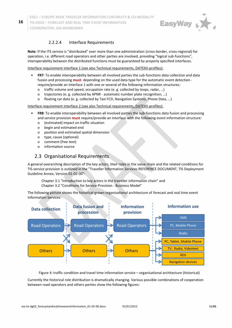
The following picture shows the historical grown organisational architecture of forecast and real time event Information Services:
Figure 4: traffic condition and travel time information service – organisational architecture (historical)
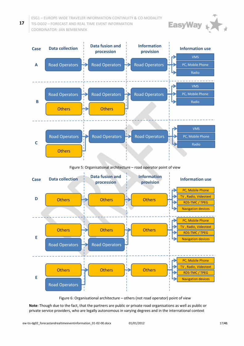
Currently the historical role distribution is dramatically changing. Various possible combinations of cooperation between road operators and others parties show the following figures:
Road Operators Road Operators Road Operators PC, Mobile Phone
VMS
Data collectionData fusion and
processionInformation
provision
Information use
PC, Tablet, Mobile Phone
TV , Radio, Videotext
RDS
Navigation devices
Others Others Others
Radio
17
ESG1 – EUROPE-WIDE TRAVELER INFORMATION CONTINUITY & CO-MODALITY
TIS-DG02 – FORECAST AND REAL TIME EVENT INFORMATION
COORDINATOR: JAN BEMBENNEK
ew-tis-dg02_forecastandrealtimeeventinformation_01-02-00.docx 01/01/2012 17/41
Figure 5: Organisational architecture – road operator point of view
Figure 6: Organisational architecture – others (not road operator) point of view
Note: Though due to the fact, that the partners are public or private road organisations as well as public or private service providers, who are legally autonomous in varying degrees and in the international context
Road Operators Road Operators Road Operators
Data collectionData fusion and
processionInformation
provisionInformation use
Road Operators Road Operators Road Operators
Others Others
Road Operators Road Operators Road Operators
Others
A
Case
B
C
PC, Mobile Phone
VMS
Radio
PC, Mobile Phone
VMS
Radio
PC, Mobile Phone
VMS
Radio
PC, Mobile Phone
TV , Radio, Videotext
RDS-TMC / TPEG
Navigation devices
Data collectionData fusion and
processionInformation
provisionInformation use
Others Others Others
Road Operators Road Operators
D
Case
PC, Mobile Phone
TV , Radio, Videotext
RDS-TMC / TPEG
Navigation devices
Others Others Others
E
Road Operators
PC, Mobile Phone
TV , Radio, Videotext
RDS-TMC / TPEG
Navigation devices
Others Others Others
E
18
ESG1 – EUROPE-WIDE TRAVELER INFORMATION CONTINUITY & CO-MODALITY
TIS-DG02 – FORECAST AND REAL TIME EVENT INFORMATION
COORDINATOR: JAN BEMBENNEK
ew-tis-dg02_forecastandrealtimeeventinformation_01-02-00.docx 01/01/2012 18/41
sometimes even work on different national laws, it is not required to define organisational aspects on a legal and binding basis.
Organisational advice:
OA1: Clear definitions of organisational aspects are a crucial precondition for the successful implementation of a "Forecast and real-time event information service" and should be documented and signed of all involved parties/partners in form of a Common partner arrangement/MoU - Memorandum of understanding, which fixes the co-operation.
The documents should define the modes of co-operation and must contain operation instructions. Thus they should be thoroughly verified before signature. Both documents are a declaration of intent to fulfil them but have no legal binding. The appointment should be concluded in written form, on the one hand, because it requires a clear common understanding of the co-operation, on the other hand because the signing of the contract can be seen as a milestone with appropriate media savvy.
Particularly in this “Forecast and Real Time Event Information Service” various “third parties” play an important role providing event information, which cannot be automatically detected (non-technical sources). These parties and their role in the organisational structure of the ITS-service must be paid special attendance and finally agreements/contracts.
Organisational requirements:
• OR1: The organisational and operational structure of the service as well as the role of each organisation/body and its exact tasks in the chain must be defined
• OR2: All for successful implementation of a "Forecast and Real Time Event Information Service" necessary organisational aspects must be documented and signed of all involved parties/partners in form of a Common partner arrangement/MoU - Memorandum of understanding, which fixes the co-operation.
• OR3: In case of involving private partners delivering private generated data for "Forecast and Real Time Event Information Service" a contract (with service level agreement) must be developed and closed wherever a "Forecast and Real Time Event Information Service" relies on receiving privately generated data.
• OR4:All for successful implementation of a "Forecast and Real Time Event Information Service" necessary collaboration processes/workflows and interfaces must be described
• OR5: The information provision should be in accordance with any management plans (TMP, see TMS-DG07) which are in operation of the road authorities or traffic management centres.
• OR6: In cases roles are taken by two or more organisations the following organisational requirements should be respected for two service life cycle phases:
o ITS-service elaboration
o ITS-Service operation and quality management (concerning content provider and service operator)
19
ESG1 – EUROPE-WIDE TRAVELER INFORMATION CONTINUITY & CO-MODALITY
TIS-DG02 – FORECAST AND REAL TIME EVENT INFORMATION
COORDINATOR: JAN BEMBENNEK
ew-tis-dg02_forecastandrealtimeeventinformation_01-02-00.docx 01/01/2012 19/41
2.4 Technical Requirements
2.4.1 Required ICT Infrastructure
No specific requirements or advices.
2.4.2 Standards and Agreements: Existing and Required
2.4.2.1 DATEXII-Profiles
Interoperable interfaces between systems are essential for many EasyWay objectives like continuity of services and cross-border traffic management cooperation. Hence, EasyWay has itself decided to actively contribute to the establishment of the required standardisation efforts by launching its dedicated working group ESG5 and liaising with the relevant European standardisation body, namely with CEN TC278 WG8 (“Road Traffic Data”). The result of this cooperation is the “DATEX II” specification for interoperable machine-to-machine communication of ITS services, available as European Standard CEN/TS 16157. This specification is used throughout EasyWay for interoperable access to dynamic traffic and travel data.

20
ESG1 – EUROPE-WIDE TRAVELER INFORMATION CONTINUITY & CO-MODALITY
TIS-DG02 – FORECAST AND REAL TIME EVENT INFORMATION
COORDINATOR: JAN BEMBENNEK
ew-tis-dg02_forecastandrealtimeeventinformation_01-02-00.docx 01/01/2012 20/41
Technical requirement:
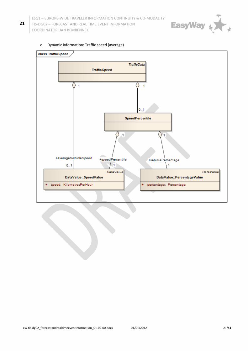
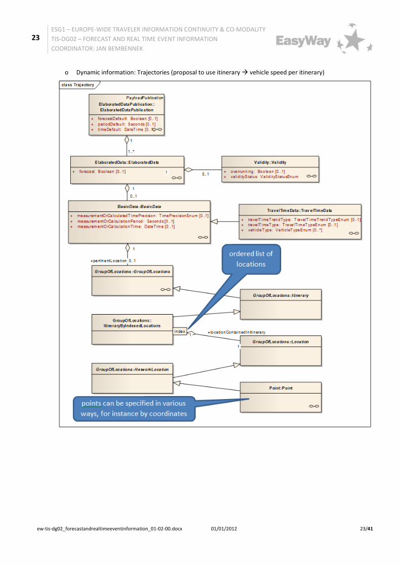
• TR1: To enable interoperability between different organisations involved in the forecast and real time event information value chain the corresponding DATEXII-Profiles2must be used for interface 1: o Static information: measurement site information
Dynamic information - Data Collection: Traffic flow
2 DATEXII profiles consist of a set of data elements taken from the overall DATEX model and can include a subset (Schema) of relationships between those elements
21
ESG1 – EUROPE-WIDE TRAVELER INFORMATION CONTINUITY & CO-MODALITY
TIS-DG02 – FORECAST AND REAL TIME EVENT INFORMATION
COORDINATOR: JAN BEMBENNEK
ew-tis-dg02_forecastandrealtimeeventinformation_01-02-00.docx 01/01/2012 21/41
o Dynamic information: Traffic speed (average)

22
ESG1 – EUROPE-WIDE TRAVELER INFORMATION CONTINUITY & CO-MODALITY
TIS-DG02 – FORECAST AND REAL TIME EVENT INFORMATION
COORDINATOR: JAN BEMBENNEK
ew-tis-dg02_forecastandrealtimeeventinformation_01-02-00.docx 01/01/2012 22/41
o Dynamic information: Traffic speed (single vehicle)
o Dynamic information: Occupancy rate
23
ESG1 – EUROPE-WIDE TRAVELER INFORMATION CONTINUITY & CO-MODALITY
TIS-DG02 – FORECAST AND REAL TIME EVENT INFORMATION
COORDINATOR: JAN BEMBENNEK
ew-tis-dg02_forecastandrealtimeeventinformation_01-02-00.docx 01/01/2012 23/41
o Dynamic information: Trajectories (proposal to use itinerary vehicle speed per itinerary)
24
ESG1 – EUROPE-WIDE TRAVELER INFORMATION CONTINUITY & CO-MODALITY
TIS-DG02 – FORECAST AND REAL TIME EVENT INFORMATION
COORDINATOR: JAN BEMBENNEK
ew-tis-dg02_forecastandrealtimeeventinformation_01-02-00.docx 01/01/2012 24/41
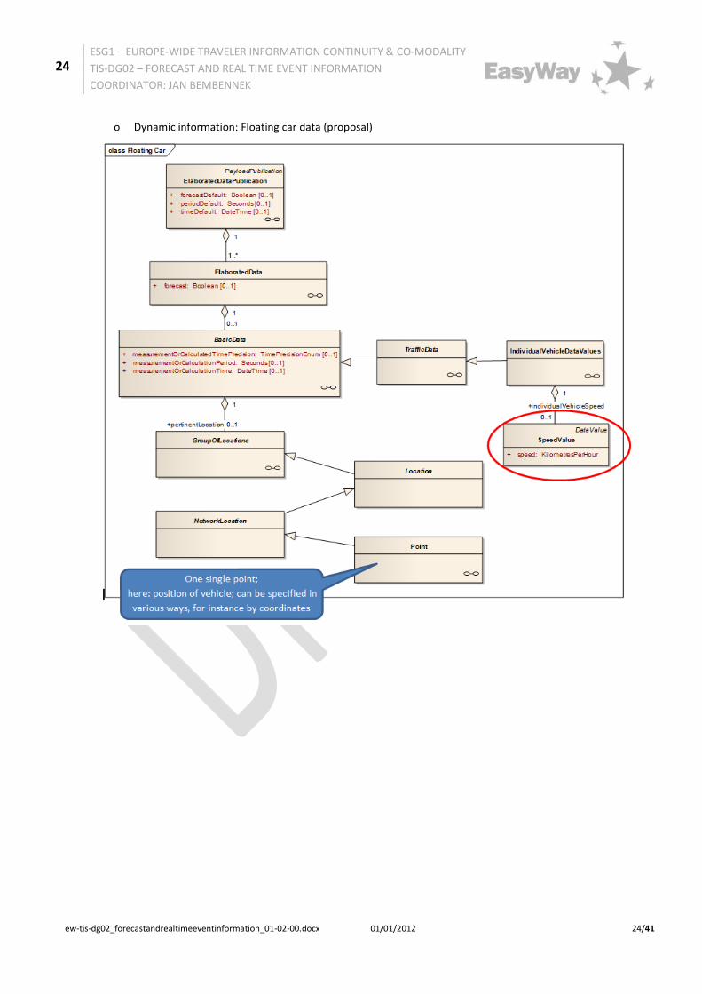
o Dynamic information: Floating car data (proposal)
25
ESG1 – EUROPE-WIDE TRAVELER INFORMATION CONTINUITY & CO-MODALITY
TIS-DG02 – FORECAST AND REAL TIME EVENT INFORMATION
COORDINATOR: JAN BEMBENNEK
ew-tis-dg02_forecastandrealtimeeventinformation_01-02-00.docx 01/01/2012 25/41
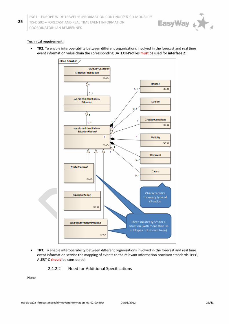
Technical requirement:
• TR2: To enable interoperability between different organisations involved in the forecast and real time event information value chain the corresponding DATEXII-Profiles must be used for interface 2:
• TR3: To enable interoperability between different organisations involved in the forecast and real time event information service the mapping of events to the relevant information provision standards TPEG, ALERT-C should be considered.
2.4.2.2 Need for Additional Specifications
None
26
ESG1 – EUROPE-WIDE TRAVELER INFORMATION CONTINUITY & CO-MODALITY
TIS-DG02 – FORECAST AND REAL TIME EVENT INFORMATION
COORDINATOR: JAN BEMBENNEK
ew-tis-dg02_forecastandrealtimeeventinformation_01-02-00.docx 01/01/2012 26/41
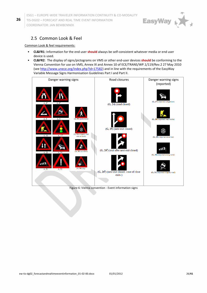
2.5 Common Look & Feel
Common Look & feel requirements:
• CL&FR1: Information for the end user should always be self-consistent whatever media or end user device is used.
• CL&FR2: The display of signs/pictograms on VMS or other end-user devices should be conforming to the Vienna Convention for use on VMS, Annex IX and Annex 10 of ECE/TRANS/WP.1/119/Rev.2 27 May 2010 (see http://www.unece.org/index.php?id=17582) and in line with the requirements of the EasyWay Variable Message Signs Harmonisation Guidelines Part I and Part II.
Danger warning signs
Road closures
Danger warning signs (reported)
Figure 6: Vienna convention - Event information signs
27
ESG1 – EUROPE-WIDE TRAVELER INFORMATION CONTINUITY & CO-MODALITY
TIS-DG02 – FORECAST AND REAL TIME EVENT INFORMATION
COORDINATOR: JAN BEMBENNEK
ew-tis-dg02_forecastandrealtimeeventinformation_01-02-00.docx 01/01/2012 27/41
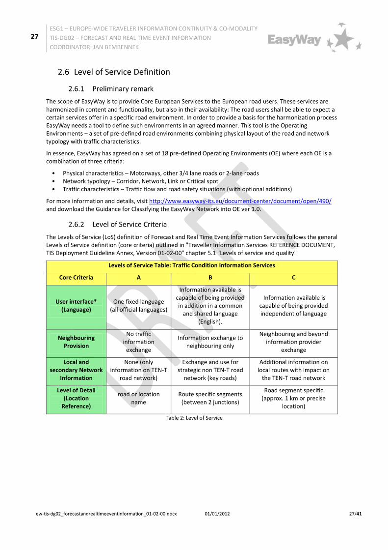
2.6 Level of Service Definition
2.6.1 Preliminary remark
The scope of EasyWay is to provide Core European Services to the European road users. These services are harmonized in content and functionality, but also in their availability: The road users shall be able to expect a certain services offer in a specific road environment. In order to provide a basis for the harmonization process EasyWay needs a tool to define such environments in an agreed manner. This tool is the Operating Environments – a set of pre-defined road environments combining physical layout of the road and network typology with traffic characteristics.
In essence, EasyWay has agreed on a set of 18 pre-defined Operating Environments (OE) where each OE is a combination of three criteria:
• Physical characteristics – Motorways, other 3/4 lane roads or 2-lane roads • Network typology – Corridor, Network, Link or Critical spot • Traffic characteristics – Traffic flow and road safety situations (with optional additions)
For more information and details, visit http://www.easyway-its.eu/document-center/document/open/490/ and download the Guidance for Classifying the EasyWay Network into OE ver 1.0.
2.6.2 Level of Service Criteria
The Levels of Service (LoS) definition of Forecast and Real Time Event Information Services follows the general Levels of Service definition (core criteria) outlined in "Traveller Information Services REFERENCE DOCUMENT, TIS Deployment Guideline Annex, Version 01-02-00" chapter 5.1 "Levels of service and quality"
Levels of Service Table: Traffic Condition Information Services
Core Criteria A B C
User interface* (Language)
One fixed language (all official languages)
Information available is capable of being provided in addition in a common
and shared language (English).
Information available is capable of being provided independent of language
Neighbouring Provision
No traffic information
exchange
Information exchange to neighbouring only
Neighbouring and beyond information provider
exchange
Local and secondary Network
Information
None (only information on TEN-T
road network)
Exchange and use for strategic non TEN-T road
network (key roads)
Additional information on local routes with impact on
the TEN-T road network
Level of Detail (Location
Reference)
road or location name
Route specific segments (between 2 junctions)
Road segment specific (approx. 1 km or precise
location)
Table 2: Level of Service
28
ESG1 – EUROPE-WIDE TRAVELER INFORMATION CONTINUITY & CO-MODALITY
TIS-DG02 – FORECAST AND REAL TIME EVENT INFORMATION
COORDINATOR: JAN BEMBENNEK
ew-tis-dg02_forecastandrealtimeeventinformation_01-02-00.docx 01/01/2012 28/41
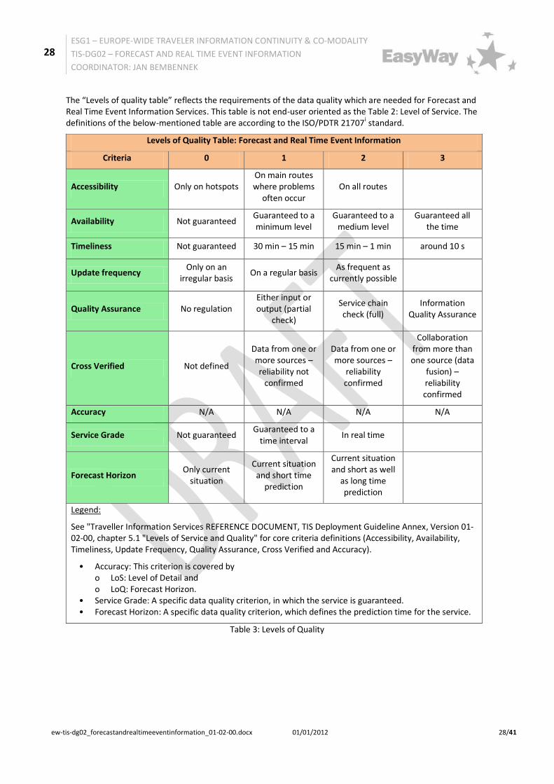
The “Levels of quality table” reflects the requirements of the data quality which are needed for Forecast and Real Time Event Information Services. This table is not end-user oriented as the Table 2: Level of Service. The definitions of the below-mentioned table are according to the ISO/PDTR 21707i standard.
Levels of Quality Table: Forecast and Real Time Event Information
Criteria 0 1 2 3
Accessibility Only on hotspots On main routes where problems
often occur On all routes
Availability Not guaranteed Guaranteed to a minimum level
Guaranteed to a medium level
Guaranteed all the time
Timeliness Not guaranteed 30 min – 15 min 15 min – 1 min around 10 s
Update frequency Only on an
irregular basis On a regular basis
As frequent as currently possible
Quality Assurance No regulation Either input or output (partial
check)
Service chain check (full)
Information Quality Assurance
Cross Verified Not defined
Data from one or more sources – reliability not
confirmed
Data from one or more sources –
reliability confirmed
Collaboration from more than one source (data
fusion) – reliability confirmed
Accuracy N/A N/A N/A N/A
Service Grade Not guaranteed Guaranteed to a
time interval In real time
Forecast Horizon Only current
situation
Current situation and short time
prediction
Current situation and short as well
as long time prediction
Legend:
See "Traveller Information Services REFERENCE DOCUMENT, TIS Deployment Guideline Annex, Version 01-02-00, chapter 5.1 "Levels of Service and Quality" for core criteria definitions (Accessibility, Availability, Timeliness, Update Frequency, Quality Assurance, Cross Verified and Accuracy).
• Accuracy: This criterion is covered by o LoS: Level of Detail and o LoQ: Forecast Horizon.
• Service Grade: A specific data quality criterion, in which the service is guaranteed. • Forecast Horizon: A specific data quality criterion, which defines the prediction time for the service.
Table 3: Levels of Quality
29
ESG1 – EUROPE-WIDE TRAVELER INFORMATION CONTINUITY & CO-MODALITY
TIS-DG02 – FORECAST AND REAL TIME EVENT INFORMATION
COORDINATOR: JAN BEMBENNEK
ew-tis-dg02_forecastandrealtimeeventinformation_01-02-00.docx 01/01/2012 29/41
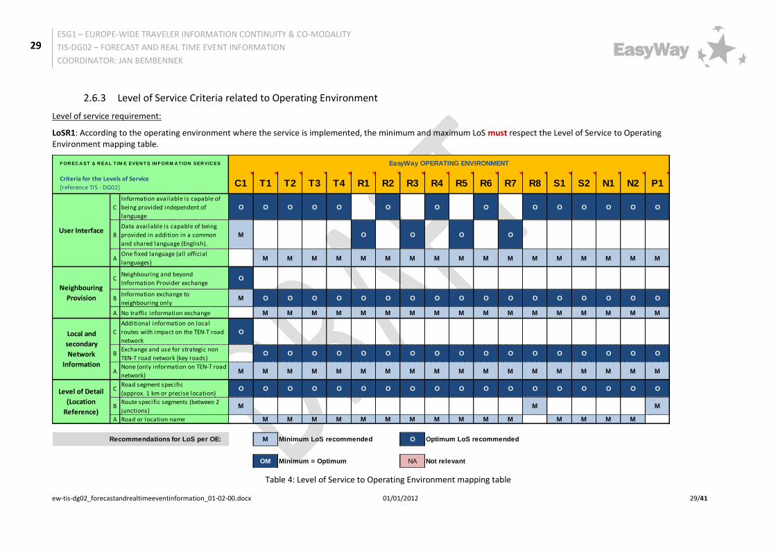
2.6.3 Level of Service Criteria related to Operating Environment
Level of service requirement:
LoSR1: According to the operating environment where the service is implemented, the minimum and maximum LoS must respect the Level of Service to Operating Environment mapping table.
Table 4: Level of Service to Operating Environment mapping table
C1 T1 T2 T3 T4 R1 R2 R3 R4 R5 R6 R7 R8 S1 S2 N1 N2 P1
C
Information available is capable of
being provided independent of
language
O O O O O O O O O O O O O O
B
Data available is capable of being
provided in addition in a common
and shared language (English).
M O O O O
AOne fixed language (all official
languages)M M M M M M M M M M M M M M M M M
CNeighbouring and beyond
Information Provider exchangeO
BInformation exchange to
neighbouring onlyM O O O O O O O O O O O O O O O O O
A No traffic information exchange M M M M M M M M M M M M M M M M M
C
Additional information on local
routes with impact on the TEN-T road
network
O
BExchange and use for strategic non
TEN-T road network (key roads)O O O O O O O O O O O O O O O O O
ANone (only information on TEN-T road
network)M M M M M M M M M M M M M M M M M M
CRoad segment specific
(approx. 1 km or precise location)O O O O O O O O O O O O O O O O O O
BRoute specific segments (between 2
junctions)M M M
A Road or location name M M M M M M M M M M M M M M M
M Minimum LoS recommended O Optimum LoS recommended
OM Minimum = Optimum NA Not relevant
F OR EC A ST & R EA L T IM E EVEN T S IN F OR M A T ION SER VIC ES EasyWay OPERATING ENVIRONMENT
Criteria for the Levels of Service
[reference TIS - DG02]
Recommendations for LoS per OE:
User Interface
Neighbouring
Provision
Local and
secondary
Network
Information
Level of Detail
(Location
Reference)

30
ESG1 – EUROPE-WIDE TRAVELER INFORMATION CONTINUITY & CO-MODALITY
TIS-DG02 – FORECAST AND REAL TIME EVENT INFORMATION
COORDINATOR: JAN BEMBENNEK
ew-tis-dg02_forecastandrealtimeeventinformation_01-02-00.docx 01/01/2012 30/41
3 Part B: Supplementary Information 3.1 Examples of deployment
3.1.1 INRIX Traffic application
The INRIX Traffic application is a free application for smartphones, available on BlackBerry App World, iTunes App Store, Android Market, Amazon and Windows Phone 7. One of the applications key features is the ability to help the driver avoid traffic and congestion by using real-time, crowd-sourced traffic information from a worldwide network, combined with road sensor data and accident reports. It is also possible to get forecast traffic information eight hours in advance.
Figure 3: INRIX Traffic application on different smartphones
On the road, the driver can report incidents and police activity along his route to help the community using the application.
For more information on this application, please see: http://www.inrixtraffic.com/
AASHTO (American Association of State Highway and Transportation Officials) introduced a mobile application which delivers the latest news about smart highways and the future of America’s roads - as well as INRIX’s real-time traffic information. For more information, please see:http://news.transportation.org/press_release.aspx?Action=ViewNews&NewsID=383).
3.1.2 Traffic information via website in Flanders, Belgium
Euro-Region CENTRICO
Country Belgium
Location Flanders TEN-T road network
Name of organisation Vlaams Verkeerscentrum
Contact Name JozefCannaerts
Contact Email [email protected]
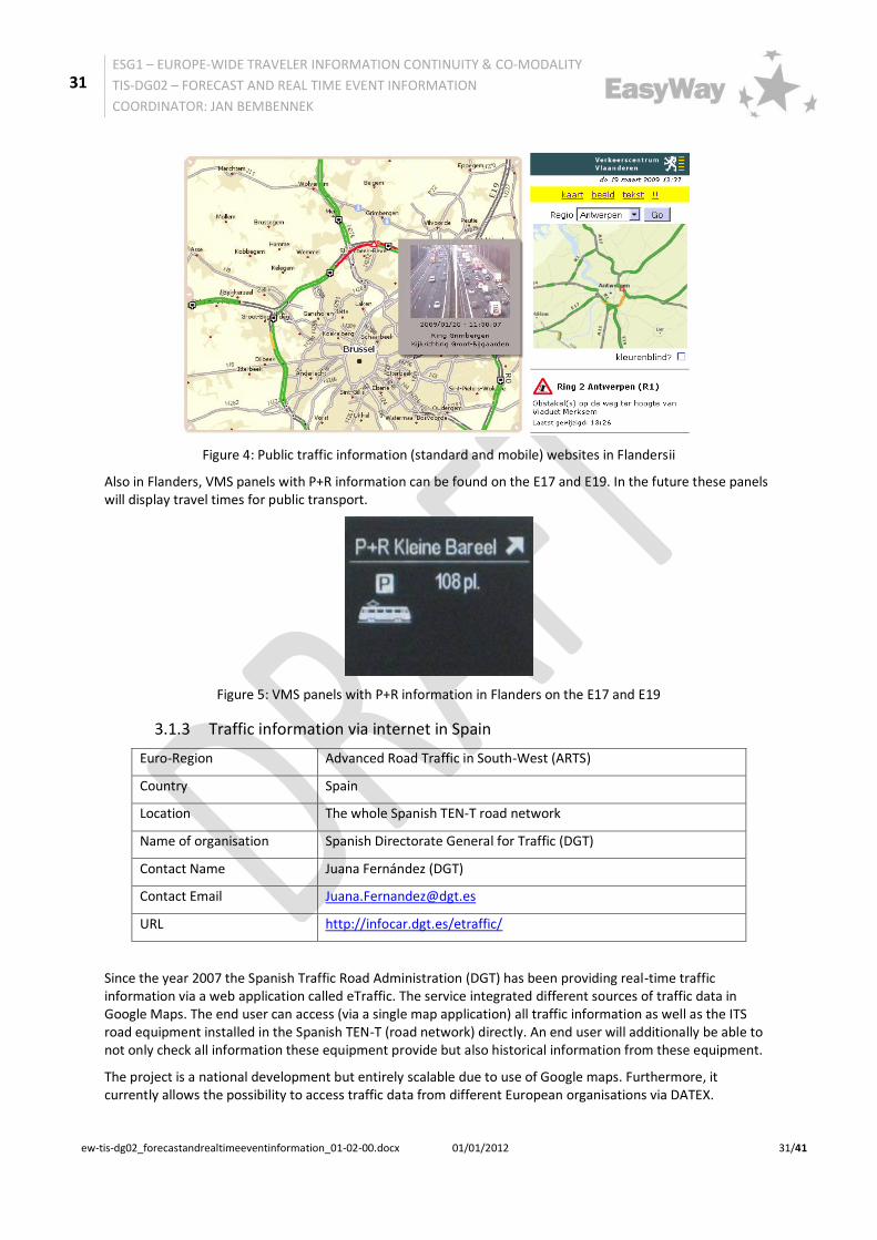
Real time event information are available to the public via national radio, RDS-TMC and a public website, http://verkeerscentrum.be. This website also provides forecast information. The Flemish traffic centre also provides a website for mobile devices: http://filebeeld.be. Additionally, information can be obtained on maps, text-only and ‘rush-hour’-mail. Slightly-delayed webcam-images are also available. As a test project, displays travel times around the city of Antwerp can also be found on the website and on VMS panels.
31
ESG1 – EUROPE-WIDE TRAVELER INFORMATION CONTINUITY & CO-MODALITY
TIS-DG02 – FORECAST AND REAL TIME EVENT INFORMATION
COORDINATOR: JAN BEMBENNEK
ew-tis-dg02_forecastandrealtimeeventinformation_01-02-00.docx 01/01/2012 31/41
Figure 4: Public traffic information (standard and mobile) websites in Flandersii
Also in Flanders, VMS panels with P+R information can be found on the E17 and E19. In the future these panels will display travel times for public transport.
Figure 5: VMS panels with P+R information in Flanders on the E17 and E19
3.1.3 Traffic information via internet in Spain
Euro-Region Advanced Road Traffic in South-West (ARTS)
Country Spain
Location The whole Spanish TEN-T road network
Name of organisation Spanish Directorate General for Traffic (DGT)
Contact Name Juana Fernández (DGT)
Contact Email [email protected]
URL http://infocar.dgt.es/etraffic/
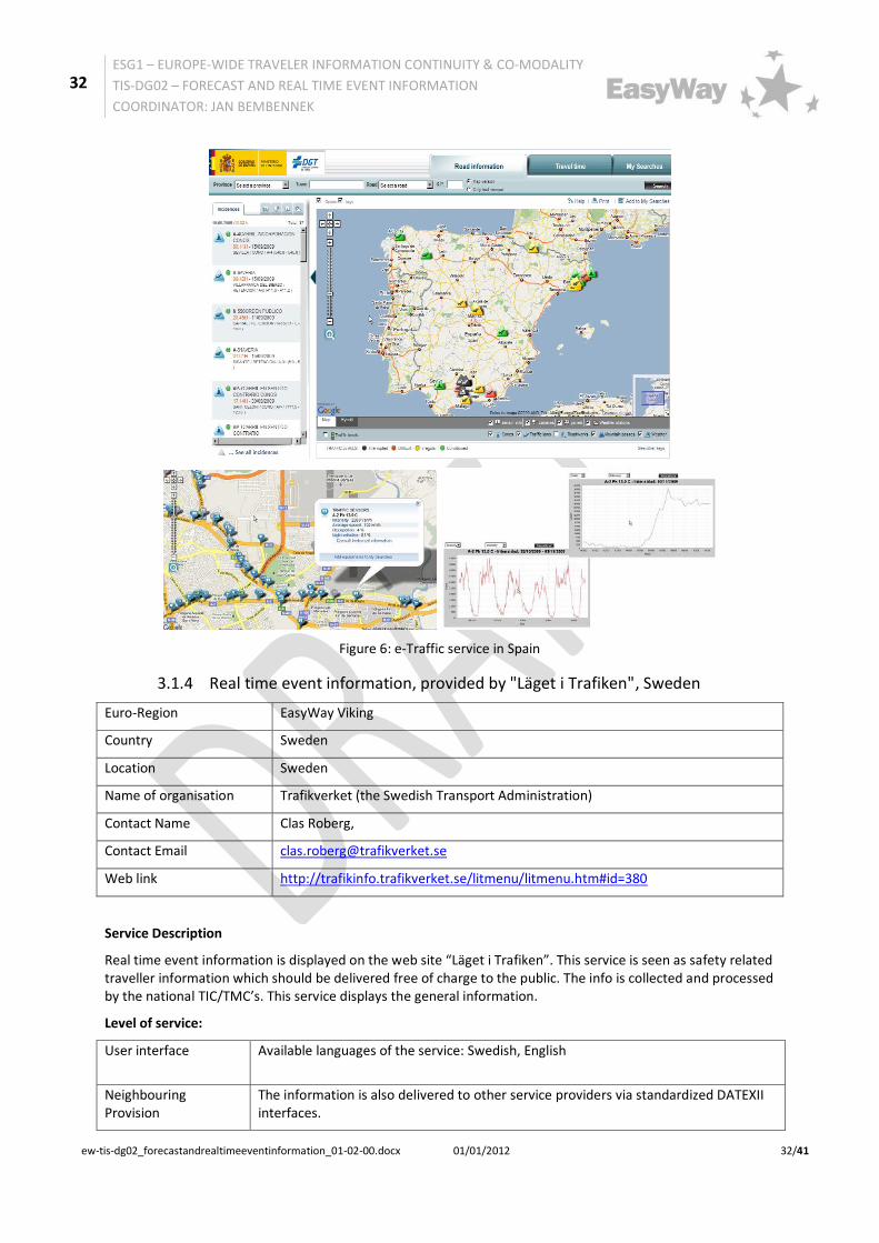
Since the year 2007 the Spanish Traffic Road Administration (DGT) has been providing real-time traffic information via a web application called eTraffic. The service integrated different sources of traffic data in Google Maps. The end user can access (via a single map application) all traffic information as well as the ITS road equipment installed in the Spanish TEN-T (road network) directly. An end user will additionally be able to not only check all information these equipment provide but also historical information from these equipment.
The project is a national development but entirely scalable due to use of Google maps. Furthermore, it currently allows the possibility to access traffic data from different European organisations via DATEX.
32
ESG1 – EUROPE-WIDE TRAVELER INFORMATION CONTINUITY & CO-MODALITY
TIS-DG02 – FORECAST AND REAL TIME EVENT INFORMATION
COORDINATOR: JAN BEMBENNEK
ew-tis-dg02_forecastandrealtimeeventinformation_01-02-00.docx 01/01/2012 32/41
Figure 6: e-Traffic service in Spain
3.1.4 Real time event information, provided by "Läget i Trafiken", Sweden
Euro-Region EasyWay Viking
Country Sweden
Location Sweden
Name of organisation Trafikverket (the Swedish Transport Administration)
Contact Name Clas Roberg,
Contact Email [email protected]
Web link http://trafikinfo.trafikverket.se/litmenu/litmenu.htm#id=380
Service Description
Real time event information is displayed on the web site “Läget i Trafiken”. This service is seen as safety related traveller information which should be delivered free of charge to the public. The info is collected and processed by the national TIC/TMC’s. This service displays the general information.
Level of service:
User interface Available languages of the service: Swedish, English
Neighbouring Provision
The information is also delivered to other service providers via standardized DATEXII interfaces.
33
ESG1 – EUROPE-WIDE TRAVELER INFORMATION CONTINUITY & CO-MODALITY
TIS-DG02 – FORECAST AND REAL TIME EVENT INFORMATION
COORDINATOR: JAN BEMBENNEK
ew-tis-dg02_forecastandrealtimeeventinformation_01-02-00.docx 01/01/2012 33/41
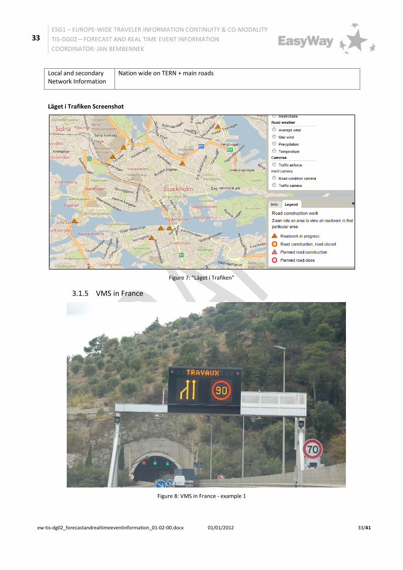
Local and secondary Network Information
Nation wide on TERN + main roads
Läget i Trafiken Screenshot
Figure 7: "Läget i Trafiken"
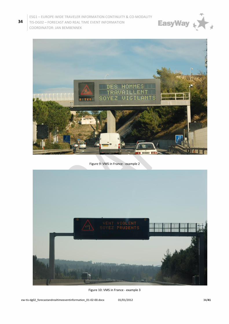
3.1.5 VMS in France
Figure 8: VMS in France - example 1
34
ESG1 – EUROPE-WIDE TRAVELER INFORMATION CONTINUITY & CO-MODALITY
TIS-DG02 – FORECAST AND REAL TIME EVENT INFORMATION
COORDINATOR: JAN BEMBENNEK
ew-tis-dg02_forecastandrealtimeeventinformation_01-02-00.docx 01/01/2012 34/41
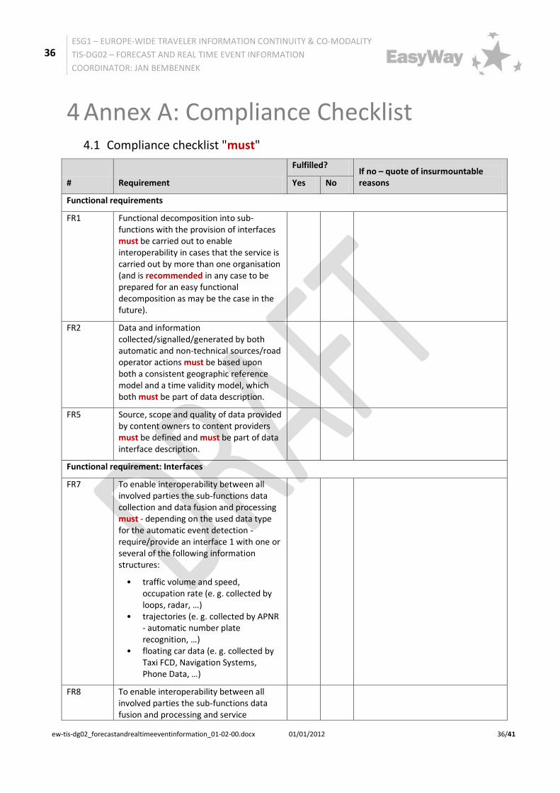
Figure 9: VMS in France - example 2
Figure 10: VMS in France - example 3

35
ESG1 – EUROPE-WIDE TRAVELER INFORMATION CONTINUITY & CO-MODALITY
TIS-DG02 – FORECAST AND REAL TIME EVENT INFORMATION
COORDINATOR: JAN BEMBENNEK
ew-tis-dg02_forecastandrealtimeeventinformation_01-02-00.docx 01/01/2012 35/41
3.2 Business Model
A general overarching description of the key actors, their roles in the value chain and the related conditions for TIS-service provision is outlined in the "Traveller Information Services REFERENCE DOCUMENT, TIS Deployment Guideline Annex, Version 01-02-00":
Chapter 3.1 "Introduction to key actors in the traveller information chain" and Chapter 3.2 "Conditions for Service Provision - Business Model"
For Additional information see chapter 2.3 Organisational requirements.
36
ESG1 – EUROPE-WIDE TRAVELER INFORMATION CONTINUITY & CO-MODALITY
TIS-DG02 – FORECAST AND REAL TIME EVENT INFORMATION
COORDINATOR: JAN BEMBENNEK
ew-tis-dg02_forecastandrealtimeeventinformation_01-02-00.docx 01/01/2012 36/41
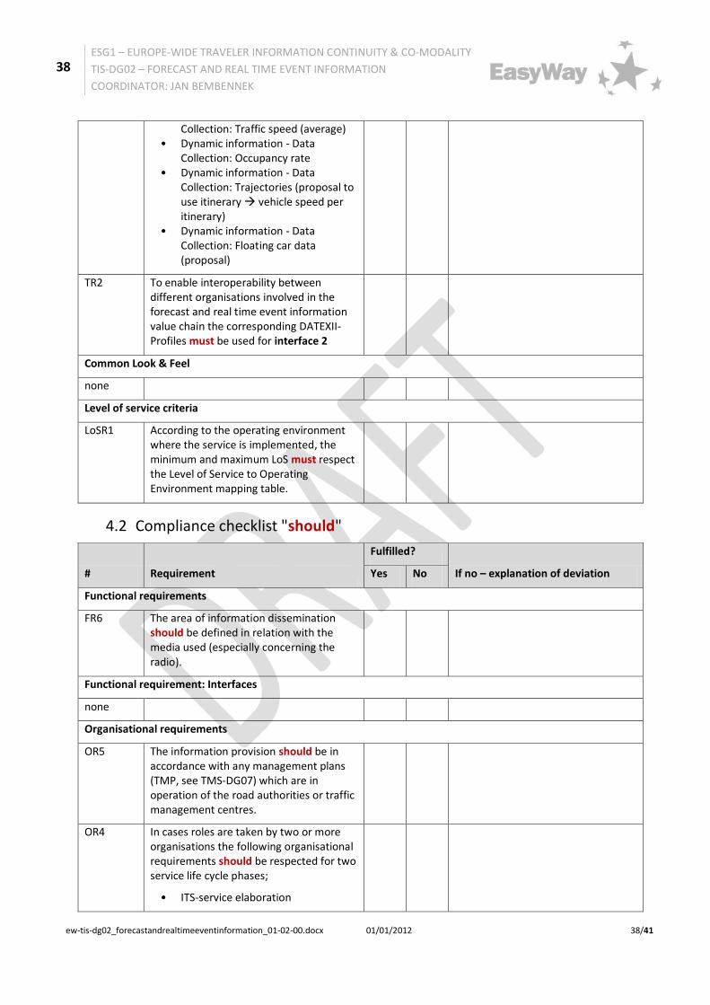
4 Annex A: Compliance Checklist 4.1 Compliance checklist "must"
# Requirement
Fulfilled? If no – quote of insurmountable reasons Yes No
Functional requirements
FR1 Functional decomposition into sub-functions with the provision of interfaces must be carried out to enable interoperability in cases that the service is carried out by more than one organisation (and is recommended in any case to be prepared for an easy functional decomposition as may be the case in the future).
FR2 Data and information collected/signalled/generated by both automatic and non-technical sources/road operator actions must be based upon both a consistent geographic reference model and a time validity model, which both must be part of data description.
FR5 Source, scope and quality of data provided by content owners to content providers must be defined and must be part of data interface description.
Functional requirement: Interfaces
FR7 To enable interoperability between all involved parties the sub-functions data collection and data fusion and processing must - depending on the used data type for the automatic event detection -require/provide an interface 1 with one or several of the following information structures:
• traffic volume and speed, occupation rate (e. g. collected by loops, radar, …)
• trajectories (e. g. collected by APNR - automatic number plate recognition, …)
• floating car data (e. g. collected by Taxi FCD, Navigation Systems, Phone Data, …)
FR8 To enable interoperability between all involved parties the sub-functions data fusion and processing and service

37
ESG1 – EUROPE-WIDE TRAVELER INFORMATION CONTINUITY & CO-MODALITY
TIS-DG02 – FORECAST AND REAL TIME EVENT INFORMATION
COORDINATOR: JAN BEMBENNEK
ew-tis-dg02_forecastandrealtimeeventinformation_01-02-00.docx 01/01/2012 37/41
provision must require/provide an interface with the following event information structure:
(estimated) impact on traffic situation
• begin and estimated end • position and estimated spatial
dimension • type, cause (optional) • comment (free text) • information source
Organisational requirements:
OR1 The organisational and operational structure of the service as well as the role of each organisation/body and its exact tasks in the chain must be defined
OR2 All for successful implementation of a "Forecast and Real Time Event Information Service" necessary organisational aspects must be documented and signed of all involved parties/partners in form of a Common partner arrangement/MoU - Memorandum of understanding, which fixes the co-operation.
OR3 In case of involving private partners delivering private generated data for "Forecast and Real Time Event Information Service" a contract (with service level agreement) must be developed and closed wherever a "Forecast and Real Time Event Information Service" relies on receiving privately generated data.
OR4 OR4: All for successful implementation of a "Forecast and Real Time Event Information Service" necessary collaboration processes/workflows and interfaces must be described
Technical requirements
TR1 To enable interoperability between different organisations involved in the forecast and real time event information value chain the corresponding DATEXII-Profiles must be used for interface 1:
• Static information: measurement site information
• Dynamic information - Data Collection: Traffic flow
• Dynamic information - Data
38
ESG1 – EUROPE-WIDE TRAVELER INFORMATION CONTINUITY & CO-MODALITY
TIS-DG02 – FORECAST AND REAL TIME EVENT INFORMATION
COORDINATOR: JAN BEMBENNEK
ew-tis-dg02_forecastandrealtimeeventinformation_01-02-00.docx 01/01/2012 38/41
Collection: Traffic speed (average) • Dynamic information - Data
Collection: Occupancy rate • Dynamic information - Data
Collection: Trajectories (proposal to use itinerary vehicle speed per itinerary)
• Dynamic information - Data Collection: Floating car data (proposal)
TR2 To enable interoperability between different organisations involved in the forecast and real time event information value chain the corresponding DATEXII-Profiles must be used for interface 2
Common Look & Feel
none
Level of service criteria
LoSR1 According to the operating environment where the service is implemented, the minimum and maximum LoS must respect the Level of Service to Operating Environment mapping table.
4.2 Compliance checklist "should"
# Requirement
Fulfilled?
If no – explanation of deviation Yes No
Functional requirements
FR6 The area of information dissemination should be defined in relation with the media used (especially concerning the radio).
Functional requirement: Interfaces
none
Organisational requirements
OR5 The information provision should be in accordance with any management plans (TMP, see TMS-DG07) which are in operation of the road authorities or traffic management centres.
OR4 In cases roles are taken by two or more organisations the following organisational requirements should be respected for two service life cycle phases;
• ITS-service elaboration
39
ESG1 – EUROPE-WIDE TRAVELER INFORMATION CONTINUITY & CO-MODALITY
TIS-DG02 – FORECAST AND REAL TIME EVENT INFORMATION
COORDINATOR: JAN BEMBENNEK
ew-tis-dg02_forecastandrealtimeeventinformation_01-02-00.docx 01/01/2012 39/41
• ITS-Service operation and quality management (concerning content provider and service operator)
Technical requirements:
TR3 To enable interoperability between different organisations involved in the forecast and real time event information the mapping of events to the relevant information provision standards TPEG, ALERT-C should be considered.
Common Look & Feel
CL&FR1 Information for the end user should always be self-consistent whatever the media or the end user device used.
CL&FR2 The display of signs/pictograms on VMS or other end-user devices should be conforming to the Vienna Convention for use on VMS, Annex IX and Annex 10 of ECE/TRANS/WP.1/119/Rev.2 27 May 2010 (see http://www.unece.org/index.php?id=17582) and in line with the requirements of the EasyWay Variable Message Signs Harmonisation Guidelines Part I and Part II.
Level of service criteria
none
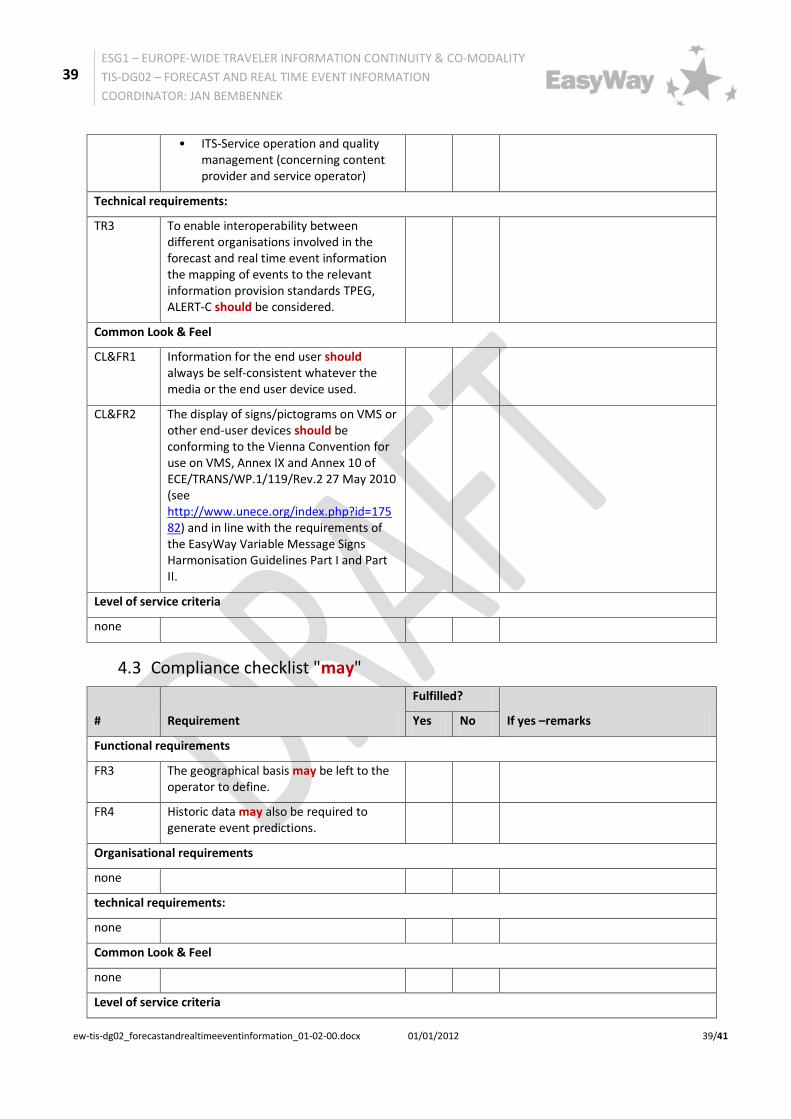
4.3 Compliance checklist "may"
# Requirement
Fulfilled?
If yes –remarks Yes No
Functional requirements
FR3 The geographical basis may be left to the operator to define.
FR4 Historic data may also be required to generate event predictions.
Organisational requirements
none
technical requirements:
none
Common Look & Feel
none
Level of service criteria

40
ESG1 – EUROPE-WIDE TRAVELER INFORMATION CONTINUITY & CO-MODALITY
TIS-DG02 – FORECAST AND REAL TIME EVENT INFORMATION
COORDINATOR: JAN BEMBENNEK
ew-tis-dg02_forecastandrealtimeeventinformation_01-02-00.docx 01/01/2012 40/41
none
41
ESG1 – EUROPE-WIDE TRAVELER INFORMATION CONTINUITY & CO-MODALITY
TIS-DG02 – FORECAST AND REAL TIME EVENT INFORMATION
COORDINATOR: JAN BEMBENNEK
ew-tis-dg02_forecastandrealtimeeventinformation_01-02-00.docx 01/01/2012 41/41
5 Annex B: Bibliography 1. S. Bradner, (Network Working Group). Key words for use in RFCs to Indicate Requirement Levels. The Internet Engineering Task Force (IETF). [Online] March 1997. http://www.ietf.org/rfc/rfc2119.txt.
2. United Nations - Economic and Social Council. ECE/TRANS/WP.1/119/Rev.2. [Online] 27 May 2010. http://www.unece.org/fileadmin/DAM/trans/main/wp1/wp1fdoc/ECE-TRANS-WP.1-119-Rev.2%20e.pdf.
3. 21707, Draft ISO/PDTR.Intelligent Transport Systems – Integrated Transport Information, Management and Control – Data Quality in ITS Systems . 30. March 2007.
6 Annex C: Endnotes
i Draft ISO/PDTR 21707 Intelligent Transport Systems – Integrated Transport Information, Management and Control – Data Quality in ITS Systems, 30. March 2007
iihttp://www.verkeerscentrum.be and http://www.filebeeld.be for mobile devices