Embed Size (px)
Citation preview
Transportation Plan of Nord-du-Queacutebec
Technical Study
Marine Transport
Overview Networks Infrastructures Operations and Management in Nord-du-Queacutebec
WORK DOCUMENT FINAL VERSION
October 2002
RESEARCH AND WRITING Franccedilois Gaudreau Consultant in Marine Transport
REVISION AND TEXT HARMONIZATION Luc Ampleman Service des inventaires et plan DATNQ Jean-Franccedilois Boutin Universiteacute du Queacutebec agrave Rimouski Leacutevis Campus Anick Guimond Service des inventaires et plan DATNQ Marie Lalancette Service des inventaires et plan DATNQ
TECHNICAL SUPPORT Luc Ampleman Service des inventaires et plan DATNQ Anick Guimond Service des inventaires et plan DATNQ
SPECIAL COLLABORATION Joseacutee Arseneault Service des relations exteacuterieures DGPST Guy Marcil Direction du transport maritime aeacuterien et ferroviaire DGPST
ACKNOWLEDGEMENTS We wish to thank all those who have contributed comments and suggestions in the making of this document This document was prepared for the Service des inventaires et plan of Direction de lrsquoAbitibi-TeacutemiscaminguendashNord-du-Queacutebec Ministegravere des Transports For more information contact Ministegravere des Transports Direction de la coordination du Nord-du-Queacutebec 80 Avenue Queacutebec Rouyn-Noranda (Queacutebec) J9X 6R1 Telephone (819) 763-3237 Fax (819) 763-3493 E-mail plantransportnordmtqgouvqcca Web site wwwmtqgouvqccaregionsabitibiplan_nord-enhtml
TABLE OF CONTENTS
ACRONYMS V
SUMMARY VII
INTRODUCTION 1
1 OVERVIEW OF THE NETWORKS INFRASTRUCTURES AND EQUIPMENT FOR MARINE TRANSPORT IN NORD-DU-QUEacuteBEC 2
11 History and Evolution of the Overall Marine Transport System in the Nord-du-Queacutebec Region and Surrounding Area 2
111 Current Situation 6
112 Involvement of the Canadian Coast Guard 7
113 Commercial Fisheries Network in Nunavik 7
12 Background and General Description of the Infrastructures and Equipment for marine transport in Nord-du-Queacutebec 10
121 Nunavik Marine Infrastructures 13
122 James Bay Marine Infrastructures 15
123 Deception Bay16
124 Canadian Coast Guard Navigational Aids16
13 Inventory of Implementation Projects for Marine Infrastructures in Nord-du-Queacutebec17
14 Factors Affecting the Infrastructures Condition and Maintenance 18
141 Natural Factors 19
142 Anthropogenic Factors20
20 OVERVIEW OF MARINE TRANSPORT SERVICES AND OPERATIONS IN NORD-DU-QUEacuteBEC 21
21 General Description of Marine Transport Services in Nord-du-Queacutebec Equipment and Services 21
211 Transport Desgagneacutes 22
212 Nunavut Eastern Arctic Shipping (NEAS) 24
213 Fednav24
214 Moosonee Transportation Limited (MTL) 25
Transportation Plan of Nord-du-Queacutebec I
22 General Description of Marine Transport Services in Nord-du-Queacutebec Traffic25
221 Volume of Cargo Handled in the Past26
222 Forecast of Cargo Volume to be Handled in the Future31
23 General Description of the Logitics of Marine Transport Operations in Nord-du-Queacutebec32
231 General Cargo 32
232 Petroleum products37
233 Transhipment of Goods at Deception Bay 41
24 Activities Related to Marine Transport Operations that can Have a Negative Impact on the Environment41
241 Environmental Impacts Related to Marine Infrastructures 41
242 Environmental Impacts Related to Marine Operations42
30 STRENGTHS AND CONSTRAINTS OF MARINE TRANSPORT IN NORD-DU-QUEacuteBEC 44
31 Strengths and Constraints for the Entire Region44
311 Ice 44
312 Tides 46
313 Absence of Marine Infrastructures 46
314 Other Constraints47
32 Strengths and Constraints for Each Site 47
40 TRENDS AND ACTION LEADS IN MARINE TRANSPORT IN THE NORD-DU-QUEacuteBEC REGION 54
41 Importance of Marine Transport for the Socio-Economic Development of the Nord-du-Queacutebec Communities54
411 Necessary Marine Link 54
412 Local Communitiesrsquo Involvement in the Industrial Sector54
42 Environmental Risks and Impacts Related to Marine Transport 55
421 Risks and Impacts Rlated to Mrine Ifrastructures and Tanshipment Oerations 55
422 Impact Mitigation Measures 56
43 Improved Quality of Services and Infrastructures 56
Transportation Plan of Nord-du-Queacutebec II
431 Improved Services 56
432 Improved Infrastructures 57
44 Improved Security in Marine Transport 58
441 Navigation58
442 Transhipment Operations 59
CONCLUSION61
GLOSSARY62
BIBLIOGRAPHY 64 APPENDICES 1 Maritime distance chart Nord-du-Queacutebec 2 Description of marine infrastructures in Nord-du-Queacutebec 3 Description of ships and equipment used by the shipping companies supplying
the Nunavik sites 4 Marine service provided by the Ministegravere des Transports du Queacutebec per type of
goods and per village 1984 5 Queacutebec and Inuit populations age pyramids 6 Maps showing yearly evolution of sea ice 7 Tables of the strengths and weaknesses of each site concerning unloading
operations
Transportation Plan of Nord-du-Queacutebec III
LIST OF APPENDICES MAPS FIGURES CHARTS PHOTOS AND TABLES
MAPS 1 Nord-du-Queacutebec Coastal Communities 4 2 Nord-du-Queacutebec and Baffin Area Locations Supplied by Ship 5 3 Marine Infrastructures in Nord-du-Queacutebec (2001) 12 4 Proportion of Freight Delivered in Each Nunavik Village by Transport Desgagneacutes (1970-1998) 28 5 Areas of Access Constraints Caused by Tidal Conditions 45 FIGURES 1 Cargo Unloading Process 34 2 Oiler Unloading Process 38 CHARTS 1 Freight Handled by Transport Desgagneacutes in Nunavik 1970-1998 27 2 Number of Containers (TEU) Shipped to Nunavik for the FCNQ 1996-2000 29 3 Number of Litres of Oil Products Shipped to Nunavik for Shell Canada 1996-2000 30 PHOTOS 1 Secondary Breakwater Kangiqsualujjuaq 13 2 Construction of the Umiujaq Breakwater 15 3 Loading of Cargo on the Barge 35 4 Barge Unloading 36 5 Temporary Container Storage at Inukjuak 36 6 Shell Canada Equipment in Kuujjuaq 40 7 Aupaluk Beach 49 TABLES 1 Organizational Evolution of Marine Services in Nunavik and Nunavut 3 2 Marine Infrastructures in Nord-du-Queacutebec (2001) 11 3 Construction Projects - Marine Infrastructures in Nord-du-Queacutebec 18 4 Factors Affecting the Infrastructures Condition and Maintenance 19 5 Canadian Shipowners Supplying Nord-du-Queacutebec and Nunavuts Baffin Area 23
Transportation Plan of Nord-du-Queacutebec IV
ACRONYMS
KRG Kativik Regional Government DGPS Differential Global Positioning System FCNQ Feacutedeacuteration des Coopeacuteratives du Nouveau-Queacutebec IMDG International Maritime Dangerous Goods Code MARPOL International Convention on the Prevention of Pollution from Ships MTL Moosonee Transportation Limited MTQ Ministegravere des Transports du Queacutebec NEAS Nunavut Eastern Arctic Shipping NORDREG Arctic Canada Traffic System NTCL Northern Transportation Company Limited IMO International Maritime Organization MCTS Marine Communications and Traffic Services GMDSS Global Maritime Distress and Safety System SOPEP Shipboard Oil Pollution Emergency Plans GPS Global Positioning System TEU Twenty Equivalent Units TDGR Transportation of Dangerous Goods Regulations
Transportation Plan of Nord-du-Queacutebec V
NOTICE TO THE READER
Unless otherwise indicated by the context the following expressions and words mean Technical study This technical study has no scientific pretence It is not an
opportunity study by any means nor an exhaustive research on the subject It aims at drawing up an overview of the situation in the specific area of transportation in Nord-du-Queacutebec Although the study is internal the Ministegravere is nonetheless pleased to make it available to the reader
The Ministegravere The Ministegravere des Transports du Queacutebec In the text words in italics are found in the glossary except for laws regulations and document titles
Transportation Plan of Nord-du-Queacutebec VI
SUMMARY
In the Nord-du-Queacutebec region marine transport is of paramount importance For centuries now Aboriginals have used the sea as a means of communications In recent years marine freight from southern Queacutebec has become necessary in order to support the rapid socio-economic development of Nord-du-Queacutebec communities Furthermore in the case of Nunavik the lack of a regional and provincial road network makes it necessary to use marine transport for heavy and bulky goods Once organized and coordinated by the Ministegravere des Transports du Queacutebec (MTQ) steamship services have been entirely provided by private sector enterprises since 2001 In spite of the importance of marine transport in the region marine infrastructures are rudimentary even non-existent in some places It forces navigators to adapt their way of doing things They resort to unusual unloading methods (cargo ships and oil tankers) for supply operations Mariners must also deal with several natural constraints Navigators have to synchronize their trips with seasons tides and wind conditions Because of the risks involved with these constraints the Nunavik Marine Infrastructure Program is presently underway Overseen by Makivik Corporation and financed by Transport Canada this program primarily aims at making the access to sea safe and easy for the local population Moreover the partnership agreement signed on April 9 2002 between the Inuit and the Queacutebec government provides that the latter will participate in the Marine Infrastructure Program In James Bay a few villages are equipped with marine infrastructures that facilitate domestic operations while commercial infrastructures have practically fallen into disuse since the opening up of the region has greatly diminished marine freight Safety at sea was significantly enhanced by the onset of new technologies The use of the Global Positioning System (GPS) and satellite communication systems markedly increased the safety of marine transport The infrastructures built in the framework of the Nunavik Marine Infrastructure Program also contribute to an improved safety in marine operations The implementation of simple facilities strict and efficient measures and emergency response plans would also promote safety and reduce the risk of impacts on the environment that could occur during commercial and domestic marine operations
Transportation Plan of Nord-du-Queacutebec VII
INTRODUCTION
In the preparation of the Transportation Plan of Nord-du-Queacutebec this technical study draws an overall picture of networks infrastructures operations and management in Nord-du-Queacutebec The aim is to have an overview of marine transport in Nord-du-Queacutebec To do this we will first discuss marine transport networks that already exist in this area Then we will describe the marine infrastructures of Ungava Bay Hudson Strait Hudson Bay and James Bay We will see that marine infrastructures are rudimentary in spite of the importance of marine transport in the region An infrastructure construction program that is presently underway in Nunavik will also be discussed In Chapter 2 we will take a closer look at marine supply operations in villages and various locations of the region We will see that unloading methods used by shipping lines for petroleum products and general cargo are well-adapted to the regions specific conditions These supply operations require impressive logistics We will discuss transport services provided by shipping lines and attempt to demonstrate the importance of supply ships by reviewing the data available on freight quantities over the last few years We will close this chapter with a look at the environmental impacts of marine operations in Nord-du-Queacutebec Chapter 3 deals with marine constraints in the general region and for each supply site We will observe that constraints are numerous and strongly affect the use of the sea as a means for transportation Finally we will focus on the importance of marine transport for the areas socio-economic development for the region Then we will discuss recent improvements made to increase safety and marine transport services We will also make a few suggestions to foster safety even more and mitigate the environmental impacts of marine transport in the region
Transportation Plan of Nord-du-Queacutebec 1
1 OVERVIEW OF THE NETWORKS INFRASTRUCTURES AND EQUIPMENT FOR MARINE TRANSPORT IN NORD-DU-QUEacuteBEC
Several geographers agree on dividing the vast Nord-du-Queacutebec region (840000 square kilometres) in two territories Nunavik and James Bay (see Map 1) This region is characterised by the length of its littoral that extends from the bayhead of James Bay to the north-eastern tip of Ungava Bay (Killinik Point) Fourteen Inuit communities and five Cree communities are located in the coastal area The 14 Inuit communities and the Whapmagoostui Cree community are not connected by road while the four Cree coastal communities of Chisasibi Eastmain Waskaganish and Wemindji are connected to Queacutebecrsquos road network Appendix 1 shows a waterway distance chart for the communities of region Nord-du-Queacutebec 11 History and Evolution of the Overall Marine Transport System in the Nord-
du-Queacutebec Region and Surrounding Area
Table 1 illustrates the evolution of the organisation of steamship services in Nunavik and Nunavut Ships have sailed in northern Canada and Queacutebec for several decades From occasional departures the ships visits to these territories have intensified after World War II At that time the Canadian Government wished to reaffirm its sovereignty over the territory and set up governmental stations (military stations research stations and meteorological stations) and dispersed the Inuit villages over the territory1 Since it was necessary to service these facilities ships started visiting more and more often In 1959 the Canadian Coast Guard became responsible for steamship services in northern communities Map 2 shows the villages and operational facilities visited for supply operations in the eastern Canadian Arctic and Nord-du-Queacutebec areas In 1978 responding to the Gouvernement du Queacutebecs request the Canadian Government transferred to Queacutebec its responsibility in the management and coordination of marine services to the Nunavik
1 Landry Raymond (1982) Desserte maritime des villages du Nouveau-Queacutebec Ministegravere des
Transports p 29
Transportation Plan of Nord-du-Queacutebec 2
Overview of Networks Infrastructures and Equipment
TABLE 1 ORGANIZATIONAL EVOLUTION OF MARINE SERVICES IN NUNAVIK AND NUNAVUT
TERRITORY FEDERAL GOVERNMENT
TRANSPORT SERVICES
PROVINCIALTERRITORIAL GOVERNMENT
TRANSPORT SERVICES
COMMERCIAL TRANSPORT SERVICES
Nunavik 1959-1978 1979-2000 2001
Nunavut 1959-2000 2001
Sources Landry Raymond (1982) Desserte maritime des villages du Nouveau-Queacutebec Marcil Guy Ministegravere des Transports (2001) Personal communication
Transportation Plan of Nord-du-Queacutebec 3
Operational siteampampampampampampampampampampampampampampampampampampampampampampampampampampampampampampampampampampampampampampampampampampampampampampampampampMine
LocalisationCree villageCity or town
MInuit municipalityNaskapi village
RoadFinancial responsability
MTQ - National regional collectorMTQ - Access and miningMTQ - Other roadsHydro-Queacutebec
Rail and marine routes Administrative limit
Rail road
Rail and marine routes
Marine route and distance in nauticalmiles (1 nautical mile = 1852 meters)South limit Nord-du-Queacutebec region
Administrative limitMunicipaliteacute de la Baie James
Mer du Labrador
Baie dUngava
Deacutetroit dHudson
Baie dHudson
Baie James
49degN
55degN
Riviegravere
George Baleine la
Riviegravere
Riviegravere
agrave
Caniapiscau
Koksoak
Riviegravere
Grande Riviegravere
La
Riviegravere
aux Feuilles
Eastm
ain
Puvirnituq
Petite riviegravere de la Baleine
Riviegravere
de la Baleine
Riv
iegravere
Riviegravere Sakami
Grande riviegravere
Eastmain
Riviegravere
Riviegravere
Grande La
ReacuteservoirSmallwood
ReacuteservoirCaniapiscau
Lac Mistassini
ReacuteservoirManicouagan
Lac Bienville
ReacuteservoirsLaforge
ReacuteservoirLG-4
Lac desLoups Marins
Lac Payne
LacNantais
Lac agrave lEau Claire
Lac Minto
CoutureLac
Reacuteservoir LG-3
Guillaume-DelisleLac
OpinacaReacuteservoir
Lac Sakami
Reacuteservoir LG-2
Icircle Mansel
Terre de Baffin
Icircle Akpatok
IcirclesBelcher
IcircleAkimiski
M
M
M
M
M
M
M
MM
M
M
M
M
M
rsquo
ampampampampampampampampampampampampampampampampampampampampampampampampampampampampampampampampampampampampampampampampampampampampampampampampamp
62degN
Traceacute de 1927 du Conseil priveacute
Traceacute de 1927 du Conseil priveacute
Traceacute de 1927 du Conseil priveacute
Traceacute de 1927 du Conseil priveacute
Traceacute de 1927 du Conseil priveacute
Traceacute de 1927 du Conseil priveacute
Traceacute de 1927 du Conseil priveacute
Traceacute de 1927 du Conseil priveacute
Traceacute de 1927 du Conseil priveacute
(non deacutefinitif)(non deacutefinitif)(non deacutefinitif)
(non deacutefinitif)(non deacutefinitif)
(non deacutefinitif)(non deacutefinitif)(non deacutefinitif)
(non deacutefinitif)
Traceacute de 1927 du Conseil priveacuteTraceacute de 1927 du Conseil priveacuteTraceacute de 1927 du Conseil priveacuteTraceacute de 1927 du Conseil priveacuteTraceacute de 1927 du Conseil priveacuteTraceacute de 1927 du Conseil priveacuteTraceacute de 1927 du Conseil priveacuteTraceacute de 1927 du Conseil priveacuteTraceacute de 1927 du Conseil priveacute
(non deacutefinitif)(non deacutefinitif)(non deacutefinitif)(non deacutefinitif)(non deacutefinitif)(non deacutefinitif)(non deacutefinitif)(non deacutefinitif)(non deacutefinitif)
Ont
ario
Ont
ario
Ont
ario
Ont
ario
Ont
ario
Ont
ario
Ont
ario
Ont
ario
Ont
ario
Queacute
bec
Queacute
bec
Queacute
bec
Queacute
bec
Queacute
bec
Queacute
bec
Queacute
bec
Queacute
bec
Queacute
bec
ChapaisChapaisChapaisChapaisChapaisChapaisChapaisChapaisChapais
KawawachikamachKawawachikamachKawawachikamachKawawachikamachKawawachikamachKawawachikamachKawawachikamachKawawachikamachKawawachikamach
SAGUENAY-LAC-SAINT-JEAN
GASPEacuteSIE-IcircLES-DE-LA-MADELEINE
ABITIBI-TEacuteMISCAMINGUE MAURICIE
BAS-SAINT-LAURENT
COcircTE-NORD
NORD-DU-QUEacuteBEC
Route de la Baie James
Route du Nord
Route Transtaiumlga
ChibougamauChibougamauChibougamauChibougamauChibougamauChibougamauChibougamauChibougamauChibougamau
Lebel-sur-QueacutevillonLebel-sur-QueacutevillonLebel-sur-QueacutevillonLebel-sur-QueacutevillonLebel-sur-QueacutevillonLebel-sur-QueacutevillonLebel-sur-QueacutevillonLebel-sur-QueacutevillonLebel-sur-Queacutevillon
Oujeacute-BougoumouOujeacute-BougoumouOujeacute-BougoumouOujeacute-BougoumouOujeacute-BougoumouOujeacute-BougoumouOujeacute-BougoumouOujeacute-BougoumouOujeacute-Bougoumou
WaswanipiWaswanipiWaswanipiWaswanipiWaswanipiWaswanipiWaswanipiWaswanipiWaswanipi
MistissiniMistissiniMistissiniMistissiniMistissiniMistissiniMistissiniMistissiniMistissini
BeaucantonBeaucantonBeaucantonBeaucantonBeaucantonBeaucantonBeaucantonBeaucantonBeaucanton
MatagamiMatagamiMatagamiMatagamiMatagamiMatagamiMatagamiMatagamiMatagami
VilleboisVilleboisVilleboisVilleboisVilleboisVilleboisVilleboisVilleboisVilleboisVal-ParadisVal-ParadisVal-ParadisVal-ParadisVal-ParadisVal-ParadisVal-ParadisVal-ParadisVal-Paradis
KangiqsualujjuaqKangiqsualujjuaqKangiqsualujjuaqKangiqsualujjuaqKangiqsualujjuaqKangiqsualujjuaqKangiqsualujjuaqKangiqsualujjuaqKangiqsualujjuaq
NemaskaNemaskaNemaskaNemaskaNemaskaNemaskaNemaskaNemaskaNemaska
FermontFermontFermontFermontFermontFermontFermontFermontFermont
KuujjuarapikKuujjuarapikKuujjuarapikKuujjuarapikKuujjuarapikKuujjuarapikKuujjuarapikKuujjuarapikKuujjuarapikWhapmagoostuiWhapmagoostuiWhapmagoostuiWhapmagoostuiWhapmagoostuiWhapmagoostuiWhapmagoostuiWhapmagoostuiWhapmagoostui
WaskaganishWaskaganishWaskaganishWaskaganishWaskaganishWaskaganishWaskaganishWaskaganishWaskaganish
SalluitSalluitSalluitSalluitSalluitSalluitSalluitSalluitSalluitIvujivikIvujivikIvujivikIvujivikIvujivikIvujivikIvujivikIvujivikIvujivik
Moosonee
ndndndndndndndndnd
ndndndndndndndndnd
106106106106106106106106106656565656565656565
ndndndndndndndndnd
128128128128128128128128128
ndndndndndndndndnd
Baie DeacuteceptionBaie DeacuteceptionBaie DeacuteceptionBaie DeacuteceptionBaie DeacuteceptionBaie DeacuteceptionBaie DeacuteceptionBaie DeacuteceptionBaie Deacuteception
UmiujaqUmiujaqUmiujaqUmiujaqUmiujaqUmiujaqUmiujaqUmiujaqUmiujaq
ScheffervilleScheffervilleScheffervilleScheffervilleScheffervilleScheffervilleScheffervilleScheffervilleSchefferville
ChisasibiChisasibiChisasibiChisasibiChisasibiChisasibiChisasibiChisasibiChisasibi RadissonRadissonRadissonRadissonRadissonRadissonRadissonRadissonRadisson
WemindjiWemindjiWemindjiWemindjiWemindjiWemindjiWemindjiWemindjiWemindji
EastmainEastmainEastmainEastmainEastmainEastmainEastmainEastmainEastmain
KangiqsujuaqKangiqsujuaqKangiqsujuaqKangiqsujuaqKangiqsujuaqKangiqsujuaqKangiqsujuaqKangiqsujuaqKangiqsujuaq
QuaqtaqQuaqtaqQuaqtaqQuaqtaqQuaqtaqQuaqtaqQuaqtaqQuaqtaqQuaqtaq
KangirsukKangirsukKangirsukKangirsukKangirsukKangirsukKangirsukKangirsukKangirsuk
AkulivikAkulivikAkulivikAkulivikAkulivikAkulivikAkulivikAkulivikAkulivik
PuvirnituqPuvirnituqPuvirnituqPuvirnituqPuvirnituqPuvirnituqPuvirnituqPuvirnituqPuvirnituq
InukjuakInukjuakInukjuakInukjuakInukjuakInukjuakInukjuakInukjuakInukjuak
AupalukAupalukAupalukAupalukAupalukAupalukAupalukAupalukAupaluk
TasiujaqTasiujaqTasiujaqTasiujaqTasiujaqTasiujaqTasiujaqTasiujaqTasiujaq
KuujjuaqKuujjuaqKuujjuaqKuujjuaqKuujjuaqKuujjuaqKuujjuaqKuujjuaqKuujjuaq
183183183183183183183183183127127127127127127127127127
101101101101101101101101101818181818181818181
256256256256256256256256256
949494949494949494
545454545454545454
222222222222222222979797979797979797
757575757575757575
757575757575757575
109109109109109109109109109
RaglanRaglanRaglanRaglanRaglanRaglanRaglanRaglanRaglan
Transportation Plan of Nord-du-Queacutebec
Basic map - Ministegravere des Ressources naturelles digital maps scale 1 250000 and 1 8000000
October 2002
Map 1 Nord-du-Queacutebec coastal communities
Maritime transport overviewnetworksinfrastructures operation and managementin Nord-du-Queacutebec
Nunavik
Baie-James
109 113
167
167
222222222222222222
kilometerskilometerskilometerskilometerskilometerskilometerskilometerskilometerskilometers
300300300300300300300300300150150150150150150150150150000000000
nd nd nd nd nd nd nd nd nd = No data
Source - Ministegravere des Transports du Queacutebec - Fisheries and Oceans Canada (1988) Sailing directions Labrador et Baie dHudson 491 pages
Direction de la coordinationdu Nord-du-Queacutebec
Other Queacutebec regions
A
Baie dUngavaBaie dUngavaBaie dUngavaBaie dUngavaBaie dUngavaBaie dUngavaBaie dUngavaBaie dUngavaBaie dUngava
Mer du LabradorMer du LabradorMer du LabradorMer du LabradorMer du LabradorMer du LabradorMer du LabradorMer du LabradorMer du Labrador
Baie JamesBaie JamesBaie JamesBaie JamesBaie JamesBaie JamesBaie JamesBaie JamesBaie James
Baie dHudsonBaie dHudsonBaie dHudsonBaie dHudsonBaie dHudsonBaie dHudsonBaie dHudsonBaie dHudsonBaie dHudson
Deacutetroit dHudsonDeacutetroit dHudsonDeacutetroit dHudsonDeacutetroit dHudsonDeacutetroit dHudsonDeacutetroit dHudsonDeacutetroit dHudsonDeacutetroit dHudsonDeacutetroit dHudson
MM
M
MM
MM
MM
M
M
M
M
M
vvvvvvvvvvvvvvvvvvvvvvvvvvvvvvvvvvvvvvvvvvvvvvvvv
vvvvvvvvvvvvvvvvvvvvvvvvvvvvvvvvvvvvvvvvvvvvvvvvv
M
M
M
vvvvvvvvvvvvvvvvvvvvvvvvvvvvvvvvvvvvvvvvvvvvvvvvv
fraslvvvvvvvvvvvvvvvvvvvvvvvvvvvvvvvvvvvvvvvvvvvvvvvvv
Mvvvvvvvvvvvvvvvvvvvvvvvvvvvvvvvvvvvvvvvvvvvvvvvvv
M
M
MMM
M
M2
amp
M
M
M
MampM
M
amp
Traceacute de 1927 du Conseil priveacute
Traceacute de 1927 du Conseil priveacute
Traceacute de 1927 du Conseil priveacuteTraceacute de 1927 du Conseil priveacute
Traceacute de 1927 du Conseil priveacuteTraceacute de 1927 du Conseil priveacute
Traceacute de 1927 du Conseil priveacute
Traceacute de 1927 du Conseil priveacuteTraceacute de 1927 du Conseil priveacute
(non deacutefinitif)(non deacutefinitif)(non deacutefinitif)(non deacutefinitif)(non deacutefinitif)(non deacutefinitif)(non deacutefinitif)(non deacutefinitif)(non deacutefinitif)
Nunavik
Baie-James
Queacutebec
Manitoba
Nunavut
Ontario
Groenland
ChibougamauChibougamauChibougamauChibougamauChibougamauChibougamauChibougamauChibougamauChibougamauOujeacute-BougoumouOujeacute-BougoumouOujeacute-BougoumouOujeacute-BougoumouOujeacute-BougoumouOujeacute-BougoumouOujeacute-BougoumouOujeacute-BougoumouOujeacute-Bougoumou
ChapaisChapaisChapaisChapaisChapaisChapaisChapaisChapaisChapaisVal-ParadisVal-ParadisVal-ParadisVal-ParadisVal-ParadisVal-ParadisVal-ParadisVal-ParadisVal-Paradis VilleboisVilleboisVilleboisVilleboisVilleboisVilleboisVilleboisVilleboisVillebois WaswanipiWaswanipiWaswanipiWaswanipiWaswanipiWaswanipiWaswanipiWaswanipiWaswanipi
BeaucantonBeaucantonBeaucantonBeaucantonBeaucantonBeaucantonBeaucantonBeaucantonBeaucantonLebel-sur-QueacutevillonLebel-sur-QueacutevillonLebel-sur-QueacutevillonLebel-sur-QueacutevillonLebel-sur-QueacutevillonLebel-sur-QueacutevillonLebel-sur-QueacutevillonLebel-sur-QueacutevillonLebel-sur-Queacutevillon
RadissonRadissonRadissonRadissonRadissonRadissonRadissonRadissonRadisson
ScheffervilleScheffervilleScheffervilleScheffervilleScheffervilleScheffervilleScheffervilleScheffervilleSchefferville
KuujjuarapikKuujjuarapikKuujjuarapikKuujjuarapikKuujjuarapikKuujjuarapikKuujjuarapikKuujjuarapikKuujjuarapik Whapmagoostui Whapmagoostui Whapmagoostui Whapmagoostui Whapmagoostui Whapmagoostui Whapmagoostui Whapmagoostui Whapmagoostui
ChisasibiChisasibiChisasibiChisasibiChisasibiChisasibiChisasibiChisasibiChisasibi
MatagamiMatagamiMatagamiMatagamiMatagamiMatagamiMatagamiMatagamiMatagami
FermontFermontFermontFermontFermontFermontFermontFermontFermont
SalluitSalluitSalluitSalluitSalluitSalluitSalluitSalluitSalluit
KawawachikamachKawawachikamachKawawachikamachKawawachikamachKawawachikamachKawawachikamachKawawachikamachKawawachikamachKawawachikamach
MoosoneeMoosoneeMoosoneeMoosoneeMoosoneeMoosoneeMoosoneeMoosoneeMoosonee
RaglanRaglanRaglanRaglanRaglanRaglanRaglanRaglanRaglan
Baie DeacuteceptionBaie DeacuteceptionBaie DeacuteceptionBaie DeacuteceptionBaie DeacuteceptionBaie DeacuteceptionBaie DeacuteceptionBaie DeacuteceptionBaie Deacuteception
Polaris MinePolaris MinePolaris MinePolaris MinePolaris MinePolaris MinePolaris MinePolaris MinePolaris Mine
ManisivikManisivikManisivikManisivikManisivikManisivikManisivikManisivikManisivik
Traceacute de 1927
UmiujaqUmiujaqUmiujaqUmiujaqUmiujaqUmiujaqUmiujaqUmiujaqUmiujaq
WemindjiWemindjiWemindjiWemindjiWemindjiWemindjiWemindjiWemindjiWemindji
EastmainEastmainEastmainEastmainEastmainEastmainEastmainEastmainEastmain
IvujivikIvujivikIvujivikIvujivikIvujivikIvujivikIvujivikIvujivikIvujivik
KangiqsujuaqKangiqsujuaqKangiqsujuaqKangiqsujuaqKangiqsujuaqKangiqsujuaqKangiqsujuaqKangiqsujuaqKangiqsujuaq
QuaqtaqQuaqtaqQuaqtaqQuaqtaqQuaqtaqQuaqtaqQuaqtaqQuaqtaqQuaqtaq
KangirsukKangirsukKangirsukKangirsukKangirsukKangirsukKangirsukKangirsukKangirsuk
AkulivikAkulivikAkulivikAkulivikAkulivikAkulivikAkulivikAkulivikAkulivik
PuvirnituqPuvirnituqPuvirnituqPuvirnituqPuvirnituqPuvirnituqPuvirnituqPuvirnituqPuvirnituq
InukjuakInukjuakInukjuakInukjuakInukjuakInukjuakInukjuakInukjuakInukjuak
AupalukAupalukAupalukAupalukAupalukAupalukAupalukAupalukAupaluk
TasiujaqTasiujaqTasiujaqTasiujaqTasiujaqTasiujaqTasiujaqTasiujaqTasiujaq
KuujjuaqKuujjuaqKuujjuaqKuujjuaqKuujjuaqKuujjuaqKuujjuaqKuujjuaqKuujjuaq
KangiqsualujjuaqKangiqsualujjuaqKangiqsualujjuaqKangiqsualujjuaqKangiqsualujjuaqKangiqsualujjuaqKangiqsualujjuaqKangiqsualujjuaqKangiqsualujjuaq
WaskaganishWaskaganishWaskaganishWaskaganishWaskaganishWaskaganishWaskaganishWaskaganishWaskaganishNemaskaNemaskaNemaskaNemaskaNemaskaNemaskaNemaskaNemaskaNemaska
MistissiniMistissiniMistissiniMistissiniMistissiniMistissiniMistissiniMistissiniMistissini
MontreacutealMontreacutealMontreacutealMontreacutealMontreacutealMontreacutealMontreacutealMontreacutealMontreacuteal
CartwrightCartwrightCartwrightCartwrightCartwrightCartwrightCartwrightCartwrightCartwright
SaglekSaglekSaglekSaglekSaglekSaglekSaglekSaglekSaglek
Reacutesolution IslandReacutesolution IslandReacutesolution IslandReacutesolution IslandReacutesolution IslandReacutesolution IslandReacutesolution IslandReacutesolution IslandReacutesolution Island
IqaluitIqaluitIqaluitIqaluitIqaluitIqaluitIqaluitIqaluitIqaluit
BrevoortBrevoortBrevoortBrevoortBrevoortBrevoortBrevoortBrevoortBrevoort
PangnirtungPangnirtungPangnirtungPangnirtungPangnirtungPangnirtungPangnirtungPangnirtungPangnirtung
Cape DyerCape DyerCape DyerCape DyerCape DyerCape DyerCape DyerCape DyerCape Dyer
QikiqtarjuaqQikiqtarjuaqQikiqtarjuaqQikiqtarjuaqQikiqtarjuaqQikiqtarjuaqQikiqtarjuaqQikiqtarjuaqQikiqtarjuaq
Clyde RiverClyde RiverClyde RiverClyde RiverClyde RiverClyde RiverClyde RiverClyde RiverClyde River
Pond InletPond InletPond InletPond InletPond InletPond InletPond InletPond InletPond Inlet
Arctic BayArctic BayArctic BayArctic BayArctic BayArctic BayArctic BayArctic BayArctic Bay
ResoluteResoluteResoluteResoluteResoluteResoluteResoluteResoluteResolute
KimmirutKimmirutKimmirutKimmirutKimmirutKimmirutKimmirutKimmirutKimmirut
Cape DorsetCape DorsetCape DorsetCape DorsetCape DorsetCape DorsetCape DorsetCape DorsetCape Dorset
Repulse BayRepulse BayRepulse BayRepulse BayRepulse BayRepulse BayRepulse BayRepulse BayRepulse Bay
Grise FjordGrise FjordGrise FjordGrise FjordGrise FjordGrise FjordGrise FjordGrise FjordGrise Fjord
Hall BeachHall BeachHall BeachHall BeachHall BeachHall BeachHall BeachHall BeachHall Beach
IgloolikIgloolikIgloolikIgloolikIgloolikIgloolikIgloolikIgloolikIgloolik
Rankin InletRankin InletRankin InletRankin InletRankin InletRankin InletRankin InletRankin InletRankin Inlet
Coral HarbourCoral HarbourCoral HarbourCoral HarbourCoral HarbourCoral HarbourCoral HarbourCoral HarbourCoral Harbour
Whale CoveWhale CoveWhale CoveWhale CoveWhale CoveWhale CoveWhale CoveWhale CoveWhale Cove
ArviatArviatArviatArviatArviatArviatArviatArviatArviat
SanikiluaqSanikiluaqSanikiluaqSanikiluaqSanikiluaqSanikiluaqSanikiluaqSanikiluaqSanikiluaq
Cree villageCity or town
MInuit municipalityNaskapi village
Legend
fraslCanadian Coast Guard stationvvvvvvvvvvvvvvvvvvvvvvvvvvvvvvvvvvvvvvvvvvvvvvvvv Radar stationamp Mine2 Operational site
Surface road
Rail road
Sea traffic route
Map 2 Location in Nord-du-Queacutebec and Nunavut Baffin area supplied by ship in 2001
000000000 250250250250250250250250250
kilometerskilometerskilometerskilometerskilometerskilometerskilometerskilometerskilometers
500500500500500500500500500
A
t
Transportation Plan of Nord-du-Queacutebec
Basic map - Ministegravere des Ressources naturelles digital maps scale 1 250000 and 1 8000000
October 2002
Source - Ministegravere des Transports du Queacutebec - Fisheries and Oceans Canada (1988) Sailing directions Labrador et Baie dHudson 491 pages
Maritime transport overviewnetworksinfrastructures operation and managementin Nord-du-Queacutebec
Direction de la coordinationdu Nord-du-Queacutebec
Overview of Networks Infrastructures and Equipment
The Gouvernement du Queacutebecs first marine services were set up in the summer of 1979 MTQ was given the mandate to organize and coordinate marine services for Nunavik communities Through competitive bidding shipping contracts were given to a marine transport company for governmental and para-governmental institutions (Hydro-Queacutebec Socieacuteteacute drsquohabitation du Queacutebec Kativik School Board Kativik Regional Government) Moreover during the 1979-1999 period and pursuant to the service contract all stakeholders who wished to ship goods to Nunavik could take advantage of the terms established between the carrier and MTQ The purpose of this transport service was to provide a suitable supply service and regulate transport prices2 Changes were made during the summer of 2000 however thenceforth only governmental and para-governmental organizations could take advantage of the marine transport service terms 111 Current Situation
At summer of 2001 important changes occurred in the organization of marine transport services for the Nunavik and Nunavut territories Nunavik In Nunavik MTQ is withdrawing from the organization of marine transport services For the first time the operations are not coordinated by a governmental entity Thus the various customers government and private agencies construction contractors and others must negotiate shipping prices on their own and independently to come to an agreement with sea carriers to ship goods to Nunavik In order to properly meet the demand and position themselves appropriately to secure contracts transport companies established partnerships with various industry stakeholders to offer integrated services to customers They now offer packing storage insurance and transport services to the Nunavik and Nunavut communities Nunavut In Nunavut following a request from the new regional government and in accordance with its policy of withdrawal from marine transport the federal government transferred to the regional government its responsibility in the organization of transport services The Canadian Coast Guard is however still responsible for supplying the villages of Pelly Bay and Eureka since an ice-breaker is necessary to safely operate in these waters3 under the Arctic Waters Pollution Prevention Act According to the data of the new regional government more than 11000 metric tons of goods are shipped annually to the Baffin area of Nunavut4
2 Marcil Guy Ministegravere des Transports (2001) Personal communication 3 Canadian Coast Guard (September 2001) General information
Web site address www ccg-gccgcca 4 Spitzer Aaron Sealift charts new course Nunatsiaq News June 15 2001
Transportation Plan of Nord-du-Queacutebec 6
Overview of Networks Infrastructures and Equipment
It should be mentioned that even though there is a clear distinction between the territories concerned by transport services (Nunavik and Nunavut) and that the management and coordination of these transport services are provided by distinct organizations it is actually difficult to set them totally apart since marine transport companies active in Nunavik also service the eastern Nunavut communities5 Concerning marine supply operations (ship loading and unloading itineraries) both transport service systems are integrated During a supply trip a ship will service Nunavik villages as well as Nunavut villages James Bay In the James Bay territory the volume of marine transport has greatly diminished since the recent acces to the Cree villages by roads In the past Cree communities got their supplies from Moosonee (James Bay Ontario coast) They are now connected to Queacutebecrsquos road network and goods are mainly shipped by truck 112 Involvement of the Canadian Coast Guard
Even though it is no longer directly involved in supply operations any more the Canadian Coast Guard plays an essential role in ensuring the smooth operation of marine transport It offers ship escorting services with an icebreaker and is responsible for the main navigational aids These aids have been installed on the territory to meet specific needs with regards to navigation Moreover with its radio station in Iqualuit and such structures as MCTS (Marine Communications and Traffic Services) and NORDREG (Arctic Canada Traffic System) the Canadian Coast Guard sees to the management and safety of marine traffic in the Canadian and Queacutebeacutecois North It issues daily ice maps and recommended routes intended for navigators who travel the arctic waters Another NORDREG specific goal is to prevent the pollution of these waters in accordance with the Arctic Waters Pollution Prevention Act 113 Commercial Fisheries Network in Nunavik6
The Inuit and the Cree practice traditional subsitence fishing intended for the food supply of a village or area To this end they use fishing boats (peterheads) and canoes with outboard motors Also fishermen from the villages of Salluit and Quaqtaq occasionally harvest scallops for the local market Only the inhabitants from Nunavik are engaged in commercial fisheries as such
5 Marcil Guy Ministegravere des Transports (2001) Personal communication 6 Allard Marc Makivik Corporation (2001) Personal communication
Transportation Plan of Nord-du-Queacutebec 7
Overview of Networks Infrastructures and Equipment
Shrimp Fishery Makivik Corporation holds a shrimp fishing licence They have been allocated a quota of 2189 tons per year in five zones outlined in the licence agreement and they have joint access to three fishing zones with other licence holders Unaaq Fisheries inc a company set up by Makivik Corporation and Qikiqtaaluk Corporation from Baffin has a similar shrimp fishing allocation they share equally These two allocations are harvested by factory ships owned by Nova Scotia based companies The Northern Coalition a group made up of seven of the 17 shrimp-fishing licence holders in Queacutebec has an additional allocation of 6120 tons This allocation being shared equally Makivik Corporation harvests 875 additional tons Therefore the Inuit from Nunavik have shrimp-fishing allocations that allow them to catch 4160 tons per year plus a shared fishing allocation for an approximate total of 4800 tons per year Studies conducted by Makivik Corporation show that processing the resource in Nunavik would not be profitable Accordingly the ships do not transit through Nunavik Halibut Fishery Makivik Corporation holds a halibut fishing allocation (Greenland halibut) allowing them to catch 140 tons per year Harvesting is done in Davis Strait with different vessels Labour Inuit labour is recruited by the companies from a workers bank of approximately 50 individuals They receive a training delivered partly by Makivik Corporation and partly by specialized Newfoundland and Nova Scotia schools Tuition fees are paid by Kativik School Board They make up from one fifth to one half of the workers depending on the ship
Transportation Plan of Nord-du-Queacutebec 8
Overview of Networks Infrastructures and Equipment
Marine Infrastructure Development in Nunavik According to a local stakeholder improving marine infrastructures in Nunavik would not be sufficient to foster fisheries development as the Nunavik fishermen can hardly compete with other fishing companies This can be explained by the fact that
bull the fishing season is limited to 10 to 12 weeks bull fuel is twice as expensive as elsewhere bull export costs are high bull there is no processing plant on site that would allow them to offer value added
products
Transportation Plan of Nord-du-Queacutebec 9
Overview of Networks Infrastructures and Equipment
Inuits and Crees also engage in traditional subsistence fishing intended for the food supply of a village or region To do this they use small fishing boats (peterhead boats) and canoes equipped with outboard engines 12 Background and General Description of the Infrastructures and Equipment
for marine transport in Nord-du-Queacutebec
Marine infrastructures are rudimentary in the 14 Inuit villages and five coastal Cree communities of the Nord-du-Queacutebec region A few villages are equipped with modest infrastructures These are mostly facilities built either by MTQ or by Makivik Corporation (financed by Transport Canada) or by the Cree villages band councils The existence of a deep-water wharf at Deception Bay should be mentioned Moreover some navigational aids have been installed on the northern Queacutebec coasts for navigational safety purposes Table 2 lists the marine infrastructures for every village as well as various data related to each Empty boxes in the table demonstrate that in several cases we still ignore the funding sources the owners or the operators of marine infrastructures It would be desirable to pursue research on this aspect and determine the exact role of each stakeholder regarding marine infrastructures Map 3 locates the operational sites and villages in Nord-du-Queacutebec that are equipped with marine infrastructures and Appendix 2 gives a description of these infrastructures
Transportation Plan of Nord-du-Queacutebec 10
Overview of Networks Infrastructures and Equipment
TABLE 2 MARINE INFRASTRUCTURES IN NORD-DU-QUEBEC (2001)
LOCATION MARINE INFRASTRUCTURES
FUNDING OWNER OPERATOR CONSTRUCTION YEAR
Kangiqsualujjuaq Breakwater Access ramp Access road
Canadian Government
Municipality of Kangiqsualujjuaq
1999
Access ramp Storage area
Municipality of Kuujjuaq
2000 (major alterations)
Floating pontoons Municipality of Kuujjuaq
Not available
Kuujjuaq
Navigational aid (alignment and recognition lights)
Shell Canada Kuujjuamiut Corp Canadian Coast Guard
From 1975 to 1985
Aupaluk Navigational aid (4 alignments)
Canadian Government
Canadian Coast Guard
Canadian Coast Guard
1984 and 1985
Access ramp Storage area
Gouvernement du Queacutebec
1986 Kangirsuk
Navigational aid (6 alignments)
Canadian Government Canadian Coast
Guard Canadian Coast Guard
1979
Quaqtaq Breakwater Access ramp Access road
Canadian Government Municipality of
Quaqtaq
2000
Kangiqsujuaq Breakwater Access ramp Mooring area
Canadian Government Municipality of
Kangiqsujuaq
2001
Deep water wharf Sheltered storage area
Socieacuteteacute Miniegravere Asbestos
Socieacuteteacute Miniegravere Raglan
Socieacuteteacute miniegravere Raglan
1963-1966 Deception Bay
Navigational aid (2 alignments)
Canadian Government Canadian Coast
Guard Canadian Coast Guard
From 1966 to 1976
Puvirnituq Navigational aid (4 alignments)
Canadian Government Canadian Coast
Guard Canadian Coast Guard
1981
Inukjuak Access ramp Municipality of Inukjuak
1987
Umiujaq Breakwater Access ramp Mooring area
Canadian Government Municipality of
Umiujaq
2001
Kuujjuarapik-Whapmagoostui
Floating pontoons Gouvernement du Queacutebec
Ministegravere des Transports du Queacutebec
Ministegravere des Transports du Queacutebec
1966 (Construction by Public Work Canada)
1970-1971 (Major improvement by Transport Canada)
1989 (Property transfer to MTQ)
Access ramp Chisasibi Band Council
Not available Chisasibi
Navigational aid (1 alignment)
Canadian Government
Canadian Coast Guard
Canadian Coast Guard
1974
Slip ways Wemindji Band Council
Not available Wemindji
Markers Wemindji Band Council
Not available
Eastmain Floating pontoons Eastmain Band Council
Not available
Access ramp Waskaganish Band Council
Not available Waskaganish
Markers Waskaganish Band Council
Not available
Infrastructures built in the framework of Phase 1 of Nunavik Marine Infrastructure Program
Sources Yang Shun Hui Makivik Corporation (2001) Personal communication Geacutenium (1995) Prefeasibility Studies All villages
Geacutenivar (1998) Construction of Marine Infrastructures at Quatqaq Fisheries and Oceans Canada (1988) Sailing Directions Band councils of the villages of Chisasibi Wemindji Eastmain and Waskaganish (2001) Personal communication
Transportation Plan of Nord-du-Queacutebec 11
Operational siteampampampampampampampampampampampampampampampampampampampampampampampampampampampampampampampampampampampampampampampampampampampampampampampampampMine
LocalisationCree villageCity or town
MInuit municipalityNaskapi village
Marine infrastructure
permilAlignment (6)
frac12frac12frac12frac12frac12frac12frac12frac12frac12frac12frac12frac12frac12frac12frac12frac12frac12frac12frac12frac12frac12frac12frac12frac12frac12frac12frac12frac12frac12frac12frac12frac12frac12frac12frac12frac12frac12frac12frac12frac12frac12frac12frac12frac12frac12frac12frac12frac12frac12 Mooring area (2)
T Breakwater (6)
Floating pontoon (4)
aDeepwater wharf (1)
cedilAcces ramp (11)
Administrative limit
Other Queacutebec reacutegion
South limit Nord-du-Queacutebec region
Municipaliteacute de la Baie James
Mer du Labrador
Baie dUngava
Deacutetroit dHudson
Baie dHudson
Baie James
49degN
55degN
Riviegravere
George Baleine la
Riviegravere
Riviegravere
agrave
Caniapiscau
Koksoak
Riviegravere
Grande Riviegravere
La
Riviegravere
aux Feuilles
Eastm
ain
Puvirnituq
Petite riviegravere de la Baleine
Riviegravere
de la Baleine
Riv
iegravere
Riviegravere Sakami
Grande riviegravere
Eastmain
Riviegravere
Riviegravere
Grande La
ReacuteservoirSmallwood
ReacuteservoirCaniapiscau
Lac Mistassini
ReacuteservoirManicouagan
Lac Bienville
ReacuteservoirsLaforge
ReacuteservoirLG-4
Lac desLoups Marins
Lac Payne
LacNantais
Lac agrave lEau Claire
Lac Minto
CoutureLac
Reacuteservoir LG-3
Guillaume-DelisleLac
OpinacaReacuteservoir
Lac Sakami
Reacuteservoir LG-2
Icircle Mansel
Terre de Baffin
Icircle Akpatok
IcirclesBelcher
IcircleAkimiski
M
M
M
M
M
M
M
MM
M
M
M
M
M
rsquo
ampampampampampampampampampampampampampampampampampampampampampampampampampampampampampampampampampampampampampampampampampampampampampampampampamp
cedil
permil
cedilTpermil
frac12frac12frac12frac12frac12frac12frac12frac12frac12frac12frac12frac12frac12frac12frac12frac12frac12frac12frac12frac12frac12frac12frac12frac12frac12frac12frac12frac12frac12frac12frac12frac12frac12frac12frac12frac12frac12frac12frac12frac12frac12frac12frac12frac12frac12frac12frac12frac12frac12
Tcedil
cedilpermilcedil T
T cedil
a
permil
Tcedil
permil
cedil
cedil
permil
cedilTfrac12frac12frac12frac12frac12frac12frac12frac12frac12frac12frac12frac12frac12frac12frac12frac12frac12frac12frac12frac12frac12frac12frac12frac12frac12frac12frac12frac12frac12frac12frac12frac12frac12frac12frac12frac12frac12frac12frac12frac12frac12frac12frac12frac12frac12frac12frac12frac12frac12
Ont
ario
Ont
ario
Ont
ario
Ont
ario
Ont
ario
Ont
ario
Ont
ario
Ont
ario
Ont
ario
Queacute
bec
Queacute
bec
Queacute
bec
Queacute
bec
Queacute
bec
Queacute
bec
Queacute
bec
Queacute
bec
Queacute
bec
62degN
Traceacute de 1927 du Conseil priveacute
Traceacute de 1927 du Conseil priveacute
Traceacute de 1927 du Conseil priveacute
Traceacute de 1927 du Conseil priveacute
Traceacute de 1927 du Conseil priveacute
Traceacute de 1927 du Conseil priveacute
Traceacute de 1927 du Conseil priveacute
Traceacute de 1927 du Conseil priveacute
Traceacute de 1927 du Conseil priveacute
(non deacutefinitif)(non deacutefinitif)(non deacutefinitif)
(non deacutefinitif)(non deacutefinitif)
(non deacutefinitif)(non deacutefinitif)(non deacutefinitif)
(non deacutefinitif)
Traceacute de 1927 du Conseil priveacuteTraceacute de 1927 du Conseil priveacuteTraceacute de 1927 du Conseil priveacuteTraceacute de 1927 du Conseil priveacuteTraceacute de 1927 du Conseil priveacuteTraceacute de 1927 du Conseil priveacuteTraceacute de 1927 du Conseil priveacuteTraceacute de 1927 du Conseil priveacuteTraceacute de 1927 du Conseil priveacute
(non deacutefinitif)(non deacutefinitif)(non deacutefinitif)(non deacutefinitif)(non deacutefinitif)(non deacutefinitif)(non deacutefinitif)(non deacutefinitif)(non deacutefinitif)
ChapaisChapaisChapaisChapaisChapaisChapaisChapaisChapaisChapais
KawawachikamachKawawachikamachKawawachikamachKawawachikamachKawawachikamachKawawachikamachKawawachikamachKawawachikamachKawawachikamach
SAGUENAY-LAC-SAINT-JEAN
GASPEacuteSIE-IcircLES-DE-LA-MADELEINE
ABITIBI-TEacuteMISCAMINGUE MAURICIE
BAS-SAINT-LAURENT
COcircTE-NORD
NORD-DU-QUEacuteBEC
Route de la Baie James
Route du Nord
Route Transtaiumlga
Oujeacute-BougoumouOujeacute-BougoumouOujeacute-BougoumouOujeacute-BougoumouOujeacute-BougoumouOujeacute-BougoumouOujeacute-BougoumouOujeacute-BougoumouOujeacute-BougoumouMatagamiMatagamiMatagamiMatagamiMatagamiMatagamiMatagamiMatagamiMatagami
VilleboisVilleboisVilleboisVilleboisVilleboisVilleboisVilleboisVilleboisVilleboisWaswanipiWaswanipiWaswanipiWaswanipiWaswanipiWaswanipiWaswanipiWaswanipiWaswanipi
Lebel-sur-QueacutevillonLebel-sur-QueacutevillonLebel-sur-QueacutevillonLebel-sur-QueacutevillonLebel-sur-QueacutevillonLebel-sur-QueacutevillonLebel-sur-QueacutevillonLebel-sur-QueacutevillonLebel-sur-Queacutevillon
ChibougamauChibougamauChibougamauChibougamauChibougamauChibougamauChibougamauChibougamauChibougamau
MistissiniMistissiniMistissiniMistissiniMistissiniMistissiniMistissiniMistissiniMistissini
BeaucantonBeaucantonBeaucantonBeaucantonBeaucantonBeaucantonBeaucantonBeaucantonBeaucanton
FermontFermontFermontFermontFermontFermontFermontFermontFermont
Val-ParadisVal-ParadisVal-ParadisVal-ParadisVal-ParadisVal-ParadisVal-ParadisVal-ParadisVal-Paradis
NemaskaNemaskaNemaskaNemaskaNemaskaNemaskaNemaskaNemaskaNemaska
KangiqsualujjuaqKangiqsualujjuaqKangiqsualujjuaqKangiqsualujjuaqKangiqsualujjuaqKangiqsualujjuaqKangiqsualujjuaqKangiqsualujjuaqKangiqsualujjuaq
KuujjuarapikKuujjuarapikKuujjuarapikKuujjuarapikKuujjuarapikKuujjuarapikKuujjuarapikKuujjuarapikKuujjuarapikWhapmagoostuiWhapmagoostuiWhapmagoostuiWhapmagoostuiWhapmagoostuiWhapmagoostuiWhapmagoostuiWhapmagoostuiWhapmagoostui
KangiqsujuaqKangiqsujuaqKangiqsujuaqKangiqsujuaqKangiqsujuaqKangiqsujuaqKangiqsujuaqKangiqsujuaqKangiqsujuaq
IvujivikIvujivikIvujivikIvujivikIvujivikIvujivikIvujivikIvujivikIvujivik SalluitSalluitSalluitSalluitSalluitSalluitSalluitSalluitSalluit
WaskaganishWaskaganishWaskaganishWaskaganishWaskaganishWaskaganishWaskaganishWaskaganishWaskaganish
MoosoneeMoosoneeMoosoneeMoosoneeMoosoneeMoosoneeMoosoneeMoosoneeMoosonee
Baie DeacuteceptionBaie DeacuteceptionBaie DeacuteceptionBaie DeacuteceptionBaie DeacuteceptionBaie DeacuteceptionBaie DeacuteceptionBaie DeacuteceptionBaie Deacuteception
UmiujaqUmiujaqUmiujaqUmiujaqUmiujaqUmiujaqUmiujaqUmiujaqUmiujaq
ScheffervilleScheffervilleScheffervilleScheffervilleScheffervilleScheffervilleScheffervilleScheffervilleSchefferville
ChisasibiChisasibiChisasibiChisasibiChisasibiChisasibiChisasibiChisasibiChisasibi RadissonRadissonRadissonRadissonRadissonRadissonRadissonRadissonRadisson
WemindjiWemindjiWemindjiWemindjiWemindjiWemindjiWemindjiWemindjiWemindji
EastmainEastmainEastmainEastmainEastmainEastmainEastmainEastmainEastmain
QuaqtaqQuaqtaqQuaqtaqQuaqtaqQuaqtaqQuaqtaqQuaqtaqQuaqtaqQuaqtaq
KangirsukKangirsukKangirsukKangirsukKangirsukKangirsukKangirsukKangirsukKangirsuk
AkulivikAkulivikAkulivikAkulivikAkulivikAkulivikAkulivikAkulivikAkulivik
PuvirnituqPuvirnituqPuvirnituqPuvirnituqPuvirnituqPuvirnituqPuvirnituqPuvirnituqPuvirnituq
InukjuakInukjuakInukjuakInukjuakInukjuakInukjuakInukjuakInukjuakInukjuak
AupalukAupalukAupalukAupalukAupalukAupalukAupalukAupalukAupaluk
TasiujaqTasiujaqTasiujaqTasiujaqTasiujaqTasiujaqTasiujaqTasiujaqTasiujaq
KuujjuaqKuujjuaqKuujjuaqKuujjuaqKuujjuaqKuujjuaqKuujjuaqKuujjuaqKuujjuaq
RaglanRaglanRaglanRaglanRaglanRaglanRaglanRaglanRaglan
Map 3 Marine infrastructures in Nord-du-Queacutebec 2002
Nunavik
Baie-James
109 113
167
167
kilometerskilometerskilometerskilometerskilometerskilometerskilometerskilometerskilometers
300300300300300300300300300150150150150150150150150150000000000
Basic map - Ministegravere des Ressources naturelles digital maps scale 1 250000 and 1 8000000
October 2002
Source - Ministegravere des Transports du Queacutebec - Makivik Corporation personal communication - Band Councils (Chisasibi Wemindji Eastmain Waskaganish) - Geacutenium (1995) pre-feasibility study
Transportation Plan of Nord-du-Queacutebec
Direction de la coordinationdu Nord-du-Queacutebec
Maritime transport overviewnetworksinfrastructures operation and managementin Nord-du-Queacutebec
A
Overview of Networks Infrastructures and Equipment
121 Nunavik Marine Infrastructures
Kangiqsualujjuaq Kangiqsualujjuaq was the first village in Nunavik to be equipped with marine infrastructures through the Nunavik Marine Infrastructure Program of Makivik Corporation (see 13) Since 1999 Kangiqsualujjuaq is equipped with an access ramp and two breakwaters The main breakwater and the access ramp were built at the mouth of Akilasakallak Cove The breakwater offers a good protection against waves and southern winds A secondary breakwater was also built in proximity to the village in order to protect outboard canoes and boats during periods of strong winds (Photo 1) PHOTO 1 SECONDARY BREAKWATER KANGIQSUALUJJUAQ
Anic
k G
uim
ond
200
1
Kuujjuaq In Kuujjuaq the site presently used for barge unloading operations was redeveloped during the summer of 2000 by Kuujjuamiut Corporation (local socio-economic development corporation) Work was done to reinforce the ramp and storage area A parking lot was also built close to the access ramp As in almost all Nunavik villages the site is used by the local population and by marine transport operators North of the landing in Nascopie Cove floating pontoons are launched every year by the
Transportation Plan of Nord-du-Queacutebec 13
Overview of Networks Infrastructures and Equipment
municipality of Kuujjuaq These pontoons used for mooring local canoes are poorly protected and vulnerable during periods of southerly and westerly winds Kangirsuk In Kangirsuk the access ramp and storage site were built in 1986 by MTQ7 The access ramp makes it possible for local people to launch their boats it also facilitates marine transport operations In fact even though it is too narrow and steep this ramp eases the grounding of barges used to supply the village The storage site is also useful but it rapidly becomes cluttered with piles of cargo during supply operations Quaqtaq Quaqtaq infrastructures were built in 2000 in the framework of the Nunavik Marine Infrastructure Program A breakwater and a slide for small boats were built at Mission Cove A road was also built to allow access to the ramp Kangiqsujuaq Still in the framework of the Nunavik Marine Infrastructure Program a main breakwater secondary breakwater mooring basin access ramp and small parking area were also built in Kangiqsujuaq during the fall of 2001 Inukjuak The village of Inukjuak is equipped with a pier built by MTQ in 1987 Some 65 metres in length and 20 metres in width8 it makes access to the sea much easier There is also a small wooden dock at the end of the pier that is frequently used by local fishing boats
7 Geacutenium (1995) Projet drsquoameacutenagement drsquoinfrastructures maritimes nordiques dans la reacutegion du
Nunavik Eacutetude de preacutefaisabiliteacute Kangirsuk p 29 8 Geacutenium (1995) Projet drsquoameacutenagement dinfrastructures maritimes nordiques dans la reacutegion du
Nunavik Eacutetude de preacutefaisabiliteacute Inukjuak p 29
Transportation Plan of Nord-du-Queacutebec 14
Overview of Networks Infrastructures and Equipment
Umiujaq In Umiujaq work was carried out during the summer of 2001 (Photo 2) to build two breakwaters a mooring basin and an access ramp for local boats This work was under the supervision of Makivik Corporation PHOTO 2 CONSTRUCTION OF THE UMIUJAQ BREAKWATER
Anic
k G
uim
ond
200
1
Kuujjuarapik-Whapmagoostui There are also marine infrastructures in Kuujjuarapik-Whapmagoostui These are floating pontoons located in the Great Whale River These pontoons are maintained and managed by MTQ The Ministegravere mandates a local business to launch the pontoons in the spring and take them out of the water in the fall They are mainly used by small local fishing boats 122 James Bay Marine Infrastructures
Marine infrastructures are rudimentary in the James Bay territory The Eastmain community village is nonetheless equipped with floating pontoons used by local boats In Chisasibi there is an old access ramp that is abandoned et left without maintenance9 In
Transportation Plan of Nord-du-Queacutebec 15
9 Chiskamish William Chisasibi Band Council (2001) Personal communication
Overview of Networks Infrastructures and Equipment
Wemindji the Cree nation owns a slide used by Moosonee Transportation Limited (MTL) to launch its barges and tugs in the spring and take them out of the water in the fall10 The Waskaganish Band Council owns a ramp that was previously used by MTL for supply operations11 It should also be noted that there are buoys on the approach channels to the communities of Wemindji and Waskaganish These navigational aids belong to the band council of each community 123 Deception Bay
The most impressive marine facilities in the region can be found at Deception Bay They belong to Socieacuteteacute Miniegravere Raglan and are operated as part of the Raglan mining project The wharf built in 1963-1966 by Asbestos Corporation can accommodate ships with a 107 metre draft This wharf is made of two metal caissons filled with material In Deception Bay there is also a hangar and a storage dome with a capacity de 45000 tons used for stockpiling nickel concentrate Another wharf some five kilometres upstream from the first was built in the 1990s to facilitate the unloading of huge sections of a plant This structure was only used once12 This docks specific design limits the possibilities of using it it is not expected to serve other purposes and no maintenance is done 124 Canadian Coast Guard Navigational Aids
Transport Canada owns the navigational aids dotting the coasts of Nord-du-Queacutebec These navigational aids help navigators to position their ship with precision which is vital to a safe navigation Navigational aids include day alignments and luminous alignment markers racons radar reflectors recognition lights and radio beacons Of these aids the first four are still frequently used by navigators while radio beacons are obsolete13 as they are replaced by the Global Positioning System (GPS) There are alignment markers on the shores of rivers with narrow channels and where navigation must be very accurate Each alignment pair comprises two landmarks covered with a wooden trellis usually painted orange By aligning both markers navigators get a precise course and can navigate safely Luminous alignments are simply topped with a light these allow navigation at night In Nord-du-Queacutebec the villages of Kuujjuaq Aupaluk Kangirsuk Puvirnituq community of Chisasibi and the Deception Bay site are equipped with alignments Racons indicate to the navigator the location of the mouth of a bay or river Navigators can therefore know this location from open sea or during low visibility periods These beacons are equipped with a radar wave reflection system so navigators can see their 10 Watson Tom Wemindji Band Council (2001) Personal communication 11 Patpon Bob Waskaganish Band Council (2001) Personal communication 12 Harvey Jeannot Falconbridge (2001) Personal communication 13 Creacutepeau Daniel Canadian Coast Guard (2001) Personal communication
Transportation Plan of Nord-du-Queacutebec 16
Overview of Networks Infrastructures and Equipment
signal on a radar screen Moreover each beacon emits a unique signal which informs the navigator of his exact position14 In Nord-du-Queacutebec we find racons at the mouth of every river or bay where there is a site of interest Radar reflectors are passive instruments they do not emit any precise signal They include a dome and are often located at places where the coast is flat and where radar waves are not well-reflected by the terrain These aids indicate to navigators their position in relation to the coast Finally recognition lights are simple lights indicating the presence of an obstacle an island a rocky point or any other danger 13 Inventory of Implementation Projects for Marine Infrastructures in
Nord-du-Queacutebec
Nunavik Pre-feasibility studies for the construction of marine infrastructures have been completed by the Government of Canada in 1993-1994 for the villages of Kangiqsualujjuaq Quaqtaq and Puvirnituq In 1995 the Gouvernement du Queacutebec funded pre-feasibility studies for the 11 other villages15 Following an agreement in 1998 between Makivik Corporation and the Federal Government the latter made a commitment to provide some $30M for the construction of infrastructures in three villages (Kangiqsualujjuaq Quaqtaq and Puvirnituq) It was later decided to make a new distribution of these funds to complete infrastructures in eight Nunavik communities16 The initial goal of the Nunavik Marine Infrastructure Program was to build access ramps for supply operations slides for local boats service areas docks for local fishing boats as well as sheltered mooring basins17 Because of the high cost of these works the infrastructure construction projects were modified through the years In agreement with local poeple Makivik Corporation divided the construction projects in two phases The objective of the first phase is to improve the local populations access to the sea and make it safer18 The focus is on the construction of access ramps and breakwaters To be completed at a later date Phase 2 will aim at facilitating marine supply operations for the villages Ramps and service areas will be built at this time Phase 2 schedules have not been completed yet by Makivik Corporation Until now MTQ made sure that the crushed material necessary for the second phase of infrastructure construction would be available by the end of the first phase19 The crushing work paid by the Ministegravere des
14 Creacutepeau Daniel Canadian Coast Guard (2001) Personal communication 15 Arseneault Joseacutee Ministegravere des Transports (2001) Personal communication 16 Gouvernement du Queacutebec Ministegravere des Transports (October 2001) General information Web site
address httpwwwmtqgouvqcca 17 Geacutenium (1996) Programme dinfrastructures maritimes au Nunavik Concept drsquoameacutenagement reacuteviseacute
p 1 18 Klinking Eileen Makivik Corporation (2001) Personal communication 19 Arseneault Joseacutee Ministegravere des Transports (2001) Personal communication
Transportation Plan of Nord-du-Queacutebec 17
Overview of Networks Infrastructures and Equipment
Transports is done by Makivik Corporation under the supervision of the Kativik Regional Government As mentioned above (121) Phase 1 of the program has already been completed in the villages of Kangiqsualujjuaq Quaqtaq Kangiqsujuaq and Umiujaq Table 3 shows the marine infrastructure construction projects to come Infrastructures will be completed in the villages of Kuujjuaq and Ivujivik during the summer of 2002 and in Salluit and Kangirsuk during the summer of 200320 In each of these villages two breakwaters and an access ramp for small boats should be built Breakwaters will be oriented in such a way as to create a sheltered zone or harbour where boats can safely come to anchor (at high tide) The access ramps will normally be protected from storm waves by the breakwaters There are actually no plans for neither soft docking facilities nor dredging to facilitate access to the infrastructures at low tide or to allow boats to anchor during low water time TABLE 3 CONSTRUCTION PROJECTS - MARINE INFRASTRUCTURES IN NORD-DU-QUEBEC
Location Completion Year In Charge of Work Type of Infrastructures
Kuujjuaq 2001 and 2002 Makivik Corporation Breakwater and access ramp
Ivujivik 2002 Makivik Corporation Breakwater and access ramp
Salluit 2003 Makivik Corporation Breakwater and access ramp
Kangirsuk 2003 Makivik Corporation Breakwater and access ramp
Sources Yang Shun Hui and Kleenking Eileen Makivik Corporation (2001) Personal communication James Bay In the James Bay area a pre-feasibility study was completed on the construction of marine infrastructures on the coast This study was financed by the Gouvernement du Queacutebec (13) the Government of Canada (13) and the band councils of Chisasibi and Wemindji (13) A work group comprising officers from these three entities met a few times during 1999 and 2000 to discuss this project and a preliminary report was produced in March 2000 14 Factors Affecting the Infrastructures Condition and Maintenance
20 Klinking Eileen Makivik Corporation (2001) Personal communication
Transportation Plan of Nord-du-Queacutebec 18
Overview of Networks Infrastructures and Equipment
Various factors can impact the infrastructures condition Table 4 lists these factors (natural or man-made) the effects these factors can have on the condition of the infrastructures and the maintenance work that might be required to keep them in good condition No precise information is available on the nature of maintenance work on the infrastructures Each year in the framework of its Marine Infrastructure Program Makivik Corporation completes a technical follow-up on the infrastructures condition21 A list of recommendations is sent to the concerned villages and these will carry out the maintenance work if they want to TABLE 4 FACTORS AFFECTING THE INFRASTRUCTURES CONDITION AND MAINTENANCE
Type of Factor Effects on the Infrastructures Condition
Maintenance Work that Could Be Carried Outa
Waves Risk of causing erosion Reconsolidating the facilities
Sedimentation
Risk of sanding in sensitive zones
Dredging
Risk of rock transport and accumulation
Yearly clean-up of channel and beach
Natural Factors
Ice
Risk of ice build-up in the
spring Clearing the facilities
ANTHROPOGENIC
FACTOR
Maintenance
Degradation of
infrastructures if not maintained
Regular follow-up on infrastructures condition
and execution of maintenance work
a Exact nature of maintenance work is unknown Sources Geacutenium (1995) Prefeasibility Studies All villages
Public Works Canada (1994) Marine Infrastructure Development Project Quaqtaq Kangiqsualujjuaq and Puvirnituq 141 Natural Factors
Weather conditions and natural factors specific to the various communities inevitably impact the infrastructures condition Shore ice waves and sediment transport are all factors that can cause alterations to the facilities They act in a different manner on each of the facilities since they are unique and part of different environments Usually present from mid-November to mid-June ice exerts considerable pressure on the infrastructures and the stones they are made of22 However calculations by Groupe- 21 Yang Shun Hui Makivik Corporation (2001) Personal communication 22 Geacutenium (1995) Projet drsquoameacutenagement drsquoinfrastructures maritimes nordiques dans la reacutegion du
Nunavik Eacutetude de preacutefaisabiliteacute Kuujjuaq Appended study completed by Groupe-Conseil Lasalle Inc p 9
Transportation Plan of Nord-du-Queacutebec 19
Overview of Networks Infrastructures and Equipment
Conseil Lasalle demonstrate that ice cannot move blocks over 500 kg These results should be taken into account when building infrastructures Ice also plays a major role in the transport of blocks over the flats each spring changes in the layout of stones can be seen on the foreshore Every year these rock movements alter the navigation zones and a clean up of the foreshores should be done yearly to avoid marine incidents It should be noted that it is also possible that existing breakwaters capture the ice in the spring preventing ice evacuation at break-up In this case it would be necessary to either wait for the ice to melt on the spot or clear it with machinery to facilitate access to the infrastructures Sediment transport which varies according to location can also alter marine infrastructures Infrastructures built at a right angle to the beach inevitably affect the dynamics of sediment transport A study of each locations characteristics is required in order to quantify the importance of these impacts It would probably be necessary to use heavy machinery to clear areas of sediment accumulation on and around the breakwaters to maintain a safe access to the infrastructures 142 Anthropogenic Factors
The infrastructure use and maintenance practices will have a significant impact on the facilities condition Regular maintenance work must be carried out to prevent their rapid deterioration To keep them in good condition the built structures should also be used appropriately To insure this a portmaster should be designated in each village equipped with infrastructures23 This person would be responsible for making sure the facilities are used in a safe manner and properly maintained
23 Geacutenium Urbatique Inc (1997) Environmental Impact Study Marine Infrastructures Project
Kangiqsualujjuaq Summary p 10
Transportation Plan of Nord-du-Queacutebec 20
20 OVERVIEW OF MARINE TRANSPORT SERVICES AND OPERATIONS IN NORD-DU-QUEacuteBEC
During summer and fall periods various marine transport companies offer marine supply services to the villages and operational sites of Nord-du-Queacutebec Since many Nord-du-Queacutebec villages are not connected to Queacutebecrsquos road network and considering the competitive advantage of marine transport for several categories of goods this service is the only means of transportation for certain kinds of goods shipped to this area Consequently the communities depend on these supply services Each summer ships loaded with various goods (general cargo and petroleum products) service the communities of Ungava Bay Hudson Strait and Hudson Bays east coast Because of the remoteness of the communities and sites to supply short navigation season climate variability and lack of marine infrastructures these operations require a great deal of know-how on the part of sea carriers 21 General Description of Marine Transport Services in Nord-du-Queacutebec
Equipment and Services
Today the Nord-du-Queacutebec marine supply market is almost exclusively restricted to Nunavik Since the Cree villages located on James Bays east coast are now accessible by road goods are mainly transported by truck In Nunavik Transport Desgagneacutes through its subsidiary Desgagneacutes Transarctik and Nunavut Eastern Arctic Shipping (NEAS) share the major part of the total volume of general cargo Two other companies Fednav and Moosonee Transportation Limited (MTL) offer specific marine transport services in Nord-du-Queacutebec Table 5 lists Canadian shipowners who occasionally work in Nord-du-Queacutebec and in the Baffin region (east) of Nunavut Marine transport companies that service Nord-du-Queacutebec and Nunavut from Canadian ports must use ships registered in Canada Actually under the Coasting Trade Act ships doing coastal shipping in Canada must be registered in the country In fact a foreign ship can get a coasting trade licence in Canada only if there are no Canadian ships available to carry out the transport in question24 This measure aims at protecting the Canadian coastal shipping market It should be noted that foreign shipowners whose ships are not registered in Canada supply the Nunavut communities in petroleum products from foreign ports
24 Gaudreau Richard Langlois Gaudreau (2001) Personal communication
Transportation Plan of Nord-du-Queacutebec 21
Overview of Marine Transport Services and Operations
211 Transport Desgagneacutes
Transport Desgagneacutes has been active in northern Canada and Queacutebec since 1967 This company has an expertise based on its lengthy experience of navigation in arctic waters First specialized in transporting general cargo Transport Desgagneacutes through its Petro-Nav subsidiary also operates a fleet of oilers some of which are used to supply petroleum products to Nunavik and Nunavut
Transportation Plan of Nord-du-Queacutebec 22
Overview of Marine Transport Services and Operations
TABLE 5 CANADIAN SHIPOWNERS SUPPLYING NORD-DU-QUEacuteBEC AND NUNAVUTS BAFFIN AREA
Shipowners Number of Shipsa Territory Serviced Coordinates
Nunavut Eastern Arctic Shipping
(NEAS)
2 cargo ships Nunavik and Nunavut PO Box 186 Station M
Montreacuteal (Queacutebec) H1V 3L
Tel (514) 597-0186 wwwneasca
Transport Desgagneacutes Inc
3 or 4 cargo ships and 2 oilers
Nunavik and Nunavut 21 du Marcheacute Champlain Room 100
Queacutebec (Queacutebec) G1K 8Z8
Tel (418) 692-1000 Crosbie Shipping
2 cargo ships Nunavut 276 St-Jacques Suite 822
Montreacuteal (Queacutebec) H2Y 1N3
Tel (514) 849-6194 McKeil Marine
Not available Visited Nunavik villages on a few
occasions during the last few years
208 Hillyard Street Hamilton (Ontario)
L8L 6B6 Tel (905) 528-4780
wwwmckeilmarinecom Moosonee
Transportation Limited (MTL)
3 barges and 2 tugboats
Mainly the west coast of James Bay and
Hudson Bay
PO Box 156 Moosonee (Ontario)
P0L 1Y0 Tel (705) 336-2225
Northern Transportation
Company Limited (NTCL)
Several barges and tugboats
North-West Territories and Western Nunavut
42003 Mackenzie Hwy Hay River NWT
X0E 0R9 Tel (867) 874-5100
wwwntclcom Fednav
1 cargo ship Deception Bay 1000 de la
Gauchetiegravere West Suite 3500
Montreacuteal (Queacutebec) H3B 4W5
Tel (514) 878-6500 wwwfednavcom
a The number of ships varies according to contracts Companies that regularly service Nord-du-Queacutebec villages
Sources Gaudreau Franccedilois Personal experience Corporate documents Transport Desgagneacutes and NEAS Web sites of Fednav NTCL and McKeil Marine Recently merged with Northern Transportation Company Nortran and Arctic Co-op under the N3 Alliance banner Transport Desgagneacutes and its partners now service all of Nunavut and Nunavik communities This partnership now offers integrated services to
Transportation Plan of Nord-du-Queacutebec 23
Overview of Marine Transport Services and Operations
customers who want to ship goods to the Nunavut The N3 Alliance provides packing services shipping to loading port storage before ship loading and marine transport services Within this alliance Transport Desgagneacutes has the mandate of carrying out marine transportation to the communities of Nunavuts Baffin area as well as to Nunavik villages Transport Desgagneacutes normally uses three or four ships (see Appendix 3 for their description) to transport general cargo to the communities and various supply sites in Nunavik and Nunavut Most of these ships are certified for ice navigation by major ship registration firms (Lloydrsquos and Bureau Veritas) The ships carry a variety of equipment used for unloading goods This equipment essential to the operations must be used to make up for the absence of a dock at the various supply locations These are barges tugboats loaders light tower generators bunks outboard canoes buoys and trailers Petro-Nav operates two oilers (see Appendix 3) in order to supply oil products to Nunavik and Nunavut villages These are modern ships that meet the most recent requirements concerning bulk oil product transportation in arctic waters (double-hulled) They are also equipped with the necessary emergency equipment to deal with a potential oil spillage (absorbing pads booms dispersants) as required by the Arctic Waters Pollution Prevention Act and by the Shipboard Oil Pollution Emergency Plan (SOPEP) of the International Convention on the Prevention of Pollution from Ships (MARPOL 7378) 212 Nunavut Eastern Arctic Shipping (NEAS)
Nunavut Eastern Arctic Shipping is owned by Nanuk Transport and Nunavut Umiaq Corporation Nunavut Umiaq Corporation which holds 60 of NEAS shares is the property of Sakku Investment Corporation Makivik Corporation and Qikiqtaaluk Corporation25 Nanuk Transport is owned by Logistec Navigation and Northern Store It should be noted that Northern Store used to own its supply ship and this company has a lengthy experience in supplying northern communities Logistec Navigation has been supplying Nunavik and eastern Nunavut villages for almost half a century NEAS offers one-stop services to customers who wish to ship general goods to the North Two cargo ships (see Appendix 3) that meet ice navigation requirements are used by NEAS to service Nunavik and Nunavut villages These ships are equipped with the same unloading equipment as Transport Desgagneacutes ships 213 Fednav
25 Nunavut Eastern Arctic Shipping NEAS (May 2001) General information Web site address
wwwneasca
Transportation Plan of Nord-du-Queacutebec 24
Overview of Marine Transport Services and Operations
Fednav is a Canadian multinational company that owns an impressive fleet of ships travelling all oceans Its involvement in Nord-du-Queacutebec is limited to transporting general cargo and nickel ore between the port of Queacutebec City and the Raglan mine facilities at Deception Bay (Raglan project) All year long the NM Arctic (see Appendix 3) goes back and fort between Deception Bay and Queacutebec City harbour In Queacutebec it loads machinery containers chemical products and various materials intended for the Raglan mining operations The return shipment mainly comprises nickel concentrate with some outdated equipment and waste oil The NM Arctic is a unique ship built in 1978 This ship is in fact a real icebreaker cargo with a hull as strong as that of an icebreaker and a very powerful engine In spite of thick ice it is therefore capable of reaching Deception Bay in the middle of winter which is exceptional for a cargo 214 Moosonee Transportation Limited (MTL)
Moosonee Transportation Limited was previously involved in the transportation of general cargo on the Queacutebec coast of James Bay The Cree villages of the Queacutebec James Bay territory now being linked to the Queacutebec road network most freight is shipped by truck Even though it operates there occasionally (to complete some specific contracts) MTL is not very active any more on the eastern coast of James Bay By contrast its activities have rather intensified on the west coast of the bay26 The company is however still very present at Wemindji where its equipment is stored (barges and tugboats) during the winter season 22 General Description of Marine Transport Services in Nord-du-Queacutebec
Traffic
Freight companies generally start loading their ships during the third week of June The first ships thence head north at the end of June or in early July Depending on weather and ice conditions and the ships speed the trip lasts six or seven days before reaching the first village Depending on the villages importance and the quantity of goods to deliver at each location the ship will make between two and five visits during the season General goods loaded on cargo ships include all sorts of goods packaged in various ways Simard et al (1996) made a short list of the types of goods carried by Transport Desgagneacutes for governmental transport services in 1984 (Appendix 4) There are main goods (consumer goods supplies) construction materials cement steel wood prefabricated materials insulation material furniture and various other dry goods Petroleum products (oil and diesel) in barrels on pallets as well as voluminous items such as trailers vehicles tanks and electrical power units are also transported Perishable foods (usually in small quantities) canoes or boats snowmobiles and ATVs can be added to this list
26 Cool Rhea Moosonee Transportation Limited (2001) Personal communication
Transportation Plan of Nord-du-Queacutebec 25
Overview of Marine Transport Services and Operations
There are several types of packaging for all these products Now more and more the goods are containerised for a safe shipment Modern machinery makes it easier to handle the containers even when the terrain is not very adequate for this kind of operation In general there is little packaging for materials (wood steel and insulation) they are in fact strapped and covered with a plastic sheet More fragile materials and of various shapes are placed into crates Furniture personal property and small equipment used for construction are packed in wood crates A lot of goods are also simply packed in waterproof cardboard boxes attached to wood pallets Perishable goods are transported in refrigerated or freezing containers according to food type Small cars are regularly put into containers while larger vehicles (pick-up trucks) are loaded on board without protection Packaging is not always effective in protecting the contents repeated handling of packages and the nature of the carrier sometimes contribute to damaging poorly packaged parcels 221 Volume of Cargo Handled in the Past
Transport companies and shippers are somewhat reluctant to reveal information concerning freight quantities thus the available information is limited In the following paragraphs we will nonetheless attempt to draw a picture of the evolution of freight volumes in the past Nunavik Chart 1 shows the evolution of cargo quantities carried to Nunavik by Transport Desgagneacutes from 1970 to 1998 Data is given in percentages for confidentiality purposes It should be stressed that this data does not cover all the freight in Nunavik and the growth shown on this chart is not an exact indication of the global trend It shows however that there is in the long term a clear increase in the quantity of freight shipped to Nunavik In the short term numbers vary considerably
Transportation Plan of Nord-du-Queacutebec 26
Overview of Marine Transport Services and Operations
CHART 1 FREIGHT HANDLED BY TRANSPORT DESGAGNEacuteS IN NUNAVIK 1970-1998
(Shown in )a
01234567
1970
1971
1972
1973
1974
1975
1976
1977
1978
1979
1980
1981
1982
1983
1984
1985
1986
1987
1988
1989
1990
1991
1992
1993
1994
1995
1996
1997
1998
Year
Goo
ds
a Yearly rates indicate proportions of freight shipped to Nunavik during the 1970-1998 period Source SNC Lavallin Inc and Paul F Wilkinson amp Associates Inc (2000) James Bay Marine Facility Pre-feasibility Study
A Comparative Evaluation of Chisasibi and Wemindji p 34 Map 4 and its accompanying chart 1 show proportions of general goods delivered by Transport Desgagneacutes in each Nunavik village from 1970 to 1998 This map shows that the quantities of delivered goods vary considerably from one village to another Kuujjuaq received 20 of the freight during this period while Umiujaq received only 2 The freight delivered seems to be proportional to the population of northern villages So it is possible to ascertain that Kuujjuaq Puvirnituq Inukjuak and Salluit are the villages that received the most freight these villages are also the most densely populated with Kuujjuarapik-Whapmagoostui
Transportation Plan of Nord-du-Queacutebec 27
Operational siteampampampampampampampampampampampampampampampampampampampampampampampampampampampampampampampampampampampampampampampampampampampampampampampampampMine
LocalisationCree villageCity or town
MInuit municipalityNaskapi village
Proportion of freightdelivered in each villages
aaaaaaaaaaaaaaaaaaaaaaaaaaaaaaaaaaaaaaaaaaaaaaaaaa From 16 to 20 (1)
aaaaaaaaaaaaaaaaaaaaaaaaaaaaaaaaaaaaaaaaaaaaaaaaaa From 11 to 15 (2)
aaaaaaaaaaaaaaaaaaaaaaaaaaaaaaaaaaaaaaaaaaaaaaaaaaaaaaaaaaaaaaaaaa From 6 to 10 (4)
aaaaaaaaaaaaaaaaaaaaaaaaaaaaaaaaaaaaaaaaaaaaaaaaaaaaaaaaaaaaaaaaaa From 0 to 5 (7)
Administrative limit
Other Queacutebec region
South limit Nord-du-Queacutebec regionMunicipaliteacute de la Baie James
Mer du Labrador
Baie dUngava
Deacutetroit dHudson
Baie dHudson
Baie James
49degN
55degN
Riviegravere
George Baleine la
Riviegravere
Riviegravere
agrave
Caniapiscau
Koksoak
Riviegravere
Grande Riviegravere
La
Riviegravere
aux Feuilles
Eastm
ain
Puvirnituq
Petite riviegravere de la Baleine
Riviegravere
de la Baleine
Riv
iegravere
Riviegravere Sakami
Grande riviegravere
Eastmain
Riviegravere
Riviegravere
Grande La
ReacuteservoirSmallwood
ReacuteservoirCaniapiscau
Lac Mistassini
ReacuteservoirManicouagan
Lac Bienville
ReacuteservoirsLaforge
ReacuteservoirLG-4
Lac desLoups Marins
Lac Payne
LacNantais
Lac agrave lEau Claire
Lac Minto
CoutureLac
Reacuteservoir LG-3
Guillaume-DelisleLac
OpinacaReacuteservoir
Lac Sakami
Reacuteservoir LG-2
Icircle Mansel
Terre de Baffin
Icircle Akpatok
IcirclesBelcher
IcircleAkimiski
M
M
M
M
M
M
M
MM
M
M
M
M
M
rsquo
aaaaaaaaaaaaaaaaaaaaaaaaaaaaaaaaaaaaaaaaaaaaaaaaaaaaaaaaaaaaaaaaaaaaaaaaaaaaaaaaaaaaaaaaaaaaaaaaaaaaaaaaaaaaaaaaaaaaaaaaaaaaaaaaaaaa
aaaaaaaaaaaaaaaaaaaaaaaaaaaaaaaaaaaaaaaaaaaaaaaaaaaaaaaaaaaaaaaaaa
aaaaaaaaaaaaaaaaaaaaaaaaaaaaaaaaaaaaaaaaaaaaaaaaaaaaaaaaaaaaaaaaaa
aaaaaaaaaaaaaaaaaaaaaaaaaaaaaaaaaaaaaaaaaaaaaaaaaaaaaaaaaaaaaaaaaa aaaaaaaaaaaaaaaaaaaaaaaaaaaaaaaaaaaaaaaaaaaaaaaaaaaaaaaaaaaaaaaaaaaaaaaaaaaaaaaaaaaaaaaaaaaaaaaaaaaaaaaaaaaaaaaaaaaa
aaaaaaaaaaaaaaaaaaaaaaaaaaaaaaaaaaaaaaaaaaaaaaaaaaaaaaaaaaaaaaaaaa
aaaaaaaaaaaaaaaaaaaaaaaaaaaaaaaaaaaaaaaaaaaaaaaaaaaaaaaaaaaaaaaaaa
aaaaaaaaaaaaaaaaaaaaaaaaaaaaaaaaaaaaaaaaaaaaaaaaaaaaaaaaaaaaaaaaaa aaaaaaaaaaaaaaaaaaaaaaaaaaaaaaaaaaaaaaaaaaaaaaaaaaaaaaaaaaaaaaaaaa
aaaaaaaaaaaaaaaaaaaaaaaaaaaaaaaaaaaaaaaaaaaaaaaaaaaaaaaaaaaaaaaaaa
aaaaaaaaaaaaaaaaaaaaaaaaaaaaaaaaaaaaaaaaaaaaaaaaaa
aaaaaaaaaaaaaaaaaaaaaaaaaaaaaaaaaaaaaaaaaaaaaaaaaa
ampampampampampampampampampampampampampampampampampampampampampampampampampampampampampampampampampampampampampampampampampampampampampampampampamp
Ont
ario
Ont
ario
Ont
ario
Ont
ario
Ont
ario
Ont
ario
Ont
ario
Ont
ario
Ont
ario
Queacute
bec
Queacute
bec
Queacute
bec
Queacute
bec
Queacute
bec
Queacute
bec
Queacute
bec
Queacute
bec
Queacute
bec
62degN
Traceacute de 1927 du Conseil priveacute
Traceacute de 1927 du Conseil priveacute
Traceacute de 1927 du Conseil priveacute
Traceacute de 1927 du Conseil priveacute
Traceacute de 1927 du Conseil priveacute
Traceacute de 1927 du Conseil priveacute
Traceacute de 1927 du Conseil priveacute
Traceacute de 1927 du Conseil priveacute
Traceacute de 1927 du Conseil priveacute
(non deacutefinitif)(non deacutefinitif)(non deacutefinitif)
(non deacutefinitif)(non deacutefinitif)
(non deacutefinitif)(non deacutefinitif)(non deacutefinitif)
(non deacutefinitif)
Traceacute de 1927 du Conseil priveacuteTraceacute de 1927 du Conseil priveacuteTraceacute de 1927 du Conseil priveacuteTraceacute de 1927 du Conseil priveacuteTraceacute de 1927 du Conseil priveacuteTraceacute de 1927 du Conseil priveacuteTraceacute de 1927 du Conseil priveacuteTraceacute de 1927 du Conseil priveacuteTraceacute de 1927 du Conseil priveacute
(non deacutefinitif)(non deacutefinitif)(non deacutefinitif)(non deacutefinitif)(non deacutefinitif)(non deacutefinitif)(non deacutefinitif)(non deacutefinitif)(non deacutefinitif)
ChapaisChapaisChapaisChapaisChapaisChapaisChapaisChapaisChapais
KawawachikamachKawawachikamachKawawachikamachKawawachikamachKawawachikamachKawawachikamachKawawachikamachKawawachikamachKawawachikamach
SAGUENAY-LAC-SAINT-JEANGASPEacuteSIE-IcircLES-DE-LA-MADELEINE
ABITIBI-TEacuteMISCAMINGUE MAURICIE
BAS-SAINT-LAURENT
COcircTE-NORD
NORD-DU-QUEacuteBEC
Route de la Baie James
Route du Nord
Route Transtaiumlga
Oujeacute-BougoumouOujeacute-BougoumouOujeacute-BougoumouOujeacute-BougoumouOujeacute-BougoumouOujeacute-BougoumouOujeacute-BougoumouOujeacute-BougoumouOujeacute-Bougoumou
BeaucantonBeaucantonBeaucantonBeaucantonBeaucantonBeaucantonBeaucantonBeaucantonBeaucanton
WaswanipiWaswanipiWaswanipiWaswanipiWaswanipiWaswanipiWaswanipiWaswanipiWaswanipi
Lebel-sur-QueacutevillonLebel-sur-QueacutevillonLebel-sur-QueacutevillonLebel-sur-QueacutevillonLebel-sur-QueacutevillonLebel-sur-QueacutevillonLebel-sur-QueacutevillonLebel-sur-QueacutevillonLebel-sur-Queacutevillon
ChibougamauChibougamauChibougamauChibougamauChibougamauChibougamauChibougamauChibougamauChibougamauMatagamiMatagamiMatagamiMatagamiMatagamiMatagamiMatagamiMatagamiMatagami
VilleboisVilleboisVilleboisVilleboisVilleboisVilleboisVilleboisVilleboisVillebois
MistissiniMistissiniMistissiniMistissiniMistissiniMistissiniMistissiniMistissiniMistissini
FermontFermontFermontFermontFermontFermontFermontFermontFermont
SalluitSalluitSalluitSalluitSalluitSalluitSalluitSalluitSalluit
Val-ParadisVal-ParadisVal-ParadisVal-ParadisVal-ParadisVal-ParadisVal-ParadisVal-ParadisVal-Paradis
NemaskaNemaskaNemaskaNemaskaNemaskaNemaskaNemaskaNemaskaNemaska
KangiqsualujjuaqKangiqsualujjuaqKangiqsualujjuaqKangiqsualujjuaqKangiqsualujjuaqKangiqsualujjuaqKangiqsualujjuaqKangiqsualujjuaqKangiqsualujjuaq
KuujjuarapikKuujjuarapikKuujjuarapikKuujjuarapikKuujjuarapikKuujjuarapikKuujjuarapikKuujjuarapikKuujjuarapikWhapmagoostuiWhapmagoostuiWhapmagoostuiWhapmagoostuiWhapmagoostuiWhapmagoostuiWhapmagoostuiWhapmagoostuiWhapmagoostui
IvujivikIvujivikIvujivikIvujivikIvujivikIvujivikIvujivikIvujivikIvujivik
WaskaganishWaskaganishWaskaganishWaskaganishWaskaganishWaskaganishWaskaganishWaskaganishWaskaganish
MoosoneeMoosoneeMoosoneeMoosoneeMoosoneeMoosoneeMoosoneeMoosoneeMoosonee
Baie DeacuteceptionBaie DeacuteceptionBaie DeacuteceptionBaie DeacuteceptionBaie DeacuteceptionBaie DeacuteceptionBaie DeacuteceptionBaie DeacuteceptionBaie Deacuteception
RaglanRaglanRaglanRaglanRaglanRaglanRaglanRaglanRaglan
UmiujaqUmiujaqUmiujaqUmiujaqUmiujaqUmiujaqUmiujaqUmiujaqUmiujaq
ScheffervilleScheffervilleScheffervilleScheffervilleScheffervilleScheffervilleScheffervilleScheffervilleSchefferville
ChisasibiChisasibiChisasibiChisasibiChisasibiChisasibiChisasibiChisasibiChisasibi RadissonRadissonRadissonRadissonRadissonRadissonRadissonRadissonRadisson
WemindjiWemindjiWemindjiWemindjiWemindjiWemindjiWemindjiWemindjiWemindji
EastmainEastmainEastmainEastmainEastmainEastmainEastmainEastmainEastmain
KangiqsujuaqKangiqsujuaqKangiqsujuaqKangiqsujuaqKangiqsujuaqKangiqsujuaqKangiqsujuaqKangiqsujuaqKangiqsujuaq
QuaqtaqQuaqtaqQuaqtaqQuaqtaqQuaqtaqQuaqtaqQuaqtaqQuaqtaqQuaqtaq
KangirsukKangirsukKangirsukKangirsukKangirsukKangirsukKangirsukKangirsukKangirsuk
AkulivikAkulivikAkulivikAkulivikAkulivikAkulivikAkulivikAkulivikAkulivik
PuvirnituqPuvirnituqPuvirnituqPuvirnituqPuvirnituqPuvirnituqPuvirnituqPuvirnituqPuvirnituq
InukjuakInukjuakInukjuakInukjuakInukjuakInukjuakInukjuakInukjuakInukjuak
AupalukAupalukAupalukAupalukAupalukAupalukAupalukAupalukAupaluk
TasiujaqTasiujaqTasiujaqTasiujaqTasiujaqTasiujaqTasiujaqTasiujaqTasiujaq
KuujjuaqKuujjuaqKuujjuaqKuujjuaqKuujjuaqKuujjuaqKuujjuaqKuujjuaqKuujjuaq
Source - Ministegravere des Transports du Queacutebec - SNC Lavallin et Paul F Wilkinson amp Associates
Map 4 Proportion of freight delivered in each Nunavik village by transport Desgagneacutes (1970-1998)
Nunavik
Baie-James
109 113
167
167
kilometerskilometerskilometerskilometerskilometerskilometerskilometerskilometerskilometers
300300300300300300300300300150150150150150150150150150000000000
Basic map - Ministegravere des Ressources naturelles digital maps scale 1 250000 and 1 8000000
October 2002
Proportion of freight delivered in each Nunavik village by transport Desgagneacutes
(1970-1998)
Transportation Plan of Nord-du-QueacutebecMaritime transport overviewnetworksinfrastructures operation and managementin Nord-du-Queacutebec
Direction de la coordinationdu Nord-du-Queacutebec
A
Overview of Marine Transport Services and Operations
It was not possible to obtain data on NEAS freight volume but some unofficial information and findings tend to reflect that with time freight quantities vary on the short term according to development and construction projects while on the medium and long term they are slightly on the increase27 It should be noted that overall all transport companies put together approximately 150000 cubic metres of general cargo is shipped to Nunavik every year28 Chart 2 shows the evolution trend of the number of 20 containers (TEU) carried for the Feacutedeacuteration des Coopeacuteratives du Nouveau-Queacutebec (FCNQ) to 14 Inuit villages of Nunavik The FCNQ owns stores in every Nunavik village It sells all kinds of goods food clothes fishing and hunting gear appliances furniture snowmobiles all-terrain vehicles as well as canoes All these goods except for snowmobiles all-terrain vehicles and canoes are transported in containers The number of containers shipped in Nunavik rose from 172 in 1996 to 307 in 2000 This strong increase of the number of containers sent to Nunavik is mostly due to the implementation of construction or alteration projects in the stores29 This also supports the trend towards containerisation in the last few years CHART 2 NUMBER OF CONTAINERS (TEU) SHIPPED TO NUNAVIK FOR THE FCNQ 1996-2000
0
50
100
150
200
250
300
350
1996 1997 1998 1999 2000
Year
Con
tain
ers
Source FCNQ (2001) Personal communication
27 Paquin Suzanne NEAS (2001) Personal communication 28 SNC Lavallin Inc and Paul F Wilkinson amp Associates Inc (2000) James Bay Marine Facility Pre-
feasibility Study A Comparative Evaluation of Chisasibi and Wemindji p 43 29 Sautette Guy FCNQ (2001) Personal communication
Transportation Plan of Nord-du-Queacutebec 29
Overview of Marine Transport Services and Operations
The ships that supply Nunavik frequently return with cargo to the ports of the St-Lawrence River or carry freight between northern villages However there is no data available on the quantity of goods handled in this way We do know that these containers are the property of or rented by construction contractors and stores (FCNQ and Northern Store) Sea carriers also return obsolete machinery equipment used on construction sites as well as personal property The goods transferred from one village to another are usually equipment and tools that belong to contractors Concerning petroleum products we have obtained data on the freight volumes for Shell Canada over the last five years Chart 3 shows there is a slight increase in the number of litres of petroleum products delivered to the villages of Kangiqsualujjuaq Kuujjuaq and Quaqtaq Although slight this increase could be explained by the fact that the automobile population as well as the number of snowmobiles and all-terrain vehicles is constantly on the rise in Nunavik villages The FCNQ ships and sells petroleum products in the other villages of Nunavik but since freight volume data is confidential it is impossible for us to analyse it CHART 3 NUMBER OF LITRES OF OIL PRODUCTS SHIPPED TO NUNAVIK FOR SHELL CANADA 1996-2000
1000
2000
Kuujjuaq
0
200
400
1996 1997 1998 1999 2000
Quaqtaq Kangiqsualujjuaq
1500
500
300
1000
2000
0
200
400
1996 1997 1998 1999 2000
1500
500
300
1000
2000
ombre de litres de produits peacutetroliers transporteacutespour Shell Canada au Nunavik 1996 - 2000
0
200
400
1996 1997 1998 1999 2000
1500
500
300
1000
2000
0
400
1996 1997 1998 1999 2000
1500
500
300
100
Nb
de
litre
s (x
10
000)
NU
MBE
R O
F LI
TRES
(X 1
000
)
AnneacuteeYEAR
N
Source Chabot Yvon Shell Canada (2001) Personal communication
Transportation Plan of Nord-du-Queacutebec 30
Overview of Marine Transport Services and Operations
Deception Bay For each of its five or six yearly trips to Raglan Mine the NM Arctic loads some 24000 metric tons of nickel concentrate and some 150 to 300 tons of waste oil and general cargo bound for the Queacutebec City harbour It returns to Deception Bay loaded with some 3200 cubic metres of general cargo (machinery containers reagents and explosives) Oilers visit Deception Bay three times every year and each time approximately ten million litres of oil products are delivered30 James Bay It was impossible to obtain data for the James Bay Cree villages about the evolution of freight volumes by sea over the last few years Prices Today freight prices for supply operations in Nunavik are subject to market fluctuations Since there was no governmental transport service for the 2001 season there was no price smoothing It is therefore difficult to know the rates charged by carriers for the 2001 season because they are set differently according to volumes locations customers etc 222 Forecast of Cargo Volume to be Handled in the Future
The stakeholders in the maritime sector involved in shipping goods to Nunavik who were contacted in the framework of this study refused to make any projections about cargo quantities that could be transported in the future This is understandable considering the strong competition between carriers to get shipping contracts It was nevertheless mentioned that freight volumes should be maintained and would vary according to various construction projects By reviewing Nunaviks socio-economic data it is possible to foresee a freight increase in the coming years According to some sources Nunavik needs 400 new houses31 This data is explained by the growth of Nunaviks Inuit population A rapid glance at the age pyramid issued by Santeacute Queacutebec in its Rapport sur la santeacute des Inuits du Nunavik (Appendix 5) allows us to anticipate that the demand for housing should remain high in the coming years32 The Inuit population is actually very young and the number of occupants per housing unit is high33 All these social indicators tend to indicate that freight volumes to Nunavik will increase or at least be maintained in the future Since the main infrastructures (schools health clinics day care centres and municipal
30 Robillard Franccedilois and Harvey Jeannot Falconbridge (2001) Personal communication 31 George Jane Nunavikrsquos Housing Crunch Continues Nunatsiaq News August 24 2001 32 Santeacute Queacutebec (1992) Et la santeacute des Inuits ccedila va Report on the Santeacute Queacutebec survey of the
Nunavik Inuit p 46 33 Chamberland Reneacute Socieacuteteacute drsquoHabitation du Queacutebec (2001) Personal communication
Transportation Plan of Nord-du-Queacutebec 31
Overview of Marine Transport Services and Operations
buildings) have already been built it is not possible to contend that freight quantities to Nunavik will increase as rapidly as in the past34 The young population of the Cree communities located on the James Bay Coast is an indication of the regions rapid growth The demand for housing and various infrastructures should increase and therefore result in additional freight to Cree villages35 23 General Description of the Logitics of Marine Transport Operations in
Nord-du-Queacutebec
Because of time constraints and the lack of marine infrastructures supply operations in Nunavik villages require specific logistics The crews of cargo ships and oilers must perform special operations to service the communities and various locations of Nord-du-Queacutebec 231 General Cargo
Ship Loading Sea carriers usually receive goods for freight up to a few days before ship loading Freight is first temporarily stored at the port then taken out on the docks a few hours before loading Significant preparation is previously carried out to separate and classify the goods in order to facilitate and speed up the transfer on board Ship loading is a key event for the success of the supply trip to the North Apart from basic rules such as ship stability dockworking crews must deal with specific constraints especially the weight and size of each parcel the maximum use of space the sorting of parcels by village and according to the planned itinerary The management of loading operations is not a simple matter considering that thousands of parcels destined to some ten different villages must be loaded on the same ship It is important to take into account the parcels shape and weight to avoid breakage during transport Also for the operations to be profitable shipowners make sure the ships are fully loaded Parcels must be loaded on board in reverse order to unloading at destination and cases where parcels intended for a village are mixed up with parcels destined to another village must be eliminated by all means Moreover strict and complex rules dictated by the Transportation of Dangerous Goods Regulations (TDGR) and the International Maritime Dangerous Goods Code (IMDG) must also apply to the handling placing and tie-down of dangerous goods In consequence Class 1 (explosives) and Class 2 (gas) or 3 (flammable liquids) cargo must be separated during ship loading Also certain parcels must be placed on the deck of the ship particularly those containing flammable gas (propane) All these obligations force shipowners to prepare precise loading plans to give directions to dock workers 34 Marcil Guy Ministegravere des Transports (2001) Personal communication 35 SNC Lavallin Inc and Paul F Wilkinson amp Associates Inc (2000) James Bay Marine Facility Pre-
feasibility Study A Comparative Evaluation of Chisasibi and Wemindji p 93
Transportation Plan of Nord-du-Queacutebec 32
Overview of Marine Transport Services and Operations
Routes After navigating for six days on the St Lawrence River and Gulf the Strait of Belle Isle and the Labrador Coast ships head towards the supply sites Upon the ships arrival at proximity to these sites the officers perform difficult and precise manoeuvres to take the ships as close as possible to the various sites and drop anchor In fact the closer the ship is anchored to the beach the shorter the unloading operations The routes travelled by the ships as well as the order of visited sites are not regular Carriers decide on routes according to various constraints Obviously the issue of distance between locations is the first constraint therefore a ship will service locations successively located close to each other Furthermore according to the type of cargo to deliver to a location and the placing of these goods on board carriers will start unloading the ship at a location instead of another In order to offer the best service possible to their customers carriers can also decide to supply a location in priority It should be added that ships can change their route along the way to respond to a transport request or other constraints (access limited by ice bad weather) Unloading As shown on Figure 1 various operations are carried out when unloading the ships Barges and tugboats are first launched by deck cranes Where there is no dock this equipment is used to go back and forth between the anchored ship and the supply site During that time some of the unloading crewmembers go to the village by canoe to prepare the site and ensure the smooth running of the operations The main task is then to install buoys to clearly indicate the approach channel and reduce the risks for incidents while tugboats and barges approach the shore Afterwards land equipment is loaded on barges and brought to shore When the barges return to the ship they are tied to its hull and deck cranes start the loading process (Photo 3) All the cargo is then loaded onto the barges This operation must be carried out with great care to avoid damaging the cargo and to use the maximum available space on the barges The more goods are put on each barge the less round trips will have to be done to complete the task We should also bear in mind that loading the barges must be done while taking into account floatation and stability regulations relating to the barges The precise handling of parcels by deck cranes is very sensitive
Transportation Plan of Nord-du-Queacutebec 33
Overview of Marine Transport Services and Operations
FIGURE 1 CARGO UNLOADING PROCESS
Arrival of Cargo Ship at Mooring
GOOD WEATHER CONDITIONS
BAD WEATHER CONDITIONS
Launch of floating equipment (barges and tugboat)
LOADING OF LAND EQUIPMENT ON BARGE
BARGE LOADED WITH EQUIPMENT LEAVING FOR THE BEACH
Favourable tides
Unfavourable tides
Unloading of equipment on the beach and barge returning to the
ship
Loading of cargo on the barge
Favourable tides
Unfavourable tides
Tugboat and barge leaving for the beach
Cargo unloading on the beach
Start of operations Standby
Standby
Standby
Tugboat and empty barge returning to the ship
Tugboat and barge making several round trips between the ship and
e beach to complete taskth
Some goods intended for Montreal or another village can be brought back on the
ship
Temporary cargo storage on the beach or service area
If this is the case delivery of goods to
customers
Installation of buoys whennecessary
Equipment recovery and loading
then departure for next destination Source Gaudreau Franccedilois (2001) Personal experience
Transportation Plan of Nord-du-Queacutebec 34
Overview of Marine Transport Services and Operations
PHOTO 3 LOADING OF CARGO ON THE BARGE
Fran
ccedilois
Gau
drea
u 2
000
Cranes do not actually rest on stable bases so parcels handled are twice or three times as much affected by the teeter totter action caused by the ships pitching motion After the barges are loaded and if the tide allows it they are taken to the beach by the tugboat The tugboat literally grounds the front part of the barges on the beach and removable ramps are set on the barges to allow land machinery to climb on Photo 4 shows unloading operations on land from barges Loaders equipped with forks climb on the barges and unload them The parcels are then separated according to customer and temporarily stored on the beach or some vacant lot (Photo 5) They are later delivered to the various locations in the villages either by the shipping company by contractors or by the municipalities Barge unloading must be done rapidly where the tide limits access to the beach in order to be able to return the barges to the ship before getting stuck at low tide when this happens the operations are delayed over one tide cycle which is very costly
Transportation Plan of Nord-du-Queacutebec 35
Overview of Marine Transport Services and Operations
PHOTO 4 BARGE UNLOADING
Jean
Cocirct
eacute 2
000
PHOTO 5 TEMPORARY CONTAINER STORAGE AT INUKJUAK
Anic
k G
uim
ond
200
1
Transportation Plan of Nord-du-Queacutebec 36
Overview of Marine Transport Services and Operations
When cargo must be sent to another village or to Montreacuteal it is put on the barge and returned to be loaded on board the ship These operations are repeated until the village supply is complete Once the operation is completed land and floating equipment is recovered on the ship and the latter heads to the next location Other Unloading Method The unloading method described above is the one most often used for supply operations These methods vary slightly depending on the ships and the persons in charge of operations each ships own equipment dictates how things will be done For example the NM Aivik is equipped with a large ramp on which cargo is transferred The barges are moored at the back of the ship and the ramp is lowered on the barges cargo is then taken to the barges with forklifts therefore reducing the sensitive use of cranes to load the barges The smooth conduct of cargo unloading operations using barges depends on field and weather conditions In the cases where tides limit access to the beach round trips to the beach must be synchronised with high tide periods (twice a day for semi-diurnal tides in the concerned area) As explained earlier these operations are very delicate and therefore should be conducted under fair skies It would be too dangerous for the safety of the crew and cargo to do this work under windy conditions Since mooring areas and beaches are not sheltered as soon as the wind starts blowing waves get bigger and operations are halted 232 Petroleum Products
There are mainly two ways of unloading petroleum products in Nunavik In fact the same technique is used for all supply sites except for the village of Kuujjuaq where a very different supply method is used because of particular conditions Floating Pipeline Figure 2 shows the various steps involved in supplying petroleum products at most locations Following approach manoeuvres which are also tricky for oilers the captain positions his ship and gives the order to drop anchor It should be noted that oil tankers drop anchors in the front and back of the ship to prevent turning around the anchor when currents change direction This normally occurs when a ship is only anchored at the front Next the ships crew launches a workboat using the ships deck crane This boat is used to unroll the floating pipeline and connect it to the land pipeline located on shore these operations are done at high tide because it is easier to lay out the pipeline on water than on land Oil tankers are equipped with a big roller around which some 1900 metres of floating pipeline are rolled up Following the connection of the floating pipeline with the land pipeline buoys are attached to the floating pipeline to clearly indicate its presence on the water surface and therefore reduce risks of collision with boats
Transportation Plan of Nord-du-Queacutebec 37
Overview of Marine Transport Services and Operations
FIGURE 2
Transportation Plan of Nord-du-Queacutebec 38
OILER UNLOADING PROCESS
Arrival of Oil Tanker at Mooring ____________________
Good weather conditions
Pumping ends
Floating pipeline is rolled up and equipment is recovered
Pipeline is disconnected and cleaned
Standby
Bad weather conditions
Launching of workboat
Floating pipeline is unrolled and connected to land pipeline
Installation of buoys and anchors
Pumping starts
Start of operations
At high tide
Inspection of floating pipeline for leak tightness
Departure for next destination
Source Tremblay Sylvain Transport Desgagneacutes (2001) Personal communication
Overview of Marine Transport Services and Operations
Anchors are sometimes attached to the pipeline to keep it in place and prevent it from drifting during periods of strong winds and currents Before the pumping starts compressed air is pushed into the floating pipeline to check for leak tightness After the inspection petroleum products can be pumped to storage tanks The rate of these pumps is 70 to 80 m3 per hour36 At this rate for an average village and in ideal conditions approximately two days are necessary to complete the operations The floating pipeline and connections between pipelines are inspected every thirty minutes during the pumping at the slightest doubt the operations are halted and the pipeline is repaired When pumping is over the pipeline is cleaned and rolled up on board the ship The workboat is recovered on board and the oil tanker leaves for the next destination Various occurrences can make the crews task more complicated during pumping operations First mainly in Ungava Bay tidal range and the strength of tidal currents exert considerable pressure on the floating pipeline In some villages such as Kangiqsualujjuuaq the morphology of the mooring basin combined with tidal range cause tidal currents so strong it is sometimes difficult to keep the ship in place37 To avoid any incident the crew must pay close attention to the ships slightest movement as well as the floating pipelines movements At Kuujjarapik the oilers mooring area is very far from shore and the floating pipeline has to be almost completely rolled out which makes the operations much more complicated under windy conditions It does not matter where the ships are their crew constantly watches the weather forecast and when winds over 25 knots are announced pumping is halted until conditions improve38 There has been neither accident nor spillage over the last years during these operations Barges
In Kuujjuaq moorings used by oil tankers are located 12 to 20 nautical miles from the supply site so it would be impossible to use a floating pipeline39 Petroleum product supply is therefore done using barges and tugboats Two barges (each equipped with four tanks) pushed by two tugboats go back and forth between the oil tanker and the beach Photo 5 shows barges and tugboats aground on the beach and storage tanks in the background (Shell Canada facilities) Given the importance of tides in Koksoak River tugboats can only access the beach at high tide They therefore leave the beach about two hours after high tide to head out to the oil tanker
36 Tremblay Sylvain Transport Desgagneacutes (2001) Personal communication 37 Ibid 38 Ibid 39 Lamarre Denis Shell Canada (2001) Personal communication
Transportation Plan of Nord-du-Queacutebec 39
Overview of Marine Transport Services and Operations
PHOTO 6 SHELL CANADA EQUIPMENT IN KUUJJUAQ
Jea
n C
ocircteacute
200
0
Drawing close to the tanker they come alongside it and pumping operations are undertaken to fill the barges with petroleum products These barges can respectively carry 210 and 240 m3 of petroleum products40 When they are loaded and the tide is adequate tugboats leave the tanker and push the barges to the beach Depending on the tankers mooring area and the weather conditions tugboats will take between 1 hour 30 minutes and 2 hours 45 minutes to make the trip Getting to the beach the front of the barges runs aground and the pumping of petroleum products to the tanks can start Pumping will be over in about 2 hours 30 minutes41 Kuujjuaqs supply operations always extend over some twenty days according to weather conditions Once again like with the pipeline petroleum method the crew always pays close attention to weather forecasts and takes no risks during the operations As soon as the winds blow and tides are not sufficiently high supply is halted and resumes with improving conditions Neither incident nor spillage has occurred in Kuujjuaq during fuel supply operations
Transportation Plan of Nord-du-Queacutebec 40
40 Tremblay Denis Transport Desgagneacutes (2001) Personal communication 41 Lamarre Denis Shell Canada (2001) Personal communication
Overview of Marine Transport Services and Operations
It should be noted finally that oil tankers are all equipped with booms absorbing pads and dispersants to contain any oil spillage in case of an accident This equipment meets the standards of the Arctic Waters Pollution Prevention Act The barges used for supplying Kuujjuaq are also equipped with material to mitigate damages in case of an accident 233 Transhipment of Goods at Deception Bay
Dry Bulk and General Cargo In Deception Bay cargo transhipment methods are more conventional because of the infrastructures in place When the ship is docked the nickel concentrate stored in a dome by the wharf is brought to the ship by a complex system of screw auger and pneumatic conveyor The concentrate is never in contact with free air during ship loading operations Machinery other material and waste oil are loaded on board with a land crane or the ships deck cranes The ships loading and unloading operations usually last seven days at Deception Bay Petroleum Products The petroleum product transhipment operations are simplified in Deception Bay The wharf is connected to storage tanks by a land pipeline The moored oiler is linked to the land pipeline by a short hosepipe The pumping of petroleum products starts once the pipes leak tightness has been checked A constant surveillance is done by the ships crew and Raglan Mine employees to make sure no leaks occur A marine emergency crew set up every year attends to pumping work and is ready to take action at any time42 24 Activities Related to Marine Transport Operations that can Have a Negative
Impact on the Environment
The marine transport industry can have various environmental impacts in Nord-du-Queacutebec Few studies have been conducted on these potential impacts and there is little discussion about this in the literature We will discuss the impacts related to marine infrastructures and the impacts directly related to maritime transport 241 Environmental Impacts Related to Marine Infrastructures
The construction and presence of marine infrastructures such as breakwaters launching ramps and access roads have a definite impact on the environment Construction work inevitably results in alterations to the intertidal zone and lands used to build the various 42 Robillard Franccedilois and Harvey Jeannot Falconbridge (2001) Personal communication
Transportation Plan of Nord-du-Queacutebec 41
Overview of Marine Transport Services and Operations
infrastructure elements (road and quarry) When possible mitigation measures are taken to reduce the significance of the impacts on the environment As for the intertidal zone the rearrangement on the beach of materials removed from it during construction work as well as the reuse of stone blocks taken from the foreshore during the construction of breakwaters are valid mitigation measures43 The implementation and existence of coastal infrastructures affect the erosion sediment transport and sedimentation processes that maintain the environments dynamic balance The alteration of sediment dynamics at each site will also have repercussions on the wildlife and flora that occupy these habitats The benthic fauna ichtyological fauna sea mammal and plant habitats will be altered44 It should be mentioned however that marine infrastructures that were implemented as well as infrastructure construction projects are mostly located on sites already used for marine operations These locations are generally not very affected by intense sediment transport Moreover given the human activities occurring at these locations they are generally not very rich habitats Consequently there is little traditional gathering fishing and hunting activities in these zones 242 Environmental Impacts Related to Marine Operations
Whether domestic or commercial marine operations also pose a risk to the environment Domestic Navigation Domestic navigation and marine operations do not pose a great risk for the environment The navigation and repeated passage of local boats can certainly disrupt wildlife and flora but these effects remain minimal The transhipment of various products by the local population can also involve some environmental hazards The transhipment of hunting and fishing products and petroleum products is done manually This is the only way to transfer material from a peterhead to a canoe and eventually to the beach These transhipment operations are carried out under difficult conditions when the weather is bad and there is a risk of spilling small quantities of fuel in the water Commercial Navigation Commercial marine operations also involve environmental hazards and can have severe impacts on the environment in case of an incident Measures have been implemented however to mitigate environmental impacts and hazards
43 Geacutenium Urbatique (1997) Environmental Impact Study Marine Infrastructures Project
Kangiqsualujjuaq Summary p 8 44 Geacutenium (1995) Projet drsquoameacutenagement drsquoinfrastructures maritimes nordiques dans la reacutegion du
Nunavik Eacutetude de preacutefaisabiliteacute Kuujjuaq p 55
Transportation Plan of Nord-du-Queacutebec 42
Overview of Marine Transport Services and Operations
The traffic of cargo ships and oil tankers in certain sensitive zones can result in impacts on or alterations to the natural habitat Measures exist to mitigate among others the effects of this activity on wildlife By virtue of an agreement between Socieacuteteacute Miniegravere Raglan and the Inuit villages of Salluit and Kangiqsujuaq the NM Arctic which supplies the Raglan facilities is prohibited from going through certain areas between May 15 and June 15 (seal calving season)45 Unloading operations for general cargo and petroleum products do not entail real impacts on the environment Of course there is a resuspension of sand and silt while land machinery unloads the barges but this is only temporary and the water quality improves rapidly soon after the end of operations It should be reminded that barge unloading operations are usually carried out at the location used by the local population for its own marine activities and these areas are seldom the site of fishing and hunting However ship unloading activities do involve environmental hazards in cases where incidents occur during the operations A potential spillage of petroleum products could be catastrophic for the natural habitat On this subject it should be mentioned that no incidents have been reported during petroleum product unloading operations In the present situation (lack of infrastructures) strict procedures followed by the crews and their professionalism are the best guarantee against potential accidents If a spillage should happen it should be noted that oilers are equipped according to the requirements of the Arctic Waters Pollution Prevention Act to stop and contain a spillage Moreover the Coast Guards icebreakers are also equipped to fight pollution and ready to take action in case of a spillage In Iqualuit there is a big equipment depot to fight pollution46 This equipment which belongs to the Coast Guard and is managed by Iqualuits radio station (SCTM) and by NORDREG will be used to intervene in case of an incident In spite of all the precautions taken by machinery operators during the unloading of general cargo the extensive handling of parcels can sometimes lead to minor incidents General cargo comprises all kinds of goods including dangerous goods and incidents could impact the environment It usually concerns a small quantity of cargo that is rapidly recovered by the crews
45 Robillard Franccedilois and Harvey Jeannot Falconbridge (2001) Personal communication 46 Pelletier Sylvie Canadian Coast Guard (2001) Personal communication
Transportation Plan of Nord-du-Queacutebec 43
30 STRENGTHS AND CONSTRAINTS OF MARINE TRANSPORT IN NORD-DU-QUEacuteBEC
Marine transport in Nord-du-Queacutebec is subject to several constraints Whether physical or human considered as a whole or individually these constraints are obstacles that stakeholders must circumvent to carry out their task These constraints exist at the regional scale and at the local scale 31 Strengths and Constraints for the Entire Region
The Nord-du-Queacutebec area is vast and constraints have different effects according to location Ice and tide conditions are not the same in Ungava Bay Hudson Strait Hudson Bay and James Bay On this matter Map 5 shows areas of access constraints caused by tidal conditions 311 Ice
The ice cover present for seven months every year is certainly one of the main constraints for marine transport in Nord-du-Queacutebec The ecological laws and processes that rule freeze-up and break-up are very complex and vary a lot according to location and latitude This results in a multitude of ice types We will only draw a brief picture of the ice conditions in the region Appendix 6 shows a series of maps produced by the federal governments Ice Centre that explain sea ice evolution in the Ungava Hudson and James bays and in the Hudson Strait all year long Ice starts to form in the bay head and coves where water is more still around the middle of November Spring thaw is usually over at the end of June Given the latitude differences between the bays of Ungava Hudson and James freeze-up and break-up do not occur at the same time In the fall ice forms from the Foxe Basin and advances toward the south while thawing starts in James Bay in the spring and progresses onto Hudson Bays east coast Ice is gradually cleared through the Hudson Strait which is ice free by mid-July47 This ice cover limits the duration of the navigation season which starts at the end of June and is over by mid-November From December to June most ships cannot travel these waters and even if they could it would be impossible for the barges to go back and forth between the beach and the ship
47 Fleet Technologies Lteacutee (1994) Eacutetude des infrastructures maritimes au Nunavik Final Report p 71
Transportation Plan of Nord-du-Queacutebec 44
Operational siteampampampampampampampampampampampampampampampampampampampampampampampampampampampampampampampampampampampampampampampampampampampampampampampampampMine
LocalisationCree villageCity or town
MInuit municipalityNaskapi village
Tide
Administrative limit
Other Queacutebec region
Amplitude (meters)
Area where the tide limitsaccess to the sites
South limit Nord-du-Queacutebec regionMunicipaliteacute de la Baie James
Mer du LabradorMer du LabradorMer du LabradorMer du LabradorMer du LabradorMer du LabradorMer du LabradorMer du LabradorMer du Labrador
Baie dUngavaBaie dUngavaBaie dUngavaBaie dUngavaBaie dUngavaBaie dUngavaBaie dUngavaBaie dUngavaBaie dUngava
Deacutetroit dHudsonDeacutetroit dHudsonDeacutetroit dHudsonDeacutetroit dHudsonDeacutetroit dHudsonDeacutetroit dHudsonDeacutetroit dHudsonDeacutetroit dHudsonDeacutetroit dHudson
Baie dHudsonBaie dHudsonBaie dHudsonBaie dHudsonBaie dHudsonBaie dHudsonBaie dHudsonBaie dHudsonBaie dHudson
Baie James Baie James Baie James Baie James Baie James Baie James Baie James Baie James Baie James
49degN
55degN
Riviegravere
George Baleine la
Riviegravere
Riviegravere
agrave
Caniapiscau
Koksoak
Riviegravere
Grande Riviegravere
La
Riviegravere
aux Feuilles
Eastm
ain
Puvirnituq
Petite riviegravere de la Baleine
Riviegravere
de la Baleine
Riv
iegravere
Riviegravere Sakami
Grande riviegravere
Eastmain
Riviegravere
Riviegravere
Grande La
ReacuteservoirSmallwood
ReacuteservoirCaniapiscau
Lac Mistassini
ReacuteservoirManicouagan
Lac Bienville
ReacuteservoirsLaforge
ReacuteservoirLG-4
Lac desLoups Marins
Lac Payne
LacNantais
Lac agrave lEau Claire
Lac Minto
CoutureLac
Reacuteservoir LG-3
Guillaume-DelisleLac
OpinacaReacuteservoir
Lac Sakami
Reacuteservoir LG-2
Icircle Mansel
Terre de Baffin
Icircle Akpatok
IcirclesBelcher
IcircleAkimiski
M
M
M
M
M
M
M
MM
M
M
M
M
M
rsquo
ampampampampampampampampampampampampampampampampampampampampampampampampampampampampampampampampampampampampampampampampampampampampampampampampamp
Ont
ario
Ont
ario
Ont
ario
Ont
ario
Ont
ario
Ont
ario
Ont
ario
Ont
ario
Ont
ario
Queacute
bec
Queacute
bec
Queacute
bec
Queacute
bec
Queacute
bec
Queacute
bec
Queacute
bec
Queacute
bec
Queacute
bec
62degN
Traceacute de 1927 du Conseil priveacute
Traceacute de 1927 du Conseil priveacute
Traceacute de 1927 du Conseil priveacute
Traceacute de 1927 du Conseil priveacute
Traceacute de 1927 du Conseil priveacute
Traceacute de 1927 du Conseil priveacute
Traceacute de 1927 du Conseil priveacute
Traceacute de 1927 du Conseil priveacute
Traceacute de 1927 du Conseil priveacute
(non deacutefinitif)(non deacutefinitif)(non deacutefinitif)
(non deacutefinitif)(non deacutefinitif)
(non deacutefinitif)(non deacutefinitif)(non deacutefinitif)
(non deacutefinitif)
Traceacute de 1927 du Conseil priveacuteTraceacute de 1927 du Conseil priveacuteTraceacute de 1927 du Conseil priveacuteTraceacute de 1927 du Conseil priveacuteTraceacute de 1927 du Conseil priveacuteTraceacute de 1927 du Conseil priveacuteTraceacute de 1927 du Conseil priveacuteTraceacute de 1927 du Conseil priveacuteTraceacute de 1927 du Conseil priveacute
(non deacutefinitif)(non deacutefinitif)(non deacutefinitif)(non deacutefinitif)(non deacutefinitif)(non deacutefinitif)(non deacutefinitif)(non deacutefinitif)(non deacutefinitif)
ChapaisChapaisChapaisChapaisChapaisChapaisChapaisChapaisChapais
KawawachikamachKawawachikamachKawawachikamachKawawachikamachKawawachikamachKawawachikamachKawawachikamachKawawachikamachKawawachikamach
SAGUENAY-LAC-SAINT-JEAN
GASPEacuteSIE-IcircLES-DE-LA-MADELEINE
ABITIBI-TEacuteMISCAMINGUE MAURICIE
BAS-SAINT-LAURENT
COcircTE-NORD
NORD-DU-QUEacuteBEC
Route de la Baie James
Route du Nord
Route Transtaiumlga
Oujeacute-BougoumouOujeacute-BougoumouOujeacute-BougoumouOujeacute-BougoumouOujeacute-BougoumouOujeacute-BougoumouOujeacute-BougoumouOujeacute-BougoumouOujeacute-BougoumouMatagamiMatagamiMatagamiMatagamiMatagamiMatagamiMatagamiMatagamiMatagami
VilleboisVilleboisVilleboisVilleboisVilleboisVilleboisVilleboisVilleboisVilleboisWaswanipiWaswanipiWaswanipiWaswanipiWaswanipiWaswanipiWaswanipiWaswanipiWaswanipi
Lebel-sur-QueacutevillonLebel-sur-QueacutevillonLebel-sur-QueacutevillonLebel-sur-QueacutevillonLebel-sur-QueacutevillonLebel-sur-QueacutevillonLebel-sur-QueacutevillonLebel-sur-QueacutevillonLebel-sur-Queacutevillon
ChibougamauChibougamauChibougamauChibougamauChibougamauChibougamauChibougamauChibougamauChibougamau
MistissiniMistissiniMistissiniMistissiniMistissiniMistissiniMistissiniMistissiniMistissini
BeaucantonBeaucantonBeaucantonBeaucantonBeaucantonBeaucantonBeaucantonBeaucantonBeaucanton
FermontFermontFermontFermontFermontFermontFermontFermontFermont
Val-ParadisVal-ParadisVal-ParadisVal-ParadisVal-ParadisVal-ParadisVal-ParadisVal-ParadisVal-Paradis
NemaskaNemaskaNemaskaNemaskaNemaskaNemaskaNemaskaNemaskaNemaska
IvujivikIvujivikIvujivikIvujivikIvujivikIvujivikIvujivikIvujivikIvujivik SalluitSalluitSalluitSalluitSalluitSalluitSalluitSalluitSalluit
KangiqsualujjuaqKangiqsualujjuaqKangiqsualujjuaqKangiqsualujjuaqKangiqsualujjuaqKangiqsualujjuaqKangiqsualujjuaqKangiqsualujjuaqKangiqsualujjuaq
KuujjuarapikKuujjuarapikKuujjuarapikKuujjuarapikKuujjuarapikKuujjuarapikKuujjuarapikKuujjuarapikKuujjuarapikWhapmagoostuiWhapmagoostuiWhapmagoostuiWhapmagoostuiWhapmagoostuiWhapmagoostuiWhapmagoostuiWhapmagoostuiWhapmagoostui
WaskaganishWaskaganishWaskaganishWaskaganishWaskaganishWaskaganishWaskaganishWaskaganishWaskaganish
MoosoneeMoosoneeMoosoneeMoosoneeMoosoneeMoosoneeMoosoneeMoosoneeMoosonee
~546
28
~12
RaglanRaglanRaglanRaglanRaglanRaglanRaglanRaglanRaglan
Baie DeacuteceptionBaie DeacuteceptionBaie DeacuteceptionBaie DeacuteceptionBaie DeacuteceptionBaie DeacuteceptionBaie DeacuteceptionBaie DeacuteceptionBaie Deacuteception
UmiujaqUmiujaqUmiujaqUmiujaqUmiujaqUmiujaqUmiujaqUmiujaqUmiujaq
ScheffervilleScheffervilleScheffervilleScheffervilleScheffervilleScheffervilleScheffervilleScheffervilleSchefferville
ChisasibiChisasibiChisasibiChisasibiChisasibiChisasibiChisasibiChisasibiChisasibi RadissonRadissonRadissonRadissonRadissonRadissonRadissonRadissonRadisson
WemindjiWemindjiWemindjiWemindjiWemindjiWemindjiWemindjiWemindjiWemindji
EastmainEastmainEastmainEastmainEastmainEastmainEastmainEastmainEastmain
KangiqsujuaqKangiqsujuaqKangiqsujuaqKangiqsujuaqKangiqsujuaqKangiqsujuaqKangiqsujuaqKangiqsujuaqKangiqsujuaq
QuaqtaqQuaqtaqQuaqtaqQuaqtaqQuaqtaqQuaqtaqQuaqtaqQuaqtaqQuaqtaq
KangirsukKangirsukKangirsukKangirsukKangirsukKangirsukKangirsukKangirsukKangirsuk
AkulivikAkulivikAkulivikAkulivikAkulivikAkulivikAkulivikAkulivikAkulivik
PuvirnituqPuvirnituqPuvirnituqPuvirnituqPuvirnituqPuvirnituqPuvirnituqPuvirnituqPuvirnituq
InukjuakInukjuakInukjuakInukjuakInukjuakInukjuakInukjuakInukjuakInukjuak
AupalukAupalukAupalukAupalukAupalukAupalukAupalukAupalukAupaluk
TasiujaqTasiujaqTasiujaqTasiujaqTasiujaqTasiujaqTasiujaqTasiujaqTasiujaq
KuujjuaqKuujjuaqKuujjuaqKuujjuaqKuujjuaqKuujjuaqKuujjuaqKuujjuaqKuujjuaq
18
14
82
82
98
05
04
04
125
135
61
116
21
11
26
Map 5 Aera of access constraints caused by tidal conditions
Nunavik
Baie-James
109 113
167
167
kilometerskilometerskilometerskilometerskilometerskilometerskilometerskilometerskilometers
300300300300300300300300300150150150150150150150150150000000000
135
Basic map - Ministegravere des Ressources naturelles digital maps scale 1 250000 and 1 8000000
October 2002
Source - Ministegravere des Transports du Queacutebec - Fisheries and Oceans Canada (1988) Sailing directions Labrador et Baie dHudson 491 pages
Transportation Plan of Nord-du-QueacutebecMaritime transport overviewnetworksinfrastructures operation and managementin Nord-du-Queacutebec
Direction de la coordinationdu Nord-du-Queacutebec
A
Strengths and Constraints of Marine Transport
312 Tides
In the Nord-du-Queacutebec region tide amplitudes vary depending on the location whether it is the Ungava Bay Hudson Strait Hudson Bay or James Bay Moreover the morphology of the various basins also greatly influences the tides amplitude The Hudson Strait and the Ungava Bay are affected by strong tidal falls the harmonic component that originates in North Atlantic flows into the strait and its amplitude is increased by the basins morphology This phenomenon reaches a high at the head of Ungava Bay where the tide fall reaches 152 metres48 In Hudson Bay and James Bay the impact of tides is not so strong Because of the bays morphology its depth and physical factors the tides amplitude is somewhat weak Tides have a significant impact on marine traffic and supply operations in Nord-du-Queacutebec In Ungava Bay a ship must frequently wait for slack tide or at least an abating of tidal current to go upriver It would be too risky even impossible for a ship to go against currents that can reach 12 knots at times (215 kmh)49 In these cases ships drop anchor or reduce their speed in order to avoid periods of strong current and go upriver under the best conditions The other significant result of tides is the direct access to villages for small boats In certain villages at low tide the intertidal zone dries up completely and it is impossible to reach the beach by water It is necessary to wait for high tide and navigate in narrow channels that lead to the village In these cases the beach is only accessible during a few hours of the day to operators of marine transport services This access constraint is limited to Ungava Bay villages and to certain Hudson Strait and James Bay villages
313 Absence of Marine Infrastructures
The fact that marine infrastructures are precarious or absent in certain villages of Nord-du-Queacutebec is obviously a major constraint to marine transport in this region As mentioned earlier there are a few access ramps floating pontoons for small boats and a program for the construction of infrastructures that is underway but there is no wharf (for small or large boats) where it would be possible to dock and that would significantly facilitate transhipment operations The exception is the private wharf at Deception Bay This constraint forces marine carriers to use barges and tugboats to go back and forth between the village and the ship lying at anchor and that substantially increases the length of operations and their related risks Obviously it would not be appropriate to build a deep water wharf at each supply site it would however be warranted to implement simple facilities to make navigation and unloading activities safer The infrastructures built in the framework of the Nunavik Marine Infrastructure Program will help in making marine operations safer
48 Fisheries and Oceans Canada (1988) Sailing Directions Labrador and Hudson Bay p 96 49 Ibid
Transportation Plan of Nord-du-Queacutebec 46
Strengths and Constraints of Marine Transport
314 Other Constraints
Apart from the constraints listed above several other occurrences contribute to the difficulty of marine operations in Nord-du-Queacutebec Very changeable weather conditions constitute significant constraints for the operations The fog drizzle and snow greatly reduce visibility at sea Moreover strong winds that suddenly start blowing can catch many navigators by surprise and cause them problems We should not omit to mention the presence of icebergs and drifting ice especially on the Labrador Coast This situation forces navigators to be extremely cautious at sea 32 Strengths and Constraints for Each Site
Appendix 7 shows a table which summarizes the strong and weak points for each location visited concerning supply operations Certain constraints are specific to each site while others (regional constraints) exist at several locations but have different effects depending on the site Here is a brief view of site-specific constraints This information was collected from stakeholders responsible for marine supply operations Kangiqsualujjuaq Kangiqsualujjuaq is a village located 14 nautical miles upstream from the mouth of George River This impressive river that flows into the southeast end of Ungava Bay is narrow in places and sometimes shows very strong currents This forces navigators to wait for dawn as well as the reduction of tidal currents to go upriver for mooring Also because of the tidal range (116 metres) and the intertidal zones weak slope the villages beach used to be only accessible during high tide periods The access ramp built in the summer of 1998 in the framework of the Nunavik Marine Infrastructure Program now facilitates access to the village Access is now possible for shallow draft boats during a time frame of approximately four hours (two hours before and two hours after high tide) for each tidal cycle Navigators piloting in the narrow channel that leads to the access ramp must have an extensive knowledge of the area since there are numerous obstacles and navigational aids (buoys) are scarce As is the case in several villages and even though the ramp was built to be used by the local population marine transport operators use it for unloading operations this poses certain problems of traffic congestion The new landing site has a solid bottom that makes circulation much easier for heavy machinery Kuujjuaq In Kuujjuaq the tide range is 61 metres at the level of the village located some 31 nautical miles from the rivers mouth Alignments are arranged on the river banks to direct navigators going upriver The Koksoak River just like George River is very narrow in some places and currents reaching ten knots are fairly common So here too one must wait for daylignt and slack tide to go upriver50 Certain ships drop anchor a few miles from the village while others with deeper drafts must drop anchor much further 50 Desgagneacutes Sylvain Port master (2001) Personal communication
Transportation Plan of Nord-du-Queacutebec 47
Strengths and Constraints of Marine Transport
downriver Access to the beach is also severely limited by tides It is possible to get there two hours before high tide and one must leave two hours after it There are a few alignments and recognition lights (public and private) to guide tugboat captains when they go back and forth between the ship and the beach but these are clearly insufficient given the difficulty of navigating the Koksoak River51 As is the case with Kangiqsualujjuaq there can be some conflicts between the local populations needs and those of transport service operators since they use the same location to access the sea Kuujjuaq being Nuvaviks biggest village a lot of cargo is unloaded there and the site rapidly becomes congested Steel plates installed on the beach are very useful because machinery easily gets bogged down in the fine sand It would be advisable however to add more steel plates to enlarge the circulation area for machinery Tasiujaq Tasiujaq is located on the shore of Riviegravere-aux-Feuilles 35 nautical miles from Ungava Bay A large basin connects the river to the Ungava Bay Tidal range is 135 metres Because of tide driven strong currents ships usually have to wait for a drop in tidal current speed to cross certain parts of the river Navigation between the beach and the ship is difficult and requires the installation of buoys to clearly mark the channel The weak beach slope and the tidal range make it possible to reach the beach two hours before high tide and one has to leave one hour and a half after it Even if little cargo is unloaded in Tasiujaq the site rapidly becomes congested Crews must be careful with machinery on the beach of Tasiujaq since it can get bogged down in the soft bottom Aupaluk Aupaluk is one of the smallest villages of Nunavik Even if tidal range is 125 metres tidal currents do not hinder the ships approach to the village Navigation must be precise however since certain sections are quite narrow which explains the presence of alignments It is also cautious to go upriver during daylight Here too the weak beach slope (see Photo 7) and the tide fall limit access to the beach at two and a half hours before high tide and two hours after it It should be noted that the access channel to the beach is maintained by the municipality but that it is not well marked The space available backshore is sufficient for the temporary storage of the few goods to be delivered to Aupaluk Machinery can easily operate without the risk of getting stuck on the beach
51 Leclerc Feacutelix Transport Desgagneacutes (2001) Personal communication
Transportation Plan of Nord-du-Queacutebec 48
Strengths and Constraints of Marine Transport
PHOTO 7 AUPALUK BEACH
Anic
k G
uim
ond
200
1
Kangirsuk The village of Kangirsuk some nine nautical miles upstream from the mouth of Payne River has tides of 98 metres Very strong tidal currents force navigators to cross the river during slack periods Also because of the difficult navigation on Payne River five pairs of alignments are arranged on its shores to direct navigators These manoeuvres must be carried out during daylight The ramp built by MTQ in 1987 facilitates access to the village This way even if tides have a certain amplitude the village is accessible during 18 or 20 hours each day Navigation is not too difficult between the ships mooring and the beach it is not necessary to put buoys to indicate the channel The solid bottom offers a good carrying capacity for machinery Quaqtaq Quaqtaq is located at the northwestern end of Ungava Bay Access to Quaqtaqs mooring station is relatively simple for navigators it is however not very well-sheltered and waves grow rapidly under northerly and westerly winds52 Barge loading operations then become very complicated Tidal range (82 metres) limits access to the beach (two hours before high tide and one hour thirty minutes after it) and the channel that leads to
Transportation Plan of Nord-du-Queacutebec 49
52 Fisheries and Oceans Canada (1988) Sailing Directions Labrador and Hudson Bay p 359
Strengths and Constraints of Marine Transport
the beach is poorly marked The breakwater built during the summer of 2000 largely contributes in reducing the waves that enter Mission Bay Similarly to the other villages there are also problems here concerning the use of space during unloading operations and congestion of the beach because of the accumulation of goods The circulation of machinery on the beach is sometimes difficult because the bottom is soft in some places Kangiqsujuaq The Kangiqsujuaq community is located six nautical miles from the mouth of a fjord that ends in the Hudson Strait Tidal range is 82 metres in the bay of Kangiqsujuaq Approach is rather easy for ships and the anchorage area is close to the village The infrastructures built by Makivik Corporation in the fall of 2001 will significantly ease marine operations Once limited to 33 of the time access to the beach is now possible 90 of the time facilitated by the available water depth and the access ramp53 Two breakwaters constitute a sheltered mooring area accessible at all times for small boats In the case where marine transport operators would use this site there should be a clear agreement on the issue of priority use to avoid conflicts and reduce hazards during unloading operations An efficient buoyage of the channel would also be desirable at Kangiqsujuaq Deception Bay In contrast with the other locations of Nord-du-Queacutebec the Raglan site has impressive infrastructures (wharf storage area machinery unloading equipment) Two pairs of day alignments ensure that navigators will not go off their way and will reach the wharf without danger Tidal range is not available for Deception Bay but it is believed to be approximately five metres Ocean currents are weak and pose no problems to navigators The wharf at Deception Bay can host deep draft ships (107 metres) Salluit The Salluit northern village is located south-east of the Sugluk Inlet Tidal range (46 metres) is much less significant here compared with Ungava Bay Approach to the mooring area is safe and it is possible to drop anchor relatively close to the village The channel leading to the landing site is poorly marked and access to the beach is limited to two hours before and two hours thirty minutes after high tide The beachs solid bottom is not a problem for the machinery
53 Yang Shun Hui Makivik Corporation (2001) Personal communication
Transportation Plan of Nord-du-Queacutebec 50
Strengths and Constraints of Marine Transport
Ivujivik Ivujivik is located at the northern tip of Queacutebec The ships approach to the anchorage area is without danger The Ivujivik mooring site is however very poorly sheltered and as soon as the wind blows waves come into the harbour and operations become hazardous Tides of 28 metres and the beachs strong slope do not hinder access to the landing site Crews can work there almost around the clock only slack low tide periods limit access In Ivujivik there are also some problems with the priority of beach use during unloading operations The beachs bottom is too soft and this causes problems for heavy machinery circulation Akulivik The village of Akulivik is located on Hudson Bays northeastern coast Tidal range is only 05 metre in Akulivik and that poses no problem for the shipsrsquo approach and access to the beach The beach is accessible 24 hours a day Since space is limited there is little room for storing goods temporarily in Akulivik The beachs solid bottom is good for heavy machinery circulation Puvirnituq Puvirnituq is one of the big villages on the Hudson Bay coast Navigation must be very precise to approach the village of Puvirnituq four day alignment pairs have incidentally been installed by the Coast Guard to make approach manoeuvres easier and safer These manoeuvres must be carried out during the day to avoid any incident Ships exceeding 121 metres in length with more than 67 metres of draft must drop anchor outside the river while smaller boats can approach the village54 Weak tides (04 metre) do not hinder access to the unloading site There is a severe lack of space in Puvirnituq As the village is relatively large and a significant amount of cargo is delivered there that local users and marine transport operators use the same site and that the latter which is quite confined it rapidly becomes congested and cargo has to be stored on adjacent roads Machinery can easily operate at the landing site Inukjuak Inukjuak is also a big village on the Hudson Bay Approach manoeuvres are simpler here than in Puvirnituq and it is possible to drop anchor at proximity to the village The pier and weak tidal range (04 metre) allow access to the village at all times Tugboats must approach the pier very carefully since there is a sandbank next to it It would be advisable to clearly mark the latter with a buoy As in the other villages because of the quantity of cargo and traffic in the area there are congestion problems at the landing site Machinery can operate without problems on the beach 54 Chaudhary Azhar and Desgagneacutes Dominique (1995) Guide pour les opeacuterations dans le Nord
Transport Desgagneacutes Inc p 70
Transportation Plan of Nord-du-Queacutebec 51
Strengths and Constraints of Marine Transport
Umiujaq Umiujaq was established by Inuit people from the village of Kuujjuarapik-Whapmagoostui in 1979 It is a small village with a population of 350 in 1995 Approach navigation is relatively simple and it is possible for ships to drop anchor close to the village The infrastructures built during the summer of 2001 in the framework of the Nunavik Marine Infrastructure Program contribute in making marine operations safer Two breakwaters offer a sheltered mooring area accessible at all times Moreover the beach has been redesigned to facilitate boat launching The weak tidal range (14 metre) and the beach slope allow access to the facilities 24 hours a day Kuujjuarapik-Whapmagoostui Kuujjuarapik-Whapmagoostui is located at the mouth of Great Whale River Approach to the mooring area is quite simple in Kuujjuarapik-Whapmagoostui big ships however must drop anchor far from the village in a poorly sheltered location Tidal range (18 metre) does not limit access to the floating pontoons and neighbouring beach used to land cargo from the barges These facilities are located upstream from the mouth of Great Whale River Floating pontoons are used by local fishing boats (peterheads) for domestic transhipment operations Marine carriers do not use floating pontoons anymore as they use the adjacent beach instead where they run their barges aground to unload them like in other villages The beach bottom is somewhat soft and can cause problems for heavy machinery during unloading operations Chisasibi Chisasibi is located at the mouth of the La Grande River Approach to the Cree village is risky and must be done during the day because certain sections are narrow and strong tidal currents exist in this area Alignment lights guide navigators toward one of the available mooring areas Tidal range is 21 metres at Chisasibi Wemindji Since there are no navigational aids to access the Cree village of Wemindji it is recommended to navigators to have a good knowledge of the area before entering it55 In Wemindji there is a slide used by Moosonee Transportation Limited to pull its boats out of the water in the fall and launch them in the spring 55 Fisheries and Oceans Canada (1988) Sailing Directions Labrador and Hudson Bay p 408
Transportation Plan of Nord-du-Queacutebec 52
Strengths and Constraints of Marine Transport
Eastmain The Eastmain community is located two miles upstream from the mouth of the Eastmain River Navigation on the river must be precise since there are a lot of rocks and sandbanks that dry up at low tide (amplitude of 11 metre) The Eastmain River is not accessible to ships with a draft above 24 metres and this at high tide during high water periods56 Floating pontoons that belong to the Band Council allow docking for shallow draft boats Waskaganish Waskaganish is located on the shores of Rupert River where there used to be private markers (wooden posts) indicating the access channel Here also ships with a draft less than 24 metres can go upriver during high tide periods The access ramp once used by MTL is therefore only accessible during high tides Tide range is 26 metres in this area
56 Fisheries and Oceans Canada (1988) Sailing Directions Labrador and Hudson Bay p 409
Transportation Plan of Nord-du-Queacutebec 53
40 TRENDS AND ACTION LEADS IN MARINE TRANSPORT IN THE NORD-DU-QUEacuteBEC REGION
41 Importance of Marine Transport for the Socio-Economic Development of the Nord-du-Queacutebec Communities
In the Nord-du-Queacutebec region and more particularly in Nunavik the lack of a road network and the competitive advantages provided by this transportation mode makes marine transport of goods a necessity A marine link between north and south is essential to support the development of the villages and coastal communitiesrsquo operations sites
411 Necessary Marine Link
Because of Nunavikrsquos particularities (remoteness and lack of a road link to the south of Queacutebec) and its fast development (population growth mining) it can be stated that a north-south marine link is a must for this region It would be economically unfeasible and often technically impossible to use air transport for bulky goods such as vehicles reservoirs containers sections of prefab houses construction material and any other bulky object Marine transport is the only and most economical way to transport large quantities of freight (approximately 150000 m3 per year) It should be reminded that domestic marine transport is also essential for Aboriginal people Since time immemorial they have used this transportation mode to travel across the territory for their traditional hunting and fishing activities
412 Local Communitiesrsquo Involvement in the Industrial Sector
The local community members have an opportunity to get involved in the marine industry Makivik Corporation in association with the Kativik Regional Government and the Kativik School Board offers academic and practical training to the Inuit with a view to preparing future labour For example under the Makivik Corporationrsquos Marine Infrastructure Program 70 of the jobs are held by Inuit people when infrastructures are built in a village57
57 Klinking Eileen Makivik Corporation (2001) Personal communication
Transportation Plan of Nord-du-Queacutebec 54
Trends and action leads
Shipping companies involved in supplying Nunavik also offer jobs to Aboriginal people However it should be mentioned that past experiences tend to show that Inuit workers have adjustment difficulties in such work environments Structured programs have been set up as an incentive for Inuit to get involved in the marine industry For example a clause in the marine transport contract between the Nunavut Regional Government and the shipping company involved provides that three cadet positions must be reserved for the Inuit on the ships58 The knowledge the Inuit have about the territory could also support their involvement in marine transport security Indeed a feasibility study has been made by the Canadian Coast Guard to assess the possibility of implementing local groups of volunteers who could assist the Coast Guard during search and rescue operations59 As a further incentive for Inuit to get involved in marine transport the Ministegravere des Transports through its marine and river transport policy aims at increasing the Nunavik institutionsrsquo participation in steamship services The MTQ will also facilitate the training and hiring of Inuit people to allow them to get further involved in marine operations and marine infrastructure maintenance in Nunavik60 42 Environmental Risks and Impacts Related to Marine Transport
First it should be noted that due to the transported goods fuel consumption ratio marine transport is one of the less damaging transportation mode for the environment And this is even more so when transportation has to take place over long distances61 421 Risks and Impacts Related to Marine Infrastructures and Transhipment
Operations
Marine infrastructures The landing facilities that make up the marine infrastructures modify the dynamic profile of the water front These fragile ecosystems are automatically disturbed when such facilities are built Transhipment operations Commercial and domestic transhipment of general goods and petroleum products taking place on beaches have minor environmental impacts Commercial transhipment
58 Desgagneacutes Daniel Transport Desgagneacutes (2001) Personal communication 59 Pelletier Sylvie Canadian Coast Guard (2001) Personal communication 60 Gouvernement du Queacutebec Ministegravere des Transports (2001) Politique de transport maritime et
fluvial(marine and river transport policy) p 43 61 Hamelin-CfoRT-Gesco (2000) Eacutetude comparative des impacts environnementaux des modes de
transport de marchandises dans lrsquoaxe du Saint-Laurent Saint-Laurent Vision 2000 et SODES p 104
Transportation Plan of Nord-du-Queacutebec 55
Trends and action leads
of petroleum products may however represent a risk of major impacts should an accident occur 422 Impact Mitigation Masures
Marine infrastructures During the construction of the marine infrastructures measures such as putting back the removed material on the beach helps lower the environmental impacts Transhipment operations Building breakwaters and creating protected berthing areas help lower spill-related risks during domestic transhipment operations Sheltered from the waves by the breakwater the vessels are a lot more stable and transhipment manoeuvres less risky When barge unloading areas are also protected by a breakwater there is a lesser risk of spilling material during the commercial unloading operations To lower the risk of incident strict measures and procedures must be followed when transhipping petroleum products Let us keep in mind that oil tankers and ice-breakers have on-board spill control equipment that allow to limit the damages in case of a spill The Canadian Coast Guard also has a major depot of spill control and hazardous material recovery equipment This equipment is stored in Iqualuit The implementation of contingency plans in each site and village of the Nord-du-Queacutebec region would increase the speed of intervention during accidental spills62 This idea is a response to a study conducted by the Coast Guard on the possibility of setting up search and rescue teams and to the Ministegravere des Transportsrsquo wish to promote the involvement of Aboriginal people in the marine industry A study could be made on the need for local teams specialised in rescue and intervention in case of environmental emergency in order to assess the impact related to the quality of intervention during accidents 43 Improved Quality of Services and Infrastructures
431 Improved Services
The services offered by ocean carriers have significantly improved over the years As mentioned in chapter 1 shipping companies are making efforts to offer integrated services to their clients Moreover with the improvement of communication between ships and land it is now possible to communicate easily and at all times with the ships Satellite telephones (sat-phone) are now in common use for communication In
62 Noeumllle Lemos enr Consultant (1994) Eacutetude environnementale preacuteliminaire du projet drsquoameacutenagement
drsquoinfrastructures maritimes au Nunavik Final version Kangiqsualujjuaq p 81
Transportation Plan of Nord-du-Queacutebec 56
Trends and action leads
addition Internet communication systems using the GMDSS platform (see item 441) are also widely used to share information between land and ships63 The services offered and the safety of navigation have been significantly improved with the use of these new communication systems The Ministegravere des Transportsrsquo withdrawal from the organization of marine services for the 2001 season has raised concerns among certain stakeholders But the competition resulting from this withdrawal has been beneficial to certain shippers It is now possible for individual clients to negotiate their own transportation fees and obtain better prices through publicly advertised tender calls Conversations with several local stakeholders lead to believe that transportation companies offer better services Ships make more stops in each village which facilitates the procedures for ordering and purchasing goods for shippers It would not be inappropriate to conduct a study on the shippersrsquo satisfaction level towards the services offered by shipowners
432 Improved Infrastructures
The marine infrastructures in the coastal villages of Nord-du-Queacutebec represent a positive interest in terms of goods mobility and will be considered by many as sufficient for the time being to meet the communitiesrsquo needs This is why the idea of the construction in each village of major and more complex infrastructures including docks dredged channel access ramp for the local population access ramp for supply operations mooring basin storage areas and breakwaters has been received with caution In this regard Makivik Corporationrsquos decision to split up its infrastructure project in two and concentrate first on the construction of breakwaters and access ramps for the local population has not been questioned and this choice seems to offer advantages at the planning level It is therefore important for all the stakeholders involved in the marine infrastructure construction project in the region to take a position on how to priorise the actions in the villages where significant marine activities (domestic and commercial) take place In these villages the construction of two access ramps (one for supply operations and one for Aboriginal people) would be appropriate as the areas are congested with users A suitable service area would also be very useful for the supply operations In the villages where marine activities are not as important one ramp would seem to be sufficient However a clear agreement should be made between local users and marine operators regarding the priority of access to the ramp during unloading operations in order to avoid any conflict and to lower the risk of accidents Indeed it would not be appropriate to build two ramps in a village that is visited only three times a year for supply operations In all the villages an efficient and standardised buoying of the access channel would be advisable64 This simple and affordable improvement would permit navigators to safely 63 Desgagneacutes Daniel Transport Desgagneacutes (2001) Personal communication 64 Leclerc Feacutelix Transport Desgagneacutes (2001) Personal communication
Transportation Plan of Nord-du-Queacutebec 57
Trends and action leads
do the final approach to the beach or unloading site These installations could be set up and managed by a local or regional Aboriginal organisation in association with the water carriers and the Coast Guard (through its Private Buoy Regulations) In the spring local agents in each village could place buoys along the channel and remove them in the fall The implementation of this service would certainly promote the safety of domestic and commercial approach-to-land navigation Moreover as a result of such buoying program the local communitiesrsquo involvement in the marine industry would be increased 44 Improved Security in Marine Transport
441 Navigation
Concerning regional navigation and navigation between supply sites security has significantly improved with the use of new navigation and communication instruments All merchant ships in addition to using radar are now equipped with a geographical positioning system (GPS) that allows navigators to know their shiprsquos exact position and thus to be able to navigate safely This instrument receives signals sent by the 24 GPS satellites orbiting around Earth By calculating the distance and the position of the satellites as well as by triangulation the GPS can give us a position with a ten-metre accuracy This accurate information is very useful for sailors because when we know our exact position navigation becomes a lot simpler There now exists a Differential Global Positioning System (DGPS) but it is used only on waterways with high density traffic and where navigation must be very accurate (St Lawrence River for instance) This system works like a GPS but for increased accuracy a correction received from a ground signal is made to the calculations made by the GPS Using this system requires a ground structure It is not used in the North and it is thought that it would not be appropriate to implement it right now65 Concerning security and emergency at sea the new World System for Emergency and Safety at Sea (SMDSM or GMDSS) substantially increases the performance of the former communication systems This system developed by the International Maritime Organisation (IMO) uses improved terrestrial and satellite technology and ship-board radio systems 66 The primary objective of the GMDSS is to save lives by enhancing communications between ships and shore-based rescue and communications authorities With this system a whole maritime and terrestrial network will maintain continuous listening watch on vessels which if problems occur increases the rapidity of emergency interventions However these instruments do not offer a full guarantee against all navigation-related problems The officersrsquo skills and experience are still the best factors to ensure safe navigation
65 Desgagneacutes Sylvain Harbour Master (2001) Personal communication 66 Canadian Coast Guard (September 2001) General information Web site wwwccg-gccgcca
Transportation Plan of Nord-du-Queacutebec 58
Trends and action leads
The safety of approach navigation to unloading sites or villages has also improved over the years Tugboats towing barges are now all equipped with radar and some of them also have GPS These boats are also equipped with VHF radio through which they can communicate with the main ship or with the team working on the beach Aboriginal peoplersquos boats (peterheads) are increasingly equipped with these electronic navigation instruments All these instruments are used for safer navigation when approaching the villages but it would be easy to further encourage such practice As mentioned in the previous section the installation of small standardised lighted buoys in the channels of each village would also be much appreciated by navigators This would represent a significant improvement as final approaches are often dangerous and the channelsrsquo morphology changes regularly due to sediment flow and ice movement 442 Transhipment Operations
Sea supply operations represent different risks and improvements can be made to lower these risks First as already mentioned barge unloading operations is done rapidly with heavy equipment (three wheeled loaders) in limited and congested space These operations are also carried out at the sea-land interface and they involve large quantities of goods During these operations there is a combination of high risk factors for the security of the workers involved as well as for the people not involved in the operations This is why it would be crucial to establish priorities for using the area during the unloading operations This would ensure the security of both people and goods It is not uncommon that parcels are damaged at the end of the supply operation line due to the very nature of the transportation mode and the multiple handling to be done To avoid these unfortunate situations particular emphasis should be put on packaging Each parcel is unique It contains either fragile or hazardous material it is heavy or lightweight and its weight is distributed in a particular way So these variables must be taken into account during packaging Too often poorly packaged parcels or insufficiently resistant packaging are sent by boat to Nunavik causing damages to the material Particular care should be taken for parcels containing hazardous material Preference should be given to containerising goods to ensure safe shipping In addition to simplifying the handling of numerous multiple size parcels containers provide sturdy and water-proof packaging for transported goods Parcel identification could also be improved this would facilitate sorting during the unloading procedures and could inform the machinery operators on the type of goods they handle The local transhipment operations are also risky at times In the coastal communities without a wharf the residents must manually transfer the goods from an anchored vessel to another and bring it on the beach This operation becomes risky in windy weather as the roadsteads to shelter the vessels are scarce Finally it is important to mention that due to time constraints and the particular nature of these operations it is not possible to eliminate all risks and that the attitude and
Transportation Plan of Nord-du-Queacutebec 59
Trends and action leads
professionalism of the people conducting these operations still represent the best guarantee against potential problems However this should not preclude further research on and implementation of new working methods that would facilitate the operations and make them safer
Transportation Plan of Nord-du-Queacutebec 60
CONCLUSION
The physical and human features of the Nunavik and James Bay territories being different it is difficult not to separately consider the two territories when it comes to drawing conclusions from this study The recent land access to the Cree coastal communities of James Bay did not happen without an undeniable impact on the transport mode shifting from marine to road In Nunavik domestic and commercial marine transport (supply operations by boat) is a must Despite this fact several villages still do not have marine infrastructures The infrastructures currently being put in place by Makivik Corporation certainly contribute to facilitate marine operations and make them safer but they do not meet all the needs Adding simple installations (such as buoys) and implementing a contingency plan in addition to promoting Aboriginal involvement would further enhance safety in marine operations The implementation of the new Politique de transport maritime et fluvial (Marine and River Transport Policy) of the Ministegravere des Transports offers new opportunities for partnership The multiplication of agreements consultation committees and discussion forums between government agents and local representatives and even between the communities themselves will perhaps allow for the development of new projects to support the marine activities notably in the area of transportation These opportunities point out to the importance of ensuring a follow-up of the marine transport activities in the Nord-du-Queacutebec region and its impacts on the economy the environment and safety
Transportation Plan of Nord-du-Queacutebec 61
GLOSSARY
Access ramp Inclined ramp used for launching boats from a trailer hitched to a motor vehicle
Alignment (leading line range)
A set of two land structures used by navigators to ensure accurate navigation By aligning two landmarks navigators obtain a safe route for their ship
Barge or towing scow
Generally a ship without propulsion pushed or towed by a tugboat and used for transporting a variety of goods
Bow thruster
Motor located at the front of a ship allowing to move the bow laterally Breakwater
Long structure made of heavy masonry enrockment big stones sections of reinforced concrete or other built on the offshore side of a harbour to protect it against waves
Cargo ship
Ship used for transporting general goods and solid bulk material Coastal shipping
Water transport of goods between ports of a same country Draft
Depth of water to the keel of a ship The depth vary according the size of the ship the weight of the cargo and the water density
Floating pipeline
Flexible and floating pipe running on the water surface and linking an oil tanker to a land pipeline
Floating pontoon
Floating structures usually tied to posts driven in a harbourrsquos bed and used to moor vessels
Foreshore
See tide land Freight
Transported goods
Transportation Plan of Nord-du-Queacutebec 62
Glossary
Intertidal zone See tide land
Landmark
Fixed and visible object located onshore and used as a reference point Marker
Mark (picket) indicating the course of a channel Mooring basin
Generally sheltered basin with enough water depth to allow the mooring of vessels Port master
Person supervising and ensuring the safe and efficient operations in a harbour Racon
Sea-marker equipped with a system that reflects radar waves Racons also transmit signals
Shipowner
Owner and operator of a ship or fleet Tide land
Area between the low tide and high tide lines Tide rise and fall
Tidal range difference between the highest high tide (spring tide) and the lowest low tide (spring tide)
Twenty equivalent unit (TEU)
20-foot container Wharf
Marine structure used for mooring vessels or for boarding or unloading cargo and passengers
Workboat
Small boat equipped with a powerful motor and used for various work purposes
Transportation Plan of Nord-du-Queacutebec 63
BIBLIOGRAPHY
Brouard J (1989) Inventaire des eacutequipements et infrastructures maritimes au Nunavik Transport Queacutebec 141 pages
Bureau Veritas (June 2000) Ship classification corporation General information Web
site address wwwveristarcom Cameron J (May 2001) Information on ship movements in the St Lawrence ndash Great
Lakes system General information Web site address wwwvaxxinecomjcameron Canadian Coast Guard (May 2000) General information Web site address wwwccg-
gccgcca Chaudhary A et Desgagneacutes D (1995) Guide pour les Opeacuterations dans le Nord
Transport Desgagneacutes inc 6 pages Cocircteacute J (juillet 2001) Exhibition of photos on marine operations in Nunavik and
Nunavut General information Web site address wwwwebnetqccacecilia2000 Fisheries and Oceans Canada (1988) Sailing Directions Labrador and Hudson Bay
491 pages Fleet Technologies lteacutee (1994) Eacutetude drsquoinfrastructures maritimes au Nunavik Final
report 85 pages Geacutenium (1995) Projet drsquoameacutenagement drsquoinfrastructures maritimes nordiques dans la
reacutegion du Nunavik Eacutetude de preacute-faisabiliteacute Kuujjuaq 66 pages Geacutenium (1995) Projet drsquoameacutenagement drsquoinfrastructures maritimes nordiques dans la
reacutegion du Nunavik Eacutetude de preacute-faisabiliteacute Kangirsuk 64 pages Geacutenium (1995) Projet drsquoameacutenagement drsquoinfrastructures maritimes nordiques dans la
reacutegion du Nunavik Eacutetude de preacute-faisabiliteacute Akulivik 64 pages Geacutenium (1995) Projet drsquoameacutenagement drsquoinfrastructures maritimes nordiques dans la
reacutegion du Nunavik Eacutetude de preacute-faisabiliteacute Inukjuak 65 pages Geacutenium (1995) Projet drsquoameacutenagement drsquoinfrastructures maritimes nordiques dans la
reacutegion du Nunavik Eacutetude de preacute-faisabiliteacute Aupaluk 57 pages Geacutenium (1995) Projet drsquoameacutenagement drsquoinfrastructures maritimes nordiques dans la
reacutegion du Nunavik Eacutetude de preacute-faisabiliteacute Ivujivik 60 pages
Transportation Plan of Nord-du-Queacutebec 64
Bibliography
Geacutenium (1995) Projet drsquoameacutenagement drsquoinfrastructures maritimes nordiques dans la reacutegion du Nunavik Eacutetude de preacute-faisabiliteacute Tasiujaq 78 pages
Geacutenium (1995) Projet drsquoameacutenagement drsquoinfrastructures maritimes nordiques dans la
reacutegion du Nunavik Eacutetude de preacute-faisabiliteacute Umiujaq 76 pages Geacutenium (1995) Projet drsquoameacutenagement drsquoinfrastructures maritimes nordiques dans la
reacutegion du Nunavik Eacutetude de preacute-faisabiliteacute Kuujjuarapik 67 pages Geacutenium (1995) Projet drsquoameacutenagement drsquoinfrastructures maritimes nordiques dans la
reacutegion du Nunavik Eacutetude de preacute-faisabiliteacute Kangiqsujuaq 65 pages Geacutenium (1995) Projet drsquoameacutenagement drsquoinfrastructures maritimes nordiques dans la
reacutegion du Nunavik Eacutetude de preacute-faisabiliteacute Salluit 72 pages Geacutenium (1996) Programme drsquoinfrastructures maritimes au Nunavik concept
drsquoameacutenagement reacuteviseacute 18 pages Geacutenium Urbatique inc (1997) Environmental impact study marine infrastructures
project Kangiqsualujjuaq Summary 12 pages Geacutenivar inc (1998) Construction of marine infrastructures at Quaqtaq Environmental
Assessment 68 pages Gouvernement du Queacutebec Ministegravere de lrsquoEacutenergie et des Ressources (1972) Black and
white aerial photos Kuujjuaq 1 10000 no 72849 series 132-134 Gouvernement du Queacutebec Ministegravere des Transports (1986) Black and white aerial
photos Kuujjuarapik (Great Whale) 1 8000 no 86026 series 26-28 Gouvernement du Queacutebec Ministegravere des Transports (1991) Colour aerial photos
Tasiujaq 1 5000 no 91009 photograph 17 Gouvernement du Queacutebec Ministegravere des Transports (1991) Colour aerial photos
Kangiqsualujjuaq 1 5000 no 91010 series 83-85 Gouvernement du Queacutebec Ministegravere des Transports (1991) Colour aerial photos
Inukjuak 1 5000 no 91006 series 4-6 Gouvernement du Queacutebec Ministegravere des Transports (1991) Colour aerial photos
Kangirsuk 1 5000 no 91008 series 70-72 Gouvernement du Queacutebec Ministegravere des Transports (1991) Colour aerial photos
Quaqtaq 1 5000 no 91008 series 32-35
Transportation Plan of Nord-du-Queacutebec 65
Bibliography
Gouvernement du Queacutebec Ministegravere des Transports (1991) Colour aerial photos Kangiqsujuaq 1 5000 no 91007 series 74-76
Gouvernement du Queacutebec Ministegravere des Transports (1991) Colour aerial photos
Salluit 1 5000 no 91007 series 14-15 Gouvernement du Queacutebec Ministegravere des Transports (1991) Colour aerial photos
Ivujivik 1 5000 no 91006 series 70-71 et 77 Gouvernement du Queacutebec Ministegravere des Transports (1994) Colour aerial photos
Umiujaq 1 5000 no 9401 series 46-49 Gouvernement du Queacutebec Ministegravere des Transports (1994) Colour aerial photos
Povungnituk 1 5000 no 9402 series 81-85 Gouvernement du Queacutebec Ministegravere des Transports (1994) Colour aerial photos
Akulivik 1 5000 no 9402 series 180-183 Gouvernement du Queacutebec Ministegravere des Transports (1994) Colour aerial photos
Aupaluk 1 5000 no 9402 series 154-157 Gouvernement du Queacutebec Ministegravere des Transports (2001) Politique de transport
maritime et fluvial 54 pages Gouvernement du Queacutebec Ministegravere des Transports (October 2001) General
information Web site address wwwmtqgouvqcca Gouvernement du Queacutebec Ministegravere des Transports (1982) Desserte maritime des
villages du Nouveau-Queacutebec 237 pages Groupe Desgagneacutes Lrsquohomme et la mer Corporate document Hamelin-CfoRT-Gesco (2000) Eacutetude comparative des impacts environnementaux des
modes de transport de marchandises dans lrsquoaxe du Saint-Laurent Saint-Laurent Vision 2000 et SODES 131 pages
Lloydrsquos Register (June 2001) Marine insurance General information Web site address
wwwlrorg Makivik Corporation (May 2001) General information Web site address
wwwmakivikorg Marine Publishing Co inc (2001) Know Your Ships 2001 Marine Publishing Co Inc
143 pages
Transportation Plan of Nord-du-Queacutebec 66
Bibliography
Noeumllle Lemos enr Expert-conseil (1994) Eacutetude environnementale preacuteliminaire du projet drsquoameacutenagement drsquoinfrastructures maritimes au Nunavik version finale Kangiqsualujjuaq 134 pages
Noeumllle Lemos enr Expert-conseil (1994) Eacutetude environnementale preacuteliminaire du projet
drsquoameacutenagement drsquoinfrastructures maritimes au Nunavik Final version Quaqtaq 104 pages
Noeumllle Lemos enr Expert-conseil (1994) Eacutetude environnementale preacuteliminaire du projet
drsquoameacutenagement drsquoinfrastructures maritimes au Nunavik Final version Povirnituk 99 pages
Northern Transportation Company Limited NTCL (May 2001) General information Web
site address wwwntclcom Nunatsiak News (January 2001) Weekly newspaper published in Iqualuit General information Web site address wwwnunatsiaqcom Nunavik Commission (2001) Let us share Mapping the road toward a government for
Nunavik Report of the Nunavik Commission 60 pages Nunavut Eastern Arctic Shipping NEAS (XXXX) Le lien entre lrsquoArctique et le monde
Corporate document Nunavut Eastern Arctic Shipping NEAS (May 2001) General information Web site
address wwwneasca N3 Alliance (August 2001) General information Web site address wwwsealiftca Public Works and Government Services Canada (1994) Marine Infrastructure
Development Project Quaqtaq Nunavik Feasibility study 79 pages Public Works and Government Services Canada (1994) Marine Infrastructure
Development Project Kangiqsualujjuaq Nunavik Feasibility study 75 pages Public Works and Government Services Canada (1994) Marine Infrastructure
Development Project Puvirnituq Nunavik Feasibility study 59 pages Rigel Shipping Canada inc (July 2001) Shipowner General information Web site
address wwwrigelcanadacom Riou E (1989) La desserte maritime du Nord canadien Arctique de lrsquoest et Nouveau-
Queacutebec Meacutemoire de maicirctrise Universiteacute Renne II 88 pages
Transportation Plan of Nord-du-Queacutebec 67
Bibliography
Santeacute Queacutebec (1992) Et la santeacute des Inuits ccedila va Report on the Santeacute Queacutebec survey of the Nunavik Inuit 275 pages
Simard JJ et al (1996) Tendances nordiques Les changements sociaux 1970-1990
chez les Cris et les Inuits du Queacutebec Une enquecircte statistique exploratoire Universiteacute Laval Queacutebec
SNC Lavallin Inc et Paul F Wilkinson amp Associates Inc (2000) James Bay marine
facility pre-feasibility study A comparative evaluation of Chisasibi and Wemindji 144 pages
Stratos Services Ltd (September 2001) General information Web site address
wwwstratosca
Transportation Plan of Nord-du-Queacutebec 68
APPENDICES
APPENDIX 1 MARITIME DISTANCE CHART NORD-DU-QUEBEC
MARITIME DISTANCE CHART NORD-DU-QUEBEC Montreacuteal ndash Kuujjuaq 1 697 nautical miles Montreacuteal ndash Salluit 1 834 nautical miles Montreacuteal ndash Inukjuak 2 187 nautical miles Montreacuteal ndash Kuujjuarapik 2 443 nautical miles Ungava Bay approximate distances Kangiqsualujjuaq ndash Kuujjuaq 106 nautical miles Kuujjuaq ndash Tasiujaq 109 nautical miles Tasiujaq ndash Aupaluk 65 nautical miles Aupaluk ndash Kangirsuk 75 nautical miles Kangirsuk ndash Quaqtaq Unavailable Hudson Straight approximate distances Quaqtaq ndash Kangiqsujuaq 75 nautical miles Kangiqsujuaq ndash Deception Bay (Bay entrance) 97 nautical miles Deception Bay (Bay entrance) ndash Salluit 22 nautical miles Salluit ndash Ivujivik Unavailable
Hudson Bay approximate distances Ivujivik ndash Akulivik 128 nautical miles Akulivik ndash Puvirnituq (Bay entrance) 54 nautical miles Puvirnituq (Bay entrance) ndash Inukjuak 94 nautical miles Inukjuak ndash Umiujaq Unavailable Umiujaq ndash Kuujjuarapik Unavailable Inukjuak ndash Kuujjuarapik 256 nautical miles James Bay approximate distances Moosonee ndash Chisasibi 183 nautical miles Moosonee ndash Wemindji 127 nautical miles Moosonee ndash Eastmain 101 nautical miles Moosonee ndash Waskaganish 81 nautical miles Note One nautical mile is 1 852 metres
APPENDIX 2
DESCRIPTION OF MARINE INFRASTRUCTURES IN NORD-DU-QUEBEC (OTHER THAN NAVIGATION AIDS)
DESCRIPTION OF MARINE INFRASTRUCTURES IN NORD-DU-QUEBEC KANGIQSUALUJJUAQ Marine Infrastructures
bull Main breakwater at the mouth of Akilasakallak Cove bull An access road for all-terrain vehicles runs on the breakwater bull Elevation approximately 14 metres bull Access ramp protected by a breakwater bull Width varies from 10 to 20 metres bull Secondary breakwater in front of the village bull Elevation approximately 14 metres bull Beach and tide land cleaned between the main breakwater and village beach
Purpose
bull The access ramp was built to facilitate access to water for the local population Shipping companies also use this ramp to unload barges
Access Road
bull An access road has been built along the hillside The municipality is responsible for its maintenance
Entity in Charge and Year of Construction
bull Under the responsibility of Makivik Corporation in summer 1999 Services Available in Kangiqsualujjuaq
bull Fuels available at the Shell station bull Possibility of making minor repairs at the municipal garage bull Shell Canada has equipment to control a potential spill of petroleum products on
land
Accessibility of Infrastructure
bull Approximately 25 of the time Condition of Infrastructures
bull Recently built infrastructures in good condition
Maintainer
bull The municipality under the supervision of Makivik Corporation is responsible for maintaining the installations
KUUJJUAQ Marine Infrastructures
bull Access ramp located in the Nascopie Cove Width approximately 20 metres
bull Storage area in front of the ramp Size approximately 5 000 m2
bull Floating pontoons located on the beach in front of the village bull Cleaned beach rocks are removed
Purpose
bull The access ramp is used by the local population and shipping companies who supply the village
bull The floating pontoons are used by the local population
Access Road
bull Under the responsibility of the municipality Entity in Charge and Year of Construction
bull Kuujjuamiut Corporation has made major renovations to the access ramp and the temporary storage area in summer 2000
Services Available in Kuujjuaq
bull Fuels available at the Shell Canada station bull Many resources available for equipment repair bull Shell Canada has equipment to control a potential spill of petroleum products on
land
Accessibility of Infrastructure
bull Approximately 20 of the time
Condition of Infrastructures
bull Work done recently infrastructures in good condition bull The floating pontoons are not protected by a breakwater so they are exposed to
winds during storms Maintainer
bull The municipality is responsible for maintaining the ramp the storage area and the floating pontoons
KANGIRSUK Marine Infrastructures
bull Access ramp Length unavailable Width approximately 25 metres
bull Storage area Size approximately 60 metres x 60 metres
Elevation 1 metre above high tide line (mean tide)
Purpose
bull The access ramp is used by the local population and shipping companies who supply the village
Access Road
bull Under the responsibility of the municipality
Entity in Charge and Year of Construction
bull The Ministegravere des Transports du Queacutebec built the installations in 1986
Services Available in Kangirsuk
bull Fuels available on site bull Possibility to make minor repairs at the municipal garage
Accessibility of Infrastructure
bull Approximately 80 of the time
Condition of Infrastructures
bull General condition of infrastructures is satisfactory even if the works have been
carried out some time ago Storage area occasionally flooded during spring tides
Maintainer
bull Undetermined
QUAQTAQ Marine Infrastructures
bull L-shaped breakwater located in the Mission Cove Length 160 metres Height 11 metres
bull Access ramp for small boats also located in the Mission Cove bull Access road (210 metres newly built and 2 800 metres renovated)
Purpose
bull Infrastructures primarily used by the local population Access Road
bull Under the responsibility of the municipality Entity in Charge and Year of Construction
bull Works carried out under the responsibility of Makivik Corporation in summer
2000 Services Available in Quaqtaq
bull Fuels available on site bull Possibility to make minor repairs at the municipal garage bull Shell Canada has equipment to control a potential spill of petroleum products on
land Accessibility of Infrastructure
bull No ramp available for marine service It is possible to unload barges on the upper part of the beach 2 hours before and 2 hours after high tide Beach accessibility 16 of the time
Condition of Infrastructures
bull Works carried out recently infrastructures in good condition
Maintainer
bull The municipality under the supervision of Makivik Corporation is responsible
for maintaining the installations
KANGIQSUJUAQ Marine Infrastructures
bull Main breakwater An access road for all-terrain vehicles runs on the breakwater
Elevation approximately 102 metres bull Secondary breakwater
Elevation approximately 102 metres bull Mooring basin sheltered by the breakwaters bull Access ramp sheltered by the breakwaters
Width 30 metres Length 60 metres Slope 10
bull Beach cleaned on the inside of the breakwaters bull Parking area
Purpose
bull Infrastructures primarily used by the local population Access Road
bull Under the responsibility of the municipality Entity in Charge and Year of Construction
bull Works carried out under the responsibility of Makivik Corporation in fall 2001
Services Available in Kangiqsujuaq
bull Fuels available on site bull Possibility to make minor repairs at the municipal garage
Accessibility of Infrastructure
bull Approximately 90 of the time
Condition of Infrastructures
bull Works carried out recently infrastructures in good condition Maintainer
bull The municipality under the supervision of Makivik Corporation is responsible
for maintaining the installations
DECEPTION BAY Marine Infrastructures
bull Deep water wharf bull Covered storage area
Purpose
bull Commercial Access Road
bull Private infrastructures Under the responsibility of Raglan Mine Entity in Charge and Year of Construction
bull Asbestos Corporation from 1963 to 1966 Services Available in Deception Bay
bull Possibility to repair equipment on site bull There is an emergency response team on site to control potential spills They
have oil slick booms and a workboat Accessibility of Infrastructure
bull Wharf access is not limited by tides Condition of Infrastructures
bull The wharf is in good condition Maintainer
bull Raglan Mine is responsible for operating and maintaining the site
INUKJUAK Marine Infrastructures
bull Access ramp Length approximately 65 metres Width approximately 20 metres
bull Small wooden wharf at the far end of the ramp Size approximately 5 metres x 8 metres
Purpose
bull The access ramp is used by the local population and shipping companies who supply the village
bull The wharf is used by the local population Access Road
bull Under the responsibility of the municipality Entity in Charge and Year of Construction
bull The ramp was built in 1987 under the responsibility of the Ministegravere des Transports du Queacutebec
bull Wharf construction date is unknown Services Available in Inukjuak
bull Fuels available on site bull Possibility to make minor repairs at the municipal garage
Accessibility of Infrastructure
bull There is always a good water depth at the far end of the ramp and wharf Accessibility is 100 of the time
Condition of Infrastructures
bull The ramp is in good condition bull The wharf needs to be strengthened
Maintainer
bull Undetermined
UMIUJAQ Marine Infrastructures
bull Main breakwater An access road for all-terrain vehicles runs on the breakwater
Elevation approximately 4 metres bull Secondary breakwater
Elevation approximately 4 metres bull Mooring basin sheltered by the breakwaters bull Beach re-organised to facilitate boat launching and grounding
Slope 10 bull Parking area
Purpose
bull Infrastructures primarily used by the local population Access Road
bull Under the responsibility of the municipality Entity in Charge and Year of Construction
bull Works carried out under the responsibility of Makivik Corporation in summer
2001 Services Available in Umiujaq
bull Fuels available on site bull Possibility to make minor repairs at the municipal garage
Accessibility of Infrastructure
bull 100 of the time
Condition of Infrastructures
bull Works carried out recently infrastructures in good condition Maintainer
bull The municipality under the supervision of Makivik Corporation is responsible
for maintaining the installations
KUUJJUARAPIK-WHAPMAGOOSTUI Marine Infrastructures
bull Floating pontoons located upstream of the mouth of the Great Whale River Size approximately 200 m2
Vocation
bull Used by the local population Access Road
bull Under the responsibility of the municipality Entity in Charge and Year of Construction
bull The Ministegravere des Transports du Queacutebec is responsible for the pontoons in Kuujjuarapik since 1989
Services Available in Kuujjuarapik
bull Fuels available on site bull Possibility to make minor repairs at the municipal garage
Accessibility of Infrastructure
bull The pontoons and the neighbouring beach (used for marine service) can be accessed at all times by shallow-draft boats
Condition of Infrastructures
bull Minor repairs are necessary Maintainer
bull The Ministegravere des Transports du Queacutebec is responsible for maintaining the pontoons
CHISASIBI Marine Infrastructures
bull Old access ramp Vocation
bull The ramp is not used any more Access Road
bull Under the responsibility of the Chisasibi Band Council Entity in Charge and Year of Construction
bull Unavailable Services Available in Chisasibi
bull Fuels available on site bull Possibility to repair equipment
Accessibility of Infrastructure
bull Accessible only at high tide Condition of Infrastructures
bull The ramp is in poor condition no maintenance done recently Maintainer
bull There is no maintenance of the ramp
WEMINDJI Marine Infrastructures
bull Landing ramp Size Unavailable Purpose
bull Commercial Access Road
bull Under the responsibility of the Wemindji Band Council Entity in Charge and Year of Construction
bull Moosonee Transportation Limited built the ramp in 1997 Services Available in Wemindji
bull Fuels available on site bull Possibility to repair equipment
Accessibility of Infrastructure
bull Unavailable Condition of Infrastructures
bull The infrastructures are in good condition Maintainer
bull Moosonee Transportation Limited
EASTMAIN Marine Infrastructures
bull Floating aluminium pontoons Size Unavailable
Vocation
bull Pontoons used by the local population Access Road
bull Under the responsibility of the municipality and Eastmain Band Council
Entity in Charge and Year of Construction
bull Unavailable Services Available in Wemindji
bull Fuels available on site bull Possibility to repair equipment
Accessibility of Infrastructure
bull The infrastructures are accessible at all times Condition of Infrastructures
bull Unavailable Maintainer
bull Unavailable
WASKAGANISH Marine Infrastructures
bull Access ramp Length approximately 15 metres
Width approximately 45 metres Vocation
bull Not used very much Access Road
bull Under the responsibility of the Waskaganish Band Council Entity in Charge and Year of Construction
bull Unavailable Services Available in Waskaganish
bull Fuels available on site bull Possibility to repair equipment
Accessibility of Infrastructure
bull The infrastructures are accessible only at high tide Condition of Infrastructures
bull The ramp is in poor condition no maintenance has been done recently Maintainer
bull Waskaganish Band Council
APPENDIX 3
DESCRIPTION OF SHIPS (SEASON 2001) AND EQUIPMENT USED BY SHIPPING COMPANIES SUPPLYING THE NUNAVIK SITES
DESCRIPTION OF SHIPS (SEASON 2001) AND EQUIPMENT USED BY SHIPPING COMPANIES SUPPLYING THE NORD-DU-QUEacuteBEC VILLAGES
TRANSPORT DESGAGNEacuteS INC Head office 21 rue du Marcheacute-Champlain room 100
Queacutebec City Queacutebec G1K 8Z8 Tel(418) 692-1000 E-mail infodesgagnescom
Cargo ships -NM ANNA DESGAGNEacuteS Built 1986 Type of vessel Ro-ro ship (roll-on roll-off) Class Bureau Veritas I 33 E Ice1 Net tonnage 8 092 tons Deadweight tonnage 17 850 metric tons Draft 10 metres Overall length 1735 metres Number of holds 4 Bale capacity 24 935 msup3 Passenger transportation None Engine Man BampW 10 330 BHP Bow thruster 700 kW Mean speed 145 knots Cranes Four x 125 metric tons cranes (25 tons in tandem)
Two 25-ton derricks One 125-ton derrick
-NM CEacuteCILIA DESGAGNEacuteS Built 1971 Type of vessel General cargo ship Class Lloydrsquos +100A1 Ice 1 Net tonnage 3 747 tons Deadweight tonnage 7 879 metric tons Draft 808 metres Overall length 11425 metres Number of holds 7 Bale capacity 11 157 msup3 Passenger transportation None Engine 1 Burmeister amp Wain 5 100 BHP Bow thruster 450 HP Mean speed 12 knots Cranes Three x 125 metric tons cranes (25 tons in tandem)
-NM JACQUES DESGAGNEacuteS Built 1960 Type of vessel General cargo ship Class Transport Canada Cabotage Net tonnage 712 Deadweight tonnage 1 298 metric tons Draft 339 metres Overall length 6368 metres Number of holds 1 Bale capacity 2 379 msup3 Passenger transportation None Engine 2 Lister Blackstone 6 000 BHP each Bow thruster None Mean speed 75 knots Cranes 1 mobile crane fixed on the shiprsquos deck
-NM MATHILDA DESGAGNEacuteS Built 1957 Type of vessel General cargo ship Class Lloydrsquos +100A1 Reinforced for ice navigation Net tonnage 2 656 tons Deadweight tonnage 6 985 metric tons Draft 721 metres Overall length 10983 metres Number of holds 4 Bale capacity 8 656 msup3 Passenger transportation None Engine 2 Fairbanks Morse de 1 600 BHP Bow thruster None Mean speed 11 knots Cranes Two x 7 metric tons cranes
One x 55 metric tons mobile crane fixed on the shiprsquos deck
Oil tankers
NC MARIA DESGAGNEacuteS Built 1999 Type of vessel Oil and chemicals tanker Class Lloydrsquos + 100A1 Double hull Type 2 SG 155
ESP IWS LI Ice 1 Net tonnage 4 527 tons Deadweight tonnage 13 199 metric tons Draft 9 metres Overall length 120 metres Number of tanks 6 plus one residue container Tanks capacity 15 570 msup3 Passenger transportation None Engine 1 Man BampW S42MC 8 370 BHP Bow thruster 750 BHP Mean speed 14 knots
-NC JADE STAR Owned by Rigel Shipping Canada and chartered by Peacutetro-Nav subsidiary of Groupe Desgagneacutes
Built 1993 Type of vessel Oil tanker Class GL + 100 A5 E3 COLL 1 Chemical Tanker
Type 2 Net tonnage Unavailable Deadweight tonnage 10 511 metric tons Draft 836 metres Overall length 12371 metres Number of tanks 6 Tank capacity 10 596 msup3 Passenger transportation None Engine MAN B amp W 6L35MC Bow thruster Yes Mean speed 125 knots
Cargo ship loading site
-Cocircte-Sainte-Catherine harbour Qc Oil tanker loading site -Montreal harbour Ship repair and docking site -Montreal harbour -Queacutebec City harbour -Saint-Joseph-de-la-Rive wharf
General cargo rates (season 2001) -From Cocircte-Sainte-Catherine to Nunavik Unavailable -From Nunavik to Cocircte-Sainte-Catherine (Retrograde cargo) Unavailable -In transit between two Nunavik villages (Lateral cargo) Unavailable
Equipment used during cargo unloading operations (for each ship)
-Two 17-metre X 79-metre barges (with ramps) with a 130-ton cargo capacity -Two small tugboats used to tow or push the barges -Three wheeled loaders to unload the barges -One cabin to receive the clients on the beach -One mobile lighting tower (generator) to light the unloading sites -One trailer to deliver goods -One canoe with an outboard motor -Buoys
NEAS (NUNAVUT EASTERN ARCTIC SHIPPING) Head office Box 1059
Iqaluit Nunavut X0A 0H0 Tel (867) 979-8400 wwwNEASca
Montreal Office Box 186 Postal Station M Montreacuteal Queacutebec H1V 3L8 Tel (514) 597-0186
Cargo ships -NM AIVIK
Built 1980 Type of vessel Ro-Ro heavy lift carrier Class BV 1 33 E RO-RO Ice 111 UMS Net tonnage 5 043 tons Deadweight tonnage 4 860 metric tons Draft 592 metres Overall length 1099 metres Number of holds Unavailable Bale capacity 13 388 msup3 Passenger transportation None Engine Unavailable 5 200 BHP Bow thruster Yes Mean speed 14 knots Cranes Two x 155 metric tons cranes (310 tons in tandem)
-NM UMIAVUT Built 1988 Type of vessel General cargo carrier Class Lloydrsquos 100 A1 Ice 1 Net tonnage Unavailable Deadweight tonnage 9 587 metric tons Draft 854 metres Overall length 11316 metres Number of holds Unavailable Bale capacity 11 840 msup3 Passenger transportation None Engine Unavailable Horsepower 6 000 BHP Bow thruster Unavailable Mean speed 15 knots Cranes Two x 50 metric tons cranes Cargo ship loading site
-Valleyfield harbour Qc Ship repair and docking site
-Montreacuteal harbour
General cargo rates (season 2001)
-From Valleyfield to Nunavik Unavailable -From Nunavik to Valleyfield (Retrograde) Unavailable -In transit between two Nunavik villages (Lateral cargo) Unavailable
Equipment used during cargo ship unloading operations (for each ship)
-Two barges (with ramps) Certain barges are 17 metres by 79 metres while others are 30 metres by 10 -Two small tugboats used for towing the barges -Three wheeled loaders to unload the barges -One cabin to receive the clients on the beach -One mobile lighting tower (generator) to light the unloading sites -One trailer to deliver goods -One canoe with an outboard motor -Buoys
FEDNAV Head office 1000 rue de la Gauchetiegravere Ouest
Room 3 500 Montreacuteal Queacutebec H3B 4W5 Tel (514) 878-6500 wwwfednavcom
-NM ARCTIC
Built 1978 Type of vessel General cargo ship (dry and liquid bulk) Class Lloydrsquos +100 A1 LMC IGS Net tonnage 10 849 tons Deadweight tonnage 29 450 metric tons Draft 1152 metres Overall length 22082 metres Number of holds 7 Bale capacity 34 522 msup3 Passenger transportation None Engine Unavailable Bow thruster Unavailable Mean speed 13 knots Cranes Four x 16 metric tons cranes Cargo ship loading site
-Queacutebec City harbour Ship repair and docking site
-Montreacuteal harbour General cargo rates (season 2001)
-From Queacutebec City to Deception Bay Unavailable
APPENDIX 4 MARINE SERVICE PROVIDED BY THE MINISTERE DES TRANSPORTS DU QUEacuteBEC
PER TYPE OF GOODS AND PER VILLAGE 1984 (METRIC TONS)
MARINE SERVICE PROVIDED BY THE MINISTERE DES TRANSPORTS DU QUEacuteBEC PER TYPE OF GOODS AND PER VILLAGE 1984 (METRIC TONS)
Source Simard JJ et al (1996) Tendances nordiques Les changements sociaux 1970-1990 chez les Cris et les Inuits du
Queacutebec Une enquecircte statistique exploratoire Universiteacute Laval Queacutebec Page 30
APPENDIX 5 QUEacuteBEC AND INUIT POPULATIONS AGE PYRAMIDS
QUEacuteBEC AND INUIT POPULATIONS AGE PYRAMIDS (1991) (PER 1000 PERS) ((INUIT 1992))
Source Santeacute Queacutebec (1992) Et la santeacute des Inuits ccedila va Report on the Santeacute Queacutebec survey of
Nunavik Inuit Page 46
APPENDIX 6 MAPS SHOWING YEARLY EVOLUTION OF SEA ICE
YEARLY EVOLUTION OF SEA ICE
Source -Fisheries and Oceans Canada (1988) Sailing Directions Labrador and Hudson Bay Page 75
Source -Fisheries and Oceans Canada (1988) Sailing Directions Labrador and Hudson Bay Page 75
YEARLY EVOLUTION OF SEA ICE (CONTINUED)
Source -Fisheries and Oceans Canada (1988) Sailing Directions Labrador and Hudson Bay Page 76
Source -Fisheries and Oceans Canada (1988) Sailing Directions Labrador and Hudson Bay Page 76
YEARLY EVOLUTION OF SEA ICE (CONTINUED)
Source -Fisheries and Oceans Canada (1988) Sailing Directions Labrador and Hudson Bay Page 77
Source -Fisheries and Oceans Canada (1988) Sailing Directions Labrador and Hudson Bay Page 77
YEARLY EVOLUTION OF SEA ICE (CONTINUED)
Source -Fisheries and Oceans Canada (1988) Sailing Directions Labrador and Hudson Bay Page 73
Source -Fisheries and Oceans Canada (1988) Sailing Directions Labrador and Hudson Bay Page 73
YEARLY EVOLUTION OF SEA ICE (CONTINUED)
Source -Fisheries and Oceans Canada (1988) Sailing Directions Labrador and Hudson Bay Page 74
Source -Fisheries and Oceans Canada (1988) Sailing Directions Labrador and Hudson Bay Page 74
APPENDIX 7 TABLE OF STRENGTHS AND WEAKNESSES OF EACH SITE
CONCERNING UNLOADING OPERATIONS
Strengths and weaknesses of each site concerning unloading operations
Good bearing capacity for machinery on the beach
STRENGTHS
WEAKNESSES LOCALITY
Full-time
access
Well protected rampbeach
Compact and hard substrate
Access limited by tide
Few or no
markers in
channel
Lack of storage space
Conflict with local
population
Soft substrate
KANGIQSUALUJJUAQ radic radic radic radic radic KUUJJUAQ radic radic radic radic TASIUJAQ radic radic radic radic radic AUPALUK radic radic radic radic
KANGIRSUK radic radic radic radic QUAQTAQ radic radic radic radic radic
KANGIQSUJUAQ radic radic radic radic radic radic DECEPTION BAY radic
SALLUIT radic radic radic radic IVUJIVIK radic radic radic radic radic AKULIVIK radic radic radic radic radic
PUVIRNITUQ radic radic radic radic radic INUKJUAK radic radic radic radic radic UMIUJAQ radic radic radic radic radic
KUUJJUARAPIK - WHAPMAGOOSTUI
radic radic radic radic
CHISASIBI WEMINDJI EASTMAIN
WASKAGANISH
---------------NOT APPLICABLE---------------
There are no more marine supply operations in these communities
Conflict on using the beach during the operations Sources Leclerc Feacutelix Transport Desgagneacutes (2001) Personal communication Gaudreau Franccedilois (2001) personal experience
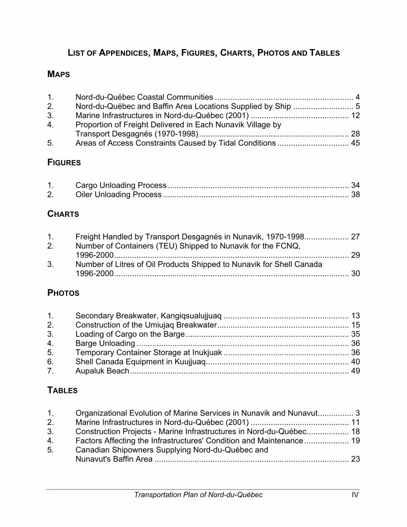
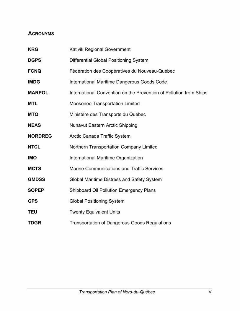
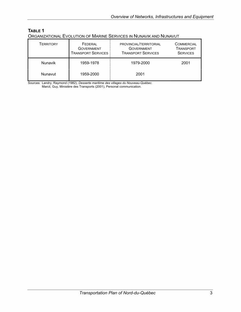
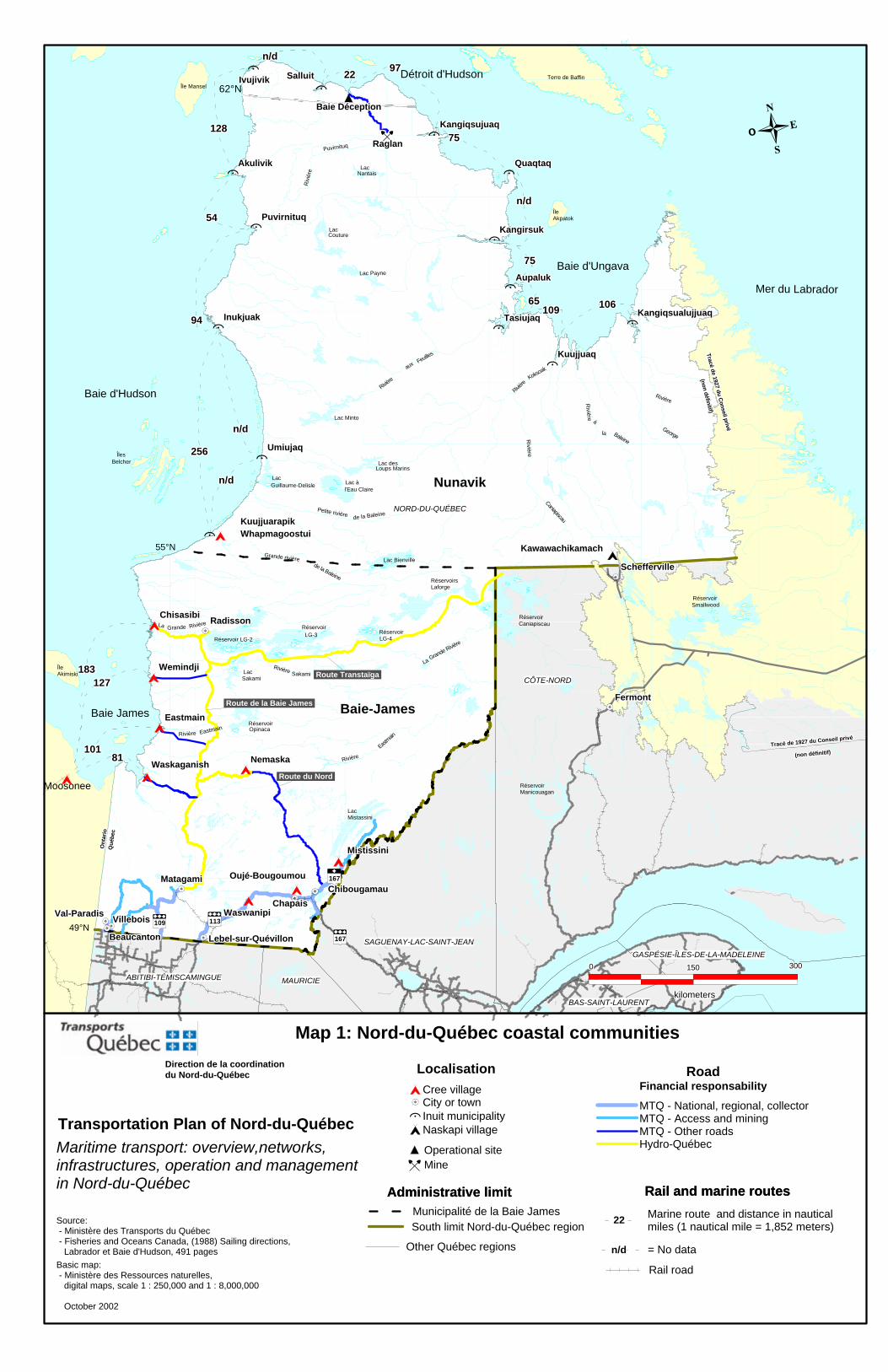
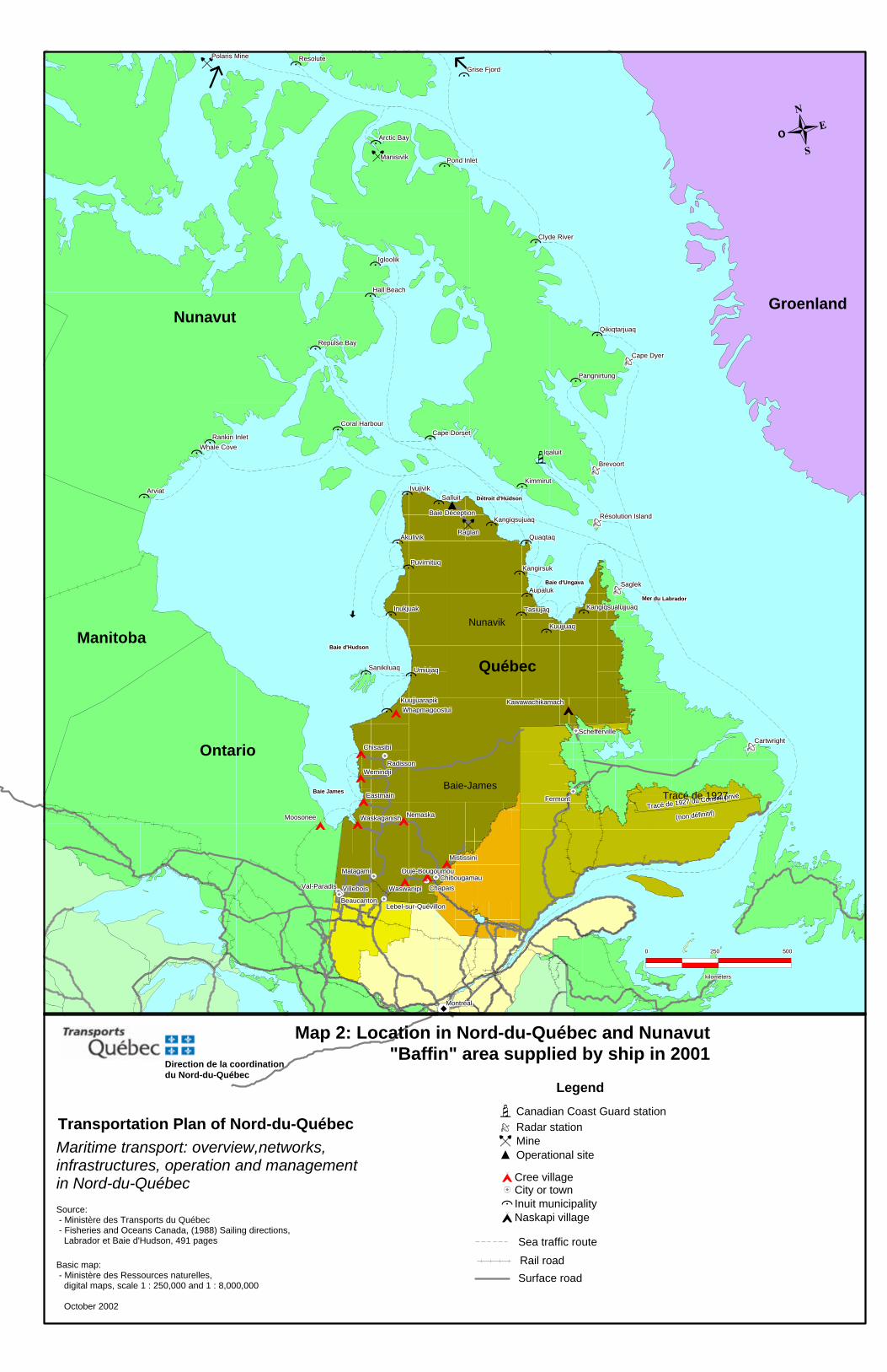
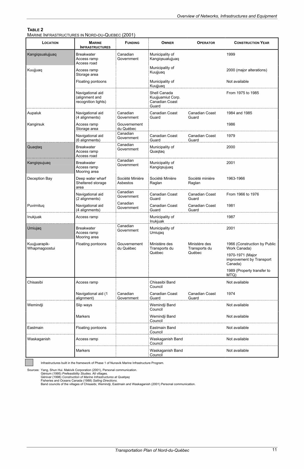
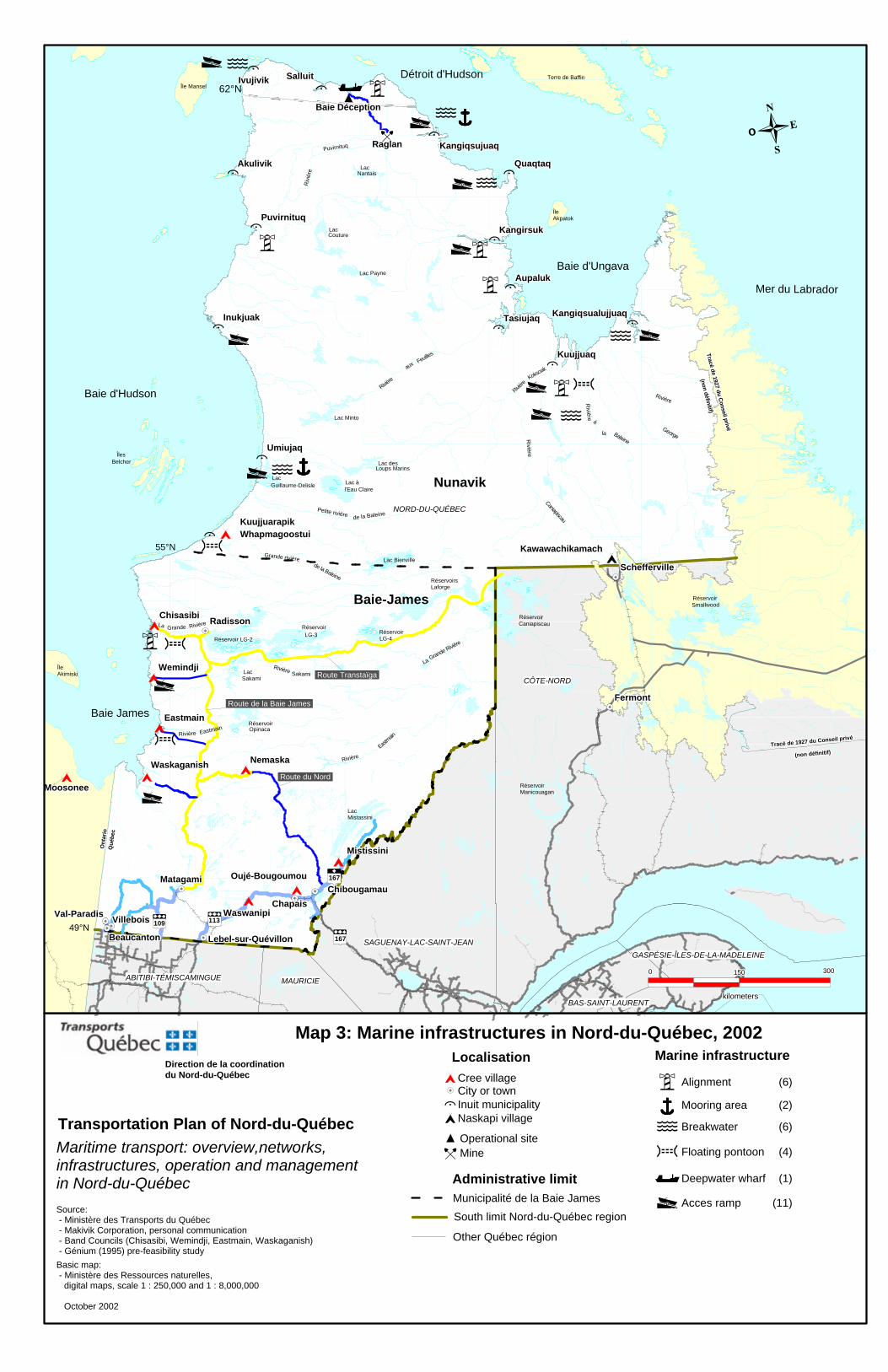

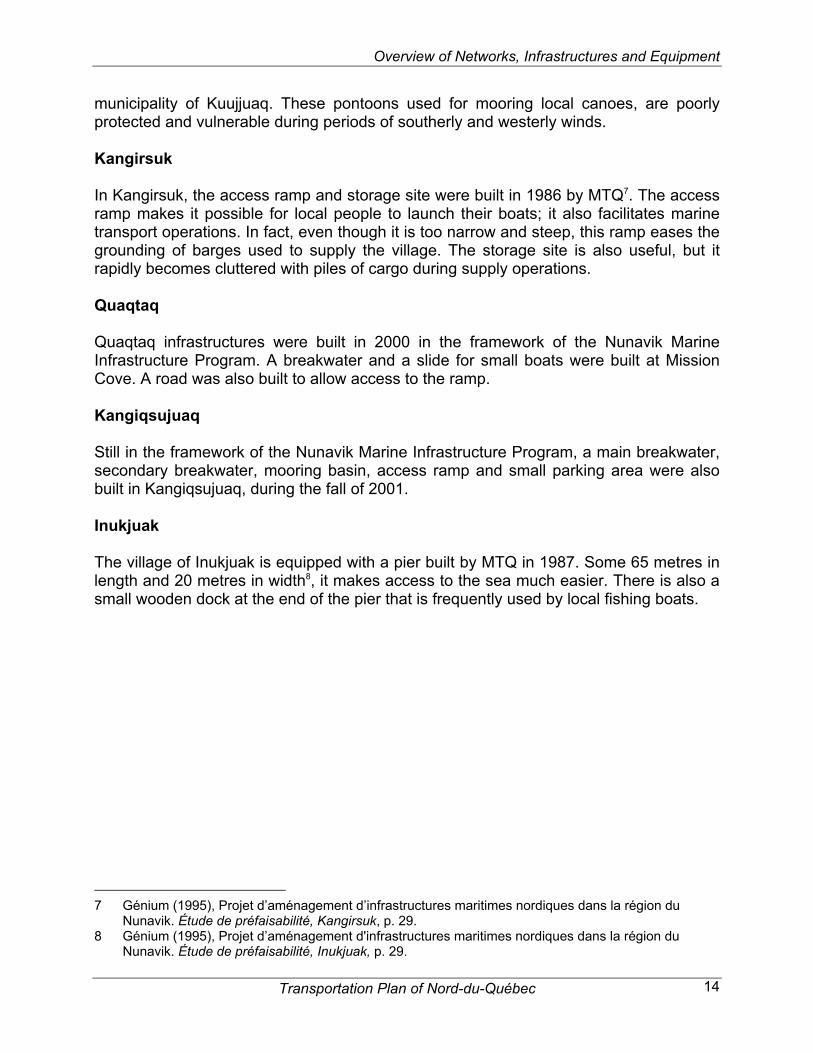
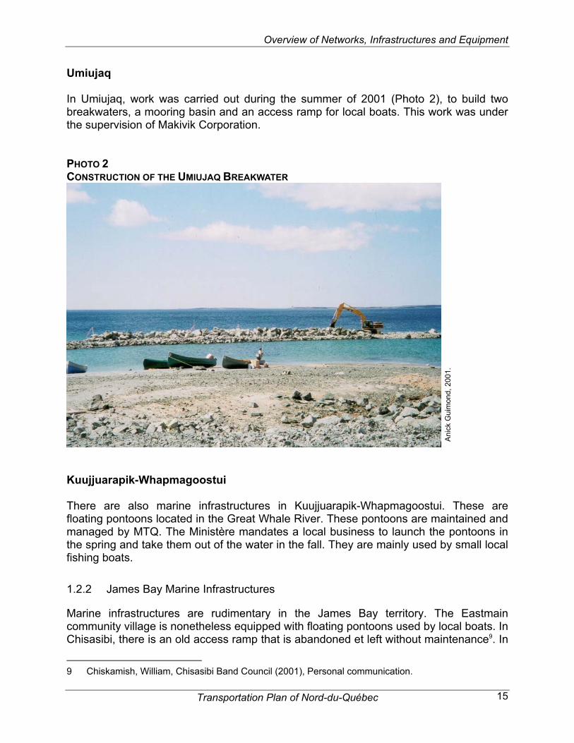
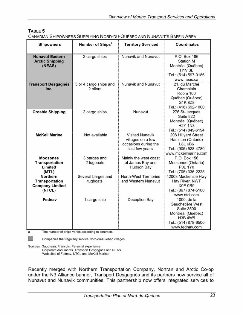
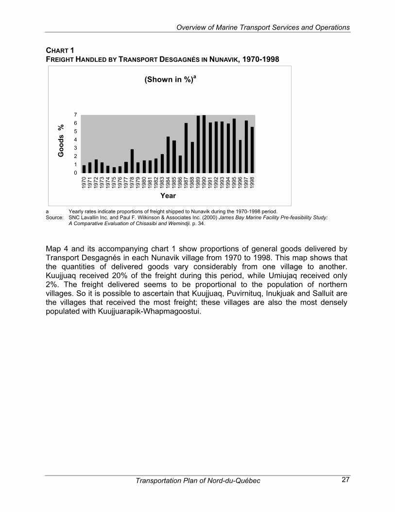
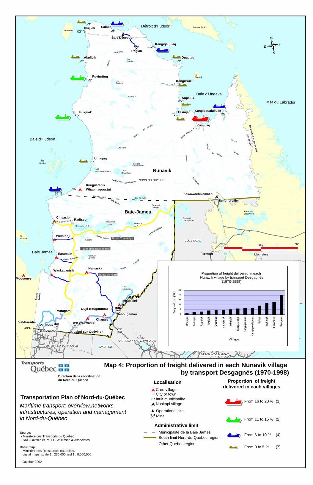
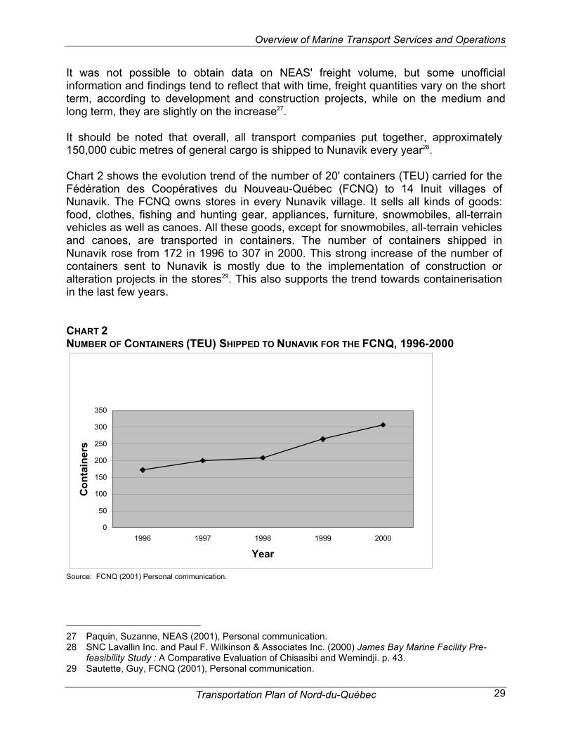
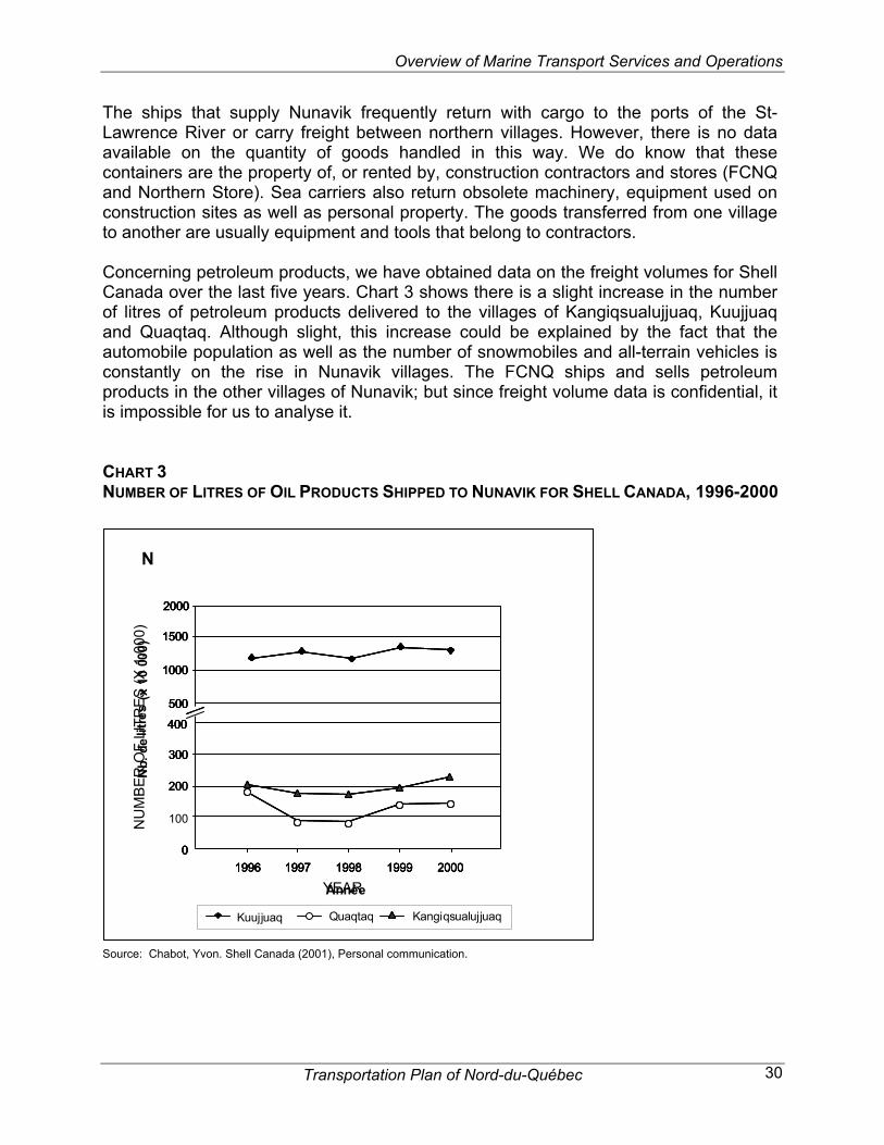
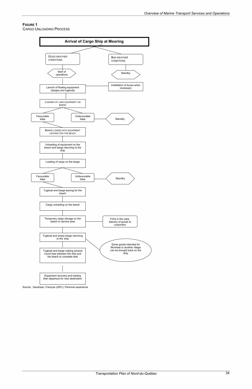
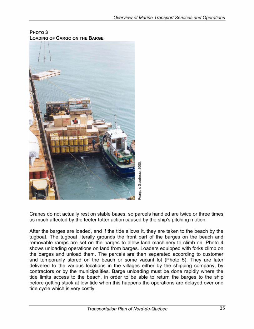
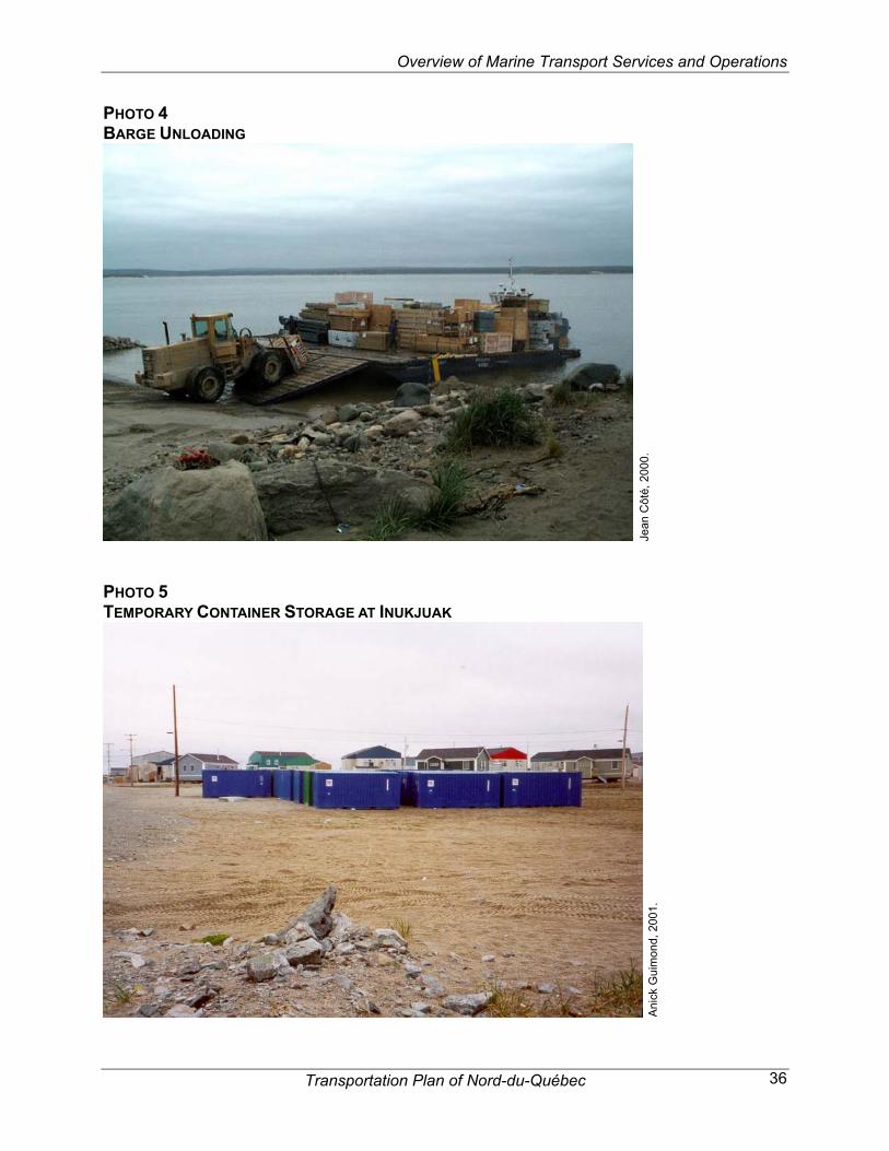
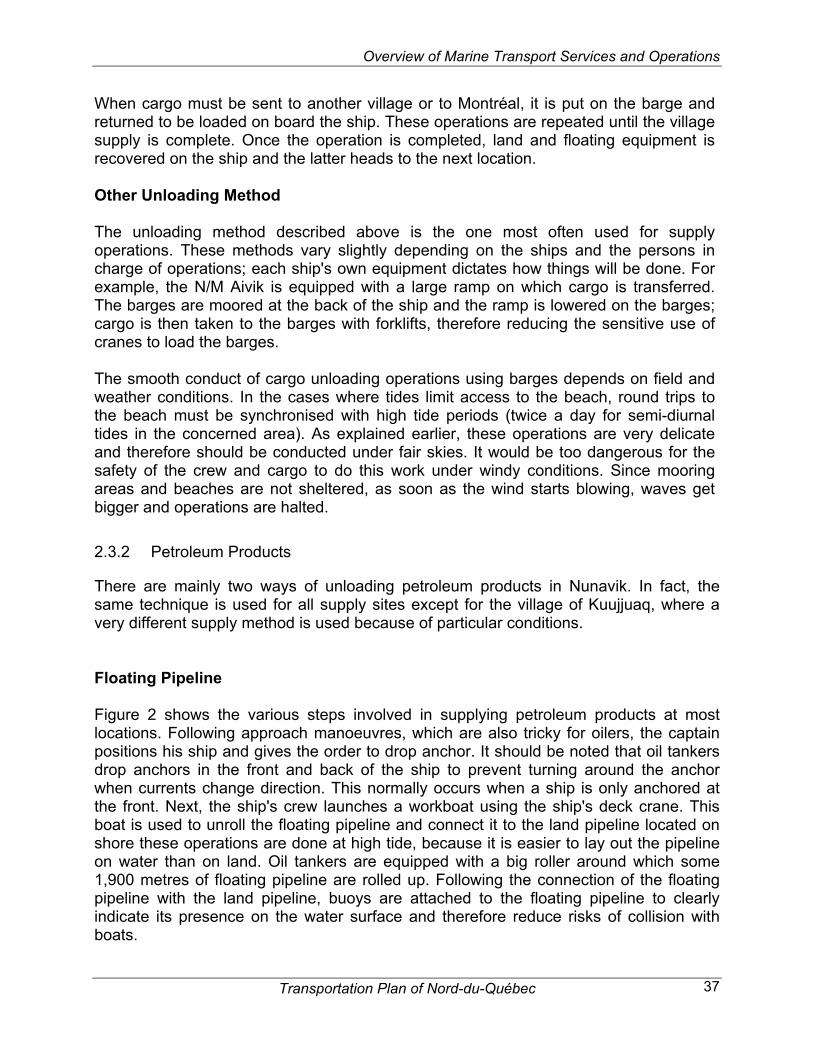
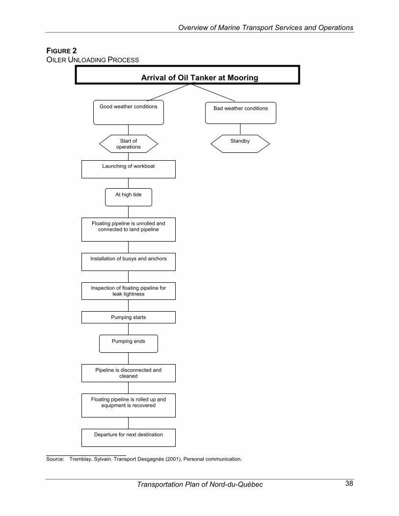

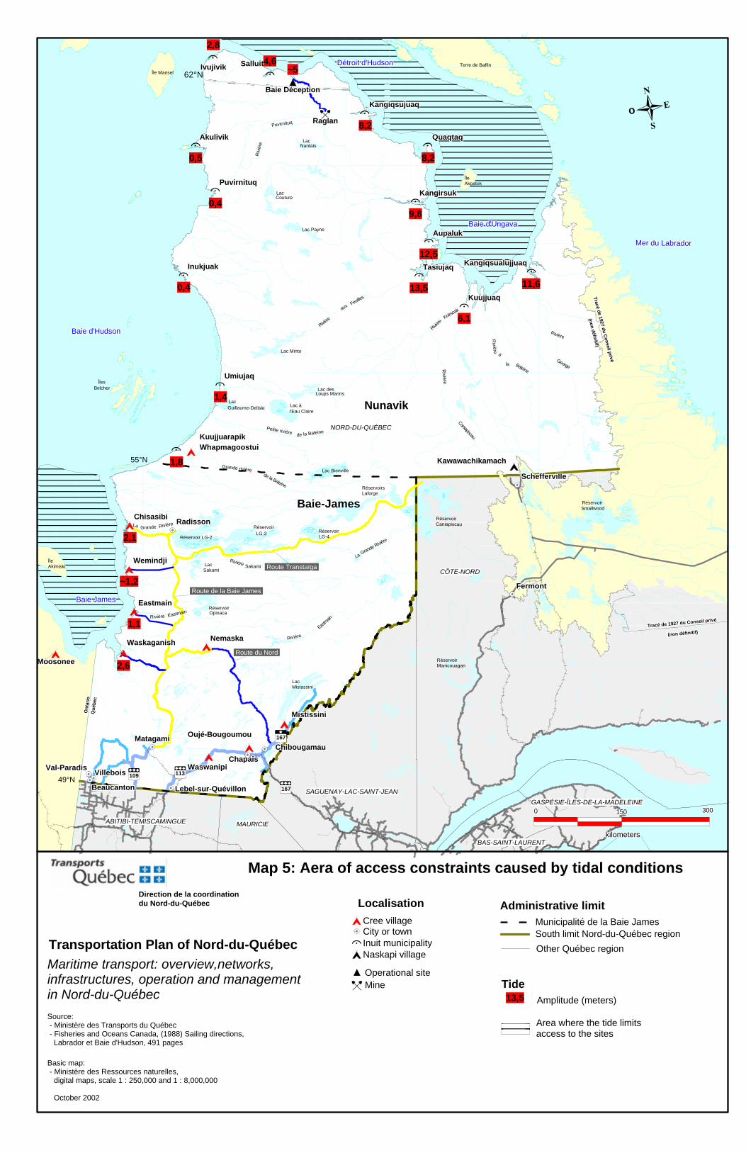
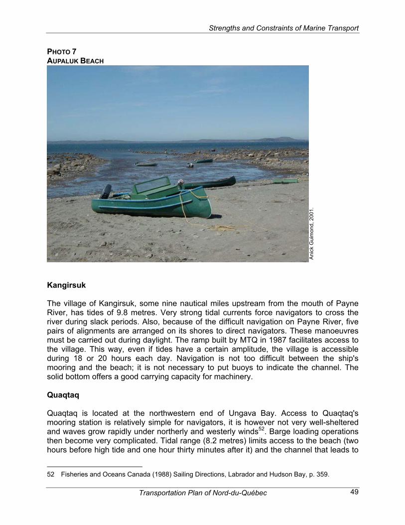


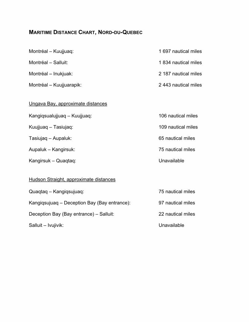
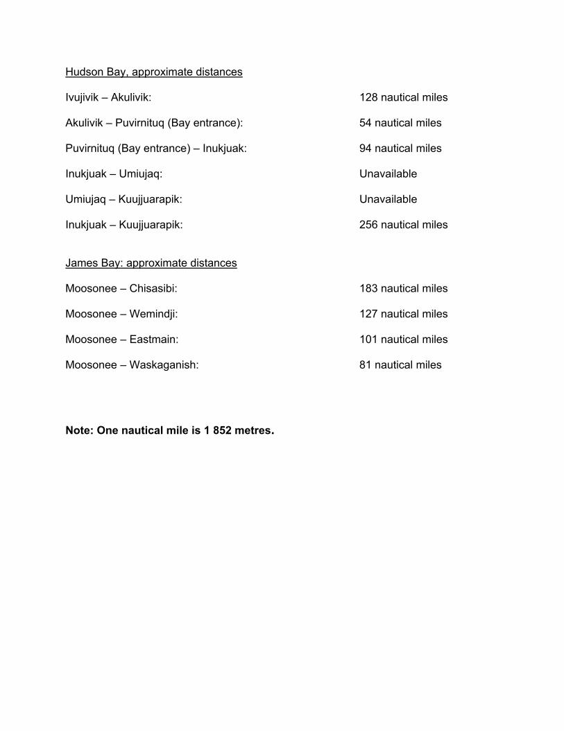

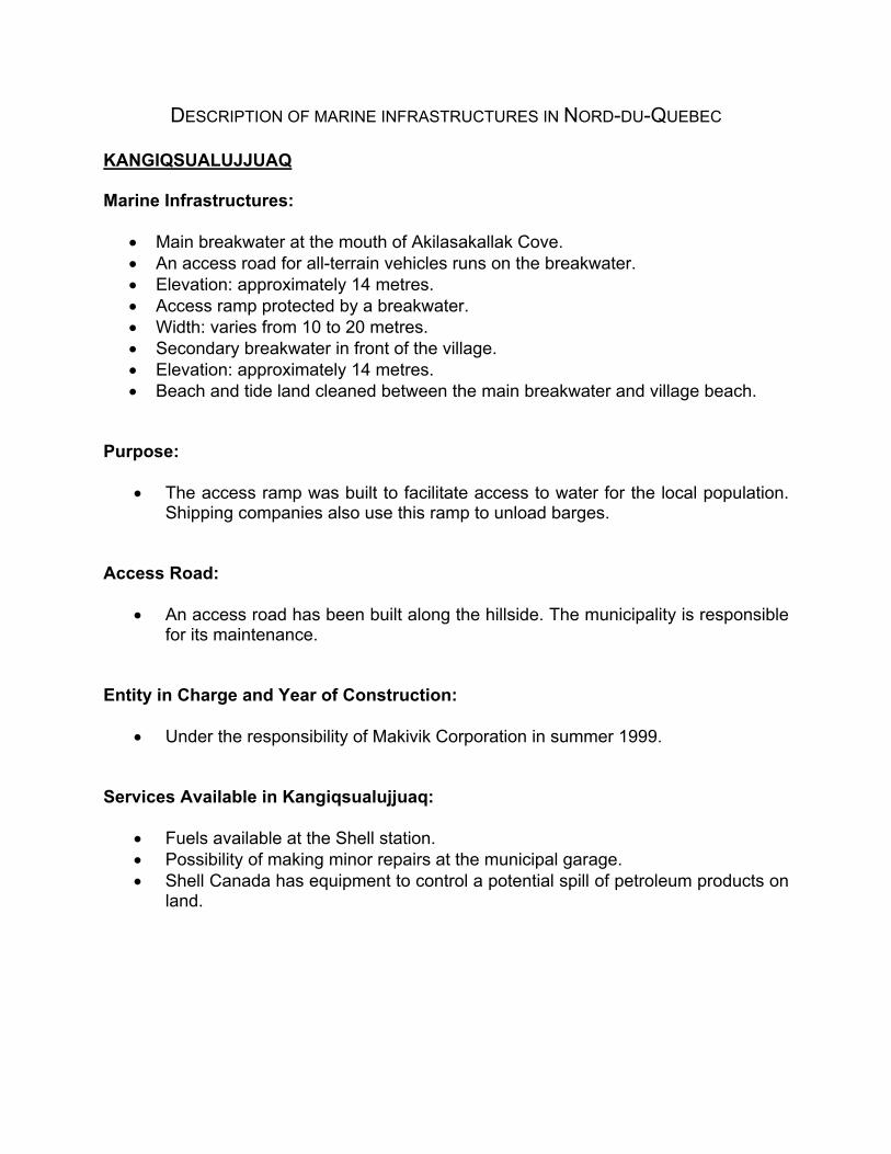
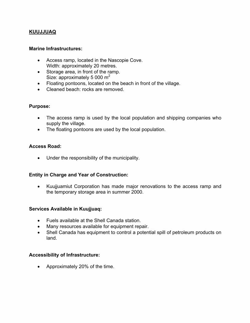
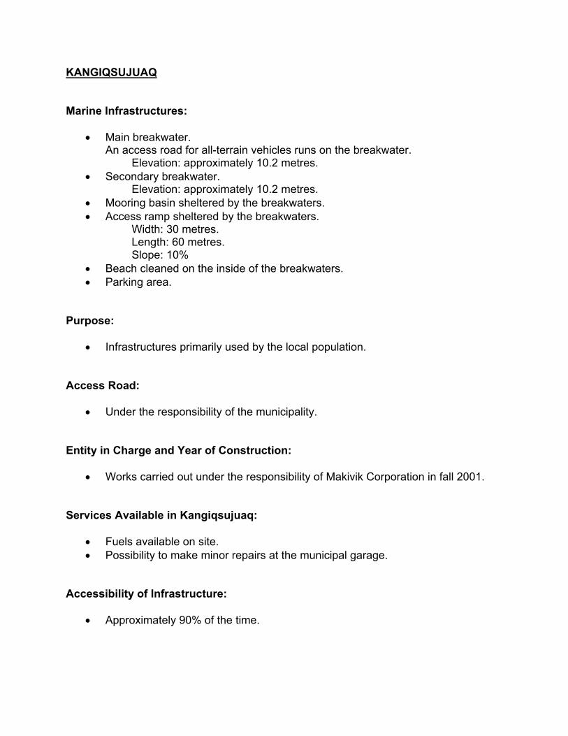

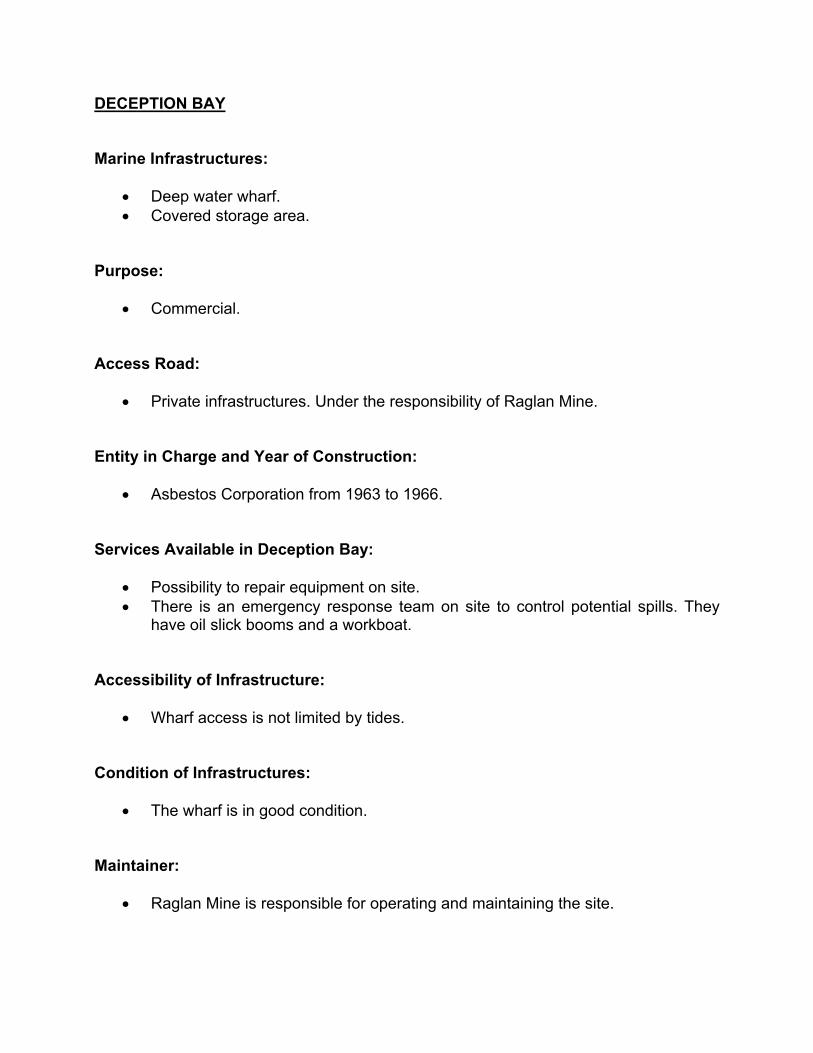
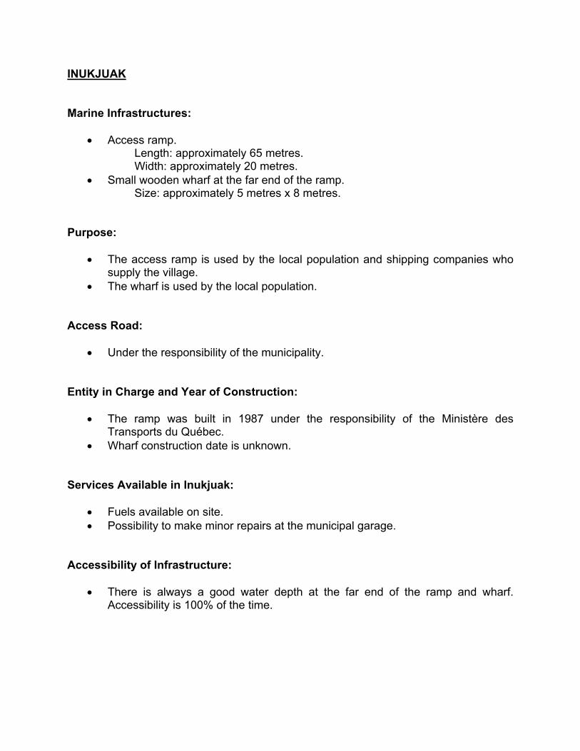

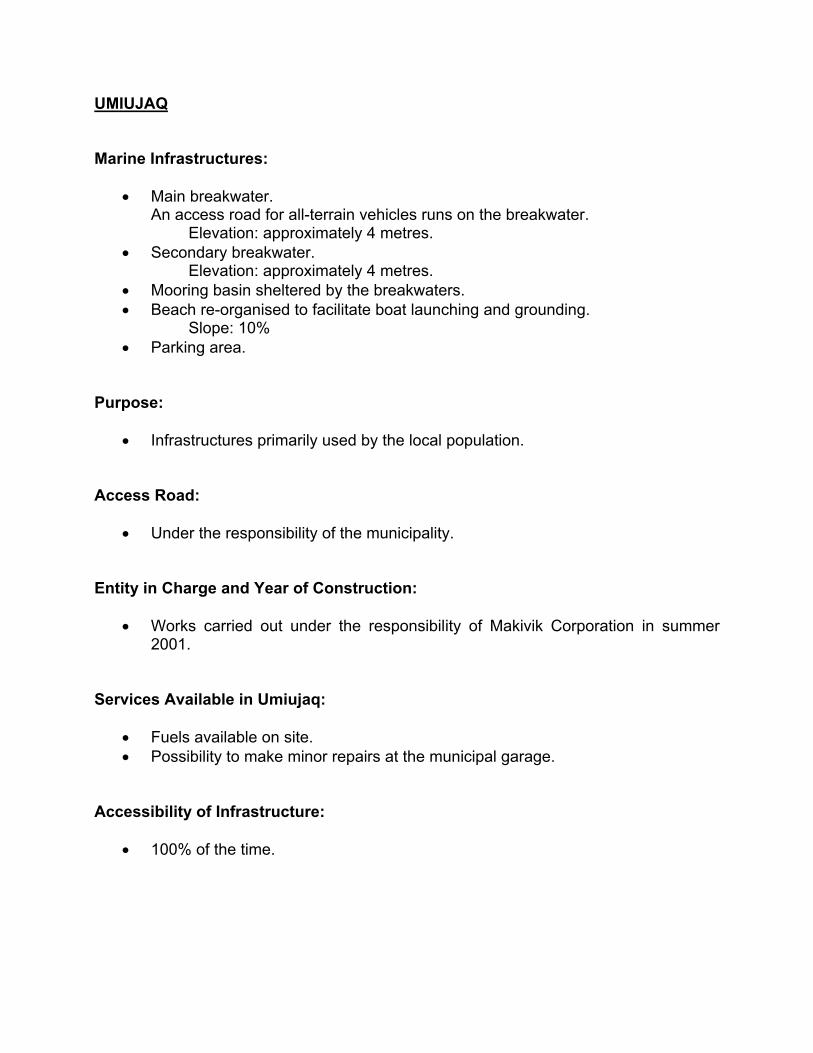

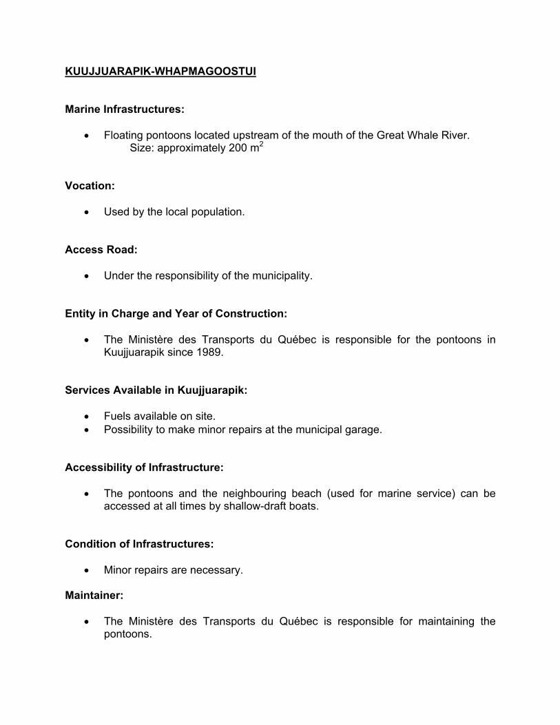
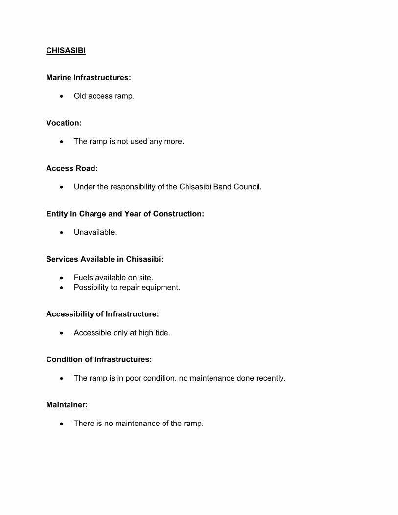
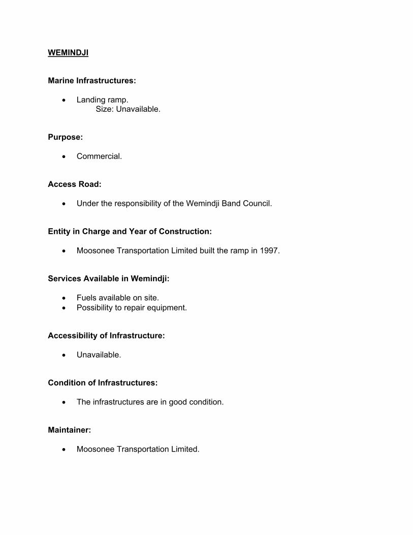
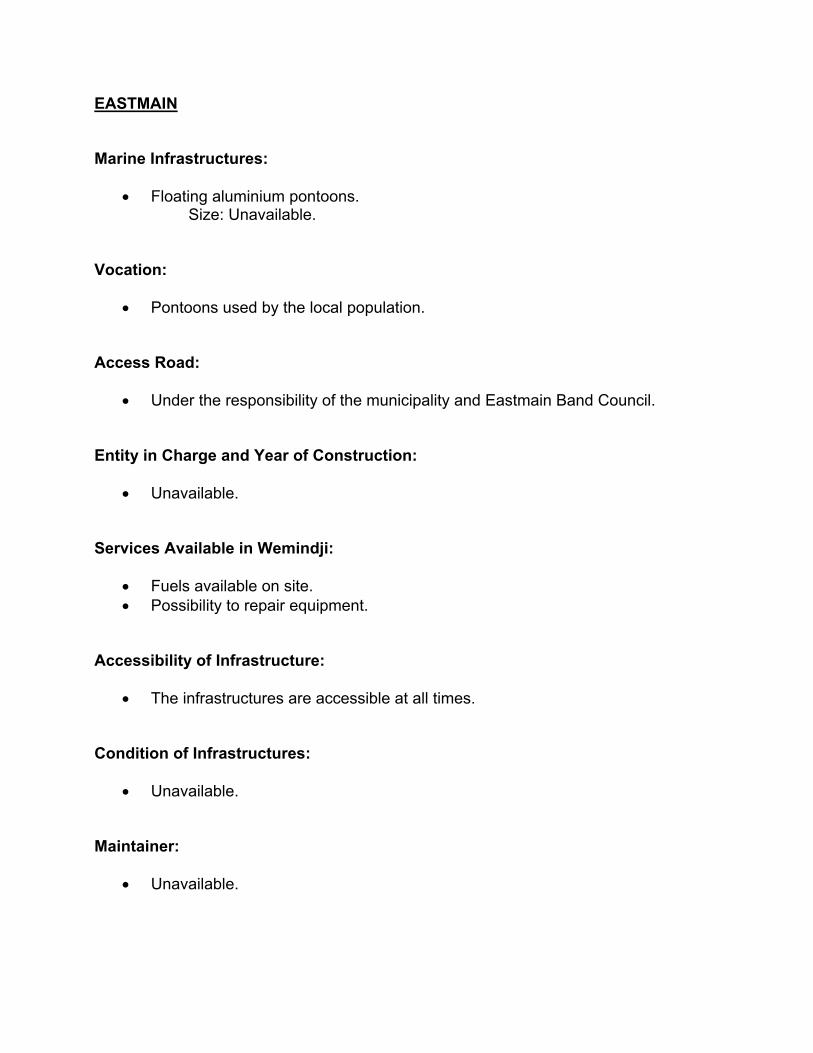
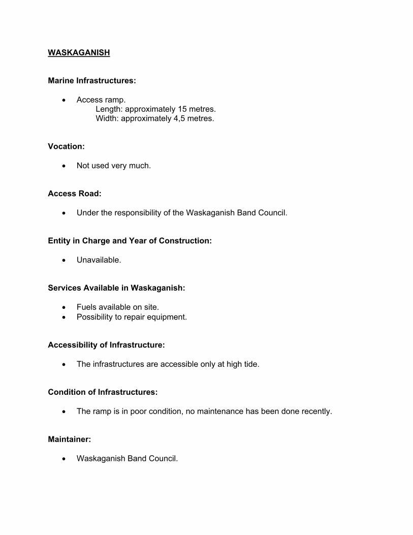

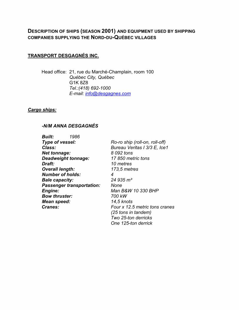
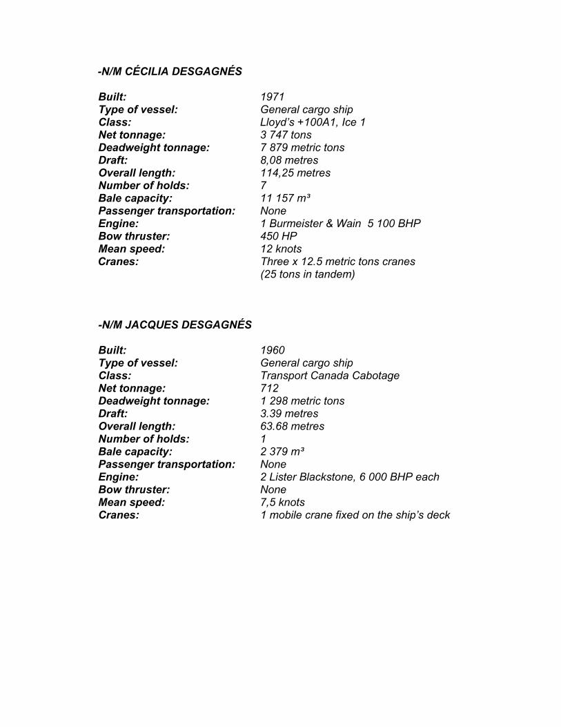
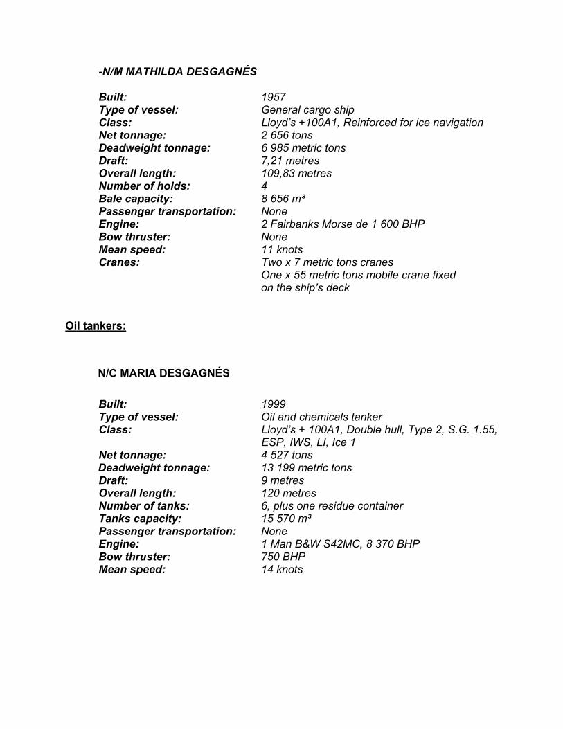
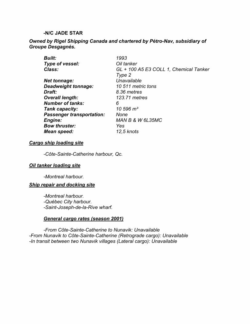

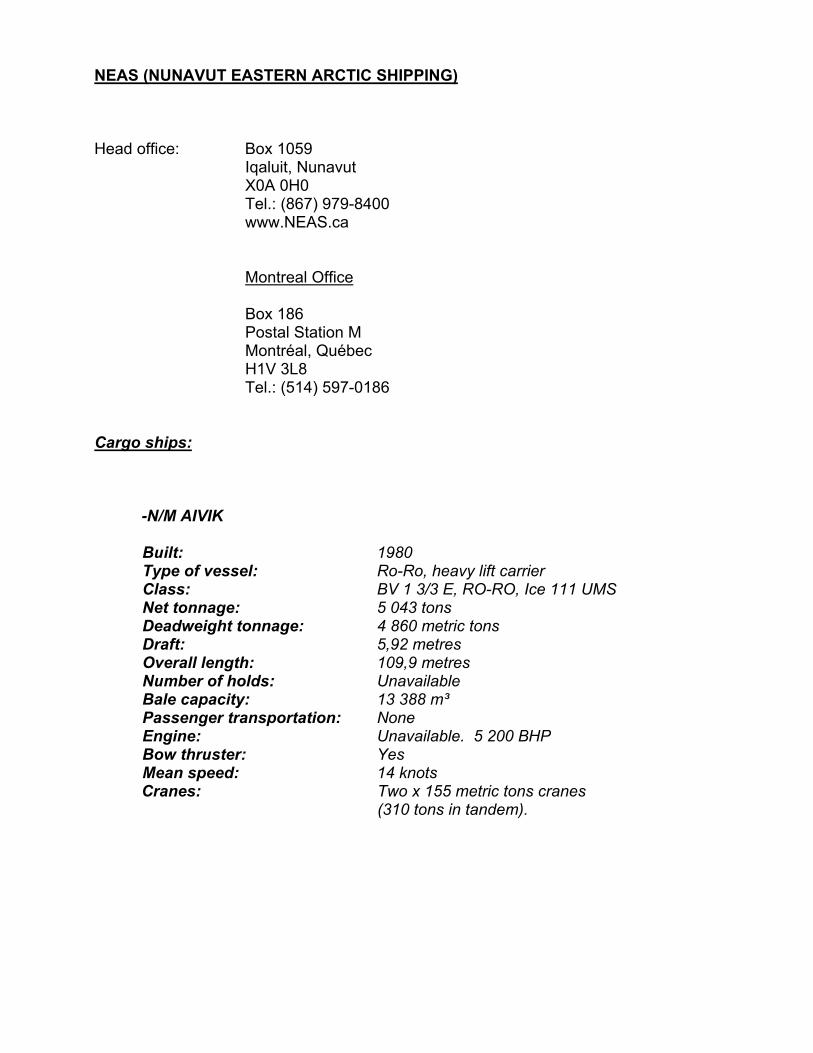
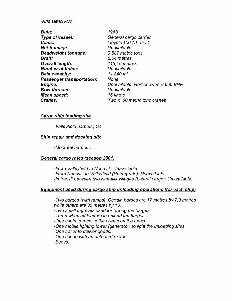
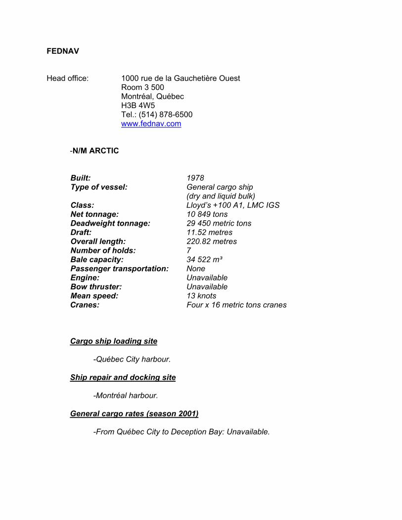

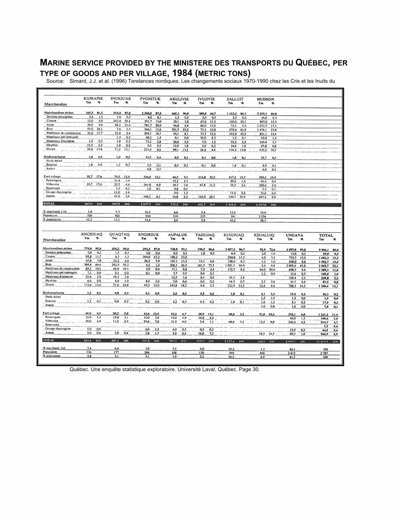

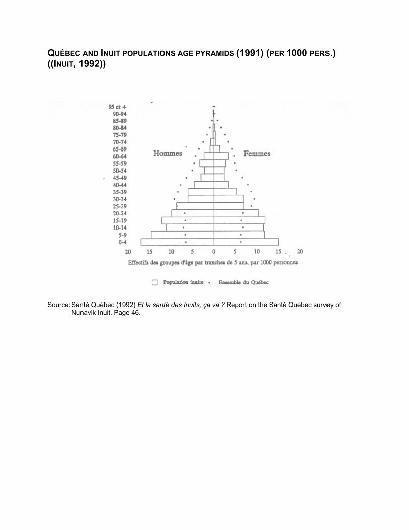

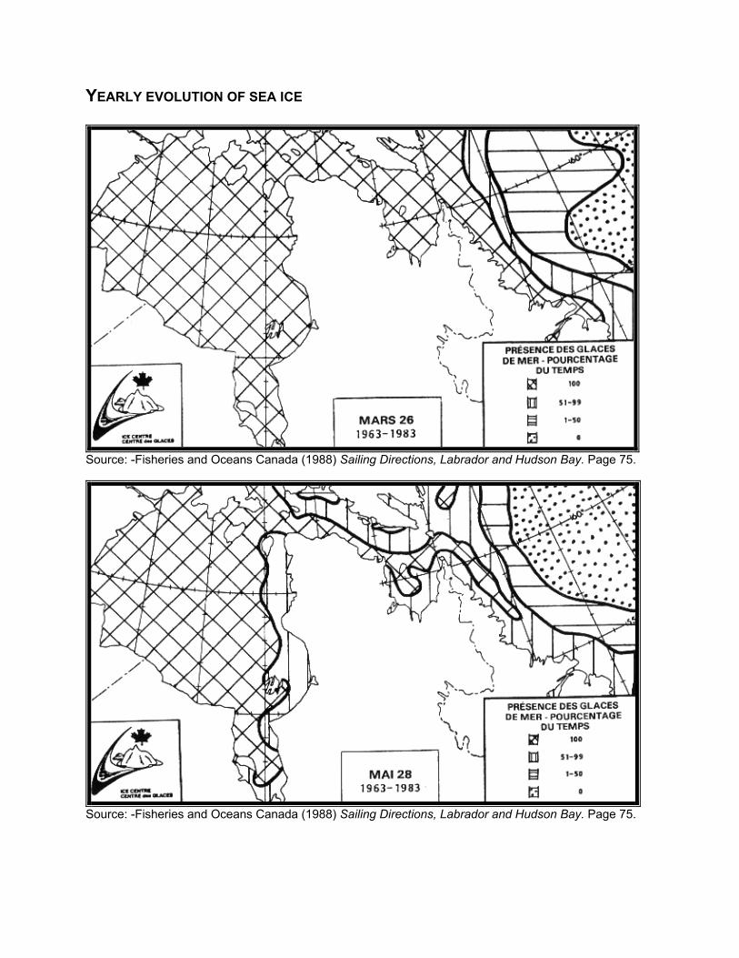
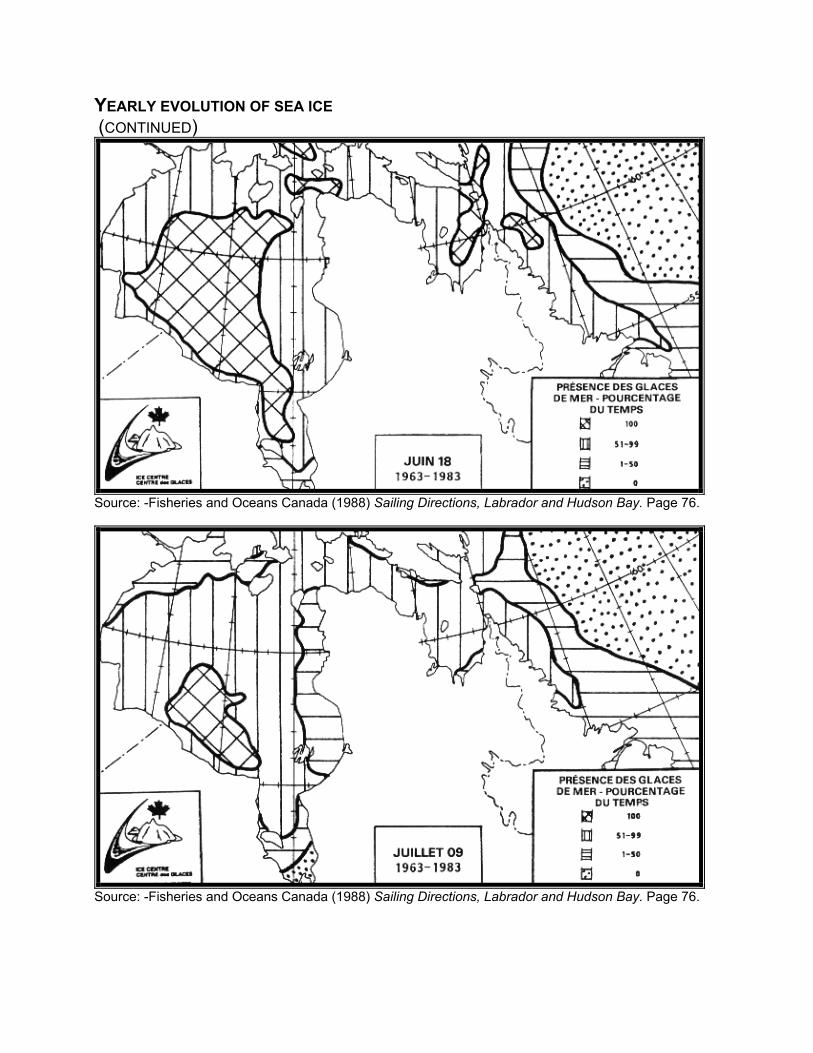
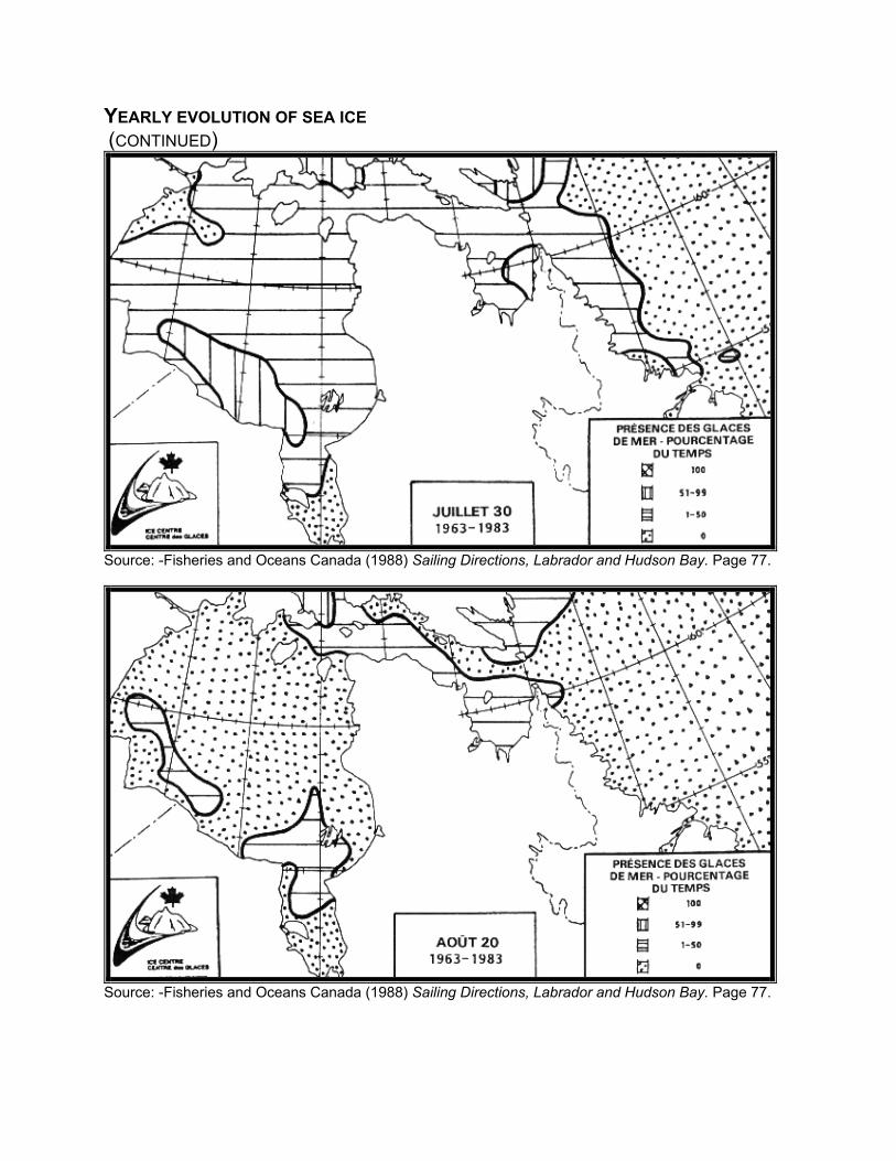
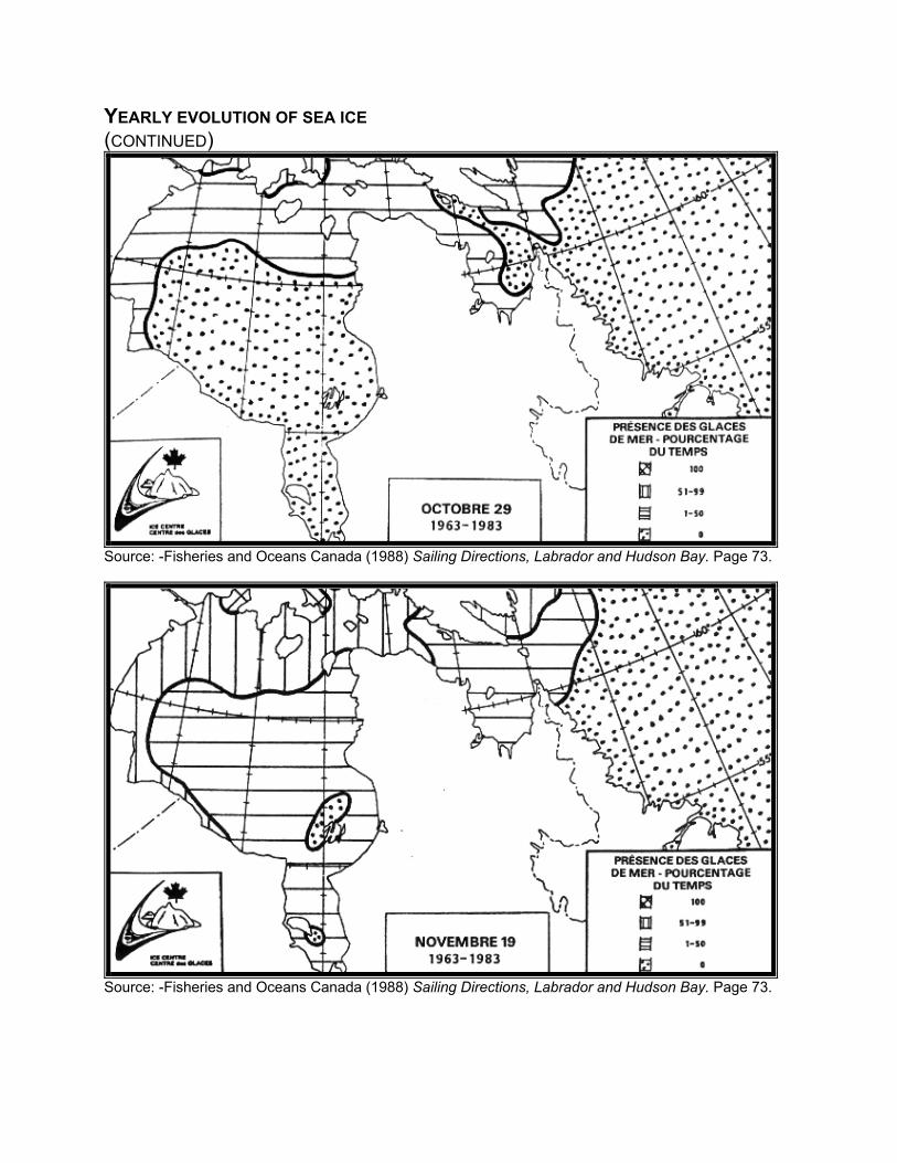
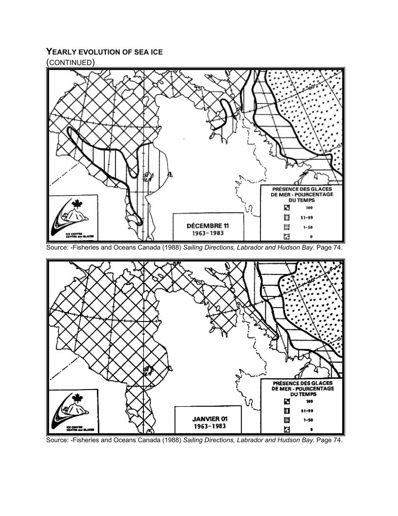

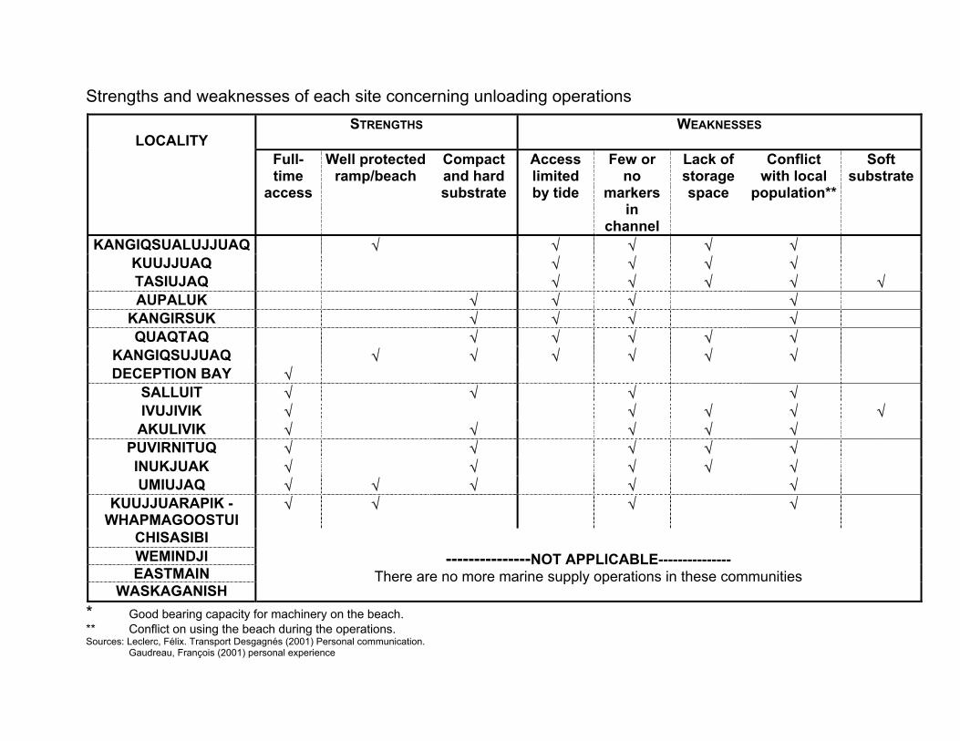


![CartemotoneigeSagLac2014-15 [Unlocked by ] sentier lac st-jean.pdf · 6.6 trans-quÉbec 83 trans-quÉbec 93 trans-quÉbec 93 trans-quÉbec 93 trans-quÉbec 93 trans-quÉbec 93 trans-quÉbec](https://img.pdfslide.us/doc/110x75/5b2cb5eb7f8b9ac06e8b5a01/cartemotoneigesaglac2014-15-unlocked-by-sentier-lac-st-jeanpdf-66-trans-quebec.jpg)