Embed Size (px)
Citation preview
Members
Todd Gloria, Chair Councilmember City of San Diego
Mary Salas, Vice Chair Mayor, Chula Vista (Representing South County)
Ron Roberts, Supervisor County of San Diego
Mary Sessom Mayor, Lemon Grove (Representing East County)
Harry Mathis, Chair Metropolitan Transit System
Lisa Shaffer Councilmember, Encinitas (Representing North County Coastal)
Judy Ritter Mayor, Vista (Representing North County Inland)
Rebecca Jones, Vice Chair North County Transit District
David Alvarez San Diego County Regional Airport Authority
Alternates
Mark Kersey, Councilmember City of San Diego
Michael Woiwode Councilmember, Coronado (Representing South County)
Bill Horn, Chair County of San Diego
Greg Cox, Supervisor County of San Diego
Bill Baber Councilmember, La Mesa (Representing East County)
Lorie Bragg Metropolitan Transit System
Mike Nichols Councilmember, Solana Beach (Representing North County Coastal)
Sam Abed Mayor, Escondido (Representing North County Inland)
Bill Horn / John Aguilera North County Transit District
Lloyd Hubbs San Diego County Regional Airport Authority
Advisory Members
Laurie Berman / Bill Figge District 11, Caltrans
Raymond Hunter, Sr. (Jamul) Allen Lawson (San Pasqual) Southern California Tribal Chairmen’s Association
Gary L. Gallegos Executive Director, SANDAG
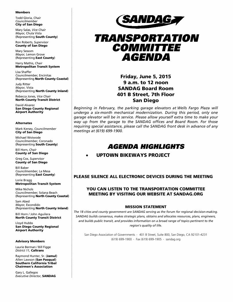
TRANSPORTATION COMMITTEE
AGENDA
Friday, June 5, 2015 9 a.m. to 12 noon
SANDAG Board Room 401 B Street, 7th Floor
San Diego Beginning in February, the parking garage elevators at Wells Fargo Plaza will undergo a six-month mechanical modernization. During this period, only one garage elevator will be in service. Please allow yourself extra time to make your way up from the garage to the SANDAG offices and Board Room. For those requiring special assistance, please call the SANDAG front desk in advance of any meetings at (619) 699-1900.
AGENDA HIGHLIGHTS • UPTOWN BIKEWAYS PROJECT
PLEASE SILENCE ALL ELECTRONIC DEVICES DURING THE MEETING
YOU CAN LISTEN TO THE TRANSPORTATION COMMITTEE MEETING BY VISITING OUR WEBSITE AT SANDAG.ORG
MISSION STATEMENT The 18 cities and county government are SANDAG serving as the forum for regional decision-making.
SANDAG builds consensus, makes strategic plans, obtains and allocates resources, plans, engineers,
and builds public transit, and provides information on a broad range of topics pertinent to the
region's quality of life.
San Diego Association of Governments ⋅ 401 B Street, Suite 800, San Diego, CA 92101-4231
(619) 699-1900 ⋅ Fax (619) 699-1905 ⋅ sandag.org
2 Rev. 022315
Welcome to SANDAG. Members of the public may speak to the Transportation Committee on any item at the time the Committee is considering the item. Please complete a Speaker’s Slip, which is located in the rear of the room, and then present the slip to the Clerk of the Committee seated at the front table. Members of the public may address the Committee on any issue under the agenda item entitled Public Comments/Communications/Member Comments. Public speakers are limited to three minutes or less per person. The Transportation Committee may take action on any item appearing on the agenda. Public comments regarding the agenda can be sent to SANDAG via [email protected]. Please include the agenda item, your name, and your organization. Email comments should be received no later than 12 noon, two working days prior to the Transportation Committee meeting. Any handouts, presentations, or other materials from the public intended for distribution at the Transportation Committee meeting should be received by the Clerk of the Committee no later than 12 noon, two working days prior to the meeting. In order to keep the public informed in an efficient manner and facilitate public participation, SANDAG also provides access to all agenda and meeting materials online at www.sandag.org/meetings. Additionally, interested persons can sign up for e-notifications via our e-distribution list at either the SANDAG website or by sending an email request to [email protected]. SANDAG operates its programs without regard to race, color, and national origin in compliance with Title VI of the Civil Rights Act. SANDAG has developed procedures for investigating and tracking Title VI complaints and the procedures for filing a complaint are available to the public upon request. Questions concerning SANDAG nondiscrimination obligations or complaint procedures should be directed to SANDAG General Counsel, John Kirk, at (619) 699-1997 or [email protected]. Any person who believes himself or herself or any specific class of persons to be subjected to discrimination prohibited by Title VI also may file a written complaint with the Federal Transit Administration. In compliance with the Americans with Disabilities Act (ADA), SANDAG will accommodate persons who require assistance in order to participate in SANDAG meetings. If such assistance is required, please contact SANDAG at (619) 699-1900 at least 72 hours in advance of the meeting. To request this document or related reports in an alternative format, please call (619) 699-1900, (619) 699-1904 (TTY), or fax (619) 699-1905. SANDAG agenda materials can be made available in alternative languages. To make a request call (619) 699-1900 at least 72 hours in advance of the meeting.
Los materiales de la agenda de SANDAG están disponibles en otros idiomas. Para hacer una solicitud, llame al (619) 699-1900 al menos 72 horas antes de la reunión.
如有需要, 我们可以把SANDAG议程材料翻译成其他語言.
请在会议前至少 72 小时打电话 (619) 699-1900 提出请求.
SANDAG offices are accessible by public transit. Phone 511 or see 511sd.com for route information. Bicycle parking is available in the parking garage of the SANDAG offices.
3
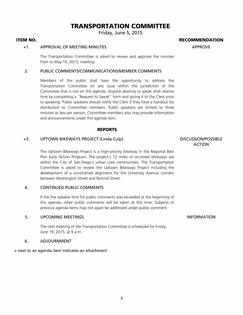
TRANSPORTATION COMMITTEE Friday, June 5, 2015
ITEM NO. RECOMMENDATION
+1. APPROVAL OF MEETING MINUTES APPROVE
The Transportation Committee is asked to review and approve the minutes from its May 15, 2015, meeting.
2. PUBLIC COMMENTS/COMMUNICATIONS/MEMBER COMMENTS
Members of the public shall have the opportunity to address the Transportation Committee on any issue within the jurisdiction of the Committee that is not on this agenda. Anyone desiring to speak shall reserve time by completing a “Request to Speak” form and giving it to the Clerk prior to speaking. Public speakers should notify the Clerk if they have a handout for distribution to Committee members. Public speakers are limited to three minutes or less per person. Committee members also may provide information and announcements under this agenda item.
REPORTS
+3. UPTOWN BIKEWAYS PROJECT (Linda Culp) DISCUSSION/POSSIBLE ACTION
The Uptown Bikeways Project is a high-priority bikeway in the Regional Bike Plan Early Action Program. The project’s 12 miles of on-street bikeways are within the City of San Diego’s urban core communities. The Transportation Committee is asked to review the Uptown Bikeways Project including the development of a constrained alignment for the University Avenue corridor between Washington Street and Normal Street.
4. CONTINUED PUBLIC COMMENTS
If the five speaker limit for public comments was exceeded at the beginning of this agenda, other public comments will be taken at this time. Subjects of previous agenda items may not again be addressed under public comment.
5. UPCOMING MEETINGS INFORMATION
The next meeting of the Transportation Committee is scheduled for Friday, June 19, 2015, at 9 a.m.
6. ADJOURNMENT
+ next to an agenda item indicates an attachment
TRANSPORTATION COMMITTEE
AGENDA ITEM NO. 15-06-1 JUNE 5, 2015 ACTION REQUESTED – APPROVE
TRANSPORTATION COMMITTEE DISCUSSION AND ACTIONS
MAY 15, 2015
The meeting of the Transportation Committee was called to order by Chair Todd Gloria (City of San Diego) at 9:01 a.m. See the attached attendance sheet for Transportation Committee member attendance.
1. APPROVAL OF MEETING MINUTES
Action: Upon a motion by Mayor Sam Abed (North County Inland), and a second by Councilmember Lisa Shaffer (North County Coastal), the Transportation Committee approved the meeting minutes of April 17, 2015. Yes – Chair Gloria, Councilmember Bill Baber (East County), Chair Harry Mathis (Metropolitan Transit System [MTS]), Councilmember Shaffer, Mayor Abed, and Vice Chair Rebecca Jones (North County Transit District [NCTD]). No - None. Abstain –None. Absent – South County, County of San Diego, and San Diego County Regional Airport Authority (SDCRAA).
2. PUBLIC COMMENTS/COMMUNICATIONS/MEMBER COMMENTS
John Wotzka, a member of the public, submitted written comments and spoke about various transportation issues.
Chair Gloria announced the birth of Damiana Chuma and congratulated Gary Gallegos, Executive Director, on becoming a grandfather.
Chair Gloria reminded the Transportation Committee members that Bike to Work day is postponed to Friday, May 29, 2015.
Councilmember Shaffer presented a Proclamation to SANDAG, which proclaimed the month of May as Bike to Work Month in the City of Encinitas.
CONSENT
3. TransNet ENVIRONMENTAL MITIGATION PROGRAM: LAND MANAGEMENT GRANT PROGRAMQUARTERLY STATUS UPDATE (INFORMATION)
This report provided information on the quarterly status of active projects.
Action: This item was presented for information.
REPORTS 4. 2014 REGIONAL TRANSPORTATION IMPROVEMENT PROGRAM: AMENDMENT NO. 4 –
ADMINISTRATIVE MODIFICATION (APPROVE) Michelle Smith, Associate Financial Analyst, presented the item. Amendment No. 4 is a special amendment to program federal funding that will need to be obligated this federal fiscal year. Action: Upon a motion by Supervisor Ron Roberts (County of San Diego), and a second by Vice Chair Mary Salas (South County), the Transportation Committee approved Amendment No. 4 - Administrative Modification to the 2014 RTIP. Yes – Chair Gloria, Vice Chair Salas, Supervisor Roberts, Mayor Mary Sessom (East County), MTS Chair Mathis, Councilmember Shaffer, Mayor Abed, NCTD Vice Chair Jones, and Councilmember David Alvarez (SDCRAA). No - None. Abstain –None. Absent – None. 5. TRANSPORTATION DEVELOPMENT ACT CLAIM AMENDMENTS (APPROVE) Lisa Kondrat-Dauphin, Senior Accountant, presented the item. The FY 2014 Transportation Development Act (TDA) compliance audits identified unexpended funds from completed projects for the Cities of Carlsbad and San Marcos that are to be returned to the Local Transportation Fund. A subsequent review of unused balances identified additional completed projects from several cities, the County of San Diego, and SANDAG. Action: Upon a motion by NCTD Vice Chair Jones, and a second by Councilmember Shaffer, the Transportation Committee adopted Resolution No. 2015-28, approving revisions to TDA Article 3.0 claims for various completed bicycle and pedestrian projects. Yes – Chair Gloria, Vice Chair Salas, Supervisor Roberts, Mayor Sessom, MTS Chair Mathis, Councilmember Shaffer, Mayor Abed, NCTD Vice Chair Jones, and Councilmember Alvarez. No - None. Abstain –None. Absent – None. 6. PROPOSED CONSTRUCTION MANAGER/GENERAL CONTRACTOR (CMGC) DELIVERY METHOD:
INTERSTATE 5/VOIGT BRIDGE AND COASTAL RAIL TRAIL SAN DIEGO:ROSE CREEK PROJECTS (RECOMMEND)
John Haggerty, Division Director of Rail, presented the item. Action: Upon a motion by Supervisor Roberts, and a second by Vice Chair Salas, the Transportation Committee recommended that the Board of Directors: (1) approve Resolution Nos. 2015-29 and 2015-30, authorizing the use of the CMGC construction delivery method for the Interstate 5/ Voigt Drive Bridge and Street Realignment and Coastal Rail Trail San Diego: Rose Creek Projects; and (2) authorize the Executive Director to negotiate and award the Preconstruction Services Contract for these Projects to Mid Coast Transit Constructors in coordination with the Mid-Coast Corridor Transit Project. Yes – Chair Gloria, Vice Chair Salas, Supervisor Roberts, Mayor Sessom, MTS Chair Mathis, Councilmember Shaffer, Mayor Abed, NCTD Vice Chair Jones, and Councilmember Alvarez. No - None. Abstain –None. Absent – None.
2
7. REGIONAL PRIORITIZATION OF FY 2014-2015 CAP-AND-TRADE: AFFORDABLE HOUSING AND SUSTAINABLE COMMUNITIES PROGRAM (RECOMMEND)
Charles “Muggs” Stoll, Land Use and Transportation Planning Director, presented the item. Carlos Aguirre, Community Development Program Manager, City of National City, spoke about the Westside Infill Transit-Oriented Development and asked the Transportation Committee to approve staff’s recommendation. Blake Hopkins, Project Manager, AMCAL Housing, spoke about the Villa Encantada Apartments asked the Transportation Committee to approve staff’s recommendation. Mary Jane Jagodzinsky, Community Housing Works, spoke about the Westside Infill Transit-Oriented Development and asked the Transportation Committee to approve staff’s recommendation. Ms. Jagodzinsky also addressed concerns related to the ranking criteria categories B1, B2, 4 and 5. Carolina Martinez, Environmental Health Coalition, spoke about the Westside Infill Transit-Oriented Development and submitted a fact sheet about the project. Action: Upon a motion by Mayor Abed, and a second by Supervisor Roberts, the Transportation Committee recommended that the Board of Directors approve the regional prioritization of the applications for the AHSC Program from the San Diego region. Yes – Chair Gloria, Vice Chair Salas, Supervisor Roberts, Mayor Sessom, MTS Chair Mathis, Councilmember Shaffer, Mayor Abed, NCTD Vice Chair Jones, and Councilmember Alvarez. No - None. Abstain –None. Absent – None.
8. FY 2016 TRANSPORTATION DEVELOPMENT ACT PRODUCTIVITY IMPROVEMENT
RECOMMENDATIONS (RECOMMEND)
Brian Lane, Senior Transit Planner, presented the item. Action: Upon a motion by Councilmember Shaffer, and a second by Vice Chair Salas, the Transportation Committee recommended that the Board of Directors find that the Metropolitan Transit System and North County Transit District made a reasonable effort to implement productivity improvements during FY 2015 and approve continuing this program in FY 2016, which fulfills the requirements outlined in Section 99244 of the TDA. Yes – Chair Gloria, Vice Chair Salas, Supervisor Roberts, Mayor Sessom, MTS Chair Mathis, Councilmember Shaffer, Mayor Abed, NCTD Vice Chair Jones, and Councilmember Alvarez. No - None. Abstain –None. Absent – None. 9. CONTINUED PUBLIC COMMENTS There were no additional public comments. 10. UPCOMING MEETINGS The next meeting of the Transportation Committee is scheduled for June 5, 2015, at 9 a.m. 11. ADJOURNMENT Chair Gloria adjourned the meeting at 10:05 a.m.
3
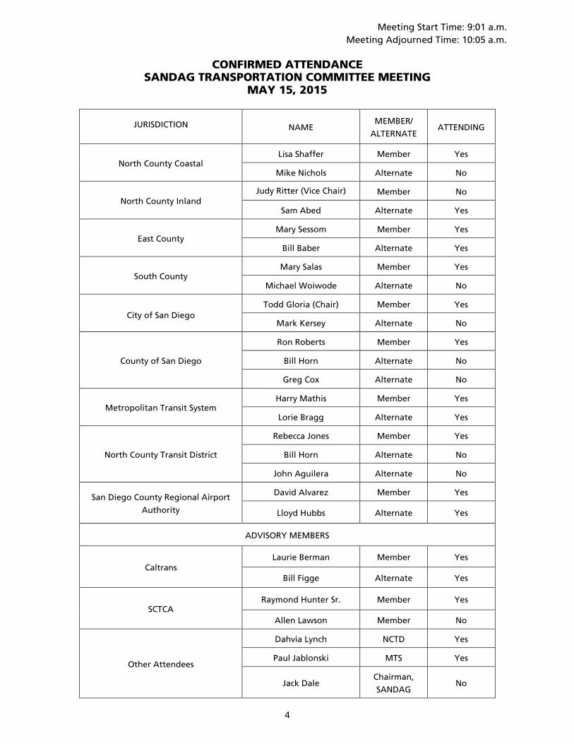
Meeting Start Time: 9:01 a.m. Meeting Adjourned Time: 10:05 a.m.
CONFIRMED ATTENDANCE
SANDAG TRANSPORTATION COMMITTEE MEETING MAY 15, 2015
JURISDICTION NAME MEMBER/
ALTERNATE ATTENDING
North County Coastal Lisa Shaffer Member Yes
Mike Nichols Alternate No
North County Inland Judy Ritter (Vice Chair) Member No
Sam Abed Alternate Yes
East County Mary Sessom Member Yes
Bill Baber Alternate Yes
South County Mary Salas Member Yes
Michael Woiwode Alternate No
City of San Diego Todd Gloria (Chair) Member Yes
Mark Kersey Alternate No
County of San Diego
Ron Roberts Member Yes
Bill Horn Alternate No
Greg Cox Alternate No
Metropolitan Transit System Harry Mathis Member Yes
Lorie Bragg Alternate Yes
North County Transit District
Rebecca Jones Member Yes
Bill Horn Alternate No
John Aguilera Alternate No
San Diego County Regional Airport
Authority
David Alvarez Member Yes
Lloyd Hubbs Alternate Yes
ADVISORY MEMBERS
Caltrans Laurie Berman Member Yes
Bill Figge Alternate Yes
SCTCA Raymond Hunter Sr. Member Yes
Allen Lawson Member No
Other Attendees
Dahvia Lynch NCTD Yes
Paul Jablonski MTS Yes
Jack Dale Chairman,
SANDAG No
4
TRANSPORTATION COMMITTEE
AGENDA ITEM NO. 15-06-3
JUNE 5, 2015 ACTION REQUESTED – DISCUSSION/POSSIBLE ACTION
UPTOWN BIKEWAYS PROJECT File Number 1223022
Introduction
The Uptown Bikeways Project is a high-priority bikeway in the Regional Bike Plan Early Action Program (EAP), adopted by the Board of Directors in September 2013. The EAP is a $200 million program of Active Transportation improvements to be implemented over the next ten years.
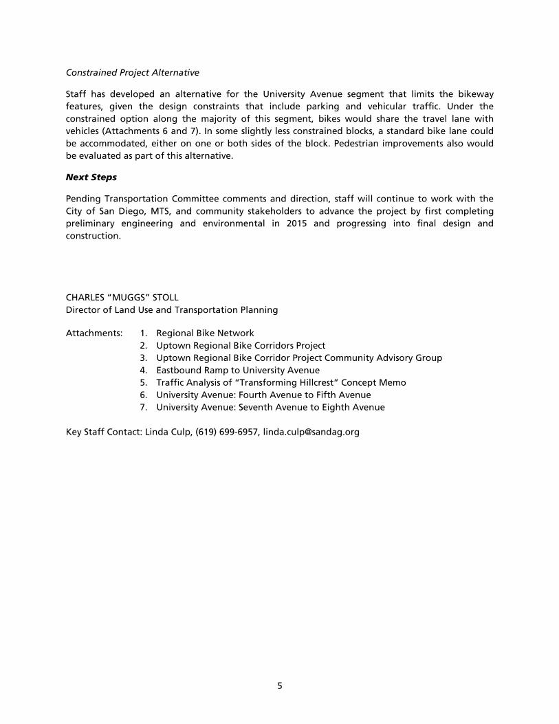
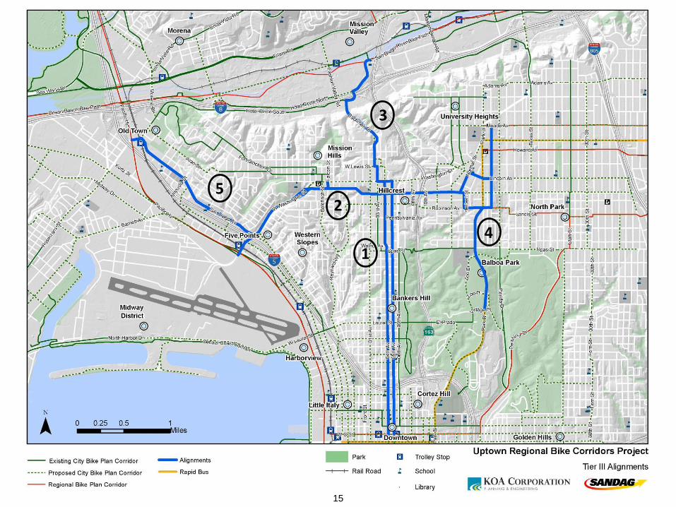
The project’s 12 miles of on-street bikeways are within the City of San Diego’s urban core communities of Uptown (Five Points, Mission Hills, Hillcrest, and Bankers Hill neighborhoods), Old Town, Mission Valley, Downtown, North Park, and Balboa Park (Attachment 1).
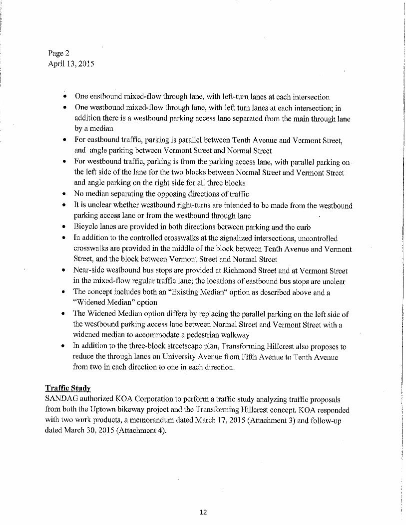
Overall, proposed project features include protected bikeways that provide a buffer between people biking and traffic, pedestrian improvements like curb bulb outs at busy intersections, and traffic calming features like lane reductions and speed humps. As with all regional bikeway projects, these designs are meant to enhance the comfort level and safety of people biking of all ages and riding abilities in order to increase their use for everyday trips, including trips to work, school, and to take transit. The proposed project, at a preliminary engineering phase, includes many of these design concepts.
Discussion
Community Outreach and Input
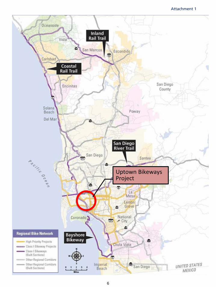
Since 2012, SANDAG has completed advanced planning for the project, including more than 70 public meetings and workshops, concluding with the last community workshop in February 2014. During the past year, staff has progressed with project level engineering and environmental analysis on five separate corridors (Attachment 2). This work has been coordinated with the City of San Diego and Metropolitan Transit System (MTS).
Recommendation
The Transportation Committee is asked to review the Uptown Bikeways Project and direct staff to continue development of the proposed project along the Old Town, Mission Valley, Downtown, Park Boulevard, and Washington Street corridors. In addition, due to numerous design limitations and a lack of consensus on improvement strategies, direct staff to continue development of a constrained alignment for the University Avenue corridor between Washington Street and Normal Street.
2
As part of this project-level analysis, potential roadway and parking changes were considered, with many of these roadway concepts suggested by community members. In summer 2014, a specific proposal referred to as “Transforming Hillcrest” was developed by community members for sections of the University Avenue corridor. The concept was based on a “road diet1,” with two of the four existing through lanes reconfigured to accommodate additional on-street parking and streetscape enhancements such as wider sidewalks. Like the original SANDAG design concept, Transforming Hillcrest also proposed a protected bikeway facility.
Much input has recently been received from the community regarding portions of the University Avenue section of Corridor #2, between Washington Street and Normal Street, including both support for the project and expressions of concern for potential impacts to parking, neighborhood access, and traffic. In response to this additional community feedback, SANDAG is seeking direction on a change in project features for this project section to a more constrained bikeway project than the original design concepts. In general, this alternative proposes shared travel lanes rather than protected bikeways along the more constrained sections of the corridor.
Alternatives Analysis
An analysis of more than 50 routes was conducted in 2013 with community input. The alignment and design concepts were evaluated using the following five goals, also established with community input, including that of the Community Advisory Group, whose membership is shown in Attachment 3:
1. Mobility: Increase choices; connect communities
2. Experience: Improve travel safety for everyone, and create an exceptional biking experience
3. Community: Build on and support related community initiatives
4. Placemaking: Enhance community identity and public spaces
5. Economic Development: Improve public infrastructure and strengthen opportunities for community and business development
The analysis included both quantitative and qualitative evaluation of a variety of factors, including connectivity, directness, grade, and existing traffic stress level of the street. The process resulted in recommended project alignments for each of the five corridors and design concepts for each alignment. The outcomes of the alignment analysis were brought to community stakeholders in early 2014. Since that time, work has focused on developing more detailed design solutions as part of the preliminary engineering phase of the project.
1 In general, a road diet is a reallocation of roadway width usually involving reducing the number of through traffic lanes to provide for other transportation purposes such as bicycles, pedestrian, or transit improvements.
3
Overview of Five Project Segments
For the purposes of preliminary engineering, the project alignments were grouped into five segments and several sub-sections: (1) Downtown to Hillcrest, (2) Five Points to North Park, (3) Hillcrest to Mission Valley, (4) Hillcrest to Balboa Park, and (5) Five Points to Old Town (Attachment 2).
Design Principles in the Bike Early Action Program
The project objective is to provide street improvements to allow for the safe movement of people walking, biking, riding transit, and driving. This is generally accomplished by designing each alignment to reduce speeding traffic, lower traffic volumes, create safer crossings for people walking, and provide separated space for people biking. The combined effect is increased accessibility by facilitating a variety of transportation choices.
Protected bikeways provide separation between people traveling on bikes and traffic lanes using a combination of raised medians, planters, parked cars, or bollards. This separated or protected space within a street is a critical accommodation to realize an increase in the number of people biking for short trips, a key long-range regional transportation strategy. Traffic calming design features are also being applied to segments to enhance the comfort and safety for all roadway users.
In December 2014, the City of San Diego converted one of three travel lanes to a buffered bike lane along sections of Fourth and Fifth Avenues north of downtown, including a painted three foot buffer between the bike lane and the next travel lane. The buffered bike lane along Fifth Avenue was recently extended north to Robinson Avenue. Ridership has steadily grown since December: on Fourth Avenue, by 49 percent to 1,700 monthly riders and on Fifth Avenue, by 21 percent to 2,200 monthly riders.
Generally, making room for bikeways on existing city streets is a significant challenge due to limited space and competing uses. Travel lanes on city streets are often 12 feet wide and sometimes as much as 14 to 16 feet wide. Research shows that 10-foot travel lanes can be as safe as wider lanes for vehicles, and can have the added benefit of traffic calming, or helping to reduce driving at excessive speeds. When the street width is more constrained, repurposing a turning or travel lane can be considered in the design process upon conducting appropriate traffic analysis.
As a last resort, in highly constrained situations, space currently used for on-street parking may be considered for the bikeway. In these situations, SANDAG, City officials, and local community members have generally made a commitment to explore, to the extent possible, how any reduced parking capacity could be relocated to other nearby streets.
Proposed Project Along University Avenue
In the planning phase, three east-west alignments through the center of the project area (through Mission Hills and Hillcrest) were analyzed: Washington Street, Robinson Avenue, and University Avenue. The analysis was conducted to identify a recommended alignment that could be feasibly implemented within the project budget, provide the most overall community benefit, and the most potential to increase the number of people choosing biking as a travel choice for short trips. The recommendation resulting from the analysis was the University Avenue alignment. Conditions along University Avenue vary and some portions west of State Route 163 are highly constrained.
4
On-Street Parking
Where there is potential parking loss, adjustments to the proposed project design have been made to minimize the effect on on-street parking. Furthermore, the implementation of parking reconfigurations on side streets is being facilitated in coordination with the City and Uptown Community Parking District. A comprehensive parking strategy, including evaluation of parking demand, inventory of nearby parking lots, and recommended parking management tools to increase availability in high demand areas is currently under development.
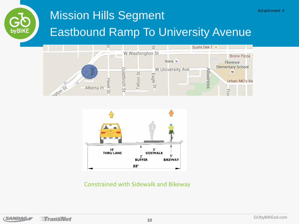
Washington Street/University Avenue access ramps to First Avenue (Mission Hills)
Based on early community input, the project concept included a sidewalk and protected bikeway on the uphill side of Washington Street in Corridor #2. Furthermore, the original design concept called for the eastbound ramp from Washington Street to University Avenue in Mission Hills to be reserved for people walking and biking, while only emergency vehicles would continue to access the ramp.
Recently, community members raised concerns regarding these concepts, particularly the eastbound ramp closure to vehicles. The original design concept for this segment was reevaluated. A modified ramp design was developed to maintain access for people walking, biking and driving (Attachment 4).
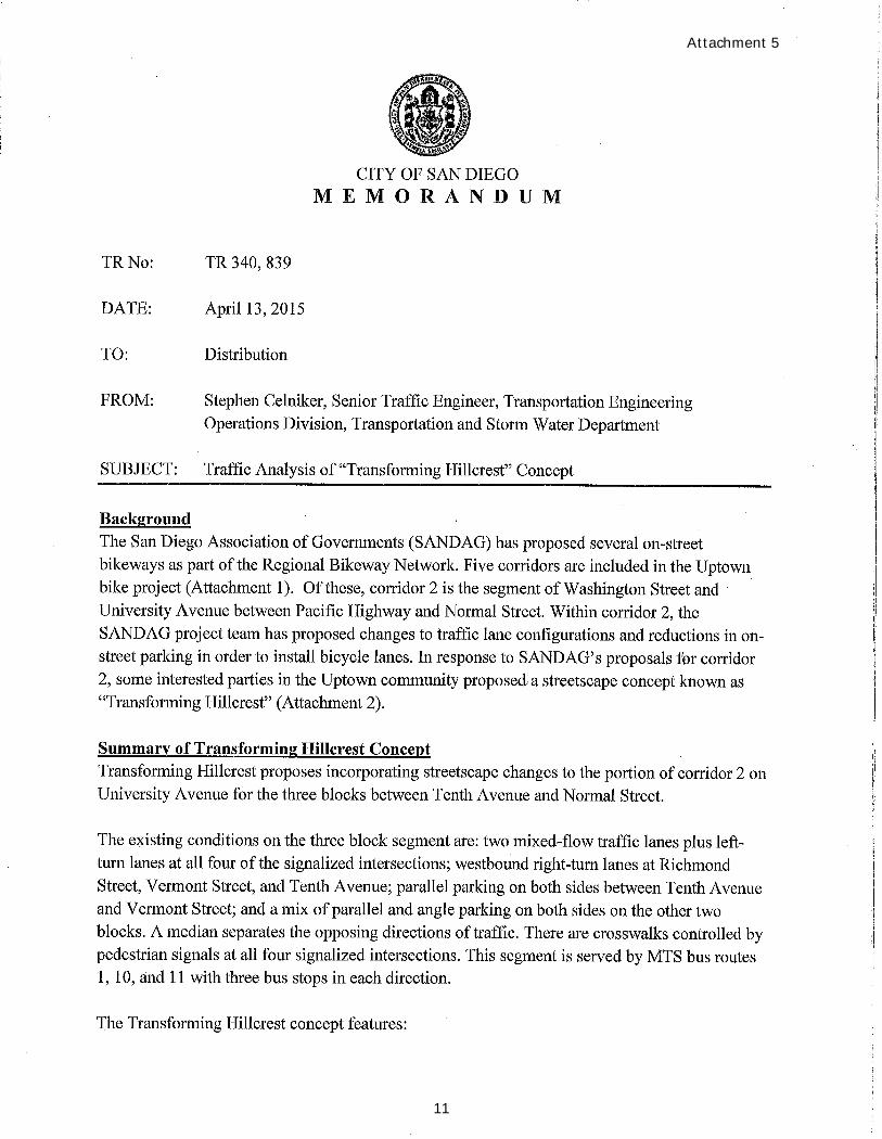
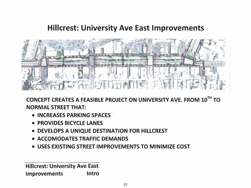
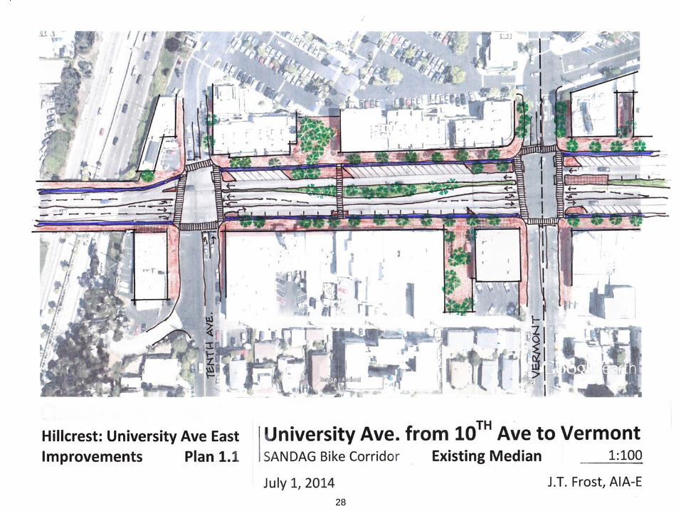
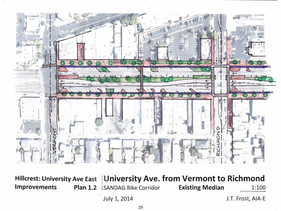
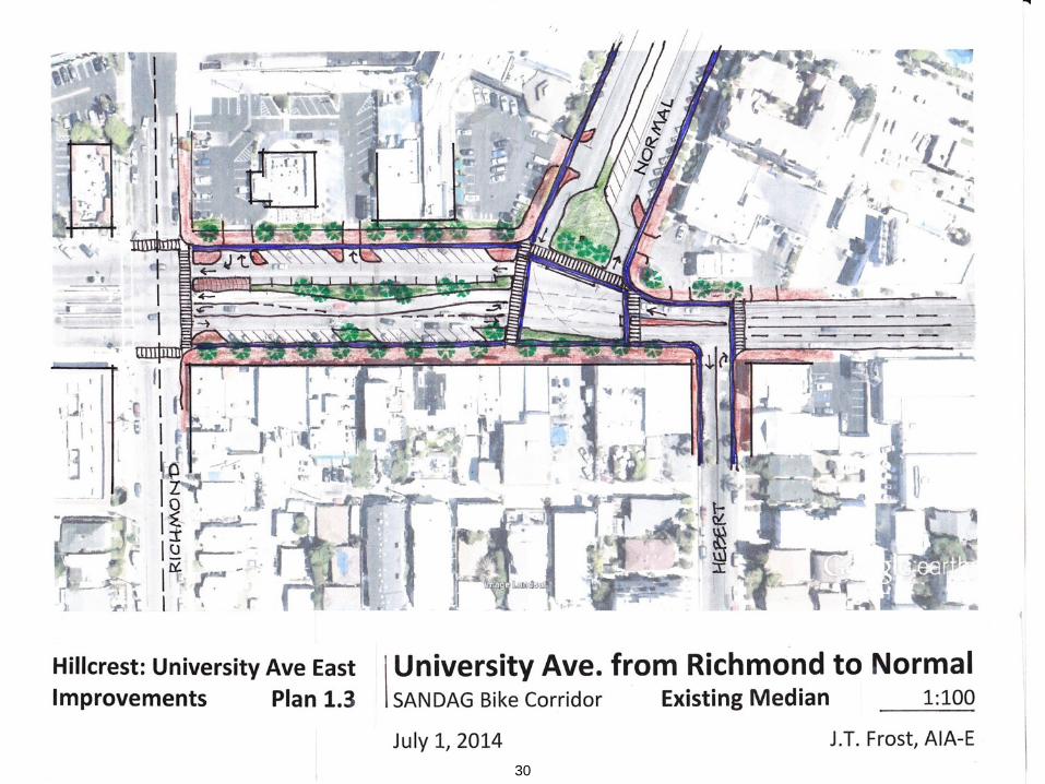
First Avenue to Normal Street (Hillcrest)
Loss of on-street parking is of great concern to the local business community. SANDAG completed an inventory of parking in the vicinity that indicated limited availability of on-street parking and parking spaces in adjacent lots. During summer 2014, a community member presented a design concept for two segments of University Avenue, First to Third and Tenth to Normal, called “Transforming Hillcrest”. The road diet concept was supported at the time by some Hillcrest community groups. SANDAG, together with the City of San Diego, conducted a traffic analysis of the basic lane reduction concept included in the design, and several scenarios were modeled. The analysis was submitted to the City of San Diego for review and determination of whether to include the road diet concept into the bikeway project design. The City of San Diego concluded the following in an April 13, 2015, memo:
“Unfortunately, the analysis by KOA [traffic analysis consultant] indicates that this location is not a good candidate for a road diet. Road diets are ideal when a roadway has excessive width, no bus routes, carries a relatively light load of traffic compared to its capacity, and parallel streets have the capacity to absorb any diverted traffic. None of these conditions exist on University Avenue between Tenth Avenue and Normal Street and further, the ability to provide efficient public transit service through this segment would be particularly hindered by the proposed geometrics and increased delay. Accordingly, we recommend that SANDAG continue its analysis of corridor #2 of the Uptown Bikeway Project without linkage to the Transforming Hillcrest concept.” (Attachment 5)
5
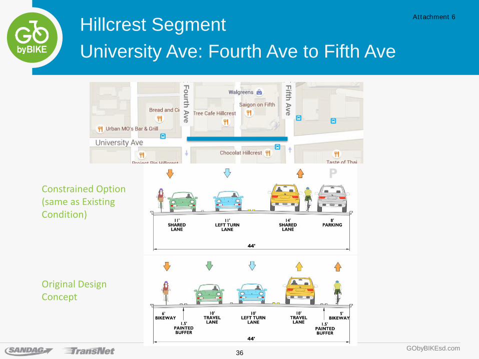
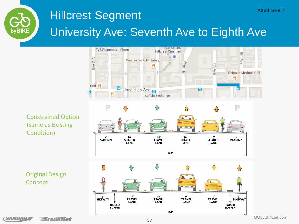
Constrained Project Alternative
Staff has developed an alternative for the University Avenue segment that limits the bikeway features, given the design constraints that include parking and vehicular traffic. Under the constrained option along the majority of this segment, bikes would share the travel lane with vehicles (Attachments 6 and 7). In some slightly less constrained blocks, a standard bike lane could be accommodated, either on one or both sides of the block. Pedestrian improvements also would be evaluated as part of this alternative.
Next Steps
Pending Transportation Committee comments and direction, staff will continue to work with the City of San Diego, MTS, and community stakeholders to advance the project by first completing preliminary engineering and environmental in 2015 and progressing into final design and construction.
CHARLES “MUGGS” STOLL Director of Land Use and Transportation Planning
Attachments: 1. Regional Bike Network 2. Uptown Regional Bike Corridors Project 3. Uptown Regional Bike Corridor Project Community Advisory Group 4. Eastbound Ramp to University Avenue 5. Traffic Analysis of “Transforming Hillcrest” Concept Memo 6. University Avenue: Fourth Avenue to Fifth Avenue 7. University Avenue: Seventh Avenue to Eighth Avenue Key Staff Contact: Linda Culp, (619) 699-6957, [email protected]
Attachment 1
Uptown Bikeways Project
6
5
1
3
4 2
Attachment 2
7
UPTOWN BIKEWAYS PROJECT
Corridor Segments and Sub-sections
1. Downtown to Hillcrest
a. Fourth and Fifth Avenues - C Street to Elm (Downtown)
b. Fourth and Fifth Avenues – Elm Street to Upas Street (Bankers Hill)
c. Fourth and Fifth Avenues - Upas Street to Washington Street (Hillcrest)
2. Five Points to North Park
a. Washington Street - Trolley Station to University Avenue access ramps (Five Points)
b. University Avenue - Washington Street access ramps to First Avenue (Mission Hills)
c. University Avenue - First Street to Normal Street (Hillcrest)
d. Normal Street and Lincoln Avenue and Herbert Street and Robinson Avenue(connections to North Park Mid-City Bikeways project)
3. Hillcrest to Mission Valley
a. Third Avenue
b. Bachman Place
c. Hotel Circle South
d. Camino De La Reina
4. Hillcrest to Balboa Park
a. Park Boulevard - Robinson Avenue to Upas Street
b. Park Boulevard - Upas Street to Village Place
5. Five Points to Old Town
a. San Diego Avenue – Washington Street to Congress Street
b. Congress Street – San Diego Avenue to Old Town Trolley Station
8
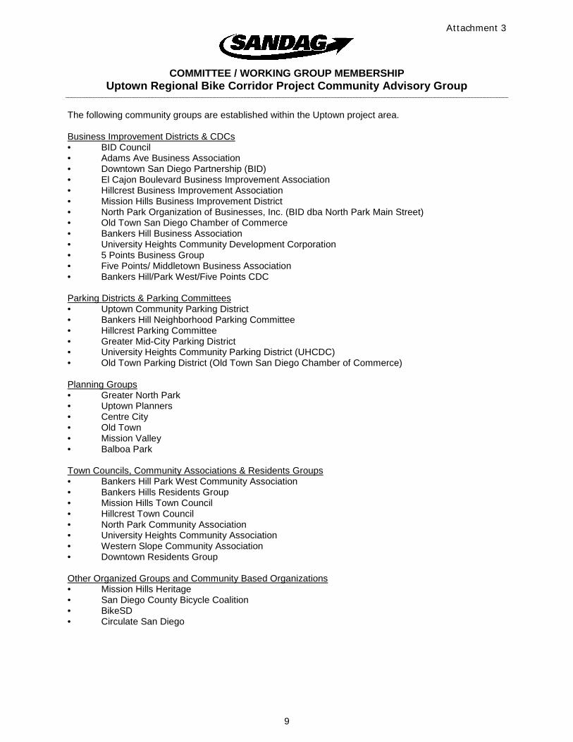
COMMITTEE / WORKING GROUP MEMBERSHIP Uptown Regional Bike Corridor Project Community Advisory Group
The following community groups are established within the Uptown project area.
Business Improvement Districts & CDCs • BID Council• Adams Ave Business Association• Downtown San Diego Partnership (BID)• El Cajon Boulevard Business Improvement Association• Hillcrest Business Improvement Association• Mission Hills Business Improvement District• North Park Organization of Businesses, Inc. (BID dba North Park Main Street)• Old Town San Diego Chamber of Commerce• Bankers Hill Business Association• University Heights Community Development Corporation• 5 Points Business Group• Five Points/ Middletown Business Association• Bankers Hill/Park West/Five Points CDC
Parking Districts & Parking Committees • Uptown Community Parking District• Bankers Hill Neighborhood Parking Committee• Hillcrest Parking Committee• Greater Mid-City Parking District• University Heights Community Parking District (UHCDC)• Old Town Parking District (Old Town San Diego Chamber of Commerce)
Planning Groups • Greater North Park• Uptown Planners• Centre City• Old Town• Mission Valley• Balboa Park
Town Councils, Community Associations & Residents Groups • Bankers Hill Park West Community Association• Bankers Hills Residents Group• Mission Hills Town Council• Hillcrest Town Council• North Park Community Association• University Heights Community Association• Western Slope Community Association• Downtown Residents Group
Other Organized Groups and Community Based Organizations • Mission Hills Heritage• San Diego County Bicycle Coalition• BikeSD• Circulate San Diego
Attachment 3
9
GObyBIKEsd.com
Mission Hills Segment Eastbound Ramp To University Avenue
Ibis
Albatross
Constrained with Sidewalk and Bikeway
Attachment 4
10
Attachment 5
11
12
13
14
5 2
3
1 4
15
5095 Murphy Canyon Road, Suite 330
San Diego, CA 92123
t: 619.683.2933 f: 619.683.7982
www.koacorporation.com
Page 1 of 5
MEMORANDUM To: Beth Robrahn, SANDAG Project Manager
From: Arnold Torma, T.E., Senior Engineer
Re: Preliminary Analysis of Traffic LOS Results | Transforming Hillcrest
Project: Uptown Bikeways Project – A&E Task Order #2 (KOA Project # B32097)
Date: March 17, 2015
Transforming Hillcrest
During summer 2014, community stakeholders developed and demonstrated collective support for a design
concept involving lane reductions on portions of University Avenue through Hillcrest. SANDAG and the City of
San Diego jointly made a commitment to analyze the operational feasibility of the community supported design
concept known as “Transforming Hillcrest.” To meet this commitment, a traffic analysis for “Transforming
Hillcrest” was conducted, comparing expected future conditions to the future conditions with the lane reduced
community concept. Analysis was also conducted on other lane configurations, suggested through community
input, along portions of the main east-west project alignment through the center of the Uptown Bikeways
project area.
Purpose and Objective
The purpose of this analysis is to preliminarily identify and address the basic effects upon the vehicular
circulation system as a result of implementing various lane configuration scenarios. The analysis establishes the
basic future (2020) conditions for the traditional vehicular circulation system to evaluate access, feasibility and
diversion. The analysis is considered preliminary and will serve to inform which lane configurations warrant
additional analysis and further investment in the short term for the Uptown Bikeways project and potentially in
the long term for the community.
The area of focus for the operational analysis includes portions of Washington Street, University Avenue, and
the westerly portion of Robinson Avenue, generally between India Street and Park Boulevard. The analysis
includes a basic traffic operations level-of-service analysis of the segmental lane and intersection configurations
of the “Transforming Hillcrest” concept. Several alternative approaches to handling the allocation of lanes
throughout this segment of University Ave were also considered. Transit operation was considered within the
context of the basic traffic operations. However, this analysis did not include a detailed assessment of the effects
on transit operations. This analysis also did not include a geometric assessment of the specific design concepts
included in Transforming Hillcrest, beyond the basic changes to the number of through lanes suggested in the
concept.
The analysis discussed herein is meant to help guide the selection of a scenario for incorporation into the
project design for further development and provide basic information about traffic operations associated with
the “Transforming Hillcrest” concept.
16
Page 2 of 5
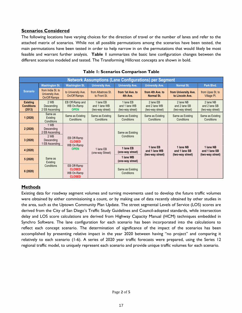
Scenarios Considered
The following locations have varying choices for the direction of travel or the number of lanes and refer to the
attached matrix of scenarios. While not all possible permutations among the scenarios have been tested, the
main permutations have been tested in order to help narrow in on the permutations that would likely be most
feasible and warrant further analysis. Table 1 summarizes the basic lane configuration changes between the
different scenarios modeled and tested. The Transforming Hillcrest concepts are shown in bold.
Table 1: Scenarios Comparison Table
Methods
Existing data for roadway segment volumes and turning movements used to develop the future traffic volumes
were obtained by either commissioning a count, or by making use of data recently obtained by other studies in
the area, such as the Uptown Community Plan Update. The street segmental Levels of Service (LOS) scores are
derived from the City of San Diego’s Traffic Study Guidelines and Council-adopted standards, while intersection
delay and LOS score calculations are derived from Highway Capacity Manual (HCM) techniques embedded in
Synchro Software. The lane configuration for each scenario has been incorporated into the calculations to
reflect each concept scenario. The determination of significance of the impact of the scenarios has been
accomplished by presenting relative impact in the year 2020 between having “no project” and comparing it
relatively to each scenario (1-6). A series of 2020 year traffic forecasts were prepared, using the Series 12
regional traffic model, to uniquely represent each scenario and provide unique traffic volumes for each scenario.
Network Assumptions (Lane Configurations) per Segment
Scenario
Washington St. Washington St. University Ave. University Ave. University Ave. Normal St. Park Blvd.
from India St. to University Ave. On/Off Ramps
to University Ave. On/Off Ramps
from Albatross St. to Front St.
from 1st Ave. to 4th Ave.
from 4th Ave. to Normal St.
from University Ave. to Lincoln Ave.
from Upas St. to Village Pl.
Existing Conditions
(2013)
2 WB Descending
2 EB Ascending
EB Off-Ramp and WB On-Ramp
OPEN
1 lane EB and 1 lane WB (two-way street)
1 lane EB and 1 lane WB (two-way street)
2 lane EB and 2 lane WB (two-way street)
2 lane NB and 2 lane SB
(two-way street)
2 lane NB and 2 lane SB
(two-way street)
1 (2020) Same as Existing
Conditions
Same as Existing Conditions
Same as Existing Conditions
Same as Existing Conditions
Same as Existing Conditions
Same as Existing Conditions
Same as Existing Conditions
2 (2020) 1 WB
Descending 2 EB Ascending
EB Off-Ramp CLOSED
WB On-Ramp OPEN 1 lane EB
(one-way Street)
Same as Existing Conditions
1 lane EB and 1 lane WB
(two-way street)
1 lane NB and 1 lane SB
(two-way street)
1 lane NB and 1 lane SB
(two-way street)
3 (2020) 2 WB
Descending 1 EB Ascending
4 (2020)
Same as Existing
Conditions
1 lane EB (one-way street)
5 (2020) 1 lane WB
(one-way street)
6 (2020)
EB Off-Ramp CLOSED
WB On-Ramp CLOSED
Same as Existing Conditions
17
Page 3 of 5
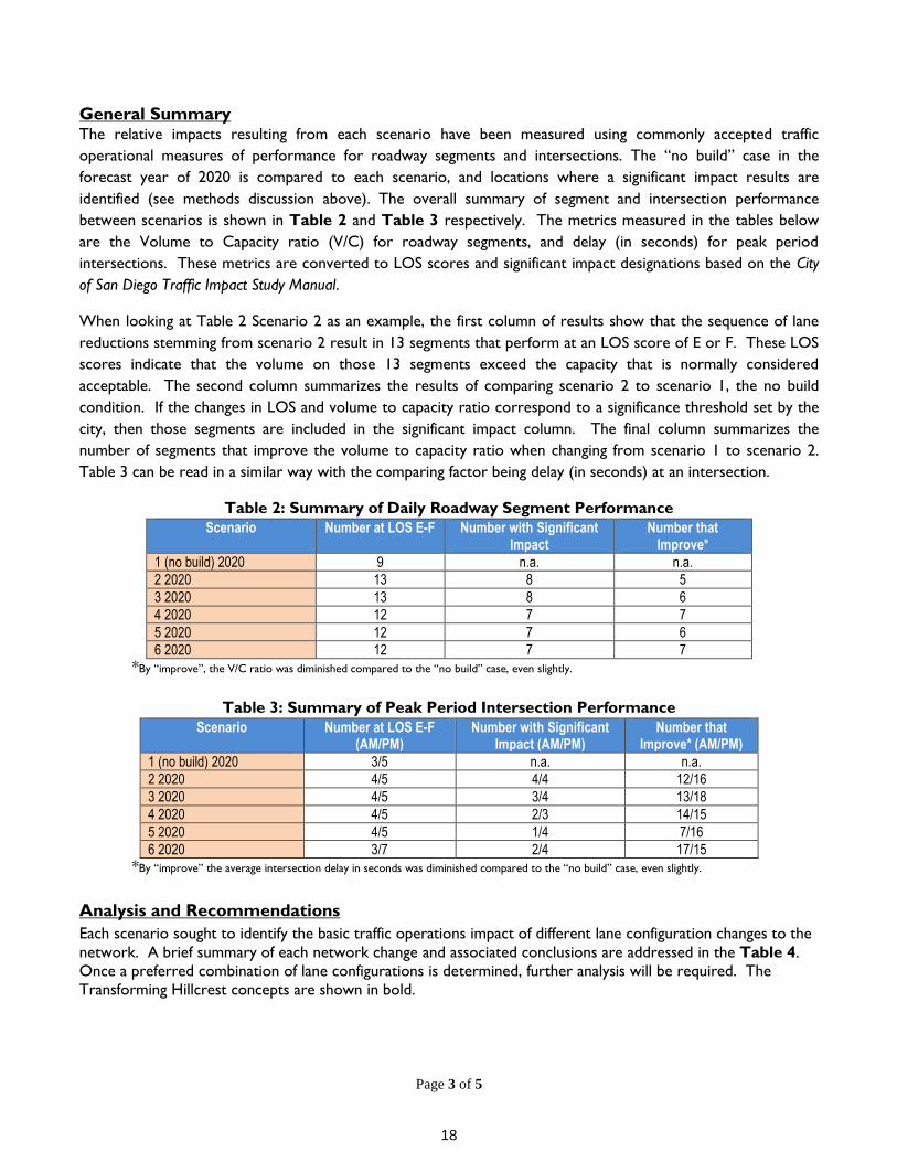
General Summary The relative impacts resulting from each scenario have been measured using commonly accepted traffic
operational measures of performance for roadway segments and intersections. The “no build” case in the
forecast year of 2020 is compared to each scenario, and locations where a significant impact results are
identified (see methods discussion above). The overall summary of segment and intersection performance
between scenarios is shown in Table 2 and Table 3 respectively. The metrics measured in the tables below
are the Volume to Capacity ratio (V/C) for roadway segments, and delay (in seconds) for peak period
intersections. These metrics are converted to LOS scores and significant impact designations based on the City
of San Diego Traffic Impact Study Manual.
When looking at Table 2 Scenario 2 as an example, the first column of results show that the sequence of lane
reductions stemming from scenario 2 result in 13 segments that perform at an LOS score of E or F. These LOS
scores indicate that the volume on those 13 segments exceed the capacity that is normally considered
acceptable. The second column summarizes the results of comparing scenario 2 to scenario 1, the no build
condition. If the changes in LOS and volume to capacity ratio correspond to a significance threshold set by the
city, then those segments are included in the significant impact column. The final column summarizes the
number of segments that improve the volume to capacity ratio when changing from scenario 1 to scenario 2.
Table 3 can be read in a similar way with the comparing factor being delay (in seconds) at an intersection.
Table 2: Summary of Daily Roadway Segment Performance
Scenario Number at LOS E-F Number with Significant Impact
Number that Improve*
1 (no build) 2020 9 n.a. n.a.
2 2020 13 8 5
3 2020 13 8 6
4 2020 12 7 7
5 2020 12 7 6
6 2020 12 7 7
*By “improve”, the V/C ratio was diminished compared to the “no build” case, even slightly.
Table 3: Summary of Peak Period Intersection Performance
Scenario Number at LOS E-F (AM/PM)
Number with Significant Impact (AM/PM)
Number that Improve* (AM/PM)
1 (no build) 2020 3/5 n.a. n.a.
2 2020 4/5 4/4 12/16
3 2020 4/5 3/4 13/18
4 2020 4/5 2/3 14/15
5 2020 4/5 1/4 7/16
6 2020 3/7 2/4 17/15
*By “improve” the average intersection delay in seconds was diminished compared to the “no build” case, even slightly.
Analysis and Recommendations
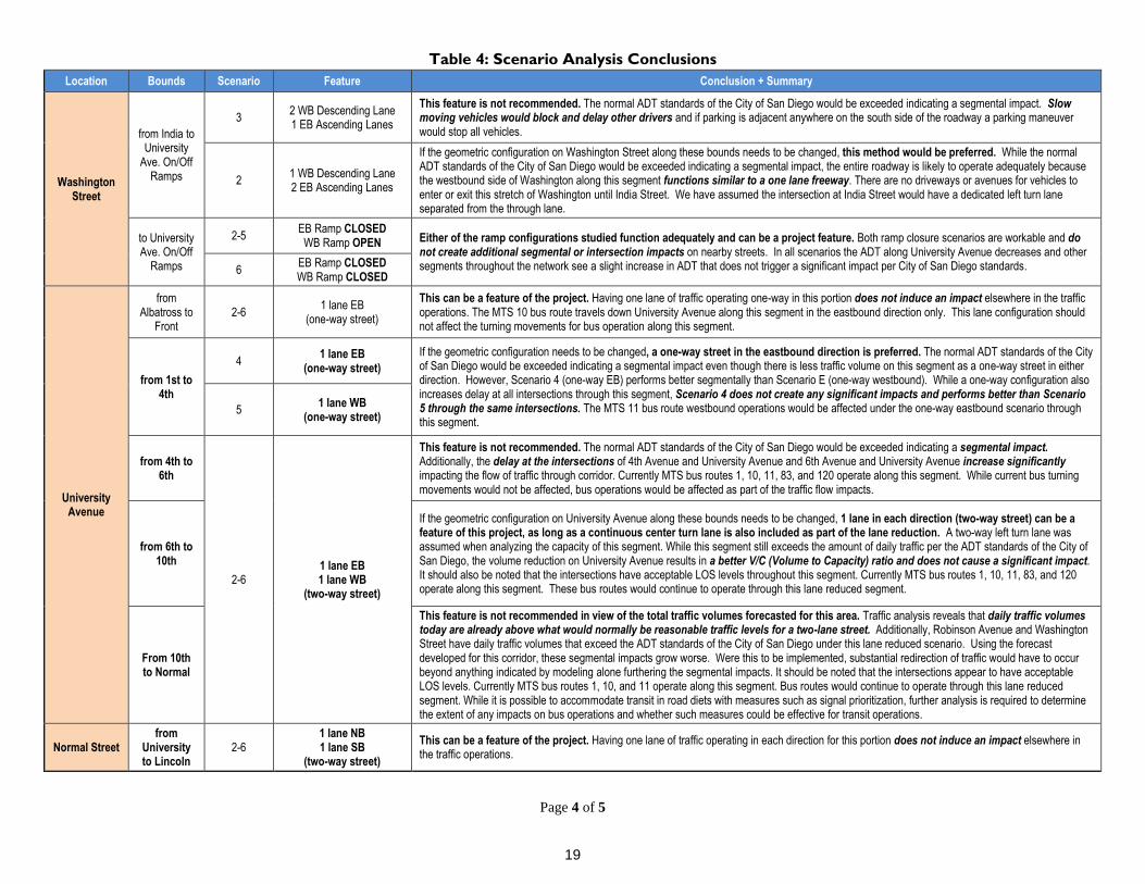
Each scenario sought to identify the basic traffic operations impact of different lane configuration changes to the
network. A brief summary of each network change and associated conclusions are addressed in the Table 4.
Once a preferred combination of lane configurations is determined, further analysis will be required. The
Transforming Hillcrest concepts are shown in bold.
18
Page 4 of 5
Table 4: Scenario Analysis Conclusions
Location Bounds Scenario Feature Conclusion + Summary
Washington Street
from India to University
Ave. On/Off Ramps
3 2 WB Descending Lane 1 EB Ascending Lanes
This feature is not recommended. The normal ADT standards of the City of San Diego would be exceeded indicating a segmental impact. Slow moving vehicles would block and delay other drivers and if parking is adjacent anywhere on the south side of the roadway a parking maneuver would stop all vehicles.
2 1 WB Descending Lane 2 EB Ascending Lanes
If the geometric configuration on Washington Street along these bounds needs to be changed, this method would be preferred. While the normal ADT standards of the City of San Diego would be exceeded indicating a segmental impact, the entire roadway is likely to operate adequately because the westbound side of Washington along this segment functions similar to a one lane freeway. There are no driveways or avenues for vehicles to enter or exit this stretch of Washington until India Street. We have assumed the intersection at India Street would have a dedicated left turn lane separated from the through lane.
to University Ave. On/Off
Ramps
2-5 EB Ramp CLOSED WB Ramp OPEN Either of the ramp configurations studied function adequately and can be a project feature. Both ramp closure scenarios are workable and do
not create additional segmental or intersection impacts on nearby streets. In all scenarios the ADT along University Avenue decreases and other segments throughout the network see a slight increase in ADT that does not trigger a significant impact per City of San Diego standards. 6
EB Ramp CLOSED WB Ramp CLOSED
University Avenue
from Albatross to
Front 2-6
1 lane EB (one-way street)
This can be a feature of the project. Having one lane of traffic operating one-way in this portion does not induce an impact elsewhere in the traffic operations. The MTS 10 bus route travels down University Avenue along this segment in the eastbound direction only. This lane configuration should not affect the turning movements for bus operation along this segment.
from 1st to 4th
4 1 lane EB
(one-way street)
If the geometric configuration needs to be changed, a one-way street in the eastbound direction is preferred. The normal ADT standards of the City of San Diego would be exceeded indicating a segmental impact even though there is less traffic volume on this segment as a one-way street in either direction. However, Scenario 4 (one-way EB) performs better segmentally than Scenario E (one-way westbound). While a one-way configuration also increases delay at all intersections through this segment, Scenario 4 does not create any significant impacts and performs better than Scenario 5 through the same intersections. The MTS 11 bus route westbound operations would be affected under the one-way eastbound scenario through this segment.
5 1 lane WB
(one-way street)
from 4th to 6th
2-6 1 lane EB 1 lane WB
(two-way street)
This feature is not recommended. The normal ADT standards of the City of San Diego would be exceeded indicating a segmental impact. Additionally, the delay at the intersections of 4th Avenue and University Avenue and 6th Avenue and University Avenue increase significantly impacting the flow of traffic through corridor. Currently MTS bus routes 1, 10, 11, 83, and 120 operate along this segment. While current bus turning movements would not be affected, bus operations would be affected as part of the traffic flow impacts.
from 6th to 10th
If the geometric configuration on University Avenue along these bounds needs to be changed, 1 lane in each direction (two-way street) can be a feature of this project, as long as a continuous center turn lane is also included as part of the lane reduction. A two-way left turn lane was assumed when analyzing the capacity of this segment. While this segment still exceeds the amount of daily traffic per the ADT standards of the City of San Diego, the volume reduction on University Avenue results in a better V/C (Volume to Capacity) ratio and does not cause a significant impact. It should also be noted that the intersections have acceptable LOS levels throughout this segment. Currently MTS bus routes 1, 10, 11, 83, and 120 operate along this segment. These bus routes would continue to operate through this lane reduced segment.
From 10th to Normal
This feature is not recommended in view of the total traffic volumes forecasted for this area. Traffic analysis reveals that daily traffic volumes today are already above what would normally be reasonable traffic levels for a two-lane street. Additionally, Robinson Avenue and Washington Street have daily traffic volumes that exceed the ADT standards of the City of San Diego under this lane reduced scenario. Using the forecast developed for this corridor, these segmental impacts grow worse. Were this to be implemented, substantial redirection of traffic would have to occur beyond anything indicated by modeling alone furthering the segmental impacts. It should be noted that the intersections appear to have acceptable LOS levels. Currently MTS bus routes 1, 10, and 11 operate along this segment. Bus routes would continue to operate through this lane reduced segment. While it is possible to accommodate transit in road diets with measures such as signal prioritization, further analysis is required to determine the extent of any impacts on bus operations and whether such measures could be effective for transit operations.
Normal Street from
University to Lincoln
2-6 1 lane NB 1 lane SB
(two-way street)
This can be a feature of the project. Having one lane of traffic operating in each direction for this portion does not induce an impact elsewhere in the traffic operations.
19

Page 5 of 5
Attachments:
Summary Tables for Roadway Segment Results
Summary Tables for Intersection LOS
20
5095 Murphy Canyon Road, Suite 330 San Diego, CA 92123
t: 619.683.2933 f: 619.683.7982 www.koacorporation.com
MEMORANDUM
To: Beth Robrahn, SANDAG Project Manager From: Arnold Torma, T.E., Senior Engineer Re: Supplemental Analysis of Traffic LOS Results Project: Uptown Bikeways Project – A&E Task Order #2 (KOA Project # B32097) Date: March 30, 2015
In order to help you better understand how the “Transforming Hillcrest” concept might operate with respect to traffic and associated diversion we have prepared some supplemental information, particularly for the portion of University Avenue to the east of SR163. Attached are two graphics and a table. We hope this can provide some additional useful information.
The first figure entitled “2020 Scenario 1 –(No Project Condition)” represents year 2020 daily traffic volumes with current geometry on segments along with peak hour intersection conditions in the AM/PM as already reported in our analysis of all the alternatives being considered. This is simply a graphic portrayal of the same information contained in the Tables in our March 4, 2015 memo on Corridor II.
The second figure entitled “2020 Scenario 2 – (Transforming Hillcrest concept – from 4th Ave. to Park Blvd.)” uses some of the same data from the March 4, 2015 memo to represent conditions most likely to represent the Transforming Hillcrest concept. The analysis looked at the same number of through traffic lanes proposed in the Transforming Hillcrest concept and did not analyze the additional overall effect on intersection operations by introducing the complexity of the “parking lanes” between 10th and Normal Street. This includes the total daily volumes and intersection conditions and the amount of traffic that would be introduced to parallel facilities like Robinson Ave and Washington St that would have to carry the burden of some of the diverted traffic. What we also recognize is that this represents our best interpretation of the modeled results, but in fact even greater amounts of traffic are likely to be diverted once the reality of trying to move as many as 27,000 plus cars per day on a two-lane University Ave were to be experienced. What you can see is an increasing number of segments and intersections begin to have failing conditions in Scenario 2.
We have also included a Table based on using the Highway Capacity Manual Arterial Analysis methods to determine both the total travel time and the arterial level of service in the PM peak period. This is a different calculation than what we have already reported in the March 4, 2015 memo at the intersections. This table portrays how the change in operating speed during the PM peak periods on the roadway segments is affected by direction. The rows of the table represent differing combinations of the entire length of roadway in the area, and one can select which group of segments may be of interest and see the results. We show year 2020 results both with and without the Transforming Hillcrest project in the columns and a comparison of the two in the last columns on the right, particularly if there is a significant difference using the City’s Guidelines for determining significance.
MTS could also use the appropriate rows in this table under the Total Travel Time column to estimate the effect upon the bus operations in the future during the PM peak. The running time is the result of a calculation using the segment length and average speed. An estimate of increased transit total travel time is included in the Arterial Analysis Results table attached.
Page 1 of 2
21

Attachments: • 2020 LOS Scenario 1 & 2 Maps• Arterial Analysis Results
Page 2 of 2
22
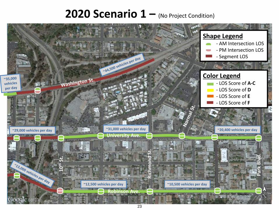
2020 Scenario 1 – (No Project Condition)
Shape Legend - AM Intersection LOS - PM Intersection LOS - Segment LOS
Color Legend - LOS Score of A-C - LOS Score of D - LOS Score of E - LOS Score of F
University Ave.
Robinson Ave.
10th
St.
Rich
mon
d St
.
Park
Blv
d.
~29,000 vehicles per day ~31,000 vehicles per day ~20,400 vehicles per day
~10,500 vehicles per day ~12,500 vehicles per day
23
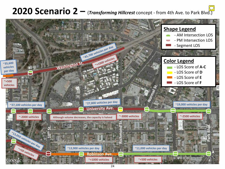
2020 Scenario 2 – (Transforming Hillcrest concept - from 4th Ave. to Park Blvd.)
Shape Legend - AM Intersection LOS - PM Intersection LOS - Segment LOS
Color Legend - LOS Score of A-C - LOS Score of D - LOS Score of E - LOS Score of F
Robinson Ave.
10th
St.
Rich
mon
d St
.
Park
Blv
d.
~27,100 vehicles per day ~19,000 vehicles per day
~11,000 vehicles per day ~13,900 vehicles per day
Although volume decreases, the capacity is halved
~+500 vehicles
~-2000 vehicles ~-3000 vehicles ~-2500 vehicles
~+1000 vehicles ~+500 vehicles
24
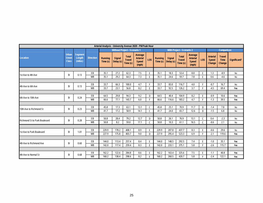
Running Time (s)
Signal Delay (s)
Total Travel
Time (s)
Average Arterial Speed (mph)
LOS Running Time (s)
Signal Delay (s)
Total Travel
Time (s)
Average Arterial Speed (mph)
LOSArterial Speed
Change
Travel Time
ChangeSignificant?
EB 35.1 27.2 62.3 7.5 E 35.1 18.3 53.4 8.8 E 1.3 -8.9 NoWB 35.1 29.2 64.3 7.3 E 35.1 24.6 59.7 7.8 E 0.6 -4.6 No
EB 33.7 66.3 100.0 4.7 F 33.7 83.0 116.7 4.0 F -0.7 16.7 NoWB 33.7 23.1 56.8 8.2 E 33.7 92.5 126.2 3.7 F -4.5 69.4 Yes
EB 64.5 29.8 94.3 9.2 D 64.5 40.4 104.9 8.2 E -0.9 10.6 YesWB 66.6 77.1 143.7 6.0 F 66.6 116.6 183.2 4.7 F -1.3 39.5 Yes
EB 45.8 17.3 63.1 13.1 C 45.8 25.1 70.9 11.7 D -1.4 7.8 NoWB 41.7 17.2 58.9 14.1 C 41.7 24.0 65.7 12.6 D -1.5 6.8 No
EB 50.8 28.4 79.2 12.7 D 50.8 26.1 76.9 13.1 C 0.4 -2.3 NoWB 50.8 8.2 59.0 17.1 C 50.8 10.3 61.1 16.5 C -0.6 2.1 No
EB 229.9 178.2 408.1 8.9 E 229.9 207.8 437.7 8.3 E -0.6 29.6 NoWB 227.9 175.8 403.7 9.0 D 227.9 295.4 523.3 6.9 F -2.1 119.6 Yes
EB 144.0 113.4 257.4 8.4 E 144.0 148.5 292.5 7.4 E -1.0 35.1 YesWB 142.0 117.4 259.4 8.3 E 142.0 233.1 375.1 5.8 F -2.6 115.7 Yes
EB 162.2 122.6 284.8 8.6 E 162.2 163.4 325.6 7.5 E -1.1 40.8 YesWB 160.2 138.4 298.6 8.2 E 160.2 260.5 420.7 5.8 F -2.4 122.1 Yes
0.23IV10th Ave to Richmond St
Arterial Analysis - University Avenue 2020 - PM Peak Hour
1st Ave to Park Boulevard IV 1.01
4th Ave to Richmond Ave IV 0.60
4th Ave to Normal St IV 0.68
1st Ave to 4th Ave IV 0.13
LocationUrban Street Class
Segment Length (miles)
ComparisonWithout Project - Scenario 1 With Project - Scenario 2
Direction
4th Ave to 6th Ave IV 0.13
6th Ave to 10th Ave IV 0.24
Richmond St to Park Boulevard IV 0.28
25
26
27
28
29
30
31
32
33
34
35
GObyBIKEsd.com
Constrained Option (same as Existing Condition)
Hillcrest Segment University Ave: Fourth Ave to Fifth Ave
Original Design Concept
Fourth Ave
Fifth Ave
Attachment 6
36
GObyBIKEsd.com
Hillcrest Segment University Ave: Seventh Ave to Eighth Ave
Original Design Concept
Constrained Option (same as Existing Condition)
Attachment 7
37