Embed Size (px)
Citation preview
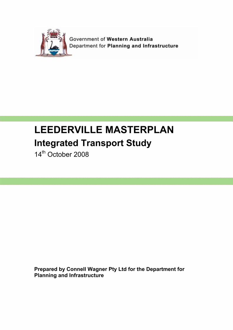
LEEDERVILLE MASTERPLAN
Integrated Transport Study 14
th October 2008
Prepared by Connell Wagner Pty Ltd for the Department for Planning and Infrastructure
Preface
In 2004, the Town of Vincent, with the assistance of the Western Australian Planning Commission (WAPC) Communities Grants Programme funding, undertook community visioning to establish a new local planning scheme to guide the strategic direction of the Town of Vincent (Town) into the future, producing 'Vincent Vision 2024'.
As part of the implementation of that vision, in 2005 the Town embarked on the development of the Leederville Masterplan, for the central business district. This culminated in the Town's release of the Leederville Masterplan for public consultation in July 2007, encompassing the area bounded by Richmond and Loftus Streets, Leederville Parade and Stamford Street.
The Town of Vincent's masterplan process has identified several redevelopment sites within the town centre and significant opportunity to guide wider redevelopment within the Leederville area.
At the request of the then Minister for Planning and Infrastructure, in November 2007, the Department for Planning and Infrastructure (DPI) and Town of Vincent facilitated a Leederville Masterplan "peer design review". Key recommendations identified through the review process were to assist the Town by providing additional transport analysis, and preparation of precinct plans for the Carr Place residential area and for the Leederville train station precinct.
In January 2008, the Town of Vincent and the DPI agreed to an allocation of the State Government's Local Government Planning Assistance Program funds for the transport analysis and precinct plan studies to assist in the regeneration of Leederville town centre. The intent was to assist local government, through the provision of additional capacity to identify opportunities to increase housing density and diversity; and/ or assess infrastructure capacity and constraints in delivering Network city outcomes for transit - oriented developments (TOD) and activity centres.
The main objective of this study was to develop an integrated transport plan to augment the Leederville Masterplan and ensure that it is consistent with Network city objectives. The integrated transport study consolidates all traffic and transport investigation undertaken by the relevant authorities in the past few years and comments on future actions that may be required.
The study has provided additional transport analysis to identify changes and improvements to existing road and public transport services to the Leederville Masterplan area needed to support the scale of development envisaged and additional ancillary public transport servicing requirements.
The study was overseen by a major stakeholder engagement group including representatives and contributions over time from officers of the Town of Vincent, the Town of Cambridge, the DPI, Main Roads Western Australia, the Public Transport Authority, and the Water Corporation. In addition, contributions were also sought from the following minor stakeholders: City of Subiaco, East Perth Redevelopment Authority, the Department of Health and the RAC.
The WAPC has not endorsed any part of this document. It will serve as a useful information resource and input into more detailed planning and the assessment of applications within the area.
The Statutory Planning Committee of the WAPC considered this study at its meeting on 14 October 2008 and resolved to support the release of copies of this study for stakeholder community information and any feedback, and as an input to further planning, and to distribute copies to the State Reference Library and the offices and libraries of the Town of Vincent, Town of Cambridge, City of Perth and the City of Subiaco.
The Department for Planning and Infrastructure 469 Wellington Street, Perth WA 6000
Reference 851-2-33-2PV6
14 October 2008
Connell Wagner Pty Ltd ABN 54 005 139 873 Level 1, Septimus Roe Square 256 Adelaide Terrace PerthWestern Australia 6000 Australia
Telephone: +61 8 9223 1500 Facsimile: +61 8 9223 1605 Email: [email protected] www.conwag.com
Leederville MasterplanIntegrated Transport StudyDepartment for Planning and Infrastructure
26 August 2008Reference 34493 Revision 5
Document Control
Document ID: P:\34493.001\6.0 REPORTS_SPECS\REPORT TRANSPORT STUDY.DOC
Rev No Date Revision Details Typist Author Verifier Approver
0 21 April 2008 Working draft – issued to DPI NMB NMB / LHR
1 20 May 2008 Working draft – issued to DPI NMB NMB / LHR
2 26 May 2008 Verification issue NMB NMB / LHR GA
3 04 July 2008 Final report – issued to DPI NMB NMB GA LHR
4 15 August 2008 Revision to S7.1.2 LHR LHR LHR
5 26 August 2008 Revision to S7.1 NMB NMB
A person using Connell Wagner documents or data accepts the risk of:
a) Using the documents or data in electronic form without requesting and checking them for accuracy against the original hard copy version. b) Using the documents or data for any purpose not agreed to in writing by Connell Wagner.
Integrated Transport Study Department for Planning and Infrastructure Leederville Masterplan
� � �FILE P:\34493.001\6.0 REPORTS_SPECS\REPORT TRANSPORT STUDY.DOC 26 AUGUST 2008 REVISION 5 PAGE i
ContentsSection Page
1. Introduction 11.1 Project background 11.2 Study area 11.3 Project objective 11.4 Project outcome 1
2. Government Policy Context 22.1 State Government Policy 22.2 Local Government Policy 32.3 Policy summary 4
3. Study Process 53.1 Sustainability 53.2 Methodology 53.3 Consultation 5
4. Existing conditions 74.1 Land use and demographics 74.2 Road and traffic data 84.3 Public transport 124.4 Pedestrian and cyclist facilities 134.5 RAC and public awareness 14
5. Improvements to the public transport network 155.1 Existing road and traffic conditions 155.2 Transport feeder issues 165.3 “Free to user” services 175.4 Extension of existing services 195.5 Local Governments 205.6 Light rail 215.7 Awareness 225.8 Requirements of pedestrians 225.9 Requirements of cyclists 235.10 Car parking provision and needs 23
6. Action plan 25
7. Priority action items 277.1 Subiaco Shuttle / Inner Collar Link 277.2 Pedestrian / bus bridge 31
Appendix AMap: Leederville redevelopment (DPI 2007)
Appendix BLand use and demographic data (DPI 2008)
Integrated Transport Study Department for Planning and Infrastructure Leederville Masterplan
� � �FILE P:\34493.001\6.0 REPORTS_SPECS\REPORT TRANSPORT STUDY.DOC 26 AUGUST 2008 REVISION 5 PAGE ii
Appendix CRoad network (photos sourced via Intramaps and Google Maps)
Appendix DWest Leederville Traffic Management Review – recommendations (Town of Cambridge 2005)
Appendix ECAT and FTZ (DPI 2008)
Appendix FLight rail (DPI 2008)
Appendix GRoute options for extension of Subiaco Shuttle (route 97) to Leederville Train Station (DPI 2008)
Integrated Transport Study Department for Planning and Infrastructure Leederville Masterplan
FILE P:\34493.001\6.0 REPORTS_SPECS\REPORT TRANSPORT STUDY.DOC � 26 AUGUST 2008 � REVISION 5 � PAGE 1
1. Introduction
1.1 Project background
In 2004 the Town of Vincent, with the assistance of WAPC Communities Grants Programme funding, undertook community visioning to establish a new Town Planning Scheme to guide the strategic direction of the Town of Vincent into the future. As part of the implementation of that vision, in 2005, the Town embarked on the development of the Leederville Masterplan, encompassing the central business district of the Leederville/West Perth precinct.
This process has identified several redevelopment sites within the town centre and significant opportunity to guide wider redevelopment within the Leederville area.
Growth potential on this scale immediately adjacent to the Leederville Train Station provides a significant opportunity for Leederville to become an important Network City Activity Centre.
In November 2007 the Department for Planning and Infrastructure (DPI) facilitated a design review of the Leederville Masterplan. Key recommendations coming out of the review were that the Town of Vincent required further assistance to develop a transport study brief; and the preparation of precinct plans for the Carr Place precinct and the Leederville Train Station precinct.
The DPI prepared a transport study brief, and Connell Wagner was commissioned by DPI during February 2008 to undertake the Leederville Integrated Transport Study.
1.2 Study area
The transport study area encompasses: � The Leederville Masterplan area bordered by Loftus, Richmond, Oxford and Vincent Streets
and Leederville Parade in Leederville (refer blue shaded area of map in Appendix A) � The area directly west of the Leederville train station belonging to the Town of Cambridge (refer
red shaded area of map in Appendix A for indicative representation only) � A subregional area identified by the DPI, which includes public transport access from QE2 and
Subiaco to West Leederville, and access to Kitchener Park (due to the planned football stadium development) Floreat, East Perth, West Perth and Mount Lawley
1.3 Project objective
The main objective of this project is to develop an integrated transport plan to be provided to the Town of Vincent and Town of Cambridge to augment the Leederville Masterplan and ensure that it is consistent with Network City objectives. The plan consolidates all traffic and transport investigation undertaken by the relevant authorities in the past few years and comments on future actions that may be required.
1.4 Project outcome
Additional transport analysis to identify changes and improvements to existing road and public transport services to the Leederville Master Plan area needed to support the scale of development envisaged and additional ancillary public transport servicing requirements.
Integrated Transport Study Department for Planning and Infrastructure Leederville Masterplan
FILE P:\34493.001\6.0 REPORTS_SPECS\REPORT TRANSPORT STUDY.DOC � 26 AUGUST 2008 � REVISION 5 � PAGE 2
2. Government Policy Context
The key Western Australian Government and Local Government strategies affecting the Leederville Integrated Transport Study are outlined in this section, to provide context for this Study.
2.1 State Government Policy
2.1.1 Hope for the future: The Western Australian State Sustainability Strategy
Sustainability is meeting the needs of current and future generations through an integration of environmental protection, social advancement, and economic prosperity.
Hope for the future: The Western Australian State Sustainability Strategy was developed by the State Government in 2003. It contains background information on the concept of sustainability as well as establishing illustrative actions for sustainability in Western Australia. Within the strategy, it is recognised that overcoming car dependence is fundamental to sustainability in cities.
One chapter of the strategy focuses on “Sustainability and Settlements,” with a priority area identified as “integrating land use and balanced transport.” Two objectives were identified for this item: � Maximise the opportunity to increase residential, employment, retail, community and
entertainment activity around key transport nodes and in major centres � Achieve a more sustainable balance between car use and other transport options through the
promotion and provision of efficient and effective public transport and non-motorised personal transport alternatives
The proposed intensification of land use within the Leederville Masterplan area and potential improvements to public transport, cyclist and pedestrian facilities that will support this redevelopment are consistent with the State Sustainability Strategy objectives. This transport study aims to help inform the planning process for additional or improved public transport to serve the redeveloped area.
2.1.2 Perth Metropolitan Transport Strategy 1995 – 2029
The Perth Metropolitan Transport Strategy 1995 – 2029 provides direction for achieving a balanced, efficient, and effective transport system for the Perth Metropolitan Region into 2030. Rather than aiming to reduce the level of anticipated travel in the region, the strategy aims to alter the modal share between different transport options and hence reduce the proportion held by the ‘car as driver’ method.
Upon successful implementation of the plan, it is aimed that “public transport passengers will benefit from efficient and effective public transport services and improved access to regional centres as well as the Perth Central Area.” Actions suggested in the Perth Metropolitan Transport Strategy 1995 – 2029 to promote public transport as a method of travel include: � Improve train stations, bus stops and shelters � Improve public transport priority and services in the Perth Central Area, other Strategic
Regional Centres and congested areas � Promote usage of public transport to current and future car drivers � Encourage innovative public transport options
The Leederville Integrated Transport Study will assist in achieving these action items.
2.1.3 Network City
Network City is the DPI’s strategic framework for guiding Perth and Peel to a sustainable future. The guiding theme is managing growth by sharing responsibility between industry, community and government.
Integrated Transport Study Department for Planning and Infrastructure Leederville Masterplan
FILE P:\34493.001\6.0 REPORTS_SPECS\REPORT TRANSPORT STUDY.DOC � 26 AUGUST 2008 � REVISION 5 � PAGE 3
The 10 key objectives of Network City are: i) Deliver urban growth management ii) Accommodate urban growth primarily within a Network City pattern, incorporating
communities iii) Align transport systems and land use to optimise accessibility and amenity iv) Deliver a safe, reliable and energy-efficient transport system that provides travel choice v) Protect and enhance the natural environment, open spaces and heritage vi) Deliver for all a better quality of life, building on our existing strengths vii) Plan with the communities viii) Ensure employment is created in centres ix) Deliver a city with ‘urban’ energy, creativity and cultural vitality x) Provide a city plan that will be implemented, provide certainty and deliver results
One of the major project objectives of this study is to provide the Town of Vincent and Town of Cambridge with information to supplement the Leederville Masterplan and ensure that it is consistent with Network City objectives.
2.2 Local Government Policy
2.2.1 Town of Cambridge
Town Planning Scheme No 1 The Scheme indicates general support for the provision of park and ride facilities close to public transport stops.
Policy No: 5.2.21 – Road Traffic Policy The objective of this Policy is to ensure the orderly management of traffic flows within the Town of Cambridge. It commits the Town to achieving “full integration and maximum use of public transport options available within the Town.”
Strategic Plan 2005 – 2009 Several strategies identified within the Town’s Strategic Plan 2005 – 2009 are applicable to providing integrated public transport solutions within the town, including: � To work with surrounding councils to develop partnered solutions � To continually review Town Planning Schemes to reflect contemporary transport standards � Ensure the sustainable provision of community infrastructure
2.2.2 Town of Vincent
Town Planning Scheme No 1Comment is not made on transport objectives.
Policy No: 3.7.1 – Parking and Access Policy This Policy consolidates the Town of Vincent’s parking requirements, and outlines its approach to the provision of parking facilities for uses in the Town of Vincent. The policy states that “on-site parking is to be provided at a rate that adequately meets the demand generated by a particular use or activity as determined by the Town of Vincent,” whilst noting that “an oversupply of parking for a particular use will not be supported as this discourages the use of public transport facilities.”
The Parking and Access Policy also specifies adjustment factors that may be applied to the parking provision at developments. A reduction of 20% (or 15%) is available if the development is within 400m (or 800m) of a railway station, and a reduction of 15% is available if the development is within 400m of a bus stop/station.
Strategic Plan 2006 – 2011 An action identified under the Town’s Strategic Plan 2006 – 2011 is to implement transport development and management improvements eg Travel Smart and Integrated Transport Planning
Integrated Transport Study Department for Planning and Infrastructure Leederville Masterplan
FILE P:\34493.001\6.0 REPORTS_SPECS\REPORT TRANSPORT STUDY.DOC � 26 AUGUST 2008 � REVISION 5 � PAGE 4
Strategies. The encouragement of alternative (to private motor vehicle) transport methods is part of this action.
2.2.3 Vincent Vision 2024
Beginning in 2004, the Town of Vincent undertook an extensive project to establish a community vision for a new Town Planning Scheme and to guide the strategic direction of the Town into the future. The resulting document, Vincent Vision 2024, contains community visions for the Town as a whole and also for five place-based areas, including the Leederville West Perth precinct. The traffic and transport vision for this precinct is:
“Good traffic management, including volume and speed on major and local roads, create a pedestrian and bicycle-friendly environment where streets are safe for all, permitting only neighbourhood traffic. The public transport system allows for easy travel and movement within Leederville and West Perth and beyond. Innovative, energy efficient public transport reduces the dominance of cars and parking in both commercial and residential areas.”
The development of this Leederville Integrated Transport Study assists in working towards the realisation of this community vision.
2.2.4 Leederville Masterplan
The Town of Vincent’s Leederville Masterplan was developed to progress the community visions identified in Vincent Vision 2024. The Masterplan “aims to create a social, physical and economic environment where people universally feel invited to live, work and play.”
Through redevelopment, an intensification of land uses within the area of land bounded by Richmond Street, Oxford Street, Leederville Parade and Loftus Street is foreseen under the Leederville Masterplan. The area includes a mix of commercial, retail, mixed business, education, entertainment, and residential land uses.
The Masterplan was established to comply with the vision, values, objectives and principles of Network City and the goals of Transit Orientated Development. The outcome of this transport study is to provide additional transport analysis to augment the Leederville Masterplan with regards to Network City objectives.
2.3 Policy summary
At both a State Government and Local Government level, it has been recognised that a transport modal shift which reduces the dependence on private motorised vehicle usage would be beneficial to the community.
Relevant actions noted in these policies have been included in Section 6 of this report.
Integrated Transport Study Department for Planning and Infrastructure Leederville Masterplan
FILE P:\34493.001\6.0 REPORTS_SPECS\REPORT TRANSPORT STUDY.DOC � 26 AUGUST 2008 � REVISION 5 � PAGE 5
3. Study Process
3.1 Sustainability
The Western Australian Planning Commission (WAPC) promotes land use that maximises the opportunities for integration with public transport. By enhancing accessibility of travel modes other than private motor vehicle, the WAPC considers urban sustainability to be both promoted and maintained.
Sustainability can be considered in terms of the triple bottom line analysis, in which options are assessed with regards to economic, environmental, and social criteria. Sustainable Transport(Chambers 2002) discusses the benefits of increasing public transport usage on each of these levels. Several points made in Chamber’s discussion paper are: � Economic
– Public transport oriented urban environments have the most cost-effective urban transport systems
– To allow people to live with only one or no car, investments in public transport seem like very good investments. This is especially important with respect to concerns of an aging population and the financial capacity to support this population.
– Public transport spending has more than twice the potential to improve worker productivity than highway spending, and the net economic benefits occur sooner for the economy
� Environmental – For the Australian cities, carbon dioxide emissions from public transport averaged only
0.12 kg per passenger km, while from private transport it was more than double at 0.26 kg per passenger km
� Social– Increased car dependence reinforces social inequality in urban areas. Mobility costs for
lower socio-economic households can account for 25% of household income. – People with disabilities are required by law to be given equal opportunity to access life
activities. A lack of suitable public transport can isolate this group of people from access to urban activities.
The development of the Leederville Integrated Transport Study has been undertaken within a framework of sustainability.
3.2 Methodology
The Leederville Integrated Transport Study is to be conducted by Connell Wagner, and overseen by the DPI.
The methodology adopted to guide the study is as follows: i) Identify the study area, project objective, and project outcome (DPI) ii) Conduct a workshop to consult with major stakeholders iii) Undertake a review of relevant State Government and Local Government policies iv) Identify existing and future public transport demand including: land use; demographics;
travel patterns; road and traffic conditions and limits to growth; existing public transport network services; pedestrian facilities; cyclist facilities; and, car parking provisions and needs
v) Explore the potential areas of improvement for public transport vi) Create an action plan of desirable improvements to the public transport system vii) Identify priority actions and make recommendations on these
3.3 Consultation
Consultation is viewed as a key step towards understanding the needs and expectations of different parties. To enable an informed transport study to occur and recommendations made that are
Integrated Transport Study Department for Planning and Infrastructure Leederville Masterplan
FILE P:\34493.001\6.0 REPORTS_SPECS\REPORT TRANSPORT STUDY.DOC � 26 AUGUST 2008 � REVISION 5 � PAGE 6
supported by those responsible for their implementation, consultation with Local Government and State Agencies was undertaken.
The following major stakeholders were consulted: � Department for Planning and Infrastructure (DPI) � Town of Vincent � Town of Cambridge � Public Transport Authority (PTA) � Main Roads Western Australia (MRWA) � Water Corporation
In addition, the following minor stakeholders were consulted: � RAC� City of Subiaco � East Perth Redevelopment Authority (EPRA) � Department of Health (DoH)
Integrated Transport Study Department for Planning and Infrastructure Leederville Masterplan
4. Existing conditions
4.1 Land use and demographics
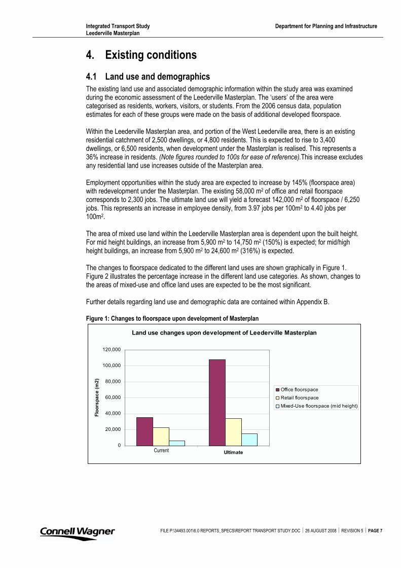
The existing land use and associated demographic information within the study area was examined during the economic assessment of the Leederville Masterplan. The ‘users’ of the area were categorised as residents, workers, visitors, or students. From the 2006 census data, population estimates for each of these groups were made on the basis of additional developed floorspace.
Within the Leederville Masterplan area, and portion of the West Leederville area, there is an existing residential catchment of 2,500 dwellings, or 4,800 residents. This is expected to rise to 3,400 dwellings, or 6,500 residents, when development under the Masterplan is realised. This represents a 36% increase in residents. (Note figures rounded to 100s for ease of reference).This increase excludes any residential land use increases outside of the Masterplan area.
Employment opportunities within the study area are expected to increase by 145% (floorspace area) with redevelopment under the Masterplan. The existing 58,000 m2 of office and retail floorspace corresponds to 2,300 jobs. The ultimate land use will yield a forecast 142,000 m2 of floorspace / 6,250 jobs. This represents an increase in employee density, from 3.97 jobs per 100m2 to 4.40 jobs per 100m2.
The area of mixed use land within the Leederville Masterplan area is dependent upon the built height. For mid height buildings, an increase from 5,900 m2 to 14,750 m2 (150%) is expected; for mid/high height buildings, an increase from 5,900 m2 to 24,600 m2 (316%) is expected.
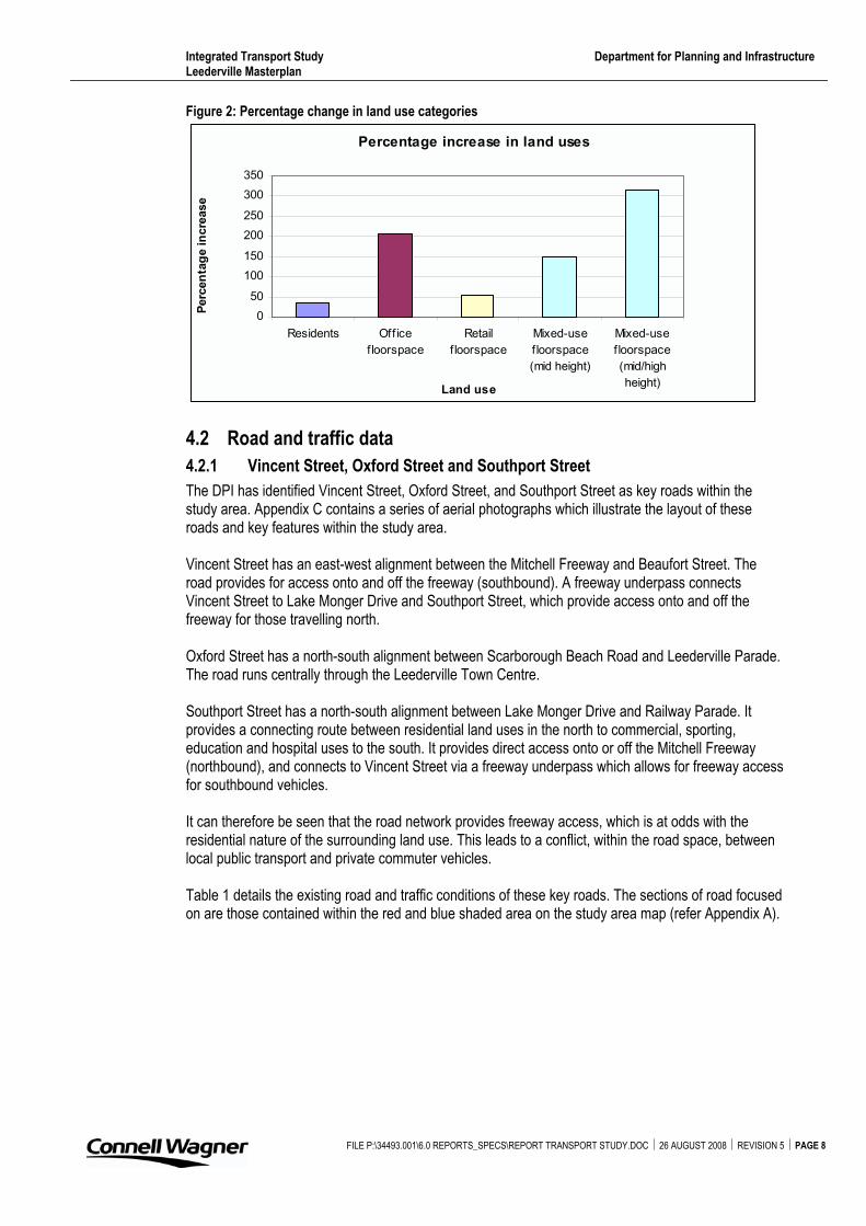
The changes to floorspace dedicated to the different land uses are shown graphically in Figure 1.Figure 2 illustrates the percentage increase in the different land use categories. As shown, changes to the areas of mixed-use and office land uses are expected to be the most significant.
Further details regarding land use and demographic data are contained within Appendix B.
Figure 1: Changes to floorspace upon development of Masterplan
Land use changes upon development of Leederville Masterplan
0
20,000
40,000
60,000
80,000
100,000
120,000
Ultimate
Flo
ors
pa
ce
(m
2)
Office floorspace
Retail floorspace
Mixed-Use floorspace (mid height)
Current
FILE P:\34493.001\6.0 REPORTS_SPECS\REPORT TRANSPORT STUDY.DOC � 26 AUGUST 2008 � REVISION 5 � PAGE 7
Integrated Transport Study Department for Planning and Infrastructure Leederville Masterplan
Figure 2: Percentage change in land use categories
Percentage increase in land uses
0
50
100
150
200
250
300
350
Residents Office
floorspace
Retail
f loorspace
Mixed-use
floorspace
(mid height)
Mixed-use
floorspace
(mid/high
height)Land use
Perc
en
tag
e in
cre
ase
4.2 Road and traffic data
4.2.1 Vincent Street, Oxford Street and Southport Street
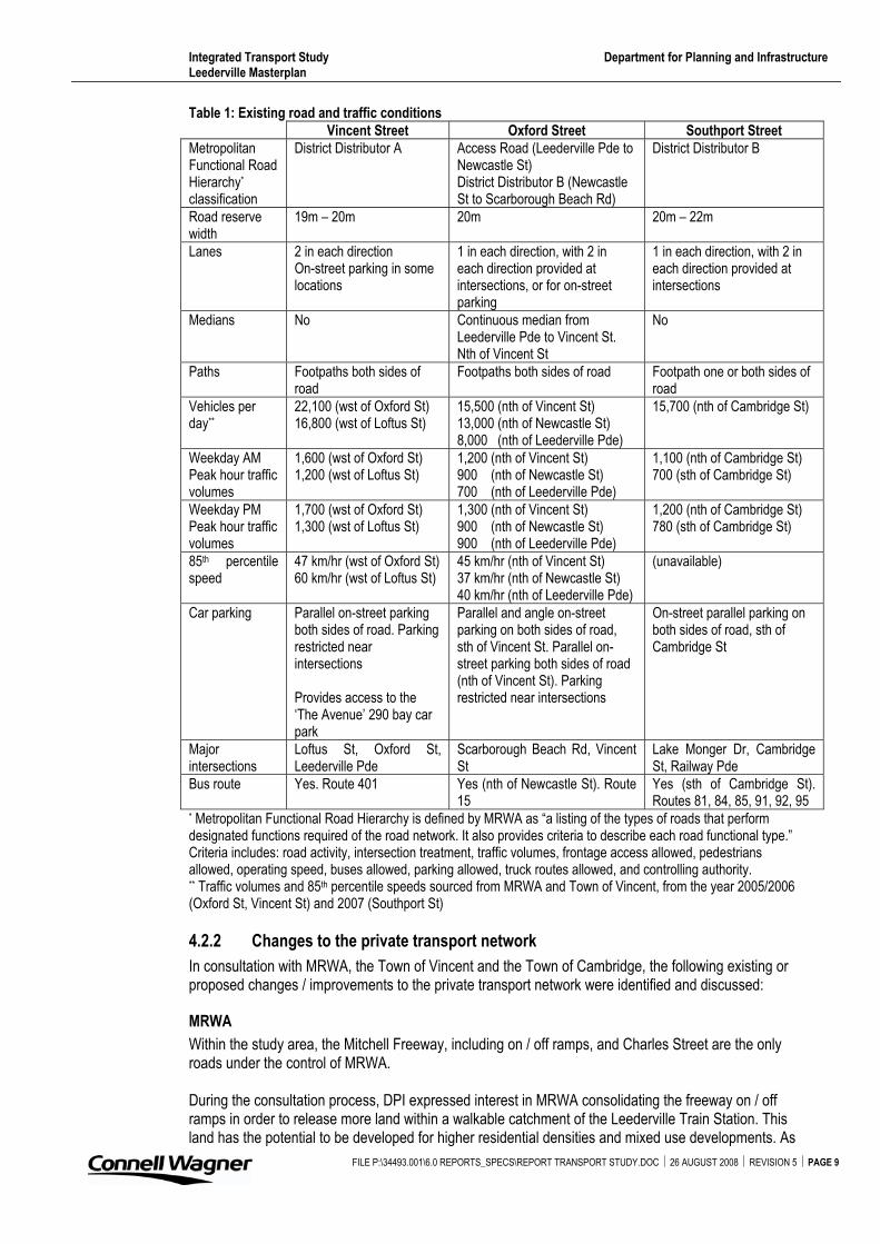
The DPI has identified Vincent Street, Oxford Street, and Southport Street as key roads within the study area. Appendix C contains a series of aerial photographs which illustrate the layout of these roads and key features within the study area.
Vincent Street has an east-west alignment between the Mitchell Freeway and Beaufort Street. The road provides for access onto and off the freeway (southbound). A freeway underpass connects Vincent Street to Lake Monger Drive and Southport Street, which provide access onto and off the freeway for those travelling north.
Oxford Street has a north-south alignment between Scarborough Beach Road and Leederville Parade. The road runs centrally through the Leederville Town Centre.
Southport Street has a north-south alignment between Lake Monger Drive and Railway Parade. It provides a connecting route between residential land uses in the north to commercial, sporting, education and hospital uses to the south. It provides direct access onto or off the Mitchell Freeway (northbound), and connects to Vincent Street via a freeway underpass which allows for freeway access for southbound vehicles.
It can therefore be seen that the road network provides freeway access, which is at odds with the residential nature of the surrounding land use. This leads to a conflict, within the road space, between local public transport and private commuter vehicles.
Table 1 details the existing road and traffic conditions of these key roads. The sections of road focused on are those contained within the red and blue shaded area on the study area map (refer Appendix A).
FILE P:\34493.001\6.0 REPORTS_SPECS\REPORT TRANSPORT STUDY.DOC � 26 AUGUST 2008 � REVISION 5 � PAGE 8
Integrated Transport Study Department for Planning and Infrastructure Leederville Masterplan
FILE P:\34493.001\6.0 REPORTS_SPECS\REPORT TRANSPORT STUDY.DOC � 26 AUGUST 2008 � REVISION 5 � PAGE 9
Table 1: Existing road and traffic conditions
Vincent Street Oxford Street Southport Street
MetropolitanFunctional Road Hierarchy*
classification
District Distributor A Access Road (Leederville Pde to Newcastle St) District Distributor B (Newcastle St to Scarborough Beach Rd)
District Distributor B
Road reserve width
19m – 20m 20m 20m – 22m
Lanes 2 in each direction On-street parking in some locations
1 in each direction, with 2 in each direction provided at intersections, or for on-street parking
1 in each direction, with 2 in each direction provided at intersections
Medians No Continuous median from Leederville Pde to Vincent St. Nth of Vincent St
No
Paths Footpaths both sides of road
Footpaths both sides of road Footpath one or both sides of road
Vehicles per day**
22,100 (wst of Oxford St) 16,800 (wst of Loftus St)
15,500 (nth of Vincent St) 13,000 (nth of Newcastle St) 8,000 (nth of Leederville Pde)
15,700 (nth of Cambridge St)
Weekday AM Peak hour traffic volumes
1,600 (wst of Oxford St) 1,200 (wst of Loftus St)
1,200 (nth of Vincent St) 900 (nth of Newcastle St) 700 (nth of Leederville Pde)
1,100 (nth of Cambridge St) 700 (sth of Cambridge St)
Weekday PM Peak hour traffic volumes
1,700 (wst of Oxford St) 1,300 (wst of Loftus St)
1,300 (nth of Vincent St) 900 (nth of Newcastle St) 900 (nth of Leederville Pde)
1,200 (nth of Cambridge St) 780 (sth of Cambridge St)
85th percentile speed
47 km/hr (wst of Oxford St) 60 km/hr (wst of Loftus St)
45 km/hr (nth of Vincent St) 37 km/hr (nth of Newcastle St) 40 km/hr (nth of Leederville Pde)
(unavailable)
Car parking Parallel on-street parking both sides of road. Parking restricted near intersections
Provides access to the ‘The Avenue’ 290 bay car park
Parallel and angle on-street parking on both sides of road, sth of Vincent St. Parallel on-street parking both sides of road (nth of Vincent St). Parking restricted near intersections
On-street parallel parking on both sides of road, sth of Cambridge St
Majorintersections
Loftus St, Oxford St, Leederville Pde
Scarborough Beach Rd, Vincent St
Lake Monger Dr, Cambridge St, Railway Pde
Bus route Yes. Route 401 Yes (nth of Newcastle St). Route 15
Yes (sth of Cambridge St). Routes 81, 84, 85, 91, 92, 95
* Metropolitan Functional Road Hierarchy is defined by MRWA as “a listing of the types of roads that perform designated functions required of the road network. It also provides criteria to describe each road functional type.” Criteria includes: road activity, intersection treatment, traffic volumes, frontage access allowed, pedestrians allowed, operating speed, buses allowed, parking allowed, truck routes allowed, and controlling authority. ** Traffic volumes and 85th percentile speeds sourced from MRWA and Town of Vincent, from the year 2005/2006 (Oxford St, Vincent St) and 2007 (Southport St)
4.2.2 Changes to the private transport network
In consultation with MRWA, the Town of Vincent and the Town of Cambridge, the following existing or proposed changes / improvements to the private transport network were identified and discussed:
MRWA
Within the study area, the Mitchell Freeway, including on / off ramps, and Charles Street are the only roads under the control of MRWA.
During the consultation process, DPI expressed interest in MRWA consolidating the freeway on / off ramps in order to release more land within a walkable catchment of the Leederville Train Station. This land has the potential to be developed for higher residential densities and mixed use developments. As
Integrated Transport Study Department for Planning and Infrastructure Leederville Masterplan
FILE P:\34493.001\6.0 REPORTS_SPECS\REPORT TRANSPORT STUDY.DOC � 26 AUGUST 2008 � REVISION 5 � PAGE 10
outlined in the WAPC Development Control Policy 1.6, the location of this type of development near a train station has “the potential to reduce car dependence, to increase accessibility for those without access to private cars, to reduce congestion on the road network and the demand for new road space, and to reduce fuel consumption and air pollution.”
The existing use of this land will need to be investigated before redevelopment occurring. Currently, MRWA consider the ramps necessary to allow for sufficient traffic queuing and road grade achievement. There is also Town of Vincent drainage facilities within the ‘centre’ of the circular ramps.
At the time of this study, MRWA did not have any existing plans to alter the roads under their control.
Town of Vincent
The Oxford Street / Vincent Street four-way signalised intersection has secured Blackspot funding for the year 2008/2009. As stated in the Leederville Masterplan Traffic and Services Report , “the intersection has had a high number of crashes (86 reported in the five years to December 2006), with no dominant pattern. The Town has proposed a modified layout, which includes the reduction of Oxford Street to one through lane in each direction, and the banning of the right turn movement from Oxford Street (northbound) to Vincent Street (eastbound).” The report recommended that the intersection be modified only to reflect the outcomes of the Blackspot funding process. Appendix C contains a copy of the proposed concept layout of the intersection.
At the stakeholder workshop, the Town of Vincent reported the signalised intersections (Loftus Street / Vincent Street, Loftus Street / Newcastle Street, Vincent Street / Charles Street) tend to operate very well for north-south travellers. Concern was expressed that this is at the expense of east-west travellers, and leads to high congestion in the east-west direction. It is recommended the Town of Vincent discusses the signal operation with the MRWA Traffic Operations Centre, to potentially resolve this issue. In addition, the Water Corporation, Town of Vincent, and MRWA have discussed jointly funding the installation of pedestrian phases along Loftus Street, with the aim to improve safety of employees arriving / leaving work.
Frame Court is a cul-de-sac road accessed from Leederville Parade. The Water Corporation site abuts Frame Court and Newcastle Street, and an access driveway extending from the end of Frame Court allows for a connection between Newcastle Street and Leederville Parade to occur (although not a public right of way, this driveway generally allows for public vehicle traffic, but the Water Corporation may close the access when desired). During consultation, DPI commented that a public through road would be logical in regards to street block layout. The connection would increase permeability and provide a ‘circular’ route for public transport vehicles or private vehicles looking for parking. The Water Corporation do not support a road reserve through their site, due to security concerns. The DPI support the establishment of a through connection in this street block.
Town of Cambridge
At the stakeholder workshop, the Town of Cambridge did not specifically identify improvements to the private transport network under their control.
However, over the past 15 years, there have been a number of studies undertaken which have relevance to traffic in West Leederville. Of these, the most recent and directly related to the study area include: � Intersection of Cambridge Street and Southport Street Traffic Signal Review (Connell Wagner
2004) � West Leederville Traffic Management Review (Town of Cambridge 2005) � Intersection of Railway Parade and Southport Street: Intersection review (Connell Wagner
2007) � Traffic Signal Modification Report: Cambridge Street / Southport Street Intersection (Connell
Wagner 2008)
Integrated Transport Study Department for Planning and Infrastructure Leederville Masterplan
FILE P:\34493.001\6.0 REPORTS_SPECS\REPORT TRANSPORT STUDY.DOC � 26 AUGUST 2008 � REVISION 5 � PAGE 11
These reports consider the traffic routes and data, traffic amenity, potential road improvements, potential intersection improvements, and the impact of kerbside parking. The West Leederville Traffic Management Review is a broad study of the entire West Leederville area, and recommendations from the report are contained within Appendix D.
Currently, the Town of Cambridge is preparing design drawings for the conversion of the Railway Road / Southport Street intersection (unsignalised T-junction) to a roundabout.
4.2.3 Limits to growth of private transport
Within the study area, potential growth to the private transport network is limited.
The road reserves generally are not considered wide enough to introduce additional lanes whilst retaining other important transport networks (footpaths and / or cycle lanes).
In some instances, the key roads identified allow for on-street parking. Whilst removing the parking would increase the road capacity, this measure is not recommended in the context of development envisaged under the Masterplan. The creation of a pedestrian friendly environment is an objective of the plan, which would include roads with lower vehicle travel speeds. The on-street parking acts as a traffic calming measure.
Key intersections within the study area are operating close to, or at, capacity. The simplest way to improve capacity at intersections is generally to provide additional through or turning lanes. However within the study area this practice many not be achievable due to the historic nature of the area which limits the potential to widen existing road reserves due to the presence of heritage buildings fronting roads. Many of the lots adjacent to the intersections in West Leederville do not have truncations, limiting any changes to layouts.
Particular reference is given to the Vincent Street / Oxford Street intersection. Whilst a key node in the network for those accessing (or departing from) the freeway in an easterly direction, this intersection is near capacity and is bounded on most corners by historic buildings. Additional lanes, whilst the traditional approach for capacity increase, cannot be accommodated.
When a length of road or an intersection begins to near capacity a driver will evaluate their choice of route, and may consider alternative routes between their origin and destination. Whilst outside the scope of this study, the district / regional level traffic impacts of increased intensity of land use in one location and driver route choice can be modelled and the results investigated.
Integrated Transport Study Department for Planning and Infrastructure Leederville Masterplan
4.3 Public transport
4.3.1 Current services
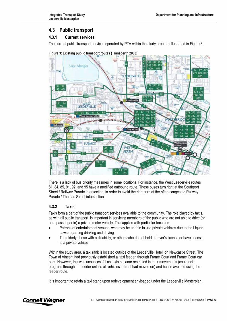
The current public transport services operated by PTA within the study area are illustrated in Figure 3.
Figure 3: Existing public transport routes (Transperth 2008)
There is a lack of bus priority measures in some locations. For instance, the West Leederville routes 81, 84, 85, 91, 92, and 95 have a modified outbound route. These buses turn right at the Southport Street / Railway Parade intersection, in order to avoid the right turn at the often congested Railway Parade / Thomas Street intersection.
4.3.2 Taxis
Taxis form a part of the public transport services available to the community. The role played by taxis, as with all public transport, is important in servicing members of the public who are not able to drive (or be a passenger in) a private motor vehicle. This applies with particular focus on: � Patrons of entertainment venues, who may be unable to use private vehicles due to the Liquor
Laws regarding drinking and driving � The elderly, those with a disability, or others who do not hold a driver’s license or have access
to a private vehicle
Within the study area, a taxi rank is located outside of the Leederville Hotel, on Newcastle Street. The Town of Vincent had previously established a ‘taxi feeder’ through Frame Court and Frame Court car park. However, this was unsuccessful as taxis became restricted in their movements (could not progress through the feeder unless all vehicles in front had moved on) and hence avoided using the feeder route.
It is important to retain a taxi stand upon redevelopment envisaged under the Leederville Masterplan.
FILE P:\34493.001\6.0 REPORTS_SPECS\REPORT TRANSPORT STUDY.DOC � 26 AUGUST 2008 � REVISION 5 � PAGE 12
Integrated Transport Study Department for Planning and Infrastructure Leederville Masterplan
FILE P:\34493.001\6.0 REPORTS_SPECS\REPORT TRANSPORT STUDY.DOC � 26 AUGUST 2008 � REVISION 5 � PAGE 13
As with all public transport, it is important that patrons feel safe accessing taxis and so the stands should be in areas of high surveillance with good levels of lighting. Any improvements to the station access, on either side of the railway, should include an allowance for taxi pick up and drop off.
4.3.3 Changes to the public transport network
PTA has no current plans to alter the public transport routes within the study area.
There had been previous consideration by PTA of altering the 401 route, to bring the bus down Oxford Street to the Leederville Train Station. However this concept has not been pursued further as demand, both existing and in the foreseeable future, for transferring between the bus and train is limited.
4.3.4 Limits to growth of public transport
Limits to the growth of public transport within the study area include: � The constrained geometry of the road network � Road congestion affects public transport � The priority actions of PTA focus on provision of initial, or additional, public transport services to
the outer metropolitan areas � Funding for additional bus routes or increased bus frequency
4.4 Pedestrian and cyclist facilities
The Perth Bicycle Network (PBN) is a comprehensive plan that details the cycling facilities within the Perth Metropolitan Region. These facilities include on-road (bicycle lanes), off-road (shared paths), and end of trip facilities (bicycle parking). The bicycle network consists of a variety of routes, both existing and proposed, including: � Principal Shared Paths – These high standard shared paths form the ‘backbone’ of the bicycle
network and are located along the freeway and railway corridors. They are primarily used for longer journeys, and connect major public transport stations. The funding for construction and maintenance of Principal Shared Paths generally comes from MRWA, PTA, and DPI (via the DPI PBN program). There is a good pedestrian and cyclist network adjacent to the Mitchell Freeway
� Recreational Shared Paths – These paths are high standard shared paths generally located along the coastal and river foreshores. Typically used by both commuter and recreational cyclists, the paths also attract a high number of pedestrians. The interaction between pedestrians and cyclists commonly causes safety concerns along some routes. Recreational Shared Paths are the responsibility of the asset owner, which could be the local government, Department of Environment and Conservation, or the WAPC. Funding assistance is available to local governments through the DPI PBN Local Government grants Program.
� Local Bicycle Routes – These routes consist of relatively quiet, local streets which link together the major paths (Recreational and Principal) to form continuous bicycle routes. The majority of Local Bicycle Routes are on-road, and are identified through community consultation and planning. The routes commonly provide access to facilities such as shopping centres, schools, and public facilities. The local government is responsible for implementing and maintaining the route, and may seek funding from the PBN Local Government grants Program.
Available from DPI are the Perth Bicycle Network maps, local TravelSmart guides, and access and facility guides for the local governments (including the Town of Cambridge and Town of Vincent). These maps illustrate (list is not exhaustive): � The Principal Shared Paths, Recreational Shared Paths and Local Bicycle Routes � Local bicycle friendly streets, and streets with bicycle lanes or sealed shoulders either side � Shared paths and walk trails � Bicycle facilities eg Bicycle locker locations, bicycle shops, bicycle parking � Bus routes and bus stop locations for the CircleRoute, high frequency routes, and ‘other’ routes � Train stations � Destinations eg supermarkets, tertiary education facilities, playgrounds, sporting facilities
Integrated Transport Study Department for Planning and Infrastructure Leederville Masterplan
FILE P:\34493.001\6.0 REPORTS_SPECS\REPORT TRANSPORT STUDY.DOC � 26 AUGUST 2008 � REVISION 5 � PAGE 14
4.5 RAC and public awareness
The RAC acts as both a motoring organisation and as an advocate for its members. As many members of the RAC use public transport, the RAC has noted a “keen interest in ensuring it is operating at its optimum capability” (RAC 2008).
Accordingly, the RAC has corresponded with the Town of Vincent regarding the RAC’s continuing investigation into the barriers to public transport. It was noted that in general for the metropolitan area, inadequate parking around train stations, infrequent buses feeding into the train line and personal safety concerns were hindering people from using public transport. The RAC has also met with the Town of Vincent to discuss issues of relevance to the Town of Vincent itself. These include personal safety of pedestrians accessing public transport, and east-west links through the Town.
The RAC has conducted public campaigns and studies into the usage of public transport in Perth. Released via an online news article during March 2008 (Public transport good, but could be better), the following results highlight the public’s perception and use of public transport in Perth: � 45% rate Perth’s public transport system as excellent or good � 55% of people primarily use public transport to get to work � Benefits of public transport include the relatively low cost compared with driving, the
convenience due to lack of city parking, and the environmental benefits � Reasons for not using public transport more often include poor connections, infrequent service,
lack of parking at train stations, over-crowding, and personal safety concerns
The survey noted that poor connections were most likely cited by those respondents who used both the bus and train. However, respondents living in the inner metropolitan area thought overcrowding was a major difficulty and did not cite connection issues. Overall, the highest response across all age brackets for a way to improve the public transport system was for buses and trains to adhere to timetables.
Discussion with the RAC indicated that education and awareness regarding public transport options are the main methods of attracting people to public transport. The lower fare cost, when compared to private transport running and parking costs, is seen as the main driver behind the favoured use of public transport over private transport. Secondary to this are the environmental and social benefits.
If encouraging a modal shift to public transport from private car usage, the governing authorities need to ensure that the facilities are in place to cope with the additional demand placed on the public transport network. In relation to Leederville, and many inner metropolitan suburbs, this includes consideration that, due to the dominantly radial nature of Perth’s public transport system, the buses / trains are often full by the time they reach these areas from the outer Perth suburbs. This leads to decreased reliability in the services, and a potential resistance to modal change.
In conjunction with providing public transport facilities and services, adequate linkages to these facilities must also be developed. This includes permeable pedestrian linkages to increase the catchment of bus stops / train stations. The safety of pedestrians utilising these linkages also needs consideration.
Integrated Transport Study Department for Planning and Infrastructure Leederville Masterplan
FILE P:\34493.001\6.0 REPORTS_SPECS\REPORT TRANSPORT STUDY.DOC � 26 AUGUST 2008 � REVISION 5 � PAGE 15
5. Improvements to the public transport network
5.1 Existing road and traffic conditions
5.1.1 East West link
One of the weaknesses in the public transport system for the Leederville and West Leederville areas considered in this study is the lack of an east west link. To get from West Leederville to Mount Lawley on public transport requires a change of bus. Transperth’s current priority for expanding its services is to increase the speed and frequency of a number of services that run radial to the CBD to suburbs that are not served by the train lines. The development of an east west link is supported by the Town of Vincent.
5.1.2 Major attractions and generators
Using the convention of a trip attractor being internal to an area and a trip generator being external to the area gives the example of the Water Corporation being a trip attractor and Edith Cowan University being a trip generator. The major trip generators for the study area would be businesses accessing clients and suppliers, and residents accessing Edith Cowan University, the University of Western Australia, QEII Medical Centre, and Perth CBD.
The major trip attractors in the study area are TAFE, the café strip, the entertainment opportunities, and the Water Corporation. These attractors operate at different times of day and have peak demand on different days. This would suggest that travel demand in the study area is spread across the week and any public transport services would need to match this, rather than concentrating on the weekday peak hours. Similarly, the trip generators operate throughout the day, week, and into the weekend.
To support public transport provision across the week the Towns of Vincent and Cambridge need to continue to implement their parking strategies that recognise reciprocal parking so that there is not an oversupply of parking, which in turn encourages people to use private vehicles. The provision of public parking overcomes concerns of building owners regarding access to a premises “out of hours”. This public parking can be funded through developers being required to pay into a parking fund rather than providing parking on site. This practice occurs throughout the Perth region, for example, the City of Fremantle will consider taking cash-in-lieu of car parking when the developments are unable to meet the relevant Town Planning Scheme requirements for parking provision. The City of Stirling takes a cash-in-lieu payment whether or not the development provides the required parking provision. The cash-in-lieu is used to fund public parking areas.
A potential attractor to the study area is the supply of public parking that is cheaper than Perth CBD parking. The issue to be managed is to balance the requirements of businesses in the area, who need all day parking for their employees, and the risk that the parking will be taken by commuters to the CBD. The Town of Vincent is currently undertaking a study into its parking policy and it is expected that this issue will be investigated as part of that study.
5.1.3 Traffic Conditions
The consistent traffic flow from the attractors and generators is borne out by the traffic flows on the major roads.
The road network in this area services the freeway and so whilst there are morning and evening peak hours this term is misleading. For Vincent Street (west of Oxford Street) the traffic flow on weekdays is consistently above 1,000 vehicles per hour between the hours of 07:00 and 20:00. Interestingly the weekend traffic flows are also above 1,000 vehicles per hour between the hours of 07:00 and 19:00 on Saturday and 11:00 and 20:00 on Sunday. The traffic flow is also even across the westbound and eastbound traffic.
Integrated Transport Study Department for Planning and Infrastructure Leederville Masterplan
FILE P:\34493.001\6.0 REPORTS_SPECS\REPORT TRANSPORT STUDY.DOC � 26 AUGUST 2008 � REVISION 5 � PAGE 16
For Oxford Street (south of Vincent Street) the traffic flow on weekdays is consistently above 600 vehicles per hour between the hours of 07:00 and 20:00, with the predominate direction of travel being southbound in the morning and northbound in the evening.
Like Vincent and Oxford Streets, Southport Street (north of Cambridge Street) has a consistent flow of traffic during the day. Unlike the others, Southport Street shows a strong southbound peak of 1,100 vehicles per hour between 08:00 and 09:00. This is not matched by such a strong northbound peak in the evening. Southport Street is also strongly influenced by Subiaco Oval. Surveys undertaken on Saturday 1st September 2007, when West Coast played Essendon, indicated over 1,100 vehicles travelling southbound (towards Subiaco) between 13:00 and 14:00 with a similar number of vehicles travelling northbound (away from the Subiaco) between 17:00 and 18:00.
These traffic patterns indicate that when attention is given to public transport two issues should be considered. Firstly, any public transport priority measures in the study area should be in place between 07:00 and 20:00, rather than for the “peak” hour. Secondly, there is consistent travel demand across this area during the day and into the weekend.
Vincent Street / Oxford Street intersection
The Town of Vincent’s plan to make changes to the intersection of Vincent and Oxford Street will address the safety concerns at this intersection. It will also improve amenity for pedestrians crossing the road. However, the changes will decrease the capacity of the intersection which is contrary to Vincent Street’s place in the road hierarchy. Only bus route 15, which is on Oxford Street, and bus route 401, which is on Vincent Street, will be affected by this change.
Loftus Street / Vincent Street intersection
The consultation process identified the suggested improvement of increasing the length of the left turn slip lane from Loftus Street (north) into Vincent Street (east). This could reduce the queuing delays for left turn buses.
5.2 Transport feeder issues
5.2.1 Bus rail interchange
Under current public transport operations, Leederville station is not a bus rail interchange. With the proximity of Leederville station to the CBD, Transperth does not consider it likely that passengers will transfer between the buses and the train.
The creation of an east west link would require a bus rail interchange on at least one side of the railway, which runs in the median of the Mitchell Freeway. If a bus bridge was established over the freeway, then space will be needed for the landing of the bridge on either side of the freeway.
5.2.2 External road network
The Leederville precinct is well situated in regards to transport linkages. The Mitchell Freeway, situated to the west of Leederville and forming the boundary between the Town of Cambridge and the Town of Vincent, can be accessed (in both the southern and northern bound directions) from Leederville and West Leederville. Exiting the freeway into these suburbs is also possible. The traffic volumes on the roads which link to the Mitchell Freeway on / off ramps indicate that this access point is utilised throughout the day.
Charles Street and Loftus Street are high order roads (Primary Distributor and District Distributor A respectively) which provide north / south transport routes from / to the Leederville precinct. In an east-west alignment, Vincent Street, Lake Monger Drive, and Grantham Street are District Distributor A roads which allow access from, to, and through the precinct.
Integrated Transport Study Department for Planning and Infrastructure Leederville Masterplan
During the consultation process, no significant changes to areas of the transport network that enter the Leederville precinct (particularly North Perth, West Perth, CBD and the Mitchell Freeway) were identified.
5.3 “Free to user” services
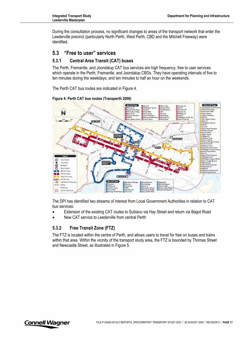
5.3.1 Central Area Transit (CAT) buses
The Perth, Fremantle, and Joondalup CAT bus services are high frequency, free to user services which operate in the Perth, Fremantle, and Joondalup CBDs. They have operating intervals of five to ten minutes during the weekdays, and ten minutes to half an hour on the weekends.
The Perth CAT bus routes are indicated in Figure 4.
Figure 4: Perth CAT bus routes (Transperth 2008)
The DPI has identified two streams of interest from Local Government Authorities in relation to CAT bus services: � Extension of the existing CAT routes to Subiaco via Hay Street and return via Bagot Road � New CAT service to Leederville from central Perth
5.3.2 Free Transit Zone (FTZ)
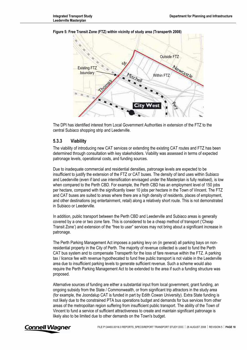
The FTZ is located within the centre of Perth, and allows users to travel for free on buses and trains within that area. Within the vicinity of the transport study area, the FTZ is bounded by Thomas Street and Newcastle Street, as illustrated in Figure 5.
FILE P:\34493.001\6.0 REPORTS_SPECS\REPORT TRANSPORT STUDY.DOC � 26 AUGUST 2008 � REVISION 5 � PAGE 17
Integrated Transport Study Department for Planning and Infrastructure Leederville Masterplan
Figure 5: Free Transit Zone (FTZ) within vicinity of study area (Transperth 2008)
Within FTZ
Outside FTZ
Existing FTZ boundary
The DPI has identified interest from Local Government Authorities in extension of the FTZ to the central Subiaco shopping strip and Leederville.
5.3.3 Viability
The viability of introducing new CAT services or extending the existing CAT routes and FTZ has been determined through consultation with key stakeholders. Viability was assessed in terms of expected patronage levels, operational costs, and funding sources.
Due to inadequate commercial and residential densities, patronage levels are expected to be insufficient to justify the extension of the FTZ or CAT buses. The density of land uses within Subiaco and Leederville (even if land use intensification envisaged under the Masterplan is fully realised), is low when compared to the Perth CBD. For example, the Perth CBD has an employment level of 150 jobs per hectare, compared with the significantly lower 10 jobs per hectare in the Town of Vincent. The FTZ and CAT buses are suited to areas where there are a high density of residents, places of employment, and other destinations (eg entertainment, retail) along a relatively short route. This is not demonstrated in Subiaco or Leederville.
In addition, public transport between the Perth CBD and Leederville and Subiaco areas is generally covered by a one or two zone fare. This is considered to be a cheap method of transport (‘Cheap Transit Zone’) and extension of the “free to user” services may not bring about a significant increase in patronage.
The Perth Parking Management Act imposes a parking levy on (in general) all parking bays on non-residential property in the City of Perth. The majority of revenue collected is used to fund the Perth CAT bus system and to compensate Transperth for the loss of fare revenue within the FTZ. A parking tax / licence fee with revenue hypothecated to fund free public transport is not viable in the Leederville area due to insufficient parking levels to generate sufficient revenue. Such a scheme would also require the Perth Parking Management Act to be extended to the area if such a funding structure was proposed.
Alternative sources of funding are either a substantial input from local government, grant funding, an ongoing subsidy from the State / Commonwealth, or from significant trip attractors in the study area (for example, the Joondalup CAT is funded in part by Edith Cowan University). Extra State funding is not likely due to the constrained PTA bus operations budget and demands for bus services from other areas of the metropolitan region suffering from insufficient public transport. The ability of the Town of Vincent to fund a service of sufficient attractiveness to create and maintain significant patronage is likely also to be limited due to other demands on the Town's budget.
FILE P:\34493.001\6.0 REPORTS_SPECS\REPORT TRANSPORT STUDY.DOC � 26 AUGUST 2008 � REVISION 5 � PAGE 18
Integrated Transport Study Department for Planning and Infrastructure Leederville Masterplan
FILE P:\34493.001\6.0 REPORTS_SPECS\REPORT TRANSPORT STUDY.DOC � 26 AUGUST 2008 � REVISION 5 � PAGE 19
Unless extra resources were made available to the PTA, an extension of the CAT may reduce service frequency, and most certainly reduce legibility to "non-expert" users. Two key characteristics of a CAT service are “frequent service” and “readily comprehendible routes.” If these are not met, then patronage levels are likely to decrease. The extension of the FTZ is unlikely to be supported by PTA without additional funding, as reduced revenue in conjunction with increased operating costs would occur.
A free-to-user service should not be extended into the Town of Vincent or City of Subiaco. There may be potential for the introduction of a new service, if a funding arrangement along the lines of the Joondalup or Fremantle CAT is established beforehand (joint funding between PTA, the local government, key businesses or attractors). This service could operate independent of the Central Perth CATs at a frequency more suitable to the area.
Further information on the CAT and FTZ is contained within Appendix E.
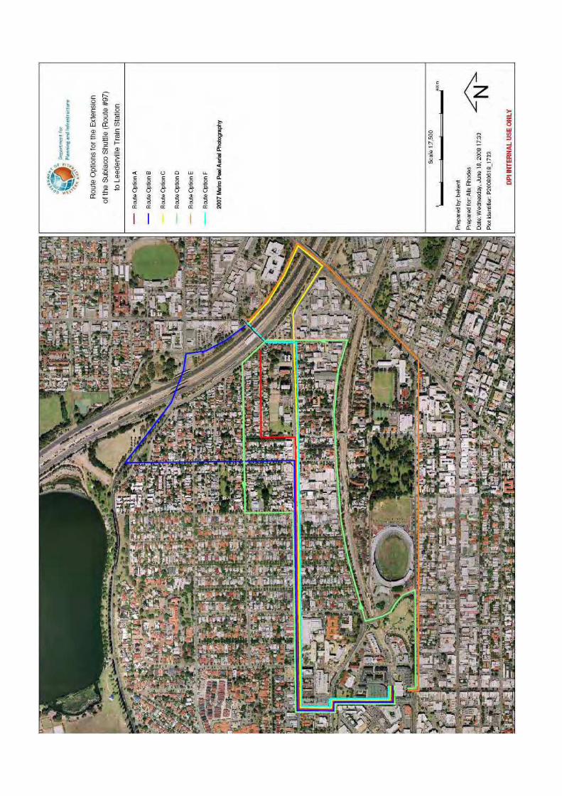
5.4 Extension of existing services
During the consultation process, extension of the Subiaco Shuttle bus route (route number 97) was a key discussion point. The Subiaco Shuttle currently runs between UWA and Subiaco Train Station; the City of Subiaco has suggested extending this route northwards to Leederville Train Station and southwards to the Matilda Bay Foreshore. The DPI suggested further extensions, being (in the north) westwards to Mt Lawley and East Perth, and (in the south) westwards to the Esplanade Busport.
To achieve a similar linking of major activity centres and train lines, an ‘Inner Collar’ bus route has been put forward by the Town of Vincent. This essentially has two parts:
i) “A high-capacity high-frequency service between UWA and QEII Medical Centre and Leederville Station (via Subiaco Station). This gets people to/from those two major and expanding activity centres to four of the five suburban train lines without the need to go on surface roads in the CBD.”
ii) “Extension across the freeway into an east-west link that would pick up some other major generators…This would require a crossing of the freeway that could be integrated into improved access to Leederville Station…”
The PTA agreed that benefit could be seen in provision of a UWA / QEII / Subiaco Station / Leederville Station link. Extension through to Leederville Town Centre is less certain in the absence of a bridge across the Mitchell Freeway; buses would be required to use Thomas Street / Loftus Street which suffers from congestion and travel times may be too great to make the route attractive to people. Instead, it may be more effective to limit the route to the western side of the freeway and develop an inviting pedestrian bridge link into Leederville.
The east-west link through the Town of Vincent is desirable from the Town’s perspective. PTA has noted that this is not currently viewed as having sufficient demand and therefore not being viable, but would reconsider this position if travel demand data / evidence is presented that suggests an east-west travel market does exist.
At the stakeholder workshops, the potential to divert existing bus services from Scarborough Beach Road (a District Distributor A road located to the north and northwest of Leederville) along Oxford Street to the Leederville Train Station was identified. However, the two bus routes (the 400 and 402) which travel along Scarborough Beach Road in the vicinity of Oxford Street already provide access to/from the Joondalup Train Line on their existing routes. Both these bus routes have the Wellington Street Bus Port as a destination, similar to the route 15 bus (which already travels down Oxford Street). As such, the diversion of the 400 or 402 bus route is not expected to generate notable additional patronage and would increase the travel time for existing users of the service. Therefore it is not considered a feasible option.
Integrated Transport Study Department for Planning and Infrastructure Leederville Masterplan
FILE P:\34493.001\6.0 REPORTS_SPECS\REPORT TRANSPORT STUDY.DOC � 26 AUGUST 2008 � REVISION 5 � PAGE 20
For commuters, extension of existing bus services to the Leederville Train Station is not viewed as a priority action to improve public transport. The connection from bus to train, or train to bus, is not envisaged to be a common movement as the ‘Transfer Penalty’ could be high. Commuters transferring between modes incur this penalty (ie waiting time between alighting one mode and boarding the other) and it is more likely that commuters would stay on one form of transport for their entire journey. In addition, those who remain on the initial form of transport incur a penalty due to the increased length, and therefore time, of their journey due to the extension or diversion of the service. PTA has expressed the importance of ‘protecting’ the journey of people travelling from the outer suburbs.
5.4.1 Bus priority
During the consultation process, congestion on the road network, particularly during the peak periods, was noted as reducing the attractiveness of public transport (buses), as these vehicles are also exposed to queuing and travel delays on the road network.
The constrained geometry at intersections, and generally narrow road reserve width, would make implementing bus priority measures, such as ‘bus only’ lanes, difficult. When carrying out local traffic management, negative impacts upon bus routes should be avoided or minimised. Where bus priority measures can be introduced, these measures should be in effect throughout the day rather than during the traditional peak periods.
To improve connectivity between the east and west sides of the Mitchell Freeway, the establishment of a bridge over the freeway was suggested during consultation with key stakeholders. This bridge could be a bus / pedestrian / cyclist bridge, and would assist in providing bus access between the two areas. The bridge could be incorporated into improved access for the Leederville Train Station. Investigations by stakeholders have indicated that the bridge would require careful consideration of placement, due to the difference in levels, especially on the eastern side.
5.5 Local Governments
5.5.1 Town of Cambridge
The Town of Cambridge has embarked on a revision of their Town Planning Scheme. The revision focuses on the area of land between Loftus Street and McCourt Street, in West Leederville. The Leederville Train Station directly abuts this area, and Southport Street, near the station, is to be one of the focus locations during the review.
Consultation with the Town of Cambridge identified the following ideas from the Town: � A link from the Leederville Train Station to Subiaco Oval (and the future Kitchener Park oval) is
strongly desired. Several ideas for this link have been proposed, including that of reducing Cambridge Street to one lane in either direction and provision of light rail down the centre of the road reserve or development of high quality cycle and pedestrian lanes / paths.
� A bus drop off point at the Leederville Train Station. This would involve land take from adjacent landowners; the north-west corner of Cambridge Street / Southport Street intersection was suggested as a potential location as existing development is of low density.
� A bus bridge over the Mitchell Freeway is worth investigating further � Parking at the Leederville Train Station would only be desirable if in conjunction with providing
linkages from the station to Subiaco Oval
The main topic discussed was linking the Leederville Train Station through to Subiaco Oval.
5.5.2 Town of Vincent
The Town of Vincent has expressed a desire to increase the east-west public transport linkages within the Town. In addition, the Leederville Train Station should be made more inviting and visible, which is the subject of a separate study.
Integrated Transport Study Department for Planning and Infrastructure Leederville Masterplan
FILE P:\34493.001\6.0 REPORTS_SPECS\REPORT TRANSPORT STUDY.DOC � 26 AUGUST 2008 � REVISION 5 � PAGE 21
The Town also aims to achieve a modal shift from private motor vehicle to public transport, cycling, or walking. The Leederville Masterplan draws on the objectives of Transit Orientated Development, by developing a higher intensity of land uses close to public transport (the train station).
5.5.3 City of Subiaco
The City of Subiaco has developed an Integrated Transport Strategy. The primary aim of this strategy is so that “(r)esidents and visitors to Subiaco will enjoy convenient and safe access and movement to, from and within the City by all transport modes (walking, cycling, public transport and car) on a sustainable basis without negatively impacting on Subiaco’s diversity of amenity and lifestyles.” The Strategy identifies five key activity areas:
i) Managing travel demand ii) Improving walking and cycling iii) Improving public transport iv) Managing vehicular traffic v) Managing and improving parking
Consultation with the City of Subiaco raised the following desired improvements to the public transport network: � Extension of the Subiaco Shuttle bus service to Leederville in the north, and to the river
foreshore in the south � Parking facilities at the Leederville Train Station � A bridge over the Mitchell Freeway, to improve linkages and help overcome the radial train lines
which ‘dissect’ the road network � East west bus linkages to bring people to the Leederville Train Station
Due to the major hospitals, sporting venue, entertainment venues, and mix of retail, commercial and residential land uses, the City of Subiaco, similar to the Leederville area, has a consistent travel demand throughout the day, week, and into the weekend.
The City has developed a parking policy which aims to promote the use of public transport. There is limited provision of long term bays, to encourage employees to use public transport. Parking is severely restricted during events at Subiaco Oval, to again promote the use of public transport. In addition, free public transport travel before and after an event at Subiaco Oval is often included in the ticket. “Inverse parking,” in which the cost of parking decreases as the number of persons in the vehicle increases, is also utilised within the City of Subiaco.
Extension of the FTZ or CAT bus service is not a key consideration by the City.
5.6 Light rail
The Towns of Cambridge and Vincent have indicated an interest in a light rail service along certain routes within their boundaries. In 2007, the DPI commissioned Maunsell Australia Pty Ltd to undertake the Perth Light Rail Study. The requirement of this study was an investigation of route feasibility for a light rail alignment between the City of Subiaco and East Perth. Appendix F contains information on this study and its key findings.
One option for the alignment of the light rail was through West Leederville. However, the study found this would be unviable. The main reason suggesting this is the heavy traffic congestion at various points of the road network 'with the section of Loftus/Thomas Streets between the Mitchell Freeway and Hay Street commonly acknowledged as one of the busiest roads in Perth.' Considering this, 'the possibility of a dedicated bridge structure for light rail over this section might be required.' This would involve extensive funding.
The DPI does not recommend the progression of introducing a light rail service in the West Leederville Area.
Integrated Transport Study Department for Planning and Infrastructure Leederville Masterplan
FILE P:\34493.001\6.0 REPORTS_SPECS\REPORT TRANSPORT STUDY.DOC � 26 AUGUST 2008 � REVISION 5 � PAGE 22
The Perth Light Rail Study suggested route for Perth's first light rail route is the ‘Rokeby Road’ option. If implemented, the light rail would supersede the need for the Subiaco Shuttle (route #97) service. With increased public transport patronage levels projected due to a light rail service, additional pressure is placed on the need for an extension of the Subiaco Shuttle to Leederville Train Station to allow for efficient transfer of passengers to the Northern Suburbs train line.
5.7 Awareness
Ultimately none of the measures that are put in place will be effective without the public being aware of the transport options that are available to them. The RAC considers education and awareness of options to be the major methods of attracting people to public transport.
The Travel Smart program is a voluntary behaviour change program, which addresses information, attitude, and motivational barriers to the use of alternative travel modes. Its implementation has been proven to reduce the number of car trips made by people living in a suburb / Local Government Area. The program should be implemented within the Town of Vincent to increase people’s awareness regarding public transport options.
5.8 Requirements of pedestrians
Almost all users of public transport are pedestrians for at least part of their journey. The WAPC Policy DC 1.6 for enhanced use of public transport suggests pedestrian linkages should be safe, attractive, friendly, efficient and accessible. These principles apply to all situations in which walking is to be encouraged as an alternative form of transport to vehicular usage. The principles can be summarised as:� Safe - overlooking of streets with building frontage, good footpath design, safe pedestrian
crossings at grade � Attractive - shade trees or verandas, good pedestrian amenity � Friendly - inviting streets, inviting destinations such as cafes and neighbourhood centres � Efficient - interconnected street network with direct routes, a choice of routes and visible
destinations � Accessible - continuous level access suitable for all people including those with mobility, vision
and other impairments
To ensure public transport is available to and accessible by pedestrians, the alighting (or boarding) points for the transport should be located within a ‘threshold’ distance to the user’s destination (or origin). Research has indicated that people are generally willing to walk about 10-15 minutes, or 800m distance, for rail stations, transit interchanges or major bus transfer stations or terminals, and about 5-7 minutes, or 400m, for bus stops located on bus routes with multiple services that are high frequency during peak periods (WAPC 2006).
To increase the catchment for public transport, an increased neighbourhood permeability is recommended. Stakeholder consultation and previous reports published in association with the Leederville Masterplan identified the need for: � A pedestrian link from Oxford Street to the Food Market Precinct (refer Leederville Masterplan) � A north-south pedestrian link between Carr Place and Vincent Street � A north-south pedestrian link between Newcastle Street and Carr Place � In general, the encouragement of developing pedestrian links through ‘large’ street blocks to
increase the directness of pedestrian routes and hence reduce travel time
In assessing existing or developing new pedestrian links, the following general design guidelines are recommended: � The provision of adequate lighting to increase real and perceived safety � Operation of pedestrian links (including through private developments) at all times of the day, to
increase night time public transport access
Integrated Transport Study Department for Planning and Infrastructure Leederville Masterplan
FILE P:\34493.001\6.0 REPORTS_SPECS\REPORT TRANSPORT STUDY.DOC � 26 AUGUST 2008 � REVISION 5 � PAGE 23
� Adequate width of footpaths (1.8m minimum), increasing this to 2.5m – 3.0m is an advised alternative if the path is to be dual use
� Road crossing points that are safe and convenient. Crossing facilities should comply with Australian Standards for accessibility (AS 1428) eg appropriate kerb ramps.
� Clear signage of public transport facilities, and directional signage en-route to provide guidance to these facilities
Strong pedestrian desire lines have been identified between the Leederville Train Station and Leederville TAFE; between the Water Corporation and Leederville town centre; east-west between the public car parks (‘The Avenue’ and ‘Frame Court’) and the town centre and entertainment venues; and north-south between Newcastle Street and Vincent Street. The development of these links is expected to occur as part of the Leederville Masterplan redevelopment works.
In summary, the provision and maintenance of adequate pedestrian links is essential to provide access to the public transport network, as for almost all public transport users, walking forms part of the journey.
5.9 Requirements of cyclists
The Perth Bicycle Network Plan and Local Government Bicycle Plans (currently being developed) identify works required to improve bicycle routes within the study area. In general, these plans aim to expand the bicycle network, improve connectivity, and increase the level of service provided to cyclists along these routes. As every street is a potential bicycle route, a basic level of safety and service should be provided on all roads.
To integrate the travel modes of cycling and public transport, two key requirements are needed: i) End of trip facilities at public transport boarding / alighting points ie secure bicycle
parking. End of trip facilities are necessary as bicycles can not be taken on trains (during peak periods) or on buses.
ii) Bicycle routes of a sufficient standard to encourage cycling by all classes of cyclists.
Specific to the study area, the following recommendations are made as a result of consultation with major stakeholders: � Improve the pedestrian / cyclist bridge over the freeway. The bridge provides access to the
Leederville Train Station and connects the two sides of the freeway. Identified items for improvement include widening of the bridge, provision of adequate route signage and line marking, a change in the ramp design, integration with Leederville Town Centre and Southport Street, and vertical integration with the Leederville redevelopment works.
� Improve the amenity of the link under the freeway from Vincent Street to Lake Monger Drive � Investigate potential improvements to Oxford Street and Vincent Street, which are attractive
cyclist destinations due to the mixed business land use and proximity of the Leederville Train Station. These roads are not currently identified as bicycle friendly routes, although bicycle lanes are preferred as part of the Leederville Masterplan and should be provided for in future when feasible.
� Investigate the provision, location, and standard of bicycle parking facilities at the Leederville Train Station
5.10 Car parking provision and needs
The Leederville Masterplan Traffic and Services Report (Connell Wagner 2007) set recommended rates for parking provision (both car and bicycle) on landholding redevelopments within the Town of Vincent’s Leederville Masterplan area.
The Town of Vincent is undertaking a separate car parking study to investigate and identify a suitable level of car parking provision to meet the existing and future car parking needs of the Town. The Leederville Town Centre is located adjacent to a railway station, is served by good quality public
Integrated Transport Study Department for Planning and Infrastructure Leederville Masterplan
FILE P:\34493.001\6.0 REPORTS_SPECS\REPORT TRANSPORT STUDY.DOC � 26 AUGUST 2008 � REVISION 5 � PAGE 24
transport, and is situated in close proximity to Perth CBD and West Perth. The road system which serves Leederville has limited remaining peak period capacity. Given this, lower parking requirements should be applied and the taking of cash-in-lieu of parking supported. This would enable the Town to acquire land for public parking purposes.
The Town is presenting the revised parking policy at a Council Forum on the 26 June 2008.
In addition, the new stadium at Kitchener Park (Subiaco) and the redevelopment of the Leederville Oval (Leederville) require a broad car parking study and strategy to be developed.
Integrated Transport Study Department for Planning and Infrastructure Leederville Masterplan
FILE P:\34493.001\6.0 REPORTS_SPECS\REPORT TRANSPORT STUDY.DOC � 26 AUGUST 2008 � REVISION 5 � PAGE 25
6. Action plan
The following tables list a range of actions which have arisen from the State Government and Local Government policies reviewed, and the stakeholder consultation carried out, during this study.
1. Actions arising from State Government policies
1.1 Improve land use around rail stations and public transport transit corridors, thereby maximising the environmental and economic benefits of public transport.
1.2 Improve public transport infrastructure and encourage behaviour change in favour of public transport and other transport options.
1.3 Research and document vehicle trip behaviour and personal travel mode choices to establish planning implications for land development, traffic management, bus priority measures and cycling infrastructure projects.
1.4 Provide safe and economical bicycle parking at train and bus stations, as well as bicycle priority measures on certain roads.
1.5 Encourage flexibility in local government parking policy in areas where there is good public transport eg cash-in-lieu for parking, discounted parking provision rates.
1.6 Introduce appropriate measures to improve real and perceived passenger security on public transport.
1.7 Encourage land uses that favour public transport. 1.8 Improve train stations, bus stops, and shelters. 1.9 Establish funding for public transport rolling stock and infrastructure replacement,
improvement and expansion. 1.10 Expand and improve public transport marketing. 1.11 Define and protect land requirements for future public transport infrastructure. 1.12 Improve public transport priority and services in the Perth Central Area, other Strategic
Regional Centres and congested areas. 1.13 Promote use of public transport to current and future car drivers. 1.14 Improve access to public transport for all people, including those with disabilities. 1.15 Ensure communities are involved in defining local public transport services.
2. Actions arising from current Local Government initiatives
2.1 Liaise with neighbouring local government authorities and state government agencies to promote regional cost sharing, grants and subsidies and seek opportunities for potential revenue sharing within the Town’s business activity.
2.2 Implement transport development and management improvements (Travel Smart, Integrated Transport Planning Strategies, reducing traffic on major roads, reducing posted speed on district distributors).
2.3 Review, implement and promote the car parking strategy. 2.4 Determine the requirements of the community and ensure that the services provided meet
those needs. 2.5 Innovative and efficient public transport with integrated transport connections to provide
easy access to and from the town centre.
3. Actions arising from this study
3.1 Undertake a land use study for the wider area, fully encompassing the Town of Cambridge, Town of Vincent, and City of Subiaco suburbs, to allow for integrated planning of public transport between these adjacent areas.
3.2 Undertake a travel demand survey within the Town of Vincent, to assess the viability of an east-west service.
3.3 Make the Leederville Train Station more visible. 3.4 Investigate the extension of the Subiaco Shuttle bus route to Leederville or West Leederville
and the Matilda Bay Foreshore / UWA.
Integrated Transport Study Department for Planning and Infrastructure Leederville Masterplan
FILE P:\34493.001\6.0 REPORTS_SPECS\REPORT TRANSPORT STUDY.DOC � 26 AUGUST 2008 � REVISION 5 � PAGE 26
3.5 Investigate the provision of more frequent bus services along current routes outside of peak periods, to meet the consistent demand for travel throughout the week and times of day.
3.6 Any public transport priority measures in the study area should be in place between 07:00 and 20:00, rather then for the “peak” hour. There is consistent travel demand across this area during the day and into the weekend.
3.7 Ensure that fares for public transport remain low in comparison with private vehicle parking costs, as the RAC has found cost to be the main driver for use of public transport.
3.8 Local Governments and significant trip attractors within the study area to implement the Travel Smart program and increase public awareness of public transport options / undertake an awareness campaign for residents and workers in the area.
3.9 Improve the connectivity and legibility of pedestrian networks on both the western and eastern sides of the Leederville Train Station (west and east of the Mitchell Freeway).
3.10 Balance the requirements of businesses in the area, who need all day parking for their employees, and the risk that the parking will be taken by commuters to the CBD.
3.11 Consider forming a standard parking policy to apply to the Inner Perth Suburbs, to achieve a consistent approach amongst the Local Governments.
3.12 Implement the planned changes to the intersection of Vincent and Oxford Streets. 3.13 Provide a better connection over the Freeway, either for public transport or pedestrians and
cyclists, or both. Develop an inviting pedestrian link bridge into Leederville. 3.14 Provide for a car pick up and drop off area on both sides of the Leederville Train Station. 3.15 Retain taxi stands and services to the area and provide for a taxi pick up and drop off area
on both sides of the Leederville Train Station. 3.16 Provide a public transport drop off point on the Town of Cambridge side of the Leederville
Train Station. 3.17 Provide adequate end of trip facilities for cyclists on both the western and eastern sides of
the Leederville Train Station. Continue to improve cyclist facilities throughout the Town of Cambridge, Town of Vincent, and City of Subiaco.
The priority action items identified by the DPI are: i) Item 3.4: Investigate the extension of the Subiaco Shuttle bus route to Leederville or
West Leederville and the Matilda Bay Foreshore / UWA. ii) Item 3.13: Provide a better connection over the Freeway, either for public transport or
pedestrians and cyclists, or both. Develop an inviting pedestrian link bridge into Leederville.
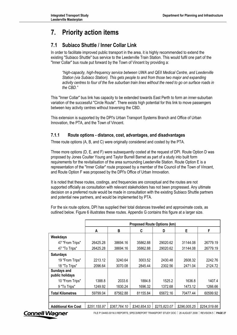
Integrated Transport Study Department for Planning and Infrastructure Leederville Masterplan
FILE P:\34493.001\6.0 REPORTS_SPECS\REPORT TRANSPORT STUDY.DOC � 26 AUGUST 2008 � REVISION 5 � PAGE 27
7. Priority action items
7.1 Subiaco Shuttle / Inner Collar Link
In order to facilitate improved public transport in the area, it is highly recommended to extend the existing "Subiaco Shuttle" bus service to the Leederville Train Station. This would fulfil one part of the "Inner Collar" bus route put forward by the Town of Vincent by providing a:
“high-capacity, high-frequency service between UWA and QEII Medical Centre, and Leederville Station (via Subiaco Station). This gets people to and from those two major and expanding activity centres to four of the five suburban train lines without the need to go on surface roads in the CBD.”
This "Inner Collar" bus link has capacity to be extended towards East Perth to form an inner-suburban variation of the successful "Circle Route". There exists high potential for this link to move passengers between key activity centres without traversing the CBD.
This extension is supported by the DPI's Urban Transport Systems Branch and Office of Urban Innovation, the PTA, and the Town of Vincent.
7.1.1 Route options - distance, cost, advantages, and disadvantages
Three route options (A, B, and C) were originally considered and costed by the PTA.
Three more options (D, E, and F) were subsequently costed at the request of DPI. Route Option D was proposed by Jones Coulter Young and Taylor Burrell Barnet as part of a study into built form requirements for the revitalisation of the area surrounding Leederville Station. Route Option E is a representation of the "Inner Collar" route proposed by a member of the Council of the Town of Vincent, and Route Option F was proposed by the DPI's Office of Urban Innovation.
It is noted that these routes, costings, and frequencies are conceptual and the routes are not supported officially as consultation with relevant stakeholders has not been progressed. Any ultimate decision on a preferred route would be made in consultation with the existing Subiaco Shuttle partners and potential new partners, and would be implemented by PTA.
For the six route options, DPI has supplied their total distances travelled and approximate costs, as outlined below. Figure 6 illustrates these routes. Appendix G contains this figure at a larger size.
Proposed Route Options (km)
A B C D E F
Weekdays
47 "From Trips" 26425.28 38694.16 35862.88 29020.62 31144.08 26779.19
47 "To Trips" 26425.28 38694.16 35862.88 29020.62 31144.08 26779.19
Saturdays
19 "From Trips" 2213.12 3240.64 3003.52 2430.48 2608.32 2242.76
18 "To Trips" 2096.64 3070.08 2845.44 2302.56 2471.04 2124.72Sundays and public holidays
10 "From Trips" 1388.8 2033.6 1884.8 1525.2 1636.8 1407.4
9 "To Trips" 1249.92 1830.24 1696.32 1372.68 1473.12 1266.66
Total Kilometres 59799.04 87562.88 81155.84 65672.16 70477.44 60599.92
Additional Km Cost $251,155.97 $367,764.10 $340,854.53 $275,823.07 $296,005.25 $254,519.66
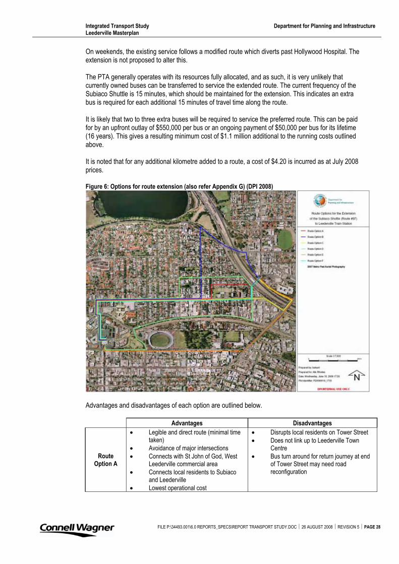
Integrated Transport Study Department for Planning and Infrastructure Leederville Masterplan
On weekends, the existing service follows a modified route which diverts past Hollywood Hospital. The extension is not proposed to alter this.
The PTA generally operates with its resources fully allocated, and as such, it is very unlikely that currently owned buses can be transferred to service the extended route. The current frequency of the Subiaco Shuttle is 15 minutes, which should be maintained for the extension. This indicates an extra bus is required for each additional 15 minutes of travel time along the route.
It is likely that two to three extra buses will be required to service the preferred route. This can be paid for by an upfront outlay of $550,000 per bus or an ongoing payment of $50,000 per bus for its lifetime (16 years). This gives a resulting minimum cost of $1.1 million additional to the running costs outlined above.
It is noted that for any additional kilometre added to a route, a cost of $4.20 is incurred as at July 2008 prices.
Figure 6: Options for route extension (also refer Appendix G) (DPI 2008)
Advantages and disadvantages of each option are outlined below.
Advantages Disadvantages
RouteOption A
� Legible and direct route (minimal time taken)
� Avoidance of major intersections � Connects with St John of God, West
Leederville commercial area � Connects local residents to Subiaco
and Leederville � Lowest operational cost
� Disrupts local residents on Tower Street � Does not link up to Leederville Town
Centre� Bus turn around for return journey at end
of Tower Street may need road reconfiguration
FILE P:\34493.001\6.0 REPORTS_SPECS\REPORT TRANSPORT STUDY.DOC � 26 AUGUST 2008 � REVISION 5 � PAGE 28
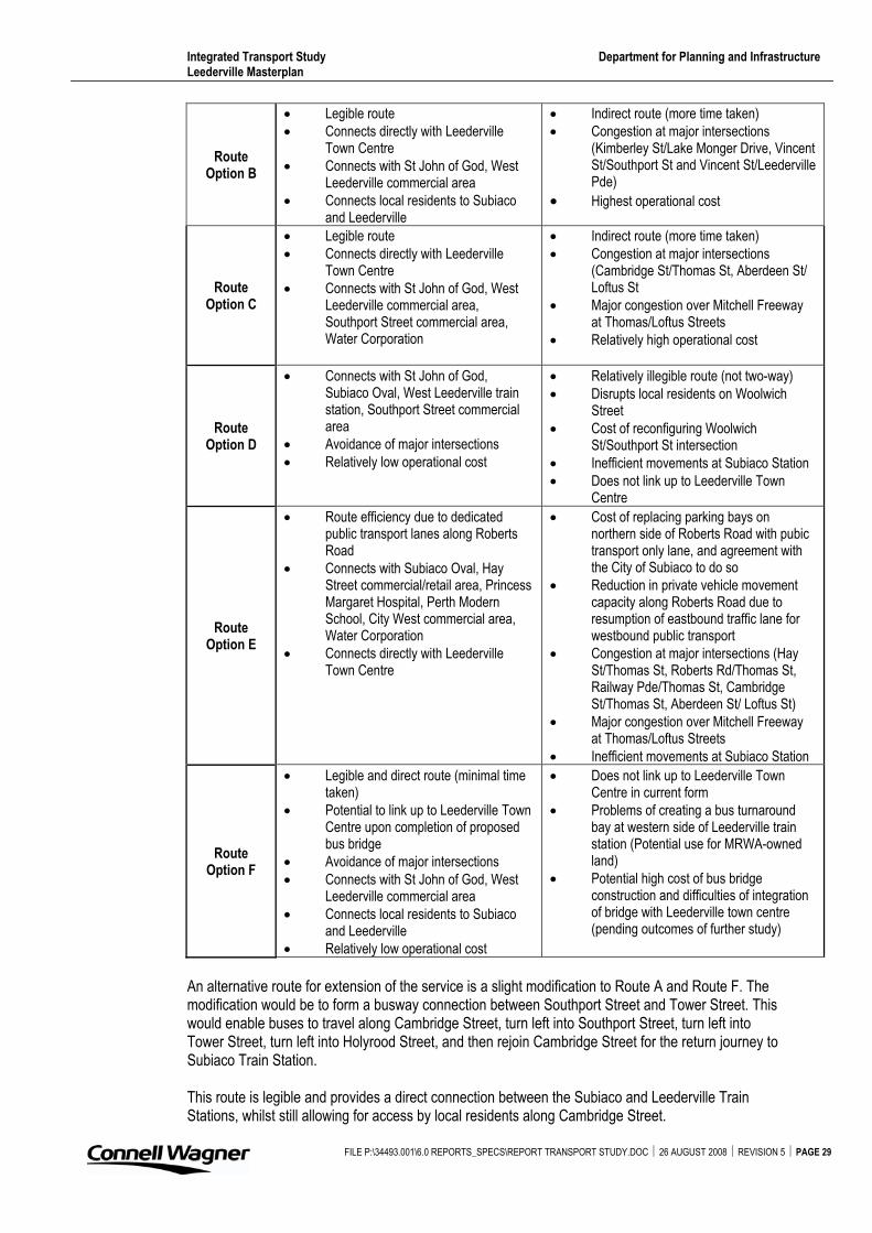
Integrated Transport Study Department for Planning and Infrastructure Leederville Masterplan
FILE P:\34493.001\6.0 REPORTS_SPECS\REPORT TRANSPORT STUDY.DOC � 26 AUGUST 2008 � REVISION 5 � PAGE 29
RouteOption B
� Legible route � Connects directly with Leederville
Town Centre � Connects with St John of God, West
Leederville commercial area � Connects local residents to Subiaco
and Leederville
� Indirect route (more time taken) � Congestion at major intersections
(Kimberley St/Lake Monger Drive, Vincent St/Southport St and Vincent St/Leederville Pde)
� Highest operational cost
RouteOption C
� Legible route � Connects directly with Leederville
Town Centre � Connects with St John of God, West
Leederville commercial area, Southport Street commercial area, Water Corporation
� Indirect route (more time taken) � Congestion at major intersections
(Cambridge St/Thomas St, Aberdeen St/ Loftus St
� Major congestion over Mitchell Freeway at Thomas/Loftus Streets
� Relatively high operational cost
RouteOption D
� Connects with St John of God, Subiaco Oval, West Leederville train station, Southport Street commercial area
� Avoidance of major intersections � Relatively low operational cost
� Relatively illegible route (not two-way) � Disrupts local residents on Woolwich
Street� Cost of reconfiguring Woolwich
St/Southport St intersection � Inefficient movements at Subiaco Station � Does not link up to Leederville Town
Centre
RouteOption E
� Route efficiency due to dedicated public transport lanes along Roberts Road
� Connects with Subiaco Oval, Hay Street commercial/retail area, Princess Margaret Hospital, Perth Modern School, City West commercial area, Water Corporation
� Connects directly with Leederville Town Centre
� Cost of replacing parking bays on northern side of Roberts Road with pubic transport only lane, and agreement with the City of Subiaco to do so
� Reduction in private vehicle movement capacity along Roberts Road due to resumption of eastbound traffic lane for westbound public transport
� Congestion at major intersections (Hay St/Thomas St, Roberts Rd/Thomas St, Railway Pde/Thomas St, Cambridge St/Thomas St, Aberdeen St/ Loftus St)
� Major congestion over Mitchell Freeway at Thomas/Loftus Streets
� Inefficient movements at Subiaco Station
RouteOption F
� Legible and direct route (minimal time taken)
� Potential to link up to Leederville Town Centre upon completion of proposed bus bridge
� Avoidance of major intersections � Connects with St John of God, West
Leederville commercial area � Connects local residents to Subiaco
and Leederville � Relatively low operational cost
� Does not link up to Leederville Town Centre in current form
� Problems of creating a bus turnaround bay at western side of Leederville train station (Potential use for MRWA-owned land)
� Potential high cost of bus bridge construction and difficulties of integration of bridge with Leederville town centre (pending outcomes of further study)
An alternative route for extension of the service is a slight modification to Route A and Route F. The modification would be to form a busway connection between Southport Street and Tower Street. This would enable buses to travel along Cambridge Street, turn left into Southport Street, turn left into Tower Street, turn left into Holyrood Street, and then rejoin Cambridge Street for the return journey to Subiaco Train Station.
This route is legible and provides a direct connection between the Subiaco and Leederville Train Stations, whilst still allowing for access by local residents along Cambridge Street.
Integrated Transport Study Department for Planning and Infrastructure Leederville Masterplan
FILE P:\34493.001\6.0 REPORTS_SPECS\REPORT TRANSPORT STUDY.DOC � 26 AUGUST 2008 � REVISION 5 � PAGE 30
The route avoids major intersections which would impose a time penalty on passengers, especially during peak periods, and make the extended route less attractive.
By connecting Southport Street and Tower Street, the problem of creating a bus turnaround point is avoided. The proximity of this route to the Leederville Train Station allows for the future expansion of the route if a bus bridge over the Mitchell Freeway is constructed.
The additional km cost of this route is the lowest of all options. There would be an additional initial cost of creating the Southport Street / Tower Street connection.
In relation to the various route options, the following comments are made: � Routes C and E travel through Loftus Street / Thomas Street intersections which experiences
heavy congestion during peak periods. This would severely impact upon the journey time of passengers.
� Route B, whilst increasing the catchment area of the route through West Leederville, provides an indirect route between the Subiaco and Leederville Train Stations. This may discourage the use of this service by people transferring between the train lines.
� An improvement to Route B could be the travel of buses along Oxford Street rather than Leederville Parade, as this would make the service more visible through the Leederville Town Centre.
Further investigation into the routes is required. In particular the suitability of the roads along the route to carry buses.
A seventh route option (G) was suggested by DPI’s Urban Transport Systems branch in the final review of this study. This route connects directly with St. John of God hospital and the West Leederville commercial area along Cambridge Street. It makes a small loop by turning left off Cambridge Street to utilise the alignment of the existing foot/cycle path which runs parallel to the edge of the Mitchell Freeway, as a one-way bus-only link road, to set down at Leederville Train Station, then loop left into Southport Street and right onto Cambridge Street. This has advantages inclusive of minimising the length that the route is ‘split’ (ie that it is not dual-directional on the same section of road, the optimal outcome for legibility), and re-enters Cambridge Street at a signalised intersection.
7.1.2 Selection of preferred route
The (existing) Subiaco Shuttle is a high frequency service which connects the key locations of Subiaco Train Station, QEII Medical Centre, and UWA. The chosen route extension should allow for the maintenance of a high frequency, reliable, and direct service.
It is recommended that a comprehensive study be undertaken to determine the preferred route and funding arrangements required for extending the shuttle service to Leederville Train Station.
7.1.3 Joint funding arrangement
Current priority actions of the PTA are to focus on the provision of initial, or additional, public transport services to the outer metropolitan areas. For this reason, the proposed extension would not be supported if the PTA were expected to be the sole funding provider.
The current service has been possible due to a joint-funding arrangement between the University of Western Australia, Queen Elizabeth II Medical Centre, the City of Subiaco, and Transperth.
The extension would therefore need to be joint-funded by various parties, which could include the Towns of Cambridge and Vincent, St John of God, the Department of Sport and Recreation and Transperth among others.
Consultation with existing and potential partners would need to take place prior to an ultimate route being agreed upon.
Integrated Transport Study Department for Planning and Infrastructure Leederville Masterplan
FILE P:\34493.001\6.0 REPORTS_SPECS\REPORT TRANSPORT STUDY.DOC � 26 AUGUST 2008 � REVISION 5 � PAGE 31
7.2 Pedestrian / bus bridge
It is recommended that a feasibility study be undertaken regarding a Bus Bridge over the Mitchell Freeway near the Leederville Train Station. Dependent upon the outcomes of this study, a concept design for the bridge should be progressed.
These works should include a: � Feasibility study for a bus bridge crossing the Mitchell Freeway, including confirmation of
appropriate location � Study of bridge structure including road approaches based on the most suitable alignment � Consideration of a bridge width option based on AS5100 and MRWA requirements, for a two
lane standard bus lane width � High level feasibility study for the bridge construction � Preliminary cost estimate � Concept design
The works are recommended to occur in two stages.
7.2.1 Stage 1
Stage 1 should identify a potential location for the bus bridge and to provide an order of magnitude cost estimate.
This stage should include a desktop study of available documentation and topographical survey information, a site inspection, and an assessment of founding locations based on surface features and the geometry of the Mitchell Freeway and the Northern Suburbs Railway.
The bridge is proposed to cross the freeway in the vicinity of the Leederville Station. This stage of the feasibility study should be used to assess the location of the bridge in terms of the adjacent topography and features, and the extent of access to ramp opportunities and connection to feeder roads.
A preliminary cost estimate should be made, to provide budgetary order of magnitude costs for the proposed bridge crossing.
During the feasibility study, initial stakeholder consultation should occur. Stakeholders would include the Local Government Authorities, PTA, MRWA, and other relevant representatives. This consultation would determine the position in principle of stakeholders, and to identify possible future planning impacts that may affect the bridge crossing.
7.2.2 Stage 2
If the feasibility study (Stage 1) concludes that further investigation into the bus bridge is warranted, Stage 2 would consider a concept design for the bridge.
The crossing of the Mitchell Freeway, and the electrified Northern Suburbs Railway, is envisaged to limit construction methodologies to only a few options. These are likely to be focussed on precast superstructures or systems that can be constructed in a short period over the freeway corridor. The Design for Safety and OH&S safety requirements are likely to impact on the feasible solutions, and the key impacts should be identified.
The basic dimensions of the bridge would be established, including the number of lanes of the bridge and its overall width.
Once a concept design is established, the cost estimate of Stage 1 can be refined. This estimate would be used as a reference for additional future planning studies or budgetary purposes.
Appendix A Map: Leederville redevelopment (DPI 2007)
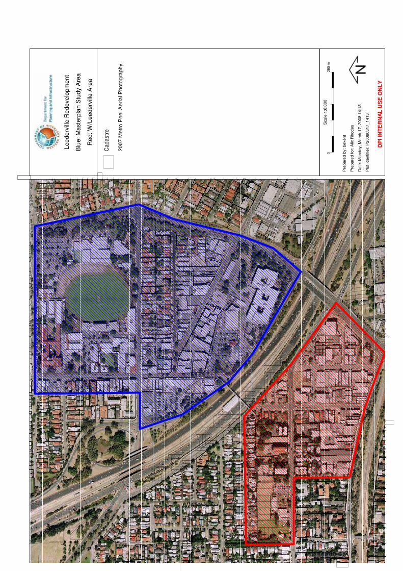
Cadastr
e
2007 M
etr
o P
eel A
erial P
hoto
gra
phy
0250 m
Pre
pa
red
by:
be
ke
nt
Pre
pa
red
fo
r: A
lix R
ho
de
s
Da
te:
Mo
nd
ay,
Ma
rch
17
, 2
00
8 1
4:1
3
Plo
t id
en
tifie
r: P
20
08
03
17
_1
41
3
Sca
le 1
:6,0
00
DP
I IN
TE
RN
AL
US
E O
NL
Y
Le
ed
erv
ille
Re
de
ve
lop
me
nt
Blu
e:
Ma
ste
rpla
n S
tud
y A
rea
Re
d:
W/L
ee
de
rvill
e A
rea
Appendix B Land use and demographic data (DPI 2008)
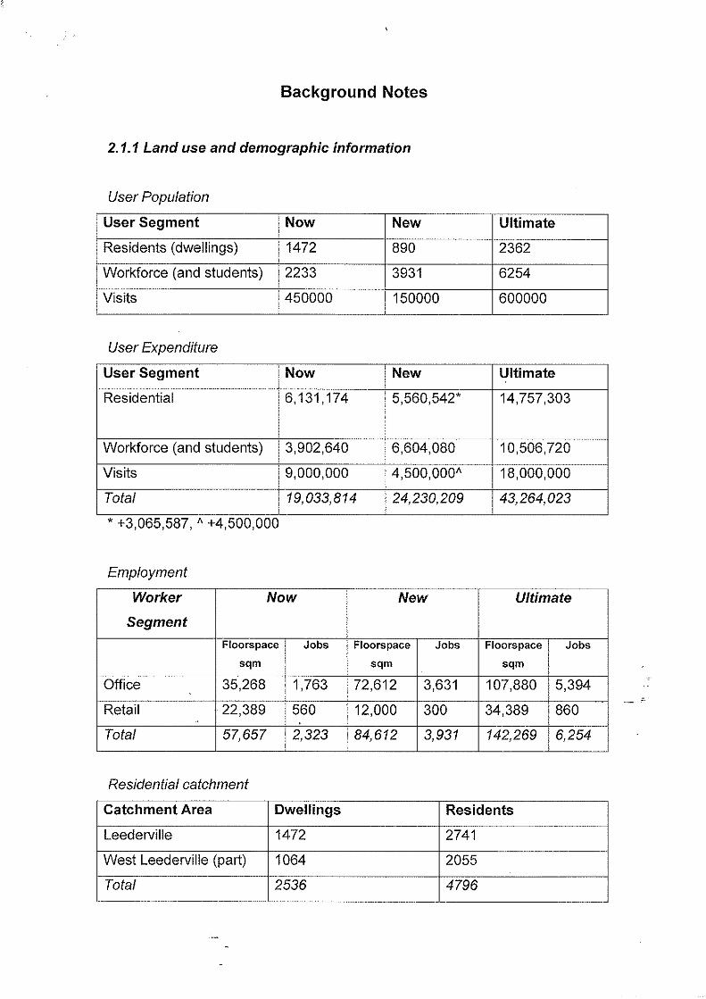
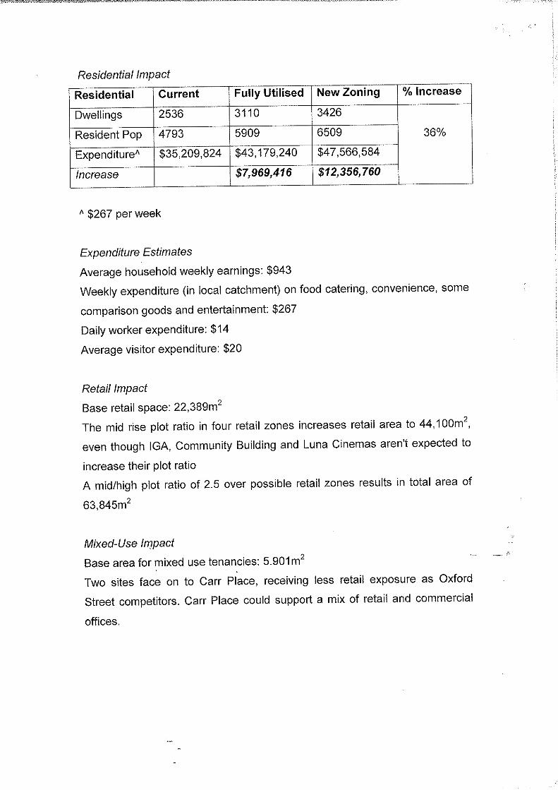
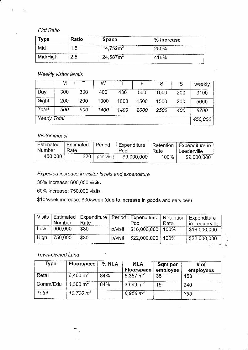
Appendix C Road network (photos sourced via Intramaps and Google Maps)
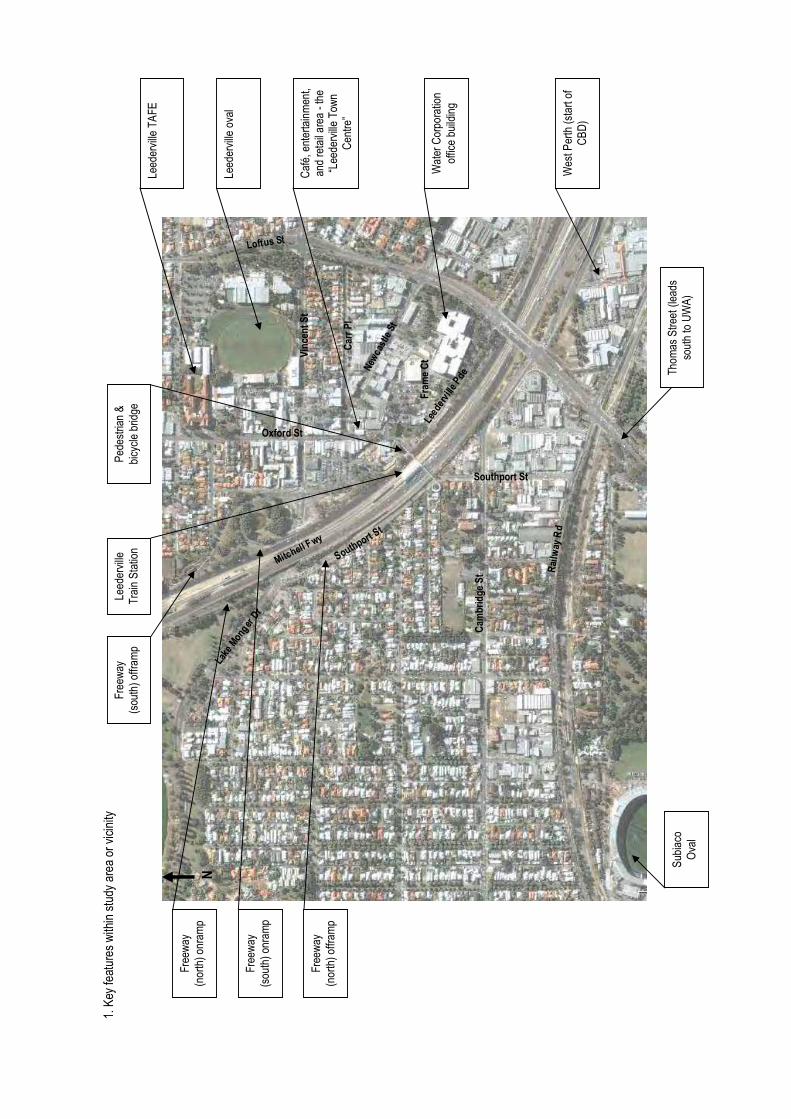
� ����
�����
��
� ��
����
� �
���
���
����
����
���
� � �
��
��
���
���
��
��
����
����
����
��
����
��
���
���
��
���
���
����
����
����
�
�
���!
��<�
���
����
�����
�����
����
����
����
�����
=>?
�
!�
X[��
���
��
]��
[��
����
���
��
�^��
��`�
����
�����
���
����
!��
��{�
��
����
��|
�
����
!}
~��
���]
��
���
�|��
� �
��
���
���
=��
�
>��
���
�|
���
������
]<�
>���
��
�|
���
����
�]
<�
>���
��
�|�
���
�����
]<�
>���
��
�|�
���
������
]<�
��������
�� �����
��������
������������
���
��������
�� ����
����������
����� ��
������!����� ���
��������
�������
�
��"���������#��
$�������$��
����
����
�����
���
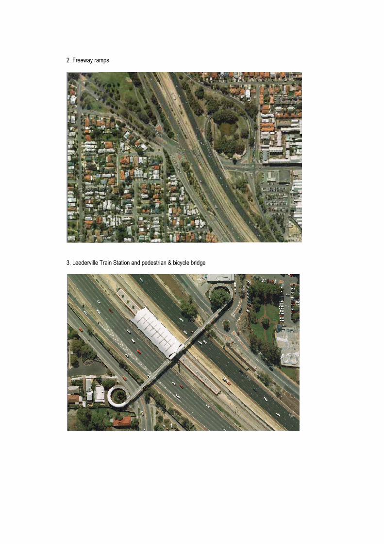
���>�������]< �
����������������������������<��� ���������������������
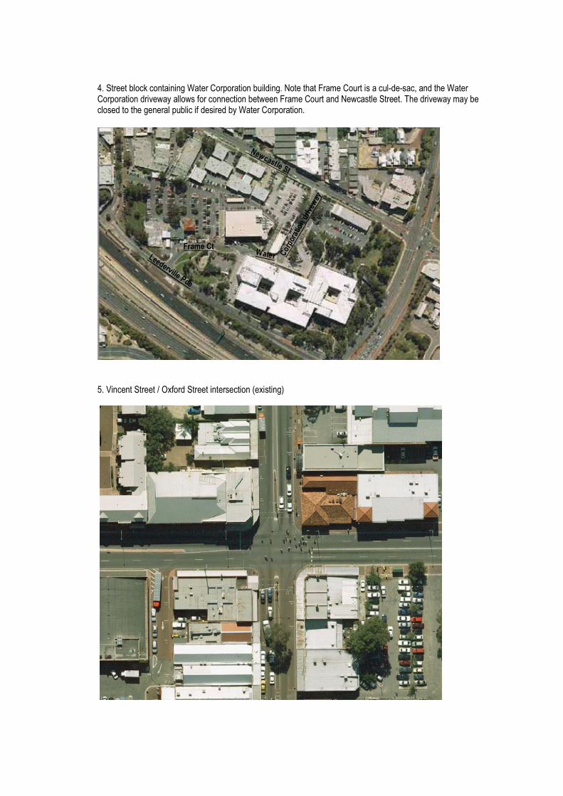
���������������������������!��<����������������������>�]��!����� �����^��^ �[�����������!��<������������������ ����������������������>�]��!����������� ���������������������]�������� ���������������<����������� ������������!��<�������
��������������������������������� ������|��� ������
��������
����������
������!����� �����������������!�����
%����
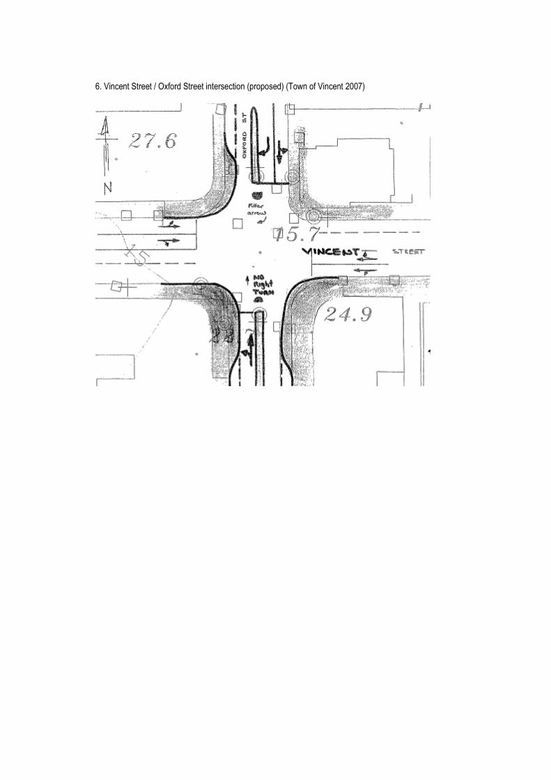
��������������������������������� ������|<��<� ����|���������������������
Appendix D West Leederville Traffic Management Review – recommendations (Town of Cambridge 2005)
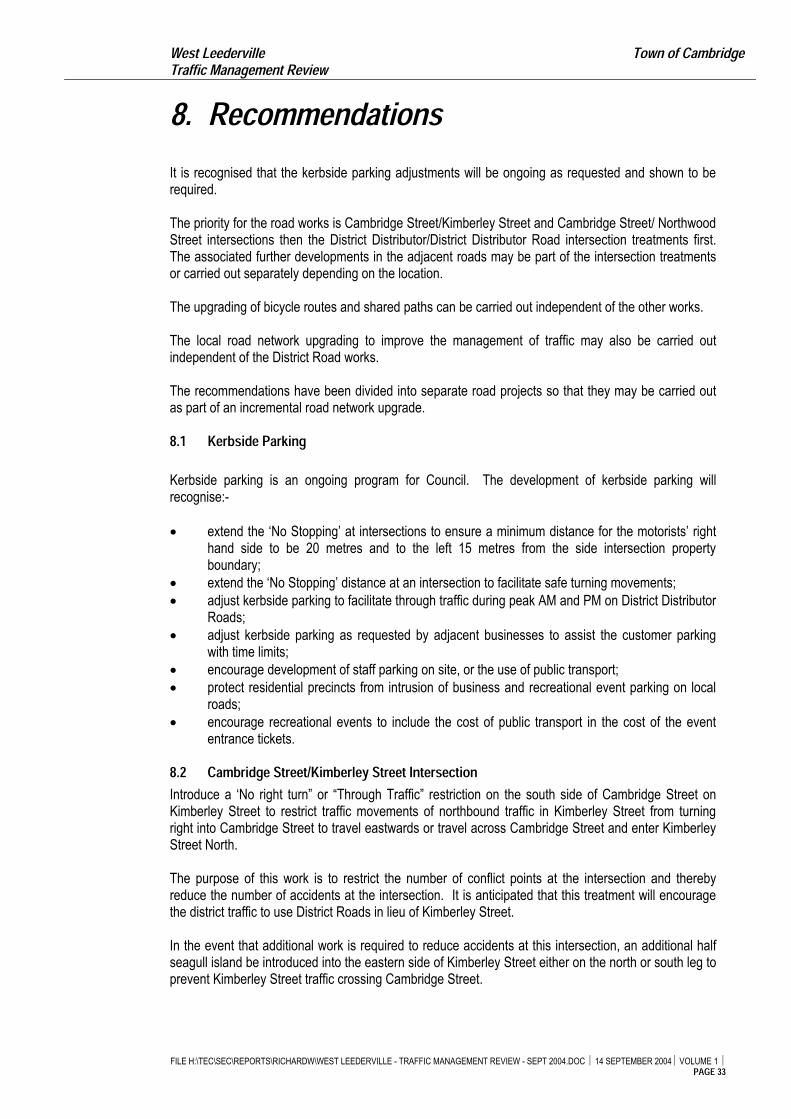
West Leederville Town of Cambridge Traffic Management Review
8. Recommendations
It is recognised that the kerbside parking adjustments will be ongoing as requested and shown to berequired.
The priority for the road works is Cambridge Street/Kimberley Street and Cambridge Street/ NorthwoodStreet intersections then the District Distributor/District Distributor Road intersection treatments first.The associated further developments in the adjacent roads may be part of the intersection treatmentsor carried out separately depending on the location.
The upgrading of bicycle routes and shared paths can be carried out independent of the other works.
The local road network upgrading to improve the management of traffic may also be carried outindependent of the District Road works.
The recommendations have been divided into separate road projects so that they may be carried outas part of an incremental road network upgrade.
8.1 Kerbside Parking
Kerbside parking is an ongoing program for Council. The development of kerbside parking willrecognise:-
� extend the ‘No Stopping’ at intersections to ensure a minimum distance for the motorists’ righthand side to be 20 metres and to the left 15 metres from the side intersection propertyboundary;
� extend the ‘No Stopping’ distance at an intersection to facilitate safe turning movements;� adjust kerbside parking to facilitate through traffic during peak AM and PM on District Distributor
Roads;� adjust kerbside parking as requested by adjacent businesses to assist the customer parking
with time limits;� encourage development of staff parking on site, or the use of public transport;� protect residential precincts from intrusion of business and recreational event parking on local
roads;� encourage recreational events to include the cost of public transport in the cost of the event
entrance tickets.
8.2 Cambridge Street/Kimberley Street Intersection
Introduce a ‘No right turn” or “Through Traffic” restriction on the south side of Cambridge Street onKimberley Street to restrict traffic movements of northbound traffic in Kimberley Street from turningright into Cambridge Street to travel eastwards or travel across Cambridge Street and enter KimberleyStreet North.
The purpose of this work is to restrict the number of conflict points at the intersection and therebyreduce the number of accidents at the intersection. It is anticipated that this treatment will encouragethe district traffic to use District Roads in lieu of Kimberley Street.
In the event that additional work is required to reduce accidents at this intersection, an additional halfseagull island be introduced into the eastern side of Kimberley Street either on the north or south leg toprevent Kimberley Street traffic crossing Cambridge Street.
FILE H:\TEC\SEC\REPORTS\RICHARDW\WEST LEEDERVILLE - TRAFFIC MANAGEMENT REVIEW - SEPT 2004.DOC � 14 SEPTEMBER 2004� VOLUME 1 �PAGE 33
West Leederville Town of Cambridge Traffic Management Review
8.3 Cambridge Street/Northwood Street Intersection
The proposed restriction is to prevent westbound traffic in Cambridge Street from turning right intoNorthwood Street and travelling northwards and to prevent traffic travelling northwards in NorthwoodStreet from crossing Cambridge Street and travelling northwards in the northern section of NorthwoodStreet.
The purpose of this work is to reduce the number of traffic conflict points at the intersection andthereby reduce the number of accidents. Further, to negate the need to stop in Cambridge Streetwhile waiting to turn right into Northwood Street and travel northwards. This will remove the queuingtraffic in Cambridge Street across the school pedestrian crossing over Cambridge Street east ofNorthwood Street. By removing this waiting traffic in Cambridge Street, the sight distance formotorists’ in Cambridge Street will be improved and this will also improve the safety of the intersection.
It is anticipated that this work will be carried out at the same time as the intersection treatment at Cambridge Street/Kimberley Street, as indicated in 8.2 above.
8.4 Southport Street/Cambridge Street Intersection It is recommended that a right turn arrow be introduced for the southbound traffic in Southport Street toturn right into Cambridge Street and travel westward. This is being negotiated with Main Roads WA atpresent and there may be an interim phase where the right turn arrow for westbound traffic inCambridge Street will remain to assess the impact.
It is anticipated that this work will enhance the safety of southbound traffic in Southport Street turningright into Cambridge Street and reduce the accidents at this intersection. Further, it is anticipated thatthere will be a small increase in the traffic turning right from Southport Street into Cambridge Street inlieu of turning right from Southport Street into Railway Parade and therefore reduce the accidents atthe intersection of Southport Street and Railway Parade.
8.5 Railway Parade/Southport Street Intersection This recommendation is to implement a right turn and through traffic lane for westbound traffic inRailway Parade from Loftus Street to Southport Street and improve the turning movements at theintersection. It is anticipated that this will improve the road safety and reduce the accidents at thisintersection.
It is considered that this work should be done in association with the work as identified in 8.4 above.
Further, consideration is to be given to introducing a single lane roundabout and is subject to trafficanalysis design and land acquisition.
8.6 Southport Street – from Cambridge Street to Railway Parade
It is proposed that this section of Southport Street be widened to accommodate kerbside parking,through traffic, underground power, upgraded street lighting and improved footpath pavements.
This work should be carried out in association with the work at the Railway Parade/Southport Streetintersection (8.5).
8.7 Railway Parade – from Southport Street to Kerr Street It is proposed that kerbside parking embayment be introduced on the southern side of Railway Paradefrom Southport Street to the Hamilton Street Bridge and a median island be introduced toaccommodate one lane of through traffic in each direction, kerbside parking and pedestrians.
FILE H:\TEC\SEC\REPORTS\RICHARDW\WEST LEEDERVILLE - TRAFFIC MANAGEMENT REVIEW - SEPT 2004.DOC � 14 SEPTEMBER 2004� VOLUME 1 �PAGE 34
West Leederville Town of Cambridge Traffic Management Review
FILE H:\TEC\SEC\REPORTS\RICHARDW\WEST LEEDERVILLE - TRAFFIC MANAGEMENT REVIEW - SEPT 2004.DOC � 14 SEPTEMBER 2004� VOLUME 1 �PAGE 35
This work may be carried out after the completion of 8.5 and 8.6 above.
8.8 Railway Parade/Kimberley Street Intersection It is proposed that a roundabout be introduced at this intersection.
The proposed works will encourage district traffic crossing the Hamilton Street Bridge to turn left into Railway Parade and carry out a ‘U’ turn movement at the Kimberley Street roundabout, then travel eastwards to Southport Street and north along Southport Street to the Mitchell Freeway.
This work should be carried out in association with or after Item 8.2, and 8.3 above.
8.9 Harborne Street/Cambridge Street Intersection Consideration be given to introducing a pedestrian phase into the traffic signals at the intersection.
Recommend that the traffic lanes in Harborne Street north of Cambridge Street be widened to permit two lanes of traffic to approach the traffic signals for a distance of approximately 150 metres.
It is considered that this will improve the efficiency of the network traffic.
8.10 Harborne Street/Grantham Street Intersection Consideration be given to introducing a pedestrian phase into the traffic signals at the intersection.
Recommend to extend the two lane approach to the traffic signals in each direction along Harborne Street to approximately 150 metres.
It is considered that this will improve the efficiency of the network traffic turning movements.
8.11 Cambridge Street/Station Street Intersection To introduce a half seagull island into Station Street on the northern side of Cambridge Street to prevent southbound traffic from turning right into Cambridge Street or crossing Cambridge Street.
It is recognised that this will reduce the number of conflict points at the intersection and improve the traffic safety.
8.12 Cambridge Street/McCourt Street It is recommended that a half seagull island be introduced into McCourt Street at the Cambridge Street intersection to prevent traffic from crossing and turning right into Cambridge Street.
This work will reduce the number of conflict points at the intersection and improve road safety.
8.13 Loftus Street/Cambridge Street It is recommended that a left turn lane be provided for northbound traffic in Loftus Street to turn left into Cambridge Street and travel westwards. This lane will extend southwards to the Bermondsey Street shared path underpass without extending the underpass.
This work is proposed to improve the left turn traffic flow and reduce the delay time for northbound traffic in Loftus Street.
West Leederville Town of Cambridge Traffic Management Review
8.14 Station Street – from Cambridge Street to Salvado Road
It is recommended that this section of road be widened and that provision be made for kerbsideparking on both sides of the road and through traffic, as well as turning movements.
The recommended work will improve the free-flow of traffic in this section of Station Street.
8.15 Cambridge Street – Pedestrian Signals To introduce a traffic signal pedestrian crossing over Cambridge Street between Northwood Street andKimberley Street if shown to be necessary after Item 8.1 (AM, PM Clearways on Cambridge Street)8.2, 8.3 and 8.8 are complete.
This will assist pedestrians to cross Cambridge Street without a school guard.
8.16 Bicycle Routes and Shared Paths
a. That the bicycle routes and shared paths leading to the West Leederville Railway Station, LakeMonger, the shopping precinct along Cambridge Street and the West Leederville PrimarySchool be upgraded to encourage parents and children to walk or ride to the school and shopsin lieu of driving short trips.
b. It is recommended that a shared path be installed in Northwood Street and extend from LakeMonger Drive to Railway Parade. Further, that a shared path be installed into Woolwich Streetand extend from St Leonard’s Avenue to Kimberley Street.
This work will assist school children and pedestrians travelling to the West Leederville PrimarySchool and cross Cambridge Street at the school pedestrian crossing, linking Lake Monger pathwith the Northwood Street West Leederville Railway Station pedestrian underpass.
c. It is recommended that a shared path be developed along Cambridge Street from Oxford Closeto Loftus Street. Further that the median island in Cambridge Street be extended westwards toprovide a safe refuge for cyclists and pedestrian crossing over Cambridge Street.
8.17 Cambridge Street – Blencowe Street to Holyrood Street - Clearway It is recommended that an AM and PM ‘Clearway’ be introduced on the northern and southern side ofCambridge Street from Blencowe Street to Holyrood Street.
This will improve traffic flow, side road and driveway access, and pedestrian crossing.
8.18 Cambridge Street – Bus Embayments
Recommend that the road reserve along Cambridge Street from Harborne Street to Loftus Street bewidened by 3 metres for a length of 30 metres at bus stops at the time of future property developmentadjacent to the bus stops.
This will provide for bus embayments, bus passenger shelters, footpaths, improved traffic flow and motorist sight distance.
8.19 Harborne Street – Bus Embayments
Recommend that the road pavement in Harborne Street be widened at bus stops to provide busembayments.
FILE H:\TEC\SEC\REPORTS\RICHARDW\WEST LEEDERVILLE - TRAFFIC MANAGEMENT REVIEW - SEPT 2004.DOC � 14 SEPTEMBER 2004� VOLUME 1 �PAGE 36
West Leederville Town of Cambridge Traffic Management Review
This will improve the traffic flow in Harborne Street and reduce the need for traffic to "rat run" throughlocal access roads.
8.20 Local Area Traffic Management
Consideration be given to introducing Local Area Traffic Management in streets in accordance withtheir traffic volume and the existing road pavement using the “Liveable Neighbourhood” guidelines and utilising the following management devices:-
� Highlight the entrance to local residential precincts and the change of traffic speed – entrystatement with traffic island;
� to slow traffic speeds – plateaux or raised pavements at intersections;� to reduce the width of 10 metre wide pavements for through traffic – introduce kerbside nibs
and parking embayments;� to break vistas for motorists’ to a maximum of 200 metres – introduce blister islands with
landscaping;� to assist pedestrians crossing roads – traffic islands;� manage intersection traffic and reduce right angle accidents – roundabouts;� street enhancement – plant verge trees one per property.
The above recommendations are based on a traffic analysis of the local and district road network andsome detailed designs. The development of the projects will be subject to detailed design, publiccomment, Main Roads WA signs and lines approval and allocated funds.
FILE H:\TEC\SEC\REPORTS\RICHARDW\WEST LEEDERVILLE - TRAFFIC MANAGEMENT REVIEW - SEPT 2004.DOC � 14 SEPTEMBER 2004� VOLUME 1 �PAGE 37
Appendix E CAT and FTZ (DPI 2008)
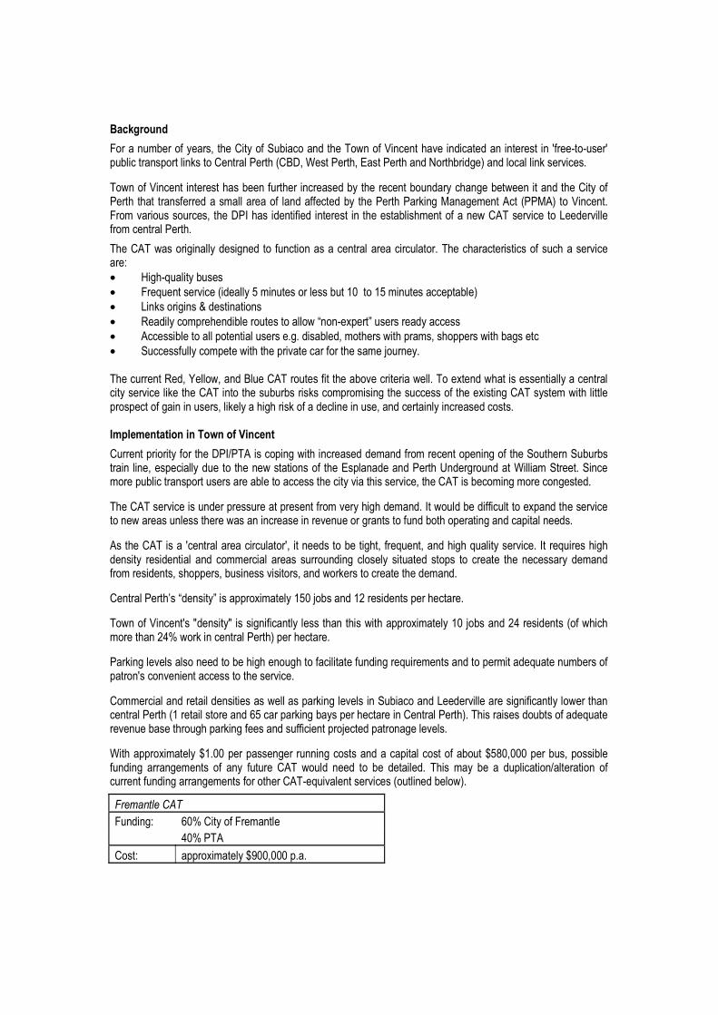
&��"�������
>������]���������� [����!����������������������������������������������������� � ��� �����^�^� ����<�������� <������� ���!����������|!}~[��� �����[�? ���������������������������������� ������ ���
�������������������� �� ������������� ����� ��������������������������������������������!����������� �� �� �������� ]��������� �������������� �������������������]���=�� |���=�� ����������>��]������ � ����� [����~���� ���������������� � ������� ��� �]�����������!=�� ������� �����������������]�������������
����!=��� ������������� ������ �� �������� �������� ������������������������ �� ���� ����� �����������• ����^�������� � �• >������� �������|���������]���� ������ �������������]���� ����<������• ���� ������� ����� ����� �• ���������]<��������������� ��������`���^��<��{�� �� ��������� �• =��� ����������<������� �� �������� ����[�]���� �����<�] [� ��<<�� ������� ����• ����� ��������]<����������<��������������� ]��������������������������[�������[����}����!=������ �������������������������������������� �� ������������������ ���������������!=��������� ����� ��� � ���]<��]� ������� ���� ���������� ����!=�� � �]����������<�� <�������������� �� [���������������� ������������������ �[����������������� ����� ���'���������������(����� ��������
!������<��������������~�����=�� ���<������������� �����]������]��������<�������������������������� ����� ����[�� <������������� ������� ��� �������? <�������������������������������]�������������]����<�������� <���� �� ������������� ������������� � ������[����!=��� �����]����]��������� ����
����!=�� �������� �������<�� �����<�� ������]�������������]����������������������������<������ ��������������� ����� ������� �������� ������������������� �������������<����������<������� ��
= ����!=��� �� �������������������[� ������ ���������[� �������[��������������� ���������� ������� ��������� ��� �� ������� ��� ��]]������ �� � ����������� ��� ���� ����� �< � �� ����� ��� ���� ��� ��]������]��� ���� [� ��<<�� [��� ��� ��� ��� [���������� �������������]�����
!���������� �`��� ��{�� �<<����]����������� ��������� ���� �<����������
��������������� ����� ����� � ������������� ������ �����<<����]���������� ��������� ���� �|���������]�������������������������������<�����������
������������ �� ������������������������������������������������]�� ������<��]����������]��� ����<���� �������������� ������ ���������
!�]]����������������� ��� � ������ �<����������� ����������������������������� �������������������������������|������� �������������<�������� �<������������!��������������� ��� � ����� ������������������� ���������<��������� ���� ���������<��������<����������� ��
����<<����]����������<���< ���������������� ������<����� ���������� �[����<����� [�<� ������������� �����]�� � ��� ��� ������ !=�� ������ ����� �� ��� �������� ��� � ]�� ��� � ��<�������������� �����������������������]�� ����������!=�^��������� ������ �|����������������
����������
>��������� ����!������>��]�����
�� ������=�
!� �� <<����]�����¡��[����<���
� �
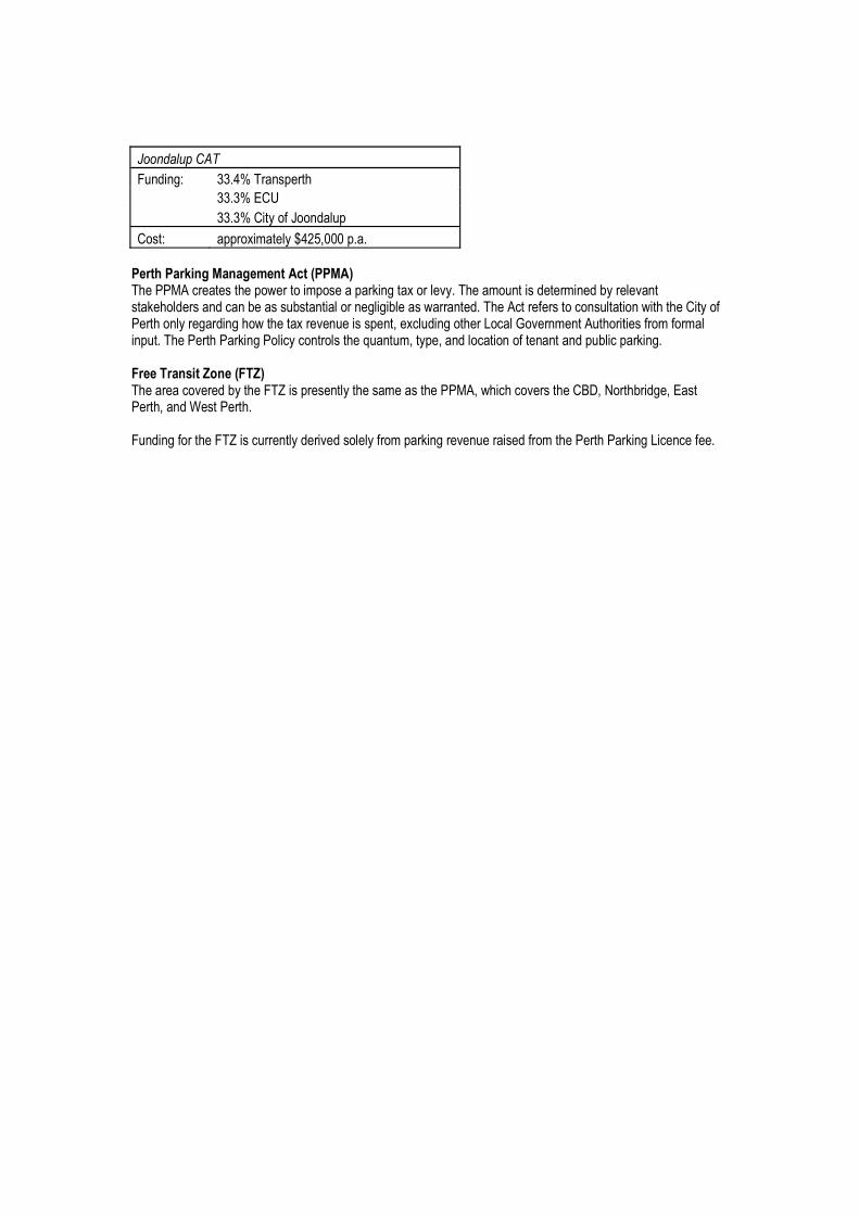
����������
>�������� ��������� <����
�� ������?!��
�� ������!������¢������<���
!� ��� <<����]��������[����<���
���� ��"��������������)��* �)+��������=����� ����<��������]<� ���<���������������������]����� �����]��������������� �������� ���������� � �� ������������������ �������������=������� ������ �������������!������������������������������������������� � <��[���������������������£�����]���=������� ����]����]����<�������������������������������� ��������][��<�[���������������������<������<�������������(������,����*�(,+����������������������>�¤�� �<�� �������� ]�� �������=[������������ ����!}~[�����������[�? �����[������ ��������>��������������>�¤�� ������������������ ���������]�<���������������� ������]�����������������������������
Appendix F Light rail (DPI 2008)
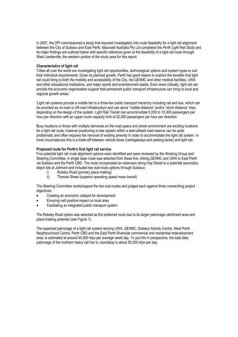
�������[����~�����]]� ������� ������������������� ����������������� �������������������������]�������������!����������������? ���������� ����=� ������������]<������������������������������� �]����������� ���������������������� <������������������������������ ���������������������������������� ������������¥������ ����<������������ ������������� ���<��������������������� ������������!��� ������������������������� ����������������<<������� [��������������<��� ���� � �]��<� ��� �������������������������]�� ��£������ �<�����������[������� �������� �������<�������������� ���������������������������������]������������� �������������!��[����¦?���!���������]������������� [���=�������������������� ����� [����]���� <�� ����������]��� ����?����]������������[�������������<���������������]�������������� �<<�����<��]����<�������� <������� ������������������������������������������ �������������� � �] �<��������]�����������������^����<�������� <������������������������������� [�������������<�������� ���^����������^�������� ������������� �����`]�������� ���{�������` ������ ���{���< [���<��������������� ���������� � �]�������������� ��������]]�����[��������[����< ����� �<��������<�������������������<<������ ���<������]�������[����< ����� �<��������<���������������}� �������� ������ ������]���<�����]�� ����������� <������ �����������]�������������������� �������������������[���������<� ������������� � �]������������^���� ��������� ����������������<�����]������������������ ������]���������� ����]�������������������]]���������������� � �]�����]� ������] ��� ��� �� �����^���������������������� �|�������� ����<��������� ���������������� ������������� ��� ���-�� �����������������!����>����<������������������������]����<��� �����������������������������������������������£���<������������!�]]�����=� ������� �������� � ����������]��� ������[���������¦?���!������=���? ���������������������������!}~����������������<����������� ��������������������<������ ����������<�� ����¢���]������������������ ��^������<��� ����������������
�� �����������|<��]���<����]��������� ���] ������| �<�������<������ <����] ��� ���
�������������!�]]�������� ��<<��������� ��^���� ������������������ �����������������<�������������� ��• !�������������]������ �����������<]���• ?� ���������<� ������]<�������������• >������������������<�������� <��� � �]������������������<����� � ������� ����<��������������������� �������<���������]���������<���^]�����<������| ���>�����������������<�����<������������������� � �]� ���������=[�¦?���![��������=������!����[��� ��������������������!����[������!}~�������? ����������� ������]]����������� ���������������<]�����[�� �� �]������������[������< �<���������������������<���� ����<�� <�����[������������<������������������������������������¢������<�� �������[������< �<��������
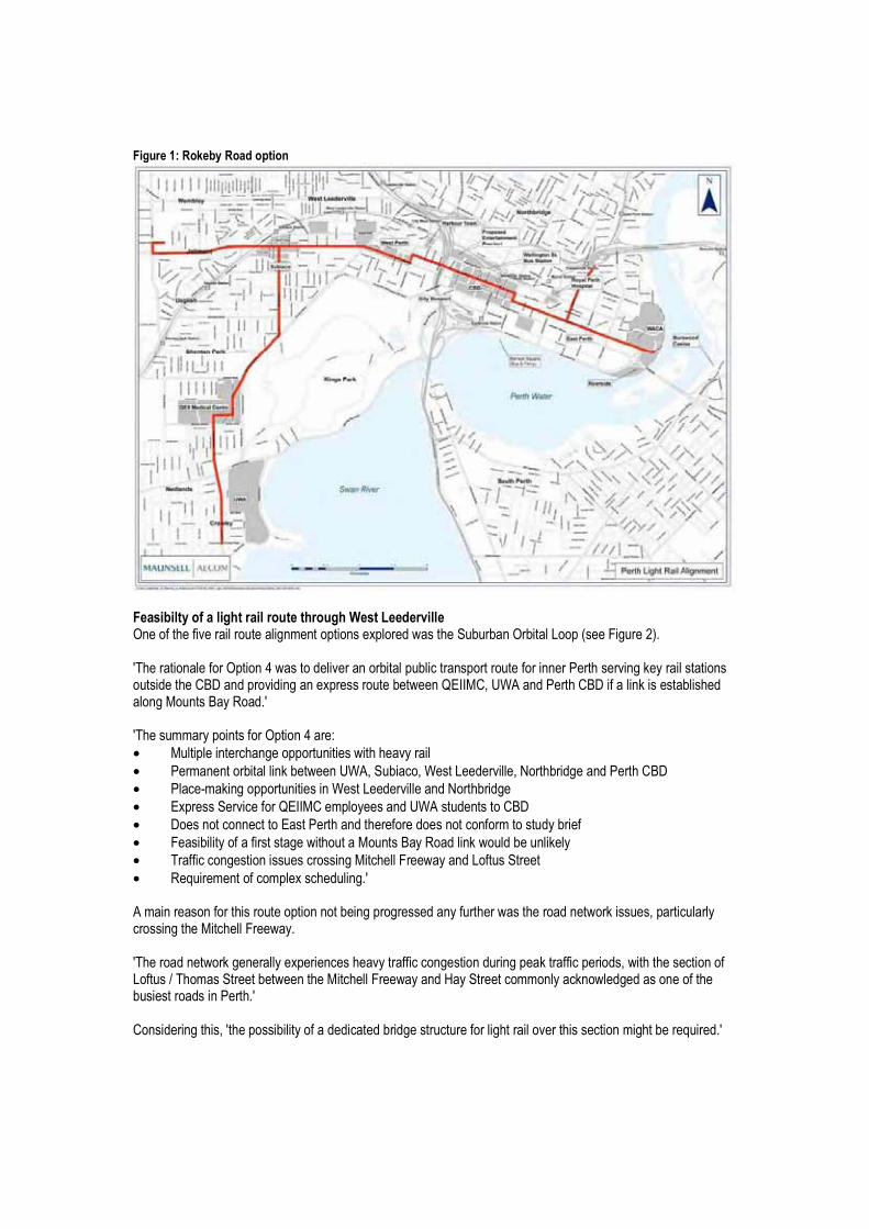
�������./�$�"����$����������
������������� �������������������������%���������!���������������������������������]����<��� ���<������� ���������������������<�| ���>����������������������������<������� �������������������<�������� <����������������������� ��������������� ��� ��� �������!}~����<�������������<�� �������������¦?���![���=���������!}~����������� �� ��� ������������� �}�������������� �]]���<��� ������<����������• ����<��������������<<������� ��������������• ���]������������������������=[�������[��� ������������[��������������������!}~�• ����^]������<<������� ������ ���������������������������• ?�<�� �������������¦?���!��]<����� ������=� ���� ���!}~�• ~�� �������������? ��������������������� ����������]��� ����������• >� �������������� � �������������� �}�����������������������������• ������������ ����� �� ���� ������������>������������� ������• �������]��������]<���� �������������=�]����� ��������� �������<�������������<����� �������������� ���������������� �� [�<������������ ���������������>�����������������������������������<������� ����������������� �����������<���������<����� [�������� ������������� ������] ������������������������>�������������������]]����������������� ������������� �� ���� ������������!�� ���������� [�����<� �������������������������� ��������������������������� � ������]��������������������
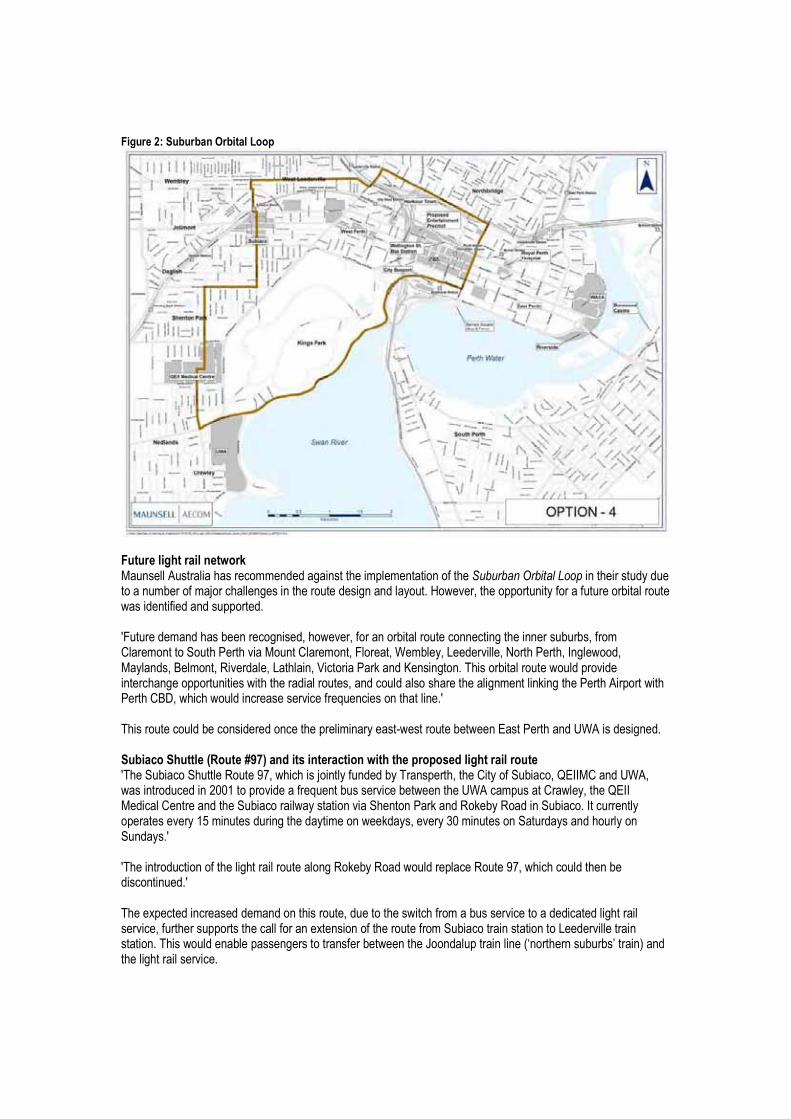
�������0/���������������������
�����������������������"���� ����=� ����� �����]]��������� �����]<��]��������������������������������������� �������������]�������]������������ �������������� ��������������������[�����<<������������������������������ �������������� �<<��������>�������]���� ������������� ��[��������[������������������������������������� ����� [����]�!���]�����������������������!���]��[�>����[���]����[������������[����������[����������[������ [�}��]��[���������[������[������������������ ���������� ������������������<������������������<<������� ����������������� [����������� �� �����������]�������������������=��<������������!}~[������������������ �� ����������������� ����������������� ������������������ ���������������<����]������ ^�� �������������? �����������=�� ��� ���������������������*$����123+������������������������������������������������������������������������¡�[�������� ��������������������� <���[����!������������[�¦?���!������=[�� ���������������������<������������������ � �������������������=��]<� ��!�����[����¦?����������!������������������������ �������������������������������������������������������<��� ����������]���� ��������������]����������� [����������]���� ��������� ������������������� ����������������������������������������������������������������<���������¡�[���������������������� ������������������<���������� �����]�������� �����[���������� ��������]���� � ��������������������������� ������[�������� �<<�� ������������������ ������������������]������������ ���������������������� �������� �������������< ����� ����� ��������������¢������<����������|§�������� ����� ���������������������� ��������
Appendix G Route options for extension of Subiaco Shuttle (route 97) to Leederville Train Station (DPI 2008)