Embed Size (px)
Citation preview
TRANSPORT ASSESSMENT
LONDON BRIDGE STATION
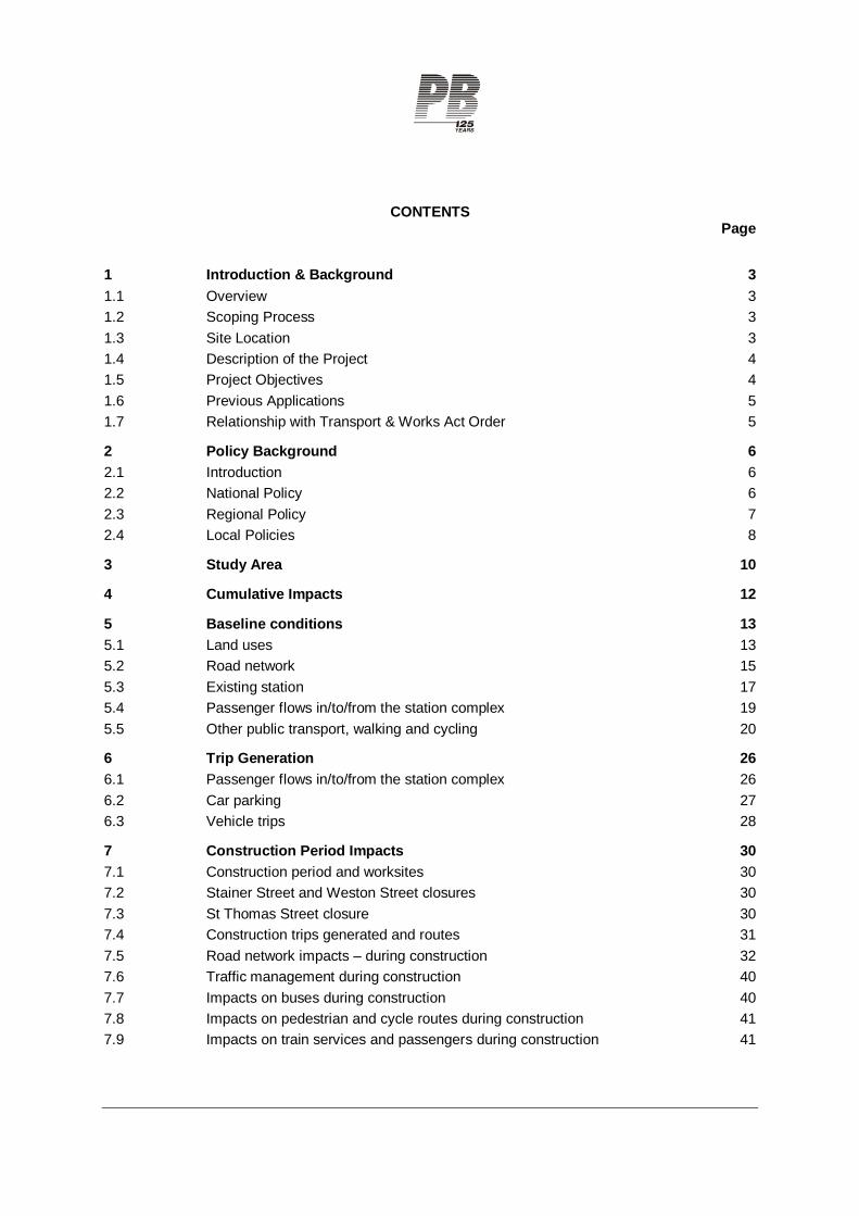
CONTENTS Page
1 Introduction & Background 3 1.1 Overview 3 1.2 Scoping Process 3 1.3 Site Location 3 1.4 Description of the Project 4 1.5 Project Objectives 4 1.6 Previous Applications 5 1.7 Relationship with Transport & Works Act Order 5
2 Policy Background 6 2.1 Introduction 6 2.2 National Policy 6 2.3 Regional Policy 7 2.4 Local Policies 8
3 Study Area 10
4 Cumulative Impacts 12
5 Baseline conditions 13 5.1 Land uses 13 5.2 Road network 15 5.3 Existing station 17 5.4 Passenger flows in/to/from the station complex 19 5.5 Other public transport, walking and cycling 20
6 Trip Generation 26 6.1 Passenger flows in/to/from the station complex 26 6.2 Car parking 27 6.3 Vehicle trips 28
7 Construction Period Impacts 30 7.1 Construction period and worksites 30 7.2 Stainer Street and Weston Street closures 30 7.3 St Thomas Street closure 30 7.4 Construction trips generated and routes 31 7.5 Road network impacts – during construction 32 7.6 Traffic management during construction 40 7.7 Impacts on buses during construction 40 7.8 Impacts on pedestrian and cycle routes during construction 41 7.9 Impacts on train services and passengers during construction 41
8 Permanent Impacts 43 8.1 Overview 43 8.2 Diverted trips 43 8.3 Potential wider highway network changes 46 8.4 Operational impacts 48 8.5 Parking 51 8.6 Public transport impacts – overview 51 8.7 Impact on rail passengers – across the rail network 51 8.8 Impact on rail passengers at London Bridge 54 8.9 Pedestrian flows in the station complex 54 8.10 Bus network 54 8.11 Walking 56 8.12 Cycling 57 8.13 Taxis 59
9 Mitigation 61 9.1 Road network 61 9.2 Public transport 61 9.3 Travel Plan 61 9.4 Delivery and Servicing Plan 61 9.5 Construction Logistics Plan 61 9.6 Planning obligations / Section 278 discussions 62
10 Summary and Conclusions 63 10.2 Public transport 63 10.3 Trip generation, parking, deliveries and servicing 63 10.4 Road network 63 10.5 Walking 64 10.6 Cycling 65 10.7 Taxis 65 Appendix 1 - Scoping Report Appendix 2 - Comments On Scoping Report Appendix 3 – Minutes of Scoping Meetings on 6 December 2010 and 28 February 2011 Appendix 4 – Summary of PERS / CSA Audit Results Appendix 5 – Accident data analysis Appendix 6 – Cycling Assessment Appendix 7 – Train Operations During Construction Appendix 8 – Pedestrian modelling of existing station Appendix 9 – Pedestrian modelling of proposed station Appendix 10 – Pedestrian Modelling of Local Streetscape and Crossings Appendix 11 – Base Year Traffic Modelling report Appendix 12 – Future Year Traffic Modelling report Appendix 13 – Highways Optioneering Modelling report Appendix 14 – Strategic Traffic Modelling report Appendix 15 – Travel Plan
TRANSPORT ASSESSMENT LONDON BRIDGE STATION REDEVELOPMENT
London Bridge Station Redevelopment TA Prepared by Parsons Brinckerhoff Ltd June 2011 Page 3 for Network Rail
1 INTRODUCTION & BACKGROUND
1.1 Overview
1.1.1 This Transport Assessment (TA) has been prepared as part of the planning application for redevelopment of London Bridge Station.
1.1.2 It has been prepared in line with the Department for Transport’s Guidance on Transport Assessment, Transport for London’s (TfL’s) Transport Assessment Best Practice Guidance Document, and the London Borough of Southwark’s Sustainable Transport Supplementary Planning Document.
1.1.3 This TA also acts as a supporting report for the traffic and transport chapter of an Environmental Statement (ES) which is being submitted with the planning application.
1.2 Scoping Process
1.2.1 A Scoping Report was issued in November 2010. Comments on the Scoping Report were received from TfL and Southwark. Further discussions were held between Network Rail, TfL and Southwark to agree the final scope of the TA. A pre-application meeting was held on 6 June 2011.
1.2.2 Appendix 1 reproduces the Scoping Report. Appendix 2 reproduces the comments received on the scoping report, and shows how they have been addressed in this TA. Appendix 3 reproduces the notes of further technical meetings held on 6 December 2010 and 28 February 2011 to agree traffic proposals and modelling requirements.
1.3 Site Location
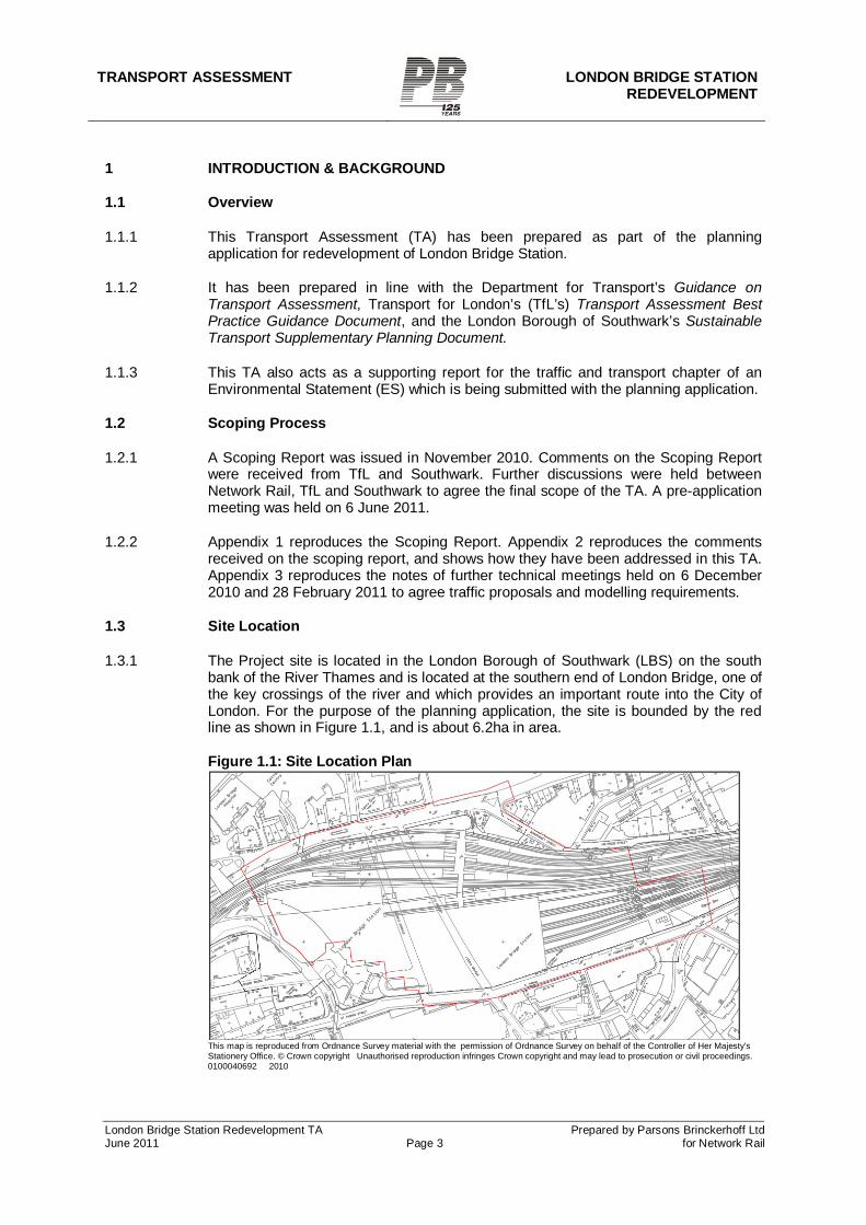
1.3.1 The Project site is located in the London Borough of Southwark (LBS) on the south bank of the River Thames and is located at the southern end of London Bridge, one of the key crossings of the river and which provides an important route into the City of London. For the purpose of the planning application, the site is bounded by the red line as shown in Figure 1.1, and is about 6.2ha in area.
Figure 1.1: Site Location Plan
This map is reproduced from Ordnance Survey material with the permission of Ordnance Survey on behalf of the Controller of Her Majesty's Stationery Office. © Crown copyright Unauthorised reproduction infringes Crown copyright and may lead to prosecution or civil proceedings. 0100040692 2010
TRANSPORT ASSESSMENT LONDON BRIDGE STATION
REDEVELOPMENT
London Bridge Station Redevelopment TA Prepared by Parsons Brinckerhoff Ltd June 2011 Page 4 for Network Rail
1.4 Description of the Project
1.4.1 The Project is proposed by Network Rail and forms part of the Thameslink Programme (TLP). The TLP is a wider scheme that will introduce new and improved stations, new track, new cross-London routes and new longer and more frequent trains in order to reduce overcrowding. Up to 18 train paths per hour are proposed through the redeveloped station.
1.4.2 The Project proposes a new station concourse without which the Thameslink programme cannot be delivered. It is relevant to note that the track works themselves already have the benefit of consent under the Transport and Works Act Order granted for the Thameslink scheme.
1.4.3 The proposal is for:
Provision of a new Station layout at London Bridge, including construction of new Station Concourse, together with the demolition of existing arches; the demolition of Listed train shed and part of the wall on St Thomas Street; and the demolition of 84 Tooley Street and the construction of new replacement facades on Tooley Street and St Thomas Street; landscaping and other works associated with the station.
1.4.4 The planning application and ES will relate to the station building redevelopment and
the works required for that. They will not examine in-principle issues relating to the rail works themselves as these already have the benefit of permission granted through the Transport and Works Act Order confirmed in 2006.
1.4.5 Main construction is due to begin in 2012, after the Olympic and Paralympic Games period, and is due to finish in 2018.
1.5 Project Objectives
1.5.1 Operational Objectives
The main objective of the proposal is to enable the Thameslink Programme to be delivered.
The Thameslink Programme requires change in platform configuration at London Bridge, increasing the number of through platforms and reducing the number of terminating platforms. Without these operational changes 80% of the benefits of the Thameslink Programme cannot be delivered.
This operational work is one of the last parts of the Thameslink Programme work to be completed.
The operational work at London Bridge requires a new station; the existing station will not physically be able to operate after the platform and track alterations have been implemented.
The Thameslink Programme will dramatically increase the number of people who can use the railway, providing major benefits:
o increasing trains through central London by up to 300%, with up to 24 train paths per hour at peak times
o increasing capacity with longer, 12-car, trains
o removing bottlenecks; the worst are at London Bridge Station
TRANSPORT ASSESSMENT LONDON BRIDGE STATION REDEVELOPMENT
London Bridge Station Redevelopment TA Prepared by Parsons Brinckerhoff Ltd June 2011 Page 5 for Network Rail
o providing direct access to more destinations
o reducing crowding on London Underground
1.5.2 Station Objectives
London Bridge Station is at maximum capacity during peak hours and the objective is to provide a better station environment for passengers.
To provide a more coherent station to replace the 'piecemeal' existing station.
To provide a north/south link between Tooley Street & St. Thomas Street by creating a ground level concourse for both train users and the local area, assisting in the regeneration of the area.
1.6 Previous Applications
1.6.1 There is a long planning history at London Bridge Station and this history, through both the Planning Acts and the Transport and Works Act (TWA), establishes a baseline for the current proposal.
1.6.2 In summary:-
a) There is an extant planning permission for a new station with an above station office development. This is known as the Masterplan Scheme. This was approved in 2000, and the decision issued in 2003 after completion of a s106 Agreement. It was 'extended' in 2008 and a small element has been implemented. Although extant this Masterplan permission is now to be set to one side and the new proposal is proposed to replace it. It does however set down the principle of a ground level concourse. It also sets down the principle of permanently closing Stainer Street and Weston Street, in connection with the new concourse.
b) Listed Building Consent (LBC) for the demolition of the Listed Train Shed was granted alongside the Masterplan permission and this was 'renewed' by virtue of a new LBC application approved in 2008; this will expire in 2011. A new LBC application will be submitted with the new station proposal, however the extant LBC sets down a precedent for the demolition of the Train Shed.
c) Conservation Area Consent for the demolition of 84 Tooley Street was granted and renewed alongside the LBC above. Again this sets down a precedent for the demolition of 84 Tooley Street.
d) There was a TWA Order confirmed in 2006 for the Thameslink Programme which included operational track and platform works at London Bridge Station. This Order will continue to cover the operational track and platform changes in the current proposal.
1.7 Relationship with Transport & Works Act Order
1.7.1 The Network Rail (Thameslink 2000) Order 2006 (Statutory Instrument 2006 No. 3117) came into force on 13 December 2006. It provides for the construction of railway and other works for the purposes of increasing the operating capacity of Network Rail's railways serving St. Pancras, Farringdon, Blackfriars and London Bridge stations and improving facilities. The Order also provides for the lengthening of platforms and related works at other stations to enable the existing Thameslink network to be upgraded and extended.
TRANSPORT ASSESSMENT LONDON BRIDGE STATION
REDEVELOPMENT
London Bridge Station Redevelopment TA Prepared by Parsons Brinckerhoff Ltd June 2011 Page 6 for Network Rail
1.7.2 Within this Order, section 9 'Further works at London Bridge' states that 'Network Rail may, at London Bridge in the London Borough of Southwark, in the construction of Works Nos. 13 and 14 or either of them and within the limits of deviation for those works form, alter or extend platforms at Network Rail's London Bridge station with all necessary works and conveniences connect therewith, including the alteration of the station footbridge, the train shed and bus interchange.'
1.7.3 Article 16 of the Order provides powers for the temporary stopping up, alteration or diversion of streets and enables those closed streets to be used as temporary working sites. Schedule 5 lists specific streets which can be temporarily closed following consultation with the highway authority. At London Bridge the named streets are Duke Hill Street, Tooley Street, Bermondsey Street, Weston Street, Stainer Street, St. Thomas Street, Vinegar Yard, Holyrood Street, Joiner Street and London Bridge Street. In relation to other streets (not listed in Schedule 5), the powers are subject to consent by the highway authority but such consent shall not be unreasonably withheld.
1.7.4 Article 29 provides powers to temporarily use land for construction of works. Schedule 8 lists those plots of land which may be used. At London Bridge the plots listed include small parcels of land adjacent to The Shipwrights Arms and land on St. Thomas Street (either side of Vinegar Yard) which is currently used for car parking.
1.7.5 Network Rail therefore has a number of existing powers in relation to the proposed Project. The TA will take account of these existing powers, and will refer to them where appropriate, but will not examine in-principle issues relating to these powers.
2 POLICY BACKGROUND
2.1 Introduction
2.1.1 This section reviews relevant national, regional and local planning policy and guidance regarding the transport impact of developments, and particularly the transport impact of the proposed redevelopment of London Bridge station.
2.2 National Policy
PPG13: Transport January 2011 2.2.1 PPG13 seeks to manage patterns of growth and development to make the fullest use
of public transport and integrate local transport investment decisions with locational decisions for the major land uses. It also aims to promote accessibility to jobs, shopping, leisure facilities and services by public transport, walking and cycling and to reduce the need to travel, especially by car.
DfT Delivering a Sustainable Railway White Paper Cm 7176 July 2007 2.2.2 This White Paper states that 'Capacity needs to increase so that rail can continue to
contribute to sustainable economic growth' (para 4.6). Para 5.21 sets out what the Thameslink programme entails. Para 5.25 acknowledges that major stations will need to be re-developed to permit higher frequencies of service and handle greater numbers of passengers safely.
DfT Delivering a Sustainable Transport System (DaSTS) November 2008 2.2.3 This White Paper explains that the Government’s 'priority to 2014 is making better use
of the existing network, combined with a targeted programme of improvements to improve capacity, reliability and safety in the most congested areas' (para 15). Under Economic Priorities, 'Improving reliability and resilience and providing appropriate
TRANSPORT ASSESSMENT LONDON BRIDGE STATION REDEVELOPMENT
London Bridge Station Redevelopment TA Prepared by Parsons Brinckerhoff Ltd June 2011 Page 7 for Network Rail
capacity in the face of growing transport demand will therefore be our primary focus under this goal...' It continues that 'In the short to medium term (i.e. 5–20 years), this will inevitably require some increase in the total carrying capacity of transport networks, with an emphasis on concentrating the capacity growth on the lowest carbon transport mode that can actually meet the requirements of the goods or people movement' (para 2.12).
2.3 Regional Policy
Mayor’s Transport Strategy 2010 2.3.1 The Mayor’s Transport Strategy (MTS) states that ‘London Bridge will be significantly
rebuilt to provide a major increase in capacity and better facilities for passengers’ (p119). The Strategy supports transport investment, particularly at London Bridge, and emphasises the need to improve transport integration.
2.3.2 Paragraph 32 explains how transport investment will support sustainable economic growth by developing the network and capacity to meet the requirements of London’s growth areas. It identifies the Thameslink project as one of the strategic transport infrastructure proposals that will help to achieve the vision for London’s transport system.
2.3.3 Relevant individual policies in the MTS are summarised as follows:
Policy 1 seeks to develop London’s transport system in order to accommodate sustainable population and employment growth.
Policy 2 supports sustainable capacity enhancements to interregional, national and international rail and coach services and high-speed rail hubs.
Policy 3 seeks to improve public transport accessibility. Policy 4 seeks to ensure that appropriate transport capacity and connectivity
is provided on radial corridors into central London. In particular, the Mayor will seek to maximise public transport connectivity and capacity benefits on the two main east-west and north-south corridors (incorporating the Crossrail and Thameslink projects respectively).
Policy 5 seeks improved access to major public transport interchanges for pedestrians and cyclists.
Policy 13 seeks to expand the capacity and quality of public transport services, improve passenger comfort and customer satisfaction, reduce crowding, and improve road user satisfaction.
London Plan Feb 2008 (consolidated with alterations since 2004)
2.3.4 The London Plan identifies this site as being within the London Bridge/Bankside Opportunity Area. Policy 2A.5 Opportunity Areas states that frameworks for these areas should maximise access by public transport, promote social and economic inclusion and relate development to the surrounding areas, take account of the community, environmental and other distinctive local characteristics of each area, and deliver good design, including public realm, open space and, where appropriate, tall buildings.
2.3.5 Policy 3C.12 New cross-London links within an enhanced London National Rail network seeks to improve the strategic public transport system in London, to support future development and regeneration priority areas, and increase public transport capacity. This includes completing the Thameslink Programme.
TRANSPORT ASSESSMENT LONDON BRIDGE STATION
REDEVELOPMENT
London Bridge Station Redevelopment TA Prepared by Parsons Brinckerhoff Ltd June 2011 Page 8 for Network Rail
Draft Replacement London Plan (October 2009) 2.3.6 The Draft Replacement London Plan was published in October 2009 for consultation.
It underwent Examination in Public in the Summer of 2010. Its transport-related policies are broadly comparable to those in the current plan. Chapter 6 (Transport) notes that the MTS is the main source of policy on transport.
2.4 Local Policies
Core Strategy 2.4.1 Southwark’s Core Strategy was adopted in April 2011. The vision for London Bridge
includes 'major redevelopment of the station to improve capacity and links between transport types as well as provide more shops and offices' (para. 4.21). Strategic Policy 2 Sustainable Transport seeks to maximise the use of public transport and place increased priority for walking and cycling.
2.4.2 The Core Strategy aims to deliver large scale change focused in the area around London Bridge station including the major redevelopment of the station to improve capacity and links between transport types as well as provide more shops and offices. The Core Strategy recognises that ‘the Thameslink Programme is a massive rail investment programme which will provide many more journey options for passengers travelling through or to London from the North and South’ (para. 5.19).
Bankside, Borough and London Bridge Draft SPD (February 2010) 2.4.3 The Draft SPD identifies London Bridge as a key area for development stating that
‘upgrading and improving the station and interchange at London Bridge is essential to unlocking the area’s potential’ (p.56). As far as London Bridge Station is concerned, the document highlights the need to reduce congestion on platforms and concourses at peak times, to redesign and upgrade the bus station to help it better connect with rail services and cope with an increased flow of buses and taxis and be a more pleasant environment. ‘The station also acts as a barrier to movement and creates a poor visual link with the train station interchange to the rear’ (p. 56). The need to accommodate Thameslink works is also recognised (p.56).
2.4.4 The document highlights that ‘redevelopment of the station provides a significant opportunity to address a number of key public realm issues to improve links south of the viaduct and enliven St Thomas Street’ (p.56). It stresses that the location of station access points will have a major impact on the movement through the surrounding area which currently follows a very complicated pattern and that ‘existing narrow footpaths particularly along Tooley Street make it a congested place to walk during rush hour’ (p.56).
2.4.5 The SPD emphasises the importance of the public realm. It highlights that the railway viaducts currently act as a barrier to pedestrian movement as most activity is focussed in the area north of the railway thereby causing crowding in areas around London Bridge Station and Borough Market (p32). ‘The current network of pedestrian routes is also not helping to reduce crowding as they suffer from heavy traffic, are narrow and cluttered, or unpleasant. Currently most people tend to move along a small number of busy routes’ (p.33). New entrances at London Bridge Station should alter the way that people move through the area by shifting the focus of activity. Opportunities for reconfiguring the flow of traffic and phasing of the lights on Tooley Street outside the station are limited (p.58).
Transport Plan (Local Implementation Plan) (2010) 2.4.6 Southwark’s Transport Plan incorporates the borough’s Local Implementation Plan
(LIP). The December 2010 consultation draft highlights, as a key priority, the need for
TRANSPORT ASSESSMENT LONDON BRIDGE STATION REDEVELOPMENT
London Bridge Station Redevelopment TA Prepared by Parsons Brinckerhoff Ltd June 2011 Page 9 for Network Rail
the business area around London Bridge (among others) to have ‘top class connections to the rest of the region’ to continue to be successful (p.5). It also highlights the capacity constraints on the lines into London Bridge, which lead to peak time crowding and constrain service frequencies (p.15).
2.4.7 The borough will work with partners to support the delivery of the Thameslink programme (p.88). The large redevelopment areas around the station, including high profile sites such as the Shard, will be supported by the station redevelopment as part of this programme (p.18). The Transport Plan notes that currently pedestrian congestion extends beyond the station itself and onto surrounding streets, and that this will need to be managed as the station capacity increases (p.18).
Section 106 Planning Obligations SPD (2007) 2.4.8 The Section 106 Planning Obligations SPD provides guidance on the Borough’s
policies concerning planning obligations, and the type and scale of development from which these obligations are sought.
Southwark Sustainable Transport SPD 2.4.9 The Sustainable Transport SPD provides further information and guidance on policies
in the Southwark Plan, and provides guidance on information that is required for planning applications.
TRANSPORT ASSESSMENT LONDON BRIDGE STATION
REDEVELOPMENT
London Bridge Station Redevelopment TA Prepared by Parsons Brinckerhoff Ltd June 2011 Page 10 for Network Rail
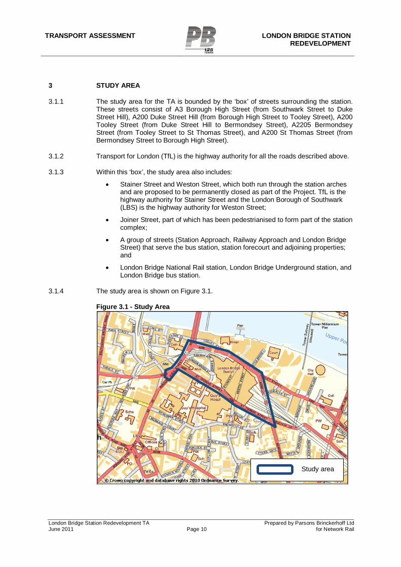
3 STUDY AREA
3.1.1 The study area for the TA is bounded by the ‘box’ of streets surrounding the station. These streets consist of A3 Borough High Street (from Southwark Street to Duke Street Hill), A200 Duke Street Hill (from Borough High Street to Tooley Street), A200 Tooley Street (from Duke Street Hill to Bermondsey Street), A2205 Bermondsey Street (from Tooley Street to St Thomas Street), and A200 St Thomas Street (from Bermondsey Street to Borough High Street).
3.1.2 Transport for London (TfL) is the highway authority for all the roads described above.
3.1.3 Within this ‘box’, the study area also includes:
Stainer Street and Weston Street, which both run through the station arches and are proposed to be permanently closed as part of the Project. TfL is the highway authority for Stainer Street and the London Borough of Southwark (LBS) is the highway authority for Weston Street;
Joiner Street, part of which has been pedestrianised to form part of the station complex;
A group of streets (Station Approach, Railway Approach and London Bridge Street) that serve the bus station, station forecourt and adjoining properties; and
London Bridge National Rail station, London Bridge Underground station, and London Bridge bus station.
3.1.4 The study area is shown on Figure 3.1.
Figure 3.1 - Study Area
Study area
TRANSPORT ASSESSMENT LONDON BRIDGE STATION REDEVELOPMENT
London Bridge Station Redevelopment TA Prepared by Parsons Brinckerhoff Ltd June 2011 Page 11 for Network Rail
3.1.5 In addition to this study area, one of the proposed traffic diversion routes during the
construction period extends outside the study area. This route is described in Section 7.5. There are also proposed permanent changes to traffic arrangements along the A200 east from the edge of the study area to Jamaica Road. These are described in Section 8.4. These additional areas, although beyond the main study area, are also addressed in the TA as appropriate.
TRANSPORT ASSESSMENT LONDON BRIDGE STATION
REDEVELOPMENT
London Bridge Station Redevelopment TA Prepared by Parsons Brinckerhoff Ltd June 2011 Page 12 for Network Rail
4 CUMULATIVE IMPACTS
4.1.1 The following committed developments and their associated impacts on the study area have been considered as part of this TA:
London Bridge Quarter – which consists of the London Bridge Place and Shard of Glass developments. Main construction of the Shard of Glass is expected to be complete by 2012. Construction of London Bridge Place is in progress and may overlap with the early part of the London Bridge Station project. Liaison is maintained between Network Rail and London Bridge Place, and at this stage there is expected to be minimal impact from one project to another. For TA purposes, the operational site traffic from both of these developments, as identified in their TA[2], has been included in the traffic analysis for the construction period and permanent scenarios. The site traffic consists of taxi and private car pick-ups and drop-offs. Estimated rail passenger trips from these developments have also been taken into account in the passenger flow forecasts. As part of the Shard development, a revised station concourse layout is being delivered. This has been taken into account in the assessment.
London Bridge Bus Station Redevelopment. The bus station and taxi rank are being redeveloped in association with construction of the adjoining London Bridge Place development. Planning permission has been granted for an ‘interim’ layout which has begun construction and is due to be complete by 2012. The anticipated construction of the Station Approach Viaduct and its extension (SAV/SAVEX), under the existing TWA powers, will require some adjustments to part of the interim bus station. The design of the interim layout took these anticipated changes into account, and demonstrated that a final layout could be successfully achieved. The bus station redevelopment in itself involves no new trip generation.
One Tower Bridge (also known as Potters Field). Vehicular trip generation within the study area from this site is negligible[3].
The Quill. This site on the corner of Weston Street and St Thomas Street is due to be redeveloped as student accommodation. Vehicular trip generation from this site is negligible[4].
The Station Approach Viaduct (SAV) and Station Approach Viaduct Extension (SAVEX). These are a separate part of the Thameslink programme, not part of the London Bridge station redevelopment, but are due to be built during part of the London Bridge station construction period.
[2] London Bridge Quarter Bus Station Traffic Modelling Technical Note, WSP, November 2009. This document includes trip generation and modelling results for site traffic from the two London Bridge Quarter developments as well as the bus station itself. [3] One Tower Bridge Transport Assessment (Including Travel Plan), Berkeley Homes, July 2010 [4] Quill, 40-46 Weston Street, London, Transport Assessment, Pell Frischmann, September 2010
TRANSPORT ASSESSMENT LONDON BRIDGE STATION REDEVELOPMENT
London Bridge Station Redevelopment TA Prepared by Parsons Brinckerhoff Ltd June 2011 Page 13 for Network Rail
5 BASELINE CONDITIONS
5.1 Land uses
Existing land use
5.1.1 The existing station includes platforms above street level, approximately 1,000 sq m of retail space associated with the station, and approximately 7,000 sq m of other commercial spaces in the arches below the platforms.
5.1.2 Land uses around London Bridge Station are varied. Large offices dominate the immediate surroundings; leisure uses, as well as offices, occur to the north. Guy’s Hospital tower block is a landmark to the south. Residential development is concentrated to the east, near Tower Bridge. The large and busy station is a key driver in the pressure for commercial development in the area.
Parking
5.1.3 There is no public parking available at London Bridge Station, only a pick up and set down point. Six pay and display parking bays are available on St Thomas Street and there is a coach parking facility in Battle Bridge Lane.
5.1.4 The staff car park, under the tracks at street level, is reached from St Thomas Street near Vinegar Yard and includes an access ramp to operational spaces for maintenance and signallers at track level between the tracks and the St Thomas Street frontage. There is a total of 79 spaces including the spaces at track level.
Cycle parking
5.1.5 The station currently has 107 cycle parking spaces, located in the paid area of the station on platform 8. The TfL-supported London Bridge Cycle Park (trading as On Your Bike) also operates from the arches under the station. Further information on cycle parking supply and demand is provided in Section 5.5.
Parking, Loading & Stopping Restrictions
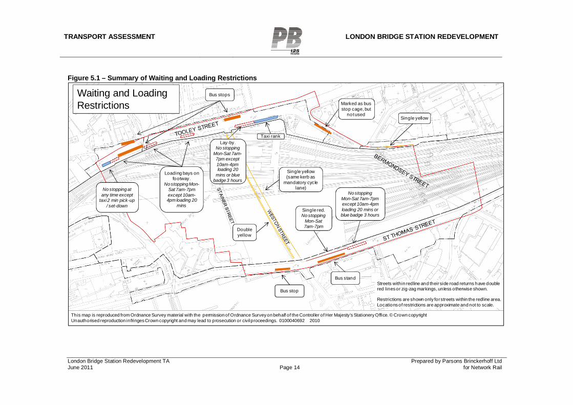
5.1.6 The majority of roads surrounding the station are TLRN roads with ‘no stopping at any time’ restrictions. Tooley Street restrictions do not allow stopping at any time, except 20 minutes loading from 10am-4pm and/or three hours blue badge parking outside commercial outlets. Borough High Street is a red route with no stopping at any time north of Southwark Street junction, although loading is permitted south of this point. St Thomas Street is a red route with a combination of ‘no stopping at any time’, ‘no stopping Mon-Sat 7am-7pm’, pay and display parking, and loading. There are a mixture of single and double yellow lines through the bus station. Figure 5.1 summarises the waiting and loading restrictions immediately around the station.
TRANSPORT ASSESSMENT LONDON BRIDGE STATION REDEVELOPMENT
London Bridge Station Redevelopment TA Prepared by Parsons Brinckerhoff Ltd June 2011 Page 14 for Network Rail
Figure 5.1 – Summary of Waiting and Loading Restrictions
Marked as bus stop cage, but
not used
Bus stand
Bus stopStreets within redline and their side road returns have double red lines or zig-zag markings, unless otherwise shown.
Restrictions are shown only for streets within the redline area. Locations of restrictions are approximate and not to scale.
.
Taxi rank
Loading bays on footway.
No stopping Mon-Sat 7am-7pm except 10am-4pm loading 20
mins
No stopping at any time except
taxi 2 min pick-up / set-down
Single red. No stopping
Mon-Sat 7am-7pm
Single yellow (same kerb as
mandatory cycle lane)
Double yellow
Lay-by.No stopping
Mon-Sat 7am-7pm except 10am-4pm loading 20
mins or blue badge 3 hours
Waiting and Loading Restrictions
No stopping Mon-Sat 7am-7pmexcept 10am-4pm loading 20 mins or blue badge 3 hours
Single yellow
Bus stops
This map is reproduced from Ordnance Survey material with the permission of Ordnance Survey on behalf of the Controller of Her Majesty's Stationery Office. © Crown copyright Unauthorised reproduction infringes Crown copyright and may lead to prosecution or civil proceedings. 0100040692 2010
TRANSPORT ASSESSMENT LONDON BRIDGE STATION REDEVELOPMENT
London Bridge Station Redevelopment TA Prepared by Parsons Brinckerhoff Ltd June 2011 Page 15 for Network Rail
5.2 Road network
Traffic flows
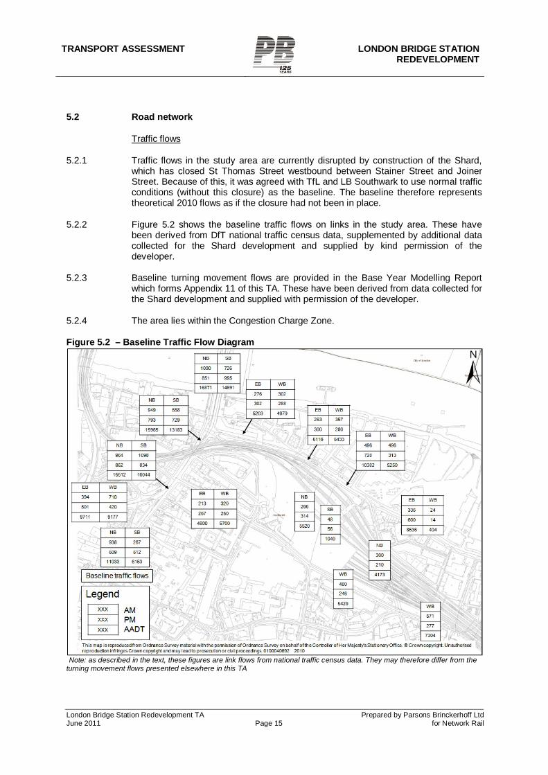
5.2.1 Traffic flows in the study area are currently disrupted by construction of the Shard, which has closed St Thomas Street westbound between Stainer Street and Joiner Street. Because of this, it was agreed with TfL and LB Southwark to use normal traffic conditions (without this closure) as the baseline. The baseline therefore represents theoretical 2010 flows as if the closure had not been in place.
5.2.2 Figure 5.2 shows the baseline traffic flows on links in the study area. These have been derived from DfT national traffic census data, supplemented by additional data collected for the Shard development and supplied by kind permission of the developer.
5.2.3 Baseline turning movement flows are provided in the Base Year Modelling Report which forms Appendix 11 of this TA. These have been derived from data collected for the Shard development and supplied with permission of the developer.
5.2.4 The area lies within the Congestion Charge Zone.
Figure 5.2 – Baseline Traffic Flow Diagram
Note: as described in the text, these figures are link flows from national traffic census data. They may therefore differ from the turning movement flows presented elsewhere in this TA
TRANSPORT ASSESSMENT LONDON BRIDGE STATION
REDEVELOPMENT
London Bridge Station Redevelopment TA Prepared by Parsons Brinckerhoff Ltd June 2011 Page 16 for Network Rail
Accident analysis
5.2.5 Appendix 5 provides an analysis of accident data in the study area. Accident rates have remained generally steady over the past five years, and accident rates are generally in line with the equivalent values across Southwark as a whole. However, the accident rate at signalised pedestrian crossings in the study area is higher than the corresponding rate for Southwark as a whole. This probably reflects the high pedestrian flows and complex traffic environment at some crossings in the study area, particularly on Tooley Street near the station.
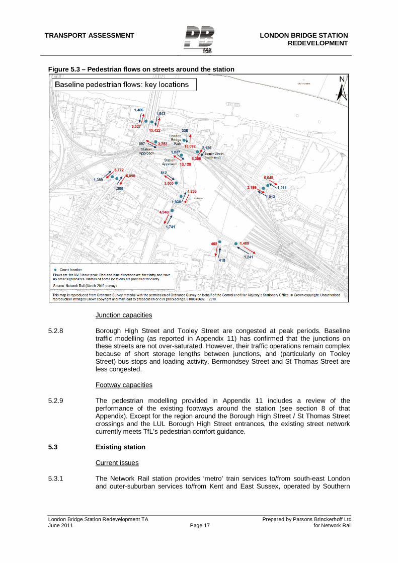
Pedestrian flows
5.2.6 The station and some of the surrounding streets have substantial pedestrian flows. Tooley Street (with a combination of commercial, commuter and tourist activity) is a key street for pedestrians. The south side of Tooley Street immediately east of Joiner Street is a congested area. The queue for the London Dungeon, a bus stop, and a loading bay on the footway represent competing demands for space on this footway. Other key locations for pedestrians include Borough High Street (commercial and commuters) and the bridge across Duke Street Hill to London Bridge (commuters). In addition, Guy’s Hospital and the immigration office on St Thomas Street generate pedestrian traffic. Pedestrian flows along Stainer Street and Weston Street are low, reflecting the poor quality environment.
5.2.7 Figure 5.3 shows the flows recorded at key locations in a March 2010 survey undertaken for Network Rail during the three-hour AM peak period.
TRANSPORT ASSESSMENT LONDON BRIDGE STATION REDEVELOPMENT
London Bridge Station Redevelopment TA Prepared by Parsons Brinckerhoff Ltd June 2011 Page 17 for Network Rail
Figure 5.3 – Pedestrian flows on streets around the station
Junction capacities
5.2.8 Borough High Street and Tooley Street are congested at peak periods. Baseline traffic modelling (as reported in Appendix 11) has confirmed that the junctions on these streets are not over-saturated. However, their traffic operations remain complex because of short storage lengths between junctions, and (particularly on Tooley Street) bus stops and loading activity. Bermondsey Street and St Thomas Street are less congested.
Footway capacities
5.2.9 The pedestrian modelling provided in Appendix 11 includes a review of the performance of the existing footways around the station (see section 8 of that Appendix). Except for the region around the Borough High Street / St Thomas Street crossings and the LUL Borough High Street entrances, the existing street network currently meets TfL’s pedestrian comfort guidance.
5.3 Existing station
Current issues
5.3.1 The Network Rail station provides ‘metro’ train services to/from south-east London and outer-suburban services to/from Kent and East Sussex, operated by Southern
TRANSPORT ASSESSMENT LONDON BRIDGE STATION
REDEVELOPMENT
London Bridge Station Redevelopment TA Prepared by Parsons Brinckerhoff Ltd June 2011 Page 18 for Network Rail
and Southeastern. It also provides Thameslink services, operated by First Capital Connect, to/from Brighton in the south and Bedford in the north. Track capacity constrains mean that the Thameslink service is currently very limited at peak periods. As part of the Thameslink Programme, the main objective of the Project is to transform the Thameslink service capacity and journey opportunities available at London Bridge.
5.3.2 Because of the station’s historic piecemeal development, access and interchange are currently unintuitive and of poor quality. The station has several different entrances, some of which in effect only serve the through platforms:
a) The main concourse is reached from the station forecourt at terminating platform level, or from Joiner Street via the Western Arcade and escalators. The concourse layout is itself unintuitive as the through and terminating platforms are reached by separate gatelines at opposite ends of the concourse.
b) The ‘red brick’ passageway under the through tracks serves the through
platforms. This passageway is accessed via a gateline to/from the main concourse, plus additional gatelines to/from the forecourt, Joiner Street (via escalators) and a non-Network Rail owned bridge over Tooley Street.
5.3.3 Although the station has full access for mobility-impaired passengers, step-free
interchange between through and terminating services requires passengers to travel via the concourse and two sets of gatelines.
5.3.4 A revised main concourse layout is currently under construction in association with the Shard development. This will not affect the basic layout or operation of the station.
5.3.5 The station is currently crowded at peak times and significant interventions, based on established contingency plans, are required to maintain safe operations during service disruptions. The key issue during disruptions is crowding on the through platforms. The interventions include running trains non-stop through London Bridge (in the AM peak) or stopping at London Bridge to pick up only (in the PM peak). If this is insufficient, access to the station is restricted until the situation eases. These interventions maintain safe operations but cause disruption and delay to passengers.
Congestion modelling
5.3.6 Network Rail has undertaken dynamic pedestrian modelling of the ‘base’ station design (the current station after the revised main concourse is complete). The station was assessed for normal operation in the AM and PM peaks against three passenger demand scenarios (2006+5%, 2006+15% and 2006+25%). Appendix 6 summarises the results of the modelling.
5.3.7 The 2006+5% demand is considered broadly consistent with the current level of station usage. The base station can accommodate this in normal operations in both peaks, although the level of congestion is beyond that which would be accepted for a new build design.
5.3.8 Further growth beyond the 2006+5% level has been shown to result in severe passenger congestion and safety issues. This is most apparent in relation to the platform widths on the through platforms, the platform-end ramp capacity (particularly on platforms 5/6) and the terminating platform widths adjacent to the footbridge stairs. The issue is largely driven by the physical dimensions of the station structure; this would be impractical to resolve within the existing station design. It is not considered
TRANSPORT ASSESSMENT LONDON BRIDGE STATION REDEVELOPMENT
London Bridge Station Redevelopment TA Prepared by Parsons Brinckerhoff Ltd June 2011 Page 19 for Network Rail
feasible to mitigate the congestion impacts of growth in these areas of the station through operational measures.
5.4 Passenger flows in/to/from the station complex
5.4.1 This section describes the passenger flows within the station complex (Network Rail, LUL and bus stations, and to/from the street).
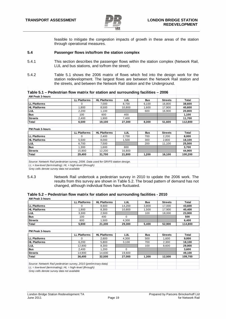
5.4.2 Table 5.1 shows the 2006 matrix of flows which fed into the design work for the station redevelopment. The largest flows are between the Network Rail station and the streets, and between the Network Rail station and the Underground.
Table 5.1 – Pedestrian flow matrix for station and surrounding facilities – 2006
Grey cells denote survey data not available 5.4.3 Network Rail undertook a pedestrian survey in 2010 to update the 2006 work. The
results from this survey are shown in Table 5.2. The broad pattern of demand has not changed, although individual flows have fluctuated.
Table 5.2 – Pedestrian flow matrix for station and surrounding facilities - 2010
Grey cells denote survey data not available
AM Peak 3-hoursLL Platforms HL Platforms LUL Bus Streets Total
LL Platforms 0 7,000 8,700 6,100 16,800 38,600HL Platforms 1,800 8,500 10,800 1,600 17,900 40,600LUL 2,200 1,100 600 16,900 20,800Bus 100 600 400 1,100Streets 2,400 1,900 7,400 11,700Total 6,500 19,100 27,300 8,300 51,600 112,800
PM Peak 3-hoursLL Platforms HL Platforms LUL Bus Streets Total
LL Platforms 0 2,400 2,700 700 2,200 8,000HL Platforms 5,500 8,000 1,500 300 2,800 18,100LUL 6,700 7,500 200 11,100 25,500Bus 1,300 1,600 800 3,700Streets 15,900 12,200 16,800 44,900Total 29,400 31,700 21,800 1,200 16,100 100,200
Source: Network Rail pedestrian survey, 2006. Data used for GRIP3 station design.LL = low-level (terminating). HL = high-level (through)
AM Peak 3-hoursLL Platforms HL Platforms LUL Bus Streets Total
LL Platforms 0 8,600 14,200 3,800 17,000 43,600HL Platforms 1,900 8,300 10,800 1,500 17,900 40,400LUL 3,300 2,500 100 18,000 23,900Bus 100 400 0 500Streets 600 1,500 4,300 6,400Total 5,900 21,300 29,300 5,400 52,900 114,800
PM Peak 3-hoursLL Platforms HL Platforms LUL Bus Streets Total
LL Platforms 0 2,600 4,300 500 1,600 9,000HL Platforms 6,200 5,800 3,100 700 2,300 18,100LUL 12,900 8,300 100 8,600 29,900Bus 2,400 1,200 0 3,600Streets 14,900 14,600 19,600 49,100Total 36,400 32,500 27,000 1,300 12,500 109,700
Source: Network Rail pedestrian survey, 2010 (preliminary data)LL = low-level (terminating). HL = high-level (through)
TRANSPORT ASSESSMENT LONDON BRIDGE STATION
REDEVELOPMENT
London Bridge Station Redevelopment TA Prepared by Parsons Brinckerhoff Ltd June 2011 Page 20 for Network Rail
5.5 Other public transport, walking and cycling
5.5.1 The London Bridge station area is an important public transport interchange in its own right. The site has a public transport accessibility level (PTAL) of 6 on a scale of 1 to 6, where 6 is most accessible.
Underground
5.5.2 The Underground station is served by the Northern and Jubilee lines. The station has step-free access between the ticket hall and each platform[1]. The step and gap from platform to train is category ‘A’ (the smallest step/gap) at the level access boarding point at the centre of each platform. However, changing lines by a step-free route requires a 410m journey via street level.
Buses
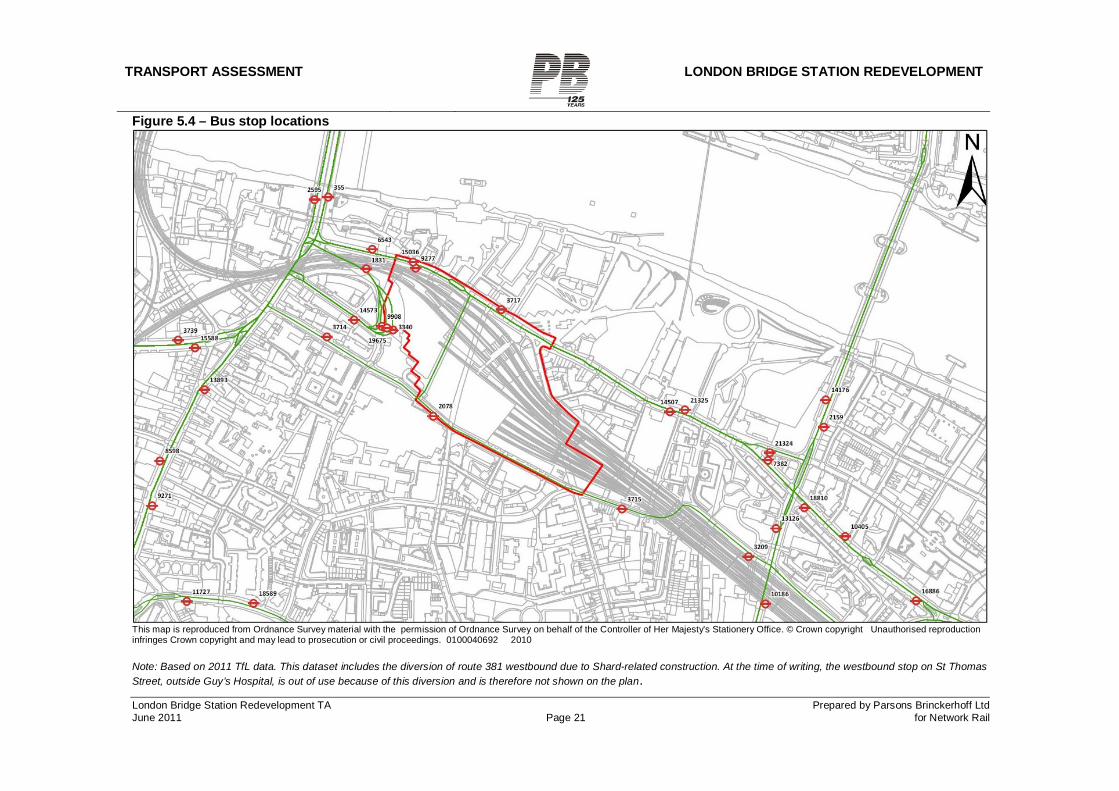
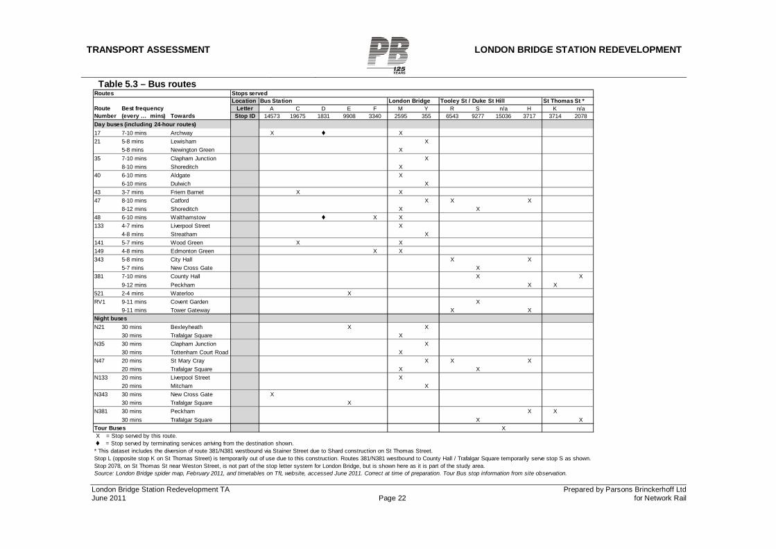
5.5.3 A wide range of daytime, night and 24-hour bus routes serve the area. London Bridge Bus Station, alongside the Network Rail Station, serves bus routes that terminate at London Bridge. Other routes pass close to the station along the adjoining streets. In the daytime, there are currently nine terminating bus services, with a further six passing the station. The routes are shown in Table 5.3 below and the bus stop locations are displayed in Table 5.3. Taken together, these bus routes provide more than 100 buses per hour during the day in each direction. Bus services cover destinations in north and south London as well as those in the central area.
5.5.4 The bus station, which is part of the station forecourt, is entered from the junction of Duke Street Hill with London Bridge. All buses enter from this direction and leave via London Bridge Street, which is a one way (westbound) street leading back to Borough High Street. The bus station provides six islands for terminating routes, capable of accommodating 11 buses.
5.5.5 Bus stops for services passing London Bridge are located on Duke Street Hill, St Thomas Street, Tooley Street and Borough High Street.
[1] Source for Underground accessibility information: Step-free Tube Guide, TfL, January 2009
TRANSPORT ASSESSMENT LONDON BRIDGE STATION REDEVELOPMENT
London Bridge Station Redevelopment TA Prepared by Parsons Brinckerhoff Ltd June 2011 Page 21 for Network Rail
Figure 5.4 – Bus stop locations
This map is reproduced from Ordnance Survey material with the permission of Ordnance Survey on behalf of the Controller of Her Majesty's Stationery Office. © Crown copyright Unauthorised reproduction infringes Crown copyright and may lead to prosecution or civil proceedings. 0100040692 2010 Note: Based on 2011 TfL data. This dataset includes the diversion of route 381 westbound due to Shard-related construction. At the time of writing, the westbound stop on St Thomas Street, outside Guy’s Hospital, is out of use because of this diversion and is therefore not shown on the plan.
TRANSPORT ASSESSMENT LONDON BRIDGE STATION REDEVELOPMENT
London Bridge Station Redevelopment TA Prepared by Parsons Brinckerhoff Ltd June 2011 Page 22 for Network Rail
Table 5.3 – Bus routes
Routes Stops servedLocation Bus Station London Bridge Tooley St / Duke St Hill St Thomas St *
Letter A C D E F M Y R S n/a H K n/aStop ID 14573 19675 1831 9908 3340 2595 355 6543 9277 15036 3717 3714 2078
Day buses (including 24-hour routes)17 7-10 mins Archway X X21 5-8 mins Lewisham X
5-8 mins Newington Green X35 7-10 mins Clapham Junction X
8-10 mins Shoreditch X40 6-10 mins Aldgate X
6-10 mins Dulwich X43 3-7 mins Friern Barnet X X47 8-10 mins Catford X X X
8-12 mins Shoreditch X X48 6-10 mins Walthamstow X X133 4-7 mins Liverpool Street X
4-8 mins Streatham X141 5-7 mins Wood Green X X149 4-8 mins Edmonton Green X X343 5-8 mins City Hall X X
5-7 mins New Cross Gate X381 7-10 mins County Hall X X
9-12 mins Peckham X X521 2-4 mins Waterloo XRV1 9-11 mins Covent Garden X
9-11 mins Tower Gateway X XNight busesN21 30 mins Bexleyheath X X
30 mins Trafalgar Square XN35 30 mins Clapham Junction X
30 mins Tottenham Court Road XN47 20 mins St Mary Cray X X X
20 mins Trafalgar Square X XN133 20 mins Liverpool Street X
20 mins Mitcham XN343 30 mins New Cross Gate X
30 mins Trafalgar Square XN381 30 mins Peckham X X
30 mins Trafalgar Square X XTour Buses X X = Stop served by this route.
= Stop served by terminating services arriving from the destination shown.* This dataset includes the diversion of route 381/N381 westbound via Stainer Street due to Shard construction on St Thomas Street.Stop L (opposite stop K on St Thomas Street) is temporarily out of use due to this construction. Routes 381/N381 westbound to County Hall / Trafalgar Square temporarily serve stop S as shown.Stop 2078, on St Thomas St near Weston Street, is not part of the stop letter system for London Bridge, but is shown here as it is part of the study area.Source: London Bridge spider map, February 2011, and timetables on TfL website, accessed June 2011. Correct at time of preparation. Tour Bus stop information from site observation.
Route Number
Best frequency (every … mins) Towards
TRANSPORT ASSESSMENT LONDON BRIDGE STATION REDEVELOPMENT
London Bridge Station Redevelopment TA Prepared by Parsons Brinckerhoff Ltd June 2011 Page 23 for Network Rail
5.5.6 The bus station is currently being redeveloped in association with construction of the adjoining London Bridge Place development. Planning permission has been granted for an ‘interim’ layout which began construction in early 2011 and is due to be complete by 2012. The anticipated construction of the Station Approach Viaduct and its extension (SAV/SAVEX) under existing TWA powers will require some adjustments to part of the interim bus station. The design of the interim layout took these anticipated changes into account, and demonstrated that a final layout could be successfully achieved. The station redevelopment is not expected to have an impact on bus station operations.
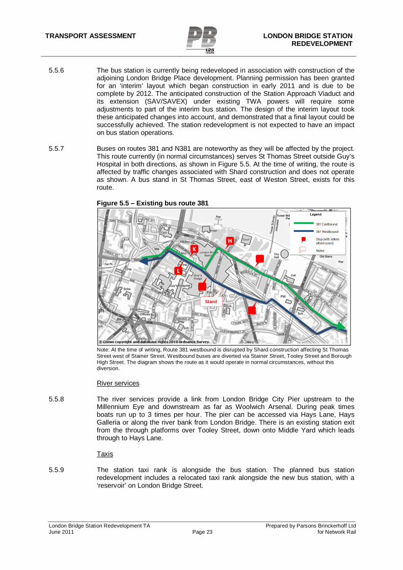
5.5.7 Buses on routes 381 and N381 are noteworthy as they will be affected by the project. This route currently (in normal circumstances) serves St Thomas Street outside Guy’s Hospital in both directions, as shown in Figure 5.5. At the time of writing, the route is affected by traffic changes associated with Shard construction and does not operate as shown. A bus stand in St Thomas Street, east of Weston Street, exists for this route.
Figure 5.5 – Existing bus route 381
Note: At the time of writing, Route 381 westbound is disrupted by Shard construction affecting St Thomas Street west of Stainer Street. Westbound buses are diverted via Stainer Street, Tooley Street and Borough High Street. The diagram shows the route as it would operate in normal circumstances, without this diversion.
River services
5.5.8 The river services provide a link from London Bridge City Pier upstream to the Millennium Eye and downstream as far as Woolwich Arsenal. During peak times boats run up to 3 times per hour. The pier can be accessed via Hays Lane, Hays Galleria or along the river bank from London Bridge. There is an existing station exit from the through platforms over Tooley Street, down onto Middle Yard which leads through to Hays Lane.
Taxis
5.5.9 The station taxi rank is alongside the bus station. The planned bus station redevelopment includes a relocated taxi rank alongside the new bus station, with a ‘reservoir’ on London Bridge Street.
TRANSPORT ASSESSMENT LONDON BRIDGE STATION
REDEVELOPMENT
London Bridge Station Redevelopment TA Prepared by Parsons Brinckerhoff Ltd June 2011 Page 24 for Network Rail
5.5.10 Other taxi ranks within the study area are on Duke Street Hill (1 cab) and on Tooley Street near More London (4 cabs). These primarily serve nearby offices and attractions.
Walking
5.5.11 Existing pedestrian flows and capacities were described in section 5.2. Existing station entrances were described in section 5.3.
5.5.12 A combined TRL PERS (Pedestrian Environment Review System) audit and Living Streets CSA (Community Street Audit) of the streets around London Bridge Station was undertaken in 2008. The report1 highlighted a poor pedestrian environment on some streets, with poor wayfinding also being highlighted. Appendix 4 reproduces the report’s key findings.
5.5.13 North-south pedestrian connectivity through the station area is a key gap in the pedestrian network. Joiner Street provides a reasonable route but, further east, Stainer Street, Weston Street and Bermondsey Street are poor quality and uninviting routes. This reinforces the severance between the areas north and south of the station. One of the key reasons for the proposed north-south concourse is to address this severance.
Cycling
5.5.14 Existing signed cycle routes include National Cycle Network Route 4 which runs along Tooley Street, and London Cycle Network Route 22 which runs southbound down Weston Street and northbound along Bermondsey Street. Cycle lanes are provided on all these routes. The routes through Weston Street and Bermondsey Street under the railway arches are of poor quality.
5.5.15 There are currently no Barclays Cycle Superhighways within the study area. Cycle Superhighway 4 (CS4) (Woolwich to London Bridge2) is proposed to run along Tooley Street and be implemented by 2015, although these details are subject to change following future consultation on CS4.
5.5.16 Network Rail has undertaken a Cycling Assessment for this project, working with cycling specialists from LB Southwark and TfL. The results are provided in Appendix 6.
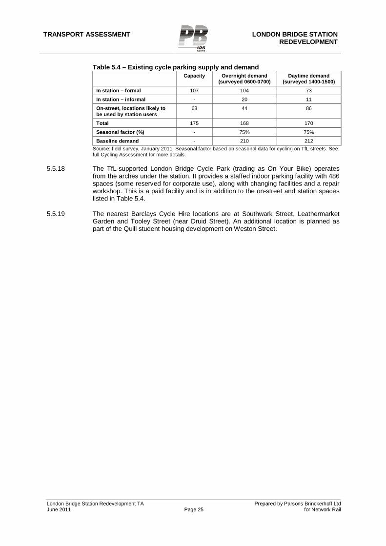
5.5.17 Table 5.4 summarises the existing on-street and on-station cycle parking supply and demand, based on a survey undertaken in January 2011. The station currently has 107 cycle parking spaces, located in the paid area of the station on platform 8. In addition to these spaces, cycles are parked informally along the nearby fence and railings. Another 68 cycle parking spaces (Sheffield-type stands) are provided on-street on Duke Street Hill or Tooley Street and are likely to be used, at least in part, by station users. In addition to these spaces, cycles are parked informally against railings, signposts or lamp columns. Allowing for seasonal variations in levels of cycling, the baseline peak cycle parking demand from station users is estimated to be approximately 210 spaces.
1 Transport for London PERS and CSA 07/08 Category A Station Audits London Bridge Station - Final Report. TRL ref. UPR/T/023/08 2 Source: TfL Business Plan 2011. This appears to supersede Map 6.2 of the Mayor’s Transport Strategy which describes CS4 as running from Woolwich to Tower Bridge, not London Bridge.
TRANSPORT ASSESSMENT LONDON BRIDGE STATION REDEVELOPMENT
London Bridge Station Redevelopment TA Prepared by Parsons Brinckerhoff Ltd June 2011 Page 25 for Network Rail
Table 5.4 – Existing cycle parking supply and demand Capacity Overnight demand
(surveyed 0600-0700) Daytime demand
(surveyed 1400-1500) In station – formal 107 104 73
In station – informal - 20 11
On-street, locations likely to be used by station users
68 44 86
Total 175 168 170
Seasonal factor (%) - 75% 75%
Baseline demand - 210 212 Source: field survey, January 2011. Seasonal factor based on seasonal data for cycling on TfL streets. See full Cycling Assessment for more details.
5.5.18 The TfL-supported London Bridge Cycle Park (trading as On Your Bike) operates
from the arches under the station. It provides a staffed indoor parking facility with 486 spaces (some reserved for corporate use), along with changing facilities and a repair workshop. This is a paid facility and is in addition to the on-street and station spaces listed in Table 5.4.
5.5.19 The nearest Barclays Cycle Hire locations are at Southwark Street, Leathermarket Garden and Tooley Street (near Druid Street). An additional location is planned as part of the Quill student housing development on Weston Street.
TRANSPORT ASSESSMENT LONDON BRIDGE STATION
REDEVELOPMENT
London Bridge Station Redevelopment TA Prepared by Parsons Brinckerhoff Ltd June 2011 Page 26 for Network Rail
6 TRIP GENERATION
6.1 Passenger flows in/to/from the station complex
6.1.1 The station redevelopment will not, in itself, generate new pedestrian trips. However, it will accommodate and ‘unlock’ growth in rail passenger demand from both background growth and the Thameslink programme.
6.1.2 The Thameslink programme will also produce changes in existing passenger flows. In particular, many passengers who currently interchange at London termini (including London Bridge) will be able to continue by train through central London to a station nearer their destination (which in some cases will be London Bridge). This will reduce the demand on other modes. The net impact at London Bridge is therefore complex.
6.1.3 Table 6.1 presents the forecast flow matrix for 2016. This represents the opening year of the Thameslink programme (although following recent changes to the programme, as announced by the Government in Spring 2011, the full Thameslink programme train service may not be in place until 2018). It is based on forecast station entry/exit volumes, which in turn are derived from rail passenger forecasts. These forecasts include gradual growth to 2016, followed by a one-off uplift in 2016 due to the opening of the full Thameslink service.
Table 6.1 – Pedestrian flow matrix for station and surrounding facilities - 2016
Grey cells denote figures not available 6.1.4 For station planning purposes, a demand horizon of 2016+35% has been agreed with
the Department for Transport and London Underground. Table 6.2 presents the pedestrian flow matrix at this level of demand.
AM Peak 3-hoursLL Platforms HL Platforms LUL Bus Streets Total
LL Platforms 0 4,600 8,100 3,600 10,100 26,400HL Platforms 800 17,600 18,900 2,500 34,000 73,800LUL 900 5,200 700 21,400 28,200Bus 0 1,200 400 1,600Streets 700 4,600 7,000 12,300Total 2,400 33,200 34,400 6,800 65,500 142,300
PM Peak 3-hoursLL Platforms HL Platforms LUL Bus Streets Total
LL Platforms 0 1,500 1,100 100 800 3,500HL Platforms 3,500 18,100 6,600 1,100 5,500 34,800LUL 6,600 12,100 200 9,200 28,100Bus 700 2,800 900 4,400Streets 9,900 28,400 19,200 57,500Total 20,700 62,900 27,800 1,400 15,500 128,300
Source: Network Rail - Railplan forecasts as used in GRIP 3 designLL = low-level (terminating). HL = high-level (through)
TRANSPORT ASSESSMENT LONDON BRIDGE STATION REDEVELOPMENT
London Bridge Station Redevelopment TA Prepared by Parsons Brinckerhoff Ltd June 2011 Page 27 for Network Rail
Table 6.2 – Pedestrian flow matrix for station and surrounding facilities – 2016+35%
Grey cells denote figures not available
6.2 Car parking
6.2.1 A significant number of operational staff, both those of Network Rail and the Train Operating Companies, need to travel to the station and/or travel from the station outside of the times when public transport services are in operation. This necessitates them travelling to the station by non-public transport means, and this is predominantly necessary via the private car. In addition, certain operational vehicles need to be parked within the station for use during the day as and when required. As part of this requirement Network Rail is contractually obligated to provide an agreed level of car parking provision for the Train Operating Companies as well as meeting its own operational needs. Network Rail is also required to provide a parking space for use by the British Transport Police. Table 6.3 sets out the operational car parking requirements.
6.2.2 In addition, operational staff shift changeovers can include briefings, reading notices, handing over files, and updates on shift events, in addition to time taken walking to and from the signing-on point within the station. As a result such shift changeovers can take up to 3 hours, which means a crossover of staff and parking, thus requiring further parking provision.
6.2.3 Network Rail has sought, through the proposals, to reduce as far as possible the level of car parking provision within the station in order to improve the visual appearance of the station and to promote alternative modes of transport to the private car where possible. The existing platform level signalling car park is to be removed and the parking relocated to within the street level operational car park. In addition, the Maintenance Delivery Unit currently based at the station is to be relocated to James Forbes House on Great Suffolk Street. Station car parking has therefore been reduced to a single location within the existing station car park at street level on St Thomas Street. No changes are proposed to this car park. The proposed level of car parking is the minimum level possible for the safe and efficient operation of the station and the transport services provided from it.
AM Peak 3-hoursLL Platforms HL Platforms LUL Bus Streets Total
LL Platforms 0 6,200 11,000 4,800 13,600 35,600HL Platforms 1,100 23,700 25,600 3,400 45,800 99,600LUL 1,200 7,000 900 28,800 37,900Bus 0 1,600 600 2,200Streets 1,000 6,200 9,400 16,600Total 3,300 44,700 46,600 9,100 88,200 191,900
PM Peak 3-hoursLL Platforms HL Platforms LUL Bus Streets Total
LL Platforms 0 2,000 1,500 100 1,100 4,700HL Platforms 4,700 24,400 9,000 1,500 7,400 47,000LUL 9,000 16,300 300 12,400 38,000Bus 1,000 3,800 1,200 6,000Streets 13,300 38,300 25,900 77,500Total 28,000 84,800 37,600 1,900 20,900 173,200
Source: Network Rail - 2016 Railplan forecasts increased by 35%. As used in GRIP 3 designLL = low-level (terminating). HL = high-level (through)
TRANSPORT ASSESSMENT LONDON BRIDGE STATION
REDEVELOPMENT
London Bridge Station Redevelopment TA Prepared by Parsons Brinckerhoff Ltd June 2011 Page 28 for Network Rail
Table 6.3 – Existing and proposed car parking provision CURRENT PARKING PROVISION Location Spaces Existing Operational Car Park (Street Level) 53 Signalling Car Park (Platform Level) 12 Maintenance Car Park (Platform Level) (Note A) 9 Total 74 CURRENT USAGE (Note B) Station User Role of User Spaces Network Rail Security, Cleaning, Facilities, Reception / Station Ops, Duty Mgrs 10 Signalling staff 12 Rapid Response 1 Maintenance & Field Ops 14 Southeastern Station Controllers, Duty Mgr, Train Crew 14 Southern Train Crew 12 British Transport Police Police Officer 1 Total 64 FUTURE REQUIREMENTS (Note B) Station User Role of User Spaces Network Rail Security, Cleaning, Facilities, Reception/Station Ops, Duty Mgrs 10 Rapid Response 1 Signalling Staff 12 Southeastern Station Controllers, Duty Mgr, Train Crew (Railway Operations) 14 Southern Train Crew 12 BTP Police Officer 1 FCC Train Crew, Station Control Duty Mgr (Note C) 3 Total 53
Notes:
(A) Plus 5 loading dock spaces used by maintenance staff when required. Total 14 available.
(B) During Shift changeover it is important to note that with operational staff this can include briefings, reading notices, handing over files, update on shift events and walking routes to and from the signing on point. This can take up to 3 hours which means there will be a crossover of staff and parking.
(C) Provisional. The Thameslink Service is being increased and the full extent of FCC staffing and requirements are not yet fully confirmed.
6.3 Vehicle trips
6.3.1 The project is not anticipated to generate a significant number of new vehicle trips, for the following reasons.
6.3.2 As described above, the number of operational parking spaces will be reduced from 74 to 53. Given the existing parking restrictions in the area, spillover impacts are not expected and the trip generation and distribution impact of this change is considered to be negligible.
6.3.3 Deliveries currently use a loading bay in the bus station, but are proposed to use a dedicated off-street service yard accessed from St Thomas St. The trip generation and distribution impact of this change is considered to be negligible.
TRANSPORT ASSESSMENT LONDON BRIDGE STATION REDEVELOPMENT
London Bridge Station Redevelopment TA Prepared by Parsons Brinckerhoff Ltd June 2011 Page 29 for Network Rail
6.3.4 Taxi pick-up and drop-off for station users currently takes place at the bus station. The approved bus station design includes replacement pick-up and drop-off areas and a ‘reservoir’ in Railway Approach. The taxi trip generation from this facility was addressed as part of the London Bridge Bus Station redevelopment and is therefore already taken into account under committed development.
TRANSPORT ASSESSMENT LONDON BRIDGE STATION
REDEVELOPMENT
London Bridge Station Redevelopment TA Prepared by Parsons Brinckerhoff Ltd June 2011 Page 30 for Network Rail
7 CONSTRUCTION PERIOD IMPACTS
7.1 Construction period and worksites
7.1.1 It is planned to begin enabling works for utility diversions from summer 2011. Main construction work on the station will begin in Autumn 2012 and will last for six years. Construction will take place in ‘slices’ through the station, starting at the south side and progressing northwards. The main worksites will be St Thomas Street and Vinegar Yard, along with Stainer Street, Weston Street, and individual parts of the station.
7.1.2 Network Rail already has powers under Article 16 of the Thameslink project’s Transport and Works Act Order to temporarily stop up, alter or divert a number of streets around the station during the construction period. These powers are therefore not sought in connection with the planning application. Under these powers, Network Rail will consult with the relevant highway authority on what further action is necessary to limit disruption to road users. Network Rail recognises the importance of minimising disruption to the road network, and will work with stakeholders, including LB of Southwark and TfL as the highway authorities, to do so wherever feasible.
7.1.3 A Transport Liaison Group (TLG) has been set up which includes Network Rail, the highway authorities and the Metropolitan Police. Consultation and liaison on highway operations is taking place through this group, which is expected to include other emergency services in future. Network Rail will work with this group, both before and during construction, to minimise impacts on the highway network.
7.2 Stainer Street and Weston Street closures
7.2.1 It is currently anticipated that Stainer Street and a section of Weston Street (between Tooley Street and St Thomas Street) will close permanently from the start of construction. During the construction period they will be used as work sites. The number of pedestrians currently using these streets is low. Pedestrians will need to use either Joiner Street or Bermondsey Street as alternative routes. Joiner Street is a more accessible route than either Stainer Street or Weston Street.
7.3 St Thomas Street closure
7.3.1 A section of St Thomas Street will temporarily close for the duration of the construction works. This will be from late 2012 to late 2018. Additionally the street may be closed from September 2011 until before the Olympics in mid 2012 for utility diversions. The closure and traffic diversion work for the utility diversions will be undertaken by the utility companies and/or by a multi-utility contractor (MUC).
7.3.2 Figure 7.1 shows the proposed arrangements during the closure period. The street will be closed from the junction with Snowsfields to the western side of the junction with Stainer Street. The section of St Thomas Street from Stainer Street to Joiner Street will remain open for deliveries to The Shard and maintenance access to the EDF sub station on Stainer Street. It is proposed that traffic marshals are placed at the junction with Joiner Street to prevent unauthorised access and to facilitate turning for vehicles delivering to other properties on the open section of St. Thomas Street.
TRANSPORT ASSESSMENT LONDON BRIDGE STATION REDEVELOPMENT
London Bridge Station Redevelopment TA Prepared by Parsons Brinckerhoff Ltd June 2011 Page 31 for Network Rail
7.3.3 The temporary closure will be removed from the section of street between Stainer Street and Weston Street when the south entrance of the new concourse is required for station operations.
7.3.4 Pedestrian access will be maintained on the south side of the closed section with the exception of the footpath in front of the new construction work site adjacent to Vinegar Yard. A temporary footpath diversion will re-route pedestrians along Vinegar Yard, Mellor Street and Fenning Street.
7.3.5 Fire escapes to all properties are unaffected. Emergency vehicles can reach the Immigration Centre from the rear and Fenning Street and the Quill site from Weston Street (the section south of St. Thomas Street) and Mellor Street. Guy’s Hospital is accessible from St Thomas Street and Weston Street.
7.3.6 During the closure pedestrian access will be maintained to the frontages of the Immigration Centre office building, the Quill site and Guy’s Hospital. Delivery and service vehicles will not be able to access the frontages of these buildings but the Immigration Centre has a rear service access off Mellor Street, and the Quill site service access is from Weston Street. Guy’s Hospital servicing is not affected.
Figure 7.1 – St Thomas Street Closure
7.4 Construction trips generated and routes
7.4.1 Construction traffic will consist of a fluctuating number of HGVs carrying demolition & construction material, plus an estimated 40 other vehicles a day visiting the site.
7.4.2 Based on early construction planning estimates, the peak volume of construction traffic is estimated at approximately 235 vehicles per day, of which approximately 195 would be heavy goods vehicles (HGVs). This volume would occur during five peak periods of construction, each lasting four to six weeks. However, this is an early estimate and may vary as the design progresses and as more detailed planning, including value engineering, is undertaken.
TRANSPORT ASSESSMENT LONDON BRIDGE STATION
REDEVELOPMENT
London Bridge Station Redevelopment TA Prepared by Parsons Brinckerhoff Ltd June 2011 Page 32 for Network Rail
7.4.3 Outside these peak periods, trip rates will be significantly lower, typically around 100 vehicles per day, or less.
7.4.4 All construction vehicles will enter the site compound at the St Thomas Street / Bermondsey Street junction. Most vehicles (an estimated 85%) will also leave at this junction, under the direction of traffic marshals. The remainder may leave at other locations such as the west end of St Thomas Street near the Shard, or via Stainer Street or Weston Street onto Tooley Street. The exit routes will depend on the space physically available at each stage of construction. The aim is to minimise the number of construction vehicles using Tooley Street west of Bermondsey Street.
7.4.5 The routing of vehicles to or from the site compound will be finalised at a later stage in consultation with stakeholders and will be formalised in traffic management plans for each stage of construction. For traffic forecasting and modelling purposes, it is assumed that construction traffic is routed to the site compound from the Inner Ring Road via Crucifix Lane and leaves the site compound via Bermondsey Street and Tooley Street to the Inner Ring Road. Figure 7.2 shows this assumed route.
7.4.6 The closed section of St Thomas Street will be used in part as a vehicle holding area, minimising the need for construction vehicles to wait on operational streets.
Figure 7.2 – Construction Vehicles – Assumed Routing for Modelling Purposes
7.5 Road network impacts – during construction
Baseline flows
7.5.1 Traffic flows in the study area are currently disrupted by construction of the Shard, which has closed St Thomas Street westbound between Stainer Street and Joiner Street. Because of this, it was agreed with TfL and LB Southwark to use normal traffic conditions (without this closure) as the baseline. The baseline therefore represents theoretical 2010 flows as if the closure had not been in place.
TRANSPORT ASSESSMENT LONDON BRIDGE STATION REDEVELOPMENT
London Bridge Station Redevelopment TA Prepared by Parsons Brinckerhoff Ltd June 2011 Page 33 for Network Rail
Diversions and re-assignment
7.5.2 Signed diversion routes will be required during the construction period. The current proposals are shown here as discussed with Southwark and TfL for the purposes of the planning application and traffic modelling. However, it is recognised that the diversions may be revised as construction planning continues and in the light of traffic modelling results.
Weston Street flows
7.5.3 The section of Weston Street to be closed has low flows, estimated to be under 60 vehicles per hour. This traffic will not have a specific diversion route. Figure 7.3 shows how the flows are reassigned for traffic forecasting purposes.
Figure 7.3 – Construction Period Traffic Reassignment – Weston Street
Stainer Street / St Thomas Street flows
7.5.4 There are three principal traffic flows using Stainer Street and/or St Thomas Street:
a) An east-to-west movement from Crucifix Lane or Bermondsey Street along St Thomas Street and Stainer Street to Tooley Street. This is shown on Figure 7.4.
b) An east-to-west movement from Crucifix Lane or Bermondsey Street along St Thomas Street to Borough High Street. This is also shown on Figure 7.4.
c) A west-to-east movement from Borough High Street along St Thomas Street and Stainer Street, as shown on Figure 7.5. This represents the majority of the traffic on Stainer Street.
TRANSPORT ASSESSMENT LONDON BRIDGE STATION
REDEVELOPMENT
London Bridge Station Redevelopment TA Prepared by Parsons Brinckerhoff Ltd June 2011 Page 34 for Network Rail
7.5.5 The east-to-west Stainer Street traffic (flow ‘a’) will be signed north along Bermondsey Street and west along Tooley Street to reach its existing route. This is shown on Figure 7.4. The peak flow is estimated to be less than 100 vehicles per hour.
7.5.6 The east-to-west flow on St Thomas Street which continues to Borough High Street (flow ‘b’) will be signed north along Bermondsey Street, west along Tooley Street / Duke Street Hill and south along Borough High Street to reach its existing route. This is also shown on Figure 7.4. The peak flow is estimated to be approximately 250-300 vehicles per hour.
7.5.7 Taken together, the two east-to-west flows will be diverted via Tooley Street / Duke Street Hill. As described below in the section on operational impacts, it is likely that some of this traffic would divert away from the study area via alternative routes, in reaction to limited capacity at the Borough High Street / Duke Street Hill junction.
7.5.8 There is a relatively small amount of traffic which turns left from Weston Street onto St Thomas Street. This is assumed to re-route via alternative routes, with negligible impact.
7.5.9 The west-to-east movement (flow ‘c’) cannot be signed onto Duke Street Hill and Tooley Street under current traffic arrangements, as the right turn from Borough High Street to Duke Street Hill is buses-only.
7.5.10 At this stage, the proposal as agreed with TfL is to use Great Dover Street as the alternative route. The signed diversion route will begin on Southwark Street. Traffic will be signed south onto Southwark Bridge Road and Marshalsea Road to the Borough. Here traffic will also be signed from Borough High Street onto the diversion route. The diversion route will continue along Great Dover Street eastbound. Traffic will then be signed northbound along Tower Bridge Road up to the Tooley Street junction. Figure 7.5 shows the existing route and Figure 7.6 shows the diversion. The peak flow is estimated at approximately 200-250 vehicles per hour. To accommodate this flow, the Southwark Street / Southwark Bridge Road junction will require the addition of an unopposed right turn filter from Southwark Street to Southwark Bridge Road (to be confirmed by operational modelling).
TRANSPORT ASSESSMENT LONDON BRIDGE STATION REDEVELOPMENT
London Bridge Station Redevelopment TA Prepared by Parsons Brinckerhoff Ltd June 2011 Page 35 for Network Rail
Figure 7.4 – Construction Period Traffic Reassignment – Key East-West Flows
Note: diagram shows key east-to-west flows only. The major flow on Stainer Street is west-to-east as shown on Figure 7.5. Figure 7.5 – Construction Period Traffic Reassignment – Key West-East Flow
TRANSPORT ASSESSMENT LONDON BRIDGE STATION
REDEVELOPMENT
London Bridge Station Redevelopment TA Prepared by Parsons Brinckerhoff Ltd June 2011 Page 36 for Network Rail
Figure 7.6 – Construction Period Traffic Reassignment – West-East signed diversion
© Crown copyright and database rights 2010 Ordnance Survey
Impacts on traffic operations – TRANSYT modelling
7.5.11 TRANSYT modelling of operational impacts in the main study area during the construction period has been undertaken. The results are provided in the Future Year Modelling Report in Appendix 12.
7.5.12 Initial modelling showed that if the entire east-to-west flows requiring diversion was allocated to Tooley Street / Duke Street Hill, the junction of Borough High Street and Duke Street Hill would be significantly over-saturated. This is the critical junction. In reality, traffic patterns would adjust (after a settling-down period) to reflect this capacity limitation.
7.5.13 This is confirmed by current traffic patterns operating as a result of Shard construction. The Shard construction currently requires the St Thomas Street east-to-west flows to use Stainer Street and Tooley Street / Duke Street Hill. This means the Borough High Street / Duke Street Hill junction is taking the same flows as are proposed for the station construction period. There has been an initial settling-down period, and the junction – although carrying a heavy traffic volume – is now understood to be operating at an acceptable level of capacity. Traffic appears to have adjusted to the capacity constraint and it is understood from LB Southwark that no significant rat-run problems have become apparent.
7.5.14 It is therefore reasonable to assume that during the station construction period, traffic patterns will readjust in a similar way to the Shard construction period. This was subsequently confirmed by the strategic modelling as described below.
TRANSPORT ASSESSMENT LONDON BRIDGE STATION REDEVELOPMENT
London Bridge Station Redevelopment TA Prepared by Parsons Brinckerhoff Ltd June 2011 Page 37 for Network Rail
7.5.15 To reflect this, the modelled peak-hour east-to-west flow has been reduced to a level that provides acceptable operation at the Borough High Street / Duke Street Hill junction (up to 95% Degree of Saturation on the westbound approach). It is assumed that the remaining traffic will disperse outside the study area (this is addressed by the strategic modelling described below). More details are provided in the Future Year Modelling Report in Appendix 12.
7.5.16 The remaining junctions in the main study area are forecast to operate at 67% Degree of Saturation or less, on individual approaches, as described in the Future Year Modelling Report.
Strategic modelling
7.5.17 Strategic traffic modelling has been undertaken using TfL’s CLoHAM assignment model, to indicate the potential level of traffic redistribution. This is a general-purpose model and its results should therefore be seen as indicative only.
7.5.18 The results of this modelling are provided in Appendix 14. The results for the construction period include an increase in traffic flows on Bermondsey Street, north of Crucifix Lane, compared to the pre-Shard baseline. The results also show an increase in traffic flows on Long Lane, Great Dover Street and (to some extent) Abbey Street. As described in Appendix 14, further comparison against the ‘with-Shard’ scenario suggests that the level of east-to-west traffic using Long Lane and Abbey Street will be similar to that which is already occurring as a result of Shard construction.
Impacts on non-signed alternative routes
7.5.19 It is recognised that some traffic may choose to divert via Long Lane and/or Abbey Street instead of the signed diversion routes. As part of the traffic management plan for each stage of construction, this will be discussed and reasonable mitigation measures agreed.
7.5.20 It is recognised that some east-to-west traffic may attempt to use Snowsfields and Newcomen Street or Crosby Row, rather than the signed diversion route via Tooley Street. The extent of this will depend partly on the level of congestion on the signed diversion route via Tooley Street (to which traffic is expected to adapt as described above), and partly on the extent to which the signal timings at Newcomen Street / Borough High Street are used to meter the Newcomen Street volumes. As part of the traffic management plan for each stage of construction, this will be discussed and reasonable mitigation measures agreed. In particular, if monitoring showed significant lorry movements along these streets, a temporary Traffic Management Order (TMO) restricting lorries could be introduced by the highway authority.
Traffic volumes
7.5.21 The Future Year Modelling Report in Appendix 12 provides peak hour flow diagrams for the construction period, based on the TRANSYT modelling. This modelling assumes only the manual reassignments described above.
7.5.22 The Strategic Traffic Modelling Report in Appendix 14 provides peak hour flow tables for the construction period, based on the strategic modelling results.
7.5.23 Because the two sets of modelling are based on different datasets, and because the strategic model additionally reassigns traffic in response to congestion, the two sets of modelling will not necessarily show the same results where they overlap. Appendix 14
TRANSPORT ASSESSMENT LONDON BRIDGE STATION
REDEVELOPMENT
London Bridge Station Redevelopment TA Prepared by Parsons Brinckerhoff Ltd June 2011 Page 38 for Network Rail
therefore also includes a comparison of the two sets of modelling results for key locations. In these locations the most reasonable estimate has been used for EIA purposes.
7.5.24 For EIA purposes, Table 7.1 shows the streets where significant changes in traffic (considered to be more than a 30% increase/decrease in one-way flows) are forecast. These forecasts are based on a combination of the two sets of modelling results, including the most reasonable estimate where the two sets of results overlap.
7.5.25 The model results have shown how traffic is likely to adjust in response to the closures and diversion routes. The routes taken and volume changes on links, as indicated by the model, appear realistic and logical. This includes the model showing that there will be additional traffic on alternative routes further from the station, including Southwark Bridge Road, Marshalsea Road, Great Dover Street, Long Lane and Abbey Street. At a local level the changes will create some notable traffic increases on some streets and decreases on others. Critically the model indicates that the network as a whole in this area can accommodate the changes.
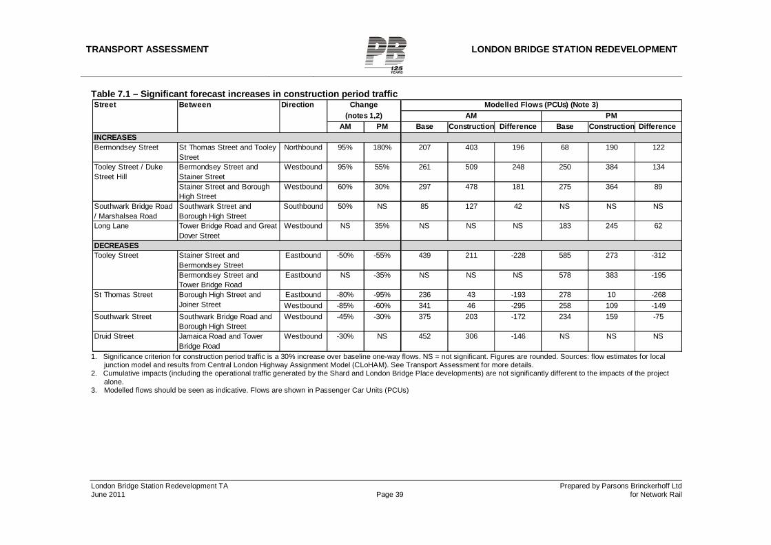
TRANSPORT ASSESSMENT LONDON BRIDGE STATION REDEVELOPMENT
London Bridge Station Redevelopment TA Prepared by Parsons Brinckerhoff Ltd June 2011 Page 39 for Network Rail
Table 7.1 – Significant forecast increases in construction period traffic
1. Significance criterion for construction period traffic is a 30% increase over baseline one-way flows. NS = not significant. Figures are rounded. Sources: flow estimates for local
junction model and results from Central London Highway Assignment Model (CLoHAM). See Transport Assessment for more details. 2. Cumulative impacts (including the operational traffic generated by the Shard and London Bridge Place developments) are not significantly different to the impacts of the project
alone. 3. Modelled flows should be seen as indicative. Flows are shown in Passenger Car Units (PCUs)
AM PMAM PM Base Construction Difference Base Construction Difference
Bermondsey Street St Thomas Street and Tooley Street
Northbound 95% 180% 207 403 196 68 190 122
Bermondsey Street and Stainer Street
Westbound 95% 55% 261 509 248 250 384 134
Stainer Street and Borough High Street
Westbound 60% 30% 297 478 181 275 364 89
Southwark Bridge Road / Marshalsea Road
Southwark Street and Borough High Street
Southbound 50% NS 85 127 42 NS NS NS
Long Lane Tower Bridge Road and Great Dover Street
Westbound NS 35% NS NS NS 183 245 62
Stainer Street and Bermondsey Street
Eastbound -50% -55% 439 211 -228 585 273 -312
Bermondsey Street and Tower Bridge Road
Eastbound NS -35% NS NS NS 578 383 -195
Eastbound -80% -95% 236 43 -193 278 10 -268Westbound -85% -60% 341 46 -295 258 109 -149
Southwark Street Southwark Bridge Road and Borough High Street
Westbound -45% -30% 375 203 -172 234 159 -75
Druid Street Jamaica Road and Tower Bridge Road
Westbound -30% NS 452 306 -146 NS NS NS
Tooley Street / Duke Street Hill
DECREASESTooley Street
St Thomas Street Borough High Street and Joiner Street
Modelled Flows (PCUs) (Note 3)Street Between Direction Change(notes 1,2)
INCREASES
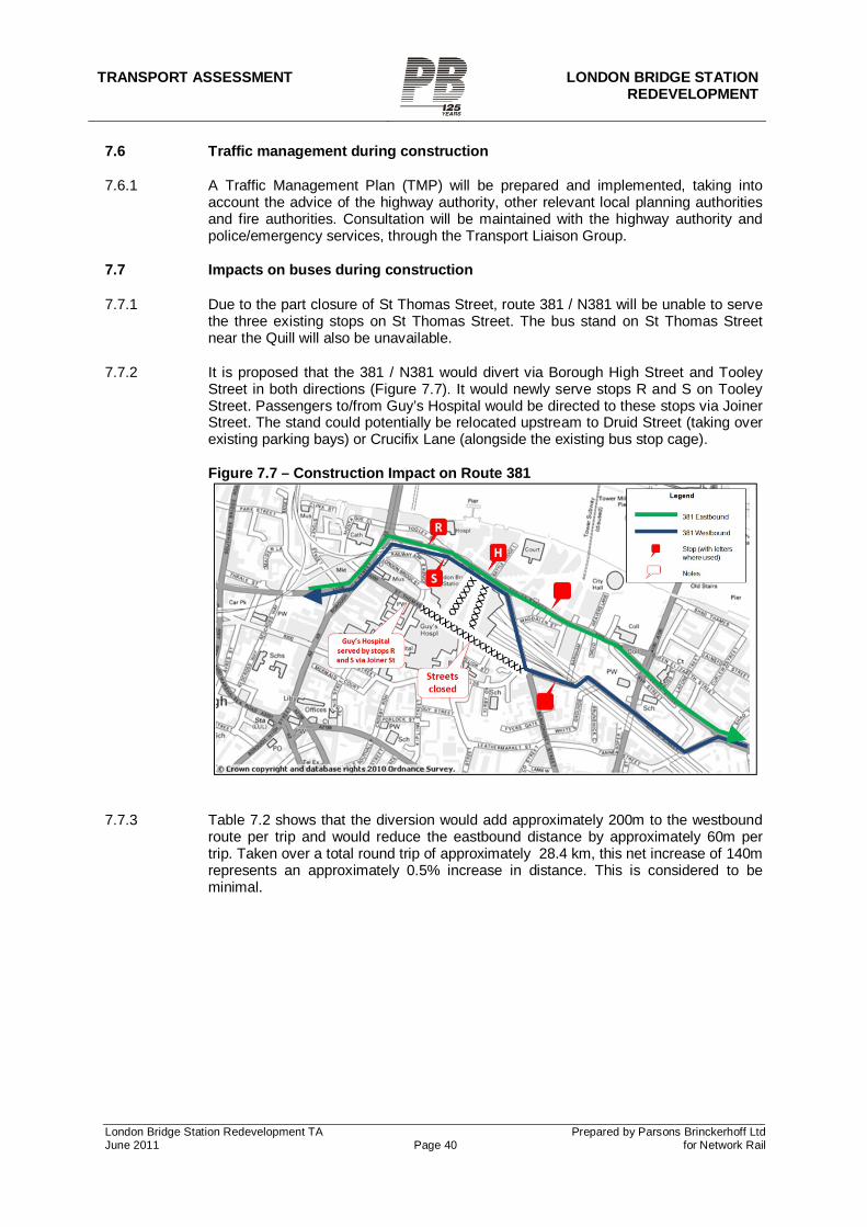
TRANSPORT ASSESSMENT LONDON BRIDGE STATION
REDEVELOPMENT
London Bridge Station Redevelopment TA Prepared by Parsons Brinckerhoff Ltd June 2011 Page 40 for Network Rail
7.6 Traffic management during construction
7.6.1 A Traffic Management Plan (TMP) will be prepared and implemented, taking into account the advice of the highway authority, other relevant local planning authorities and fire authorities. Consultation will be maintained with the highway authority and police/emergency services, through the Transport Liaison Group.
7.7 Impacts on buses during construction
7.7.1 Due to the part closure of St Thomas Street, route 381 / N381 will be unable to serve the three existing stops on St Thomas Street. The bus stand on St Thomas Street near the Quill will also be unavailable.
7.7.2 It is proposed that the 381 / N381 would divert via Borough High Street and Tooley Street in both directions (Figure 7.7). It would newly serve stops R and S on Tooley Street. Passengers to/from Guy’s Hospital would be directed to these stops via Joiner Street. The stand could potentially be relocated upstream to Druid Street (taking over existing parking bays) or Crucifix Lane (alongside the existing bus stop cage).
Figure 7.7 – Construction Impact on Route 381
7.7.3 Table 7.2 shows that the diversion would add approximately 200m to the westbound route per trip and would reduce the eastbound distance by approximately 60m per trip. Taken over a total round trip of approximately 28.4 km, this net increase of 140m represents an approximately 0.5% increase in distance. This is considered to be minimal.
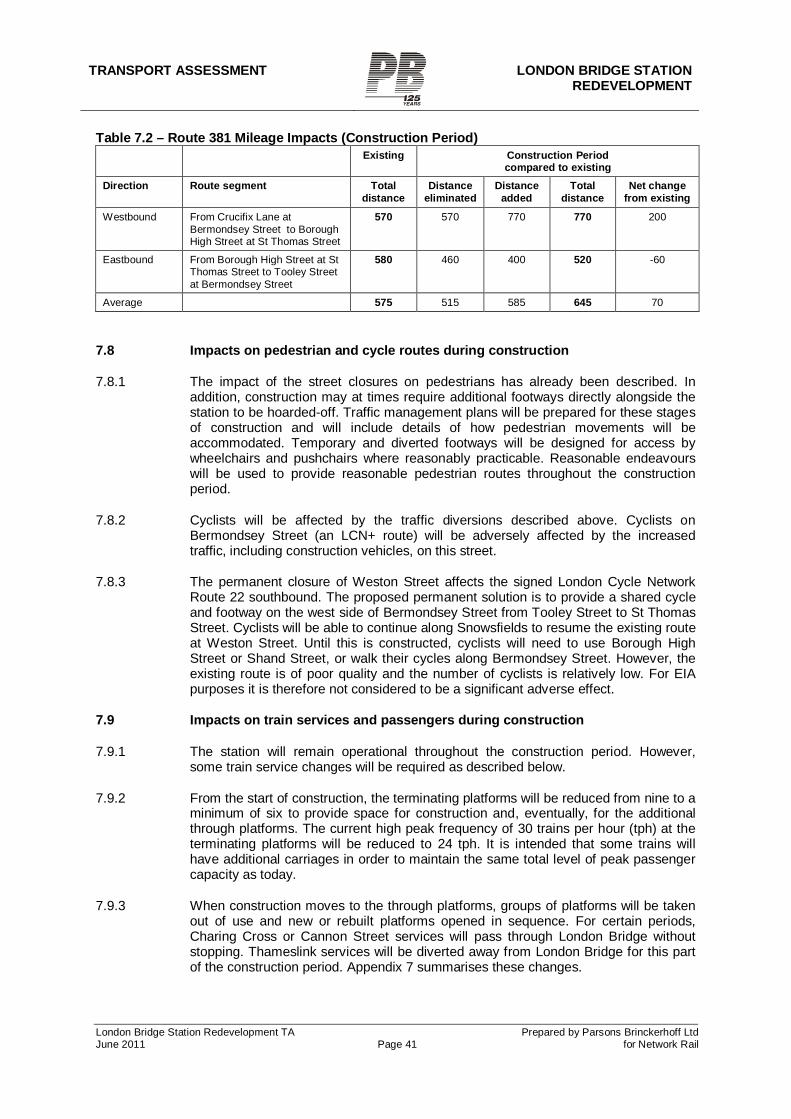
TRANSPORT ASSESSMENT LONDON BRIDGE STATION REDEVELOPMENT
London Bridge Station Redevelopment TA Prepared by Parsons Brinckerhoff Ltd June 2011 Page 41 for Network Rail
Table 7.2 – Route 381 Mileage Impacts (Construction Period) Existing Construction Period
compared to existing Direction Route segment Total
distance Distance
eliminated Distance
added Total
distance Net change
from existing
Westbound From Crucifix Lane at Bermondsey Street to Borough High Street at St Thomas Street
570 570 770 770 200
Eastbound From Borough High Street at St Thomas Street to Tooley Street at Bermondsey Street
580 460 400 520 -60
Average 575 515 585 645 70
7.8 Impacts on pedestrian and cycle routes during construction
7.8.1 The impact of the street closures on pedestrians has already been described. In addition, construction may at times require additional footways directly alongside the station to be hoarded-off. Traffic management plans will be prepared for these stages of construction and will include details of how pedestrian movements will be accommodated. Temporary and diverted footways will be designed for access by wheelchairs and pushchairs where reasonably practicable. Reasonable endeavours will be used to provide reasonable pedestrian routes throughout the construction period.
7.8.2 Cyclists will be affected by the traffic diversions described above. Cyclists on Bermondsey Street (an LCN+ route) will be adversely affected by the increased traffic, including construction vehicles, on this street.
7.8.3 The permanent closure of Weston Street affects the signed London Cycle Network Route 22 southbound. The proposed permanent solution is to provide a shared cycle and footway on the west side of Bermondsey Street from Tooley Street to St Thomas Street. Cyclists will be able to continue along Snowsfields to resume the existing route at Weston Street. Until this is constructed, cyclists will need to use Borough High Street or Shand Street, or walk their cycles along Bermondsey Street. However, the existing route is of poor quality and the number of cyclists is relatively low. For EIA purposes it is therefore not considered to be a significant adverse effect.
7.9 Impacts on train services and passengers during construction
7.9.1 The station will remain operational throughout the construction period. However, some train service changes will be required as described below.
7.9.2 From the start of construction, the terminating platforms will be reduced from nine to a minimum of six to provide space for construction and, eventually, for the additional through platforms. The current high peak frequency of 30 trains per hour (tph) at the terminating platforms will be reduced to 24 tph. It is intended that some trains will have additional carriages in order to maintain the same total level of peak passenger capacity as today.
7.9.3 When construction moves to the through platforms, groups of platforms will be taken out of use and new or rebuilt platforms opened in sequence. For certain periods, Charing Cross or Cannon Street services will pass through London Bridge without stopping. Thameslink services will be diverted away from London Bridge for this part of the construction period. Appendix 7 summarises these changes.
TRANSPORT ASSESSMENT LONDON BRIDGE STATION
REDEVELOPMENT
London Bridge Station Redevelopment TA Prepared by Parsons Brinckerhoff Ltd June 2011 Page 42 for Network Rail
7.9.4 Passenger access will be maintained to/from operational platforms and facilities but with changes to routes as required at each stage of construction. Access for mobility-impaired passengers (MIPs) will be maintained between all platforms in use and the main concourse. Access from the concourse to the forecourt will be maintained at all times when the station is in use.
TRANSPORT ASSESSMENT LONDON BRIDGE STATION REDEVELOPMENT
London Bridge Station Redevelopment TA Prepared by Parsons Brinckerhoff Ltd June 2011 Page 43 for Network Rail
8 PERMANENT IMPACTS
8.1 Overview
8.1.1 The key changes in the permanent situation will be:
The final track and platform configuration (under existing TWA powers) is in place.
The new permanent train service pattern begins. The new north-south station concourse opens. Stainer Street and Weston Street (north of St Thomas Street) remain closed
permanently. St Thomas Street re-opens, with a new configuration to accommodate the closure
of Stainer Street. Streetscape works on Tooley Street, Bermondsey Street and St Thomas Street,
associated with the new concourse entrances and retail space, are complete. Consequential highway changes to accommodate the Stainer Street closure are
in place. Depending on experience during the construction period, these changes may be confined to St Thomas Street or may include alterations to traffic patterns and highway layouts on Crucifix Lane, Druid Street, Tooley Street, Tanner Street and Tower Bridge Road.
8.2 Diverted trips
8.2.1 The permanent closure of Stainer St and Weston St will require existing vehicular trips to divert to alternative routes.
Weston Street
8.2.2 Existing traffic flows on the closed section of Weston Street are low and existing streets already provide alternatives. In addition, St Thomas Street will be re-opened with two-way traffic between the former Stainer Street and Weston Street. This will allow traffic to reach the southern part of Weston Street via St Thomas Street. Figure 8.1 shows how traffic is forecast to divert, for the purposes of traffic modelling.
8.2.3 The two-way section of St Thomas Street will be extended as far east as Weston Street at a minimum. This is to allow southbound traffic to reach the remaining part of Weston Street. It will also serve to provide an eastbound ‘exit’ from the western part of St Thomas Street (including, for example, the Shard drop-off) back to the wider network without requiring U-turns. As described below, additional consequential highway changes may be required that would affect the traffic pattern on St Thomas Street east of Weston Street.
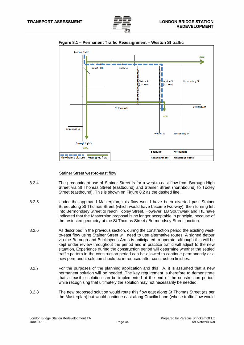
TRANSPORT ASSESSMENT LONDON BRIDGE STATION
REDEVELOPMENT
London Bridge Station Redevelopment TA Prepared by Parsons Brinckerhoff Ltd June 2011 Page 44 for Network Rail
Figure 8.1 – Permanent Traffic Reassignment – Weston St traffic
Stainer Street west-to-east flow
8.2.4 The predominant use of Stainer Street is for a west-to-east flow from Borough High Street via St Thomas Street (eastbound) and Stainer Street (northbound) to Tooley Street (eastbound). This is shown on Figure 8.2 as the dashed line.
8.2.5 Under the approved Masterplan, this flow would have been diverted past Stainer Street along St Thomas Street (which would have become two-way), then turning left into Bermondsey Street to reach Tooley Street. However, LB Southwark and TfL have indicated that the Masterplan proposal is no longer acceptable in principle, because of the restricted geometry at the St Thomas Street / Bermondsey Street junction.
8.2.6 As described in the previous section, during the construction period the existing west-to-east flow using Stainer Street will need to use alternative routes. A signed detour via the Borough and Bricklayer’s Arms is anticipated to operate, although this will be kept under review throughout the period and in practice traffic will adjust to the new situation. Experience during the construction period will determine whether the settled traffic pattern in the construction period can be allowed to continue permanently or a new permanent solution should be introduced after construction finishes.
8.2.7 For the purposes of the planning application and this TA, it is assumed that a new permanent solution will be needed. The key requirement is therefore to demonstrate that a feasible solution can be implemented at the end of the construction period, while recognising that ultimately the solution may not necessarily be needed.
8.2.8 The new proposed solution would route this flow east along St Thomas Street (as per the Masterplan) but would continue east along Crucifix Lane (whose traffic flow would
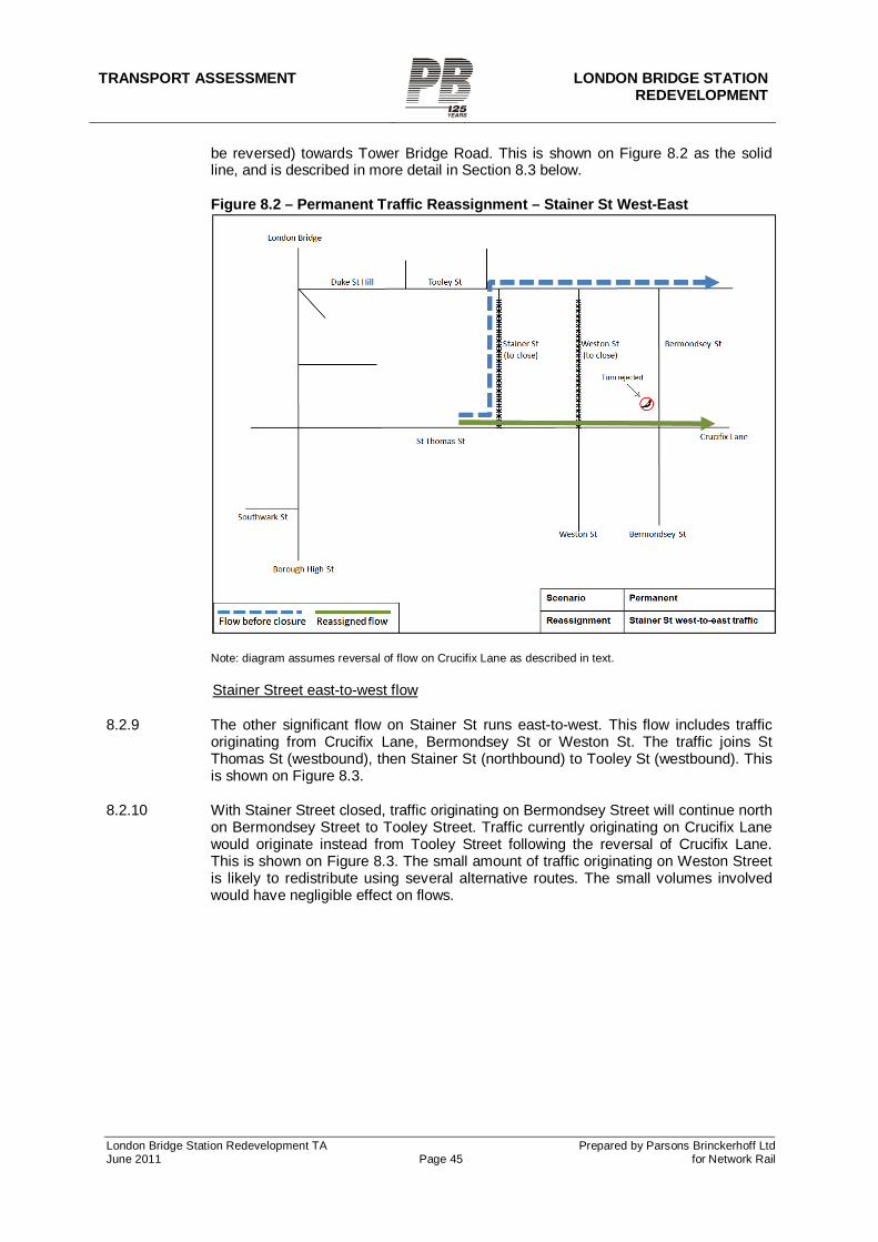
TRANSPORT ASSESSMENT LONDON BRIDGE STATION REDEVELOPMENT
London Bridge Station Redevelopment TA Prepared by Parsons Brinckerhoff Ltd June 2011 Page 45 for Network Rail
be reversed) towards Tower Bridge Road. This is shown on Figure 8.2 as the solid line, and is described in more detail in Section 8.3 below.
Figure 8.2 – Permanent Traffic Reassignment – Stainer St West-East
Note: diagram assumes reversal of flow on Crucifix Lane as described in text. Stainer Street east-to-west flow
8.2.9 The other significant flow on Stainer St runs east-to-west. This flow includes traffic originating from Crucifix Lane, Bermondsey St or Weston St. The traffic joins St Thomas St (westbound), then Stainer St (northbound) to Tooley St (westbound). This is shown on Figure 8.3.
8.2.10 With Stainer Street closed, traffic originating on Bermondsey Street will continue north on Bermondsey Street to Tooley Street. Traffic currently originating on Crucifix Lane would originate instead from Tooley Street following the reversal of Crucifix Lane. This is shown on Figure 8.3. The small amount of traffic originating on Weston Street is likely to redistribute using several alternative routes. The small volumes involved would have negligible effect on flows.
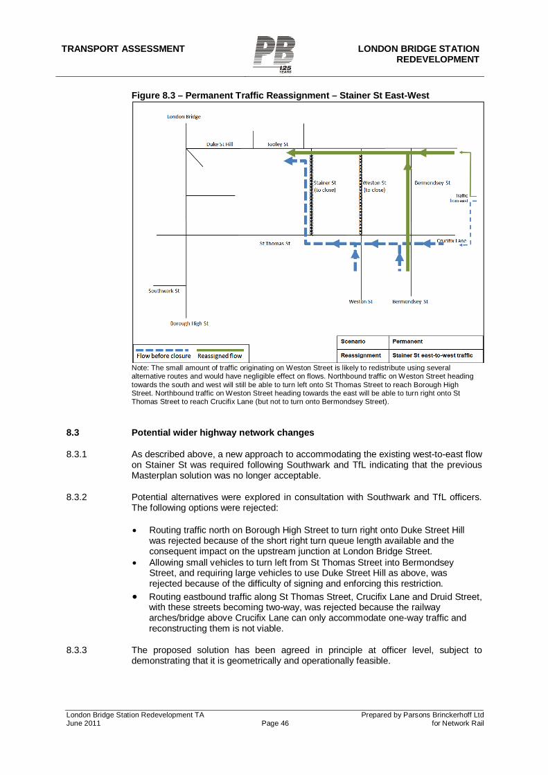
TRANSPORT ASSESSMENT LONDON BRIDGE STATION
REDEVELOPMENT
London Bridge Station Redevelopment TA Prepared by Parsons Brinckerhoff Ltd June 2011 Page 46 for Network Rail
Figure 8.3 – Permanent Traffic Reassignment – Stainer St East-West
Note: The small amount of traffic originating on Weston Street is likely to redistribute using several alternative routes and would have negligible effect on flows. Northbound traffic on Weston Street heading towards the south and west will still be able to turn left onto St Thomas Street to reach Borough High Street. Northbound traffic on Weston Street heading towards the east will be able to turn right onto St Thomas Street to reach Crucifix Lane (but not to turn onto Bermondsey Street).
8.3 Potential wider highway network changes
8.3.1 As described above, a new approach to accommodating the existing west-to-east flow on Stainer St was required following Southwark and TfL indicating that the previous Masterplan solution was no longer acceptable.
8.3.2 Potential alternatives were explored in consultation with Southwark and TfL officers. The following options were rejected:
Routing traffic north on Borough High Street to turn right onto Duke Street Hill was rejected because of the short right turn queue length available and the consequent impact on the upstream junction at London Bridge Street.
Allowing small vehicles to turn left from St Thomas Street into Bermondsey Street, and requiring large vehicles to use Duke Street Hill as above, was rejected because of the difficulty of signing and enforcing this restriction.
Routing eastbound traffic along St Thomas Street, Crucifix Lane and Druid Street, with these streets becoming two-way, was rejected because the railway arches/bridge above Crucifix Lane can only accommodate one-way traffic and reconstructing them is not viable.
8.3.3 The proposed solution has been agreed in principle at officer level, subject to demonstrating that it is geometrically and operationally feasible.
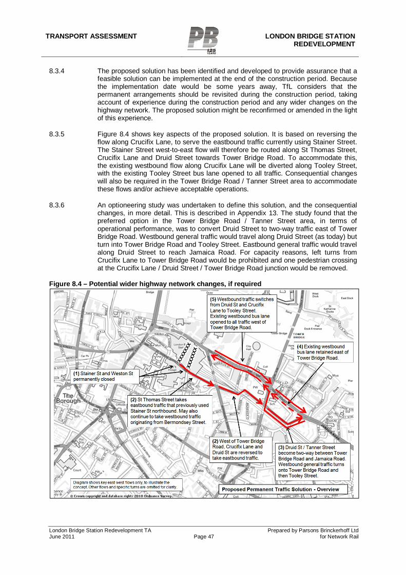
TRANSPORT ASSESSMENT LONDON BRIDGE STATION REDEVELOPMENT
London Bridge Station Redevelopment TA Prepared by Parsons Brinckerhoff Ltd June 2011 Page 47 for Network Rail
8.3.4 The proposed solution has been identified and developed to provide assurance that a feasible solution can be implemented at the end of the construction period. Because the implementation date would be some years away, TfL considers that the permanent arrangements should be revisited during the construction period, taking account of experience during the construction period and any wider changes on the highway network. The proposed solution might be reconfirmed or amended in the light of this experience.
8.3.5 Figure 8.4 shows key aspects of the proposed solution. It is based on reversing the flow along Crucifix Lane, to serve the eastbound traffic currently using Stainer Street. The Stainer Street west-to-east flow will therefore be routed along St Thomas Street, Crucifix Lane and Druid Street towards Tower Bridge Road. To accommodate this, the existing westbound flow along Crucifix Lane will be diverted along Tooley Street, with the existing Tooley Street bus lane opened to all traffic. Consequential changes will also be required in the Tower Bridge Road / Tanner Street area to accommodate these flows and/or achieve acceptable operations.
8.3.6 An optioneering study was undertaken to define this solution, and the consequential changes, in more detail. This is described in Appendix 13. The study found that the preferred option in the Tower Bridge Road / Tanner Street area, in terms of operational performance, was to convert Druid Street to two-way traffic east of Tower Bridge Road. Westbound general traffic would travel along Druid Street (as today) but turn into Tower Bridge Road and Tooley Street. Eastbound general traffic would travel along Druid Street to reach Jamaica Road. For capacity reasons, left turns from Crucifix Lane to Tower Bridge Road would be prohibited and one pedestrian crossing at the Crucifix Lane / Druid Street / Tower Bridge Road junction would be removed.
Figure 8.4 – Potential wider highway network changes, if required
TRANSPORT ASSESSMENT LONDON BRIDGE STATION
REDEVELOPMENT
London Bridge Station Redevelopment TA Prepared by Parsons Brinckerhoff Ltd June 2011 Page 48 for Network Rail
8.4 Operational impacts
TRANSYT modelling
8.4.1 The Future Year Modelling report (Appendix 12) provides peak period traffic diagrams for the main study area, and describes the operational impacts in that area. The TRANSYT modelling indicates that the network around London Bridge station will continue to operate effectively. The highest Degree of Saturation on any approach is 94%. At the Borough High Street / Duke Street Hill junction, the queue lengths increase but remain within 94% saturation.
8.4.2 The Highways Optioneering Modelling report (Appendix 13) describes the operational impacts in the Tower Bridge Road area, should the proposed traffic solution be implemented. The TRANSYT modelling indicates that the network will continue to operate effectively with a highest Degree of Saturation on any approach of 90%.
Strategic modelling
8.4.3 The Strategic Traffic Modelling Report (Appendix 14) describes the results of the proposed solution as modelled in the CLoHAM strategic assignment model. Compared to the pre-Shard baseline, the results indicate increases in traffic flows on Bermondsey Street both north and south of Crucifix Lane (which may in part reflect the model’s zone structure and coding). The results also indicate increases on Long Lane eastbound and Abbey Street westbound.
Traffic volumes
8.4.4 As with the construction period, because the two sets of modelling are based on different datasets, and because the strategic model additionally reassigns traffic in response to congestion, the two sets of modelling will not necessarily show the same results where they overlap. Appendix 14 therefore also includes a comparison of the two sets of modelling results for key locations. In these locations the most reasonable estimate has been used for EIA purposes.
8.4.5 For EIA purposes, Table 8.1 lists the roads where significant increases or decreases in traffic are forecast. It also lists the modelled flows for the roads concerned.
8.4.6 The model results have shown how traffic is likely to adjust in response to the closures and diversion routes. The routes taken and volume changes on links, as indicated by the model, appear realistic and logical (although, as noted above, the forecast increase on Bermondsey Street may in part reflect the model’s zone structure and coding). This includes the model showing that there will be additional traffic on alternative routes further from the station, including Southwark Bridge Road, Marshalsea Road, Long Lane and Abbey Street. At a local level the changes will create some notable traffic increases on some streets and decreases on others. As with the construction period, the model indicates that the network as a whole in this area can accommodate the changes.
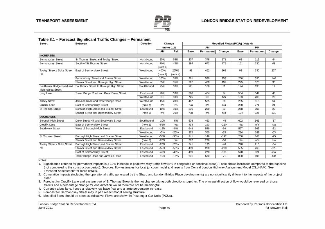
TRANSPORT ASSESSMENT LONDON BRIDGE STATION REDEVELOPMENT
London Bridge Station Redevelopment TA Prepared by Parsons Brinckerhoff Ltd June 2011 Page 49 for Network Rail
Table 8.1 – Forecast Significant Traffic Changes – Permanent
Notes: 1. Significance criterion for permanent impacts is a 10% increase in peak two-way traffic flow (5% in congested or sensitive areas). Table shows increases compared to the baseline
(not compared to the construction period). Sources: flow estimates for local junction model and results from Central London Highway Assignment Model (CLoHAM). See Transport Assessment for more details.
2. Cumulative impacts (including the operational traffic generated by the Shard and London Bridge Place developments) are not significantly different to the impacts of the project alone.
3. Forecast for Crucifix Lane and eastern part of St Thomas Street is the net change taking both directions together. The principal direction of flow would be reversed on those streets and a percentage change for one direction would therefore not be meaningful.
4. Currently a bus lane, hence a relatively low base flow and a large percentage increase. 5. Forecast for Bermondsey Street may in part reflect model zoning structure. 6. Modelled flows should be seen as indicative. Flows are shown in Passenger Car Units (PCUs).
AM PMAM PM Base Permanent Change Base Permanent Change
Bermondsey Street St Thomas Street and Tooley Street Northbound 85% 65% 207 378 171 68 112 44Bermondsey Street South of St Thomas Street Northbound 70%
(Note 5)45% 394 672 278 161 230 69
400% 255% 93 462 369 93 330 237(note 4) (note 4)
Bermondsey Street and Stainer Street Westbound 100% 55% 261 520 259 250 390 140Stainer Street and Borough High Street Westbound 65% 35% 297 489 192 275 370 95
Southwark Bridge Road and Marshalsea Street
Southwark Street to Borough High Street Southbound 25% 10% 85 106 21 124 138 14
Eastbound 20% 10% 390 464 74 504 544 40Westbound NS 10% NS NS NS 183 203 20
Abbey Street Jamaica Road and Tower Bridge Road Westbound 15% 20% 467 535 68 265 319 54Crucifix Lane East of Bermondsey Street (note 4) n/a 8% n/a n/a n/a 250 271 21
Borough High Street and Stainer Street Eastbound 10% 10% 236 259 23 278 305 27Stainer Street and Bermondsey Street (note 3) n/a 70% n/a n/a n/a 194 325 131
Borough High Street Duke Street Hill and Southwark Street Southbound -10% -5% 508 463 -45 602 565 -37Crucifix Lane East of Bermondsey Street (note 3) -55% n/a 413 193 -220 n/a n/a n/a
Eastbound -15% -5% 648 549 -99 597 565 -32Westbound -5% -25% 375 350 -25 234 181 -53
Borough High Street and Stainer Street Westbound -55% -35% 341 149 -192 258 163 -95Stainer Street and Bermondsey Street (note 3) -20% n/a 362 296 -66 n/a n/a n/aBorough High Street and Stainer Street Eastbound -20% -20% 241 195 -46 270 216 -54Stainer Street and Bermondsey Street Eastbound -55% -55% 439 200 -239 585 260 -325East of Bermondsey Street Eastbound -40% -45% 459 278 -181 578 321 -257Tower Bridge Road and Jamaica Road Eastbound -10% -15% 601 530 -71 830 696 -134
DECREASES
Southwark Street West of Borough High Street
St Thomas Street
Tooley Street / Duke Street Hill
Modelled Flows (PCUs) (Note 6)
Tooley Street / Duke Street Hill
East of Bermondsey Street Westbound
Long Lane Tower Bridge Road and Great Dover Street
St Thomas Street
Street Between Direction Change(notes 1,2)
INCREASES
TRANSPORT ASSESSMENT LONDON BRIDGE STATION
REDEVELOPMENT
London Bridge Station Redevelopment TA Prepared by Parsons Brinckerhoff Ltd June 2011 Page 50 for Network Rail
Impact on accident rates
8.4.7 The section of St Thomas Street between Stainer Street and Bermondsey Street has had more than ten accidents in a three-year period. For EIA purposes, the combination of this accident record and the forecast increase in traffic would initially suggest a significant impact on safety – particularly given the proposed new concourse entrance at this location.
8.4.8 The historic accidents on this section are mainly in a cluster at the junction of St Thomas Street and Weston Street, with some at the junction of St Thomas Street and Stainer Street. At Weston Street they are predominantly right-angle collisions, often involving vehicles emerging from Weston Street (in either direction) not giving way adequately.
8.4.9 The project involves a major reconfiguration of the vehicle movements and overall character of this section of St Thomas Street. The Stainer Street junction will be closed and the Weston Street junction will change to a T-junction. New controlled pedestrian crossing points will be provided and the new road layout presents an opportunity to incorporate modern design standards as far as possible. It is therefore not considered reasonable to use the historic accident record as a predictor of future safety in this location. Accordingly, for EIA purposes a significant impact is not anticipated.
Impact on Snowsfields and other local streets
8.4.10 It is proposed to allow northbound traffic on Bermondsey Street to continue to turn into St Thomas Street and travel westbound. This would maintain existing movements from the southern part of Bermondsey Street, which in turn would also help to reduce the pressure on Tooley Street. This is unlikely to lead to significant rat-running traffic from the east using this movement to avoid Tooley Street, because traffic from the east heading north of the river cannot turn right from St Thomas Street onto Borough High Street. Furthermore, traffic from the east heading west towards Southwark Street would have to negotiate an extended route and make several turns to reach the Bermondsey Street approach. For example, affected traffic will negotiate the full length of Abbey Street, or via Abbey Street, Druid Street and Tanner Street.
8.4.11 It is proposed that traffic should still be able to enter Snowsfields from Bermondsey Street (via a very short length of St Thomas Street). This movement is unlikely to become a rat-run in lieu of Tooley Street for westbound traffic, because it would require traffic to travel a long route to reach the Bermondsey Street approach as described in the previous paragraph.
8.4.12 The existing movement from Crucifix Lane into Snowsfields (via a very short length of St Thomas Street) would no longer be available. This movement currently has low traffic volumes and is likely to serve local destinations such as Guy’s Hospital. This local traffic could still reach Snowsfields but from Bermondsey Street or Weston Street instead.
TRANSPORT ASSESSMENT LONDON BRIDGE STATION REDEVELOPMENT
London Bridge Station Redevelopment TA Prepared by Parsons Brinckerhoff Ltd June 2011 Page 51 for Network Rail
8.5 Parking
8.5.1 The project is not anticipated to have an impact on parking demand or parking supply (other than the reduction in the station’s own operational parking supply as described above). Few, if any, passengers arrive by car and this is unlikely to change in the future.
8.6 Public transport impacts – overview
8.6.1 The Project will, by its nature, generate benefit across the wider public transport network by unlocking the full Thameslink Programme service of up to 24 train paths per hour. This will provide additional capacity and journey opportunities.
8.6.2 The project itself is not a demand generator and will therefore not generate additional public transport trips in its own right. However, the project is designed to accommodate the forecast increase in Thameslink project rail services and passenger numbers, and from background growth in rail passenger numbers. For this reason, and because the project represents part of London’s transport system rather than a private development, it is not considered appropriate for the project to be required to ‘mitigate’ the forecast increase in passenger numbers by providing for additional station or vehicle capacity on the bus or Underground networks.
8.7 Impact on rail passengers – across the rail network
8.7.1 The need for the station redevelopment, and the benefits it brings to rail passengers, are set out in detail in the Planning Statement and summarised below.
8.7.2 The Thameslink Programme requires changes in platform and track configuration at London Bridge, increasing the number of through platforms and reducing the number of terminating platforms. Without these operational changes, around 80% of the benefits of the Thameslink Programme (listed below) cannot be delivered. This operational work is one of the last parts of the Thameslink Programme work to be completed. The operational work at London Bridge requires a new station, as the existing station will not physically be able to operate after the platform and track alterations have been implemented.
8.7.3 The Thameslink programme will provide major benefits to rail passengers:
removing bottlenecks, the worst of which are at London Bridge Station.
increasing trains through central London by up to 300%, with up to 24 train paths per hour at peak times. Of these, up to 18 paths will be through London Bridge, compared to the one path through London Bridge available today (Figure 8.5).
increasing capacity with longer, 12-car, trains.
providing direct access between more origins and destinations (Figure 8.6).
reducing crowding on London Underground.
8.7.4 There will accordingly be widespread benefits to rail passengers in London and across south-east England.
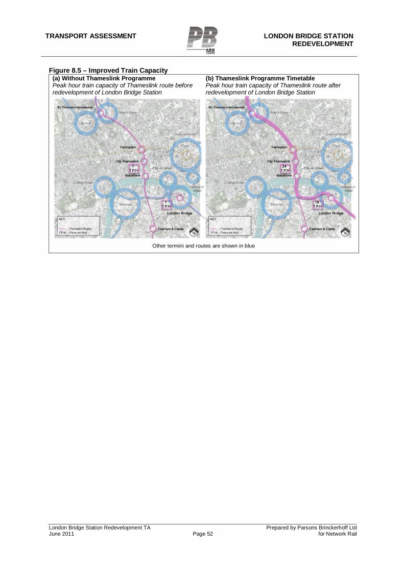
TRANSPORT ASSESSMENT LONDON BRIDGE STATION
REDEVELOPMENT
London Bridge Station Redevelopment TA Prepared by Parsons Brinckerhoff Ltd June 2011 Page 52 for Network Rail
Figure 8.5 – Improved Train Capacity (a) Without Thameslink Programme Peak hour train capacity of Thameslink route before redevelopment of London Bridge Station
(b) Thameslink Programme Timetable Peak hour train capacity of Thameslink route after redevelopment of London Bridge Station
Other termini and routes are shown in blue
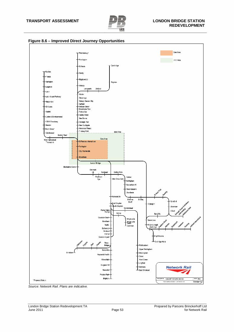
TRANSPORT ASSESSMENT LONDON BRIDGE STATION REDEVELOPMENT
London Bridge Station Redevelopment TA Prepared by Parsons Brinckerhoff Ltd June 2011 Page 53 for Network Rail
Figure 8.6 – Improved Direct Journey Opportunities
Source: Network Rail. Plans are indicative.
TRANSPORT ASSESSMENT LONDON BRIDGE STATION
REDEVELOPMENT
London Bridge Station Redevelopment TA Prepared by Parsons Brinckerhoff Ltd June 2011 Page 54 for Network Rail
8.8 Impact on rail passengers at London Bridge
8.8.1 Passengers at London Bridge will find the station much easier to access and much more convenient to use, with new street level entrances on Tooley Street and St Thomas Street, a unified concourse, and more intuitive routes through the station. Crowding will be reduced and the station will be more resilient to service disruption. Wayfinding will be assisted by both the ‘legible’ station layout and signage to/from nearby key destinations as part of the overall station signage.
8.8.2 Passengers at London Bridge will also benefit greatly from the improved train capacity and journey opportunities which the Thameslink Programme provides. In particular, there will be up to 18 Thameslink paths per hour at peak times through London Bridge, compared to the one path available today (Figure 8.5). In addition to the capacity benefits, these paths will allow direct trains to/from a wide range of new locations north of London (Figure 8.6).
8.9 Pedestrian flows in the station complex
8.9.1 Network Rail has undertaken pedestrian modelling of the station design. This is shown in Appendix 9. Overall, the design performs well with performance largely meeting Network Rail’s guidelines at 2016+35%, and fully meeting the guidelines at 2016+20%. The design also has sufficient resilience to effectively accommodate degraded operations (facilities unavailable) or perturbations (train service disruptions). Forecast passenger journey times through the station compare favourably with those forecast for the Masterplan design; this confirms the lack of congestion problems as well as the straightforward layout of the new station (which is one of the key design goals).
8.9.2 The modelling forecasts congestion in the LUL ticket hall and Joiner Street. It is important to recognise that the limiting factor for passengers to and from the Underground is primarily the Jubilee Line escalator arrangements. This would need to be expanded to accommodate future passenger growth, regardless of the Thameslink programme or the station redevelopment.
8.10 Bus network
Impact on route 381/N381
8.10.1 Route 381/N381 will be affected by the permanent closure of Stainer Street and by the wider highway changes. It will not be possible for this route to serve St Thomas Street in both directions, because a left turn from St Thomas Street into Bermondsey Street will not be possible and Crucifix Lane will only accommodate one direction of traffic.
8.10.2 If the proposed traffic solution goes ahead, eastbound buses could serve either St Thomas Street or Tooley Street but westbound buses could only serve Tooley Street. If the proposed traffic solution does not go ahead, and St Thomas Street re-opens with westbound traffic, eastbound buses could only serve Tooley Street but westbound buses could serve either St Thomas Street or Tooley Street.
8.10.3 It is therefore only possible to serve St Thomas Street in one direction, whether or not the proposed highway changes are implemented. Current bus network planning practice is to route buses along the same street in both directions wherever possible, as this is seen as more passenger-friendly. It is therefore assumed that the route would serve Tooley Street in both directions.
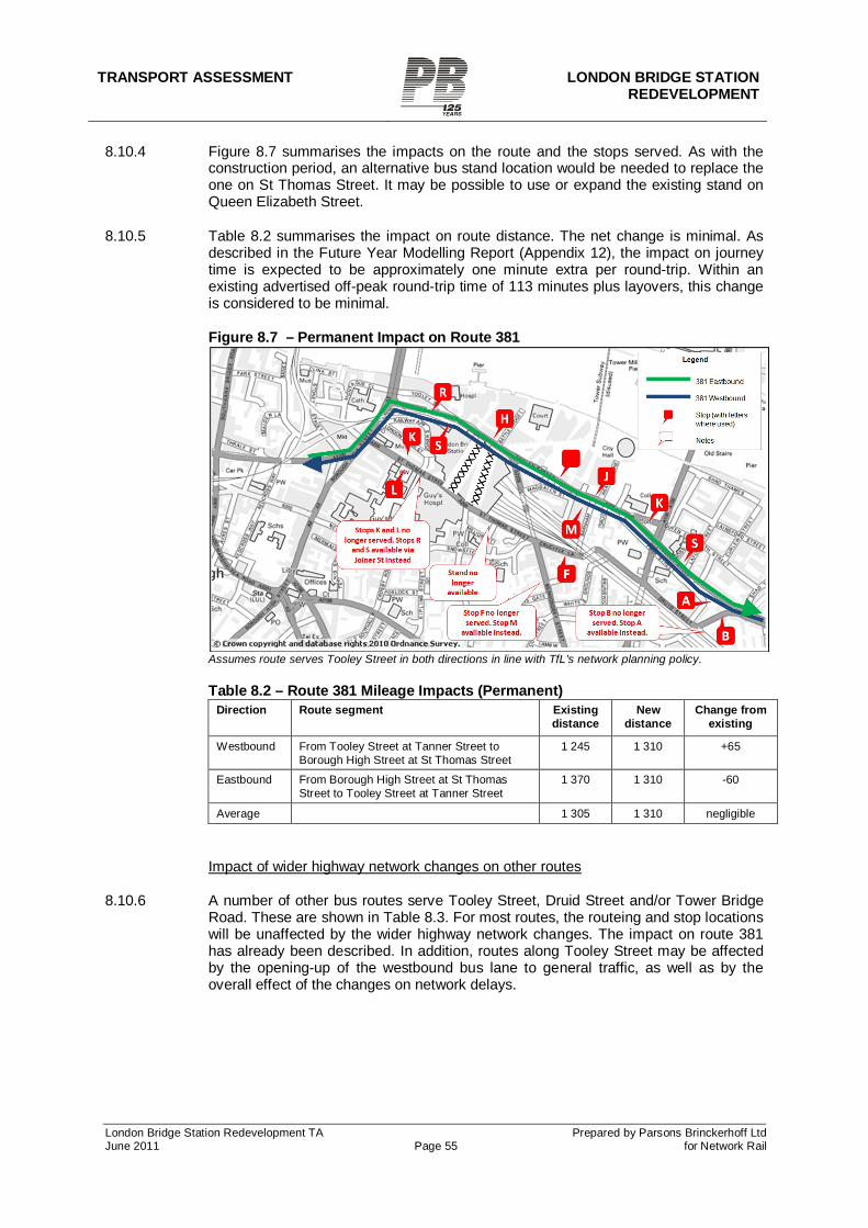
TRANSPORT ASSESSMENT LONDON BRIDGE STATION REDEVELOPMENT
London Bridge Station Redevelopment TA Prepared by Parsons Brinckerhoff Ltd June 2011 Page 55 for Network Rail
8.10.4 Figure 8.7 summarises the impacts on the route and the stops served. As with the construction period, an alternative bus stand location would be needed to replace the one on St Thomas Street. It may be possible to use or expand the existing stand on Queen Elizabeth Street.
8.10.5 Table 8.2 summarises the impact on route distance. The net change is minimal. As described in the Future Year Modelling Report (Appendix 12), the impact on journey time is expected to be approximately one minute extra per round-trip. Within an existing advertised off-peak round-trip time of 113 minutes plus layovers, this change is considered to be minimal.
Figure 8.7 – Permanent Impact on Route 381
Assumes route serves Tooley Street in both directions in line with TfL’s network planning policy. Table 8.2 – Route 381 Mileage Impacts (Permanent)
Direction Route segment Existing distance
New distance
Change from existing
Westbound From Tooley Street at Tanner Street to Borough High Street at St Thomas Street
1 245 1 310 +65
Eastbound From Borough High Street at St Thomas Street to Tooley Street at Tanner Street
1 370 1 310 -60
Average 1 305 1 310 negligible
Impact of wider highway network changes on other routes
8.10.6 A number of other bus routes serve Tooley Street, Druid Street and/or Tower Bridge Road. These are shown in Table 8.3. For most routes, the routeing and stop locations will be unaffected by the wider highway network changes. The impact on route 381 has already been described. In addition, routes along Tooley Street may be affected by the opening-up of the westbound bus lane to general traffic, as well as by the overall effect of the changes on network delays.
TRANSPORT ASSESSMENT LONDON BRIDGE STATION
REDEVELOPMENT
London Bridge Station Redevelopment TA Prepared by Parsons Brinckerhoff Ltd June 2011 Page 56 for Network Rail
Table 8.3 – Impact of wider highway changes on other routes Route Streets used Potential impact 42 Liverpool Street - Denmark Hill
Tower Bridge Road No routing /stop impact
47 Catford – Shoreditch (also N47 similar)
Tooley Street No routing impact. May be marginally affected by opening of westbound bus lane to all traffic
78 Nunhead - Shoreditch
Tower Bridge Road No routing /stop impact
188 North Greenwich to Russell Square
Tower Bridge Road, Druid Street (westbound), Tooley Street (eastbound)
No routing /stop impact
343 New Cross Gate – City Hall
Tooley Street, Tower Bridge Road, Queen Elizabeth Street
No routing /stop impact
381 County Hall – Peckham (also N381 similar)
Tooley Street, Druid Street See separate text
RV1 Covent Garden – Tower Gateway
Tooley Street, Tower Bridge Road
No routing /stop impact
8.11 Walking
Improvements for pedestrians
8.11.1 The new north-south concourse will greatly improve pedestrian connections between the areas north and south of the station. The existing unattractive routes under the station arches will be replaced by a new ‘unpaid’ route alongside the station concourse, following the line of Stainer Street. This route will be open to pedestrians even at times when the station concourse itself is closed.
8.11.2 Pedestrians will also benefit from the new public realm area, streetscape enhancements and improved pedestrian crossing facilities to be provided on sections of Tooley Street, Bermondsey Street and St Thomas Street. In particular:
A controlled crossing will be provided on Tooley Street outside the northern concourse entrance (west side of the concourse) and Hay’s Galleria, replacing the current crossing that forms part of the signalised junction with Stainer Street.
The south side of Tooley Street outside the northern concourse entrance, including the area currently occupied by 84 Tooley Street, will become a public realm area.
A new controlled crossing will be provided on Tooley Street outside the northern concourse entrance (east side of the concourse) and More London. This additional crossing is justified in this location because of the expected heavy pedestrian flows along this desire line towards More London and City Hall. The crossing would serve this pedestrian flow, as well as maintaining traffic flow during ‘red man’ periods.
The public realm area will extend past the Shipwright’s Arms into Bermondsey Street, replacing the existing car park site. Proposed retail units in the station arches will face onto this part of the public realm area.
New controlled crossings will be provided on St Thomas Street outside the southern concourse entrance, where there are currently no controlled facilities.
8.11.3 These changes will greatly improve the walking environment in areas around the station, with benefits for all pedestrians, not only rail passengers. There will be particular benefits to people walking between areas north and south of the station,
TRANSPORT ASSESSMENT LONDON BRIDGE STATION REDEVELOPMENT
London Bridge Station Redevelopment TA Prepared by Parsons Brinckerhoff Ltd June 2011 Page 57 for Network Rail
between the station and More London, or between the station and areas to the south and east.
Pedestrian volumes and capacity
8.11.4 Growth in rail passengers will lead to growth in pedestrian volumes to/from the station, as described in section 6.1. In addition, the reconfigured station layout (particularly the new concourse entrance on Tooley Street) will redistribute pedestrian flows.
8.11.5 Network Rail has undertaken pedestrian flow modelling for the streets in the study area. The report is provided in Appendix 11. The key conclusions of the assessment are:
The congestion issue already identified for the base year, around the Borough High Street / St Thomas Street crossings and the LUL Borough High Street entrance, is worsened. This would be expected to occur with or without the station redevelopment.
Apart from that issue, pedestrian comfort remains within recommended levels. The pedestrian green times used in the traffic modelling are sufficient to meet
pedestrian requirements. The impact of the station redevelopment is therefore considered to be
acceptable.
8.11.6 The narrow ‘waist’ in the central part of the southern footway on Tooley Street had previously been identified as a potential constraint. The pedestrian modelling confirms that performance in this area will remain within acceptable bounds.
8.12 Cycling
Cycling routes
8.12.1 The permanent closure of Weston Street affects the signed London Cycle Network Route 22 southbound. The proposed solution is to provide a shared cycle and footway on the west side of Bermondsey Street from Tooley Street to St Thomas Street. Cyclists will be able to continue along Snowsfields to resume the existing route at Weston Street. For EIA purposes, this is not considered to be a significant impact.
General cycle parking
8.12.2 Network Rail will provide for at least 500 existing or new cycle parking spaces in and around the station, to serve station users (passengers and staff) and the proposed retail space (staff and customers). This figure is considerably greater than the approximately 200 spaces that currently serve the station. It is also considerably greater than the approximately 250 spaces that the TfL cycle parking guidelines would suggest for the NR/LUL station complex after allowing for future passenger growth (Table 8.4). The proposed level of provision therefore allows for not only anticipated passenger growth but also substantial growth in levels of cycling.
8.12.3 Figure 8.8 shows the broad locations proposed for cycle parking. The exact distribution of spaces will need to be balanced with other goals for space within and around the site (such as pedestrian movement), and will be determined at the detailed design stage in consultation with LB of Southwark and TfL.
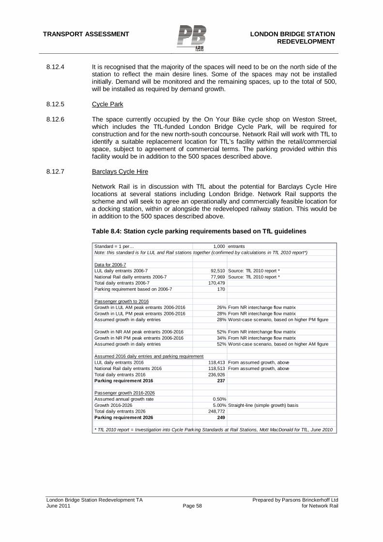
TRANSPORT ASSESSMENT LONDON BRIDGE STATION
REDEVELOPMENT
London Bridge Station Redevelopment TA Prepared by Parsons Brinckerhoff Ltd June 2011 Page 58 for Network Rail
8.12.4 It is recognised that the majority of the spaces will need to be on the north side of the station to reflect the main desire lines. Some of the spaces may not be installed initially. Demand will be monitored and the remaining spaces, up to the total of 500, will be installed as required by demand growth.
8.12.5 Cycle Park
8.12.6 The space currently occupied by the On Your Bike cycle shop on Weston Street, which includes the TfL-funded London Bridge Cycle Park, will be required for construction and for the new north-south concourse. Network Rail will work with TfL to identify a suitable replacement location for TfL’s facility within the retail/commercial space, subject to agreement of commercial terms. The parking provided within this facility would be in addition to the 500 spaces described above.
8.12.7 Barclays Cycle Hire
Network Rail is in discussion with TfL about the potential for Barclays Cycle Hire locations at several stations including London Bridge. Network Rail supports the scheme and will seek to agree an operationally and commercially feasible location for a docking station, within or alongside the redeveloped railway station. This would be in addition to the 500 spaces described above.
Table 8.4: Station cycle parking requirements based on TfL guidelines
Standard = 1 per… 1,000 entrantsNote: this standard is for LUL and Rail stations together (confirmed by calculations in TfL 2010 report*)
Data for 2006-7LUL daily entrants 2006-7 92,510 Source: TfL 2010 report *National Rail dailly entrants 2006-7 77,969 Source: TfL 2010 report *Total daily entrants 2006-7 170,479 Parking requirement based on 2006-7 170
Passenger growth to 2016Growth in LUL AM peak entrants 2006-2016 26% From NR interchange flow matrixGrowth in LUL PM peak entrants 2006-2016 28% From NR interchange flow matrixAssumed growth in daily entries 28% Worst-case scenario, based on higher PM figure
Growth in NR AM peak entrants 2006-2016 52% From NR interchange flow matrixGrowth in NR PM peak entrants 2006-2016 34% From NR interchange flow matrixAssumed growth in daily entries 52% Worst-case scenario, based on higher AM figure
Assumed 2016 daily entries and parking requirementLUL daily entrants 2016 118,413 From assumed growth, aboveNational Rail daily entrants 2016 118,513 From assumed growth, aboveTotal daily entrants 2016 236,926 Parking requirement 2016 237
Passenger growth 2016-2026Assumed annual growth rate 0.50%Growth 2016-2026 5.00% Straight-line (simple growth) basisTotal daily entrants 2026 248,772 Parking requirement 2026 249
* TfL 2010 report = Investigation into Cycle Park ing Standards at Rail Stations, Mott MacDonald for TfL, June 2010
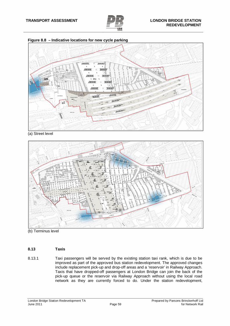
TRANSPORT ASSESSMENT LONDON BRIDGE STATION REDEVELOPMENT
London Bridge Station Redevelopment TA Prepared by Parsons Brinckerhoff Ltd June 2011 Page 59 for Network Rail
Figure 8.8 – Indicative locations for new cycle parking
(a) Street level
(b) Terminus level
8.13 Taxis
8.13.1 Taxi passengers will be served by the existing station taxi rank, which is due to be improved as part of the approved bus station redevelopment. The approved changes include replacement pick-up and drop-off areas and a ‘reservoir’ in Railway Approach. Taxis that have dropped-off passengers at London Bridge can join the back of the pick-up queue or the reservoir via Railway Approach without using the local road network as they are currently forced to do. Under the station redevelopment,
TRANSPORT ASSESSMENT LONDON BRIDGE STATION
REDEVELOPMENT
London Bridge Station Redevelopment TA Prepared by Parsons Brinckerhoff Ltd June 2011 Page 60 for Network Rail
interchange between rail and taxi will be via the terminating concourse and an escalator to/from the new north-south concourse.
8.13.2 The existing, small, taxi rank on Tooley Street opposite the More London development will be relocated to Bermondsey Street. The area currently occupied by this rank and the adjoining loading bay will become part of the new public realm area outside the new concourse entrance, which will provide an improved pedestrian environment. Station passengers will be directed to the improved station taxi rank and would therefore not compete for taxis in this location.
8.13.3 The existing rank on Duke Street Hill will be unaffected.
TRANSPORT ASSESSMENT LONDON BRIDGE STATION REDEVELOPMENT
London Bridge Station Redevelopment TA Prepared by Parsons Brinckerhoff Ltd June 2011 Page 61 for Network Rail
9 MITIGATION
9.1 Road network
9.1.1 The proposed highway works and streetscape enhancements on Tooley Street, Bermondsey Street and St Thomas Street, along with the proposed wider highway network changes, are regarded as incorporated mitigation. These include:
Addition of a westbound unopposed right-turn filter at the Southwark Bridge Road / Southwark Street junction, to accommodate diverted flows during the construction period.
Conversion of St Thomas Street to two-way traffic from Stainer Street at least as far as Weston Street.
A new pedestrian crossing on Tooley Street opposite the new concourse entrance and Hays Galleria, replacing the existing signalised junction at Stainer Street.
An additional pedestrian crossing on Tooley Street opposite the new concourse entrance and More London, linking with the existing walkway through to City Hall.
The enhancements on Tooley Street will be compatible with the proposed Cycle Superhighway 4.
Two new pedestrian crossings on St Thomas Street, opposite the new concourse entrance.
A shared pedestrian/cycle footway on Bermondsey street, allowing cycling southbound from Tooley Street to St Thomas Street.
Wider highway network changes, if required, affecting Crucifix Lane, Druid Street, Tooley Street and Tower Bridge Road.
9.2 Public transport
9.2.1 The impacts on bus route 381/N381 have been described above. Network Rail aims to reach agreement with TfL on the relocation of the bus stand and on mitigating any journey-time impact.
9.3 Travel Plan
9.3.1 A Framework Travel Plan is provided in Appendix 15. This reflects the fact that people working at the station will be employed variously by Network Rail, train operators and retail tenants.
9.4 Delivery and Servicing Plan
9.4.1 As described in Section 6.3 above, an off-street service yard will be provided, with access from St Thomas Street. A Delivery and Servicing Plan (DSP) will be submitted for consideration when the station design is further developed. It is anticipated that the DSP will be made a condition of planning permission.
9.5 Construction Logistics Plan
9.5.1 A Construction Logistics Plan (CLP) will be submitted for consideration when a prime contractor has been appointed. It is anticipated that the CLP will be made a condition of planning permission.
TRANSPORT ASSESSMENT LONDON BRIDGE STATION
REDEVELOPMENT
London Bridge Station Redevelopment TA Prepared by Parsons Brinckerhoff Ltd June 2011 Page 62 for Network Rail
9.6 Planning obligations / Section 278 discussions
9.6.1 The proposed highway and streetscape works will require a Section 278 agreement between Network Rail and the highway authorities (TfL and Southwark).
9.6.2 Permanent closure of Stainer Street and part of Weston Street will require an application under Section 247 of the Town and Country Planning Act 1990.
TRANSPORT ASSESSMENT LONDON BRIDGE STATION REDEVELOPMENT
London Bridge Station Redevelopment TA Prepared by Parsons Brinckerhoff Ltd June 2011 Page 63 for Network Rail
10 SUMMARY AND CONCLUSIONS
10.1.1 Transport policy
10.1.2 As both part of the Thameslink Programme and a major station redevelopment in its own right, the project represents an important contribution to national, regional and local transport objectives.
10.2 Public transport
10.2.1 The project will provide a greatly improved station at London Bridge, as well as unlocking major improvements to train capacity and journey opportunities as part of the Thameslink Programme. Passengers travelling to and from a wide range of destinations across London and south-east England will benefit. Passengers travelling to and from London Bridge station, or making an interchange there, will particularly benefit from the redeveloped station itself as well as the increased train capacity and new direct journey opportunities.
10.2.2 During the construction period, the station will remain operational but with changes to the train service pattern that will affect some passengers’ journeys at different stages.
10.2.3 During the construction period, bus route 381/N381 will not serve the existing stops outside Guy’s Hospital. Alternative stops nearby will be served instead, and a new stand location will need to be agreed.
10.2.4 After the construction period, route 381/N381 westbound is expected to be re-routed from Druid Street / Crucifix Lane to Tooley Street, due to the wider highway network changes, with minimal change in route distance/time but additional consequential changes to some stops.
10.3 Trip generation, parking, deliveries and servicing
10.3.1 The project will not have significant trip generation. Parking provision will, as now, be limited to a small provision for operational requirements only. A dedicated off-street servicing area will be provided, which will reduce or eliminate the need for servicing from the bus station.
10.4 Road network
Construction period
10.4.1 During the construction period, the closure of Stainer, Weston and St Thomas Streets will divert significant amounts of existing traffic onto alternative main roads around the station, including Tooley Street / Duke Street Hill for westbound traffic. It will also divert existing eastbound traffic onto a diversion route via the Borough and Great Dover Street.
10.4.2 Within the main study area, the critical junction is at Borough High Street and Duke Street Hill. Initial operational modelling indicated that if all existing westbound traffic were to re-route via this junction, the junction would be over-saturated. However, the current traffic patterns created by Shard construction involve a similar diversion onto Tooley Street / Duke Street Hill, and this junction is understood (from discussions with TfL officers) not to be over-saturated. This is likely to be because traffic has dispersed
TRANSPORT ASSESSMENT LONDON BRIDGE STATION
REDEVELOPMENT
London Bridge Station Redevelopment TA Prepared by Parsons Brinckerhoff Ltd June 2011 Page 64 for Network Rail
in response to the limited capacity at that junction. It is reasonable to assume a similar response will take place during the station construction period.
10.4.3 Further modelling has therefore taken place on the basis of the Duke Street Hill approach operating up to its practical capacity. On this basis, the network in the main study area performs with a maximum Degree of Saturation on any approach of 95%.
10.4.4 The potential wider impacts of this dispersal, as well as the impacts of the eastbound diversion route via Great Dover Street, were assessed in strategic highway assignment modelling. This modelling suggested that traffic flows will increase on Long Lane, Great Dover Street and (to some extent) Abbey Street as traffic redistributes across the highway network in response to the changes. The analysis therefore shows that the network will accommodate the traffic changes during construction.
Permanent
10.4.5 It is anticipated that traffic patterns during the construction period will be monitored and that a decision will need to be taken on whether wider highway network changes are required to accommodate traffic that previously used Stainer Street.
10.4.6 If these wider changes are required, the anticipated solution is to route eastbound traffic along St Thomas Street, Crucifix Lane and Druid Street to Tower Bridge Road. This will require consequential changes on Tooley Street, Druid Street and Tanner Street (east of Druid Street) as far east as Shad Thames. Operational modelling has suggested that this solution is feasible in capacity terms.
10.4.7 Strategic modelling of this anticipated solution has indicated increases in traffic flows on Bermondsey Street both north and south of Crucifix Lane. The results also indicate increases on Long Lane eastbound and Abbey Street westbound. The analysis shows that the network will accommodate the traffic changes during construction.
10.5 Walking
10.5.1 Pedestrians will benefit permanently from the improved north-south link offered by the new concourse, replacing the current unattractive on-street routes under railway arches. The current unattractive routes act as a significant barrier to north/south movements, and the new concourse will significantly reduce this barrier. Pedestrians will also benefit from the streetscape improvements to be made outside the new station entrances on St Thomas Street and Tooley Street. This will include a new public realm area on Tooley Street and Bermondsey Street, complementing the existing area at More London on the other side of Tooley Street. These changes will greatly improve the walking environment in areas around the station, with benefits for all pedestrians, not only rail passengers. There will be particular benefits to people walking between areas north and south of the station, between the station and More London, or between the station and areas to the south and east.
10.5.2 Pedestrian modelling has been undertaken for the streets around the station. It indicates that with one exception, the streets will accommodate the anticipated passenger numbers while remaining within guideline levels of comfort. The exception is the area around the Borough High St / St Thomas St crossings and the LUL Borough High Street entrance. This is an existing problem area and would be expected to worsen even without the station redevelopment.
TRANSPORT ASSESSMENT LONDON BRIDGE STATION REDEVELOPMENT
London Bridge Station Redevelopment TA Prepared by Parsons Brinckerhoff Ltd June 2011 Page 65 for Network Rail
10.6 Cycling
10.6.1 The proposed closure of Weston Street will require the signed London Cycle Network route 22 southbound to be diverted. This diversion will be to a shared cycle and footway on the west side of Bermondsey Street, from Tooley Street to St Thomas Street. Cyclists will be able to continue along Snowsfields to resume the existing route at Weston Street. The overall impact of this diversion is considered to be neutral to cyclists, since the current route along Weston Street is of poor quality.
10.6.2 At least 500 existing or new cycle parking spaces will be provided in and around the station, to serve station users (passengers and staff) and the proposed retail space (staff and customers). This figure is considerably greater than the approximately 200 spaces that currently serve the station. In addition, Network Rail will work with TfL to identify a suitable replacement location for TfL’s London Bridge Cycle Park facility within the retail/commercial space, subject to agreement of commercial terms.
10.7 Taxis
10.7.1 Rail passengers will continue to use the existing station taxi rank, which is due to be redeveloped with increased capacity as part of the approved bus station redevelopment.
10.7.2 The existing, small, taxi rank on Tooley Street opposite the More London development will be relocated to Bermondsey Street. The area currently occupied by this rank and the adjoining loading bay will become part of the new public realm area outside the new concourse entrance, which will provide an improved pedestrian environment. Station passengers will be directed to the improved station taxi rank and would therefore not compete for taxis in this location.