Embed Size (px)
Citation preview
1
TRANSITIONING TO OPERATIONS: LIDARS AND CEILOMETERS
W. Thomas Deutscher Wetterdienst (DWD)
Hohenpeissenberg Meteorological Observatory D-82383 Hohenpeissenberg, Albin-Schwaiger-Weg 10, Germany
Phone: +49 69 8062 9720, e-mail: [email protected] Abstract: Atmospheric profiling from ground-based remote sensing instruments has reached a level of maturity making it possible to gather routinely information about the atmospheric state. Such information is ex-emplarily needed in near-real-time by national and international entities being responsible for air traffic control. On the other hand, recent improvements of data assimilation techniques pave the way for in-gesting profile data into models for numerical weather prediction, thus supporting and fostering the operational use of such instruments and measurements. Further applications are long-term monitoring thus climate research at global and regional level and observations of long-range transport phenom-ena. Current networks are however heterogeneous with respect to the spatial density of instruments, remote sensing capabilities of instruments and products. Consequently, first steps have recently been undertaken to harmonize data and products and to close the gap between research-oriented opera-tions and application-oriented operations. 1. Introduction: Existing Lidar networks are typically research-oriented and many different systems are in use, from relatively simple single-wavelength backscatter instruments (ceilometers) up to powerful multi-wavelengths Raman Lidar and High-Resolution Lidar systems. National Meteorological and Hydrologi-cal services (NMHSs) often operate ceilometer networks (UK Met. Office, DMI, DWD, FMI, KNMI, Me-teo-France, SMHI etc.) which provide fully automatically and continuously atmospheric measurements of e.g., the cloud-base height, the height of the planetary boundary layer (PBL), and more generally a profile of atmospheric backscattering. A common product of all Lidar systems is a single-wavelength extinction profile which can even be obtained from ceilometers, provided the instruments were cali-brated and/or additional measured quantities (e.g. the aerosol optical depth (AOD) from sun-photometer measurements, information about the particle type from sophisticated Lidars) are avail-able. A global operational network for aerosol monitoring could, at a first stage, therefore consist of such easy-to-use and continuously measuring ceilometers, operated together with sun-tracking sun-photometers and Lidar anchor stations equipped with aerosol Lidars for calibration, evaluation and quantification of ceilometer data. Regarding aerosol measurements the information content of ceilometer measurements relative to a multi-wavelength Raman Lidar has already been analysed by Heese et al. (2010). According to this study a combination of different instrument types seems feasible as well as appropriate for a prototype aerosol profiling near-real-time system that bridges between re-search-based and operational aerosol observations. With respect to hazardous aerosol layers (after volcanic outbreaks, dust storms, forest fires) and thanks to continuous monitoring such network may also act as a warning and tracking system of atmospheric particles. 2. Status: Little was recently known about existing instruments and networks at national levels. Therefore, a dedicated survey was performed during the winter half year 2011/2012, which was part of a memo-randum of agreement between the World Meteorological Organization (WMO) and Deutscher Wetter-dienst (DWD). About 50 institutions, mainly the European NMHSs and aviation control entities, were contacted for their national Lidar and ceilometer networks (see Annex B for details) and responses were put together in a data base. Google Earth was chosen for visualizing ceilometer positions and
2
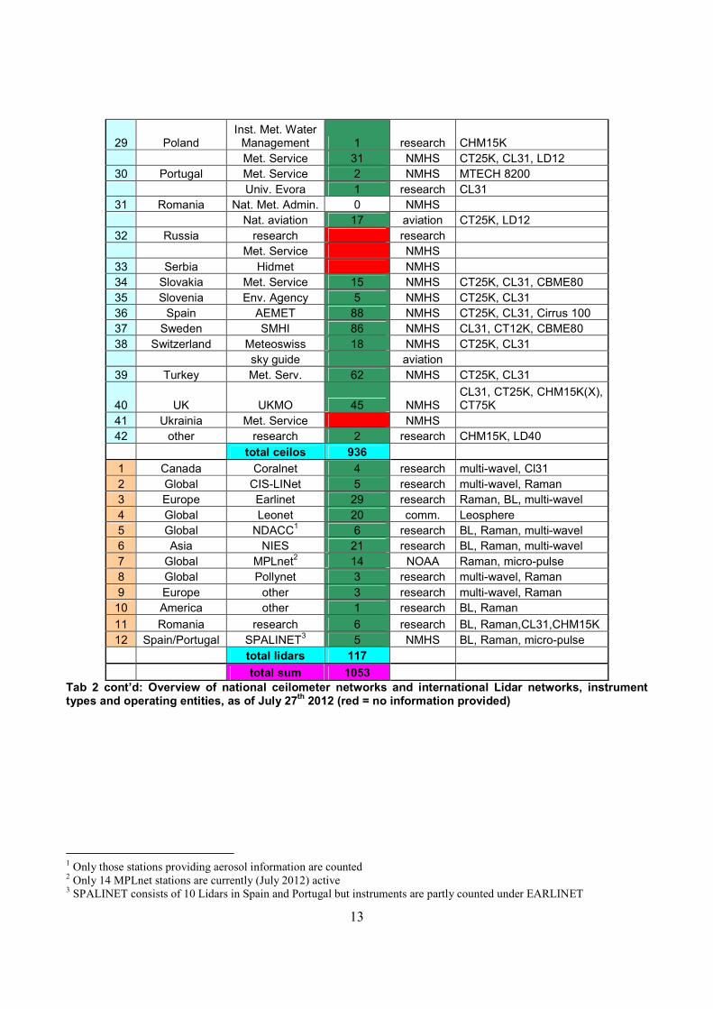
instrument types worldwide. The current data base contains more than 1000 positions (as of July 2012) and instrument types of ceilometers and Lidars mainly in Europe but also America and Asia, thus showing the potentially available global vertical profiling capacities.
2.1. Lidars: Existing Lidar networks are mostly operated by scientific entities (the exception is the Micro-pulse Li-dar Network - MPL-net) and are described in WMO’s Global Atmosphere Watch (GAW) report No. 178. The GAW Aerosol Lidar Observation Network (GALION) founded in 2000 is a global “network of networks” of entities and research groups operating Lidar systems. It aims at providing harmonized data of known (high) quality from different instrument types. Routine operations are performed by members following different measurement protocols but are often restricted to certain measurement periods.
2.2. Ceilometers: Ceilometers are however typically operated by NMHSs and aviation control entities. These latter net-works are, in contrast to most Lidar networks, fully automated and measure continuously. It turned out that the majority of national networks in Europe relies on just a few different instruments, namely the CT25K, the CL31, the outdated LD40 (all Vaisala), the CBME80 (Eliasson) and the relatively new CHM15K(X) (Jenoptik) instruments. Especially the latter has shown its potential for aerosol profiling during the European volcano crisis in April/May 2010 (Flentje et al., 2010). Few other instruments are in use, namely the CT12K, CT75K, LD12 and AW11 (all outdated Vaisala instruments) and the new CL51 (Vaisala), the Cirrus 100 (Telvent, Spain), the 8200-CHS (MTECH Systems, Portugal), and the higher-level instruments of Leosphere, the latter building its own loose network called Leonet. The ma-jority of ceilometers operate in the near-infrared region between 900 nm and 1064 nm. The Leosphere devices (ALS 300, ALS 450) however measure in the UV/VIS spectral region at 355 nm and also at 387 nm, if they are equipped with a depolarization channel.
2.3. Data access: Several stations of the European Aerosol Research Lidar Network (EARLINET), the entire AD-net op-erated by the Japanese National Institute for Environmental Studies (NIES) in several countries in Asia, and all active MPL-net stations provide quick looks of range-corrected backscatter intensities and partly retrieved backscatter coefficients. Furthermore, the newly established ceilometer networks in Germany (operated by DWD) and in the UK (operated by U.K. Met. Office) based on Jenoptik CHM15K instruments and some Impulsphysik LD40 instruments in the Netherlands operated by KNMI provide links to quick look images in near-real-time. A total of ~125 stations worldwide are on-line. In case of emergency (e.g. volcanic ash plumes) these instruments may provide information about the spatial distribution of ash clouds and the height regime of such clouds in near-real-time. The devel-oped visualization tool then allows fast and easy access to the data through links to quick look images. It must however be mentioned that for roughly half of all instruments gathered in the survey the raw data is not stored by operators for various reasons, making it impossible to retrieve information about the atmospheric state at these positions.
2.4. Algorithms: A number of algorithms exist in the scientific community for retrieving aerosol parameters from differ-ent ceilometers. A semi-operational retrieval code for aerosol parameters is available for the Jenoptik CHM15K instrument from DWD (Flentje et al., 2010). Another algorithm for analyzing the CHM15K measurements is provided by the “Site Instrumental de Recherche par Télédétection Atmosphérique” (SIRTA) at Palaiseau/France. These algorithms may be shared with other operators using this instru-ment in their networks. The Vaisala CL31 has been compared with a Raman Lidar which implies basically the availability of a retrieval code for this instrument (McKendy et al. 2009; Tsaknakis et al. 2011). The newer Vaisala
3
CL51 was recently compared with a Micro Pulse Lidar in Spain as described by Hernandez et al. (2011). According to C. Münkel/Vaisala (private communication) retrieval codes exist also for older instru-ments such as the LD40 and the CT25K (both Vaisala) but results are not published in peer-reviewed papers. Concerning the sensitivity for aerosol backscatter signals the Eliasson CBME80 (mainly in use in Norway and Sweden) seems to be comparable to the Vaisala CT25K. According to the company’s technical description the backscatter data is in principle available from this instrument. It might there-fore be possible adapting pre-existing algorithms.
2.5. Complementary data: Useful complementary data for constraining the ceilometer retrievals are daylight measurements of the aerosol optical depth. The calibration method is described in detail by Ansmann et al. (2011). Routine AOD measurements are available from fully-automated sun photometer stations, e.g. within the AER-ONET network (Holben et al., 1998), based on CIMEL CE 318A instruments, and the WMO/GAW Precision Filter Radiometer (PFR) network. Currently, AOD and ceilometer measurements are mostly taken independently and usually at different places. The exception is MPL-net where Lidars and sun photometers are predominantly operated at the same place. There are however plans at national lev-els to partly support ceilometer measurements with corresponding AOD measurements. If not other-wise possible, AOD data from stations in the vicinity may be used together with ceilometer measure-ments but retrieved profile results will be less accurate, which is due to changing atmospheric condi-tions at different locations. Also night-time measurements cannot be constrained by sun photometer observations. Another (costly) method for improving the quality of ceilometer retrievals is the parallel operation of Raman Lidar systems at dedicated anchor stations. Such combination of instruments is e.g. available at several national research observatories and entities (Cabauw/The Netherlands, Chilbolton/UK, Leipzig/Germany, Palaiseau/France, Payerne/Switzerland) but the vast majority of ceilometers are operated stand-alone. 3. User needs and applications:
3.1. Cloud base height and Planetary Boundary Layer height Users of ceilometer data are currently mostly with NMHSs and the main quantity of interest is the cloud-base height complementing synoptical data and supporting aviation. Ceilometers are therefore often operated close to or at national airports. Moreover, the planetary boundary height (PBL) can be retrieved from ceilometers (for example Markowicz et al., 2007 and references therein), although a standard retrieval algorithm has not yet been established, which is partly due to the different instru-ment types in use (different laser types, laser power, wavelengths, signal-to-noise levels). The PBL height is typically used for model validation, thus having again users mostly within NMHSs but also in the scientific community (GAW, regional climate model development, chemical weather forecast). It seems possible in the nearer future to assimilate ceilometer data into numerical weather prediction models which would then trigger further user interests in NMHSs.
3.2. Aerosol layer detection
The simple ceilometers may however deliver two other basic quantities for applications: the geometri-cal thickness of a semi-transparent backscattering (lofted) layer and its height above ground level. Under cloudless conditions these semi-transparent layers will predominantly consist of aerosol parti-cles. This information and its continuous provision in 24/7 mode is highly important for aviation and users are therefore NMHSs and national (and international) aviation control institutions (e.g., EASA, Eurocontrol, ICAO). Legal aspects of using ceilometers for aviation control have however not yet been tackled and technical specifications of ceilometer measurements must be elaborated before e.g. ICAO might officially rely also on ceilometer observations.

4
3.3. Aerosol profiles Further to geometrical quantities ceilometers may also be used for retrieving aerosol parameters. Since ceilometer measurements are often done in the near infrared spectral domain at 1064 nm, day-light measurements data are not largely affected by Rayleigh scattering. Measurements in this spec-tral range therefore allow continuous observations during day and night with comparable reliability. The retrieval of first backscatter profiles and secondly extinction profiles (and further mass extinction coefficients) from these routine ceilometer measurements is in principal possible, provided that addi-tional measurements are available (sun photometer, advanced Lidars) and that the instrument was calibrated. This method is exemplarily described in Flentje et al. (2010). In a combined network of Li-dars and ceilometers these measurements would further allow provision of the four-dimensional back-scatter field over a certain region. Certainly, this latter product would also be asked for in the scientific community for model and satellite data validation.
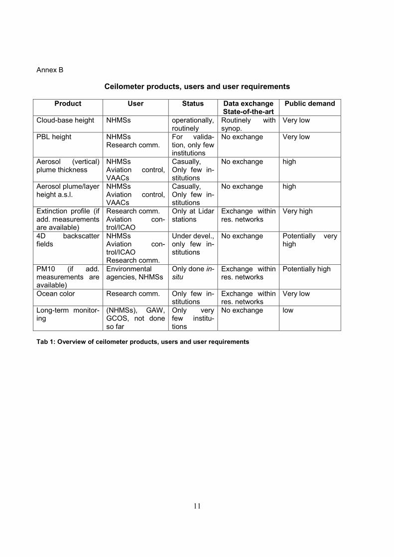
3.4. Air quality PM10 is of large (public) interest at regional scales and national environmental agencies and NMHSs are providing this quantity, but it typically originates from in-situ aerosol measurements. A PM10 re-trieval based on ceilometer data relies on even more additional measurements and necessary as-sumptions as needed for retrieving the extinction profile. Similarly this is true for ocean colour retriev-als (from satellite data) which benefit from aerosol profile information (especially if absorbing aerosols are present, IOGCC report 2010) that would originate from ceilometers or Lidar data. Naturally, the research community itself is asking for such data while the public interest especially for the latter is low.
3.5. Long-term monitoring Finally, long-term monitoring of aerosol parameters/aerosol profiles is mainly requested by global re-search and observational programmes but since these programmes typically rely on national meas-urements little has been done so far in the field. There is however the Sand and Dust Storm Warning Advisory and Assessment System (SDS-WAS) which was established in 2006 under the aegis of WMO. Concerning observations it relies mainly on AOD measurements mostly from ground but also satellites, but it is planned to further support the activities there by ceilometers. Summary: A high public interest or demand exists for aerosol plume monitoring under special circum-stances, i.e. volcanic outbreaks and dust outbreaks, which may affect air traffic. Support of this user community is therefore a good starting point of an operational network for aerosol profiling but long-term observations of aerosols are also covered by this approach. Other applications are however not ruled out but are not followed with high priority. An overview of users and possible products originating from a ceilometer/lidar network is given in Tab 1. 4. Needs for operational networks: Although international Lidar research networks follow agreed measurement protocols and exchange data in a common data format such efforts still lack at the level of operational national networks of NMHSs. Typically, each service has its own routine operations procedure, applies its own quality as-surance mechanisms, runs its own retrieval algorithms, and stores data locally in a self-made data format. Such “patchwork” however hampers exchange and use of data from different national net-works, although routine operations are fully established. This weakness, especially in case of emergencies, has been realised by representatives of NMHSs and national research entities. Consequently, a dedicated working group dealing with data and prod-uct harmonization, definition of BUFR format tables, and algorithm development has been established in early 2012 under the aegis of EG-CLIMET (COST Action ES0702). More recently and supporting this initiative the Economic Interest Grouping (EIG) EUMETNET (29 members, European NMHSs) de-cided during its 8th assembly in May 2012 to organize data exchange and data harmonization of both
5
wind profilers and ceilometers under its new sub-programme E-PROFILE. Furthermore, the former EARLINET consortium which is now part of the newly established EU FP7 research infrastructure pro-ject ACTRIS (Aerosols, Clouds, and Trace gases Research InfraStructure Network) has agreed to sup-port the development of common retrieval algorithm(s) for aerosol properties from ceilometer raw data. Especially global aviation would benefit from a coordinated and internationally agreed procedure on how retrieving aerosol parameters from ground-based remote sensing instruments. In the long-term perspective such data records may be analysed for long-range transport phenomena and even climate change analyses. 5. Recommendations from expert meetings:
5.1. EARLINET/ACTRIS The EARLINET community welcomed the initiative of WMO/DWD for better integrating national ceilometer networks into GALION and established a dedicated working group dealing with ceilometer issues. Representatives from WMO and the German Federal Ministry of Transport, Building and Ur-ban Development being responsible for aeronautics highlighted the importance of near-real-time measurements from such denser profile network in case of emergencies (for aviation) and strongly emphasized the expected role of EARLINET, being the scientific backbone in this respect. The focus of EARLINET (see Pappalardo 2010) is with scientific development, quality assurance/quality control of measurements and technical improvements of systems while standardization and operational as-pects still play a minor role. Note that EARLINET will become unfunded in 2015 after finishing AC-TRIS. Concerning algorithm development the idea of developing “single calculus chains” for different ceilometer types is supported by EARLINET but will not be possible as part of the running AC-TRIS/EARLINET project. Sharing of e.g. quick looks of range-corrected signals or preferably backscat-ter profiles was seen as an initial step, until any operational data exchange would be in place. Cali-brated backscatter data from ceilometers are however much in favour over simple range-corrected quick look images. The backscatter data (after calibration) which may in principle also be made avail-able in near-real-time would enable a direct quantitative comparison of results. Such calibration has recently been shown by O’Connor et al. (2004). The analysis of a calibration technique applied to Jen-optik instruments is currently underway at the Univ. Munich (Germany, see paper by Wiegner and Geiß, 2012). Its application to the German ceilometer network is investigated at DWD Hohenpeissen-berg. There is agreement about the leading role of operational entities (weather services, national air traffic control) regarding data exchange and data format issue, although help from EARLINET defining the content of data records of ceilometers is anticipated.
5.2. Chemical weather forecast Several NMHSs in Europe among them DWD, are involved in the EU FP7 project MACC-II (Monitoring Atmospheric Composition and Climate, from 11/2011 – 7/2014), which is the successor of EU projects MACC and GEMS, the latter starting its activities already back in 2005. The focus of MACC-II is “chemical weather forecast” and as such it paves the way for the envisaged GMES “Atmosphere Core Service” which shall start operational services after finishing the project phase in summer 2014. As analysed by working groups of MACC-II and EG-CLIMET ceilometer networks would be in principle appropriate for validating aerosol parameters of the global integrated (chemistry+dynamics) C-IFS model operated at ECMWF, bur also contributing regional models at higher spatial resolution. Pa-rameters of interest are again height above ground and geometrical thickness of e.g. ash/fire and dust plumes at a Lidar/ceilometers position together with the geographical distribution of such atmospheric constituents at a larger scale. A direct comparison of aerosol parameters seems compromised since neither the models nor the ceilometers are typically able to provide ab-initio a (calibrated) backscatter profile. A comparison of measured and modelled extinction profiles would be more useful, but even better is the application of forward model operators allowing comparison of simulated and measured intensities and finally profile

6
parameters on the basis of measured/input optical properties of atmospheric scatterers. First steps towards assimilating aerosol profiles into models and validation strategies are currently under discus-sion within MACC-II and EG-CLIMET.
5.3. CIMO/CBS Two expert group meetings of CIMO (Commission for Instruments and Methods of Observations) and CBS (Commission for Basic Systems) took recently place at WMO (Geneva, December 2011), dis-cussing the status of ground-based remote sensing instruments for supporting aviation. There was a large interest of non-European members of the two commissions since many regions world-wide are frequently affected by volcanic ash, although the economic damage so far was lower than it was re-cently in Europe in Spring 2010. Exchange of quick looks was seen as a first useful step in case of emergencies. Costs and benefits of ceilometers and Lidars were discussed as well as possible ways forward setting up an integrated network of ceilometers, lidars, cloud radars and sun photometers. Ex-pected error margins of ceilometer data seem to be high but the alternative would be to have no measurements at all. A comparison of nowadays instruments was seen as necessary prerequisite for certified operations in aviation. Clearly it is recommended to store instrumental raw data at national level for further aerosol analyses.
5.4. WEZARD The focus of the EU FP7 project WEZARD (WEather HaZARD for aeronautics) is predominantly on risks for aviation due to icing and volcanic ash. Experts identified the large variability of volcanic ash (grain size, chemical composition, melting temperature) and its various impacts on aircraft engines as critical problem. Not every ash or dust composition is equally dangerous for aircraft engines while forecasts and near-real-time measurements of hazardous aerosol layers are hardly available with rea-sonable error margins. Dense ground-based Lidar and ceilometer networks would therefore certainly improve the situation. The UK Met. Office and Meteo-France currently plan such denser integrated networks at national level. It will consist of few Raman Lidars (UKMO) or Leosphere UV instruments (Meteo-France) which will serve as back-bones of existing ceilometer networks.
5.5. EG-CLIMET An expert team established within EG-CLIMET for harmonizing ceilometer operations and paving the way for exchanging ceilometer data. Initially the work on ceilometers within EG-CLIMET was on har-monizing retrievals of the planetary boundary height (Martial Haeffelin, Institut Pierre Simon Laplace (IPSL), SIRTA) but is now accompanied by the retrieval of aerosol parameters. The expert team con-sists of Lidar experts from leading European Weather services (UKMO, Meteo-France, DWD, KNMI, MeteoSwiss) and the research community (EARLINET, Univ. Reading, ISPL/SIRTA). Thanks to the work of this expert team EUMETNET was successfully approached for continuing the work on harmo-nizing ceilometer observations and data products/data formats in the future (E-PROFILE). The group further discussed ceilometer calibration methods (self-calibration technique, cross-calibration with Li-dars and sun-photometers), quality assurance issues, intercomparison campaigns and long-term op-erations. Care must be taken about the long-term stability of ceilometers (e.g. either avoid or correct for daily gain corrections) and several calibration methods must be applied, in order to develop an optimized and fully automatically working method for a network of different instruments. Parallel operations of ceilometers and Lidars are currently in progress at several places in Europe (Univ. Munich/Germany, CNR Tito-Scalo/Italy, SIRTA Palaiseau/France) and SIRTA offers already a software package (STRAT) for analyzing ceilometer (Jenoptik CHM15K) and Lidar data together. It provides products such as target classification and the PBL height. STRAT was already transferred to Meteo-France and will be used in the upcoming French national lidar/ceilometer network (to be operational in 2014). The group further discussed data policy issues and a recommendation about the exchange of ceilometer quick looks, raw data and near-real-time data between NMHSs and the research commu-
7
nity (here: EARLINET) has been formulated and was sent to NMHSs for further discussion. It was also realized that the CIMO guideline about ceilometer and lidar measurements needs to be updated. 6. Outlook: Actions are required on different time scales: A short-term action is setting up a web page (to be done by DWD) which makes the current instrumen-tal network available to users. The available google earth prototype map may serve as a template, al-lowing access to instrumental quick looks and web sites of Lidar stations. An intercomparison campaign of ceilometers and Lidars involving ACTRIS and CIMO/CBS is envis-aged until 2015 (the end of ACTRIS), in order to assess the quality and usefulness of state-of-the art ceilometers and Lidars for aerosol measurements. Further to that the corresponding CIMO guidelines will be updated. A midterm action is the definition of a common data format for data exchange/data storage at scientific level (preferably netcdf) and at NMHS level (preferably BUFR). First steps have already been under-taken by UKMO, Univ. Reading/UK and DWD. Having the experience from harmonizing European wind profiler measurements and data it seems feasible to perform similarly with ceilometer and Lidar networks within next five years in Europe. Correspondingly, data exchange should be organized through WMOs information systems GTS and WIS while data access could be provided through WIGOS. A long-term perspective is the storage of instrumental raw data of profiling instruments world-wide, for at least “day+1”- retrievals and long-term studies. Currently, only few data providers/NMHSs have in-vested in network infrastructure, storage capacity and software development, in order to build up the capacity for enhanced usage of profiling instruments. Near-real-time capability of networks is another challenge which would allow easy and fast access to at least quick looks from instruments that may help identifying possible hazards in case of emergencies, such as volcanic ash layers or large-scale dust layers.
8
Annex A
Reports
1) WMO GAW Report No. 178, Plan or the implementation of the GAW Aerosol Lidar Observation Network GALION, 2007
2) Atmospheric Correction for Remotely-Sensed Ocean-Colour Products, IOCCG Report Number
10, 2010
3) Joint Meeting of CIMO Expert Team on Operational Remote Sensing (ET-ORS) (First Session) and CBS Expert team on Surface-based Remote Sensing Observations (ET-SBRSO) (Second Session), Geneva, Switzerland, 05-09 December 2011, Final Report.
4) Review of volcanic ash observation quality monitoring, data storage and data access activities,
WEZARD, 2012.
5) Talks and report from Special Working Group (SWG) meeting “Harmonisation of European automatic lidar and ceilometer network recording formats and data sharing protocols, data quality management, calibration, target classification and parameter retrievals” http://www.eg-climet.org/index.php?option=com_content&view=article&id=35&Itemid=23
6) Project and Implementation Plan, WMO Information System, Version 1.2.1, August 2010
7) http://www.wmo.int/pages/prog/www/wigos/index_en.html
Networks and Projects
1) ACTRIS: http://www.actris.net/
2) AD-net: http://www-lidar.nies.go.jp/AD-Net/
3) AERONET: http://aeronet.gsfc.nasa.gov/
4) EARLINET: http://www.earlinet.org
5) EG-CLIMET: European Ground-Based Observations of Essential Variables for Climate and Operational Meteorology, COST action ES0702, http://www.eg-climet.org
6) EUMETNET: http://www.eumetnet.eu/
7) GMES: http://www.gmes.info/pages-principales/library/implementation-groups/gmes-
atmosphere-core-service/
8) LEONET: http://leo-net.eu
9) MPLNET: http://mplnet.gsfc.nasa.gov/
10) WEZARD: http://cordis.europa.eu/search/index.cfm?fuseaction=proj.document&PJ_RCN=12134641
9
11) WMO Sand and Dust Storm Warning Advisory and Assessment System (SDS-WAS), http://www.wmo.int/pages/prog/arep/wwrp/new/Sand_and_Dust_Storm.html
12) WMO PFR network, http://www.pmodwrc.ch/worcc/index.html
System providers (not an exhaustive list)
1) Eliasson: http://www.eliasson.com
2) Jenoptik: http://www.jenoptik.de
3) MTECH Systems: http://www.mtechsystems.com/
4) Leosphere: http://www.leosphere.com/
5) Telvent: http://www.telvent.com/
6) Vaisala: http://www.vaisala.com
References
1) Ansmann A., M. Tesche, P. Seifert, S. Groß, V. Freudenthaler, A. Apituley, K.M. Wilson, I.
Serikov, H. Linné, B. Heinold, A. Hiebsch, F. Schnell, J. Schmidt, I. Mattis, U. Wandinger, and
M. Wiegner (2011): Ash and fine-mode particle mass profiles from EARLINET-AERONET ob-
servations over central Europe after the eruptions of the Eyjafjallajökull volcano in 2010, J.
Geophys. Res., 116, doi:10.1029/2010JD015567.
2) Flentje H., H. Claude, T. Elste, S. Gilge, U. Köhler, C. Plass-Dülmer, W. Steinbrecht, W. Tho-
mas, A. Werner, and W. Fricke (2010): The Eyjafjallajökull eruption in April 2010 – Detection of volcanic plume using in-situ measurements, ozone sondes and lidar-ceilometer profiles, At-mos. Chem. Phys., 10, 10085–10092, doi:10.5194/acp-10-10085-2010.
3) Heese B., H. Flentje, D. Althausen, A. Ansmann, and S. Frey (2010): Ceilometer lidar compari-
son: backscatter coefficient retrieval and signal-to-noise ratio determination, Atmos. Meas. Tech., 3, 1763–1770, doi:10.5194/amt-3-1763-2010.
4) Hernández Y., S. Alonso-Pérez, E. Cuevas, C. Camino, R. Ramos, J. De Bustos, C. Marrero,
C. Córdoba-Jabonero4 and M. Gil (2011), MicroPulse Lidar and Ceilometer inter-comparison during Saharan dust intrusions over the Canary Islands, V Reunión Española de Ciencia y Tecnología de Aerosoles – RECTA 2011
5) Holben B.N., T.F. Eck, I. Slutsker, D. Tanré, J.P. Buis, A. Setzer, E. Vermote, J.A. Reagan, Y.
Kaufman, T. Nakajima, F. Lavenu, I. Jankowiak and A. Smirnov (1998): AERONET – A feder-ated instrument network and data archive for aerosol characterization, Rem. Sens. Environ., 66, 1-16.
10
6) K.M. Markowicz, P.J. Flatau, A.E. Kardas, J. Remiszewska, K. Stelmaszczyk, and L. Woeste (2008): Ceilometer Retrieval of the Boundary Layer Vertical Aerosol Extinction Structure, J. Atmos. Oc. Tech., 25, 928-944
7) McKendy I.G., D.v.d. Kamp, K.B. Strawbridge, A. Christen and B. Crawford (2009): Simultane-
ous observations of boundary- layer aerosol layers with CL31 ceilometer and 1064/532 nm li-dar, Atm. Env., 43, 5847-5852.
8) O’Connor E.J., A.J. Illingworth, and R.J. Hogan (2004): A Technique for Autocalibration of
Cloud Lidar, J. Atmos. Oc. Tech., 21, 776-786.
9) Pappalardo G. (2010): EARLINET: the European Lidar network for aerosol study at continental scale, EARSeL Newsletter, N. 82, p13-18.
10) Tsaknakis G., A. Papayannis, P. Kokkalis, V. Amiridis, H.D. Kambezidis, R.E. Mamouri, G.
Georgoussis, and G. Avdikos (2011): Inter-comparison of lidar and ceilometer retrievals for aerosol and Planetary Boundary Layer profiling over Athens, Greece, Atmos. Meas. Tech., 4, 1261–1273, doi:10.5194/amt-4-1261-2011
11) M. Wiegner and A. Geiß (2012): Aerosol profiling with the JenOptik ceilometer CHM15kx, At-
mos. Meas. Tech. Discuss., 5, 3395–3430, doi:10.5194/amtd-5-3395-2012.
11
Annex B
Ceilometer products, users and user requirements
Product User Status Data exchange State-of-the-art
Public demand
Cloud-base height NHMSs operationally, routinely
Routinely with synop.
Very low
PBL height NHMSs Research comm.
For valida-tion, only few institutions
No exchange Very low
Aerosol (vertical) plume thickness
NHMSs Aviation control, VAACs
Casually, Only few in-stitutions
No exchange high
Aerosol plume/layer height a.s.l.
NHMSs Aviation control, VAACs
Casually, Only few in-stitutions
No exchange high
Extinction profile (if add. measurements are available)
Research comm. Aviation con-trol/ICAO
Only at Lidar stations
Exchange within res. networks
Very high
4D backscatter fields
NHMSs Aviation con-trol/ICAO Research comm.
Under devel., only few in-stitutions
No exchange Potentially very high
PM10 (if add. measurements are available)
Environmental agencies, NHMSs
Only done in-situ
Exchange within res. networks
Potentially high
Ocean color Research comm. Only few in-stitutions
Exchange within res. networks
Very low
Long-term monitor-ing
(NHMSs), GAW, GCOS, not done so far
Only very few institu-tions
No exchange low
Tab 1: Overview of ceilometer products, users and user requirements
12
National ceilometer networks and international Lidar networks
Nr. Country Institute ceilos/lidars network instrument type
1 Albania Met. Service NHMS
2 Armenia Met. Service 3 NHMS CT25K, CL31
3 Austria ZAMG 0 NHMS
Austrocontrol 15 aviation CL31
4 Belarus Met. Service NHMS
5 Belgium RMI 1 NMHS CL51
Belgocontrol aviation
6 Bosnia
Herzegovina Fed. Hydromet.
Institute 0 NMHS
7 Bulgaria Nat. Inst. of
Met. and Hydro. 1 NMHS CHM15K
8 Croatia MHS 0 NMHS
9 Czech Rep. Hydromet. Inst. 3 NMHS CL31
10 Denmark DMI 44 NMHS Vaisala CT25K
11 Estonia Estonian Met. and Hyd. Inst. 19 NMHS CT25K, CL31
12 Finland FMI 65 NMHS CT25K, CL31, CL51
13 France Meteo-France 66 NMHS CT25K, CL31, LD40
14 Georgia Met. Service NMHS
15 Germany DWD 176 NMHS CHM15K(X), LD40
research 5 research CT25K, CL31, CHM15KX
16 Greece NOA 3 research CL31
17 Hungary Met. Service NMHS
18 Iceland Met. Service 15 NMHS CL31, CT25K, 3 un-knowns
19 Ireland Met. Eireann 20 NMHS CL31, CT25K, CHM15K
20 Italy CNR 3 CNR BL+DPL, CHM15K, CT25K
Aero.Militare 26 NMHS CT25K
21 Latvia
Latv. Env., Geol. and Met.
Centre 2 NMHS CT25K, CL31
22 Lithuania Met. Service NMHS
23 Luxembourg Service Météo. NMHS
24 Makedonija Met. Service 2 NMHS CT12k
25 Moldova Met. Service 5 NMHS CT25K, CL31
26 Montenegro Met. Service 0 NMHS
Tab 2: Overview of national ceilometer networks and international Lidar networks, instrument types and operating entities, as of Mar 30
th 2012 (red = no information provided)
27 Netherlands KNMI 43 NMHS LD40
28 Norway Met.NO 0 NMHS
Avinor 46 aviation Eliasson CBME80
13
29 Poland Inst. Met. Water Management 1 research CHM15K
Met. Service 31 NMHS CT25K, CL31, LD12
30 Portugal Met. Service 2 NMHS MTECH 8200
Univ. Evora 1 research CL31
31 Romania Nat. Met. Admin. 0 NMHS
Nat. aviation 17 aviation CT25K, LD12
32 Russia research research
Met. Service NMHS
33 Serbia Hidmet NMHS
34 Slovakia Met. Service 15 NMHS CT25K, CL31, CBME80
35 Slovenia Env. Agency 5 NMHS CT25K, CL31
36 Spain AEMET 88 NMHS CT25K, CL31, Cirrus 100
37 Sweden SMHI 86 NMHS CL31, CT12K, CBME80
38 Switzerland Meteoswiss 18 NMHS CT25K, CL31
sky guide aviation
39 Turkey Met. Serv. 62 NMHS CT25K, CL31
40 UK UKMO 45 NMHS CL31, CT25K, CHM15K(X), CT75K
41 Ukrainia Met. Service NMHS
42 other research 2 research CHM15K, LD40
total ceilos 936
1 Canada Coralnet 4 research multi-wavel, Cl31
2 Global CIS-LINet 5 research multi-wavel, Raman
3 Europe Earlinet 29 research Raman, BL, multi-wavel
4 Global Leonet 20 comm. Leosphere
5 Global NDACC1 6 research BL, Raman, multi-wavel
6 Asia NIES 21 research BL, Raman, multi-wavel
7 Global MPLnet2 14 NOAA Raman, micro-pulse
8 Global Pollynet 3 research multi-wavel, Raman
9 Europe other 3 research multi-wavel, Raman
10 America other 1 research BL, Raman
11 Romania research 6 research BL, Raman,CL31,CHM15K
12 Spain/Portugal SPALINET3 5 NMHS BL, Raman, micro-pulse
total lidars 117
total sum 1053
Tab 2 cont’d: Overview of national ceilometer networks and international Lidar networks, instrument types and operating entities, as of July 27
th 2012 (red = no information provided)
1 Only those stations providing aerosol information are counted 2 Only 14 MPLnet stations are currently (July 2012) active 3 SPALINET consists of 10 Lidars in Spain and Portugal but instruments are partly counted under EARLINET
14
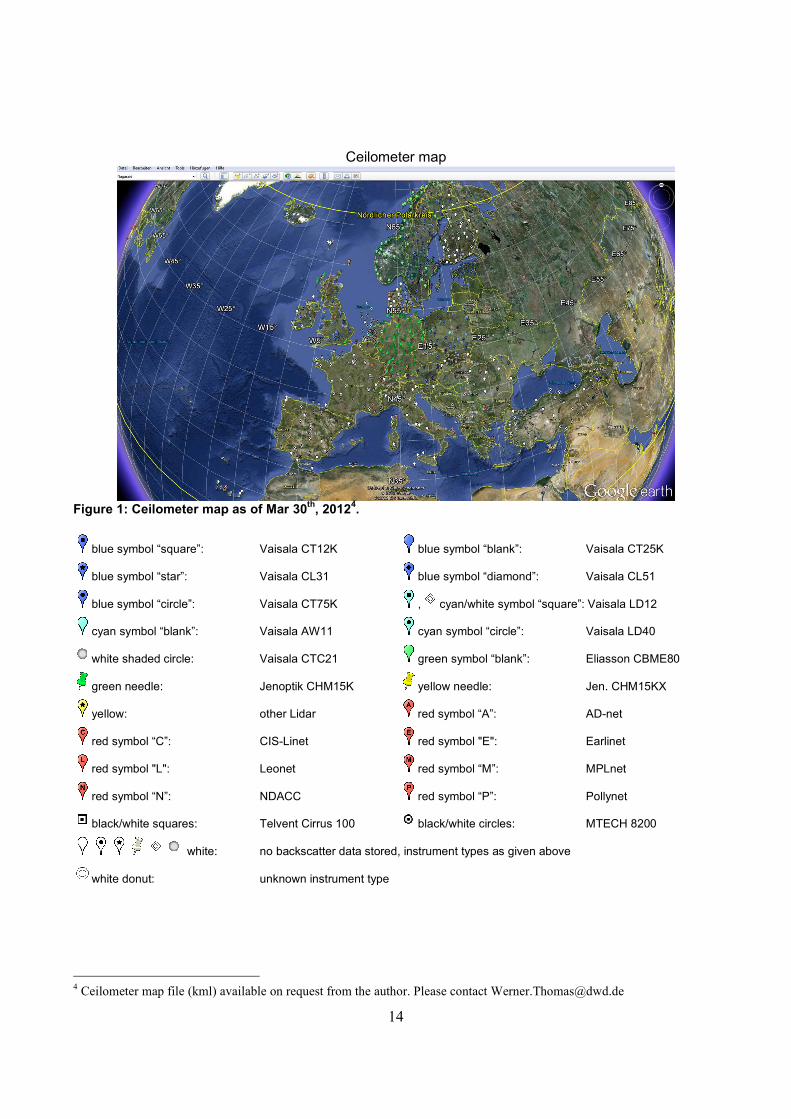
Ceilometer map
Figure 1: Ceilometer map as of Mar 30
th, 2012
4.
blue symbol “square”: Vaisala CT12K blue symbol “blank”: Vaisala CT25K
blue symbol “star”: Vaisala CL31 blue symbol “diamond”: Vaisala CL51
blue symbol “circle”: Vaisala CT75K , cyan/white symbol “square”: Vaisala LD12
cyan symbol “blank”: Vaisala AW11 cyan symbol “circle”: Vaisala LD40
white shaded circle: Vaisala CTC21 green symbol “blank”: Eliasson CBME80
green needle: Jenoptik CHM15K yellow needle: Jen. CHM15KX
yellow: other Lidar red symbol “A”: AD-net
red symbol “C”: CIS-Linet red symbol "E": Earlinet
red symbol "L": Leonet red symbol “M”: MPLnet
red symbol “N”: NDACC red symbol “P”: Pollynet
black/white squares: Telvent Cirrus 100 black/white circles: MTECH 8200
white: no backscatter data stored, instrument types as given above
white donut: unknown instrument type
4 Ceilometer map file (kml) available on request from the author. Please contact [email protected]