Embed Size (px)
Citation preview

International Civil Aviation Organization
Approved by the Secretary Generaland published under his authority
Training Manual
First Edition — 2002
Doc 7192
AN/857
Part F-1Meteorology for Air TrafficControllers and Pilots

International Civil Aviation Organization
Approved by the Secretary Generaland published under his authority
Training Manual
First Edition — 2002
Doc 7192
AN/857
Part F-1Meteorology for Air TrafficControllers and Pilots

AMENDMENTS
The issue of amendments is announced regularly in the ICAO Journal and in themonthly Supplement to the Catalogue of ICAO Publications and Audio-visualTraining Aids, which holders of this publication should consult. The space belowis provided to keep a record of such amendments.
RECORD OF AMENDMENTS AND CORRIGENDA
AMENDMENTS CORRIGENDA
No. Date Entered by No. Date Entered by
The designations employed and the presentation of the material in thispublication do not imply the expression of any opinion whatsoever on the partof ICAO concerning the legal status of any country, territory, city or area orof its authorities, or concerning the delimitation of its frontiers or boundaries.
(ii)

(iii)
FOREWORD
The importance of meteorology for the safety of civilaviation has been acknowledged since the early days ofaviation. The ICAO Training Manual has provided guid-ance on meteorological training for aviation operationspersonnel since its inception. However, this new part of theTraining Manual is the first that is exclusively dedicated toaeronautical meteorology. This approach has been chosento outline, in a more efficient way, the important develop-ments which have taken place in the dissemination ofmeteorological information.
This manual has been prepared by the Meteorologyand the Personnel Licensing and Training Sections ofICAO. It updates the meteorological part of the syllabusthat is included in Doc 7192 — Training Manual, Part B-5
— Integrated Commercial Pilot Course, and providesguidance for the training of air traffic controllers.
Comments on this manual, particularly with respect toits application, usefulness and scope of coverage, would beappreciated from States, ICAO Technical Co-operation fieldmissions and training organizations. They will be taken intoconsideration in the preparation of subsequent editions.Comments concerning this manual should be addressed to:
The Secretary GeneralInternational Civil Aviation Organization999 University StreetMontreal, Quebec H3C 5H7Canada

�������

(v)
TABLE OF CONTENTS
Page Page
Glossary . . . . . . . . . . . . . . . . . . . . . . . . . . . . . . . . . . . (vii)
Chapter 1. Introduction . . . . . . . . . . . . . . . . . . . . 1-1
Chapter 2. Training goals . . . . . . . . . . . . . . . . . . . 2-1
2.1 Conditions . . . . . . . . . . . . . . . . . . . . . . . . . 2-12.2 Performance . . . . . . . . . . . . . . . . . . . . . . . . 2-12.3 Standard of accomplishment . . . . . . . . . . . 2-12.4 Training reference guide . . . . . . . . . . . . . . 2-1
Chapter 3. Syllabi . . . . . . . . . . . . . . . . . . . . . . . . . 3-1
3.1 Atmosphere . . . . . . . . . . . . . . . . . . . . . . . . 3-13.2 Atmospheric temperature and humidity . . 3-13.3 Atmospheric pressure. . . . . . . . . . . . . . . . . 3-23.4 Pressure-wind relationships . . . . . . . . . . . . 3-23.5 Wind in the free atmosphere . . . . . . . . . . . 3-33.6 Winds near the earth’s surface . . . . . . . . . 3-33.7 Turbulence . . . . . . . . . . . . . . . . . . . . . . . . . 3-43.8 Vertical motion in the atmosphere . . . . . . 3-43.9 Formation of clouds and precipitation . . . 3-43.10 Thunderstorms . . . . . . . . . . . . . . . . . . . . . . 3-5
3.11 Aircraft icing . . . . . . . . . . . . . . . . . . . . . . . 3-63.12 Visibility and RVR . . . . . . . . . . . . . . . . . . 3-73.13 Volcanic ash . . . . . . . . . . . . . . . . . . . . . . . . 3-73.14 Air masses and fronts . . . . . . . . . . . . . . . . 3-83.15 Frontal depressions . . . . . . . . . . . . . . . . . . 3-83.16 Weather at fronts and at other parts
of the frontal depression . . . . . . . . . . . . . . 3-83.17 Other types of pressure systems . . . . . . . . 3-93.18 Surface observations . . . . . . . . . . . . . . . . . 3-93.19 Upper-air observations. . . . . . . . . . . . . . . . 3-93.20 Station model . . . . . . . . . . . . . . . . . . . . . . . 3-103.21 General climatology. . . . . . . . . . . . . . . . . . 3-103.22 Weather in the tropics . . . . . . . . . . . . . . . . 3-113.23 MET service for international
air navigation . . . . . . . . . . . . . . . . . . . . . . . 3-113.24 Aeronautical MET reports. . . . . . . . . . . . . 3-123.25 Prognostic charts . . . . . . . . . . . . . . . . . . . . 3-133.26 Aeronautical forecasts and warnings . . . . 3-133.27 Aircraft observations and AIREPs . . . . . . 3-143.28 Sources of MET information . . . . . . . . . . 3-153.29 MET information for ATS units and
search and rescue services centres . . . . . . 3-163.30 Field trip to local MET office or station . 3-16

�������

(vii)
GLOSSARY
ACC Area control centreACARS Aircraft communications addressing and
reporting system ADS Automatic dependent surveillanceAFI Africa-Indian OceanAFTN Aeronautical fixed telecommunication
networkAIP Aeronautical information publicationAIRMET Information concerning en-route
weather phenomenon which may affect the safety of low-level aircraft operations
AIREP A report from an aircraft in flight prepared in conformity with requirements for position and operational and/or meteorological reporting
AIS/MET Aeronautical information service/meteorology
AMBEX AFI MET bulletin exchangeAMDAR Aircraft meteorological data acquisition
and relayANP Air navigation planAPP Approach control officeASDAR Aircraft-to-satellite data relayASHTAM A special series NOTAM notifying, by
means of a specific format, change in activity of a volcano, a volcanic eruption and/or volcanic ash cloud that is of significance to aircraft operations
ATCO Air traffic controllerATIS Automatic terminal information serviceATP Airline transport pilotATPL Airline transport pilot licenceATS Air traffic serviceATS/MET Air traffic service/meteorologyAWOS Automated weather observation systemCAT Clear air turbulenceCAVOK Visibility, cloud and present weather
better than prescribed values or conditions
CP Commercial pilotCPDLC Controller-pilot data link
communicationsCPL Commercial pilot licence
D-ATIS Data link automatic terminal information service
D-VOLMET VOLMET data link serviceETD Estimated time of departureETOPS Extended range operations by twin-
engined aeroplanesEUR EuropeanFIC Flight information centreFIR Flight information regionGAMET Area forecast for low-level flightsGRIB Processed meteorological data in the
form of grid point values expressed in binary form
GTS Global telecommunication systemIAVW International airways volcano watch ISA International standard atmosphereISCS International satellite communications
systemITCZ Intertropical convergence zoneMET MeteorologicalMET REPORT Local routine meteorological report METAR Aviation routine weather reportMOTNE Meteorological Operational
Telecommunications Network EuropeMWO Meteorological watch officeNAT North AtlanticNOTAM Notice to airmenOPMET Operational meteorological informationPP Private pilot PPL Private pilot licenceQFE Atmospheric pressure at aerodrome
elevationQNH Altimeter subscale setting to obtain
elevation when on the groundROBEX Regional OPMET bulletin exchangeRVR Runway visual rangeSADIS Satellite distribution system for
information relating to air navigationSIGMET Information concerning en-route
weather phenomena which may affect the safety of aircraft operations
SIGWX Significant weatherSNOWTAM A special series NOTAM notifying the
presence or removal of hazardous conditions due to snow, ice, slush or

(viii) Training Manual
standing water associated with snow, slush and ice on the movement area, by means of a specific format
SPECI Aviation selected special weather reportSPECIAL Local special meteorological reportSVR Slant visual rangeSYNOPs Report of surface observation from a
fixed land station TAF Aerodrome forecastTCAC Tropical cyclone advisory centre
TEMPS Upper-level pressure, temperature, humidity and wind report from a fixed land station
TWR Aerodrome control towerVAAC Volcanic ash advisory centreVOLMET Meteorological information for aircraft
in flightWAFC World area forecast centreWAFS World area forecast systemWMO World Meteorological Organization

1-1
Chapter 1
INTRODUCTION
1.1 While all transport is subject to weatherconditions which can vary from benign to vicious, it can beargued that aviation is the most sensitive to weatherconditions. Moreover, an international or small local airportcan be equally affected by weather conditions. Evenrelatively low-speed cross-winds combined with wetrunway conditions can effectively close an airport, andconditions of poor visibility can cause major disruptions toaviation schedules. Meteorological (MET) conditions mayalso compromise safety, efficiency and regularity of flightoperations en route.
1.2 It is most important, therefore, that the air trafficcontrollers (ATCOs), private pilots (PPs), commercialpilots (CPs) and airline transport pilots (ATPs) havesufficient skill and knowledge to interpret METinformation, reports, forecasts and warnings correctly andefficiently. They must be able to use this information whenexercising their duties.
1.3 In order to ensure that the trainee fullyunderstands the role that the local MET office andaeronautical MET station play in the preparation, codingand dissemination of weather data, it is strongly
recommended that the trainee be taken on a guided tour ofthe nearest MET office and/or aeronautical MET station,where questions and discussion should be encouraged. Itshould be emphasized to the ATCO trainees that themaintenance of good coordination between the designatedMET office and the respective air traffic service (ATS)units and search and rescue services centres has a majorpositive impact on the quality of the work of both units.
1.4 The following syllabus outlines the minimumknowledge and skill that are necessary if the ATCOs, PPs,CPs and ATPs are to perform their jobs efficiently andproductively. While it may be necessary for authorities toenhance some parts of the outlined syllabus, it must not beat the expense of other parts. For the private pilot licence(PPL) instrument rating, the minimum knowledge requiredfor commercial pilot licences (CPLs) applies.
1.5 The minimum required knowledge may bepresented to ATCO trainees in two separate courses: theinitial course and the ATCO licence course. The compositionof the suggested course content given in Table 2-1 reflectssuch an arrangement.

Chapter 2
TRAINING GOALS
2.1 CONDITIONS
The trainee must be provided with all relevantdocumentation, examples of actual aeronautical MET reportsand forecasts, and copies of all the appropriate charts andpublications currently in use and relevant to flight operations.At least one visit to an aerodrome MET office and/oraeronautical MET station is strongly recommended.
2.2 PERFORMANCE
ATCO, CPL, ATPL (airline transport pilot licence): Inaddition to demonstrating theoretical knowledge, traineeswill also be able to demonstrate practical application atevery opportunity using actual aeronautical MET reports,forecasts, warnings and other aeronautical MET products1
in conjunction with actual aviation situations and/orproblems.
PPL: In addition to demonstrating basic theoreticalknowledge, trainees will also be able to demonstratesufficient practical application using actual aeronauticalMET reports, forecasts and warnings.
2.3 STANDARD OFACCOMPLISHMENT
2.3.1 The trainee shall have a thorough understandingof:
a) the basic physical principles of meteorology;
b) MET observations as well as their interpretationand dissemination; and
c) the use of MET observations in making forecasts.1
2.3.2 The trainee must have an adequateunderstanding of:
a) the general circulation and world climate;2 and
b) weather conditions:
— at aerodromes
— along specific routes3
— in relevant flight information regions (FIRs)and control areas.1
2.3.3 The trainee should be able to understandweather conditions and make intelligent deductionstherefrom.
2.4 TRAINING REFERENCE GUIDE
2.4.1 The recommended duration (in hours) and thedegree of expertise of the various subjects that need to becovered for trainees with and without previous aviationexperience for the ATCO, PPL, CPL and ATPL courses arepresented in Tables 2-1 to 2-4, respectively.
2.4.2 In addition, the various parts of the course havebeen marked with a coding from 1 to 4 indicating an in-creasing degree of expertise to clarify understanding of thedesired level of accomplishment:
1. Applicable for ATCO only.
2. Not applicable for PPL.
3. Not applicable for ATCO.
2-1

2-2 Training Manual
1 — denotes a basic knowledge of a subject. Traineesshould have a basic understanding of the subjectbut are not expected to apply that knowledge.
2 — denotes knowledge of the subject and the ability,where applicable, to apply it in practice with thehelp of reference materials and instructions.
3 — denotes a thorough knowledge of the subject andthe ability to apply it with speed and accuracy.
4 — denotes extensive knowledge of the subject andthe ability to apply procedures derived from itwith judgement appropriate to the circumstances.
Part F-1. Meteorology for air traffic controllers and pilotsChapter 2. Training goals 2-3
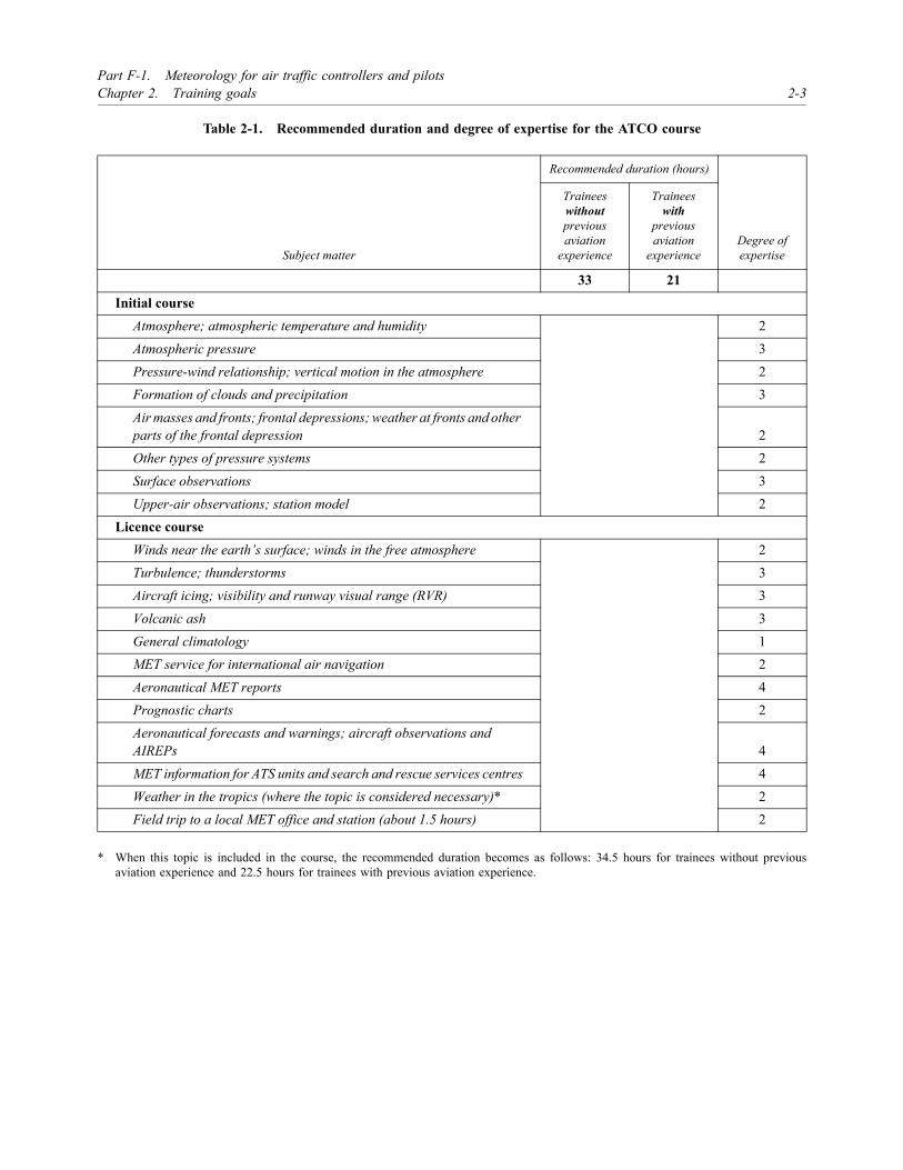
Table 2-1. Recommended duration and degree of expertise for the ATCO course
* When this topic is included in the course, the recommended duration becomes as follows: 34.5 hours for trainees without previousaviation experience and 22.5 hours for trainees with previous aviation experience.
Subject matter
Recommended duration (hours)
Degree ofexpertise
Traineeswithoutpreviousaviation
experience
Traineeswith
previousaviation
experience
33 21 Initial course
Atmosphere; atmospheric temperature and humidity 2Atmospheric pressure 3Pressure-wind relationship; vertical motion in the atmosphere 2Formation of clouds and precipitation 3Air masses and fronts; frontal depressions; weather at fronts and other parts of the frontal depression 2Other types of pressure systems 2Surface observations 3Upper-air observations; station model 2
Licence courseWinds near the earth’s surface; winds in the free atmosphere 2Turbulence; thunderstorms 3Aircraft icing; visibility and runway visual range (RVR) 3Volcanic ash 3General climatology 1MET service for international air navigation 2Aeronautical MET reports 4Prognostic charts 2Aeronautical forecasts and warnings; aircraft observations and AIREPs 4MET information for ATS units and search and rescue services centres 4Weather in the tropics (where the topic is considered necessary)* 2Field trip to a local MET office and station (about 1.5 hours) 2

2-4 Training Manual
Table 2-2. Recommended duration and degree of expertise for the PPL course
* When this topic is included in the course, the recommended duration becomes as follows: 21 hours for trainees without previous aviationexperience and 15 hours for trainees with previous aviation experience.
Subject matter
Recommended duration (hours)
Degree ofexpertise
Traineeswithoutpreviousaviation
experience
Traineeswith
previousaviation
experience
19.5 13.5Atmosphere; atmospheric temperature and humidity 1Atmospheric pressure; pressure-wind relationships 2Vertical motion in the atmosphere 1Formation of clouds and precipitation; visibility and RVR 2Winds near the earth’s surface; turbulence 2Winds in the free atmosphere 1Thunderstorms; aircraft icing 2Air masses and fronts; frontal depressions 1Weather at fronts and other parts of the frontal depression; other types of pressure systems 2Surface observations; station model 2Upper-air observations 1MET service for international air navigation 1Aircraft observations and AIREPs; volcanic ash 2Aeronautical MET reports 3Prognostic charts 2Aeronautical forecasts and warnings; sources of MET information 3Weather in the tropics (where the topic is considered necessary,1.5 hours)* 2Field trip to a local MET office or station (about 1.5 hours) 1

Part F-1. Meteorology for air traffic controllers and pilotsChapter 2. Training goals 2-5
Table 2-3. Recommended duration and degree of expertise for the CPL course
* When this topic is included in the course, the recommended duration becomes as follows: 34.5 hours for trainees without previousaviation experience and 22.5 hours for trainees with previous aviation experience.
Subject matter
Recommended duration (hours)
Degree ofexpertise
Traineeswithoutpreviousaviation
experience
Traineeswith
previousaviation
experience
33 21Atmosphere; atmospheric temperature and humidity 2Atmospheric pressure 3Pressure-wind relationships; winds near the earth’s surface; vertical motion in the atmosphere 2Formation of clouds and precipitation; visibility and RVR 3Winds in the free atmosphere 2Turbulence 3Thunderstorms; aircraft icing 3Air masses and fronts; frontal depressions 2Weather at fronts and other parts of the frontal depression; other types of pressure systems 3Surface observations; station model 2Upper-air observations 1MET service for international air navigation 2Volcanic ash 3General climatology 1Aeronautical MET reports; prognostic charts 3Aeronautical forecasts and warnings; sources of MET information 3Aircraft observations and AIREPs 3Weather in the tropics (where the topic is considered necessary)* 2Field trip to a local MET office or station (about 1.5 hours) 2

2-6 Training Manual
Table 2-4. Recommended duration and degree of expertise for the ATPL course
Subject matter
Recommended duration (hours)
Degree of expertise
Traineeswithoutpreviousaviation
experience
Traineeswith
previousaviation
experience
40.5 25.5Atmosphere; atmospheric temperature and humidity 2Atmospheric pressure 3Pressure-wind relationships; winds near the earth’s surface 2Winds in the free atmosphere; turbulence 3Vertical motion in the atmosphere 2Formation of clouds and precipitation 3Thunderstorms; aircraft icing 3Visibility and RVR; volcanic ash 3Air masses and fronts; frontal depressions 2Weather at fronts and other parts of the frontal depression; other types of pressure systems 3Surface observations 3Upper-air observations; station model 2General climatology; weather in the tropics 2MET service for international air navigation 2Prognostic charts 4Aeronautical MET reports 4Aeronautical forecasts and warnings 4Sources of MET information; aircraft observations and AIREPs 4Field trip to a local MET office or station (about 1.5 hours) 2

Chapter 3
SYLLABI
Note.— The duration (hours) and the degree ofexpertise required for each subject are indicated under“Objective”.
3.1 ATMOSPHERE
3.1.1 Objective — all courses
To outline the composition and structure of the atmosphereand the definition of the international standard atmosphere(ISA).4
[ATCO: 1.0/2 PPL: 0.5/1 CPL: 1.0/2 ATPL: 1.0/2]
3.1.2 Required knowledge and skill
Atmosphere• composition• structure:
— troposphere— tropopause— stratosphere— mesosphere— thermosphere
ISA• purpose of a standard atmosphere• definition• description
3.2 ATMOSPHERIC TEMPERATUREAND HUMIDITY
3.2.1 Objective — all courses
To describe the physical processes related to the transfer ofheat and moisture in the atmosphere; to outline the reasons
for temperature and humidity variations both horizontallyand vertically; and to explain the effect of temperature onthe take-off performance. To indicate the units ofmeasurement for temperature and humidity and relatedconversions.
[ATCO: 1.0/2 PPL: 0.5/1 CPL: 1.0/2 ATPL: 1.0/2]
3.2.2 Required knowledge and skill
Measurement of temperature• units of measurement• conversions
Heat transfer in the atmosphere• mechanisms:
— conduction— convection— advection— radiation
• actual heating of the atmosphere:— short-wave radiation— long-wave radiation— absorption
Temperature at the earth’s surface• definition• standard method of measurement• factors that influence surface temperature• diurnal variation (over land and water)
Atmospheric humidity• variables used:
— measurement
4. Refer also to the Manual of the ICAO Standard Atmosphere(extended to 80 kilometres (262 500 feet)) (Doc 7488).
3-1

3-2 Training Manual
— water vapour content— dew-point temperature— relative humidity
Adiabatic processes• definition• unsaturated air• saturated air
Vertical distribution of temperature (lapse rate)• thermodynamic charts (e.g. tephigrams):
— description— principal uses
• lapse rate• convection• diurnal variations of lapse rate in the lower layers:
— low-level inversions/jets and their effect on take-off performance
• trade-wind inversions
Stability of the atmosphere• definition• stable equilibrium• neutral equilibrium• unstable equilibrium• absolute stability
Effect of temperature on take-off performance
3.3 ATMOSPHERIC PRESSURE
3.3.1 Objective — all courses
To describe horizontal and vertical variations in atmosphericpressure and how pressure distributions are shown on METcharts. To indicate the units of measurement for atmosphericpressure and related conversions. To outline the METaspects relating to altimetry.
[ATCO: 1.0/3 PPL: 1.0/2 CPL: 1.0/3 ATPL: 1.0/3]
3.3.2 Required knowledge and skill
Definition and measurement• definition of pressure• measurement of pressure• units of measurement• conversions
Pressure at sea level• common reference• surface synoptic chart• lines of equal pressure (isobars)• pressure patterns (highs, lows, troughs and ridges)• pressure gradient • surface pressure changes (diurnal and synoptic)
Variation of pressure with height• reduction of pressure to aerodrome and mean sea
level• altimetry:
— pressure altitude, density altitude— height, altitude, flight level— altimeter subscale setting to obtain elevation
when on the ground (QNH), atmospheric press-ure at aerodrome elevation (QFE)
— calculation of terrain clearance, lowest usableflight level, regional QNH
Constant pressure charts• common constant pressure levels and their standard
altitudes• lines of equal height (contours or isohypses) • slope of the constant pressure (isobaric) surface and
its relation to pressure gradient• construction of constant pressure charts
Effect of pressure on take-off performance
Classroom exercise• inspection of actual and forecast charts:
— identification of pressure patterns on surfaceand upper-air charts
— identification of pressure gradients
3.4 PRESSURE-WIND RELATIONSHIPS
3.4.1 Objective — all courses
To identify the physical factors that determine windvelocity. To indicate the units of measurement for wind andrelated conversions.
[ATCO: 1.0/2 PPL: 0.5/2 CPL: 1.0/2 ATPL: 1.5/2]
3.4.2 Required knowledge and skill
Definitions and measurement of wind• definitions:
— wind

Part F-1. Meteorology for air traffic controllers and pilotsChapter 3. Syllabi 3-3
— wind direction (magnetic and true)— wind speed— wind velocity— wind shear— veering— backing
• units of measurement• conversions• methods of measuring wind velocity
Horizontal forces acting on the air• pressure gradient force• Coriolis force• centripetal force• surface friction
Geostrophic wind (including Buys-Ballot Law)
3.5 WIND IN THE FREE ATMOSPHERE
3.5.1 Objective
PPL
To recognize and interpret the wind and temperature fieldson upper air charts. To outline the characteristics of jetstreams.
ATCO, CPL
To recognize and interpret the wind and temperature fieldson upper air charts. To outline the characteristics of jetstreams and their impact on flights.
ATPL
To recognize and interpret the wind and temperature fieldson upper air charts. To describe jet streams and their impacton flights.
[ATCO: 1.5/2 PPL: 0.5/1 CPL: 1.5/2 ATPL: 1.5/3]
3.5.2 Required knowledge and skill
Relationship between wind and isobars/contours• geostrophic approximation:
— northern hemisphere— southern hemisphere
Behaviour of the wind with increasing height including jetstreams
• thermal wind concept:— relationship between temperature distribution
and upper winds• jet streams:
— definition— cause— major areas and orientation— maximum wind speeds— cross-section of a typical jet stream— low-level jet streams and associated wind shear— impact on flights
Classroom exercise• inspection of jet streams at upper air charts• interpretation of tropopause and maximum wind
charts
3.6 WINDS NEAR THEEARTH’S SURFACE
3.6.1 Objective — all courses
To explain the principal reasons why surface winds deviatefrom those expected from surface pressure distribution. Todescribe various local winds systems.
[ATCO: 1.0/2 PPL: 0.5/2 CPL: 1.0/2 ATPL: 1.5/2]
3.6.2 Required knowledge and skill
Effects of surface friction• gusts:
— winds reported averaged over two or tenminutes
• squalls• diurnal variations in wind• topographical effects
Local wind systems• anabatic and katabatic winds• land and sea breezes• chinook (foehn) winds
Effect of surface wind on take-off and landing• selection of runway:
— crosswind, tailwind limits

3-4 Training Manual
3.7 TURBULENCE
3.7.1 Objective
PPL
To outline the basic characteristics of atmosphericturbulence and its effect on aircraft operations. To addressmethods and criteria for observing and reporting turbu-lence. To describe mountain waves and rotors and theireffect on aircraft operations.
ATCO, CPL, ATPL
To describe the characteristics of various types ofatmospheric turbulence and its effect on aircraft operations.To outline methods and criteria for observing and reportingturbulence. To describe mountain waves and rotors andtheir effect on aircraft operations.
[ATCO: 1.5/3 PPL: 1.0/2 CPL: 1.5/3 ATPL: 1.5/3]
3.7.2 Required knowledge and skill
Types of atmospheric turbulence
Clear air turbulence (CAT)• occurrence• role of jet streams• aircraft response• ICAO criteria for reporting turbulence (both in
manual and automated air-reports):— nil— light— moderate— severe
Impact of turbulence on flight operations
Technologies for turbulence detection and warning
Mountain waves (rotors)• occurrence• cloud types associated with mountain waves• ICAO criteria for reporting mountain waves:
— moderate— severe
• impact on flight operations
Wake turbulence
3.8 VERTICAL MOTION INTHE ATMOSPHERE
3.8.1 Objective — all courses
To identify the causes of vertical motion and outline ingeneral terms its influence on aircraft operations.
[ATCO: 0.5/2 PPL: 0.5/1 CPL: 0.5/2 ATPL: 1.0/2]
3.8.2 Required knowledge and skill
Localized vertical motion• produced by:
— topography— convection
Widespread vertical motion• role of convergence/divergence• role of stability
3.9 FORMATION OF CLOUDSAND PRECIPITATION
3.9.1 Objective — all courses
To describe the processes involved in the formation ofclouds and precipitation and classify clouds.
[ATCO: 1.0/2 PPL: 0.5/2 CPL: 1.5/3 ATPL: 2.0/3]
3.9.2 Required knowledge and skill
Processes involved• condensation and related warming due to latent heat
release • evaporation and related cooling due to latent heat
stored• sublimation• cloud constituents:
— water droplets— ice crystals— supercooled water droplets
• cloud formation:— adequate moisture content— cooling by conduction, radiation and adiabatic
ascent— adiabatic ascent predominant
• precipitation

Part F-1. Meteorology for air traffic controllers and pilotsChapter 3. Syllabi 3-5
Role of upward motion in the formation of cloudsand precipitation
• turbulence:— stratus/stratocumulus clouds
• convection:— fair-weather cumulus— cumulonimbus and associated showers
• orographic ascent:— orographic clouds and associated precipitation
• slow, widespread (frontal) ascent:— layer clouds and associated continuous precipi-
tation
Classification of clouds• low clouds (stratus, stratocumulus)• medium-level clouds (altostratus, nimbostratus,
alto-cumulus)• high-level clouds (cirrus, cirrostratus, cirrocumulus)• convective clouds (cumulus, cumulonimbus)• subdivided into species based upon their:
— form— structure— physical formation process— examples (lenticularis, castellanus, fractus,
congestus)
Formation of various types of precipitation (includingassociated cloud type)
• drizzle (including freezing drizzle)• rain (including freezing rain)• snow (including blowing snow)• snow grains• ice pellets• ice crystals• hail• small hail and snow pellets
Intensity of precipitation (for aeronautical purposes)• light• moderate• heavy
Effect on aerodrome operations• height of cloud base:
— part of aerodrome operating minima• effect of precipitation on runway surface:
— liquid, freezing precipitation, snow (includingslush)icing
• information on the state of runway surface:— SNOWTAM (role and dissemination)— runway state group (in aviation routine weather
reports (METARs)/aviation selected specialweather reports (SPECIs))
3.10 THUNDERSTORMS
3.10.1 Objective
PPL
To outline the characteristics and types of thunderstormsand their effects on surface weather and flight conditions.To explain the requirement for the avoidance of flight inthunderstorms.
ATCO, CPL, ATPL
To explain the characteristics, types and development stagesof thunderstorms and associated phenomena, such as windshear, and their effects on surface weather and flightconditions. To explain the requirement for the avoidance offlight in thunderstorms.
[ATCO: 1.5/3 PPL: 1.0/2 CPL: 1.5/3 ATPL: 1.5/3]
3.10.2 Required knowledge and skill
Conditions for formation• deep layer of unstable air• high relative humidity• mechanism to initiate the uplift of the air:
— convection— wind and orography— convergence in frontal and non-frontal
depressions
Types• air mass thunderstorms• severe thunderstorms:
— gust front and microburst— supercell storm— squall line
Development stages• cumulus stage• mature stage• dissipating stage
Characteristics• vertical extent• circulation within the cloud• precipitation within the cloud
Funnel cloud (tornado or waterspout)
Surface weather associated with thunderstorms• gusty, turbulent winds:
— wind shifts

3-6 Training Manual
• wind shear (including gust fronts and dry and wetmicrobursts)
• heavy precipitation (rain and/or hail)• changes in temperature and pressure• lightning
Effects on aircraft operations• aircraft operations in thunderstorms should be
avoided:— often impossible to get above or around the
storm due to its great extent— severe turbulence (also above the storm)— severe icing
• aircraft take-off and landing affected by:— gusty, turbulent winds— wind shear (including gust fronts and micro-
bursts)— reduced visibility due to heavy precipitation or
hail• effects of lightning on:
— airframe— compass and radio communications
Detection• use of radar systems:
— airborne weather radar— ground-based radar— Doppler radar to detect wind shear
• use of satellite imagery• use of lightning detection systems
Classroom exercise• interpretation of processed ground-based radar data• inspection of satellite images with cumulonimbus
clouds and thunderstorms
3.11 AIRCRAFT ICING
3.11.1 Objective
PPL
To enumerate the factors that cause icing and to identify theproblems associated with different types of aircraft icing.To describe criteria for reporting icing. To outline theoperation of various icing protection systems.
ATCO, CPL, ATPL
To describe the factors that cause icing and the problemsassociated with different types of aircraft icing. To describe
criteria for reporting icing. To outline the operation ofvarious icing protection systems.
[ATCO: 1.5/3 PPL: 1.0/2 CPL: 1.5/3 ATPL: 1.5/3]
3.11.2 Required knowledge and skill
Definitions• static air temperature• total air temperature• sublimation (of water vapour)• freezing (of supercooled water droplets):
— predominant process for formation
Occurrence• in clouds• in freezing precipitation• in temperatures above 0°C:
— cold-soak effect
Factors affecting the intensity of icing• temperature• humidity• cloud liquid water content• drop-size distribution• aircraft type and speed
Forms of icing• hoar-frost• rime ice• clear ice• mixed ice
Icing intensity • in various cloud types• ICAO criteria for reporting icing:
— light— moderate— severe
Operational problems associated with icing• reduced aerodynamic, propeller and engine
efficiency:— loss of aircraft performance
• impaired controllability due to contaminatedaerofoil and asymmetric deposition of ice
• impaired cockpit vision• air data instrument error• loss of performance due to increased mass• damage to airframe and engines• strategies to minimize the effect of icing on flight
operations

Part F-1. Meteorology for air traffic controllers and pilotsChapter 3. Syllabi 3-7
Common forms of ice protection• heating• pneumatic de-icer boots• de-icing and anti-icing sprays:
— type I fluid— type II fluid— inspection— hold-over/endurance times
3.12 VISIBILITY AND RVR
3.12.1 Objective — all courses
To define visibility and RVR. To describe the processes andconditions that result in significant visibility reduction. Toaddress the MET components of aerodrome operatingminima.
[ATCO: 1.5/3 PPL: 1.0/2 CPL: 1.5/3 ATPL: 1.5/3]
3.12.2 Required knowledge and skill
Types of visibility used in aviation• visibility:
— definition— minimum and prevailing visibility— observation— reporting
• RVR:— definition— use— assessment— units, conversions— reporting
• slant visual range (SVR)• vertical visibility
MET components of aerodrome operating minima • visibility, RVR• height of cloud base, vertical visibility
Causes of reduced visibility• fog and mist• haze• smoke• sand and dust (widespread)• volcanic ash• precipitation• sunrise/sunset effect:
— not accounted for in MET visibilitymeasurements
Fog types• radiation fog• advection fog• upslope fog• steaming fog• frontal fog
3.13 VOLCANIC ASH
3.13.1 Objective
PPL
To identify the problems caused by volcanic ash. Todescribe warnings for volcanic ash.
ATCO, CPL, ATPL
To identify the problems caused by volcanic ash. Todescribe the ICAO international airways volcano watch(IAVW), warnings for volcanic ash and observations andreports on volcanic activity.
[ATCO: 1.0/3 PPL: 0.5/2 CPL: 1.0/3 ATPL: 1.5/3]
3.13.2 Required knowledge and skill
Volcanic ash and flight operations• impact on flight operations (requirement for
avoidance to be emphasized):— engines— airframe— instruments, radio communications— en route— at aerodromes
• detection• reporting of volcanic ash including colour code
ICAO IAVW• observation component• notice to airmen (NOTAM), ASHTAM• volcanic ash advisory centres (VAACs):
— forecasting movement of volcanic ash clouds• volcanic ash advisories issued• information concerning en-route weather phenomena
which may affect the safety of aircraft operations(SIGMET) information on volcanic ash clouds
Classroom exercise• inspection of reports, warnings, advisories and
products in graphical form relating to volcanic ash

3-8 Training Manual
3.14 AIR MASSESAND FRONTS
3.14.1 Objective — all courses
To describe air masses, their transition zones and thegeneral weather characteristics associated with each type.
[ATCO: 0.5/2 PPL: 0.5/1 CPL: 0.5/2 ATPL: 0.5/2]
3.14.2 Required knowledge and skill
Concept of air masses• troposphere can be divided into air masses:
— with different characteristics— do not readily mix— separated by narrow transition zones, fronts
• definition of an air mass• air masses:
— source regions
Classification of air masses• main air masses (arctic, polar, tropical)• transition zones:
— arctic front— polar front— intertropical convergence zone (ITCZ)— Mediterranean front
• subdivisions of air masses on basis of moisturecontent:— continental— maritime
• classification:— maritime tropical— continental tropical— maritime polar— continental polar— maritime arctic— continental arctic
Characteristics of air masses• initial characteristics• air mass modification
General properties of fronts• definitions• slope• wind shift• movement
3.15 FRONTAL DEPRESSIONS
3.15.1 Objective — all courses
To describe the formation and life cycle of a frontaldepression.
[ATCO: 0.5/2 PPL: 0.5/1 CPL: 0.5/2 ATPL: 0.5/2]
3.15.2 Required knowledge and skill
Frontal depressions• formation• life cycle• characteristics• families of frontal depressions
3.16 WEATHER AT FRONTS AND AT OTHER PARTS OF
THE FRONTAL DEPRESSION
3.16.1 Objective — all courses
To outline the surface weather and flying problemsassociated with fronts and other parts of the frontaldepression.
[ATCO: 1.5/2 PPL: 1.0/2 CPL: 1.5/3 ATPL: 1.5/3]
3.16.2 Required knowledge and skill
Warm front• structure• factors determining weather at warm fronts• surface weather changes• flight problems associated with warm fronts
Cold front• structure• factors determining weather at cold fronts• surface weather changes• flight problems associated with cold fronts
Occluded front• structure• factors determining weather at occluded fronts• surface weather changes• flight problems associated with occluded fronts

Part F-1. Meteorology for air traffic controllers and pilotsChapter 3. Syllabi 3-9
Stationary front• structure• factors determining weather at stationary fronts• surface weather changes• flight problems associated with stationary fronts
Other parts of the frontal depression• warm sector characteristics• cold air mass characteristics• upper fronts characteristics:
— associated weather conditions
3.17 OTHER TYPES OF PRESSURE SYSTEMS
3.17.1 Objective — all courses
To describe the weather characteristics of depressions notassociated with polar/arctic fronts or anticyclones.
[ATCO: 0.5/2 PPL: 0.5/2 CPL: 0.5/3 ATPL: 0.5/3]
3.17.2 Required knowledge and skill
Non-frontal depressions• thermal depressions• orographic depressions• secondary depressions• tropical cyclones (see also 3.22)• troughs of low pressure (without fronts)
Anticyclones• description• general properties• types• ridge of high pressure• col
3.18 SURFACE OBSERVATIONS
3.18.1 Objective — all courses
To identify types of surface observations. To address thesurface observations and measurements at aerodromes.
[ATCO: 1.0/3 PPL: 0.5/2 CPL: 1.0/2 ATPL: 1.5/3]
3.18.2 Required knowledge and skill
Requirements for aviation• routine and special observations
Elements of observations at aerodromes• wind direction• wind speed• visibility• RVR• present weather• cloud• air temperature• dew-point temperature• pressure• supplementary information• differences filed by States
Automated weather observing system (AWOS)• current limitations and related issues
Synoptic stations• land and maritime stations
Ground-based radar observations• principles of cloud and precipitation detection• interpretation of radar observations
3.19 UPPER-AIR OBSERVATIONS
3.19.1 Objective — all courses
To outline the methods of making upper-air observationsand the elements that are routinely measured.
[ATCO: 0.5/2 PPL: 0.5/1 CPL: 0.5/1 ATPL: 0.5/2]
3.19.2 Required knowledge and skill
Upper-wind and upper-air temperature observations• radiosondes:
— pressure, temperature, humidity (by radiosonde)— wind finding (by radar, radio or navigation aid)
• pilot balloons

3-10 Training Manual
Aircraft observations and reports (AIREPs)• AIREPs and special AIREPs:5
— routine AIREPs— special AIREPs— other non-routine observations
• aircraft observations for MET purposes (aircraftcommunications addressing and reporting system(ACARS), aircraft-to-satellite data relay (ASDAR),aircraft MET data acquisition and relay (AMDAR))
Observations from MET satellites• types of MET satellites• types of satellite images and their interpretation• parameters measured
3.20 STATION MODEL
3.20.1 Objective — all courses
To describe the basics of plotting surface and upper-airsynoptic charts.
[ATCO: 1.0/2 PPL: 0.5/2 CPL: 1.0/2 ATPL: 1.0/2]
3.20.2 Required knowledge and skill
Collecting observations• observations made at fixed times• need for weather analysis and forecasting:
— limited value of a single observation• analysis done by computers for the entire earth:
— available to States and operators in digital orchart form
Presentation of surface observations on charts• parameters reported (in SYNOPs)• station model
Presentation of upper-air observations on charts• parameters reported (in TEMPs (upper-level press-
ure, temperature, humidity and wind report from afixed land station))
• station model for upper-air charts
Classroom exercise• interpretation of weather observations plotted in
standard format on synoptic charts
3.21 GENERAL CLIMATOLOGY
Note.— No lectures on this topic in the PPL course.
3.21.1 Objective
ATCO, CPL, ATPL
To describe the general circulation, associated wind,pressure and weather patterns in regions for which thetrainees may assume responsibilities.
[ATCO: 1.0/1 PPL: N/A CPL: 1.0/1 ATPL: 1.5/2]
3.21.2 Required knowledge and skill
Idealized general circulation• assumption of uniform surface of the earth• variation of heating with latitude• circulation to transfer heat from the equator to the
poles:— to maintain average global temperature
• modification of circulation due to the earth’s rotation• resultant pressure distribution and air circulation:
— horizontal cross-sections— vertical cross-sections
• identification of prevailing winds, pressure systems,fronts and tropopause
Distribution of weather elements• global temperatures:
— surface temperature— upper-air temperature
• global pressure patterns• global circulation:
— surface wind systems— upper winds
• global cloudiness and precipitation:— occurrence of thunderstorms— occurrence of fog— occurrence of duststorms/sandstorms
5. Also to be addressed under 3.27.

Part F-1. Meteorology for air traffic controllers and pilotsChapter 3. Syllabi 3-11
Climatic classification• Köppen’s classification• general characteristics of:
— polar climates (E)— moist mid-latitude climates with severe
winters (D)— moist mid-latitude climates with mild
winters (C)— dry climates (B)— tropical moist climates (A)
Aeronautical climatological information
3.22 WEATHER IN THE TROPICS
Note.— Except for the ATPL course, this section is to begiven only in selected courses, where the subject isapplicable.
3.22.1 Objective
ATPL (ATCO, PPL, CPL, where applicable)
To identify the significant features of the weather in theTropics. To analyse tropical cyclones and to describe theoperation of tropical cyclone advisory centres (TCACs).
[ATCO: 1.5/2 PPL: 1.0/2 CPL: 1.0/2 ATPL: 1.5/2]
3.22.2 Required knowledge and skill
General weather features• small temperature contrasts (no frontal depressions):
— precipitation and wind systems as the mainchanging weather elements
• dry weather associated with subtropical anticyclones• widespread precipitation (thunderstorms) associated
with:— active portions of ITCZ— easterly waves— tropical cyclones— monsoons
• factors to be considered:— diurnal effects— seasonal effects— orographic effects
Easterly waves
Tropical cyclones• classification• structure• occurrence of tropical cyclones:
— regions exposed— seasons
• impact on flight operations
TCACs6
• forecasting movement, central pressure andmaximum wind of tropical cyclones
• tropical cyclone advisories issued• SIGMET information for tropical cyclones
3.23 MET SERVICE FORINTERNATIONAL AIR NAVIGATION
3.23.1 Objective — all courses
To outline the organization of aeronautical MET servicesestablished for the provision of MET service for inter-national air navigation.
[ATCO: 1.0/2 PPL: 0.5/1 CPL: 1.0/2 ATPL: 1.5/2]
3.23.2 Required knowledge and skill
Role of international organizations• role of the World Meteorological Organization
(WMO):— international standards (technical regulations)
related to basic MET data:• observations• telecommunications • data processing
• role of ICAO:— international Standards and Recommended Prac-
tices related to aeronautical meteorology— main components:
• world area forecast system (WAFS) IAVW• tropical cyclone warning system• MET offices• meteorological watch offices (MWOs)
aeronautical MET stations
6. Also to be addressed under 3.23.

3-12 Training Manual
WAFS• centralization of en-route forecasting at two world
area forecast centres (WAFCs) in the final phase ofthe system:— WAFC London— WAFC Washington
• role of WAFCs• products and data issued• means of communication used• institutional issues:
authorized access
IAVW and tropical cyclone warning system• centralization of services concerning volcanic ash
and tropical cyclones:— nine VAACs of IAVW— seven TCACs
• role of VAACs and TCACs• advisory information issued
Organization of aeronautical MET services within States• role of the MET authority• (aerodrome) MET office:
— role — products and services provided:
• aerodrome, take-off and landing forecasts(TAF, trend forecasts) aerodrome warningsand wind shear warnings
• reliance on WAFS for en-route informationfor flight planning and flight documentation
• issuance of en-route forecasts for low-levelflights
• briefing and consultation• display of MET information
• MWO:— role (in particular, in relation to FIRs)— products and services provided:
• maintain watch over en-route weather• SIGMET (and AIRMET) information for
the en-route phase• aeronautical meteorology station:
— role— products issued:
• routine and special reports (METAR, METREPORT, SPECI, SPECIAL)
• responsibilities assigned to States:— provide in accordance with ICAO requirements
MET service in the State concerned— designate the MET authority— reference to aeronautical publications, identi-
fying relevant chapters:• Annex 3 — Meteorological Service for
International Air Navigation7
• Manual of Aeronautical MeteorologicalPractice (Doc 8896)
• air navigation plans (ANPs/Facilities andServices Implementation Document(FASID), Part VI — Meteorology)
• States’ aeronautical information publi-cations (AIPs)
Exchange of MET information• detailed exchange requirements included in the
ICAO ANPs:— role of meteorology tables
• satellite broadcasts:— satellite distribution system for information
relating to air navigation (SADIS)— international satellite communications system
(ISCS)• aeronautical fixed telecommunication network
(AFTN):— Meteorological Operational Telecommunications
Network Europe (MOTNE)— AFI MET bulletin exchange (AMBEX) scheme— regional operational meteorological information
(OPMET) bulletin exchange (ROBEX) scheme• WMO global telecommunication system (GTS)
3.24 AERONAUTICALMET REPORTS
3.24.1 Objective — all courses
To identify aeronautical MET reports and describe theirdecoding and interpretation.
[ATCO: 2.5/4 PPL: 1.5/3 CPL: 2.0/3 ATPL: 3.0/4]
3.24.2 Required knowledge and skill
Types of reports• routine reports (MET REPORT, METAR)• special reports (SPECIAL, SPECI)
7. Identical to the WMO Technical Regulations (C.3.1).

Part F-1. Meteorology for air traffic controllers and pilotsChapter 3. Syllabi 3-13
Routine reports• reporting times:
— reasons for greater frequency than for synopticobservations
• issued in two forms:— coded (routine report in the METAR code form
(METAR))— disseminated beyond the aerodrome— abbreviated plain language (local routine report
(MET REPORT))— disseminated locally at the aerodrome
• METAR code: — format— abbreviations and terminology— use of CAVOK— may be supplemented by trend forecast— may be supplemented by runway state groups
(European (EUR) and North Atlantic (NAT)Regions)
• MET REPORT:— format— abbreviations and terminology— differences between METAR and MET REPORT
Special reports• criteria• issued in two forms:
— coded (special report in the SPECI code form),disseminated beyond the aerodrome
— abbreviated plain language (local special report(SPECIAL)), disseminated locally at the aero-drome
• SPECI code:— format similar to METAR
• SPECIAL:— format similar to MET REPORT
Use of reports in ATSs• automatic terminal information service (ATIS) (in
ATIS broadcasts and data link automatic terminalinformation service (D-ATIS))
• meteorological information for aircraft in flight(VOLMET) (in VOLMET broadcasts andVOLMET data link service (D-VOLMET))
Classroom exercise• decoding of routine and special reports (coded and
in abbreviated plain language)• analysing a series of reports from the same station:
— observe trend in weather— estimate frontal passage
• analysing a sequence of simultaneous reports foradjacent stations to identify the air masses involvedand the location of fronts
• analysing a series of sequences of simultaneousreports to forecast conditions at specific stations
3.25 PROGNOSTIC CHARTS
3.25.1 Objective — all courses
To outline methods used for the preparation of prognosticcharts. To describe aeronautical prognostic charts.
[ATCO: 0.5/2 PPL: 0.5/2 CPL: 1.0/3 ATPL: 1.5/4]
3.25.2 Required knowledge and skill
Methods of preparing prognostic charts• mostly numerical methods (computer models)• subjective methods:
— decreasing use— in aeronautical meteorology: preparation of sig-
nificant weather (SIGWX) charts
Aeronautical prognostic charts• prepared and issued as part of the WAFS by:
— WAFC London— WAFC Washington
• upper-wind and upper-air temperature charts• SIGWX charts:
— depiction of SIGWX phenomena• for flights below FL 100:
— charts prepared locally by the MET office
WAFS grid point forecasts in digital form• contain upper-wind and upper-air temperature fore-
casts in the GRIB code• provided by WAFC London and Washington for:
— computer flight planning— issuance of upper-wind and upper-air tempera-
ture charts at MET offices
Classroom exercise• examination and interpretation of aeronautical prog-
nostic charts
3.26 AERONAUTICAL FORECASTSAND WARNINGS
3.26.1 Objective — all courses
To identify and interpret aeronautical weather forecasts andwarnings.
[ATCO: 2.0/4 PPL: 1.0/3 CPL: 2.0/3 ATPL: 3.0/4]

3-14 Training Manual
3.26.2 Required knowledge and skill
Take-off forecasts• required to plan maximum permissible take-off mass• parameters included• formats established by local arrangement• required to ensure compliance with operating
minima
En-route forecasts for pre-flight planning• required for flight planning at least three hours
before estimated time of departure (ETD)• basic requirements:
— upper-wind and upper-air temperatures— significant en-route weather— valid for time and route of flight
• methods of meeting the requirements:— fixed time WAFS prognostic charts
• upper-wind and upper-air temperature charts:— WAFS grid point forecasts in digital format
(GRIB code)• SIGWX charts• SIGMET information:
— in particular those related to tropical cyclonesand volcanic ash
• specific issues related to extended range operationsby twin-engined aeroplanes (ETOPS)
• GAMET (area forecast for low-level flights)
Forecasts for landing at destination/alternate• trend-type landing forecast:
— METAR or SPECI followed by a two-hourtrend forecast
— change indicators in the trend forecast• aerodrome forecast (TAF):
— TAF code format
Warnings• SIGMET/AIRMET information:
— en route— criteria for issuance— role of SIGMET information related to tropical
cyclones and volcanic ash— format
• aerodrome warnings:— terminal area— content
• wind shear warnings:— terminal area— format
• wake turbulence
Classroom exercise• examination of charts and forecasts used for flight
planning and included in flight documentation
• practice in decoding and interpretation of aerodromeand trend-type landing forecasts
• practice in reading of aerodrome and wind shearwarnings
3.27 AIRCRAFT OBSERVATIONSAND AIREPs
3.27.1 Objective
PPL
To outline the purpose of air-reporting. To identify therequirement for special air-reports, describing their formatand criteria to be applied.
ATCO, CPL, ATPL
To outline the purpose and modes of air-reporting. Toidentify the requirement for air-reporting, reporting pro-cedures, format, content, criteria and dissemination patternof various types of air-reports.
[ATCO: 1.0/4 PPL: 0.5/2 CPL: 1.5/3 ATPL: 2.0/4]
3.27.2 Required knowledge and skill
Purpose of aircraft observations and reports• identifying conditions affecting the safety and
efficiency of flight operations• supplementing upper-air observations to contribute
to the quality of WAFS forecasts
Types of aircraft observations and AIREPs• routine AIREPs• special AIREPs• other non-routine aircraft observations and reports
Modes of aircraft observations and reports• automatic by data link• manual by voice communications
Routine AIREP• routine AIREP by data link:
— preferred mode— elements:
• wind direction and speed• temperature• turbulence (if available)

Part F-1. Meteorology for air traffic controllers and pilotsChapter 3. Syllabi 3-15
• humidity (if available)— frequency of reporting:
• 15 minutes en route• 30 seconds in the climb-out phase for the
first 10 minutes of flight— data link systems used:
• automatic dependent surveillance (ADS)report with MET information data block
• controller pilot data link communications(CPDLC) application “position report”
— dissemination:• to WAFC London, Washington• fully automated
• routine AIREP by voice communications:— where air-ground data link is not available— elements observed by pilots:
• temperature• wind direction and speed• turbulence• aircraft icing• humidity (if available):
— detailed instructions on reporting in Ap-pendix 1 to the PANS-ATM (Doc 4444)
• reporting at designated ATS/MET reportingpoints
• dissemination:— to the associated MWO
Special AIREP• observations made at all flight phases• reported by voice communications or semi-
automatically through suitable data link applications• criteria for reporting identical to those for SIGMET
information• dissemination:
— to the associated MWO• action by the ATS units concerned:
— supply the special AIREP received to aircraftin-flight until relevant SIGMET is issued byMWO
Other non-routine aircraft observations and reports• pilot reports MET conditions affecting the safety
and efficiency of flights which are not subject tospecial AIREPs
Classroom exercise• interpret examples of routine AIREPs (to be
reported by voice communication)• interpret examples of special AIREPs (to be
reported by voice communication)• inspect the current list of ATS/MET reporting
points
3.28 SOURCES OF MET INFORMATION
Note.— Applicable for PPL, CPL and ATPL coursesonly.
3.28.1 Objective
PPL, CPL and ATPL
To specify the sources of MET information for pre-flightplanning. To describe the requirement for timely notifi-cations before the flight. To outline the methods used forthe provision of VOLMET.
[ATCO: N/A PPL: 0.5/3 CPL: 1.0/3 ATPL: 1.0/4]
3.28.2 Required knowledge and skill
Sources of MET information for pre-flight planning• local MET office• automated systems:
— established by the MET authority— accessible through dedicated or public communi-
cations and information systems• aeronautical information service/meteorology
(AIS/MET) pre-flight planning packages• published by the MET authority, included in the
AIP
Adequate notification required from pilots and operators toMET offices
• scheduled and non-scheduled flights• new routes and special services
Sources of MET information in flight• ATS units concerned• VOLMET, ATIS• non-routine requests to be addressed to ATS units
concerned
Classroom exercise• familiarization with the services available in the
State concerned

3-16 Training Manual
3.29 MET INFORMATION FOR ATS UNITS AND SEARCH AND RESCUE SERVICES CENTRES
Note.— Applicable for the ATCO course only.
3.29.1 Objective
ATCO
To outline MET information to be supplied to ATS unitsand search and rescue centres. To analyse various aspects ofATS/MET coordination.
[ATCO: 1.5/3 PPL: N/A CPL: N/A ATPL: N/A]
3.29.2 Required knowledge and skill
Requirements• relating to:
— aerodrome control tower (TWR)— approach control office (APP)— flight information centre (FIC) or area control
centre (ACC) — rescue coordination centres
• format of information• use of communications:
— minimum requirements for direct speechcommunications
— minimum requirements for printed communi-cations
Designated MET offices to ATS units• role and functions
Displays of MET instruments at ATS units• requirements for TWR• use of AWOS displays at TWR, APP
Observing and reporting of MET information by ATS units• ad hoc visual MET observations by ATS personnel:
— to be transmitted to MET stations or offices
ATS/MET coordination• Letter of Agreement:
— between the ATS and MET authorities— detailed local agreements
Role of the ATS authority in establishing certain criteria forMET information
• called for in Annexes 3, 11 and the PANS-ATM(Doc 4444)
• applicable to:— criteria for special observations at aerodromes— requirement for routine observations at aero-
dromes— displays of MET instruments at TWR— ATS/MET reporting points, etc.
3.30 FIELD TRIP TO LOCALMET OFFICE OR STATION
3.30.1 Objective — all courses
To outline the services and products provided to aviation bya MET office and/or an aeronautical MET station.
[ATCO: 1.5/2 PPL: 1.0/1 CPL: 1.5/2 ATPL: 1.5/2]
3.30.2 Required knowledge and skill
Introduction• visit to the local (aerodrome) MET office• division into small groups• allocation of assignments to the MET staff during
the visit• copies of reports, charts and other flight documen-
tation to be given to trainees
Objectives of the visit• see the equipment and methods used to make obser-
vations• witness the issuance of METAR/SPECI reports• see the communications equipment• see examples of reports from other aeronautical
MET stations• see examples of preparation of flight documentation• witness preparation of surface charts and issuance
of aerodrome and landing forecasts• see briefing facilities and witness briefing and de-
briefing of crews• gain insight into the role of the local MET office in
the global context• discuss typical local weather conditions
— END —

© ICAO 200212/02, E/P1/2000
Order No. 7192F1Printed in ICAO