Embed Size (px)
Citation preview
T
T
National Trails Intermountain Region News October 2015
National Park Service US Department of the Interior
Trail of Tears National Historic Trail Project Updates - Protection Development and Promotion
Interpretation Update
Geography affects our daily lives The landscape determines the locations of our homes and travel routes During Cherokee removal most of the infrastructure of today did not exist The Cherokees faced striking challenges navigating around the rivers and swamps that dominated southeastern Missouri at that time
The Benge Detachment left northeastern Alabama and worked its way north and west to Iron Banks at Columbus Kentucky Ferrying all 1100 Cherokees 60 wagons and 600 horses across the Mississippi River took several days Even though no first-hand account of the Benge Detachment journey has been found
Route of Benge Detachment in southeastern Missouri
The Geography of Removal
Missouri State Parks National Park ServiceBelmont State Historic Site rail of Tears National Historic Trail
1844
This Hutawa Sectional Map of Missouri shows the correct route from Baldwinsville (Belmont) to Bickwiths (OrsquoBryanrsquos Landing) The route contined to Matthewrsquos Prairie (Charleston) passing Fish Lake to Cypress
1839
From OrsquoBryanrsquos landing a lsquostate roadrsquo shown on this map by David Burr extended from Baldwinsville (Belmont) to Matthews Prairie (Charleston) and on to Fish Lake It crossed the Northcutt Swamp at Cypress and continued on to Benton where it turned north
1844
US Topographical Engineer Walter B Guionrsquos Map of the New Madrid and St Francis River Swamp in the States of Missouri and Arkansas was based on a 1836 survey shows Wolf Island and Fish Lake While it does not identify Baldwinsville (Belmont) it does clearly show how the swamps obstructed travel
Due to the swampy terrain of southern Missouri most detachments crossed the river further north above Cape Girardeau
1845 (background map)
This manuscript map drawn by Thomas S Walker shows Iron Banks (Columbus) Kentucky and Baldwinsville (Belmont)
Mapping Removal
Missouri State Archives
period journals and maps illustrate the safe paths they followed such as the sandy road along the natural levee between Belmont (Baldwinsville) and OrsquoBryanrsquos Landing (Bickwiths) as well as the dangers and difficulties they faced such as the Great Swamp
After crossing the Great Swamp below Cape Girardeau on a causeway the Benge Detachment arrived in Jackson on November 28 1838 They next turned southwest and traveled through Old Greenville crossing the St Francis and Current rivers into Arkansas Indian Territory todayrsquos Oklahoma was still nearly 500 challenging miles away
o Matthewrsquos Prairie Fish Lake and Cypress
MISSOURI
ILLINOIS
Nort h
Fish Lake
Swamp
Fish Lake
Baldwinsville Matthewrsquos Prairie
Fish LakeCypress
Matthewrsquos Prairie
Baldwinsville
Bickwiths
Cre
dit
Cou
rtes
y of
The
Birm
ingh
am P
ublic
Lib
rary
Cre
dit
Cape Girardeau
Three additional Cherokee detachments passed by here on the water route
Columbus Kentucky
Iron Banks
Baldwinsville Missouri
Bickwiths
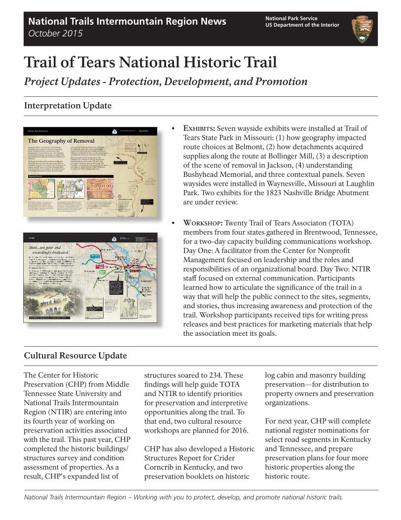
bull Exhibits Seven wayside exhibits were installed at Trail of Tears State Park in Missouri (1) how geography impacted route choices at Belmont (2) how detachments acquired supplies along the route at Bollinger Mill (3) a description of the scene of removal in Jackson (4) understanding Bushyhead Memorial and three contextual panels Seven waysides were installed in Waynesville Missouri at Laughlin Park Two exhibits for the 1823 Nashville Bridge Abutment are under review
bull Workshop Twenty Trail of Tears Associaton (TOTA) members from four states gathered in Brentwood Tennessee for a two-day capacity building communications workshop Day One A facilitator from the Center for Nonprofit Management focused on leadership and the roles and responsibilities of an organizational board Day Two NTIR staff focused on external communication Participants learned how to articulate the significance of the trail in a way that will help the public connect to the sites segments and stories thus increasing awareness and protection of the trail Workshop participants received tips for writing press releases and best practices for marketing materials that help the association meet its goals
Cultural Resource Update
The Center for Historic Preservation (CHP) from Middle Tennessee State University and National Trails Intermountain Region (NTIR) are entering into its fourth year of working on preservation activities associated with the trail This past year CHP completed the historic buildings structures survey and condition assessment of properties As a result CHPrsquos expanded list of
structures soared to 234 These findings will help guide TOTA and NTIR to identify priorities for preservation and interpretive opportunities along the trail To that end two cultural resource workshops are planned for 2016
CHP has also developed a Historic Structures Report for Crider Corncrib in Kentucky and two preservation booklets on historic
log cabin and masonry building preservationmdashfor distribution to property owners and preservation organizations
For next year CHP will complete national register nominations for select road segments in Kentucky and Tennessee and prepare preservation plans for four more historic properties along the historic route
National Trails Intermountain Region ndash Working with you to protect develop and promote national historic trails
Staff News Design amp Development Projects
bull Fort Armistead Tennessee A tribal listening session and design charette commenced the week of July 13th for the fort an archaeologically intact fort site Ideas for sitetrail development as well as interpretation were conceptualized and will be compiled into a development concept plan in 2016
bull Hamburg Hill Illinois NTIR has partnered with Shawnee National Forest to develop a one-mile section of pedestrian trail a trailhead and two exhibits Funded by Connect Trails to Parks
bull Ten counties across five states Twelve sign plans were completed in 2015 across 10 counties within the states of Alabama Georgia Illinois Missouri amp Tennessee These signs will mark approximately 78 miles of the Trail of Tears National Historic Trail
bull Birchwood Tennessee A Connect Trails to Park project proposal has been submitted to develop a section of retracement trail that will connect Cherokee Removal Memorial Park at historic Blythe Ferry
The charette brought together representatives from the NPS and USFS Cherokee Eastern Band Cherokee and Creek nations Western Carolina University local community organizations and TOTA
As part of the Fort Armistead project NTIR will work with the Cherokee National Forest to sign Unicoi Turnpike retracement trail in Tennessee with pedestrian signs
NTIR has several new employees in both our Santa Fe and Salt Lake City offices In May Jill Jensen joined the cultural resource specialist team in June Mike Elliott returned as a planner in August John Cannella accepted the position of Deputy Superintendent Program Manager and Kelly Shea came on as Administrative Officer Welcome
State Brochures
The North Carolina state brochure is underway The TOTA Kentucky chapter requested a state brochure and NTIR has it in their work queue
Find Your Park or Trail
Trail of Tears NHT has an entry on the website FindYourParkcom Since posting the experience in August we have received almost 100 requests for the NPS-produced Trail of Tears film The Find Your Park campaign is expanding the publicrsquos view of the National Park System and as a result NHTs will receive more public attention
News Releases
Trail of Tears news releases can be found at wwwnpsgovtrte
100 Years in 2016 More Anniversaries Comments Write to
The NPS is celebrating its 2016 NPS Centennial Lynne Mager 100th birthday Whatrsquos 2018 50 years National Interpretive Specialist your favorite park Trails System National Trails Intermountain Region (We think it may be a PO Box 728 Santa Fe NM 87504 national historic trail) Lynne_Magernpsgov
National Trails Intermountain Region ndash Working with you to protect develop and promote national historic trails


![Isaac The Shawnee[1]](https://img.pdfslide.us/doc/110x75/55642f06d8b42ace308b4582/isaac-the-shawnee1.jpg)