Embed Size (px)
Citation preview
9200
X 9342
9200
9200
9040
9040
9200
Frisco Bay
Dillon Reservoir
Peak OneDisc Golf Course
Skate P
ark
Tubing Hill
(winter only)
Day Lodge
Nordic Center
Frisco Bay
Tex’s TrotM’Rezy
Kim’s Chase
M’Rezy
Dirt Jum
ps
Pum
pTrack
Slopestyle
Park
Multi U
seField
Baseball
Field
63
1
23
4
56
7
8
910
11
1314
15
16
17
18
1920
2122
2324
25
262728
2930
3132
333435
36
38
373940
41
4243
4445 46
4749
5051
52
5354
55
5657
5859
6062
61
12
6465
66 6768
69
70
71
72
7374
75
7677
79
78
C
A
B
80
Peak OneCam
pground
To Breckenridge
To Frisco
Perimeter Connector
Water Dance Dr.
Water Dance Dr.
Frisco Bay
To Frisco
Peninsula Road
CrownPoint
Silver DollarIsland
FishhookIsland
Hole 1
Hole 2
Hole 3
Hole 7
Hole 8
Hole 9
Hole 10
Hole 11
Hole 12
Hole 13
Hole 14
Hole 15Hole 16
Hole 17
Hole 18
Switchback
Riechl’s Retreat
Riechl’s Retreat
J ody’s Loop
J ody’s Loop
Cross Over
Scenic Loop
Perim
eter Connect
Rocky’s Ride
Rocky’s Ride
Olympian’s Link
Buzz Saw West
B uzz Saw East
J ody’s Loop
Jody’s Loop
Balfonz Blitz
Lakeshore Perimeter Trail
Lakeshore Perimeter Trail
Lakeshore Perimeter Trail
Lakeshore Perimeter Trail
Lakeshore Perimeter Trail
Dickey C
onnection
Buzz Saw
Dickey Trail
Buzz Saw
Buzz Saw East
Buzz Spur
Buzz Sa w West
Balfonz B litz
Crown Point Rd.
Crown Point Rd.
Crown Point Rd.
Crown Point Rd.
Pine CoveCam
pground
Recreation Way
X-C Bike Loop
X-C Bike LoopRecreation W
ayW
aterTank
Pine CoveDay Use Fee Area
Hole 6Hole 5
Hole 4
Hole 24
Hole 23
Hole 25
Hole 26Hole 27
Hole 19
Hole 20
Hole 21Hole 22
Phat Loop
CAUTION: HIGH ALTITUDE Be aware of the effects of altitude sickness which may include dizziness, nausea, and headaches. Use caution if you are pregnant, or have cardiac or respiratory problems. The weather in the mountains can be unpredictable and change rapidly. Be prepared with the all of the items on the Gear Checklist.
This free map is published by the Town of Frisco for informational purposes only. This map does not comply with National Mapping Accuracy Standards and represents only the approximate relative location of trails and bike paths. Not all roads are shown or named. Users of this map should be aware of the potential hazards and dangers of hiking and bicycling. Users bear the full responsibility for his or her safety. Photography: Todd Powell ©2017 Town of Frisco
IN CASE OF EMERGENCY CALL 911
TRAIL MAP Hiking and Biking in Frisco, CO
GEAR CHECKLIST:
Sunscreen/Lip Balm Sunglasses Hat Fleece Mid-Layer Rain Jacket Supportive Footwear
Plenty of Water! Food and Snacks Maps/GPS First Aid Kit Bike Repair Kit Dog Leash
BA
LFON
Z BLITZ 0.5 M
iles B
UZZ SAW
0.9 Miles
BU
ZZ SAW LO
OP 1.6 M
iles B
UZZ SPU
R 0.2 M
iles C
RO
SS OVER
0.2 Miles
CR
OW
N PO
INT R
OA
D 2.2 M
iles JO
DY’S LO
OP 2.0 M
iles LA
KESH
OR
E PERIM
ETER TR
AIL 3.9 M
iles PER
IMETER
CO
NN
ECTO
R 0.1 M
iles O
LYMPIA
N’S LIN
K 0.4 M
iles R
OC
KY’S R
IDE 0.5 M
iles R
EICH
L’S RETR
EAT 0.4 Miles
SWITC
HB
AC
K 0.5 M
iles
CO
NN
ECTIO
N TR
AILS
DIR
T RO
AD (no m
otor vehicle access) W
INTER
NO
RD
IC TR
AILS
PAVED R
ECR
EATION
PATH
FRISC
O PEN
INSU
LA TR
AIL SYSTEM
UPH
ILL RO
UTE- back to the top
Easy Slopestyle LineM
edium Slopestyle Line
Difficult Slopestyle Line
Dual Slalom
X-C Loop
FRISC
O B
IKE PA
RK
FRISC
O A
DVEN
TUR
E PAR
K
Frisco Day Lodge
Nordic C
enter
Bike Park
Peak One D
isc Golf C
ourse
Tubing Hill (w
inter only)
Parking Area
Restroom
s
Skate Park
Frisco Copper Information [email protected] 1-800-424-1554300 Main Street Frisco, CO 80443
CLA
SSIC PEN
INSU
LA RO
UTES
Town of Frisco:
ww
w.tow
noffrisco.com
Dillon R
anger District Trails:
ww
w.dillonrangerdistrict.com
National Forest C
ampgrounds:
ww
w.recreation.gov
Summ
it County Paved R
ec Path System:
ww
w.co.sum
mit.co.us
Summ
it Stage Free Public Transportation: w
ww
.co.summ
it.co.us
FOR
MO
RE IN
FOR
MATIO
N
Starting Elevation: 9,150 ft.Highest Elevation: 9,346 ft.
BU
ZZ SAW LO
OP 3.6 M
i. Round Trip
DIFFIC
ULT
From the parking area at the intersection of
Recreation W
ay and Peninsula R
oad, ride the Rec
Path south tow
ards Hw
y. 9. Take a left on the paved D
ickey Connection P
ath then an imm
ediate right onto B
uzzsaw. The singletrack trail clim
bs 0.9 miles to the
start of Buzz S
aw Loop. R
ide the 1.6 mile loop and
return to the parking lot the same w
ay you came via
Buzz S
aw.
Starting Elevation: 9,150 ft.Highest Elevation: 9,346 ft.
JOD
Y’S LOO
P 3 Mi. R
ound Trip
From the parking area at the intersection of
Recreation W
ay and Peninsula R
oad, ride the Rec
Path south tow
ards Highw
ay 9. Turn left on the paved D
ickey Connection P
ath. Veer left onto Crow
n P
oint Road for a short distance to the start of Jody’s
Loop. Ride the trail counter clockw
ise around the w
estern ridgeline. You will pass intersections w
ith C
rossover and Riechl’s R
etreat before the trail hairpins back to the south. Finish the ride dow
n B
alfonz Blitz to P
eninsula Road.
Starting Elevation: 9,150 ft.Highest Elevation: 9,270 ft.
CR
OW
N PO
INT R
OA
D 4.4 M
i. Round Trip
From the parking area at the intersection of
Recreation W
ay and Peninsula R
oad, ride the Rec
Path south tow
ards Highw
ay 9. Turn left on the paved D
ickey Connection P
ath. In 100 yards, veer left onto C
rown P
oint Road and ride the dirt road to
the turnaround loop at 2.2 miles. R
eturn the same
way, or for a m
ore technical option, return to the parking lot via O
lympian’s Link to P
eninsula Rd.
Starting Elevation: 9,068 ft.Highest Elevation: 9,068 ft.
LAK
ESHO
RE PER
IMETER
TRA
IL 4.3 Miles
Hike or bike the relatively flat Lakeshore P
erimeter
Trail in either direction. Park at the Frisco A
dventure P
ark and access the trail via the paved Rec P
ath. N
ote: This trail enters and exits the Peak O
ne Cam
p-ground betw
een sites 68, 70 and 71 and passes through the P
ine Cove C
ampground.
Perim
eter Connector Trail
Use this trail to connect to the w
est side of the Perim
-eter Trail. D
o not access the trail via Water D
ance D
r. This route travels through Hole 5 and 6 of the
Peak O
ne Disc G
olf Course. B
eware of flying discs!
MO
DER
ATE
EASY
MO
DER
ATE
The Town of Frisco is
located in the White
River N
ational Forest and operates under perm
it from
the US
DA Forest S
ervice. P
rotect this unique natural resource, so w
e can keep enjoying it for years to com
e.
WIN
TER U
SE of the Frisco Peninsula Trails: P
ublic trail closures exist. Open trails are
accessible via the Frisco Nordic C
enter ON
LY, fees apply. P
aved Recreation P
ath open to free public use year-round.
Starting Elevation: 9,025 ft.Highest Elevation: 9,175 ft.
PHAT LO
OP 1.2 M
iles
Start and finish this loop bike trail at the parking
area nearest baseball field. This trail rides well either
direction and offers a mix of vista view
s and twisty
single track in dense forest.
MO
DER
ATE
Frisco_Trail_Map_Detail_2019.indd 1 3/21/2019 1:10:07 PM

9200
9200
9400
9800
9800
1060
0
1020
0
10200
10600
9800
9800
9800
9800
1040
0
10400
1040
0
11000
1100
0
11000
1120
0
11200
11800
1120
0
1180
0
12400
12400
9200
9800
1000
0
1040
0
1080
0
1120
0
1160
0
1200
01260
0
Lily Pad Lake Tra il
Dillon Reservoir
SentinelIsland
CrownPoint
Silver DollarIsland
FishhookIsland
Frisco Bay
Blue R
iver A
rm
Heaton B
ay
Giberson Bay
Snake River Arm
Bills RanchLake
MeadowCreek Park
Walter Byron Park
Frisco Transfer Center
Sapphire PointOverlook
Peak 1 x12,805
x Mt. Victoria 11,785
x Tenmile Peak 12,933and Vail Pass
To:
x Ophir Mtn.
Rainbow Lake
Lily Pad Lake
KayakLot
Old DillonReservoir
x Wichita Mountain 10,855
x Little Chief
x Buffalo Mountain 12,777
x Masontown
x Mt. Royal 10,502
Gor
e Ra
nge T
rail
North Tenmile Trail
North Tenmile Trail
Chief Mountain
Peaks Trail
Peaks Trail
Min
ers C
reek
Rd.
Mine
rs Creek
Rd.
Mt. R
oyal T
rail
Rainbow Lake Trail
Gor
e R
ange
Tra
il
Meadow Creek Trail Meadow Creek Trail
Lily
Pad
Lak
e Tr
ail Upper Salt Lick Tr.
Buffalo Mountain Tr.
Lower Salt Lick
Tr.
(to S
ilver
thor
ne)
Peak OneCampground
Pine CoveCampground
Ryan Gulch Road
Summit Middle School
Summit County Commons &Library
Hospital
Frisco BayMarina
Gate(winter parking)
Heaton BayCampground
Giberson BayDay Use Fishing Site
EcclesPass 11,918
Red BuffaloPass 11,740
To Breckenridge
To Keystone
To Dillon
x
x
LowryCampground
SummitHighSchool
Tiger RunRV Resort
ProspectorCampground
Windy PointGroup Camping andPicnic Area
2nd
Ave.
1st A
ve.
Mad
ison
3rd
Ave.
4th
Ave.
5th
Ave.
6th
Ave.
Swan
Mou
ntai
n Ro
ad
Swan
Mou
ntai
n Ro
ad
Dillon D
am Road
Dillo
n Dam
Roa
d
Main Street
Cree
ksid
e D
r.
Fore
st D
r.
Wild Flower Ln.
Alpine Dr.
Highwood Terrace
Larson Ln.
Frisco St.
Pitkin St.
Belford St.
S. Cabin Green
Galena St.
7th
Ave.
8th
Ave.
Min
ers C
reek
Rd.
Sum
mit
Blvd
.
P e ak One Blvd.
Recreation W
ay
Peni
nsul
a Ro
ad
Hawn Dr.
Lusher Ct.
Mea
dow
Dr.
Tenm
ile D
r.
Lago
on D
r.
Granite St.
M
iners Creek Rd.
Creeksi de Dr.
Little Chief Way
Gold Hill TrailGold Hill Trail
Miners Creek Trail
Revette Dr.
Gatew
ay Dr.
Gold Hill Rd.
Revette Dr.
MasontownTrail
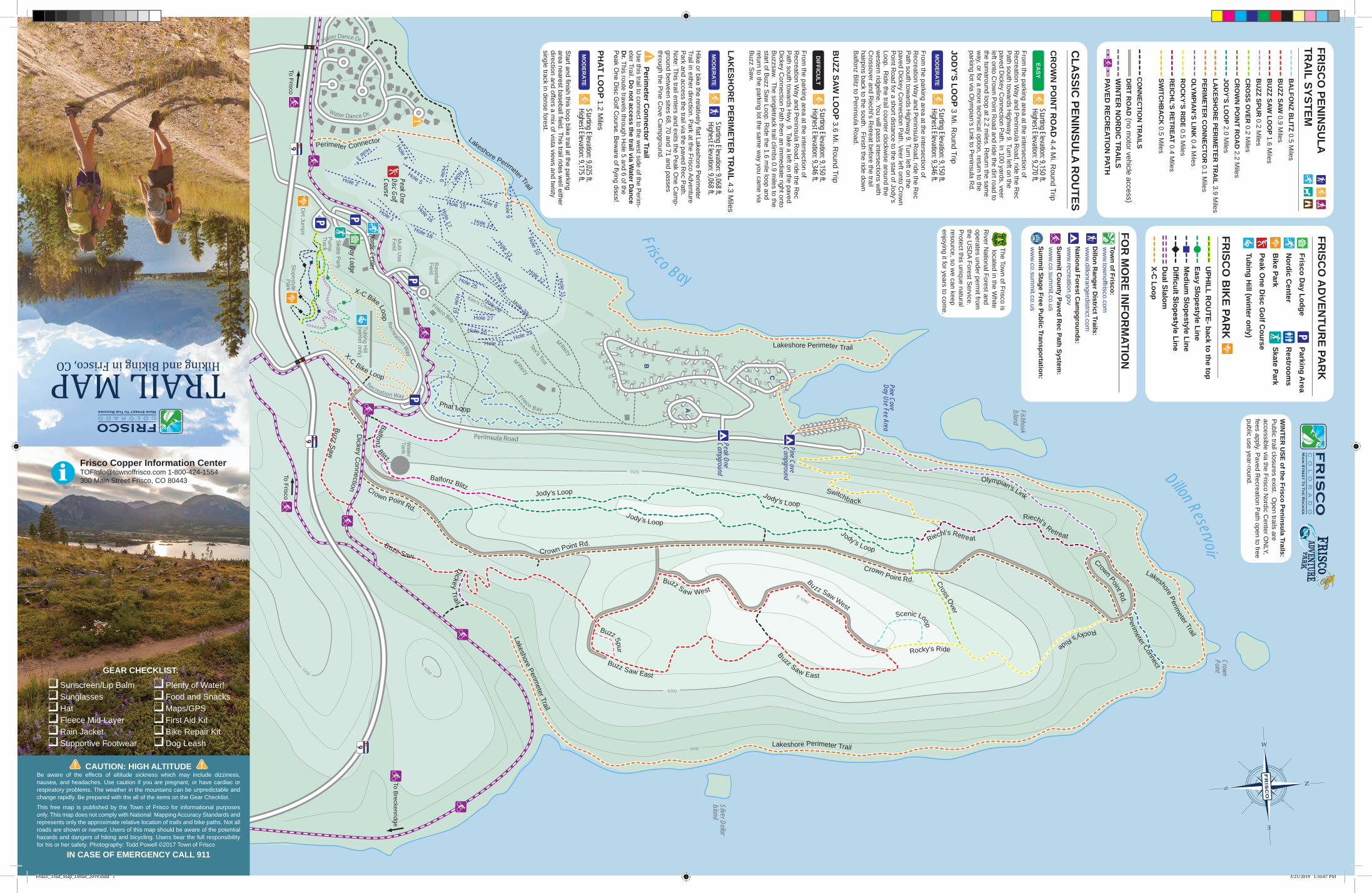
DIFFICULT
Motor vehicles and mountain bikes are prohibited.Dogs MUST be on leash at all times.Group size is limited to 15 people.Camping is prohibited within 100 feet of lakes, streams and trails.Campfires are prohibited within 0.25 miles of lakes and 100 feet of any trail or stream.
Trailhead: From Frisco Main St. turn south onto Hwy. 9 and drive 2.9 miles to the stoplight at Summit High School. Turn left on Swan Mountain Rd. and continue 1.9 miles to the trailhead.
Description: A short family friendly loop with dramatic views of Dillon Reservoir, Gore Range and Tenmile Range.
Round Trip: 0.7 mi.Elevation Gain: 9 ft.
SAPPHIRE POINT OVERLOOK
EASY
Trailhead: From Frisco Main St. turn left onto Hwy. 9. Drive 1 mile and turn right onto Dillon Dam Rd. In approximately 1.5 miles the trailhead will be on the left. Description: A short family friendly hike with nice views of Dillon Reservoir and Tenmile Range.
Round Trip: 1.6 mi.Elevation Gain: 137 ft.
OLD DILLON RESERVOIR
EASY
Trailhead: Drive to the west end of Frisco Main St. and pass under I-70 to find the parking lot on the north side of the interstate.
Description: The trail starts moderately steep through the valley as you pass Wichita Mountain on your left and Chief Mountain on your right. After 1 mile the trail will level out and follow close to the stream. At 2 miles the trail enters the Eagles Nest Wilderness. In another 1.4 miles the trail will intersect the Gore Range Trail. Turn around here to return to the parking lot.
See Regulations This trail travels through the Eagles Nest Wilderness. DOGS MUST BE ON LEASH - MOUNTAIN BIKES PROHIBITED
Trailhead: See Lily Pad Lake
Description: Hike the Meadow Creek Trail 0.6 miles and continue straight past the Lily Pad Lake Trail intersection. Follow the trail 3.6 miles to a gorgeous high alpine meadow with the opportunity to see wildflowers. At 4.45 miles you will reach the intersection with the Gore Range Trail. Bear right (north) and climb steeply to the summit of Eccles Pass at 11,918 feet.
See Regulations This trail travels through the Eagles Nest Wilderness. DOGS MUST BE ON LEASH - MOUNTAIN BIKES PROHIBITED
Trailhead: From Frisco Main St. turn left onto Hwy. 9 and continue 1.2 miles to the traffic circle on the north side of I-70. Exit the traffic circle onto the gravel frontage road and arrive at the trailhead in 0.6 miles.
Description: Follow the Meadow Creek Trail 0.6 miles to the intersection with Lily Pad Lake Trail. Turn right and continue 0.7 miles through pine forest and aspen trees to the beautiful lakes, one of which is covered in lily pads.
See Regulations This trail travels through the Eagles Nest Wilderness. DOGS MUST BE ON LEASH - MOUNTAIN BIKES PROHIBITED
Round Trip: 2.6 mi.Elevation Gain: 760 ft.
Round Trip: 6.8 mi.Elevation Gain: 899 ft.
Round Trip: 10.2 mi.Elevation Gain: 2,762 ft.
LILY PAD LAKE
NORTH TENMILE TRAIL
MEADOW CREEK TO ECCLES PASS
Trailhead: See important trailhead information in the bottom-right corner of this map.
Description: Hike, bike or drive this 4x4 road along Miners Creek. In approx. 0.5 miles the road will pass Rainbow Lake on the right. Dispersed campsites can be found along the road. At 2.5 miles the road ends with majestic views of the northern Tenmile Range. From here the Miners Creek Trail continues over the Tenmile Range to Copper Mountain.
MINERS CREEK ROAD- Important Information:Trailhead: From Frisco Main St. turn right at the stoplight and travel south on Hwy. 9 toward Breckenridge. In 1.5 miles turn right on Peak One Blvd. In approximately 100 yards, turn right, then an immediate left onto Miners Creek Rd. CR 1000. Continue on this road for another 0.1 mile to the gate. This is the parking area for winter access. During the summer, you can pass the gate and continue up the road. Use caution driving on the road/bike path past the gate and be aware of bicyclists when crossing the paved Rec Path.
Seasonal Closure: Miners Creek Road is typically closed to motor vehicles November - May (or until road is dry)
Camping: Dispersed camping is allowed along Miners Creek Road after the first 0.25 miles. Campsites must be at least 100 feet from the creek.
This road is used for many activities including motor vehicles, hiking and mountain biking. Please respect other users.
Swan Mountain Road On Street Bike Lane: The paved Recreation Path joins Swan Mountain Road between Highway 9 and Sapphire Point. The west side of Swan Mountain Road (uphill climb from Highway 9 to Sapphire Point) has a dedicated bike climbing lane. The dedicated lane is for CLIMBING ONLY. Bikes traveling downhill from Sapphire Point use the normal car lane to descend to Highway 9.
Trailhead: Park in the Kayak Lot at the west end of Frisco Main St. Walk over the footbridge and turn left on the paved Rec Path. In 0.5 miles the Mt. Royal trailhead will be on your right.
Description: This trail begins as a gradual climb through lodgepole pine forest for approximately 0.9 miles to theold mining town of Masontown. From Masontown to the summit the trail becomes very steep, ascending 1,356 feet in just over one mile. At the saddle, take a right along the ridge to the Mt. Royal summit. Continue to the spectacular viewpoint on top of the cliffs above the Town of Frisco if you choose. Return to the parking lot on the same trail. Descending Mt. Royal any other way can be dangerous.
(mileage shown round trip) Mayflower Gulch 3.2 mi. Wheeler Lakes 6.2 mi. Lost Lake 9.2 mi. Searle Pass 13 mi.
Round Trip: 5 mi.Elevation Gain: 845 ft.
Round Trip: 4.0 mi.Elevation Gain: 1,372 ft.
MINERS CREEK ROAD
9,097 ft.FRISCO
Eagles Nest Wilderness Regulations
MT. ROYAL
Trailhead: From Frisco Main St. turn south on 2nd Ave. At the end of 2nd turn right on S. Cabin Green. Cross the paved Rec Path to the Zach’s Stop parking lot.
Description: A family favorite with easy access from downtown. Hike the Peaks Trail 0.75 miles (one way) through wetlands on a boardwalk, aspen trees and lodgepole pines before arriving at Rainbow Lake. See Peaks Trail to continue to Breckenridge.
Round Trip: 1.5 mi.Elevation Gain: 463 ft.
RAINBOW LAKEEASY
MODERATE
MODERATE
Trailhead: See Rainbow Lake
Description: The Peaks Trail is a favorite among mountain bikers and climbs in and out of numerous creek drainages for its entire length from Frisco to the Peak 7 base area in Breckenridge.
One Way: 7.8 mi.Elevation Gain: 965 ft.
PEAKS TRAILMODERATE
Hiking
Mtn. Biking
X-Country Skiing
Snowshoeing
Fishing
Frisco Bay Marina
Dog Friendly
Leash Restrictions
Summit Stage Bus Stop
Picnic Area
Scenic Overlook
Parking Area
Camping
Trailhead
Information Center
Hospital
EASY
DIFFICULT
MODERATE
Paved Recreation Path
4x4 Road
Other Trails
Streams
LEGEND
Willow PreserveNature Trail and Overlook
FRISCO PENINSULA RECREATION AREASee reverse side for a detailed map of the Frisco Peninsula trails and the Frisco Adventure Park
DIFFICULT
4x4 ROAD
Copper Area Hikes
Town of Frisco: www.townoffrisco.com
Dillon Ranger District Trails: www.dillonrangerdistrict.com
National Forest Campgrounds: www.recreation.gov
Paved Rec Path System: www.co.summit.co.us
Summit Stage Free Transportation: www.co.summit.co.us
FOR MORE INFORMATION
Frisco_Trail_Map_Detail_2019.indd 2 3/21/2019 1:10:15 PM


![Early Detection of Aquatic Invasive Species Using eDNA ... · Hydrilla Daphnia cristata Fishhook Water Flea [Medinis Biologi] [shopboblake.blogspot.com] Gene-ZTM for detecting eDNA](https://img.pdfslide.us/doc/110x75/5c81e61009d3f2f3348d0d61/early-detection-of-aquatic-invasive-species-using-edna-hydrilla-daphnia.jpg)