Embed Size (px)
Citation preview
Trail Bike Riding – Otways DSE – South West Area
July 2011 FS0107
ISSN 1440-2262
© State of Victoria, Department of Sustainability and Environment Page 1
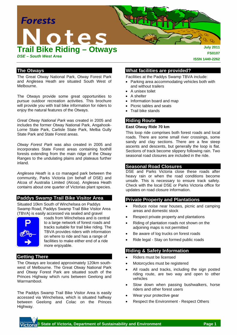
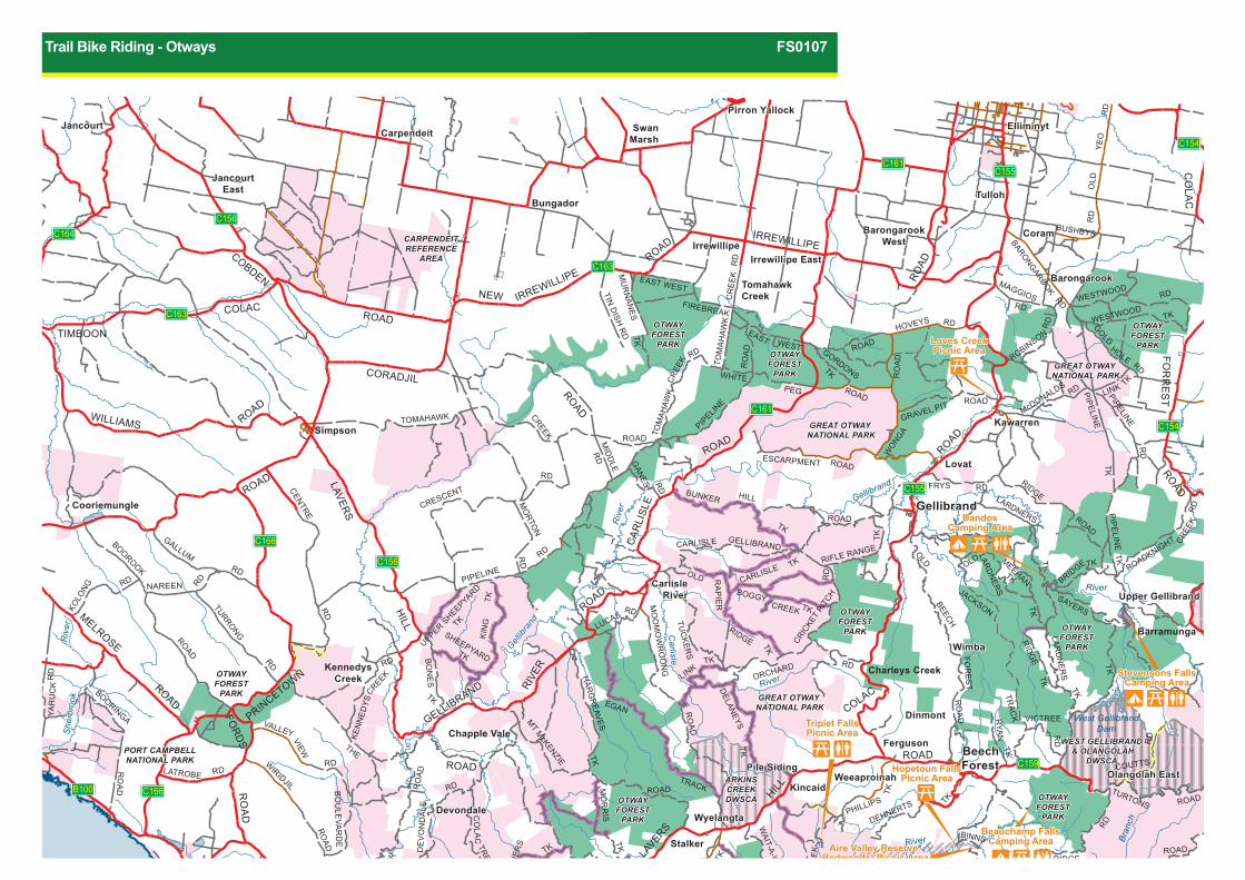
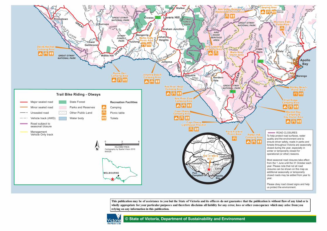
The Otways The Great Otway National Park, Otway Forest Park and Anglesea Heath are situated South West of Melbourne. The Otways provide some great opportunities to pursue outdoor recreation activities. This brochure will provide you with trail bike information for riders to enjoy the natural features of the Otways. Great Otway National Park was created in 2005 and includes the former Otway National Park, Angahook-Lorne State Park, Carlisle State Park, Melba Gully State Park and State Forest areas. Otway Forest Park was also created in 2005 and incorporates State Forest areas containing foothill forests extending from the main ridge of the Otway Ranges to the undulating plains and plateaus further inland. Anglesea Heath is a co managed park between the community, Parks Victoria (on behalf of DSE) and Alcoa of Australia Limited (Alcoa). Anglesea Heath contains about one quarter of Victorias plant species. Paddys Swamp Trail Bike Visitor Area Situated 10km South of Winchelsea on Paddys Swamp Road, Paddys Swamp Trail Bike Visitor Area (TBVA) is easily accessed via sealed and gravel
roads from Winchelsea and is central to a large network of forest roads and tracks suitable for trail bike riding. The TBVA provides riders with information on where to ride and has a range of facilities to make either end of a ride more enjoyable.
Getting There The Otways are located approximately 120km south-west of Melbourne. The Great Otway National Park and Otway Forest Park are situated south of the Princes Highway which runs between Geelong and Warrnambool. The Paddys Swamp Trail Bike Visitor Area is easily accessed via Winchelsea, which is situated halfway between Geelong and Colac on the Princes Highway.
What facilities are provided? Facilities at the Paddys Swamp TBVA include: • Parking area accommodating vehicles both with
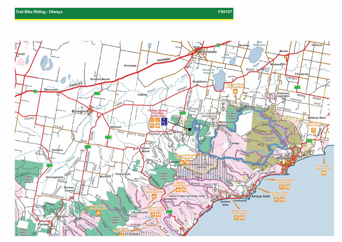
and without trailers • A unisex toilet • A shelter • Information board and map • Picnic tables and seats • Trail bike stands Riding Route East Otway Ride 70 km This loop ride comprises both forest roads and local roads. There are some small river crossings, some sandy and clay sections. There are a few steep ascents and descents, but generally the loop is flat. Sections of track become slippery following rain. Two seasonal road closures are included in the ride. Seasonal Road Closures DSE and Parks Victoria close these roads after heavy rain or when the road conditions become unsafe. This is necessary to ensure track safety. Check with the local DSE or Parks Victoria office for updates on road closure information. Private Property and Plantations • Reduce noise near houses, picnic and camping
areas and domestic stock • Respect private property and plantations • Riding of plantation roads not shown on the
adjoining maps is not permitted • Be aware of log trucks on forest roads • Ride legal - Stay on formed public roads Riding & Safety Information • Riders must be licensed • Motorcycles must be registered • All roads and tracks, including the sign posted
riding route, are two way and open to other vehicles
• Slow down when passing bushwalkers, horse riders and other forest users
• Wear your protective gear • Respect the Environment - Respect Others
GREAT OTWAY NATIONAL PARKGREAT OTWAY NATIONAL PARK
ANGLESEAHEATH
ANGLESEAHEATH
GHERANGGHERANG
BR
GHERANGGHERANG
BR
OTWAYFOREST
PARK
OTWAYFOREST
PARK
OTWAYFOREST
PARK
OTWAYFOREST
PARK
OTWAYFOREST
PARK
OTWAYFOREST
PARK
PAINKALAC CREEKDWSCA
PAINKALAC CREEKDWSCA
ST GEORGESDWSCA
ST GEORGESDWSCA
OTWAYFOREST
PARK
OTWAYFOREST
PARK
OTWAYFOREST
PARK
OTWAYFOREST
PARKRiverRiver
Anglesea
Painkalac Creek
Painkalac Creek
River
River
Barwon
Barwon
River
RiverSt George
Erskine
River
RiverSt George
Erskine
LakeModewarre
LakeModewarre
LakeGherang
LakeGherang
WurdibolucReservoir
WurdibolucReservoir
RO
AD
GREAT
OCEAN
GREAT
OCEAN
RO
AD
ROAD
RO
AD
ROAD
ROAD
ROAD
ROAD
SHARPSR
RD
RD
HAYDEN
TRACK
TRACK
TRACK
TK
TKTK
TK
TKTK
TK
TK
TK
TK
TK
TK
TK
TK
CREEK
TK
TK
TK
DENHAM
LOVES
NORM
AN
NECK
DUNSE PENNYROYAL
THO
MP
SO
NS TK
RD
COWLEY
ROAD
FOR
REST
FOR
REST
FOR
RE
ST
COLAC
BIR
RE
GU
RR
A
CAPE
OTWAY
ROAD
DEANS MARSH
DEANS MARSH
LORNE
WIN
CH
ELS
EA
HIGHWAY
PRINCES
MAIN ROAD
HENDY
COALMINEROAD WU
RD
ALE
RO
AD
ROAD
RO
AD
RO
AD
DA
NG
ER
SD
AN
GE
RS
RO
AD
ROAD
ROAD
RO
AD
ROAD
RD
RD RD
RD
RD
RD
RD DAM
RD
RD
ALS
OPS
RD
RD
GU
ND
RYS
RO
AD
INLET
AIREYS
HILLS
BALD
NO 2
WORMBETE STATION ROAD
WORMBETE STATION ROAD
TANNERS
FLAT
GUM
NORTONS ROAD
FOREST
FOR
ES
T
NO
BLE
S
BAMBRA
BAMBRA
BO
ON
AH
BAMBRA
CEMETERY
FALLSERSKINE
DELANEYS
NEWCOMBE SPUR
KAA
SEVEN BRIDGES RD
SEVEN BRIDGES RD
WESTWOOD RO
AD
ROAD
RO
AD
ROAD
LOR
NE
COLAC
JAM
ES
BRIDGE
DEWIN
GS
WICKHAM
S
HA
MM
ON
D
HAGGARTS
PORTREATHPORTREATH
DISTILLERY
BOUNDARY
RIFLE BUTTS ROAD
CR
EEK
BREAKFAST
CECIL
ALLARDYCE
COALMINE RD
ANNIE
SPUR
SP
UR
BARK
IRON
GENTLE
RENNICKS
CREEKMOGGS
CO
ALMIN
E
HILLBIG
REEDYSTON
Y
FIVEM
ILE
OLD
TELE
GR
AP
HR
D
EAST WORMBETECREEK ROAD
EAST WORMBETECREEK ROAD
SEAVIEW
PARKER
S
ADKNIGHT CREEK
TELE
GRAPH
MurroonPennyroyal
YeodeneDeansMarsh
WensleydaleBellbrae West
Lorne
ForrestForrest
YaugherYaugherWymboolielWymbooliel
BenwerrinEastern
ViewFairhaven
Aireys Inlet
BarwonDowns
BarwonDowns
GerangameteGerangamete MurroonPennyroyal
BoonahAngleseaAnglesea
YeodeneDeansMarsh
Sokel
BambraBambra
Whoorel
WensleydaleBellbrae West
BirregurraBirregurra
InglebyIngleby
Warncoort
IrrewarraRicketts Marsh
Paraparap
Modewarre
Winchelsea
Buckley
WurdibolucWurdibolucRicketts Marsh
Paraparap
Armytage Modewarre
OnditMoriacWinchelsea
Buckley PettavelPettavel
Paddys SwampTrail Bike
Visitor Area
Paddys SwampTrail Bike
Visitor Area
M
o
2
o2
o2
o2o2
gno@
M@
M@
M
M
M
A1
A1
C151
C151
C152
C119
C119
C154
B100
C135
ROAD CLOSURES
Urquhart BluffVisitor Area
Distillery CreekPicnic Area
Urquhart BluffVisitor Area
Point AddisPoint AddisVisitor AreaVisitor AreaPoint AddisVisitor Area
Ironbark BasinPicnic Area
Ironbark BasinPicnic Area
Tanners RoadCamping AreaTanners RoadCamping Area
Hammond RoadCamping Area
Hammond RoadCamping Area
Big HillCamping Area
Big HillCamping Area
HerbertsCamping Area
HerbertsCamping Area
Cora LynnCamping Area
Cora LynnCamping Area
Goat TrackCamping Area
Goat TrackCamping Area
Moggs CreekPicnic Area
Moggs CreekPicnic Area
Blanket LeafPicnic AreaBlanket LeafPicnic Area
Distillery CreekPicnic Area
Trail Bike Riding - Otways FS0107
GREAT OTWAY NATIONAL PARKGREAT OTWAY NATIONAL PARK
OTWAYFOREST
PARKPARK
OTWAYFOREST
PARK
OTWAYFOREST
PARK
WEST GELLIBRAND & OLANGOLAH
DWSCA
WEST GELLIBRAND & OLANGOLAH
DWSCA
ST GEORGESDWSCA
ST GEORGESDWSCA
WEST BARWONDWSCA
WEST BARWONDWSCA
WestGellibrandDam
WestGellibrandDam
West BarwonReservoir
West BarwonReservoir
River
RiverSt George
River
River
Wye
Cumberland
River
RiverSt George
River
River
Grey Kennett
River
River
Wye
RiverRiver
Grey Kennett
Barh
am R
iver
Eas
t Bra
nch
Barh
am R
iver
Eas
t Bra
nch
Cumberland
ROAD
GREATOCE
AN
CR
EE
K
RO
AD
RO
AD
OAD
ROAD
ROAD
TKSHARPSROAD
ROAD
ROAD
ROAD
DOG
WIL
D
HAYDEN
TRACK
K
TK
TK
TRACK
GARVEY
TRACK
THO
MP
SO
NS TK
TK
TK
TK
RD
RD
RD
TK
RD
RD
NO
2
ROAD
RD
RD
RDB
US
TY
SUNNYSIDE
RIVER
GREY
HENRYS
COOPERS
KENNETT
RD
RD
WYE
WYE RIVER
WY
E
OLD
COWLEY
SKENES
APO
LLO
BAY
APO
LLO
BAY
FOR
RE
ST
FALLSERSKINENEWCOMBE SPUR
MT SABINE
BENWERRIN
TURTONS
SAY
ER
S
KAANGLANG
VEM
ILE
JAMIESON
GO
DFR
EY
CURTIS
WEST BARWON TK
NOONDAY
ROADKNIGHT CREEK
CUMBERLAND
arengo
ApolloBay
SkenesCreek
Wongarra
SkenesCreekNorth
Wye River
Barramunga
SkenesCreekNorth
Grey River
Kennett River
Tanybryn
OlangolahEastOlangolahEast Wye River Separation Creek
Barramunga
UpperGellibrand
UpperGellibrand
AllenvaleLorne
ForrestForrest
o2
o2o2
Mo@
M M
M
M
M
Mo@ C119
B100
B100
OCEAN
GREAT
HAMILTON
PRINCES
HAMILTON
HWY
PRINCES
GREAT
OCEAN
ROAD
HWY
HWY
GLENELGGLENELG MIDLAND
HWY
Lorne
Mortlake
PortCampbell Apollo
Bay
Lorne
Warrnambool
Ballarat
Warrnambool Colac
GeelongTHE OTWAYS EAST
THE OTWAYS EAST
MELBOURNE
Trail Bike Riding - Otways
Freeway/Highway
Major sealed road
Minor sealed road
Unsealed road
Vehicle track (4WD)
Road subject to seasonal closure
Management Vehicle Only track
Trail BikeVisitor Area
East Otway Ride
Reduce Noise Area
Recreation Facilities
Camping
Information
Picnic shelter
Picnic table
Toilets
Forest Park
Parks and Reserves
Anglesea Heath
Other Public Land
Designated Water Supply Catchment
Water body
NKILOMETRES
0 3 6
Cartography by Spatial Vision 2010 M/9328
ROAD CLOSURESTo help protect road surfaces, water quality and the environment and to ensure driver safety, roads in parks and forests throughout Victoria are seasonally closed during the year, especially in winter or temporarily closed for operational (or other) reasons.
Most seasonal road closures take effect from the 1 June until the 31 October each year. Please note that not all road closures can be shown on this map as additional seasonally or temporarily closed roads may be added from year to year.
Please obey road closed signs and help us protect the environment.
Cora LynnCamping Area
Cora LynnCamping Area
Allanvale MillCamping AreaAllanvale MillCamping Area
Jamieson TrackCamping Area
Wye River RoadCamping Area
Jamieson TrackCamping Area
Wye River RoadCamping Area
Sharps TrackCamping AreaSharps TrackCamping Area
SheoakPicnic Area
SheoakPicnic Area
Addis BayPicnic AreaAddis BayPicnic AreaGrey River
Picnic AreaGrey RiverPicnic Area
Lake ElizabethCamping AreaLake ElizabethCamping Area
Stevensons FallsCamping Area
Stevensons FallsCamping Area
Mgno2
© State of Victoria, Department of Sustainability and Environment
This publication may be of assistance to you but the State of Victoria and its officers do not guarantee that the publication is without flaw of any kind or is wholly appropriate for your particular purposes and therefore disclaims all liability for any error, loss or other consequence which may arise from you relying on any information in this publication.
GREAT OTWAY NATIONAL PARKGREAT OTWAY
GREAT OTWAY NATIONAL PARKGREAT OTWAY
NATIONAL PARK
GREAT OTWAY NATIONAL PARKGREAT OTWAY
NATIONAL PARK
GREAT OTWAY NATIONAL PARKGREAT OTWAY
NATIONAL PARK
PORT CAMPBELLNATIONAL PARKPORT CAMPBELLNATIONAL PARK
OTWAYFOREST
PARK
OTWAYFOREST
PARK
OTWAYFOREST
PARK
OTWAYFOREST
PARK
OTWAYFOREST
PARK
OTWAYFOREST
PARK
OTWAYFOREST
PARK
OTWAYFOREST
PARK
OTWAYFOREST
PARK
OTWAYFOREST
PARK
OTWAYFOREST
PARK
OTWAYFOREST
PARK
OTWAYFOREST
PARK
OTWAYFOREST
PARK
OTWAYFOREST
PARK
CARPENDEITREFERENCE
AREA
CARPENDEITREFERENCE
AREA
ARKINSCREEKDWSCA
ARKINSCREEKDWSCA
WEST GELLIBRAND & OLANGOLAH
DWSCA
WEST GELLIBRAND & OLANGOLAH
DWSCA
r
Riv
erS
herb
rook
She
rbro
ok
RiverRiver
Eas
tBr
anch
Riv
er
River
Carlisle
River
Carlisle
River
Gellibr
and
Gellibr
and
Gellibrand
West GellibrandDam
FOR
RE
ST
ROAD
ROADROAD
ROAD
ROAD
CORADJIL
ROAD
ROAD
ROAD
ROAD
RO
AD
ROAD
CO
LAC
COBDEN
CAR
LISL
E LA
VERS
LAVERS
HILL
ROAD
HILL
COLAC
IRREWILLIPE
IRREWILLIPE
NEW
WILLIAMS
COLAC
TIMBOON
ROAD
ROAD
RO
AD
RO
AD
PRINCETOWN
MELROSE
WESTWOOD
WESTWOOD RD
RD R
D
RD
McDONALDS
TK
TK
TK
RD
RD
RD
RD
RD
CENTRE
RD
RD
RD RD
RD
RD
ROAD
RD
RD
RD NAREEN
GALLUM
PIPELINE
RD
RD
GANES
TKTKTK
TK
TK
SAYERS
TK
BRIDGE
TRAC
K
ROAD
ROAD
TURTONS
TRACK
TK
TK
TK
TK
TK
OG
MO
RR
IS
IETS
EGAN
JACKSON
TK
TK
MEEHAN
TK
TK
RID
GE
RD
TK
TK
TK
TK
TK
TK
TK
TK
TK
TKK
ING
CREEK
BOGGY
RIDGE
RA
PIE
R
OLD
HILLBUNKER
OLD
RD
TK
RD
R
D
YE
O
OLD
RD
RD
RD
BARONGAROOK
BUSHBYS
ROAD
ROAD
RO
AD
RIDGE
RD
RDFRYS
ROAD
ROAD
ROAD
RD
RD
RD
RD
RD
RD R
D
ROAD
RO
AD
RO
AD
ROAD
GRAVEL PIT
HOVEYSEAST WEST
WONGA
PEG
WHITE
MU
RN
ANES
CR
EE
K
CREEK
MID
DLE
TOM
AH
AWK
TOMAHAWK
PIPELIN
E
PIPELINE
PIPELINE
PIP
ELIN
E
ESCARPMENT
ROADKNIGHT CREE
K
LARD
NER
S
FOR
ES
T
BEECH
OLDRIFLE RANGE
CRICKE
T PI
TCH
GELLIBRANDCARLISLE
CARLISLETU
CKER
S
ORCHARD
MO
OM
OW
RO
ON
G
HAR
GR
EAVESMT M
cKENZIE
SKIN
NER
STREEC
OLA
C
FORDS
RIVE
R
RIVE
R
ROAD
RO
AD
BO
NE
S
GELLIBRAND
GELLIBRAND
THE
BO
ULE
VAR
DE
RO
AD
RD
WIRIDJIL
BOORINGA
WAIT-A-W
HILE
D
HOLE
GOLD
LINK
MAGGIOS
ROBINSON
GORDONS
FIREBREAK
EAST WEST
CREE
K
TOM
AHAW
K
TIN D
ISH R
D
LARDNERS
LAR
DN
ER
S
RYA
N
LINK
DELAN
EYS
COUTTS
VICTREE
LUCAS
DEHNERTS PHILLIPS
BINNS
RIDGE
AVIEW
GSC
RE
EK
CRESCENT
MO
RTON
UPPER SHEEPYARD
TK
SHEEPYARD TK
CREEK
KEN
NED
YS
DE
VO
ND
ALE
VALLEY VIEW
LATROBE
TURRONG
BOOROOK
KOLO
NG
YAR
UC
K
WyelangtaDevondale
Olangolah East
BeechForestPile Siding
Wimba
GellibrandCooriemungle
Kawarren
TomahawkCreek
Barongarook
Irrewillipe East
CoramBarongarookWest
Tulloh
JancourtEast
CarpendeitJancourt
Pirron Yallock
CrowesPrincetown Lavers HillLavers Hill
Stalker
TanybryWyelangtaDevondale
Olangolah EastKincaid
BeechForestPile Siding
WeeaproinahWeeaproinah
FergusonChapple Vale
Dinmont
Charleys CreekKennedysCreek
Wimba
Upper Gellibrand
Barramunga
Upper GellibrandCarlisle
RiverCarlisle
River
ForrestGellibrandCooriemungle
YaugheLovat
SimpsonKawarren
s Creek
TomahawkCreek
Barongarook
Irrewillipe East
YeodeneCoramIrrewillipeIrrewillipe
BarongarookWest
BungadorTulloh
JancourtEast
SwanMarshCarpendeit
ElliminytElliminytJancourtPirron Yallock
o
Mo2
o2
o2
o
Mo2
Mo2 B100
B100 C166
C166
C156
C156
C163
C163
C164
C155
C159
C155
C154
C154
C161
C161
Stevensons FallsCamping Area
Stevensons FallsCamping Area
DandosCamping Area
DandosCamping Area
Beauchamp FallsCamping Area
Beauchamp FallsCamping Area
Aire Valley Reserve(Redwoods) Picnic Area
Aire Valley Reserve(Redwoods) Picnic Area
Triplet FallsPicnic AreaTriplet FallsPicnic Area
Hopetoun FallsPicnic Area
Hopetoun FallsPicnic Area
Loves CreekPicnic AreaLoves CreekPicnic Area
Trail Bike Riding - Otways FS0107
GREAT OTWAY NATIONAL PARKGREAT OTWAY
NATIONAL PARK
GREAT OTWAY NATIONAL PARK
GREAT OTWAY NATIONAL PARKGREAT OTWAY
NATIONAL PARK
GREAT OTWAY NATIONAL PARKGREAT OTWAY
NATIONAL PARK
OTWAYFOREST
PARK
OTWAYFOREST
PARKPARK
OTWAYFOREST
PARK
OTWAYFOREST
PARK
FORESTPARK
OTWAYFOREST
PARK
OTWAYFOREST
PARK
AIRERIVER
HERITAGEAREA
AIRERIVER
HERITAGEAREA
ARKINSCREEKDWSCA
Riv
er
River
Aire
River
Riv
er
River
Eas
tBr
anch
West
Barha
m
Barham
Rive
r
Cal
der
Aire
Gellibrand
RO
AD
LAVERS
AD
GREAT
GR
EAT
OCEAN
OC
EAN
RO
AD
ROAD
ROADTK
TK
TK
DOG
WIL
D
TK
TK
TK
TK
RIS
AMIE
TS
TK
TK
RD
RD
TK
RD
RD
RD
RD
RDR
D
RD
RD
RD
RD
BU
STY
TUX
ION
RD
RDSKIN
NER
STREEC
OLA
C
RIVE
R
ADAMS
GE
LLIB
RA
ND
LEVA
RD
E
RO
AD
ROAD
RD
RD
RD
RD
RD
BLU
E
RED
JOH
AN
NA
JOHANNA
WAT
ER
HOLY
WAIT-A-W
HILE
ROAD
RO
AD
ROAD
BIN
NS
HALLRIDGE
RIDGE
CALDERCA
NN
AN
S
DEHNEP
BINNS
RIDGE
SEAVIEW
YOUNGS
CR
EE
K
SETTLEMENT
AIRE CLEARWATER
JOHANSSONS
RD
OLD BAY
KILLALA
BA
RH
AM
RIVER
RIDGE
PAR
KER
SNOWY
SANDY
RIDGE RID
GE ELLIOTT JOHNSON
BLANKET BAY
BLA
NK
ET
BAY
TK
LIG
HTH
OU
SE
HORDEN VALE
RDSAND
DE
VO
ND
A
MELANESIA
OLDOLD
COACH
OCEAN
MarengoGlenaireHordernVale
Johanna
Wattle Hill
YuulongLowerGellibrand
JohannaHeights
Wangerrip
Burrupa
WyelangtaDevondale
GlenaireHordernVale
ApolloBay
Johanna
Wattle HillKillalaKillala
CapeHorn
SkenesYuulongLowerGellibrand
JohannaHeights
Wangerrip
Graham Junction
Burrupa
Skenes CrowesPrincetownPrincetown Lavers HillLavers Hill
Stalker
TanybryWyelangtaDevondale
o2
o
Mo
o2
Mo2
Mo2
Mo2 Mo2
Mo2
Mo2
Mo2
Mo2
Mo2
o2 o2
Mo2
o2
o
B100
C157
B100
GLENELGGLENELG
OCEAN
GREAT
HAMILTON
PRINCES
HAMILTON
HWY
PRINCES
GREAT
OCEAN
ROAD
HWY
HWY
MIDLAND
HWY
Lorne
Mortlake
PortCampbell Apollo
Bay
Lorne
Warrnambool
Ballarat
Warrnambool Colac
GeelongTHE OTWAYSTHE OTWAYS
WESTTHE OTWAYS
WEST
MELBOURNE
Trail Bike Riding - Otways
Major sealed road
Minor sealed road
Unsealed road
Vehicle track (4WD)
Road subject to seasonal closure
Management Vehicle Only track
Recreation Facilities
Camping
Picnic table
Toilets
State Forest
Parks and Reserves
Other Public Land
Water body
NKILOMETRES
0 3 6
Cartography by Spatial Vision 2010 M/9328
ROAD CLOSURESTo help protect road surfaces, water quality and the environment and to ensure driver safety, roads in parks and forests throughout Victoria are seasonally closed during the year, especially in winter or temporarily closed for operational (or other) reasons.
Most seasonal road closures take effect from the 1 June until the 31 October each year. Please note that not all road closures can be shown on this map as additional seasonally or temporarily closed roads may be added from year to year.
Please obey road closed signs and help us protect the environment.
Beauchamp FallsCamping Area
Beauchamp FallsCamping Area
Elliot RidgeCamping Area
Elliot RidgeCamping Area
Parker HillCamping Area
Parker HillCamping Area
Cape OtwayCamping Area
Aire River EastCamping Area
Aire River WestCamping Area
Cape OtwayLighthouse Precinct
Cape OtwayCamping Area
Aire River EastCamping Area
Johanna BeachCamping Area
Johanna BeachCamping Area
Ryans DenCamping Area
Ryans DenCamping Area
Aire CrossingCamping AreaAire CrossingCamping Area
Devils KitchenCamping AreaDevils KitchenCamping Area
Aire River WestCamping Area
Blanket BayCamping &
Day Visitor Area
Blanket BayCamping &
Day Visitor Area
Aire Valley Reserve(Redwoods) Picnic Area
Aire Valley Reserve(Redwoods) Picnic Area
Shelley BeachPicnic Area
Shelley BeachPicnic Area
Maits RestVisitor AreaMaits Rest
Visitor Area
Cape OtwayLighthouse Precinct
Melba GullyPicnic AreaMelba GullyPicnic Area
Point FranklinPicnic Area
Point FranklinPicnic Area
Mariners FallsVisitorArea
Mariners FallsVisitorArea
Mo2
© State of Victoria, Department of Sustainability and Environment
This publication may be of assistance to you but the State of Victoria and its officers do not guarantee that the publication is without flaw of any kind or is wholly appropriate for your particular purposes and therefore disclaims all liability for any error, loss or other consequence which may arise from you relying on any information in this publication.
Trail Bike Riding – Otways FS0107
© State of Victoria, Department of Sustainability and Environment Page 2
Ride for Tomorrow Trail bike riding is great fun, but just so you don’t spoil the fun for others who come to use the forests, please note the following: Reduce Your Noise
DSE and VicRoads have developed some new signs to indicate noise sensitive areas where riders should ride more slowly and quietly. Obeying these signs is voluntary (i.e. not a legal requirement), but if riders ride slowly and quietly in these areas, it will help keep the peace and be greatly appreciated by other forest users and nearby residents. Refer to map overleaf for key noise sensitive areas.
“Be seen but not heard – ride quiet bikes” Otway Trail Riders Respect the Environment The Anglesea Grevillea (Grevillea infecunda) is only found in small pockets around the town of Anglesea. It is one of our threatened flora species. The roots of the Grevillea grow close to the surface and are very brittle, making them very susceptible to damage. The Anglesea Grevillea uses its root system to germinate. Riding only on the legal road network will help protect the Anglesea Grevillea for future generations. Phytophthora cinnamomi (pronounced: fy-TOFF-thor-ah) is a foreign plant pathogen. This pathogen attacks the root systems of susceptible vegetation including the iconic grass trees in the Otways. People and vehicles are the prime movers of the pathogen. Riding only on the legal road network and washing your bike after every ride will help reduce the spread of Phytophthora • Please take your litter home
Be Bushfire Smart Fires can only be lit in properly constructed fireplaces. • Call the Victorian Bushfire Information line 1800
240 667 for more information • Do not light a fire on a day of Total Fire Ban. Track Closure & Rehabilitation Please respect track closure and rehabilitation areas. There are many reasons the closure of a road or track may be required. These include: • Public Safety • Impacts on adjoining landholders/residents
(ie. noise) • Erosion/water quality impacts (i.e. sedimentation
of streams, important water catchment area etc) • Environmental impacts ie. damage to vegetation,
weed spread (eg. Phytophthora), disturbance to fauna/habitat etc
• Duplication of existing/nearby road network, resulting in unnecessary maintenance costs
• Low level of recreational use • Surplus to DSE or PV managerial requirements DSE & Parks Victoria consult in regard to track closures with groups including the community, Four Wheel Drive Victoria, Australian Motorcycle Trail Riders Association and Otway Trail Riders about track closures. When tracks have been or are proposed to be closed and rehabilitated in the Otways, a consultation process with stakeholders takes place. The most recent closure and rehabilitation plans and proposals can be found at www.dse.vic.gov.au. Please respect these revegetation areas. For more informationThe Department of Sustainability and Environment (DSE) is responsible for managing Victoria's State Forest. For further information contact DSE’s Customer Service Centre on 136 186 (TTY: 1800 122 969) or visit http://www.dse.vic.gov.au/trailbikes
This publication may be of assistance to you but the State of Victoria and its officers do not guarantee that the publication is without flaw of any kind or is wholly appropriate for your particular purposes and therefore disclaims all liability for any error, loss or other consequence which may arise from you relying on any information in this publication


![INDEX [] · Traffic ordinances and state laws of the road apply to persons riding bicycles, 74.03](https://img.pdfslide.us/doc/110x75/60332623149b4004dc604f48/index-traffic-ordinances-and-state-laws-of-the-road-apply-to-persons-riding.jpg)