Embed Size (px)
Citation preview

Traffic Management Centers IN A CONNECTED VEHICLE ENVIRONMENT
Task 2. Investigation of Expected Changes in TMCs
Final Report
Prepared for:
CTS Pooled Fund Study, University of Virginia
Prepared By:
November 20, 2013

Traffic Management Centers in a Connected Vehicle Environment
November 2013
Final Report i
TABLE OF CONTENTS
EXECUTIVE SUMMARY ................................................................................................................................. iii
1 Introduction .......................................................................................................................................... 1
1.1 Background ................................................................................................................................... 1
1.2 Approach and Methodology ......................................................................................................... 3
2 Current TMC Status ............................................................................................................................... 4
2.1 Transportation Management Centers .......................................................................................... 4
2.2 Current Trends Impacting TMCs ................................................................................................... 5
2.3 Institutional and Programmatic Setting of Typical TMCs ............................................................. 7
3 Connected Vehicle Environment .......................................................................................................... 9
3.1 Background and Overview ............................................................................................................ 9
3.2 Components of a Connected Vehicle Environment .................................................................... 10
3.3 Connected Vehicle Data and Messages ...................................................................................... 13
3.4 NHTSA Rulemaking ..................................................................................................................... 14
3.5 Potential Roll-Out of Connected Vehicle Technologies .............................................................. 15
4 Expected Changes to a TMC in a Connected Vehicle Environment .................................................... 18
4.1 Connected Vehicle Environment and Public Agencies ............................................................... 18
4.2 Potential Benefits for TMC Operations ....................................................................................... 19
4.3 Expected Changes to TMC Service Packages in a Connected Vehicle Environment................... 21
4.3.1 Incident Management ......................................................................................................... 23
4.3.2 Roadway Hazard Warnings (Continuous and Transient) .................................................... 24
4.3.3 Speed Monitoring and Warning .......................................................................................... 26
4.3.4 Cooperative Intersection Collision Avoidance Systems (CICAS) ......................................... 28
4.3.5 Traffic Signal Control ........................................................................................................... 29
4.3.6 Probe Data Collection ......................................................................................................... 30
4.3.7 Traffic Metering .................................................................................................................. 32
4.3.8 Lane Management .............................................................................................................. 32
4.3.9 Electronic Payments / Fee Collection ................................................................................. 33
4.3.10 Traffic Information Dissemination ...................................................................................... 34
4.3.11 Emissions Monitoring and Management ............................................................................ 35

Traffic Management Centers in a Connected Vehicle Environment
November 2013
Final Report ii
4.3.12 Road Weather Monitoring and Management .................................................................... 36
4.3.13 Asset Management ............................................................................................................. 38
4.3.14 Parking Management .......................................................................................................... 40
4.3.15 Performance Measures ....................................................................................................... 40
4.4 Summary of Expected Changes to How a TMC Operates ........................................................... 41
Appendix A – Interview Format and Guiding Questions............................................................................. 50
Appendix B – SAE J2735 Messages ............................................................................................................. 55
LIST OF TABLES
Table 1. TMC Functionality ........................................................................................................................... 5
Table 2. Current J2735 Messages and How They May Be Used by TMCs .................................................. 56
LIST OF FIGURES
Figure 1. Connected Vehicle Communications ............................................................................................. 9
Figure 2. Components of a Connected Vehicle Environment ..................................................................... 11
Figure 3. A Connected Vehicle .................................................................................................................... 13
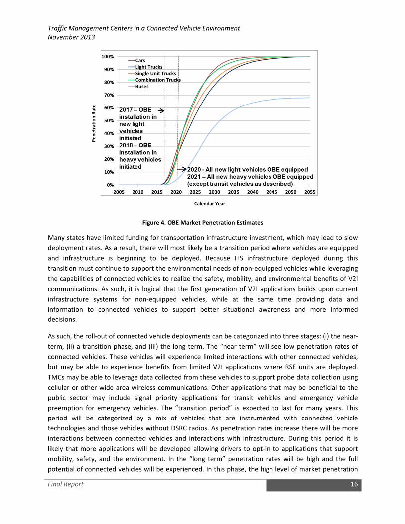
Figure 4. OBE Market Penetration Estimates ............................................................................................. 16

Traffic Management Centers in a Connected Vehicle Environment
November 2013
Final Report iii
EXECUTIVE SUMMARY
To date, the emerging connected vehicle capabilities have not had a significant impact on
Transportation Management Centers (TMCs), largely because many connected vehicle activities are still
in the development and testing stages. The members of the Connected Vehicle Pooled Fund Study (PFS)
recognize that connected vehicle capabilities may affect the role of the TMC and TMC operations,
and/or the manner in which they are carried out. To better prepare for the potential impacts,
operational activities, resource and system needs, the PFS initiated a project to identify how a
connected vehicle environment will shape the role and function of TMCs. The project examines
operational, technical, and policy impacts of TMC in a connected vehicle environment, and will be used
to inform the Connected Vehicle PFS members about priority needs and gaps that would need to be
addressed relative to TMCs in a future connected vehicle environment. The project includes four tasks:
• Task 1. Review of Connected Vehicle Program Activities in Relation to Traffic Management
Center Operations;
• Task 2. Investigation of Expected Changes in TMCs;
• Task 3. Document the Future of TMCs in a Connected Vehicle Environment; and
• Task 4. Preparation of Recommendations:
A Concept Paper was developed and used to guide detailed interviews with state and local agency staff.
Interviews were conducted as part of Task 2 with three state DOTs – Michigan Department of
Transportation, Florida Department of Transportation, and Virginia Department of Transportation – and
one local DOT – Maricopa County Department of Transportation – to solicit further input on the
potential impacts of a connected vehicle environment on a TMC. While the initial version of this
document was written prior to the interviews taking place, the document was updated after the
interviews to incorporate key findings from the Task 2 interviews.
The connected vehicle environment will produce an enormous volume of traffic monitoring data and a
potential new interface to use to communicate with a traveler. Current TMC practices will need to be
modified to take advantage of these new capabilities. For example, connected vehicle systems will
produce a large volume of raw, real-time traffic data that will need to be aggregated. This aggregated
data will need to be fed into existing (or updated) traffic management software systems and
applications. This may also require changes in the operating procedures for TMC operators and
managers. Similarly, if a different tool to deliver appropriate information to drivers becomes available,
this will also change the procedures and the roles of TMC operators and managers, resulting in a
different form of a TMC. Finally, connected vehicle technologies may enable entirely new functions not
previously provided by TMCs.
During Task 1 of the project, a survey was distributed to TMC staff across the United States.
Respondents were presented with 37 connected vehicle application areas and were asked to select up
to five that they felt would have the most impact on their TMC operations. The most frequently selected
applications represented those focused largely on situational awareness at the network/corridor level:

Traffic Management Centers in a Connected Vehicle Environment
November 2013
Final Report iv
• Incident Detection (11)
• Probe Data Collection - Vehicle position, speed, and heading (10)
• Arterial Management - Advanced Traffic Signal Systems (e.g. leveraging connected vehicle data
to support traffic signal operations including adaptive traffic signal systems) (8)
• Traveler Information - Traffic Conditions (7)
Safety applications (e.g. speed reductions for work zones, school zones, highway-rail crossings, and
curve speeds) were ranked low by respondents. This is not indicative of the priority of safety, but rather
these results are more likely due to the location-specific nature of these warnings. The limited selections
by TMCs does not indicate they are not important applications, but rather they might not fit within the
broader network, regional or statewide focus for a TMC to implement a specific strategy to address in
real-time. Additionally, this may be due to the fact that without 100% market penetration, TMCs can’t
rely on connected vehicle technology alone for safety, as interviewees pointed out.
This document discusses expected changes to TMCs in a connected vehicle environment based on
fifteen groupings of potential connected vehicle applications. These groupings, referred to as service
packages, provide an overview of potential connected vehicle applications and a discussion of the
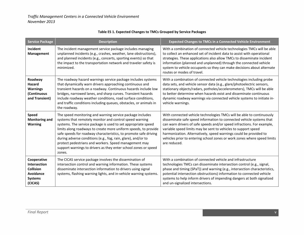
impacts a TMC may expect in a connected vehicle environment. Table ES 1 summarizes key findings.
Traffic Management Centers in a Connected Vehicle Environment
November 2013
Final Report v
Table ES 1. Expected Changes to TMCs Grouped by Service Packages
Service Package Description Expected Changes to TMCs in a Connected Vehicle Environment
Incident
Management
The incident management service package includes managing
unplanned incidents (e.g., crashes, weather, lane obstructions),
and planned incidents (e.g., concerts, sporting events) so that
the impact to the transportation network and traveler safety is
minimized.
With a combination of connected vehicle technologies TMCs will be able
to collect an enhanced set of incident data to assist with operational
strategies. These applications also allow TMCs to disseminate incident
information (planned and unplanned) through the connected vehicle
system to vehicle occupants so they can make decisions about alternate
routes or modes of travel.
Roadway
Hazard
Warnings
(Continuous
and Transient)
The roadway hazard warnings service package includes systems
that dynamically warn drivers approaching continuous and
transient hazards on a roadway. Continuous hazards include low
bridges, narrowed lanes, and sharp curves. Transient hazards
include roadway weather conditions, road surface conditions,
and traffic conditions including queues, obstacles, or animals in
the roadway.
With a combination of connected vehicle technologies including probe
data sets, and vehicle sensor data (e.g., glare/photoelectric sensors,
stationary objects/radars, potholes/accelerometers), TMCs will be able
to better determine when hazards exist and disseminate continuous
dynamic roadway warnings via connected vehicle systems to initiate in-
vehicle warnings.
Speed
Monitoring and
Warning
The speed monitoring and warning service package includes
systems that remotely monitor and control speed warning
systems. The service package is used to set appropriate speed
limits along roadways to create more uniform speeds, to provide
safe speeds for roadway characteristics, to promote safe driving
during adverse conditions (e.g., fog, rain, glare), and/or to
protect pedestrians and workers. Speed management may
support warnings to drivers as they enter school zones or speed
zones.
With connected vehicle technologies TMCs will be able to continuously
disseminate safe speed information to connected vehicle systems that
can warn drivers of safe speeds and/or speed infractions. For example,
variable speed limits may be sent to vehicles to support speed
harmonization. Alternatively, speed warnings could be provided to
vehicles prior to entering school zones or work zones where speed limits
are reduced.
Cooperative
Intersection
Collision
Avoidance
Systems
(CICAS)
The CICAS service package involves the dissemination of
intersection control and warning information. These systems
disseminate intersection information to drivers using signal
systems, flashing warning lights, and in-vehicle warning systems.
With a combination of connected vehicle and infrastructure
technologies TMCs can disseminate intersection control (e.g., signal,
phase and timing (SPaT)) and warning (e.g., intersection characteristics,
potential intersection obstructions) information to connected vehicle
systems to help inform drivers of impending dangers at both signalized
and un-signalized intersections.

Traffic Management Centers in a Connected Vehicle Environment
November 2013
Final Report vi
Service Package Description Expected Changes to TMCs in a Connected Vehicle Environment
Traffic Signal
Control
The traffic signal control service package supports a range of
traffic signal control systems ranging from fixed-schedule control
systems to fully traffic responsive systems that dynamically
adjust control plans and strategies based on current traffic
conditions and priority requests.
With a combination of connected vehicle and infrastructure
technologies TMCs will be able to collect more robust probe data sets to
enable greater accuracy in signal control analyses. These enhanced data
sets can be collected on a continuous basis to enable signal timing
updates that are more responsive to changes in traffic patterns.
Additionally, these systems will be able to better support vehicle priority
and preemption.
Probe Data
Collection
The probe data collection service package provides an
alternative approach for surveillance of the roadway network.
Probe data collection enables TMCs and Third Party Data
Providers to monitor road conditions, identify incidents, analyze
and reduce the collected data, and make it available to users
and private information providers.
With connected vehicle technologies TMCs can have access to greater
probe data sets that can enhance their operational and planning
capabilities. Many state and local DOTs may leverage third party data
providers to assist in turning large quantities of probe data into useful
information. TMCs will then be able to leverage this data and connected
vehicle applications to provide better management of TMC facilities and
provide greater situational awareness for drivers.
Traffic
Metering
The traffic metering service package includes central monitoring
and control, communications, and field equipment that support
metering of traffic. It incorporates traffic data collected from
sensors and probes to support traffic monitoring so responsive
and adaptive metering strategies can be implemented.
With connected vehicle technologies TMCs will be able to collect and
use probe data to continuously sense vehicles and provide traffic
metering without the need for traditional sensor technology. The
collection of the probe data sets may allow TMCs to activate and
deactivate the meters more dynamically based on actual conditions.
Lane
Management
The lane management service package provides remote
monitoring and control of the systems that are used to
dynamically manage travel lanes, including temporary use of
shoulders as travel lanes, reversible lanes, HOV and HOT lanes.
With connected vehicle technologies including probe data collection
TMCs can improve their ability to plan and manage lanes based on
actual demand. TMCs can also use connected vehicle technology to
better inform drivers of impending changes to lane configurations and
rules, via information disseminated through the connected vehicle
system.
Electronic
Payments / Fee
Collection
The electronic payments/fee collection service package provides
TMCs with the ability to collect payments electronically and
detect and process violations. The fees that are collected may be
adjusted to implement tolls, demand management strategies
such as HOT lanes, and other road user fees.
With connected vehicle technologies fee collection application can be
used to allow the vehicle driver to securely make payments. Fees
associated with that vehicle within an open-road environment can be
deducted from a pre-authorized account. A predefined set of cues
within the application will allow the vehicle driver to automatically pay
fees for that vehicle.

Traffic Management Centers in a Connected Vehicle Environment
November 2013
Final Report vii
Service Package Description Expected Changes to TMCs in a Connected Vehicle Environment
Traffic
Information
Dissemination
The traffic information dissemination service supports the
dissemination of range of information to vehicles including
traffic and road conditions, closure and detour information,
travel restrictions and warnings, incident information, travel
times, and emergency alerts and driver advisories.
With connected vehicle technologies TMCs will have access to a greater
set of information useful for optimizing TMC operations. This access can
serve as a convenient method to provide prioritized traveler information
including emergency and travel conditions, roadway configurations,
roadway warnings, and user fees.
Emissions
Monitoring and
Management
The emissions monitoring and management service package
monitors vehicle emissions and provides general air quality
monitoring using distributed sensors to collect the data.
With a combination of connected vehicle technologies TMCs can collect
a more robust set of data and information to analyze compliance with
area wide air quality standards and determine effective mitigation
strategies.
Road Weather
Monitoring and
Management
The road weather monitoring and management service package
includes collecting current road and weather conditions using
data collected from environmental sensors such as road weather
information stations (RWIS) deployed on and about the
roadway. The collected road weather data is used to process the
information and make decisions on operations.
With a combination of connected vehicle technologies TMCs can collect
vehicle sensor data (e.g., glare, precipitation, pavement temperature,
ambient temperature, wiper activation, etc.) and probe data, provided
via the connected vehicle system, to better manage roadway resources.
With additional data sets from the vehicle the TMC can analyze travel
conditions wherever vehicles are traveling.
Asset
Management
The asset management service package includes the tracking of
resources, identification of resource conditions, and efficient
management of resources. These systems for example enable
access to vehicle tracking information, identification of
pavement conditions, and efficient operation of powered
resources.
With connected vehicle technologies TMCs can collect probe data for
state or locally owned fleet vehicles for tracking purposes to better
manage operations. TMCs could reduce carbon footprints and costs by
implementing lighting control systems that could be activated through
communication with connected vehicle systems in approaching vehicles.
Parking
Management
The parking management connected vehicle supports
communication and coordination between equipped parking
facilities and also supports regional coordination between
parking facilities and traffic and transit management systems.
Information including current parking availability, system status,
and operating strategies are shared to enable local parking
facility management that supports regional transportation
strategies. Parking Management is also important for
commercial vehicles due to their limited hours of service.
With connected vehicle technologies TMCs would be able to
communicate parking availability information to vehicle occupants that
are delayed due to major incidents. The parking information and
incident information provided by TMCs to the connected vehicle system
may provide vehicle occupants with information needed to make
decisions about changing modes of travel to avoid further delays.
Parking Management is also important for commercial vehicles due to
their limited hours of service and helps to get trucks off of shoulders and
into parking lots is a huge safety initiative for many state and local DOTs.

Traffic Management Centers in a Connected Vehicle Environment
November 2013
Final Report viii
Service Package Description Expected Changes to TMCs in a Connected Vehicle Environment
Performance
Measures
Performance measures provide accountability to the public and
enhance communication between the operators and users of
the system. They can aid in setting policy, allocating resources,
and reporting on results. Performance measures used by TMCs
can be categorized into the following categories: traffic demand
assessment, traffic flow characteristics, reliability measures,
traffic signal operations, traffic safety, incident management,
pavement conditions assessment, and environmental
assessment.
Connected vehicle technologies provide new opportunities for the
collection of data for performance measurement. Not only do they allow
data for existing performance measures to be collected more cheaply
and easily, but they also have the potential to encourage the
development of more complex and meaningful measures involving data
that were not previously collectable (e.g., more detailed measure at
traffic signals or emissions data that can be collected from vehicles).
Probe vehicle data may be used to assess various performance
measures. In a connected vehicle environment more robust data can be
collected including vehicle speed, location, acceleration, and other data
directly from vehicles.

Traffic Management Centers in a Connected Vehicle Environment
November 2013
Final Report ix
As stated earlier, this document was used to guide detailed interviews. Task 3 of the PFS project will
bring together outcomes from Task 1 surveys and Task 2 interviews to begin developing a vision for a
future TMC in a connected vehicle environment. This vision will present: (i) types of information that are
anticipated to be available to TMCs through connected vehicle platforms, (ii) how that data could be
integrated into TMC operations and systems, (iii) potential benefits, and (iv) potential changes to TMC
operating environments, such as enhanced decision support, more responsive strategy implementation,
and broader coverage of real-time conditions.

Traffic Management Centers in a Connected Vehicle Environment
November 2013
Final Report 1
1 Introduction
Connected vehicles focus on vehicle-to-vehicle (V2V), vehicle-to-infrastructure (V2I), and vehicle or
infrastructure-to-handheld device (X2D) to support safety, mobility, and environmental applications
using vehicle Dedicated Short Range Communications (DSRC) or other wireless communications. With
the exception of the use of commercial probe data, connected vehicle capabilities have not yet had a
significant impact on Transportation Management Centers (TMCs), largely because most connected
vehicle activities are still in the development and testing stages.
To better prepare for the potential impacts, and to identify operational activities, resource and system
needs, the Cooperative Transportation Systems Pooled Fund Study (PFS) initiated this project to identify
how a connected vehicle environment will shape the role and function of TMCs. The project examines
operational, technical, and policy impacts of a new TMC environment, and informs the PFS members
about priority needs and gaps that would need to be addressed relative to TMCs in a future connected
vehicle environment.
The PFS seeks information about current connected vehicle activities and which activities may have the
most impact on TMCs, what TMC functions or activities could most benefit from integrating with
connected vehicle activities and initiatives, and the overall “readiness” of TMCs to adapt to a connected
vehicle environment. This document is intended to create discussion around the following questions:
• Given that the connected vehicle environment will be established in a phased manner, how will
TMCs phase in connected vehicle technologies alongside existing ITS technologies?
• How can connected vehicle data be used to enhance current TMC operations? How will a
connected vehicle environment impact standard operating procedures at the TMC?
• What, if any, changes in agency roles and responsibilities may result from a TMC operating in a
connected vehicle environment?
• What is the role of third-party data providers in providing connected vehicle data to TMCs?
• How will connected vehicle infrastructure (e.g., roadside equipment (RSE) units and onboard
equipment (OBE) units) be incorporated into TMCs?
• What are the expected impacts to TMC operations and maintenance budget in a connected
vehicle environment?
1.1 Background
This report is the product of an effort initiated by the PFS to investigate, at a high level, how the
connected vehicle environment will change the TMC of the future, both technically and the role of TMC
operators/managers to be able to take full advantage of a connected vehicle environment. The project
includes four tasks:

Traffic Management Centers in a Connected Vehicle Environment
November 2013
Final Report 2
• Task 1. Review of Connected Vehicle Program Activities in Relation to Traffic Management
Center Operations: This task provides an important foundation for the project, in that it
aggregates and summarizes key operational functions performed by TMCs and begins to assess
the readiness of TMCs to integrate new processes, functions, and data in a connected vehicle
environment. This task will summarize and aggregate current (and anticipated future) efforts
within TMCs to provide a baseline for assessing potential impacts and operational issues or
readiness for a connected vehicle environment. To obtain this information, the PFS team
developed an electronic survey instrument to distribute to a select list of TMCs. The electronic
survey was distributed to TMCs in April 2013.
• Task 2. Investigation of Expected Changes in TMCs: This task investigates the expected changes a
TMC may undertake in a connected vehicle environment. In investigating these potential
changes, special consideration will be given to the type of connected vehicle data that may be
available to TMCs, how these data will be used to enhance TMC operations, the role of third-
party data providers in providing these data, the types of connected vehicle applications that
may be implemented by TMCs, and how roadside equipment (RSE) units and on-board
equipment (OBE) units can be incorporated into TMC operations. This document was developed
as part of this task. Task 2 also includes a subtask to conduct interviews with TMC staff to gain
additional input, and to help fill in the gaps identified in writing the document. Interviews were
held with four agencies: Michigan Department of Transportation, Maricopa County Department
of Transportation, Florida Department of Transportation and Virginia Department of
Transportation. The latter two were conducted via teleconference.
• Task 3. Document the Future of TMCs in a Connected Vehicle Environment: This task will bring
together outcomes from Task 1 and Task 2 to begin to develop a vision for a future TMC in a
connected vehicle environment. This will serve as a high-level Operational Concept, and present
potential operational scenarios of a TMC operating environment integrating information sources
and capabilities from connected vehicle platforms and systems. This vision is envisioned to
present: (i) types of information that are anticipated to be available to TMCs through connected
vehicle platforms, (ii) how that data could be integrated into TMC operations and systems, (iii)
potential benefits, and (iv) potential changes to TMC operating environments, such as enhanced
decision support, more responsive strategy implementation, and broader coverage of real-time
conditions.
• Task 4. Preparation of Recommendations: This task will summarize the findings across the prior
three tasks to prepare a succinct summary of key recommendations, including action items and
important next steps to advance the readiness of state and local TMCs to integrate data and
other aspects of a future connected vehicle environment.
This document was developed as part of Task 2 prior to the TMC interviews. An update to the document
was developed in September 2013 to incorporate key findings from the interviews into the report. Key
findings are included as grey call-out boxes in the document.

Traffic Management Centers in a Connected Vehicle Environment
November 2013
Final Report 3
1.2 Approach and Methodology
This document was used to guide detailed interviews as part of Task 2. Interviews were conducted with
three state DOTs and one local DOT to solicit further input on the potential impacts of a connected
vehicle environment on a TMC. The interviews were conducted with TMC staff to gain additional input,
and to help fill in the gaps identified in writing the document.
Initial sites for detailed interviews were Michigan DOT and Arizona DOT/Maricopa County DOT, as
recommended by the team and confirmed by the PFS. At the June meeting, the PFS recommended that
additional data points/interviews be conducted and two additional teleconferences were held with
Florida DOT and Virginia DOT. All four represent early adopters of connected vehicle planning or
implementation. The following are the dates for the respective interviews:
• Michigan DOT – June 17, 2013 (on-site interview)
• Maricopa County DOT – June 18, 2013 (on-site interview)
• Florida DOT – August 23, 2013 (teleconference)
• Virginia DOT – August 28, 2013 (teleconference)
On-site interviews with Michigan and Arizona ranged from two to four hours, and covered a variety of
topics, including some brief introductory and background information, as well as prepared questions
that were intended to guide the discussion. The teleconferences, due to the format and time, focused
primarily on early adopter activities of FDOT and VDOT, as well as potential operational needs within the
TMC that connected vehicle capabilities could address. All of the sites that were visited or interviewed
via teleconference are currently receiving third party speed data on freeways. This is an important
contextual note in terms of a future multi-source data environment.
In Michigan, project team members were able to interact with TMC operators one-on-one to inquire
about aspects of their day-to-day operational responsibilities that could be enhanced or affected by a
future connected vehicle environment. In Arizona, the team was able to speak with the system
developer that has been integrally involved in the Arizona SMARTDrive initiative and was able to provide
some insights on system and development issues.

Traffic Management Centers in a Connected Vehicle Environment
November 2013
Final Report 4
2 Current TMC Status
2.1 Transportation Management Centers
TMCs are at the core of a transportation agency’s role in providing mobility through transportation
operations. Traditionally, traffic data such as volume, speed, and occupancy rate is collected using point
detectors and then sent to a TMC through a backhaul network. More recently, TMC have been collecting
probe data from vehicles using toll tag readers, Bluetooth readers, and data collected from third party
vendors. Once this data is received and fused with other information – such as 911 dispatch data,
traveler phone calls, and closed circuit television (CCTV) camera feeds – within existing applications,
decision processes are executed and this data can drive applications/systems – such as ramp meters,
travel time messages, and variable speed limits. Those decisions may include disseminating information
to the public via dynamic message signs (DMS) or traveler information systems (e.g., websites and 511
systems), coordinating with local and state authorities on an event, managing impacts of incident-
related traffic, coordinating with maintenance operations, among other functions.
Functions and roles of TMCs vary depending on several parameters, such as urban vs. rural focus, multi-
agency operating environments, etc. Across the United States, TMCs can be classified as urban TMCs,
rural/ statewide TMCs, multi-agency TMCs, arterial-focused TMCs, and TMCs that cover multiple
regions. These centers vary greatly in size, functionality, and the number of agencies housed in the TMC.
Operating environments include TMCs that are: agency-staffed, contracted operations, single and multi-
agency operating models. For example, some urban TMCs may co-locate DOT, E-911, police, transit, and
other agencies under one roof. Functionality performed by these TMCs may include operations of
freeways, arterials, and transit services. Alternatively, at a local level a TMC may be responsible for a
simple function (i.e., operating the local traffic signal system).
For the purpose of this document, a TMC is defined as an entity performing freeway management,
incident management, road weather management, traveler information, arterial management, and
maintenance & construction operations. Table 1 identifies key functionality of TMCs. Transit operations
and commercial vehicle operations are not considered in the definition of a TMC for purposes of this
report.

Traffic Management Centers in a Connected Vehicle Environment
November 2013
Final Report 5
Table 1. TMC Functionality
TMC Functionality
Freeway Management
� Detection (volume/occupancy/speed)
� CCTV monitoring and control
� Freeway metering
� Managed lanes (e.g., HOV and HOT Lanes)
� Active Traffic Demand Management (ATDM)
� Variable speed limits
� Integrated Corridor Management
� Shoulder Running
� Freeway Service Patrols/Road Rangers
Incident Management
� Automated TMC/public safety interface for data
exchange
� Pre-planned incident management strategies
� Coordinate/request incident response teams
� Public safety radio communications
Road Weather Management
� Monitoring of environmental sensor stations
(ESS)
� Automated weather data sent to TMC from
other sources (i.e., National Weather Service,
other agency ESS)
� Coordinate/request of maintenance response to
weather or winter operations teams
� Dissemination of weather-related data
� Road condition information from field crews,
law enforcement or the public
Traveler Information
� Central/regional road condition reporting
system
� 511 phone system
� Traveler information web site
� Traveler information mobile capabilities (mobile
platform or application)
� Automated travel time generation
� Dynamic message signs
� Highway Advisory Radio
� Email/Text Alerts
� Social media tools
� Automated data feeds to external
agencies/entities to share road and traffic
conditions information
Arterial Management
� Traffic signal operations and management
� Arterial Detection Systems
� Arterial CCTV
Maintenance and Construction Operations
� Temporary work zone field equipment
monitoring and/or control
� Real-time location data of maintenance fleet
vehicles
� Coordinate/request maintenance resources or
teams
2.2 Current Trends Impacting TMCs
TMCs support a variety of functions; some common across TMCs throughout the country, some unique
to respond to specific programs, applications or operational requirements. The TMC is the central point
of coordination, communication, and management of traffic control and monitoring infrastructure for
freeway and arterial operations programs. As these programs evolve, so must the systems, functions,
and operational processes within the TMC. New technologies and systems, enhanced decision support
capabilities, and higher expectations from the public for improved operations and service, all affect TMC
operations, staffing, training needs, partnerships, and business processes.

Traffic Management Centers in a Connected Vehicle Environment
November 2013
Final Report 6
A recent effort through the Traffic Management Center PFS (Impacts of Technology Advancements on
Transportation Management Center Operations1) captured key technology trends affecting or
influencing TMCs. These technology trends are discussed in the following sections. During this effort,
connected vehicle technologies were identified as an important emerging influence to TMC operations,
with an emphasis on V2I communications. A key consideration for the V2I communications was the
uncertainty about agency willingness to invest (deployment, operations, and maintenance) in road side
communication devices given the limited deployment of V2V, and the lack of any pending legislative or
regulatory requirements to do so.
Proactive and Integrated Operations Programs. Integrated Corridor Management (ICM) and Active
Transportation and Demand Management (ATDM) influence both the operational response and level of
system decision support capabilities within a TMC. With the focus on more coordinated and proactive
operations, operations become elevated toward proactive strategy implementation to respond to real-
time conditions. Adaptive control technologies for signal operations are also an emerging trend. All of
these capabilities require training on new processes, operating and monitoring new types of
infrastructure, developing and implementing new strategies as well as system enhancements to support
new algorithms.
Mobile Communications and Multi-Source Data. The mobile environment was identified as an
overarching trend, which influences the geographical extent of data coverage (to include rural highways
and arterials), the potential for increasing the multi-source data environment supplying TMCs, and the
ability to support location-specific traveler information and alerts. With the proliferation of mobile
devices and information available via mobile platforms, users become consumers of information, and
capable of generating information. Third-party data providers and application developers were
identified as having a key role in future data provision and information dissemination. These developers
will be an important link between the user, their mobile device (including in-vehicle displays and
systems) and the transportation network. Many TMCs are already utilizing third-party speed data to
support operations and traveler information. There are, however, data types that will likely remain
within the domain of a TMC to collect and provide, such as work zones and restrictions, incident and
emergency response, and special event traffic impacts.
Advances in Wireless Network Capabilities. Enabling this mobile environment is a wireless network,
which recently advanced to a fourth generation (4G), providing increased bandwidth and speed. TMC
operations also benefit from increased wireless capabilities as a means of expanding their network
monitoring and management capabilities. In many urban areas these networks may experience
degraded service during peak hours or major events. Reliability, latency, and stability are envisioned to
improve as wireless networks become more robust. Security is an important concern with the increased
reliance on wireless networks as is reliability during emergency events.
1 Impacts of Technology Advancements on Transportation Management Centers, FHWA, 2012
Traffic Management Centers in a Connected Vehicle Environment
November 2013
Final Report 7
Traveler Information and Social Media. Traveler information, historically a core function of TMCs, will
continue to expand with mobile applications, be enhanced through expanded coverage and multi-
source data, and will enable more precise and timely road and travel conditions to users. Even with the
proliferation of third-party sources, TMCs will continue to have a role in providing traveler information.
The emergence of social media has generated key outlets for disseminating information and alerts, and
also creates a user community capable of generating information. In some cases, TMCs have
responsibilities for pushing alerts through social media channels; in other cases, agency public
information officers retain that role.
Performance Management. Monitoring performance through enhanced and increased availability of
data (e.g., probe data provided by third party data providers), as well as applying operational
performance data toward improving transportation operations strategies are envisioned to become
even stronger focus areas for TMCs. As the hub for system data as well as strategy implementation,
integrating performance management into the TMC operations culture will require a shift in operational
processes, an expansion of operational partnerships, and a commitment to ongoing support of
identified goals and objectives.
TMC Staffing and Skill Sets. New capabilities (e.g., decision support capabilities to support ICM and
ATDM), new systems (e.g., modules in the ATMS to support the collection of connected vehicle data),
the need for additional specialized training or staff with new technical skill sets will require funding to
support and sustain an evolving TMC operations model. Many transportation management agencies
(and TMCs) are operating in a fiscally-constrained environment; funding models are not allowing
operations and management to keep pace with deployment. In addition, agency procurement and
programming processes do not always allow agencies to quickly procure and implement newer
technology and systems. The timeframes between planning and being able to deploy can skip
technology generations in this era of rapidly emerging systems and networking capabilities.
2.3 Institutional and Programmatic Setting of Typical TMCs
State and local governments face various challenges in deploying and effectively using Intelligent
Transportation Systems (ITS) technologies to manage traffic congestion. ITS tends to be complex and is
deployed by multiple agencies, which involves planning and coordination across agencies. Effectively
using ITS – and connected vehicle technology in the future – is dependent upon agencies having the
staff and funding resources needed to maintain and operate the technologies. According to a report by
the United States Government Accountability Office (GAO) titled “Improved DOT Collaboration and
Communication Could Enhance the Use of Technology to Manage Congestion”, there are four key
challenges agencies face in using ITS: strategic planning, funding deployment and maintenance, having
staff with the knowledge needed to use and maintain ITS, and coordinating ITS approaches.
• Strategic Planning Challenges. Transportation planning for metropolitan areas has traditionally
focused on building and maintaining basic infrastructure to ensure adequate roadway capacity.
ITS, in contrast, focuses on managing already-existing capacity to use it more effectively.
Strategically using ITS infrastructure and strategies requires agencies to shift focus from

Traffic Management Centers in a Connected Vehicle Environment
November 2013
Final Report 8
planning construction and maintenance of roadways to planning the operations of the surface
transportation system, a shift that some states and local transportation agencies have not yet
fully made.
• Funding Challenges. Funding constraints pose a significant challenge to transportation agencies
in their efforts to deploy ITS technologies because of competing priorities and an overall
constrained funding situation. ITS projects must compete for funding with other surface
transportation needs including construction and maintenance of roads, which often take
priority. Similar challenges are expected when deploying connected vehicle technologies.
• ITS Knowledge Challenges. ITS is a rapidly developing field that requires a specialized workforce
familiar with emerging technologies. Connected vehicle technologies introduce a new frontier
for this workforce. Staff responsible for managing ITS need knowledge in a variety of areas,
including project management and systems engineering. Workforce demographic changes, the
competitive labor market, new technologies, and new expectations in the transportation
industry combine to make attracting and retaining a capable workforce difficult for state and
local transportation agencies. These issues combine to affect the ability of state and local
agencies, especially smaller agencies, to manage ITS.
• Coordination Challenges. ITS tends to be complex and involve multiple agencies. Transportation
networks include freeways, arterial roadways, and transit systems that cross state and
jurisdictional boundaries; and ITS may be implemented by numerous agencies, such as state
DOTs, counties, cities, and transit agencies. Agencies face difficulty coordinating for many
reasons, including differing priorities and perspectives. Connected vehicle technologies will add
new stakeholders to the discussion including the automotive industry, as well as entities
responsible for ensure the security of the connected vehicle system.
Among other implications, state and local DOTs operating TMCs should be acknowledged include:
• TMC’s are significantly resource constrained – both financially and in professional capacity.
• TMC’s are organizationally set within an operations or ITS program function of a transportation
agency at a relatively low level within the organizational structure.
• There are interdependencies beyond the function that involve transportation planning, financial
programming, construction and system deployment, public safety and law enforcement, and
others. These will limit the TMC’s ability and influence in committing resources or taking
broader actions on behalf of their agency.
• The agency places competing missions and expectations upon the TMC for emergency
transportation operations and traffic incident management program support, work zone
management, signal systems management, road weather and maintenance management, and
others.

Traffic Management Centers in a Connected Vehicle Environment
November 2013
Final Report 9
3 Connected Vehicle Environment
3.1 Background and Overview
Connected vehicles have the potential to transform the way we travel through the use of reliable,
interoperable wireless data communications networks—a system that allows cars, buses, trucks, trains,
traffic signals, cell phones, and other devices to automatically communicate with one another.
Connected vehicles combine leading edge technologies—advanced wireless communications, on-board
computer processing, advanced vehicle-sensors, Global Positioning System (GPS) navigation, smart
infrastructure, and others—to provide the capability for vehicles to identify threats, hazards, and delays
on the roadway and to communicate this information over wireless networks to provide drivers with
alerts, warnings, and real time road network information.
At its foundation are communications networks that support V2V two-way communications, V2I one-
and two-way communications, and vehicle or infrastructure-to-handheld device (X2D) one- and two-way
communications to support cooperative system capability. Onboard equipment (OBE) units consist of
connected vehicle equipment installed in the vehicle capable of broadcasting and receiving wireless
messages. Roadside equipment (RSE) units consist of roadside equipment capable of broadcasting and
receiving wireless messages from vehicles. Vehicle safety systems, because of the need for frequently
broadcasted real-time data, are expected to use DSRC technology for active safety applications. Many of
the other envisioned applications could use other technologies, such as third generation (3G) or fourth
generation (4G) cellular or other Wireless Fidelity (Wi-Fi) communications, as well as DSRC.
Figure 1. Connected Vehicle Communications

Traffic Management Centers in a Connected Vehicle Environment
November 2013
Final Report 10
3.2 Components of a Connected Vehicle Environment
Figure 2 depicts the components of a connected vehicle environment as defined by the USDOT’s
Connected Vehicle Core System Concept of Operations2. An overview of these components is provided
below.
• Core System: The connected vehicle Core System is envisioned to provide the functionality
needed to enable trust relationships and data exchanges between and among Mobile, Field, and
Center components. The vision for the Core System is to facilitate trusted applications
transactions—requests for data, exchange of data, and synthesis of data for dynamic safety,
mobility, and environment applications from multiple sources simultaneously—for both mobile
and non-mobile users.
• External Support Systems: External Support Systems provide services on behalf of and/or
support of the Core System. Mobile components in the connected vehicle environment will
need to know that messages they receive from infrastructure or other mobile components is
from a trusted source. Security provides assurance that the messages originate from trusted
parties (they are authorized) and that all messages are free from tampering (they are
authenticated). The validity of certificates is assured by the establishment of a Certificate
Authority. A Certificate Authority for a national deployment of connected vehicles currently
does not exist. Security is critical for TMCs. In a connected vehicle environment, the TMC and its
infrastructure (e.g., network, systems and field devices) could be opened to inappropriate
activity (whether accidental or deliberate). The purposeful attempt to feed or retrieve malicious
data from a TMC is a major concern for state and local DOTs.
• Mobile: The Mobile component includes all vehicle types (e.g., private/personal, trucks, transit,
emergency, commercial, maintenance, and construction vehicles) as well as non-vehicle-based
platforms including personal devices (e.g., smartphones, tablets, etc.) used by travelers (e.g.,
drivers, passengers, cyclists, pedestrians, etc.) to provide and receive transportation
information. Mobile entities interact with other Mobile components (e.g., other vehicles via V2V
communications), and Field components (e.g., RSE units), and Centers. Often, when referring to
devices in vehicles, the term OBE is used. OBE units refer to equipment embedded in vehicles
that allow data exchanges with other vehicles through V2V communications and infrastructure
through V2I communications. OBE units generally consist of several components such as
computer modules for processing data, human-machine interfaces (HMIs), and a DSRC radio or
other wireless radio. OBE units may interface with vehicle sensors (i.e., CAN bus).
• Field: The Field component represents infrastructure deployed along the transportation network
performing surveillance (e.g., traffic detectors, CCTV cameras), traffic control (e.g., traffic signal
controllers), information dissemination (e.g., DMS), and local transaction (e.g., toll payment)
functions. The operation of Field components is typically governed by back office entities such
as TMCs. Field components also include RSE units supporting DSRC and other wireless
2Core System Concept of Operations (ConOps), USDOT (October 2011).
http://www.its.dot.gov/docs/CoreSystemConOpsRevE2.pdf

Traffic Management Centers in a Connected Vehicle Environment
November 2013
Final Report 11
communications infrastructure that provides communication between Mobile components and
fixed infrastructure. These RSE units comprise the infrastructure component of the connected
vehicle environment.
• Center: The Center component represents back office systems including public and commercial
transportation and non-transportation systems that provide management, administrative,
information dissemination, and support functions. Examples of centers include TMCs,
Information Service Providers (ISPs), Transit Operations Centers, and other transportation
centers.
• Radio/Satellite Sources: This component refers to terrestrial radio and satellite broadcast,
including GPS broadcasts, and position correction broadcasts.
Figure 2. Components of a Connected Vehicle Environment

Traffic Management Centers in a Connected Vehicle Environment
November 2013
Final Report 12
Key Findings from Literature
Connected Vehicle Core System
The USDOT produced baseline documentation defining the Connected Vehicle Core System that
will enable V2V, V2I, and vehicle-to-personal device communications. This documentation was
developed in conjunction with interested stakeholders across the United States and provides a
concept for the core system operations, and initiates a high-level design of the system defining
what the system must accomplish. The Core System documentation is particularly useful for
those interested in building, deploying, or writing applications for connected vehicle systems. The
Core System documentation includes:
• Core System Concept of Operations (ConOps)
• Core System Architecture Document (SAD)
• Core System Requirements Specification (SyRS)
• Core System Deployment Critical Risk Assessment Report
• Core System Standards Recommendations
For more information on the Core System, visit:
http://www.its.dot.gov/press/2011/connected_vehicle_coresystem_docs.htm
Connected Vehicle Reference Implementation Architecture (CVRIA)
The USDOT is in the process of developing a Connected Vehicle Reference Implementation
Architecture (CVRIA) as the basis for identifying the key interfaces across the connected vehicle
environment which will support further analysis to identify and prioritize standards development
activities. The CVRIA will also support policy considerations for certification, standards, core
system implementation, and other elements of the connected vehicle environment. Simply put,
the CVRIA is an ITS Architecture for connected vehicles consisting of four different viewpoints:
• Enterprise View: Describes the relationships between organizations and the roles those
organizations play within the connected vehicle environment.
• Functional View: Describes abstract functional elements (processes) and their logical
interactions (data flows) that satisfy the system requirements.
• Physical View: Describes physical objects (systems and devices) and their application
objects as well as the high-level interfaces between those physical objects.
• Communications View: Describes the layered sets of communications protocols that are
required to support communications among the physical objects that participate in the
connected vehicle environment.
The CVRIA also provides a view of the connected vehicle architecture from the perspective of
connected vehicle safety, mobility, environmental, and support applications. Each application
page shows the subset of each of the viewpoints that pertain to that application.
The CVRIA should be helpful for state and local DOTs as they begin to implement connected
vehicle systems. For more information on the CVRIA, visit: http://www.iteris.com/cvria/

Traffic Management Centers in a Connected Vehicle Environment
November 2013
Final Report 13
3.3 Connected Vehicle Data and Messages
Connected vehicle technologies offer tremendous promise for reductions in surface transportation
emissions and fuel consumption. Connected vehicle technologies function using a V2V and V2I data
communications platform that, like the Internet, supports numerous applications, both public and
private. This wireless communications platform provides the foundation to integrate data from the
infrastructure (e.g., traffic sensors and environmental sensors) with data from the vehicle to optimize
the transportation network. V2I communications offer an environment rich in vehicle and infrastructure
data that can be used by applications residing in the vehicle to provide drivers with real-time traveler
information. Additionally, connected vehicle technologies provide the ability for TMCs operating the
transportation network to collect data from vehicles and use these data to optimize the transportation
system. Examples include collecting probe data to monitor the system’s performance and optimizing
traffic signals, ramp meters, and variable speed limits in real-time to reduce emissions along a corridor.
Figure 3 illustrates examples of data that can be collected from the vehicle’s CAN-BUS (i.e., vehicle
diagnostics data), sent from the vehicle to infrastructure, and sent from infrastructure to the vehicle.
These data would be sent using message sets defined in SAE J2735 using DSRC, 3G, 4G, Wi-Fi, and/or
other wireless communications.
Figure 3. A Connected Vehicle
The SAE J2735 standard entitled “Dedicated Short Range Communications (DSRC) Message Set
Dictionary” specifies “message sets, data frames, and data elements specifically for use by applications
intended to utilize the 5.9 GHz Dedicated Short Range Communications for Wireless Access in Vehicular
Environments (DSRC/WAVE) communications systems.” Appendix A provides a summary of the
messages included in the standard. Although it is likely that the message details will be revised for use
over media other than DSRC, the current SAE J2735 definitions still provide a useful flavor for the types

Traffic Management Centers in a Connected Vehicle Environment
November 2013
Final Report 14
of information exchanges that are envisioned to be enabled by connected vehicles. SAE J2735 defines 15
message sets. Messages are defined for broadcasting the position, velocity, heading, and other key
parameters of vehicles, for collecting vehicle locations, speeds, accelerations, throttle setting, engine
rpm and torque, weather-related vehicle data (e.g., lights status, wiper status, temperature, air
pressure), and other event-driven vehicle data such as brake activation and traction control system
activation. Additionally, messages exist for sending traveler information messages or roadside alerts and
for sending signal phase and timing (SPaT) data originating from traffic signal controllers to vehicles.
Appendix A lists these 15 message sets and includes examples of how a TMC may use the J2735
messages.
The current version of the SAE J2735 standard incorporates revisions based on feedback from early
connected vehicle deployment tests. However, additional revisions are still expected, based on the
USDOT’s Safety Pilot and later on the planned USDOT field tests.
3.4 NHTSA Rulemaking
Deployment of DSRC is complex and faces the classic “chicken-and-egg problem.” Why should vehicle
manufacturers invest in developing and paying to install in-vehicle devices (i.e., DSRC radios) with no
guarantee that there will be any infrastructure based devices or other vehicles with which to
communicate? Conversely, why should state and local agencies invest in the installation of
infrastructure-based technology with no guarantee that there will be any in-vehicle devices for their
infrastructure-based devices to talk to?
Because of the substantial safety benefits that V2V safety applications may provide, NHTSA believes that
connected vehicle technology warrants consideration for possible regulatory action. In 2013, NHTSA will
decide whether to enter into the rulemaking process for requiring V2V technologies for light vehicles
and a similar milestone has been set in 2014 for a decision regarding V2V safety technology on heavy
vehicles. Assuming NHTSA decides to enter the rulemaking process, a decision on whether to require the
technology or not will be made only after the rulemaking process is completed which may take one to
two years, or longer. NHTSA’s agency decision could include one of several options, such as:
• A regulatory mandate requiring such equipment in new cars;
• Inclusion in the New Car Assessment Program (NCAP); or
• More research and development.
A mandate would require manufacturers to include equipment (i.e., DSRC radios) to support V2V safety
applications in new cars by a future date; the consumer information approach through NCAP would
enable manufacturers to earn higher government safety ratings for vehicles that support the V2V safety
applications.
The NHTSA rulemaking begins to provide an answer the “chicken-and-egg problem.” The rulemaking
may serve as a catalyst for state and local agencies to begin deploying RSE units. Additionally, some
state and local DOTs may believe an "if we build it, and we can guarantee its functionality, they will

Traffic Management Centers in a Connected Vehicle Environment
November 2013
Final Report 15
come" approach. Depending on the outcome of the NHTSA rulemaking, it is envisioned that vehicle
manufacturers may begin to install DSRC radios in new vehicles and device manufacturers may begin
developing and selling aftermarket devices that can be carried in to vehicles (i.e., aftermarket safety
devices). These devices could then be used to support V2I applications and other V2V applications, in
addition to the mandated V2V safety applications. As penetration rate of equipped vehicles grows, the
business case will begin to grow for state and local agencies invest in the installation of infrastructure-
based technology along the roadway.
State and local agencies may also be early adopters of connected vehicle technologies that reside within
the vehicle (i.e., OBE units), leveraging the capabilities of V2V communications and V2I communications
(both DSRC and wide-area wireless). Following the NHTSA rulemaking, public agencies may decide to
begin purchasing vehicles (e.g., maintenance vehicles, safety service patrol vehicles, emergency
vehicles) equipped with DSRC technologies or may begin retrofitting vehicles. These devices could be
installed to support “Day 1 applications” providing safety and mobility benefits to the drivers of the
vehicle. Examples of a “Day 1 applications” include emergency vehicle signal preemption or applications
used to collect probe data from vehicles.
3.5 Potential Roll-Out of Connected Vehicle Technologies
The potential roll-out of connected vehicle technologies is uncertain. Many expect a positive 2013
NHTSA decision to jumpstart deployment. Regardless of when OEMs begin installing DSRC equipment,
the market penetration of connected technology as original equipment in vehicles is expected to take at
least a decade to achieve comprehensive deployment, due to the rate at which new vehicles replace
older vehicles. Figure 4 shows possible market penetration rates. The figure was developed by Volpe
and the ITS-JPO for its AERIS and Road Weather Management (RWM) Benefit Cost Analysis Reports to
estimate deployment of connected vehicle technologies based on fleet turnover models. The graph
assumes that only new vehicles will have an OBE unit and implementation will begin in 2017 with a 3-
year phase-in period for all vehicle types. The start of implementation is based on a 2013 NHTSA
decision, 2 years for rule-making, and 2 years for litigation prior to manufacturers beginning to
incorporate the equipment. While the timeframes for rulemaking and litigation may vary, the figure
provides a general context for potential rollout of OBE units. These assumptions do not consider the
potential of aftermarket safety devices that may be brought in to vehicles. Such devices, if seen by
drivers as offering substantial benefits, could significantly accelerate the equipage curves. Such devices
are being tested in the ongoing USDOT Safety Pilot test.
Estimating infrastructure (e.g., RSE unit) deployments are more difficult. While an affirmative 2013
NHTSA decision could potentially mandate technologies in vehicles, no mandate exists for infrastructure,
nor is one expected. While very early connected vehicle scenarios assumed USDOT commitments to the
deployment and funding of a DSRC-based infrastructure over a 1-2 year period, this scenario is now seen
as very unlikely. A more likely scenario is that the USDOT will provide guidance to state and local
agencies for infrastructure deployments, but it will ultimately be left up to states and local agencies to
deploy the infrastructure using existing types of funding.
Traffic Management Centers in a Connected Vehicle Environment
November 2013
Final Report 16
Figure 4. OBE Market Penetration Estimates
Many states have limited funding for transportation infrastructure investment, which may lead to slow
deployment rates. As a result, there will most likely be a transition period where vehicles are equipped
and infrastructure is beginning to be deployed. Because ITS infrastructure deployed during this
transition must continue to support the environmental needs of non-equipped vehicles while leveraging
the capabilities of connected vehicles to realize the safety, mobility, and environmental benefits of V2I
communications. As such, it is logical that the first generation of V2I applications builds upon current
infrastructure systems for non-equipped vehicles, while at the same time providing data and
information to connected vehicles to support better situational awareness and more informed
decisions.
As such, the roll-out of connected vehicle deployments can be categorized into three stages: (i) the near-
term, (ii) a transition phase, and (iii) the long term. The “near term” will see low penetration rates of
connected vehicles. These vehicles will experience limited interactions with other connected vehicles,
but may be able to experience benefits from limited V2I applications where RSE units are deployed.
TMCs may be able to leverage data collected from these vehicles to support probe data collection using
cellular or other wide area wireless communications. Other applications that may be beneficial to the
public sector may include signal priority applications for transit vehicles and emergency vehicle
preemption for emergency vehicles. The “transition period” is expected to last for many years. This
period will be categorized by a mix of vehicles that are instrumented with connected vehicle
technologies and those vehicles without DSRC radios. As penetration rates increase there will be more
interactions between connected vehicles and interactions with infrastructure. During this period it is
likely that more applications will be developed allowing drivers to opt-in to applications that support
mobility, safety, and the environment. In the “long term” penetration rates will be high and the full
potential of connected vehicles will be experienced. In this phase, the high level of market penetration
Calendar Year
Pe
ne
tra
tio
n R
ate

Traffic Management Centers in a Connected Vehicle Environment
November 2013
Final Report 17
may allow some older technologies to be phased out, generating cost savings. By this time, it is also
likely that vehicle automation will be advanced allowing connected vehicles to leverage cooperative
automated capabilities.
Key Findings from Task 2 Interviews
During the Task 2 Interviews, state and local agency staff commented that even with a NHTSA
mandate for DSRC capabilities in vehicles, it would take a long time to reach high penetration
rates of OBES in vehicles. As a result, there will likely be a long transition period where both
conventional ITS and connected vehicle technologies will both be used by TMCS. This will require
more equipment for TMCs to operate and maintain – and it is unlikely that state and local DOTs
will be given more funding to deploy this additional equipment.
While it may take a considerable number of years (e.g., 20 years or more) for OBE penetration
rates to be 90%, state and local agency staff interviewed believe that TMCs can do a lot with
small penetration rates (e.g., 10% or more of vehicles equipped with connected vehicle
technologies). For example, interviewees identified the potential for using connected vehicle data
to support the collection of travel time information. Transit signal priority was also identified as
an application that could be deployed in the near term with low penetration rates with
interviewees noting that transit agencies may be early adopters of connected vehicle
technologies. In the near term, TMCs may also implement V2I applications to support traveler
information and safety applications; however state and local agencies interviewed noted that
with low penetration rates only those vehicles with the technology would be able to receive the
messages. As a result, TMCs will not be able to phase out or retire conventional ITS technologies,
such as dynamic message signs (DMS), until all vehicles are equipped with connected vehicle
technologies. Finally, many state and local DOT’s are researching at what market penetration
should a DOT start to deploy RSEs. If a RSE only has a field life of 12-15 year and it will take 20
years to reach 90% market penetration, a deployed RSE may have to be replaced before
achieving any noticeable benefits.
An issue that state and local DOTS are grappling with is when they would be able to phase out
conventional ITS field devices and use solely connected vehicle applications that perform the
same function, or rather, how a hybrid model might function with new and legacy equipment.
Initially, it appears that TMCs will have to run redundant systems because connected vehicle
systems may not be in every vehicle for some time. The redundancy that TMCs will experience in
operating conventional ITS field devices (e.g., DMS) and connected vehicle applications will be
costly. In some cases, state and local DOTs may require nearly 100% deployment of in-vehicle
technologies to consider retiring some field infrastructure. Interviewees also emphasized that
TMCs would need extreme confidence in the connected vehicle systems before retiring some ITS
field devices. State and local agencies see a need for more research pertaining to how TMCs can
manage this transition.

Traffic Management Centers in a Connected Vehicle Environment
November 2013
Final Report 18
4 Expected Changes to a TMC in a Connected Vehicle
Environment
The connected vehicle environment will produce an enormous volume of traffic monitoring data and a
potential new interface to use to communicate with a traveler. Current TMC practices will need to be
modified to take advantage of these new capabilities. For example, connected vehicle systems will
produce a large volume of raw, real-time traffic data that will need to be aggregated. This aggregated
data will need to be fed into existing (or updated) traffic management software systems and
applications. This may also require changes in the operating procedures for TMC operators and
managers. Similarly, if a different tool to deliver appropriate information to drivers becomes available,
this will also change the procedures and the roles of TMC operators and managers, resulting in a
different form of a TMC. Finally, connected vehicle technologies may enable entirely new functions not
previously provided by TMCs.
For the most part, ATMS software is a major challenge for TMC operators. Most of the time they do not
care about what happens on the backend and only work to resolve what they can "see", which is often
the smoothed data that is presented to them. In a connected vehicle environment where much larger
quantities of data will exist, what will need to be worked out is how big data can be turned into useful
information and presented to TMC operators. For example, systems will need to be able to determine
the difference between recurring and non-recurring congestion in a meaningful way and still allow for
determining incidents within recurring congestion areas.
4.1 Connected Vehicle Environment and Public Agencies
It is envisioned that once implemented, the connected vehicle environment will enable travelers to
access traffic conditions and routing information for multiple modes of travel, receive warnings about
imminent hazards, and conduct commercial transactions within their vehicles. State and local agencies
will have access to data needed to better manage traffic operations, support planning, and more
efficiently manage maintenance services.
The 2011 AASHTO Deployment Scenarios Report3 identified five objectives that public agencies may
consider when deploying connected vehicle technologies. These objectives are consistent with the
USDOT’s priorities which are focused on improving safety, enhancing mobility, and reducing the
negative impacts that surface transportation has on the environment. These objectives are listed below:
• Objective #1: Improve Safety: According to NHTSA, in 2011 there were 32,367 highway deaths,
5.3 million crashes, and traffic crashes were the leading cause of death for ages 11-27.4
Connected vehicle applications provide the opportunity to address high percentages traffic
related crashes by providing drivers with greater situational awareness. Crashes may be reduced
3 2011 AASHTO Deployment Analysis, AASHTO (November 2011).
4 Traffic Safety Facts: 2011 Data, National Highway Traffic Safety Administration (June 2012).

Traffic Management Centers in a Connected Vehicle Environment
November 2013
Final Report 19
through driver advisories, driver warnings, or systems in the future that take control of the
vehicle to avoid the collision.
• Objective #2: Enhance Mobility: The benefits of ITS and operations for mobility are well
documented. The 2011 Annual Urban Mobility Report – developed by the Texas Transportation
Institute (TTI) – estimated that Americans experienced 5.5 billion hours of travel delay in urban
areas.
• Objective #3: Reduce the Environmental Impact of Road Travel: Using estimates of delay from
the Urban Mobility Report, estimates show that these delays result in 2.9 billion gallons of
wasted fuel and 56 billion pounds of additional CO2 – a harmful greenhouse gas (GHG).
Operational objectives for reducing the environmental impacts can be associated with many of
the objectives defined for mobility since reductions in delay often result in reductions in
emissions.
• Objective #4: Facilitate Electronic Payment: Improving the speed and accuracy of electronic
payments within the transportation infrastructure could contribute to enhanced mobility,
reductions in vehicular emissions, and reduced cost of operations.
• Objective #5: Improve Agency Operational Performance: Although much of the focus in
connected vehicle discussions is on safety, mobility, and environmental benefits, public agencies
could benefit more directly from these deployments.
4.2 Potential Benefits for TMC Operations
Interviewees identified several key benefits to TMC operations and enhancements to TMC capabilities.
These generally aligned with the priorities that emerged from the survey, including:
• Improved incident detection, verification and timely response strategies;
• Improved situational awareness of the impacts to traffic as a result of an incident;
• Broader coverage of real-time conditions, particularly on corridors not instrumented with
detection (arterials and rural corridors);
• Improved accuracy, timeliness and relevancy of traveler information and notifications; and
• Support for more proactive and traffic responsive strategies.
More detailed information about these potential benefits to TMC processes is presented below.
More detailed information about crashes, impact of crashes and extent of crash-related congestion:
Where regions are dependent on incident data from multiple sources and multiple CAD systems,
integration or access to that data can be a challenge. Further, depending on the data sharing
arrangement between the TMC and public safety/law enforcement, incident notifications might be
transmitted via CAD but this data may or may not be integrated with the TMC ATMS or operating
system.
Connected vehicle data could make incident information more accessible and usable in the TMC
operating environment: More precise incident location information, number of lanes blocked, and
impact on surrounding traffic was seen as a benefit in reducing the incident detection and verification

Traffic Management Centers in a Connected Vehicle Environment
November 2013
Final Report 20
time for TMCs. A notable example was cited that TMCs may not always receive updates from the scene,
and do not always know when responders have left or the incident is cleared. More detailed information
about types of vehicles involved and what resources may be needed (such as equipment to remove a
freight vehicle) could help to initiate response actions faster, particularly in rural environments where
response times are affected by distance. Most TMCs have stringent processes for incident verification,
either through direct confirmation from response entities or through visual verification via CCTV. With
connected vehicle information, the verification process could be expanded, although some noted that
there would need to be some thresholds and requirements established. Information from response
vehicles themselves could provide valuable information about on-scene arrival and departure; currently
this information may be collected by the responding entity (such as ambulance, fire or law enforcement)
but may or may not be shared with TMCs. Connected vehicle data was seen as a potential source of
information for all stages of an incident and all phases of incident management.
Improved logic and analytics can help TMCs to determine if congestion is recurring and typical for that
time of day and road segment versus whether congestion is atypical and may be the result of an incident
or other impact. This can help to inform TMC strategy selection and implementation.
Connected vehicles can help to address current data gaps, and as a result, support integrated corridor
and active traffic management strategies: Surveys and interviews yielded consistent feedback on the
potential for connected vehicle data to fill a key gap in real-time freeway and arterial conditions; in
particular, arterials and other corridors not currently instrumented with detection. Issues were noted
about probe data latency in some instances. With connected vehicles, TMCs would potentially have a
broader geographic view of current conditions and be able to use that data to balance network demand
across multiple facilities. In particular, integrated corridor strategy support was noted by three of the
four TMCs interviewed.
Support for traffic signal timing and balancing demand with available capacity: Connected vehicle data
was identified as supporting better traffic signal timing and operations with more real-time information
about current conditions on those facilities. There is growing interest in and implementation of adaptive
traffic control systems, although these can be infrastructure intensive with the amount of detection and
sensors required to support this capability. Connected vehicle data could help to offset that sensor
requirement. It was also noted that detection at signalized intersections will still be needed to support
real-time strategies until a higher level of connected vehicle penetration is reached.
Consistently (for interviews and the survey), connected vehicle data was seen as improving the level and
type of information that TMCs could share with partner agencies and with the public through traveler
information and alert notifications: More precise information about road and travel conditions, road
weather hazards, delays (corridor or specific locations such as event venues, border crossings, etc.)
could result in specific advisory messages and alerts sent to travelers approaching verified impacts or
road hazards. This is one area where the public and private sectors are seen as having a significant
overlap – this is true today, and is expected to increase in the future with more information being made
available through third party applications. TMCs see a strong continued role in the future for providing
alerts and traveler information, although information delivery mechanisms may change.

Traffic Management Centers in a Connected Vehicle Environment
November 2013
Final Report 21
4.3 Expected Changes to TMC Service Packages in a Connected Vehicle
Environment
This section identifies service packages—or specific ITS functions that a TMC is responsible for
operating. Fifteen (15) service packages were identified and adapted from the National ITS Architecture.
For each service package, a description is provided, potential connected vehicle applications are listed,
and potential impacts to a TMC are discussed. This section includes the following application
descriptions:
• Incident Management
• Roadway Hazard Warnings (Continuous and Transient)
• Speed Monitoring and Warning
• Cooperative Intersection Collision Avoidance Systems (CICAS)
• Traffic Signal Control
• Probe Data Collection
• Traffic Metering
• Lane Management
• Electronic Payments / Fee Collection
• Traffic Information Dissemination
• Emissions Monitoring and Management
• Road Weather Monitoring and Management
• Asset Management
• Parking Management
• Performance Measures
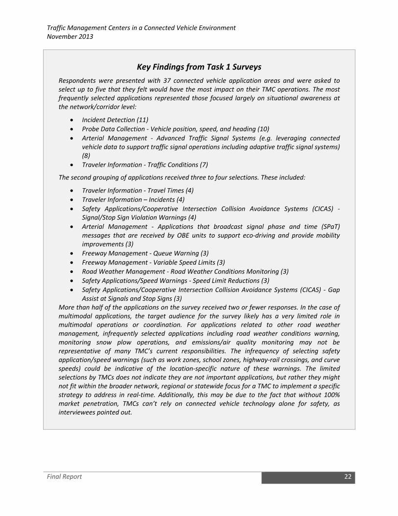
Traffic Management Centers in a Connected Vehicle Environment
November 2013
Final Report 22
Key Findings from Task 1 Surveys
Respondents were presented with 37 connected vehicle application areas and were asked to
select up to five that they felt would have the most impact on their TMC operations. The most
frequently selected applications represented those focused largely on situational awareness at
the network/corridor level:
• Incident Detection (11)
• Probe Data Collection - Vehicle position, speed, and heading (10)
• Arterial Management - Advanced Traffic Signal Systems (e.g. leveraging connected
vehicle data to support traffic signal operations including adaptive traffic signal systems)
(8)
• Traveler Information - Traffic Conditions (7)
The second grouping of applications received three to four selections. These included:
• Traveler Information - Travel Times (4)
• Traveler Information – Incidents (4)
• Safety Applications/Cooperative Intersection Collision Avoidance Systems (CICAS) -
Signal/Stop Sign Violation Warnings (4)
• Arterial Management - Applications that broadcast signal phase and time (SPaT)
messages that are received by OBE units to support eco-driving and provide mobility
improvements (3)
• Freeway Management - Queue Warning (3)
• Freeway Management - Variable Speed Limits (3)
• Road Weather Management - Road Weather Conditions Monitoring (3)
• Safety Applications/Speed Warnings - Speed Limit Reductions (3)
• Safety Applications/Cooperative Intersection Collision Avoidance Systems (CICAS) - Gap
Assist at Signals and Stop Signs (3)
More than half of the applications on the survey received two or fewer responses. In the case of
multimodal applications, the target audience for the survey likely has a very limited role in
multimodal operations or coordination. For applications related to other road weather
management, infrequently selected applications including road weather conditions warning,
monitoring snow plow operations, and emissions/air quality monitoring may not be
representative of many TMC’s current responsibilities. The infrequency of selecting safety
application/speed warnings (such as work zones, school zones, highway-rail crossings, and curve
speeds) could be indicative of the location-specific nature of these warnings. The limited
selections by TMCs does not indicate they are not important applications, but rather they might
not fit within the broader network, regional or statewide focus for a TMC to implement a specific
strategy to address in real-time. Additionally, this may be due to the fact that without 100%
market penetration, TMCs can’t rely on connected vehicle technology alone for safety, as
interviewees pointed out.

Traffic Management Centers in a Connected Vehicle Environment
November 2013
Final Report 23
4.3.1 Incident Management
Description: The incident management service package includes managing unplanned incidents (e.g.,
crashes, weather, lane obstructions), and planned incidents (e.g., concerts, sporting events) so that the
impact to the transportation network and traveler safety is minimized. Included are incident detection
capabilities through roadside surveillance devices (e.g. CCTV), traffic detectors, connected vehicle
technologies, and through regional coordination with other TMCs or Third Part Data Providers.
Information from these diverse sources is collected and correlated to detect and verify incidents and
implement an appropriate response. Incident management also includes appropriate response in
coordination with emergency management, maintenance and construction management, and other
incident response personnel to confirm incidents. Incident response also includes presentation of
information to affected travelers.
Potential Connected Vehicle Applications:
• Incident Detection
• Incident Warnings
• Advanced Automatic Crash Notification Relay
• Emergency Communications and Evacuation
• Incident Scene Pre-Arrival Staging for Emergency Responders
• Incident Scene Work Zone Alerts for Drivers and Workers
• Emergency Vehicle Alerts
Potential Changes to How a TMC Operates: With a combination of connected vehicle technologies
TMCs will be able to collect an enhanced set of incident data to assist with operational strategies. These
applications will allow users (driver, non-driver, or vehicle system) to initiate requests for emergency
assistance and enable emergency management systems to locate the user, gather information about the
incident, and determine the appropriate response. The request for assistance may be manually initiated
or automated through links to vehicle sensors. These user initiated incident alerts help TMCs to more
rapidly log incidents and respond with the appropriate incident (planned or unplanned) mitigation
resources. These applications also allow TMCs to disseminate incident information (planned and
unplanned) through the connected vehicle system to vehicle occupants so they can make decisions
about alternate routes or modes of travel.
Key Findings from Task 2 Interviews
When asked what type of data TMCs would benefit from most in a connected vehicle
environment, several state and local agency staff identified better crash data as being the most
beneficial data for a TMC. Interviewees stated that connected vehicle technologies would allow
TMCs to collect better incident data including more detailed information about the location of
the incident; the number of lanes blocked; impact on nearby traffic; the number and types of
vehicles involved the incident; information about how best to route emergency vehicles to the
incident site. Interviewees also stated that TMCs may also use connected vehicle technologies to

Traffic Management Centers in a Connected Vehicle Environment
November 2013
Final Report 24
collect data from first responders at the incident site. These data could support data collection
including information about when the response vehicle arrives or leaves the incident site.
When asked about how TMCs currently collect incident data, TMC staff noted that they often
rely on police/dispatchers to provide incident data to the TMC. At times it can take 10-15
minutes or longer for the TMC to receive incident data. In a connected vehicle environment,
many TMC staff interviewed believed connected vehicle technologies would help reduce the time
it took for TMCs and other first responders to detect and verify incidents. They envisioned On-
Star like information being sent from the vehicles involved in the incident directly to the TMC and
other first responders.
Agency staff also saw the potential to use connected vehicle technologies to provide real-time
traveler information directly to in-vehicle systems during incidents. In a connected vehicle
environment, vehicle systems could send incident and real-time traffic data to the RSE which in
turn would send these data to the TMC. Upon receiving these data, the TMC would determine
incident response plans and disseminate information to vehicles approaching the incident.
Messages provided by TMCs could be used to divert traffic away from the incident or support
speed harmonization strategies (e.g., variable speed limits) to smooth traffic flow.
With regard to incident data, TMCs are very interested in learning actionable information they
can collect from connected vehicle data. Many staff acknowledged the potential to collect a lot
of data from vehicles, but noted that TMCs need to figure out how to deal with these large
quantities of data, identify how to analyze the data, and determine how to best use it to benefit
operations and management of the transportation system. Many TMCs interviewed, stated that
connected vehicle data would also help support integrated corridor management (ICM) efforts
currently underway my many agencies.
4.3.2 Roadway Hazard Warnings (Continuous and Transient)
Description: The roadway hazard warnings service package includes systems that dynamically warn
drivers approaching continuous and transient hazards on a roadway. Continuous hazards include low
bridges, narrowed lanes, and sharp curves. Transient hazards include roadway weather conditions, road
surface conditions (including uneven pavement or scarfaced road surfaces), traffic conditions including
queues, obstacles, or animals in the roadway and any other transient events that can be sensed.
Traditional ITS warning systems can alert approaching drivers via warning signs, flashing lights, in-vehicle
messages, etc. Such systems can increase the safety of a roadway by reducing the occurrence of
incidents due to these hazards. These systems can be centrally monitored and controlled by a TMC or
they can be autonomous.
Potential Connected Vehicle Applications:
Roadway Continuous Hazards
• Curve Speed Warning
• Oversize Vehicle Warning
• Railroad Crossing Warning
• Low Bridge Warning
• Lane Merge Warning

Traffic Management Centers in a Connected Vehicle Environment
November 2013
Final Report 25
• Reduced Sight Distance Warning
Roadway Transient Hazards
• Roadway Obstacle Detection (e.g., animal, pedestrians, dropped cargo, stalled vehicle)
• Queue Warning
• Low Visibility Warning
• Glare Warning
• Wrong Way Driver Warning
Potential Changes to How a TMC Operates: With a combination of connected vehicle technologies
including probe data sets, and vehicle sensor data (e.g., glare/photoelectric sensors, stationary
objects/radars, potholes/accelerometers), TMCs will be able to better determine when hazards exist
and disseminate dynamic roadway warnings via connected vehicle systems to initiate in-vehicle
warnings. Likewise, TMCs will be able to disseminate continuous roadway information to connected
vehicle systems that may initiate warnings to drivers (e.g., curve geometry for truck rollover systems,
bridge height information for tall vehicles). With the addition of decision support systems, TMCs may be
able to use aggregated connected vehicle data to identify compounded hazards, such as, glare that
creates traffic queues on sharp curves with reduced sight distance. The decision support system may be
able to determine for example a safe speed under these compounded conditions that would help
mitigate incidents and then assist TMC operators in disseminating information about safe speeds.
Key Findings from Literature
Queue Warning Applications
The USDOT’s Dynamic Mobility Applications (DMA) Program is investigating Queue Warning
applications that seek to provide a vehicle operator with sufficient warning of an impending
queue backup in order to brake safely, change lanes, or modify the route such that secondary
collisions can be minimized or even eliminated. It is distinct from collision warning, which
pertains to events or conditions that require immediate or emergency actions. A queue backup
can occur due to a number of conditions, including:
• Daily recurring congestion caused by bottlenecks;
• Work zones, which typically cause bottlenecks;
• Incidents, which, depending on traffic flow, lead to bottlenecks;
• Weather conditions, including icing, low visibility, sun angles, and high wind; and
• Exit ramp spillovers onto freeways due to surface street traffic conditions.
In all cases, queuing is a result of significant downstream speed reductions or stopped traffic
and can occur with freeways, arterials, and rural roads. Queuing conditions present significant
safety concerns; in particular, the increased potential for rear-end collisions. They also present
disruptions to traffic throughput by introducing shockwaves into the upstream traffic flow. A
queue warning system will be successful at minimizing secondary collisions and the resulting
traffic flow shockwaves by being able to: rapidly detect the location, duration, and length of
queue propagation; formulate an appropriate response plan for approaching vehicles; and

Traffic Management Centers in a Connected Vehicle Environment
November 2013
Final Report 26
disseminate such information to the approaching vehicles readily and in an actionable manner.
Queue Warning applications aim to minimize the occurrence and impact of traffic queues by
using connected vehicle technologies, including V2I and V2V communications, to enable
vehicles within the queue event to automatically broadcast their queued status information
(e.g., rapid deceleration, disabled status, lane location) to nearby upstream vehicles and to
TMCs.
The USDOT developed a Concept of Operations and requirements for a connected vehicle Queue
Warning application. A prototype application is also being developed by the USDOT’s DMA
Program. For more information on the USDOT’s DMA Program, visit:
http://www.its.dot.gov/dma/
4.3.3 Speed Monitoring and Warning
Description: The speed monitoring and warning service package includes systems that remotely monitor
and control speed warning systems. These systems remotely monitor vehicle speeds and present this
information to traffic operations personnel. They also configure and control the speed monitoring and
warning equipment that provides safe speed advisories to the motorist. This category sets appropriate
speed limits along roadways to create more uniform speeds, to provide safe speeds for roadway
characteristics (e.g., geometry, sight distance), to promote safe driving during adverse conditions (e.g.,
fog, rain, snow, glare), to reduce air pollution, and/or to protect pedestrians and workers. Speed
management may support warnings to drivers as they enter school zones or speed zones. Typically, roadway
equipment over and along the roadway will then display the speed limits and additional information
such as basic safety rules and current traffic information. These systems can be centrally monitored and
controlled by a TMC or they can be autonomous.
Potential Connected Vehicle Applications:
• Variable Speed Limits
• Curve Speed Warning
• School Zone Speed Warning
• Work Zone Speed Warning
• Reduced Speed Zone Warning
Potential Changes to How a TMC Operates: With connected vehicle technologies TMCs will be able to
continuously disseminate safe speed information to connected vehicle systems that can warn drivers of
safe speeds and/or speed infractions. Speed harmonization applications may also enable variable speed
limits to be sent to vehicles to support traffic smoothing. Alternatively, speed warnings could be
provided to vehicles prior to entering school zones or work zones where speed limits are reduced. With
connected vehicle data, systems will have the capability to determine excessive speed for vehicles. To
make this determination, the system will accept and process data about the vehicles speed, heading and
position. The system will also accept and process TMC data about the safe speeds including curve
speeds, variable speeds limits, work and school zone speeds. This information will be used by the system

Traffic Management Centers in a Connected Vehicle Environment
November 2013
Final Report 27
to calculate the likelihood of excessive speed and issue timely in-vehicle violation warnings to drivers.
Likewise, anonymous vehicle probe data can alert enforcement agencies to unsafe speeding in specific
locations. Optionally, anonymous speed violation information can be provided to the TMC to be
analyzed for potential improvements to the roadway infrastructure.
Key Findings from Literature
Speed Warning Applications
The USDOT’s Vehicle-to-Infrastructure (V2I) Program developed a Concept of Operations for V2I
Safety Applications. Reduced Speed Zone Warning applications are intended to alert or warn
drivers of equipped and non-equipped vehicles who are approaching a reduced speed zone if
they are operating at a speed higher than the zone’s posted speed limit and/or if the
configuration of the roadway is altered (e.g., lane closures, lane shifts). This will be achieved
through the integration of both vehicle-based and infrastructure-based technologies, including
onboard and roadside signage warning systems, to make drivers approaching a reduced speed
zone aware of the potential for a crash due to changes in speed and roadway configuration.
The V2I Concept of Operations documents also describe a Curve Speed Warning application. This
application is intended to improve safety when traversing curves through the integration of
vehicle-based and infrastructure-based technologies to help drivers approaching a curve travel
through it at a safe speed based on the current road and weather conditions. In particular, the
application is intended to warn drivers if they are exceeding the safe speed threshold which may
result in a loss of vehicle stability and control, leading to run-off-road or roll-over events.
Variable Speed Limit Applications
The USDOT’s Dynamic Mobility Applications (DMA) Program is investigating Dynamic Speed
Harmonization applications that seek to dynamically adjust and coordinate maximum
appropriate vehicle speeds in response to downstream congestion, incidents, and weather or
road conditions in order to maximize traffic throughput and reduce crashes. Speed
harmonization techniques promote reduced vehicle speeds and speed variance, especially in
unsafe driving conditions; support modest improvements in throughput; and have a moderately
positive impact on travel time reliability. Research and experimental evidence has consistently
demonstrated that by reducing speed variability among vehicles, especially in near-onset flow
breakdown conditions, traffic throughput is improved, flow breakdown formation is delayed or
even eliminated, and collisions and severity of collisions are reduced.
The USDOT’s Speed Harmonization application concept aims to realize these benefits by utilizing
connected vehicle V2V and V2I communication to detect the precipitating roadway or congestion
conditions that might necessitate speed harmonization, to generate the appropriate response
plans and speed recommendation strategies for upstream traffic, and to broadcast such
recommendations to the affected vehicles.
The USDOT developed a Concept of Operations and requirements for a connected vehicle Speed
Harmonization application. A prototype application is also being developed by the USDOT’s DMA
Program. For more information on the USDOT’s DMA Program, visit:
http://www.its.dot.gov/dma/

Traffic Management Centers in a Connected Vehicle Environment
November 2013
Final Report 28
4.3.4 Cooperative Intersection Collision Avoidance Systems (CICAS)
Description: The CICAS service package involves the dissemination of intersection control and warning
information. These systems disseminate intersection information to drivers using signal systems,
flashing warning lights, and in-vehicle warning systems. Data is collected via infrastructure sensors and
vehicle systems in order to determine optimized flow for traffic signal systems and initiate warning to
mitigate potential crashes. These systems can be centrally controlled by a TMC, locally controlled or be
autonomous.
Potential Connected Vehicle Applications:
• Signal/Stop Sign Violation Warnings
• Gap Assist at Signals and Stop Signs
• Stop Sign Violation Warning
Potential Changes to How a TMC Operates: With a combination of connected vehicle and infrastructure
technologies TMCs can disseminate intersection control (e.g., signal, phase and timing (SPaT)) and
warning (e.g., intersection characteristics, potential intersection obstructions) information to connected
vehicle systems to help inform drivers of impending dangers at both signalized and un-signalized
intersections. These intersection control and warning applications are envisioned to provide timely
warnings to drivers if they appear headed towards violating intersection rules or to avoid other
obstacles in intersections. These applications focus on the delivery of a combination of accurate map
and enhanced positioning data and probe data to the vehicle through the connected vehicle system, and
establishing an interface between a traffic signal controller and the connected vehicle system.
Optionally, potential violation and actual violation information can be provided to the TMC to be
assessed for potential improvements to intersections.
Key Findings from Literature
The USDOT’s Vehicle-to-Infrastructure (V2I) Program developed a Concept of Operations for V2I
Safety Applications. Included in these documents are descriptions of several V2I connected
vehicle safety applications including: Stop Sign Violation Warning applications and Stop Sign Gap
Assist applications. The Concept of Operations describes, at a high level, how these connected
vehicle applications may work. For more information on USDOT’s V2I Safety Applications, visit:
http://www.its.dot.gov/research/v2i.htm
Stop Sign Violation Warning Applications
Stop Sign Violation Warning applications are intended to improve safety at un-signalized
intersections with posted stop signs. This will be achieved through the integration of both
vehicle-based and infrastructure-based technologies, focusing mostly on onboard warning
systems, to make drivers approaching an un-signalized intersection aware of the need to stop
ahead if a violation is predicted to occur. In this way, Stop Sign Violation Warning applications
will help reduce the number of drivers that run stop signs, reducing the number of conflicts and
crashes.

Traffic Management Centers in a Connected Vehicle Environment
November 2013
Final Report 29
Stop Sign Gap Assist Applications
Stop Sign Gap Assist applications are intended to improve safety at non-signalized intersections
where only the minor road has posted stop signs. This will be achieved through the integration
of both vehicle-based and infrastructure-based technologies, including both onboard and
roadside signage warning systems, to help drivers stopped at an intersection understand the
state of activities within that intersection by providing a warning of unsafe gaps on the major
road to drivers stopped on a minor road. In this way, Stop Sign Gap Assist applications will help
drivers maneuver through cross traffic, reducing the number of conflicts and crashes.
4.3.5 Traffic Signal Control
Description: The traffic signal control service package provides the central control and monitoring
equipment, communication links, and the signal control equipment that support traffic control at
signalized intersections. There are a range of traffic signal control systems ranging from fixed-schedule
control systems to fully traffic responsive systems that dynamically adjust control plans and strategies
based on current traffic conditions and priority requests. These systems provide infrastructure based
control and warning information to drivers as they approach intersections. This category also includes
control of signals for the purpose of providing vehicle priority and preemption.
Potential Connected Vehicle Applications:
• Intelligent Traffic Signal Systems
• Transit Signal Priority
• Emergency Vehicle Preemption
• Freight Signal Priority
Potential Changes to How a TMC Operates: With a combination of connected vehicle and infrastructure
technologies TMCs will be able to collect more robust probe data sets to enable greater accuracy in
signal control analyses. These data sets can provide enhanced measures including queue length, stops
and stop locations, stop delay, cycle failures, time and position trajectories, queue overflow, and arterial
travel times. These enhanced data sets can also provide sufficient data to efficiently generate signal
timing plans including volumes (by lane), turning movements, stops and stop locations, and stop delay.
The probe data sets can be collected on a continuous basis to enable signal timing updates that are
more responsive to changes in traffic patterns. Additionally, the traffic signal controller will be able to
use the connected vehicle system to enable new and potentially more cost effective methods for vehicle
priority and preemption systems. These applications focus on the delivery of accurate map and
enhanced positioning data to the vehicle through the connected vehicle system, and establishing an
interface between a traffic signal controller and the connected vehicle system. The TMC can benefit by
reducing and/or eliminating the need for traditional vehicle detection, priority, and preemption systems.

Traffic Management Centers in a Connected Vehicle Environment
November 2013
Final Report 30
Key Findings from Literature
The Multi-Modal Intelligent Traffic Signal System (MMITSS) project is part of the Cooperative
Transportation System Pooled Fund Study and is investigating the potential for connected vehicle
technologies to transform traffic signal control. The project incorporates the following arterial
traffic signal applications:
• Intelligent Traffic Signal System: Using high-fidelity data collected from vehicles through
V2V and V2I wireless communications as well as pedestrian and non-motorized travelers,
this proposed application seeks to control signals and maximize flows in real time.
• Transit Signal Priority: This proposed application allows transit agencies to manage bus
service by adding the capability to grant buses priority based on a number of factors. The
proposed application provides the ability for transit vehicles to communicate passenger
count data, service type, scheduled and actual arrival time, and heading information to
roadside equipment via an on-board device.
• Mobile Accessible Pedestrian Signal System: This application integrates information from
roadside or intersection sensors and new forms of data from pedestrian-carried mobile
devices. Such systems will be used to inform visually impaired pedestrians when to cross
and how to remain aligned with the crosswalk.
• Emergency Vehicle Preemption: This proposed application will integrate with V2V and
V2I communication systems. The application would account for non-linear effects of
multiple emergency responses through the same traffic network.
• Freight Signal Priority: This application provides signal priority near freight facilities
based on current and projected freight movements. The goal is to reduce delays and
increase travel time reliability for freight traffic, while enhancing safety at key
intersections.
The project is divided into four technical segments including: the development of a Concept of
Operations, development of system requirements, development of system design, and
development of a prototype utilizing the California Test Bed and/or Maricopa County Test Bed as
the target implementation networks.
For more information on the MMITSS Project, visit: http://www.its.dot.gov/dma/
4.3.6 Probe Data Collection
Description: The probe data (e.g., speed, position, heading, and time) collection service package
provides an alternative approach for surveillance of the roadway network. Two general implementation
paths are supported by these systems: (1) wide-area wireless communications between the vehicle and
TMC can be used to communicate vehicle operational information and status directly to the center, and
(2) DSRC between passing vehicles and RSE units can be used to provide equivalent information to the
center. The first approach leverages wide area communications equipment (i.e., cell phones) that may
already be in the vehicle to support personal safety and advanced traveler information services. The
second approach utilizes vehicle equipment that supports toll collection, in-vehicle signing, and other
connected vehicle applications. Probe Data Collection enables TMCs and Third Party Data Providers to
monitor road conditions, identify incidents, analyze and reduce the collected data, and make it available

Traffic Management Centers in a Connected Vehicle Environment
November 2013
Final Report 31
to users and private information providers. It requires one of the communications options identified
above, on-board equipment, data reduction software, and fixed-point to fixed-point links between
centers to share the collected information. Due to the large volume of data collected by probes, data
reduction techniques are required, such as the ability to identify and filter out-of-bounds or extreme
data reports.
Potential Connected Vehicle Applications:
• Probe Vehicle Data (PVD) Collection
• Performance Monitoring and Planning
Key Findings from Literature
Michigan DOT’s Data Use Analysis and Processing (DUAP) Report
The Michigan Department of Transportation (MDOT) recently completed a report covering
several key subjects related to the generation of connected vehicle probe vehicle data and use of
these data in application of interest to state departments of transportation and local public
transportation agencies. The evaluations conducted as part of the project were primarily based
on the probe vehicle data collection system that was deployed and part of the USDOT’s Vehicle-
Infrastructure Integration (VII) Proof-of-Concept (POC) Test Bed Program in Novi, Michigan. The
probe data collection system was designed around the use of the 5.9-GHz Dedicated Short Range
Communication (DSRC) wireless protocol to enable vehicles to communicate with Roadside
Equipment (RSE). The generation of snapshots further followed the protocols defined within the
SAE J2735 DSRC Message Set standard.
Michigan DOT’s DUAP Report includes:
• A summary of the protocols that were used to generate and retrieve probe vehicle
snapshots;
• An evaluation of the POC test data that were accumulated during the 2008 test
program;
• An examination of the effects of snapshot generation protocols and privacy policies on
data latency, data quality, and the ability to track vehicles over short distances;
• A mapping of application data needs and general descriptions of processes required to
convert raw probe data into useful information;
• An evaluation of how basic traffic flow performance measures (flow rates, flow density,
travel times, speed profiles, queue parameters) can be estimated from probe data in
systems featuring full and partial proportions of probe vehicles; and
• A Concept of Operations for an enhanced traffic monitoring system incorporating probe
vehicle and other data sources.
It is envisioned that this recent report will be useful to TMCs as they begin to collect and process
probe data from vehicles in a connected vehicle environment. To access the DUAP report, visit:
http://www.michigan.gov/documents/mdot/MDOT_DUAP_Project_Report_301596_7.pdf

Traffic Management Centers in a Connected Vehicle Environment
November 2013
Final Report 32
Potential Changes to How a TMC Operates: With connected vehicle technologies TMCs can have access
to greater probe data sets that can enhance their operational and planning capabilities. TMCs will need
to accommodate the collection and possibly reduction and storage of the connected vehicle probe data
either directly or through third party providers. TMCs will then be able to leverage this data and
connected vehicle applications to provide better management of TMC facilities and provide greater
situational awareness for drivers.
4.3.7 Traffic Metering
Description: The traffic metering service package includes central monitoring and control,
communications, and field equipment that support metering of traffic. It supports the complete range of
metering strategies including ramp, interchange, and mainline metering. This category incorporates
traffic data collected from sensors and probes to support traffic monitoring so responsive and adaptive
metering strategies can be implemented. Also included is configurable field equipment to disseminate
information to drivers approaching a meter, such as advance warning of the meter, its operational
status (whether it is currently on or not, how many cars per green are allowed, etc.), lane usage at the
meter (including a bypass lane for HOVs) and existing queue at the meter.
Potential Connected Vehicle Applications:
• Ramp Metering
Potential Changes to How a TMC Operates: With connected vehicle technologies TMCs will be able to
collect and use probe data to continuously sense vehicles and provide traffic metering without the need
for traditional sensor technology. The collection of the probe data sets may allow TMCs to activate and
deactivate the meters more dynamically based on actual conditions. Ultimately, TMCs could disseminate
the traffic metering information to the driver through the connected vehicle system. This could
potentially eliminate the need for field equipment or simply provide a virtual backup for the field
equipment in the case of equipment failures.
4.3.8 Lane Management
Description: The lane management service package provides remote monitoring and control of the
systems that are used to dynamically manage travel lanes, including temporary use of shoulders as
travel lanes, reversible lanes, HOV and HOT lanes. These systems monitor traffic conditions and demand
measured in the field and determine when the lane configuration of the roadway should be changed;
when intersections and/or interchanges should be reconfigured; when shoulders should be used for
travel (as a lane); when lanes should be designated for use by special vehicles only, such as buses, high
occupancy vehicles (HOVs), high occupancy toll and express tolls (HOTs), vehicles attending a special
event, etc.; and/or when types of vehicles should be prohibited or restricted from using particular lanes.
These systems control the field equipment used to manage and control specific lanes and the shoulders
and provide notification of such changes to drivers. They also can automatically notify enforcement
agencies of lane control violations.

Traffic Management Centers in a Connected Vehicle Environment
November 2013
Final Report 33
Potential Connected Vehicle Applications:
• HOV / HOT Lanes Information Dissemination
• Dynamic Lane Management and Shoulder Use
• Reversible Lane Management
• Restricted Lane Warnings
Potential Changes to How a TMC Operates: With connected vehicle technologies including probe data
collection TMCs can improve their ability to plan and manage lanes based on actual demand. TMCs can
also use connected vehicle technology to better inform drivers of impending changes to lane
configurations and rules, via information disseminated through the connected vehicle system. TMCs
may also be able to use lane violation data to better analyze and plan for improvements to the roadway
infrastructure and operational practices.
4.3.9 Electronic Payments / Fee Collection
Description: The electronic payments/fee collection service package provides TMCs with the ability to
collect payments electronically and detect and process violations. The fees that are collected may be
adjusted to implement tolls, demand management strategies such as HOT lanes, and other road user
fees. Field-Mobile communication between field equipment and the vehicle is required as well as “fixed
point-fixed point” interfaces between the fee collection equipment and transportation authorities and
the financial infrastructure that supports fee collection. Payment violations may also be identified and
electronically posted to vehicle owners.
Potential Connected Vehicle Applications:
• Fee Collection
Potential Changes to How a TMC Operates: It should be noted that back-end financial software is
usually not in the hands of TMCs and thus this service package is not likely to impact TMCs; instead
entities operating electronic toll collection infrastructure. With connected vehicle technologies fee
collection application can be used to allow the vehicle driver to securely make payments. Fees
associated with that vehicle within an open-road environment can be deducted from a pre-authorized
account. A predefined set of cues within the application will allow the vehicle driver to automatically pay
fees for that vehicle.
Fees will be assessed while the vehicle is moving and is within range of payment infrastructure. Payment
applications have two major components: the vehicle application facilitating the transfer of account
information between the driver and the vehicle, and network components which allow the proper
transaction service to be established and maintained. The application focuses on establishing an
interface between the vehicle and infrastructure payment systems through the connected vehicle
system. Entities operating electronic toll collection can leverage the automation of fee payment
collection through the connected vehicle system and potentially eliminate the need for manual
processes and realize benefits due to the reduced need for costly field infrastructure.

Traffic Management Centers in a Connected Vehicle Environment
November 2013
Final Report 34
4.3.10 Traffic Information Dissemination
Description: The traffic information dissemination service package consists of providing driver
information using dynamic message signs, highway advisory radio, 511 systems, websites, telephony
systems, and connected vehicle technologies including in-vehicle signing, haptic and audio alerts. A wide
range of information can be disseminated including traffic and road conditions, closure and detour
information, travel restrictions and warnings, incident information, travel times, and emergency alerts
and driver advisories.
Potential Connected Vehicle Applications:
Traveler Information / In-Vehicle Signage
• Traffic and Weather Conditions
• Travel Times
• Incidents
• Work Zones
• School Zones
Potential Changes to How a TMC Operates: With connected vehicle technologies TMCs will have access
to a greater set of information useful for optimizing TMC operations. Likewise, TMCs will have
continuous access to each vehicle to disseminate traveler information. In a connected vehicle
environment, information can be sent directly to the users (e.g., to in-vehicle devices) versus having the
users retrieve the information themselves from systems like 511. This access can serve as a convenient
method to provide prioritized traveler information including emergency and travel conditions, roadway
configurations, roadway warnings, and user fees.
Key Findings from Literature
The Enable Advanced Traveler Information System (Enable ATIS) project is part of the USDOT’s
Dynamic Mobility Applications (DMA) program. The initiative is looking ahead to a future
operational environment that will support and enable an advanced, transformational traveler
information services framework. This future framework is envisioned to be enabled with a much
more robust pool of real-time data through connected vehicles, public and private systems, and
user-generated content. As part of the USDOT’s DMA Program, an Operational Concept
document was developed. The document incorporates input from various stakeholders around
the United States. This Operational Concept does not define specific future applications, but
rather seeks to formalize a framework whereby multiple activities are envisioned to interact to
support a diverse traveler information environment.
Enable ATIS has the potential to transform how traveler information is gathered and shared,
how agencies are able to use information to better manage and balance the transportation
networks, as well as transform how users obtain information about every detail of their trip.
New forms of data will unlock the potential for a highly personalized, intuitive, and predictive

Traffic Management Centers in a Connected Vehicle Environment
November 2013
Final Report 35
suite of traveler information services well beyond what is experienced today. Connected vehicle
technologies are a major component of this vision.
For more information, visit: http://www.its.dot.gov/dma/
4.3.11 Emissions Monitoring and Management
Description: The emissions monitoring and management service package monitors vehicle emissions
and provides general air quality monitoring using distributed sensors to collect the data. The collected
information is transmitted to the emissions management centers for processing. Both area wide air
quality monitoring and point emissions monitoring are included. For area wide monitoring, these
systems measure air quality, identify sectors that are non-compliant with air quality standards and
collect, store, and report supporting statistical data. For point emissions monitoring, these systems
collect data from on-board diagnostic systems and measures tail pipe emissions to identify vehicles that
exceed emissions standards and/or clean vehicles that could be released from standard emissions tests,
depending on policy and regulations. Summary emissions information or warnings can also be displayed
to drivers. The gathered information can be used to implement environmentally sensitive TDM
programs, policies, and regulations.
Potential Connected Vehicle Applications:
• Emissions / Air Quality Monitoring
• Emissions Pricing
Potential Changes to How a TMC Operates: With a combination of connected vehicle technologies
TMCs can collect a more robust set of data and information to analyze compliance with area wide air
quality standards and determine effective mitigation strategies. The USDOT’s AERIS Program is
investigating how data collected from vehicles can be used to estimate vehicular emissions. Models
have been developed to estimate vehicular emissions based on an individual vehicle’s speed,
acceleration, fuel consumption, and other data collected directly from vehicles. The AERIS Program is
currently investigating the potential for a basic environmental message (BEM) to be included in J2735.
Some mitigation strategies could be facilitated using connected vehicle systems such as the
implementation of emissions pricing, eco-speed limits, or updates to signal timing plans especially on
code red air quality days.
Key Findings from Literature
The USDOT’s Applications for the Environment: Real-Time Information Synthesis (AERIS) research
program is working in partnership with other connected vehicle research efforts to better define
how connected vehicle data and applications might contribute to mitigating some of the
negative environmental impacts of surface transportation. The objectives of the AERIS research
program are to investigate whether it is possible and feasible to:

Traffic Management Centers in a Connected Vehicle Environment
November 2013
Final Report 36
• Identify connected vehicle applications that could provide environmental impact
reduction benefits via reduced fuel use, more efficient vehicles, and reduced emissions.
• Facilitate and incentivize “green choices” by transportation service consumers (i.e.,
system users, system operators, policy decision makers, etc.).
• Identify vehicle-to-vehicle (V2V), vehicle-to-infrastructure (V2I), and vehicle-to-grid (V2G)
data (and other) exchanges via wireless technologies of various types.
• Model and analyze connected vehicle applications to estimate the potential
environmental impact reduction benefits.
• Develop a prototype for one of the applications to test its efficacy and usefulness.
The AERIS Program is investigating three high priority operational scenarios and has developed
detailed Concept of Operations documents for each concept. These concepts include:
• Eco-Signal Operations is investigating how connected vehicle technologies can be used
to decrease fuel consumption and decrease emissions by reducing idling, the number of
stops, unnecessary accelerations and decelerations as well as improving traffic flow at
signalized intersections.
• Eco-Lanes features dedicated lanes optimized for the environment, referred to as eco-
lanes. Eco-lanes are similar to high-occupancy vehicle (HOV) lanes and are optimized for
the environment through the use of connected vehicle data. These lanes are targeted
toward low-emission, high-occupancy, freight, transit, and alternative-fuel vehicles
(AFV). Drivers are able to opt in to these dedicated eco-lanes to take advantage of eco-
friendly applications such as eco-cooperative adaptive cruise control (eco-CACC), eco-
speed harmonization, and wireless inductive charging applications.
• Low Emissions Zones aim at using connected vehicle technologies to define a geographic
area that seeks to restrict or deter access by specific categories of high-polluting vehicles
to improve the air quality within the geographic area. With connected vehicle
technologies, low emissions zones may be responsive to real-time traffic and
environmental conditions.
For more information on the USDOT’s AERIS Program, visit: http://www.its.dot.gov/aeris/
4.3.12 Road Weather Monitoring and Management
Description: The road weather monitoring and management service package includes collecting current
road and weather conditions using data collected from environmental sensors such as road weather
information stations (RWIS) deployed on and about the roadway. In addition to fixed sensor stations at
the roadside, sensing of the roadway environment can also occur from sensor systems located on
vehicles. The collected environmental data is used to process the information and make decisions on
operations. The collected environmental data may be aggregated, combined with data attributes, and
sent to meteorological systems for data qualification and further data consolidation.
This category also includes processing and distributing the environmental information. These systems
use the environmental data to detect environmental hazards such as icy road conditions, high winds,
dense fog, etc. With this data system operators and decision support systems can make decision on

Traffic Management Centers in a Connected Vehicle Environment
November 2013
Final Report 37
corrective actions to take. The continuing updates of road condition information and current
temperatures can be used by system operators to more effectively deploy road maintenance resources,
issue general traveler advisories, issue location specific warnings to drivers, and aid operators in
scheduling work activity.
Potential Connected Vehicle Applications:
• Road Weather Conditions Monitoring
• Spot Weather Impact Warnings
• Monitoring of Snow Plow Activities
• Road Weather Information and Routing Support for Emergency Responders
Potential Changes to How a TMC Operates: With a combination of connected vehicle technologies
TMCs can collect vehicle sensor data (e.g., glare, precipitation, pavement temperature, ambient
temperature, wiper activation, etc.) and probe data, provided via the connected vehicle system, to
better manage roadway resources. With additional data sets from the vehicle the TMC can analyze
travel conditions wherever vehicles are traveling. This significantly increases the number of
environmental sensor data points from which to draw weather information. These increased data sets
can significantly improve operational analyses and the quality of decision support and information
dissemination. Additionally, TMCs will have the ability to directly communicate with vehicle occupants
to provide weather related traffic information and warnings to improve safety and mobility. TMCs can
also use connected vehicle systems to collect vehicle positioning information from (e.g., snow plows,
infield supervisory resources) to better plan and manage operational efforts due to weather impacts.
Key Findings from Literature
The USDOT’s Road Weather Management (RWM) Program applications and services are
intended to capitalize on the previous Clarus Initiative research that has delivered a network of
road weather information by integrating existing data sources. The vision for the RWM Program
is to broaden the foundation of road weather data to include mobile sources and to focus the
analysis on improving the ability to detect and forecast road weather and pavement conditions
by specific roadway links. The RWM Program identified six high-priority applications:
• Enhanced Maintenance Decision Support System (MDSS): This application will provide
the existing federal prototype MDSS with expanded data acquisition from connected
vehicles. Snowplows, agency fleet vehicles, and other vehicles operated by the general
public will provide road weather connected vehicle data to the Enhanced-MDSS, which
will use this data to generate recommendations to maintenance personnel.
• Information for Maintenance and Fleet Management Systems: This application focuses
on non-road weather data. The data collected may include powertrain diagnostic
information from maintenance and specialty vehicles, the status of vehicle components,
the current location of maintenance vehicles and other equipment, and the types and
amounts of materials onboard maintenance vehicles and will be used to automate the
inputs to Maintenance and Fleet Management Systems on a year-round basis.

Traffic Management Centers in a Connected Vehicle Environment
November 2013
Final Report 38
• Weather-Responsive Traffic Management: Two Weather-Responsive Traffic
Management applications are being investigated. First, connected vehicles provide
opportunities to enhance the operation of variable speed limit (VSL) systems and
dramatically improve work zone safety during severe weather events. Second, connected
vehicles can support the effective operation of signalized intersections where
information from connected vehicles can be used to adjust timing intervals in a signal
cycle or to select special signal timing plans.
• Motorist Advisories and Warnings: This application focuses on the ability to gather road
weather information from connected vehicles to dramatically change this situation.
Information on deteriorating road and weather conditions on specific roadway segments
can be pushed to travelers through a variety of means as alerts and advisories within a
few minutes.
• Information for Freight Carriers: This application focuses on the ability to gather road
weather information from connected vehicles to significantly improve the ability of
freight shippers to plan and respond to the impacts of severe weather events and poor
road conditions. Information on deteriorating road and weather conditions on specific
roadway segments can be pushed to both truck drivers and their dispatchers.
• Information and Routing Support for Emergency Responders: Emergency responders,
including ambulance operators, paramedics, and fire and rescue organizations, have a
compelling need for the short, medium, and long time horizon road weather alerts and
warnings. This application focuses on how connected vehicle data can be used to help
emergency responders. These applications may help drivers safely operate their vehicles
during severe weather events and under deteriorating road conditions. Emergency
responders also have a particular need for information that affects their dispatching and
routing decisions. Information on weather-affected travel routes, especially road or lane
closures caused by snow, flooding, and wind-blown debris, is particularly important.
For more information on the USDOT’s RWM Program, visit:
http://www.its.dot.gov/connected_vehicle/road_weather.htm
4.3.13 Asset Management
Description: The asset management service package includes the tracking of resources, identification of
resource conditions, and efficient management of resources. These systems for example enable access
to vehicle tracking information, identification of pavement conditions, and efficient operation of
powered resources. As an example, these systems can allow a center to control street lights based on
traffic conditions, time-of-day, and the occurrence of incidents. This type of system can also increase the
safety of a roadway segment by increasing lighting and conserve energy at times when conditions
warrant a reduction in the amount of lighting.
Potential Connected Vehicle Applications:
• State and Local DOT Vehicle Tracking
• Pothole Detection/Pavement Conditions (uneven pavement or scarfaced road surfaces)
• Lighting System Control

Traffic Management Centers in a Connected Vehicle Environment
November 2013
Final Report 39
Potential Changes to How a TMC Operates: With connected vehicle technologies TMCs can collect
probe data for state or locally owned fleet vehicles for tracking purposes to better manage operations.
For example, TMC operators may be able to track progress and location of safety service patrols in order
to update dispatch instructions for improved resource management. Public and private vehicles could
also be equipped with sensors that help to determine pavement conditions on roadways and send that
information to the TMC to be investigated and/or repaired by maintenance crews. Also, TMCs could
reduce carbon footprints and costs by implementing lighting control systems that could be activated
through communication with connected vehicle systems in approaching vehicles. To implement lighting
system control applications, it would require not only new light fixtures in the field, but a completely
new operations system which would need to be managed and monitored at the TMC and a TMC to field
communications systems. The potential wide spread application of these systems has significantly large
impacts on a TMC. These types of systems are not about being turned on and off by
approaching/departing vehicle, but about best managing the lighting on highway systems to balance
safety and efficiency, which must be managed.
Key Findings from Task 2 Interviews
As part of the Virginia Department of Transportation’s (VDOT) recent connected vehicle test bed
effort, the department is testing a pothole detection application along with several other
connected vehicle applications. The purpose of the test bed is for the VDOT to test connected
vehicle technologies in a congested urban area. Assets include vehicles equipped with DSRC and
cellular OBEs, RSEs, back end servers, and a data management system managed by Virginia
Tech.
With the pothole detection application, VDOT is investigating how to best collect and process
connected vehicle data from vehicles and then turn this data into useful information that VDOT
maintenance crews can use to identify and fix/repair the potholes. During interviews with VDOT
staff, it was noted that this single application had the potential to produce a multitude of data
points that may be difficult for TMCs to handle from a data processing standpoint. For example,
in a connected vehicle environment TMCs may receive connected vehicle data about the same
pothole from multiple vehicles. This information compounded with the total number of potholes
on the road has the potential to create real data collection and processing challenges. As other
connected vehicle applications are deployed, the amount of data collected will increase
drastically.

Traffic Management Centers in a Connected Vehicle Environment
November 2013
Final Report 40
4.3.14 Parking Management
Description: The parking management connected vehicle supports communication and coordination
between equipped parking facilities and also supports regional coordination between parking facilities
and traffic and transit management systems. These systems also share information with transit
management systems and information service providers to support multimodal travel planning,
including parking reservation capabilities. Information including current parking availability, system
status, and operating strategies are shared to enable local parking facility management that supports
regional transportation strategies. Parking Management is also important for commercial vehicles due
to their limited hours of service and helps to get trucks off of shoulders and into parking lots is a huge
safety initiative for many state and local DOTs.
Potential Connected Vehicle Applications:
• Parking Management / Information Dissemination
Potential Changes to How a TMC Operates: With connected vehicle technologies TMCs would be able
to communicate parking availability information to vehicle occupants that are delayed due to major
incidents. The parking information and incident information provided by TMCs to the connected vehicle
system may provide vehicle occupants with information needed to make decisions about changing
modes of travel to avoid further delays. As previously mentioned Parking Management is also important
for commercial vehicles due to their limited hours of service helping to get trucks off of shoulders and
into parking lots is a huge safety initiative for many state and local DOTs.
4.3.15 Performance Measures
Description: Performance measures provide accountability to the public and enhance communication
between the operators and users of the system. They can aid in setting policy, allocating resources, and
reporting on results. Performance measures used by TMCs can be categorized into the following
categories:
• Traffic demand assessment (e.g., average daily traffic, vehicle miles traveled, volume-to-capacity
ratios, etc.)
• Traffic flow characteristics (e.g., vehicle throughput, average speed, average travel time, total
delay, travel congestion index, level-of-service, lane occupancy, etc.)
• Reliability measures (e.g., buffer index, planning time index, 95th
percentile travel time)
• Traffic signal operations (e.g., lost time, number of stops, total stopped delay, etc.)
• Traffic safety (e.g., number of crashes, number of secondary crashes, etc.)
• Incident management (e.g., incident notification time, response time, incident duration,
blockage duration, incident clearance time, etc.)
• Pavement conditions assessment
• Environmental assessment (e.g., fuel consumption per vehicle-mile traveled, NOx emission rate,
CO emission rate, particulate matter emission rate, etc.)

Traffic Management Centers in a Connected Vehicle Environment
November 2013
Final Report 41
Potential Connected Vehicle Applications:
• Performance Monitoring and Planning
Potential Changes to How a TMC Operates: Connected vehicle technologies provide new opportunities
for the collection of data for performance measurement. Not only do they allow data for existing
performance measures to be collected more cheaply and easily, but they also have the potential to
encourage the development of more complex and meaningful measures involving data that were not
previously collectable (e.g., more detailed measure at traffic signals or emissions data that can be
collected from vehicles). Probe vehicle data may be used to assess various performance measures. In a
connected vehicle environment more robust data can be collected including vehicle speed, location,
acceleration, and other data directly from vehicles. These measures can be used to assess the number of
vehicles traveling on a given link at a given time, directional flow movements at an intersection, the
average time needed to travel across a link, queue lengths, or whether there are indications of slippery
road conditions. Additionally, connected vehicle data could be used to support performance measures
for incident management. TMCs already track measures such as incident duration. In a connected
vehicle environment, TMCs would be able to better gauge roadway clearance and be a reliable source of
"first awareness" using these data pieces instead of relying on CAD systems. The specific needs of each
agency will determine which performance measures need to be compiled and the type of information
provided by probe vehicles will also affect what can be determined from the data. The Michigan DOT
conducted a comprehensive study of performance measures using probe data as part of their VII Data
Use Analysis and Processing (DUAP) project. For more information, visit:
http://deepblue.lib.umich.edu/handle/2027.42/78569
4.4 Summary of Expected Changes to How a TMC Operates
This section provides initial discussion of expected changes to TMCs. While this list is not all inclusive, it
is expected to generate conversation with state and local agencies during face-to-face interviews and
other discussions that will occur during the remainder of this project. Task 3 will further investigate
expected changes to TMCs in a connected vehicle environment.
TMC Operations and Processes
• Automating processes and information processing for TMC operations. Several interviewees
expressed some concern over TMC operator overload with potentially hundreds and thousands
of data points available in a connected vehicle environment. It will be critical to develop
operating system components capable of translating and interpreting these data points into
usable information by operators. In some instances, response actions may be able to be further
automated (such as activating warning signs in response to safety hazards such as speeding
through curves). There will need to be some level of support from third party providers, central
system developers, or TMC staff to be able to convert activity data points (i.e., windshield wiper
activity) into usable information for TMC actions.

Traffic Management Centers in a Connected Vehicle Environment
November 2013
Final Report 42
• Automating traveler alerts and notifications: The level of TMC operator intervention for traveler
information (initiate, approve, remove) varies from TMC to TMC. Notifications such as travel
times are typically automated, pre-advisories (for upcoming road work or events) may be
scheduled, and alerts are typically operator initiated. With connected vehicles, there may be
opportunities for automating more types of traveler information, providing verification
processes are in place and systems are capable of interpreting conditions and appropriate
messaging and alerts. While this may increase the level of automation and reduce TMC operator
intervention, TMCs will need to evaluate how this fits in to operating processes. Furthermore,
there may be additional responsibility and focus of resources on system maintenance and
reliability to support an elevated level of automation.
• Processes to elevate connected vehicle data as “verified” need to be developed: Presently, many
TMCs have specific processes in place to support incident verification, whether by
DOT/transportation agency crews or response teams, law enforcement, emergency responders
or through technologies such as CCTV (where available). In some cases, the TMC might not be
directly involved in communications with field responders. Criteria need to be established as to
how connected vehicle data could be considered “verified” incident information.
• Improving integrated corridor and active traffic management strategies: Although these are
emerging operational approaches for many areas, the capability and coverage enabled by
connected vehicles could help to accelerate integrated corridor and active traffic management
strategies. Both approaches will elevate the level of operations and strategy implementation
beyond what is occurring in most areas today. Where freeway and arterial management roles
are carried out by separate and distinct entities, there will need to be additional coordination
between systems and between system operators to implement strategies.
Guidance from the National Level
• State and local agencies need guidance from the national level. State and local agencies are
looking for guidance from the national level since the connected vehicle environment must work
across the entire United States. During Task 2 interviews, state and local agencies provided the
following examples of areas where they needed additional guidance from the national level:
o Information about the costs and benefits of connected vehicles applications and
technologies;
o Information about how a TMC would tie into the connected vehicle system;
o How connected vehicle systems could support regional freeway/arterial coordination or
multi-region/multi-state corridor operations;
o Information to support the installation of RSEs (e.g., the number of feet acceptable for
communications between a RSE and OBE)
o Requirements for operating connected vehicle infrastructure (e.g., are TMCs expected to
operate field equipment 24/7?)
o Clarification on who is paying for connected vehicle infrastructure/equipment deployment;
o Clarification on who is paying for connected vehicle infrastructure/equipment operations
and maintenance (O&M);

Traffic Management Centers in a Connected Vehicle Environment
November 2013
Final Report 43
o Information about installation and maintenance of connected vehicle infrastructure; and
o Requirements for changing out connected equipment over time.
Greater Expectations for TMCs in a Connected Vehicle Environment
• In a connected vehicle environment, it is likely that the traveling public’s expectations from TMCs
will be greater. If vehicles are providing data at a rate of 10 times a second to TMCs, the
expectation from travelers will likely be that they receive greater benefits (e.g., more accurate
travel times, less time waiting at traffic signals, better/more timely incident/traffic information).
Connected Vehicle Roadway Infrastructure
• Deployment of connected vehicle roadside equipment: State and local agencies will likely play a
large role in deploying connected vehicle RSE units to support connected vehicle applications.
Since the population of vehicles equipped with DSRC and other connected vehicle
communication technologies will start off small, state and local DOTs will need to weigh the
benefits and costs of deploying RSE units. While the NHTSA decisions to enter into rulemaking in
2013 and 2014 are potential catalysts to move forward with infrastructure deployment, there
are also technical and policy challenges that must be addressed at a national level to ensure
interoperability. For example, a Certificate Authority will need to be established to support
certificate management. A Certificate Authority is a fundamental prerequisite to all of the DSRC-
enabled active safety applications. Who issues the certificates, on what communications
networks are they transmitted, on whose servers are they hosted, and who is responsible if
there is a system failure? These are all questions that will need to be resolved. Some are
technical, some are policy, and others are legal issues. The USDOT will have to take the lead in
addressing them, but the agencies and the auto manufacturers will have to be active
participants. In addition, equipment certification testing requirements, procedures, and test
facilities must be established for connected vehicle equipment to ensure that systems are
interoperable. Once these challenges are addressed, state and local DOTs can have more
confidence in deploying infrastructure. Funding for the infrastructure is also likely to be a
challenge, since many states are limited in funding for operations projects and there has not
been any recent discussion of a massive investment from the federal government to support
infrastructure deployments. As a result, much of the costs for deploying infrastructure will
reside with state and local agencies. Finally, connected vehicle roadway deployments would
likely involve a new technical skillset that many state and local DOTs do not currently employ.
That limitation is skill sets coupled with the saturation level that field equipment would need to
be deployed to get valuable data sets, will likely be burdensome to state and local DOTs.
• Deployment of connected vehicle roadside equipment at signalized intersections: RSE units
deployed at signalized intersections to support safety and mobility applications will require
software (or traffic signal controllers with interfaces) that allows for J2735 SPaT messages to be
derived from the traffic signal controller. Integration of DSRC capabilities for connected vehicles
with signal controllers may in many cases require upgrade or replacement of the existing traffic
signal controllers. To support connected vehicle applications controllers will need to meet

Traffic Management Centers in a Connected Vehicle Environment
November 2013
Final Report 44
minimal requirements for: (i) computer processing speed; (ii) Ethernet support, (iii) “standard”
operating systems, and (iv) application programming interfaces (APIs) to support connected
vehicle applications to run on the controller. Interviewees noted that an important
consideration is the current controller environment. Many transportation agencies are facing
challenges with outdated controller technology to support current desired system functions,
and costs to replace these are outpacing available funding. There are concerns about controller
requirements and replacement on a large scale, particularly with the pace of new controller
requirements.
Key Findings from Task 2 Interviews
During the Task 2 interviews, some state and local agencies expressed concerns about
maintaining connected vehicle equipment, especially maintaining equipment that may be
integrated with traffic signal controller cabinets. Interviewees noted that traffic signal
systems need to be operational close to 100% of the time and identified concerns that
additional connected vehicle equipment may add operational risk to these systems. Before
many TMCs install equipment in their cabinets, state and local agencies want to better
understand how connected vehicle equipment can coexist with traffic signal controllers, both
short-term and long-term. The Virginia Department of Transportation (VDOT) is currently
performing some bench testing to try and understand any maintenance issues related to the
connected vehicle systems as part of its test bed. The Maricopa County Department of
Transportation (MCDOT) is also researching the integration of connected vehicle
technologies with traffic signal systems as part of its MMITSS project.
State and local agencies also noted that many of the traffic signal controllers being used
today by TMCs use old technology. For example, VDOT currently has thousands of Type 170
traffic signal controllers deployed throughout the state. Agencies interviewed were not sure
if older models of controllers would support connected vehicle applications. Many believed
that these older models of controllers would need to be upgraded to newer models or
enhanced. Without additional funding, State and local agencies noted that it would be
difficult to replace or deploy new systems to support connected vehicle applications.
• Short equipment lifecycle with emerging and new technologies: There are few TMCs or DOTs
that can respond to rapidly changing and evolving technology generation and technology
turnover. Project planning and programming, available funding and ability to implement as new
technologies emerge may deter (or prevent) some agencies from making significant investments
in rapidly emerging technology or field infrastructure to support it. In some cases, RSE
equipment deployed within the last two to three years is already approaching obsolescence as
new technology is introduced to the market.
• Integration of connected vehicle roadside infrastructure into existing Advanced Traffic
Management Systems (ATMS): Once connected vehicle roadway infrastructure is deployed,
state and local DOTs will need to integrate these devices into their advanced traffic

Traffic Management Centers in a Connected Vehicle Environment
November 2013
Final Report 45
management systems (ATMS) similar to conventional ITS devices (e.g., detectors, DMS, CCTV
cameras, etc.). It is likely that ATMS software will need to be modified and perhaps new
connected vehicle modules will need to be created. An example of this integration occurred in
Florida where FDOT integrated RSE units into their SunGuide system (i.e., Florida DOT’s ATMS)
prior to the 2011 ITS World Congress. These devices will need to be integrated alongside
conventional ITS devices, especially in the near term, to provide data back to TMCs. State and
local DOT’s have invested heavily in conventional ITS over the years. Thus, it will be important to
these agencies to continue to make use their current systems allowing new connected vehicle
systems to contribute to them, rather than render them obsolete.
• Integration of state and local DOT systems with the Core System: In addition to integrating the
devices into the ATMS, state and local agencies will also need to connect their systems to the
Core System to ensure trusted relationships and data exchanges occur between and among
Mobile, Field, and Center components. In addition, it may be a TMC responsibility to acquire and
operate a regional Core System, should it be determined that the public sector is best suited for
this role. See Section3.2 – Components of a Connected Vehicle Environment for more
information about the Core System.
• Communications and Power: Communications infrastructure presents a potential challenge for
TMCs. Depending on the types of applications a TMC deploys; different communications media
will be desired or deployed. As demonstrated in the USDOT’s Connected Vehicle Test Bed in
Novi, MI, backhaul to RSE units may use different communications media including wired and
cellular communications. Fiber optic cable, in which many state and local DOTs have heavily
invested, may need to be expanded or may require new infrastructure to support backhaul.
Providing power to connected vehicle equipment in the field is also an area for consideration,
and can often be a difficult issue, particularly in rural areas. For example, supplying power to for
a curve warning system in a remote area will be a practical concern to a designers and installers
of connected vehicle applications. Consideration will need to be given to AC or DC power
supplies, solar power, and the ability for batteries to meet specifications.

Traffic Management Centers in a Connected Vehicle Environment
November 2013
Final Report 46
Key Findings from Task 1 Surveys
As part of the Task 1 surveys, respondents were asked to describe the potential benefits or
impacts a connected vehicle environment may have on communications. Interviewees stated
that in a connected vehicle environment, TMCs may:
• Provide wider network coverage;
• Improve communication capabilities assuming network is built properly and funded
appropriately;
• Reduce need for TMC owned communications facilities and have an increased
reliance on public networks and shift to wireless communications;
• Be required to upgrade existing communications to higher speeds;
• Result in the higher demand for bandwidth that may require some data be process
locally, some function or intelligence might be decentralized; and
• Use some of their existing fiber backbone and require that TMCs have sufficient
bandwidth/equipment to handle the increased data flow efficiently and reliably.
Back-Office / TMC Hardware and Software
• Enhancements to store, process, retrieve, and present large amounts of connected vehicle data:
Connected vehicle technology is expected to turn vehicles on the road into real-time probes.
These probes could potentially provide anonymous data on vehicle locations, speeds,
accelerations, throttle setting, engine rpm and torque, weather-related vehicle data (e.g., lights
status, wiper status, temperature, air pressure), and other event-driven vehicle data such as
brake activation and traction control activation. Most applications will require back office
systems for data processing, storage, retrieval, and end-user presentation. The issue of “Big
Data” will need to be addressed. TMCs or other entities responsible for data storage will need to
determine how they manage these large quantities of data and turn the data into useful
information for state and local DOT staff. TMCs may need to: (i) include additional hardware
(i.e., servers) to store the data, (ii) determine the impact connected will vehicle data have on
data retention requirements, and (iii) determine how these data can be presented to operators.

Traffic Management Centers in a Connected Vehicle Environment
November 2013
Final Report 47
Key Findings from Task 2 Interviews
Advanced traffic management system (ATMS) software will need to be more advanced to
support connected vehicle technologies. Several interviewees stated that future systems
need to include decision support capabilities that turn large amounts of data into useful
information that is made available to operators. More information would allow operators to
make better decisions through increased situational awareness. TMC staff emphasized that
operators should not be required to analyze large amounts of data—instead the software
should do the processing. Many expressed the vision of ATMS systems moving towards
automation; however it was noted that there may be different levels of automation within
the TMC. For example, the ATMS may collect data and provide recommendations for an
incident response plan, but the operator may be required to approve or activate the
recommendation. Other applications/strategies like travel time applications, variable speed
limits, or standalone curve speed warnings may not require (or require less) operator input.
• Development of software modules and algorithms to support connected vehicle applications:
Many V2I applications such as probe data collection, variable speed limits, and traveler
information dissemination applications will require new software modules – or enhancements
to existing modules – in the state and local agency’s ATMS. The modules will need to consider
how connected vehicle data can be integrated with conventional ITS data to support ITS and
connected vehicle applications. For example, TMCs may continue to collect traffic data from
roadside sensors, but may supplement connected vehicle probe data with the traffic sensors.
Likewise, modules may need to support traveler information dissemination to 511 systems,
DMS, HAR, and connected vehicles equipped with in-vehicle signage capabilities.
• New opportunities for collecting data from public agency clearinghouses and third party data
providers: Until relatively recently, most TMCs received traffic data almost exclusively through
government-owned roadside sensors. Now public agencies are beginning to receive traffic data
from third party data providers or other non-agency sources. Connected vehicles may offer
opportunities for yet another paradigm shift, with a large percentage of vehicles providing data
through a common format. TMCs may:
o Receive raw connected vehicle data from RSE units deployed by state and local DOTs
and integrated into the TMCs ATMS;
o Obtain raw data from a private third party data provider;
o Obtain processed information from a private third party data provider;
o Receive raw connected vehicle data from regional public-agency supported
data/information clearinghouses; and/or
o Receive processed information from regional public-agency supported data/information
clearinghouses.
These opportunities may be investigated further by TMCs and new agreements may need to be
established between agencies to facilitate data sharing. Information privacy and security was
not cited as a critical issue by those who were interviewed, largely because many TMCs already

Traffic Management Centers in a Connected Vehicle Environment
November 2013
Final Report 48
have policies and processes in place to govern privacy and anonymity of data they receive from
third parties. Data received from third parties (such as probe speed data) already is anonymous.
In a connected vehicle environment, however, new types and granularity of data will be
introduced that may require revisiting current policies, establishing new policies, or
incorporating new requirements into data management and archiving strategies.
The overall integration and handling of "big raw data" is an issue that public agencies will have
difficulty with, especially considering many TMCs are often challenged with IT coordination since
they use their networks, servers and systems. Public agencies may work with private entities to
resolve the issue of storage and processing with private entities “handling all the data...public
agencies just telling them what pieces of the data they want and how they want it".
Key Findings from Task 1 Surveys and Task 2 Interviews
As part of the Task 1 surveys, respondents were asked to identify how they envision receiving
real-time data from connected vehicle applications or connected vehicle-enabled
technologies. Based on the survey, state and local agencies preferred receiving data from
either an agency-deployed RSE (29%) or from an agency-supported data clearinghouse
(21%). Twenty-one percent indicated a preference toward processed information from a
third party provider, which is a similar mechanism to the current practice of obtaining speed
probe data from the private sector. Receiving raw data from a public-agency clearinghouse
or raw data from a third party data provider each received 13% of responses.
During the Task 2 interviews, state and local agencies were not sure who would own the
data in a connected vehicle environment and were seeking guidance from the national
perspective. Additional discussion occurred about how the rules may be different for raw
data versus data that a TMC or private entity turns into information.
Overall, TMCs will need to define processes to handle the large quantities of data to support
operations at the TMC, asset management, planning, and maintenance. Several of the TMCs
interviewed stated that their infrastructure was not set-up to handle the large quantities of
data that are expected in a connected vehicle environment. TMCs will need to learn how to
use/manage “big data” (or coordinate with IT departments that own their servers) and
further investigate where the line should be drawn in determining what should be done
internally versus where they need help from third party providers. In general most TMCs
stated that they are not ready to handle the connected vehicle data and will need assistance
from the private sector.
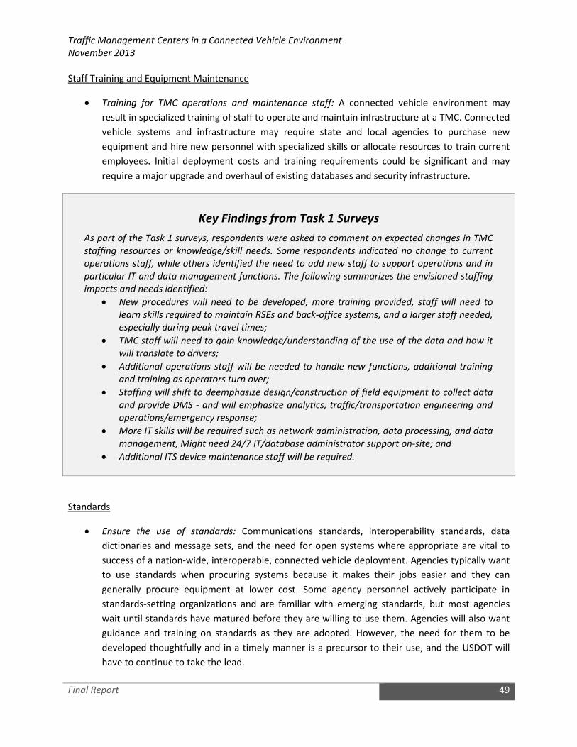
Traffic Management Centers in a Connected Vehicle Environment
November 2013
Final Report 49
Staff Training and Equipment Maintenance
• Training for TMC operations and maintenance staff: A connected vehicle environment may
result in specialized training of staff to operate and maintain infrastructure at a TMC. Connected
vehicle systems and infrastructure may require state and local agencies to purchase new
equipment and hire new personnel with specialized skills or allocate resources to train current
employees. Initial deployment costs and training requirements could be significant and may
require a major upgrade and overhaul of existing databases and security infrastructure.
Key Findings from Task 1 Surveys
As part of the Task 1 surveys, respondents were asked to comment on expected changes in TMC
staffing resources or knowledge/skill needs. Some respondents indicated no change to current
operations staff, while others identified the need to add new staff to support operations and in
particular IT and data management functions. The following summarizes the envisioned staffing
impacts and needs identified:
• New procedures will need to be developed, more training provided, staff will need to
learn skills required to maintain RSEs and back-office systems, and a larger staff needed,
especially during peak travel times;
• TMC staff will need to gain knowledge/understanding of the use of the data and how it
will translate to drivers;
• Additional operations staff will be needed to handle new functions, additional training
and training as operators turn over;
• Staffing will shift to deemphasize design/construction of field equipment to collect data
and provide DMS - and will emphasize analytics, traffic/transportation engineering and
operations/emergency response;
• More IT skills will be required such as network administration, data processing, and data
management, Might need 24/7 IT/database administrator support on-site; and
• Additional ITS device maintenance staff will be required.
Standards
• Ensure the use of standards: Communications standards, interoperability standards, data
dictionaries and message sets, and the need for open systems where appropriate are vital to
success of a nation-wide, interoperable, connected vehicle deployment. Agencies typically want
to use standards when procuring systems because it makes their jobs easier and they can
generally procure equipment at lower cost. Some agency personnel actively participate in
standards-setting organizations and are familiar with emerging standards, but most agencies
wait until standards have matured before they are willing to use them. Agencies will also want
guidance and training on standards as they are adopted. However, the need for them to be
developed thoughtfully and in a timely manner is a precursor to their use, and the USDOT will
have to continue to take the lead.

Traffic Management Centers in a Connected Vehicle Environment
November 2013
Version 2.0 50
Appendix A – Interview Format and Guiding Questions
Preliminary Materials: Candidate sites will be contacted via phone in advance to schedule interviews
and discuss overall approach and format. Preliminary materials will include the
Concept Paper, interview questions, and suggested attendees from the
interview site.
Format: Interviews are envisioned to be 3-3.5 hours in duration. The intent is that the
interview serves as more of a discussion rather than a question and answer
session. It is important to provide some flexibility in terms of additional topics
or issues raised by interview sites relative to specific functions, systems,
challenges or experiences.
Interview Team: The interview team will consist of 2-3 participants from the study team. There
will be a designated facilitator and a designated scribe, although all study team
members will be expected to take notes. Lisa Burgess or JD Schneeberger will
serve as the designated facilitator.
Suggested attendees from interview site:
• TMC Manager
• Lead/Sr. TMC Operator or Supervisor (knowledgeable about current processes, staffing,
potential training needs)
• Information Technology/Technical Representative (knowledgeable about TMC systems, TMC
data management systems, and internal data network issues and structure)
• Field Network Representative (knowledgeable about field telecommunications and network
connectivity)
Candidate site may suggest additional attendees based on their review of the questions
INTRODUCTION/OBJECTIVES
Meeting participants will provide short introductions. The study team facilitator will provide a brief
overview of the agenda. A high level agenda is provided below.
• Introductions/Objectives (All)
• Overview of Pooled Fund Study Project (Project Team)
o Review of Task 1 Survey Results
o Review of TMC in a Connected Vehicle Environment Concept Paper
• Current TMC Processes (TMC Manager/Lead/Sr. TMC Operator or Supervisor)
o Facilitated Discussion (All)
• Current TMC Data Environment and Data Management

Traffic Management Centers in a Connected Vehicle Environment
November 2013
Version 2.0 51
o Facilitated Discussion (All)
• Field Device and Network Considerations
o Facilitated Discussion (All)
• Next Steps (Project Team)
The study team facilitator will then provide an overview of the project. This will include the objectives of
the project as well as a brief discussion on the survey and how this site was selected for a more detailed
interview. This also will include a discussion on how the information received will be used to help to
formulate concepts for expected changes in TMCs, opportunities, challenges, and constraints. This will
be supported by a brief slide presentation that illustrates the process. Finally, to set the stage for
discussions, the project team facilitator will give a short presentation highlighting key concepts from the
Concept Paper.
Participants will be provided an opportunity to ask any preliminary questions on the project, how
information will be used, etc.
CURRENT TMC PROCESSES
The TMC Manager/Lead/Sr. TMC Operator or Supervisor will be asked to provide an overview of current
TMC processes for core functions. The intent of this overview will be to provide the study team with
information on how various data sources are used, how operators interact with data sources and
information, and how operating systems in the TMC process (at a very high level) data and information.
Key functions to be observed and discussed are envisioned to include:
• Freeway and traffic conditions monitoring
• Incident detection and monitoring
• TMC/operator responses to traffic conditions and incidents (may need to provide some
hypothetical scenario response)
• External sources for traffic conditions data (non-DOT systems) and how those data are used by
TMC operators
• External sources (e.g., CAD, radio communications) for incident data and how those data are
used by TMC operators
• External sources for weather data (i.e., forecast information or alerts)
• Other types of data/information sources used by TMC operators
• Traveler information (available to media and the public)
• Data and conditions information made available to other agencies (what and to whom)
Key Questions:
1. What data would be valuable from the road network, in a real-time context, to support what
you do in the TMC?
Traffic Management Centers in a Connected Vehicle Environment
November 2013
Version 2.0 52
2. Are there opportunities for improving how data is integrated into your monitoring and response
functions? (Are there multiple separate sources that must be monitored and processed? If so,
what are the challenges or limitations in better integrating that data?)
3. How much information/data to you receive to support operations that do not get translated
externally?
4. Information sharing:
a. What data/information from your TMC is shared with other agencies?
b. What data/information from your TMC is shared with media or other private parties?
c. What information from your TMC is shared with the public? What tools (e.g., DMS, HAR,
511, web, mobile applications) are used to disseminate information to the traveling
public?
5. With connected vehicles providing another data source (or multiple data sources), what would
be the key data types that would best support your TMC processes?
a. What processes would change (become more or less efficient)?
b. What processes would stay the same?
c. What would be needed to modify processes?
6. Potential new data could include additional data points on the network including vehicle
locations, speeds, accelerations, throttle setting, engine rpm and torque, weather-related
vehicle data (e.g., lights status, wiper status, temperature, air pressure), and other event-driven
vehicle data such as brake activation and traction control system activation. Of these:
a. Which would have the most benefit to your operations?
b. Which would be the most challenging to integrate into your processes and operations?
7. What are the envisioned or potential impacts on your current operating systems? Do you
foresee significant changes? Will these changes need to be handled by system vendors, agency
IT, etc.?
8. What are the current processes for monitoring field equipment status? Are there automated
alerts for device status, operational status or potential malfunctions? Is this a current function of
the TMC operator or another group (such as maintenance)?
CURRENT TMC DATA ENVIRONMENT AND DATA MANAGEMENT
This portion of the interview is intended to focus on current processes and capabilities for data
management. The intent is to identify potential challenges with integrating new data into the data
environment, current data standards/protocols in use, data storage and management, accessibility to
data by TMC or others, and other topics.
This portion of the interview will need input from information technology staff, or others knowledgeable
about the data environment and data management.
Key Questions:
1. What is considered “TMC” data? What types of data are currently generated/stored?

Traffic Management Centers in a Connected Vehicle Environment
November 2013
Version 2.0 53
2. Do you have a data policy specific to TMC/FMS/Operating systems? Is there an agency privacy
policy or more specific data privacy policy for your TMC that would govern any data exchanges
for data generated by your system or data you procure to support your system?
3. How much of your TMC data is shared with other entities? With whom? Are there data sharing
agreements in place?
4. Do you generate or store data that is restricted from being shared with external entities?
5. How can TMC (or other) users query your database(s) for information? Can you describe the
process whereby users access your data?
6. What is the TMC data storage capacity, and what are the data management practices? What is
the scalability of the current strategy to accommodate a potentially significant amount of
connected vehicle generated data? Are there timelines or limits associated with data storage?
7. For those who have already initiated some early connected vehicle activities, what has the
experience been with data management? What are the issues with sharing connected vehicle
data? Describe any issues with implementing firewalls? Describe any liability concerns with
connected vehicle data.
8. IT system readiness – Ipv4 vs. IPv6 is an issue, how would something like this need to be
addressed in your current strategy?
9. Current IT staff to support TMC and TMC related systems – what do you foresee being key needs
(e.g., additional staff, additional skills)? What is the relationship between system hardware and
field hardware maintenance staff, including network management (field network vs. system
network)
10. What is the role of IT if changes need to be made to operating systems to accommodate
connected vehicle data?
FIELD DEVICE AND NETWORK CONSIDERATIONS
Although the focus of this project is on TMC operations, there is an important relationship between the
field network monitored and managed by the TMC and overall TMC processes. The following questions
are intended to obtain feedback on field equipment/deployment issues.
Key Questions:
1. Discuss the potential for supporting RSE deployment. If likely (or if already underway), what are
the potential impacts to network capacity (field communications)?
2. What combination of communications technologies do you use to link field equipment with
TMCs (fiber, wireless, leased lines, or other mechanism)? What types of modifications do you
envision would be needed to support a connected vehicle environment?
3. The connected vehicle concept includes a system that collects data from vehicles (via DSRC and
via other means such as multiple cellular carriers) and redistributes the data of interest to
multiple subscribers, both public and private (e.g., TMCs, auto-makers, information service
providers such as Inrix or Tom-Tom). What ownership/responsibility models do you think are
viable for this service (e.g., government owned, with provision for fees for cost recovery;

Traffic Management Centers in a Connected Vehicle Environment
November 2013
Version 2.0 54
commercially owned, with charges to data subscribers including government agencies; operated
by some sort of public/private consortium, and/or other models)?
4. What issues, if any, do you foresee in sharing connected vehicle data?
5. What is your current staffing level to support field device maintenance? Agency staff?
Maintenance contract? What would be some potential considerations if RSE devices were part
of a future deployment scenario?
6. How are communications links between field devices and the TMC obtained and maintained
(e.g., outsourced to service provider, agency owned with contracted maintenance, agency
owned with agency staff providing maintenance, other)? What impacts would your foresee in a
connected vehicle environment?

Traffic Management Centers in a Connected Vehicle Environment
November 2013
Version 2.0 55
Appendix B – SAE J2735 Messages
The SAE J2735 standard specifies a message set, and its data frames and data elements specifically for
use by applications intended to utilize the 5.9 GHz Dedicated Short Range Communications for Wireless
Access in Vehicular Environments (DSRC/WAVE, referenced in this document simply as “DSRC”),
communications systems. Although the scope of the standard is focused on DSRC, the message set, and
its data frames and data elements have been designed, to the extent possible, to also be of potential
use for applications that may be deployed in conjunction with other wireless communications
technologies.
Table 2 provides a list of messages contained within the SAE J2735 standard. The message descriptions
in the table were adapted from the standard. The contents in the column titled “Examples of How State
and Local Agencies Can Use the Message” were created by the authors of this report.

Traffic Management Centers in a Connected Vehicle Environment
November 2013
Final Report 56
Table 2. Current J2735 Messages and How They May Be Used by TMCs
J2735 Message Message Description Examples of How State and Local Agencies
Can Use the Message
Basic Safety
Message (BSM)
The BSM is used for broadcasting information related to the real-time
operating statuses of the mobile device. Broadcast at a transmission
frequency of 10 Hz, the BSM includes information about the position of
the mobile device, the current motion of the mobile device, and other
information. The BSM is also referred to as the “here I am” message since
it can be broadcasted to make the surrounding vehicles and infrastructure
aware of the vehicle’s presence. Two parts of the contents can be
included in each broadcast:
• Part I is required and contains the data elements that are used to
outline the basic vehicle status. The data elements include
vehicle dimensions, brake status, vehicle position (in terms of
latitude, longitude, and altitude) and its accuracy, vehicle speed,
heading, steering wheel angle, and accelerations.
• Part II is optional and contains the data elements that
supplement part I data to give a full description of the vehicle
status. The data elements include headlight status, brake system
status, windshield wiper status, traction control status, anti-lock
braking system (ABS), path history (namely “bread crumbs”),
path prediction, acceleration sequence, and its confidence, and
weather reports (precipitation status, temperature, and air
pressure).
How TMCs May Use the Message? BSMs will be exchanged
between vehicles to support V2V applications. It is unlikely
that TMCs will use BSMs but will instead collecting probe
data from the prove vehicle data (PVD) message. BSMs may
be used by traffic management roadside devices for
applications such as signal preemption.
How Public Agency Vehicles May Use the Message? Similar
to other equipped vehicles on the roadway, public agency
vehicles will be able to use BSMs to support a variety of V2V
active safety applications.
Common Safety
Request (CSR)
The CSR message allows a mobile device to broadcast requests to other
DSRC receivers to acquire additional information that is not contained in a
typical BSM broadcast. The purpose of this message is to minimize the
data payload used by a typical BSM broadcast and reserve the
communications bandwidth for application-specific broadcasts. The
additional information, if available, can be attached to the next BSM
broadcast or otherwise ignored. The data elements that can be requested
are all the items supported by part II of the BSM.
How TMCs May Use the Message? CSRs will be exchanged
between vehicles to support V2V applications. It is unlikely
that TMCs will use these messages.
How Public Agency Vehicles May Use the Message? Similar
to other equipped vehicles on the roadway, public agency
vehicles would be able to use CSRs to support a variety of
V2V active safety applications.
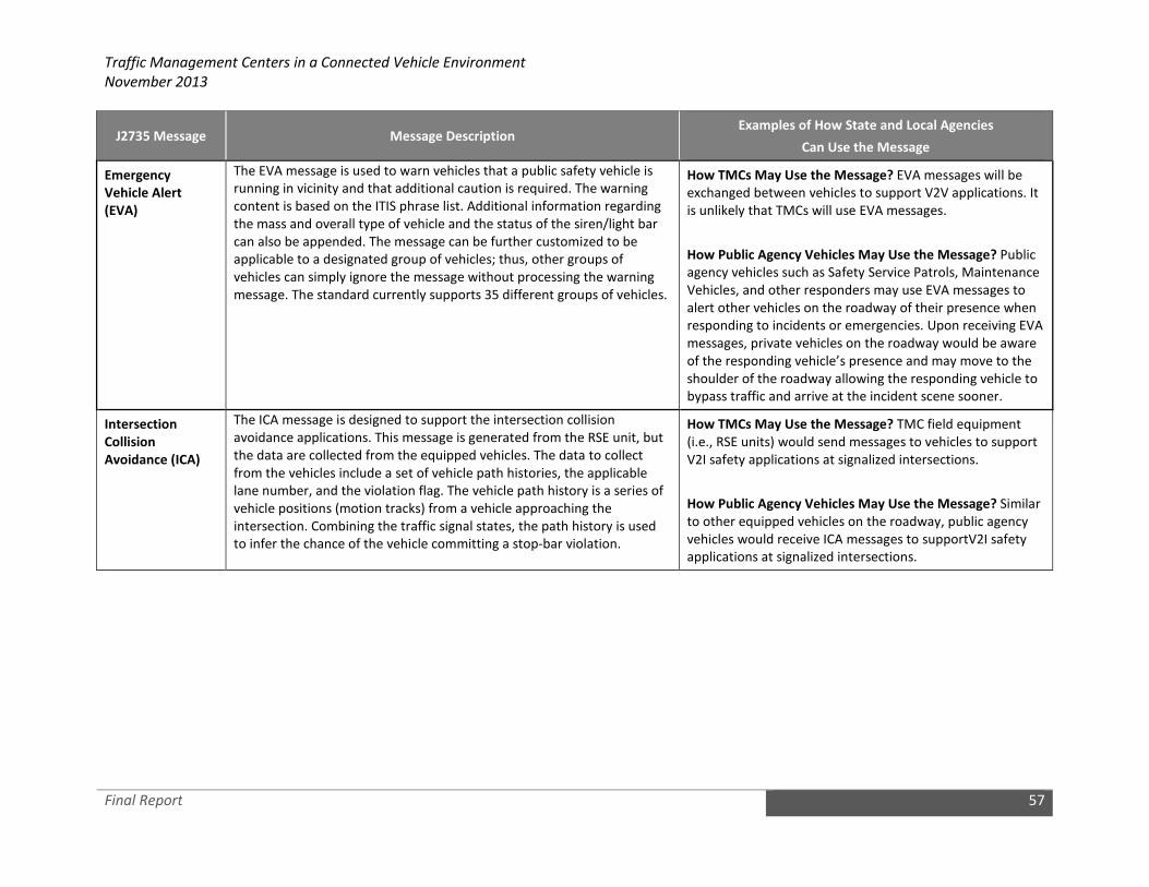
Traffic Management Centers in a Connected Vehicle Environment
November 2013
Final Report 57
J2735 Message Message Description Examples of How State and Local Agencies
Can Use the Message
Emergency
Vehicle Alert
(EVA)
The EVA message is used to warn vehicles that a public safety vehicle is
running in vicinity and that additional caution is required. The warning
content is based on the ITIS phrase list. Additional information regarding
the mass and overall type of vehicle and the status of the siren/light bar
can also be appended. The message can be further customized to be
applicable to a designated group of vehicles; thus, other groups of
vehicles can simply ignore the message without processing the warning
message. The standard currently supports 35 different groups of vehicles.
How TMCs May Use the Message? EVA messages will be
exchanged between vehicles to support V2V applications. It
is unlikely that TMCs will use EVA messages.
How Public Agency Vehicles May Use the Message? Public
agency vehicles such as Safety Service Patrols, Maintenance
Vehicles, and other responders may use EVA messages to
alert other vehicles on the roadway of their presence when
responding to incidents or emergencies. Upon receiving EVA
messages, private vehicles on the roadway would be aware
of the responding vehicle’s presence and may move to the
shoulder of the roadway allowing the responding vehicle to
bypass traffic and arrive at the incident scene sooner.
Intersection
Collision
Avoidance (ICA)
The ICA message is designed to support the intersection collision
avoidance applications. This message is generated from the RSE unit, but
the data are collected from the equipped vehicles. The data to collect
from the vehicles include a set of vehicle path histories, the applicable
lane number, and the violation flag. The vehicle path history is a series of
vehicle positions (motion tracks) from a vehicle approaching the
intersection. Combining the traffic signal states, the path history is used
to infer the chance of the vehicle committing a stop-bar violation.
How TMCs May Use the Message? TMC field equipment
(i.e., RSE units) would send messages to vehicles to support
V2I safety applications at signalized intersections.
How Public Agency Vehicles May Use the Message? Similar
to other equipped vehicles on the roadway, public agency
vehicles would receive ICA messages to supportV2I safety
applications at signalized intersections.

Traffic Management Centers in a Connected Vehicle Environment
November 2013
Final Report 58
J2735 Message Message Description Examples of How State and Local Agencies
Can Use the Message
Map Data (MAP) The MAP message is used to concisely define the geometries of a complex
intersection, a highway curve, or a segment of roadway. This message is
sometimes informally referred to as the “Geometric Intersection
Description or GID layer.” This digital map is typically broadcast from an
RSE. In SAE J2735, only the data elements related to intersection
geometries are fully specified. To concisely digitize an intersection, the
message contains a reference point in terms of three dimensional
coordinates. Based on the reference point, lanes on all approaches can be
computed using coordinate offsets and orientation information. All the
lanes are numbered, and each lane has its own lane properties such as
lane width, movements allowed, downstream lanes, etc. Under this basic
structure, different signal control zones, such as preemption and priority
zones, can be specified in reference to the structure. In addition, dynamic
intersection status (such as “preempt is active” or “intersection is in
conflict flash”) is also supported by this message. Although the lane
assignment to each intersection movement is static in one MAP
broadcast, the lane assignments can be different from one broadcast to
the next. In this sense, the MAP message can support dynamic lane
assignment throughout the day.
How TMCs May Use the Message? TMCs would disseminate
MAP messages to support V2I applications including
signalized intersection safety (e.g., red light violation) and
mobility applications (e.g., green wave applications) as well
as V2I warning applications (e.g., curve speed warning). It is
envisioned that map data would be provided from map
providers and updated periodically.
How Public Agency Vehicles May Use the Message? Similar
to other equipped vehicles, public agency vehicles would
receive the MAP data to support V2I safety and mobility
applications.
NMEA Corrections
(NMEA)
The NMEA message is used to encapsulate differential corrections for GPS
radio navigation signals as defined by the NMEA (National Marine
Electronics Association) committee in its Protocol 0183 standard.
How TMCs May Use the Message? TMCs are not likely to
use the NMEA corrections message; however RSE units may
broadcast these messages.
H How Public Agency Vehicles May Use the Message?
Similar to other equipped vehicles, public agency vehicles
would use these messages for their GPS positioning systems
to increase the absolute and relative accuracy estimates
produced.

Traffic Management Centers in a Connected Vehicle Environment
November 2013
Final Report 59
J2735 Message Message Description Examples of How State and Local Agencies
Can Use the Message
Probe Data
Management
(PDM)
The PDM message is typically sent from an RSE unit to a vehicle onboard
unit. Its purpose is to instruct which OBE units should collect probe data,
and how the data should be collected. It changes only the snapshot
generation characteristics of the OBE units but not the contents. When a
vehicle equipped with an OBE unit comes in the range of an RSE, a new
probe management process is started. This process is temporary and will
live until a time duration expires, a distance is reached, or the vehicle is
out of communications range. This instruction is specified in the PDM
message. By using the PDM, an RSE unit can sample only a portion of the
OBE population in range for any of its applications. The OBE unit heading
information is used by the RSE unit to filter out irrelevant OBE units. The
PDM can also modify the threshold values for any of the three snapshot
methods in the PVD message. The interval for snapshot generation and
that for transmitting the PVD snapshots are separately defined to control
different rates of data collection and communications. In general, the use
of this message improves the flexibility of transportation agencies to
dynamically manage the collection of probe vehicle data.
How TMCs May Use the Message? The PDM message
would be used by TMCs (or by a core system that relays data
between TMCs and vehicles) to instruct which OBE units
should collect probe data, and how the data should be
collected.
How Public Agency Vehicles May Use the Message? Similar
to other equipped vehicles, public agency vehicles will
receive PDM messages and use the contents of these
messages as instructions for collecting probe messages.

Traffic Management Centers in a Connected Vehicle Environment
November 2013
Final Report 60
J2735 Message Message Description Examples of How State and Local Agencies
Can Use the Message
Probe Vehicle
Data (PVD)
The PVD message is used for a vehicle to send vehicle attributes and
recent history of the vehicle’s running status to a roadside DSRC reader.
The probe data are intended for learning the real-time conditions about
road, weather, and traffic. In typical use, this message is a collection of
one or more snapshots of a vehicle’s current and past running statuses;
each snapshot is also stamped with when and where the snapshot was
taken. Each snapshot can support up to 42 vehicle data elements,
including most of those in BSM part I and other data such as tire pressure.
SAE J2735 (2009 revision) gives more details. The probe data snapshots
are generated in one of the three ways:
• Periodic snapshots – The period can be on a per-time or per-
distance basis. The default method is to use time. Either way, the
goal is to obtain a more uniform distribution of snapshots to
minimize data collection frequency but also obtain ubiquitous
coverage. As specified in the current standard, 20 seconds per
snapshot for rural cases and 4 seconds per snapshot for urban
cases are used as default values. However, these values can be
easily changed by the probe data management message.
• Event-triggered snapshots – Any changes or specific changes
(e.g., change exceeding a threshold) in vehicle status elements
can trigger a new snapshot of vehicle data. Comparing to the
periodic method, it is useful to target specific purposes and save
communication channel resources.
• Starts and stops snapshots – The collection of snapshots may
also be triggered by vehicle starts or stops. The start and stop
events are defined by vehicle speeds.
How TMCs May Use the Message? PVD messages will be
used by TMCs to support applications at TMCS for traffic
signal and freeway operations. Probe data will supplement
other traffic data collected from roadway sensors (e.g., loop
detectors, radar detectors, and environmental sensor
stations). These data are expected to provide more granular
data that can be used by advanced applications at TMCs to
better manage the transportation network. For example,
probe data may be leveraged at signalized intersections to
support more advance traffic signal operations such as
adaptive signal control. Probe data messages may be used
on freeways to support ATDM including variable speed
limits, queue warnings, and ramp meters. Probe data may
also be used to monitor the performance of the
transportation network. Finally, PVD messages may include
information about weather conditions that would support
road weather applications (e.g., warnings and advisories). In
addition to location, speed, and acceleration data, the
following data collected from vehicles may be beneficial to
TMCs:
• Stop sign violation
• Hard braking / ABS activation
• Flat tire
• Disabled vehicle
• Air bag deployment
• Ambient air temperature
• Ambient air pressure
• Wipers changed / rain rate / precipitation situation
How Public Agency Vehicles May Use the Message? Similar
to other equipped vehicles, public agency vehicles would
produce PVD messages that could be used by a TMC.

Traffic Management Centers in a Connected Vehicle Environment
November 2013
Final Report 61
J2735 Message Message Description Examples of How State and Local Agencies
Can Use the Message
Roadside Alert
(RSA)
The RSA message is normally emitted from roadside infrastructure (e.g.,
RSE) to nearby mobile devices alerting them about roadway hazards. The
actual content of the message is formatted in the International Traveler
Information Standard (ITIS) code. Typical example messages would be
“bridge icing ahead,” “train coming,” or “ambulances operating in the
area.” The ITIS standard (i.e., SAE J2540.1) contains the accepted phrases
supported by the standard, which are all coded in standardized integer
formats. In addition, the RSA message contains optional fields used to
determine the relevance of the RSA message. A position vector is sent
along with the ITIS phrases, which can be used by the receiving device to
filter out irrelevant messages. A priority level for the message is also sent
and determines the order and type of message presentation to minimize
driver distraction. A spatial extent message is used to provide a gross level
of applicability for the message over a distance.
How TMCs May Use the Message? TMCs would use the RSA
message to alert equipped vehicles of roadway hazards. The
full range of ITIS phrases are supported here, but those
dealing with mobile hazards, construction zones, and
roadside events (e.g., incidents) are the ones most
frequently expected to be used. Other event types
supported by these messages include:
• Accidents and incidents
• Road and lane closures
• Delays
• Parking information
• Precipitation
• Regulatory and warning signs
• Roadwork
• Special events
• Traffic conditions
• Weather conditions / pavement conditions
• MUTCD Signage Patterns Expressed in IT IS
o Regulatory signs
o Speed limit signs
o Turn prohibitions
o Lane use control
o Traffic signal signs
o Weigh station signs / weight limit signs
o Rail road advance signs
o Advisory speed limits
o Road work, detour, and exit signs
o Motorist service signs / rest areas
o School signs / school speed limit signs
How Public Agency Vehicles May Use the Message? Similar
to other equipped vehicles, public agency vehicles may
receive RSA messages which would be used to alert drivers
of potential hazards on the roadway.

Traffic Management Centers in a Connected Vehicle Environment
November 2013
Final Report 62
J2735 Message Message Description Examples of How State and Local Agencies
Can Use the Message
RTCM Corrections
(RTCM)
The RTCM corrections (RTCM) message is used to encapsulate RTCM
differential corrections for GPS and other radio navigation signals as
defined by the RTCM (Radio Technical Commission For Maritime Services)
special committee number 104 in its various standards.
How TMCs May Use the Message? TMCs are not likely to
use the RTCM corrections message; however RSE units may
broadcast these messages.
How Public Agency Vehicles May Use the Message? Similar
to other equipped vehicles, public agency vehicles would
use these messages for their GPS positioning systems to
increase the absolute and relative accuracy estimates
produced.
Signal Phase and
Timing (SPaT)
The SPaT message is designed to primarily convey the current states of all
phases of a traffic signal. Phases currently in red are not transmitted.
Other active phases are mapped with one or more traffic lanes. Along
with the MAP message, the receiving devices can determine the signal
status for each lane and for each movement. As an option, the expected
time to the end of a particular phase and the confidence of this
expectation are also supported and will be sent if available. In addition, a
brief summary of any current priority or preemption events is sent
through this message, but the full list of priority or preemption events is
sent via another message (i.e., a signal status message). The SPaT
message is deemed essential to a large number of applications involving
traffic signal states.
How TMCs May Use the Message? Traffic signal controllers
would provide SPaT data to RSE units for broadcasting.
These messages would support V2I safety applications at
signalized intersections (e.g., red light violation) and
mobility applications allowing vehicles to collect SPaT
messages to determine an optimal trajectory to a signalized
intersection allowing the driver of the vehicle to adjust the
vehicles speed to avoid stopping at the intersection or to
ride the green wave.
How Public Agency Vehicles May Use the Message? Similar
to other equipped vehicles, public agency vehicles would
use these messages to support active V2I safety applications
or mobility applications at signalized intersections.

Traffic Management Centers in a Connected Vehicle Environment
November 2013
Final Report 63
J2735 Message Message Description Examples of How State and Local Agencies
Can Use the Message
Signal Request
Message (SRM)
This message is one of the four messages that are used to support
intersection signal-related applications. The SRM enables signal
priority/preemption requests sent from public transit/safety vehicles to
the RSE in a signalized intersection. The contents of an SRM request
contain not only a specific request including the duration of service, but
also the first part of the BSM that is used to identify the vehicle
submitting the request. To generate a signal request, the requesting
vehicle needs first identify its current position in terms of the geometry of
the intersection. The knowledge of intersection geometry is attained by
decoding and examining the list of supported zones for that intersection.
This list is contained in the MAP message that a vehicle receives prior to
making a signal request. Optionally, the request can be further tailored by
inputting the ingress and egress lanes on which the vehicle path is
projected.
How TMCs May Use the Message? TMCs (or TMC field
infrastructure) would collect SRMs from vehicles requesting
signal priority or preemption at signalized intersection.
These messages would be similar to existing priority and
preemptions request messages, but include more detailed
information from the vehicle (i.e., BSM Part I data) to assist
the TMC or field infrastructure in making priority or
preemption decisions.
How Public Agency Vehicles May Use the Message? Public
agency vehicles would use the SRM to make priority or
preemption requests at signalized intersections. Vehicles
requesting priority may include transit vehicles. Vehicles
requesting preemption may include police, fire & rescue,
and possibly DOT response vehicles.
Signal Status
Message (SSM)
This message is one of the four messages that are used to support
intersection signal-related applications. The SSM is usually used to reply
to a service request (sent via the SRM). To spare data transmission
bandwidth, the generation of an SSM response is not always, but only
when there are other active events or pending requests. In the case of no
active request pending, the response to an SRM is reflected in the change
of signal phasing (sent from SPaT). The SSM also contains the rankings of
all the pending requests submitted so that each vehicle can determine its
rank in the list. In addition, an SSM contains the general intersection
signal state, all active priority states, and all active preemption states.
How TMCs May Use the Message? TMCs (or TMC field
infrastructure) will use the SSM to reply to a service request
(sent via the SRM).
How Public Agency Vehicles May Use the Message? Public
agency vehicles seeking priority or preemption at a
signalized intersection may receive SSMs when there are
other active events or pending requests. The SSM also
contains the rankings of all the pending requests submitted
so that each vehicle can determine its rank in the list.

Traffic Management Centers in a Connected Vehicle Environment
November 2013
Final Report 64
J2735 Message Message Description Examples of How State and Local Agencies
Can Use the Message
Traveler
Information
Message (TIM)
The TIM is used to send various types of lower-priority messages,
currently supporting only road signs and advisories. It is a message very
similar to the RSA message for its heavy use of the ITIS representations
for various messages. Each message can be received earlier than the start
time and/or prior to entering the specified region where the message
becomes active. The nature of the message contents is usually
informational. There are three parts of the message:
• Part I – specifies the type of message and the start time and
duration of the message.
• Part II – specifies the geographic region and direction where the
message is applicable.
• Part III – includes the actual content of the message. The current
standard supports ITIS encoded advisories, Manual on Uniform
Traffic Control Devices (MUTCD) signs and directions, speed limit
signs, and available roadside business services.
How TMCs May Use the Message? TMCs will use TIMs to
send various types of messages (advisory and road sign
types) to vehicles. It uses the ITIS encoding system to send
well known phrases, but allows limited text for local place
names. The expressed messages are active at a precise start
and duration period, which can be specified to a resolution
of a minute. Event types supported by these messages
include:
• Accidents and incidents
• Road and lane closures
• Delays
• Parking information
• Precipitation
• Regulatory and warning signs
• Roadwork
• Special events
• Traffic conditions
• Weather conditions / pavement conditions
How Public Agency Vehicles May Use the Message? Similar
to other equipped vehicles, public agency vehicles would
receive TIMs which would be used to provide drivers
traveler information.