Embed Size (px)
Citation preview

Abrams AssociatesTRAFFIC ENGINEERING, INC.
1875 Olympic Boulevard, Suite 210 Walnut Creek, CA 94596 925.945.0201 Fax: 925.945.7966
July 10, 2019 Eric Tam Trachtenberg Architects 2421 Fourth Street Berkeley, CA 94710 Re: Trip Generation and Parking Analysis for the Proposed Mixed Use Project at 2590
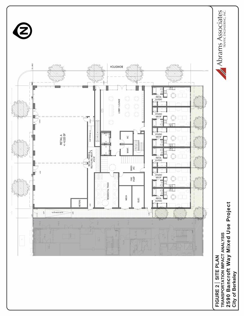
Bancroft Way This report presents the results of the trip generation analysis of the proposed mixed use project located at 2590 Bancroft Way in the City of Berkeley, across the street from the University of California. The proposed project involves constructing a mixed use housing project with 87 residential units plus 4,490 square feet of ground floor retail space. The site currently has an existing commercial building with 13,313 square feet of space that is occupied by a retail clothing store and an art supply store. There is also an underground parking garage with 27 parking spaces that are available to the public for a fee. Please note the existing parking garage is proposed to be eliminated as part of the project. The attached Figure 1 shows the location of the project and the surrounding roadway system as well as nearby transit stops, crosswalks, and traffic controls in the area. Figure 2 shows the proposed site plan for the project.
PROJECT TRIP GENERATION
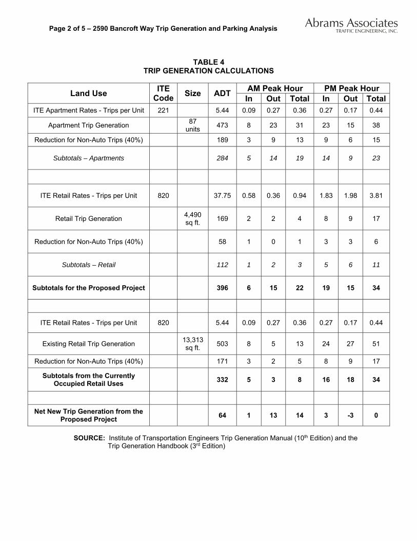
The proposed project would have 87 apartments and 4,490 square feet of retail space taken from the 10th Edition of the Institute of Transportation Engineers (ITE) Trip Generation Manual. As shown in the attached Table 1, the proposed project is forecast to generate about 14 net new trips during the AM peak hour and about the same amount of traffic as the existing retail uses during the PM peak hour. Berkeley Residential Trip Generation - Since the project is located near a central business district with excellent transit access (and located next to a major university) the vehicle trip rate per unit is less than would be generated by a typical apartment building. The availability of transit, the use of bicycles, and the attractiveness of walking in a mixed-use university environment clearly results in reduced vehicle trip generation. For this project, a trip reduction of 40% has been applied to the unfiltered trip generation rate to account for conditions in this part of Berkeley adjacent to the UC Berkeley Campus. The ITE trip generation rates are based on surveys of primarily suburban locations and this reduction is intended to account for walk, bicycle, and transit trips as well as shared trips with the residential component of the project. The 40% reduction was based on data from the Alameda County Transportation Commission’s
Abrams AssociatesTRAFFIC ENGINEERING, INC.Page 2 of 5 – 2590 Bancroft Way Trip Generation and Parking Analysis
TABLE 4
TRIP GENERATION CALCULATIONS
Land Use ITE
CodeSize ADT
AM Peak Hour PM Peak Hour In Out Total In Out Total
ITE Apartment Rates - Trips per Unit 221 5.44 0.09 0.27 0.36 0.27 0.17 0.44
Apartment Trip Generation 87
units 473 8 23 31 23 15 38
Reduction for Non-Auto Trips (40%) 189 3 9 13 9 6 15
Subtotals – Apartments 284 5 14 19 14 9 23
ITE Retail Rates - Trips per Unit 820 37.75 0.58 0.36 0.94 1.83 1.98 3.81
Retail Trip Generation 4,490 sq ft.
169 2 2 4 8 9 17
Reduction for Non-Auto Trips (40%) 58 1 0 1 3 3 6
Subtotals – Retail 112 1 2 3 5 6 11
Subtotals for the Proposed Project 396 6 15 22 19 15 34
ITE Retail Rates - Trips per Unit 820 5.44 0.09 0.27 0.36 0.27 0.17 0.44
Existing Retail Trip Generation 13,313 sq ft.
503 8 5 13 24 27 51
Reduction for Non-Auto Trips (40%) 171 3 2 5 8 9 17
Subtotals from the Currently Occupied Retail Uses
332 5 3 8 16 18 34
Net New Trip Generation from the Proposed Project
64 1 13 14 3 -3 0
SOURCE: Institute of Transportation Engineers Trip Generation Manual (10th Edition) and the Trip Generation Handbook (3rd Edition)

Abrams AssociatesTRAFFIC ENGINEERING, INC.Page 3 of 5 – 2590 Bancroft Way Trip Generation and Parking Analysis
Travel Demand Model and census data on vehicle ownership and travel patterns for the census tract where the project is located.1
Existing Site Trip Generation - Please note that there is currently a commercial building with 13,313 sq. ft. of space. Based on the ITE trip generation rates the currently occupied commercial space generates about 8 trips during the AM peak hour and about 34 trips during the PM peak hour. As shown in Table 1 the proposed project is forecast to generate about 14 trips per hour more during the AM peak hour than the currently occupied retail space. During the PM peak hour the proposed project is forecast to have approximately the same trip generation as the existing retail uses.
PARKING ANALYSIS
This section discusses the City of Berkeley’s zoning and estimated parking demand for the project. Section 23E.56 of the Berkeley Municipal Code specifies that no parking spaces are required for projects within the Telegraph Avenue Commercial District. This section of the code also specifies that occupants of residential units without parking shall not be entitled to receive parking permits under the Residential Permit Parking Program. In addition, all use permits issues shall be subject to a condition of approval requiring payment of a Transportation Services Fee if and when adopted. Please note there is currently an existing garage with 27 parking spaces on the site. The project would not require off-street parking under the site’s current zoning and the project currently proposes to remove the existing underground garage as part of the project.. Please note the project is also proposing to provide secure bicycle parking in an amount that would meet or exceed City standards. The following is a summary of the potential parking demand from the project. Residential Parking Demand Based on ITE Parking Generation Rates - To provide additional information on parking demand, Table 2 provides a summary of the parking demand results using the average ITE parking generation rates for retail space and for apartments in a Central Business District (CBD) taken from the 4th Edition of the ITE Parking Generation Manual. As shown in Table 2, the unadjusted average peak parking demand that would be generated by the proposed project would be forecast to be approximately 90 parking spaces based on the ITE data. Residential Parking Demand Based on US Census Data - In addition to the zoning requirements and ITE rates, there are other factors that can be considered with regard to residential parking. For a location in a business district with excellent transit access (and located next to a major university), the parking demand can be shown to be less than the typical parking demand rate in the ITE Parking Generation Manual. To provide additional information on the potential parking demand in the project area U.S. Census data was also utilized based on Census Transportation Planning Products summary of data from the American Community
1 American Community Survey, U.S. Census Bureau, Washington D.C., 2016.

Abrams AssociatesTRAFFIC ENGINEERING, INC.Page 4 of 5 – 2590 Bancroft Way Trip Generation and Parking Analysis
Survey (2015). The U.S. census data indicated the parking demand for the census tract where the project was located averaged 0.53 automobiles per dwelling unit. Based on the U.S. Census data the residents of the proposed 46 vehicles.
Table 2 Off-Street Parking Calculations Using Parking Data
from the Institute of Transportation Engineers
Component Data Source Land Use Size Parking
Ratio Required Spaces
Residential ITE Parking
Demand Rates Apartments 87 units 0.45 39
Commercial ITE Parking
Demand Rates Retail 4,490 sq. ft. 2.55 51
Totals 90
OTHER PLANNED PROJECTS IN THE AREA
The following is a list of five other planned development that are all located within about two blocks of the project site:
1. 2580 Bancroft Way – 187 apartments and 11,000 square feet of retail/restaurant space 2. 2510 Channing Way – 36 apartments and 2,500 square feet of retail space. 3. 2631 Durant Avenue – 56 apartments. 4. 2542 Channing Way – 32 apartments and 1,500 square feet of retail space. 5. 2532 Channing Way – 7 apartments.
ANALYSIS OF TRAFFIC OPERATIONS AT BANCROFT WAY AND BOWDITCH STREET
As part of this study detailed traffic, pedestrian, and bicycle counts were conducted during the peak commute periods (7:00 to 9:00 AM and 4:00 to 6:00 PM) at the adjacent intersection of Bancroft Way and Bowditch Street. The existing intersection turning movement volumes for existing conditions as well as the existing bicycle and pedestrian volumes (during the weekday AM and PM peak hours) were incorporated into the calculations. Existing operational conditions at Bancroft Way and Bowditch Street were evaluated according to the requirements set forth by the City of Berkeley. Analysis of traffic operations was conducted using the 2010 Highway
Capacity Manual (HCM) Level of Service (LOS) methodology using Synchro software. 2 The
analysis indicated the intersection of Bancroft Way and Bowditch Street would be forecast to continue to operate at LOS A with or without traffic from the proposed project. The LOS
2 2010 Highway Capacity Manual, Transportation Research Board, Washington D.C., 2011
Abrams AssociatesTRAFFIC ENGINEERING, INC.Page 5 of 5 – 2590 Bancroft Way Trip Generation and Parking Analysis
analysis indicated the intersection would continue to meet the City’s LOS standards (LOS D or better) with the addition of project traffic during both the AM and PM weekday peak hours.
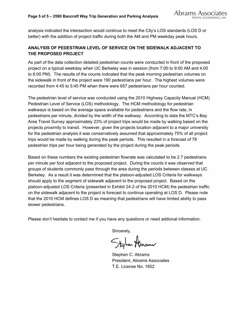
ANALYSIS OF PEDESTRIAN LEVEL OF SERVICE ON THE SIDEWALK ADJACENT TO THE PROPOSED PROJECT
As part of the data collection detailed pedestrian counts were conducted in front of the proposed project on a typical weekday when UC Berkeley was in session (from 7:00 to 9:00 AM and 4:00 to 6:00 PM). The results of the counts indicated that the peak morning pedestrian volumes on the sidewalk in front of the project were 190 pedestrians per hour. The highest volumes were recorded from 4:45 to 5:45 PM when there were 657 pedestrians per hour counted. The pedestrian level of service was conducted using the 2010 Highway Capacity Manual (HCM) Pedestrian Level of Service (LOS) methodology. The HCM methodology for pedestrian walkways is based on the average space available for pedestrians and the flow rate, in pedestrians per minute, divided by the width of the walkway. According to data the MTC’s Bay Area Travel Survey approximately 23% of project trips would be made by walking based on the projects proximity to transit. However, given the projects location adjacent to a major university for the pedestrian analysis it was conservatively assumed that approximately 75% of all project trips would be made by walking during the peak periods. This resulted in a forecast of 78 pedestrian trips per hour being generated by the project during the peak periods. Based on these numbers the existing pedestrian flowrate was calculated to be 2.7 pedestrians per minute per foot adjacent to the proposed project. During the counts it was observed that groups of students commonly pass through the area during the periods between classes at UC Berkeley. As a result it was determined that the platoon-adjusted LOS Criteria for walkways should apply to the segment of sidewalk adjacent to the proposed project. Based on the platoon-adjusted LOS Criteria (presented in Exhibit 24-2 of the 2010 HCM) the pedestrian traffic on the sidewalk adjacent to the project is forecast to continue operating at LOS D. Please note that the 2010 HCM defines LOS D as meaning that pedestrians will have limited ability to pass slower pedestrians.
Please don’t hesitate to contact me if you have any questions or need addional information.
Sincerely,
Stephen C. Abrams President, Abrams Associates T.E. License No. 1852

N
PEO
PLE’
SPA
RK
COM
MER
CIA
L
ARE
A
UN
IVER
SITY
OF
CALI
FORN
IABE
RKEL
EY
M
Dura
nt A
ve
Chan
ning
Way
Hast
e S
t
Dwig
ht W
ay
Blak
e S
t
Park
er S
t
Fulton St
Ellsworth St
Dana St
Telegraph Ave
Bowditch St
College Ave
Regent St
Hillegass Ave
Benvenue Ave
Etna St
Banc
roft
Way
Piedmont Ave
STOP
PRO
JEC
TLO
CAT
ION
DO
WN
TOW
N B
ERK
ELEY
BA
RT
STAT
ION
LEG
END
BU
S ST
OP
CO
MM
ERC
IAL
AR
EA
STO
P SI
GN
SIG
NA
LIZE
D IN
TER
SEC
TIO
N
CR
OSS
WA
LK
2590
Ban
crof
t W
ay M
ixed
Use
Pro
ject
TRA
NSP
OR
TATI
ON
IMPA
CT
AN
ALY
SIS
City
of B
erke
ley
FIG
UR
E 1
PRO
JEC
T LO
CA
TIO
N &
PR
OPO
SED
STU
DY
INTE
RSE
CTI
ON
(1)
Abra
ms
Asso
ciat
esTR
AFFI
C E
NG
INEE
RIN
G, I
NC
.
1 -G
RO
UN
D L
EV
EL
PLA
N1/
16"=
1'-0
" @ 1
1x17
1/8"
=1'
-0" @
24x
36
N
2590
Ban
crof
t W
ay M
ixed
Use
Pro
ject
TRA
NSP
OR
TATI
ON
IMPA
CT
AN
ALY
SIS
City
of B
erke
ley
FIG
UR
E 2
SITE
PLA
NAb
ram
s As
soci
ates
TRAF
FIC
EN
GIN
EERI
NG
, IN
C.