Embed Size (px)
Citation preview
Town Planning Report
PROPONENT: Development Victoria
PROPOSAL:
Knox Planning Scheme Amendment Fast Track Government Land
ADDRESS:
609 - 621 Burwood Highway, Knoxfield
13 December 2017
Town Planning Report
PROPONENT: Development Victoria
ADDRESS: 609 - 621 Burwood Highway, Knoxfield
13 December 2017
This document was prepared by Collie for the benefit of the client and in response to the specific services required by the client. Collie has used its best endeavours to ensure this document reflects the required services and outcomes and the client intentions, at the time of preparing the document. In preparing the document, Collie has relied upon stated or implied assumptions, data (reports, plans, surveys, correspondence, photographs and such), commentary, responses to enquiries and other third party information, available to it at the time of preparing the document. Notwithstanding that Collie attempted to ensure it was using the most current versions of such documents and other information, it did not check independently their accuracy or completeness. Collie does not warrant their accuracy and points out that those assumptions, data and responses may have been qualified and may have been given with a disclaimer of responsibility.
o:\projects\16-8340\00200 now 00201\word\finalised\36525er planning report with cdz2.docx ADDRESS: 609 - 621 Burwood Highway, Knoxfield
Version 131217 Page: 3
Table of Contents
Table of Contents 1 Introduction 4
1.1 Surplus Land 4
2 The Subject Land and Surrounds 5
2.1 Location 5
2.2 The Surrounds 5
3 Knox Planning Scheme Controls 7
3.1 State Planning Policy Framework 7
3.2 Local Planning Policy Framework 7
3.3 Existing Zone 7
3.4 Overlays 7
4 The Proposed Amendment 12
4.1 The Proposed Zones 12
4.2 The Proposed Overlays 12
4.3 Appropriateness of the Amendment 13
5 Strategic Considerations 16
6 Conclusion 20
Figures Subject Land 6 Schedule 7 to the Public Use Zone (PUZ7) 9 Schedule 2 to the Environmental Significance Overlay (ESO2) 10 Land Subject to Inundation Overlay (LSIO) 11 Proposed Zone 14 Proposed Overlays 15
Appendices Appendix A Comprehensive Development Zone - Schedule 2 Appendix B Comprehensive Development Plan Appendix C Schedule 2 to Clause 81.01
o:\projects\16-8340\00200 now 00201\word\finalised\36525er planning report with cdz2.docx ADDRESS: 609 - 621 Burwood Highway, Knoxfield
Version 131217 Page: 4
Introduction
1 Introduction This planning report has been prepared on behalf of Development Victoria as the proponent in the request for an amendment to the Knox Planning Scheme (the Scheme). The amendment to the Scheme (the amendment) affects the land at 609 - 621 Burwood Highway, Knoxfield (the subject land).
Specifically, the amendment seeks to:
rezone the subject land from Schedule 7 to the Public Use Zone to Schedule 2 to the Comprehensive Development Zone;
vary the locations of Schedule 2 to the Environmental Significance Overlay and the Land Subject to Inundation Overlay affecting parts of the northern section (in different locations) to have the same location and affect the entire northern section of the subject land.
This planning report provides the strategic justification for the proposed amendment and a response to the strategic assessment guidelines published by the Department of Environment, Land, Water and Planning (DELWP).
1.1 Surplus Land In accordance with the Victorian Government Landholding Guidelines, the subject land was declared surplus by the Department of Economic Development, Jobs, Transport and Resources on 29 July 2014. Victorian Government Agencies were notified through the first right of refusal process between 2 June 2015 to 2 August 2015 and Development Victoria submitted an expression of interest to acquire the subject land. Development Victoria is seeking therefore, to rezone the disused subject land for suitable reuse through the Fast Track Government Land Service.
o:\projects\16-8340\00200 now 00201\word\finalised\36525er planning report with cdz2.docx ADDRESS: 609 - 621 Burwood Highway, Knoxfield
Version 131217 Page: 5
The Subject Land and Surrounds
2 The Subject Land and Surrounds
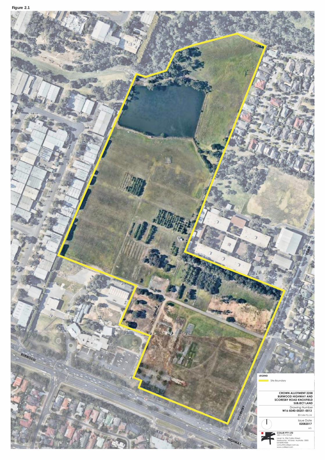
2.1 Location The subject land (figure 2.1) is located at 609 - 621 Burwood Highway, Knoxfield, Victoria, is irregular in shape, and has a slope from south to north of approximately 20 metres. The subject land has frontages to Burwood Highway (to the south) of approximately 210 metres and to Scoresby Road (to the east) of approximately 290 metres.
The subject land was previously used as the horticultural research and flora quarantine facility for the DELWP and comprises grassed vacant land, some sparse tree cover, a dam and some abandoned road pavements. It should be noted that the previous land use ceased operation in 2013.
2.2 The Surrounds The subject land forms part of the Knox Central Principal Activity Centre and is surrounded by a range of uses including residential to the east and south, light industrial and service industries to the west, Blind Creek Reserve (and its shared path) to the north and Fairhills High School to the east.
Being located within the Knox Central Principal Activity Centre, the subject land is in close proximity to a range of services including:
Fairhills High School, immediately east and adjacent to the subject land; Fairhills Primary School, 800 metres to the northeast; Lewis Park, approximately 800 metres to the northwest; St Andrews Christian College, located approximately 1 kilometre to the southwest; Knox City Council offices, approximately 1 kilometre to the west; Westfield Knox, a major retail shopping centre located approximately 1 kilometre to the west; various bus stops adjacent to the subject site on Burwood Highway and Scoresby Road.
BURWOOD
HIGHWAY
DA
OR
Y
BS
ER
OC
S
CROWN ALLOTMENT 2258
BURWOOD HIGHWAY AND
SCORESBY ROAD KNOXFIELD
SUBJECT LAND
Drawing NumberW16-8340-00201-0013
Collie Pty Ltd
Issue Date
02082017
NTS
COLLIE PTY LTDABN 11 076 755 069
Level 16, 356 Collins Street, Melbourne Victoria Australia 300003 8698 [email protected]
LEGEND
Site Boundary
Figure 2.1
o:\projects\16-8340\00200 now 00201\word\finalised\36525er planning report with cdz2.docx ADDRESS: 609 - 621 Burwood Highway, Knoxfield
Version 131217 Page: 7
Knox Planning Scheme Controls
3 Knox Planning Scheme Controls
3.1 State Planning Policy Framework The State Planning Policy Framework (SPPF) provides a context for spatial planning and decision making by planning authorities. The SPPF is predominantly general in nature and used to guide more specific planning policies within each municipality.
Various sections of the SPPF are of general relevance to the consideration of the proposed amendment including clauses 11.01 (Activity Centres), 11.02 (Urban Growth), 12.01 (Biodiversity), 16.01 (Residential Development) and 17.01 (Commercial).
A response to the relevant sections of the SPPF is provided in section 5 of this report.
3.2 Local Planning Policy Framework The Local Planning Policy Framework (LPPF) includes the Municipal Strategic Statement (MSS) and provides more specific planning controls for the City of Knox. Of particular relevance to the proposed amendment are clauses 21.05 (Housing), 21.06 (Environment), 21.07 (Economic Development) and 22.04 (Knox Central Principal Activity Centre).
A response to the relevant provisions of the LPPF is provided in Section 5 of this report.
3.3 Existing Zone Under the Scheme, the subject land is covered by Schedule 7 to the Public Use Zone (PUZ7) (figure 3.1). The purpose of the PUZ7 is to recognise public land use for public utility and community services and facilities and to provide for associated uses that are consistent with the intent of the public land reservation or purpose.
3.4 Overlays
3.4.1 Environmental Significance Overlay Part of the northern section of the subject land is affected by Schedule 2 to the Environmental Significance Overlay (ESO2) (figure 3.2). The purpose of the ESO2 is to identify areas where development of land may be affected by environmental constraints and to ensure that development is compatible with identified environmental values. The ESO2 specifically relates to sites of biological significance and aims to achieve a range environmental objectives that generally seeks to protect and retain flora and fauna species and in particular indigenous species.
3.4.2 Land Subject to Inundation Overlay Part of the northern section of the subject land is affected by the Land Subject to Inundation Overlay (LSIO) (figure 3.3). The purpose of the LSIO is:
to identify land in a flood storage or flood fringe area affected by the 1 in 100 year flood or any other area determined by the floodplain management authority;
to ensure that development maintains the free passage and temporary storage of floodwaters, minimises flood damage, is compatible with the flood hazard and local drainage conditions and will not cause any significant rise in flood level or flow velocity;
o:\projects\16-8340\00200 now 00201\word\finalised\36525er planning report with cdz2.docx ADDRESS: 609 - 621 Burwood Highway, Knoxfield
Version 131217 Page: 8
Knox Planning Scheme Controls
to reflect any declaration under Division 4 of Part 10 of the Water Act, 1989 where a declaration has been made;
to protect water quality in accordance with the provisions of relevant State Environment Protection Policies, particularly in accordance with Clauses 33 and 35 of the State Environment Protection Policy (Waters of Victoria);
to ensure that development maintains or improves river and wetland health, waterway protection and flood plain health.
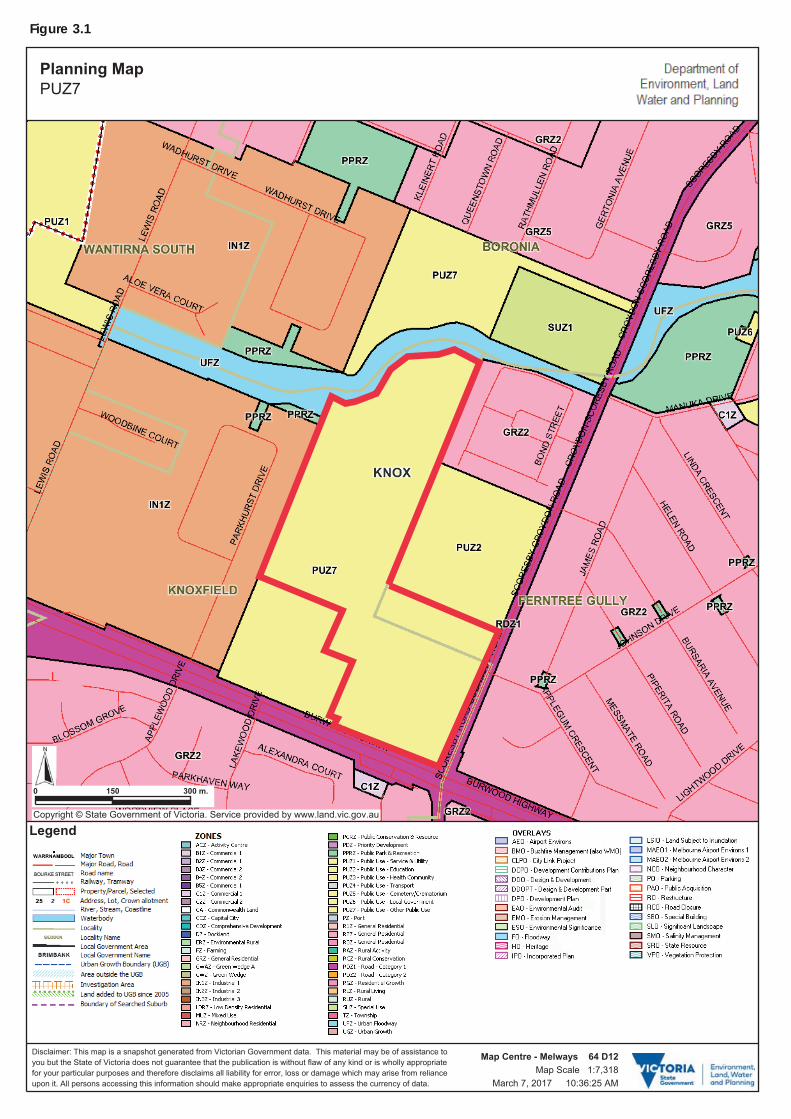
Figure 3.1
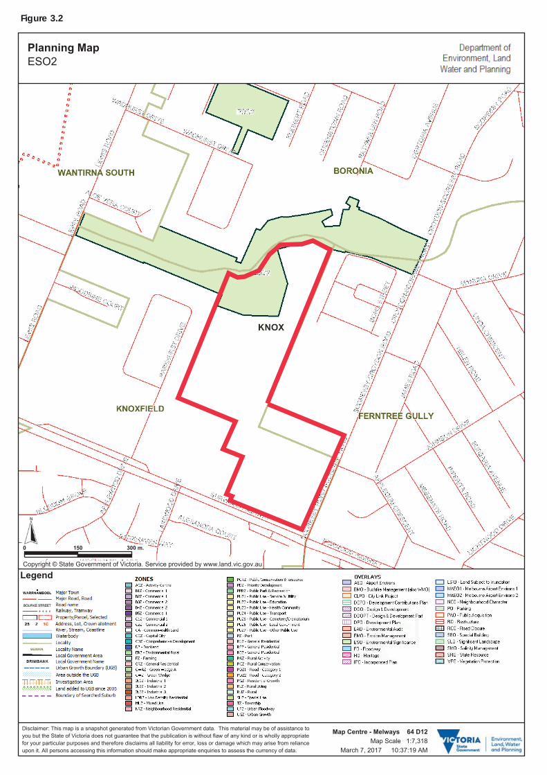
Figure 3.2
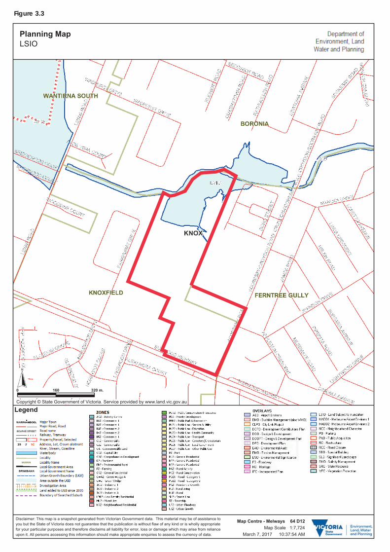
Figure 3.3

o:\projects\16-8340\00200 now 00201\word\finalised\36525er planning report with cdz2.docx ADDRESS: 609 - 621 Burwood Highway, Knoxfield
Version 131217 Page: 12
The Proposed Amendment
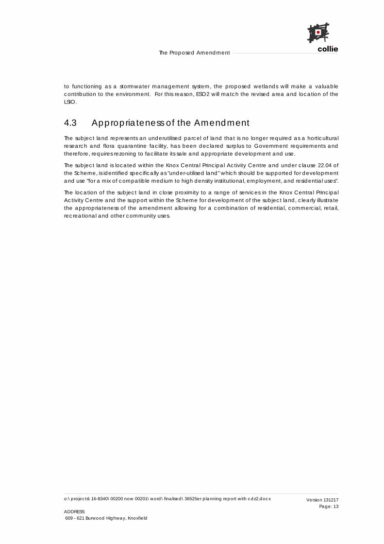
4 The Proposed Amendment This application proposes to amend the Scheme to rezone the subject land and to vary the location of the ESO and LSIO, based on the results of the proposed stormwater management strategy and environmental studies.
4.1 The Proposed Zones The amendment proposes to rezone the subject land to Comprehensive Development Zone (CDZ) under a new schedule 2 (CDZ2) (refer Appendix A). The amendment indicative zoning map (Figure 4.1) shows the proposed zone and its boundaries.
The amendment proposes to incorporate a comprehensive development plan (refer Appendix B) and to amend schedule 2 to clause 81.01 (refer Appendix C).
The Comprehensive Development Zone (CDZ) and the proposed Schedule 2 is the most appropriate single zone to provide for the varied development and uses intended for the subject land, whilst under the Comprehensive Development Plan (CDP) being able to restrict the location of such development and use. Furthermore, the CDP will allow for some flexibility as the exact boundaries of the mixed use area and residential area are not known at this stage.
In addition, the CDZ is an appropriate zone to enable the Small Lot Housing Code (SLHC) approach to be adopted for the subject land. In our experience, Councils in growth areas strongly encourage the use of the SLHC as an alternative to separate planning permit applications. We understand that the assessment of house plans by a Council planning department is time consuming and the SLHC is an avenue to freeing up Council resources. As a significant infill site (19.21 hectares), a large proportion of lots less than 300 square metres will be proposed on the subject land. In this context, the SLHC would reduce substantially the workload of Council in assessing house plans and will allow for the quicker delivery of housing.
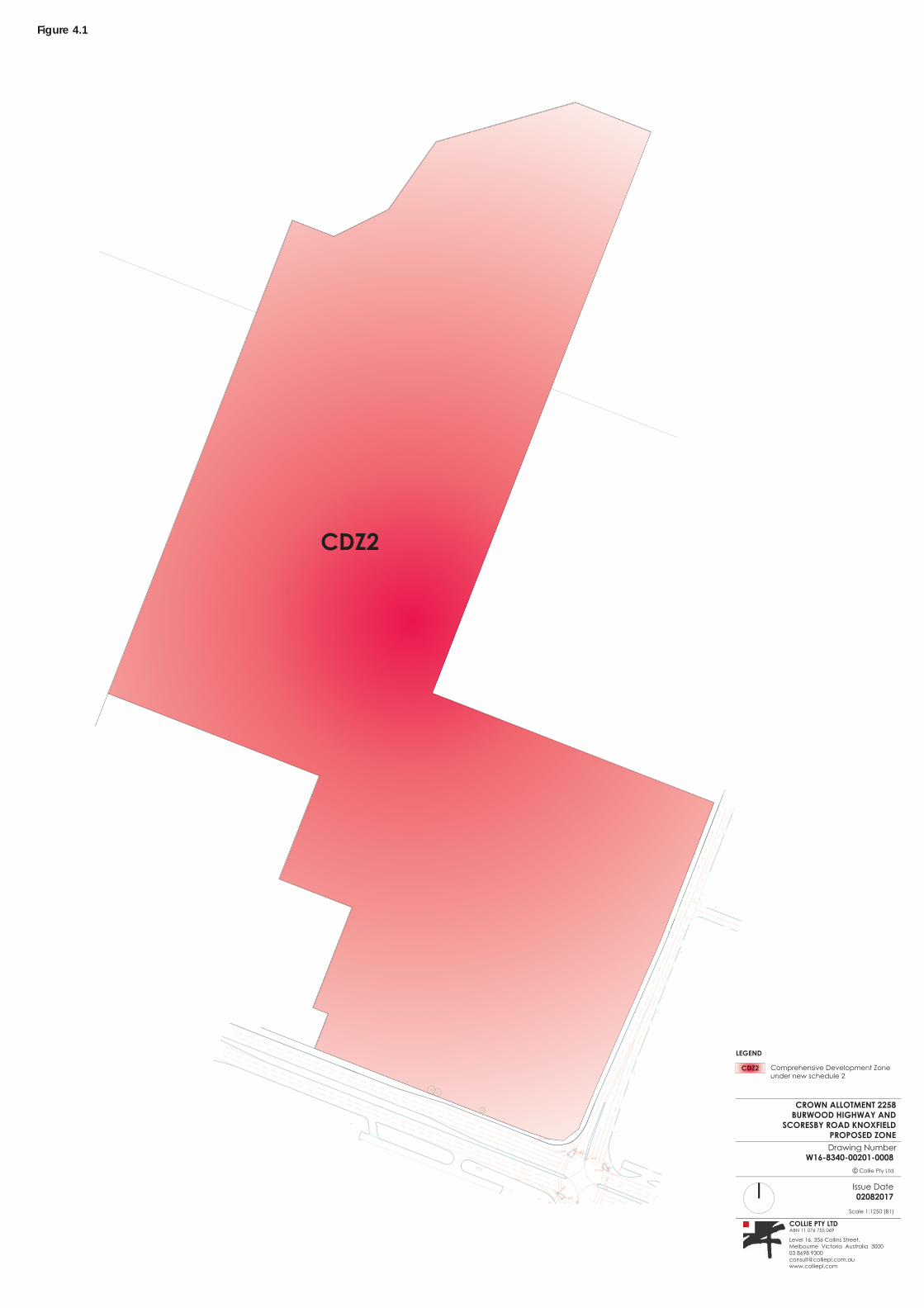
4.2 The Proposed Overlays
4.2.1 Environmental Significance and Land Subject to Inundation Overlays
The amendment varies the locations (figure 4.2) of the ESO2 and LSIO in the northern section of the subject land.
The existing dam located in the northwest part of the subject land is identified in the Preliminary Stormwater Management Strategy (PSMS), August 2017, prepared by Engeny Water Management as a constraint due to it not being designed to retard stormwater. It is recommended therefore in the PSMS, to remove the existing dam and construct a retarding basin in the northernmost part of the subject land, which is the logical location as all of the site drains to this location.
As part of the strategy for the treatment of stormwater, it is also proposed to construct a treatment wetland and sediment pond. As a result of the above works, the LSIO has been revised to reflect generally the location of the proposed wetlands. For the location of the wetlands, refer to the wetland design plans contained in the PSMS.
Flora, Fauna and Native Vegetation Assessment (FFNVA), 4 August 2017, prepared by Ecocentric Environmental Consulting, identifies the existing dam as being of importance for a range of flora and fauna species. The FFNVA confirms that the proposed construction of the new wetlands outlined above, will create an equivalent habitat area that will result in an improvement to the habitat quality. In addition
o:\projects\16-8340\00200 now 00201\word\finalised\36525er planning report with cdz2.docx ADDRESS: 609 - 621 Burwood Highway, Knoxfield
Version 131217 Page: 13
The Proposed Amendment
to functioning as a stormwater management system, the proposed wetlands will make a valuable contribution to the environment. For this reason, ESO2 will match the revised area and location of the LSIO.
4.3 Appropriateness of the Amendment The subject land represents an underutilised parcel of land that is no longer required as a horticultural research and flora quarantine facility, has been declared surplus to Government requirements and therefore, requires rezoning to facilitate its sale and appropriate development and use.
The subject land is located within the Knox Central Principal Activity Centre and under clause 22.04 of the Scheme, is identified specifically as "under-utilised land" which should be supported for development and use "for a mix of compatible medium to high density institutional, employment, and residential uses".
The location of the subject land in close proximity to a range of services in the Knox Central Principal Activity Centre and the support within the Scheme for development of the subject land, clearly illustrate the appropriateness of the amendment allowing for a combination of residential, commercial, retail, recreational and other community uses.
CROWN ALLOTMENT 2258
BURWOOD HIGHWAY AND
SCORESBY ROAD KNOXFIELD
PROPOSED ZONE
Drawing NumberW16-8340-00201-0008
Collie Pty Ltd
Issue Date
02082017
Scale 1:1250 (B1)
COLLIE PTY LTDABN 11 076 755 069
Level 16, 356 Collins Street, Melbourne Victoria Australia 300003 8698 [email protected]
CDZ2
LEGEND
Comprehensive Development Zone under new schedule 2
CDZ2
Figure 4.1
APPLEGM RE CENT
UC
S
BURWOOD
GHWAY
HI
SE
D
CO
RSB
Y
RO
A
CROWN ALLOTMENT 2258
BURWOOD HIGHWAY AND
SCORESBY ROAD KNOXFIELD
PROPOSED OVERLAYS
Drawing NumberW16-8340-00201-0009
Collie Pty Ltd
Issue Date
02082017
Scale 1:1250 (B1)
COLLIE PTY LTDABN 11 076 755 069
Level 16, 356 Collins Street, Melbourne Victoria Australia 300003 8698 [email protected]
LEGEND
Environmental Significance Overlay Schedule 2Land subject to Indundation Overlay
Figure 4.2
o:\projects\16-8340\00200 now 00201\word\finalised\36525er planning report with cdz2.docx ADDRESS: 609 - 621 Burwood Highway, Knoxfield
Version 131217 Page: 16
Strategic Considerations
5 Strategic Considerations The amendment has been assessed under Direction No. 11 - Strategic Assessment of Amendments, as set out below.
WHY IS AN AMENDMENT REQUIRED?
The planning scheme amendment is required as the government-owned land has become surplus to requirements and needs to be rezoned to an appropriate zone or zones to facilitate the sale of the land and its appropriate development and use.
The existing Public Use Zone 7 reflects its former use as a government horticulture research farm and this use has now ceased. The proposed development and use of the land is for a variety of potential uses ranging from medium density residential, commercial uses in the vicinity of Burwood Highway and natural systems, wetlands and stormwater management in the north end of the site abutting the Blind Creek Reserve.
The amendment proposes a Comprehensive Development Zone with adjustment of the existing ESO2 and LSIO, to reflect recent environmental and stormwater management studies.
The amendment will:
result in a good planning outcome that is logical in all of the circumstances; will have a net community benefit in that it will enable unused surplus government land to be
utilised for an economic purpose while providing commitment to future environmental and stormwater management best practise;
be consistent with the wider planning policies for the area and enable development and use consistent with its location in the Knox Central Principal Activity Centre;
utilise existing zones and overlays in the Knox Planning Scheme.
DOES THE AMENDMENT IMPLEMENT THE OBJECTIVES OF PLANNING AND ADDRESS ANY ENVIRONMENTAL, SOCIAL AND ECONOMIC EFFECTS?
The proposed amendment assists in implementing the objectives of sections 4(1) and 12(1)(a) of the Planning and Environment Act 1987. In particular, it:
provides for fair, orderly, economic and sustainable use of land, as reflected in the content of this assessment;
provides for the protection of ecological processes; secures a safe living and recreational environment; enhances and conserves areas of aesthetic and scientific interest; enables the orderly provision of public utilities.
The amendment addresses adequately sections 12(2)(b) and (c) of the Planning and Environment Act 1987. In particular, it:
addresses environmental considerations for the subject land including ecosystems enhancement and stormwater management;
addresses social and economic effects by proposing appropriate uses that are compatible with the surroundings, providing an economic use for under-utilised land and providing for reasonable social effects by way of the above.
The amendment will provide positive social and economic benefits by providing appropriate environmental improvement and opportunities for residential, commercial, retail, recreational and other
o:\projects\16-8340\00200 now 00201\word\finalised\36525er planning report with cdz2.docx ADDRESS: 609 - 621 Burwood Highway, Knoxfield
Version 131217 Page: 17
Strategic Considerations
community uses, in an area that is earmarked for and able to support such a variety of urban growth elements.
DOES THE AMENDMENT ADDRESS RELEVANT BUSHFIRE RISK?
The bushfire management overlay is the key tool in the planning scheme for protecting from the risk of bushfire and its purpose includes to "identify areas where the bushfire hazard warrants bushfire protection measures to be implemented".
The subject land is not affected by the bushfire management overlay.
DOES THE AMENDMENT COMPLY WITH ALL THE RELEVANT MINISTER'S DIRECTIONS?
The amendment complies with all of the relevant Ministerial Directions.
In response to Ministerial Direction No. 1 on potentially contaminated land, an Environmental Site Assessment (ESA), February 2016, has been prepared by Parsons Brinckerhoff Australia. The ESA confirms that the subject land is suitable for residential development and other sensitive uses and that an environmental audit is not required. As an environmental audit of the land is not required, it follows that neither a certificate of environmental audit nor a statement of environmental audit is required.
DOES THE AMENDMENT SUPPORT OR IMPLEMENT THE STATE PLANNING POLICY FRAMEWORK?
The State Planning Policy Framework (SPPF) provides a context for decision making by planning authorities. Of particular relevance to the amendment are clauses 11.01 (Activity Centres), 11.02 (Urban Growth), 12.01 (Biodiversity), 16.01 (Residential Development) and 17.01 (Commercial).
Clause 11.01 relates to activity centres and seeks to ensure that activity centres will be a focus for high-quality development, activity and living for the whole community. The amendment is consistent with clause 11.01 as its outcomes will enhance the growth and development of a vibrant Knox Central Principal Activity Centre.
In accordance with clause 11.02 (Urban Growth), the amendment assists in ensuring that suitable land is available for residential, commercial, retail, recreational and other community uses in an area expected to accommodate increased urban development.
Clause 12.01 relates to biodiversity and was considered in the preparation of the amendment and the detailed studies on which it has been based and is reflected in the continued use of the Environmental Significance Overlay to protect and enhance the natural habitat of native flora and fauna on the subject land.
In accordance with clause 16.01 (Residential Development), the amendment will increase the supply of housing in an existing urban area by facilitating increased housing yield in an under-utilised appropriate location.
Clause 17.01 encourages development which meets the community needs for retail, entertainment, office and other commercial services which will be facilitated via the amendment in the area in the vicinity of Burwood Highway.
o:\projects\16-8340\00200 now 00201\word\finalised\36525er planning report with cdz2.docx ADDRESS: 609 - 621 Burwood Highway, Knoxfield
Version 131217 Page: 18
Strategic Considerations
HOW DOES THE AMENDMENT SUPPORT OR IMPLEMENT THE LOCAL PLANNING POLICY FRAMEWORK (LPPF) AND, SPECIFICALLY, THE MUNICIPAL STRATEGIC STATEMENT?
The Local Planning Policy Framework (LPPF) relates specifically to the City of Knox and contains the Municipal Strategic Statement (MSS). Of particular relevance to the amendment are clauses 21.05 (Housing), 21.06 (Environment), 21.07 (Economic Development) and 22.04 (Knox Central Principal Activity Centre).
The amendment assists in implementing the relevant clauses of the LPPF and MSS by providing increased opportunities for residential, commercial, retail, recreational and other community uses in an underutilised location that has been identified in the relevant local policy as a strategic site for an intensification of future development.
In particular, the amendment addresses directly clause 22.04 which supports the development of under-utilised land and specifically the subject land.
DOES THE AMENDMENT MAKE PROPER USE OF THE VICTORIA PLANNING PROVISIONS?
The proposed zone and overlays are the most appropriate to be used from the Victoria Planning Provisions 'toolkit' and achieve the strategic objectives of the Scheme. The CDZ2 is appropriate for this proposed multi-use area where it is not otherwise possible to identify:
an alternative single zone over the subject land to provide the necessary range of development and uses proposed under the Scheme but with the restrictions on the location of such development and use as proposed in the comprehensive development plan for the subject land;
and even were it appropriate to have more than one zone over a single parcel of land, the exact boundary of the two zones.
The CDZ is an existing zone in the Scheme, is appropriate over the land with its locational characteristics (within the Knox Central Principal Activity Centre; having significant frontage to Burwood Highway, which is recognised for commercial, retail and like uses) and has been drafted via the amendment to enable a range of appropriate use in areas identified for such uses. All of this makes it an appropriate zone in the circumstances.
The intended overlays exist over the land already (ESO and LSIO) and are sensible and appropriate overlays to continue to utilise, albeit in somewhat varied locations.
HOW DOES THE AMENDMENT ADDRESS THE VIEWS OF RELEVANT AGENCIES?
As part of the preparation of the amendment, the relevant government agencies have been consulted and / or their recent submissions to proposed Scheme amendment C149 that affects the subject land, have been considered. These have included:
the Department of Environment, Land, Water and Planning; Knox City Council; VicRoads; Melbourne Water.
Proposed amendment C149 dealt with the Knox Activity Centre, which includes the subject land. The concerns of Development Victoria with amendment C149, were generally supported by the independent panel that considered submissions.
o:\projects\16-8340\00200 now 00201\word\finalised\36525er planning report with cdz2.docx ADDRESS: 609 - 621 Burwood Highway, Knoxfield
Version 131217 Page: 19
Strategic Considerations
DOES THE AMENDMENT ADDRESS THE REQUIREMENTS OF THE TRANSPORT INTEGRATION ACT 2010?
The proposed amendment will not have any significant impact on the existing or proposed transport system around the subject land.
WHAT IMPACT WILL THE NEW PLANNING PROVISIONS HAVE ON THE ADMINISTRATIVE COSTS OF THE RESPONSIBLE AUTHORITY?
The amendment is not expected to have any undue impact on the administrative costs of the responsible authority. The amendment will result in additional development / activity on the subject land and thus there will be an increase in revenues but equally an increase in costs to administer the new urban precinct. This is expected to be in keeping with normal expectations for developing areas.
Knox City Council has in train its own amendment covering the Knox Central Activity Centre area, which includes the subject land and the proposed amendment is generally consistent with the principles in that amendment.
o:\projects\16-8340\00200 now 00201\word\finalised\36525er planning report with cdz2.docx ADDRESS: 609 - 621 Burwood Highway, Knoxfield
Version 131217 Page: 20
Conclusion
6 Conclusion As outlined in this report, the Scheme amendment is required in order to rezone the subject land to more appropriate zones to facilitate its sale (as surplus government land), zoning and overlay control, to facilitate appropriate development and use.
The amendment responds appropriately to the relevant provision of the Scheme as well as the strategic assessment guidelines, as outlined in this report.
In summary, the amendment will facilitate the redevelopment of the subject land from its current under-utilised state into an appropriate residential, commercial, retail, recreational and other community uses area.
o:\projects\16-8340\00200 now 00201\word\finalised\36525er planning report with cdz2.docx ADDRESS: 609 - 621 Burwood Highway, Knoxfield
Comprehensive Development Zone - Schedule 2
Version 131217
Appendix A Comprehensive Development Zone - Schedule 2
KNOX PLANNING SCHEME
COMPREHENSIVE DEVELOPMENT ZONE - SCHEDULE 2 PAGE 1 OF 7
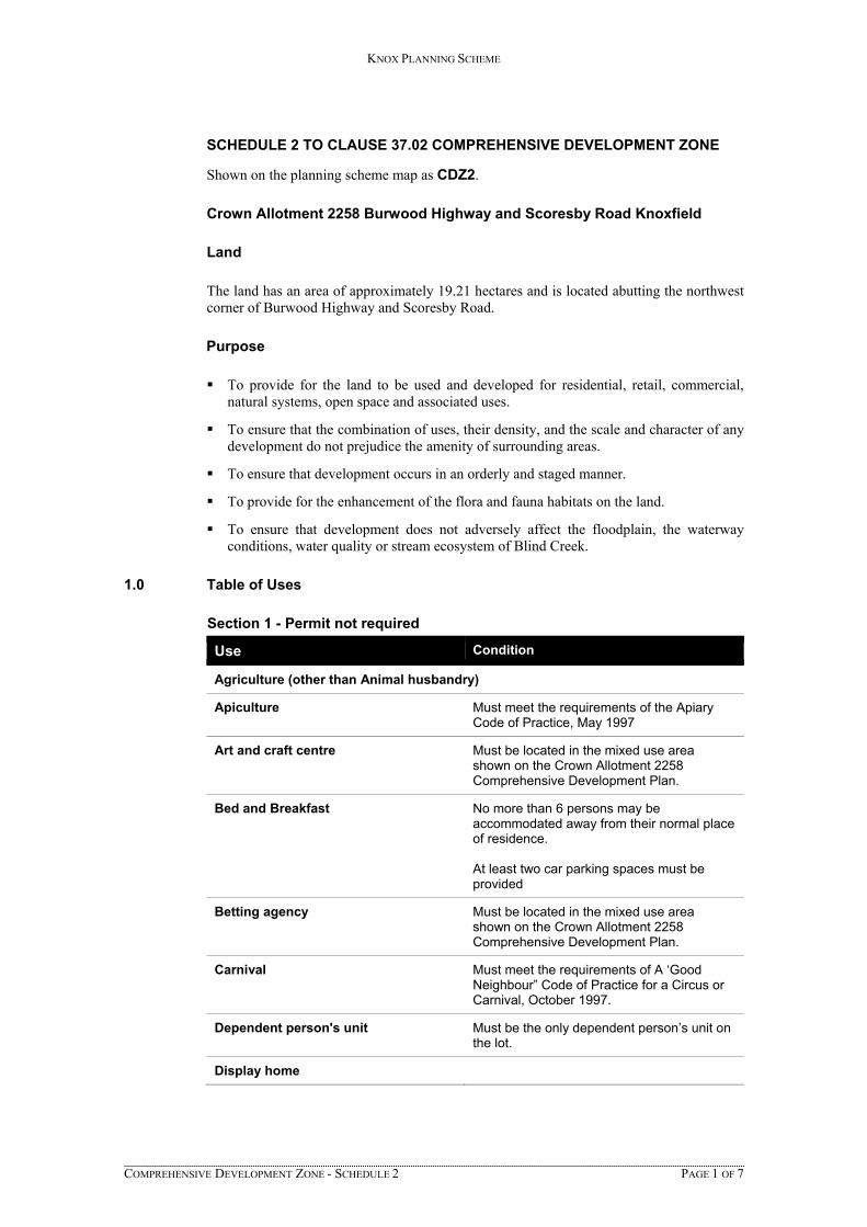
SCHEDULE 2 TO CLAUSE 37.02 COMPREHENSIVE DEVELOPMENT ZONE
Shown on the planning scheme map as CDZ2.
Crown Allotment 2258 Burwood Highway and Scoresby Road Knoxfield
Land
The land has an area of approximately 19.21 hectares and is located abutting the northwest corner of Burwood Highway and Scoresby Road.
Purpose
To provide for the land to be used and developed for residential, retail, commercial, natural systems, open space and associated uses.
To ensure that the combination of uses, their density, and the scale and character of any development do not prejudice the amenity of surrounding areas.
To ensure that development occurs in an orderly and staged manner.
To provide for the enhancement of the flora and fauna habitats on the land.
To ensure that development does not adversely affect the floodplain, the waterway conditions, water quality or stream ecosystem of Blind Creek.
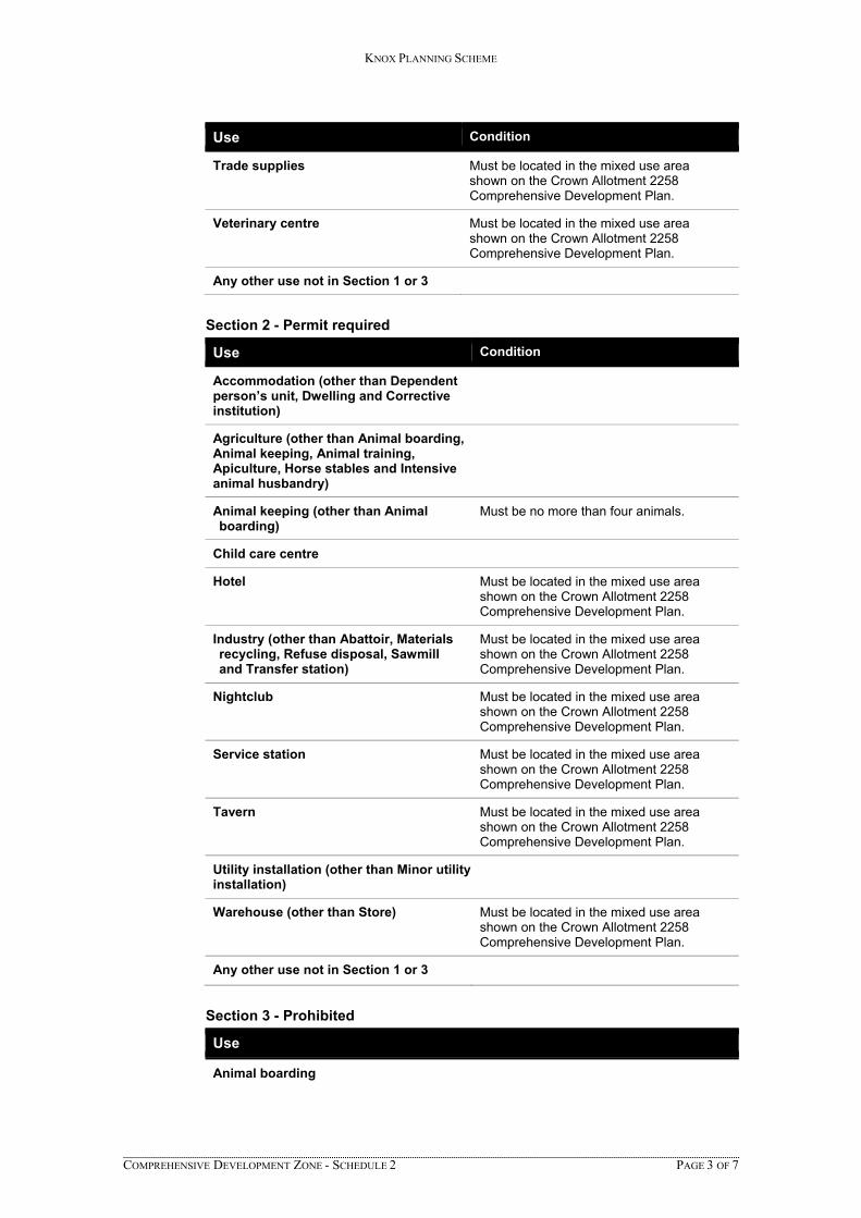
1.0 Table of Uses
Section 1 - Permit not required
Use Condition
Agriculture (other than Animal husbandry)
Apiculture Must meet the requirements of the Apiary Code of Practice, May 1997
Art and craft centre Must be located in the mixed use area shown on the Crown Allotment 2258 Comprehensive Development Plan.
Bed and Breakfast No more than 6 persons may be accommodated away from their normal place of residence. At least two car parking spaces must be provided
Betting agency Must be located in the mixed use area shown on the Crown Allotment 2258 Comprehensive Development Plan.
Carnival Must meet the requirements of A ‘Good Neighbour” Code of Practice for a Circus or Carnival, October 1997.
Dependent person's unit Must be the only dependent person’s unit on the lot.
Display home
KNOX PLANNING SCHEME
COMPREHENSIVE DEVELOPMENT ZONE - SCHEDULE 2 PAGE 2 OF 7
Use Condition
Dwelling (other than bed and breakfast)
Education centre Must be located in the mixed use area shown on the Crown Allotment 2258 Comprehensive Development Plan.
Earth and energy resources industry Must meet the requirements of clause 52.08-2.
Food and drink premises (other than Hotel and Tavern)
Must be located in the mixed use area shown on the Crown Allotment 2258 Comprehensive Development Plan.
Home occupation
Indoor recreation facility Must be located in the mixed use area shown on the Crown Allotment 2258 Comprehensive Development Plan.
Informal outdoor recreation
Medical centre Must be located in the mixed use area shown on the Crown Allotment 2258 Comprehensive Development Plan.
Minor utility installation Natural systems
Office Must be located in the mixed use area shown on the Crown Allotment 2258 Comprehensive Development Plan.
Place of assembly (other than Carnival, Nightclub and Place of Worship)
Must be located in the mixed use area shown on the Crown Allotment 2258 Comprehensive Development Plan.
Place of Worship Must be located in the mixed use area shown on the Crown Allotment 2258 Comprehensive Development Plan.
Postal Agency Must be located in the mixed use area shown on the Crown Allotment 2258 Comprehensive Development Plan.
Residential hotel Must be located in the mixed use area shown on the Crown Allotment 2258 Comprehensive Development Plan.
Retail premises (other than Department store and Supermarket)
Must be located in the mixed use area shown on the Crown Allotment 2258 Comprehensive Development Plan.
Road
Store Must be located in the mixed use area shown on the Crown Allotment 2258 Comprehensive Development Plan.
Telecommunication facility Buildings and works must meet the requirements of Clause 52.19.
KNOX PLANNING SCHEME
COMPREHENSIVE DEVELOPMENT ZONE - SCHEDULE 2 PAGE 3 OF 7
Use Condition
Trade supplies Must be located in the mixed use area shown on the Crown Allotment 2258 Comprehensive Development Plan.
Veterinary centre Must be located in the mixed use area shown on the Crown Allotment 2258 Comprehensive Development Plan.
Any other use not in Section 1 or 3
Section 2 - Permit required
Use Condition
Accommodation (other than Dependent person’s unit, Dwelling and Corrective institution)
Agriculture (other than Animal boarding, Animal keeping, Animal training, Apiculture, Horse stables and Intensive animal husbandry)
Animal keeping (other than Animal boarding)
Must be no more than four animals.
Child care centre
Hotel Must be located in the mixed use area shown on the Crown Allotment 2258 Comprehensive Development Plan.
Industry (other than Abattoir, Materials recycling, Refuse disposal, Sawmill and Transfer station)
Must be located in the mixed use area shown on the Crown Allotment 2258 Comprehensive Development Plan.
Nightclub Must be located in the mixed use area shown on the Crown Allotment 2258 Comprehensive Development Plan.
Service station Must be located in the mixed use area shown on the Crown Allotment 2258 Comprehensive Development Plan.
Tavern Must be located in the mixed use area shown on the Crown Allotment 2258 Comprehensive Development Plan.
Utility installation (other than Minor utility installation)
Warehouse (other than Store) Must be located in the mixed use area shown on the Crown Allotment 2258 Comprehensive Development Plan.
Any other use not in Section 1 or 3
Section 3 - Prohibited
Use
Animal boarding
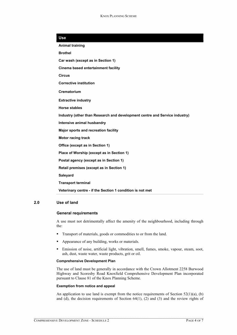
KNOX PLANNING SCHEME
COMPREHENSIVE DEVELOPMENT ZONE - SCHEDULE 2 PAGE 4 OF 7
Use
Animal training
Brothel
Car wash (except as in Section 1)
Cinema based entertainment facility
Circus
Corrective institution
Crematorium
Extractive industry
Horse stables
Industry (other than Research and development centre and Service industry)
Intensive animal husbandry
Major sports and recreation facility
Motor racing track
Office (except as in Section 1)
Place of Worship (except as in Section 1)
Postal agency (except as in Section 1)
Retail premises (except as in Section 1)
Saleyard
Transport terminal
Veterinary centre - if the Section 1 condition is not met
2.0 Use of land
General requirements
A use must not detrimentally affect the amenity of the neighbourhood, including through the:
Transport of materials, goods or commodities to or from the land.
Appearance of any building, works or materials.
Emission of noise, artificial light, vibration, smell, fumes, smoke, vapour, steam, soot, ash, dust, waste water, waste products, grit or oil.
Comprehensive Development Plan
The use of land must be generally in accordance with the Crown Allotment 2258 Burwood Highway and Scoresby Road Knoxfield Comprehensive Development Plan incorporated pursuant to Clause 81 of the Knox Planning Scheme.
Exemption from notice and appeal
An application to use land is exempt from the notice requirements of Section 52(1)(a), (b) and (d), the decision requirements of Section 64(1), (2) and (3) and the review rights of
KNOX PLANNING SCHEME
COMPREHENSIVE DEVELOPMENT ZONE - SCHEDULE 2 PAGE 5 OF 7
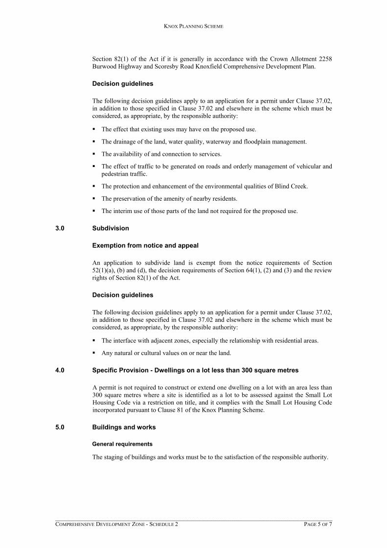
Section 82(1) of the Act if it is generally in accordance with the Crown Allotment 2258 Burwood Highway and Scoresby Road Knoxfield Comprehensive Development Plan.
Decision guidelines
The following decision guidelines apply to an application for a permit under Clause 37.02, in addition to those specified in Clause 37.02 and elsewhere in the scheme which must be considered, as appropriate, by the responsible authority:
The effect that existing uses may have on the proposed use.
The drainage of the land, water quality, waterway and floodplain management.
The availability of and connection to services.
The effect of traffic to be generated on roads and orderly management of vehicular and pedestrian traffic.
The protection and enhancement of the environmental qualities of Blind Creek.
The preservation of the amenity of nearby residents.
The interim use of those parts of the land not required for the proposed use.
3.0 Subdivision
Exemption from notice and appeal
An application to subdivide land is exempt from the notice requirements of Section 52(1)(a), (b) and (d), the decision requirements of Section 64(1), (2) and (3) and the review rights of Section 82(1) of the Act.
Decision guidelines
The following decision guidelines apply to an application for a permit under Clause 37.02, in addition to those specified in Clause 37.02 and elsewhere in the scheme which must be considered, as appropriate, by the responsible authority:
The interface with adjacent zones, especially the relationship with residential areas.
Any natural or cultural values on or near the land.
4.0 Specific Provision - Dwellings on a lot less than 300 square metres
A permit is not required to construct or extend one dwelling on a lot with an area less than 300 square metres where a site is identified as a lot to be assessed against the Small Lot Housing Code via a restriction on title, and it complies with the Small Lot Housing Code incorporated pursuant to Clause 81 of the Knox Planning Scheme.
5.0 Buildings and works
General requirements
The staging of buildings and works must be to the satisfaction of the responsible authority.
KNOX PLANNING SCHEME
COMPREHENSIVE DEVELOPMENT ZONE - SCHEDULE 2 PAGE 6 OF 7
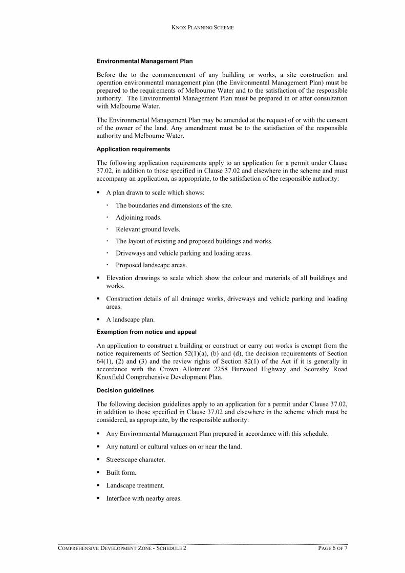
Environmental Management Plan
Before the to the commencement of any building or works, a site construction and operation environmental management plan (the Environmental Management Plan) must be prepared to the requirements of Melbourne Water and to the satisfaction of the responsible authority. The Environmental Management Plan must be prepared in or after consultation with Melbourne Water.
The Environmental Management Plan may be amended at the request of or with the consent of the owner of the land. Any amendment must be to the satisfaction of the responsible authority and Melbourne Water.
Application requirements
The following application requirements apply to an application for a permit under Clause 37.02, in addition to those specified in Clause 37.02 and elsewhere in the scheme and must accompany an application, as appropriate, to the satisfaction of the responsible authority:
A plan drawn to scale which shows:
The boundaries and dimensions of the site.
Adjoining roads.
Relevant ground levels.
The layout of existing and proposed buildings and works.
Driveways and vehicle parking and loading areas.
Proposed landscape areas.
Elevation drawings to scale which show the colour and materials of all buildings and works.
Construction details of all drainage works, driveways and vehicle parking and loading areas.
A landscape plan.
Exemption from notice and appeal
An application to construct a building or construct or carry out works is exempt from the notice requirements of Section 52(1)(a), (b) and (d), the decision requirements of Section 64(1), (2) and (3) and the review rights of Section 82(1) of the Act if it is generally in accordance with the Crown Allotment 2258 Burwood Highway and Scoresby Road Knoxfield Comprehensive Development Plan.
Decision guidelines
The following decision guidelines apply to an application for a permit under Clause 37.02, in addition to those specified in Clause 37.02 and elsewhere in the scheme which must be considered, as appropriate, by the responsible authority:
Any Environmental Management Plan prepared in accordance with this schedule.
Any natural or cultural values on or near the land.
Streetscape character.
Built form.
Landscape treatment.
Interface with nearby areas.
KNOX PLANNING SCHEME
COMPREHENSIVE DEVELOPMENT ZONE - SCHEDULE 2 PAGE 7 OF 7
Parking and site access.
Lighting.
Stormwater discharge.
The preservation of the amenity of nearby residents.
The protection and enhancement of the environmental qualities of Blind Creek including the protection of the water quality of these waterways.
The orderly management of vehicular and pedestrian traffic.
The visual impact of the building or works upon the area.
The management of the floodplain and catchment.
6.0 Advertising signs
Advertising sign requirements are at Clause 52.05.
All land located within the residential area shown on the Crown Allotment 2258 Burwood Highway and Scoresby Road Knoxfield Comprehensive Development Plan is in Category 3.
All land located within the mixed use area shown on the Crown Allotment 2258 Burwood Highway and Scoresby Road Knoxfield Comprehensive Development Plan is in Category 1.
All land located within the drainage / watercourse / wetlands area shown on the Crown Allotment 2258 Burwood Highway and Scoresby Road Knoxfield Comprehensive Development Plan is in Category 4.

o:\projects\16-8340\00200 now 00201\word\finalised\36525er planning report with cdz2.docx ADDRESS: 609 - 621 Burwood Highway, Knoxfield
Comprehensive Development Plan
Version 131217
Appendix B Comprehensive Development Plan
PUBLIC USE(DELWP)
FAIRHILLS
HIGH
SCHOOL
EXISTING
RESIDENTIAL
EXISTING
INDUSTRIAL
APPLEGM RE CENT
UC
S
BURWOOD GHWAY
HI
SE
D
CO
RSB
Y
RO
A
CROWN ALLOTMENT 2258
BURWOOD HIGHWAY AND
SCORESBY ROAD KNOXFIELD
COMPREHENSIVE DEVELOPMENT PLAN
Drawing NumberW16-8340-00201-0025D
Collie Pty Ltd
Issue Date
02082017
Scale 1:1250 (B1)
COLLIE PTY LTDABN 11 076 755 069
Level 16, 356 Collins Street, Melbourne Victoria Australia 300003 8698 [email protected]
Key Vehicular Access / Egress Point
Possible Future Access / Egress Point
WDRP
R
MU Mixed Use Area
LEGEND
Waterway / Drainage / Retardation / Public Open Space
Residential - including permitted and permissible uses as typical General Residential Zone
R
WDRP
MU

o:\projects\16-8340\00200 now 00201\word\finalised\36525er planning report with cdz2.docx ADDRESS: 609 - 621 Burwood Highway, Knoxfield
Schedule 2 to Clause 81.01
Version 131217
Appendix C Schedule 2 to Clause 81.01
KNOX PLANNING SCHEME
INCORPORATED DOCUMENTS - CLAUSE 81.01 - SCHEDULE PAGE 1 OF 1
SCHEDULE 2 TO CLAUSE 81.01
Name of document Introduced by:
Crown Allotment 2258 Burwood Highway and Scoresby Road Knoxfield Comprehensive Development Plan - July 2017
CXXX
Knox Central – Rembrandts Triangle and Stud Road West Precincts Plan – August 2010
C101
Level Crossing Removal Project – Mountain Highway and Scoresby Road, Bayswater Incorporated Document, December 2015
C147
Proposed Knox Driving Range, April 2004 C39
Restructure Plan 1, November 1999 NPS1
Restructure Plan 3, November 1999 NPS1
Site Specific Control - 27 Reservoir Crescent, Rowville July 2011 Incorporated document
C99
Site Specific Control – 33-35 Napoleon Road, Lysterfield (Lot 1, TP 760282), August 2014
C134
Site Specific Control – Lot 3 LP 42250 Wellington Road, Rowville, 11 March 2011
C87
Site Specific Control – Section of Napoleon Road, Lysterfield, January 2013
C110
Waterford Valley Comprehensive Development Plan, Drawing No.30015698/101 (A), prepared by Aspect Landscape Consultants Pty Ltd, August 1999
NPS1
Woolworths Oxygen, Knoxfield, February 2011 C107