Embed Size (px)
Citation preview

Dane County (Town of Springdale) 1 Multi-Hazard Mitigation Plan October 2009
Town of Springdale Annex
Community Profile
The Town of Springdale is located in southwestern Dane County, Wisconsin, southwest of the City of Madison, between the City of Verona and the Village of Mount Horeb. Neighboring Towns in Dane County include Blue Mounds, Cross Plains, Middleton, Montrose, Perry, Primrose, Vermont, and Verona.
Residing on the eastern edge of southwestern Wisconsin’s driftless (unglaciated) area, Springdale’s topography is consequently varied with rolling hills and valleys hosting natural springs that feed trout streams. The 36 square mile area of Springdale lies within the Upper Sugar River Watershed. According to the United States Census Bureau, the Town of Springdale has a total area of 35.28 square miles, all of it land .
As of the 2000 Census, there are 1,530 people, 570 households, and 441 families residing in the Town of Springdale. The population density is 43.4 people per square mile. There are 585 housing units at an average density of 16.6 units per square mile. The municipality population distributed by Dane County indicates that the 2008 population for Springdale was 1,792 people.
There are 570 households out of which 46.3% have children under the age of 18 living with them, 15.8% of all households are made up of individuals and 3.7% have someone living alone who is 65 years of age or older. The average household size is 2.68 and the average family size is 3.03. In the Town of Springdale, the population is spread out with 27.1% under the age of 18, 4.4% from ages 18 to 24, 30.7% ages 25 to 44, 28.2% ages 45 to 64, and 9.6% who are 65 years of age or older. The median age is 40.1 years. 4.4% of the population speaks a language other than English at home and 11.1% of the population (above the age of 5) is disabled.
The median income for a household in the Town of Springdale is $65,655 and the median income for a family is $68,417. The per capita income for the Town of Springdale is $27,138. 1.9% of all individuals and 1.8% of families are below the poverty line. Out of the total people living in poverty, 3.3% are under the age of 18 and 2.1% are 65 or older. 93.9% of the population has at least a high school degree, while 31.5% of the population holds at least a bachelor’s level degree.
Hazard Identification and Risk Assessment
A hazard identification and vulnerability analysis was completed for the Town of Springdale using the same methodology in the base plan. The information to support the hazard identification and risk assessment for this Annex was collected through a Data Collection Guide, which was distributed to each participating municipality to complete.
The first step in a hazard analysis is to identify which hazards the community is vulnerable to. Table 1 outlines the hazard identification for the Town of Springdale based on the Data Collection Guide issued in 2008. The Data Collection Guide listed all of the hazards that could impact anywhere in Dane County. The purpose of this worksheet was to identify and

Dane County (Town of Springdale) 2 Multi-Hazard Mitigation Plan October 2009
rank the hazards and vulnerabilities specific to the jurisdiction. The Town of Springdale’s planning team members were asked to complete the matrix by ranking each category on a scale of 0 to 3 based on the experience and perspective of each planning team member. A ranking of 0 indicated “no concern” while a ranking of 3 indicated “highest concern”. This matrix appears as Table 1. This matrix reflects the significance of the hazards relative to one another.
This matrix reflects that the Town of Springdale feels most vulnerable to Tornados and Winter Storms. A medium vulnerability rating was assigned to Flood, and Low ratings were assigned to Hail Storms, Extreme Heat, Drought, and Extreme Cold. The hazards of Dam Failure, Fog, Landslide, Lightning, and Wildfire received ratings of ‘0’ and the hazards of Windstorms, Erosion, and Subsidence were not evaluated. The vulnerability established here is a qualitative assumption based on the impacts, geographic extent, probability of future occurrence, and magnitude/severity.
Dane County (Town of Springdale) 3 Multi-Hazard Mitigation Plan October 2009
Table 1 Vulnerability Assessment Matrix for the Town of Springdale
Impact Attributes (0-1-2-3)
Hazard Attributes (1-2-3) Primary Impact
(Short Term – Life and Property) Secondary Impact
(Long Term- Community Impacts) Hazard
Area of Impact
Past History, Probability of
Future Occurrence
Short Term Time
Factors
Impact on General
Structures
Impact on Critical
Facilities
Impact on At-Risk
Populations Social Impact
Economic Impact
Severity of other
associated secondary
hazards
Total
Dam failure 0 0 0 0 0 0 0 0 0 0
Extreme Cold 1 1 1 1 4
Extreme Heat 1 1 1 1 1 5
Drought 1 1 1 1 1 5
Erosion
Flood 2 2 2 2 2 10
Fog 0
Hail Storm 1 1 2 1 1 6
Landslide 0 0 0 0 0 0 0 0 0 0
Lightning 0 0
Tornado 3 2 3 3 3 3 3 3 3 26
Wildfire 0 0 0 0 0 0 0 0 0 0
Windstorm 0
Winter Storm 3 3 3 2 2 2 2 2 2 21
Subsidence
Other:
Dane County (Town of Springdale) 4 Multi-Hazard Mitigation Plan October 2009
Previous Hazard Events
Through the Data Collection Guide, the Town of Springdale was solicited to note specific historic hazard events to include in the community profile. No specific events were highlighted for the Town of Springdale.
Asset Inventory
Assets include the people, property, and critical facilities within the Town of Springdale that are exposed to hazards in general. Inventories of property, essential infrastructure, and natural, cultural or historic resources help provide a comprehensive picture of the community and provide a method of assessing exposure to hazards by establishing the improved and total values, capacities and populations for these assets. It also forms the basis for estimating potential losses, where possible.
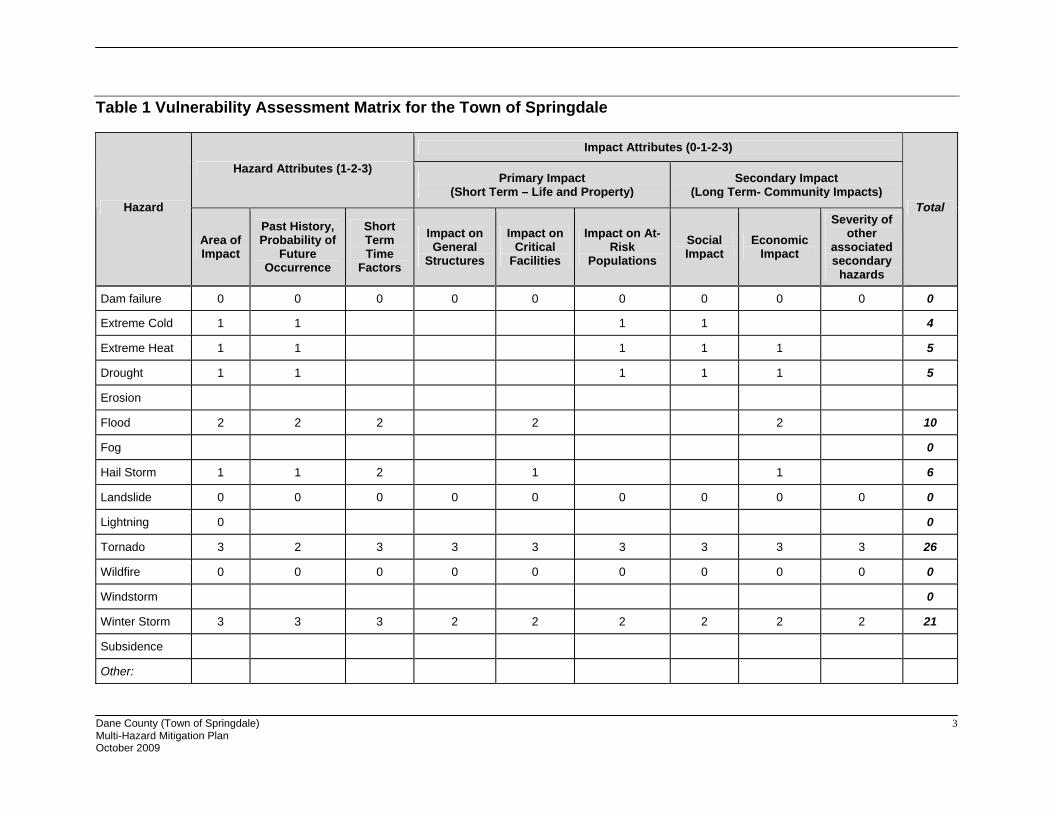
Population
Table 2 Vulnerable Population Summary
Disability Status from the 2000 Census Number Percent
Total Population ages 5 or less 86 5.6%
Total population ages 5 to 19 361 23.4%
Total population over 65 years old 147 9.6%
Total Population with any Disability 160 11.1%
Families Below Poverty Level 8 1.8%
Individuals Below Poverty Level 29 1.9%
Total Population who Speak English less than “very well” 17 1.2%
Total Population 1,530 -Data Source: 2000 US Census
General Property
Table 3 Property Exposure Summary
Property Type Total Parcel CountImproved
Parcel Count
Improved Values ($) Content ($) Total Value ($)
Residential 424 365 81,585,400 40,792,700 122,378,100Other 575 221 60,536,300 30,268,150 90,804,450Agriculture 524 158 34,694,900 34,694,900 69,389,800Commercial Sales 11 9 1,159,600 1,159,600 2,319,200Commercial Services 4 4 225,500 225,500 451,000Industrial 5 2 71,300 106,950 178,250Institutional Government 9 - - - -Transportation 38 - - - -Utilities 1 - - - - Total 1,591 759 178,273,000 107,247,800 285,520,800

Dane County (Town of Springdale) 5 Multi-Hazard Mitigation Plan October 2009
Data Source: Dane County Land Information Office, December 2008
Critical Facilities
The Town of Springdale has identified the following critical facilities important to protect from disaster impacts. These are collected in Table 4, which is based on GIS data inventories from Dane County.
Table 4 Critical Facility Summary/Essential Infrastructures
Facility Type* No. of Facilities Replacement Value ($)
Airport EI 1 16,200,000
Bridge EI 2 2,000,000
Child Care VF 3 470,100
Communications Tower EI 4 467,500
Electric Substation EI 1 0
FCC Tower EI 2 152,200
Hazardous Chemicals HM 2 0
Historic Site VF 3 0
Municipal Hall EI 1 0
TOTAL 19 19,289,800
*EI: Essential Infrastructure; VF: Vulnerable Facilities; HM: Hazardous Materials Facilities; Source: Dane County GIS
Other Assets
Other assets help define a community beyond the current composition of the Town of Springdale. These assets may provide economic benefit to the community, in addition to preserving the heritage and diversity of the community and may include natural, cultural and historic assets or economic assets such as major employers. It may also include more specific detail on critical facilities. At this time, the Town of Springdale has not identified additional assets.
Vulnerability to Specific Hazards
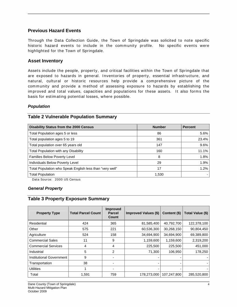
This section details vulnerability to specific hazards, where quantifiable, and where it differs from that of the overall County. The previous inventory tables quantify what is exposed to the various hazards within the Town of Springdale. Table 5 cross-references the hazards with the various tables where exposure or vulnerability specifics are found. The intent of Table 5 is to quantify, where possible, future impacts of each hazard on the jurisdiction. In many cases it is difficult to estimate potential losses, so the overall exposure of populations, structures, and critical facilities is referenced.
Dane County (Town of Springdale) 6 Multi-Hazard Mitigation Plan October 2009
Table 5 Hazard Vulnerability Specifics
Hazard Populations Structures Critical Facilities Future Damage Potential
Dam Failure None None None Specifics unknown; See hazard profile in County Plan
Drought Minimal None Minimal Specifics unknown; See hazard profile in County Plan
Flooding See section below See section below See section below See section below
Fog Minimal None None Specifics unknown; See hazard profile in County Plan
Hailstorm Minimal See Property Exposure table 3
See Critical Facility Inventory Table(s)
Specifics unknown; See hazard profile in County Plan
Landslide/ Sinkholes/ Erosion
Minimal Minimal Minimal Specifics unknown; See hazard profile in County Plan
Lightning See Table 2 Population
See Table 3 Property Exposure
See Critical Facility Inventory Table(s)
Specifics unknown; See hazard profile in County Plan
Severe Cold See Table 2 Population
See Table 3 Property Exposure
See Critical Facility Inventory Table(s)
Specifics unknown; See hazard profile in County Plan
Severe Heat See Table 2 Population None Minimal Specifics unknown; See
hazard profile in County Plan
Severe Winter Storm
See Table 2 Population
See Table 3 Property Exposure
See Critical Facility Inventory Table(s)
Specifics unknown; See hazard profile in County Plan
Tornado See Table 2 Population See section below
See Critical Facility Inventory Table(s)
See section below
Wildfire Minimal Minimal Minimal Specifics unknown; See hazard profile in County Plan
Windstorm See Table 2 Population
See Table 3 Property Exposure
See Critical Facility Inventory Table(s)
Specifics unknown; See hazard profile in County Plan
Flood
Structures in the Floodplain
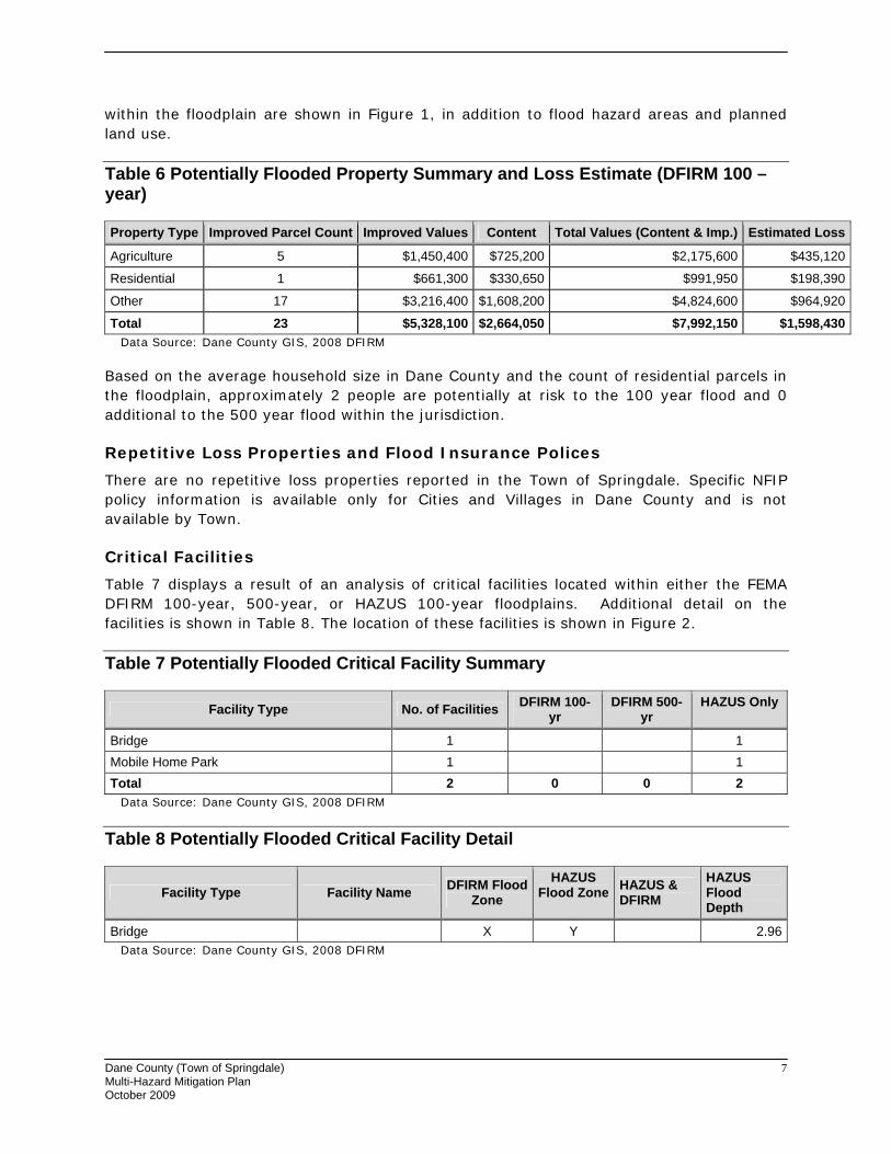
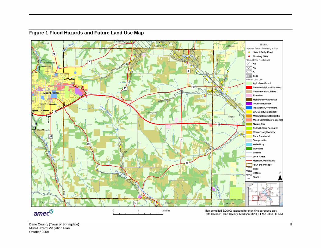
Some assets are specifically vulnerable to floods, due to their location. These assets are collected in Table 6. Refer to the flood profile in the mitigation plan for a description of the methodology used to identify potentially flood-prone properties. The locations of properties
Dane County (Town of Springdale) 7 Multi-Hazard Mitigation Plan October 2009
within the floodplain are shown in Figure 1, in addition to flood hazard areas and planned land use.
Table 6 Potentially Flooded Property Summary and Loss Estimate (DFIRM 100 –year)
Property Type Improved Parcel Count Improved Values Content Total Values (Content & Imp.) Estimated Loss
Agriculture 5 $1,450,400 $725,200 $2,175,600 $435,120
Residential 1 $661,300 $330,650 $991,950 $198,390
Other 17 $3,216,400 $1,608,200 $4,824,600 $964,920
Total 23 $5,328,100 $2,664,050 $7,992,150 $1,598,430Data Source: Dane County GIS, 2008 DFIRM
Based on the average household size in Dane County and the count of residential parcels in the floodplain, approximately 2 people are potentially at risk to the 100 year flood and 0 additional to the 500 year flood within the jurisdiction.
Repetitive Loss Properties and Flood Insurance Polices
There are no repetitive loss properties reported in the Town of Springdale. Specific NFIP policy information is available only for Cities and Villages in Dane County and is not available by Town.
Critical Facilities
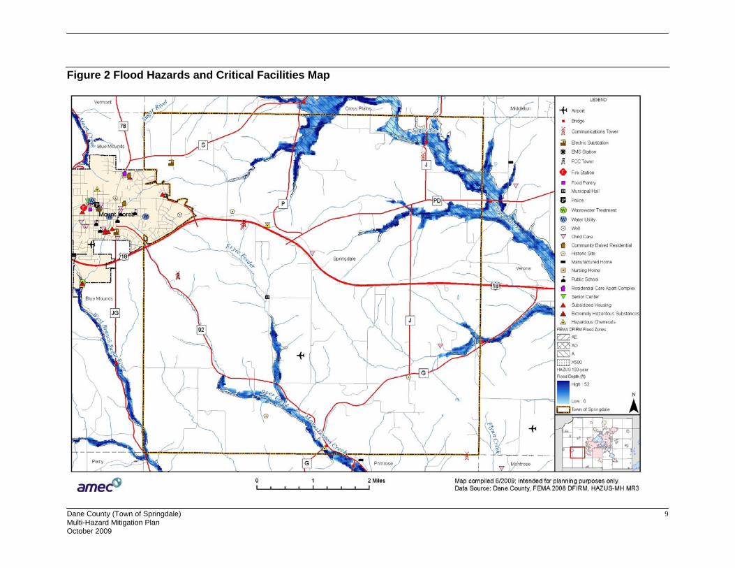
Table 7 displays a result of an analysis of critical facilities located within either the FEMA DFIRM 100-year, 500-year, or HAZUS 100-year floodplains. Additional detail on the facilities is shown in Table 8. The location of these facilities is shown in Figure 2.
Table 7 Potentially Flooded Critical Facility Summary
Facility Type No. of Facilities DFIRM 100-yr
DFIRM 500-yr
HAZUS Only
Bridge 1 1 Mobile Home Park 1 1 Total 2 0 0 2
Data Source: Dane County GIS, 2008 DFIRM
Table 8 Potentially Flooded Critical Facility Detail
Facility Type Facility Name DFIRM Flood Zone
HAZUS Flood Zone HAZUS &
DFIRM HAZUS Flood Depth
Bridge X Y 2.96Data Source: Dane County GIS, 2008 DFIRM
Dane County (Town of Springdale) 8 Multi-Hazard Mitigation Plan October 2009
Figure 1 Flood Hazards and Future Land Use Map
Dane County (Town of Springdale) 9 Multi-Hazard Mitigation Plan October 2009
Figure 2 Flood Hazards and Critical Facilities Map

Dane County (Town of Springdale) 10 Multi-Hazard Mitigation Plan October 2009
Tornado
While it is difficult to estimate specific losses to a tornado due to the random nature of the event, a methodology was developed that was applied to each jurisdiction during the 2009 update. The table below estimates the percent area of the jurisdiction that could be impacted based on the average sized tornado (F2) in Dane County. High value exposure is based on 100% loss, medium 50% loss, and low is 25% loss to the property potentially impacted. The loss ratio, which is the ratio of the damaged building value to total exposed building value, is a measure of the impact to the jurisdiction as a whole. Communities with loss ratios 10% or more may have difficulty recovering from a disaster. Refer to the tornado hazard profile in the main mitigation plan for more details on this methodology.
Table 9 Tornado Loss Estimate
% area impact
Improved Parcel Count
Affected Structure Estimate
Total Exposed
Value
Estimated Loss $ (High
Damage Range)
Estimated Loss $
(Moderate Damage Range)
Estimated Loss $ (Low
Damage Range)
Loss Ratio for Moderate
Damage Range
2.39% 759 18 85,520,800 6,813,359 3,406,679 851,670 .2% Data Source: Analysis Based on Dane County Land Information Office’s data
Growth and Development Trends
Planned land use is shown in Figure 1, in relation to the flood hazard. Table 10 illustrates how the Town of Springdale has grown in terms of population and number of housing units between 2000 and 2008. Table 11, drawn from the Comprehensive Plan for the Town of Springdale, shows population projections through 2025.
Table 10 Town of Springdale Change in Population and Housing Units, 2000-2008
2000 Population
2008 Population
Percent Change (%) 2000-2008
2000 # of Housing Units
2008 # of Housing Units
Percent Change (%) 2000-2008
1,530 1,792 17.2 % 585 740 26.5% Data Source: Dane County and the Town of Springdale Comprehensive Plan.
Table 11 Town of Springdale Population Projections, 2005-2025
Change in Population Method 2005 2010 2015 2020 2025
Increase Estimate 1,697 1,799 1,916 2,039 2,173 Data Source: Town of Springdale Comprehensive Plan.
Problems or Additional Vulnerability issues
On April 12, 2004, Springdale residents, Town Board Supervisors, Karl Klopotic, Town appointee to the Natural Hazard Mitigation Citizen Advisory Committee, and Erik Carlson, representative from the Department of Dane County Emergency Management, met to brainstorm about the type of natural hazards that impact Springdale and steps the Town

Dane County (Town of Springdale) 11 Multi-Hazard Mitigation Plan October 2009
could take to prevent and minimize the damage. The main criteria used to decide on the policies of a natural hazard mitigation plan for the Town of Springdale were:
• What problems related to natural hazards have Springdale residents experienced? • Which Springdale citizens are most susceptible? • What are the realistic solutions to prevent and minimize the damage?
Several problems arose through the hour and half discussion.
Springdale has experienced its share of natural hazards in the last 30 years. During the ice storm in 1976, Townspeople were without power for 8 days. Electrical lines were down because ice accumulation. Generators were not readily available during this disaster.
Residents recall a mini-tornado in 1976. It did not cause much damage, but it acted as a reminder for what is possible. If a more powerful tornado were to strike the area there is a concern that they will not be adequately warned. Severe weather warning sirens are not always effective in warning residents. Another method is needed to alert residents to tornadoes or severe thunderstorms.
A severe hailstorm in 1976 did cause damages. Droughts in 1976, and 1987-1988 resulted in crop loss.
Residents are concerned with the effects of extreme heat and cold on elderly residents and special populations groups. Currently there is no system to track the status of residents who may be adversely affected by extreme temperatures.
The Township also experiences flooding. During spring runoff and heavy rains roads flood. Also agricultural areas that are in low areas are susceptible to flooding. Culverts are undersized and are restricting flows of water through the Township. Farm fields not only experience flooding, but also are suspected to be a cause of flooding.
When farm fields are worked in wet conditions a hardpan develops in the soil. This decreases infiltration of precipitation and causes more runoff. Related to flooding, ditches are filling in with soil and plant material. Farm fields are the likely source of the erosion. In wet farm fields, willows grow and farmers tend to push the willows into streams. The willows clog up streams and decay slowly. As a result there is more water in area streams and it is moving through the Town more slowly.
In response the above problems, several solutions were put forth in the form of objectives.
The Data Collection Guide issued in 2009 provided additional insight into growth and development trends or vulnerability for the Town of Springdale:
The Town is concerned with the timely and efficient identification of elderly and citizens residing alone who should be contacted during periods of extreme heat and cold and hazardous weather conditions.
Decrease in dairy farms may have decreased economic loss of livestock due to extreme weather. Increase in development and continued use of overhead electrical lines instead of

Dane County (Town of Springdale) 12 Multi-Hazard Mitigation Plan October 2009
buried lines may increase incidence of power outage. Increase use of cell phones leads to increase in cell towers which could be damaged in weather extremes.
Vulnerability has slightly decreased due to the Dane County program utilized in the town of Springdale by which 175 homes purchased NOAA all weather hazard radios at a discounted price. The town will participate in the program in 2009.
Capability Assessment
Capabilities are the programs and policies currently in use to reduce hazard impacts or that could be used to implement hazard mitigation activities. This capabilities assessment summarizes regulatory mitigation capabilities, administrative and technical mitigation capabilities, and fiscal mitigation capabilities for the Town of Springdale.
Mitigation Capabilities Summary
The Town of Springdale has not identified any regulatory tools as mitigation capabilities.
Table 12 identifies the personnel responsible for mitigation and loss prevention activities as well as related data and systems in the Town of Springdale.
Table 12 Responsible Personnel and Departments for the Town of Springdale
Personnel Resources Yes/No Department/Position Comments
Planner/engineer with knowledge of land development/land management practices No
Engineer/professional trained in construction practices related to buildings and/or infrastructure
Contract as needed with private company
Planner/engineer/scientist with an understanding of natural hazards No
Personnel skilled in GIS Dane County
Full-time Building Official No
Floodplain Manager Dane County
Emergency Manager No
Grant Writer No
GIS Data Resources – (land use, building footprints, etc.) Dane County
Warning systems/services (Reverse 9-11, cable override, outdoor warning signals) Dane County
Data Source: Dane County Data Collection Guides
The Town of Springdale has not identified financial resources to help fund mitigation activities.
Dane County (Town of Springdale) 13 Multi-Hazard Mitigation Plan October 2009
Additional Capabilities
National Flood Insurance Program Participation
The Town of Springdale does not participate in the National Flood Insurance Program as a stand-alone entity, but is covered by the County’s floodplain ordinance.
Public Involvement Activities
During the 2009 update, the community assisted with the public involvement activities referenced in the base plan.
Mitigation Actions
Objective #1: Implement a program to identify and monitor Springdale residents, primarily the elderly, at most risk to the effects of extreme heat and cold.
Steps:
1) Organize a meeting with the personnel of the Southwest Dane Outreach senior citizen services.
2) Develop a list of the elderly and citizens residing alone who should be contacted during periods of extreme heat and cold.
3) Develop criteria to assess risk level.
4) Develop a procedure by which the staff of the Southwest Dane Outreach and Town government would identify the periods of extreme heat and cold, the list of people to contact, and the procedures for contacting folks and helping them out.
5) Assist the entities involved to identify funding sources for the program in addition to the current source: taxes.
6) Publicize information about the program in the Southwest Dane Outreach newsletter, the Town of Springdale newsletter, the Mt. Horeb Mail weekly newspaper, etc.
Lead Implementing Agency: Southwest Dane Outreach
Supporting Agencies:
• Local governments participating in the Southwest Dane Outreach
Possible Funding and Technical Assistance:
• Staff time • FEMA-Hazard Mitigation Grant Program • FEMA-Pre-disaster Mitigation • HUD-Community Development Block Grant
Dane County (Town of Springdale) 14 Multi-Hazard Mitigation Plan October 2009
Timeline: Begin immediately, with grant applications and program implementation as funding becomes available.
Priority: High
Estimated Costs: Unknown
2009 Update: This project is not completed. It has not been started but is still relevant and should not be changed.
Objective #2: Implement a program to assist residents, home-based business, and farmers, in particular, to maintain power during tornadoes, high winds, hail, and ice storms.
Steps:
1) Organize a meeting of Town patrolmen, fire and EMS personnel, utility company representatives, Town government officials, etc.
2) Develop criteria to assess risk level posed by tornadoes, high winds, hail and ice storms.
3) Inventory and critique the effectiveness of existing weather notification devices: tornado sirens, weather radios, etc.
4) Evaluate the need and feasibility to purchase weather radios for all residents out-of-range of the weather sirens and without other weather notification devices.
5) Inventory and prioritize overhead power lines to be buried.
6) Inventory and prioritize tree-trimming needs.
7) Evaluate the need and feasibility of a program to share Town-owned small propane generators on an as-needed basis.
Lead Implementing Agency: Dane County Emergency Management
Supporting Agencies:
• Local government
Possible Funding and Technical Assistance:
• Staff time • FEMA-Hazard Mitigation Grant Program • FEMA-Pre-disaster Mitigation
Timeline: Begin immediately, with grant applications and program implementation as funding becomes available.
Priority: High for weather radios and Moderate for other steps.
Estimated Costs: Unknown

Dane County (Town of Springdale) 15 Multi-Hazard Mitigation Plan October 2009
2009 Update: This project is ongoing. A meeting was held and Chief Himsel named as the coordinator. Chief Himsel will be the one to asses the risk and disaster level. Dane County has updated the tornado sirens but, depending on the wind, it may not be audible to citizens residing in the country. 160 weather radios were sold in 2 years so individuals can be informed. Tree trimming has been done every year. The propane generators have not been purchased, as grant money will be needed to secure their purchase.
Objective 3: Implement a program to improve road safety for all traffic on Town-wide roads. Determine the feasibility of reducing the flow of floodwaters over roads by evaluating road elevation, road shoulder, ditching, and culvert sizing standards for construction and upgrade for all roads in the Town of Springdale, but especially for roads in low-lying or flood prone areas.
Steps:
1) Review existing inventory of all culverts in the Town of Springdale.
2) Review existing inventory of flood prone roads with specific attention to road elevation, road shoulder, ditching and culvert sizing.
3) Develop criteria to evaluate and prioritize problems,
4) Compile existing road elevation, road shoulder, ditching, and culvert sizing design standards.
5) Evaluate the feasibility of designing roadway water conveyance systems for larger storm events.
6) Evaluate the impact of culvert sizing in private driveways and the impact on public roads.
7) Evaluate effectiveness of culvert aid program as a compliance tool for Town road upgrades.
8) Develop and disseminate to private property owners Best Management Practices (BMP) for
a) Culvert sizing and maintenance on Town roads.
b) Culvert sizing and maintenance on private driveways.
c) Ditch protection and maintenance.
9) Use flood occurrences as an educational opportunity and an opportunity to implement upgrades.
Lead Implementing Agency: Dane County Highway
Supporting Agencies:
• Local governments
Dane County (Town of Springdale) 16 Multi-Hazard Mitigation Plan October 2009
• State DOT • Upper Sugar River Watershed Association
Possible Funding and Technical Assistance:
• Staff time • FEMA-Hazard Mitigation Grant Program • FEMA-Flood Mitigation Assistance • FEMA-Pre-disaster Mitigation • U.S. Army Corps of Engineers Small Flood Control Projects • DNR-Municipal Flood Control Grant Program
Timeline: Begin immediately, with grant applications and program implementation as funding becomes available.
Priority: High
Estimated Costs:
2009 Update: This project is ongoing. The existing culvert inventory has not been completed. Flood prone areas are reviewed yearly by the town board and patrolmen. Criteria for evaluating problems has been set. The Town participates in the RACER program standard of roads for every road. Compiling existing road elevations has not been completed, but a design standard for new roads has been compiled. All of the new roads put in are designed for larger storm events, but existing roads have not been brought to conform to the new standard. A driveway construction guide has been written for new driveways. The culvert aid program has not been evaluated yet. The driveway construction guide lays out the Best Management Practices for culverts and ditches. Flooding has been minimal, but excessive run off is monitored to identify problem areas.
Objective #4: Mitigation of hazardous road conditions during slippery foggy weather at sharp curve on northern section of Town Hall road in Section 5.
Steps:
1) Installation of sharp curve ahead sign illuminated with solar powered flashers.
2) Installation of a guardrail on the down-side of the road near intersection with Norwegian Trail near deep ditch.
3) Installation of reduce speed limit signs on this section of road.
Lead Implementing Agency:
• Town of Springdale • Town Board • Dane County
Supporting agencies: WIS DOT

Dane County (Town of Springdale) 17 Multi-Hazard Mitigation Plan October 2009
Possible Funding and Technical Assistance:
• Highway Safety Improvement Program (HSIP) – sponsored federally as part of the Safe Accountable Flexible Efficient Transportation Equity Act.
Timeline: Apply for HSIP by 8/1/09.
Priority: High
Estimated Costs: Considerably less than the $25,000 project limitation under HSIP.