Embed Size (px)
Citation preview

Community Development Department
Town of Milford Development Regulations Site Plan and Subdivision Regulations
Adopted by Milford Planning Board 2/24/2009 Revised 9/5/2017

Town of Milford Development Regulations 2017
2 2011 Printing
Table of Contents
ARTICLE I: INTRODUCTION ............................................................................................................................ 6
1.01 PURPOSE ................................................................................................................................................................... 6 1.02 AUTHORITY ............................................................................................................................................................... 6 1.03 VALIDITY.................................................................................................................................................................... 6
1.03.1 INTERPRETATION ........................................................................................................................................................ 6 1.03.2 CONFLICT .................................................................................................................................................................... 6
1.04 SEVERABILITY ............................................................................................................................................................ 7 1.05 AMENDMENTS .......................................................................................................................................................... 7 1.06 EFFECTIVE DATE......................................................................................................................................................... 7
ARTICLE II: JURISDICTION ................................................................................................................................ 7
2.01 GENERAL ................................................................................................................................................................... 7 2.02 APPLICABILITY ........................................................................................................................................................... 7 2.03 DEVELOPMENT REQUIRING SITE PLAN APPROVAL .................................................................................................... 7 2.04 DEVELOPMENT REQUIRING SUBDIVISION APPROVAL ............................................................................................... 8
ARTICLE III: DEFINITIONS .................................................................................................................................. 8
3.01 DEFINITIONS .............................................................................................................................................................. 8
ARTICLE IV: PERMITTING PROCEDURE – SITE PLAN AND SUBDIVISION APPLICATIONS ......... 14
4.01 PROCESS .................................................................................................................................................................. 14 4.02 CONCEPTUAL REVIEW ............................................................................................................................................. 15 4.03 DESIGN REVIEW ....................................................................................................................................................... 15 4.04 FORMAL REVIEW ..................................................................................................................................................... 16 4.05 PUBLIC HEARING AND NOTICES ............................................................................................................................... 17 4.06 DETERMINATION OF POTENTIAL REGIONAL IMPACT ............................................................................................... 17 4.07 SITE PLAN EXTENSION AND EXPIRATION OF APPROVAL .......................................................................................... 18 4.08 SUBDIVISION EXTENSION AND EXPIRATION OF APPROVAL ..................................................................................... 18 4.09 PLANNING BOARD ACTION AND TIME REQUIREMENTS: SITE PLAN AND SUBDIVISIONS ......................................... 18 4.010 FAILURE TO APPROVE .............................................................................................................................................. 19 4.011 APPROVAL AND DISAPPROVAL: SITE PLAN AND SUBDIVISION ................................................................................ 19
4.011.1 CONDITIONAL APPROVAL ......................................................................................................................................... 19 4.011.2 FINAL APPROVAL ...................................................................................................................................................... 20 4.011.3 DISAPPROVAL ........................................................................................................................................................... 20
4.012 RECORDING PROCEDURE ......................................................................................................................................... 20 4.013 REVOCATION OF APPROVAL .................................................................................................................................... 20 4.014 BUILDING AND CERTIFICATE OF OCCUPANCY PERMITS ........................................................................................... 20

Town of Milford Development Regulations 2017
3 2011 Printing
ARTICLE V: PLAN REQUIREMENTS: SITE PLAN AND SUBDIVISION .................................................. 21
5.01 SCOPE OF REVIEW ................................................................................................................................................... 21 5.02 TYPES OF SITE PLAN APPLICATIONS ......................................................................................................................... 21 5.03 SUBMITTAL REQUIREMENTS – MINOR SITE PLAN APPLICATIONS ............................................................................ 21 5.04 SUBMITTAL REQUIREMENTS – MAJOR SITE PLAN APPLICATIONS ............................................................................ 22 5.05 TYPES OF SUBDIVISION APPLICATIONS .................................................................................................................... 24 5.06 SUBMITTAL REQUIREMENTS – MINOR SUBDIVISION, LOT LINE ADJUSTMENT AND CONDOMINIUM CONVERSION
APPLICATIONS.......................................................................................................................................................... 25 5.07 SUBMITTAL REQUIREMENTS – MAJOR SUBDIVISION APPLICATIONS ....................................................................... 27 5.08 OPEN SPACE CONSERVATION DEVELOPMENTS ....................................................................................................... 29 5.09 IMPACT STUDIES ..................................................................................................................................................... 29 5.010 REFERRAL TO TOWN AGENCIES AND BOARDS ......................................................................................................... 30 5.011 ENVIRONMENTAL STUDY ........................................................................................................................................ 30 5.012 HYDROGEOLOGIC STUDY ......................................................................................................................................... 31 5.013 PREMATURE DEVELOPMENT ................................................................................................................................... 32 5.014 ALTERNATIVES TO A RULING OF PREMATURE DEVELOPMENT ................................................................................ 33 5.015 OFF-SITE IMPROVEMENTS ....................................................................................................................................... 33 5.016 ACCEPTANCE OF IMPROVEMENTS ........................................................................................................................... 34 5.017 PHASING.................................................................................................................................................................. 34 5.018 TAX LIEN DISCLOSURES ............................................................................................................................................ 34 5.019 DEVELOPMENT AGREEMENT ................................................................................................................................... 34 5.020 WAIVER APPLICATIONS ........................................................................................................................................... 35 5.021 AMENDMENTS ........................................................................................................................................................ 35 5.022 SEAL AND CERTIFICATION ........................................................................................................................................ 36 5.023 FINAL PLAN: SITE PLAN AND SUBDIVISION .............................................................................................................. 36 5.024 FINAL PLAN COPIES ................................................................................................................................................. 37
ARTICLE VI: DEVELOPMENT GUIDELINES .................................................................................................. 37
6.01 GENERAL ................................................................................................................................................................. 37 6.02 PURPOSE ................................................................................................................................................................. 37 6.03 CONFORMITY .......................................................................................................................................................... 37 6.04 ARCHITECTURAL DESIGN ......................................................................................................................................... 38
6.04.1 PURPOSE ................................................................................................................................................................... 38 6.04.2 GENERAL CRITERIA ................................................................................................................................................... 38 6.04.3 GUIDELINES .............................................................................................................................................................. 38
6.05 PARKING REQUIREMENTS ....................................................................................................................................... 39 6.05.1 GENERAL ................................................................................................................................................................... 39 6.05.2 PARKING SPACE LOCATION ...................................................................................................................................... 40 6.05.3 PARKING SPACE DIMENSIONS .................................................................................................................................. 40 6.05.4 TABLE OF OFF-STREET PARKING ............................................................................................................................... 41 6.05.5 Ada compliance ........................................................................................................................................................ 42 6.05.6 PARKING AND LOADING AREA STANDARDS ............................................................................................................. 43 6.05.7 PARKING SUBSTITUTIONS ......................................................................................................................................... 44 6.05.8 INCREASE OR CHANGE OF USE ................................................................................................................................. 44
Town of Milford Development Regulations 2017
4 2011 Printing
6.05.9 PRIOR NON-CONFORMING USES .............................................................................................................................. 44 6.05.10 PROVISION FOR SHARED PARKING ........................................................................................................................... 45
6.06 OUTDOOR LIGHTING ............................................................................................................................................... 45 6.07 FIRE PROTECTION .................................................................................................................................................... 45 6.08 LANDSCAPING STANDARDS ..................................................................................................................................... 45
6.08.1 GENERAL ................................................................................................................................................................... 45 6.08.2 SITE FEATURES AND LAYOUT .................................................................................................................................... 46 6.08.3 SOIL PREPARATION ....................................................................................................................................................... 47 6.08.4 MULCHING ................................................................................................................................................................ 47 6.08.5 LANDSCAPING BUFFERS ........................................................................................................................................... 48 6.08.6 LANDSCAPING ALONG BUILDING FRONTAGES ......................................................................................................... 48 6.08.7 LANDSCAPING PARKING LOTS AND ACCESS WAYS .................................................................................................. 49 6.08.8 PLANTING SPECIFICATIONS ...................................................................................................................................... 50 6.08.9 LOW IMPACT DEVELOPMENT LANDSCAPING .......................................................................................................... 51 6.08.10 LANDSCAPING STANDARDS – SUBDIVISIONS – NEW ROADS ................................................................................... 51 6.08.11 MAINTENANCE OF LANDSCAPING ............................................................................................................................ 52 6.08.12 ENFORCEMENT ......................................................................................................................................................... 52 6.08.13 LANDSCAPING TIME FRAME ..................................................................................................................................... 52
6.08 SNOW STORAGE AND REMOVAL ............................................................................................................................. 52 6.09 WETLANDS .............................................................................................................................................................. 53
6.010.1 WETLAND BOUNDARY MARKERS ............................................................................................................................. 53 6.010.2 WETLANDS ................................................................................................................................................................ 53
6.010 STORMWATER MANAGEMENT PLAN ...................................................................................................................... 53 6.011 EROSION AND SEDIMENT CONTROL ........................................................................................................................ 54 6.012 OTHER STORMWATER AND EROSION CONTROL PERMITS ....................................................................................... 54 6.013 SPECIAL FLOOD HAZARD AREAS .............................................................................................................................. 55 6.014 MUNICIPAL AND PUBLIC UTILITIES .......................................................................................................................... 55 6.015 SANITARY SYSTEMS – GENERAL REQUIREMENTS .................................................................................................... 56 6.016 WATER SERVICES– GENERAL REQUIREMENTS ......................................................................................................... 57
6.017.1 MUNICIPAL WATER .................................................................................................................................................. 57 6.017.2 PRIVATE WATER SYSTEMS ........................................................................................................................................ 57 6.017.3 ON-SITE WATER SUPPLY ........................................................................................................................................... 57
6.017 BRIDGES .................................................................................................................................................................. 58 6.018 SIGNAGE .................................................................................................................................................................. 58 6.019 EASEMENTS, DEED RESTRICTIONS, DEDICATIONS, COVENANTS .............................................................................. 58 6.020 SELF-IMPOSED RESTRICTIONS AND/OR COVENANTS ............................................................................................... 59 6.021 BOUNDS .................................................................................................................................................................. 59
ARTICLE VII: ROADWAY REGULATIONS ................................................................................................... 60
7.01 ROADWAYS – GENERAL ........................................................................................................................................... 60 7.02 ROADWAY STANDARDS CHARTS Table 1: Roadway Standards ............................................................................... 62 7.03 SIDEWALKS .............................................................................................................................................................. 63

Town of Milford Development Regulations 2017
5 2011 Printing
ARTICLE VIII: PERFORMANCE AND MAINTENANCE SECURITIES .................................................... 64
8.01 POSTING OF PERFORMANCE SECURITIES ................................................................................................................. 64 8.02 RELEASE OF PERFORMANCE SECURITIES.................................................................................................................. 64 8.03 MAINTENANCE SECURITIES ..................................................................................................................................... 65
ARTICLE IX: EXPIRATION, ENFORCEMENT, FINES, PENALTIES AND APPEALS ............................. 65
9.01 ENFORCEMENT ........................................................................................................................................................ 65 9.02 FINES AND PENALTIES ............................................................................................................................................. 66 9.03 APPEALS .................................................................................................................................................................. 66
ARTICLE X: FEES................................................................................................................................................. 66
10.01 APPLICATION FEES ................................................................................................................................................... 66 10.02 ADMINISTRATIVE AND OTHER FEES ......................................................................................................................... 66 10.03 PUBLIC NOTICES AND HEARING FEES ....................................................................................................................... 66 10.04 INSPECTION SERVICE FEE ......................................................................................................................................... 67
ARTICLE XI: APPENDICES ................................................................................................................................. 68
APPENDIX I: CHECKLISTS (2014) ...................................................................................................................................... 68 APPENDIX II: major subdivision process ........................................................................................................................... 68 APPENDIX III: open space subdivision flowchart ............................................................................................................... 68 APPENDIX IV: environmental study .................................................................................................................................. 68 APPENDIX V: securities submission documentation ......................................................................................................... 68
a. Cash ....................................................................................................................................................................... 68 b. Bond ....................................................................................................................................................................... 68 c. Irrevocable Letter of Credit .................................................................................................................................... 68
APPENDIX VI: ROADWAY ACCEPTANCE INFORMATION .................................................................................................... 68 APPENDIX VII: TOWN DOCUMENT RESOURCES LIST ......................................................................................................... 68 APPENDIX II: MAJOR SUBDIVISION PROCESS ................................................................................................................... 87 APPENDIX III: OPEN SPACE SUBDIVISION FLOWCHART ..................................................................................................... 88 APPENDIX IV: ENVIRONMENTAL STUDY ........................................................................................................................... 90 APPENDIX V: SECURITIES SUBMISSION DOCUMENTATION .............................................................................................. 92 APPENDIX VI: ROADWAY ACCEPTANCE INFORMATION .................................................................................................... 96 APPENDIX VII: TOWN DOCUMENT RESOURCES LIST ......................................................................................................... 99
Town of Milford Development Regulations 2017
6 2011 Printing
ARTICLE I: INTRODUCTION 1.01 PURPOSE These regulations are adopted in accordance with RSA 674:36 and 674:44, as amended, for the following purposes:
A. To provide for the safe, attractive and harmonious development of land. B. To insure the health, safety and welfare of the residents of the Town of Milford. C. To provide against such scattered or premature development of land as would involve danger or
injury to health, safety, or prosperity by reason of the lack of water supply, drainage, transportation, schools, fire protection, or other public services, or necessitate the excessive expenditure of public funds for the supply of such services.
D. To provide for open spaces and green spaces of adequate proportions. E. To provide for adequate public services, facilities and parking. F. To provide for suitably located roads of sufficient width to accommodate existing and proposed
pedestrian and vehicular traffic. G. To provide for adequate drainage, stormwater management, pollution prevention, proper
landscaping and protection from negative environmental impacts. H. To provide for harmonious and aesthetically pleasing development of the municipality and its
environs. I. To encourage the wise use and management of natural resources, conservation of energy and
historic features throughout the municipality in order to preserve the integrity, stability, and beauty of the community and the value of the land.
J. To guide the future growth and development of the municipality, in accordance with the Town’s Master Plan.
1.02 AUTHORITY Pursuant to the authority vested in the Planning Board by the voters of the Town of Milford and in accordance with state laws, but not limited to, the provisions of Chapter 672 - 677 of the New Hampshire Revised Statutes Annotated, 2008, or as may be amended, the Planning Board adopts the following regulations governing the development and subdivision of land in the Town of Milford, New Hampshire. 1.03 VALIDITY 1.03.1 INTERPRETATION These Development Regulations shall be construed broadly to promote the purposes for which they are adopted. 1.03.2 CONFLICT Whenever the regulations made under the authority hereof differ from those prescribed by any statute, ordinance or other regulations, that provision which imposes the greater restriction or the highest standard shall govern.

Town of Milford Development Regulations 2017
7 2011 Printing
1.04 SEVERABILITY If any section, clause, provision, portion or phrase of these regulations shall be held to be invalid or unconstitutional by any court of competent authority, such holding shall not affect, impair or invalidate any other section, clause, provision, portion or phrase of these regulations. 1.05 AMENDMENTS These regulations may be amended or rescinded by the Planning Board following a public hearing and a formal motion by the Planning Board on the proposed changes. The Chairman or Secretary of the Planning Board shall transmit a record of any changes so authorized to the Town Clerk. 1.06 EFFECTIVE DATE This Regulation shall be in effect from the time of its adoption by the vote of a majority of the Planning Board present and voting.
ARTICLE II: JURISDICTION 2.01 GENERAL This Regulation shall pertain to all land within the boundaries of the Town of Milford. All Sections and paragraphs of these Development Regulations shall apply to all Planning Board applications unless the section or paragraph specifically indicates otherwise. 2.02 APPLICABILITY These provisions shall govern subdivisions and commercial, industrial and multi-family development within the boundaries of the Town of Milford. No land shall be developed, redeveloped, or subdivided or until:
A. The Planning Board has given final approval of the site plan or subdivision at a public hearing and the Chairman of the Planning Board (or designee) has affixed his/her signature on the approved plan
B. The Community Development Director and Zoning Administrator have determined that no Planning Board approval is necessary per Sections 2.03 DEVELOPMENT REQUIRING SITE PLAN APPROVAL and 2.04 DEVELOPMENT REQUIRING SUBDIVISION APPROVAL of these regulations
C. The applicant has complied with all of the Town of Milford regulations including but not limited to the Stormwater Regulations, Zoning Ordinance, DPW Standards, Residential Driveway Standards and the regulations herein, including the posting of appropriate performance guarantees
D. The approved plan is filed with the Hillsborough County Registry of Deeds, if required 2.03 DEVELOPMENT REQUIRING SITE PLAN APPROVAL Site Plan approval shall be required for:
A. Any new commercial, industrial and multi-family dwelling uses of land.
Town of Milford Development Regulations 2017
8 2011 Printing
B. Any change or expansion of use to a commercial, industrial or multi-family site plan which does not have an approved site plan.
C. Any change or expansion of use to a commercial, industrial or multi-family site plan which would require upgrades to parking, drainage, landscaping or may have a significant traffic impact.
D. Any cumulative land disturbance of greater than or equal to 20,000 SF for commercial, industrial and multi-family sites.
The property owner or his representative shall apply in writing to the Planning Board on application forms provided by the Planning Board for approval of any Site Plan. 2.04 DEVELOPMENT REQUIRING SUBDIVISION APPROVAL Subdivision approval shall be required for:
A. The subdivision of any lot, tract or parcel of land B. Lot line adjustment C. Condominium conversion
The property owner or his representative shall apply in writing to the Planning Board on application forms provided by the Planning Board for approval of any subdivision, condominium conversion or lot line adjustment. The merging or consolidation of lots within Milford does not require formal Planning Board approval. By recording a Lot Merger form, available through the Community Development Office, the merged parcels of land shall, for all purposes be considered a single lot and shall be assigned a single tax map and lot number and shall not be sold separately, nor shall any other divided interest be conveyed except with the prior approval of the Milford Planning Board in accordance with its duly adopted subdivision regulations. Recording of the form implies endorsement from the Milford Planning Board and or its designee.
ARTICLE III: DEFINITIONS 3.01 DEFINITIONS
For the purpose of these Regulations, the word “shall” is mandatory, the words “may” and “can” are permissive. For any term not defined in these regulations, the definition, if any given in the Town of Milford Zoning Ordinance or applicable State Statutes shall prevail. Terms and Words not so specifically defined shall have their common meaning. In the event a conflict is found to exist between the meaning or definition of any word or term defined in this document, and the meaning or definition of any word or term also defined in the Zoning Ordinance or applicable State Statues, the most restrictive meaning or definition shall prevail. Term Definitions:

Town of Milford Development Regulations 2017
9 2011 Printing
Active and Substantial Development: Unless otherwise defined by the Planning Board at the time of approval, shall mean the installation of erosion and sediment control measures, site grading and construction of permanent physical improvements such as road base, water and sewer lines or other underground utilities including drainage structures has occurred. Abutter: Any person whose property is located in New Hampshire and adjoins or is directly across the street or stream from the land under consideration by the local land use board. For purposes of receiving testimony only, and not for purposes of notification, the term “abutter” shall include any person who is able to demonstrate that his/her land will be directly affected by the application under consideration. For purposes of receipt of notification by a municipality of a local land use board hearing, in the case of an abutting property being under a condominium or other collective form of ownership, the term abutter means the officers of the collective or association, as defined in RSA 356-B:3, XXIII. For purposes of receipt of notification by a municipality of a local land use board hearing, in the case of an abutting property being under a manufactured housing park form of ownerships defined in RSA 205-A: 1, the term “abutter” includes the manufactured housing park owner and the tenants who own manufactured housing which adjoins or is directly across the street or stream from the land under consideration by the local land use board. As defined in RSA 356.B:3 and any amendments thereto. Applicant: The owner or the person or persons duly authorized in writing by the Owner(s) to act on behalf of the Owner(s) in all matters concerning these regulations. Best Management Practice (BMP): A proven or accepted structural, non-structural, or vegetative measure; the application of which reduces erosion, sediment, or peak storm discharge, or improves the quality of stormwater runoff. Building: Any structure used or intended for supporting or sheltering any use or occupancy. Buffer: Land area maintained in either a natural or landscaped state and used to visibly separate or screen one use from another or to minimize potentially negative impacts on surrounding areas (e.g., shield or block noise, light or other nuisances, reduce water pollution). Change of Use: Any change to a building or site, to another separately identified use specified as either “Acceptable” or “Acceptable by Special Exception” in the Milford Zoning Ordinance, or as allowed by variance from the Milford Zoning Ordinance. Compliance Hearing: A publicly noticed hearing of the Planning Board within which the Planning Board will determine if the all conditions of approval, as previously determined in a motion of Conditional Approval by the Planning Board have been met. Condominium: A building or group of buildings in which units are owned individually and the structure, common areas and facilities are owned by all the owners on a proportional, undivided basis.

Town of Milford Development Regulations 2017
10 2011 Printing
Condominiums shall be considered a subdivision under the requirements of RSA 356-B and these regulations, and allowed or approved accordingly. Condominium Conversion: The division of an existing or approved building or group of buildings into units owned individually and the common areas and facilities are owned by all the owners on a proportional, undivided basis. Corner Lot: A lot situated at the intersection of two (2) Class VI or better roads or on a curved road on which the interior angle of such intersection or curved road does not exceed 135 degrees. Development: Any construction, site disturbance or grading activities to improved or unimproved real estate other than for agricultural and silvicultural practices. Development Plan: A plan submitted as part of a subdivision or site plan application. Density: The gross number of residential dwelling units per acre. Development Agreement: A contract representing an understanding between the Town of Milford and the applicant/land owner, regarding the granting of site plan or subdivision approval by the Planning Board, to contain improvements and agreements pursuant to the plans and any conditions referenced in the contract document, including definitions of “Substantial Completion of Improvements” and “Active and Substantial Development”. Disturbed Area: An area where natural vegetation has been removed exposing the underlying soil or where vegetation has been covered. Dwelling Unit: One room or rooms connected together, constituting a separate, independent housekeeping establishment physically separated from any other dwelling units in the same structure, and containing independent cooking and sleeping facilities. Dwelling, Single-family: A detached residential dwelling unit, other than a mobile home, designed for one family only. Dwelling, Two-family: A structure which contains two (2) separate dwelling units, each provided with complete and independent living facilities for one or more persons, including provisions for living, sleeping, eating, cooking, and sanitation as well as independent access and egress to and from each living unit. Dwelling, Multi-family: A structure consisting of three (3) or more dwelling units designed for occupancy by three (3) or more families.
Town of Milford Development Regulations 2017
11 2011 Printing
Easement: A grant of one or more of the property rights by the property owner to or for use by the public or other person(s) or entity. Examples include but are not limited to: Access, Conservation, Drainage, Slope and Utility. Erosion: The detachment and movement of soil or rock fragments by water, wind, ice or gravity. Frontage: That continuous portion of land bordering on a road(s) from which access may be taken. Grading: Any excavating, grubbing, filling (including hydraulic fill) or stockpiling of earth materials or any combination thereof, including the land in its excavated or filled condition. Lot: The whole area of a single parcel of land, with assertable boundaries in single or joint ownership undivided by a road and established by deeds of record (see also Parcel and Tract). Lot Line Adjustment: A subdivision where no new buildable lots are created. A lot line adjustment may not create a more a non-conforming lot per the Town of Milford Zoning Ordinance, save those cases where a variance has been granted for such. Lot of Record: A lot or parcel described by metes and bounds, the description of which has been so recorded in the Hillsborough County Registry of Deeds. Minimum Building Setback Line: That horizontal distance measured between the right-of-way of a road or a side or rear lot line and the closest point at which any building or structure contained on the lot may be situated, as specified in the Milford Zoning Ordinance. Manufactured Housing: Any structure transportable in one or more sections, which in the traveling mode, is eight (8) body feet or more in width and forty (40) body feet for more in length, or when erected on site, is 320 square feet or more, and which is built upon a permanent chassis and designed to be used as a dwelling with or without a permanent foundation when connected to required utilities, which include plumbing, heating, and electrical heating systems contained therein. Manufactured Housing shall not include presite built housing as defined in RSA 674:31-a, as amended. Manufactured Housing Park: A parcel of land upon which two (2) or more manufactured houses are, or are intended to be, placed and occupied as dwellings. Parcel: The whole area of a single tract of land, with assertable boundaries in single or joint ownership undivided by a road and established by deeds of record (see also Lot and Tract). Presite Built Housing: Any structure designed primarily for residential occupancy which is wholly or in substantial part made, fabricated, formed or assembled in off-site manufacturing facilities in conformance with the United States Department of Housing and Urban Development minimum property standards and
Town of Milford Development Regulations 2017
12 2011 Printing
local building codes for installation, or assembly and installation, on the building site. Presite Built Housing shall not include similarly built manufactured housing as defined in RSA 673:31, as amended. Parking Space: An off-street space available for the parking of one motor vehicle, exclusive of the necessary internal access driveways and passageways. Planning Board: The Planning Board of the Town of Milford. Person: Any individual, firm, co-partnership, corporation, company, association, joint stock association or body politic, trustee, receiver, assignee, or other similar representative thereof. Public Utility: Buildings, structures and facilities, including generating and switching stations, poles, lines, pipes, pumping stations, repeaters, antennas, transmitters and receivers, valves and all buildings and structures relating to the furnishing of utility services, such as electric, gas, telephone, communications, fire protection, water, sewer and public transit, to the public. Regular Planning Board Meeting: A publicly noticed regularly scheduled meeting of the Planning Board at which applications may be presented for acceptance and approval by the Board, generally held the third Tuesday of each month. Road: Any vehicular right-of-way that: (1) is an existing Federal, State, Town, or privately owned and maintained roadway; (2) is shown upon a plan approved pursuant to NH RSA’s; (3) is shown on a plan duly filed and recorded in the Office of the Hillsborough County Registry of Deeds; or (4) is approved by any other official action of the Town of Milford. A road contains all the land within the right-of-way. The following shall be used to classify all roads:
A. Arterial Road: A road which serves the major movements of traffic within and through the community.
B. Collector Road: A road which serves to collect and distribute traffic primarily from local roads to Arterial Roads.
C. Local Road: A road which is designed to be used primarily for direct access to abutting properties and leading into Collector Roads.
D. Dead-End Road: A road having an outlet at one end only and having the other end permanently closed with facilities permitting vehicles to turn around.
E. Private Road: A road or road system on private property from a public road, constructed in
accordance with these regulations and to the Department of Public Works Infrastructure Design, Construction and Administration Standards. Such private property and private roads shall be permanently encumbered with deed restrictions, satisfactory to the Planning Board, which shall insure that the private road does not become a public road and that the Town will have no liability or responsibility to maintain said road.
Town of Milford Development Regulations 2017
13 2011 Printing
F. Alley: A strip of land dedicated for public use, located at the side or rear of lots, providing secondary access to abutting property which generally does not meet required right-of-way and paved surface widths.
Sediment: Solid material, either mineral or organic, that is in suspension, is transported, or has been moved from its site of origin by erosion. Sign: Any device, including support structures, that communicates information or a message. Signage Plan: A plan containing specification for one or more signs on a proposed development or application. Site Plan, Minor: An application of six hundred (600) square feet, or less, of additional building space. Site Plan, Major: An application of greater than six hundred (600) square feet of additional building space. Soil: Any unconsolidated mineral or organic material of any origin. Stabilized: A condition when the soil erosion rate approaches that of undisturbed soils. Soils which are disturbed will be considered protected when covered with a healthy, mature growth of grass, or a good covering of straw mulch or other equivalent (seedless) mulch (2 tons/acre). Mulch is only a temporary measure; ultimately, a site needs vegetation. Stormwater Management and Erosion Control Plan (SWMP): A plan which may be required by the Town which outlines project features, proposed temporary and permanent erosion control features, maintenance schedules and practices, and design basis used to establish temporary and permanent stormwater design features. If a SWPPP is required under Federal or State law, the applicant may completely incorporate SWMP requirements into the SWPPP and request that the SWPPP cover both the SWPPP and SWMP requirements. Stormwater Pollution Prevention Plan (SWPPP): A plan required by the Environmental Protection Agency (EPA) that clearly describes appropriate pollution control measures that include a description of all pollution control measures (i.e., BMP’s) that will be implemented as part of the construction activity to control pollutants in stormwater discharges and describes the interim and permanent stabilization practices for the site. Stream, Intermittent: A place where water flows for sufficient duration and/or in sufficient quantity to maintain a channel.
Town of Milford Development Regulations 2017
14 2011 Printing
Stream, Perennial: Any channel, natural or manmade, which has water present for twelve (12) months of a normal year but which may dry up during a period in which the rainfall is less than sixty (60) percent of average for more than three consecutive months. Structure: A combination of materials for occupancy or use, such as, but not limited to, a building, bridge, trestle, tower, tunnel, pier, wharf, fence and retaining wall over six (6) feet in height above grade and swimming pool. Subdivision: The division of a lot, tract, or parcel of land into two (2) or more lots, sites, or other divisions of land for the purpose, whether immediate or future, of sale, rent, lease, condominium conveyance or building development. It includes re-subdivision and, when appropriate to the context, relates to the process of subdividing or to the land or territory subdivided. The division of a parcel of land held in common and subsequently divided into parts among the several owners shall be deemed a subdivision under NH RSA 674, as amended. Subdivision, Minor: The division of a lot, tract or parcel of land which would result in three (3) or fewer new building lots and which does not require the installation of any new roads (public or private) or the extension of any municipally owned utilities (sewer and water). Subdivision, Major: The division of a lot, tract or parcel of land which creates four (4) or more additional building lots or an application which requires the installation of new roads (public or private) or the extension of municipally owned utilities (sewer and water). Town Engineer: The duly designated engineer of the Town of Milford, or if there is no such official, the planning consultant or official assigned by the Planning Board. Tract: The whole area of a single parcel of land, with assertable boundaries in single or joint ownership undivided by a road and established by deeds of record (see also Lot and Parcel). Wetland: An area that is inundated or saturated by surface water or groundwater at a frequency and duration sufficient to support, and that under normal conditions does support, a prevalence of vegetation typically adapted for life in saturated soil conditions. Wetlands include swamps, marshes, bogs and similar areas.
ARTICLE IV: PERMITTING PROCEDURE – SITE PLAN AND SUBDIVISION APPLICATIONS
4.01 PROCESS The applicant may elect to forgo both the conceptual review and the design review stage of the planning process. However, for major site plans and subdivisions these stages are recommended.

Town of Milford Development Regulations 2017
15 2011 Printing
4.02 CONCEPTUAL REVIEW Prior to the formal acceptance of an application submitted for review by the Planning Board, the Planning Board at a duly noticed public meeting of the Board may conduct a conceptual review with the applicant or applicant’s representatives, and may hear and confer with other parties whose interest may be affected by the proposed layout. The Planning Board shall discuss the application in conceptual form and only in general terms with the applicant. No formal decisions can be made. A conceptual review shall not bind either the applicant or the Planning Board. In order to facilitate discussion, the applicant is requested to submit:
A. A drawing or plan of the site to be developed or property to be subdivided B. A brief written description of the development plan
Abutter notification is not required for conceptual review. 4.03 DESIGN REVIEW A more detailed review of an application can be made at the design review phase. More specific design and engineering details are discussed at this stage. The Planning Board may review the basic concept of the application and provide suggestions, which might be of assistance in resolving problems with meeting requirements during formal consideration. The Planning Board may make decisions on the granting of waivers and shall determine the allowed density for future Open Space Conservation Development (OSCD) subdivision final applications. (See also Sections 5.020 WAIVER APPLICATIONS and 5.08 OPEN SPACE CONSERVATION DEVELOPMENTS) The Planning Board may require outside or interdepartmental review of engineering or impact studies requested at this stage. If outside review is required by the Board all costs are to be borne by the applicant. Design review discussions may be non-binding for the applicant and the Planning Board. However, any formal motions and decisions voted on are binding for the applicant and the Planning Board. In order to facilitate discussion, the applicant is requested to submit:
A. A plan, drawn to scale, of the site to be developed or property to be subdivided, which meets the minimum submittal requirements of the minor site plan or minor subdivision application
B. A brief written description of the development plan C. Preliminary Engineering
Design review requires abutters be notified by registered mail per RSA 676:4, as amended.
Town of Milford Development Regulations 2017
16 2011 Printing
The Planning Board may require the applicant to submit an architectural elevation of the project, which complies with Section 6.04 ARCHITECTURAL DESIGN. The Planning Board shall make an official motion to end the design review process and shall notify the applicant in writing of the date the design review process is completed. 4.04 FORMAL REVIEW The applicant shall file the completed application for Formal Review with the Community Development Department at least fifteen (15) days prior to the meeting at which the application will be accepted, per the schedule of regular Planning Board Meetings. Application checklists are located in APPENDIX I: CHECKLISTS. A copy of the schedule of regular Planning Board Meetings is available at the Community Development Department. The application shall include the names and addresses of the applicant, engineer(s), property owner and all abutters, as listed in the Department of Assessing records, current within five (5) days of the deadline for filing an application. Once an application has been submitted to the Community Development Department it will be sent out for Interdepartmental Review whereby, all applicable Town Departments and Commissions will have seven (7) days to review the application for comment and compliance with Town regulations. Prior to the public hearing, a Staff Report will be provided to the Planning Board for review. The Staff Reports summarize the application, including any Interdepartmental Review comments and a copy of the documentation submitted by the applicant. Staff Reports may also include documentation submitted by interested parties. The applicant shall receive a copy of the Staff Report prior to the public hearing. At a properly noticed public hearing, the Planning Board may:
A. Vote to determine if the application poses potential regional impact and take corresponding action. If the Planning Board determines there is potential regional impact, further action on the application will be tabled until after the public hearing on potential regional impact.
B. Determine if an application is complete and if so accept the application, or if the application is determined not to be complete, the Board will deny or table the acceptance of the application and thereafter shall communicate to the applicant in writing why such action has been taken by the Planning Board.
C. Vote to table, approve, approve with conditions, or deny the application. The Planning Board may require outside or interdepartmental review of engineering or impact studies required at this stage. If outside review is required by the Board all costs are to be borne by the applicant.

Town of Milford Development Regulations 2017
17 2011 Printing
4.05 PUBLIC HEARING AND NOTICES No application shall be accepted, approved or disapproved by the Planning Board without affording a public hearing thereon. A public hearing will be held for any of the following:
A. An amendment to a previously approved plan B. A waiver request C. Design review D. Formal review
The applicant and the abutters shall be notified of the public hearing by certified mail (as necessary), return receipt requested, mailed at least ten (10) days prior to the hearing. The notice shall include the time and place of the public hearing and a general description of the application and shall identify the applicant and the location of the application. Notice to the general public shall also be given at least ten (10) days prior to the hearing by posting said notice in the Offices of the Board of Selectmen and the Community Development Department within the Town of Milford or on the Town website. 4.06 DETERMINATION OF POTENTIAL REGIONAL IMPACT Determination of potential regional impact shall apply to all applications requiring abutter notification and shall be made at an abutter notified public hearing to provide notice to and an opportunity for response from potentially affected municipalities and the regional planning commission(s) concerning developments which are likely to have impacts beyond the boundaries of the Town of Milford, in accordance with RSA 36:54-58, as amended.
A. Determination of potential regional impact may be found for applications which meet any of the following impacts: 1. Relative size or number of dwelling units as compared with existing stock 2. Proximity to the borders of a neighboring community 3. Transportation networks 4. Anticipated emissions such as light, noise, smoke, odors, or particles 5. Proximity to aquifers or surface waters which transcend municipal boundaries 6. Shared facilities such as schools and solid waste disposal facilities
If a determination of potential regional impact is made by the Board, the Planning Board will notify the regional planning commission and affected municipalities, in accordance with RSA 36:57 as amended. All costs associated with notification shall be borne by the applicant.
Town of Milford Development Regulations 2017
18 2011 Printing
4.07 SITE PLAN EXTENSION AND EXPIRATION OF APPROVAL Approved and conditionally approved site plans that have not yet been signed by the Planning Board Chairman, have one (1) year from the date of approval to meet the conditions of approval and have the site plan signed. Prior to expiration, the applicant may apply at a regular Planning Board meeting for a single six (6) month extension to allow time to complete the conditions of approval. The approval of this extension shall be at the Planning Board’s discretion. Signed site plans have two (2) years from the date of signing to complete active and substantial development or building on the site, in accordance with RSA 674:39, as amended. If the applicant fails to complete active and substantial development or building within that time they may, prior to expiration, apply at a regular Planning Board meeting for a single six (6) month extension of approval. If active and substantial development or building is not accomplished by the end of the extension period, the site plan approval expires and any proposed development will have to apply to the Planning Board with a new site plan application. Extensions of approval must be granted at a public hearing, but do not require abutter notification. 4.08 SUBDIVISION EXTENSION AND EXPIRATION OF APPROVAL Approved and conditionally approved subdivisions that have not yet been signed have one year from the date of approval to meet the conditions of approval and have the subdivision plan signed. Prior to expiration, the applicant may apply at a regular Planning Board meeting for a single six (6) month extension to allow time to complete the conditions of approval. The approval of this extension shall be at the Planning Board’s discretion. Signed major subdivisions have two (2) years from the date of signing to submit the required bonding and complete active and substantial development or building as defined in these regulations, on the plan or in the development agreement. If the applicant fails to complete active and substantial development or building within that time they may, prior to expiration, apply at a regular Planning Board meeting for a single twelve (12) month extension of approval. If active and substantial development or building is not accomplished by the end of the extension period, the subdivision will not be subject to the five (5) year exemption per RSA 674:39, as amended. Extensions of approval must be granted at a public hearing but do not require abutter notification. 4.09 PLANNING BOARD ACTION AND TIME REQUIREMENTS: SITE PLAN AND SUBDIVISIONS The Planning Board shall place on its agenda for consideration any application meeting the minimum requirements for completion submitted to it and move to accept, table or deny the application within thirty (30) days or at the next regularly scheduled meeting of the Planning Board. Checklists with the minimum requirements are available at the Community Development office.

Town of Milford Development Regulations 2017
19 2011 Printing
The final determination as to the completeness of the application and acceptance thereof shall only be made at a noticed public hearing. After an application has been formally accepted the Planning Board shall act to approve, conditionally approve or disapprove the application within sixty-five (65) days. The Planning Board may apply to the Board of Selectmen for an extension not to exceed an additional ninety (90) days before acting to approve, conditionally approve or disapprove the plan. The applicant may waive the requirement for Planning Board action and consent to an extension as may be mutually agreeable, in which case no application to the Board of Selectmen is required. This section is intended to be in accordance with RSA 676:4, as amended. 4.010 FAILURE TO APPROVE Upon failure to approve, conditionally approve or disapprove an application, the Board of Selectmen shall, upon request of the applicant, immediately issue an order directing the Planning Board to act on the application within thirty (30) days. If the Planning Board does not act on the application within the thirty (30) day time period, then within forty (40) days of the issuance of the order, the Board of Selectmen shall certify on the applicant’s application that the plan is approved, unless within those forty (40) days the Board of Selectmen identify in writing a specific provision of these regulations, the Zoning Ordinance, or other applicable regulation or law with which the application does not comply. If the Board of Selectmen approves the application it shall constitute final approval for all purposes including filing, recording and court review. 4.011 APPROVAL AND DISAPPROVAL: SITE PLAN AND SUBDIVISION 4.011.1 CONDITIONAL APPROVAL The Planning Board may grant conditional approval of an application as presented to the Planning Board at the public hearing. Conditional approval shall become final approval without further public hearing, upon satisfactory compliance with the conditions imposed and a signature by the Planning Board Chairman or his/her representative. The plan will not be signed or recorded until all of the conditions have been met. An application may be granted conditional approval when the conditions are:
A. Minor plan changes whether or not imposed by the Planning Board as a result of public hearing B. Conditions that are administrative in nature not requiring discretionary judgment by the Planning
Board C. Conditions regarding the applicant’s possession of permits and approvals granted by other boards
or agencies Compliance Hearings may be required at the discretion of the Planning Board when conditional approval is granted. Public notice is required.
Town of Milford Development Regulations 2017
20 2011 Printing
An applicant has one (1) year to obtain final approval. If final approval cannot be obtained within one (1) year, the applicant will be required to come back to the Planning Board for an extension of approval. (See Section 4.07 SITE PLAN EXTENSION AND EXPIRATION OF APPROVAL and 4.08 SUBDIVISION EXTENSION AND EXPIRATION OF APPROVAL) 4.011.2 FINAL APPROVAL The Planning Board may grant final approval of an application as presented to the Planning Board at a public hearing. Approvals are final when all conditions of approval have been completed and the plan is signed and dated by the Chairman or designee of the Planning Board. 4.011.3 DISAPPROVAL In cases where an application has not been accepted, denied or an application has not been approved, the grounds for such disapproval shall be clearly stated in the minutes of the Planning Board’s meeting and in the notice provided to the applicant. 4.012 RECORDING PROCEDURE Site Plans – The Planning Board generally does not require site plans to be recorded, however the Board reserves the right to require a site plan be recorded by the Town at the Hillsborough County Registry of Deeds once said plan is approved and signed Subdivisions, Easements and Other Documents – All approved and signed subdivision plans, development agreements, easements and notarized documents, will be recorded at the Hillsborough County Registry of Deeds The cost of recording plans and all documents shall be borne by the applicant. The recording fees will be determined by the Registry at the date of filing. 4.013 REVOCATION OF APPROVAL A site plan, subdivision or other approval which has been filed with the appropriate recording official may be revoked by the Planning Board in accordance with RSA 676:4-a, as amended. 4.014 BUILDING AND CERTIFICATE OF OCCUPANCY PERMITS No building permit shall be issued for any parcel subject to site plan (Section 2.03 DEVELOPMENT REQUIRING SITE PLAN APPROVAL) or subdivision (Section 2.04 DEVELOPMENT REQUIRING SUBDIVISION APPROVAL) approval unless final approval from the Planning Board has been granted. No Certificate of Occupancy may be issued for a building or structure that is within the purview of the regulations contained herein until the Director of Community Development or their designee, certifies that all site improvements as shown on the approved site development plan have been completed. The applicant may elect to post a bond (or another assurance) adequate to ensure completion of all site
Town of Milford Development Regulations 2017
21 2011 Printing
improvements, in which case a Certificate of Occupancy may be issued if deemed acceptable by State Regulations and the Code Enforcement Officer.
ARTICLE V: PLAN REQUIREMENTS: SITE PLAN AND SUBDIVISION 5.01 SCOPE OF REVIEW Any application, whether it covers the entire site or just a building addition, must, by necessity, incorporate the entire parcel within the review. Not to do so may cause approval of a use or situation which does not conform to the Zoning Ordinance and/or other applicable ordinances and regulations. 5.02 TYPES OF SITE PLAN APPLICATIONS The following are considered site plan applications: MINOR SITE PLAN – an application of six hundred (600) square feet, or less, of additional building space. MAJOR SITE PLAN – an application of greater than six hundred (600) square feet of additional building space. 5.03 SUBMITTAL REQUIREMENTS – MINOR SITE PLAN APPLICATIONS A fully executed and signed copy of the application. Four (4) large copies and one (1) reduced (11”x17”) copy of a plan drawn at a scale sufficient to allow review of the following items:
A. Name, address and signature of applicant B. Name, address and signature of owner(s) of record, if different from applicant C. Name and address of person or firm preparing the plan D. Names and addresses of all current abutting property owners as displayed in the Assessing
Department’s records within five (5) days of application due date E. North arrow F. Scale G. Date prepared H. Locus map showing general location of the site within the Town I. Property boundary lines, inclusive of distances and angles plotted to scale J. The lot area of the parcel, road frontage and minimum zoning requirements for lot size and road
frontage K. Current zoning classification of property, and location of district boundaries if located in two or
more zones L. All existing buildings, parking and driveways M. The location of all building setbacks required by the Zoning Ordinance. N. The location of any proposed addition(s) O. On-site flow of traffic

Town of Milford Development Regulations 2017
22 2011 Printing
P. All existing utilities such as sewer, water, electric and gas Q. Provisions for storage and removal of refuse and recycling R. Location, size and details of signs S. Location, size and details of exterior lighting T. Location, size and character of storage tanks U. Existing and proposed landscaping with detail table V. Snow storage details W. A note defining the purpose of the plan X. A note referencing and delineations on the plan of all easements, rights-of-way and deeded
property restrictions Y. A note detailing applicable Impact Fees Z. A note detailing the Open Space calculations per 6.04.0 of the Zoning Ordinance AA. Flood hazard information provided in conformance with the requirements of 6.014 SPECIAL
FLOOD HAZARD AREAS BB. A note detailing Groundwater Protection District Information per 6.01.0 of the Zoning Ordinance. CC. Architectural details in accordance with 6.04 ARCHITECTURAL DESIGN DD. Any approved waivers indicating the sections waived and a brief general description of the
waiver The Planning Board may require outside and Interdepartmental Reviews including but not limited to Assessing, Ambulance, Building/Code Enforcement, Fire, Police, Public Works, Water Utilities, Conservation Commission, Stormwater, Tax Collector, Town Clerk and Heritage Commission. The Planning Board may require a Stormwater Management and Erosion Control permit or plan be submitted in accordance with the Town’s Stormwater Management and Erosion Control Regulation. (See APPENDIX VII: TOWN DOCUMENT RESOURCES LIST) 5.04 SUBMITTAL REQUIREMENTS – MAJOR SITE PLAN APPLICATIONS A fully executed and signed copy of the application. One (1) reduced (11”x17”) copy of a plan and four (4) large copies to be determined at the time of application, shall be drawn at a scale sufficient to allow review of the items listed under the following requirements:
A. Name, address and signature of applicant B. Name, address and signature of owner(s) of record, if different from applicant C. Name and address of person or firm preparing the plan D. Names and addresses of all current abutting property owners as displayed in the Assessing
Department’s records within five (5) days of the application due date. E. North arrow

Town of Milford Development Regulations 2017
23 2011 Printing
F. Scale of not more than fifty (50) feet to the inch G. Date prepared H. Locus map showing general location of the site within the Town I. Property boundary lines, inclusive of distances and angles, plotted to scale J. The lot area of the parcel, frontage and minimum zoning requirements for lot size and road
frontage K. Current zoning classification of property and location of district boundaries if located in two or
more zones L. Delineation of all wetlands and wetlands buffers M. Existing and proposed topography of the site at five (5’) foot contour intervals or two (2) foot
contour intervals if major changes to the existing topography are being proposed N. Scaled roadway centerline at fifty (50’) feet increments for rural areas and ten (10’) feet
increments in the Urbanized/Oval Sub-district area O. The location of all existing buildings within fifty (50’) feet of the subject site P. Locations of all roads or driveways within two hundred (200’) feet of the subject site Q. Locations of infiltrating drainage systems within two hundred (200’) feet, where appropriate R. Existing access roads, recreational trails and boundaries (such as stone walls, barbed wire, etc.) S. The location of existing and proposed buildings (including size and height), driveways, sidewalks,
parking spaces, loading areas, open spaces, significant trees, vegetated areas, open drainage courses, service areas, rock ledges and other essential features on site(s) of proposed development
T. The location of all building setbacks as required by the Zoning Ordinance U. On-site flow of traffic V. Provisions for storage and removal of refuse and recycling W. Location, size and details of signs X. Location, size and details of exterior lighting Y. Location, size and detail of storage tanks Z. Snow Storage locations AA. A note defining the purpose of the plan BB. A note detailing Open Space calculations per 6.04.0 of the Zoning Ordinance CC. Brief history of the property, including other disturbances that have happened on the property
and previously approved Planning Board, ZBA and other regulatory approvals DD. General description of the existing characteristics such as: developed, productive farmland,
meadow, forest, viewshed, archeological site, areas contiguous with other open space, wildlife corridors
EE. Brief description of drainage upstream onto property and discharge downstream from property FF. A note detailing applicable Impact Fees GG. A note indicating that: “All water, sewer, road (including parking lot) and drainage work shall be
constructed in accordance with the Town of Milford’s Water Utilities Department and Public Works Department standards.”

Town of Milford Development Regulations 2017
24 2011 Printing
HH. A note indicating that: “As-built plans shall be delivered to the Building Department prior to a Certificate of Occupancy being issued.”
EE. A note detailing Flood Hazard information in conformance with the requirements of 6.014 SPECIAL FLOOD HAZARD AREAS
II. A note detailing Groundwater Protection District information per 6.010 of the Zoning Ordinance JJ. A note referencing and delineations on the plan of all easements, rights-of-way and deeded
property restrictions KK. A Landscaping Plan which meets the requirements of 6.08 LANDSCAPING STANDARDS LL. The Planning Board may require a Stormwater Management or an Erosion and Sediment Control
plan be submitted in accordance with Section 6.011 STORMWATER MANAGEMENT PLAN and the Town’s Stormwater Management and Erosion Control Ordinance. (See APPENDIX VII: TOWN DOCUMENT RESOURCES LIST)
MM. Architectural Plans in accordance with 6.04 ARCHITECTURAL DESIGN NN. A Utility Plan in accordance with 6.015 MUNICIPAL AND PUBLIC UTILITIES OO. Any approved waivers indicating the sections waived and a brief general description of the
waiver Please note all street signage and individual lot identification number signage must be erected prior to building construction . The Planning Board may require outside and Interdepartmental Reviews including but not limited to Assessing, Ambulance, Building/Code Enforcement, Fire, Police, Public Works, Water Utilities, Conservation Commission, Stormwater, Tax Collector, Town Clerk and Heritage Commission. Any Federal or State permits required including but not limited to: NH Water Supply and Pollution Control Commission for septic systems, NH Wetlands Bureau and/or Milford’s Zoning Board of Adjustment for relocation, dredging, filling or rechanneling wetlands and wetlands buffers, NH DOT or Milford DPW driveway permits, Stormwater Management and Erosion Control Permits and NH DES Shoreland Permits. The Planning Board may require additional information in certain situations and is not limited to only those submittal requirements listed in this section. 5.05 TYPES OF SUBDIVISION APPLICATIONS The following are considered subdivision applications: CONDOMINIUM CONVERSION – The division of an existing or approved building or group of buildings into units owned individually and the common areas and facilities are owned by all the owners on a proportional, undivided basis.

Town of Milford Development Regulations 2017
25 2011 Printing
LOT LINE ADJUSTMENT– A subdivision where no new buildable lots are created. A lot line adjustment may not create a more a non-conforming lot per the Town of Milford Zoning Ordinance, save those cases where a variance has been granted for such. MINOR SUBDIVISION – The division of a lot, tract or parcel of land which would result in three (3) or fewer new building lots and which does not require the installation of any new roads (public or private) or the extension of any municipally owned utilities (sewer and water). MAJOR SUBDIVISION – The division of a lot, tract or parcel of land which creates four (4) or more additional building lots or an application which requires the installation of new roads (public or private) or the extension of municipally owned utilities (sewer and water). 5.06 SUBMITTAL REQUIREMENTS – MINOR SUBDIVISION, LOT LINE ADJUSTMENT AND CONDOMINIUM CONVERSION APPLICATIONS A fully executed and signed copy of the application. Four (4) large copies and one (1) reduced (11”x17”) copy of a plan drawn at a scale sufficient to allow review of the following items:
A. Name, address and signature of applicant B. Name, address and signature of owner(s) of record, if different from applicant C. Name and address of person or firm preparing the plan D. Names and addresses of all current abutting property owners as displayed in the Assessing
Department’s records within five (5) days of application due date E. North arrow F. Scale G. Date prepared H. Locus map showing general location of the site within the Town I. Property boundary lines, inclusive of distances and angles plotted to scale J. Areas of proposed lots in square feet and acres K. Delineation of all wetlands and wetlands buffers L. Delineation of slopes over twenty-five (25%) percent M. Location of buildings within fifty (50’) feet of the subject site N. Location of all roads or driveways within two hundred (200’) feet of the subject site O. Existing access roads, recreational trails and boundaries (such as stone walls, barbed wire, etc.) P. Existing and proposed buildings and driveways on-site Q. Current zoning classification of property, and location of district boundaries if located in two or
more zones R. The location of all building setbacks required by the Zoning Ordinance S. On-site flow of traffic

Town of Milford Development Regulations 2017
26 2011 Printing
T. All existing services such as sewer, water and utilities U. A note defining the purpose of the plan V. Brief history of the property, including other disturbances that have happened on the property W. General description of the existing characteristics such as: developed, productive farmland,
meadow, forest, viewshed, archeological site, areas contiguous with other open space, wildlife corridors
X. Summary description of drainage upstream onto property and discharge downstream from property
Y. Flood hazard information provided in conformance with the requirements of 6.014 SPECIAL FLOOD HAZARD AREAS
Z. A note detailing Groundwater Protection District information per 6.010 of the Zoning Ordinance AA. A note referencing and delineations on the plan of all easements, rights-of-way and deeded
property restrictions BB. Deleted. CC. State of New Hampshire Site Specific permit number(s), if required DD. All parcels shall be numbered in a consecutive manner with no omissions or duplications. The
notation of the plan shall contain a list of the map and lot numbers of the parent tract(s) as identified in the Town of Milford Assessing records
EE. Planning Board approval block with space for Chairman’s signature and date, and Approval number and Approval date
FF. The seal of a duly registered and licensed land surveyor shall be affixed to the final plan attesting that the final plan is substantially correct and which certifies that all bounds have been set and that the survey will close within one ten thousandth of a foot (1’/10,000’)
GG. Any approved waivers indicating the sections waived and a brief general description of the waiver
The Planning Board may require the plans be stamped by a NH Licensed Civil Engineer, Soil Scientist or Wetlands Scientist, as necessary, to certify all regulations have been adhered to and the plan conforms to applicable Federal, State and Town regulations. The Planning Board may require outside and Interdepartmental Review including but not limited to Assessing, Ambulance, Building/Code Enforcement, Fire, Police, Public Works, Water Utilities, Conservation Commission, Stormwater, Tax Collector, Town Clerk and Heritage Commission. The Planning Board may require a Stormwater Management and Erosion Control plan be submitted in accordance with Section 6.011 STORMWATER MANAGEMENT PLAN and the Town’s Stormwater Management and Erosion Control Ordinance. (See APPENDIX VII: TOWN DOCUMENT RESOURCES LIST) The Planning Board may require additional information as deemed necessary in certain situations and is not limited to only those submittal requirements listed in this section.

Town of Milford Development Regulations 2017
27 2011 Printing
5.07 SUBMITTAL REQUIREMENTS – MAJOR SUBDIVISION APPLICATIONS A fully executed and signed copy of the application. One (1) reduced (11”x17”) copy of a plan and four (4) large copies to be determined at the time of application, shall be drawn at a scale sufficient to allow review of the items listed under the following requirements:
A. Name, address and signature of applicant B. Name, address and signature of owner(s) of record, if different from applicant C. Name and address of person or firm preparing the plan D. Names and addresses of all current abutting property owners as displayed in the Assessing
Department’s records within five (5) days of application due date E. North arrow F. Scale G. Date prepared H. Current zoning of property I. Lot area in square feet and acres, frontage and associated minimum zoning requirements J. Locus map showing general location of the site within the Town K. Property boundary lines, inclusive of distances and angles plotted to scale L. Delineation of all wetlands and wetlands buffers M. Delineation of slopes over twenty-five (25%) percent N. Existing and proposed topography at five (5’) foot intervals or two (2’) foot intervals if major
changes are proposed O. Balance sheet of proposed cut and fill quantities with maximum amounts stated P. Scaled roadway centerline at fifty (50’) feet increments for rural areas and ten (10’) feet increments
in the Urbanized/Oval Sub-district area Q. Location of buildings within fifty (50’) feet of the subject site R. Location of all roads or driveways within two hundred (200’) feet of the subject site S. Locations of infiltrating drainage systems within two hundred (200’) feet, where appropriate T. Existing access roads, recreational trails and boundaries (such as stone walls, barbed wire, etc.) U. Existing and proposed buildings, driveways and roads on-site V. New roads shall have the centerline marked at fifty (50’) intervals W. The location of all building setbacks required by the Zoning Ordinance X. On-site flow of traffic Y. All existing services such as sewer, water and utilities Z. Provisions for storage of recycling and refuse, as necessary AA. Location, size and detail of signs BB. Location, size and detail of exterior lighting CC. Location, size and detail of storage tanks

Town of Milford Development Regulations 2017
28 2011 Printing
DD. A note defining the purpose of the plan EE. Brief history of the property, including other disturbances that have happened on the property FF. General description of the existing characteristics such as: developed, productive farmland,
meadow, forest, viewshed, archeological site, areas contiguous with other open space, wildlife corridors
GG. Summary description of drainage upstream onto property and discharge downstream from property
HH. Flood hazard information provided in conformance with the requirements of 6.014 SPECIAL FLOOD HAZARD AREAS
II. A note detailing Groundwater Protection District information per 6.01.0 of the Zoning Ordinance JJ. Deed references for the property KK. A note referencing and delineations on the plan of all easements, rights-of-way and deeded
property restrictions LL. Note detailing applicable Impact Fees MM. Deleted. NN. A note indicating that: “All water, sewer, road (including parking lot) and drainage work shall be
constructed in accordance with the Town of Milford’s Water Utilities Department and Public Works Department Standards.”
OO. A note indicating the ownership of any open space to be created as part of the subdivision application
PP. A note shall be required on the plan stating a sign is required at the entrance to a new road or set of roads reading as follows: “This road has not been accepted by the Town of Milford. Until the road has been accepted the Town assumes no responsibility for maintenance including snow removal, nor any liability for damages resulting from use of the road. RSA 674:41.”
QQ. A Utility plan in accordance with 6.015 MUNICIPAL AND PUBLIC UTILITIES RR. Road, sidewalk and drainage cross-sections, profiles and engineering specifications SS. All parcels shall be numbered in a consecutive manner with no omissions or duplications. In
addition, the Notes Section shall contain a list of the map and lot numbers of the parent tract(s) as identified in the Town of Milford Assessing records
TT. Planning Board approval block with space for Chairman’s signature and date, and Approval number and Approval date
UU. The seal of a duly registered and licensed land surveyor shall be affixed to the final plan attesting that the final plan is substantially correct and that the survey will close within one ten thousandth of a foot (1’/10,000’). All bounds or pints are required to be set on each lot prior to the issuance of a Certificate of Occupancy and all roadway bounds must be set prior to a road acceptance.
VV. Any approved waivers indicating the sections waived and a brief general description of the waiver
Please note all street signage and individual lot identification number signage must be erected prior to building construction .
Town of Milford Development Regulations 2017
29 2011 Printing
The Planning Board may require the plans be stamped by a NH Licensed Civil Engineer, Soil Scientist or Wetlands Scientist, as necessary, to certify all regulations have been adhered to and the plan conforms to applicable Federal, State and Town regulations. The Planning Board may require outside and Interdepartmental Review including but not limited to Assessing, Ambulance, Building/Code Enforcement, Fire, Police, Public Works, Water Utilities, Conservation Commission, Stormwater, Tax Collector, Town Clerk and Heritage Commission. The Planning Board may require a Stormwater Management or an Erosion and Sediment Control plan and/or permit be submitted in accordance with Section 6.011 STORMWATER MANAGEMENT PLAN and the Town’s Stormwater Management and Erosion Control Ordinance. (See APPENDIX VII: TOWN DOCUMENT RESOURCES LIST) The Planning Board may require additional information as deemed necessary in certain situations and is not limited to only those submittal requirements listed in this section. 5.08 OPEN SPACE CONSERVATION DEVELOPMENTS All subdivisions of (5) or more lots or dwelling units are subject to the Open Space Conservation Zoning District (OSCD), Section 6.04.0 of the Zoning Ordinance. The applicant may apply at the Design Review stage for a waiver to the Planning Board for authorization to design a conventional subdivision based on the list of resources desirable for preservation set forth in the Open Space Conservation Zoning District (OSCD). Please see APPENDIX III: OPEN SPACE SUBDIVISION FLOWCHART. Open space area(s) must be owned by one of the following entities (unless otherwise approved by the Planning Board):
A. A government agency or nonprofit organization holding the land for conservation purposes B. In common by the pertinent lot owners in the subdivision C. A Homeowner’s Association D. The developer or his/her successor
A note must be added on the final plans stating which of these entities will own the land. 5.09 IMPACT STUDIES The Planning Board may, at its discretion, require an applicant to provide to the Planning Board with applicable impact studies such as but not limited to: Hydrogeologic, Facilities, Environmental, Fiscal, Public Services, Utilities, Traffic, Drainage, and Stormwater. The requirement for these studies shall be made, when applicable, at the Design Review stage.

Town of Milford Development Regulations 2017
30 2011 Printing
The purpose of any impact study required by the Board shall be to determine: A. The extent to which the proposed development or facility will impact resources, public services
and facilities of the Town, and; B. The extent to which the environment or public services and facilities may need to be expanded,
upgraded or mitigated because of the proposed development. The scope of any impact study not specifically defined in the following sections will be determined by Planning Staff at such time as the Planning Board determines which, if any Impact Studies will be required. Such studies, once prepared by the applicant, may be required to be reviewed for the Planning Board by an acceptable consultant, with the scope and cost mutually agreed on by the Planning Board or its designee and the applicant. The cost of the consultant review shall be borne by the applicant. The Planning Board, prior to the granting of any approval with respect to a development application wherein such an impact study has been requested, shall hold a hearing on the information gathered in accordance with this Section. The Planning Board, in accordance with said hearing, may deny any application for development in which it is determined that the proposed development, if approved, would result in danger or injury to health, safety or prosperity by reason of the lack of water supply, drainage, transportation, fire protection or other public services, or necessitate the excessive expenditure of public funds for the supply of such services. 5.010 REFERRAL TO TOWN AGENCIES AND BOARDS The Planning Board may refer any impact studies submitted by the applicant to any boards, agencies or other administrative or policy making bodies for their evaluation of the extent to which the proposed development will have an impact, adverse or otherwise, on the Town. The Planning Board may request that said boards, agencies or other bodies indicate the extent to which the Town’s public services and facilities can accommodate the demands created by the proposed project in terms of the present capabilities of the Town and the realistic and planned projections of future increases in said capabilities. In this regard, reference may be made to the Master Plan, Capital Improvements Plan, Budget or other documents or plans that are operative or under study in the Town at the time that this study is being undertaken. 5.011 ENVIRONMENTAL STUDY Included in the purposes of these regulations is the statement “to encourage the wise use and management of natural resources, conservation of energy and historic features throughout the municipality in order to preserve the integrity, stability, and beauty of the community and the value of the land”. The Planning Board believes that the protection of our natural resources is important, and requires applicants to have a complete understanding of the natural resources of sites being proposed for development.

Town of Milford Development Regulations 2017
31 2011 Printing
The Planning Board, with input from the Conservation Commission, may require the applicant to submit an ‘Environmental Study’ (see APPENDIX IV: ENVIRONMENTAL STUDY). The criteria used to determine whether an Environmental Study may need to be completed shall include, at least one of the following:
A. The property is 25 acres or more and a portion shows a habitat co-occurrence score of three (3) or higher on the “Course Filter Significant Wildlife Habitat, Co-occurrence Scores Map (see Planning Department website). Results of future environmental studies or resource inventories that identify additional areas qualifying as “Highest Ranked” in accordance with NH Fish & Game criteria will be added to the map used by the town under this requirement.
B. The property is 25 acres or more and a portion is identified on the NH Audubon Natural Services Network map as providing important ecological services that are difficult and expensive to replicate. Loss of these services affects human health, safety, quality of life, and economic opportunity.
C. There exists within the property all or a portion of a perennial stream, a wetland identified in the National Wetland Inventory (NWI) or a vernal pool.
D. The property is located within an unfragmented block of 250 acres or more as depicted on the NH Fish & Game Coarse Filter Significant Wildlife Habitat: Base Map (see Planning Department website).
All of the above referenced maps and resources are available on the Planning Departments website (http://www.milford.nh.gov). It is recommended that the field work for the Environmental Study be conducted from April – June or September – November whenever possible. In unusual circumstances, the developer may be requested to do field surveys during breeding/flowering seasons. The Requirements for an Environmental Study are listed in APPENDIX IV: ENVIRONMENTAL STUDY. 5.012 HYDROGEOLOGIC STUDY A hydrogeologic study may be required for projects when deemed necessary by the Planning Board when one or more of the following conditions warrant further analysis:
A. Have one or more septic systems designed for a total on-site sewage loading of 2,500 gallons per day or more
B. Subdivisions of four or more lots located within the Town’s Groundwater Protection District C. For subdivisions of more than 10 lots with and without Town water and sewer
For subdivisions of three lots or less, the Planning Board will determine on a case-by-case basis the need for a hydrogeologic study. Particularly sensitive sites may include areas that have septic systems in close proximity to wells, or may contain excessively drained soils or steep slopes. A hydrogeologic study shall at a minimum provide the following:
Town of Milford Development Regulations 2017
32 2011 Printing
A. A hydrogeologic mapping of local groundwater flow B. Existing background water quality C. The location of abutter water supply wells and septic systems D. The location and capacity of the proposed septic system(s) E. The location of stormwater management facilities F. Model the affects of stormwater management with proposed well and septic systems G. Estimates of the transport of contaminants from the septic system(s) and of constituent
concentrations (i.e. nitrates) at the property boundary and at abutter’s water supplies The proposed septic system(s) shall not create groundwater degradation beyond the limits of the property line in excess of EPA water quality criteria for domestic supplies, as amended. Degradation that does occur shall be minimal and shall not result in significant changes in local well water quality. Systems that violate these tenets shall be rejected. The hydrogeologic studies shall be performed by registered or certified hydrologists, hydrogeologists, or other qualified professionals. All water testing is to be performed at EPA approved laboratories. 5.013 PREMATURE DEVELOPMENT The Planning Board, in its discretion, will not approve such scattered or premature development as would involve danger or injury to health, safety or prosperity by reason of the lack of water supply, drainage, transportation, schools, fire protection or other public services; nor will the Planning Board approve such development which will necessitate an excessive expenditure of public funds for the supply of such services. These regulations are designed to guide the Town’s future growth in a balanced and responsible manner. Towards this end, the Planning Board shall consider the following items when determining whether a proposed development is scattered or premature:
A. Existing and projected capacity of the Town’s school system and the effect of the development on school bus transportation
B. Adequacy of existing access roads and/or sidewalks C. Adequacy of water for domestic needs and firefighting purposes D. Potential health problems regarding the relationship between on-site sewage disposal systems
and the soil conditions of the parcels, as well as the potential impact on surrounding water quality. E. Potential problems with the delivery of municipal services (such as fire protection, ambulance and
police services) F. Potential drainage problems both on-site and downstream and within existing receiving municipal
systems G. Adequacy of nearby recreation facilities H. General compliance with applicable Master Plan goals and recommendations I. Other issues which, in the view of the Planning Board, may cause the proposed development to be
scattered or premature
Town of Milford Development Regulations 2017
33 2011 Printing
The Planning Board may determine that a proposed development is scattered or premature unless special improvements are made off-site or to the site itself. In such cases, the Planning Board may require the applicant to make said improvements prior to, or as a condition of development approval. Required improvements may consist of, but shall not be limited to, the following:
A. Improvement of access roads leading to the proposed development if, in the view of the Planning Board, the existing access roads are deemed to be inadequate
B. Extension of the municipal water and/or sewer system(s) if the water mains and/or sewer lines are within 100 feet of the proposed development
C. Construction or improvement of sidewalks along any access roads where a potential increase in pedestrian traffic is expected
D. Construction of static water systems for fire protection E. Improvement of nearby intersections (including the installation of traffic signals) if, in the view of
the Planning Board, the existing intersections are deemed to be inadequate F. Provision and/or enhancement of recreational facilities G. Provision and/or extension of drainage facilities or upgrades of existing receiving drainage
systems The Planning Board will consider only the impact of the proposed development in relation to the provision of municipal services and, if necessary and appropriate, apportion the costs of any such improvements required of the applicant. All details for provisions of off-site improvements shall be incorporated either as detailed plan notes and/or contained in a recorded development agreement. 5.014 ALTERNATIVES TO A RULING OF PREMATURE DEVELOPMENT Nothing in the foregoing shall preclude the Planning Board and the applicant from coming to some compromise with respect to the problems that are addressed in regard to this Section so long as the Planning Board finds that the application is consistent with the overall objectives of the Master Plan, Capital Improvements Plan or other documents by which it is required to be guided. 5.015 OFF-SITE IMPROVEMENTS If the Board determines that the proposed subdivision will adversely affect existing public facilities, roads, sidewalks, drainage, sewer or water supply, causing them to be inadequate to meet the additional needs created by the subdivision, then the applicant shall pay a reasonable share for such upgrading of the public facilities to an extent necessary to protect the public interest. If other properties benefit from the upgrading of such off-site public improvements, the Board shall determine the portion of the cost to be paid by the applicant, taking into consideration the following elements:
A. The character of the area B. The extent that other public and private property will be benefited by the upgrading; and C. Any other factors that the Board deems appropriate to establish a rational connection between the
needs created by the development and the amount to be paid by the applicant.

Town of Milford Development Regulations 2017
34 2011 Printing
5.016 ACCEPTANCE OF IMPROVEMENTS The applicant shall grant easements and/or deeds in a form certified as satisfactory by Planning Board of any on or off-site improvement, road, utility or open space to be accepted by the Town as part of the completed plan. Approval of the plan by the Planning Board shall not constitute an acceptance by the Town of the dedication of any road, on or off-site improvement, utility or open space. 5.017 PHASING The Planning Board requires developments which qualify as Major Subdivisions to take place over a period of years, in stages, in order to promote orderly development with minimal impact on the provisions of Town services. The allocation of building permits shall be by the following method:
# of New Building Permits Phasing (years) 1-10 None
11-20 2 21-30 3 31-40 4 40+ Minimum of 5
A. It is the intention of the phasing schedule to evenly distribute the number of building permits over
the required number of years. However, if the Planning Board determines it is in the public’s best interest (i.e. through-road connection, etc.) to allow an applicant to have a greater number of permits in the beginning or end of the allotted phasing period, the Planning Board may grant an allowance for more permits in a single year, as long as the project remains phased over the entire phasing period.
B. The approved phasing schedule shall be identified in a note on the plan or laid out as a phasing plan included in the final plan set.
C. If a development is not built out within the timeframe of the approved phasing plan, the development may continue to be built out at a rate not greater than the highest yearly rate in the approved phasing plan or at a rate mutually agreed upon by the applicant and Planning Board.
5.018 TAX LIEN DISCLOSURES No subdivision shall be finally signed until the Planning Board is provided with confirmation, in writing, from the Office of the Tax Collector that all tax liens (other than those that apply to April 1 of the tax year in which the subdivision is being approved) have been paid and cleared; or that a written agreement between the Tax Collector and the applicant has been signed. 5.019 DEVELOPMENT AGREEMENT The Planning Board may require the applicant to enter into a Development Agreement with the Town in which the timetable, off-site improvements, responsible parties and methods of payment of the proposed development will be laid out.
Town of Milford Development Regulations 2017
35 2011 Printing
5.020 WAIVER APPLICATIONS The Planning Board may grant a waiver from a specific section of the Development Regulations in a special case when:
A. The strict application of these regulations would result in peculiar and exceptional practical difficulties or exceptional and undue hardship upon the owner of the affected property; or
B. An alternative site plan or subdivision design approach which meets the purpose of the regulations equally well or better than compliance with the existing regulations.
In either of the forgoing circumstances, the waiver may be granted so that justice may be done and the public interest secured, provided that such waiver will not have the effect of nullifying the intent and purposes of these Regulations, the Zoning Ordinance or the Master Plan. The Planning Board shall approve or disapprove waivers based upon the evidence presented to it in each specific case. An applicant shall request in writing to waive specific requirements of these Regulations as they pertain to the application, by the application deadline for a regularly scheduled Planning Board meeting. The Planning Board’s publicly noticed agenda for the particular meeting shall clearly indicate that a waiver request(s) has been received, a copy of which is available at the Community Development office and that the waiver request(s) will be considered at the meeting. Abutter notification is required for all waiver requests. All approved waivers shall be noted on the plans, indicating the sections waived and a general description of the waivers. 5.021 AMENDMENTS The following provisions shall govern the approval of amendments to an approved development plan:
A. Minor amendments, as determined by the Director of Community Development and Code Enforcement officer, after consultation with appropriate departments may be approved by the Director of Community Development or the Planning Board.
B. The Town Engineer may approve engineering changes related to field conditions, provided that the change(s) do not have a detrimental effect to abutting properties and provided that all changes are consistent with the Planning Board’s and the Town of Milford’s regulations and standards.
C. All minor amendments shall be shown on an As-Built plan to be submitted to the Planning Department.
D. All major amendments as determined by the Director of Community Development shall be shown on a revised plan to be submitted and approved by the Planning Board prior to the amendment being undertaken by the applicant.
Town of Milford Development Regulations 2017
36 2011 Printing
5.022 SEAL AND CERTIFICATION All plans with on- or off-site engineered designs or details shall be certified by a duly registered and licensed civil engineer that all regulations have been adhered to and the plan conforms to all the applicable Town and State regulations. A land surveyor licensed in the State of New Hampshire shall stamp all subdivisions and boundary surveys. 5.023 FINAL PLAN: SITE PLAN AND SUBDIVISION A request for final approval of a site plan or subdivision application shall be accompanied by a Final Plan legibly and clearly drawn as follows:
A. Size of sheets shall not measure more than 22” x 34” B. A final plan shall show all items required in minor or major application requirements C. Copies of all applicable State approvals and permits including but not limited to:
1. Approval of the Department of Environmental Services (DES) of any proposed septic system(s) or additions to buildings on a septic system
2. Approval of the New Hampshire DES Wetlands Board and/or the Zoning Board of Adjustment for the relocation, filling, dredging or re-channeling of any natural or manmade drainage area, river, stream, pond, wet area, etc
3. Approval of the New Hampshire Department of Transportation or Milford Department of Public Works for any required driveway permits or curb cuts
D. Before final approval of the plan the Planning Board may require outside and Interdepartmental Review including but not limited to Assessing, Ambulance, Building/Code Enforcement, Fire, Police, Public Works, Water Utilities, Conservation Commission, Tax Collector, Town Clerk and Heritage Commission.
E. The original signed and approved mylar of a final Site Plan shall be retained by the Community Development office. One paper copy shall be delivered to the applicant and the remaining copies shall be distributed by the Community Development office. For subdivisions the original mylar shall be delivered by the Community Development office or its authorized representative to the Hillsborough County Registry of Deeds. The recording fee for said plan shall be given to the Community Development office at the time of the signing of the Final Plan.
F. Upon completion of all construction of road and utilities on the premises shown on said Final Plan and prior to acceptance of said roads, on and off-site improvements, open space and utilities by the Town of Milford, the applicant shall submit to the Planning Board an “As-built” Final Plan showing the actual location and position of said roads and utilities and all necessary easement and deed documents. (See APPENDIX VI: ROADWAY ACCEPTANCE INFORMATION )
G. MINOR AND MAJOR SUBDIVISIONS shall also have: H. The seal of a licensed land surveyor attesting that such Final Plan is substantially correct and
certifies all bounds are set shall be included on the plan. The surveyor shall certify that the survey will close within one ten thousandth of a foot (1’/10,000’).

Town of Milford Development Regulations 2017
37 2011 Printing
5.024 FINAL PLAN COPIES A. Minor Site Plan: minimum of five (5) copies with one (1) copy no larger than 11”X17” and one (1)
electronic PDF or CAD file if available. B. Major Site Plan: one (1) mylar, one 11” x 17”, one electronic PDF or CAD file and if private water
and sewer five (5) 22”X34” plans or if public water and sewer six (6) 22”X34” plans. C. Minor Subdivision: Two (2) mylars, one 11” x 17”, one electronic CAD file and if private water and
sewer five (5) 22”X34” plans or if public water and sewer six (6) 22”X34” plans. D. Major Subdivision: Two (2) mylars, one 11” x 17”, one electronic CAD file and if private water and
sewer five (5) 22”X34” plans or if public water and sewer six (6) 22”X34” plans.
ARTICLE VI: DEVELOPMENT GUIDELINES 6.01 GENERAL An applicant shall adhere to the following general principles when designing a site plan or laying out a proposed subdivision development within the Town of Milford. These principals and requirements shall be construed as the minimum requirements. The Planning Board, at its discretion, may require higher standards in individual cases or may waive certain requirements (See 5.020 WAIVER APPLICATIONS) for good cause in accordance with the procedures outlined in these regulations. 6.02 PURPOSE These guidelines are intended to promote development that protects and improves environmental quality, preserves natural features, conserve energy and retains historic character where possible and practical. All development plans shall protect and preserve elements such as but not limited to, historic and natural features as stonewalls, historic structures, wetlands, watercourses, water bodies, floodplains, steep slopes, aquifer recharge areas, large or unique trees, wildlife habitats and scenic views. Natural features that provide buffers between lots, or sections, of a development should be preserved to enhance privacy and aesthetic value. The road and lot layout shall bear a logical relationship and be adapted to the topography of the site. Extensive grading and filling is discouraged and shall be avoided to the greatest extent possible. Insofar as possible, the development plan shall preserve existing woodlands and vegetation. If not possible to retain such, additional suitable plantings shall be included on the development plan. In addition, the Planning Board may require landscaped buffers between developments and adjacent land uses as deemed necessary. Native species are encouraged whenever possible and invasive species are prohibited (See APPENDIX VII: TOWN DOCUMENT RESOURCE LIST for Invasive Species Resources). 6.03 CONFORMITY Development plans shall be in harmony and consistent with the Town’s Master Plan goals and objectives, Zoning Ordinance and these Regulations. Development plans shall conform to all regulations of the Planning Board and other applicable Town by-laws, ordinances, regulations and statutes of the local, State and Federal governments.

Town of Milford Development Regulations 2017
38 2011 Printing
6.04 ARCHITECTURAL DESIGN 6.04.1 PURPOSE The purpose of these regulations is to promote compatibility, imagination, innovation, and variety in new construction or renovation of commercial and multi-family buildings and related property; and to encourage continued economic development, energy conservation, improve transportation efficiency, conserve property values, and further enhance the visual appearance of the community and its gateways within the context of overall community character. The guidelines are directed towards, but are not limited to, assisting corporate franchises and commercial developments in the design of structures that reflect small town New England atmosphere unique to Milford. Consideration must be given to human scale and pedestrian orientation for the design of or renovation of a structure. These architectural design guidelines are not necessarily intended to apply to industrial buildings; however general compliance is encouraged and additional screening may be required for industrial buildings. 6.04.2 GENERAL CRITERIA
A. Plans shall show all building elevations and portray the design of all buildings and the relationship of the development to surrounding properties, buildings, natural features and built features.
B. The Planning Board may require that development proposals be reviewed by an historic consultant or architect, and be designed by a NH licensed architect at the cost of the applicant.
6.04.3 GUIDELINES The guidelines contained herein do not expect to foresee all possible proposed building situations. Decisions concerning such unforeseen situations will be made with these guidelines in mind:
A. Monotony of design or warehouse style structures shall be avoided. Variation in detail, form, and siting shall be used to provide visual interest.
B. New structures shall orient their main entrance or storefront to a public road. Buildings shall be sited so that entrances are clearly identifiable.
C. The size, mass and form of new structures must relate to the appropriate scale of neighboring buildings as well as the context of the district in which it is located in. The flowing architectural features and treatments should be used to enhance the character of new development and the corridor: 1. Avoid blank walls at ground-floor levels through the use of windows, trellises, wall articulation. 2. Arcades, material changes, awnings or other features. 3. Reduce the apparent scale of the building by introducing small-scaled architectural features,
creating an irregular footprint and variations in roof forms and height of roof elements. 4. Enhance definition of each floor of the building through terracing, articulated structural
elements, changes in materials, belt courses and horizontal trim bands. D. Roof forms and materials
1. Rooflines shall be characteristically sloped and articulated with architectural features such as dormers, chimneys, gables, cupolas, etc.
Town of Milford Development Regulations 2017
39 2011 Printing
2. Rooflines shall not run in continuous planes and shall be broken into appropriately scaled masses.
3. Flat roofs are strongly discouraged unless the Planning Board finds that a proposal can provide appropriate visual appeal.
4. Where appropriate roofs shall provide adequate overhangs for pedestrian activity. 5. Roof materials shall be comprised of high quality, durable and architecturally consistent
materials, including but not limited to concrete tile, asphalt shingles and standing seam metal. 6. In cases where pitched roofs are not practical, the use of false building fronts shall be used to
imitate pitched roofs to vary the horizontal lines along portions of the façade to create the appearance of multiple attached buildings. All sides of a structure shall receive design consideration. A façade unrelated to the rest of the building is not an acceptable design.
7. In all cases, all roof top mechanical units shall be located or screened so as to not be visible from road level or from public areas from ground level.
E. Architectural features and details shall be considered in every building design. 1. Traditional features and details such as columns, pilasters, canopies, porticos, awnings or
arches associated with Milford’s architectural heritage are strongly encouraged. 2. Long expanses of repetitive architectural elements and flat unarticulated wall surfaces shall be
avoided. 3. Use of traditional materials or materials that have the same visual effect shall be used including
but not limited to wood, brick, tile or stone. 4. Building facades should have an abundance of windows that use clear non-reflective glass. 5. Windows on higher floors should align vertically with windows below, if possible.
F. Existing buildings and structures of historic value should be preserved and if renovated or expanded done so in a manner that is respectful of the character, features and details of the existing structure.
G. Signs 1. Signs shall comply with the Town of Milford Sign Ordinance and should be designed to meet
the needs of the individual uses while complementing the building, site and surroundings. 2. Wall signs shall be appropriately scaled to the building or surface on which it is placed and
should not obscure important architectural features. 3. Signs shall be readable for both pedestrians and drivers approaching the site. 4. Consideration should be given to form, color, lighting and materials that are compatible with the
building and its surroundings. Alternative architectural solutions may be considered by the Planning Board. Emphasis should be placed on compatibility, aesthetics and creativity. 6.05 PARKING REQUIREMENTS 6.05.1 GENERAL Safe, adequate and convenient vehicular and pedestrian traffic must be maintained both within and adjacent to the development. To this end, all plans should address the following items:
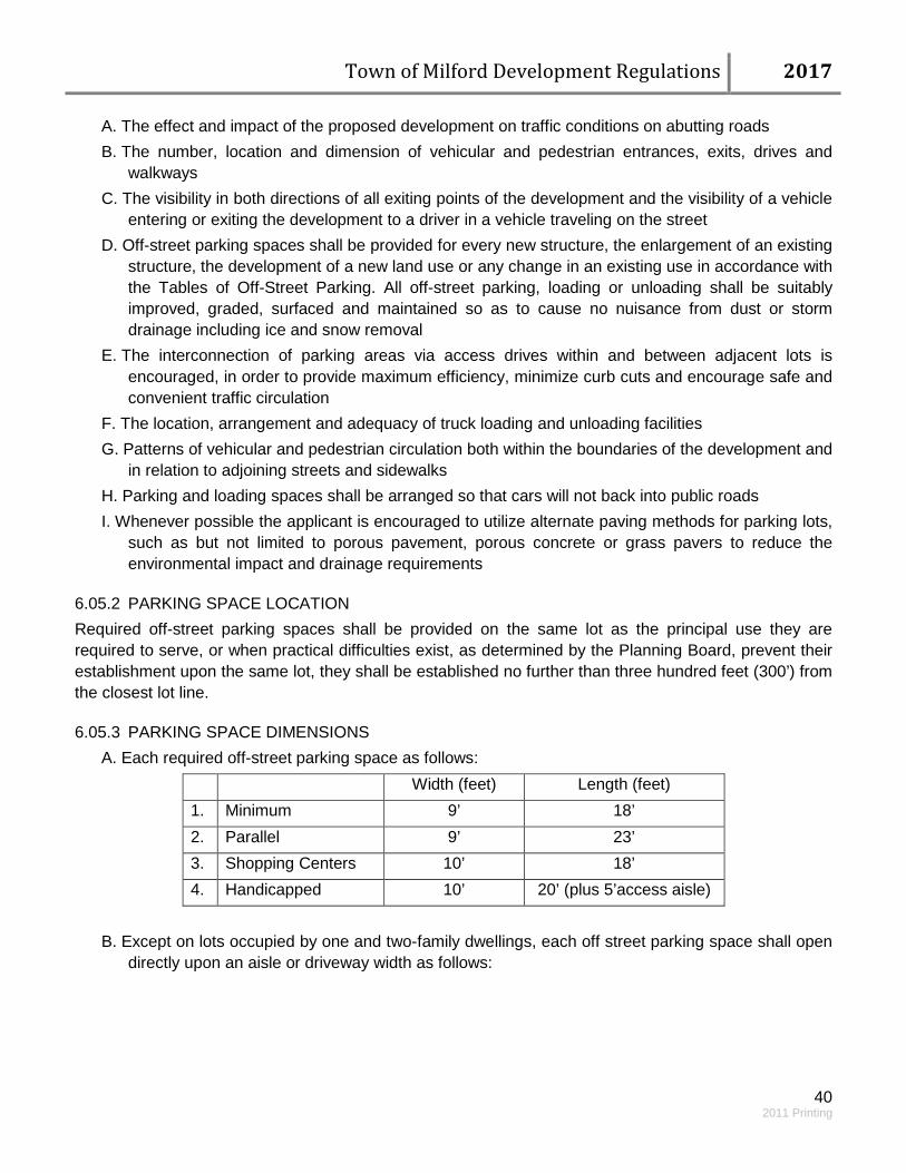
Town of Milford Development Regulations 2017
40 2011 Printing
A. The effect and impact of the proposed development on traffic conditions on abutting roads B. The number, location and dimension of vehicular and pedestrian entrances, exits, drives and
walkways C. The visibility in both directions of all exiting points of the development and the visibility of a vehicle
entering or exiting the development to a driver in a vehicle traveling on the street D. Off-street parking spaces shall be provided for every new structure, the enlargement of an existing
structure, the development of a new land use or any change in an existing use in accordance with the Tables of Off-Street Parking. All off-street parking, loading or unloading shall be suitably improved, graded, surfaced and maintained so as to cause no nuisance from dust or storm drainage including ice and snow removal
E. The interconnection of parking areas via access drives within and between adjacent lots is encouraged, in order to provide maximum efficiency, minimize curb cuts and encourage safe and convenient traffic circulation
F. The location, arrangement and adequacy of truck loading and unloading facilities G. Patterns of vehicular and pedestrian circulation both within the boundaries of the development and
in relation to adjoining streets and sidewalks H. Parking and loading spaces shall be arranged so that cars will not back into public roads I. Whenever possible the applicant is encouraged to utilize alternate paving methods for parking lots,
such as but not limited to porous pavement, porous concrete or grass pavers to reduce the environmental impact and drainage requirements
6.05.2 PARKING SPACE LOCATION Required off-street parking spaces shall be provided on the same lot as the principal use they are required to serve, or when practical difficulties exist, as determined by the Planning Board, prevent their establishment upon the same lot, they shall be established no further than three hundred feet (300’) from the closest lot line.
6.05.3 PARKING SPACE DIMENSIONS A. Each required off-street parking space as follows:
Width (feet) Length (feet) 1. Minimum 9’ 18’ 2. Parallel 9’ 23’ 3. Shopping Centers 10’ 18’ 4. Handicapped 10’ 20’ (plus 5’access aisle)
B. Except on lots occupied by one and two-family dwellings, each off street parking space shall open
directly upon an aisle or driveway width as follows:

Town of Milford Development Regulations 2017
41 2011 Printing
Parking Angle (degrees) Aisle Width (feet)
45* 16’ 60* 20’ 90* 24’
C. The aisle or driveway shall be unobstructed and allow for the passage of emergency vehicles at all
times. The angle shall be measured between the centerline of the parking space and the centerline of the aisle.
6.05.4 TABLE OF OFF-STREET PARKING
Use Parking Spaces Required Appliance, Carpet, Furniture, Electrical, Heating & Plumbing Retails Sales
1.5 per 1,000 SF¹
Adult daycare facilities 1 per employee², plus 1 per 5 clients and if necessary 1 per facility vehicle
Automotive Services: gas stations, auto dealers, auto repair & body shops
1 per employee² plus 1 per 1,000 SF or 4 per bay
Banks 3 per 1,000 SF College, Universities, Trade School and Vocational Institutions
1 per 2 seats, plus 1 per every 2 employees²
Government Offices (including municipal and school)
1 per 200 SF
Hair Salon, Spa & Barber Shop 2 per employee Bowling Alley, Skating Rinks and other places of assembly where capacity cannot be measured in terms of seats
1 per 200 SF or 1 per every 4 people at capacity, plus 1 per every 2 employees
Childcare Facilities 1 per employee² plus 2 per 1,000 SF Car Wash 1 per employee Dwellings: Single Family 2 per dwelling unit Multi-family 2 per dwelling unit Elderly 1.5 per dwelling unit Hotels and Motels 1 per room, plus 1 per 400 SF of public
meeting area Laundromats 1 per every 2 washing machines Medical, Dental, Veterinary and other Healthcare Providers Offices
4 per practitioner, plus one per every 2 employees
Manufacturing and Light Industrial 1 per 600 SF
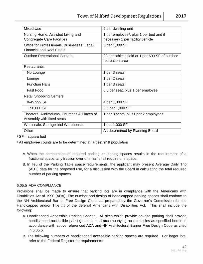
Town of Milford Development Regulations 2017
42 2011 Printing
Mixed Use 2 per dwelling unit Nursing Home, Assisted Living and Congregate Care Facilities
1 per employee², plus 1 per bed and if necessary 1 per facility vehicle
Office for Professionals, Businesses, Legal, Financial and Real Estate
3 per 1,000 SF
Outdoor Recreational Centers 20 per athletic field or 1 per 600 SF of outdoor recreation area
Restaurants: No Lounge 1 per 3 seats Lounge 1 per 2 seats Function Halls 1 per 3 seats Fast Food 0.6 per seat, plus 1 per employee Retail Shopping Centers 0-49,999 SF 4 per 1,000 SF + 50,000 SF 3.5 per 1,000 SF Theaters, Auditoriums, Churches & Places of Assembly with fixed seats
1 per 3 seats, plus1 per 2 employees
Wholesale, Storage and Warehouse 1 per 1,000 SF Other As determined by Planning Board
¹ SF = square feet ² All employee counts are to be determined at largest shift population
A. When the computation of required parking or loading spaces results in the requirement of a fractional space, any fraction over one-half shall require one space.
B. In lieu of the Parking Table space requirements, the applicant may present Average Daily Trip (ADT) data for the proposed use, for a discussion with the Board in calculating the total required number of parking spaces.
6.05.5 ADA COMPLIANCE Provisions shall be made to ensure that parking lots are in compliance with the Americans with Disabilities Act of 1990 (ADA). The number and design of handicapped parking spaces shall conform to the NH Architectural Barrier Free Design Code, as prepared by the Governor’s Commission for the Handicapped and/or Title III of the deferral Americans with Disabilities Act. This shall include the following:
A. Handicapped Accessible Parking Spaces. All sites which provide on–site parking shall provide handicapped accessible parking spaces and accompanying access aisles as specified herein in accordance with above referenced ADA and NH Architectural Barrier Free Design Code as cited in 6.05.5.
B. The following numbers of handicapped accessible parking spaces are required. For larger lots, refer to the Federal Register for requirements:
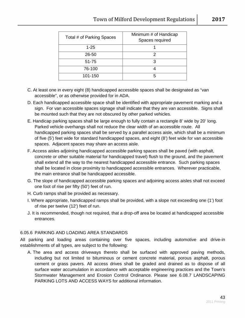
Town of Milford Development Regulations 2017
43 2011 Printing
Total # of Parking Spaces Minimum # of Handicap Spaces required
1-25 1 26-50 2 51-75 3
76-100 4 101-150 5
C. At least one in every eight (8) handicapped accessible spaces shall be designated as “van
accessible”, or as otherwise provided for in ADA. D. Each handicapped accessible space shall be identified with appropriate pavement marking and a
sign. For van accessible spaces signage shall indicate that they are van accessible. Signs shall be mounted such that they are not obscured by other parked vehicles.
E. Handicap parking spaces shall be large enough to fully contain a rectangle 8’ wide by 20‘ long. Parked vehicle overhangs shall not reduce the clear width of an accessible route. All handicapped parking spaces shall be served by a parallel access aisle, which shall be a minimum of five (5’) feet wide for standard handicapped spaces, and eight (8’) feet wide for van accessible spaces. Adjacent spaces may share an access aisle.
F. Access aisles adjoining handicapped accessible parking spaces shall be paved (with asphalt, concrete or other suitable material for handicapped travel) flush to the ground, and the pavement shall extend all the way to the nearest handicapped accessible entrance. Such parking spaces shall be located in close proximity to handicapped accessible entrances. Wherever practicable, the main entrance shall be handicapped accessible.
G. The slope of handicapped accessible parking spaces and adjoining access aisles shall not exceed one foot of rise per fifty (50’) feet of run.
H. Curb ramps shall be provided as necessary. I. Where appropriate, handicapped ramps shall be provided, with a slope not exceeding one (1’) foot
of rise per twelve (12’) feet of run. J. It is recommended, though not required, that a drop-off area be located at handicapped accessible
entrances. 6.05.6 PARKING AND LOADING AREA STANDARDS All parking and loading areas containing over five spaces, including automotive and drive-in establishments of all types, are subject to the following:
A. The area and access driveways thereto shall be surfaced with approved paving methods, including but not limited to bituminous or cement concrete material, porous asphalt, porous cement or grass pavers. All access drives shall be graded and drained as to dispose of all surface water accumulation in accordance with acceptable engineering practices and the Town’s Stormwater Management and Erosion Control Ordinance. Please see 6.08.7 LANDSCAPING PARKING LOTS AND ACCESS WAYS for additional information.
Town of Milford Development Regulations 2017
44 2011 Printing
B. Fixtures used to illuminate any area shall be downcast and so arranged as to direct the light away from the street and away from adjoining premises.
C. There shall not be any storage of materials or equipment, or display of merchandise within required parking areas except as part of approved site plan and building operations.
D. Any entrance or exit driveway shall not exceed twenty-four feet (24’) in width at its intersection with the front lot line. Any combination entrance and exit shall not exceed forty feet (40’) in width at its intersection with the roadway, except a divided entrance exit, which shall not exceed fifty-five feet (55’) in width. Residential driveways must comply with the Residential Driveway Permit Regulations. (See APPENDIX VII: TOWN DOCUMENT RESOURCES LIST )
E. All off-street parking and loading or unloading spaces shall be at least ten feet (10’) from any public street right-of-way and shall be separated from such right-of-way by a granite curb and landscaping as required in 6.08 LANDSCAPING STANDARDS.
6.05.7 PARKING SUBSTITUTIONS If there is reasonable nearby on or off-street Municipal parking spaces the Planning Board may allow the substitution of space in lieu of the parking requirements of 6.05.4 TABLE OF OFF-STREET PARKING provided they are located within five hundred feet (500’) of the building which is intended to be served. In accordance with the Nashua and Elm Streets Corridor Overlay District, properties which share driveways or drive aisles may also share or overlap in the total number of parking spaces required. 6.05.8 INCREASE OR CHANGE OF USE When the intensity of use of any building, structure or premise shall be increased through the addition of dwelling units, floor area, beds, seating capacity or other unit of measurement, parking and loading facilities, as required, shall be provided for such increase in intensity of use. Whenever the existing use of a building, structure or premise shall be changed or converted to a new permitted use, parking and loading facilities shall be provided, as required, for such use.
6.05.9 PRIOR NON-CONFORMING USES
No use, lawfully established prior to the effective date of this chapter, shall be required to provide and maintain the parking and loading requirements of this chapter; provided, however, that off street parking and loading space required by any previously adopted zoning ordinance and/or regulation approved under shall be continued and maintained.
For any non-conforming use which is hereafter damaged or destroyed and which is lawfully reconstructed, reestablished or repaired, off-street parking and loading facilities equivalent to those maintained at the time of such damage or destruction, shall be restored and continued in operation.

Town of Milford Development Regulations 2017
45 2011 Printing
6.05.10 PROVISION FOR SHARED PARKING
Shared parking involves parking spaces that are used at different times by different uses. Shared parking provisions for combinations of uses on-site and adjacent sites are encouraged within the Nashua and Elm Streets Corridor Overlay District and may be approved by the Planning Board in other locations on a case-by-case basis.
Off-site parking shall be protected with a shared parking easement agreement which shall be reviewed and recorded with the approved plans, except in areas exempt from parking standards such as but not limited to the Oval Sub-district. 6.06 OUTDOOR LIGHTING
All outdoor lighting shall be downcast and so directed and shielded that no glare will spill out onto neighboring properties or roads.
In terms of placement and type, all outdoor lighting shall comply with an appropriate lighting standard for outdoor lighting.
6.07 FIRE PROTECTION
Fire alarms, fire hydrants, fire cisterns and other necessary fire protection measures shall be provided as specified by the Fire Department and the Department of Public Works Infrastructure Design, Construction and Administration Standards.
When necessary the Fire Department may require residential dwelling units to have sprinkler systems. These items shall be shown or noted on the development plan and installed by the applicant.
6.08 LANDSCAPING STANDARDS
6.08.1 GENERAL
The requirements of this Section shall apply to all new commercial, industrial and multi-family developments. This Section is intended as suggested guidelines for the Oval Sub-district and residential development, but not required. In addition, these standards may apply whenever a site plan is brought before the Planning Board for an amendment or a change of use. The purpose is to protect, enhance, and promote an economic, ecological and aesthetically pleasing landscape by breaking up visual expanse and connected impervious areas, delineating areas of vehicular and pedestrian traffic to improve safety and to enhance the gateways to Milford. In addition, soil and landscaping play an important role in stormwater quality and quantity. These standards are intended to increase absorption and cleansing of rainfall and runoff so that the quantity and quality are more reflective of the natural hydrology, where vegetation will thrive with minimal need for additional water, pesticides and fertilizers.
Town of Milford Development Regulations 2017
46 2011 Printing
A landscaping plan shall be provided with each site plan application. The plan shall identify existing and proposed trees, shrubs, ground cover, walls and fences. Existing mature/healthy trees and vegetation shall be preserved and integrated into the landscape plan. Landscaping must be maintained in good condition such that all plantings shall be in good health and that the parcel shall present a neat and orderly appearance, free from refuse and debris. Any dead vegetation that is part of the approved landscaping design shall be replaced within one year. Site disturbance shall be minimized wherever possible and practical. The applicant shall use native plants, shrubs, and trees whenever possible. The plant species selected should be hardy for the particular area in which they will be located. In addition, the size, number and type of plants proposed shall be shown. Invasive species must be properly managed within the area of disturbance using best management practices. Species on the current Prohibited or Restricted Invasive Plant Species Lists maintained by the NH Department of Agriculture (as amended) are prohibited and shall not be planted. Said document is hereby incorporated by reference. Where an applicant proposes leaving a significant portion of healthy non-invasive trees and other vegetation within the proposed construction area, the Board may consider alternative landscaping designs. Plant materials used in conformance with the provisions of this Section shall conform to the standards set by the American Nursery and Landscape Association (ANLA) [formerly the American Association of Nurserymen] in the American Standard for Nursery Stock (as amended) [ANSI Z60.1-1996], which document is hereby incorporated by reference. The management and care operations of all trees, shrubs, and other woody plants shall conform to the American National Standards Institute (ANSI) A300 Standards for Tree Care Operations; Tree Shrubs, which document is hereby incorporated by reference. 6.08.2 SITE FEATURES AND LAYOUT
Landscaping should be designed to encourage biodiversity, remain functional, and attractive during all seasons of the year through a thoughtful selection of deciduous, evergreen, flowering and non-flowering plant varieties.
Prominent natural or man-made features of the landscape such as mature trees, surface waters, natural rock outcrops or roadways should be retained and incorporated in to the landscape plan where possible. Stonewalls must be retained in accordance with RSA 472:6 and biodiversity of species is encouraged. Vegetation management is encouraged to maintain/preserve the aesthetic and historic qualities of the stonewall and its functionality. The addition of ornamental rocks, fencing and other features new to the landscape are encouraged. Existing natural vegetation should be retained where possible. Existing trees and shrubs to be retained may be substituted for any compatible required plantings. Maximum effort should be made to preserve small stands of trees rather than individual trees to minimize the potential for serious damage due to
Town of Milford Development Regulations 2017
47 2011 Printing
wind, grade changes or soil compaction. Alternatives to pine trees are strongly encouraged. During construction, best practices are encouraged to protect existing natural vegetation. Natural re-growth, mulched planting beds and alternative ground cover plant varieties are preferred to large expanses of lawns. Lawn areas should not be planted in strips of less than six (6’) feet in width, especially adjacent to roads or parking areas, since such areas require watering but have little utility and are less likely to thrive. Native, hybrid and naturalized non-invasive species are encouraged and should be used to meet the minimum requirements of this Section. Plant varieties selected should be hardy, drought and salt resistant (as necessary) and require minimal maintenance. Less hardy, exotic or higher maintenance plant varieties may be used to supplement minimum landscaping requirements where appropriate, but are not encouraged. Species including those plant species listed on the “New Hampshire Prohibited Plant Species Rule” list are prohibited. To promote on-site water retention and filtration, landscaped areas shall be designed in a manner that guides storm water from on-site impervious roads, parking areas, sidewalks and walkways to vegetated areas or approved retention areas. Curbing or equivalent barriers shall be required to protect vegetation from vehicular damage. Barriers shall be designed with openings that allow storm water to flow into vegetated areas. All curbing in the Town right-of-way shall be granite. Site designs are strongly encouraged to incorporate disconnected impervious areas. When irrigations systems are proposed, a temporary watering plan/schedule or low volume (drip irrigation) system shall be required. Permanent irrigation systems are discouraged. Irrigation systems shall be designed and installed for efficient and effective water use to the landscaped area. For those instances when permanent irrigation is considered necessary, such as an athletic field, permanent irrigation shall utilize water saving technologies, including rain sensors, and management systems that monitor current weather conditions. Turf and plant bed irrigation systems should incorporate technology that allows for minimal and efficient water usage. Spray heads are not recommended due to their high water usage, low precipitation rates and susceptibility to the wind. Heads that are a hybrid of sprays and rotors shall be used in place of spray heads.
6.08.3 SOIL PREPARATION
For all newly landscaped areas a minimum of four (4”) to six (6”) inches of topsoil, preferably with organic matter incorporated shall be spread in all planting and turf areas.
6.08.4 MULCHING
Mulching trees, shrubs and plants helps retain soil moisture, moderates temperature fluctuations, provides protection from mechanical damage by mowers and trimmers and serves as temporary
Town of Milford Development Regulations 2017
48 2011 Printing
covering of exposed soil until understory plants and ground covers fill in. Mulch shall be no greater than three (3”) inches in depth. Excessively thick mulch applications (>3”) and mulch against tree trunks fosters poor plant health and should be avoided. Mulches for storm water management areas should be heavier and not a type that will float away. Man-made materials such as recycled tires may not be acceptable for mulch materials. Round stone shall be given consideration as accent material in planting beds. Sizes that range from one (1”) inch to six (6”) are acceptable. 6.08.5 LANDSCAPING BUFFERS
Landscaping plans shall be designed to provide buffers in an effort to mitigate impacts to neighboring properties. Buffers are intended to physically separate one use or property from another so as to visually shield or block, noise, lights, provide a water quality benefit and to minimize other impacts.
A. Along the periphery of a property, buffers are required in the following instances: 1. Where a proposed non-residential use abuts a residential zoning district. 2. Where a proposed non-residential use abuts an existing residential use. 3. Where a proposed roadway abuts an existing property line or is within twenty (20’) feet of a
property line where the existing use is residential. B. On the periphery of a property:
1. A landscaped buffer shall be at least ten (10’) feet in width and six (6’) feet in height to effectively screen from adjacent properties and may consist of evergreens, berms, mounds, fencing or combinations thereof in conjunction with complimenting shrubs and perennials.
2. Where appropriate existing trees and vegetation shall be incorporated into landscape buffers. C. Within a property, buffers are required to provide visual screens in the following instances:
1. Outdoor storage areas. 2. Utility installations. 3. Loading areas. 4. Refuse and recycling collection areas.
D. Within a property: 1. Buffers shall be located to prevent visibility of the above listed items from the parking areas,
traveled right-of-way or neighboring properties. 2. Buffers shall be at least six (6’) feet in height and may consist of fencing, evergreens, berms,
mounds or combinations thereof. 3. All outdoor refuse and recycling facilities shall be located on a raised six (6”) inch concrete
pad. 6.08.6 LANDSCAPING ALONG BUILDING FRONTAGES
Landscaping shall be provided along all building frontage. A minimum of one (1) shrub for every five (5’) feet of building frontage shall be provided. In instances where it is not possible to locate all required shrubs along the building frontage due to doorways, walkways or other impervious surfaces, the required shrubs shall be utilized within the parking lot or landscape buffers. Plant locations are designed to be flexible and not necessarily in even spaced intervals.

Town of Milford Development Regulations 2017
49 2011 Printing
6.08.7 LANDSCAPING PARKING LOTS AND ACCESS WAYS
All parking lot landscaping shall promote the safe flow of vehicular and pedestrian traffic within and out of the site.
A. Peripheral landscaping shall be required along all sides of a parking lot or access way that abuts adjoining property or a public right-of-way as follows: 1. A landscaped strip at least ten feet (10’) in width shall be located between the paved area and
the abutting property lines or public right-of-way except where driveways or other openings may be required; and
2. At least one (1) tree for each thirty feet (30’) of landscaped strip shall be provided. These trees shall be complemented by suitable ground cover and shrubs.
B. Landscaping within parking lots or green space encompassing not less than five (5%) percent of the total parking area shall be required. A minimum of one (1) tree for every fifteen (15) parking spaces shall be provided. These trees shall be complemented by suitable ground cover and shrubs. These trees shall also be “street” trees; trees that are salt, heat drought, and urban tolerant. These trees shall also have a minimum branching height of eight (8’) feet when planted.
C. Parking lots with more than fifty (50) parking spaces shall have curbed planting areas. Planting areas shall be placed within or at each end of a parking row. No parking row shall contain more than thirty (30) contiguous parking spaces without a curbed planting area. 1. Curbs around parking lot plantings shall have a shallow descending cut that is a minimum of
five (5’) feet wide to allow drainage to flow from the parking lot into the curbed planting areas for infiltration.
2. Such planting areas shall be underlain by a suitable layer of crushed stone or other water holding reservoir, with an overlay of filter fabric to minimize clogging by superfine soils. Topsoil depths and minimum organic content shall be as listed in 6.08.3 SOIL PREPARATION for the maximum absorption of rainfall.
3. Snow storage is not permitted in the parking islands. D. Within the interior of the parking lot, landscaping should be used to delineate vehicular and
pedestrian circulation patterns. Clear and legible signs, different color and texture paving materials, raised areas, and other techniques should be used to further direct the flow of both vehicular and pedestrian traffic within the site.
E. Bare soil is not acceptable. The introduction of groundcovers and/or perennials planted enmasse and the use of mulch as a soil covering is acceptable. However, no more than twenty (20) percent of the minimum landscaped area may be covered with non-living landscaping materials such as bark mulch, woodchips, stone or leaf litter.
F. Use of Existing Landscaping Towards Requirements: 1. Each existing healthy and native or non-invasive tree, with a caliper of two and half (2.5) to
three (3) inches or greater, preserved using proper protection methods within the interior parking lot area may be substituted for one tree required for every fifteen (15) parking spaces.
2. Where an applicant proposes leaving a significant portion of healthy non-invasive trees and other vegetation within the proposed parking area, the Board may consider alternative landscaping designs.

Town of Milford Development Regulations 2017
50 2011 Printing
6.08.8 PLANTING SPECIFICATIONS
All trees, shrubs and ground cover shall be planted according to ANSI A300 standards. A. Trees and Shrubs
1. All plant stock shall meet the ANSI Z60.1 standard. 2. All deciduous trees shall be 2.5”-3.5” caliper, with a height not less than twelve (12’) feet. 3. Minimum size for evergreen trees shall be six (6’) feet in height. 4. Minimum size for shrubs shall be two (2’) feet in height.
B. Planting Specifications 1. All trees, shrubs and plantings shall be planted according to accepted horticultural standards 2. Cultivated areas shall be covered with not less than a two (2”) inch deep layer of mulch or
ornamental round stone after planting. 3. All trees and shrubs shall be appropriately pruned after planting with all broken or damaged
branches removed. C. Retention of Existing Vegetation
1. The boundary of areas to be cleared will be well defined on-site with tree markings, construction fencing, snow fencing or silt fencing as appropriate to avoid unnecessary cutting or removal. Care should be taken to protect root systems from damage due to excavation or compaction. Individual trees, rock formations and other landscape features to be retained should also be clearly marked and bounded on-site.
2. Where an applicant proposes leaving a significant portion of healthy non-invasive species and other mature vegetation within the proposed construction area, the Board may consider alternative landscaping design.
3. Invasive species and/or toxic plants such as Poison Ivy, Poison Oak, Poison Sumac and/or Giant Hog Weed shall be managed according to accepted horticultural techniques and provisions created by the State of NH and the standards of ANSI A300.7.
D. Alternative Compliance 1. The requirements of this Section are intended to set minimum standards for high quality
development, the protection of property values, and environmental protection. The requirements are not intended to be arbitrary or inhibit creative solutions. Difficult or unique site conditions or other constraints may justify the need to request alternative methods of compliance with the landscape requirements.
2. The Board may allow alternative compliance if it is warranted and the proposed compliance measures are equal to or better than normal compliance in terms of quality, effectiveness, durability, hardiness, ecological benefit, and ability to fulfill the intent of the regulation. The Board encourages the use of creative and sustainable designs, materials, techniques, concepts, and technologies, for both standard compliance measures and as part of alternative compliance proposals. Proposals must demonstrate a clear commitment to the standards for the proper installation and long-term maintenance of designs or elements involving emerging technologies, techniques, or materials, to ensure their ability to function as intended into the future.

Town of Milford Development Regulations 2017
51 2011 Printing
The Board will consider alternative compliance proposals in the context of each specific site. Alternative compliance will be limited to the specific project under consideration and will not establish precedent for acceptance in other cases. It is preferred that alternative compliance be achieved within the developed area. Where the requirements cannot be satisfied within the developed area, the method of alternative compliance may be achieved elsewhere within the project site. Where alternative compliance cannot be achieved within the project site, alternative compliance may be achieved on an alternate site within Milford, approved by the Board as well as any other necessary Town departments. A fee-in-lieu, as determined by the Board, will only be accepted as a form of alternative compliance if none of the above options for alternative compliance can be achieved.
6.08.9 LOW IMPACT DEVELOPMENT LANDSCAPING
Landscaping that incorporates Low Impact Development (LID) strategies for storm water management should serve to meet the requirements of the Town of Milford’s Storm water Management and Erosion Control Regulations by absorbing and treating storm water runoff to the greatest extent possible onsite. LID landscaping includes the use of bio-filters, raingardens, shallow swales, drywells and other features and functions. High organic content of soils encourages healthy growth and absorbs and retains rainwater on site as soil moisture, minimizing irrigation needs and runoff quantities. The applicant should consider the estimated seasonal high water table elevation during the design process to decrease the likelihood of groundwater contamination. Adequate separation is needed between infiltrating structures and the groundwater table. Landscape areas shall include all areas on site that are not covered by buildings, structures, paving or impervious surface. The selection and location of turf, trees, ground cover (including shrubs, grasses, perennials, flowerbeds and slope retention), pedestrian paving and other landscaping elements shall be designed to absorb rainfall, prevent erosion, encourage biodiversity and meet functional and visual purposes such as defining spaces, accommodating and directing circulation patterns, managing hardscape impacts, attracting attention to building entrances and other focal points and visually integrating buildings with the landscape area. Where possible, the landscaping design should combine form and function, incorporating drainage features invisibly into the landscape such as through shallow detention areas and parking lot islands for infiltration of parking lot runoff and sheet flow. 6.08.10 LANDSCAPING STANDARDS – SUBDIVISIONS – NEW ROADS
Where cul-de-sacs are permitted, the island or center area of the cul-de-sac shall remain in a natural vegetated state, with any invasive species removed. If it will be used as a bio-filter for storm water treatment, the area shall be vegetated with a combination of living plant material including trees, shrubs and groundcovers. Non-living landscape materials may cover up to twenty (20%) percent of the island or center area. When planting of vegetation is required, cul-de-sac landscaping shall be installed after construction of the road is complete.
Town of Milford Development Regulations 2017
52 2011 Printing
6.08.11 MAINTENANCE OF LANDSCAPING
Low maintenance, drought, insect and disease resistant plant varieties are encouraged so that buffer areas and other required landscaping can be maintained with minimal care and the need for watering, pesticide or fertilizer use is minimized. For these reasons, native, hybrid and naturalized non-invasive species are preferred since such plant species are well adapted to the local environment. To avoid maintenance problems and excessive watering, organic matter such as compost or peat should be added to the soil before planting as appropriate to increase the water holding capacity of the soil and to provide nutrients. Proper plant selection and planting methods are critical to the longevity of the plants. ANSI A300specifications are to be followed for plantings, installations and soil type selection. The owner and their representative shall be responsible for providing, protecting and maintaining all landscaping in healthy and growing condition, and replacing it when necessary to insure continuous conformance with these guidelines. Any landscape element that dies, or is otherwise removed, shall be promptly replaced with the same, if not similar to, height or texture element as originally intended. In addition, landscaped areas shall be kept free of all debris, rubbish, weeds and overgrown turf grass. If the ownership of a site is conveyed to a new property owner, the new owner shall be responsible for maintaining all landscaping in accordance with the approved final landscaping plan. 6.08.12 ENFORCEMENT
An inspection of all plantings to ensure compliance with the approved landscaping plan shall be conducted prior to the issuance of a Certificate of Occupancy. Ongoing inspections of landscapes shall be conducted to ensure compliance of landscape maintenance in perpetuity. 6.08.13 LANDSCAPING TIME FRAME
All landscaping should be completed prior to the issuance of a Certificate of Occupancy. If the landscaping cannot be completed prior to issuance of a Certificate of Occupancy, the owner shall be required to submit a security to the Community Development office to cover the complete cost of all planting, materials and labor required to complete the landscaping plan as depicted on the approved plan. A detail sheet itemizing the breakdown of costs shall accompany all bonds. All landscaping shall be complete within one year of issuance of a Certificate of Occupancy or the Planning Board may begin the process of revoking site plan approval. 6.08 SNOW STORAGE AND REMOVAL Provisions shall be made for snow storage. Consideration shall be given to locating the snow storage where melting will not create a hazard when refreezing occurs. Snow storage shall be located appropriately to provide maximum protection to downstream sites from the accumulated ice control materials and chemicals included in snow storage.
Town of Milford Development Regulations 2017
53 2011 Printing
The site plan shall indicate how and where snow will be stored or removed from the site to preclude large accumulations of snow from blocking LID or drainage systems, causing flooding, or causing contamination of ground and surface waters. Snow storage is not permitted within required parking spaces. Snow shall be stored or removed to allow continued safe passage of vehicles and pedestrians into, and through all travel lanes, parking areas, and pedestrian routes. All snow storage provisions shall comply with the Department of Environmental Services Best Management Practices (DES BMP) for snow storage (See APPENDIX VII: TOWN DOCUMENT RESOURCES LIST) and on-site LID Maintenance and Operations manual (if necessary). 6.09 WETLANDS 6.010.1 WETLAND BOUNDARY MARKERS The Planning Board may require a portion or all of the wetland boundaries or buffers, be delineated in accordance with the Zoning Ordinance requirements. Wetlands boundaries may also be required to be marked with an identifiable permanent marking system. 6.010.2 WETLANDS Ground control shall be marked by a certified wetlands scientist, both on the site and on the development plan(s). The ground control shall consist of numbered flags, stakes, walls, trees or other easily identifiable points on the property. These points will be well distributed throughout the site at a density of not less than four (4) points per acre. The numbered points must be identified, by number, on the plan. The purpose of this requirement is to provide easy identification for all parties required or interested in examining the site. All wetland areas, prior to tree cutting and clearing shall be staked and flagged twenty-five (25’) feet from the wetland boundary or fifty (50’) feet if designated by the Planning Board. These stakes shall be a minimum of fifty (50’) feet apart for straight boundaries and twenty-five (25’) feet apart for curved boundaries. Wetland Buffer widths are determined by Article 6.02.0 of the Zoning Ordinance. Wetland buffer areas shall be preserved as a no construction disturbance zone except for temporary and minimal impacts due to utility crossings, driveways and road crossings, or transmission lines. This area shall act as a natural vegetated buffer for stormwater filtration, flood protection, and wildlife habitat. In special circumstances the Planning Board may require an area extending an additional twenty-five (25’) feet out from the wetland buffer as determined by Zoning, which may be adversely affected by the proposed development, erosion or stormwater runoff. 6.010 STORMWATER MANAGEMENT PLAN A Stormwater Management and Erosion Control Plan (SWMP) shall be provided when required by and in conformance with the requirements of the Town of Milford’s Stormwater Management and Erosion Control Regulation. (See APPENDIX VII: TOWN DOCUMENT RESOURCES LIST)

Town of Milford Development Regulations 2017
54 2011 Printing
For all plans requiring substantial new drainage facilities to be maintained by the Town once completed the Director of Public Works may require a one (1) time cash security for the maintenance of the drainage facilities. The amount of security shall be determined once the facility is completed and must be paid prior to road acceptance or final CO. 6.011 EROSION AND SEDIMENT CONTROL For applicants that are not subject to Town of Milford Stormwater Permitting requirements, the applicant is expected to provide basic erosion control measures and construction details as part of any plan submittal involving soil disturbance. Erosion control measures must be maintained during construction until site stabilization is achieved. 6.012 OTHER STORMWATER AND EROSION CONTROL PERMITS In addition to local approval, the applicant may be responsible for obtaining Town, State and Federal permits. Permits may include a Town, State or Federal Stormwater Permit or other permits as required by the Federal NPDES program, NH Site Specific permit, State and Federal wetlands permits, and/or EPA’s dewatering permit.
Terrain Alteration (Site Specific Permit). RSA 485-A:17
Requires a permit from the Department of Environmental Services (DES) for “…any person proposing to significantly alter the characteristic of the terrain, in such a manner as to impede natural runoff or create an unnatural runoff…” Regulations require this permit for any project involving more than 100,000 contiguous square feet of disturbance or 50,000 contiguous square feet in the protected shoreland.
National Pollutant Discharge Elimination System (NPDES) Stormwater Discharge Permit
A permit issued by the Environmental Protection Agency (EPA) or by the State under authority delegated pursuant to 33 USC, section 1342 (b) that authorizes the discharge of pollutants to waters of the United States. For a cumulative disturbance of one acre of land that EPA considers “construction activity”, which includes, but is not limited to clearing, grading, excavation and other activities that expose soil typically related to landscaping, demolition and construction of structures and roads, a Federal Permit will be required. Consult the EPA for specific rules. This EPA Permit is in addition to any State or local permits required.
Wetlands Permit. RSA 482-A
Requires a permit from DES for any person desiring to “…excavate, remove, fill, dredge or construct any structures in or on any bank, flat, marsh, swamp in and adjacent to any waters of the State.”
Town of Milford Development Regulations 2017
55 2011 Printing
Dewatering Permit (EPA)
A permit issued by the EPA for construction dewatering for dewatering of groundwater intrusion and/or stormwater accumulation; flushing of potable water lines; short-term and long-term dewatering of foundation sumps; and pump testing of water wells. The permit should be in accordance with the current General NPDES Permit for Construction Dewatering Activities in MA and NH or the most recent version of the EPA Dewatering General Permit. Consult EPA for specific rules.
6.013 SPECIAL FLOOD HAZARD AREAS All applications for development governed by these Regulations having lands identified as Special Flood Hazard Areas (SFHA) by the Federal Emergency Management Agency (FEMA) in “Flood Insurance Study for the Town of Milford, NH” together with the associated Flood Insurance Rate Maps, as amended, shall meet the requirements of these regulations. All development applications shall be reviewed to determine whether such applications will be reasonably safe from flooding and are consistent with the need to minimize flood damage. Development review shall assure that the following minimum standards are met:
A. The application is designed consistent with the provisions set forth in Section 6.03.1 FLOODPLAIN MANAGEMENT DISTRICT of the Milford Zoning Ordinance and the need to minimize flood damage.
B. All public utilities and facilities, such as sewer, gas, electrical, and water systems, shall be located and constructed to minimize or eliminate flood damage.
C. Adequate drainage systems shall be provided to reduce exposure to flood hazards. D. All necessary permits have been received from those governmental agencies from which approval
is required by Federal or State law, including Section 404 of the Federal Water Pollution Control Act Amendments of 1972, 33 U.S.C. 1334.
E. Base flood elevation (the floodplain boundary and 100 year flood elevation) data shall be provided for all development greater than 50 lots or 5 acres, whichever is the lesser, and that portion of applications within the Special Flood Hazard Area.
6.014 MUNICIPAL AND PUBLIC UTILITIES 6.015.1 GENERAL Municipal utilities shall include but not be limited to sanitary sewer, stormwater, drainage, fire suppression and water supply.

Town of Milford Development Regulations 2017
56 2011 Printing
Non-municipal utilities shall include but not be limited to gas, electric, telephone, cable television, sanitary sewer, stormwater, drainage, and water supply. All applications which include the creation of a new or upgraded road or a subdivision shall have underground utilities. If utilities are proposed to be constructed within a designated scenic road right-of-way, all applicable Town scenic road requirements must be met. All new or upgraded utilities shall comply with the Town of Milford’s Water Utility and Public Works Departments standards as listed in APPENDIX VII: TOWN DOCUMENT RESOURCES LIST. All applicants who propose to do sewer and water work or construction within a Town right-of-way should consult the Town of Milford’s Water Utility and DPW Departments' construction specifications to determine if an on-site inspector shall be required during construction; the cost of which shall be borne by the applicant/developer. 6.015.2 UTILITY PLAN The location and size of all existing underground and overhead municipal and non-municipal utilities intended to serve the development shall be shown on the plan or in the plan set, inclusive of:
A. Water supply details B. Wastewater disposal including the size and location of all piping, pump stations, holding tanks,
leach field, etc. C. Location, size, grade and invert elevations of sanitary, storm and/or combined sewers D. Location and size of water mains including location of fire hydrant and valves E. Location of gas lines, storage tanks and utility poles F. Location of manholes, transformer poles, and appurtenant structures G. Location of all fire cisterns, hydrants or other apparatus H. A layout indicating how the site will be served by electric, telephone and any other public utility
must be provided. If the utility company(s) requires an easement to provide service, no final approval shall be granted by the Planning Board until such easements are secured.
6.015 SANITARY SYSTEMS – GENERAL REQUIREMENTS The applicant must meet NHDES Subsurface Disposal Regulations for any application which requires or will require an on-site subsurface disposal system. In areas not currently served by public sewer systems, it shall be the responsibility of the applicant to provide adequate information to prove that the area of each lot is adequate to permit the installation and operation of an individual sewage disposal system (septic tank and leach field). Individual Test Pit data is required along with any other tests the health officer may require regarding seepage or other tests.
Town of Milford Development Regulations 2017
57 2011 Printing
The applicant shall certify on the Final Plan that the test-pits dug for percolation tests have been performed per the requirements set forth by the New Hampshire Water Supply and Pollution Control Commission. The Planning Board, when it deems necessary, may require that said plan contain a certification by a certified soils engineer as to the information therein contained. All fees shall be paid by the applicant. NH Department of Environmental Services approval is required for all lots less than 5 acres in size which will not be served by the public sewer system. Any new development within 100 feet of a sewer line is required to hook-up to the municipal system unless the applicant is granted a waiver by Milford’s Water and Sewer Commissioners. (See APPENDIX VII: TOWN DOCUMENT RESOURCES LIST) 6.016 WATER SERVICES– GENERAL REQUIREMENTS 6.017.1 MUNICIPAL WATER Construction and installation of water mains and facilities are subject to the approval of the Milford Water and Sewer Commissioners and the Water Utilities Department. Detailed design and construction standards for the installation of water mains can be found through the Water Utilities Department specifications (See APPENDIX VII: TOWN DOCUMENT RESOURCES LIST). The Milford Water Utilities Department shall approve and inspect all water mains and services on existing Town roads from the existing main. The applicant will be responsible for obtaining all necessary permits from the Department of Water Utilities. When a public water system is proposed, the system shall be designed by a qualified engineer. Each system shall be designed to handle the expected flows (domestic and fire) for present and future development within the site. The Planning Board reserves the right to have its designated representative inspect the installation of all public water systems in accordance with the Town or State’s installation standards. 6.017.2 PRIVATE WATER SYSTEMS When a private water system is proposed the system shall be designed by a qualified engineer. Each system shall be designed to handle the expected flows (domestic and fire) for present and future development within the site. The Planning Board reserves the right to have its designated representative inspect the installation of all private water systems in accordance with the Town or State’s installation standards. 6.017.3 ON-SITE WATER SUPPLY The provision of on-site water supply shall conform to criteria of the Water Supply and Pollution Control Division of the NH Department of Environmental Services. It shall be the responsibility of the applicant to
Town of Milford Development Regulations 2017
58 2011 Printing
provide adequate information to prove that the area of each lot is adequate to permit the installation and operation of both individual on-site water supply and sewage disposal systems. 6.017 BRIDGES Bridges must be built according to State of New Hampshire Department of Transportation specifications. All bridge plans must be approved by Town and State engineers prior to construction. 6.018 SIGNAGE The Planning Board may require a Signage Plan with any new development intending to use signage. The Signage Plan shall contain the following:
A. A detail of the proposed signage to be utilized for the project including the location(s), dimensions, and type of illumination, if any, to be utilized (i.e. internal, downcast, pole lighting, wall mounted).
B. The Signage Plan should be designed to complement the proposed development in terms of style, color, and materials. Signage that provides attractive, consistent, and coordinated combinations of styles and colors is encouraged. All signage should be designed to identify the location of the development and provide directions through the site, as necessary and appropriate. The Planning Board shall provide input on the Signage Plan to insure the above; however, all signage shall be governed by the Milford Zoning Ordinance Article 7.06.0 Sign Ordinance.
All development with roads or utilities to be maintained by the Town upon completion, shall post a sign as follows prior to the first Certificate of Occupancy being issued. The sign shall remain until formal Town acceptance: “This road has not been accepted by the Town of Milford. Until the road has been accepted, the Town assumes no responsibility for maintenance including snow removal, nor any liability for damage resulting from use of this road. Posted By Town of Milford. RSA 674.41.” 6.019 EASEMENTS, DEED RESTRICTIONS, DEDICATIONS, COVENANTS Where the topography is such as to make difficult the inclusion of any utilities, drainage or other facilities, within the right-of-ways so laid out, the submitted layout shall show the boundaries of proposed permanent easements over or under private property. All common driveways shall require access easements. Easements shall be an appropriate width for their intended use and shall have satisfactory access to existing or proposed public ways. Any existing or proposed easements shall be shown, clearly labeled and identified on the plan. If the easement is being dedicated by the plan, it shall be properly set out in an easement deed to be recorded at the registry of deeds, by the Town at the time of plan recording. The costs shall be borne by the applicant. If an easement shown on the plan is already of record, its recorded reference must be given.

Town of Milford Development Regulations 2017
59 2011 Printing
Copies of deed restrictions or protective covenants for each definitely restricted section shall be submitted to the Planning Board and boundaries of such shall be accurately presented on the submitted plan. The Town is not responsible for private covenants. All easement documents may be reviewed by Town counsel, at the discretion of the Planning Board. All costs shall be borne by the applicant. All easement documents shall be submitted to the Planning Board for recording with the final plan. In addition, easement documentation should provide a space for the recorded plan number to be written in at the time of recording. All costs shall be borne by the applicant. 6.020 SELF-IMPOSED RESTRICTIONS AND/OR COVENANTS If the owner places restrictions or covenants on any portion of the site or land within the development greater than those required by these regulations, Planning Board or the Zoning Ordinance, such restrictions or covenants shall be referenced on the plan. The Planning Board reserves the right to review, or have its attorney review, the proposed restrictions or covenants to ensure that they are designed to protect the public health, safety and general welfare and that such restrictions or covenants do not violate any local regulations or ordinances. All costs of legal review shall be paid by the applicant. Private covenants or self-imposed restrictions are not enforced by the Town. 6.021 BOUNDS Property bounds are to be set using the following minimum requirements:
A. Granite markers (4” x 4” x 24”) set to a depth of 18” or a depth as approved in detail by the Planning Board shall be set at all front property boundaries.
B. Iron rods (1” x 24”) with caps set to a depth of 18” or a depth as approved in detail by the Planning Board are acceptable for all side a rear property boundaries.
Prior to the release of the completion assurance, a certified plan shall be submitted noting that all lot corner bounds have been set. If the location and type of bound noted on the approved plan has not changed, then a certified stamped letter from the surveyor attesting that all bounds have been set for the subdivision will be acceptable; Benchmarks: As part of the subdivision plan a permanent reinforced granite marker may be required by the Planning Board, and if so required, it shall be placed at the edge of each road boundary at their terminus of the subdivision as reference for all locations and elevations and every 2,500-feet within the subdivision or at other locations specified by the Department of Public Works. For all subdivisions involving more than twenty acres, all benchmarks shall be tied to the “NH State Plane Coordinate System”.

Town of Milford Development Regulations 2017
60 2011 Printing
For subdivisions that do not involve the construction of a roadway, and for lot line adjustments, all property bounds must be set and firmly established or a security in place before the Planning Board will give final approval to the plan.
ARTICLE VII: ROADWAY REGULATIONS 7.01 ROADWAYS – GENERAL A The Town encourages roadway designs which facilitate walking, cycling and social interactions as
well as the movement of vehicles. All landscaping along roadways, and included in roadway design, shall be safe pedestrians as well as traveling vehicles. Traffic calming techniques to promote the safe movement of people and vehicles along roadways are encouraged. The minimum design and construction standards for roadways and points of access are as follows: 1. For a complete listing of standards please see APPENDIX VII: TOWN DOCUMENT
RESOURCES LIST Department of Public Works Infrastructure, Design, Construction and Administration Standards (document available at the Department of Public Works office at 289 South Street or; in the Community Development Office, or online.)
2. The Planning Board shall approve of the design for a proposed access point onto the public way. Said point shall provide an adequate sight distance, grade, width and curb.
3. All permits for driveways and other access points onto a State road outside of the urban compact shall be obtained from the NH Department of Transportation prior to final approval of the development plan. Any permits required for driveways onto local roads or within the urban compact shall be obtained from the Department of Public Works and shall comply with the Town’s Residential Driveway Standards, as necessary.
4. In all cases, the number of access points to a given road shall be held to a minimum, preferably one point of access in order to minimize turning movement conflicts.
5. The Planning Board may require improvement of existing access point(s) in order to provide safe traffic flow onto abutting roads, should increased traffic be generated by the proposed development.
6. Off-site improvements may be required, such as increasing pavement width or adding deceleration lanes, curbing, drainage, sidewalks or signaling devices.
7. Traffic circulation, pedestrian access, parking and loading facilities, and emergency access shall be designed and located in a manner that ensures maximum safety on-site.
8. Driveways shall be located in such a manner as not to unduly harm the owners or occupants of neighboring parcels.
9. All proposed roadways, access points, fire lanes, and ancillary improvements for non-residential and multi-family developments shall be constructed in accordance with the Department of Public Works Infrastructure Design, Construction and Administration Standards. The Planning Board may waive the above-referenced standards based upon the review and recommendation of the Milford Department of Public Works.

Town of Milford Development Regulations 2017
61 2011 Printing
B All new roads shall meet the minimum standards as shown in ARTICLE VII: ROADWAY REGULATIONS and shall become part of the Town road map, whether public or private.
C All construction within a Town right-of-way or future right-of-way should consult the Department of
Public Works to determine if an on-site inspector shall be required during construction; the cost of which shall be borne by the applicant or developer.
D No road shall be recommended for acceptance by the Board of Selectmen until it has been approved
by the Planning Board, Community Development Director, and the Director of Public Works in accordance with this Ordinance. (See APPENDIX VI: ROADWAY ACCEPTANCE INFORMATION)
E New roads shall be so laid out as to accommodate the continuation of the principal roads in adjoining
subdivisions or for their proper protection when adjoining property is not subdivided. F Private Roads shall be built in accordance with ARTICLE VII: ROADWAY REGULATIONS. Private
roads shall remain in private ownership and the developer shall provide legal instruments to insure their continued maintenance and ownership is not the responsibility of the Town to be recorded at the Registry of Deeds.
G All proposed roads and /or utilities shall be maintained by the developer, or successor in interest,
until such time as formal acceptance by the Board of Selectmen. Maintenance of these improvements shall be performed to the satisfaction of the Director of Public Works and Town Administrator. Until all applicable improvements have been accepted, the Town assumes no responsibility for all maintenance, including but not limited to snow removal, nor any liability for damage resulting from the use of the road, utilities and improvements.
H All development with roads and/or utilities agreed to be maintained by the Town upon formal
acceptance, shall have a sign(s) posted by the developer regarding developer responsibilities for maintenance. Sign(s) shall be posted prior to the first Certificate of Occupancy being issued and shall remain until formal Town acceptance. The required wording on the sign shall be: “This road has not been accepted by the Town of Milford. Until the road has been accepted, the Town assumes no responsibility for maintenance including snow removal, nor any liability for damage resulting from use of this road. Posted By Town of Milford. RSA 674.41.”
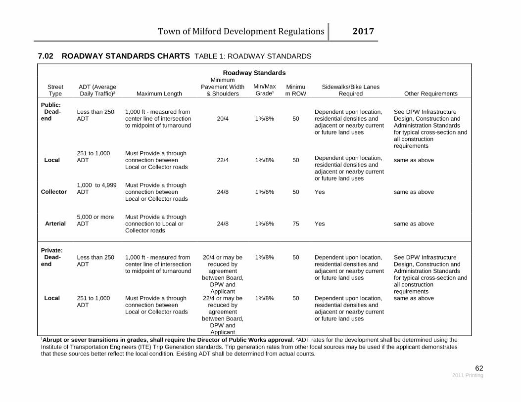
Town of Milford Development Regulations 2017
62 2011 Printing
7.02 ROADWAY STANDARDS CHARTS TABLE 1: ROADWAY STANDARDS
Roadway Standards
Street Type
ADT (Average Daily Traffic)² Maximum Length
Minimum Pavement Width
& Shoulders Min/Max Grade¹
Minimum ROW
Sidewalks/Bike Lanes Required Other Requirements
Public: Dead-end
Less than 250 ADT
1,000 ft - measured from center line of intersection to midpoint of turnaround
20/4 1%/8% 50 Dependent upon location, residential densities and adjacent or nearby current or future land uses
See DPW Infrastructure Design, Construction and Administration Standards for typical cross-section and all construction requirements
Local
251 to 1,000 ADT
Must Provide a through connection between Local or Collector roads
22/4 1%/8% 50 Dependent upon location, residential densities and adjacent or nearby current or future land uses
same as above
Collector
1,000 to 4,999 ADT
Must Provide a through connection between Local or Collector roads
24/8 1%/6% 50 Yes same as above
Arterial 5,000 or more ADT
Must Provide a through connection to Local or Collector roads
24/8 1%/6% 75 Yes same as above
Private: Dead-end
Less than 250 ADT
1,000 ft - measured from center line of intersection to midpoint of turnaround
20/4 or may be reduced by agreement
between Board, DPW and Applicant
1%/8% 50 Dependent upon location, residential densities and adjacent or nearby current or future land uses
See DPW Infrastructure Design, Construction and Administration Standards for typical cross-section and all construction requirements
Local 251 to 1,000 ADT
Must Provide a through connection between Local or Collector roads
22/4 or may be reduced by agreement
between Board, DPW and Applicant
1%/8% 50 Dependent upon location, residential densities and adjacent or nearby current or future land uses
same as above
¹Abrupt or sever transitions in grades, shall require the Director of Public Works approval. ²ADT rates for the development shall be determined using the Institute of Transportation Engineers (ITE) Trip Generation standards. Trip generation rates from other local sources may be used if the applicant demonstrates that these sources better reflect the local condition. Existing ADT shall be determined from actual counts.

Town of Milford Development Regulations 2017
63 2011 Printing
Table 2: Geometric and Structural Guides for Roadways
Geometric & Structural Guides for Roads
Roadway Types
Gravel (Private
Only) Dead-end Local Collector Arterial
Average Daily Traffic Count (ADT) 0-50 0-250 251-1,000 1,001-4,999 5,000+
Pavement Width Minimum 20' 20' 22' 24' 24'
Shoulder Width 4' 4' 4' 8' 8'
Pavement 1.5" ATG¹
Binder Course N/A 2 1/2" 2 1/2" 2 1/2" 2 1/2"
Finish Wearing Course N/A 1 1/2" 1 1/2" 1 1/2" 1 1/2"
Slope of Roadway (min/max)² 1%/8% 1%/8% 1%/8% 1%/6% 1%/6%
Minimum Centerline Radii 100 ft 100 ft 200 ft 300 ft 400 ft
Base Course Gravel Depth 16" 16" 16" 16" 24"
Finish Course Depth 11/2" Crushed Gravel 8" 8" 8" 8" 8" ¹ADT = Asphalt Treaded Gravel of not less than 1 gallon asphalt per square yard.
²Abrupt or sever changes in grades shall require the Director of Public Works approval.
Note: These guides are intended to apply to both public and private roadways.
7.03 SIDEWALKS The Planning Board may require sidewalks for pedestrian traffic to provide a connection between the main entrances of business, housing or industrial establishments, parking areas and along public roadways. The Planning Board may also require sidewalks from the road to the main building entrance or along the road frontage if there is a reasonable expectation pedestrian patrons, residents, neighbors, children, shoppers or employees would be traveling to or from the site. All sidewalks adjacent to parking areas or access drives shall be at least six inches (6) above grade and curbed with vertical granite curbing. All sidewalks shall include a means for handicapped access and comply with ADA standards. Design details and construction standards for sidewalks can be found in the Department of Public Works Infrastructure Design, Construction & Administration Standards.

Town of Milford Development Regulations 2017
64 2011 Printing
ARTICLE VIII: PERFORMANCE AND MAINTENANCE SECURITIES 8.01 POSTING OF PERFORMANCE SECURITIES A. At the discretion of the Planning Board, Community Development Director and the Director of Public
Works, all proposed Commercial, Industrial and Residential development shall require completion assurances to cover costs such as, but limited to, the following: drainage, landscaping, work involving public ways or utilities, offsite improvements, paving, erosion control measures, bounds and other areas that may be deemed necessary.
B. The Planning Board will accept the following methods of posting a performance security:
1. Cash deposited with the Town Finance Director 2. A bond issued by a guarantee company authorized to do business within the State of New
Hampshire, in an amount and manner acceptable to the Planning Board 3. An irrevocable letter of credit in an amount and manner acceptable to the Planning Board after
consultation with Town Counsel C. A performance or maintenance security is required to be sufficient to cover the cost of all construction
and improvements; including materials, labor and inspections. D. Performance securities shall be submitted to the Town prior to the construction of any road, utility
work, and public improvement or to obtaining a building permit on a new road.
E. Proper performance or maintenance securities shall be maintained at all times by the developer or successor in interest. A developer or successor in interest’s insolvency, commencement of foreclosure proceedings against, appointment of a receiver or petition into bankruptcy shall constitute default of security and shall entitle the Planning Board to draw upon any Letter of Credit or other securities unless reasonable and comparable assurances regarding the completion of all improvements have been provided to the Town.
F. Failure to maintain proper completion assurances shall result in the denial of a Certificate of
Occupancy and the revocation of all building permits outstanding for the subdivision. This does not pertain to any lots within the subdivision that have previously received a Certificate of Occupancy.
8.02 RELEASE OF PERFORMANCE SECURITIES Upon inspection of a partial completion of required improvements, the Community Development Department may authorize in writing for approval by the Board of Selectmen, a reduction in the performance security equal to the work completed. The Town shall retain sufficient funds for the current cost to complete the remaining improvements and inspections plus a ten (10%) percent retainage, as indicated by a qualified contractor’s bid estimate approved by the Planning Board. If the costs for completing the required improvements exceeds the amount of the performance security held by the Town, additional funds shall be required by the Planning Board in order to ensure completion before the

Town of Milford Development Regulations 2017
65 2011 Printing
development proceeds any further. The retainage shall be held until the completion of all required improvements have been inspected and approved by the Planning Board. Should progress toward the completion of all required improvements fall substantially behind the approved phasing schedule or reasonable timetable, the Planning Board may obtain a completion cost estimate from the developer’s contractor or a qualified contractor of the Planning Board’s choice. If the estimated completion costs exceed the amount of the performance security posted with the Town, the developer shall post an additional performance security as is necessary to complete the required improvements. The developer shall post such security within 30-days of the notice thereof. The final release of the performance security (or balance thereof) shall be released when:
A. The Director of Public Works has certified completion of all required site improvements in accordance with the approved plan,
B. Complete As-Builts has been submitted and approved, C. A maintenance security (if necessary) has been received by DPW, and; D. All easements, deeds and required legal documentation has been submitted by the applicant and
reviewed by Town Counsel (as necessary) and approved by the Director of Community Development.
Please see APPENDIX VI: ROADWAY ACCEPTANCE INFORMATION for complete road acceptance guidelines. 8.03 MAINTENANCE SECURITIES For public improvements within the Town right-of-way, or for roads intended to be turned over to the Town, the Board will not release the performance security until a maintenance security is in place. The maintenance security will cover the maintenance of public roads and other public improvements for a period of one (1) year from the date of road acceptance by the Board of Selectmen. The amount will be two (2%) percent of the original total performance security unless otherwise determined by the Director of Public Works. All Road Maintenance Bonds are held by the Department of Public Works. If repair or unusual maintenance is needed or additional improvements are required then such costs as are necessary shall be drawn against said security.
ARTICLE IX: EXPIRATION, ENFORCEMENT, FINES, PENALTIES AND APPEALS
9.01 ENFORCEMENT These regulations shall be enforced by the Planning Board or its duly authorized enforcement authority. Should the Planning Board or its duly authorized enforcement authority determine that an applicant is proceeding contrary to these regulations or the terms of the approved site plan or subdivision plan signed by the applicant and Planning Board, the Planning Board or its authorized representative shall notify the applicant in writing of the specifics of such violation(s) and the appropriate steps, including a timetable, for remedying said violation(s). This notification procedure shall, if deemed appropriate by the
Town of Milford Development Regulations 2017
66 2011 Printing
enforcement authority, include the issuance of a “cease and desist order”. The Town or its representatives has the authority to enter the premises, to cause the violation to be abated and to recover any direct or indirect expenses thereby incurred. 9.02 FINES AND PENALTIES Any person, firm, or corporation violating the provisions of these regulations or the terms of an approved site plan or subdivision plan, shall be subject to a civil penalty for each day that such a violation(s) is found to continue after the conviction date or after the date on which the violator receives written notice from the municipality that he is in violation, whichever is earlier. Whoever, being the owner or representative of the owner of any land located within a subdivision, including condominium conversion, transfers or sells a lot of a subdivision, before such lot has been approved by the Planning Board and recorded or filed in the office of the appropriate Registrar of Deeds shall forfeit and pay a penalty of one hundred ($100) dollars for each lot or parcel so transferred or sold; and the description by metes and bounds in the instrument of transfer or other document used in the process of selling or transferring shall not exempt the transaction from such penalties. Said municipality, through its solicitor or other official designated by its counsel may enjoin such transfer or sale or agreement and may recover the said penalty by civil action. 9.03 APPEALS Any person(s) aggrieved by any decision of the Planning Board concerning an application may present to the Superior Court a petition, duly verified, setting forth that such decision is illegal or unreasonable in whole or in part and specifying the grounds upon which the same is claimed to be illegal or unreasonable. Such petition shall be presented to the court within 30-days after the Planning Board’s final decision regarding the application in question.
ARTICLE X: FEES 10.01 APPLICATION FEES A set schedule of application fees shall be set by the Planning Board after due notice and public hearing. A current listing of this schedule is available in the Community Development office. 10.02 ADMINISTRATIVE AND OTHER FEES Reasonable fees may be imposed by the Planning Board to cover its administrative expenses and the costs of special investigative studies, review of documents, filing and recording fees and other matters which may be required by particular applications. 10.03 PUBLIC NOTICES AND HEARING FEES All costs of notice whether mailed, posted or published shall be paid in full by the applicant. Failure to pay such costs shall constitute valid grounds for the Planning Board to terminate further consideration and to disapprove the application without a public hearing.
Town of Milford Development Regulations 2017
67 2011 Printing
10.04 INSPECTION SERVICE FEE For all site improvements required as part of any approval by the Planning Board, including but not limited to road construction, utility installation, drainage structures and the installation of erosion and sediment control measures, there shall be deposited an inspection fee prior to final Planning Board approval. This fee shall cover the cost of inspection services to be provided by a Town appointed inspector (or his designated representative). Town’s inspector shall monitor and inspect all required site improvements for compliance with the approved plans and required engineering standards. The amount of said fee shall be determined by the Community Development Department based upon a reasonable estimate of anticipated inspection costs. All estimates shall be provided by the applicant and may be subject to review by the Town Engineer or consultant. Site inspections shall be conducted for up to the amount of the fee collected. Should the inspection fee collected be insufficient to cover the remaining required site inspections, the Town will notify the developer to cease further site development until additional funds have been deposited with the Town. Once all required site development and all required site inspections have been completed, any unused portion of the inspection fee shall be returned to the applicant upon approval by the BOS.

Town of Milford Development Regulations 2017
68
ARTICLE XI: APPENDICES APPENDIX I: CHECKLISTS (2014) A. MINOR SITE PLAN CHECKLIST
B. MAJOR SITE PLAN CHECKLIST
C. MINOR SUBDIVISION CHECKLIST
D. MAJOR SUBDIVISION CHECKLIST
E. STORMWATER PERMIT CHECKLIST
APPENDIX II: MAJOR SUBDIVISION PROCESS APPENDIX III: OPEN SPACE SUBDIVISION FLOWCHART
APPENDIX IV: ENVIRONMENTAL STUDY
APPENDIX V: SECURITIES SUBMISSION DOCUMENTATION A. CASH B. BOND C. IRREVOCABLE LETTER OF CREDIT
APPENDIX VI: ROADWAY ACCEPTANCE INFORMATION
APPENDIX VII: TOWN DOCUMENT RESOURCES LIST

69
TOWN OF MILFORD, NH Application Checklist
MINOR SITE PLAN Minor Site Plan: An application of six hundred (600) square feet, or less, of additional building space.
For any boxes under “Required” checked “No” please submit written justification if the reasons are not apparent. This checklist is for administrative efficiency. It does not take the place of the comprehensive requirements of the Development Regulations, nor does it preclude the Board from requesting additional information if deemed necessary for making an informed decision.
Waiver Requests: Provide written justification for any waiver requests, citing the appropriate section number of the regulations. Waiver Forms are available at the Community Development Office or online at: http://www.milford.nh.gov.
If you have any questions please contact the Community Development office at (603) 249-0620.
Name of Application ____________________________________________________________________________________
Map(s) _______________________________ Lot(s) _________________________________ Required Submitted Waived YES NO General Submission Requirements YES NO 1. Complete, signed Application 2. Four (4) large 22” x34” copies and one (1) reduced 11” x
17” copy
Plan Information
A. Name, address & signature of applicant B. Name, address & signature of owner (if different from
applicant)
C. Name & address of person/firm preparing plan D. Names & address of all abutters E. North arrow F. Scale G. Date Prepared H. Locus map I. Property boundary lines with distances and angles to scale J. Lot area, frontage & associated minimum zoning
requirements
K. Current zoning of property L. All existing buildings, parking & driveways M. Building setback lines
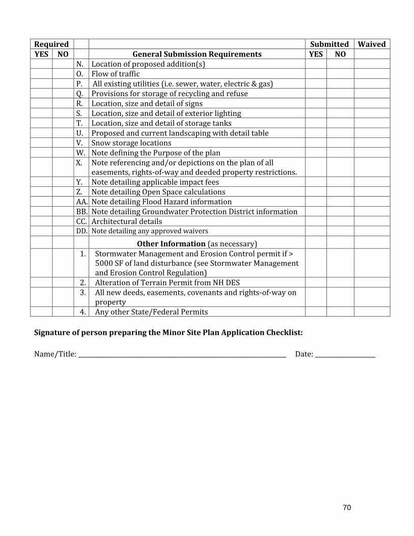
70
Required Submitted Waived YES NO General Submission Requirements YES NO N. Location of proposed addition(s) O. Flow of traffic P. All existing utilities (i.e. sewer, water, electric & gas) Q. Provisions for storage of recycling and refuse R. Location, size and detail of signs S. Location, size and detail of exterior lighting T. Location, size and detail of storage tanks U. Proposed and current landscaping with detail table V. Snow storage locations W. Note defining the Purpose of the plan X. Note referencing and/or depictions on the plan of all
easements, rights-of-way and deeded property restrictions.
Y. Note detailing applicable impact fees Z. Note detailing Open Space calculations AA. Note detailing Flood Hazard information BB. Note detailing Groundwater Protection District information CC. Architectural details DD. Note detailing any approved waivers Other Information (as necessary) 1. Stormwater Management and Erosion Control permit if >
5000 SF of land disturbance (see Stormwater Management and Erosion Control Regulation)
2. Alteration of Terrain Permit from NH DES 3. All new deeds, easements, covenants and rights-of-way on
property
4. Any other State/Federal Permits Signature of person preparing the Minor Site Plan Application Checklist: Name/Title: _____________________________________________________________________ Date: ____________________
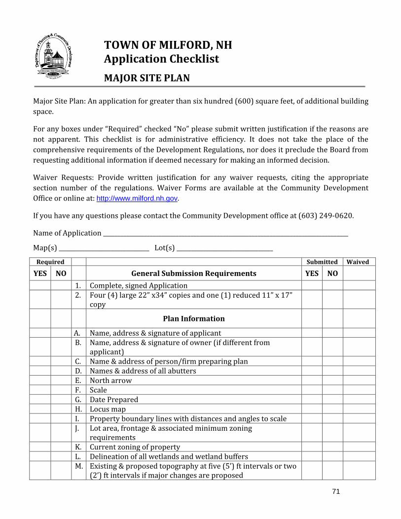
71
TOWN OF MILFORD, NH Application Checklist
MAJOR SITE PLAN Major Site Plan: An application for greater than six hundred (600) square feet, of additional building space.
For any boxes under “Required” checked “No” please submit written justification if the reasons are not apparent. This checklist is for administrative efficiency. It does not take the place of the comprehensive requirements of the Development Regulations, nor does it preclude the Board from requesting additional information if deemed necessary for making an informed decision.
Waiver Requests: Provide written justification for any waiver requests, citing the appropriate section number of the regulations. Waiver Forms are available at the Community Development Office or online at: http://www.milford.nh.gov.
If you have any questions please contact the Community Development office at (603) 249-0620.
Name of Application ____________________________________________________________________________________
Map(s) _______________________________ Lot(s) _________________________________
Required Submitted Waived
YES NO General Submission Requirements YES NO 1. Complete, signed Application 2. Four (4) large 22” x34” copies and one (1) reduced 11” x 17”
copy
Plan Information
A. Name, address & signature of applicant B. Name, address & signature of owner (if different from
applicant)
C. Name & address of person/firm preparing plan D. Names & address of all abutters E. North arrow F. Scale G. Date Prepared H. Locus map I. Property boundary lines with distances and angles to scale J. Lot area, frontage & associated minimum zoning
requirements
K. Current zoning of property L. Delineation of all wetlands and wetland buffers M. Existing & proposed topography at five (5’) ft intervals or two
(2’) ft intervals if major changes are proposed

72
Required Submitted Waived YES NO General Submission Requirements YES NO N. Scaled roadway centerline at 50’ increments for rural areas
and 10’increments in the Urbanized/Oval Sub-Dist area
O. Location of buildings within 50 ft P. Location of all roads or driveways within 200 ft Q. Locations of infiltrating drainage systems within 200ft R. Existing access roads, recreational trails and boundaries
(such as stone walls, barbed wire, etc.)
S. Existing & proposed buildings, driveways, sidewalks, parking spaces, loading areas, significant trees, vegetated areas, open drainage courses & service areas
T. Building setback lines U. Flow of traffic V. Provisions for storage of recycling and refuse W. Location, size and detail of signs X. Location, size and detail of exterior lighting Y. Location, size and detail of storage tanks Z. Snow storage locations AA. Note defining the Purpose of the plan BB. Note detailing Open Space calculations CC. Brief history of the property (i.e. previous disturbances) DD. General description of existing characteristics such as:
developed, productive farmland, meadow, forest, viewshed, archeological site, areas contiguous with other open space and wildlife corridors.
EE. Brief description of drainage upstream onto property and discharge downstream from property
FF. Note detailing applicable impact fees GG. A note indicating: “Water, sewer, road (including parking
lot) and drainage work shall be constructed in accordance with the Town of Milford’s Water Utilities Department and Public Works Department Standards.”
HH. A note indicating: “As-built plans shall be delivered to the Building Department prior to a Certificate of Occupancy being issued.”
II. Note detailing Groundwater Protection District information JJ. Note referencing and delineations on the plan of all
easements, rights-of-way and deeded property restrictions.
KK. Landscaping Plan LL. Stormwater Management and/or Erosion Control Plan MM Architectural plans and details NN. Utility Plan OO. Note detailing any approved waivers PP. Note detailing Flood Hazard information
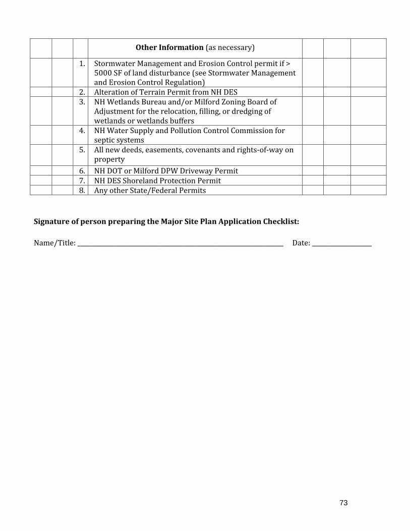
73
Other Information (as necessary)
1. Stormwater Management and Erosion Control permit if > 5000 SF of land disturbance (see Stormwater Management and Erosion Control Regulation)
2. Alteration of Terrain Permit from NH DES 3. NH Wetlands Bureau and/or Milford Zoning Board of
Adjustment for the relocation, filling, or dredging of wetlands or wetlands buffers
4. NH Water Supply and Pollution Control Commission for septic systems
5. All new deeds, easements, covenants and rights-of-way on property
6. NH DOT or Milford DPW Driveway Permit 7. NH DES Shoreland Protection Permit 8. Any other State/Federal Permits Signature of person preparing the Major Site Plan Application Checklist: Name/Title: _____________________________________________________________________ Date: ____________________
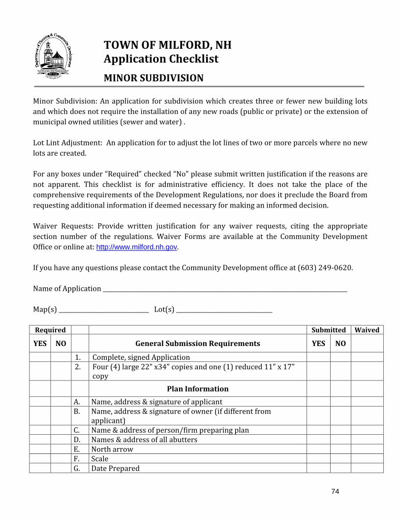
74
TOWN OF MILFORD, NH Application Checklist
MINOR SUBDIVISION Minor Subdivision: An application for subdivision which creates three or fewer new building lots and which does not require the installation of any new roads (public or private) or the extension of municipal owned utilities (sewer and water) . Lot Lint Adjustment: An application for to adjust the lot lines of two or more parcels where no new lots are created. For any boxes under “Required” checked “No” please submit written justification if the reasons are not apparent. This checklist is for administrative efficiency. It does not take the place of the comprehensive requirements of the Development Regulations, nor does it preclude the Board from requesting additional information if deemed necessary for making an informed decision. Waiver Requests: Provide written justification for any waiver requests, citing the appropriate section number of the regulations. Waiver Forms are available at the Community Development Office or online at: http://www.milford.nh.gov. If you have any questions please contact the Community Development office at (603) 249-0620. Name of Application ____________________________________________________________________________________ Map(s) _______________________________ Lot(s) _________________________________ Required Submitted Waived
YES NO General Submission Requirements YES NO
1. Complete, signed Application 2. Four (4) large 22” x34” copies and one (1) reduced 11” x 17”
copy
Plan Information
A. Name, address & signature of applicant B. Name, address & signature of owner (if different from
applicant)
C. Name & address of person/firm preparing plan D. Names & address of all abutters E. North arrow F. Scale G. Date Prepared

75
Required Submitted Waived
YES NO General Submission Requirements YES NO
H. Locus map I. Property boundary lines with distances and angles to scale J. Areas of proposed lots in square feet and acres K. Delineation of all wetlands and wetlands buffers L. Delineation of slopes over twenty-five (25%) percent M. Location of buildings within 50 ft N. Location of all roads or driveways within 200 ft O. Existing access roads, recreational trails and boundaries (such
as stone walls, barbed wire, etc.)
P. Existing & proposed buildings & driveways Q. Current zoning and location of district boundaries if located in
two or more zones
R. Building setback lines S. Flow of traffic T. All existing utilities (i.e. sewer, water, electric & gas) U. Note defining the Purpose of the plan V. Brief history of the property (i.e. previous disturbances) W. General description of existing characteristics such as:
developed, productive farmland, meadow, forest, viewshed, archeological site, areas contiguous with other open space and wildlife corridors.
X. Brief description of drainage upstream onto property and discharge downstream from property
Y. Note detailing Flood Hazard information Z. Note detailing Groundwater Protection District information AA. Note referencing and delineations on the plan of all easements,
rights-of-way and deeded property restrictions.
BB. Deleted (Note referencing the GMO) CC. State of NH Site Specific permit numbers, if required DD. Parcels numbered consecutively with no omissions or
duplications.
EE. Planning Board approval block with space for Chairman’s signature and date, Approval number and Approval date
FF. The seal of a NH Licensed Land Surveyor GG. Note detailing any approved waivers HH. The seal of a NH Licensed Civil Engineer, as necessary II. The seal of a NH Licensed Soil Scientist, as necessary JJ. The seal of a NH Licensed Wetlands Scientist, as necessary

76
Signature of person preparing the Minor Subdivision Application Checklist: Name/Title: _____________________________________________________________________ Date: ____________________
Other Information (as necessary)
1. Stormwater Management and Erosion Control Plan and a permit if > 5000 SF of land disturbance (see Stormwater Management and Erosion Control Regulation)
2. Alteration of Terrain Permit from NH DES 3. State Subdivision approval from NH DES 4. NH Wetlands Bureau and/or Milford Zoning Board of
Adjustment for the relocation, filling, or dredging of wetlands or wetlands buffers
5. NH Water Supply and Pollution Control Commission for septic systems
6. All new deeds, easements, covenants and rights-of-way on property
7. NH DOT or Milford DPW Driveway Permit 8. NH DES Shoreland Protection Permit 9. Any other State/Federal Permits

77
TOWN OF MILFORD, NH Application Checklist
MAJOR SUBDIVISION Major Subdivision: An application which creates four or more new building lots or an application which requires the installation of new roads (public or private) or the extension of municipal owned utilities (sewer and water) .
For any boxes under “Required” checked “No” please submit written justification if the reasons are not apparent. This checklist is for administrative efficiency. It does not take the place of the comprehensive requirements of the Development Regulations, nor does it preclude the Board from requesting additional information if deemed necessary for making an informed decision.
Waiver Requests: Provide written justification for any waiver requests, citing the appropriate section number of the regulations. Waiver Forms are available at the Community Development Office or online at: http://www.milford.nh.gov.
If you have any questions please contact the Community Development office at (603) 249-0620.
Name of Application ____________________________________________________________________________________ Map(s) _______________________________ Lot(s) _________________________________
Required Submitted Waived YES NO General Submission Requirements YES NO
3. Complete, signed Application 4. Four (4) large 22” x34” copies and one (1) reduced 11” x
17” copy
Plan Information A. Name, address & signature of applicant B. Name, address & signature of owner (if different from
applicant)
C. Name & address of person/firm preparing plan D. Names & address of all abutters E. North arrow F. Scale of not more than 1” = 100’. Overview plans may be
1” = 200’
G. Date Prepared H. Current zoning of property I. Lot area in square feet and acres, frontage & associated
minimum zoning requirements
J. Locus map K. Property boundary lines with distances and angles
plotted to scale

78
Required Submitted Waived YES NO General Submission Requirements YES NO
L. Delineation of all wetlands and wetlands buffers M. Delineation of slopes over twenty-five (25%) percent N. Existing & proposed topography at 5 ft intervals or 2 ft
intervals if major changes are proposed
O. Balance sheet of proposed cut and fill quantities P. Scaled roadway centerline at increments of 50’ for rural
areas and 10’ in the Urbanized/Oval Sub-district area
Q. Location of buildings within fifty (50’) feet of property R. Location of all roads or driveways within 200’ of site S. Locations of infiltrating drainage sys within 200’ of
property
T. Existing access roads, recreational trails and boundaries (such as stone walls, barbed wire, etc.)
U. Existing & proposed buildings, driveways & roads on-site V. New roads shall have centerline marked at 50’ intervals W. Building setback lines X. Flow of traffic Y. All existing utilities (i.e. sewer, water, electric & gas) Z. Provisions for storage of recycling and refuse AA. Location, size and detail of signs BB. Location, size and detail of exterior lighting CC. Location, size and detail of storage tanks DD. Note defining the Purpose of the plan EE. Brief history of the property (i.e. previous disturbances) FF. General description of existing characteristics such as:
developed, productive farmland, meadow, forest, viewshed, archeological site, areas contiguous with other open space and wildlife corridors.
GG. Brief description of drainage upstream onto property and discharge downstream from property
HH. Note detailing Flood Hazard information II. Note detailing Groundwater Protection District
information
JJ. Deed references for property KK. Note referencing and/or depictions on the plan of all
easements, rights-of-way and deeded property restrictions.
LL. A note detailing applicable Impact Fees MM. Deleted Note pertaining to GMO NN. A note indicating: “All water, sewer, road (including
parking lot) and drainage work shall be constructed in accordance with the Town of Milford’s Water Utilities Department and Public Works Department Standards.”
OO. A note indicating the ownership of open space
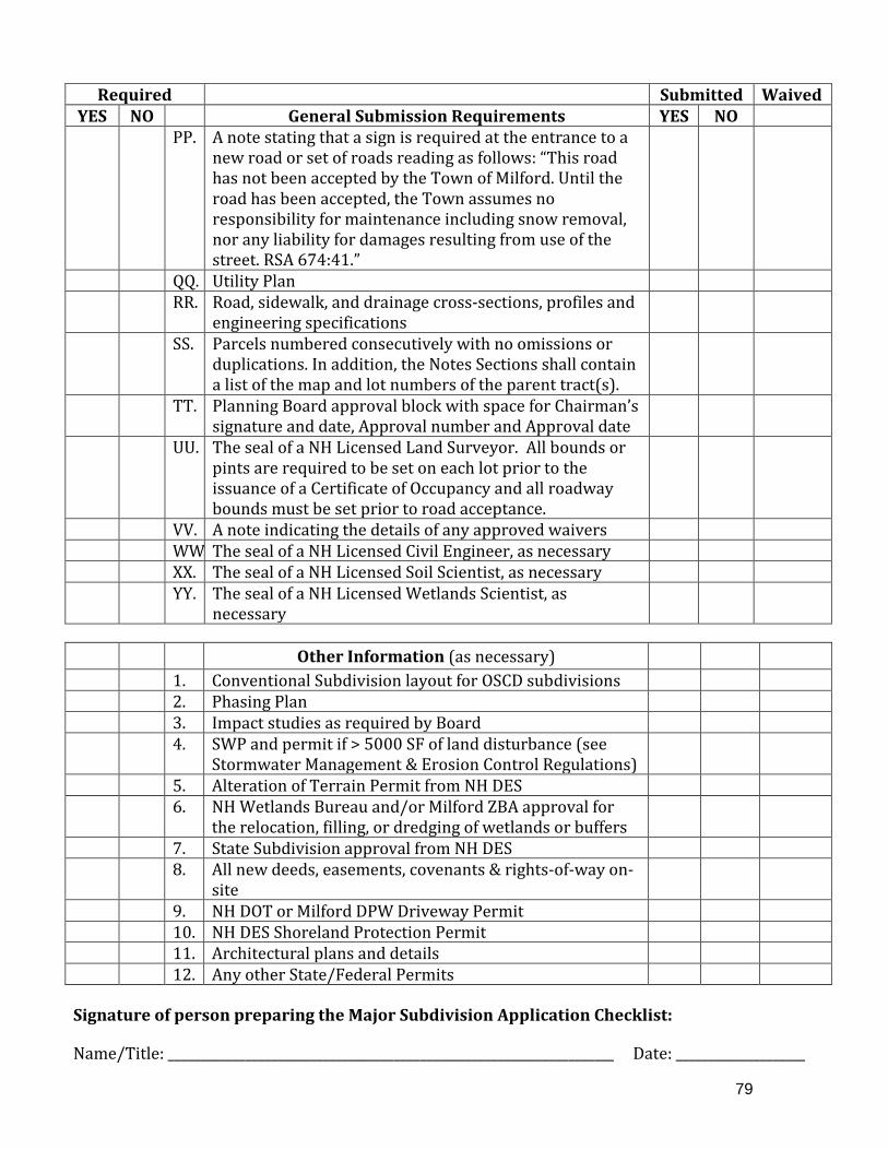
79
Required Submitted Waived YES NO General Submission Requirements YES NO
PP. A note stating that a sign is required at the entrance to a new road or set of roads reading as follows: “This road has not been accepted by the Town of Milford. Until the road has been accepted, the Town assumes no responsibility for maintenance including snow removal, nor any liability for damages resulting from use of the street. RSA 674:41.”
QQ. Utility Plan RR. Road, sidewalk, and drainage cross-sections, profiles and
engineering specifications
SS. Parcels numbered consecutively with no omissions or duplications. In addition, the Notes Sections shall contain a list of the map and lot numbers of the parent tract(s).
TT. Planning Board approval block with space for Chairman’s signature and date, Approval number and Approval date
UU. The seal of a NH Licensed Land Surveyor. All bounds or pints are required to be set on each lot prior to the issuance of a Certificate of Occupancy and all roadway bounds must be set prior to road acceptance.
VV. A note indicating the details of any approved waivers WW The seal of a NH Licensed Civil Engineer, as necessary XX. The seal of a NH Licensed Soil Scientist, as necessary YY. The seal of a NH Licensed Wetlands Scientist, as
necessary
Signature of person preparing the Major Subdivision Application Checklist:
Name/Title: _____________________________________________________________________ Date: ____________________
Other Information (as necessary) 1. Conventional Subdivision layout for OSCD subdivisions 2. Phasing Plan 3. Impact studies as required by Board 4. SWP and permit if > 5000 SF of land disturbance (see
Stormwater Management & Erosion Control Regulations)
5. Alteration of Terrain Permit from NH DES 6. NH Wetlands Bureau and/or Milford ZBA approval for
the relocation, filling, or dredging of wetlands or buffers
7. State Subdivision approval from NH DES 8. All new deeds, easements, covenants & rights-of-way on-
site
9. NH DOT or Milford DPW Driveway Permit 10. NH DES Shoreland Protection Permit 11. Architectural plans and details 12. Any other State/Federal Permits

80
CHECKLIST FOR STORMWATER PERMIT APPLICATIONS THIS CHECKLIST IS TO BE USED AS A GUIDE FOR COMPLYING WITH THE TOWN OF MILFORD STORMWATER MANAGEMENT AND EROSION CONTROL REGULATIONS. A COMPLETED CHECKLIST MUST BE SUBMITTED AS PART OF THE REQUIRED STORMWATER APPLICATION. THE PLANNING BOARD OR CODE ENFORCEMENT OFFICER SHALL MAKE A DETERMINATION TO ACCEPT, REJECT, OR TABLE AN APPLICATION BASED ON BOTH ITS REVIEW AND THE REVIEW AND RECOMMENDATION OF THE COMMUNITY DEVELOPMENT DEPARTMENT.
Please fill out this Checklist thoroughly by checking the appropriate box and providing the necessary information. Provide written justification for any waiver requests (including citing the appropriate section number of the regulations), or for any boxes checked “not applicable” if the reasons are not apparent. A Waiver Request form is available through the Town of Milford website (http://www.milford.nh.gov) or through the Milford Community Development Office. The Milford Stormwater Management and Erosion Control Regulations are available for a fee at the Milford Community Development Office or on the Web at: http://www.milford.nh.gov. If you have any questions, please contact this Office for assistance, at (603) 249-0620. General construction standards for storm drainage, roadways, water, and sanitary sewer are available for a fee at the Department of Public Works, the Water Utilities Department or on the Web at: http://www.milford.nh.gov . NOTE: If greater than 43,560 square feet of disturbance is proposed for any use, the applicant IS REQUIRED to check Federal EPA NPDES permitting requirements. Name of Stormwater Application Map(s) Lot(s)
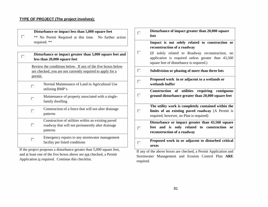
81
TYPE OF PROJECT (The project involves):
Disturbance or impact less than 5,000 square feet ** No Permit Required at this time. No further action required. **
Disturbance or impact greater than 5,000 square feet and less than 20,000 square feet
Review the conditions below. If any of the five boxes below are checked, you are not currently required to apply for a permit.
Normal Maintenance of Land in Agricultural Use utilizing BMP’s
Maintenance of property associated with a single-family dwelling
Construction of a fence that will not alter drainage patterns
Construction of utilities within an exisitng paved roadway that will not permanently alter drainage patterns
Emergency repairs to any stormwater management facility per listed conditions
If the project proposes a disturbance greater than 5,000 square feet, and at least one of the five boxes above are not checked, a Permit Application is required. Continue this checklist.
Disturbance of impact greater than 20,000 square feet
Impact is not solely related to construction or reconstruction of a roadway (If solely related to Roadway reconstruction, no application is required unless greater than 43,560 square feet of disturbance is required.)
Subdivision or phasing of more than three lots
Proposed work in or adjacent to a wetlands or wetlands buffer
Construction of utilities requiring contiguous ground disturbance greater than 20,000 square feet
The utility work is completely contained within the limits of an existing paved roadway (A Permit is required, however, no Plan is required)
Disturbance or impact greater than 43,560 square feet and is only related to construction or reconstruction of a roadway
Proposed work in or adjacent to disturbed critical areas
If any of the above boxes are checked, a Permit Application and Stormwater Management and Erosion Control Plan ARE required.
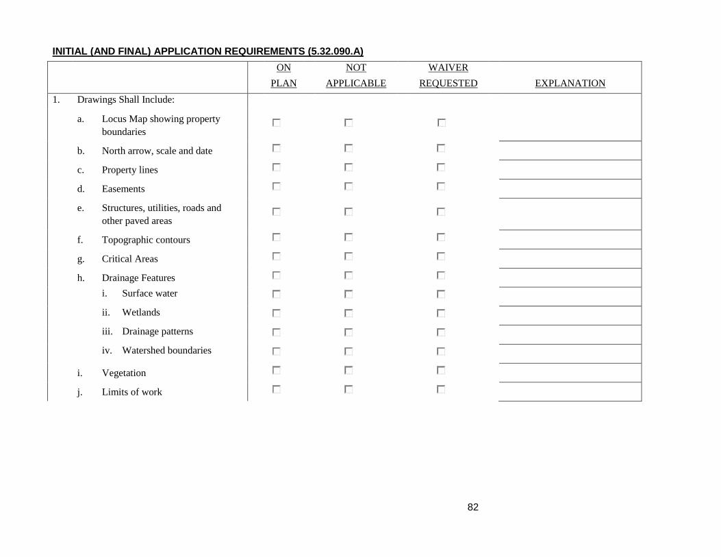
82
INITIAL (AND FINAL) APPLICATION REQUIREMENTS (5.32.090.A) ON
PLAN
NOT APPLICABLE
WAIVER
REQUESTED
EXPLANATION
1. Drawings Shall Include: a. Locus Map showing property
boundaries
b. North arrow, scale and date
c. Property lines
d. Easements
e. Structures, utilities, roads and other paved areas
f. Topographic contours
g. Critical Areas
h. Drainage Features
i. Surface water
ii. Wetlands
iii. Drainage patterns
iv. Watershed boundaries
i. Vegetation
j. Limits of work

83
2. NCSS/SSSNNE Soils information related to highly erodible soils
3. Construction details & application procedures for temporary and permanent stormwater management and erosion and sediment control BMP's
4. Areas and timing of soil disturbance
5. A schedule for self-inspection and maintenance of all BMP's
6. Narrative section including discussion of each measure, its purpose, construction sequence, and installation timing as they apply to the site
7. If no Infiltration or Exfiltration is proposed skip to question 9
a. Test pit information
b. Estimated seasonal high water table elevations
8. Calculations for the infiltration or exfiltration system
9. Any requested studies
10. Name, address, stamp, and signature of
-Licensed Surveyor
-Licensed Civil Engineer
-Licensed Soil Scientist
-Licensed Wetland Scientist

84
ADDITIONAL FINAL APPLICATION REQUIREMENTS (5.32.090.B) (If initial application, skip to question 13) ON
PLAN
NOT APPLICABLE
WAIVER
REQUESTED
EXPLANATION
11. Construction Drawings/Supporting Documents:
a. A project narrative
b. Plan for stump and debris removal
c. Topographic contours at two-foot (2’) intervals
d. Surface waters, wetlands, and drainage patterns and watershed boundaries within the project area and within 200 feet of project boundary
e. Extent of 100-year floodplain boundaries if published or determined
f. Easements
g. Areas of cut and fill
h. Locations of earth stockpiles
i. Locations of equipment storage and staging
j. Locations of proposed construction and/or permanent vehicle or equipment fueling
k. Stump disposal plan
l. Highlighted areas of poorly and very poorly drained soils
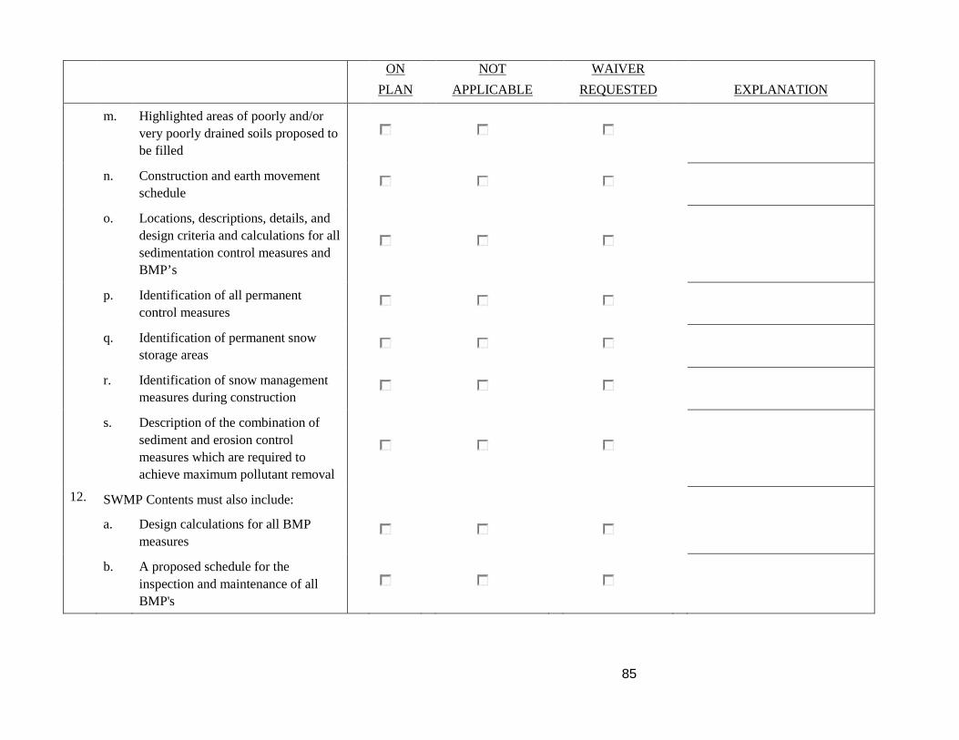
85
ON PLAN
NOT
APPLICABLE
WAIVER REQUESTED
EXPLANATION m. Highlighted areas of poorly and/or
very poorly drained soils proposed to be filled
n. Construction and earth movement schedule
o. Locations, descriptions, details, and design criteria and calculations for all sedimentation control measures and BMP’s
p. Identification of all permanent control measures
q. Identification of permanent snow storage areas
r. Identification of snow management measures during construction
s. Description of the combination of sediment and erosion control measures which are required to achieve maximum pollutant removal
12. SWMP Contents must also include:
a. Design calculations for all BMP measures
b. A proposed schedule for the inspection and maintenance of all BMP's

86
ON PLAN
NOT
APPLICABLE
WAIVER REQUESTED
EXPLANATION c. Identification of all permanent
control measures and responsibility for continued maintenance
d. Drainage report with calculations
e. Plans showing the entire drainage area affecting or being affected by the development of the site. Proposed lot boundaries and drainage areas shall be clearly shown on the plan
f. The direction of flow of runoff
g. The location, elevation, and size of all existing and proposed drainage features
h. When detention structures are planned to reduce future condition peak discharge, the soil cover complex method shall be used to compute the runoff volume and peak discharge for designing the structure
i. Copies of pertinent State and Federal Permits

87
OUTSIDE AGENCY REVIEW, PERMITTING AND APPROVALS Depending on the jurisdiction of outside agency authority, and prior to the acceptance of the Stormwater Application by the Planning Board, the applicant may be required to obtain approvals and permits for various aspects of the development from: REQUIRED COMMENTS
A. Milford Zoning Board of Adjustment B. Milford Conservation Commission C. Milford Water and Sewer Commissioners D. Milford Heritage Commission
E. NH Department of Environmental Services (DES)
1. State subdivision approval 2. Site specific 3. Utility extensions 4. Wetlands dredge and fill
F. NH Department of Transportation (NHDOT) G. US Army Corps of Engineers H. “Regional Impact” review I. Other agencies as required (please list)
Note: Depending upon the type of review and permit, the Planning Board may require that the permit be obtained prior to final approval or as a condition of approval to be met prior to the signing of the final Subdivision or Site plan but not requiring a final meeting with the Planning Board. Signature of person preparing the Stormwater Application Checklist: The Town has the right to deny a permit if any information is missing and that by signing; the applicant is stating the information is accurate to the best of their knowledge. Name / Title Date
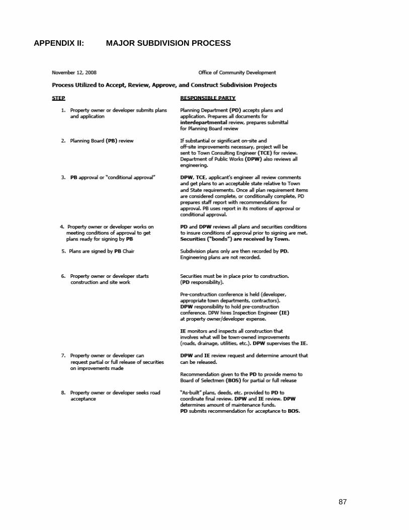
87
APPENDIX II: MAJOR SUBDIVISION PROCESS
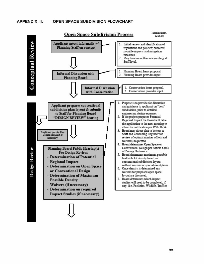
88
APPENDIX III: OPEN SPACE SUBDIVISION FLOWCHART

89
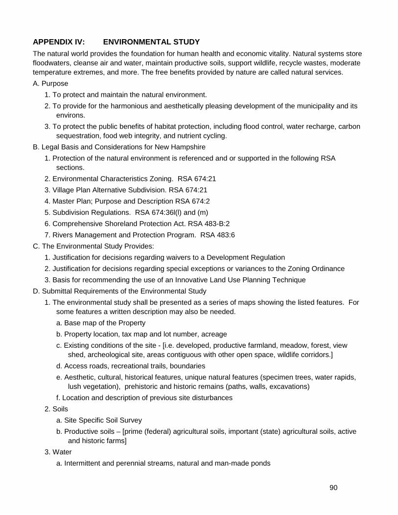
90
APPENDIX IV: ENVIRONMENTAL STUDY The natural world provides the foundation for human health and economic vitality. Natural systems store floodwaters, cleanse air and water, maintain productive soils, support wildlife, recycle wastes, moderate temperature extremes, and more. The free benefits provided by nature are called natural services. A. Purpose
1. To protect and maintain the natural environment. 2. To provide for the harmonious and aesthetically pleasing development of the municipality and its
environs. 3. To protect the public benefits of habitat protection, including flood control, water recharge, carbon
sequestration, food web integrity, and nutrient cycling. B. Legal Basis and Considerations for New Hampshire
1. Protection of the natural environment is referenced and or supported in the following RSA sections.
2. Environmental Characteristics Zoning. RSA 674:21 3. Village Plan Alternative Subdivision. RSA 674:21 4. Master Plan; Purpose and Description RSA 674:2 5. Subdivision Regulations. RSA 674:36l(l) and (m) 6. Comprehensive Shoreland Protection Act. RSA 483-B:2 7. Rivers Management and Protection Program. RSA 483:6
C. The Environmental Study Provides: 1. Justification for decisions regarding waivers to a Development Regulation 2. Justification for decisions regarding special exceptions or variances to the Zoning Ordinance 3. Basis for recommending the use of an Innovative Land Use Planning Technique
D. Submittal Requirements of the Environmental Study 1. The environmental study shall be presented as a series of maps showing the listed features. For
some features a written description may also be needed. a. Base map of the Property b. Property location, tax map and lot number, acreage c. Existing conditions of the site - [i.e. developed, productive farmland, meadow, forest, view
shed, archeological site, areas contiguous with other open space, wildlife corridors.] d. Access roads, recreational trails, boundaries e. Aesthetic, cultural, historical features, unique natural features (specimen trees, water rapids,
lush vegetation), prehistoric and historic remains (paths, walls, excavations) f. Location and description of previous site disturbances
2. Soils a. Site Specific Soil Survey b. Productive soils – [prime (federal) agricultural soils, important (state) agricultural soils, active
and historic farms] 3. Water
a. Intermittent and perennial streams, natural and man-made ponds

91
b. Source of flow, direction, and destination c. Water supply lands, including highly transmissive aquifers identified by the US Geological
Survey and favorable gravel well sites identified by the NH Department of Environmental Services.
d. Flood storage areas, including 100-year floodplains identified by FEMA and lacustrine (associated with lakes), riverine (associated with rivers), and palustrine (other non-tidal) wetlands identified by a Site Specific Soil Survey.
4. Vegetation a. Locations of major plant communities listed in the Wildlife Action Plan; b. Plant species of concern and Rare, Threatened or Endangered (RTE) species. c. Vegetation communities that are unique to the development site.
5. Wildlife a. Identify wildlife species and evidence of wildlife observed in each vegetation community.
Identification may include sightings, calls/sounds, tracks, scat, burrows, browse marks, nests, feathers, bone fragments, etc. Field visits should occur within one hour of sunrise and within one hour of sunset during good weather.
b. Identify presence of wildlife migration areas and corridors, denning, nesting and breeding areas, deer yards.
c. Note presence of snags and significant dead vegetation that may serve as nesting sites for bird species.
d. Note presence of fish, amphibians, and other species associated with wetlands and water bodies located on the site.
e. Note presence of kettle hole depressions and other areas that may function as Vernal Pools. When possible, Vernal Pool surveys shall be conducted during April, May and June.
f. Note animal species of concern and Rare, Threatened or Endangered (RTE) species. E. Environmental Impact Statement
1. Impacts: Describe and quantify impacts to wildlife, habitat and natural services as a result of the site changes.
2. Avoidance: Demonstrate how the proposed development was planned to minimize the destruction of plant and wildlife habitat, including habitat fragmentation.
3. Mitigation: For unavoidable impacts list any measures designed to enhance existing plant and wildlife habitat. Where appropriate, describe any revegetation and restoration that is planned after development and associated monitoring. Revegetation should emphasize plant species indigenous to the region.
4. Recommendations: Propose modifications to the existing plan using innovative land use planning techniques, and conservation strategies to further reduce impacts.
F. Resources 1. Wildlife Action Plan – NH Fish and Game Department www.wildlife.state.nh.us 2. Milford Conservation Commission – Aerial photos, maps of cover types, wetlands, etc. 3. NH Wetlands Bureau – www. des.nh.gov.
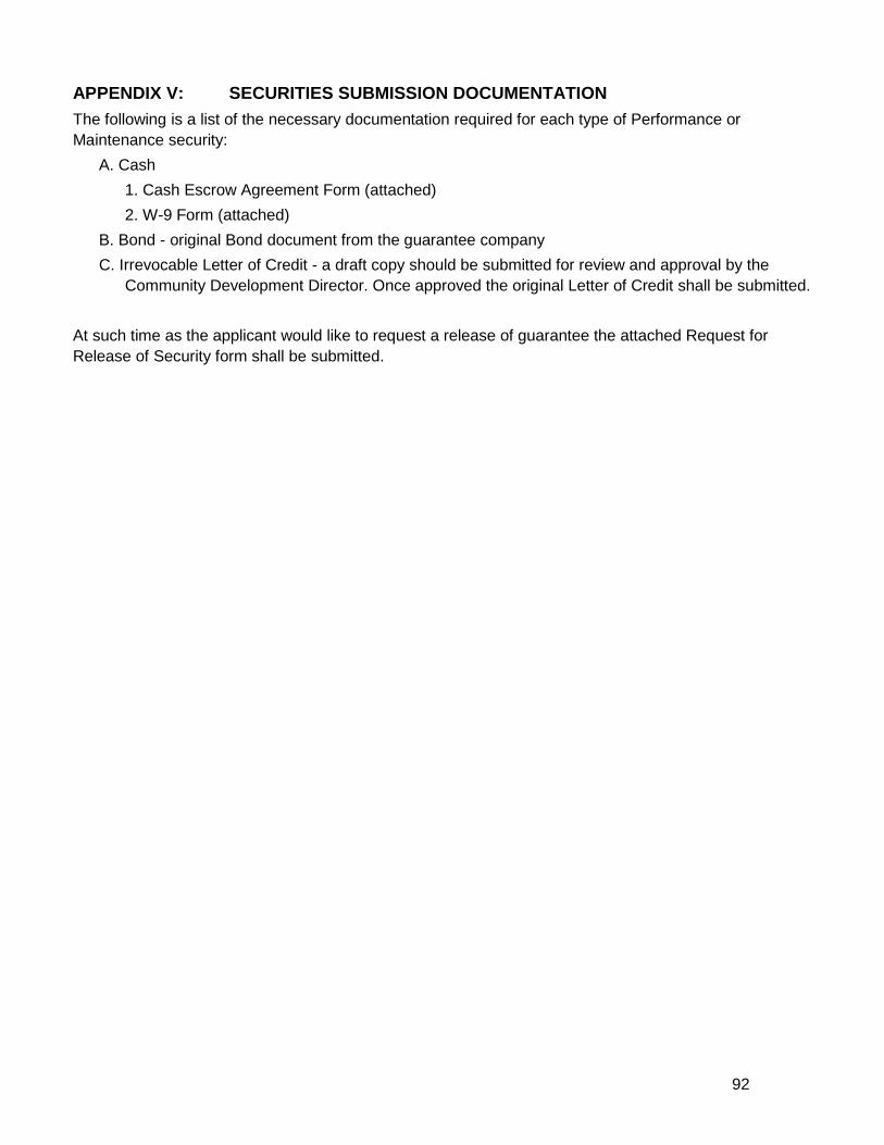
92
APPENDIX V: SECURITIES SUBMISSION DOCUMENTATION The following is a list of the necessary documentation required for each type of Performance or Maintenance security:
A. Cash 1. Cash Escrow Agreement Form (attached) 2. W-9 Form (attached)
B. Bond - original Bond document from the guarantee company C. Irrevocable Letter of Credit - a draft copy should be submitted for review and approval by the
Community Development Director. Once approved the original Letter of Credit shall be submitted. At such time as the applicant would like to request a release of guarantee the attached Request for Release of Security form shall be submitted.

93
Cash Escrow Agreement Form For Subdivision/Site Plan Improvements, Maintenance and Performance Guarantees
and Improvements Subsequent to Certificates of Occupancy
Tax Map No. _______ Lot(s): ________ AS SECURITY for the project described as,
______________________________________________,
outlined and detailed on the attached Subdivision/Site Plan Improvement Guarantee Worksheet,
________________________________________ (applicant / developer) has provided the Town of Milford the sum of $______________________ cash escrow.
These funds shall be deposited in an insured bank account of the Town’s choosing and shall require the approval of the Town of Milford Board of Selectmen and the signature of the Treasurer of the Town of Milford for withdrawal. The undersigned hereby agree and covenant that if, for any reason, they shall fail to carry out the promises and obligations as detailed above by midnight on _________________, the said Town of Milford shall be empowered and shall have the right to withdraw said funds or any part thereof from the aforementioned account, in order that the Town may complete the obligations of the applicant/developer as stated above.
The applicant/developer is required to complete an IRS Form W-9 (Request for taxpayer identification number) to establish an escrow account. ______________________________ Witness
By: _________________________________ Title: ________________________________ Date: ________________________________
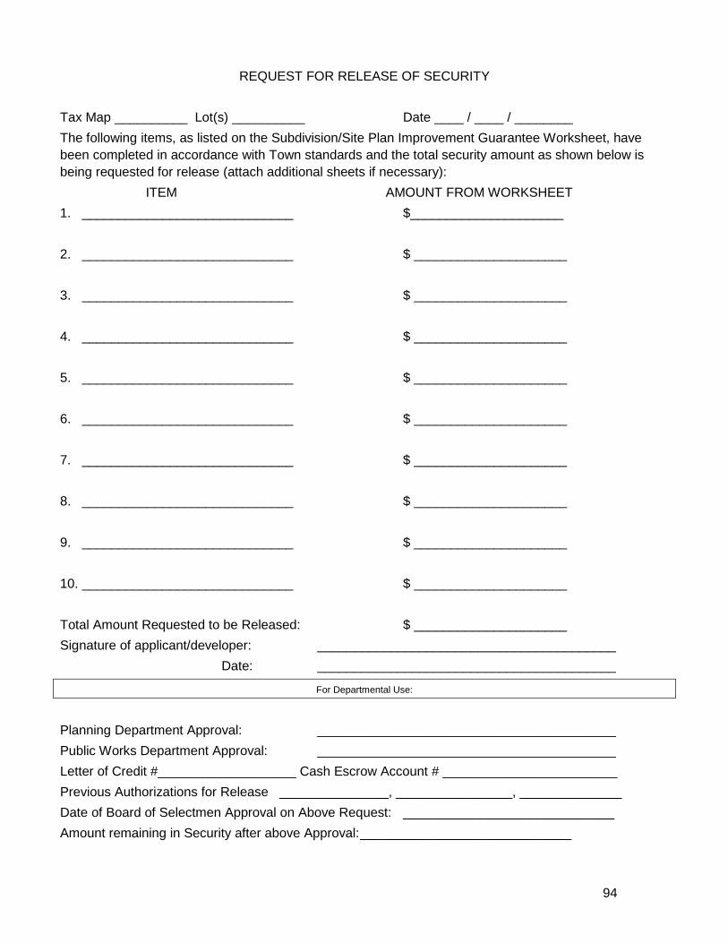
94
REQUEST FOR RELEASE OF SECURITY Tax Map __________ Lot(s) __________ Date ____ / ____ / ________ The following items, as listed on the Subdivision/Site Plan Improvement Guarantee Worksheet, have been completed in accordance with Town standards and the total security amount as shown below is being requested for release (attach additional sheets if necessary): ITEM AMOUNT FROM WORKSHEET 1. _____________________________ $_____________________ 2. _____________________________ $ _____________________ 3. _____________________________ $ _____________________ 4. _____________________________ $ _____________________ 5. _____________________________ $ _____________________ 6. _____________________________ $ _____________________ 7. _____________________________ $ _____________________ 8. _____________________________ $ _____________________ 9. _____________________________ $ _____________________ 10. _____________________________ $ _____________________ Total Amount Requested to be Released: $ _____________________ Signature of applicant/developer: _________________________________________
Date: _________________________________________
For Departmental Use:
Planning Department Approval: _________________________________________ Public Works Department Approval: _________________________________________ Letter of Credit #___________________ Cash Escrow Account # ________________________ Previous Authorizations for Release _______________, ________________, ______________ Date of Board of Selectmen Approval on Above Request: _____________________________ Amount remaining in Security after above Approval: _____________________________
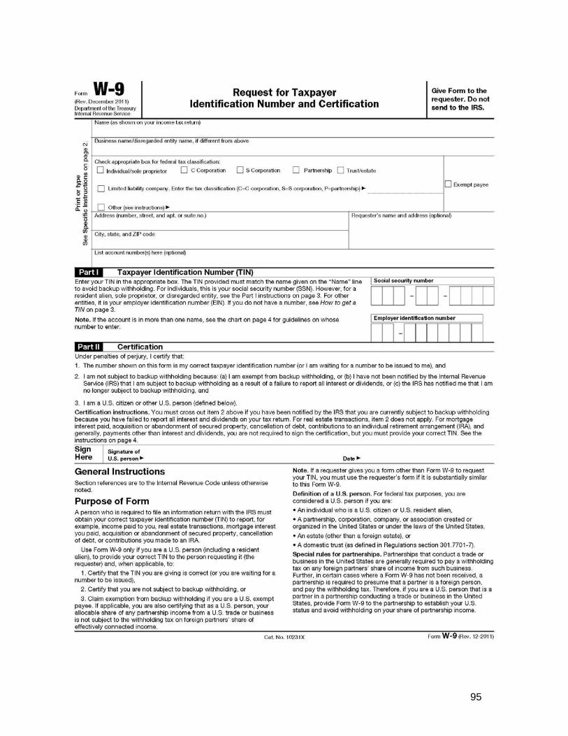
95
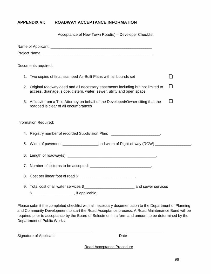
96
APPENDIX VI: ROADWAY ACCEPTANCE INFORMATION
Acceptance of New Town Road(s) – Developer Checklist
Name of Applicant: ________________________________________________
Project Name: ____________________________________________________
Documents required:
1. Two copies of final, stamped As-Built Plans with all bounds set
2. Original roadway deed and all necessary easements including but not limited to access, drainage, slope, cistern, water, sewer, utility and open space.
3. Affidavit from a Title Attorney on behalf of the Developed/Owner citing that the
roadbed is clear of all encumbrances
Information Required:
4. Registry number of recorded Subdivision Plan: _______________________.
5. Width of pavement _________________and width of Right-of-way (ROW) _________________.
6. Length of roadway(s): __________________________________________.
7. Number of cisterns to be accepted: _____________________________.
8. Cost per linear foot of road $___________________________.
9. Total cost of all water services $________________________ and sewer services
$____________________, if applicable.
Please submit the completed checklist with all necessary documentation to the Department of Planning and Community Development to start the Road Acceptance process. A Road Maintenance Bond will be required prior to acceptance by the Board of Selectmen in a form and amount to be determined by the Department of Public Works. Signature of Applicant Date
Road Acceptance Procedure

97
Once all documents have been completed and submitted to the Planning Department the following steps are taken:
1. Legal Counsel review of Roadway Deeds and As-Builts
2. Road maintenance bond, if required, be in place.
3. Signatures of Planning and Public Works Director
4. All information is compiled into Road Acceptance Form, reviewed by Road Researcher and sent
to the Board of Selectman for approval at a regularly scheduled meeting.
Once the BOS has accepted the road the following needs to be done: 1. Two final copies of As-Builts delivered to the Planning Department.
2. One copy of As-Built is delivered to Lorraine Carson with the original Road Acceptance Form and
any applicable deeds, etc.
3. One copy of As-Built is delivered to DPW.
Copy of all Road Acceptance paperwork, including deeds, is distributed to the following departments: Ambulance, Building, DPW, Fire, Planning, Police, and Water Utilities.
Road Acceptance Time Schedule From the date upon which all documentation, plans, As-Builts, deeds, etc. are received in the Community Development Office, there will be a ten (10) working day period for review prior to submission for acceptance of the road(s) to the next available Board of Selectmen meeting. Should any items be found mission or containing errors or omissions during that review period, an additional seven (7) working day review period will commence from the date of receipt of the corrected document(s), prior to submission for acceptance of the road(s) to the next Board of Selectmen’s meeting.
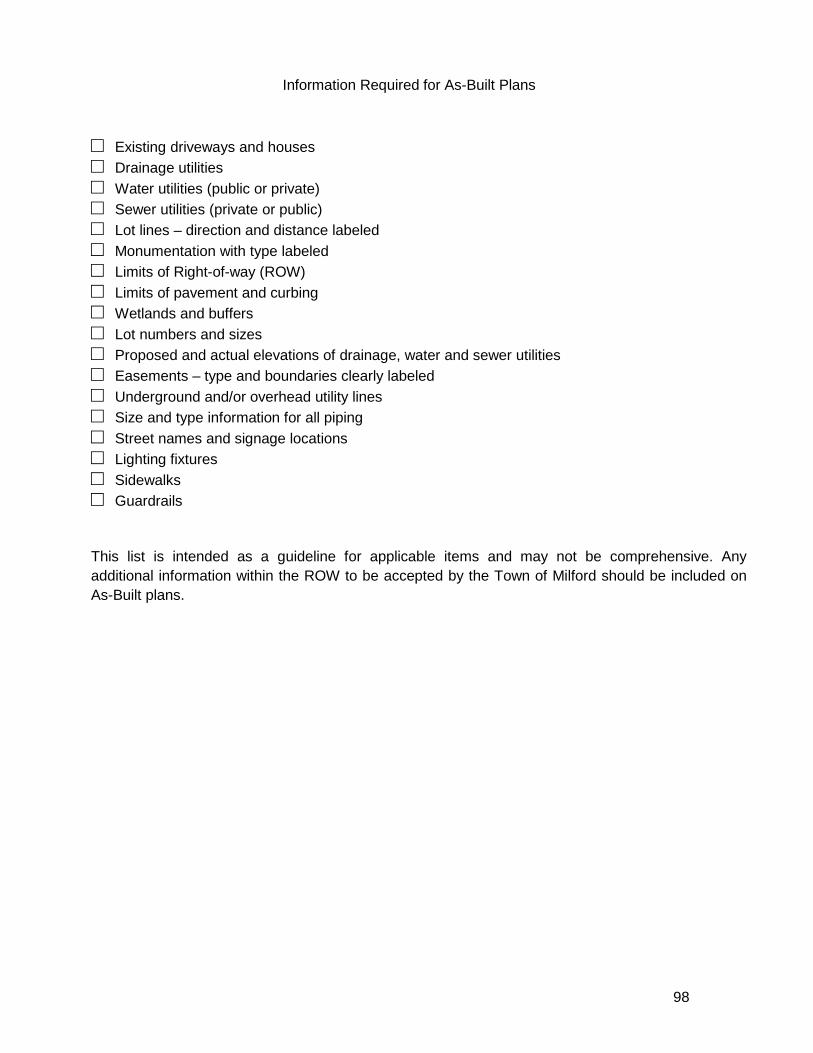
98
Information Required for As-Built Plans □ Existing driveways and houses □ Drainage utilities □ Water utilities (public or private) □ Sewer utilities (private or public) □ Lot lines – direction and distance labeled □ Monumentation with type labeled □ Limits of Right-of-way (ROW) □ Limits of pavement and curbing □ Wetlands and buffers □ Lot numbers and sizes □ Proposed and actual elevations of drainage, water and sewer utilities □ Easements – type and boundaries clearly labeled □ Underground and/or overhead utility lines □ Size and type information for all piping □ Street names and signage locations □ Lighting fixtures □ Sidewalks □ Guardrails This list is intended as a guideline for applicable items and may not be comprehensive. Any additional information within the ROW to be accepted by the Town of Milford should be included on As-Built plans.
99
APPENDIX VII: TOWN DOCUMENT RESOURCES LIST A. Department of Public Works Infrastructure, Design, Construction and Administration Standards –
document available at the Department of Public Works office at 289 South Street or by calling 673-1662.
B. Standard Regulations and Specifications for Design and Construction of Water and Sewer Infrastructure – documents available at the Water Utilities Department at 564 Nashua Street or by calling 249-0660.
C. Stormwater Management and Erosion Control Ordinance – document available in the Community Development office in Town Hall or online through the Planning Department’s website at: www.milford.nh.gov.
D. Gravel Removal Ordinance - document available in the Community Development office in Town Hall or online through the Planning Department’s website at: www.milford.nh.gov.
E. Residential Driveway Permit Regulations – document available in the Community Development office in Town Hall or online through the Planning Department’s website at: www.milford.nh.gov.