Embed Size (px)
Citation preview
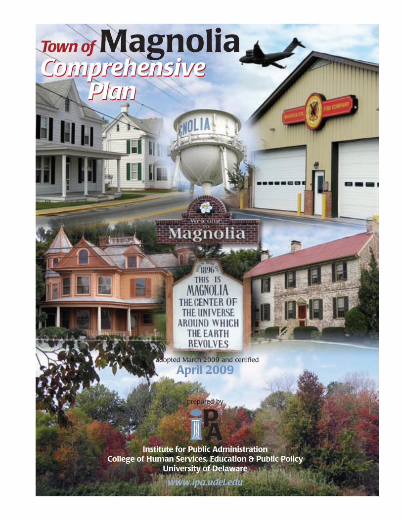
ComprehensivePlan
Town of MagnoliaComprehensive
Plan
prepared by
Institute for Public AdministrationCollege of Human Services, Education & Public Policy
University of Delaware
www.ipa.udel.edu
adopted March 2009 and certified
April 2009
Town of
MagnoliaComprehensive Plan
adopted June 2007adopted March 2009 and certifiedd
April 2009
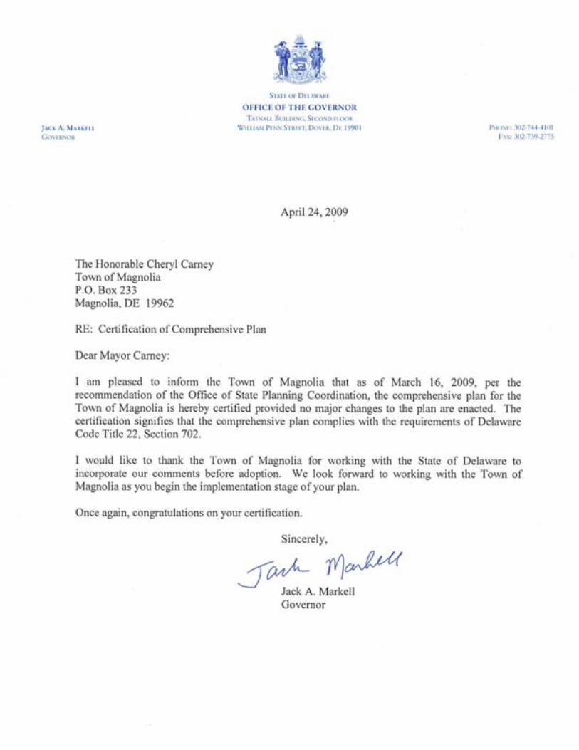
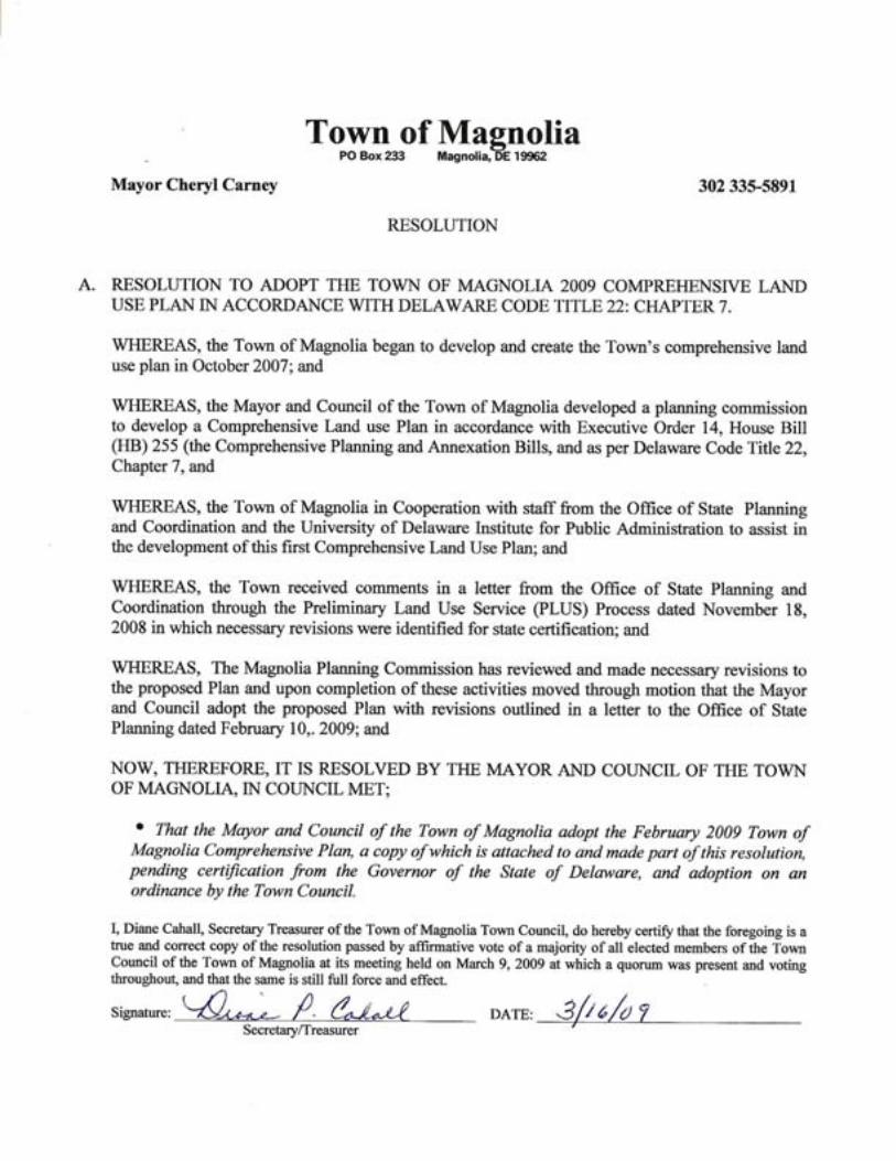
2009 Town of Magnolia Comprehensive Plan
Adopted by the Magnolia Town Council 3/16/09 Certified by the Governor April 24, 2009
TABLE OF CONTENTS Town, County, and State Officials ........................................................................................................... i Institute for Public Administration ......................................................................................................... ii Introduction................................................................................................................................................1 Chapter 1 Background .............................................................................................................................2 1-1. The Authority to Plan ...............................................................................................................2 1-2. Overview of the Community ...................................................................................................3 1-3. Public Participation, Community Vision, and Plan Goals .......................................................5 Chapter 2 Municipal Development Strategy........................................................................................10 2-1. Community Profile .................................................................................................................10 2-2. Housing ..................................................................................................................................17 2-3. Government, Community Services, and Facilities .................................................................21 2-4. Water, Wastewater, and Stormwater Management ................................................................26 2-5. Natural Resources...................................................................................................................32 2-6. Transportation ........................................................................................................................38 2-7. Existing Land Use, Future Land Use, and Annexation ..........................................................43 Chapter 3 Coordination and Implementation .....................................................................................49 3-1. Intergovernmental Coordination.............................................................................................49 3-2. Plan Implementation...............................................................................................................49 Appendix A: April 2008 Town Questionnaire .......................................................................................53 Appendix B: Maps ...................................................................................................................................54
2009 Town of Magnolia Comprehensive Plan i
Adopted by the Magnolia Town Council 3/16/09 Certified by the Governor April 24, 2009
TOWN, COUNTY, AND STATE OFFICIALS Town of Magnolia Current Mayor and Council Mayor and Council – 2007-09 Cheryl Carney, Mayor Ted Barwinski, Mayor Ray Lehman, Vice Mayor Scott Fowler, Vice Mayor Barry Fillman, Council Adam Gillespie, Council James Frazier, Council Patricia Jarrell, Council Patricia Jarrell, Council Ray Lehman, Council
Current Planning Commission Planning Commission – 2007-09 Maria Bennett Maria Bennett Sue Klindienst Cheryl Carney Michael Murray James Frazier Frank Young Sue Klindienst Michael Murray Frank Young Town Secretary Diane Cahall
Town Solicitor Nicholas Rodriguez
Kent County
County Administrator Michael Petit de Mange County Council P. Brooks Banta, President/1st District Allan F. Angel, Vice President/3rd District Bradley S. Eaby, 2nd District Eric L. Buckson, 4th District George Sweeney, 5th District Harold K. Brode, 6th District Richard E. Ennis, At large Department of Planning Services Sarah E. Keifer, AICP, Director State of Delaware
Governor Jack A. Markell Senate Colin R. J. Bonini, 16th District House of Representatives Robert E. Walls, 33rd District Office of State Planning Constance S. Holland, AICP, Director
2009 Town of Magnolia Comprehensive Plan ii
Adopted by the Magnolia Town Council 3/16/09 Certified by the Governor April 24, 2009
INSTITUTE FOR PUBLIC ADMINISTRATION This plan was prepared by the Institute for Public Administration (IPA), a unit within the College of Human Services, Education & Public Policy at the University of Delaware. IPA links the research and resources of the University of Delaware with the management and information needs of local, state, and regional governments in the Delaware Valley. IPA provides assistance to agencies and local governments through direct staff assistance and research projects as well as training programs and policy forums. Jerome R. Lewis is the Director of the Institute. Martin Wollaston manages IPA’s Planning Services Group and coordinated IPA’s role in preparing this document. He coordinated the efforts of IPA’s staff and graduate students, and together they served as IPA’s liaisons with Magnolia’s Planning Commission, Council, and residents. Nicole Minni, GIS Specialist for IPA, assembled the digital data and information and developed all of the maps in this plan. Institute Director Jerome R. Lewis, Ph.D. Town of Magnolia Comprehensive Plan Team Martin Wollaston, Planning Services Manager Amanda Tolino, Research Assistant Rachael Hurley, Research Assistant Megan Lehman, Research Assistant Mapping and GIS Development Nicole Minni, GIS/Graphics Specialist Editorial Review and Cover Design Mark Deshon, Assistant Policy Scientist Staff Review Team Plans developed by IPA are a total team effort, utilizing the individual skills of many of the staff and students working with IPA’s Planning Services Group. In addition to the IPA staff and students listed above, thanks also goes to David Edgell of the Delaware Office of State Planning Coordination for his assistance in guiding the development of this plan.
2009 Town of Magnolia Comprehensive Plan 1
Adopted by the Magnolia Town Council 3/16/09 Certified by the Governor April 24, 2009
A MUNICIPAL COMPREHENSIVE DEVELOPMENT PLAN FOR MAGNOLIA, DELAWARE
February 2009 INTRODUCTION This comprehensive development plan is intended to serve as a document for the future development of the town of Magnolia. When adopted by the Town Council, it will be given official recognition as a guide for future planning efforts of the community and its representatives. The legal means for the implementation of the goals and objectives of this plan are included in zoning codes and other municipal codes and ordinances. This plan is a flexible document, and the updating or revision of planning goals and objectives is essential to keep the planning program responsive to the changing needs of the community. The public’s understanding of the role and contribution to the efforts of the Planning Commission are needed to keep the community’s best interests aligned with the town’s growth and development plans for the future. Community interest and cooperative commitment to practical planning and the timely implementation of the goals and objectives of comprehensive-development planning will contribute to a higher quality of life in Magnolia. The plan is also an informational document for the public. Citizens, business people, and government officials can turn to the plan to learn more about Magnolia and its policies for future land use decisions. Potential new residents can use the documents as an informational resource about the town, including its characteristics and facilities, to help them make decisions about moving to Magnolia. This document contains the most current information on population, transportation, housing, employment, and the environment, which may be of interest to land developers, economic-development professionals, and financiers. Finally, the Town of Magnolia Comprehensive Plan is a legal document. The Delaware Code specifies that “. . . any incorporated municipality under this chapter shall prepare a comprehensive plan for the city or town or portions thereof as the commission deems appropriate.” The code further specifies, “after a comprehensive plan or portion thereof has been adopted by the municipality in accordance with this chapter, the comprehensive plan shall have the force of law and no development shall be permitted except as consistent with the plan.” (§ 702, Title 22, Delaware Code)
2009 Town of Magnolia Comprehensive Plan 2
Adopted by the Magnolia Town Council 3/16/09 Certified by the Governor April 24, 2009
CHAPTER 1. BACKGROUND 1-1. The Authority to Plan Delaware law requires that municipalities engage in comprehensive-planning activities for the purpose of encouraging “the most appropriate uses of the physical and fiscal resources of the municipality and the coordination of municipal growth, development, and infrastructure investment actions with those of other municipalities, counties and the State….” This plan was written to comply with the requirements of a municipal development strategy as described in the Delaware Code (below) for towns with population of 2000 or fewer. The municipal comprehensive plan for small communities (such as Magnolia) with fewer than 2,000 residents is to be a “document in text and maps, containing at a minimum, a municipal development strategy setting forth the jurisdiction’s position on population and housing growth within the jurisdiction, expansion of its boundaries, development of adjacent areas, redevelopment potential, community character, and the general uses of land within the community, and critical community development and infrastructure issues.” In addition, the town’s comprehensive-planning process must demonstrate coordination with other municipalities, the county, and the state during plan preparation. (22 Del. C. 1953, § 702; 49 Del. Laws, c. 415, § 1.) State law requires that planning be an ongoing process and that municipalities identify future planning activities. This document is Magnolia’s municipal comprehensive development plan as required by state law. It is intended to cover a ten-year planning period and be reviewed at least every five years. In May 2007 the Town of Magnolia contacted IPA at the University of Delaware to request assistance with the development of its comprehensive plan. In June 2007 it was agreed that this town plan would be prepared through an agreement with the state Office of Management and Budget. During the next two months, the Town worked to find residents who would be interested in serving on the town Planning Commission to coordinate the development of the plan. In September 2007 IPA assembled a team of professional staff and graduate research assistants to work with the Magnolia Planning Commission and Town Council to cooperatively craft the town’s first comprehensive plan.
2009 Town of Magnolia Comprehensive Plan 3
Adopted by the Magnolia Town Council 3/16/09 Certified by the Governor April 24, 2009
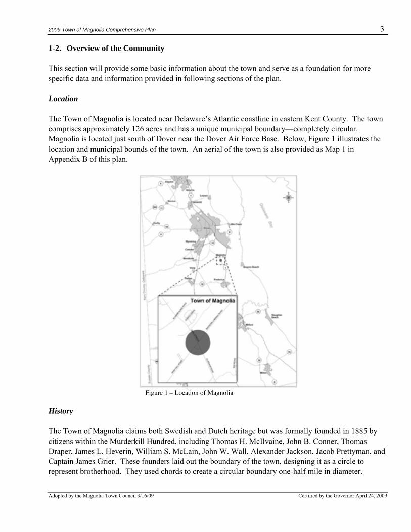
1-2. Overview of the Community This section will provide some basic information about the town and serve as a foundation for more specific data and information provided in following sections of the plan. Location The Town of Magnolia is located near Delaware’s Atlantic coastline in eastern Kent County. The town comprises approximately 126 acres and has a unique municipal boundary—completely circular. Magnolia is located just south of Dover near the Dover Air Force Base. Below, Figure 1 illustrates the location and municipal bounds of the town. An aerial of the town is also provided as Map 1 in Appendix B of this plan.
Figure 1 – Location of Magnolia
History The Town of Magnolia claims both Swedish and Dutch heritage but was formally founded in 1885 by citizens within the Murderkill Hundred, including Thomas H. McIlvaine, John B. Conner, Thomas Draper, James L. Heverin, William S. McLain, John W. Wall, Alexander Jackson, Jacob Prettyman, and Captain James Grier. These founders laid out the boundary of the town, designing it as a circle to represent brotherhood. They used chords to create a circular boundary one-half mile in diameter.
2009 Town of Magnolia Comprehensive Plan 4
Adopted by the Magnolia Town Council 3/16/09 Certified by the Governor April 24, 2009
Magnolia was built approximately one mile from the St. Jones River and, according to folklore, originated because settlers depended on the river, but wanted to escape mosquitoes that accompanied it. The original area where the town is located was known as Caroon Manor, a 3000-acre tract of land owned by the Duke of York. The Magnolia tree was the Duke’s favorite tree, hence, the name of the town. A number of magnolia trees planted throughout the town still exist. The Sons of Liberty played a part in the early legal system in Magnolia and also influenced the designation of a circular town boundary. Churches have made a significant impact on the community of Magnolia. The Magnolia Methodist Church was built in 1856 and is located on Main Street. The church burned down on Pearl Harbor Day (December 7, 1941) when no one responded to the fire whistle because everyone thought the whistle was due to Pearl Harbor being bombed. The church was rebuilt soon afterwards. Motherkill Friends’ Burial Ground, a historic Quaker cemetery, is located adjacent to the town’s northwestern border. This area is known as the “Quaker Graveyard,” dating back to the late 1700s with fieldstones marking the gravesites. The Town of Magnolia was officially recognized by the Delaware General Assembly as an incorporated area on April 3, 1885. There are two locations in Magnolia that appear on the National Register of Historic Places. One location is the John B. Lindale House, a privately owned residence that was built in the early 1900s that has both agricultural and architectural significance and was home to one of the last great peach barons in Delaware. A sign located outside the house proudly boasts:
“This is Magnolia, the center of the universe around which the earth revolves.” The other registered location is the Matthew Lowber House, which also has architectural historical significance. Built in 1774 as a domestic dwelling, this Quaker mansion has brought much publicity to Magnolia with its amazing brickwork and huge sycamore trees. In 1928 Magnolia formed one of the first volunteer fire companies in the state, and in 1931 the Town installed its first water well. In 1957 the Legislature authorized a referendum to be held in Magnolia to decide whether the boundaries of the town should be extended in order to annex previously unincorporated areas. However, due to the limited services provided by the town, residents of the areas in question felt they would simply acquire a greater tax burden with few advantages. The referendum was defeated. Possibly in response to this defeat, the town was reincorporated in 1960 with the scope of the town’s governmental authority greatly expanded. The council, with one member now designated as Mayor, was authorized to provide fire protection and an electrical supply (either directly or by contract), increase its borrowing limits to help finance these services, and establish zoning ordinances to control growth within the town. In 1972 the legislature provided Magnolia’s outlying property owners with the ability to band together and request annexation. However, at present, the town’s boundaries remain unchanged.
2009 Town of Magnolia Comprehensive Plan 5
Adopted by the Magnolia Town Council 3/16/09 Certified by the Governor April 24, 2009
1-3. Public Participation, Community Vision, and Plan Goals As an initial step in the comprehensive-planning process, the Magnolia Town Council formed its first Planning Commission during the summer of 2007. Following the creation of this important group, IPA scheduled a training session held on October 8, 2007, at the Magnolia Volunteer Fire Company, which all members of the Planning Commission and Town Council attended. IPA staff training session instructors were assisted by Dave Edgell from the Office of State Planning Coordination, and the focus was to explain the basic components of a comprehensive plan. The instructors reviewed the requirements for a plan in order to receive state of Delaware certification, reviewed the responsibilities of all of the participants in the planning process, and developed an estimated schedule for this work. The second meeting of the group was held on October 30, 2007, and was termed a community visioning meeting. It was designed to get input from the attendees on the strengths and weaknesses of the town. Everyone participated; and their thoughts were written down and later distilled by IPA staff into a set of goals. The goals are intended to provide guidance to town officials and residents as they develop town policies and make land use decisions that shape the future of the town. A third meeting was held on January 14, 2008, to review the draft goals and further discuss the future vision of the town. The Magnolia Planning Commission and Council then met on March 3rd and 17th (without IPA staff) and decided to mail out a questionnaire to all of the property owners in town to give them another opportunity to express their opinions about the future of the town. The Planning Commission developed a draft questionnaire and forwarded it to IPA for comments. On April 14, 2008, IPA staff met with the Planning Commission and Council members and worked with the group to refine the draft questionnaire developed by these members. On April 18, 2008, the Town mailed the questionnaire (included in Appendix A) with postage-paid return envelopes to every property owner in Magnolia and gave the property owners two weeks to return them. IPA tabulated the results and presented the findings at a public meeting held on May 19, 2008, at the Magnolia Fire Hall. The meeting was well attended by residents of the town and also included representatives of the state Department of Natural Resources and Environmental Control, the state Department of Transportation, and the Office of State Planning and Coordination. This meeting evoked many comments concerning problems facing the town that the residents were looking for assistance to resolve as well as a discussion of issues about the future of Magnolia. The next meeting was held on June 30, 2008. IPA staff presented the initial draft of the plan for discussion. A key part of the plan, the future land use and annexation component, was the main topic of discussion. The Planning Commission and Council met again on July 14, 2008, without IPA, to continue its review of the draft plan and forwarded the items it wanted to have revised in the draft plan to IPA. Everyone met again on September 15, 2008. At the end of the meeting, the Planning Commission voted to approve the forwarding of the draft plan, with amendments resulting from the meeting, to the state for Preliminary Land Use Service (PLUS) review in October 2008. IPA distributed the revised text. Receiving no further comments, the PLUS application was submitted to the state by the first of October.
2009 Town of Magnolia Comprehensive Plan 6
Adopted by the Magnolia Town Council 3/16/09 Certified by the Governor April 24, 2009
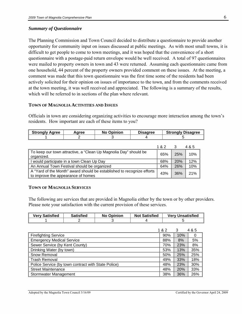
Summary of Questionnaire The Planning Commission and Town Council decided to distribute a questionnaire to provide another opportunity for community input on issues discussed at public meetings. As with most small towns, it is difficult to get people to come to town meetings, and it was hoped that the convenience of a short questionnaire with a postage-paid return envelope would be well received. A total of 97 questionnaires were mailed to property owners in town and 43 were returned. Assuming each questionnaire came from one household, 44 percent of the property owners provided comment on these issues. At the meeting, a comment was made that this town questionnaire was the first time some of the residents had been actively solicited for their opinion on issues of importance to the town, and from the comments received at the town meeting, it was well received and appreciated. The following is a summary of the results, which will be referred to in sections of the plan where relevant. TOWN OF MAGNOLIA ACTIVITIES AND ISSUES Officials in town are considering organizing activities to encourage more interaction among the town’s residents. How important are each of these items to you?
Strongly Agree Agree No Opinion Disagree Strongly Disagree 1 2 3 4 5
1 & 2 3 4 & 5 To keep our town attractive, a “Clean Up Magnolia Day” should be organized. 65% 25% 10%
I would participate in a town Clean Up Day 68% 20% 12% An Annual Town Festival should be organized 64% 26% 10% A “Yard of the Month” award should be established to recognize efforts to improve the appearance of homes 43% 36% 21%
TOWN OF MAGNOLIA SERVICES The following are services that are provided in Magnolia either by the town or by other providers. Please note your satisfaction with the current provision of these services.
Very Satisfied Satisfied No Opinion Not Satisfied Very Unsatisfied 1 2 3 4 5
1 & 2 3 4 & 5
Firefighting Service 90% 10% 0 Emergency Medical Service 88% 8% 5% Sewer Service (by Kent County) 70% 23% 8% Drinking Water (by town) 53% 13% 35% Snow Removal 50% 25% 25% Trash Removal 49% 33% 18% Police Service (by town contract with State Police) 48% 23% 30% Street Maintenance 48% 20% 33% Stormwater Management 38% 36% 26%
2009 Town of Magnolia Comprehensive Plan 7
Adopted by the Magnolia Town Council 3/16/09 Certified by the Governor April 24, 2009
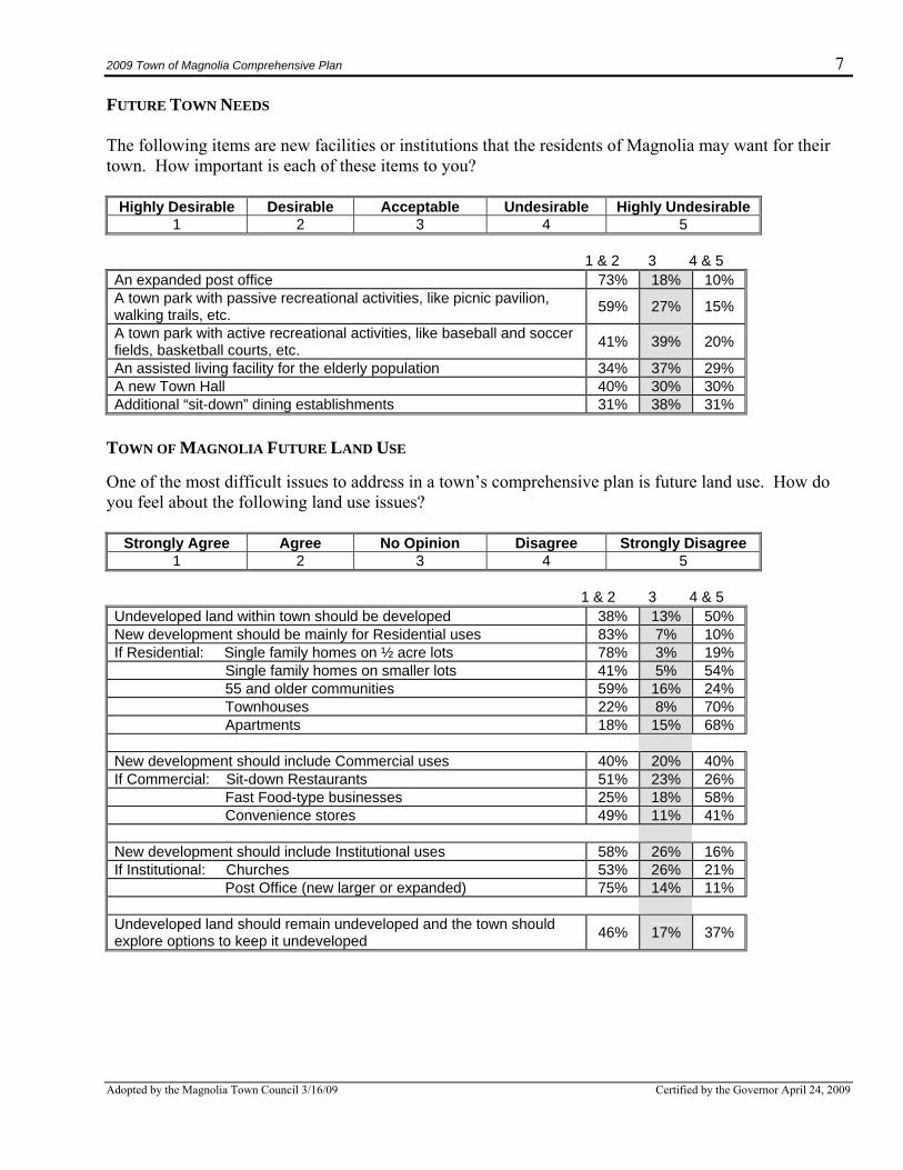
FUTURE TOWN NEEDS The following items are new facilities or institutions that the residents of Magnolia may want for their town. How important is each of these items to you?
Highly Desirable Desirable Acceptable Undesirable Highly Undesirable 1 2 3 4 5
1 & 2 3 4 & 5 An expanded post office 73% 18% 10% A town park with passive recreational activities, like picnic pavilion, walking trails, etc. 59% 27% 15%
A town park with active recreational activities, like baseball and soccer fields, basketball courts, etc. 41% 39% 20%
An assisted living facility for the elderly population 34% 37% 29% A new Town Hall 40% 30% 30% Additional “sit-down” dining establishments 31% 38% 31%
TOWN OF MAGNOLIA FUTURE LAND USE One of the most difficult issues to address in a town’s comprehensive plan is future land use. How do you feel about the following land use issues?
Strongly Agree Agree No Opinion Disagree Strongly Disagree 1 2 3 4 5
1 & 2 3 4 & 5 Undeveloped land within town should be developed 38% 13% 50% New development should be mainly for Residential uses 83% 7% 10% If Residential: Single family homes on ½ acre lots 78% 3% 19% Single family homes on smaller lots 41% 5% 54% 55 and older communities 59% 16% 24% Townhouses 22% 8% 70% Apartments 18% 15% 68% New development should include Commercial uses 40% 20% 40% If Commercial: Sit-down Restaurants 51% 23% 26% Fast Food-type businesses 25% 18% 58% Convenience stores 49% 11% 41% New development should include Institutional uses 58% 26% 16% If Institutional: Churches 53% 26% 21% Post Office (new larger or expanded) 75% 14% 11% Undeveloped land should remain undeveloped and the town should explore options to keep it undeveloped 46% 17% 37%
2009 Town of Magnolia Comprehensive Plan 8
Adopted by the Magnolia Town Council 3/16/09 Certified by the Governor April 24, 2009
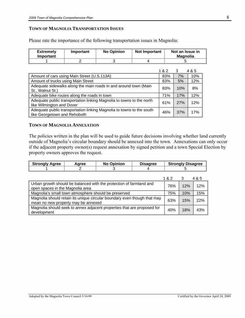
TOWN OF MAGNOLIA TRANSPORTATION ISSUES Please rate the importance of the following transportation issues in Magnolia:
Extremely Important
Important No Opinion Not Important Not an Issue in Magnolia
1 2 3 4 5 1 & 2 3 4 & 5 Amount of cars using Main Street (U.S.113A) 83% 7% 10% Amount of trucks using Main Street 83% 5% 12% Adequate sidewalks along the main roads in and around town (Main St., Walnut St.) 83% 10% 8%
Adequate bike routes along the roads in town 71% 17% 12% Adequate public transportation linking Magnolia to towns to the north like Wilmington and Dover 61% 27% 12%
Adequate public transportation linking Magnolia to towns to the south like Georgetown and Rehoboth 46% 37% 17%
TOWN OF MAGNOLIA ANNEXATION The policies written in the plan will be used to guide future decisions involving whether land currently outside of Magnolia’s circular boundary should be annexed into the town. Annexations can only occur if the adjacent property owner(s) request annexation by signed petition and a town Special Election by property owners approves the request.
Strongly Agree Agree No Opinion Disagree Strongly Disagree 1 2 3 4 5
1 & 2 3 4 & 5 Urban growth should be balanced with the protection of farmland and open spaces in the Magnolia area 76% 12% 12%
Magnolia’s small town atmosphere should be preserved 75% 10% 15% Magnolia should retain its unique circular boundary even though that may mean no new property may be annexed 63% 15% 22%
Magnolia should seek to annex adjacent properties that are proposed for development 40% 18% 43%
2009 Town of Magnolia Comprehensive Plan 9
Adopted by the Magnolia Town Council 3/16/09 Certified by the Governor April 24, 2009
Overall Plan Goals It is important that the Town of Magnolia understands its current character and identity so it can then shape its vision for the future. All town plans contain goals, broad concepts that form the foundation for implementation actions that should follow the completion and adoption of the plan. The following goals are presented as the guiding principles for the future of Magnolia.
• Preserve Magnolia’s traditional, quiet, friendly small-town character and quality of life in ways that coordinate with Kent County designated growth zones.
• Encourage conservation of the town’s historical character and assets through the revision and
increased enforcement of property maintenance ordinances for existing structures, and zoning and subdivision ordinance amendments for guiding new development.
• Continue to provide residents with services and facilities necessary to maintain a good standard of
living and assess opportunities to provide additional services. • Encourage the development of undeveloped parcels within the town boundaries, in accordance
with the character of the town, prior to consideration of annexation of parcels outside the town. • Improve the ability of pedestrians to safely move through the town by reducing the impact of
vehicular travel on the downtown area of Magnolia. • Continue to discuss the potential for future commercial activity in the town, including whether the
commercially zoned area in the center of town is still viable for commercial activity or a commercial area should be developed in another part of town.
• Coordinate regularly scheduled social activities in town, such as bingo nights, dances, or other
gatherings to maintain community spirit and increase civic engagement. • Coordinate with nearby municipalities, Kent County, and the state to mitigate the impacts of
development of surrounding areas on the Town of Magnolia, promoting the preservation of open space when possible.
2009 Town of Magnolia Comprehensive Plan 10
Adopted by the Magnolia Town Council 3/16/09 Certified by the Governor April 24, 2009
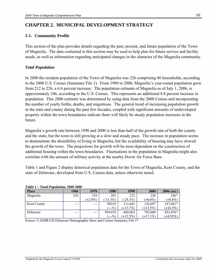
CHAPTER 2. MUNICIPAL DEVELOPMENT STRATEGY 2-1. Community Profile This section of the plan provides details regarding the past, present, and future population of the Town of Magnolia. The data contained in this section may be used to help plan for future service and facility needs, as well as information regarding anticipated changes in the character of the Magnolia community. Total Population In 2000 the resident population of the Town of Magnolia was 226 comprising 86 households, according to the 2000 U.S. Census (Summary File 1). From 1990 to 2000, Magnolia’s year-round population grew from 212 to 226, a 6.6 percent increase. The population estimate of Magnolia as of July 1, 2006, is approximately 246, according to the U.S. Census. This represents an additional 8.8 percent increase in population. This 2006 estimate was determined by using data from the 2000 Census and incorporating the number of yearly births, deaths, and migrations. The general trend of increasing population growth in the state and county during the past few decades, coupled with significant amounts of undeveloped property within the town boundaries indicate there will likely be steady population increases in the future. Magnolia’s growth rate between 1990 and 2000 is less than half of the growth rate of both the county and the state, but the town is still growing at a slow and steady pace. The increase in population seems to demonstrate the desirability of living in Magnolia, but the availability of housing may have slowed the growth of the town. The projections for growth will be most dependent on the construction of additional housing within the town boundaries. Fluctuations in the population in Magnolia might also correlate with the amount of military activity at the nearby Dover Air Force Base. Table 1 and Figure 2 display historical population data for the Town of Magnolia, Kent County, and the state of Delaware, developed from U.S. Census data, unless otherwise noted. Table 1 – Total Population, 1960-2000
Place 1960 1970 1980 1990 2000 2006 (est.) Magnolia 310
319
(+2.9%) 283
(-11.3%) 212
(-25.1%) 226
(+6.6%) 246*
(+8.8%) Kent County ---
---
98219 (---%)
111,641 (+13.7%)
126,697 (+13.5%)
147,601* (+16.5%)
Delaware --- --- 594,919 (---%)
669,063 (+12.5%)
783,600 (+17.1%)
853,476* (+8.92%)
Source: CADSR/UD Delaware Demographic Base and Census Summary File 1*
2009 Town of Magnolia Comprehensive Plan 11
Adopted by the Magnolia Town Council 3/16/09 Certified by the Governor April 24, 2009
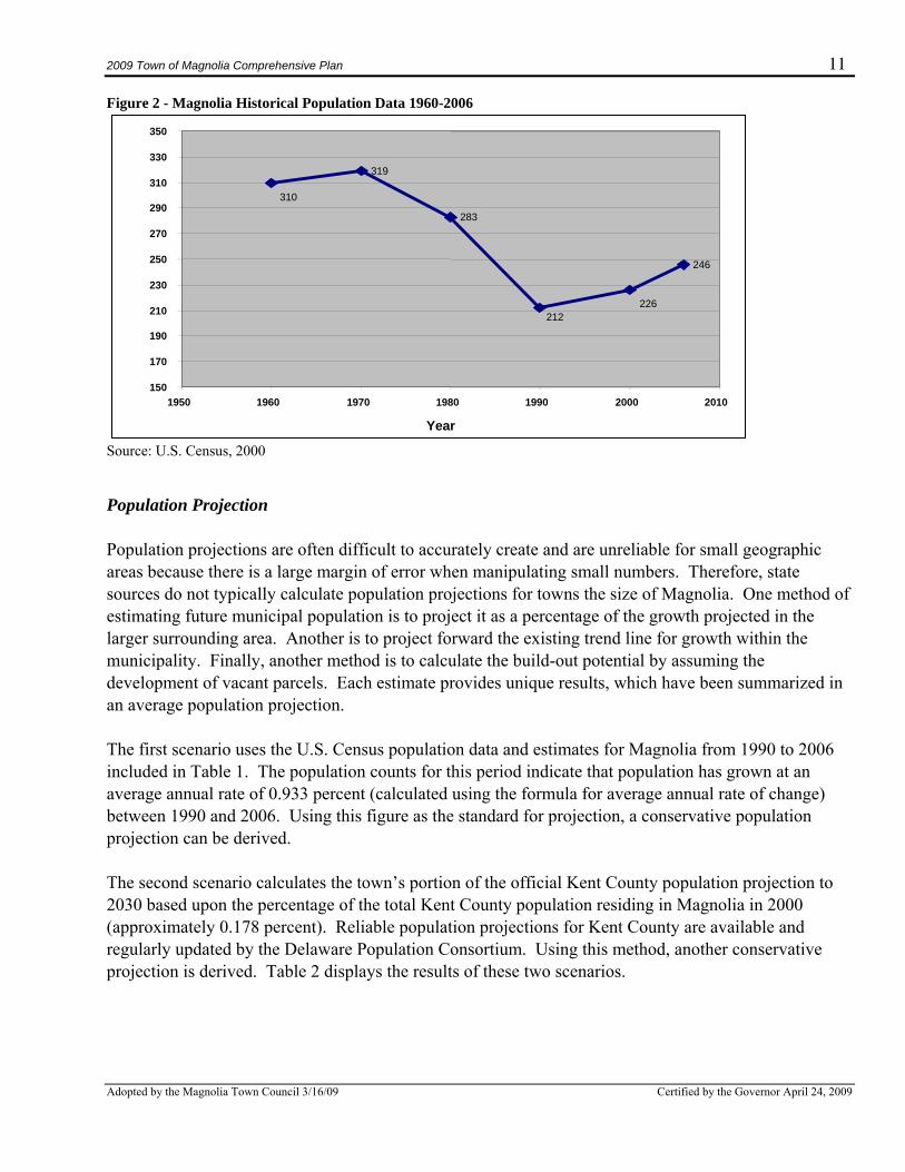
Figure 2 - Magnolia Historical Population Data 1960-2006
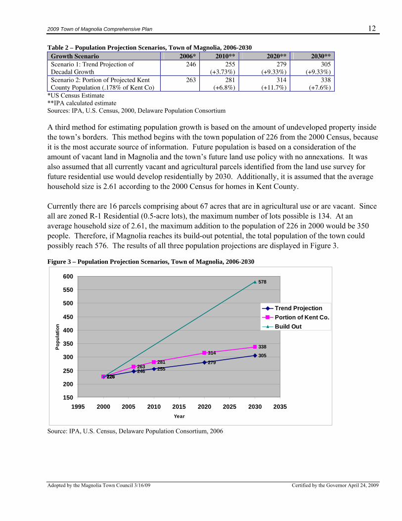
Source: U.S. Census, 2000 Population Projection Population projections are often difficult to accurately create and are unreliable for small geographic areas because there is a large margin of error when manipulating small numbers. Therefore, state sources do not typically calculate population projections for towns the size of Magnolia. One method of estimating future municipal population is to project it as a percentage of the growth projected in the larger surrounding area. Another is to project forward the existing trend line for growth within the municipality. Finally, another method is to calculate the build-out potential by assuming the development of vacant parcels. Each estimate provides unique results, which have been summarized in an average population projection. The first scenario uses the U.S. Census population data and estimates for Magnolia from 1990 to 2006 included in Table 1. The population counts for this period indicate that population has grown at an average annual rate of 0.933 percent (calculated using the formula for average annual rate of change) between 1990 and 2006. Using this figure as the standard for projection, a conservative population projection can be derived. The second scenario calculates the town’s portion of the official Kent County population projection to 2030 based upon the percentage of the total Kent County population residing in Magnolia in 2000 (approximately 0.178 percent). Reliable population projections for Kent County are available and regularly updated by the Delaware Population Consortium. Using this method, another conservative projection is derived. Table 2 displays the results of these two scenarios.
310
319
283
212226
246
150
170
190
210
230
250
270
290
310
330
350
1950 1960 1970 1980 1990 2000 2010
Year
2009 Town of Magnolia Comprehensive Plan 12
Adopted by the Magnolia Town Council 3/16/09 Certified by the Governor April 24, 2009
Table 2 – Population Projection Scenarios, Town of Magnolia, 2006-2030 Growth Scenario 2006* 2010** 2020** 2030** Scenario 1: Trend Projection of Decadal Growth
246 255 (+3.73%)
279 (+9.33%)
305 (+9.33%)
Scenario 2: Portion of Projected Kent County Population (.178% of Kent Co)
263 281 (+6.8%)
314 (+11.7%)
338 (+7.6%)
*US Census Estimate **IPA calculated estimate Sources: IPA, U.S. Census, 2000, Delaware Population Consortium A third method for estimating population growth is based on the amount of undeveloped property inside the town’s borders. This method begins with the town population of 226 from the 2000 Census, because it is the most accurate source of information. Future population is based on a consideration of the amount of vacant land in Magnolia and the town’s future land use policy with no annexations. It was also assumed that all currently vacant and agricultural parcels identified from the land use survey for future residential use would develop residentially by 2030. Additionally, it is assumed that the average household size is 2.61 according to the 2000 Census for homes in Kent County. Currently there are 16 parcels comprising about 67 acres that are in agricultural use or are vacant. Since all are zoned R-1 Residential (0.5-acre lots), the maximum number of lots possible is 134. At an average household size of 2.61, the maximum addition to the population of 226 in 2000 would be 350 people. Therefore, if Magnolia reaches its build-out potential, the total population of the town could possibly reach 576. The results of all three population projections are displayed in Figure 3. Figure 3 – Population Projection Scenarios, Town of Magnolia, 2006-2030
226246 255
279305
226
263281
314338
226
578
150
200
250
300
350
400
450
500
550
600
1995 2000 2005 2010 2015 2020 2025 2030 2035Year
Popu
latio
n
Trend ProjectionPortion of Kent Co.Build Out
Source: IPA, U.S. Census, Delaware Population Consortium, 2006
2009 Town of Magnolia Comprehensive Plan 13
Adopted by the Magnolia Town Council 3/16/09 Certified by the Governor April 24, 2009
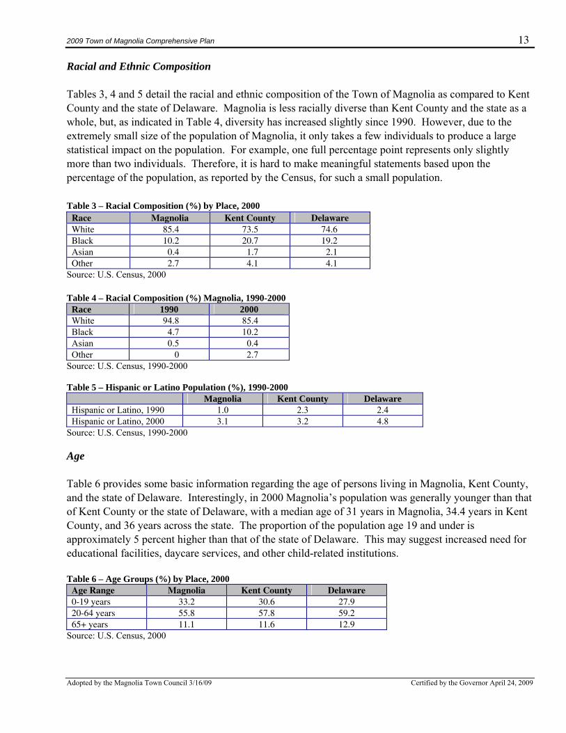
Racial and Ethnic Composition Tables 3, 4 and 5 detail the racial and ethnic composition of the Town of Magnolia as compared to Kent County and the state of Delaware. Magnolia is less racially diverse than Kent County and the state as a whole, but, as indicated in Table 4, diversity has increased slightly since 1990. However, due to the extremely small size of the population of Magnolia, it only takes a few individuals to produce a large statistical impact on the population. For example, one full percentage point represents only slightly more than two individuals. Therefore, it is hard to make meaningful statements based upon the percentage of the population, as reported by the Census, for such a small population. Table 3 – Racial Composition (%) by Place, 2000
Race Magnolia Kent County Delaware White 85.4 73.5 74.6 Black 10.2 20.7 19.2 Asian 0.4 1.7 2.1 Other 2.7 4.1 4.1
Source: U.S. Census, 2000 Table 4 – Racial Composition (%) Magnolia, 1990-2000
Race 1990 2000 White 94.8 85.4 Black 4.7 10.2 Asian 0.5 0.4 Other 0 2.7
Source: U.S. Census, 1990-2000 Table 5 – Hispanic or Latino Population (%), 1990-2000
Magnolia Kent County Delaware Hispanic or Latino, 1990 1.0 2.3 2.4 Hispanic or Latino, 2000 3.1 3.2 4.8
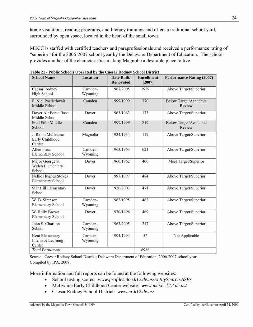
Source: U.S. Census, 1990-2000 Age Table 6 provides some basic information regarding the age of persons living in Magnolia, Kent County, and the state of Delaware. Interestingly, in 2000 Magnolia’s population was generally younger than that of Kent County or the state of Delaware, with a median age of 31 years in Magnolia, 34.4 years in Kent County, and 36 years across the state. The proportion of the population age 19 and under is approximately 5 percent higher than that of the state of Delaware. This may suggest increased need for educational facilities, daycare services, and other child-related institutions. Table 6 – Age Groups (%) by Place, 2000
Age Range Magnolia Kent County Delaware 0-19 years 33.2 30.6 27.9 20-64 years 55.8 57.8 59.2 65+ years 11.1 11.6 12.9
Source: U.S. Census, 2000
2009 Town of Magnolia Comprehensive Plan 14
Adopted by the Magnolia Town Council 3/16/09 Certified by the Governor April 24, 2009
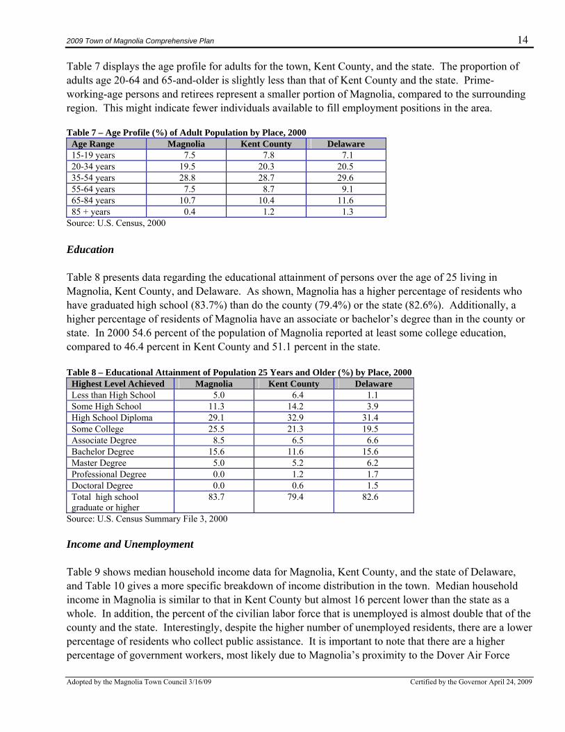
Table 7 displays the age profile for adults for the town, Kent County, and the state. The proportion of adults age 20-64 and 65-and-older is slightly less than that of Kent County and the state. Prime-working-age persons and retirees represent a smaller portion of Magnolia, compared to the surrounding region. This might indicate fewer individuals available to fill employment positions in the area. Table 7 – Age Profile (%) of Adult Population by Place, 2000
Age Range Magnolia Kent County Delaware 15-19 years 7.5 7.8 7.1 20-34 years 19.5 20.3 20.5 35-54 years 28.8 28.7 29.6 55-64 years 7.5 8.7 9.1 65-84 years 10.7 10.4 11.6 85 + years 0.4 1.2 1.3
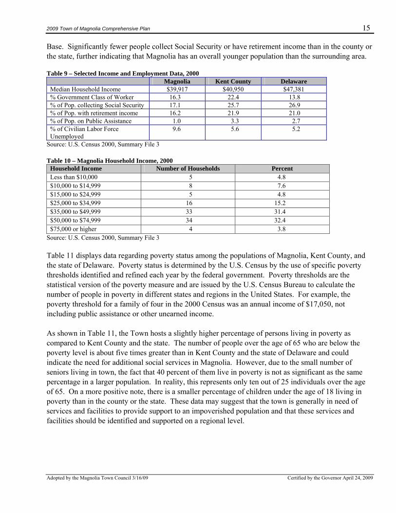
Source: U.S. Census, 2000 Education Table 8 presents data regarding the educational attainment of persons over the age of 25 living in Magnolia, Kent County, and Delaware. As shown, Magnolia has a higher percentage of residents who have graduated high school (83.7%) than do the county (79.4%) or the state (82.6%). Additionally, a higher percentage of residents of Magnolia have an associate or bachelor’s degree than in the county or state. In 2000 54.6 percent of the population of Magnolia reported at least some college education, compared to 46.4 percent in Kent County and 51.1 percent in the state. Table 8 – Educational Attainment of Population 25 Years and Older (%) by Place, 2000
Highest Level Achieved Magnolia Kent County Delaware Less than High School 5.0 6.4 1.1 Some High School 11.3 14.2 3.9 High School Diploma 29.1 32.9 31.4 Some College 25.5 21.3 19.5 Associate Degree 8.5 6.5 6.6 Bachelor Degree 15.6 11.6 15.6 Master Degree 5.0 5.2 6.2 Professional Degree 0.0 1.2 1.7 Doctoral Degree 0.0 0.6 1.5 Total high school graduate or higher
83.7 79.4 82.6
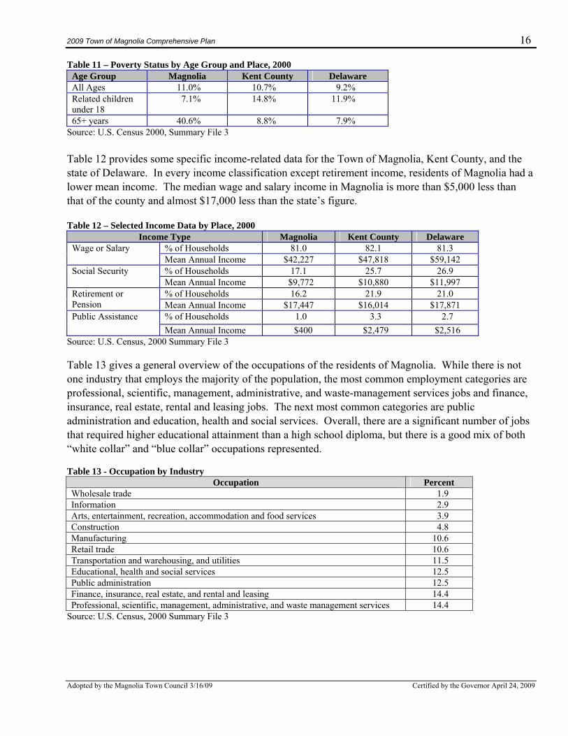
Source: U.S. Census Summary File 3, 2000 Income and Unemployment Table 9 shows median household income data for Magnolia, Kent County, and the state of Delaware, and Table 10 gives a more specific breakdown of income distribution in the town. Median household income in Magnolia is similar to that in Kent County but almost 16 percent lower than the state as a whole. In addition, the percent of the civilian labor force that is unemployed is almost double that of the county and the state. Interestingly, despite the higher number of unemployed residents, there are a lower percentage of residents who collect public assistance. It is important to note that there are a higher percentage of government workers, most likely due to Magnolia’s proximity to the Dover Air Force
2009 Town of Magnolia Comprehensive Plan 15
Adopted by the Magnolia Town Council 3/16/09 Certified by the Governor April 24, 2009
Base. Significantly fewer people collect Social Security or have retirement income than in the county or the state, further indicating that Magnolia has an overall younger population than the surrounding area. Table 9 – Selected Income and Employment Data, 2000
Magnolia Kent County Delaware Median Household Income $39,917 $40,950 $47,381 % Government Class of Worker 16.3 22.4 13.8 % of Pop. collecting Social Security 17.1 25.7 26.9 % of Pop. with retirement income 16.2 21.9 21.0 % of Pop. on Public Assistance 1.0 3.3 2.7 % of Civilian Labor Force Unemployed
9.6 5.6 5.2
Source: U.S. Census 2000, Summary File 3 Table 10 – Magnolia Household Income, 2000
Household Income Number of Households Percent Less than $10,000 5 4.8 $10,000 to $14,999 8 7.6 $15,000 to $24,999 5 4.8 $25,000 to $34,999 16 15.2 $35,000 to $49,999 33 31.4 $50,000 to $74,999 34 32.4 $75,000 or higher 4 3.8
Source: U.S. Census 2000, Summary File 3 Table 11 displays data regarding poverty status among the populations of Magnolia, Kent County, and the state of Delaware. Poverty status is determined by the U.S. Census by the use of specific poverty thresholds identified and refined each year by the federal government. Poverty thresholds are the statistical version of the poverty measure and are issued by the U.S. Census Bureau to calculate the number of people in poverty in different states and regions in the United States. For example, the poverty threshold for a family of four in the 2000 Census was an annual income of $17,050, not including public assistance or other unearned income. As shown in Table 11, the Town hosts a slightly higher percentage of persons living in poverty as compared to Kent County and the state. The number of people over the age of 65 who are below the poverty level is about five times greater than in Kent County and the state of Delaware and could indicate the need for additional social services in Magnolia. However, due to the small number of seniors living in town, the fact that 40 percent of them live in poverty is not as significant as the same percentage in a larger population. In reality, this represents only ten out of 25 individuals over the age of 65. On a more positive note, there is a smaller percentage of children under the age of 18 living in poverty than in the county or the state. These data may suggest that the town is generally in need of services and facilities to provide support to an impoverished population and that these services and facilities should be identified and supported on a regional level.
2009 Town of Magnolia Comprehensive Plan 16
Adopted by the Magnolia Town Council 3/16/09 Certified by the Governor April 24, 2009
Table 11 – Poverty Status by Age Group and Place, 2000 Age Group Magnolia Kent County Delaware All Ages 11.0% 10.7% 9.2% Related children under 18
7.1% 14.8% 11.9%
65+ years 40.6% 8.8% 7.9% Source: U.S. Census 2000, Summary File 3 Table 12 provides some specific income-related data for the Town of Magnolia, Kent County, and the state of Delaware. In every income classification except retirement income, residents of Magnolia had a lower mean income. The median wage and salary income in Magnolia is more than $5,000 less than that of the county and almost $17,000 less than the state’s figure. Table 12 – Selected Income Data by Place, 2000
Income Type Magnolia Kent County Delaware % of Households 81.0 82.1 81.3 Wage or Salary Mean Annual Income $42,227 $47,818 $59,142 % of Households 17.1 25.7 26.9 Social Security Mean Annual Income $9,772 $10,880 $11,997 % of Households 16.2 21.9 21.0 Retirement or
Pension Mean Annual Income $17,447 $16,014 $17,871 Public Assistance % of Households 1.0 3.3 2.7 Mean Annual Income $400 $2,479 $2,516
Source: U.S. Census, 2000 Summary File 3 Table 13 gives a general overview of the occupations of the residents of Magnolia. While there is not one industry that employs the majority of the population, the most common employment categories are professional, scientific, management, administrative, and waste-management services jobs and finance, insurance, real estate, rental and leasing jobs. The next most common categories are public administration and education, health and social services. Overall, there are a significant number of jobs that required higher educational attainment than a high school diploma, but there is a good mix of both “white collar” and “blue collar” occupations represented. Table 13 - Occupation by Industry
Occupation Percent Wholesale trade 1.9 Information 2.9 Arts, entertainment, recreation, accommodation and food services 3.9 Construction 4.8 Manufacturing 10.6 Retail trade 10.6 Transportation and warehousing, and utilities 11.5 Educational, health and social services 12.5 Public administration 12.5 Finance, insurance, real estate, and rental and leasing 14.4 Professional, scientific, management, administrative, and waste management services 14.4
Source: U.S. Census, 2000 Summary File 3
2009 Town of Magnolia Comprehensive Plan 17
Adopted by the Magnolia Town Council 3/16/09 Certified by the Governor April 24, 2009
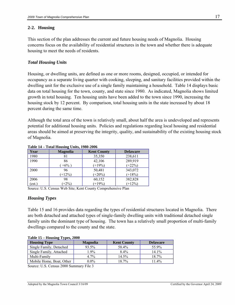
2-2. Housing This section of the plan addresses the current and future housing needs of Magnolia. Housing concerns focus on the availability of residential structures in the town and whether there is adequate housing to meet the needs of residents. Total Housing Units Housing, or dwelling units, are defined as one or more rooms, designed, occupied, or intended for occupancy as a separate living quarter with cooking, sleeping, and sanitary facilities provided within the dwelling unit for the exclusive use of a single family maintaining a household. Table 14 displays basic data on total housing for the town, county, and state since 1980. As indicated, Magnolia shows limited growth in total housing. Ten housing units have been added to the town since 1990, increasing the housing stock by 12 percent. By comparison, total housing units in the state increased by about 18 percent during the same time. Although the total area of the town is relatively small, about half the area is undeveloped and represents potential for additional housing units. Policies and regulations regarding local housing and residential areas should be aimed at preserving the integrity, quality, and sustainability of the existing housing stock of Magnolia. Table 14 – Total Housing Units, 1980-2006
Year Magnolia Kent County Delaware 1980 81 35,350 238,611 1990 86
( +6% ) 42,106 (+19%)
289,919 (+22%)
2000 96 (+12%)
50,481 (+20%)
343,072 (+18%)
2006 (est.)
98 (+2%)
60,152 (+19%)
382,828 (+12%)
Source: U.S. Census Web Site; Kent County Comprehensive Plan Housing Types Table 15 and 16 provides data regarding the types of residential structures located in Magnolia. There are both detached and attached types of single-family dwelling units with traditional detached single family units the dominant type of housing. The town has a relatively small proportion of multi-family dwellings compared to the county and the state. Table 15 – Housing Types, 2000
Housing Type Magnolia Kent County Delaware Single Family, Detached 93.5% 58.4% 55.9% Single Family, Attached 1.9% 8.4% 14.1% Multi-Family 4.7% 14.5% 18.7% Mobile Home, Boat, Other 0.0% 18.7% 11.4%
Source: U.S. Census 2000 Summary File 3
2009 Town of Magnolia Comprehensive Plan 18
Adopted by the Magnolia Town Council 3/16/09 Certified by the Governor April 24, 2009
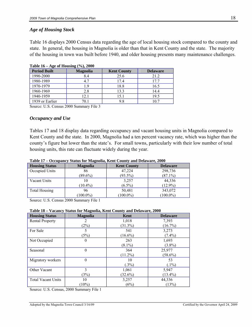
Age of Housing Stock Table 16 displays 2000 Census data regarding the age of local housing stock compared to the county and state. In general, the housing in Magnolia is older than that in Kent County and the state. The majority of the housing in town was built before 1940, and older housing presents many maintenance challenges. Table 16 – Age of Housing (%), 2000
Period Built Magnolia Kent County Delaware 1990-2000 8.4 25.6 21.2 1980-1989 4.7 17.4 17.7 1970-1979 1.9 18.8 16.5 1960-1969 2.8 13.3 14.4 1940-1959 12.1 15.1 19.5 1939 or Earlier 70.1 9.8 10.7
Source: U.S. Census 2000 Summary File 3 Occupancy and Use Tables 17 and 18 display data regarding occupancy and vacant housing units in Magnolia compared to Kent County and the state. In 2000, Magnolia had a ten percent vacancy rate, which was higher than the county’s figure but lower than the state’s. For small towns, particularly with their low number of total housing units, this rate can fluctuate widely during the year. Table 17 – Occupancy Status for Magnolia, Kent County and Delaware, 2000 Housing Status Magnolia Kent County Delaware Occupied Units 86
(89.6%) 47,224
(93.5%) 298,736 (87.1%)
Vacant Units 10 (10.4%)
3,257 (6.5%)
44,336 (12.9%)
Total Housing 96 (100.0%)
50,481 (100.0%)
343,072 (100.0%)
Source: U.S. Census 2000 Summary File 1 Table 18 – Vacancy Status for Magnolia, Kent County and Delaware, 2000 Housing Status Magnolia Kent Delaware Rental Property 2
(2%) 1,018
(31.3%) 7,393 (16.7%)
For Sale 5 (5%)
541 (16.6%)
3,273 (7.4%)
Not Occupied 0 263 (8.1%)
1,693 (3.8%)
Seasonal 0 364 (11.2%)
25,977 (58.6%)
Migratory workers 0 10 (.3%)
53 (.1%)
Other Vacant 3 (3%)
1,061 (32.6%)
5,947 (13.4%)
Total Vacant Units 10 (10%)
3,257 (6%)
44,336 (13%)
Source: U.S. Census, 2000 Summary File 1
2009 Town of Magnolia Comprehensive Plan 19
Adopted by the Magnolia Town Council 3/16/09 Certified by the Governor April 24, 2009
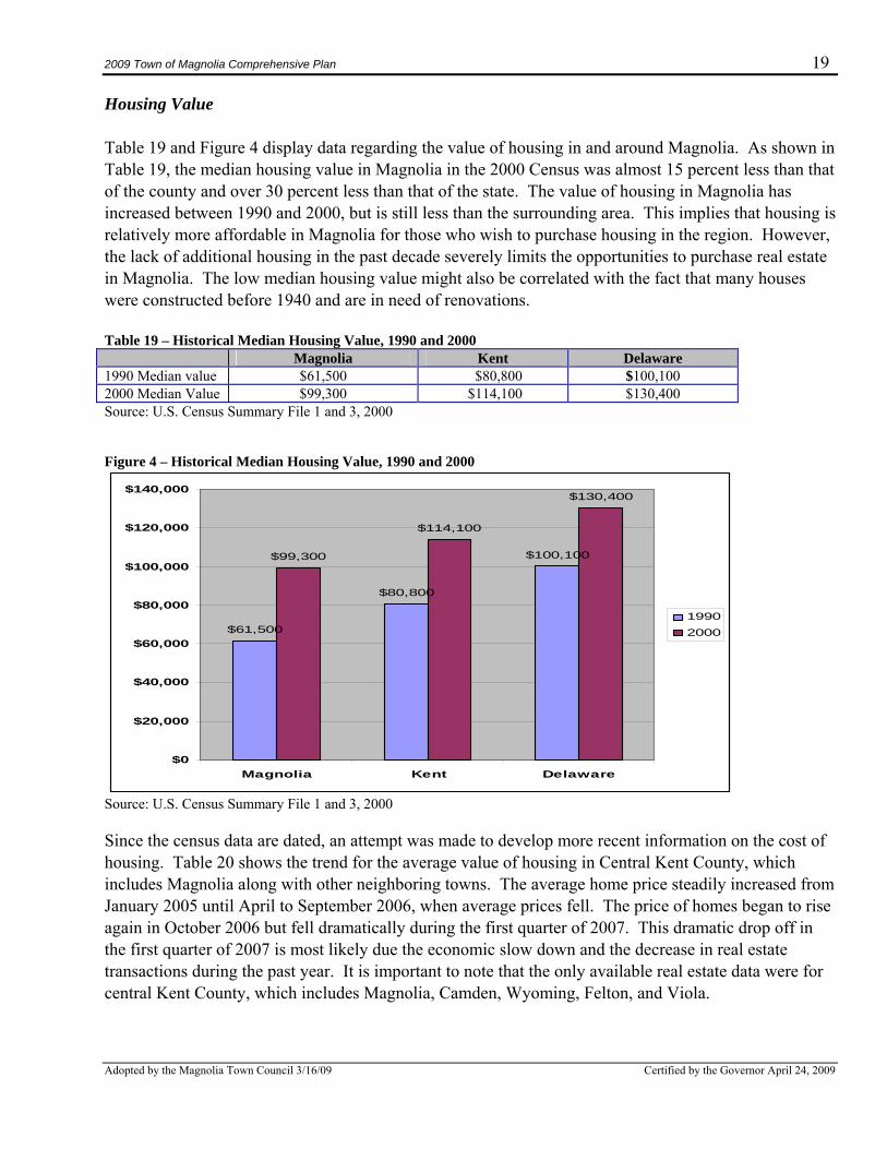
Housing Value Table 19 and Figure 4 display data regarding the value of housing in and around Magnolia. As shown in Table 19, the median housing value in Magnolia in the 2000 Census was almost 15 percent less than that of the county and over 30 percent less than that of the state. The value of housing in Magnolia has increased between 1990 and 2000, but is still less than the surrounding area. This implies that housing is relatively more affordable in Magnolia for those who wish to purchase housing in the region. However, the lack of additional housing in the past decade severely limits the opportunities to purchase real estate in Magnolia. The low median housing value might also be correlated with the fact that many houses were constructed before 1940 and are in need of renovations. Table 19 – Historical Median Housing Value, 1990 and 2000 Magnolia Kent Delaware 1990 Median value $61,500 $80,800 $100,100 2000 Median Value $99,300 $114,100 $130,400 Source: U.S. Census Summary File 1 and 3, 2000 Figure 4 – Historical Median Housing Value, 1990 and 2000
$61,500
$80,800
$100,100$99,300
$114,100
$130,400
$0
$20,000
$40,000
$60,000
$80,000
$100,000
$120,000
$140,000
Magnolia Kent Delaware
19902000
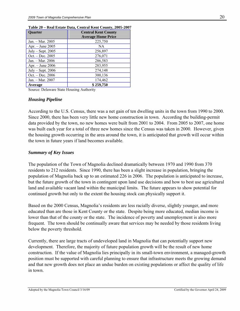
Source: U.S. Census Summary File 1 and 3, 2000 Since the census data are dated, an attempt was made to develop more recent information on the cost of housing. Table 20 shows the trend for the average value of housing in Central Kent County, which includes Magnolia along with other neighboring towns. The average home price steadily increased from January 2005 until April to September 2006, when average prices fell. The price of homes began to rise again in October 2006 but fell dramatically during the first quarter of 2007. This dramatic drop off in the first quarter of 2007 is most likely due the economic slow down and the decrease in real estate transactions during the past year. It is important to note that the only available real estate data were for central Kent County, which includes Magnolia, Camden, Wyoming, Felton, and Viola.
2009 Town of Magnolia Comprehensive Plan 20
Adopted by the Magnolia Town Council 3/16/09 Certified by the Governor April 24, 2009
Table 20 – Real Estate Data, Central Kent County, 2005-2007 Quarter Central Kent County
Average Home Price Jan. – Mar. 2005 225,750 Apr. – June 2005 NA July – Sept. 2005 256,897 Oct. – Dec. 2005 276,071 Jan. – Mar. 2006 286,583 Apr. – June 2006 283,955 July – Sept. 2006 274,148 Oct. – Dec. 2006 300,136 Jan. – Mar. 2007 174,462 Average $ 259,750 Source: Delaware State Housing Authority Housing Pipeline According to the U.S. Census, there was a net gain of ten dwelling units in the town from 1990 to 2000. Since 2000, there has been very little new home construction in town. According the building-permit data provided by the town, no new homes were built from 2001 to 2004. From 2005 to 2007, one home was built each year for a total of three new homes since the Census was taken in 2000. However, given the housing growth occurring in the area around the town, it is anticipated that growth will occur within the town in future years if land becomes available. Summary of Key Issues The population of the Town of Magnolia declined dramatically between 1970 and 1990 from 370 residents to 212 residents. Since 1990, there has been a slight increase in population, bringing the population of Magnolia back up to an estimated 226 in 2006. The population is anticipated to increase, but the future growth of the town in contingent upon land use decisions and how to best use agricultural land and available vacant land within the municipal limits. The future appears to show potential for continued growth but only to the extent the housing stock can physically support it. Based on the 2000 Census, Magnolia’s residents are less racially diverse, slightly younger, and more educated than are those in Kent County or the state. Despite being more educated, median income is lower than that of the county or the state. The incidence of poverty and unemployment is also more frequent. The town should be continually aware that services may be needed by those residents living below the poverty threshold. Currently, there are large tracts of undeveloped land in Magnolia that can potentially support new development. Therefore, the majority of future population growth will be the result of new home construction. If the value of Magnolia lies principally in its small-town environment, a managed-growth position must be supported with careful planning to ensure that infrastructure meets the growing demand and that new growth does not place an undue burden on existing populations or affect the quality of life in town.
2009 Town of Magnolia Comprehensive Plan 21
Adopted by the Magnolia Town Council 3/16/09 Certified by the Governor April 24, 2009
Based on responses to a town questionnaire mailed to property owners in April 2008, the town believes its future development pattern should continue as mainly residential. The town has a variety of assets for attracting future residential development, led by its proximity to two larger employment areas - the Dover Air Base and the City of Dover. The town also has adequate central sewer and water capacity, low property taxes, and a small-town atmosphere. The town recognizes that future growth will likely occur and should plan to ensure that future growth will fit with the character of the town and complement its positive characteristics. Plan Recommendations – Housing
1. The town should utilize its zoning authority by updating zoning codes to carefully and appropriately shape the residential development in Magnolia. In particular, the town should identify and protect areas of traditional, small-scale residential development and encourage new mixed-use development where appropriate, possibly considering cluster-type development.
2. The town should develop an approach to marketing Magnolia to future residents, focusing on
first-time home buyers and “fixer-uppers” willing to invest time and money in rehabilitating older housing within the town.
3. The town should encourage development that mixes land uses and housing types to
accommodate various income levels and provide affordable housing. 4. The town should attempt to preserve Magnolia’s traditional, quiet, friendly, small-town character
and quality of life by identifying the character of the community and only allow development that supports this character and relates to Kent County designated growth zones.
5. The town should encourage conservation of the town’s historical character and assets through the
revision and increased enforcement of property-maintenance ordinances for existing structures and new development.
6. The town should provide assistance and options for owners of historic and aging properties that
have special maintenance needs. 2-3. Government, Community Services, and Facilities This section provides an overview of the town’s government structure and the variety of community services and facilities available to the residents of Magnolia. Town Government The Town of Magnolia operates as an incorporated municipal government and was originally recognized by the state of Delaware in 1885 and reincorporated in 1960. Its governmental structure includes five town commissioners, who are elected to staggered two-year terms. The town charter
2009 Town of Magnolia Comprehensive Plan 22
Adopted by the Magnolia Town Council 3/16/09 Certified by the Governor April 24, 2009
requires anyone running for a council position to be a landowner in the town, or a spouse of a landowner, and to be at least 21 years old and current on all tax payments. Annual elections are held the second Tuesday in January, and only residents who have lived in Magnolia longer than a year and have paid their taxes are eligible to vote. Meetings are held on the second Tuesday of each month in the Town Hall. A mayor is chosen by a vote of the commissioners. The five-person council includes a Mayor, Vice Mayor, and three Council Members. Other possible positions described in the charter include a town Secretary, Solicitor and Water Official, Alderman, Treasurer, Assessor, and Collector of Taxes. Some of these positions are not currently filled. There are no paid council members, and the only paid employees include the Secretary, the Solicitor, and a part-time maintenance employee—hired periodically to paint curbs, control weeds, and perform general maintenance. Information regarding the description of the roles of town employees and information about town services and departments is available in the Town Charter and can be found online at: www.stateplanning.delaware.gov/municipal/magnolia.shtml Utilities Magnolia does not provide or bill for electric services. Delmarva Power provides electric service to Magnolia residents and businesses. Customers purchase electricity directly from Delmarva, which maintains the system. There is no natural-gas service located within the town. Magnolia is relatively well connected, but, because of its rural setting, only a few companies provide service. Comcast provides cable, phone, and broadband Internet services. Other connectivity options include satellite service from a variety of companies. Currently Verizon does not offer broadband or FIOS services in Magnolia, but the town is considering formally requesting them to start providing service. A discussion of water and wastewater services is provided in the next section of the plan. Community Services Public Safety The Town of Magnolia does not have a Police Department and presently contracts with the State Police. During the development of the plan, respondents to the town questionnaire identified crime and safety as one of the two most important issues in town. Planning Commission members also expressed concerns that there is less police presence in town than in the past. Kent County enforces the building codes, governs inspections and zoning, and performs condemnations on appropriate dwellings in Magnolia. Comments offered included concerns that there is a lack of enforcement of town ordinances, and some residents believe there is a greater need to better enforce local ordinances governing property maintenance on rental properties.
2009 Town of Magnolia Comprehensive Plan 23
Adopted by the Magnolia Town Council 3/16/09 Certified by the Governor April 24, 2009
Fire and Emergency Medical Services The Magnolia Volunteer Fire Company, located on the north corner of the intersection of Main and Walnut Streets, provides emergency medical and fire-protection services. There are about 60 members in the Magnolia Fire Company, which operates a total of ten trucks and rescue vehicles—three engines, one rescue, one ambulance, one field/brush unit, two utility vehicles, one tanker, and a marine unit. The Magnolia Fire Company participates in mutual assistance agreements with the surrounding volunteer fire companies. In 2007 it responded to 176 calls for fire and 819 calls for emergency services. The Magnolia Fire Company is staffed Monday to Friday between 6 a.m.-6 p.m. by two EMT-B/Firefighters, and Saturday and Sunday by one EMT-B/Firefighter to assist with increased call volume. Paramedic service is provided by Kent County Emergency Medical Services, which operates four Medic Stations in Kent County. The closest stations to Magnolia are Stations 65 and 67, both operating out of the Department of Public Safety Headquarters in nearby Dover. It should be noted that responses to the April 2008 town questionnaire indicated that there is great satisfaction with the fire and emergency medical services provided to residents of the town. However some residents have expressed concern about the decreasing number of emergency personnel volunteers, some due to military duty. Libraries and Schools There are no library facilities within the town limits of Magnolia, but a Kent County library facility is located only seven miles north of town on South DuPont Highway and offers books, periodicals, and computing and Internet facilities. The Dover Public Library is also located nearby in Dover and offers similar opportunities. The Milford and Harrington Public Libraries are located approximately 12 and 14 miles, respectively, to the south and offer many of the same services. There is also a specialty library that emphasizes Methodist history located at Barratt’s Chapel and Museum in Frederica, roughly four miles from Magnolia. The Barratt’s Chapel and Museum library has limited hours but offers services usually provided by museum libraries. The Town of Magnolia is located in the Caesar Rodney School District. The Caesar Rodney District has 13 schools that serve over 7,000 students and covers about 107 square miles in an area that stretches across Kent County from the Delaware Bay to the Maryland state line, just south of the City of Dover. Overall the school district has been successful and has received a performance rating of “Commendable District” for its performance by the Delaware Department of Education, meaning the District has reached its target percentages in reading/language arts and math for the Delaware standardized tests. This indicates there is a progressive increase in the number of students who are meeting the state standards in the Caesar Rodney District. Table 21 provides information on the schools operated in the District. The McIlvaine Early Childhood Center (MECC) is a six-classroom schoolhouse located on Walnut Street in Magnolia. This small school, which is being renovated and expanded, is currently home to six all-day kindergarten classes and draws students from every elementary school in the Caesar Rodney District, who are bused there daily. The MECC offers specialized programs such as speech therapy,
2009 Town of Magnolia Comprehensive Plan 24
Adopted by the Magnolia Town Council 3/16/09 Certified by the Governor April 24, 2009
home visitations, reading programs, and literacy trainings and offers a traditional school yard, surrounded by open space, located in the heart of the small town. MECC is staffed with certified teachers and paraprofessionals and received a performance rating of “superior” for the 2006-2007 school year by the Delaware Department of Education. The school provides another of the characteristics making Magnolia a desirable place to live. Table 21 - Public Schools Operated by the Caesar Rodney School District
School Name Location Date Built/ Renovated
Enrollment (2007)
Performance Rating (2007)
Caesar Rodney High School
Camden-Wyoming
1967/2005 1929 Above Target/Superior
F. Niel Postlethwait Middle School
Camden 1999/1999 770 Below Target/Academic Review
Dover Air Force Base Middle School
Dover 1963/1963 173 Above Target/Superior
Fred Fifer Middle School
Camden 1999/1999 819 Below Target/Academic Review
J. Ralph McIlvaine Early Childhood Center
Magnolia 1934/1934 119 Above Target/Superior
Allen Frear Elementary School
Camden-Wyoming
1963/1963 621 Above Target/Superior
Major George S. Welch Elementary School
Dover 1960/1962 400 Meet Target/Superior
Nellie Hughes Stokes Elementary School
Dover 1997/1997 484 Above Target/Superior
Star Hill Elementary School
Dover 1926/2003 471 Above Target/Superior
W. B. Simpson Elementary School
Camden-Wyoming
1962/1995 462 Above Target/Superior
W. Reily Brown Elementary School
Dover 1970/1996 469 Above Target/Superior
John S. Charlton School
Camden-Wyoming
1963/2005 217 Above Target/Superior
Kent Elementary Intensive Learning Center
Camden-Wyoming
1994/1994 52 Not Applicable
Total Enrollment 6986
Source: Caesar Rodney School District, Delaware Department of Education, 2006-2007 school year. Compiled by IPA, 2008. More information and full reports can be found at the following websites:
• School testing scores: www.profiles.doe.k12.de.us/EntitySearch.ASPx • McIlvaine Early Childhood Center website: www.mci.cr.k12.de.us/ • Caesar Rodney School District: www.cr.k12.de.us/
2009 Town of Magnolia Comprehensive Plan 25
Adopted by the Magnolia Town Council 3/16/09 Certified by the Governor April 24, 2009
Health Care The closest major hospital facility to Magnolia is Bayhealth Medical Center in Dover. The extensive facility provides both outpatient healthcare and emergency medical services to all residents and visitors in the region. State Service Center The James W. Williams State Service Center is located nearby to the north of town at 805 River Road in Dover. The center offers a wide variety of public services to help people with their health and human services needs. The center can assist the public obtain services provided through the state Department of Health and Social Services, the state Department of Services for Children, Youth, and Their Families, and the Delaware Department of State, as well as many nonprofit community-services groups. Refuse Collection and Recycling Refuse collection in Magnolia is provided by private companies, such as Independent Disposal Services or Waste Management. Recycling services are available for an additional fee and community collection facilities are available but may be underutilized. Postal Services Residents in Magnolia must go to the Post Office on Main Street to pick up their mail at individual Post Office boxes. The Post Office is an integral part of the character of the town but is often mentioned by town residents and officials as being too small to adequately provide mail services to the town. Some residents also expressed their interest in having the Post Office moved to an out-of-town location and would welcome home mail delivery instead of having to go to the Post Office to pick up their mail. The town should continue to discuss the need for a larger and more efficient post office and possible locations for a new facility. Summary of Key Issues Magnolia residents have access to many services provided by local, county, state, and federal levels of government and private-sector companies. Part of the attraction of the town is the availability of these services; accordingly, the town will strive to maintain access to them. It will also be necessary for the town to continually evaluate the adequacy of these services, particularly if the town begins to grow more rapidly. Plan Recommendations – Community Services and Facilities
1. Magnolia should update its charter to address a number of issues that have become dated.
2009 Town of Magnolia Comprehensive Plan 26
Adopted by the Magnolia Town Council 3/16/09 Certified by the Governor April 24, 2009
2. The town should try to attract additional Internet phone and cable providers to town to provide residents with more than one option.
3. An assessment of the residents’ satisfaction with police services in town should be periodically
made and options developed to increase police visibility and enforcement opportunities in town. 4. The town should continue to work with the volunteer fire company to explore additional
opportunities to attract more volunteers, particularly during times when volunteers are serving in the military.
5. The town should revisit the issue of contracting for trash collection services for the town’s
property owners and promote recycling opportunities. 6. The town should continue to discuss options for a new post office, deciding if the majority of the
residents favor an in-town or out-of-town location.
2-4. Water, Wastewater, and Stormwater Management Public Water System The Town of Magnolia has a Certificate of Public Convenience and Necessity (CPCN) to provide potable water within the town and to an area immediately adjacent to the town. The management and operation of the system is overseen by the Town Water Official and Vice Mayor (currently Scott Fowler). According to estimates by the Water Official, the Town of Magnolia provides water services to approximately 200 residences, two commercial operations, and two institutions. The water system is made up of two primary wells (#2a and #3a), one emergency well (#1a), and a 250,000-gallon elevated water-storage tank prominently located at the center of town, near the crossroads of Main and Walnut Streets. According to the allocation permit issued by the Delaware Department of Natural Resources and Environmental Control (DNREC) to Magnolia in 1987, the Town of Magnolia is allowed to draw groundwater from the Frederica aquifer at three wellhead locations on East Walnut Street. The wells are located at Town Hall (#1a), in the field adjacent to Town Hall (#2a) and in the school yard (#3a). Table 22 shows wells 2a and 3a are the main wells that provide potable water to the town and have a maximum pumping capacity of 700 gallons per minute (gpm) and 315 gpm, respectively. Emergency-use well 1a has a maximum pumping capacity allotted at 160 gpm. The allocation permit allows for a maximum total withdrawal of 85,000 gallons per day (gpd).
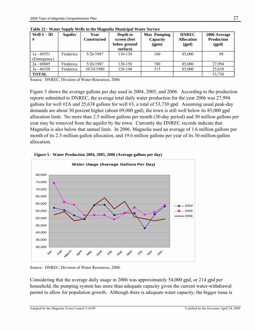
2009 Town of Magnolia Comprehensive Plan 27
Adopted by the Magnolia Town Council 3/16/09 Certified by the Governor April 24, 2009
Water Usage (Average Gallons Per Day)
30,000
35,000
40,000
45,000
50,000
55,000
60,000
65,000
70,000
75,000
80,000
Jan
Feb
March
April
MayJu
ne July
Aug
Sept Oct
Nov Dec
2004
2005
2006
Table 22 - Water Supply Wells in the Magnolia Municipal Water Service Well # - ID #
Aquifer Year Constructed
Depth to screen (feet
below ground surface)
Max Pumping Capacity
(gpm)
DNREC Allocation
(gpd)
2006 Average Production
(gpd)
1a - 69351 (Emergency)
Frederica 5/26/1987 110-130 160 85,000 98
2a - 68805 Frederica 5/26/1987 130-150 700 85,000 27,994 3a - 46358 Frederica 10/24/1980 128-148 315 85,000 25,638 TOTAL 53,730
Source: DNREC, Division of Water Resources, 2006 Figure 5 shows the average gallons per day used in 2004, 2005, and 2006. According to the production reports submitted to DNREC, the average total daily water production for the year 2006 was 27,994 gallons for well #2A and 25,638 gallons for well #3, a total of 53,730 gpd. Assuming usual peak-day demands are about 30 percent higher (about 69,000 gpd), the town is still well below its 85,000 gpd allocation limit. No more than 2.5 million gallons per month (30-day period) and 30 million gallons per year may be removed from the aquifer by the town. Currently the DNREC records indicate that Magnolia is also below that annual limit. In 2006, Magnolia used an average of 1.6 million gallons per month of its 2.5-million-gallon allocation, and 19.6 million gallons per year of its 30-million-gallon allocation. Figure 5 - Water Production 2004, 2005, 2006 (Average gallons per day)
Source: DNREC, Division of Water Resources, 2008. Considering that the average daily usage in 2006 was approximately 54,000 gpd, or 214 gpd per household, the pumping system has more than adequate capacity given the current water-withdrawal permit to allow for population growth. Although there is adequate water capacity, the bigger issue is
2009 Town of Magnolia Comprehensive Plan 28
Adopted by the Magnolia Town Council 3/16/09 Certified by the Governor April 24, 2009
whether the current infrastructure could support the increase in flow that would occur with development. The town must address the issue of a water-system upgrade before determining its ability to facilitate growth. Water service customers in town are charged a flat rate of $55 per quarter, or $220 per year for water service. There is concern that, in order to continue to provide an adequate level of service to all residents in Magnolia, the water system will need to be upgraded. Decreased water pressure occurs for residents who live further away from the water tank, due to the size and condition of the water mains and, in some instances, the condition of the smaller service lines from the street to the house. For example, residents on Thorn Street have only a 2-inch water main and residents have reported to the town that their water pressure is inadequate. Several comments were also received in the town questionnaire that complained about low water pressure. It should be noted that the town is in the process of upgrading the water lines on Thorn Street and are searching for grant-funding assistance. Source Water Assessment and Protection (SWAP) Program
The Safe Drinking Water Act Amendments of 1996 mandated that each state develop a Source Water Assessment and Protection (SWAP) Program to better protect public-drinking-water sources. There are three basic components of all SWAP Programs:
• Delineate the boundaries of the land area most important to public water sources. • Identify the potential sources of contamination within those boundaries. • Assess the susceptibility of the public water source to these contaminants.
In Delaware, the SWAP Program was coordinated mainly by the State Department of Natural Resources & Environmental Control (DNREC), which developed the majority of the assessments for all public water systems in Delaware. The assessment for the Town of Magnolia can be found at: www.wr.udel.edu/swaphome/Publications/fagw_kentcounty.html. It is difficult to summarize the results of the assessment report for each water system, as it is necessary to understand the methodology and rating system (explained in the report) to understand the final susceptibility assessment. It is recommended that readers view the entire report available at the website above if interested in the susceptibility of the town’s water system. Magnolia does rely on groundwater from its three wells for its drinking water supply. All public water systems that rely on groundwater for their source of supply need to protect two land areas—the wellhead areas surrounding the wells and excellent-groundwater-recharge areas. Wellhead areas are usually the most important areas to protect from activities on the surface or subsurface of the land. These are the areas where the quality or quantity of groundwater moving towards the well may most likely be affected by land use. In Magnolia, the Wellhead Protection Areas were delineated by DNREC using a computer model that simulates groundwater movement and is shown on Map 4 in Appendix B. The other land areas that are very important to protect are excellent-groundwater-recharge areas. These are areas where water on the surface is most easily absorbed into the land and the underlying aquifer,
2009 Town of Magnolia Comprehensive Plan 29
Adopted by the Magnolia Town Council 3/16/09 Certified by the Governor April 24, 2009
which increases the chance of contamination from the surface reaching the aquifer. A review of the recharge area mapping developed for DNREC by the Delaware Geological Survey reveals that there is a very small area in the north of town that is designated as an Excellent Water Recharge Area. Most of Magnolia is classified as a “good” water recharge zone, as opposed to an “excellent” water recharge zone, which limits the chance of infiltration and contamination of the aquifer. In 2001 the Delaware General Assembly passed legislation found in Title 7, Delaware Code, Chapter 60, Subchapter VI, Section 6082, which required all jurisdictions with a population over 2,000 persons to implement measures to protect sources of public drinking water within its boundaries by December 31, 2007. Towns with populations numbering under 2,000 are not required to implement source-water-protection measures but are strongly encouraged to do so to better protect their drinking water supplies. There are a variety of tools available to assist jurisdictions in better protecting sources of public water, including model ordinances, best management practices, and education. These measures are provided in the Source Water Protection Guidance Manual for the Local Governments in Delaware, developed for DNREC by the Institute for Public Administration’s Water Resources Agency at the University of Delaware. It and other water-resource-protection documents that may be useful to Magnolia can be found at: www.wr.udel.edu/swaphome/publications.html. It would be prudent for the town to review the measures recommended in the guidance manual and to enact and adopt measures that would be most appropriate. Generally, the regulations for the protection of water resources seek to minimize the impacts of land use on the aquifers recharging ability. This is accomplished by limiting the percentage of impervious surfaces that are allowed on the land, such as a maximum allowable percentage of impervious cover per lot. Additionally, regulations should also limit the types of materials that can be stored in recharge areas or wellhead-protection zones that might contaminate the aquifer, such as petroleum products and pesticides. By utilizing the state’s guidance document, the Town of Magnolia may provide for the continued security and quality of its municipal water. Wastewater Kent County owns, operates, and maintains the wastewater-treatment infrastructure that serves Magnolia. The town is part of a Kent County service district for that area, so there is no formal agreement with Kent County for this service. As part of the district, Kent County has guaranteed that wastewater service will be provided to all new development within the town. However, if the town was to annex, the county would have to approve the annexation, since it would require an expansion of the sewer district. It should be noted that 70 percent of the respondents to the April 2008 town questionnaire were very satisfied or satisfied with their wastewater service. The main transmission line for the Kent County Sewer Disposal District #1 runs directly through Magnolia. Pump stations, located just north of town and south of town on U.S. Route 113A, pump wastewater to the Kent County Regional Wastewater Treatment Plant located south of Frederica. This facility treats wastewater from the center portion of the state, including most of Kent County, southern New Castle County, and unincorporated areas in northern Sussex County. The Kent County treatment
2009 Town of Magnolia Comprehensive Plan 30
Adopted by the Magnolia Town Council 3/16/09 Certified by the Governor April 24, 2009
plant is a secondary-waste-treatment facility, meaning it is designed to degrade the biological components of sewage through a process known as biological-nutrient removal. Wastewater treated at this facility is discharged to a tributary of the Murderkill River. The system map can be found at: www.co.kent.de.us/Departments/PublicWorks/documents/Current_Sewer_Map_Jan_2007_001.pdf The facility is currently treating about 12.5 million gallons per day (mgd) of wastewater from all of Kent County. The plant has been upgraded to treat up to 16.3 mgd, so there is still treatment capacity available. However, discharge load limits, delineated by the NPDES permit issued by DNREC for discharges into the Murderkill River, must be observed regardless of total treatment capacity. According to the draft Kent County Comprehensive Plan, if growth in the county continues at the rate expected, the load limits for nutrients will soon be reached. At that point, the County has developed a plan to utilize spray irrigation to dispose of any treated effluent in excess of the discharge limits. Kent County’s policy is to provide wastewater-treatment service in county growth areas whenever technically feasible. Magnolia is within this identified area. It is important to note that the Kent County Regional Wastewater Facility has been one of only two publicly owned wastewater facilities in the country that has been accepted into the EPA National Performance Track Program, illustrating its commitment to the environment. This EPA-sponsored program requires the treatment facility to implement a certified Environmental Management System and make a commitment to meet certain goals by 2010. More information about this program can be found at www.epa.gov/performancetrack. This wastewater-treatment facility was also awarded an honorable mention for “Facility of the Year” in Environmental Protection magazine. Stormwater Management and Surface-Water Protection Stormwater management is an important factor in protecting surface waters, or water collecting in streams, rivers, lakes, wetlands, or oceans. There is a direct relationship between the percentage of impervious cover and water quality in streams―as impervious cover increases, stormwater runoff increases. The increased runoff that comes into contact with pollutants transfers these pollutants into the waterways. Pollutants that accumulate due to runoff include nutrients such as nitrogen and phosphorus, metals such as copper and lead, or organic chemicals such as oil and gas. A system of vegetative or structural measures to control the volume and rate of stormwater runoff and to reduce erosion should be enacted in accordance with Kent County Regulations to aid in surface-water protection. Although there were no strong opinions expressed on stormwater management in town, it was mentioned by several residents of Magnolia as a problem in an area of town that is most prone to flooding. During a public meeting, a resident expressed his concerns that flooding occurs on his property due to inadequate removal of debris from the stormwater grates in the road near his house. It is also important to note that most of Magnolia was developed many years before the adoption of stormwater-management codes and the development of management techniques. Although rare, isolated flooding incidents have occurred due to the relatively low elevation of the town and the proximity to the St. Jones River.
2009 Town of Magnolia Comprehensive Plan 31
Adopted by the Magnolia Town Council 3/16/09 Certified by the Governor April 24, 2009
There are various ways to compensate for inadequate stormwater management to reduce pollutant loads and flooding. For example, the incorporation of stream- and wetland-buffer regulations, the integration of “green” development methodologies such as low-impact development, limitations on impervious surface levels in new development and redevelopment, and increased stormwater-management requirements for redevelopment of properties. As more development occurs in town, Magnolia should continue to work with the state, Kent County, Kent County Conservation District, and other agencies to identify a strategy that will work for the needs of the town as well as for the surrounding ecosystem. As stated in Magnolia’s subdivision regulations, Article II, Section 5, any new subdivisions must provide for storm- or flood-water runoff–channels that are separate from the sanitary sewer system and meet the guidelines of the Kent County Drainage Code. These guidelines include the requirement to assure that “developments are designed and constructed with drainage adequate to prevent flooding that will cause serious personal harm or property damage and approved by the appropriate agencies” and “to control soil erosion and sedimentation along the waterways and ensure conformity with topography so as to create the least erosion potential for developments.” Summary of Key Issues Magnolia residents are provided water supply service by the town and has adequate water supply from its wells to meet current and anticipated future service needs. However, the water system is aged and in need of maintenance. Inadequate pressure has been reported in parts of the town and is likely due to the condition of the water-distribution pipes, both the mains and the customers’ service lines. The town’s customers are not metered. Users are charged a flat rate of $220 a year rather than a charge based on usage. The town relies on groundwater as its sole source of water supply and must be careful to protect the quality of the groundwater. Source-water-protection measures are required for jurisdictions in Delaware with populations over 2,000. Accordingly, Magnolia is not required to adopt land-use ordinances to better protect its drinking water sources. However, it would be prudent for the town to consider adopting protective measures, since it is always less costly to protect drinking water supplies than it is to clean them up or replace them once contaminated. Magnolia’s wastewater-disposal needs are met by Kent County. Its transmission and treatment system are well maintained, with a plan in place to meet future needs. Kent County’s current policy is to provide wastewater-treatment service in county growth areas whenever technically feasible. Magnolia is within the county’s identified growth area. Stormwater management has not been a major problem within Magnolia, although there have been localized problems associated with roadway stormwater runoff and blocked storm grates. However, presently only about half the land in town is developed, the other half is mostly agricultural or open fields. As more land is developed in town, it will become increasingly important to work with Kent County and the Conservation District to make sure the town’s ordinances includes the most advanced regulations for managing stormwater.
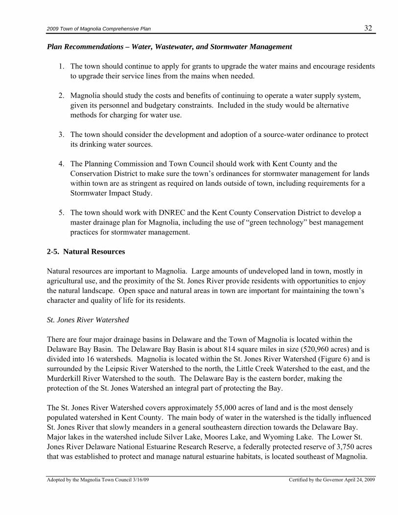
2009 Town of Magnolia Comprehensive Plan 32
Adopted by the Magnolia Town Council 3/16/09 Certified by the Governor April 24, 2009
Plan Recommendations – Water, Wastewater, and Stormwater Management
1. The town should continue to apply for grants to upgrade the water mains and encourage residents to upgrade their service lines from the mains when needed.
2. Magnolia should study the costs and benefits of continuing to operate a water supply system,
given its personnel and budgetary constraints. Included in the study would be alternative methods for charging for water use.
3. The town should consider the development and adoption of a source-water ordinance to protect
its drinking water sources.
4. The Planning Commission and Town Council should work with Kent County and the Conservation District to make sure the town’s ordinances for stormwater management for lands within town are as stringent as required on lands outside of town, including requirements for a Stormwater Impact Study.
5. The town should work with DNREC and the Kent County Conservation District to develop a
master drainage plan for Magnolia, including the use of “green technology” best management practices for stormwater management.
2-5. Natural Resources Natural resources are important to Magnolia. Large amounts of undeveloped land in town, mostly in agricultural use, and the proximity of the St. Jones River provide residents with opportunities to enjoy the natural landscape. Open space and natural areas in town are important for maintaining the town’s character and quality of life for its residents. St. Jones River Watershed There are four major drainage basins in Delaware and the Town of Magnolia is located within the Delaware Bay Basin. The Delaware Bay Basin is about 814 square miles in size (520,960 acres) and is divided into 16 watersheds. Magnolia is located within the St. Jones River Watershed (Figure 6) and is surrounded by the Leipsic River Watershed to the north, the Little Creek Watershed to the east, and the Murderkill River Watershed to the south. The Delaware Bay is the eastern border, making the protection of the St. Jones Watershed an integral part of protecting the Bay. The St. Jones River Watershed covers approximately 55,000 acres of land and is the most densely populated watershed in Kent County. The main body of water in the watershed is the tidally influenced St. Jones River that slowly meanders in a general southeastern direction towards the Delaware Bay. Major lakes in the watershed include Silver Lake, Moores Lake, and Wyoming Lake. The Lower St. Jones River Delaware National Estuarine Research Reserve, a federally protected reserve of 3,750 acres that was established to protect and manage natural estuarine habitats, is located southeast of Magnolia.
2009 Town of Magnolia Comprehensive Plan 33
Adopted by the Magnolia Town Council 3/16/09 Certified by the Governor April 24, 2009
The St. Jones River Watershed has highly productive agricultural soils, comprising about 42 percent of the land area. The remaining area in the watershed is about 30 percent urban/residential, 15 percent wetlands, 9 percent forests, and 4 percent other. Most of the wetland areas are tidally influenced marshes near the Delaware Bay.
Figure 6: St. Jones River Watershed Total Maximum Daily Load Total Maximum Daily Load (TMDL) regulations are authorized under federal code, but states are charged with developing and implementing standards to support the federal legislation that ensures the water of the United States meets certain thresholds for fishing, swimming, and drinking. The purpose of TMDL programs is to reduce the overall amount of pollution entering waterways through best management practices that take a comprehensive approach to the entire watershed. A few examples of best management practices include stormwater management, erosion control, nutrient-management plans, and pollutant removal at wastewater-treatment plants. Delaware State Code 7426 describes the regulations adopted in 2006 for TMDLs in the St. Jones watershed, which sets specific limits for pollutants that can enter into watershed and still protect water quality that supports activities such as swimming and fishing. In Delaware, strategies for pollution control are typically managed on a watershed basis by a coordinated effort between DNREC and tributary action teams made up of stakeholders and the general public. Implementation of strategies to meet these TMDL regulations is achieved through the development and implementation of a pollution-control strategy by the tributary action team. To date, a pollution-control strategy has not yet been completed, but partnerships among DNREC, the Delaware National Estuarine Research Reserve, and the public have resulted in the collection of stream data that will be used to evaluate problems and
2009 Town of Magnolia Comprehensive Plan 34
Adopted by the Magnolia Town Council 3/16/09 Certified by the Governor April 24, 2009
identify solutions. In addition, DNREC has been collecting water quality data in the St. Jones since 1970 through programs detailed in the TMDL report located at: www.dnrec.state.de.us/water2000/Sections/Watershed/TMDL/tmdlinfo.htm#co The main impact to the St. Jones Watershed is from nonpoint sources and includes excess nutrients and bacteria, low levels of dissolved oxygen, and elevated levels of chlorophyll-a. The watershed has dissolved oxygen levels less than the state minimum of 4mg/L, which severely limits the viability of certain plant and animal species. The origin of nonpoint-source pollutants is determined according to the type of land use. Areas such as forests and wetlands naturally add minimal amounts of nutrients and bacteria to waterways. Agricultural uses add nutrients and bacteria from animal-feed lots, nutrients from fertilizers, and sediments from runoff. Urban uses increase nonpoint pollution due to increased impervious cover and nutrients from septic systems, residential fertilizers, industrial wastes, and pet wastes. Since the land use in Magnolia is primarily residential and agricultural, a nutrient-runoff-mitigation strategy is needed to reduce nitrogen and phosphorus loading from land use activities. The town should work with DNREC, the Kent County Conservation District, and other local and county governments to aid in nutrient reductions. In the event of future development, Magnolia should try to implement more progressive stormwater-management techniques, including the use of green-technology stormwater-management practices in lieu of conventional open-water stormwater-management structures, establishing the DNREC-recommended 100-foot buffer from streams and wetlands, and encouraging the use of pervious materials wherever possible to reduce runoff and facilitate infiltration. TMDLs have been established for nonpoint-source pollutants for nitrogen, phosphorus and enterococcus bacteria and are aimed at improving water quality in the entire St. Jones River and its tributaries, including the Isaac Branch, Tidbury Branch, Fork Branch, Moores Lake, Silver Lake, and Derby Pond. The TMDLs for the St. Jones Watershed mandate that the total maximum daily nutrient load for nitrogen and phosphorus shall be reduced by 40 percent from the 2002-2003 baseline level and the enterococcus bacteria concentration shall be reduced by 90 percent from the 2002-2003 baseline level. The report for the TMDLs for the St. Jones can be found at: www.dnrec.state.de.us/water2000/Sections/Watershed/TMDL/7426%20Final%20TMDL%20Regs%20for%20St.%20Jones%20River.pdf Many of the issues involving surface-water quality in Kent County focus primarily on the health of the Delaware Bay. The protection of these sensitive natural resources and the surrounding waterways and water bodies is dependent upon the efforts of public, private, and corporate stakeholders alike. The Town of Magnolia is a member of this group of necessary participants in the protection of the regional environment and should participate along with the many other stakeholders whose actions have an impact on regional water quality.
2009 Town of Magnolia Comprehensive Plan 35
Adopted by the Magnolia Town Council 3/16/09 Certified by the Governor April 24, 2009
Floodplain A floodplain is defined as a flat, low-lying area adjacent to a watercourse that is subject to periodic inundation with water. While every flood event will have a unique floodplain, based on the amount of rainfall received, the 100-year-flood plain is accepted as the “regulatory” limits of flooding for flood insurance purposes and for many jurisdictional zoning and development practices. As can be seen on Map 4 in Appendix B, Magnolia is not located within, or near, a 100-year-floodplain and has a very low risk of flooding. The elevation in Magnolia increases from approximately 25 feet above sea level in the north of town to 30 feet above sea level in the south. The lowest elevation is 10 feet above sea level just outside of town adjacent to a small unnamed stream that is a tributary of the St. Jones River. The closest 500-year-floodplains are those of the St. Jones River, which are located about a half mile to the east and about a half mile to the north. A 500-year-flood plain can be described as the highest level of flood expected in a 500-year period. Wetlands Wetlands protect water quality by naturally filtering runoff on its way to water bodies. They also provide wildlife habitat and protection from flooding. Regulatory protection of wetlands is mandated under Section 404 provisions of the Federal Clean Water Act. Certain wetlands (mainly in tidal areas or sites containing regulated headwater streams) are accorded additional regulatory protection under Title 7, Chapter 66 provisions of the State of Delaware Code. Verification of the presence of wetlands is provided through a U.S. Army Corps of Engineers–approved field-wetlands delineation and/or an official DNREC wetland jurisdictional determination. Magnolia has only 0.18 acres of non-tidal wetlands, located near the northern boundary of town as delineated in the Wetlands Statewide Mapping Project. These wetlands extend further to the north and east and are characterized by three distinct qualities―hydrophytic vegetation (those plants suited to wetter soils), hydric soils (those soils that are seasonally to permanently saturated), and hydrologic connection. These wetlands are hydrologically connected to a tributary of the St. Jones River. In the event of future development, wetland areas should continue to be protected. Permitting for development in these areas is under the authority of the Army Corp of Engineers and DNREC. The town should consider wetland buffers to protect the viability of these important habitats. Soils The high quality soils in Magnolia easily support farming activities. According to the soil survey available at www.websoilsurvey.nrcs.usda.gov/app/WebSoilSurvey.aspx, almost all of Magnolia’s soils are Sassafras sandy loam soils. The only soils that are not Sassafras are about 3.5 acres in the northwest of town that are Runclint loamy sand soils. Sassafras soils are classified as well-drained soils, and Runclint soils are classified as excessively drained. Sassafras soils have a land-capability classification of “1” for irrigated and non-irrigated lands. The land-capability classification system groups soils based on their capability of producing commonly cultivated crops without deteriorating over a long period of
2009 Town of Magnolia Comprehensive Plan 36
Adopted by the Magnolia Town Council 3/16/09 Certified by the Governor April 24, 2009
time. A classification of a “1” is the highest classification with the least restrictions for agricultural use. The Runclint soils are less productive and have severe limitations for cultivation. In the event of future development, neither Sassafras soils nor Runclint soils are limiting to development, although Runclint soils sometimes limit the ability to construct houses with a basement. Critical Natural Areas A critical natural area is any site that is listed in the State Critical Natural Areas Inventory. There are no critical natural areas identified within the municipal boundaries of Magnolia. The closest critical natural areas are the Murderkill River Natural Area and Milford Neck Natural Areas, which contain the Delaware National Estuarine Research Reserve located to the south of town. In addition, there are no State Resource Areas in Magnolia. The State Resource Area system was developed for identifying and prioritizing open spaces worth preserving. Trees The character of the Magnolia community includes the protection of the natural aesthetics of town, including the trees and landscaping. Many mature trees are located throughout the town in both residential and institutional settings. The trees and ornamental plants located within the town contribute greatly to the visual appeal and healthy environment that exists in Magnolia. In the event of future development, the town should continue to protect this valuable resource and may consider adding tree and landscaping requirements in the town’s subdivision regulations. Additionally, the Delaware Forest Service’s Urban and Community Forestry Program provides $100,000 each year in funding for tree-planting, tree-care, and tree-management projects on publicly owned lands. In addition, the U.S. Forestry Service’s Tree City USA Program, offered through the National Arbor Day Foundation, provides additional funding for tree-protection, -education, and public awareness projects. About a dozen Delaware municipalities participate in the Tree City USA program. Participation in the program requires that the town have a tree board or department, a tree-care ordinance, a community forestry program with a budget of at least $2 per capita, and an Arbor Day observance or proclamation. Open Space Although there are currently many acres of land that are not developed within the town, this land is all privately owned. Magnolia does not have a public municipal park. DNREC’s Division of Parks and Recreation provides grant assistance to local governments through the Delaware Land and Water Conservation Trust Fund (DTF) for land acquisition and park development. The town may be able to utilize this program to acquire open space for a park or develop park facilities if it acquires public open space as undeveloped land in town is developed. The town should consider the inclusion of open-space requirements in its subdivision code for any new development.
2009 Town of Magnolia Comprehensive Plan 37
Adopted by the Magnolia Town Council 3/16/09 Certified by the Governor April 24, 2009
Summary of Key Issues – Natural Resources Magnolia is located within the St. Jones River Watershed, the most densely populated watershed in Kent County, covering approximately 55,000 acres of land. The Lower St. Jones River Reserve, one of two National Estuarine Research Reserves in Delaware that were established by the federal government to protect and manage natural estuarine habitats, is located nearby, southeast of Magnolia. In 2006, TMDLs for the St. Jones watershed established specific limits for pollutants that can enter the watershed and still protect the quality of water bodies that support activities such as fishing. TMDLs have been established for nonpoint-source pollutants for nitrogen, phosphorus, and enterococcus bacteria and are aimed at improving water quality in the entire St. Jones River and its tributaries. In Delaware, strategies for pollution control for watersheds are typically implemented by a coordinated effort between DNREC and tributary action teams made up of stakeholders and the general public. The Town of Magnolia is a member of this group and should participate along with the other stakeholders whose actions have an impact on regional water quality. Magnolia is not in a floodplain and has only a very small area of wetlands. There are no Critical Natural Areas or State Resource Areas in the town, although there are a number of mature trees that add to the town’s charm and character. Finally, the town does not have any parkland, but there is a lot of undeveloped land; therefore, there are still opportunities to establish a park in the town. Plan Recommendations – Natural Resources
1. The town should work with federal agencies, the state of Delaware, and other local governments to reduce pollution of the St. Jones River and the Delaware Bay and should consider joining a Tributary Action Team.
2. Magnolia should consider the development and implementation of a municipal ordinance for
landscaping requirements in new subdivisions and the development and implementation of a municipal ordinance for the protection of trees.
3. The town should encourage the use of “green” practices and materials in local construction and
development projects such as low-impact development. 4. The town should require best management practices for future development that are consistent
with the state of Delaware’s guidance documents for the protection of natural resources, including requiring buffer areas to preserve wetlands, forests, streams, and steep slopes.
5. Magnolia should consider participating in the U.S. Forestry Service’s Tree City USA Program,
offered through the National Arbor Day Foundation. Participation in the program requires that the town have a tree board or department, a tree-care ordinance, a community forestry program with a budget of at least $2 per capita, and an Arbor Day observance or proclamation.
2009 Town of Magnolia Comprehensive Plan 38
Adopted by the Magnolia Town Council 3/16/09 Certified by the Governor April 24, 2009
6. The town should consider incorporating Open Space preservation guidelines into their ordinances and consider the creation of a town park.
2-6. Transportation This section of the plan provides transportation-related data and promotes an understanding of the modes of travel and transportation infrastructure in Magnolia. Since transportation involves linking areas within and outside of the town, this section of the plan includes extensive use of a regional context and an intergovernmental approach to research and planning. The Town of Magnolia recognizes that successful regional-transportation systems require the cooperation of local, county, and state governments and has developed its transportation plan with this basic concept in mind. Roadway Facilities Map 2 in Appendix B details the simple transportation network that exists within the circular bounds of the Town of Magnolia. The primary regional transportation corridor for the town is the north-south corridor of U.S. Route 113A, which is state-maintained and identified as Main Street within the town boundaries. The primary east-west corridor is Kent County Road 31, which is also maintained by the state and is identified as Walnut Street within town. The map illustrates that there are only two other streets in Magnolia―Thorn Street and Jado Terrace. The Delaware Department of Transportation (DelDOT) manages the maintenance and alteration of state-maintained roads, including U.S. Route 113A and Kent County Road 31. Thorn Street is a municipal street maintained by the town. Jado Terrace is a dead-end gravel drive that is maintained by residents. U.S. Route 113A This north-south road connects Magnolia with U.S. Route 13 and the City of Dover to the north, and U.S. Route 113/Route 1 to the south. It is a two-lane highway classified by DelDOT as a minor arterial road. About a half-mile of U.S. Route 113A runs through Magnolia. Unfortunately, the road is frequently used as an alternative route by residents around the Dover area to reach State Route 1 and the beaches to the south. Residents have reported that, during the summer beach season, it is often very difficult to even pull out of their driveways onto the road due to the heavy beach traffic. Additionally, the only stoplight in Magnolia, located at the center of the town, often backs up this beach traffic for miles. It is no surprise that traffic and congestion was identified by the residents in the town questionnaire as the most important issue in Magnolia. Table 23 displays data regarding recent traffic estimates for the section of U.S. Route 113A in Magnolia. The traffic counts provided by DelDOT show a 6.9 percent increase in traffic volume for the section of U.S. Route 113A that is located within the town limits over the five-year period between 2002 and 2006. Estimates for the neighboring section of U.S. Route 113A entering the town from the south also showed a 6.9 percent increase, while the northern section showed an 11.4 percent increase. However, it is important to note that a traffic-count survey has not been completed in all but the northern section since 2000. Since that time, only projections have been published for those stations. However the section of
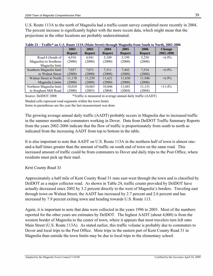
2009 Town of Magnolia Comprehensive Plan 39
Adopted by the Magnolia Town Council 3/16/09 Certified by the Governor April 24, 2009
U.S. Route 113A to the north of Magnolia had a traffic-count survey completed more recently in 2004. The percent increase is significantly higher with the more recent data, which might mean that the projections in the other locations are probably underestimated. Table 23 – Traffic* on U.S. Route 113A (Main Street) through Magnolia from South to North, 2002-2006
2002 Report
2003 Report
2004 Report
2005 Report
2006 Report
Change 2002-2006
Road 8 (South of Magnolia) to Southern
Magnolia limit
4,910 (2000)
4,941 (2000)
5,109 (2000)
5,199 (2000)
5,250 (2000)
+6.9%
Southern Magnolia limit to Walnut Street
7,027 (2000)
7,071 (2000)
7,311 (2000)
7,442 (2000)
7,516 (2000)
+6.9%
Walnut Street to North Magnolia Limits
11,170 (2000)
11,239 (2000)
11,621 (2000)
11,830 (2000)
11,948 (2000)
+6.9%
Northern Magnolia limit to Sorghum Mill Road
10,010 (2000)
10,063 (2003)
10,846 (2004)
11,041 (2004)
11,151 (2004)
+11.4%
Source: DelDOT 2008 *Traffic is measured in average annual daily traffic (AADT) Shaded cells represent road segments within the town limits Items in parentheses are the year the last measurement was done The growing average annual daily traffic (AADT) probably occurs in Magnolia due to increased traffic in the summer months and commuters working in Dover. Data from DelDOT Traffic Summary Reports from the years 2002-2006 indicate that the flow of traffic is proportionately from south to north as indicated from the increasing AADT from top to bottom in the table. It is also important to note that AADT on U.S. Route 113A in the northern half of town is almost one-and-a-half times greater than the amount of traffic on south end of town on the same road. This increased amount of traffic could be from commuters to Dover and daily trips to the Post Office, where residents must pick up their mail. Kent County Road 31 Approximately a half mile of Kent County Road 31 runs east-west through the town and is classified by DelDOT as a major collector road. As shown in Table 24, traffic counts provided by DelDOT have actually decreased since 2002 by 3.2 percent directly to the west of Magnolia’s borders. Traveling east through town on Walnut Street, the AADT has increased by 2.7 percent and 2.6 percent and has increased by 7.9 percent exiting town and heading towards U.S. Route 113. Again, it is important to note that data were collected in the years 1996 to 2003. Most of the numbers reported for the other years are estimates by DelDOT. The highest AADT (about 4,000) is from the western border of Magnolia to the center of town, where it appears that most travelers turn left onto Main Street (U.S. Route 113A). As stated earlier, this traffic volume is probably due to commuters to Dover and local trips to the Post Office. More trips in the eastern part of Kent County Road 31 in Magnolia than outside the town limits may be due to local trips to the elementary school.
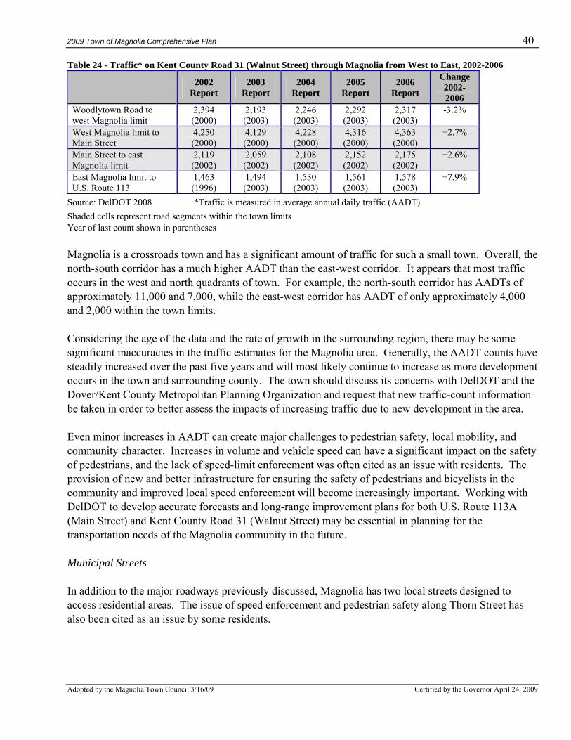
2009 Town of Magnolia Comprehensive Plan 40
Adopted by the Magnolia Town Council 3/16/09 Certified by the Governor April 24, 2009
Table 24 - Traffic* on Kent County Road 31 (Walnut Street) through Magnolia from West to East, 2002-2006
2002 Report
2003 Report
2004 Report
2005 Report
2006 Report
Change 2002-2006
Woodlytown Road to west Magnolia limit
2,394 (2000)
2,193 (2003)
2,246 (2003)
2,292 (2003)
2,317 (2003)
-3.2%
West Magnolia limit to Main Street
4,250 (2000)
4,129 (2000)
4,228 (2000)
4,316 (2000)
4,363 (2000)
+2.7%
Main Street to east Magnolia limit
2,119 (2002)
2,059 (2002)
2,108 (2002)
2,152 (2002)
2,175 (2002)
+2.6%
East Magnolia limit to U.S. Route 113
1,463 (1996)
1,494 (2003)
1,530 (2003)
1,561 (2003)
1,578 (2003)
+7.9%
Source: DelDOT 2008 *Traffic is measured in average annual daily traffic (AADT) Shaded cells represent road segments within the town limits Year of last count shown in parentheses Magnolia is a crossroads town and has a significant amount of traffic for such a small town. Overall, the north-south corridor has a much higher AADT than the east-west corridor. It appears that most traffic occurs in the west and north quadrants of town. For example, the north-south corridor has AADTs of approximately 11,000 and 7,000, while the east-west corridor has AADT of only approximately 4,000 and 2,000 within the town limits. Considering the age of the data and the rate of growth in the surrounding region, there may be some significant inaccuracies in the traffic estimates for the Magnolia area. Generally, the AADT counts have steadily increased over the past five years and will most likely continue to increase as more development occurs in the town and surrounding county. The town should discuss its concerns with DelDOT and the Dover/Kent County Metropolitan Planning Organization and request that new traffic-count information be taken in order to better assess the impacts of increasing traffic due to new development in the area. Even minor increases in AADT can create major challenges to pedestrian safety, local mobility, and community character. Increases in volume and vehicle speed can have a significant impact on the safety of pedestrians, and the lack of speed-limit enforcement was often cited as an issue with residents. The provision of new and better infrastructure for ensuring the safety of pedestrians and bicyclists in the community and improved local speed enforcement will become increasingly important. Working with DelDOT to develop accurate forecasts and long-range improvement plans for both U.S. Route 113A (Main Street) and Kent County Road 31 (Walnut Street) may be essential in planning for the transportation needs of the Magnolia community in the future. Municipal Streets In addition to the major roadways previously discussed, Magnolia has two local streets designed to access residential areas. The issue of speed enforcement and pedestrian safety along Thorn Street has also been cited as an issue by some residents.
2009 Town of Magnolia Comprehensive Plan 41
Adopted by the Magnolia Town Council 3/16/09 Certified by the Governor April 24, 2009
Public Transportation Relatively reliable, year-round public transportation is provided by DART/First State in Magnolia. The State Route 303 Dover-Milton-Georgetown bus route transports patrons between Dover and Georgetown Monday through Friday except New Year’s Day, Memorial Day, Independence Day, Labor Day, Thanksgiving, and Christmas. Residents traveling north to Dover can be picked up by buses stopping at the corner of Main Street and Walnut Street between 5:30 a.m. and 8:30 p.m. approximately every two hours. Traveling south to Milford and Georgetown, buses depart Magnolia at 7:00 a.m. and between the hours of 2:00 p.m. and 7:00 p.m. every few hours. DART provides paratransit service for elderly and disabled riders. The service is door-to-door and rides need to be arranged at least one day in advance. Also available is the Senior Citizens Affordable Taxi (SCAT) service, which provides elderly or disabled persons with a 50 percent discount on taxi fares from participating companies. Bicycles and Pedestrians Automotive congestion has made it more difficult to accommodate pedestrian and bicycle traffic in recent years. Of particular concern is the lack of a complete sidewalk system throughout town. Although the town has sidewalk infrastructure along sections of Main Street and Walnut Street, the system is not complete throughout the town due to the lack of a sidewalk ordinance and the unwillingness of some property owners to agree to sidewalks fronting their property. The result has been that pedestrians must often cross the street several times to access a sidewalk. If pedestrians choose not to cross the road, they are forced onto the shoulders of the roadways. In order to ensure the sufficiency of infrastructure and safety for pedestrians and bicyclists, the town should discuss and develop an improvement plan for Main Street and Walnut Street and consider developing a pedestrian- and bicycle-safety program. The town could partner with DelDOT or some other outside agency to conduct a mobility-friendly assessment of the town’s transportation infrastructure and obtain policy guidance on the implementation of a successful sidewalk ordinance. Such a project would likely pinpoint where and why most property owner/automobile/pedestrian conflicts arise and suggest mitigating measures. The Healthy Communities Initiative sponsored by the University of Delaware and the State Division of Public Health is a good resource for information on how to create and maintain walkability and connectivity in towns like Magnolia. The town may also want to consider developing a sidewalk ordinance to require residents to install and maintain sidewalks. Currently the town’s subdivision regulations require sidewalks in all new subdivisions, but there are no provisions for requiring sidewalks throughout the town on existing developed properties. It is important to note that respondents to the town questionnaire supported the issue of having adequate sidewalks around town. Additionally, the state Division of Public Health has strongly endorsed the need for sidewalks within towns to provide greater opportunities for residents to participate in physical activity as part of their daily routines, resulting in improved health.
2009 Town of Magnolia Comprehensive Plan 42
Adopted by the Magnolia Town Council 3/16/09 Certified by the Governor April 24, 2009
Rail The closest passenger-rail service in Delaware is in the City of Wilmington. From there, Amtrak provides daily service to many major cities. In addition, the Delaware Transit Corporation (DTC) and the Southeastern Pennsylvania Transit Administration (SEPTA) provide daily commuter-rail service between Newark, Wilmington, and Philadelphia along Amtrak’s Northeast Corridor. Airport The closest commercial passenger service for Magnolia residents is either Philadelphia International Airport or Baltimore-Washington International Airport. The travel time to each is between two to two and a half hours. Summary of Key Issues – Transportation The most important issue continually discussed during the development of this plan is the increasing level of traffic in town. In addition, responses to the town questionnaire overwhelmingly noted the number of cars and trucks using Main Street to be the most important issue in town. Magnolia is a crossroads town, and increasing numbers of vehicles are passing through the only traffic light, in the center of town, to commute or connect to areas north (Dover, Air Base) and south (S.R. 1) towards the beaches. Most of the traffic counts taken by the state are almost eight years old, and most residents believe the actual number of vehicles passing through town is much higher than the estimates provided by the state. In addition, the residents believe there are an increasing number of heavy trucks passing through town and that these trucks are tearing up the roads and damaging the homes located along Main Street. The high number of motorized vehicles and the lack of a complete sidewalk network make it difficult and dangerous to ride a bike or walk around town. There is public transportation available in town, and responses to the town questionnaire and from the attendees to the planning meetings indicated the level of service is adequate both to north and south destinations. Plan Recommendations – Transportation
1. The town should work with DelDOT to develop strategies for generating accurate and timely data regarding the increasing motor-vehicle traffic, particularly the number of vehicles passing through the Main Street traffic-light intersection.
2. Once the new traffic data is developed, the town should work with the state and the Dover/Kent
Count Metropolitan Planning Organization to develop a strategy to mitigate the impacts of pass-through vehicles, such as the daily commuters traveling to and from Dover as well as the peak traffic vehicles traveling to and from the beaches.
3. Consider conducting a comprehensive ped/bike assessment of the transportation infrastructure in
town to improve pedestrian and bicycle safety and reduce the auto-dependency of residents.
2009 Town of Magnolia Comprehensive Plan 43
Adopted by the Magnolia Town Council 3/16/09 Certified by the Governor April 24, 2009
4. The Town Council and Planning Commission should consider the development of a sidewalk ordinance requiring all property owners to install and maintain sidewalks in front of their property.
2-7. Existing Land Use, Future Land Use, and Annexation This section of the plan describes the existing land uses in Magnolia, prescribes the desired future land uses in the town, and addresses the town’s plans for future growth. Existing Land Use The Town of Magnolia totals about 120 acres and contains six land uses within its boundaries―residential, commercial, agricultural, institutional, utilities, and vacant. Map 6 in Appendix B displays the current pattern of land use; note that the town does not own or maintain a park or open space. Vacant and Agricultural Vacant and agricultural land comprises about 69.5 acres, or over half of the Town of Magnolia (58%). Most of these parcels are currently being used for agricultural crops such as hay, soy beans, and corn. Residential Residential land use comprises the next highest percentage of land activity in Magnolia, about 30 percent. Residential land uses vary in their appearance and intensity, depending upon where a particular use is located, but single-family detached homes is by far the most common type of residence (93.5%). Residential uses are concentrated along the two main arteries in town, Main Street and Walnut Street. Most residential dwellings are oriented towards the street, scattered along each side of the main road, helping to create Magnolia’s small-town feel. Thorn Street connects Main Street and Walnut Street to create a denser pocket of development. Institutional Institutional land uses include civic buildings and structures, churches, libraries, service centers, public healthcare facilities, and other such uses. Five land uses that serve the public exist in Magnolia, totaling about ten percent of the total land in town. These institutional land uses are Town Hall, J. Ralph McIlvaine Elementary School, the Magnolia Fire Station, the Post Office, and the United Methodist Church. The McIlvaine School is currently undergoing renovation and expansion to meet increasing needs in the area for this type of facility.
2009 Town of Magnolia Comprehensive Plan 44
Adopted by the Magnolia Town Council 3/16/09 Certified by the Governor April 24, 2009
Commercial There is limited commercial land use in town, totaling a little over an acre. The town has zoned several parcels along the Main Street corridor for Community Commercial use, but a restaurant and a furniture store are the only active commercial uses located on this land. Utilities There are a few parcels in town currently used for utilities. These parcels are used for the town’s elevated water-storage tank, pumping station, and cellular-phone towers. Current Zoning Within Magnolia The town’s Zoning Ordinance was originally enacted October 8, 1980, and was revised and annotated in 1981. Since then, there have been some revisions to the Zoning Ordinance as noted. The zoning within Magnolia is provided on Map 5 in Appendix B. Residential Zoning There are two residential zoning districts that provide the basis for residential land use in town, R-1 and R-2. The R-1 Single Family Residential District provides for a minimum lot size of 21,780 square feet (0.5 acre) as described in the January 10, 2005, amendment. Permitted uses on R-1 properties include single-family detached dwellings, public and private schools, churches, municipal and public buildings, cultural facilities, farming and agricultural activities, and accessory buildings like private garages and farm buildings. The R-2 Apartment Residential District allows for more dense development with a minimum lot size of 6,500 square feet (0.15 acre). R-2 uses include all R-1 uses plus single-family semi-detached dwelling units, boarding and lodging houses, and conversions of one-family dwellings into multiple units with a minimum lot area of 2,000 square feet for each unit. Community Commercial Zoning The C-1 Zoning District provides the basis for commercial land uses in town. Most of the commercially zoned properties are located along the west side of Main Street from Walnut Street to Thorn Street and to the east side of Main Street near the town’s southern boundary. The minimum lot size for commercial properties is 3,500 square feet, with a building-height restriction of 35 feet. A variety of uses typically allowed in commercial districts are permitted, including banks, beauty shops, medical clinics, food stores, restaurants (excluding franchise fast-food businesses), specialty retail stores, repair and servicing centers, parking lots, bookstores, auctions, and public services. There are also several additional commercial uses conditionally allowed, subject to special requirements.
2009 Town of Magnolia Comprehensive Plan 45
Adopted by the Magnolia Town Council 3/16/09 Certified by the Governor April 24, 2009
Industrial Zoning There is an Industrial Zoning (I) classification detailed in the Zoning Ordinance requires a minimum lot area of two acres and permits light manufacturing and processing land uses and professional and administrative offices, but there are no parcels zoned I on the current zoning map. Current Land Use/Zoning Adjacent to Magnolia At this time, most of this land within a half mile of the town is being used for residential or agricultural purposes, but that can change, so it’s important to note the future land use proposed in the draft Kent County Plan update currently underway and understand the changes that could occur on these lands. All of the land around Magnolia is governed, and therefore zoned, by Kent County and is displayed on Map 5 in Appendix B. During the past year, Kent County has been working on updating its 2002 Comprehensive Plan and the current draft plan update will be presented to Kent County Levy Court soon for adoption. It is important to note that this land surrounding Magnolia is in the Kent County Growth Zone. According to the draft Kent County Future Land Use Map, the area around Magnolia should be developed as low-density single-family detached homes. Since it is in the Growth Zone, this translates into a maximum density of three dwelling units per acre. But all of the land west of U.S. Route 113A adjacent to Magnolia is also designated as a secondary receiving area for the county’s Transfer of Development Rights program. This program provides incentives to developers to build in areas where Kent County and the state would prefer to have new development, since there is better infrastructure in these areas to handle the growth. In the secondary receiving area adjacent to Magnolia, a developer would be permitted to build up to five single-family homes per acre. Except for a few parcels to the northwest and southwest of town, most of the land adjacent to the town is zoned Agricultural Conservation (AC). According to the Kent County Zoning Code, the purpose of the AC District is “to provide for a wide range of agricultural and farm-related services while providing for low-density residential development in areas that are rural in character and where farming may not be the optimum land use activity.” However, since this AC-zoned land is in the Kent County Growth Zone, it is essentially a suburban residential zone and that type of future land use should be anticipated. Future Land Use This section of the plan was developed by the Magnolia Planning Commission and the Town Council, which discussed a variety of land use issues during the months involved in developing this plan. It is important to note that the future land use map will be the foundation for any proposed land use changes and the town is required to update its zoning map to correspond with this plan document within 18 months of plan adoption. Residential As seen in Map 6, the majority of the developed land in Magnolia is residential and all discussions by the Town Council, Planning Commission, and residents have clearly expressed the desire to keep the
2009 Town of Magnolia Comprehensive Plan 46
Adopted by the Magnolia Town Council 3/16/09 Certified by the Governor April 24, 2009
town as mainly a residential community. As explained in the previous section on zoning, the town Zoning Ordinance permits two types of residential development with most of the town zoned R-1, 0.5-acre lots. But there are also eight lots on West Walnut, five lots on Thorn Street, and six lots on Main Street that are zoned R-2, permitting more dense residential use with 0.15-acre lots. The town discussed the potential for rezoning some of these R-2 lots to R-1, since many of them are being used as R-1 and decided to make this issue a recommended activity for the Planning Commission to assess following the drafting of the town plan. Commercial There is a small downtown section of Magnolia that is zoned for commercial use, but only two of the 14 commercially zoned parcels are actually being used for commercial activity. The other lots are being used for residential activity and have reportedly been in residential use for many years. According to the zoning ordinance, among the permitted commercial uses are “Residences … in conjunction with any non-residential use.” This meaning of this regulation is unclear; it could mean “either commercial or residential is permitted,” or it could mean “residential is permitted only with a commercial use.” The Town discussed this issue in depth and opinions varied. Additionally, because of the restricted width of Main Street, and heavy traffic, there is little parking now available for these commercial parcels, so the potential viability of commercial uses may be limited. The Town decided that one of its most immediate needs was to amend the commercial-use section of its zoning ordinance. There was also much discussion on the potential rezoning of the commercial parcels that were not being used for commercial activity. These two issues will also be addressed following the completion of the town plan. Industrial The town has an Industrial classification in its Zoning Ordinance, but there are no parcels zoned Industrial in the town. The potential for future industrial land uses in town was discussed and there was unanimous consent that there will be no future industrial land use proposed in the town. It is recommended that this zoning category be removed from the ordinance. Redevelopment The state requires towns to include a redevelopment strategy in its comprehensive plan. The strategy should identify areas in need of revitalization and discuss potential policies that could encourage redevelopment of these areas. The Town of Magnolia does not have a specific area in need of revitalization; it is and has always been a predominantly residential town. Additionally, the town is unique in that over half of the area within town is currently vacant and mostly used for growing crops. Most of the energy and effort to be expended over the next five years by town officials will be focused on trying to maintain the town’s small-town character and enhancing the services provided to current residents, as additional residents move into new housing within new residential developments. As presented earlier in the housing section, the town continues to be concerned about the maintenance of existing housing stock, particularly the appearance and structural integrity of the historic properties
2009 Town of Magnolia Comprehensive Plan 47
Adopted by the Magnolia Town Council 3/16/09 Certified by the Governor April 24, 2009
located in highly visible areas of town. Magnolia would like to revise its property-maintenance ordinances for existing structures and increase the enforcement of these standards. The Town also discussed the parcels zoned commercial that are located in the center of town, which for years have been primarily used for residential land use. At one time there were small businesses in these commercially zoned structures, but now almost all are used for residential purposes. There are a variety of limitations now that make this area more difficult for commercial activity. The Town has recommended that this issue be discussed following adoption of the plan as the Planning Commission takes up the task of revising the town’s dated Zoning Ordinance. Annexation The issue of annexation is always difficult for towns. Towns that annex risk growing beyond their ability to manage the resulting increased population and housing, which often results in dramatic changes to the character of the town. However, towns that do not annex risk becoming stagnant with decreasing populations and little opportunity for increasing town revenues to meet constantly growing expenditures. In addition, towns often end up having to still deal with the consequences of development outside their boundaries without receiving any of the benefits. The Town discussed the annexation issue at several meetings and included the issue in the town questionnaire to receive more input from its residents. Although there were varying opinions on this issue, it was decided that for the short-term future (next five years) the town would not consider annexations. There are two main reasons for this decision―more than half of the land within the current town boundaries is currently undeveloped, providing opportunities for in-fill development, and, perhaps more importantly, the desire of many of the residents to maintain Magnolia’s unique circular boundary. It should be noted that the annexation process as detailed in Section 32 of the Magnolia Town Charter is a somewhat unique procedure that should be reviewed, and perhaps revised, if annexation is an option the town may want to consider in the future. The town’s unique annexation process includes the requirement for a Special Election involving town citizens and property owners. The town’s process should be reviewed during this time when annexations are not being considered. Areas of Concern Although the town is not considering the annexation of land adjacent to its boundaries, it has identified an Area of Concern on Map 7: Future Land Use and Growth. Areas of Concern have been delineated by many towns in Delaware as areas where development would likely impact the town, particularly the increased traffic that would be generated. Additionally, some of these properties adjacent to the town may be of interest to the town for future long-term growth (5-10 years and beyond). In Areas of Concern, towns ask that the neighboring jurisdiction inform them of development proposals in that area. Therefore, Magnolia would like to have any proposal submitted to Kent County for developing land shared with the town for its review and comment, and Magnolia would reciprocate this courtesy to Kent County.
2009 Town of Magnolia Comprehensive Plan 48
Adopted by the Magnolia Town Council 3/16/09 Certified by the Governor April 24, 2009
Summary of Key Issues – Future Land Use and Annexation Since over half of the land in Magnolia is undeveloped, the town will be greatly affected when this land is developed. Consideration should be given to developing an open-space provision in the town Zoning Ordinance to insure that some public open space is provided as parcels are developed. The town is comfortable being a residential community with limited commercial activity and will review the commercial zoning provisions in its ordinance. Also, the town will assess the commercially zoned parcels along Main Street and may propose down-zoning some of them to only permit residential activity. The town will discuss the potential for commercial activity in other areas of town, particularly larger, undeveloped parcels that may be better situated to handle associated traffic and parking issues. There are several institutional land uses that currently exist on residentially zoned properties, like the fire station, school, and Post Office. These are complementary land uses and most residents hope they stay in town. The one exception is the Post Office. Some residents would like it to relocate out of town. Others want it to remain in the town’s center. All agree they do not want an industrial land use in town. Since the majority of the town is undeveloped and the town’s circular boundary is very unique, the town does not plan to annex property in the near future and has not designated a growth area on its Future Land Use and Growth map. However, the town is very concerned about the potential development that may occur on the land adjacent to the town under the jurisdiction of Kent County. Accordingly, it has established an Area of Concern extending one-fourth of a mile all around its town boundary. The town and county should keep each other informed of potential development activity in this Area of Concern. Plan Recommendations – Future Land Use and Annexation
1. Review the parcels currently zoned R-2 and, in consideration of the current land use and characteristics of these parcels, determine if any of them should be rezoned to R-1.
2. Review the commercial provisions in the zoning ordinance and update to reflect the uses that
would fit with the current character and vision of the town. Additionally, parcels currently zoned C-1 (commercial) that are not being used for commercial activity should be reviewed to determine if they should be rezoned to reflect the historic and current land use (residential).
3. Amend the zoning ordinance to delete the Industrial classification from the town ordinance. 4. Consider the development of an open-space provision in the town Zoning Ordinance. 5. Although no annexation is desired in the near future, the Town has established an Area of
Concern extending a quarter-mile around the town and would like to develop an agreement with Kent County to keep each jurisdiction mutually informed of proposed development in this area.
6. The town should review its annexation procedures in the Town Charter and consider potential
revisions.
2009 Town of Magnolia Comprehensive Plan 49
Adopted by the Magnolia Town Council 3/16/09 Certified by the Governor April 24, 2009
CHAPTER 3. COORDINATION AND IMPLEMENTATION 3-1. Intergovernmental Coordination The residents of Magnolia and the services and operations of the town will be affected by activities occurring within the town and on lands within Kent County’s jurisdiction surrounding the town. Therefore, it would be of great benefit to Magnolia and Kent County to continue to maintain a cooperative relationship. The town should meet with Kent County officials to discuss matters for which Magnolia might be interested in receiving or providing assistance. Likewise, Kent County may find that this enhanced relationship can help keep them informed of issues that arise in Magnolia, issues that could adversely affect residents living outside of town in Kent County. All new development, or redevelopment, that occurs around Magnolia is relevant to the town due to the economic and social impacts that it may have upon the town. It will be very important that Magnolia remains aware and informed of land use changes and development proposals in nearby areas that would likely affect the town. The town should designate a member of Council or the Planning Commission to follow and comment on these proposals through the state PLUS processes or through the planning process in Kent County. The town should review the recent draft Kent County Comprehensive Plan to understand the potential land use that would be permitted around the town’s boundaries. Magnolia should also continue to review and comment on DelDOT and Dover/Kent County Metropolitan Planning Organization Transportation Plans, since traffic will continue to be a major issue for Magnolia. Additionally, the town should maintain a good relationship with the state’s Office of State Planning Coordination (OSPC) and the professional planner OSPC has designated as the Kent County Circuit Rider Planner. This planner can help the town with a variety of issues, including assisting the town in updating its zoning and subdivision ordinances, providing assistance with identifying the appropriate contact persons within state or county departments, identifying funding sources for programs developed to assist municipalities in Delaware, and providing direction on alternatives to locating data and information the town may need in its efforts to apply for loans and grants. 3-2. Plan Implementation Implementation is one of the most important parts of the comprehensive-planning process, as it provides direction to the town to accomplish the ideas discussed in its Comprehensive Plan. Also, it is recognized that the Town of Magnolia cannot implement this plan without coordinating with other governments and agencies, in particular Kent County and, of course, the many agencies within the state of Delaware. The following is a summary of the main recommendations made throughout this plan. It provides a guide to actions that will be needed following the certification and adoption of this plan. It should be noted that the most immediate recommendation requiring attention should be the updating and revision of the town’s Zoning Ordinance. An updated ordinance will provide the town with a better tool for maintaining the town’s historic character and charm as growth occurs in Magnolia.
2009 Town of Magnolia Comprehensive Plan 50
Adopted by the Magnolia Town Council 3/16/09 Certified by the Governor April 24, 2009
Plan Recommendations – Housing • The town should utilize its zoning authority by updating zoning codes to carefully and appropriately
shape the residential development in Magnolia. In particular, the town should identify and protect areas of traditional, small-scale residential development and encourage new mixed-use development where appropriate, possibly considering cluster-type development.
• The town should develop an approach to marketing Magnolia to future residents, focusing on first-
time home buyers and “fixer-uppers” willing to invest time and money in rehabilitating older housing within the town.
• The town should encourage development that mixes land uses and housing types to accommodate
various income levels and provide affordable housing. • The town should attempt to preserve Magnolia’s traditional, quiet, friendly, small-town character
and quality of life by identifying the character of the community and only allow development that supports this character and relates to Kent County designated growth zones.
• The town should encourage conservation of the town’s historical character and assets through the
revision and increased enforcement of property-maintenance ordinances for existing structures and new development.
• The town should provide assistance and options for owners of historic and aging properties that have
special maintenance needs. Plan Recommendations – Community Services and Facilities • Magnolia should update its charter to address a number of issues that have become dated. • The town should try to attract additional Internet phone and cable providers to town to provide
residents with more than one option. • An assessment of the residents’ satisfaction with police services in town should be periodically made
and options developed to increase police visibility and enforcement opportunities in town. • The town should continue to work with the volunteer fire company to explore additional
opportunities to attract more volunteers, particularly during times when volunteers are serving in the military.
• The town should revisit the issue of contracting for trash collection services for the town’s property
owners and promote recycling opportunities.
2009 Town of Magnolia Comprehensive Plan 51
Adopted by the Magnolia Town Council 3/16/09 Certified by the Governor April 24, 2009
• The town should continue to discuss options for a new post office, deciding if the majority of the residents favor an in-town or out-of-town location.
Plan Recommendations – Water, Wastewater, and Stormwater Management • The town should continue to apply for grants to upgrade the water mains and encourage residents to
upgrade their service lines from the mains when needed. • Magnolia should study the costs and benefits of continuing to operate a water supply system, given
its personnel and budgetary constraints. Included in the study would be alternative methods for charging for water use.
• The town should consider the development and adoption of a source-water ordinance to protect its
drinking water sources. • The Planning Commission and Town Council should work with Kent County and the Conservation
District to make sure the town’s ordinances for stormwater management for lands within town are as stringent as required on lands outside of town, including requirements for a Stormwater Impact Study.
• The town should work with DNREC and the Kent County Conservation District to develop a master
drainage plan for Magnolia, including the use of “green technology” best management practices for stormwater management.
Plan Recommendations – Natural Resources • The town should work with federal agencies, the state of Delaware, and other local governments to
reduce pollution of the St. Jones River and the Delaware Bay and should consider joining a Tributary Action Team.
• Magnolia should consider the development and implementation of a municipal ordinance for
landscaping requirements in new subdivisions and the development and implementation of a municipal ordinance for the protection of trees.
• The town should encourage the use of “green” practices and materials in local construction and
development projects such as low-impact development. • The town should require best management practices for future development that are consistent with
the state of Delaware’s guidance documents for the protection of natural resources, including requiring buffer areas to preserve wetlands, forests, streams, and steep slopes.
• Magnolia should consider participating in the U.S. Forestry Service’s Tree City USA Program,
offered through the National Arbor Day Foundation. Participation in the program requires that the
2009 Town of Magnolia Comprehensive Plan 52
Adopted by the Magnolia Town Council 3/16/09 Certified by the Governor April 24, 2009
town have a tree board or department, a tree-care ordinance, a community forestry program with a budget of at least $2 per capita, and an Arbor Day observance or proclamation.
• The town should consider incorporating Open Space preservation guidelines into their ordinances
and consider the creation of a town park. Plan Recommendations – Transportation • The town should work with DelDOT to develop strategies for generating accurate and timely data
regarding the increasing motor-vehicle traffic, particularly the number of vehicles passing through the Main Street traffic-light intersection.
• Once the new traffic data is developed, the town should work with the state and the Dover/Kent
Count Metropolitan Planning Organization to develop a strategy to mitigate the impacts of pass-through vehicles, such as the daily commuters traveling to and from Dover as well as the peak traffic vehicles traveling to and from the beaches.
• Consider conducting a comprehensive ped/bike assessment of the transportation infrastructure in
town to improve pedestrian and bicycle safety and facilitating less use of vehicles by residents. • The Town Council and Planning Commission should consider the development of a sidewalk
ordinance requiring all property owners to install and maintain sidewalks in front of their property. Plan Recommendations – Future Land Use and Annexation • Review the parcels currently zoned R-2 and, in consideration of the current land use and
characteristics of these parcels, determine if any of them should be rezoned to R-1.
• Review the commercial provisions in the zoning ordinance and update to reflect the uses that would fit with the current character and vision of the town. Additionally, parcels currently zoned C-1 (commercial) that are not being used for commercial activity should be reviewed to determine if they should be rezoned to reflect the historic and current land use (residential).
• Amend the zoning ordinance to delete the Industrial classification from the town ordinance. • Consider the development of an open-space provision in the town Zoning Ordinance. • Although no annexation is desired in the near future, the Town has established an Area of Concern
extending a quarter-mile around the town and would like to develop an agreement with Kent County to keep each jurisdiction mutually informed of proposed development in this area.
• The town should review its annexation procedures in the Town Charter and consider potential
revisions.
2009 Town of Magnolia Comprehensive Plan 53
Adopted by the Magnolia Town Council 3/16/09 Certified by the Governor April 24, 2009
APPENDIX A: APRIL 2008 TOWN QUESTIONNAIRE
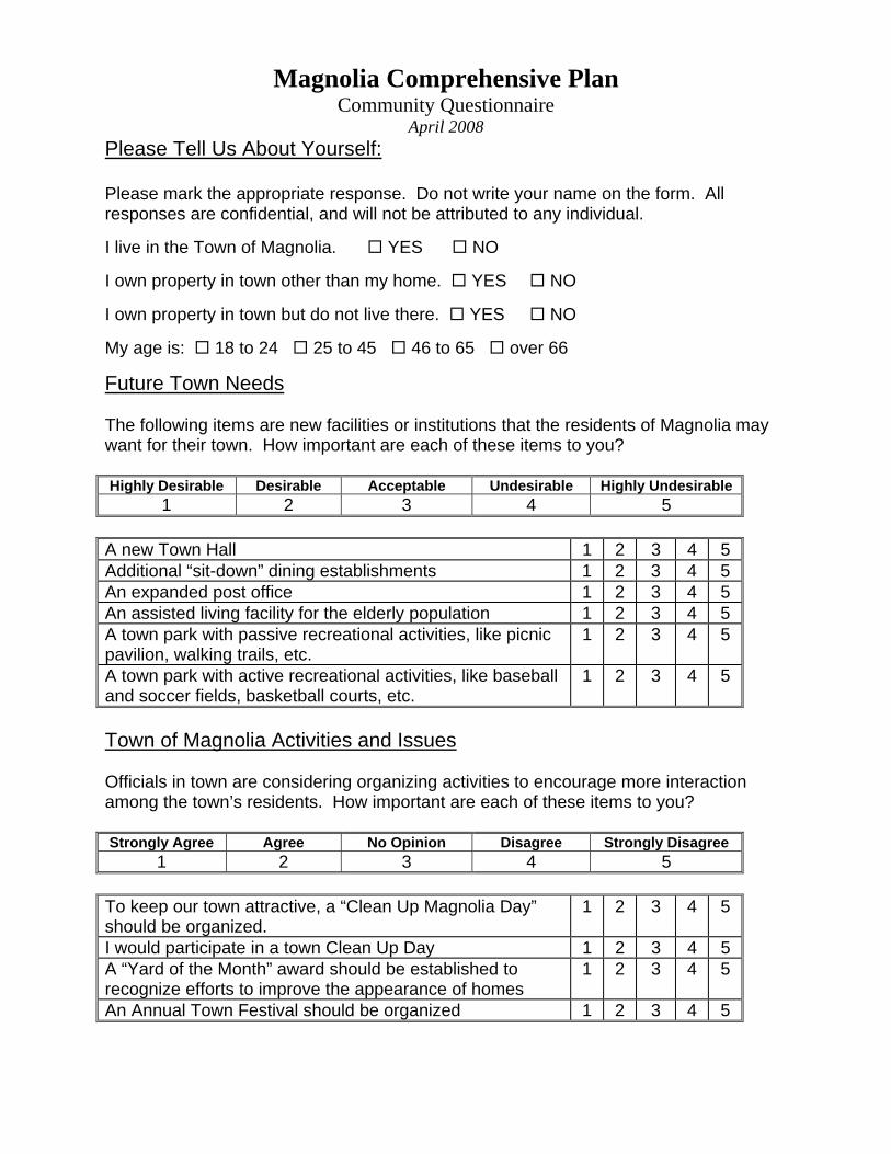
Magnolia Comprehensive Plan Community Questionnaire
April 2008 Please Tell Us About Yourself: Please mark the appropriate response. Do not write your name on the form. All responses are confidential, and will not be attributed to any individual. I live in the Town of Magnolia. YES NO I own property in town other than my home. YES NO I own property in town but do not live there. YES NO My age is: 18 to 24 25 to 45 46 to 65 over 66
Future Town Needs The following items are new facilities or institutions that the residents of Magnolia may want for their town. How important are each of these items to you? Highly Desirable Desirable Acceptable Undesirable Highly Undesirable
1 2 3 4 5 A new Town Hall 1 2 3 4 5 Additional “sit-down” dining establishments 1 2 3 4 5 An expanded post office 1 2 3 4 5 An assisted living facility for the elderly population 1 2 3 4 5 A town park with passive recreational activities, like picnic pavilion, walking trails, etc.
1 2 3 4 5
A town park with active recreational activities, like baseball and soccer fields, basketball courts, etc.
1 2 3 4 5
Town of Magnolia Activities and Issues Officials in town are considering organizing activities to encourage more interaction among the town’s residents. How important are each of these items to you? Strongly Agree Agree No Opinion Disagree Strongly Disagree
1 2 3 4 5 To keep our town attractive, a “Clean Up Magnolia Day” should be organized.
1 2 3 4 5
I would participate in a town Clean Up Day 1 2 3 4 5 A “Yard of the Month” award should be established to recognize efforts to improve the appearance of homes
1 2 3 4 5
An Annual Town Festival should be organized 1 2 3 4 5
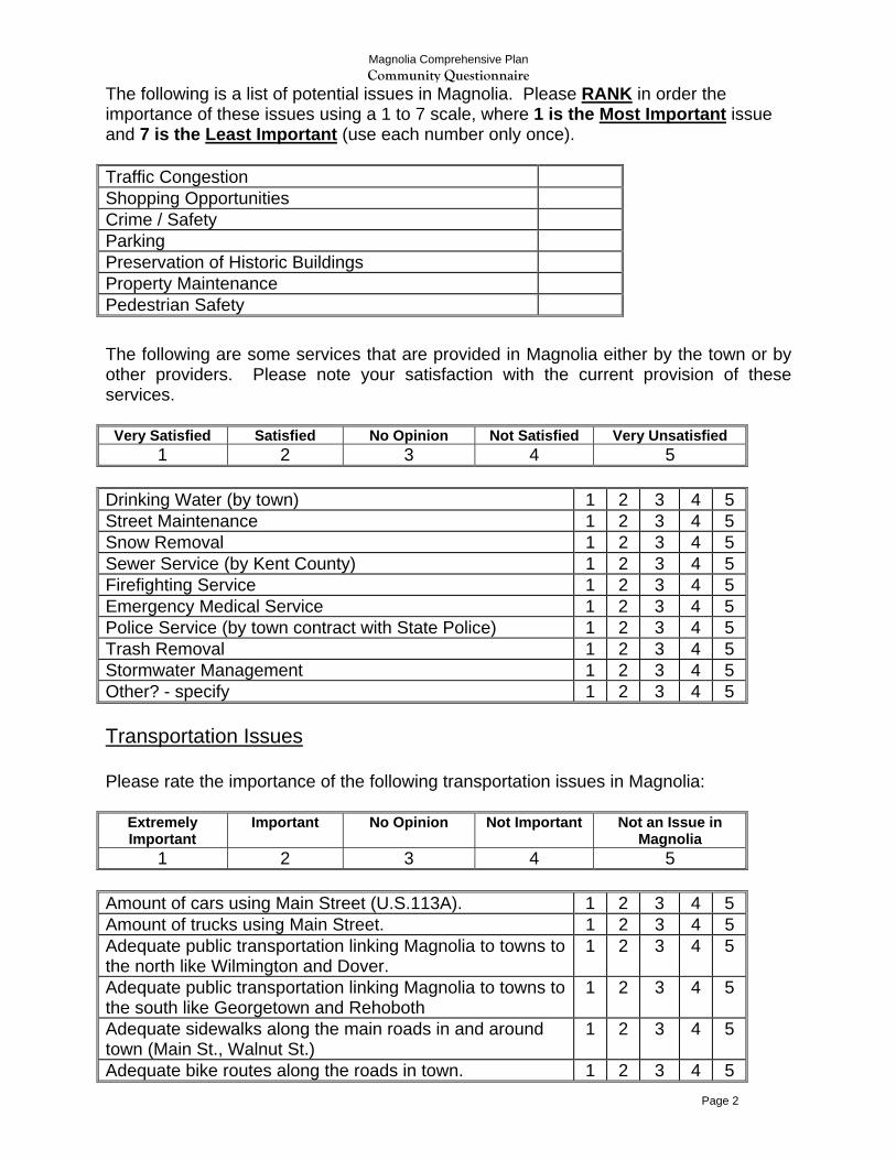
Magnolia Comprehensive Plan Community Questionnaire
Page 2
The following is a list of potential issues in Magnolia. Please RANK in order the importance of these issues using a 1 to 7 scale, where 1 is the Most Important issue and 7 is the Least Important (use each number only once). Traffic Congestion Shopping Opportunities Crime / Safety Parking Preservation of Historic Buildings Property Maintenance Pedestrian Safety The following are some services that are provided in Magnolia either by the town or by other providers. Please note your satisfaction with the current provision of these services.
Very Satisfied Satisfied No Opinion Not Satisfied Very Unsatisfied 1 2 3 4 5
Drinking Water (by town) 1 2 3 4 5 Street Maintenance 1 2 3 4 5 Snow Removal 1 2 3 4 5 Sewer Service (by Kent County) 1 2 3 4 5 Firefighting Service 1 2 3 4 5 Emergency Medical Service 1 2 3 4 5 Police Service (by town contract with State Police) 1 2 3 4 5 Trash Removal 1 2 3 4 5 Stormwater Management 1 2 3 4 5 Other? - specify 1 2 3 4 5 Transportation Issues Please rate the importance of the following transportation issues in Magnolia:
Extremely Important
Important No Opinion Not Important Not an Issue in Magnolia
1 2 3 4 5 Amount of cars using Main Street (U.S.113A). 1 2 3 4 5 Amount of trucks using Main Street. 1 2 3 4 5 Adequate public transportation linking Magnolia to towns to the north like Wilmington and Dover.
1 2 3 4 5
Adequate public transportation linking Magnolia to towns to the south like Georgetown and Rehoboth
1 2 3 4 5
Adequate sidewalks along the main roads in and around town (Main St., Walnut St.)
1 2 3 4 5
Adequate bike routes along the roads in town. 1 2 3 4 5
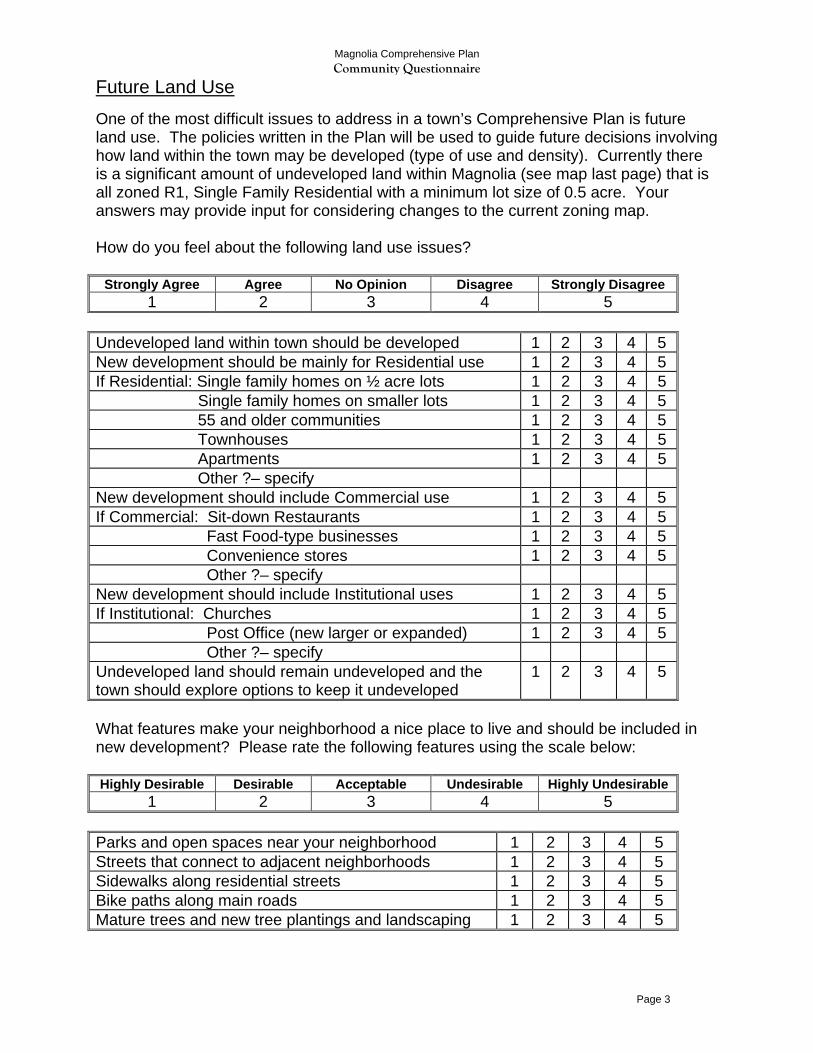
Magnolia Comprehensive Plan Community Questionnaire
Page 3
Future Land Use One of the most difficult issues to address in a town’s Comprehensive Plan is future land use. The policies written in the Plan will be used to guide future decisions involving how land within the town may be developed (type of use and density). Currently there is a significant amount of undeveloped land within Magnolia (see map last page) that is all zoned R1, Single Family Residential with a minimum lot size of 0.5 acre. Your answers may provide input for considering changes to the current zoning map. How do you feel about the following land use issues?
Strongly Agree Agree No Opinion Disagree Strongly Disagree 1 2 3 4 5
Undeveloped land within town should be developed 1 2 3 4 5 New development should be mainly for Residential use 1 2 3 4 5 If Residential: Single family homes on ½ acre lots 1 2 3 4 5 Single family homes on smaller lots 1 2 3 4 5 55 and older communities 1 2 3 4 5 Townhouses 1 2 3 4 5 Apartments 1 2 3 4 5 Other ?– specify New development should include Commercial use 1 2 3 4 5 If Commercial: Sit-down Restaurants 1 2 3 4 5 Fast Food-type businesses 1 2 3 4 5 Convenience stores 1 2 3 4 5 Other ?– specify New development should include Institutional uses 1 2 3 4 5 If Institutional: Churches 1 2 3 4 5 Post Office (new larger or expanded) 1 2 3 4 5 Other ?– specify Undeveloped land should remain undeveloped and the town should explore options to keep it undeveloped
1 2 3 4 5
What features make your neighborhood a nice place to live and should be included in new development? Please rate the following features using the scale below: Highly Desirable Desirable Acceptable Undesirable Highly Undesirable
1 2 3 4 5 Parks and open spaces near your neighborhood 1 2 3 4 5 Streets that connect to adjacent neighborhoods 1 2 3 4 5 Sidewalks along residential streets 1 2 3 4 5 Bike paths along main roads 1 2 3 4 5 Mature trees and new tree plantings and landscaping 1 2 3 4 5
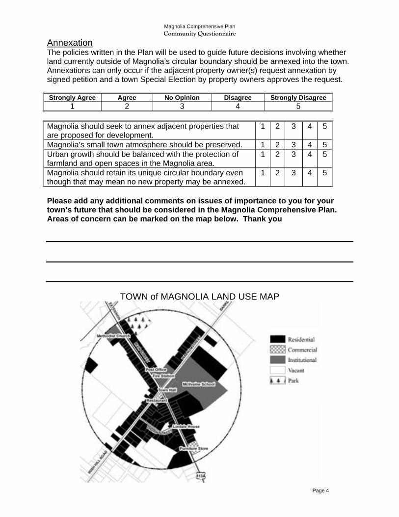
Magnolia Comprehensive Plan Community Questionnaire
Page 4
Annexation The policies written in the Plan will be used to guide future decisions involving whether land currently outside of Magnolia’s circular boundary should be annexed into the town. Annexations can only occur if the adjacent property owner(s) request annexation by signed petition and a town Special Election by property owners approves the request. Strongly Agree Agree No Opinion Disagree Strongly Disagree
1 2 3 4 5 Magnolia should seek to annex adjacent properties that are proposed for development.
1 2 3 4 5
Magnolia’s small town atmosphere should be preserved. 1 2 3 4 5 Urban growth should be balanced with the protection of farmland and open spaces in the Magnolia area.
1 2 3 4 5
Magnolia should retain its unique circular boundary even though that may mean no new property may be annexed.
1 2 3 4 5
Please add any additional comments on issues of importance to you for your town’s future that should be considered in the Magnolia Comprehensive Plan. Areas of concern can be marked on the map below. Thank you
TOWN of MAGNOLIA LAND USE MAP
2009 Town of Magnolia Comprehensive Plan 54
Adopted by the Magnolia Town Council 3/16/09 Certified by the Governor April 24, 2009
APPENDIX B: MAPS Map 1: Aerial View of the Town of Magnolia Map 2: Roads and Boundaries Map 3: State Strategies for Policies and Spending Map 4: Environmental Features Map 5: Magnolia and Adjacent Kent County Area Zoning Map 6: Existing Land Use Map 7: Future Land Use and Growth
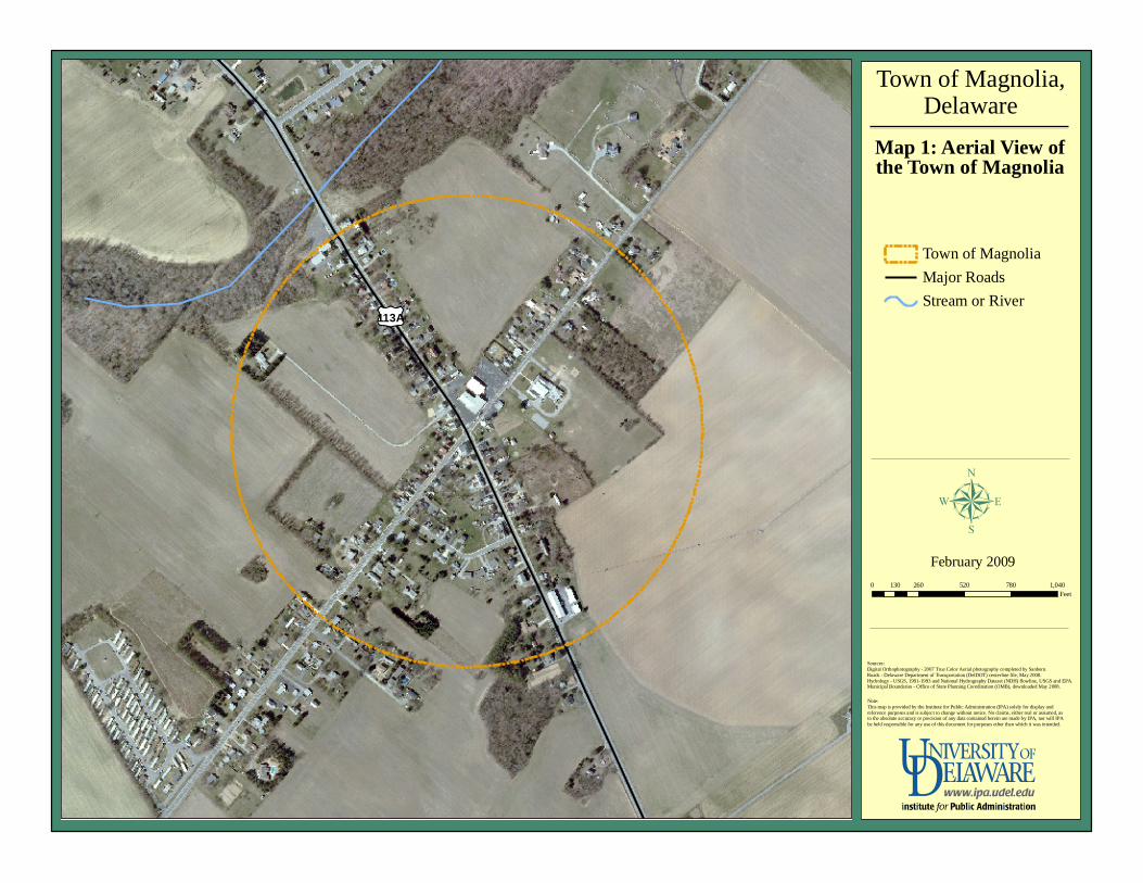
Future Land Use Map
µJanuary 2006
Draft
£¤113A
Town of Magnolia,Delaware
Map 1: Aerial View ofthe Town of Magnolia
0 260 520 780 1,040130Feet
February 2009
Sources:Digital Orthophotography - 2007 True Color Aerial photography completed by Sanborn.Roads - Delaware Department of Transportation (DelDOT) centerline file, May 2008.Hydrology - USGS, 1991-1993 and National Hydrography Dataset (NDH) flowline, USGS and EPA.Municipal Boundaries - Office of State Planning Coordination (OMB), downloaded May 2008.
Note:This map is provided by the Institute for Public Administration (IPA) solely for display and reference purposes and is subject to change without notice. No claims, either real or assumed, as to the absolute accuracy or precision of any data contained herein are made by IPA, nor will IPA be held responsible for any use of this document for purposes other than which it was intended.
Town of MagnoliaMajor RoadsStream or River
µ
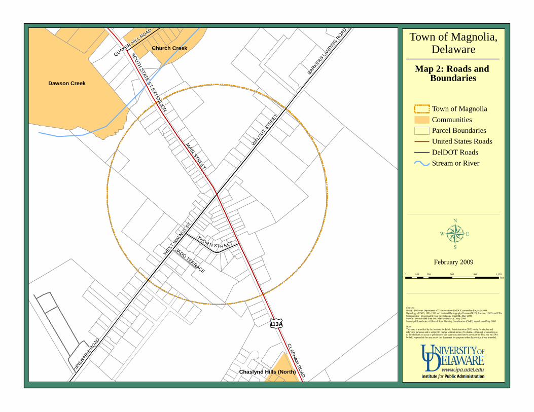
Future Land Use Map
µJanuary 2006
Draft B
ARKERS LANDIN
G ROAD
IRIS
H HILL
ROAD C
LAPHAM RO
AD
MAIN STREET
WALN
UT STR
EET
QUAKER HILL ROAD
THOR N ST R EET
SOUTH STATE ST EXTENSIO
N
WEST
WALN
UT ST
Dawson Creek
Church Creek
Chaslynd Hills (North)
£¤113A
Town of Magnolia,Delaware
Map 2: Roads and Boundaries
0 280 560 840 1,120140Feet
February 2009
Sources:Roads - Delaware Department of Transportation (DelDOT) centerline file, May 2008.Hydrology - USGS, 1991-1993 and National Hydrography Dataset (NHD) flowline, USGS and EPA.Communities - Downloaded from the Delaware DataMIL, May 2008.Parcels - Downloaded from the Delaware DataMIL, May 2008.Municipal Boundaries - Office of State Planning Coordination (OMB), downloaded May 2008.Note:This map is provided by the Institute for Public Administration (IPA) solely for display and reference purposes and is subject to change without notice. No claims, either real or assumed, as to the absolute accuracy or precision of any data contained herein are made by IPA, nor will IPA be held responsible for any use of this document for purposes other than which it was intended.
Town of MagnoliaCommunitiesParcel BoundariesUnited States RoadsDelDOT RoadsStream or River
µJADO TERRACE
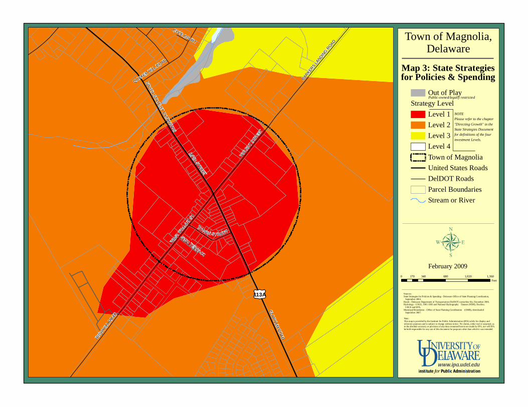
Future Land Use Map
µJanuary 2006
Draft B
ARKERS
LANDIN
G ROAD
IRIS
H HIL
L ROAD
CLAPHAM
ROAD
MAIN STREET
WALN
UT STR
EET
QUAKER HILL ROAD
THOR N ST R EET
SOUTH STATE ST EXTENSIO
N
COLE COURT
WEST W
ALNUT
ST
£¤113A
Town of Magnolia,Delaware
Map 3: State Strategiesfor Policies & Spending
0 340 680 1,020 1,360170Feet
February 2009
Sources:State Strategies for Policies & Spending - Delaware Office of State Planning Coordination, September 2004.Roads - Delaware Department of Transportation (DelDOT) centerline file, December 2006.Hydrology - USGS, 1991-1993 and National Hydrography Dataset (NDH), flowline, USGS and EPA.Municipal Boundaries - Office of State Planning Coordination (OMB), downloaded September 2007.
Note:This map is provided by the Institute for Public Administration (IPA) solely for display and reference purposes and is subject to change without notice. No claims, either real or assumed, as to the absolute accuracy or precision of any data contained herein are made by IPA, nor will IPA be held responsible for any use of this document for purposes other than which it was intended.
Out of PlayStrategy Level
Level 1Level 2Level 3Level 4Town of MagnoliaUnited States RoadsDelDOT RoadsParcel BoundariesStream or River
µ
Public-owned/legally restricted
NOTEPlease refer to the chapter"Directing Growth" in the State Strategies Document for definitions of the four investment Levels.
JADO TERRACE
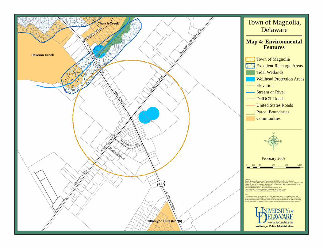
Future Land Use Map
µJanuary 2006
Draft
BARKER
S LA
NDING R
OAD
CLAPHAM
ROAD
MAIN STREET
WALN
UT STR
EET
THOR N ST R EET
IRIS
H HILL
ROAD
SOUTH STATE ST EXTENSIO
N
WEST W
ALNUT
ST
QUAKER HILL ROAD
Dawson Creek
Church Creek
Chaslynd Hills (North)
£¤113A
Town of Magnolia,Delaware
Map 4: EnvironmentalFeatures
0 300 600 900 1,200150Feet
February 2009
Sources:Roads - Delaware Department of Transportation (DelDOT) centerline file, May 2008.Hydrology - USGS, 1991-1993 and National Hydrography Dataset (NDH) flowline, USGS and EPA.Municipal Boundaries - Office of State Planning Coordination (OMB), downloaded May 2008.Wellhead Protection Areas - DNREC, 2007.Excellent Recharge Areas - Delaware Geological Survey, 2002.Tidal Wetlands - State-wide Wetlands Mapping Project, DNREC 2000.Communities - Downloaded from the Delaware DataMIL May 2008.
Note:This map is provided by the Institute for Public Administration (IPA) solely for display and reference purposes and is subject to change without notice. No claims, either real or assumed, as to the absolute accuracy or precision of any data contained herein are made by IPA, nor will IPA be held responsible for any use of this document for purposes other than which it was intended.
Town of MagnoliaExcellent Recharge AreasTidal WetlandsWellhead Protection AreasElevationStream or RiverDelDOT RoadsUnited States RoadsParcel BoundariesCommunities
µJADO TERRACE
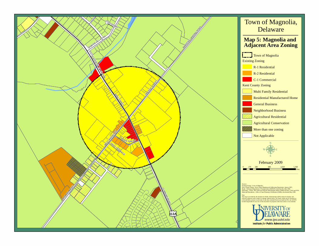
Future Land Use Map
µJanuary 2006
Draft B
ARKERS LANDIN
G ROAD
IRIS
H HIL
L ROAD CLAPH
AM RO
AD
MAIN STREET
WALN
UT STR
EET
QUAKER HILL R
OAD
THOR N ST R EET
SOUTH STATE ST EXTENSIO
N
COLE COURT
WEST
WALN
UT ST
£¤113A
Town of Magnolia,Delaware
Map 5: Magnolia and Adjacent Area Zoning
0 340 680 1,020 1,360170Feet
February 2009
Sources:Existing Zoning - Town of Magnolia.Kent County Zoning - Kent County Mapping and Addressing Department, January 2005.Roads - Delaware Department of Transportation (DelDOT) centerline file, May 2008.Hydrology - USGS, 1991-1993 and National Hydrography Dataset (NDH) flowline, USGS and EPA.Municipal Boundaries - Office of State Planning Coordination (OMB), downloaded May 2008.Note:This map is provided by the Institute for Public Administration (IPA) solely for display and reference purposes and is subject to change without notice. No claims, either real or assumed, as to the absolute accuracy or precision of any data contained herein are made by IPA, nor will IPA be held responsible for any use of this document for purposes other than which it was intended.
Town of MagnoliaExisting Zoning
R-1 ResidentialR-2 ResidentialC-1 Commercial
Kent County ZoningMulti Family ResidentialResidential Manufactured HomeGeneral BusinessNeighborhood BusinessAgricultural ResidentialAgricultural ConservationMore than one zoningNot Applicable
µJADO TERRACE
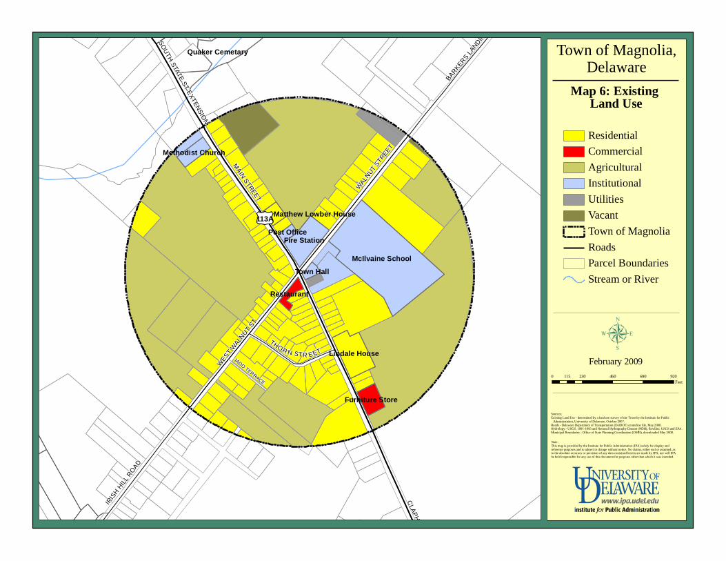
Future Land Use Map
µJanuary 2006
Draft
IRIS
H HIL
L ROAD
BARKERS L
ANDING R
OAD
CLAPHAM
ROAD
MAIN STREET
WALN
UT STR
EET
THO R N STR EET
SOUTH STATE ST EXTENSIO
N
QUAKER HILL R
OAD
WEST
WALN
UT ST
£¤113A
McIlvaine School
Fire Station
Quaker Cemetary
Lindale House
Furniture Store
Methodist Church
Restaurant
Town Hall
Post Office
Matthew Lowber House
Town of Magnolia,Delaware
Map 6: Existing Land Use
0 230 460 690 920115Feet
February 2009
Sources:Existing Land Use - determined by a land use survey of the Town by the Institute for Public Administration, University of Delaware, October 2007.Roads - Delaware Department of Transportation (DelDOT) centerline file, May 2008.Hydrology - USGS, 1991-1993 and National Hydrography Dataset (NDH), flowline, USGS and EPA.Municipal Boundaries - Office of State Planning Coordination (OMB), downloaded May 2008.
Note:This map is provided by the Institute for Public Administration (IPA) solely for display and reference purposes and is subject to change without notice. No claims, either real or assumed, as to the absolute accuracy or precision of any data contained herein are made by IPA, nor will IPA be held responsible for any use of this document for purposes other than which it was intended.
ResidentialCommercialAgriculturalInstitutionalUtilitiesVacantTown of MagnoliaRoadsParcel BoundariesStream or River
µJADO TERRACE
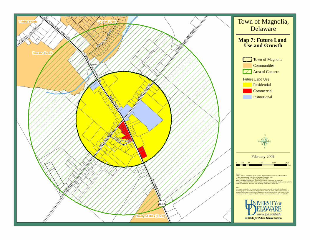
Future Land Use Map
µJanuary 2006
Draft
Dawson Creek
Church Creek
Chaslynd Hills (North)
Timber Fields
BARKERS LANDIN
G ROAD
IRIS
H HIL
L ROAD
CLAPH
AM R
OAD
MAIN STREET
WALN
UT STR
EET
QUAKER HIL
L RO
AD
WOODLYTOWN R
OAD
THOR N STR EET
SOUTH STATE ST EXTENSION
WEST
WALN
UT ST
SOUTH STATE ST EXTENSIO
N
£¤113A
Town of Magnolia,Delaware
Map 7: Future Land Use and Growth
0 350 700 1,050 1,400175Feet
February 2009
Sources:Future Land Use - determined by the Town of Magnolia with assistance from the Institute for Public Administration, University of Delaware, September 2008.Area of Concern - the Town of Magnolia, September 2008.Roads - Delaware Department of Transportation (DelDOT) centerline file, May 2008.Hydrology - USGS, 1991-1993 and National Hydrography Dataset (NDH), flowline, USGS and EPA.Municipal Boundaries - Office of State Planning Coordination (OMB), 2008.
Note:This map is provided by the Institute for Public Administration (IPA) solely for display and reference purposes and is subject to change without notice. No claims, either real or assumed, as to the absolute accuracy or precision of any data contained herein are made by IPA, nor will IPA be held responsible for any use of this document for purposes other than which it was intended.
µ
Town of MagnoliaCommunitiesArea of Concern
Future Land UseResidentialCommercialInstitutional
An Equal Opportunity/Affirmative Action EmployerThe University of Delaware is committed to assuring equal opportunity to all persons and does not discriminate on the basis of race, creed, color,gender, genetic information, age, religion, national origin, veteran or disability status, or sexual orientation in its educational programs, activities,admissions or employment practices as required by Title IX of the Educational Amendments of 1972, Section 504 of the Rehabilitation Act of 1973,Title VII of the Civil Rights Act of 1964, and other applicable statutes. Inquiries concerning Section 504 compliance and information regarding campusaccessibility should be referred to the Office of Disability Support Services (DSS), (302) 831-4643, located at 119 Alison Hall. Inquiries concerning TitleVII and Title IX should be referred to the Office of the Assistant Vice President for Affirmative Action, (302) 831-8735, located at 124 Hullihen Hall.
Institute for Public AdministrationCollege of Human Services, Education & Public Policy
University of Delaware180 Graham Hall
Newark, DE 19716-7380
phone: 302-831-8971 e-mail: [email protected] fax: 302-831-3488
www.ipa.udel.edu
The University of Delaware’s Institute for Public Administration (IPA) addresses the policy, planning,and management needs of its partners through the integration of applied research, professionaldevelopment, and the education of tomorrow’s leaders.