Embed Size (px)
Citation preview

Town of Harpswell
Open Space Plan
March 2009

Harpswell Open Space Plan –rev. 3/5/2009
1
TABLE OF CONTENTS
PART 1
Acknowledgements................................................................................................................. i
Executive Summary ..............................................................................................................ii
1. Introduction ......................................................................................................................1
2. What is Open Space and Why is it Valuable?..................................................................2
2A. Definition of Open Space ...................................................................................................... 2
2B. A Vision for Open Space in Harpswell ................................................................................ 6
3. What is the Open Space Plan? .........................................................................................7
3A. Description of the Plan.......................................................................................................... 7
3B. The Plan’s Development Process.......................................................................................... 8
4.Assessing Harpswell’s Open Space.................................................................................10
4A. Topography of Harpswell................................................................................................... 10
4B. History and Accomplishments 1987 – 2008....................................................................... 12
4C. How Much Protected Land Do We Have?........................................................................ 12
4D. How Do We Compare To Other Communities?............................................................... 15
5. Preservation of Open Space: What to Preserve?...........................................................15
5A. Resources to Preserve ......................................................................................................... 15
5B. Identification of High Value Areas of Open Space........................................................... 16
5C. What Is a Focus Area?........................................................................................................ 17
Focus Area 1: Long Reach, Great Island................................................................................. 17
Focus Area 2: Brickyard Watershed, Great Island ............................................................... 18
Focus Area 3: Bethel Point, Cundy’s Harbor.......................................................................... 18
Focus Area 4: Sandy Cove, East Cundy’s Point..................................................................... 18
Focus Area 5: Ice Pond, Gun and Long Points, Great Island .............................................. 19
Focus Area 6: Wilson’s Pond Orr’s Island .............................................................................. 19
Focus Area 7: Cedar Beach, Bailey Island............................................................................... 19
Focus Area 8: Otter Brook Corridor, North Harpswell......................................................... 20
Focus Area 9: Wilson & Widgeon Coves, Harpswell Neck ................................................... 20
Focus Area 10: Lookout Point, Harpswell Neck........................................................................ 20
Focus Area 11. Allen Point Road Corridor, Harpswell Neck.......................................................... 21
Focus Area 12 Basin Cove, South Harpswell.......................................................................... 21

Harpswell Open Space Plan –rev. 3/5/2009
2
Islands........................................................................................................................................... 21
6. Open Space Protection Strategies ..................................................................................22
6A. Protection of Water Resources: Vernal Pools and Wetlands.......................................... 24
6B. Voluntary Efforts Available to Preserve Open Space...................................................... 25
6C. Efforts to Preserve Existing Conservation Land.............................................................. 26
6D. Land Use Regulations ......................................................................................................... 28
6E. Strategic Land Acquisition ................................................................................................. 29
7. Recommendations for Implementation and Conclusion...............................................30
MAPS ..................................................................................................................................32
Map 1 – 1987 Scenic Areas Map............................................................................................... 33
Map 2 - Scenic Resources Identified in Workshop 2 .............................................................. 34
Map 3 – Harpswell Land with Permanent and Limited Protection................................................ 35
Map 4 – Water Resources ..................................................................................................... 36
Map 5 – Habitats Only ............................................................................................................ 37
Map 6 –Water Resources, Critical Habitat, and ............................................................. 38
Buildings with 175 Ft. Buffer ............................................................................................... 38
Map 7 – Open Space Focus Areas ............................................................................................ 39
Map 8 – Scenic Views & Corridors, 2008 ......................................................................... 40
Glossary -.............................................................................................................................41
PART 2 – ...............................................................................................................................1
Appendices Listings by Section ............................................................................................2
Harpswell Open Space Plan –rev. 3/5/2009
i
Acknowledgements
The Open Space Plan was prepared by the Harpswell Conservation Commission. A special thanks to the townspeople who helped start the process by returning the mail questionnaires and attending the public workshops and also individuals who attended the Commission’s weekly workshop meetings. Project assistance and guidance was provided by FB Environmental, Portland, ME and MRLD Planners, Yarmouth, ME, the Harpswell Planning Office, Marcel Polak, Advisor, Maine Association of Conservation Commissions and Reed Coles, Executive Director, Harpswell Heritage Land Trust. Additional assistance came from the Town’s Assessing, Codes Enforcement Treasurer’s Offices, the Town Lands, Recreation, and Comprehensive Plan Implementation Committees and the Town administrator’s staff. Additionally Maine communities and organizations produced documents that were helpful for insights and the development of the Harpswell Open Space Plan. Readfield’s 2006
Open Space Plan provided a framework and Searsmont’s Land Stewardship Incentives and
Education Project provided a wealth of possible open space funding sources and strategies, as did Falmouth’s 2005 open space plan update, The Greening of Falmouth. Given its immediate proximity to Harpswell, Brunswick’s 2002 Parks, Recreation and Open Space
Plan also provided some valuable insight; The Nature Conservancy, Brunswick office provided mapping strategies and the Maine Coast Heritage Trust provided helpful information regarding the use of voluntary open space protection tools. Funding for the Plan was provided by a grant from the William P. Wharton Trust and countess hours volunteered by the Conservation Commission members. We want to thank all who provided the photos that enable us to become more familiar with the diversity and uniqueness of Harpswell. Some contributors include: Tony Barrett, L. Bayless, Liz Bouve, Pat L’Heureux, Elsa Martz, Mary Ann Nahf, Sue Rich and the Town Lands Committee. Conservation Commission Town Planning Staff
Mary Ann Nahf ~ Chair Carol Tukey, Town Planner Deirdre Strachan~Vice Chair Melissa Moretti, Planning Assistant Tony Barrett Tracey Thibault ~ Interim Town Planner Don Jones Jay Chace ~ Former Town Planner Ann Nemrow Marsha Hinton, Former Planning Assistant Anne Perry Burr Taylor Former members, Patricia L'Heureux , Douglas Orput, Bob Waddle and Rhonda Weaver

Harpswell Open Space Plan –rev. 3/5/2009
ii
Executive Summary
In 2006, the Harpswell Conservation Commission (HCC) was asked to help with the execution of sections of the Town’s 2005 Comprehensive Plan Update that dealt with the conservation of open space and the direction of future growth. This was to be accomplished with an Open Space Plan for Harpswell. In order to achieve the goals for open space expressed by residents in the 2005 Comprehensive Plan Update, the Conservation Commission prepared an Open Space Plan that suggests ways to protect a portion of undeveloped land, preserve the natural and scenic assets of the Town and preserve the quality of living we enjoy in Harpswell. The Open Space Plan outlines approaches to provide for orderly residential development, enhance recreational opportunities and contribute to the health of Harpswell’s critical marine economy. As part of the development of the plan, community input was solicited from the townspeople by gathering information through a mailed questionnaire and by holding two open space planning workshops. Participants identified which natural, scenic and recreational resources were important to them and helped inventory lands that had these resources. Using the residents’ prioritizations, the HCC identified five (5) key resources in Harpswell that participants wanted to protect in the future. These resources include 1) fresh, salt and groundwater, 2) high value habitats, 3) scenic splendor, 4) recreational opportunities and 5) cultural/historic/civic locations. In order to identify the most important large uninhabited areas in Town which contained these resources, the HCC used a series of maps to determine the location of our most important water resources and habitat areas in Harpswell. The HCC also considered factors, such as proximity to a protected site, size of parcel, lineal opportunity for expansion of recreation, continuity for the benefit of wildlife and bird populations and protection of lands draining into wetlands, ponds and mudflats.
The data was analyzed to determine which locations scored the highest resource ratings and which were also designated as critical or endangered by the United States Fish and Wildlife Program. Next, all of the developed properties with buildings were identified on the maps, as well as, those that were already protected as a result of ownership by conservation, government or civic groups. As a result of this process, 12 Focus Areas were chosen for preservation. These Focus Areas and Harpswell’s undeveloped islands over (1) acre, should be at the center of the Town’s future open space protection efforts. Most of this land has limited development, high ecological value and is privately owned by conservation-minded residents, living in the area, who have kept it in its current undeveloped condition. This is considered the most vital land to preserve.

Harpswell Open Space Plan –rev. 3/5/2009
iii
A coordinated conservation strategy to protect the key natural resources includes:
• Identification of vernal pools and the updating of wetland protection
• Education about the various methods of open space preservation
• Continued preservation of our protected lands
• Review of land-use ordinances to consider open space in development
• Strategic purchase or acquisition of Harpswell land from willing sellers or donors While these strategies are designed to protect the land in the high priority Focus Areas, they are also intended for use throughout Harpswell to preserve its high-value natural areas. The Town recognizes that privately owned property may be the principal asset of its owners and that it may have significant historic value to families. This Plan respects such factors and does not include any proposal whose effect would have a harmful impact on the real or historic value of private property. We are asking the residents of Harpswell for their approval of the final Plan when presented at Town Meeting in March, 2009. As we move forward in the implementation of this Open Space Plan, we hope to achieve our shared vision for the Town of Harpswell that includes:
• Preservation of open space for future generations to enjoy
• Preservation of water quality
• Preservation and stewardship of high value natural areas
• Preservation of community character that is defined by our seafaring and farming heritage
• Collaboration to plan for, protect and manage the Town’s open space resources

Harpswell Open Space Plan –rev. 3/5/2009
1
1. Introduction
Our coast isn’t all rock and mudflats. Where the shore is protected from
turbulent waters, and where sediment is washed into the sea, a unique process
takes place. It only takes a few hundred years. The result is a coastal wetland,
or salt marsh…As Harpswell continues to develop, it is important to remember
the land-sea connection and protect these “nurseries of the sea.1
The Town of Harpswell has always had a close connection to the sea. The sea has been at the base of the Harpswell economy and quality of place, and it remains the heart and future of the community of 5,239 people. The town’s long narrow peninsula, Harpswell Neck and three large islands, Great, Orr’s and Bailey, stretch 15 miles into Casco Bay. Together with over 83 offshore islands, they give Harpswell 216 miles of oceanfront, the longest of any town in the state. Its 15,7002 acres of land have a rich and
diverse marine-forest environment. Outside of the densely developed residential and commercial fishing areas, most of the land is forested down to the sea, tidal flats and coastal marshes. The forest also has many freshwater wetlands of varying size and ecological importance that are essential for the health of plant, animal and town.
Families who have lived in Harpswell for a lifetime, even generations, can remember when the Town had a small year-round population living in villages and small neighborhoods along its narrow peninsula and islands. There were long stretches of forest, wetland and field between centers. Summers brought vacationers seeking the shore who doubled the population. Today many of these fields and forests are gone replaced by homes as more people move to enjoy Harpswell’s amenities. An average of 42 new homes per year have been built in the last five (5) years. Full time and part time residents alike speak of the importance of preserving water resources and keeping Harpswell “the way it’s always been”.
1 Where Fresh Water Meets the Sea – Harpswell’s Coastal Wetlands. Anne Perry, Harpswell Conservation Commission, Harpswell Anchor July 2008
2 These numbers are approximate. The 2005 Comprehensive Plan for Harpswell states that the town has
about 24.6 square miles or 15,744 acres at 640 acres per square mile. In 2008, the Assessor’s Office data base showed the total acres in town were 15,469 acres. The State of Maine uses the figure of 15,342 square miles for Harpswell. In this document, we have chosen to use 24.6 square miles or 15,744 square miles to do our calculations. Throughout the document, we state that Harpswell has approximately 15,700 acres.
Skolfield SSkolfield SSkolfield SSkolfield Shores, Middle Bayhores, Middle Bayhores, Middle Bayhores, Middle Bay
Harpswell Open Space Plan –rev. 3/5/2009
2
The Town’s 2005 Comprehensive Plan identified the citizens’ goal of preserving the physical character of the Town by protecting its significant wildlife habitat, its bio-diversity and the health of its critical marine resources, i.e. eelgrass beds and mud flats. A healthy marine economy will preserve the community’s fishing heritage and its heritage as a tourist, seasonal and recreational haven.3 As citizens have seen, growth in the Town is inevitable and will continue for years to come. Now we are presented with the challenge of how to accommodate future residential growth while retaining open natural areas that alternate with the coastal village and rural pattern that is desired by Harpswell citizens.
2. What is Open Space and Why is it Valuable? 2A. Definition of Open Space
Generally speaking, open space is undeveloped land. It may be a vista in the distance or a privately owned piece of land that provides wildlife habitat, contributes to flood control, or is used for farming or recreation. In addition, while not strictly open space, the Plan includes the cultural, historic and recreational resources that contribute to Harpswell’s quality of place and are part of its seafaring and rural heritage. Such traditional livelihoods as ship-building, ice making, salt processing, milling maize, farming and corralling wayward cattle have all left vestiges of these past industries for future generations to savor. Many of these resources are already protected, contain open space or adjoin open space land.
Open space land provides five (5) major resources that contribute to the quality and character of Harpswell’s open space. 1. Our Water Resources vary, but they all provide:
• retention areas that collect stormwater runoff and prevent flooding.
• natural habitats for a variety of plant and wildlife species
• valuable homes for anadromous and estuarine fish4
3 2005 Harpswell Comprehensive Plan Update, page 17 4 Drinking Water and Sanitary Septic Study Update Ransom Environmental Consultants, Inc.
Definition of Open Space
Harpswell’s Open Space Plan defines open space as land in a predominantly undeveloped condition. It may be preserved or managed in order to maintain the natural, scenic, ecological, cultural, hydrological or geological properties of the land. In addition, while not strictly open space, the Plan includes areas that provide cultural, historic, and recreational resources that contribute to Harpswell’s quality of place and are part of its seafaring and rural heritage.

Harpswell Open Space Plan –rev. 3/5/2009
3
Long MarshLong MarshLong MarshLong Marsh
Bethel Point Wetland and Long Reach Bog are examples of freshwater wetlands that recharge the groundwater supply and filter water running into the bay, enhancing marine life habitat.
Coastal Marshes not only receive upland runoff, but provide a fresh and saltwater exchange area, creating an environment that 60% of our commercial fish species use in their life cycle. (See Appendix 1A and 1B for a summary and inventory of our wetlands.) Ponds are a crucial water resource. Many provide cover at the water’s edge, making them ideal habitat for wildlife. In addition, ponds provide a sense of
wellbeing whether it be watching the Canada geese grazing near the shore on an autumn day; or while we watch the neighborhood hockey team using it for a practice rink during the winter. Ponds provide a freshwater source for our local volunteer firemen to refill their fire trucks. There are eight (8) dry-hydrants located on our ponds. (See Appendix 2A and
2B for a summary and inventory of ponds)
Strawberry CreStrawberry CreStrawberry CreStrawberry Cre
ekekekek
Long MarshLong MarshLong MarshLong Marsh
Dan’s Ice PondDan’s Ice PondDan’s Ice PondDan’s Ice Pond Wilsons PondWilsons PondWilsons PondWilsons Pond
LonLonLonLonBethel Bethel Bethel Bethel PointPointPointPoint WetlandWetlandWetlandWetland
Long ReachLong ReachLong ReachLong Reach Bog
Harpswell Open Space Plan –rev. 3/5/2009
4
BBBBaldaldaldald EagleEagleEagleEagle, Dan’s , Dan’s , Dan’s , Dan’s Ice PIce PIce PIce Pondondondond
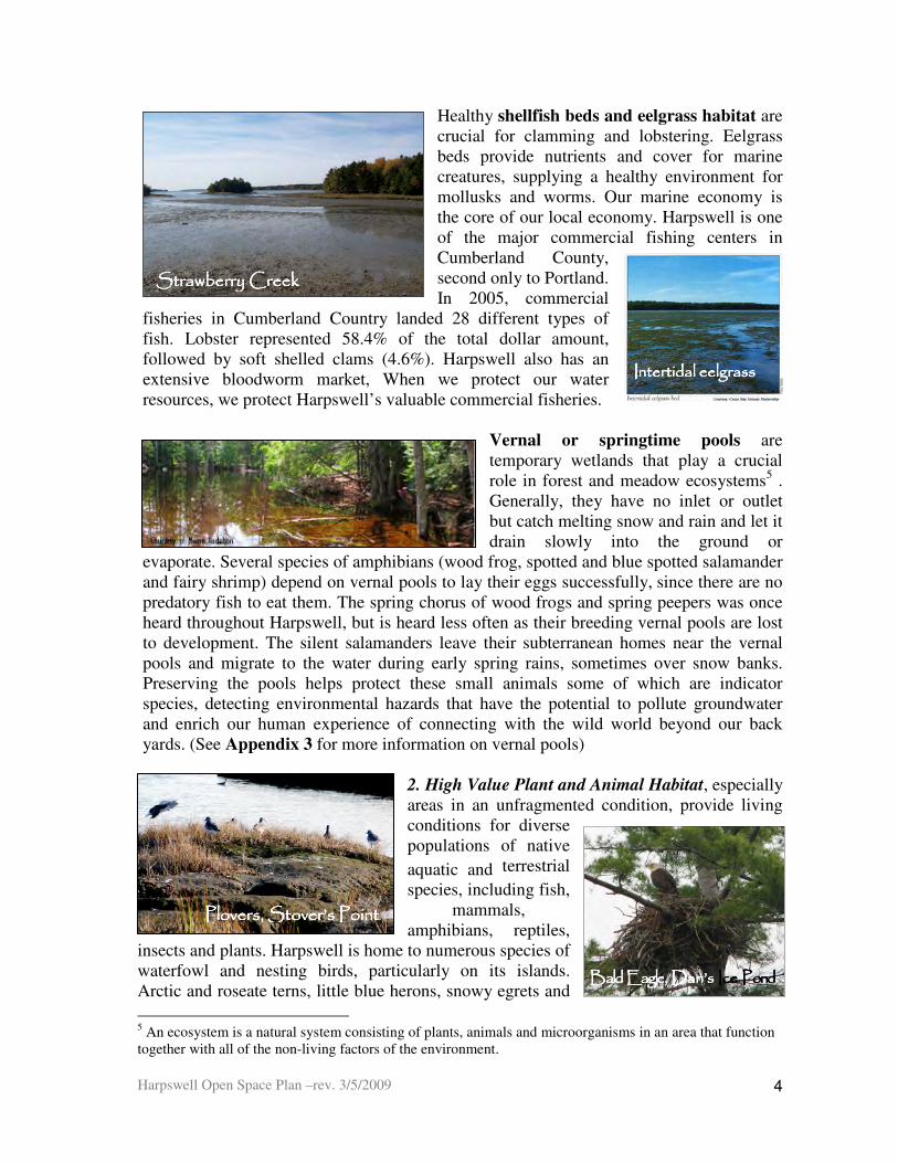
Healthy shellfish beds and eelgrass habitat are crucial for clamming and lobstering. Eelgrass beds provide nutrients and cover for marine creatures, supplying a healthy environment for mollusks and worms. Our marine economy is the core of our local economy. Harpswell is one of the major commercial fishing centers in Cumberland County, second only to Portland. In 2005, commercial
fisheries in Cumberland Country landed 28 different types of fish. Lobster represented 58.4% of the total dollar amount, followed by soft shelled clams (4.6%). Harpswell also has an extensive bloodworm market, When we protect our water resources, we protect Harpswell’s valuable commercial fisheries.
Vernal or springtime pools are temporary wetlands that play a crucial role in forest and meadow ecosystems5 . Generally, they have no inlet or outlet but catch melting snow and rain and let it drain slowly into the ground or
evaporate. Several species of amphibians (wood frog, spotted and blue spotted salamander and fairy shrimp) depend on vernal pools to lay their eggs successfully, since there are no predatory fish to eat them. The spring chorus of wood frogs and spring peepers was once heard throughout Harpswell, but is heard less often as their breeding vernal pools are lost to development. The silent salamanders leave their subterranean homes near the vernal pools and migrate to the water during early spring rains, sometimes over snow banks. Preserving the pools helps protect these small animals some of which are indicator species, detecting environmental hazards that have the potential to pollute groundwater and enrich our human experience of connecting with the wild world beyond our back yards. (See Appendix 3 for more information on vernal pools)
2. High Value Plant and Animal Habitat, especially areas in an unfragmented condition, provide living conditions for diverse populations of native
aquatic and terrestrial
species, including fish, mammals,
amphibians, reptiles, insects and plants. Harpswell is home to numerous species of waterfowl and nesting birds, particularly on its islands. Arctic and roseate terns, little blue herons, snowy egrets and
5 An ecosystem is a natural system consisting of plants, animals and microorganisms in an area that function together with all of the non-living factors of the environment.
Strawberry CreekStrawberry CreekStrawberry CreekStrawberry Creek
Intertidal eelgrassIntertidal eelgrassIntertidal eelgrassIntertidal eelgrass
Plovers, Stover’s PointPlovers, Stover’s PointPlovers, Stover’s PointPlovers, Stover’s Point
Harpswell Open Space Plan –rev. 3/5/2009
5
Cliff TrailCliff TrailCliff TrailCliff Trail Dan’s PondDan’s PondDan’s PondDan’s Pond
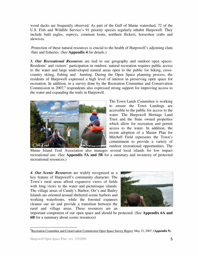
wood ducks are frequently observed. As part of the Gulf of Maine watershed, 72 of the U.S. Fish and Wildlife Service’s 91 priority species regularly inhabit Harpswell. They include bald eagles, ospreys, common loons, northern flickers, horseshoe crabs and alewives. Protection of these natural resources is crucial to the health of Harpswell’s adjoining clam flats and fisheries. (See Appendix 4 for details.) 3. Our Recreational Resources are tied to our geography and outdoor open spaces. Residents’ and visitors’ participation in outdoor, natural recreation requires public access to the water and large undeveloped natural areas open to the public for hiking, cross-country skiing, fishing and hunting. During the Open Space planning process, the residents of Harpswell expressed a high level of interest in preserving open space for recreation. In addition, in a survey done by the Recreation Committee and Conservation Commission in 2007,6 respondents also expressed strong support for improving access to the water and expanding the trails in Harpswell.
The Town Lands Committee is working to ensure the Town Landings are accessible to the public for access to the water. The Harpswell Heritage Land Trust and the State owned properties which allow for recreation and permit access to the water. In addition, the recent adoption of a Master Plan for Mitchell Field represents the Town’s commitment to provide a variety of outdoor recreational opportunities. The
Maine Island Trail Association also manages several local islands for low impact recreational use. (See Appendix 5A and 5B for a summary and inventory of protected recreational resources.) 4. Our Scenic Resources are widely recognized as a key feature of Harpswell’s community character. The Town’s rural areas afford expansive views of fields with long views to the water and picturesque islands. The village areas of Cundy’s Harbor, Orr’s and Bailey Islands are oriented around sheltered scenic harbors and working waterfronts, while the forested expanses cleanse our air and provide a transition between the rural and village areas. These resources are an important component of our open space and should be protected. (See Appendix 6A and
6B for a summary about scenic resources)
6Recreation Committee and Conservation Commission Open Space Survey Report, May 23, 2007; (Appendix 9).

Harpswell Open Space Plan –rev. 3/5/2009
6
5. Our Cultural, Civic & Historic Resources reflect Harpswell’s rich maritime and farming heritage. Cemeteries provide habitats for birds and animals, as well as an important cultural resource for residents. Civic and cultural organizations include schools, libraries, fire departments and the Merriconeag Grange. The property owned by these organizations often includes undeveloped open space, as well as buildings. For example, the Harpswell Garden Club, Harpswell Historical Society, Bowdoin College and the Holbrook Community Foundation all own properties of historic or cultural importance. Most of these properties include undeveloped land. Due to its settlement patterns since 1758, Harpswell is rich in historic buildings and structures,7 having ten buildings, a bridge, an island and an historic district that are listed on the National Register of Historic Places. Much of Harpswell’s unique identity relies on the protection of these key resources and their open spaces and as a result, they are included as priorities for protection. (See Appendix 7A and 7B for a description and inventory of these resources.
2B. A Vision for Open Space in Harpswell
This vision for open space in Harpswell is based on the 2005 Comprehensive Plan, the suggestions of the participants at the 2007 Open Space Forums and ideas of the respondents to the 2007 Recreation and Open Space Survey. (See Appendix 8, 9, & 10) The vision of the residents and taxpayers for the open space of Harpswell includes:
• Preservation of Open Space: The key open spaces that make Harpswell a desirable place to live and give it its quality of place shall be conserved for future generations to enjoy and appreciate.
7 2005 Comprehensive Plan Update, page 115
Merrucoonegan Farm, North HarpswellMerrucoonegan Farm, North HarpswellMerrucoonegan Farm, North HarpswellMerrucoonegan Farm, North Harpswell Centennial Hall, Harpswell CenterCentennial Hall, Harpswell CenterCentennial Hall, Harpswell CenterCentennial Hall, Harpswell Center
Holbrook’s, Cundy’s HarborHolbrook’s, Cundy’s HarborHolbrook’s, Cundy’s HarborHolbrook’s, Cundy’s Harbor BBBBailey Island Cemeteryailey Island Cemeteryailey Island Cemeteryailey Island Cemetery Library Hall, BaileyLibrary Hall, BaileyLibrary Hall, BaileyLibrary Hall, Bailey Island Island Island Island
Harpswell Open Space Plan –rev. 3/5/2009
7
2005 Comprehensive Plan
Recommends that:
♦ the marine environment be maintained as a high quality marine ecosystem ♦ groundwater resources be protected in order to provide a safe and adequate water supply. ♦ the natural habitat be preserved and protected to provide sufficient habitat to maintain the current diversity and health of wildlife ♦ Harpswell’s community character be maintained by managing its growth and development to preserve its working waterfronts, historic neighborhoods and valuable natural resources ♦ traditional public access to the shore for swimming and boating be maintained
• Preservation of Water Quality: The quality of the bays, rivers, ponds, vernal pools, wetlands and groundwater will be preserved in healthy condition for future generations.
• Preservation and Stewardship of its High Value Natural Areas: The animals, birds and other wildlife will continue to have habitat in which to live and prosper.
• Preservation of Community Character: The character of Harpswell will continue to be defined by the Town’s coastal, small town, rural to village pattern, the preservation of public access to the sea and its natural, cultural, scenic and recreational assets.
• Management of New Development: New development will preserve the natural features of the land, create buffers between our roads, wetlands, streams and shoreline; and include open space.
• Collaboration: Community organizations, town government, landowners, developers, the public and representatives of adjacent towns will work together collaboratively to plan for, protect and manage the open space resources of the town.
3. What is the Open Space Plan? 3A. Description of the Plan
An open space plan outlines a town’s strategies for conservation of natural resources and preservation of recreational areas and community character. In 2006, at the request of the Comprehensive Plan Implementation Committee (CPIC), the Conservation Commission (HCC) began to develop an Open Space Plan for Harpswell. A grant application was submitted to the William P. Wharton Trust and funded for $10,000. The Town of Harpswell hired the team of FB Environmental and MRLD Planners as consultants to assist the Conservation Commission and the Town in developing an Open Space Plan. In addition, the Maine Association of Conservation Commissions (MEACC) provided Harpswell with the free consulting services of conservation advisor, Marcel Polak. The resulting Open Space Plan for Harpswell makes a variety of recommendations for the future of the community. By using input from residents (See Appendix 9 and 10) and identifying Harpswell’s natural resources, it became apparent where development should not occur. An Open Space Plan provides the basis for addressing the challenge of growth against the widely recognized need to preserve community character and all the aspects it

Harpswell Open Space Plan –rev. 3/5/2009
8
embodies. It accomplished this balance by:
• Identifying, inventorying and mapping critical natural resources, wildlife habitats and open spaces
• Updating the open space resource inventory and the 1987 Critical and Scenic Areas
Map.
• Establishing a prioritization system for use when evaluating properties in the Town for conservation
• Enhancing public awareness about the benefits derived from Harpswell’s diverse natural areas
• Providing a strategic and regulatory framework which the Town can use to meet its open space goals as articulated in the 2005 Comprehensive Plan
3B. The Plan’s Development Process
1. Community Survey
One of the first steps in the process was to enlist the community’s input as to their ideas for open space. Shortly after the approval of the update to the Comprehensive Plan, the Town of Harpswell carried out a representative survey of 517 Harpswell taxpayers to find out what the residents in Harpswell wanted in relationship to open space and recreational opportunities. (Please see Appendix 9 for the details of the complete survey.) The majority of respondents wanted to preserve scenic views and wildlife habitat, expand trails in town, preserve wetlands and protect large undeveloped parcels of land. When asked about the priorities for public spending, more residents wanted to preserve and expand passive recreation and open space than wanted to build facilities. Improved access to the water was the highest priority for half of the town taxpayers
Harpswell Open Space Plan –rev. 3/5/2009
9
2. Public Workshops
Subsequently, on May 30, 2007, Harpswell residents participated in the first of two public workshops at the Harpswell Island School to help the Town of Harpswell develop an Open Space
Plan. (Please see Appendix 10 for the details of the two workshops.) The intent of the public forums was to establish the residents’ priorities for which open spaces are most important to them
for future protection.
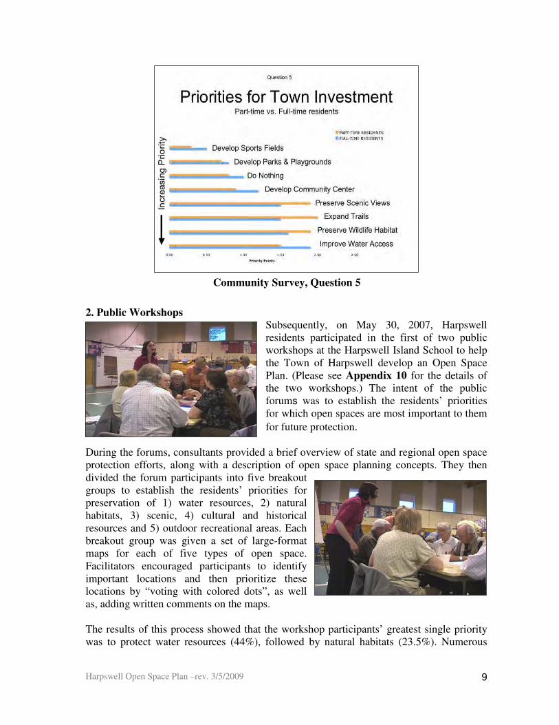
During the forums, consultants provided a brief overview of state and regional open space protection efforts, along with a description of open space planning concepts. They then divided the forum participants into five breakout groups to establish the residents’ priorities for preservation of 1) water resources, 2) natural habitats, 3) scenic, 4) cultural and historical resources and 5) outdoor recreational areas. Each breakout group was given a set of large-format maps for each of five types of open space. Facilitators encouraged participants to identify important locations and then prioritize these locations by “voting with colored dots”, as well as, adding written comments on the maps. The results of this process showed that the workshop participants’ greatest single priority was to protect water resources (44%), followed by natural habitats (23.5%). Numerous
Community Survey, Question 5

Harpswell Open Space Plan –rev. 3/5/2009
10
areas of Harpswell were identified for possible open space protection. Map 2 at the end of this document shows the scenic areas identified by the workshop participants as high priority for preservation.
4.Assessing Harpswell’s Open Space 4A. Topography of Harpswell
Looking to your right as you enter Harpswell traveling south on the Harpswell Neck Road,, your eye will travel past a coastal marsh, and continues over the rolling fields and apple orchard of the historic Merrucoonegan Farm, and rests on the barn on top of the hill. If you look to the left you will see the historic “Carrying Place”, named by the Native Americans. This freshwater wetland was used as a portage to Middle Bay from Harpswell Cove, greatly reducing the time it took for the trip.
Conclusion Based on the priorities expressed in the public survey and the two workshops, the Harpswell Conservation Commission concluded that the top priorities for conservation and preservation of open space in town are its water resources and natural habitat.
View from Harpswell Neck Road traveling south.
Merrucoonegan FarmMerrucoonegan FarmMerrucoonegan FarmMerrucoonegan Farm,
The Carrying PlaceThe Carrying PlaceThe Carrying PlaceThe Carrying Place

Harpswell Open Space Plan –rev. 3/5/2009
11
Harpswell’s topography is one of contrasts; from its pastoral rolling fields at its westerly entrance to its craggy island topography of its easterly shores.
Pond Pond Pond Pond
and to its rural and village scenes with green expanses and woodlands to the water.
To its open and closed water views
Old Tidal PondOld Tidal PondOld Tidal PondOld Tidal Pond TTTTide Mill Landingide Mill Landingide Mill Landingide Mill Landing
Orr’s Island Village & Post OfficeOrr’s Island Village & Post OfficeOrr’s Island Village & Post OfficeOrr’s Island Village & Post Office Allen Point Road, Harpswell NeckAllen Point Road, Harpswell NeckAllen Point Road, Harpswell NeckAllen Point Road, Harpswell Neck
Giant’s Stairs, Bailey IslanGiant’s Stairs, Bailey IslanGiant’s Stairs, Bailey IslanGiant’s Stairs, Bailey Islandddd

Harpswell Open Space Plan –rev. 3/5/2009
12
4B. History and Accomplishments 1987 – 2008 Open Space and its relationship to the environment was addressed in the 1987 Comprehensive Plan. The Conservation Commission used this plan to do an analysis of our accomplishments as a town in the last 21 years in the preservation of open space. (Please see Appendix 11 for the details.) In summary, we have:
• Preserved Land: In the last 20 years, we have made significant strides in preserving land. The Harpswell Heritage Land Trust (HHLT), other conservation groups, the Town of Harpswell and the State have preserved land through the acquisition of land and conservation easements. The Town Lands Committee has identified and clarified the ownership of our town lands. (See Appendix 13C)
• Preserved Scenic Views: In 1987, the town developed a map of scenic views which is used by the Planning Board to make decisions about the conservation of these views. (See Map 1) Scenic areas have been preserved. However, views from the water and along the roads have been impacted by the many new homes.
• Preserved Natural Habitat: A variety of natural habitats have been protected in Harpswell as the result of resource protection zoning and the preservation of land by HHLT, the Town, the State and other conservation and community groups.
• Developed Recreation Resources: The Town, HHLT and Bowdoin College have developed a series of recreational trails in Harpswell. A description of the trails is available on the Town of Harpswell and the Harpswell Heritage Land Trust websites. The Town Lands Committee has identified 18 landings which provide public access to the sea. (See Appendices 5A & 5B)
• Preserved Cultural and Historic Resources: The number of cultural and historic resources in Harpswell that have been preserved has increased over the past 20 years. The Harpswell Historical Society has played an active role in this process. (See Appendices 7A & 7B)
• Added Land Regulations to Benefit Open Space: Since 1987, land regulations at the State and town level have impacted positively on the conservation of our land and shoreline in Harpswell. Details about these regulations can be found in Appendix 11.
4C. How Much Protected Land Do We Have?
For purposes of this plan, the land in Harpswell is divided between developed and undeveloped land. Developed property is land with residential or commercial buildings and roadways on it. Undeveloped property is land without structures on it. Some of the undeveloped land may be difficult or impossible to develop because it is too steep, wet or rocky. The remainder of the undeveloped land can be developed in the future. (Please see
Allen Point. Rd., Allen Point. Rd., Allen Point. Rd., Allen Point. Rd.,

Harpswell Open Space Plan –rev. 3/5/2009
13
84%
12%4%
Not Protected
Permanent
Protection
Limited
Protection
Protected Land in Harpswell
Appendix 12 for more details.)
1. Inventory of Undeveloped Protected Land
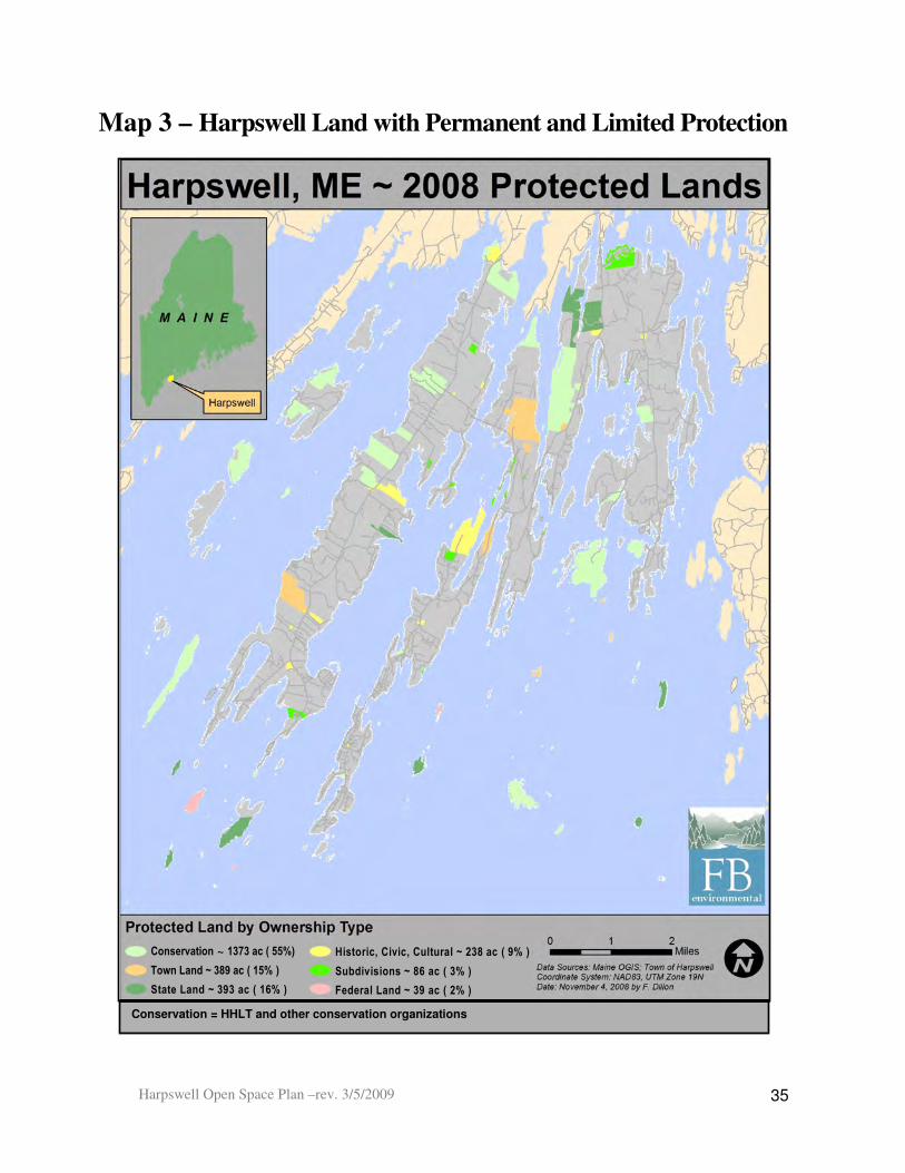
Fortunately, some of the undeveloped land in Harpswell is already protected from development because it is owned by or under easement to organizations whose mission is to preserve land or to serve the public. The Inventory of Protected Land in Harpswell (Appendices 13A, 13B and 13C) details this protected open space. Map 3 is a snapshot of existing protected open space properties in Harpswell. Some properties are permanently
protected from development because they have legal constraints on the property that limit their use to conservation purposes only. The rest of these properties have limited
protection because they are owned by governmental bodies or non-profit and educational institutions whose mission is to provide services to the community. These properties have varying forms of protection, but no legal mechanisms in place to prevent a change in their use as open space in the future.
The Town of Harpswell has approximately 15,700 acres of land. Of this amount, 16 % of the land in town has permanent or limited protection from development, because of its ownership by governmental institutions or civic and conservation organizations. (Please see Appendix 13B for an inventory of these properties). This land is valuable for the preservation of our habitat, water resources, recreation assets and scenic views, as well as history and character of our town.
The Harpswell Heritage Land Trust, The Maine Coast Heritage Trust, The Nature Conservancy and Bowdoin College8 have preserved 55% of the protected land in town. The Town of Harpswell, the State of Maine and the federal government account for another 33% of this land. The remaining 12% of this land is owned by a combination of civic, historic and cultural organizations and private individuals in subdivisions who own common land.
8 The Nature Conservancy conserves an island with important nesting habitat. The Maine Coast Heritage Trust preserves two islands. Bowdoin College owns three properties in Harpswell

Harpswell Open Space Plan –rev. 3/5/2009
14
Federal
State
Town
Subdivision
15%
16%
2%
45%
10%
9%3%
Town
State
Federal
HHLT
Other Conservation
Civic/Historic
Subdivision
Ownership of Land with Permanent Protection and Limited Protection
in Harpswell
HHLT
Other
Conservation
Civic/Historic
2. Types of Protection
Although we have 2,518 acres in Harpswell that are protected from development, only 1847 acres are permanently protected from development as the result of conservation easements or deed restrictions on the use of the property. (Please see Appendix 13C for an inventory of this land). Of these 1847 acres, 469 acres are owned by government agencies and 1378 acres by non profit and educational organizations. The permanently protected state and federal lands have deed restrictions and other restrictions on them that make it unlikely for their use to change. In other words, 12% of Harpswell's land is highly likely to remain as open space and provide habitat, water, recreational, scenic and/or civic, historic or cultural resources to the town.
The remaining 671 acres or 4% have limited protection as the result of its ownership by organizations with public missions. These organizations could chose to change the use of their open space property. For example, the Town of Harpswell could sell selected town lands to generate funds for other uses. The Town could also change the use of its existing open spaces, for example, the Cliff Trail, to other uses, such as town or residential buildings. Civic, cultural and historic organizations and education institutions could sell their properties, if they choose. The chart below provides a summary of the types of the ownership of all of the 2,518 acres of protected land in Harpswell.
Harpswell Open Space Plan –rev. 3/5/2009
15
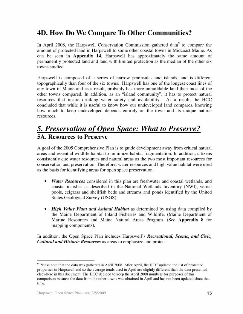
4D. How Do We Compare To Other Communities? In April 2008, the Harpswell Conservation Commission gathered data9 to compare the amount of protected land in Harpswell to some other coastal towns in Midcoast Maine. As can be seen in Appendix 14, Harpswell has approximately the same amount of permanently protected land and land with limited protection as the median of the other six towns studied. Harpswell is composed of a series of narrow peninsulas and islands, and is different topographically than four of the six towns. Harpswell has one of the longest coast lines of any town in Maine and as a result, probably has more unbuildable land than most of the other towns compared. In addition, as an “island community”, it has to protect natural resources that insure drinking water safety and availability. As a result, the HCC concluded that while it is useful to know how our undeveloped land compares, knowing how much to keep undeveloped depends entirely on the town and its unique natural resources.
5. Preservation of Open Space: What to Preserve? 5A. Resources to Preserve
A goal of the 2005 Comprehensive Plan is to guide development away from critical natural areas and essential wildlife habitat to minimize habitat fragmentation. In addition, citizens consistently cite water resources and natural areas as the two most important resources for conservation and preservation. Therefore, water resources and high value habitat were used as the basis for identifying areas for open space preservation.
• Water Resources considered in this plan are freshwater and coastal wetlands, and coastal marshes as described in the National Wetlands Inventory (NWI), vernal pools, eelgrass and shellfish beds and streams and ponds identified by the United States Geological Survey (USGS).
• High Value Plant and Animal Habitat as determined by using data compiled by the Maine Department of Inland Fisheries and Wildlife. (Maine Department of Marine Resources and Maine Natural Areas Program. (See Appendix 8 for mapping components).
In addition, the Open Space Plan includes Harpswell’s Recreational, Scenic, and Civic,
Cultural and Historic Resources as areas to emphasize and protect.
9 Please note that the data was gathered in April 2008. After April, the HCC updated the list of protected properties in Harpswell and so the average totals used in April are slightly different than the data presented elsewhere in this document. The HCC decided to keep the April 2008 numbers for purposes of this comparison because the data from the other towns was obtained in April and has not been updated since that time.

Harpswell Open Space Plan –rev. 3/5/2009
16
5B. Identification of High Value Areas of Open Space In order to identify the large uninhabited areas to preserve for open space, maps from the Maine Natural Areas and Beginning with Habitat Programs were used to determine the location of Harpswell’s natural habitat and water resources. (See Appendix 4) Tax maps and the Inventory of
Protected Land in Harpswell were used to identify the location of scenic, civic, cultural, historic and recreational resources. (See Maps
3,4,5 and 6 and Appendix 15 for more details about the methodology). This information, coupled with local knowledge, was used to select Focus Areas for preservation of Harpswell’s largest high value areas. In addition, the following criteria were used in the selection:
• Limited or no current development in the area
• Size of area with priority given to larger areas, including blocks of undeveloped land over 20 acres in size
• Connectivity of the land to existing preserved and undeveloped land or wildlife habitat
• Existence of permanently protected land and land with limited protection in the area
• Equity in the distribution of open space in all major areas within the town
• Public input

Harpswell Open Space Plan –rev. 3/5/2009
17
In addition, Harpswell Islands over one acre in size, are high value areas and, therefore, priority for open space preservation. Island ecology is fragile by nature and easily destroyed so it is important that their natural areas are preserved because:
• The undeveloped areas provide important wildlife habitat for nesting waterfowl, birds and animals with minimal human disturbance.
• Thirty of our islands have been identified by the Maine Dept of Inland Fisheries and Wildlife as important sea bird nesting islands and have been zoned for Resource Protection.
• The bald eagle and roseate tern, threatened species, nest on Harpswell Islands.
• Many are surrounded by healthy clam flats that benefit from their undeveloped state.
• They provide both a location for outdoor recreation and picturesque views from the mainland.
5C. What Is a Focus Area?
Based on the above criteria, as well as local knowledge of Harpswell, the Harpswell Conservation Commission selected 12 Focus Areas, which contain high value land to protect. The resources contained in each Focus Area are described in Appendix 16 and shown in Map 6. In general, the Focus Areas contain large open areas of land that include the water resources necessary to ensure the marine ecology and preserve the health of the fishing industry. The areas also include high value habitat critical to federally endangered, threatened and migratory birds that visit or nest in Harpswell and its islands and high value plant and animal species. In addition to these 12 Focus Areas, Harpswell’s islands, especially those with nesting habitat and access for recreation, should be preserved for open space. Each of the 12 Focus Areas was chosen for a variety of the above reasons and specific circumstances listed below. (Please see Appendix 16 for details.)
Focus Area 1: Long Reach, Great Island The Long Reach-Long Marsh area on Great Island includes:
• Long Marsh, an important State protected salt marsh
• Three coastal wetlands
• One freshwater wetland
• One coastal floodplain
• A cove with clam flats Long MarshLong MarshLong MarshLong Marsh

Harpswell Open Space Plan –rev. 3/5/2009
18
• State and HHLT conserved land
• The Town Cliff Trail and Long Reach Preserve Trail
• High value wildlife habitat and nesting areas for rare, endangered and threatened species.
• The largest undeveloped corridor of open space in Harpswell
Focus Area 2: Brickyard Watershed,
Great Island
The area of Brickyard Cove and Cranberry Horn Hill to Cundy’s Harbor Road features:
• Two freshwater wetlands which protect upper Quahog Bay
• One Freshwater wetland flowing into the New Meadows River
• Valuable for the interspersion of its wetland types
• High value habitat for tidal waterfowl and wading birds.
Focus Area 3: Bethel Point, Cundy’s
Harbor The southeast Quahog Bay/Hen Cove area includes:
• Two freshwater wetlands which protect Quahog Bay and its marine ecosystem.
• Significant inland and tidal habitat for waterfowl and wading birds.
• Good interspersion of feeding and breeding habitat and migratory staging area.
• Provides a significant corridor for wildlife.
Focus Area 4: Sandy Cove, East
Cundy’s Point
The Sandy Cove area on East Cundy’s Point includes:
• One coastal marsh which is part of the 100 year floodplain.
• Sandy Cove Beach which should be preserved for recreation and hiking
• High value habitat for tidal waterfowl/wading birds
• Historic location of salt farm and ice production

Harpswell Open Space Plan –rev. 3/5/2009
19
Focus Area 5: Ice Pond, Gun and Long Points, Great Island
• Located between Gun Point and Long Point this area has:
• The only Great Pond in Harpswell and is in a 100 year floodplain
• Potential for recreation and public access
• High value tidal habitat for waterfowl and wading birds.
• Historic site for ice production
Focus Area 6: Wilson’s Pond Orr’s Island
The area includes :
• Wilson’s Pond,
• An important freshwater wetland
• Significant inland habitat for waterfowl and wading birds
• One of our few freshwater marshes.
• The largest undeveloped area of open space on Orr’s Island.
Focus Area 7: Cedar Beach, Bailey Island
Cedar Beach is important because:
• It is an important recreational resource for the area.
• A high value habitat for tidal waterfowl and wading birds
Harpswell Open Space Plan –rev. 3/5/2009
20
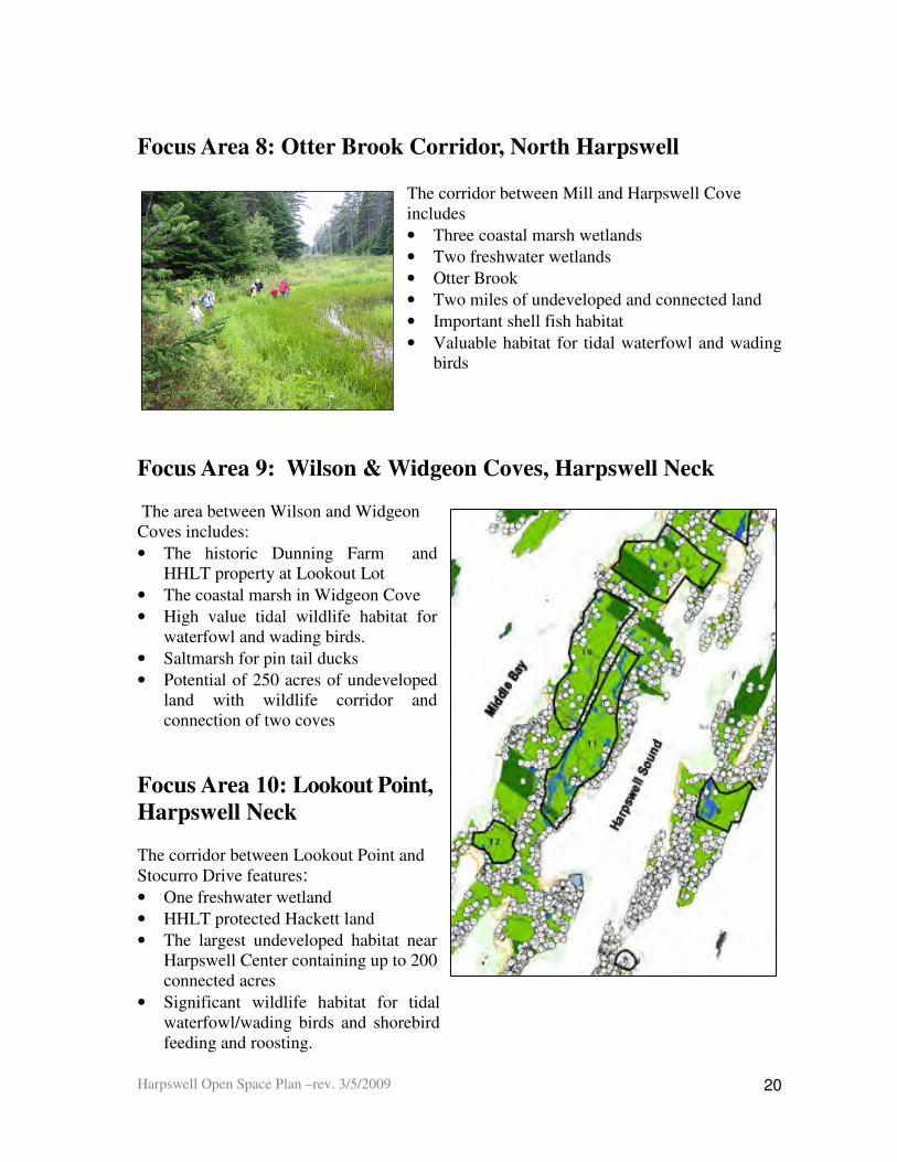
Focus Area 8: Otter Brook Corridor, North Harpswell
The corridor between Mill and Harpswell Cove includes
• Three coastal marsh wetlands
• Two freshwater wetlands
• Otter Brook
• Two miles of undeveloped and connected land
• Important shell fish habitat
• Valuable habitat for tidal waterfowl and wading birds
Focus Area 9: Wilson & Widgeon Coves, Harpswell Neck
The area between Wilson and Widgeon Coves includes:
• The historic Dunning Farm and HHLT property at Lookout Lot
• The coastal marsh in Widgeon Cove
• High value tidal wildlife habitat for waterfowl and wading birds.
• Saltmarsh for pin tail ducks
• Potential of 250 acres of undeveloped land with wildlife corridor and connection of two coves
Focus Area 10: Lookout Point,
Harpswell Neck The corridor between Lookout Point and Stocurro Drive features: • One freshwater wetland
• HHLT protected Hackett land
• The largest undeveloped habitat near Harpswell Center containing up to 200 connected acres
• Significant wildlife habitat for tidal waterfowl/wading birds and shorebird feeding and roosting.

Harpswell Open Space Plan –rev. 3/5/2009
21
Pond, Shore Acres Road.Pond, Shore Acres Road.Pond, Shore Acres Road.Pond, Shore Acres Road.
Focus Area 11. Allen Point Road Corridor, Harpswell Neck
Features:
• One freshwater wetland which drains into Harpswell Sound and influences clam flats
• Small pond containing a dry hydrant, across from the Harpswell Post Office.
• Significant tidal wildlife habitat for waterfowl and wading birds
• Provides shellfish habitat
Focus Area 12 Basin Cove, South Harpswell The Basin Cove to Curtis Cove area contains:
• Undeveloped area along Basin Cove of about 80 acres
• A high value pond on right of Basin Cove Road
• A scenic area
• Only remaining undeveloped habitat in South Harpswell
• High value habitat, including significant habitat for tidal waterfowl and wading birds
Islands
Our islands are important wildlife habitat, especially for nesting waterfowl. Thirty of our 83 islands have been identified by the Maine Dept of Inland Fisheries and Wildlife as important sea bird nesting islands. Many are surrounded by clam flats that benefit from the fact that the islands are not developed.
• Most have large undeveloped areas on them
• They all provide scenic views from the mainland of Harpswell
• The islands that have been preserved to date by HHLT and other conservation groups provide recreational opportunities
These 12 Focus Areas and the undeveloped islands are the open spaces in Harpswell which are the most important to preserve because of their ecological and economic value. These areas should be at the center of Harpswell’s future open space protection efforts. Currently,
Harpswell Open Space Plan –rev. 3/5/2009
22
the Focus Areas and most of the islands have limited development. Some of the land in these areas is already permanently protected or has limited protection from development. Most of the land is privately owned by conservation minded residents living in the area who have kept it in its current undeveloped condition. The role of the Town will be to work with the landowners in the Focus Areas and on the islands to acquaint them with policies and practices that allow them to maintain their property in an undeveloped state, or if developing, siting their land to protect water resources and valuable habitat. Strategies are discussed in the following section.
6. Open Space Protection Strategies In order to protect the open space in the Focus Areas, the Harpswell Conservation Commission (HCC) researched and chose five strategies or tools to be used to preserve the high value land in these areas. The HCC suggests that the Town use the following tools to preserve Harpswell’s existing open space in the short term and into the future:
• preservation of water resources
• voluntary efforts to preserve open space
• voluntary efforts to protect existing conservation land
• the addition of a definition of open space to our land use regulations
• strategic land acquisition.
These strategies are intended to be used primarily in the Focus Areas. Many of them however can and should be used in other parts of Harpswell to preserve open space. A Summary of Open Space Protection Strategies follows.

Harpswell Open Space Plan –rev. 3/5/2009
23
Strategy Activity Priority Audience
Protection of Water Resources 1. Map and protect vernal pools All Residents
2. Update wetland protection of four wetlands Focus Area Residents
Voluntary Efforts for Open Space 1. Provide conservation education
Focus Area Residents
2. Develop stewardship agreements, conservation leases and conservation easements in cooperation with the HHLT or other land trusts
Focus Area Residents
3. Encourage voluntary use of private land by neighbors All Residents
4. Increase current use tax programs All Residents
5. Increase access to water with parking All Residents
Efforts to Preserve Protected Land 1. Preserve selected town lands for conservation All Residents
2. Increase non-motorized boat landings All Residents
3. Promote use of Town land All Residents
4. Encourage and document use of State land All Residents
5. Contact civic and education groups re Plan Civic and education groups
6. Explore protection of historic properties Harpswell Historic Society
Land Use Regulations 1. Add open space definition to ordinance addendum
Planning Board, CPIC
2. Appoint committee to study ordinances Planning Board, CPIC
3. Develop a new scenic methodology and use to update the scenic map Planning Board
Strategic Land Acquisition 1. Identify and evaluate potential land to purchase All Residents
2. Obtain funding All Residents
3. Purchase land from willing sellers Focus Area Residents
4. Provide stewardship of property All Residents
Summary of Open Space Protection Strategies
Harpswell Open Space Plan –rev. 3/5/2009
24
6A. Protection of Water Resources: Vernal Pools and Wetlands
1. Map Vernal Pools
Vernal pools and their uplands play a crucial role in plant and animal ecosystems.10 A vernal pool provides the primary breeding habitat for wood frogs and salamanders. Due to their ephemeral nature, their small size and the fact that they are home to nocturnal feeding species, vernal pools have often slipped through the regulatory cracks. As of September 1, 2007, vernal pools identified as significant vernal pool
11 habitat are protected by law by the Natural Resources Protection Act, (§38MRSA 480-B). (Please see Appendix 3 for more detail.)
Our vernal pools are fragile water bodies which are an important wetland resource for the following reasons.
• Vernal pools are important to our local ecosystem and the entire animal and insect food chain.
• Vernal pools provide breeding habitats with plants, vertebrates and invertebrates, birds, reptiles, amphibians and mammals, as well as migratory birds and an increasing number of threatened species.
• They contribute to the local biodiversity.
• Amphibians are breeding indicator species that detect environmental hazards, which have the potential to pollute ground and other water bodies.
• Where located near wetlands, these special aquatic sites contribute to cleansing the surrounding water.
As Harpswell continues to develop, it is important to locate and protect the significant
vernal pools in our town. The HCC recommends that the Town12 identify and map the significant vernal pools in town and provide education to the public about the ecological
significance of these pools.
2. Update Wetland Protection
Wetlands are essential for the health of our water supply and marine economy. The Town currently has 27 wetlands zoned for resource protection. The Conservation Commission supports the existing resource protection zoning and recommends that four wetlands, currently zoned as Shoreline Residential,13 should be reclassified under Resource
10 An ecosystem is a natural system consisting of plants, animals and microorganisms in an area that function together with all of the non-living factors of the environment. 11 Significant vernal pools are defined in Maine as having (1) a state listed threatened or endangered species using it for an important part of its life history and/or (2) there is a notable abundance of vernal pool species, such as blue spotted salamander, wood frog or fairy shrimp. 12 The Town should be responsible for the mapping. In the future, property owners who sell property will be required by State law to survey their land to identify vernal pools. As a result, a Town survey will save money for residents who sell their property. 13 The Shoreland Residential District includes those areas suitable for residential and recreational development. The Resource Protection District includes areas in which development would adversely affect water quality, productive habitat, biological ecosystems, or scenic and natural values.

Harpswell Open Space Plan –rev. 3/5/2009
25
Protection. (Please see Appendix 17 for details and Appendix 18 for a summary of wetland mitigation.)
6B. Voluntary Efforts Available to Preserve Open Space The ability of property owners to preserve open space while having continued use of their land is a powerful tool to open space protection. In order to preserve open space in the Focus Areas, the participation of property owners should be sought and encouraged. Their voluntary participation will enhance the effectiveness of the town open space program and will increase connectivity between open spaces. Efforts to preserve open space, with priority given to land in the Focus Areas, would include: 1) conservation education, 2) voluntary stewardship and land conservation 3) the use of tax incentive programs, 4) ways to increase access to the water and 5) voluntary use of private land by neighbors.. The Conservation Commission recommends that the Town explore the following voluntary strategies to preserve high priority open space. 1. Conservation Education A program to develop ongoing education on critical habitat preservation should be developed for landowners in Harpswell, especially those who have property in the Focus Areas. The materials should include information on the value of upland habitat, wetland protection; and sound land management practices, such as, managing drainage problems, maintaining a vegetated buffer around sensitive water resources or natural habitats and encouraging minimal residential use of chemicals on lawns abutting water bodies.
2. Stewardship, Conservation Leases and Conservation Easements Voluntary stewardship agreements between the Town and residents, especially those in the Focus Areas, would encourage landowners to preserve important undeveloped open space land. If the property owner were willing, the agreement could include limited public access to the land for selected outdoor recreational activities. An open space implementation committee would develop guidelines regarding the process and content of these guidelines.
Another possible way to preserve large parcels of undeveloped land would be to develop a conservation lease
14 with the owner. Large parcels of land are undeveloped because past and current owners assume some level of stewardship of their land. The Town could encourage landowners to continue that stewardship by leasing development rights to the land. It would allow the Town to enter into a lease contract with a landowner for keeping his/her land undeveloped. The amount of the contract payment could be related to the amount the land is taxed for real estate purposes and the length of the contract, which would likely be at least 10-15 years and possibly more. Please see Appendix 19 for the details.
Landowners who live in the Focus Areas could also be encouraged to put conservation easements on their land to preserve a portion of their land in a natural state. The easements
14 This concept was developed for and found in the Casco Open Space Plan.

Harpswell Open Space Plan –rev. 3/5/2009
26
could be held by Harpswell Heritage Land Trust or other land trusts, such as the Maine Coast Heritage Trust and The Nature Conservancy. 3. Current Use Tax Incentive Programs
As a means of encouraging open space preservation, the State of Maine has established Current Use Programs, which offer property owners a reduction in the assessed value of their land for tree growth, farm land, open space15 and/or working waterfront. All of these programs are available to property owners through an application process with the Town.16 A list of these programs and a description of Harpswell’s current participation in these programs can be found in Appendix 20. The Conservation Commission should find additional ways to let residents know about these programs, especially people who reside in the Focus Areas. Currently, a forty-foot setback exists along State roads. The Town of Harpswell should
explore the idea of encouraging residents to maintain an undeveloped natural area along
State roads of at least 75 feet. which may be eligible for the open space tax reduction
program, if all other open space requirements are met.
4. Increased Access to the Water Many of the Town Landings and beaches need additional parking to increase access to the water. The HCC recommends that the Town consider ways to increase parking in selected locations. 5. Voluntary Use of Private Land by Neighbors
In order to ensure the connection between pieces of land, the HCC recommends that the Town encourage private land owners to preserve or allow rights of way or paths over their land which connect to other common lands. For generations, paths on private property have been used by neighbors without shore access and clammers and fishermen to have access to the water. A program might be developed that would encourage landowners to allow continued use of historic paths to the water. These could include education and documentation for public use of these historic paths.
6C. Efforts to Preserve Existing Conservation Land
The Town, the State and several civic and historic organization have partially protected the
use of selected open space and cultural and historic sites in Harpswell. In order to protect
these community resources further, especially those in the Focus Areas, the Harpswell
Conservation Commission recommends the following strategies.
1. Town Lands
15 The Open Space tax classification provides incremental tax savings up to 95% as follows: ordinary open space 20%; permanently protected 50%; forever wild 70%; and public access 95% reduction. 16 The Town’s Assessing Department already informs residents about the use of these programs through its website (http://www.harpswell.maine.gov).
Harpswell Open Space Plan –rev. 3/5/2009
27
The Town of Harpswell currently has 389 acres of land with limited protection from
development, some of which is in the Focus Areas. The HCC recommends that the Town
promote the use of Town Lands for recreation and consider designating some of its land,
especially land in the Focus Areas, for permanent conservation.
a. Preservation of Selected Town Lands for Conservation: The Town should explore
the possibility of preserving some of the Town lands as conservation land. In order to
decide which lands to preserve and do the work involved in preserving them,
Representatives of the Town Lands Committee and Conservation Committee could form a
conservation lands subcommittee to prepare a suggested list of potential town lands to put
under conservation easement or a declaration of trust. Priority should be given to Town
landings that allow public access to the water; Town lands that have a significant number
of acres that support habitat and permit recreation; and Town islands with nesting habitat.
A vote at Town Meeting would be needed to specify the use of selected land for permanent
conservation. Please see Appendix 21 for suggestions regarding which Town Lands
should be preserved as open space.
b. Expansion of Non-motorized Boat Landings: The HCC supports the Recreation and
Town Lands Committees’ interest in identifying locations in Harpswell for public carry-in
and carry-out landings for small boats, such as kayaks and canoes.
c. Promotion of the Use of Town Property: The HCC suggests a coordinated program
be developed by the various land use committees to inform the residents about Open
Space, Town Landings and Trails in Harpswell. This information could contain a map and
listing of trails, Town Landings and recreational spots.
2. State Lands
The State of Maine owns 393 acres of land in Harpswell, most of which is in the Focus
Areas and available to the public for recreation. State land can be used in mitigation trades;
therefore, the Town should do what it can to protect these lands In order to protect our
State lands located in Harpswell, the Town should do the following:
a. Document the Use of State Land: The Town should document the public use of these
lands and educate residents about their availability.17 The more these properties are used by
the public, the less chance they have of being converted to other uses.
17
In order to protect the state properties on Allen Point Road/Clark Cove (Lots 011-061 and 011-065), the
Town should explore ways to ensure public access to these two properties and document their use. The
current trails on the properties are overgrown and need maintenance.

Harpswell Open Space Plan –rev. 3/5/2009
28
b. Maintain a Relationship with State: As needed, the Town should make State
legislators aware of the importance of State lands to Harpswell for habitat and recreation
uses. In order to do this education about the status of each State property, information on
the public use of the property should be compiled. This information should be retained in
the Codes Office in each property’s file, making it readily accessible when needed.
3. Civic and Educational Groups
Many of the civic lands in town are buildings and small pieces of land. Cemeteries,
however, are important historically and culturally. The HCC supports efforts to preserve
these ties to community. The Town could check into the laws that protect cemeteries from
development in Maine and review the deeds of the existing cemeteries so that they are
better and more accurately recorded in town records.
Bowdoin College owns 124 acres of undeveloped land known as The Thalheimer Farm
and Wyer Island on Orr’s Island. Currently it is the home of the Environmental Studies
Program used for research and education. It also contains several trails for public use. The
HCC should contact the college to acquaint it with Harpswell’s Open Space Plan and
discuss how long term protection of this property is an important piece of the Open Space
Plan.
4. Historic Properties
The HCC supports the efforts of the Harpswell Historical Society to protect the Town’s historical buildings and properties. Harpswell has 13 properties that are listed on the National Register of Historic Places. (See Appendix 7B) One of these properties, The Auburn Colony, is a Historic District. In addition, we have a number of other historic buildings and 32 Maine Historic Preservation Commission historic archaeological sites.
All contribute to the character of Harpswell. The Town may want to explore protecting some of the historic buildings and sites that it owns by placing an easement or a deed restriction to their use.
6D. Land Use Regulations
The Harpswell Conservation Commission was asked by the CPIC to prepare an analysis of how existing land use ordinances impact on open space and what new ordinances might be considered to protect open space. The HCC did this analysis and concluded that changes are needed in the existing ordinances to protect open space. However, the HCC does not have the mandate or expertise to make these changes. As a result, the HCC recommends that the Town appoint a committee or hire a consultant to do this work. The ideas outlined in Appendix 22 can be used as a starting point for this task.

Harpswell Open Space Plan –rev. 3/5/2009
29
During its analysis of the impact of land use regulations on open space, the HCC discovered that the Town does not have a definition of open space in its Land Use Ordinances. The HCC recommends that in order to eliminate confusion or ambiguity, a uniform definition of “open space” be added to the Harpswell’s Ordinances Definitions Addendum as follows:
Open space, also known as natural areas or green space, is an area of land in
a predominantly undeveloped condition. It can include forests, fields,
wetlands and/or water bodies. Open space can be improved land, such as a
ball field or cemetery, or unimproved land, such as a wildlife preserve or
other natural area, or just an undeveloped parcel of land. Open space land
may be preserved, enhanced, or restored in order to maintain or improve the
natural scenic, ecological, cultural, hydrological or geological values of the
land.
In addition to reviewing and updating the land use regulations, the HCC recommends that
the revised Scenic Views Map of Harpswell (Map 8) be updated. The methodology that
was used to prepare the 1987 (see Map 1) and the updated 2007 map (see Map 8) focused
on scenic views from roads and a few other sites. The HCC recommends using the revised
Map 8 until a new scenic rating system using the guidelines defined by the Maine State
Planning Office in 2007 is implemented. Please see Appendix 6A for details of this new
methodology.
6E. Strategic Land Acquisition
An important way in which the Town can preserve high priority open space is by the
strategic acquisition of selected land. Prior to purchase, the Town will need to determine if
the land is within the focus areas of Harpswell, and therefore of strategic importance for
preservation as open space. Please see Appendix 15 for a methodology for assessing open
spaces and Appendix 16 for a list of recommended focus areas.
The main mechanism to acquire land is to purchase the land at fair market value from
willing sellers. The Town may also acquire property occasionally through donations of
land, the transfer of development rights and forfeiture of property due to non payment of
taxes.
Any land that is acquired by the Town will require stewardship18 which requires both labor
and money. Therefore, resources will need to be set aside for both the purchase of land and
18 Stewardship is the practice of carefully managing land use to insure natural systems are maintained or
enhanced for future generations. Land Stewardship Resource Center.
Harpswell Open Space Plan –rev. 3/5/2009
30
its maintenance. The Town’s capital reserve account could be used to hold funds for the
purchase of land19.
The Town can fund the purchase of open space from three major sources. The first is local
funding, such as municipal bonds, appropriations and donations. The second is through
state and federal sources and the third through private sources, such as individual
donations and foundations. Please see Appendices 23A, 23B and 23C for more detailed
information on sources of funding.
7. Recommendations for Implementation and
Conclusion
The residents of Harpswell need to decide which of the strategies discussed in Section 6 should be implemented to protect open space in Harpswell, especially in the Focus Areas. In order to decide on the best strategies and develop a detailed Implementation Plan, the Conservation Commission recommends a four-stage implementation process:
• Review and Approve the Open Space Plan: The Open Space Plan will be presented to Town Committees, the Selectmen and the public for input and voted on at the March 2009 Town Meeting.
• Appoint an Open Space Implementation Committee: The Committee should be responsible for the implementation of the Open Space Plan in collaboration with the Town Planner and the appropriate town committees. The Conservation Commission could be this committee.
• Implement Voluntary Strategies: The Town of Harpswell should (1) map vernal pools and update the wetland protection; 2) work with landowners to implement voluntary programs to preserve open space; and 3) explore voluntary efforts to protect existing protected land.
• Explore Land Regulation and Land Acquisition: The Town should 1) update land use regulations that impact on open space, including the definition of open space and 2) examine the possibility of purchasing land in the Focus Areas in collaboration with the local land trust (HHLT).
As a result of the implementation of this Open Space Plan, we hope to achieve our shared vision for the Town of Harpswell that:
• The key open spaces that make Harpswell a desirable place to live and give it its quality of place will be conserved for future generations to enjoy and appreciate.
• The quality of its groundwater, bays, rivers, ponds, vernal pools and wetlands will be preserved in healthy condition for future generations.
19 Capital reserve account set up to hold money for the purpose of acquiring land at the March 11, 2000 Town Meeting.

Harpswell Open Space Plan –rev. 3/5/2009
31
• The animals, birds and other wildlife will continue to have habitat in which to live and prosper.
• The character of Harpswell will continue to be defined by the Town’s coastal, small town; rural to village pattern; and its natural, cultural, scenic and recreational assets.
• New residential development will preserve the natural features of the land, provide buffers along our roads, wetlands, streams and shoreline, include open space, and allow for public access.
• Community organizations, town government, landowners, developers, and the public will work together collaboratively to plan for, protect and manage the open space resources of the town.

Harpswell Open Space Plan –rev. 3/5/2009
32
MAPS

Harpswell Open Space Plan –rev. 3/5/2009
33
Map 1 – 1987 Scenic Areas Map

Harpswell Open Space Plan –rev. 3/5/2009
34
Map 2 - Scenic Resources Identified in Workshop 2
By workshop Participants, Summer 2007 (Note: missing HHLT Easements=Houghton Graves Park, Brown Woods, Shelter Island)
Harpswell Open Space Plan –rev. 3/5/2009
35
Map 3 – Harpswell Land with Permanent and Limited Protection
Conservation = HHLT and other conservation organizations
Conservation ~ 1373 ac ( 55%)
Town Land ~ 389 ac ( 15% )
State Land ~ 393 ac ( 16% )
Historic, Civic, Cultural ~ 238 ac ( 9% )
Subdivisions ~ 86 ac ( 3% )
Federal Land ~ 39 ac ( 2% )

Harpswell Open Space Plan –rev. 3/5/2009
36
Map 4 – Water Resources
Map 4 – Water Resources

Harpswell Open Space Plan –rev. 3/5/2009
37
Map 5 – Habitats Only

Harpswell Open Space Plan –rev. 3/5/2009
38
Map 6 –Water Resources, Critical Habitat, and
Buildings with 175 Ft. Buffer
Map 6 – Water Resources, Critical Habitat, and
Buildings with 175 Ft. Buffer

Harpswell Open Space Plan –rev. 3/5/2009
39
Map 7 – Open Space Focus Areas

Harpswell Open Space Plan –rev. 3/5/2009
40
Map 8 – Scenic Views & Corridors, 2008

Harpswell Open Space Plan –rev. 3/5/2009
41
Glossary - Ecosystem: .A natural system consisting of plants, animals and microorganisms in an area that function together with all of the non-living factors of the environment.
Eelgrass: The one and only flowering plant of temperate zones that can grow in salt water. (Zostera marina). Sometimes people call it “grass wrack” because when its long slender leaves break off and wash up on shore, it forms the “wrack line” by which we judge where the high tide has been.
Focus Area: a large open area of land that includes the water resources necessary to ensure the marine ecology and preserve the health of the fishing industry. The area may include high value habitat critical to federally endangered, threatened and migratory birds that visit or nest in Harpswell and its islands, and high value plant and animal species. In addition to these 12 Focus Areas, Harpswell’s islands, especially those with nesting habitat and access for recreation, should be preserved for open space.
Freshwater wetland types: - Open water wetlands are areas of water where there are no beds of emergent,
submerged or floating vegetation. - Emergent wetlands are characterized by rooted herbaceous and grass like plants
which stand erect above the water or ground surface. - Shrub-scrub wetlands are dominated by shrubs and tree saplings less than 20 feet in
height. - Forested wetlands are dominated by trees taller than 20 feet in height.
Habitat for wildlife: the extent to which a wetland serves as habitat for animals, birds, amphibians and fish typically associated with wetlands and their adjacent uplands; for migrating species; and for species dependent on wetlands at some stage in their life cycles.
Harpswell’s wetlands: While 25% of Maine’s land area consists of freshwater wetlands, less than 2% of Harpswell’s land area does. Studies have shown that development in its adjacent uplands can significantly degrade a wetland’s ability to perform its vital functions. The freshwater wetlands, large and small, that Harpswell does have are consequently more valuable due to their scarcity.
Inter-tidal emergent vegetation: sedges, rushes and riparian shrubs and trees growing in the middle and upper intertidal zones Nutrient absorption: the potential ability of a wetland to take up nutrients that enter the wetland from surrounding uplands and upstream areas and process them into other forms less dangerous to the quality of downstream resources and downstream water quality.
Open space: land in a predominantly undeveloped condition. It may be preserved or managed in order to maintain the natural, scenic, ecological, cultural, hydrological or
Harpswell Open Space Plan –rev. 3/5/2009
42
geological properties of the land. In addition, while not strictly open space, the Plan includes areas that provide cultural, historic, and recreational resources that contribute to Harpswell’s quality of place and are part of its seafaring and rural heritage.
Production export: the ability of a wetland to produce food for wildlife and export the organic detritus (decayed organic matter) that forms the base of the marine food chain. While coastal marshes obviously have great production export abilities, freshwater wetlands can also play significant roles in land and marine food chains. Protected open space: property that is protected from development because it has a legal constraint on the property that limits its use to conservation purposes. Permanently protected open space: property that has limited protection from development because it is owned by the government entity, a non-profit or an educational institution whose mission is to provide services to the community. These properties have varying forms of protection but no legal mechanisms in place to prevent a change in their use as open space in the future.
Quahog Bay was judged particularly vulnerable to nutrient loading (especially nitrogen compounds) from its uplands. The reasons for this include its relatively narrow entrances (which limits flushing), shallowness (warmer water temperatures result in lower oxygen levels), and a high density of septic systems on its shores (nitrogen source). Recommendations for wetlands that drain into Quahog Bay reflect the importance of minimizing any additional nutrient loading into the bay. Sediment/toxicant retention: the potential ability of a wetland to trap and filter sediments and pollutants in run off water from surrounding uplands and upstream areas. Stewardship: The practice of carefully managing land use to insure natural systems are maintained or enhanced for future generations. (see footnote 18 under 6E in Part 1 if you want more)
Vernal pool: A vernal pool or seasonal forest pool is a natural, temporary to semi-permanent body of water that typically fills during the spring or fall and is often dry during the summer. A vernal pool may provide the primary breeding habitat for wood frogs, spotted salamanders, blue-spotted salamanders, and fairy shrimp. As of September 1, 2007, vernal pools identified as significant vernal pool
20 habitat are protected by the Natural Resources Protection Act, (§ 38 MRSA 480-B)
20 Significant vernal pools are defined in Maine as having (1) a state listed threatened or endangered species using it for an important part of its life history and/or (2) there is a notable abundance of vernal pool species, such as blue spotted salamander, wood frog or fairy shrimp.

PART 2 –
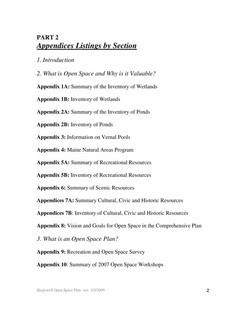
Harpswell Open Space Plan –rev. 3/5/2009
2
PART 2
Appendices Listings by Section
1. Introduction
2. What is Open Space and Why is it Valuable?
Appendix 1A: Summary of the Inventory of Wetlands Appendix 1B: Inventory of Wetlands Appendix 2A: Summary of the Inventory of Ponds Appendix 2B: Inventory of Ponds Appendix 3: Information on Vernal Pools Appendix 4: Maine Natural Areas Program Appendix 5A: Summary of Recreational Resources Appendix 5B: Inventory of Recreational Resources Appendix 6: Summary of Scenic Resources
Appendices 7A: Summary Cultural, Civic and Historic Resources Appendices 7B: Inventory of Cultural, Civic and Historic Resources Appendix 8: Vision and Goals for Open Space in the Comprehensive Plan
3. What is an Open Space Plan? Appendix 9: Recreation and Open Space Survey Appendix 10: Summary of 2007 Open Space Workshops
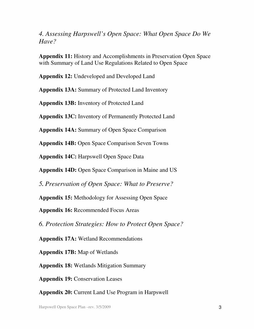
Harpswell Open Space Plan –rev. 3/5/2009
3
4. Assessing Harpswell’s Open Space: What Open Space Do We
Have?
Appendix 11: History and Accomplishments in Preservation Open Space with Summary of Land Use Regulations Related to Open Space Appendix 12: Undeveloped and Developed Land Appendix 13A: Summary of Protected Land Inventory Appendix 13B: Inventory of Protected Land Appendix 13C: Inventory of Permanently Protected Land Appendix 14A: Summary of Open Space Comparison Appendix 14B: Open Space Comparison Seven Towns Appendix 14C: Harpswell Open Space Data
Appendix 14D: Open Space Comparison in Maine and US
5. Preservation of Open Space: What to Preserve?
Appendix 15: Methodology for Assessing Open Space
Appendix 16: Recommended Focus Areas
6. Protection Strategies: How to Protect Open Space?
Appendix 17A: Wetland Recommendations Appendix 17B: Map of Wetlands Appendix 18: Wetlands Mitigation Summary Appendix 19: Conservation Leases Appendix 20: Current Land Use Program in Harpswell

Harpswell Open Space Plan –rev. 3/5/2009
4
Appendix 21: Town Lands for Open Space
Appendix 22: Land Use Memo
Appendix 23A: Funding Mechanisms for Land Acquisition
Appendix 23B: Land Stewardship and Funding Sources Appendix 23C: Federal Funding Sources for Land Conservation