Embed Size (px)
Citation preview
Dane County (Town of Cottage Grove) 1
Natural Hazard Mitigation Plan
September 2017
Town of Cottage Grove Annex
Community Profile
The Town of Cottage Grove is located in eastern Dane County, Wisconsin, about 1½ miles east of
Madison and 65 miles west of Milwaukee. Its land area includes about 33.7 square miles. It is bisected
by County Highways BB and N, bordered on the north by I-94 and US Highway 12/l8 runs through the
southern part. The Town is bordered on the north by the town of Sun Prairie and the town of Pleasant
Springs to the south. The town of Deerfield is located to the east and the Town of Blooming Grove and
the city of Madison to the west. The Village of Cottage Grove is located in the northern part of the Town,
along County Trunks N and BB and includes 1,480 acres. Pursuant to state statutes, the Village extends
and exercises its extraterritorial authority into the Town 1½ miles in all directions, and the City of
Madison extends and exercises its extraterritorial authority into the Town 3 miles. Where the
extraterritorial jurisdictions of the City of Madison and the Village of Cottage Grove meet, a compromise
between the two has been reached. This extraterritorial area encompasses some 17,225 acres.
Collectively, the area of the Village and the extraterritorial area accounts for about 81 percent of the
original town. Land use in the Town includes agriculture, wetlands and woodlands, rural subdivisions,
and dispersed one and two-family homes.
As of the 2010 Census, there are 3,875 people, 1,463 households, and 1,170 families residing in the
Town of Cottage Grove. The population density is 120.7 per square mile. There are 1,495 housing units
at an average density of 46.6 per square mile. The municipality population distributed by the Wisconsin
Department of Administration indicates that the 2015 population for Town of Cottage Grove was 3,900
people. Table 1 shows the population profile by age for the Town of Cottage Grove according to the
2010 Census.
American Community Survey estimates for 2014 indicate that the median income for a household in the
Town of Cottage Grove is $84,643 and the median income for a family is $95,469. The per capita income
for the Town of Cottage Grove is $39,525. 97.5% of the population has at least a high school degree,
while 26.2% of the population holds at least a bachelor’s level degree.
Table 1 Population Profile of Town of Cottage Grove
Category Number Percent
Total population 3,875 100.0
Under 5 years 142 3.7
5 to 9 years 204 5.3
10 to 14 years 294 7.6
15 to 19 years 326 8.4
20 to 24 years 143 3.7
25 to 29 years 134 3.5
30 to 34 years 159 4.1
35 to 39 years 207 5.3
40 to 44 years 314 8.1
45 to 49 years 412 10.6
Dane County (Town of Cottage Grove) 2
Natural Hazard Mitigation Plan
September 2017
Category Number Percent
50 to 54 years 413 10.7
55 to 59 years 426 11.0
60 to 64 years 282 7.3
65 to 69 years 189 4.9
70 to 74 years 98 2.5
75 to 79 years 66 1.7
80 to 84 years 46 1.2
85 years and over 20 0.5
Data Source: 2010 U.S. Census
Hazard Identification and Risk Assessment
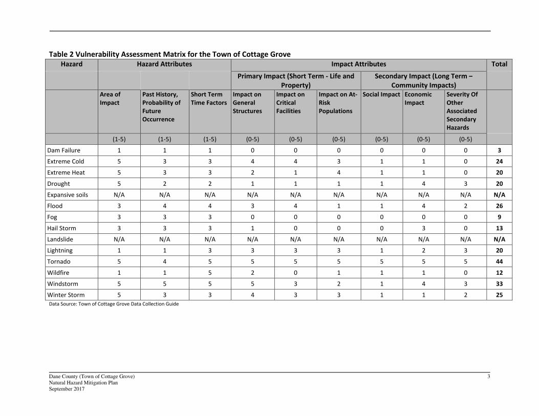
The first step in a hazard analysis is to identify which hazards the community is vulnerable to. Table 2
outlines the hazard identification for the Town of Cottage Grove based on the Data Collection Guide..
The Data Collection Guide listed all of the hazards that could impact anywhere in Dane County. The
purpose of this worksheet was to identify and rank the hazards and vulnerabilities specific to the
jurisdiction. The Town of Cottage Grove’s planning team members were asked to complete the matrix
by ranking each category on a scale of 0 to 5 based on the experience and perspective of each planning
team member. A ranking of 0 indicated “no concern” while a ranking of 5 indicated “highest concern.”
This matrix appears as Table 1. This matrix reflects the significance of the hazards relative to one
another.
This matrix reflects that the Town of Cottage Grove is most vulnerable to tornadoes and windstorms.
The Town of Cottage Grove has a lower vulnerability to dam/levee failures, extreme cold and heat,
drought, flood, fog, hail storm, landslides, lightning, tornado, subsidence, wildfire, windstorm, and
winter storm. The vulnerability established here is a qualitative assumption based on the impacts,
geographic extent, probability of future occurrence, and magnitude/severity. On the county level, these
vulnerabilities were calculated with quantitative data as well.
Dane County (Town of Cottage Grove) 3
Natural Hazard Mitigation Plan
September 2017
Table 2 Vulnerability Assessment Matrix for the Town of Cottage Grove
Hazard Hazard Attributes Impact Attributes Total
Primary Impact (Short Term - Life and
Property)
Secondary Impact (Long Term –
Community Impacts)
Area of
Impact
Past History,
Probability of
Future
Occurrence
Short Term
Time Factors
Impact on
General
Structures
Impact on
Critical
Facilities
Impact on At-
Risk
Populations
Social Impact Economic
Impact
Severity Of
Other
Associated
Secondary
Hazards
(1-5) (1-5) (1-5) (0-5) (0-5) (0-5) (0-5) (0-5) (0-5)
Dam Failure 1 1 1 0 0 0 0 0 0 3
Extreme Cold 5 3 3 4 4 3 1 1 0 24
Extreme Heat 5 3 3 2 1 4 1 1 0 20
Drought 5 2 2 1 1 1 1 4 3 20
Expansive soils N/A N/A N/A N/A N/A N/A N/A N/A N/A N/A
Flood 3 4 4 3 4 1 1 4 2 26
Fog 3 3 3 0 0 0 0 0 0 9
Hail Storm 3 3 3 1 0 0 0 3 0 13
Landslide N/A N/A N/A N/A N/A N/A N/A N/A N/A N/A
Lightning 1 1 3 3 3 3 1 2 3 20
Tornado 5 4 5 5 5 5 5 5 5 44
Wildfire 1 1 5 2 0 1 1 1 0 12
Windstorm 5 5 5 5 3 2 1 4 3 33
Winter Storm 5 3 3 4 3 3 1 1 2 25
Data Source: Town of Cottage Grove Data Collection Guide
Dane County (Town of Cottage Grove) 4
Natural Hazard Mitigation Plan
September 2017
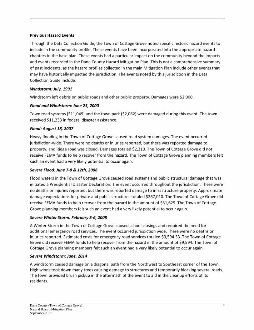
Previous Hazard Events
Through the Data Collection Guide, the Town of Cottage Grove noted specific historic hazard events to
include in the community profile. These events have been incorporated into the appropriate hazard
chapters in the base plan. These events had a particular impact on the community beyond the impacts
and events recorded in the Dane County Hazard Mitigation Plan. This is not a comprehensive summary
of past incidents, as the hazard profiles collected in the main Mitigation Plan include other events that
may have historically impacted the jurisdiction. The events noted by this jurisdiction in the Data
Collection Guide include:
Windstorm: July, 1991
Windstorm left debris on public roads and other public property. Damages were $2,000.
Flood and Windstorm: June 23, 2000
Town road systems ($11,049) and the town park ($2,062) were damaged during this event. The town
received $11,233 in federal disaster assistance.
Flood: August 18, 2007
Heavy flooding in the Town of Cottage Grove caused road system damages. The event occurred
jurisdiction-wide. There were no deaths or injuries reported, but there was reported damage to
property, and Ridge road was closed. Damages totaled $2,310. The Town of Cottage Grove did not
receive FEMA funds to help recover from the hazard. The Town of Cottage Grove planning members felt
such an event had a very likely potential to occur again.
Severe Flood: June 7-8 & 12th, 2008
Flood waters in the Town of Cottage Grove caused road systems and public structural damage that was
initiated a Presidential Disaster Declaration. The event occurred throughout the jurisdiction. There were
no deaths or injuries reported, but there was reported damage to infrastructure property. Approximate
damage expectations for private and public structures totaled $267,010. The Town of Cottage Grove did
receive FEMA funds to help recover from the hazard in the amount of $31,629. The Town of Cottage
Grove planning members felt such an event had a very likely potential to occur again.
Severe Winter Storm: February 5-6, 2008
A Winter Storm in the Town of Cottage Grove caused school closings and required the need for
additional emergency road services. The event occurred jurisdiction wide. There were no deaths or
injuries reported. Estimated costs for emergency road services totaled $9,594.33. The Town of Cottage
Grove did receive FEMA funds to help recover from the hazard in the amount of $9,594. The Town of
Cottage Grove planning members felt such an event had a very likely potential to occur again.
Severe Windstorm: June, 2014
A windstorm caused damage on a diagonal path from the Northwest to Southeast corner of the Town.
High winds took down many trees causing damage to structures and temporarily blocking several roads.
The town provided brush pickup in the aftermath of the event to aid in the cleanup efforts of its
residents.
Dane County (Town of Cottage Grove) 5
Natural Hazard Mitigation Plan
September 2017
Asset Inventory
Assets include the people, property, and critical facilities within the Town of Cottage Grove that are
exposed to hazards in general. Inventories of property, essential infrastructure, and natural, cultural or
historic resources help provide a comprehensive picture of the community and provide a method of
assessing exposure to hazards by establishing the improved and total values, capacities and populations
for these assets. It also forms the basis for estimating potential losses, where possible.
Population
Table 3 Vulnerable Population Summary
Disability Status from the 2014 American Community Survey Number
Percent of
Group with
Disability
Population Under 5 years old with a Disability 0 0%
Population 5-17 years old with a Disability 25 4.3
Population 18-64 with a Disability 137 5.4
Population Over 65 years old with a Disability 94 21
Total Population with Disability 256 6.7
Other Vulnerable Populations Estimate Percentage
Families Below Poverty Level 0 0
Individuals Below Poverty Level 47 1.2
Of those poverty: Individuals Under 18 0 0
Of those poverty: Individuals Over 65 0 0
Total Population Over 5 who Speak English less than “very well” 0 0
2014 ACS Total Population Estimate 3846 100%
Data Source: 2010 US Census and 2014 American Community Survey
General Property
Table 4 Property Exposure Summary
Property Type Total Parcel
Count
Improved
Parcel Count
Improved
Values ($) Content ($) Total Value ($)
Totals 2,131 1,480 253,654,400 126,827,200 380,481,600
Agriculture 599 232 36,895,900 18,447,950 55,343,850
Commercial 28 23 5,846,800 2,923,400 8,770,200
Utilities 6 1 585,000 292,500 877,500
Industrial 6 5 1,790,300 895,150 2,685,450
Institutional/
Governmental 7 1 66,300 33,150 99,450
Dane County (Town of Cottage Grove) 6
Natural Hazard Mitigation Plan
September 2017
Property Type Total Parcel
Count
Improved
Parcel Count
Improved
Values ($) Content ($) Total Value ($)
Other 239 33 7,634,600 3,817,300 11,451,900
Residential 1,246 1,185 200,835,500 100,417,750 301,253,250
Data Source: Dane County Land Information Office Data
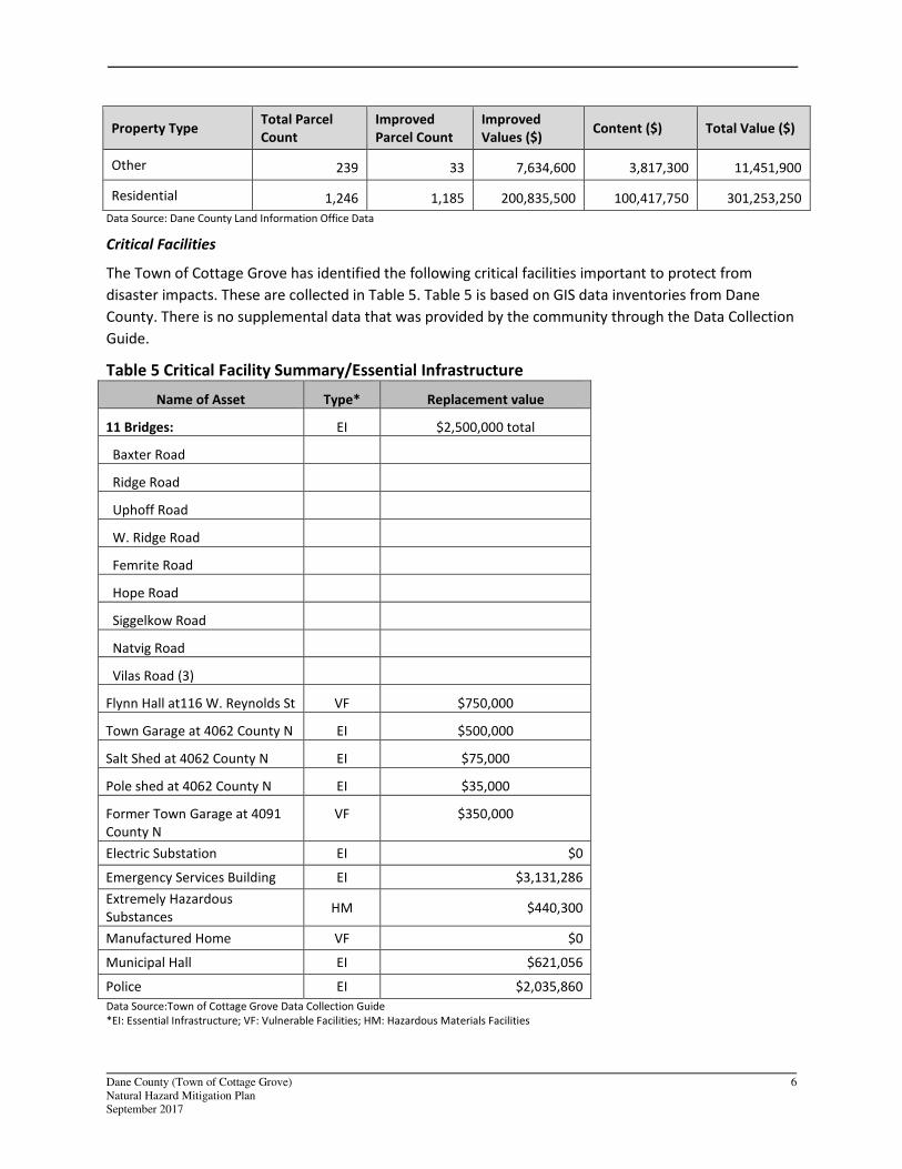
Critical Facilities
The Town of Cottage Grove has identified the following critical facilities important to protect from
disaster impacts. These are collected in Table 5. Table 5 is based on GIS data inventories from Dane
County. There is no supplemental data that was provided by the community through the Data Collection
Guide.
Table 5 Critical Facility Summary/Essential Infrastructure
Name of Asset Type* Replacement value
11 Bridges: EI $2,500,000 total
Baxter Road
Ridge Road
Uphoff Road
W. Ridge Road
Femrite Road
Hope Road
Siggelkow Road
Natvig Road
Vilas Road (3)
Flynn Hall at116 W. Reynolds St VF $750,000
Town Garage at 4062 County N EI $500,000
Salt Shed at 4062 County N EI $75,000
Pole shed at 4062 County N EI $35,000
Former Town Garage at 4091
County N
VF $350,000
Electric Substation EI $0
Emergency Services Building EI $3,131,286
Extremely Hazardous
Substances HM $440,300
Manufactured Home VF $0
Municipal Hall EI $621,056
Police EI $2,035,860
Data Source:Town of Cottage Grove Data Collection Guide
*EI: Essential Infrastructure; VF: Vulnerable Facilities; HM: Hazardous Materials Facilities
Dane County (Town of Cottage Grove) 7
Natural Hazard Mitigation Plan
September 2017
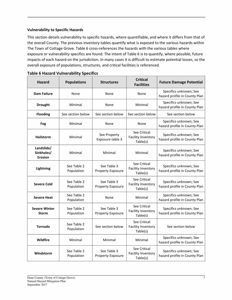
Vulnerability to Specific Hazards
This section details vulnerability to specific hazards, where quantifiable, and where it differs from that of
the overall County. The previous inventory tables quantify what is exposed to the various hazards within
The Town of Cottage Grove. Table 6 cross-references the hazards with the various tables where
exposure or vulnerability specifics are found. The intent of Table 6 is to quantify, where possible, future
impacts of each hazard on the jurisdiction. In many cases it is difficult to estimate potential losses, so the
overall exposure of populations, structures, and critical facilities is referenced.
Table 6 Hazard Vulnerability Specifics
Hazard Populations Structures Critical
Facilities Future Damage Potential
Dam Failure None None None Specifics unknown; See
hazard profile in County Plan
Drought Minimal None Minimal Specifics unknown; See
hazard profile in County Plan
Flooding See section below See section below See section below See section below
Fog Minimal None None Specifics unknown; See
hazard profile in County Plan
Hailstorm Minimal See Property
Exposure table 3
See Critical
Facility Inventory
Table(s)
Specifics unknown; See
hazard profile in County Plan
Landslide/
Sinkholes/
Erosion
Minimal Minimal Minimal Specifics unknown; See
hazard profile in County Plan
Lightning See Table 2
Population
See Table 3
Property Exposure
See Critical
Facility Inventory
Table(s)
Specifics unknown; See
hazard profile in County Plan
Severe Cold See Table 2
Population
See Table 3
Property Exposure
See Critical
Facility Inventory
Table(s)
Specifics unknown; See
hazard profile in County Plan
Severe Heat See Table 2
Population None Minimal
Specifics unknown; See
hazard profile in County Plan
Severe Winter
Storm
See Table 2
Population
See Table 3
Property Exposure
See Critical
Facility Inventory
Table(s)
Specifics unknown; See
hazard profile in County Plan
Tornado See Table 2
Population See section below
See Critical
Facility Inventory
Table(s)
See section below
Wildfire Minimal Minimal Minimal Specifics unknown; See
hazard profile in County Plan
Windstorm See Table 2
Population
See Table 3
Property Exposure
See Critical
Facility Inventory
Table(s)
Specifics unknown; See
hazard profile in County Plan
Dane County (Town of Cottage Grove) 8
Natural Hazard Mitigation Plan
September 2017
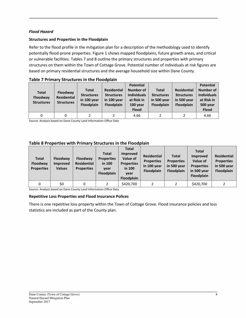
Flood Hazard
Structures and Properties in the Floodplain
Refer to the flood profile in the mitigation plan for a description of the methodology used to identify
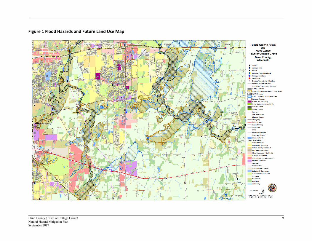
potentially flood-prone properties. Figure 1 shows mapped floodplains, future growth areas, and critical
or vulnerable facilities. Tables 7 and 8 outline the primary structures and properties with primary
structures on them within the Town of Cottage Grove. Potential number of individuals at risk figures are
based on primary residential structures and the average household size within Dane County.
Table 7 Primary Structures in the Floodplain
Total
Floodway
Structures
Floodway
Residential
Structures
Total
Structures
in 100 year
Floodplain
Residential
Structures
in 100 year
Floodplain
Potential
Number of
Individuals
at Risk in
100 year
Flood
Total
Structures
in 500 year
Floodplain
Residential
Structures
in 500 year
Floodplain
Potential
Number of
Individuals
at Risk in
500 year
Flood
0 0 2 2 4.66 2 2 4.66
Source: Analysis based on Dane County Land Information Office Data
Table 8 Properties with Primary Structures in the Floodplain
Total
Floodway
Properties
Floodway
Improved
Values
Floodway
Residential
Properties
Total
Properties
in 100
year
Floodplain
Total
Improved
Value of
Properties
in 100
year
Floodplain
Residential
Properties
in 100 year
Floodplain
Total
Properties
in 500 year
Floodplain
Total
Improved
Value of
Properties
in 500 year
Floodplain
Residential
Properties
in 500 year
Floodplain
0 $0 0 2 $420,700 2 2 $420,700 2
Source: Analysis based on Dane County Land Information Office Data
Repetitive Loss Properties and Flood Insurance Polices
There is one repetitive loss property within the Town of Cottage Grove. Flood insurance policies and loss
statistics are included as part of the County plan.
Dane County (Town of Cottage Grove) 9
Natural Hazard Mitigation Plan
September 2017
Figure 1 Flood Hazards and Future Land Use Map
Dane County (Town of Cottage Grove) 10
Natural Hazard Mitigation Plan
September 2017
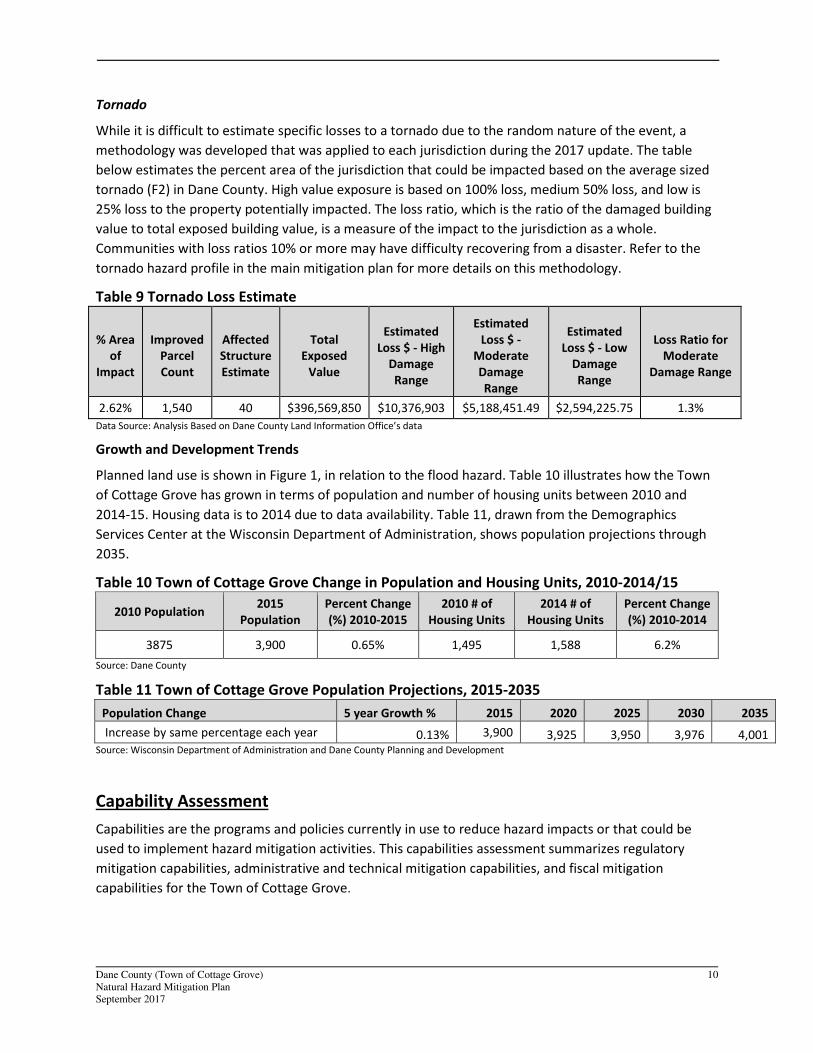
Tornado
While it is difficult to estimate specific losses to a tornado due to the random nature of the event, a
methodology was developed that was applied to each jurisdiction during the 2017 update. The table
below estimates the percent area of the jurisdiction that could be impacted based on the average sized
tornado (F2) in Dane County. High value exposure is based on 100% loss, medium 50% loss, and low is
25% loss to the property potentially impacted. The loss ratio, which is the ratio of the damaged building
value to total exposed building value, is a measure of the impact to the jurisdiction as a whole.
Communities with loss ratios 10% or more may have difficulty recovering from a disaster. Refer to the
tornado hazard profile in the main mitigation plan for more details on this methodology.
Table 9 Tornado Loss Estimate
% Area
of
Impact
Improved
Parcel
Count
Affected
Structure
Estimate
Total
Exposed
Value
Estimated
Loss $ - High
Damage
Range
Estimated
Loss $ -
Moderate
Damage
Range
Estimated
Loss $ - Low
Damage
Range
Loss Ratio for
Moderate
Damage Range
2.62% 1,540 40 $396,569,850 $10,376,903 $5,188,451.49 $2,594,225.75 1.3%
Data Source: Analysis Based on Dane County Land Information Office’s data
Growth and Development Trends
Planned land use is shown in Figure 1, in relation to the flood hazard. Table 10 illustrates how the Town
of Cottage Grove has grown in terms of population and number of housing units between 2010 and
2014-15. Housing data is to 2014 due to data availability. Table 11, drawn from the Demographics
Services Center at the Wisconsin Department of Administration, shows population projections through
2035.
Table 10 Town of Cottage Grove Change in Population and Housing Units, 2010-2014/15
2010 Population 2015
Population
Percent Change
(%) 2010-2015
2010 # of
Housing Units
2014 # of
Housing Units
Percent Change
(%) 2010-2014
3875 3,900 0.65% 1,495 1,588 6.2%
Source: Dane County
Table 11 Town of Cottage Grove Population Projections, 2015-2035
Population Change 5 year Growth % 2015 2020 2025 2030 2035
Increase by same percentage each year 0.13% 3,900 3,925 3,950 3,976 4,001 Source: Wisconsin Department of Administration and Dane County Planning and Development
Capability Assessment
Capabilities are the programs and policies currently in use to reduce hazard impacts or that could be
used to implement hazard mitigation activities. This capabilities assessment summarizes regulatory
mitigation capabilities, administrative and technical mitigation capabilities, and fiscal mitigation
capabilities for the Town of Cottage Grove.
Dane County (Town of Cottage Grove) 11
Natural Hazard Mitigation Plan
September 2017
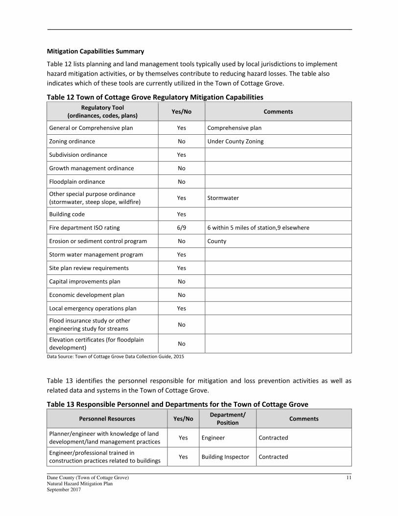
Mitigation Capabilities Summary
Table 12 lists planning and land management tools typically used by local jurisdictions to implement
hazard mitigation activities, or by themselves contribute to reducing hazard losses. The table also
indicates which of these tools are currently utilized in the Town of Cottage Grove.
Table 12 Town of Cottage Grove Regulatory Mitigation Capabilities
Regulatory Tool
(ordinances, codes, plans) Yes/No Comments
General or Comprehensive plan Yes Comprehensive plan
Zoning ordinance No Under County Zoning
Subdivision ordinance Yes
Growth management ordinance No
Floodplain ordinance No
Other special purpose ordinance
(stormwater, steep slope, wildfire) Yes Stormwater
Building code Yes
Fire department ISO rating 6/9 6 within 5 miles of station,9 elsewhere
Erosion or sediment control program No County
Storm water management program Yes
Site plan review requirements Yes
Capital improvements plan No
Economic development plan No
Local emergency operations plan Yes
Flood insurance study or other
engineering study for streams No
Elevation certificates (for floodplain
development) No
Data Source: Town of Cottage Grove Data Collection Guide, 2015
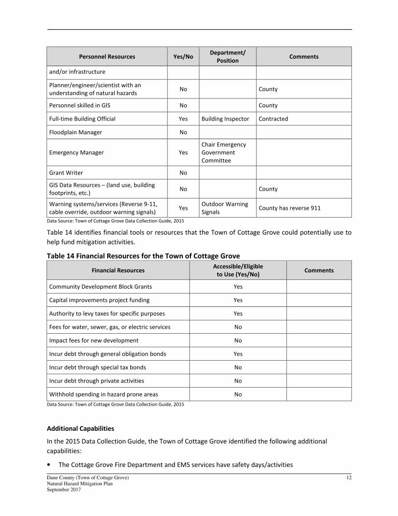
Table 13 identifies the personnel responsible for mitigation and loss prevention activities as well as
related data and systems in the Town of Cottage Grove.
Table 13 Responsible Personnel and Departments for the Town of Cottage Grove
Personnel Resources Yes/No Department/
Position Comments
Planner/engineer with knowledge of land
development/land management practices Yes Engineer Contracted
Engineer/professional trained in
construction practices related to buildings Yes Building Inspector Contracted
Dane County (Town of Cottage Grove) 12
Natural Hazard Mitigation Plan
September 2017
Personnel Resources Yes/No Department/
Position Comments
and/or infrastructure
Planner/engineer/scientist with an
understanding of natural hazards No County
Personnel skilled in GIS No County
Full-time Building Official Yes Building Inspector Contracted
Floodplain Manager No
Emergency Manager Yes
Chair Emergency
Government
Committee
Grant Writer No
GIS Data Resources – (land use, building
footprints, etc.) No County
Warning systems/services (Reverse 9-11,
cable override, outdoor warning signals) Yes
Outdoor Warning
Signals County has reverse 911
Data Source: Town of Cottage Grove Data Collection Guide, 2015
Table 14 identifies financial tools or resources that the Town of Cottage Grove could potentially use to
help fund mitigation activities.
Table 14 Financial Resources for the Town of Cottage Grove
Financial Resources Accessible/Eligible
to Use (Yes/No) Comments
Community Development Block Grants Yes
Capital improvements project funding Yes
Authority to levy taxes for specific purposes Yes
Fees for water, sewer, gas, or electric services No
Impact fees for new development No
Incur debt through general obligation bonds Yes
Incur debt through special tax bonds No
Incur debt through private activities No
Withhold spending in hazard prone areas No
Data Source: Town of Cottage Grove Data Collection Guide, 2015
Additional Capabilities
In the 2015 Data Collection Guide, the Town of Cottage Grove identified the following additional
capabilities:
• The Cottage Grove Fire Department and EMS services have safety days/activities
Dane County (Town of Cottage Grove) 13
Natural Hazard Mitigation Plan
September 2017
• Stormwater education is included in the annual newsletter and at the annual Town meeting.
National Flood Insurance Program Participation
The Town of Cottage Grove does not participate in the National Flood Insurance Program as a stand-
alone entity, but is covered under the County’s ordinance.
Public Involvement Activities
The Town of Cottage Grove community participated in the County public outreach process. This was a
series of public workshops held around the County in which an overview of natural hazard mitigation
was given and the County plan was discussed. Residents were then given the opportunity to give their
input on mitigation actions that could be taken, and filled out informational surveys that assessed the
level of risk the perceived within their own community. More information on these meetings can be
found in the County base plan.
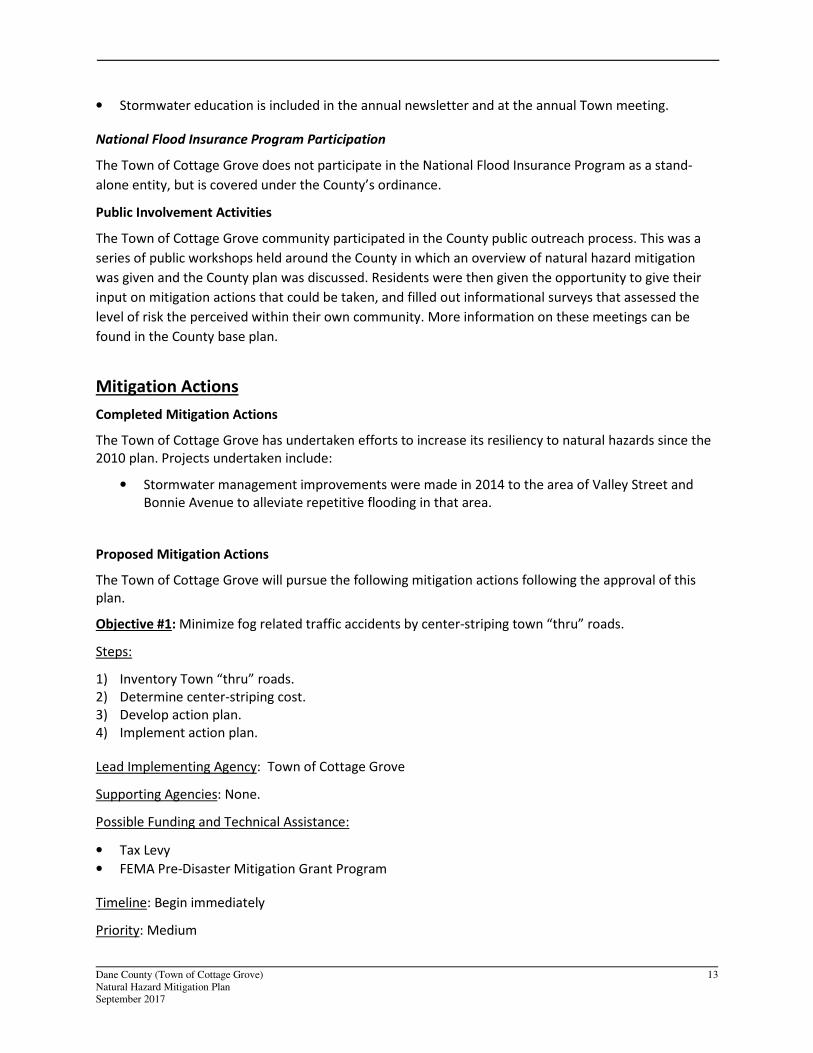
Mitigation Actions
Completed Mitigation Actions
The Town of Cottage Grove has undertaken efforts to increase its resiliency to natural hazards since the
2010 plan. Projects undertaken include:
• Stormwater management improvements were made in 2014 to the area of Valley Street and
Bonnie Avenue to alleviate repetitive flooding in that area.
Proposed Mitigation Actions
The Town of Cottage Grove will pursue the following mitigation actions following the approval of this
plan.
Objective #1: Minimize fog related traffic accidents by center-striping town “thru” roads.
Steps:
1) Inventory Town “thru” roads.
2) Determine center-striping cost.
3) Develop action plan.
4) Implement action plan.
Lead Implementing Agency: Town of Cottage Grove
Supporting Agencies: None.
Possible Funding and Technical Assistance:
• Tax Levy
• FEMA Pre-Disaster Mitigation Grant Program
Timeline: Begin immediately
Priority: Medium
Dane County (Town of Cottage Grove) 14
Natural Hazard Mitigation Plan
September 2017
Estimated Costs: Unknown
Objective #2: Encourage residents to prepare themselves by stocking up with necessary items and
planning for how family members should respond if any of a number of possible emergency or disaster
events strike.
Steps:
1) Promote the need for an emergency supply kit and plan
2) Develop list of supplies and/or a kit for purchase
3) Provide a sample emergency plan
Lead Implementing Agency: Cottage Grove Combined Emergency Government Committee
Supporting Agencies:
• Town of Cottage Grove
• Village of Cottage Grove
• Dane County Emergency Management
Possible Funding and Technical Assistance:
• Discounted supplies from local retailers
Timeline: Annually in the spring
Priority: High
Estimated Costs: Costs for display kit