Embed Size (px)
Citation preview
Coordinates N 42°28’02.0” W 71°37’32.7” Contour Lines in Feet (33’ Intervals)
PARKING – Main property parking GPS 245 Vaughn Hill Road, Bolton. Off street lot for several vehicles inside wooded area. STONE WALL
WETLAND
PARKING
WOODLAND
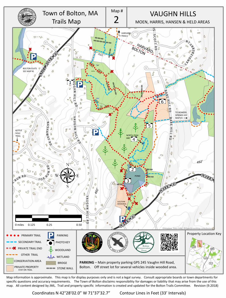
PHOTO KEY
BRIDGE
Town of Bolton, MA Trails Map
Property Location Key
2 Map #
0 miles 0.125 0.25 0.50
NORTH PEAK 686’
HARVARD TRAILS
VAUGHN HILLS
MOEN, HARRIS, HANSEN & HELD AREAS
SECONDARY TRAIL
PRIVATE TRAIL END
OTHER TRAIL
CONSERVATION AREA
PRIVATE PROPERTY STAY ON TRAIL
PRIMARY TRAIL
Map information is approximate. This map is for display purposes only and is not a legal survey. Consult appropriate boards or town departments for specific questions and accuracy requirements. The Town of Bolton disclaims responsibility for damages or liability that may arise from the use of this map. All content designed by JML. Trail and property specific information is created and updated for the Bolton Trails Committee. Revision (9.2018)
©Mapbox, Data Odbl, ©OpenStreetMap contributors
Bolton Conservation
Trust
TO BOWERS SPRINGS SEE MAP #3
SULLIVAN MEMORIAL
KETTLE HOLE TRAIL
BOLTON FLATS SEE MAP #1
POND
Town of Bolton, MA Photo Key
Property Location Key
Map #
PARKING AREA LOCATED ON VAUGHN HILL ROAD VIEW OF POND FROM BRIDGE
POND OVERLOOK VIEW FROM TRAIL ROCK CAPPED PEAK AT 686 FEET
SIDE TRAIL OVERLOOK VISTA (WINTER) VIEW OF FIELD EDGED BY STONE WALL
PARKING – Main property parking GPS 245 Vaughn Hill Road, Bolton. Off street lot for several vehicles inside wooded area.
2 VAUGHN HILLS
MOEN, HARRIS, HANSEN & HELD AREAS
TRAIL MARKERS VARY
Map information is approximate. This map is for display purposes only and is not a legal survey. Consult appropriate boards or town departments for specific questions and accuracy requirements. The Town of Bolton disclaims responsibility for damages or liability that may arise from the use of this map. All content designed by JML. Trail and property specific information is created and updated for the Bolton Trails Committee. Revision (9.2018)
Bolton Conservation
Trust
Welcome! The Bolton Conservation Trust, the Bolton Conservation Commission, and the Trails Committee invite you to enjoy the trails and conservation land of Bolton. From the floodplains of the Nashua and Still Rivers, to the rocky ledge of Powderhouse Hill, from the open fields of the Phillips land, to the fern-lined paths of Northwoods, our conservation lands protect a variety of habitats and natural and historical features. Most of the town’s trails are on public land, acquired through public and private funding, as well as outright donations of property by residents. Some trails cross private land and we are grateful to the landowners who share their land through trail easements and informal agreements. We encourage responsible public use and enjoyment of land under our stewardship. The following guidelines ensure that these special places will be here for future generations to enjoy.
Stay on marked trails and respect private property Bridges and other constructed walkways are for foot traffic only Swimming permitted only at Town Beach No motorized vehicles, except for emergency response or municipal vehicles No hunting, trapping, or discharge of firearms, arrows, paintballs, or pellets No dumping and/or littering—leave no trace No alcoholic beverages, glass containers, or smoking No cutting or removal of vegetation, soil, rock or wood No new trail cutting or posting of signs—please contact the Bolton Trails Committee
Dogs may be walked on conservation land as long as they are under effective control of a person. Dog walkers shall clean up dog waste on trails and in all environmentally sensitive areas. Please keep dogs out of vernal pools during the breeding season for frogs and salamanders (mid-February through April). Do not allow dogs to harass wildlife.
What is the role of the Bolton Conservation Trust? Learn more at: http://www.boltonconservationtrust.org/ The Bolton Conservation Trust was founded in 1974 with the purpose of preserving the natural resources and rural character of the town. A private, non-profit corporation, the Trust has helped protect large and small parcels in town, on its own and by collaborating with the Town, landowners, developers and State agencies. Projects of note include the Rattlesnake Hill/Lime Kiln area, the Nicewicz and Schartner Farms, the International/Schultz Farm and the Nashoba Valley Winery. The Trust owns 290 acres of land and holds Conservation Restrictions on over 300 acres. The Trust fulfills the public education aspect of its mission through the Tom Denney Nature Camp each summer and the Four Winds environmental education program at Florence Sawyer School.
What is the role of the Conservation Commission? The Commission works to protect open space through land acquisition, accepting gifts of land, administering Conservation Restrictions, and administering Agricultural Preservation Restrictions. The Conservation Commission enforces the Massachusetts Wetland Protection Act (MGL Ch. 131.s40), Bolton’s Wetland Bylaw (1.18). The Commission also helps advise other governing bodies and assists in non-regulatory functions, such as public education. Pursuant to MGL Ch. 40, s. 8c, the Commission has adopted these rules and regulations to provide a pleasant experience for users. The regulations also help preserve and protect wildlife, and the aesthetic, ecological, environmental, and conservation values of these properties, including: protection of surface & ground water resources - protection of un-fragmented forest habitat - protection of wildlife habitat - protection of open space and the Town’s trail system.
What is the role of the Trails Committee? The Bolton Trails Committee is a volunteer team, self-organized to help maintain our extensive local trail network. The town of Bolton and its residents enjoy a diverse system of recreational trails through dozens of properties totaling over 2000 acres. These diverse properties provide a rewarding outdoor experience of local terrains, habitats, historic features, and natural resources. Bolton’s trails showcase how our town is uniquely connected in a way other than by our roads. Primary efforts of the TC – in collaboration with the Bolton Conservation Commission, the Bolton Conservation Trust, and contributing private landowners – focus on: creating, marking, maintaining, and preserving trails in Bolton; creating and updating property trail maps; building and maintaining bridges and walkways to protect resource areas; enabling and encouraging responsible access through conservation land; uncovering and preserving the history of Bolton’s conservation properties. Contact for meeting dates, volunteer opportunities, and property needs at [email protected]
Bolton’s Trails and Public Lands
Map # VAUGHN HILLS
MOEN, HARRIS, HANSEN & HELD AREAS 2