Embed Size (px)
Citation preview
I!
8.8 TOWARDS IMPROVED FORECASTS OF ATMOSPHERIC AND OCEANIC CIRCULATIONSOVER THE COMPLEX TERRAIN OF THE EASTERN MEDITERRANEAN
Themls Chronls*_,Jonathan L Case2,Anastas=osPapadopoulos3, Emmaneuil N. Anagnoetou4, John R Meclkalski_, and Stephanle L Haines5
_NASAMarshall Space FNghtCenter, Huntsville, AL2ENSCOInc/Short term Pred_cbonResearch and Transition (SPORT)Center, Huntsville, AL
_Hellen=cCentre for Manna Research, Athens, Greece4Unrvorsltyof Connecticut, Storrs, CT
_Umversltyof Alabama in Huntsville/SPoRT Center, Huntsville, AL
t. INTRODUCTION
Forecasting atmospheric and oceaniccirculations accurately over the EasternMediterranean has proved to be an exceptionalchallen_le The existence of fine-scale topographicvanabllJty (land/sea coverage) and seasonaldynamics vanations can create strong spatialgradaents in temperature, wind end other statevariables, wh=chnumerical models may have ddt=cultycapturing
The Hellenic Center for Marine Research(HCMR) is one of the main operational centers forwave forecasbng in the eastern MediterraneanCurrently, HCMR s operational numencalweather/ocean pred=ctlon model is based on thecoupled EtaJPrmeeten Ocean Model (POM) Since1999, HOMR has also operated the POSEIDONfloabng buoys as a means of state-of-the-art, rea]-time observations of several ocean=c and surfaceatmospbenc vanables This study attempts a firstassessmem at =mprov=ng both atmospherLc andoceanic prediction by inltlahzmg a regional NumericalWeather Prediction (NWP) model w_thhigh-resoJut_onsea surface temperatures (SST) from remotelysensed platformsm order to capture the small-scalecharactenst_os
2. DESCRIPTION OF POSEIDON SYSTEM
QuaJityweather forecasting of the MediterraneanSea =s a distinct challenge as well as of utmost_mportance More than 145 m=lhonpeop]e LnhablttheMediterranean coast line and b{lhonsof tons of cargoare transferred along sh=p trade routes, w=th the=rnumber nsmg every year The complex coasthnesand corresponding shadowing effects, coupled withstrong topographic and seasonal venations, make theMediterranean basra an excellent candidate for thestudy of rigorous air-sea-land mleractlone
To address the observing and forecastingchallenges of the Mediterranean region, the HCMRestabNshed the POSEIDON system, dedicated to theoperational mon=tonng and integrated fcrecasbng ofthe manne environmental condit=ons of the easternMediterranean basin and the Greek seas (NLttlset al2001) The pnmary nblectlve of the POSEIDONsystem Is to prowde real-t=me analys=s and
*Corresponding author address Dr Thernls ChronB, NASAMarahatlSpace FlightCenter, 320 Sparkman Dr, HuntswIJe,AL, 35805 Emall Th_mls,Ohronls-l@nasa gov
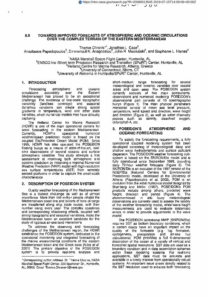
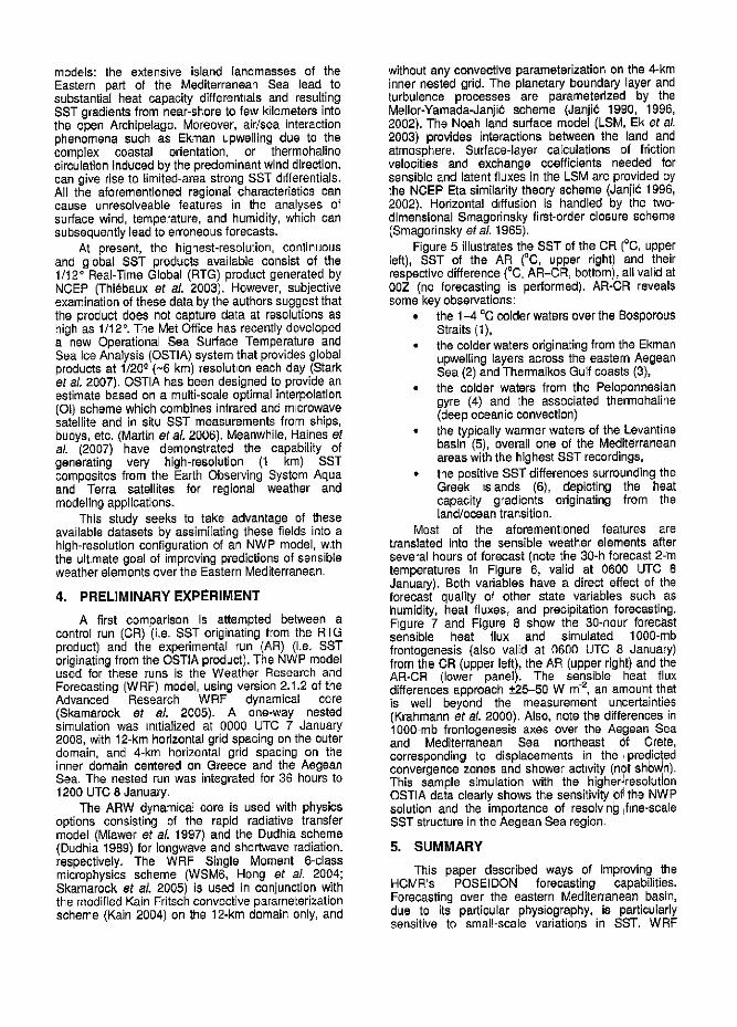
short-medium range forecasting for severalmeteorological and oceanic variables over coastalareas and open seas The POSEIDON systemcurrently consists of fwo ma_n componentsobservations and numencal modeling POSEIDON'sobservat=onal part consists of 10 oceanographicbuoys (Figure 1) The mare phys=cal parametersmonitored consist of mean sea level pressure,temperature, wind speed and direct=on,wave heightand direction (Figure 2), as well as water chem=stryproxies such as eat_n_ly, d_seotved oxygen,chlorophyll-A, etc
3, POSEIDON'S ATMOSPHERIC ANDOCEANIC FORECASTING
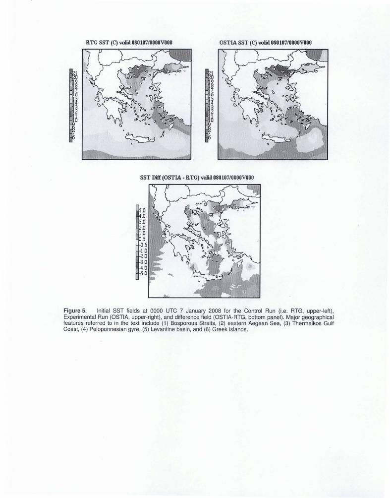
To sabsfy the forecasting requirements, a fullyoperational coup(ed modehng system has beendeveloped consisting of meteorological deep andshallow wave hydrodynamicsand sudace pollutantdiapers=on The POSEIDON weather forecasting sub-system is based on the SKIRONIEta model and isfully operational since September 1999, providingdaily 72-hour weather forecasts (Figure 3) TheSKIRON/Eta is an evolution of the 1997 version of theNCEP/Eta (National Centers for EnvironmentalPred=ctlons) model, developed at the University ofAthens (Papadopoules et aL 2002). POM is anevolut=onfrom the re{hal numerical model designed byBlumberg and Mel]or (1987). POSEIDON's POMproducts include among others, predicted waveheight, direction and period (Rgure 4) Theeforemenboned _n 81tu buoy meteorologicalo_servetlons are currently LJsedto assess the vehd_tyof the weather forecasting model, whdelwave-he=ghtmeasurements are used to evaluate systemat=cerrors =n order to prowde adjustments to the wavemodel
The POSEIDON operational NWP (SKIRON/Eta)requires SST as bottom boundary cend=tions,whichin certain cases have an important impact on thequalrty of the forecasts (eg fog format=on,cyclogenesis, precipitat=on and air-sea fluxcalculat=ons) POM provides a full 4-dimensionaldesonptlon of the ocean at a variety off vertical andhorizontal spabal resolutions SST data are used as aboundary cond=bonand in data &sSlmllatlon schemeswithin these mode]rag systems For real-t=meapphcat=cne, SST data must be accurate andava=[able=na t=melymanner from operationallyrobustsystems An important_ssueanses directly related tothe SST resolution used to imt=ahzeboth forecasting
https://ntrs.nasa.gov/search.jsp?R=20080013545 2019-07-15T14:09:06+00:00Z
models:theextensiveisland[andmaseesof theEasternpartof theMediterraneanSealeadtosubstantialheatcapacitydifferentialsandresu[tlng$STgradientsfromnear-shoretofewkilometersintotheopenArchipelago.Moreover,air/seainteractionphenomenasuchasEkmanupwellingdueto thecomp]excoastalorientation,or thermohalinecirculationinducedby the predominant wind direction,can give rise to limited-area strong SSI differentials.All the aforementioned regional characteristics cancause unresolveable features in the analyses ofsurface wind, temperature, and humidity, which cansubsequently lead to erroneous forecasts.
At present, the highest-resolution, continuousand global SST products availab]o consist of the1/12° Real-Time Global (RTG) product generated byNCEP (Thi_baux et aL 20031. However, subjectiveexamination of these data by the authors suggest thatthe product does not capture data at rasolutlons ashigh as 1/12 °. The Met Office has recently deve]opeda new Operational Sea Surface Temperature andSea Ice Analysts (OSTIA) system that provides globalproducts at 1/200-(~6 kin) resolution each day (Starket aL 2007). OSTIA has been designed to provide anestimate based on a multi-scale optimal interpolation(el) scheme which combines infrared and microwavesatellite and in situ SST measurements from ships,buoys, etc. (Martin et aL 2006). Meanwhile, Haines etaL (2007) have demonstrated the eapab[llty ofgenerating very high-resolutlon (1 km) SSTcomposites from the Earth Observing System Aquaand Terra satellites for regional weather andmodeling applications.
This study seeks to take advantage of theseavailable datasets by aasim[[atlng these fields into ahigh-resolution senfiguration of an NWP model, wLththe ultimate goal of improving predictions of sensibleweather e[ements ever the Eastern Mediterranean.
4. PRELIMINARY EXPERIMENT
A first comparison is attempted between acontrol run (CR) (i.e. SST originating from the R,Gproduct) and the experimental run (AR) (i.e. SSToriginating from the OSTIA productl. The NWP modelused for these runs is the Weather Research andForecasting (WRF) model, using version 2.1.2 of theAdvanced Research WRF dynamical core(Skamarock et aL 2005). A one-way nestedsimulation was initialized at 0000 UTC 7 January2008, with 12-kin hodzontal grid spaoing on the outerdomain, and 4-km horizontal grid spacing on theinner domain centered on Greece and the AegeanSea. The nested run was integrated for 36 hours to1200 UTC 8 January.
The ARW dynamioa] core is used with physicsoptions consisting of the rapid radiative transfermodel (M[awor et aL 1997) and the Dudhia scheme(Dudhia 1989) for Iongwave and shortwaveradiation,respectively. The WRF Single Moment 6-classmicrophysics scheme (WSMS, Hang et aL 2004;Skamaresk et aL 2005) is used in conjunctionwiththe modified Kain Fritash convectiveparameterizatianscheme (Kain 2004) on the 12-kin domain only, and
without any convectiveparameterizationon the 4-kminner nested grid. The planetary boundary layer andturbulence processes are parameterized by theMellor-Yamada-Janii_ scheme (Janji_: 1990, 1996,2002). The Noah land surface model (LSM, Ek et aL2003) provides interactions between the land andatmosphere. Surfaca-layar calculations of frictionvelooities and exchange coefficients needed forsensible and latent fluxes in the LSM are provided bythe NCEP Eta similarity theory scheme (Janjid 1996,2002). Horizontal diffusion is handled by the two-dimensional Smagorinskyfirst-order closure soheme(Smagorinsky et aL 1965).
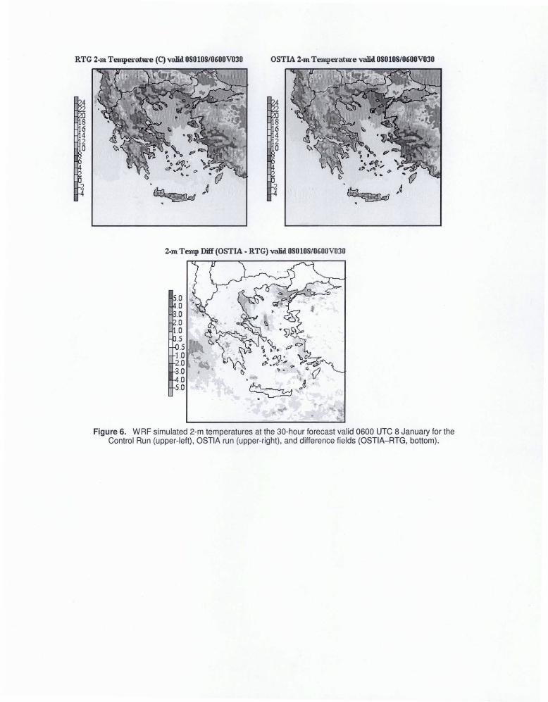
Figure 5 illustrates the SST of the CR (°C, upperleft), SST of the AR (°C, upper right) and theirrespective difference (°C, AR-CR, bottom), all valid at00Z (no forecasting is performed). AR-CR revealssome kay observations:
• the 1-4 °C colder waters over the BosporousStraits (1),the colder waters orlginating from the Ekmanupwel[ing layers across the eastern AegeanSea (2) and Thermaikos Gulf coasts (3),
• the colder waters from the Peloponnesiangyre (4) and the associated thermohaline(deep oceanic convection)
• the typically warmer waters of the Levantinebasin (5), overall one of the Mediterraneanareas with the highest SST recordings,
• the positive SST differences surroundingtheGreek islands (6), depicting the heatcapacity gradients originating from thetend/oceantransition.
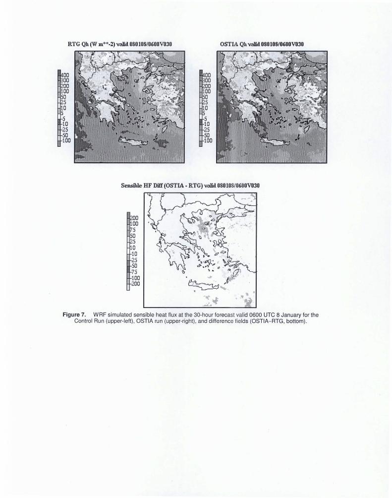
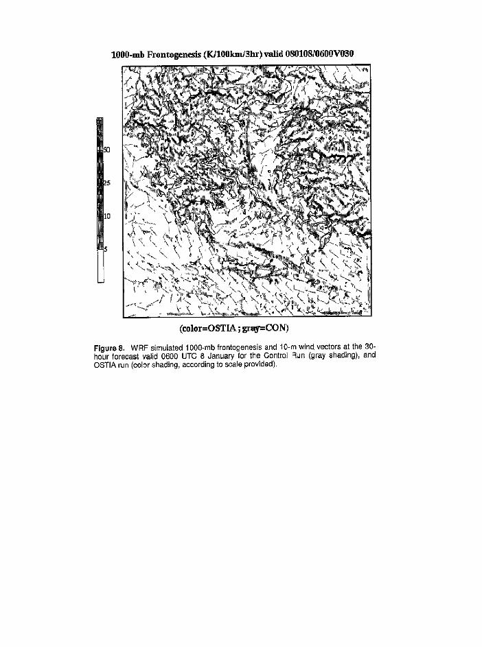
Most of the aforementioned features aretranslated into the sensible weather elements afterseveral hours of forecast (note the 30-h forecast 2-mtemperatures in Figure 6, valid at 0600 UTC 8January). Both variables have a direct effect of theforecast quality of other state variables such ashumidity, heat fluxes, and precipitation forecasting.Figure 7 and Figure 8 show the 30-hour foreo_.stsensible heat flux end simulated 1000-mbfrentogenasls (also valid at 0600 UTC ,8 January)from the OR (upper left), the AR (upper right) and theAR-CR (lower panel). The sensible heat fluxdifferences approach +_?.5-50W m-2,an amount thatis well beyond the measurement uncertainties(Krahmann et aL 2000). Also, note the differences in1000-rob frentogenesis axes over the Aegean Seaand Mediterranean Sea northeast Of Crete,correspond'ng o d'apacements in the ,predicted
• i I
convergence zones and shower act vty (not shown)., , , i J
This sample s_mulatlon wth the hgherreselutonOSTIA data clearly shows the sensitivity _fl the NWPsolution and the importance of resolvng _fne-scaleSST structurein the Aegean Sea region.
5. SUMMARY
This paper dasoribed ways of improving theHCMR's POSEIDON forecasting capabilities.Forecasting over the eastern Mediterranean basin,due to its partioular physiography, is particularlysensitive to smal!-scale variations in SST. WRF
forecastsbasedon SSTproductsof differentresolutionwere presented and shown to be sensitiveto the static SST fields used in the simulations.Further test-oases combined with regional groundand satellite validation is required to underline theoverall forecast improvement. Ongoing efforts inassimilating surface and satelhte-retrieved winds, soilmoisture, humidity, and atmospheric temperatureprofiles, focused over the eastern Mediterraneanbasin will fuither enhance the POSEIDON'smeteorological and oceanic forecasting skills,
6. ACKNOWLEDGEMENTS/DISCLAIMER
The European Free Trade Association (EFTA)and the Greek Ministry of National Economy havefunded the POSEIDON system. Mention of acopyrighted, trademarked or proprietary product,service, or document does not constituteendorsement thereof by the authors, the NationalAeronautics and Space Administration, the HellenicCenter for Manne Research, ENSCO Inc., or theUnited States Government. Any such mention issolely for the purpose of fully informing the reader ofthe resources used to conduct the work reportedheroin,
7. REFERENCES
Blumberg, A.F., and G L. Mellor, 1987: A descriptionof a three-dimensional coastal ocean cfrculatianmodel, in 7nree-Dimenalonal Coastal OceanModels. Vol. 4, edited by N.Heaps, pp. 208,American Geophysical Union, Washington, D.C.
Dudhia, J., 1989: Numerical study of convectionobserved during the winter monsoon experimentusing a mesoscale lwo-dimaneJonal model. J,Atmca. Sci., 46, 3077-3107.
Ek, M. B., K E. Mitchell, Y. Lin, E. Rogers, P,Grunmann, V. Koren, G. Gayno, and d. D,Tarpley, 2003: Implementation of Noah landsurface model advances in the National Centersfor Environmental Prediction operationalmesoscale Eta model, J. Geophys. Res., 108(D22), 8851, doi:t0.1029/2092JD003296.
Haines, S. L., G. J. Jedlovec, and S. M. Lazarus,2007: A MODIS sea surface temperaturecomposite for regional applications. IEEE Trans.GeoscL Remote Sen&, 45s2919-2927.
Hong, S.-Y,, J. Dudhia, and S.-H. Chen, 2094: ARevised Approach to Ice M[crophysicalPrecesses 1or the Bulk Parameterization ofClouds and Precipitatlon, Men. Wea. Rev., 132,103-120
Janji_, Z. I., 1990: The step-mountain coordinate:Physical package. Man. Wea. Rev., 118, 1429-144.3.
Janji& Z. I., 1996: The surface layer in the NCEP EtaModel, Preprints, Eleventh Conference onNumerical Weather Prediction, Norfolk, VA,Amer. Meteor. Sot,, 354-355.
Janji6,Z. I., 2002: Nonsingular Implementation of theMeltor-Yamada Level 2.5 Schema in the NCEPMeso model, NCEP Office Note, No. 437, 61 pp.
Kain, J. S., 2604: The Kain-Fritsch convectiveparameterization: An update.J. AppL Meteor., 43,170-181.
Krahmann, G,, Schott, F., and Send, U., 2000:Seasonal heat content changes in the westernMediterranean Sea as a means for evaluatingsurface heat flux formulations. J. Geoph. Res,Mel. 105, NO. C7, 18941-16950,
Martin, M., A Hines and M Bell, 2006: Dataassimilation in the FOAM operational short-rangeocean forecasting system: A description of thescheme and _ts impact. In prep., available formMet Office, United Kingdom.
Mlawer, E. J., S. J. Taubman, P. D. Brown, M. J.lacono, and 8. A. Clough, 1997: Radiativetransfer for inhomogeneous atmosphere: RRTM,a validated corralated-k model for the long-wave.J. Geophye. Ree., t02 (D14), 16668-16682.
Nittis K., V. Zervakis, L. Perivoliotis,A. Papadopoulosand G. Chronis, 2001 : Operational Monitoring andForecasting in the Aegean Sea: SystemLimitations and Forecasting Skill Evaluation.Marine Pollution Bulletin, Vol. 43/7-12, 154-163.
Papadopoulos, A., G. Kallos, P. Katsafados, and S.Niekovic, 2002: The Poseidon weather forecastingsystem: An overview. The GlobalAtmosphere andOcean Systems,8, 219-237.
Skamarock, W. C., J. B, Klemp, J. Dudhia, D. O. Gill,D. M. Barker, W. Wang and J. G. Powers, 2005:A Description of the Advanced Research WRFVersion 2, NCAR Teoh Note, NCAR/TN-468+STR, 88 pp. [Available from UCARCommunications, P.O. Box 3000, Boulder, CO,80307; on-line at:htt__:l/box.mmm,ucar.ed_/wrf/users/dpcslarw v2.
Smagorinsky J., S. Manabe, and J. L, Holloway Jr.,1965: Numerical results from a nine-level generalcirculation model of the atmosphere. Men. Wea,Ray, 93, 727-768.
Stark, J. D,, C. J, Donlon, M. J. Martin, and M. E.McCulloch, 2007: OSTIA: An Operational, highresolution, real time, global sea surfacetemperature analysis system. Preprints, Oceans'07, Aberdeen, Scotland, IEEE/OES, paper061214-029. [Available online at _-pp.metoffice.com/pag es/latest_analysis/decs/Stark el alOSTtA_desoription_Oceans07.pdf]
Thi6baux, J., E. Rogers, W. Wang, and B. Katz,2003: A new high-resolution blended global seasurface temperature analysis. Bull. Amer. Meteor.Soc, 84, 645--656,
Figure 1. Locations of the 10 POSEIDON oceanic buoys.
Figure 2. Sample plot of significant and maximum wave height (m) at the POSEIDONMykonos buoy.
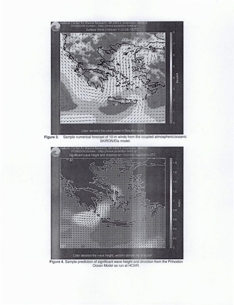
Figure 3. Sample numerical forecast of 1O-m winds from the coupled atmospheric/oceanicSKIRON/Eta model.
Figure 4. Sample prediction of significant wave height and direction from the PrincetonOcean Model as run at HCMR.
RTG SST (C) valid 080107/0000VDOO OSTIA SST (C) valid 080 107/0000VDOO
SST Diff (OSTIA. RTG) valid 080107/0000VOOO
Figure 5. Initial SST fields at 0000 UTC 7 January 2008 for the Control Run (Le. RTG, upper-left),Experimental Run (OSTIA, upper-right), and difference field (OSTIA-RTG, bottom panel). Major geographicalfeatures referred to in the text include (1) Bosporous Straits, (2) eastern Aegean Sea, (3) Thermaikos GulfCoast, (4) Peloponnesian gyre, (5) Levantine basin, and (6) Greek islands.
RTG 2·m Temperature (C) valid OSOlOS/0600V030 OSTIA 2·m Tempel'ature valid OSOlOS/0600V030
42oB642o
2
42oB642a
2
2·m Temp Diff (OSTIA. RTG) valid OSOlOS/0600V030
Figure 6. WRF simulated 2-m temperatures at the 30-hour forecast valid 0600 UTC 8 January for theControl Run (upper-left), OSTIA run (upper-right), and difference fields (OSTIA-RTG, bottom).
RTG Qh (W 1ll"''''.2) valid OSOlOS/0600V030
00 0000 0000 0000 00a a5 5a 0
5 510 1025 2550 50100 100
OSTIA Qhvalid OSOlOS/0600V030
Sensible HF Diff (OSTIA· RTG) valid 080108t0600V030
Figure 7. WRF simulated sensible heat flux at the 3D-hour forecast valid 0600 UTC 8 January for theControl Run (upper-left), OSTIA run (upper-right), and difference fields (OSTIA-RTG, bottom).
lO00-mb Frontogen_ds (10100km/3hr)_[li.d 080108/@600V030
_0
_5
10
n_
(coler=OSTIA; gray=CO N)
Figure 8. W RF simulated 1000-mb frontogenesis and 10-m wind vectorsat the 30-hour forecast vafid 0600 UTC 8 January for the Control F_un(gray shading), andOSTIA run (color shading, accordingto scale provided).