Embed Size (px)
Citation preview

Oxford Brookes University Schools of Architecture & Planning
Joint Centre for Urban Design
TOWARDS A BETTER APPROACH TO URBAN REGENERATION: defining strategies for intervention in the central area of São Paulo.
Eduardo Alberto Cuce Nobre
Dissertation submitted in partial fulfilment of the Master of Arts Degree in Urban Design
Oxford, December 1994

"But look what we have built .... low-income projects that become worse centers of deliquency and general social hopelessness than the slums they were supposed to replace; middle-income housing projects which are trully marvels of dullness and regimentation, sealed against buoyancy or vitality of city life; luxury housing projects to mitigate their inanity or try to, with a vapid vulgarity .... expressways that eviscerate great cities. This is not the rebuilding of cities. This is the sacking of cities."
Jane Jacobs, 1961, pp. 13-14.

ABSTRACT Since the end of World War II the world has undergone a major economic restructuring process. The internationalisation of the economy has caused the spread of the capitalist system and caused a dramatic change in the process of urbanisation. In the developed countries the main results have been deindustrialisation and subsequently urban decline and counter urbanisation. In the developing countries the outcome of this process has been the rapidly industrialisation and consequently urban explosion and spread of the 'western' way of life. The city of São Paulo, Brazil, is an example of a rapidly growing Third World city. The pattern of recent urban development has had negative effects in a great part of its population and in the name of modernity and progress, consolidated and traditional urban areas have been destroyed. The adoption of modern planning techniques, the prioritisation of private ways of transport rather than public ones and the process of land speculation have led to a impoverishment of the quality of life, especially for the poorest sectors of the population. This dissertation has been structured in order to understand these processes and to propose strategies to change them. These strategies have been developed to a specific inner city traditional neighbourhood but they could equally well be applied to other ones hence taking into consideration their particular characteristics. The intentions of these strategies are to solve these problems enhancing the quality of life of the residents of these neighbourhoods.
i

ACKNOWLEDGMENTS First I would like to express my gratitude to many people who have participated in the elaboration of this dissertation. To Ian Bentley I am thankful for his orientation and guidance of this project. I would also like to thank all the professors and staff of both institutions responsible for my professional education: the Joint Centre for Urban Design at Oxford Brookes University and the Faculdade de Arquitetura e Urbanismo da Universidade de São Paulo. The British Council was responsible for the financial support without which this research would not have been possible. I greatly appreciate the work of Paul Webb in editing my English. My brother Roberto and my friends Nice and Marian were especially helpful in gathering data in São Paulo and Madrid. I am particulary grateful to my family in Brazil for their continuous support in spite of the distance. To my parents, Ligia and Moacyr, I feel that I owe much for their incentive and support throughout my life. To my brother and my sisters Ligia and Rita I am much indebted for their advice and understanding of how difficult it is to write a dissertation. I should thank my Brazilian friends and colleagues, Flávio, Gil and Júlio, for the inumerous discussions we have had about the subject of our common interest. Finally, I feel that I owe much to numerous people: Alice, Cristina, Federica, Felipe, Marian and many others already mentioned or not. They have been part of my daily life for the last year and they are much responsible for the wonderful time I have had in Oxford. For them I keep the last word: saudade.
ii

BIOGRAPHY I was born in 24th May 1965 in the city of São Paulo, Brazil. I atended the School of Architecture and City Planning, University of São Paulo (Faculdade de Arquitetura e Urbanismo da Universidade de São Paulo) from 1984 to 1989 when I graduated as an architect. Since then I have worked in development of projects and building supervision in private architectural offices. My interests for urban planning and design dates from the university times as in Brazil the courses of architecture and planning are melted in just one. In 1990 I coordinated a team in a national competition for urban renewal and historic preservation of a distinguished and traditional inner district of the city of São Paulo. The team proposal was classified among the nine semi-finalists out of thirty participating groups.
iii

LIST OF CONTENTS
Page
ABSTRACT i ACKNOWLEDGMENTS ii BIOGRAPHY iii LIST OF CONTENTS iv LIST OF FIGURES vii LIST OF TABLES viii LIST OF MAPS OF BELA VISTA viii INTRODUCTION 1 CHAPTER ONE Background to the Problem 1.1 Introduction 7 1.2 Global Restructuring and Urbanisation 7 1.2.1 The Cities of the First World 9 1.2.2 The Cities of the Third World 10 1.3 São Paulo Case Study 11 1.3.1 A Brief Introduction to Brazil 11 1.3.2 The Context of São Paulo 13 1.3.3 The Urban Evolution 15 1.3.4 São Paulo Central Area 17 1.4 Conclusion 19 CHAPTER TWO Defining Criteria for Urban Regeneration 2.1 Introduction 21 2.2 Methods of Intervention 21 2.3 Establishing criteria for urban regeneration 24
iv

2.3.1 The Physical Implications 24 Reduction of Divesity of Land Uses 25 Destruction of Place Identity 27 Traffic Problem and the Street Use 28 2.3.2 The Social Implications 30 The Problem of Land Speculation 32 The Need for Community Participation 33 2.4 Conclusion 35 CHAPTER THREE The International Experience of Implementation 3.1 Introduction 37 3.2 Promoting Diversity and Character 38 3.2.1 Land Use Diversity 38 3.2.2 The Character of the Place 40 3.2.3 The Use of Design Guidelines to Promote Diversity and Character 41 3.2.4 Conclusion 43 3.3 The Traffic Problem 44 3.3.1 The International Experience 45 3.3.2 The Use of Traffic Calming Measures 46 3.3.3 Conclusion 48 3.4 The Problem of Land Speculation 49 3.4.1 Mechanisms to Avoid Land Speculation 49 3.4.2 Conclusion 49 3.5 Community Participation 53 3.5.1 The Madrid Experience 53 3.5.2 Conclusion 55 3.6 Conclusion 56 CHAPTER FOUR The Proposals to São Paulo Case Study 4.1 Introduction 58 4.2 Urban Planning in São Paulo 59 4.2.1 Urban Planning Today 62 4.2.2 The Role of Neighbourhood Associations in Urban Planning 64 4.2.3 Enhancing Community Participation in the Planning Process 67
v

4.3 The Bela Vista Case Study 69 4.3.1 The Bela Vista Urban Development 69 4.3.2 Bela Vista Today 72 4.3.3 Land Use and Character 75 4.4 Proposals to Bela Vista 77 4.4.1 Guidelines to Promote Diversity and Character 77 4.4.2 The Traffic Problem 80 4.4.3 Traffic Calming Measures 80 4.4.4 Land Speculation 82 4.4.5 Community Participation 83 4.5 Conclusion 84 CONCLUSION 86 BIBLIOGRAPHY
vi

LIST OF FIGURES
Page 1. Fastest growing cities in the world. Source: Potter, 1992 8 2. Brazil. Source: Batley, 1983 12 3. The city and metrop. area of São Paulo. Source: Oliveira & Leittman, 1994 14 4. Plan of Santiago, Chile, 18th century. Source: Marx, 1991 15 5. Plan of São Paulo, 1800-1874. Source: Toledo, 1983 16 6. Cortiços e Favelas in São Paulo. Source: Batley, 1983 18 7. Liverpool, before and after clearence. Source: Couch, 1990 24 8. Land uses in trad. neighbourhoods and new developments 26 Source: Santos & Vogel, 1981 9. Street use in traditional neighbourhoods. 28 Source: Santos & Vogel, 1981 10. Leisure activities in a private club. Source: Santos & Vogel, 1981 29 11. Home territory in San Francisco. Source: Appleyard, 1981 29 12. A ladder of citizen participation. Source: Arnstein, 1969 34 13. Variety within blocks. Source: Bentley et al, 1985 39 14. Contextual cues. Source: Bentley et al, 1985 40 15. Design Guidelines for San Francisco. Source: Moudon, 1986 43 16. Hierarchy of distributors. Source: Buchanan, 1963 46 17. Traffic calming measures. Source: Devon County Council, 1991 47 18. Woonerf scheme. Source: Appleyard, 1981 48 19. The transfer of development rights mechanism. Source: Zacharias, 1993 51 20. Macrozoning in the 1992 Master Plan. Source: PMSP, 1992a 63 21. Suggested planning process at the mun. level. Source: the author 67 22. Suggested planning process at the dist. level. Source: the author 68 23. Suggested city master plan. Source: the author 68 24. Housing typology of São Paulo, beg. 20th cent. Source: Caldeira, 1986 70 25. View towards city centre from Bela Vista, 1925. Source: Toledo, 1983 71 26. Transition zone around city centre. Source: Marzola, 1985 72 27. São Paulo city centre. Source: the author 73 28. Avenida Paulista. Source: the author 74 29. New residential development. Source: the author 75 30. Traditional low-rise area in Bela Vista. Source: the author 76
vii
31. New development according to the present legislation 77 Source: the author 32. Proposed building envelope, plan and elevation. Source: the author 78 33. Guidelines for mixed use areas. Source: the author 79 34. Guidelines for surviving views protection. Source: the author 79 35. Traffic calming measures for traffic roads. Source: the author 81 36. Traffic calming measures for mixed priority roads. Source: the author 81 37. Traffic calming measures for residential areas. Source: the author 82 LIST OF TABLES 1. The largest cities in the world, 1950 and 2000. Source: Potter, 1992 9 2. Methods of intervention. Source: the author based on Dessai and Pillai, 1990 22 LIST OF MAPS OF BELA VISTA 1. Redeveloped/Low-rise Areas. Source: PMSP, 1985b 2. Location of the Business Districts. Source: PMSP, 1985b 3. Topography. Source: Sistema Cartográfico Metropolitano, 1985 4. Zoning. Source: Geomapas, 1988 5. Transport and Traffic. Source: PMSP, 1985c 6. Hierarchisation of Traffic. Proposed by the author 7. Transfer of Development Areas. Proposed by the author
viii

INTRODUCTION Cities have been constantly changing since the beginning of civilisation. In response to economic and social factors they have grown, declined or undergone major restructuring (Couch, 1990). Changes in economic production and the demand for buildings and land have resulted in changes in the use and density of urban areas. The appearance of new economic and social activities have resulted in an intensification of use in some areas, whereas, in others, the closure of old industries, a cessation of economic activities and migration have left abandoned buildings, derelict and vacant land, creating islands of decay and deprivation. Since World War II the world has been undergoing major economic restructuring (OECD, 1983). Under the economic, financial and military hegemony of the USA the world economy has suffered a process of internationalisation resulting in the establishment of the so called New International Order (Harvey, 1989). Major investments in distant places have been made possible by the development of communication and information technologies (Castells, 1989). Little by little industrial production is shifting from the industrialised countries to newly industrialising ones by way of transnational corporation investment (OECD, 1983). These events have had a great influence on the pattern of urban development of both industrialised and industrialising countries. In the former it has been responsible for the phenomenon known as urban decline (OECD, 1983). Population and economic activity declines especially in inner-city areas. In the latter the attraction of new industries, the fall in death rates and rural migration due to technological advances in agriculture have resulted in an urban population explosion (Potter, 1992). In most developed countries the problems arising from this decline have been of a social, economic and environmental nature (OECD, 1983): physical decay, poor housing conditions, spatial segregation, lack of public open space, traffic congestion and air pollution, a reduction in diversity of uses due to an increase in office activities and a decrease in housing, the destruction of the historic heritage, dereliction and deprivation.
1

Many governments of these countries have developed regeneration policies to tackle the decline of these areas. These policies may include tax and financial incentives, loans, grants and land use regulations to promote development and attract new economic activities or to reinforce existing ones; new housing schemes and the rehabilitation of existing ones; environmental improvements and policies to promote the conservation of historic buildings. However the problem of urban deprivation is not only confined to the First World. Most countries of the Third World also have similar problems to those mentioned in the cities of the First World. Due to the rapid and vertiginous population growth it has been impossible for the governments of developing countries either to control this growth or to provide all the services, jobs and housing necessary to accommodate the newcomers (Potter, 1992). The pace of socio-economic development has not matched the pace of spatial and physical development. The city of São Paulo, Brazil's largest conurbation, is a typical example of a rapidly growing city in an industrialising country. The city has grown almost 500 times in little more than a century. The population has increased from 23,000 inhabitants in 1872 to 11,400,000 in 1990 (Devas & Rakodi, 1993). Its metropolitan area comprises 20,000,000 inhabitants and it is forecast that will be the second biggest conurbation in the world after Mexico City by the year 2000 (Potter, 1992). The city has a considerable economic and industrial basis but, despite the high level of economic development, it suffers serious problems of income distribution and deterioration of its inhabitants' quality of life, especially among the poorest ones (Bava, 1990). A considerable amount of São Paulo's population, more than 60%, lives in precarious housing conditions in slums, shanty towns or illegal developments (Rolnik, 1991). Of these a great part live in crowded slum tenements in traditional neighbourhoods in the central area. Despite the housing conditions, they have chosen to live close to the city centre where most of the job opportunities are concentrated (Batley, 1982).
2

Besides the physical decay these areas present many other problems. As they are very close to the city centre they suffer the impact of the heavy traffic and air pollution (Oliveira & Leittman, 1994). Due to rapid and uncontrolled growth, lack of public open and green space is common in the central areas and, due to its density of use, this is more intensively felt. The central traditional neighbourhoods still however offer some positive qualities when compared to the new high-rise upper class developments, in so far as they do not exclude a mixture of uses and exhibit a human scale that enhances the quality of the streetscape (Santos, 1986). They are also representative of the type of urban development that predominated at the end of the 19th century and there is some concern about their historical and cultural value (PMSP, 1985a). Due to the pressures of redevelopment and speculation these areas are in danger of being destroyed (Santos, 1986). Zoning laws that only serve to consolidate the speculation process are threatening to replace these neighbourhoods with high-rise upper class buildings displacing the poorer part of the population and destroying its physical characteristics. On the other hand the present conditions of deprivation constitute a rationale for renewal proposals that, searching for economic gains alone, do not take into account the social and cultural factors involved (Santos, 1986). There seems to be a need to intervene in these areas in order to promote a regeneration process that will lead to improvements and activities which enhance the quality of life of the poorest sector of the population and promote the image of these places, taking into account the social and cultural factors involved. The main purpose of this dissertation is to define strategies for tackling the problem of urban decay in the São Paulo central area. The objective of these strategies is to enhance the quality of life of the existing population, trying to avoid its displacement such as would represent an aggravation of the social problem. Also to be avoided is the destruction of the existing physical pattern with its traditions and places of cultural value and great relevance to its inhabitants and the city's history.
3

These strategies will address both the physical and social aspects of urban regeneration by considering public participation in the decision making process as a way of preserving the interests of the existing population. They will avoid the destruction of the physical characteristics of the existing neighbourhoods through speculative redevelopment and inadequate zoning laws. They will propose ways of intervening which tackle the problems of traffic congestion and lack of public open space. As has already been mentioned, many of the problems explained above (i.e. new developments threatening the diversity and vitality of traditional areas, population displacement, inadequate zoning laws destroying the physical characteristics, heavy traffic and lack of public open space) are common in many cities of the world. Most of them have already developed strategies of their own to tackle these problems. It seems therefore to be appropriate to study these in order to develop strategies for the case of São Paulo. The methodology applied will first involve defining the problems of the central area of São Paulo, establishing a set of criteria for urban regeneration policies taking into account the social and cultural aspects involved, assessing the strengths and weaknesses of international experiences in urban regeneration that have addressed these problems according to the established criteria and proposing how these could be adopted in the context of São Paulo. Then, in order to test the results of the proposed strategies, they will be applied to one central district of São Paulo: the Bela Vista district. This particular district was chosen because it is a highly representative traditional district that still retains its traditions and it is situated between the old and the new CBDs suffering from great redevelopment pressure. The fact that the City Hall held a national competition for its renewal and historic preservation four years ago demonstrates its importance.
4

DISSERTATION OUTLINE This dissertation is divided into four chapters. The objective of chapter one is to establish the background to the problem. It will describe how global economic restructuring has affected the urban development of both the First and the Third World. Then it will explain the changes that have occurred in cities as a result of this restructuring and examine the city of São Paulo in this context. It will also explain how the problems of land speculation, traffic congestion and lack of public space have been damaging the quality of life of the inner city population. The intention of chapter two is to define a set of criteria for assessing the international experiences. These criteria will be derived from the problems arising from chapter one. It will show that social and cultural problems arise from population displacement. It will also explain the importance of community involvement in the planning process and of empowering people to decide their own future and to share the benefits of economic development. It will explain the necessity of promoting land use diversity, existing character and values and avoiding land speculation. It will show how traffic damages the quality of life of central areas residents. The aim of chapter three is to assess international experiences of urban regeneration, assessing their strengths and weaknesses. It will consist of a study of how different countries have tackled the problems, taking into consideration the established criteria. It explores the experiences of different countries in ensuring community participation in the planning process, the promotion of land use diversity and character and the avoidance of speculation and restraint of traffic in the central areas in favour of residential streets. It will also check the appropriateness of these strategies to São Paulo. Chapter four proposes strategies for the urban regeneration of Bela Vista district. It discusses the adaptation of the international experience for this case study, taking into consideration the financial, legal and cultural context. It proposes physical tools for promoting a mixture of uses and the character of the area, strategies for avoiding speculation, improvements in traffic and open space, as well as the framework for ensuring community participation in the planning process.
5

The expected outcome of this dissertation will consist of both guidelines for improving the zoning laws and combating the traffic problem in traditional neighbourhoods, as well as, a framework for improving community participation in the planning process. Although these will be developed for a specific area, they could equally well be applied to other central districts of São Paulo taking into account their particular characteristics. Since the planning process in São Paulo has failed to address these issues the importance of this dissertation is to suggest improvements that would enhance the quality of life of the poorest part of its population.
6

CHAPTER ONE Background to the Problem
1.1 INTRODUCTION This chapter will analyse the ways in which major global economic restructuring has affected the cities of the First and the Third World. It will also examine the city of São Paulo in this context and explain how the pattern of recent urban development has caused the existing problems. 1.2 GLOBAL RESTRUCTURING AND URBANISATION The present structure of the cities of the world is strongly related to the major restructuring that has occurred in the world economy since the 1950s. After World War II a process of internationalisation of the economy began under the leadership of the financial, economic and military power of the USA (Harvey, 1989). New investments in and trade with less developed countries of the world began to be emphasised. The fact that such countries had started their process of industrialisation to substitute importation during the war also influenced the affluence of the new transnational corporations. These corporations began a process of shifting industrial production from industrialised countries to newly industrialising ones in quest of lower labour costs and weaker organisation of labour (OECD, 1983). Since the 1970s this process, described as the New International Division of Labour (Frobel et al, 1980), has accentuated. The successive oil crises of this decade had a great impact in the industrial mode of production as it became increasingly more urgent to find cheaper ways of production. The development of information technologies allowed an increase in the decentralisation of production which was able to move to different regions and countries (Castells, 1989).
7
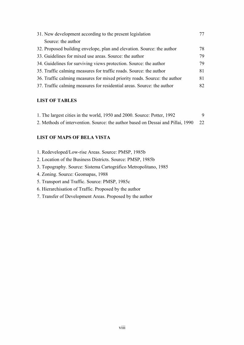
As a consequence, the developed countries (i.e. leading capitalist and free market states such as the USA, Canada, Japan and the countries of Western Europe) suffered a process of deindustrialisation whereby service industries replaced manufacturing as the major source of employment (Castells, 1989). As a result the cities of the developed countries entered into a process of urban decline whose main characteristics have been economic and population decline, especially in the inner areas of major cities where industries used to be located (OECD, 1983). On the other hand, less developed countries such as Mexico, Brazil, Egypt, Singapore, Taiwan and Korea, that displayed the features for attracting industrial development and capital, began to play a more important role in the world production, becoming Newly Industrialising Countries (Friedmann & Wolff, 1982). The attraction of the new industrial areas, the modernising cities and the influence of the media caused an intense influx of migrants from rural areas in such countries. This migration in combination with high rates of birth constituted one of the biggest problems for the cities of developing countries: the population 'explosion' (Potter, 1992). Many of these countries began a process of intense urbanisation and urban growth and the world's fastest growing cities are now to be found in the Third World (figure 1).
Figure 1: Fastest growing cities in the world. Source: Potter, 1992.
8

In 1950, apart from Shanghai, the five largest cities in the world belonged to the First World (New York, London, Tokyo and Paris)(table 1). According to an United Nations projection for the year 2000, the three largest cities (Mexico, São Paulo and Shanghai) will not belong to the First World and 9 out of the 15 largest cities will be in so-called Third World countries (Mexico, Brazil, India, Egypt, Indonesia, Argentina). _____________________________________________________________________ 1950 2000 _____________________________________________________________________ Rank City Population Rank City Population (millions) (millions) _____________________________________________________________________ 1 New York 12.3 1 Mexico City 31.0 2 London 10.4 2 São Paulo 25.8 3 Tokyo 6.7 3 Shanghai 23.7 4 Shanghai 5.8 4 Tokyo 23.7 5 Paris 5.5 5 New York 22.4 _____________________________________________________________________
Table 1: The largest cities in the world, 1950 and 2000. Source: Potter, 1992.
1.2.1 The Cities of the First World As a consequence of this economic global restructuring many industries of the First World were closed. In countries such as UK and USA, the remaining ones were restructured generally moving away from the inner areas to more peripheral ones, after major improvements in the road network (Jones, 1979; Bradburry et al, 1982). These changes worsened unemployment among the blue collar workers of the central areas. Not only jobs were suburbanised. The improvement of the car industry and the subsequent increase in its use together with the rise of suburbia as an alternative to the crowded and obsolete housing stock of inner cities also influenced the population decline in the centres. As Rothblatt et al (1986,p. 2) note, since 1945 suburbia has become "a major, if not predominant, mode of middle class life in most industrialised countries".
9

As a consequence there was a selective migration of those able to move and a concentration of the disadvantaged (OECD, 1983). Deconcentration policies, e.g. New Towns Programme, also influenced this process of suburbanisation whereas slum clearance programme helped to diminish the urban population. The physical results of this process were an increase in commercial, office and service related floor space and in land use for transport, accompanied by large decreases in warehousing, wholesale markets, industry, residential areas and population (Holliday, 1973). This constitutes a reduction in the land uses diversity of these areas and the consequent effects, i.e. under utilisation of the urban infrastructure and making it unsafe during the night time. 1.2.2 The Cities of the Third World According to Herbert et al (1990) the internationalisation of the economy and the spread of technology and Western values caused the 'Westernisation' of the cities of the Third World. Urbanisation has generally replaced the urban form inherited from the colonial period with a geometrical and spacious lay-out. Western capitalism has imposed itself on the traditional culture, destroying the existing mixture of land uses and creating clear functional areas. The differences between Western and traditional cultures have become more apparent and in the places where the migrants were unable to become part of the culture, a 'peasantisation' of the city has occurred as in some African cities (Herbert et al, 1990). Cities have grown so rapidly that national and local governments have been unable to provide sufficient housing, infrastructure and social facilities to accommodate the new population. This problem has worsened with the recession following the 1970s and the debt crisis. Many developing societies enjoy a high level of industrialisation and a modern economy, although unemployment is still very high among the less skilled. Potter (1992) reckons that the 'informal' sector plays a very important role as it absorbs a great part of the unemployed. Whereas the formal sector represents large scale production and economic growth, the informal sector represents the small scale, providing cheap services and unskilled and casual jobs at low wages for low profits.
10

Herbert et al (1990) also argue that the cities of the Third World exhibit a complex discrimination in spatial structure. The richest still have a considerably wide choice of housing. Although low rise accommodation and space are preferable, high-rise apartments constitute the majority of new buildings. The élites that used to live in the centre are now abandoning the core, aspiring to Western modes of urbanism. At the same time the upper middle classes strive to occupy areas adjacent to the élites. The lower middle classes, less worried about status and more worried about security, move into peripheral neighbourhoods that represent greater security of tenure than the central areas. The central areas have been left to the tertiary sector activities (Central Business Districts) and to housing the poorest sector of the population. As the formal housing market is unable to cope with the intensive growth, a proliferation of spontaneous housing has occurred in the poorer sectors. According to Adams (in Herbert et al, 1990) poor city dwellers can be divided into three categories. First the homeless who abound in the cities of developing countries. Secondly the slum and tenement dwellers who live in densely built-up areas of the old cities. Thirdly the squatters and occupants of shantytowns who are generally located in more peripheral areas. 1.3 SÃO PAULO CASE STUDY 1.3.1 A Brief Introduction to Brazil Brazil is the largest South American country comprising almost half of the continental area: 8,511,965 sq. km or 3,286,500 sq. miles (figure 2). It was the only Portuguese colony in the continent. Following its independence in 1822 the country remained united under the monarchy until 1889. In this year the republic was declared and the country adopted a federalist model of states adhering to a federal union. From the colonisation until the beginning of the 20th century the country's economy was based on cycles of primary goods exportation: first sugar-cane planted and produced in the Northeast region from the 16th to the 18th centuries; then gold and diamonds from the central state of Minas Gerais (18th century); and then from the middle 19th century until the 1930s, coffee from the state of São Paulo became the most important export.
11

After the 1930s the country turned towards industrialisation due to the negative effects of the economic depression on its coffee-based exports. Many governments pursued a state-led industrial development policy based on energy, heavy industry and capital goods. From the 1950s onwards foreign capital has been generally welcomed especially in the manufacturing sectors.
Figure 2: Brazil. Source: Batley, 1983.
Since then the country has confirmed itself as an industrial power and by the end of the 1980s has become the ninth largest economy in the non-communist world (Cammack, 1993). The country's economy is dominated by the 'industrial triangle' formed by the cities of São Paulo, Rio de Janeiro and Belo Horizonte (the capital of Minas Gerais state). In spite of the economic growth many social problems still remain due to an uneven distribution of income . Since the beginning of the century Brazil has become a highly urbanised country following the process of industrialisation. More than 70% of its population live in cities, there are 8 metropolitan regions with more than 1,000,000 inhabitants and 50% of the population is concentrated in the south-east region that comprises the states of São Paulo, Rio de Janeiro and Minas Gerais (Devas & Rakodi, 1993).
12

1.3.2 The Context of São Paulo São Paulo is the largest Brazilian conurbation with 11.4 million municipal inhabitants and approximately 20 million in the Metropolitan Region that comprises 37 other municipalities (figure 3)(Oliveira & Leittman, 1994). The city has a strong economic and industrial base representing 18% of Brazilian GDP and 31% of industrial domestic product. Despite its prosperity there is an uneven distribution of income. The richest 10% earns 30% of the income of the metropolitan area whereas the poorest 50% receives just 20% (Rolnik, 1991). A considerable proportion of São Paulo's population, more than 60%, lives in precarious housing conditions in slums (cortiços), shanty towns (favelas) or illegal developments (Rolnik, 1991). Of these a great part lives in crowded slum tenements in traditional neighbourhoods in the central area. In 1874 the population of the city was 23,000 (Devas & Rakodi, 1993). In 1900 it was 240,000 , most of this increase comprising immigrants who arrived in the late 19th century to substitute the slaves (Wilheim, 1984). In the 1940s and 1950s the process of industrialisation attracted more migrants from different parts of Brazil, especially the Northeast region. The population grew from 1,330,000 in the 1940s to 3,800,000 in the late 1950s. In the 1960s growth started to slow down, from 5.25% in the 1950s to 4.92%, despite investment in industrial activities on the part of transnational corporations (Instituto de Engenharia, 1988). In the 1970s this trend was reinforced by planning regulations prohibiting the establishment of new industries in the city and the rate was reduced to 3.67%. More recently the growth slowed to 1.9% annually (Oliveira & Leittman, 1994). Land uses within the city are divided in the following way: 43% is residential, 37% is not built up, 9% is commercial, 8% industrial and the remainder 3% for recreational, agricultural, etc. Despite the considerable amount of vacant land available for its expansion, the city has grown through successive processes of redevelopment of existing built-up areas led by the market forces and speculative pressures (Devas & Rakodi, 1993). The central area is the most dense, presenting serious problems of infrastructure, transportation, traffic congestion, air pollution and lack of public open spaces.
13

Due to the rapid process of unplanned urbanisation there are few public open spaces in the city. The total area represents 4.5m² per inhabitant and public green space constitutes only 2.8% of the urbanised area (Oliveira & Leittman, 1994). Likewise investment in public transport has not followed the rhythm of the city's growth (PMSP, 1992a). As a result the structural road network is always congested and the vehicular emission of pollutants (especially carbon monoxide) accounts for 73% of air pollution.
Figure 3: The city and metropolitan area of São Paulo. Source: Oliveira & Leittman, 1994.
14

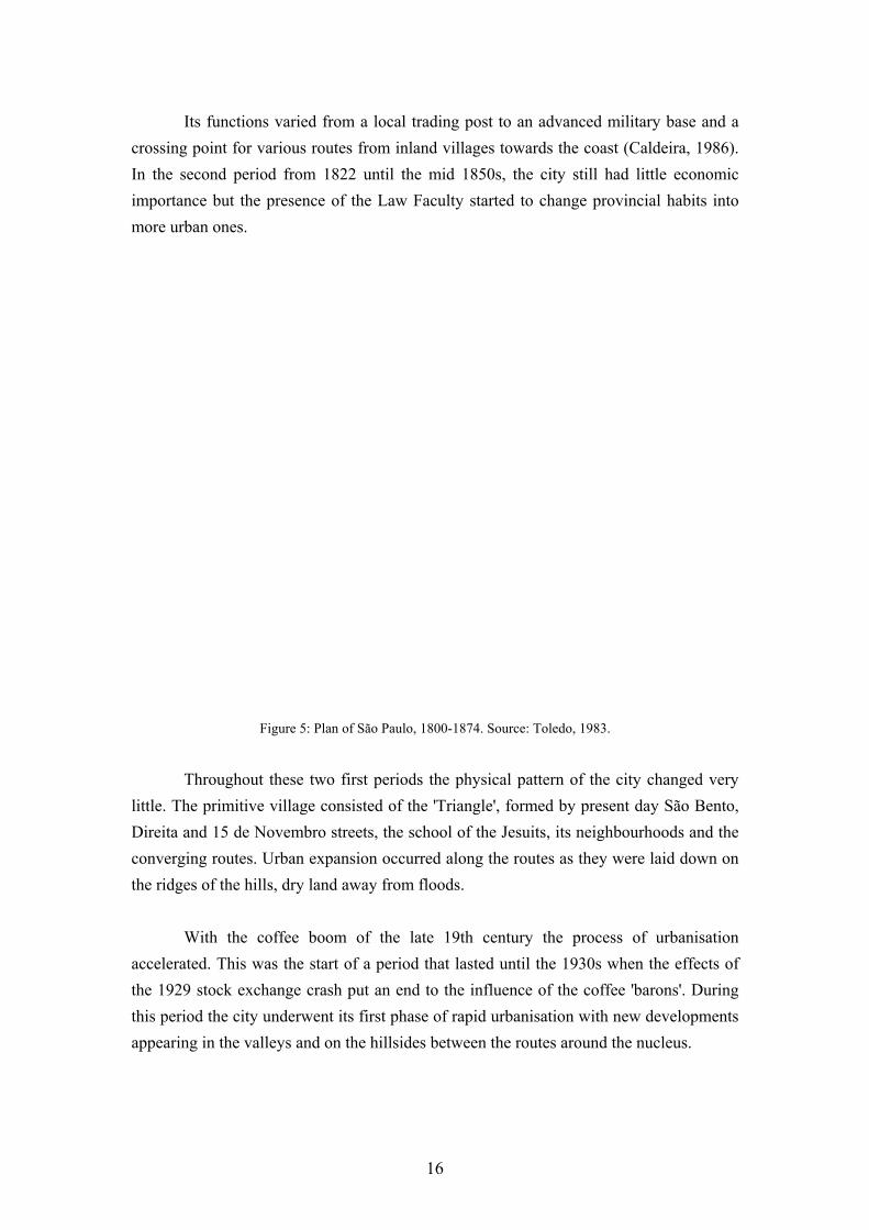
1.3.3 The Urban Evolution The morphology of Latin American cities is a result of the transformation through time of the Iberian colonial settlement policy (Butterwoth, 1981; Hardoy, 1982). However while the Spanish American cities were planned to host the Spanish bureaucracy and population, the Portuguese counterparts functioned as mere trading posts and fortifications to defend the coast. According to Hardoy (1982) the Spanish settlements followed clear and defined patterns and rules, i.e. a regular gridiron arranged around squares (figure 4), whereas the Portuguese followed no specific pattern, gradually incorporating a more regular pattern when the topography made it possible. In this sense São Paulo's growth was typical of a Portuguese Colonial city with little concern for the topography (figure 5).
Figure 4: Plan of Santiago, Chile, in the 18th century. Source: Marx, 1991.
Morse (1971) establishes that the urban evolution of São Paulo can be divided into periods affected by factors of national and extra national origin, such as colonial policy, immigration and foreign investment. The first period is that of colonial times, stretching from the foundation of the city by Jesuit priests in 1554 until Brazilian independence in 1822 and during this period the city was of little interest to the Portuguese crown.
15
Its functions varied from a local trading post to an advanced military base and a crossing point for various routes from inland villages towards the coast (Caldeira, 1986). In the second period from 1822 until the mid 1850s, the city still had little economic importance but the presence of the Law Faculty started to change provincial habits into more urban ones.
Figure 5: Plan of São Paulo, 1800-1874. Source: Toledo, 1983.
Throughout these two first periods the physical pattern of the city changed very little. The primitive village consisted of the 'Triangle', formed by present day São Bento, Direita and 15 de Novembro streets, the school of the Jesuits, its neighbourhoods and the converging routes. Urban expansion occurred along the routes as they were laid down on the ridges of the hills, dry land away from floods. With the coffee boom of the late 19th century the process of urbanisation accelerated. This was the start of a period that lasted until the 1930s when the effects of the 1929 stock exchange crash put an end to the influence of the coffee 'barons'. During this period the city underwent its first phase of rapid urbanisation with new developments appearing in the valleys and on the hillsides between the routes around the nucleus.
16
The new neighbourhoods were planned according to a grid pattern and other urbanistic innovations brought from Europe and America. The blocks exhibited a dense occupation with semidetached houses placed in narrow and long plots. For a long time this had been the main housing typology for the poorer classes and the workers in the new industries that were appearing along the railways (Caldeira, 1986). In the 1930s the first skyscrapers appeared in the city centre. The increase of the use of automobiles and buses led to the implementation of road construction programme that resulted in a major restructuring of the city in the 1940s (Rolnik, 1991). The city consolidated its position as a leading industrial centre after the establishment of the multinational car industry in its metropolitan area in the late 1950s. The business and the industrial communities started using the media to boost the position of the city. Slogans such as "São Paulo must not stop" or "Latin America's biggest industrial centre" were very common during the 1960s and 1970s (Kowarick & Bonduki). Since then an intense process of natural urban renewal has occurred, destroying traditional areas in accordance with such ideas of progress. Kowarick & Bonduki (1994, p. 127) provide a good description of this phase:
"Progress meant demolition of anything that was old - even if it was 20 years old ... Skyscrapers began springing up. The craving for progress and modernity guided and justified the process by which the most consolidated urban areas were transformed, under the control of the developers and property speculators."
1.3.4 São Paulo Central Area According to Rolnik (1991) the problem of land speculation is more intense in the central area of the city. As zoning legislation allows a floor area ration (FAR) of 4:1 (the highest in the city) in these areas, they are more sought after for development. The districts of Sé, part of Consolação and Santa Efigênia present central business district function. Most of the buildings in these areas are for commercial and office purpose (banks, financial institutions, insurance companies, etc.) with little residential use.
17

Around the central business district (CBD) there is a ring of traditional neighbourhoods (Bela Vista, Liberdade, Brás, Luz, Bom Retiro, Campos Elísios, Santa Efigênia, Consolação), constituting a transitional area between the city centre and the areas that already suffered a process of redevelopment (Marzola, 1985). These districts still keep their characteristic of being a typical low-rise development of the late 19th century, presence of diversity of uses, local traditions and parties, with great part of its population belonging to the lowest income strata. They present serious problems of deprivation, lack of public open space, heavy traffic and pollution. Batley (1983) points the high concentration of cortiços (a form of collective housing where people live in rented or sub-leted rooms and share facilities such as toilets and services): more than 10/km² (figure 6). According to Rolnik (1991) 41 to 60% of the population of these neighbourhoods belongs to the poorest classes. As they have not been developed to their full permitted potential they are in risk of being destroyed by a redevelopment and urban renewal process.
Figure 6: Cortiços e Favelas in São Paulo. Source: Batley, 1983.
18

On the other hand as these neighbourhoods are the last representative of the latest 19th century urbanisation there is some concern about them by the heritage commission (PMSP, 1985a). Due to the historical significance and the presence of the entertainment industry, some of these districts constitute in tourist attractions that are not used to their full potential due to the image of decay. 1.4. CONCLUSION Since World War II a major global economic restructuring has occurred. Searching for lower labour costs and weaker labour organisation, the industrial production has shifted little by little from developed to less developed countries. This factor has affected very much the pattern of urban development of both group of countries. In the developed world the closure of factories, warehouses and shipyards has left a great quantity of vacant land in the inner areas. The increase in car use and the adoption of a new middle class suburban lifestyle has also given rise to a migration to the city outskirts of those who can afford to do so. This process led to an urban decline and a counter urbanisation, i.e. a loss of population and a decline in economic activity in urban areas. In the developing countries the major restructuring has resulted in the process of rapid industrialisation. As a consequence thousands of migrants have established themselves in cities close to new industrial areas. The internationalisation of the economy has also caused the 'Westernisation' of Third World cities, destroying the traditional urban fabric and replacing it with new geometrical layouts. The pace of social development has not matched the pace of urbanisation and industrialisation resulting in great problems of housing and unemployment.
19

The city of São Paulo has grown in a way typical of industrial cities in the Third World. In little more than a hundred years the population has grown 500 times. Due to this rapid process of urbanisation the government of the city has been unable to provide housing, public transport, open space and other services to the great majority of its population. The recent pattern of urban development has been based in land speculation with urban renewal destroying consolidated areas and replacing them with high rise neighbourhoods. The situation has been more severe in central areas where the present legislation allows higher densities. Many traditional neighbourhoods found in these areas are in risk of being destroyed by a redevelopment process with the subsequent poorest population displacement, lose of historical heritage, traditional parties and touristisc potential.
20
CHAPTER TWO Defining Criteria for Urban Regeneration
2.1 INTRODUCTION As discussed in the previous chapter the establishment of the 'New Economic Order', i.e. the spread of the capitalist system over the world, has caused the deindustrialisation of the developed world and the appearance of rapidly industrialising countries in the developing world. As a consequence of these structural changes the pattern of urban development has changed causing the problem of urban decline in the developed and uncontrolled urban growth in the developing world. The city of São Paulo is an example of the latter. The city has grown vertiginously over a hundred years and social development has not followed the pace of urban growth. As a result the government was not able to provide housing, employment, services. Worse, a process of growth based on land speculation, urban renewal and redevelopment took place destroying established traditional neighbourhoods where a great quantity of the lowest income population lives and works. This chapter will define criteria for proposing urban regeneration policies for São Paulo. First it summarises interventions since the World War II which have aimed to achieve urban regeneration. Then it analyses the social and physical implications of these policies and the implications for São Paulo in particular and finally proposes objectives for urban regeneration policies in this city. 2.2 DEFINING METHODS OF INTERVENTION It has been argued that there are two ways of tackling the problems of decay arising from uncontrolled growth (Dessai & Pillai, 1990): one direct, the other indirect (table 2). Indirectly, rural-urban migration can be controlled through redistribution of land to peasants, creating new settlements with job opportunities or increasing employment in small towns. This method does not take measures to alleviate the existing problems but it tries to prevent their worsening through a reduction of the influx of migrants. Its results are not so visible as they can be perceived only in a long term perspective. Such an approach also depends on a regional or even national policy.
21

The direct method however, is much more visible as its actions are based on direct intervention in the areas concerned. The actions are generally applied to a specific area of a city. They can be divided in two kinds: eradication and relocation of the population of deprived neighbourhoods and improvement and rehabilitation projects.
METHODS OF INTERVENTION
1. Indirect
a) Redistribution of land
b) New settlements with job opportunities (New Towns Programme)
c) Increase of employment opportunities in small towns
2. Direct
a) Eradication and relocation of deprived areas
b) Improvements and rehabilitation of deprived areas
Table 2 : Methods of intervention, based on Dessai & Pillai, 1990.
In most developed countries these policies have developed over time. Just after the end of World War II, many Europeans countries adopted reconstruction policies based on the renewal of the urban fabric. The need to provide dwellings for many people justified a new pattern of development based on slum clearance and relocation of the population to new high-rise developments. Similar policies were implemented in the UK, Germany, the Netherlands and France (OECD, 1983). Although the USA did not suffer the destruction of its cities as Europe did, this country also promoted a renewal programme based on clearance as a result of the enthusiasm for post-war planning (Rapkin, 1980). The Federal Housing Act of 1949 provided the municipalities with grants to clear slums and blight areas. In some countries, such as the UK and France, indirect action was also taken in order to redistribute growth and relieve population pressure on large cities. The New Town Programme is the best example of this (OECD, 1983).
22

However, since the late 1960s there has been in most of these countries a shift from clearance and redevelopment towards housing rehabilitation and area improvement (OECD, 1983). There were many reasons for this shift. First dissatisfaction on the part of the relocated population with the nature, quality and remote location of new housing has led to a series of public demonstrations and political pressure against slum clearance policies. Secondly, the decrease in the significance of the housing shortage factor in these countries has reduced the need to build a great quantity of housing. Another two factors that have also contributed to this change have been the awareness of governments of the financial losses incurred in destroying existing and sometimes structurally sound housing stock, and the growing of conservation movement awaken public opinion to issues such as the limited energy resources, the destruction of natural habitats, landscape and the importance of civic and cultural heritage (Couch, 1990). However, since the beginning of the 1980s the aims of urban regeneration, especially in the UK and the USA, have been much more economically motivated and have neglected the social needs (Robinson, 1989). Some authors, when analysing these recent policies, remark upon the existence of 'winners' and 'losers' in this process (Robinson, 1989; Fainstein ,1990). New policies, such as UDCs (Urban Development Corporations) and Enterprise Zones, were designed to promote new development in areas with a considerable amount of derelict land by relaxing the planning requirements, acquiring land and attracting public and private investment to finance them. The main beneficiaries of this process were "property interests and middle class commuters, visitors and gentrifiers" (Robinson, 1989, p.41) whereas the losers were the low income, semiskilled and unskilled local residents whose legitimate demands for employment, better housing, health and education were not met. Worse still, the results of such policies in the UK and the USA have been "the diversion of resources from social policy to business support" (ibid., p.39). Even the intended 'trickle down' effect (i.e. the idea that benefits from great projects can filter to the local population) did not occur (Robson, 1994).
23
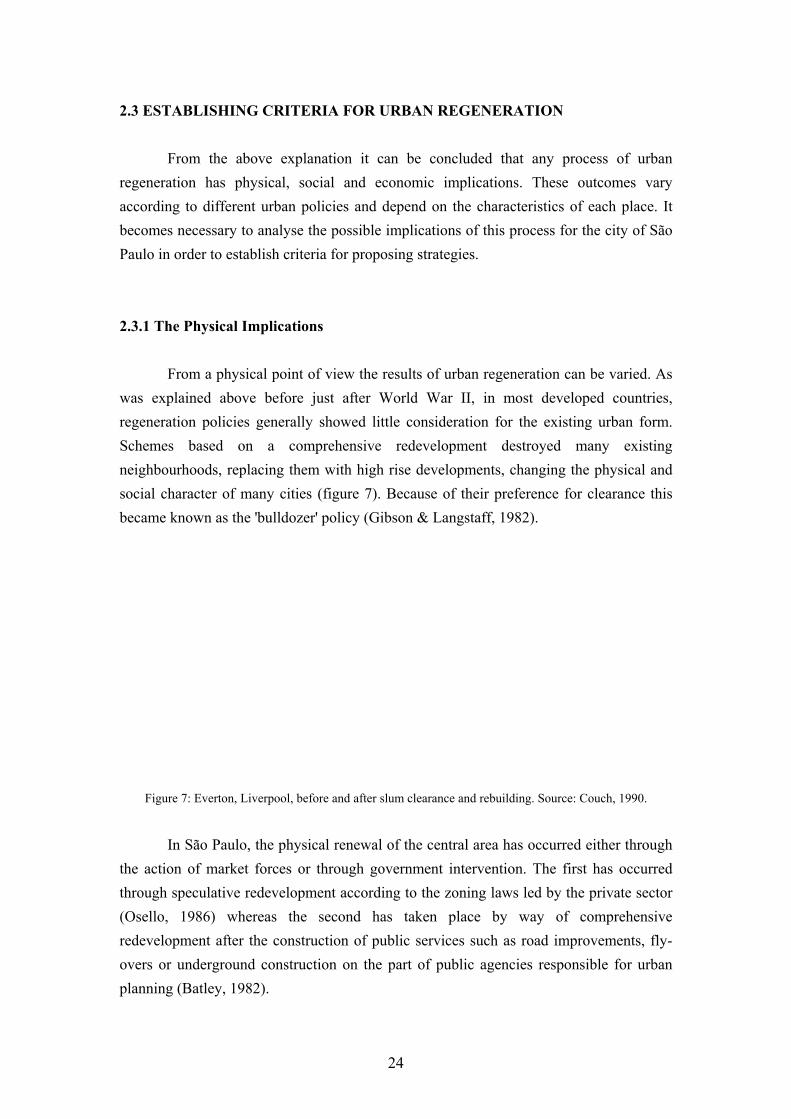
2.3 ESTABLISHING CRITERIA FOR URBAN REGENERATION From the above explanation it can be concluded that any process of urban regeneration has physical, social and economic implications. These outcomes vary according to different urban policies and depend on the characteristics of each place. It becomes necessary to analyse the possible implications of this process for the city of São Paulo in order to establish criteria for proposing strategies. 2.3.1 The Physical Implications From a physical point of view the results of urban regeneration can be varied. As was explained above before just after World War II, in most developed countries, regeneration policies generally showed little consideration for the existing urban form. Schemes based on a comprehensive redevelopment destroyed many existing neighbourhoods, replacing them with high rise developments, changing the physical and social character of many cities (figure 7). Because of their preference for clearance this became known as the 'bulldozer' policy (Gibson & Langstaff, 1982).
Figure 7: Everton, Liverpool, before and after slum clearance and rebuilding. Source: Couch, 1990.
In São Paulo, the physical renewal of the central area has occurred either through the action of market forces or through government intervention. The first has occurred through speculative redevelopment according to the zoning laws led by the private sector (Osello, 1986) whereas the second has taken place by way of comprehensive redevelopment after the construction of public services such as road improvements, fly-overs or underground construction on the part of public agencies responsible for urban planning (Batley, 1982).
24

From a physical point of view this process of urban renewal has resulted in the destruction of existing diversity and place identity, improvements in the traffic network, especially for individual modes of transport, generating an increase in traffic. In order to establish criteria for urban regeneration policies for São Paulo each one of these aspects must be analysed. Reduction in Diversity of Land Uses According to Santos (1981; 1986) traditional neighbourhoods exhibit a great diversity of uses hosting a great number of different activities that he calls 'supporting activities'. Establishments such as small workshops, artisans shops, small publishers, small stores, groceries, tyre repair services, furniture makers and sign painters provide services for local residents as well as providing support for the tertiary activities of the City Centre. Such activities are representative of the so-called 'informal sector' of the economy (ibid.). This term appeared in the late 1970s to refer to the kind of activities based on small-scale labour-intensive production in contrast to the large capital-intensive production of the formal sector (Potter, 1992). They are generally small enterprises, family-run and characterised by 'cottage industries', i.e. activities carried out in people's homes, and they are very characteristic of Third World countries (ibid.). The main reason for their appearance was the impossibility of the formal sector to provide sufficient jobs for the rapidly expanding population and the great influx of unskilled workers from rural areas. In Third World countries, these activities play a very important productive role in the urban economy due to their wide proliferation despite their small scale (ibid.). Schaeffer (1976) remarks that the informal sector is responsible for between 35 to 40 % of the active workforce of the São Paulo Metropolitan Region (RMSP). Traditional low-rise neighbourhoods provide this informal sector with the necessary physical support, since they lack sufficient capital to establish themselves in redeveloped areas that generally have more expensive rents (Santos & Vogel, 1981). When compared to the new residential developments the traditional neighbourhoods exhibit a greater liveliness and diversity (figure 8).
25

Due to the importance of the informal sector for the São Paulo economy and the impossibility of providing jobs for a considerable proportion of the active workforce, regeneration strategies should promote a diversity of uses to ensure the continuity of the informal sector. As most of these activities are home-based the zoning laws should ensure the existence of an adequate urban pattern to accommodate such activities.
Figure 8: Land uses in a traditional neighbourhood and in a new development. Source: Santos & Vogel, 1981.
The reduction of diversity has other bad consequences. Jacobs (1961) argues that planning theories based on this principle were responsible for the 'death' of American cities. She points out that land use segregation caused a reduction of the safety and liveliness of streets by reducing the diversity of street uses. As a consequence streets and whole neighbourhoods became deserted, giving rise to vandalism and criminality. Given the problem of criminality and burglary in contemporary São Paulo enhanced street surveillance seems to be an important need.
26

Land use diversification and intensification also contribute to achieving sustainable development (Elkin, 1991). Sustainable development is a form of development that "meets the needs of the present without compromising the ability of future generations to meet their needs" (World Commission on Environment and Development, 1987, p.43). In a major sense this idea concerns about the never ending consumption of natural resources by the human civilisation. Intensifying and diversifying land use implies having more people using, living and working in the same area, thus reducing energy consumption for transport and diminishing the use of physical and economical resources through infrastructure expansion. Potter (1992) remarks that for Third World countries the question of sustainability is of primary importance due the financial and environmental problems that these nations are experiencing. Destruction of Place Identity São Paulo has grown in two ways: redevelopment of its central areas and suburban sprawl (Osello, 1986). Most of the traditional neighbourhoods are found in the central areas where the effects of the land market has given rise to a process of successive redevelopment resulting in islands of houses in a sea of skyscrapers. Marzola (1985) argues that this process has destroyed the character of the buildings, the townscape and preserved only the road network. At the beginning of the 20th century the city still showed a high degree of European influence in its architecture that gave foreign travellers the sensation of being in an Italian or French city (Toledo, 1983). Nowadays the city is more famous for its skyscrapers and traffic congestion (Rolnik, 1991). The traditional neighbourhoods have been destroyed little by little by speculative redevelopment, road improvements or the construction of motorways and fly-overs. Marzola (1985, p.30) argues that the city has an 'unfinished' aspect and those that spend some years away do not recognise it when they come back. This reduces the identification of the inhabitant with the city resulting in the impoverishment of its social, cultural and affective relations (ibid.).
27
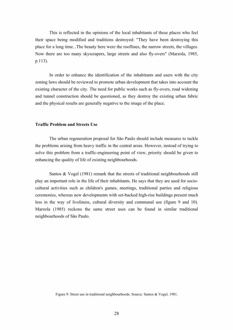
This is reflected in the opinions of the local inhabitants of these places who feel their space being modified and traditions destroyed: "They have been destroying this place for a long time...The beauty here were the rooflines, the narrow streets, the villages. Now there are too many skyscrapers, large streets and also fly-overs" (Marzola, 1985, p.113). In order to enhance the identification of the inhabitants and users with the city zoning laws should be reviewed to promote urban development that takes into account the existing character of the city. The need for public works such as fly-overs, road widening and tunnel construction should be questioned, as they destroy the existing urban fabric and the physical results are generally negative to the image of the place. Traffic Problem and Streets Use The urban regeneration proposal for São Paulo should include measures to tackle the problems arising from heavy traffic in the central areas. However, instead of trying to solve this problem from a traffic-engineering point of view, priority should be given to enhancing the quality of life of existing neighbourhoods. Santos & Vogel (1981) remark that the streets of traditional neighbourhoods still play an important role in the life of their inhabitants. He says that they are used for socio-cultural activities such as children's games, meetings, traditional parties and religious ceremonies, whereas new developments with set-backed high-rise buildings present much less in the way of liveliness, cultural diversity and communal use (figure 9 and 10). Marzola (1985) reckons the same street uses can be found in similar traditional neighbourhoods of São Paulo.
Figure 9: Street use in traditional neighbourhoods. Source: Santos & Vogel, 1981.
28

Figure 10: Leisure activities in a private club in a new development. Source: Santos & Vogel, 1981. However, traffic and pollution represent a danger for these uses. Appleyard (1981), in his research in San Francisco streets, shows how traffic can affect social relations and street use. According to this research streets with less traffic are felt to be an extension of the home and there is a greater degree of social interaction between its inhabitants (figure 11). On the other hand, heavy traffic on streets tends to render them impersonal and there are fewer acquaintances and friendships in such areas.
Figure 11: Home territory as perceived by San Francisco inhabitants. Source: Appleyard, 1981.
29

Considering the present use of streets by inhabitants, the lack of public and green open space in São Paulo central area and the threat that traffic represents to residential neighbourhoods, urban regeneration should focus on measures that would orient and restrain the traffic in these areas as well as promoting the use of the street for leisure activities and providing green areas. 2.3.2 The Social Implications From a social point of view one of the most common effects of urban regeneration is the displacement of the existing population (Couch, 1990). This can occur either through eviction for the destruction and redevelopment of the existing urban form or through a natural movement caused by increasing rents. In the case of São Paulo the displacement of the lowest income groups from central areas amounts to a worsening of quality of life, as they will have to move further away from employment opportunities, spend more on travel costs and sometimes live in worse conditions. As Batley remarks, commenting on the urban renewal process in Brás district in São Paulo (Batley, 1982, p.233):
"For poorer groups, removal from the central areas implied the loss of a relatively favoured situation, almost certainly in terms of access to public services and employment and probably also in terms of housing standards."
He also argues that there is a high degree of population stability in São Paulo inner area. In Brás district 62% of the surveyed population had been living in the area for more than 10 years in 1976 and almost 70% of the slum population has been established in the city itself for more than 10 years in 1973 (Batley, 1982; 1983). Rolnik (1991) points out that a considerable proportion of poor population lives in the inner area. According to her from 41 to 60% of the population of the inner neighbourhoods belong to the lowest income strata and 36% of the city slums are to be found in this area.
30

Marzola (1985) remarks that the slum inhabitants are not dissociated from society despite what is generally thought about them. They are integrated into the job market, and, although aware of their bad living conditions, they prefer to live close to the job opportunities and services of the central areas. Although they are unskilled, the percentage of those unable to read is low, 12%. For reasons of social justice it seems to be important to preserve the favourable situation in terms of location of the lowest income of population. Their proximity to the city centre enhances their chances of employment, reduces their transport costs and provides better housing conditions than the periphery despite the physical decay. Another point to be made is that removing these communities also means destroying cohesive social groups. Marzola (1985) remarks that there is great solidarity and a sense of 'a great family' among this population that "everyone participates in the happiness and in the problems" of each others' lives (Marzola, 1985, p.92). According to Webber (1964) physical proximity is the major factor responsible for this sense of community, although some other factors such as social organisation, shared values, sense of belonging, and interdependence are also important. This is not true for the highest income population. For them accessibility to information and facility of transportation has become more important in defining an 'interest community' than physical proximity (Webber, 1964, pp. 109-110). However, for the less skilled classes, physical space constitutes the basis of the community, as their access to information and mobility is restricted. This lack of spatial, social, and occupational mobility has led to a form of stability that encourages the proliferation of kinship ties and the establishment of long term friendships (Couch, 1990). The removal of this population should be avoided as it leads to a disruption of primary social ties and a reduction of social cohesion with negative social and psychological effects on individuals and communities (Knox, 1982).
31

The Problem of Land Speculation As was explained in chapter one, private developers have had a great influence on the shaping of São Paulo's urban form. Although different zoning ordinances have slightly reduced the allowable Floor Area Ratio over time, they have usually confirmed the existing pattern of land speculation (Osello, 1986). The establishment of FAR 4:1 in the central areas comprising just 10% of the city area has created a false shortage of highly developable land (Rolnik, 1991). As a result these areas present a land value sometimes up to 50 times the lowest valued areas in the city (Haddad, 1982). The continuous process of urban redevelopment these areas undergo is the largest factor responsible for the displacement of the poorest population. Batley points out (1982, p.233):
"Urban redevelopment stimulates increases in land and house prices in the centre and the displacement of poorer groups from previous areas of low income housing. The removal took place through the eventual eviction and demolition which followed private buildings or public works service."
However it is not only urban redevelopment that can result in the displacement of poorer sectors of the population. Sometimes the rehabilitation of an urban area can also lead to displacement of residents (Gibson & Langstaff, 1982; Holcomb & Beauregard, 1981). Rehabilitation, according to Nauta et al (1982, p.236), is "a form of urban renewal wherein the physical pattern is maintained while dwellings are improved and where possible or necessary complementary buildings are constructed and services introduced". This process of working-class displacement is more common in tenancy neighbourhoods where landlords, after making use of grant-aided rehabilitation schemes, sell their properties for owner occupation or let them to high income groups (Gibson & Langstaff, 1982). This process has become known as 'gentrification' and is generally more common in neighbourhoods with distinguished architectural or historic value (Couch, 1990).
32

As one of the established objectives for São Paulo's urban regeneration is to upheld the right to stay close to jobs opportunities and public services for the poorest sector of the population, land speculation should be tackled. Mechanisms should be created in the zoning laws to avoid urban redevelopment and the land market controlled to avoid gentrification. The Need for Community Participation One way to avoid the expulsion of the population is through encouraging participation and involvement in the planning process. Couch (1990) describes how the population of Dapperburt estate in the Netherlands avoided displacement through participation. On learning of the renewal proposals for the area, local residents, shopkeepers and businessmen formed an action committee and undermined the official process by resisting and putting political pressure on the city council. Carmon and Hill (1988) also point to the advantages to be found in delegating power in order to obtain co-operation with the implementation process. They argue that when the residents participate in the planning phase the results are better as residents are more responsive to their own needs and preferences. As a consequence the population become satisfied with the process and willing to maintain it. Arnstein (1969) argues that citizen participation is the only way that those excluded from economic and social processes (i.e. racial, ethnic and social minorities) are empowered to control their future and share "the benefits of the affluent society" (Arnstein, 1969, p.216). According to her, participation means redistribution of power and without this the process becomes "empty and frustrating for the powerless". She has illustrated the varying degrees of citizen participation using a ladder model (figure 12). The bottom rungs are manipulation and therapy. They represent levels of non-participation where power holders try to "educate" and "cure" those involved (Arnstein, 1969, p.217). The next three rungs represent levels of tokenism whereby the community has the right to hear and to be heard but the final decisions continue to be in the hands of others. The top rungs represent degrees of citizen participation in the decision-making process. Partnership enables them to negotiate with the power holders and delegated power and citizen control where the population represents a majority of the decision-making body.
33

Figure 12: A ladder of citizen participation. Source: Arnstein, 1969.
In the case of São Paulo, Osello (1986) remarks the the lack of adequate professionals and equipped authorities besides political administrative discontinuity and lack of political support from the community are the main responsible for the lack of an urban policy that takes into consideration the needs of the population. He argues that instead of complain about the lack of population participation, planners should create effective conditions to citizens to intervene in decision making process. However despite the nonexistence of mechanisms to ensure participation in the planning process, the community have struggled to improve their quality of life through groups and associations of various kinds (Kowarick & Bonduki, 1994). Among them is remarkable the work of neighbourhood associations in achieving improvements for their neighbourhoods (Gohn, 1982; PMSP, 1992b). However their role is much more to express demands rather than participating in the decision-making process. In order to achieve the social objectives established, to enable the poorest sectors to participate in the benefits of society and to allow them to decide their own future, an increase in community participation in the urban planning decision process should be encouraged in São Paulo.
34
2.4 CONCLUSION There are two ways of tackling the problems arising from uncontrolled growth: one direct and the other indirect. The indirect method involves trying to reduce the pace of growth through deconcentration policies. The direct method involves carrying out interventions in the problematic areas where such growth has caused a process of decay. Each of these policies has different physical, social and economical implications. In the case of São Paulo both direct and indirect interventions should be carried out. Indirect interventions would promote a better distribution of the population throughout the state and the country. However these should be regional and national policies, which, due to their complexity and the different subjects involved, will not be analysed in this dissertation. The direct interventions should concern the problems of the central areas where a considerable percentage of the poorest sector of the population lives. The present process of physical renewal these central areas have undergone has had very negative results. The diversity of land uses has been lowered, thereby aggravating the problem of unemployment through the displacement of the so called 'informal sectors' of the economy from a privileged area. The establishment of single residential areas and road improvements have resulted in a reduction in street uses, thereby increasing opportunities for crime and exacerbating the problem of traffic, since more people have to use their cars to go shopping or go to work. The physical renewal has destroyed the existing urban form reducing the level of identification of its inhabitants with their city. The process of land speculation has displaced the poorest sector of the population who will therefore have to spend more on travel and live further away from job opportunities and public services.
35

In order to enhance the quality of life of the population of these areas in a future process of regeneration a number of objectives can be identified. The planning tools should tackle the problem of land speculation to avoid population displacement as well as to promote the sort of development that would enhance the character of the place. They should also encourage the diversity of uses that is very important for the city's economy and helps to conserve resources. Solutions to the traffic problem should take into consideration the present community's use of the street, instead of giving more privileges to already privileged car users. This would increase the amount of public and green open space of which there is very little in the city. Finally, and probably most importantly, the population should be involved in the decision making process so that they can intervene in determining the future of their city and their own lives.
36

CHAPTER THREE The International Experience of Implementation
3.1 INTRODUCTION In the previous chapter methods of intervention to tackle the problems arising from uncontrolled growth were defined and the ways in which they have changed over time were explained. The physical and social consequences of these policies were also analysed emphasising in particular the São Paulo case study. It was argued that the existing pattern of urban development and land speculation was the main factor responsible for the displacement of the poorest sectors of the population, the decrease in diversity of land use and the destruction of the physical character of the city. The heavy traffic and works carried out in an attempt to solve this problem were also responsible for a deterioration in residents' quality of life, restricting the use of streets and generating noise and pollution. From all of these observations it was established that the regeneration process in São Paulo should tackle the problem of land speculation, character destruction and diversity reduction. It also identified the need for traffic solutions that promote the present inhabitants uses of the street, restrict traffic, as well as providing public and green areas. Community participation in the planning process was also considered important as a way of avoiding displacement by empowering the local population to decide the future of their own neighbourhoods. Chapter three will assess the strength and weaknesses of international experiences of urban regeneration that has taken into account the criteria established above. The main purpose is to check their effectiveness in order to apply them to the São Paulo case study. The chapter will consist of a study of the ways in which different cities have tackled similar problems taking into consideration the established criteria. It will explore international experiences in promoting character and diversity, providing traffic restrictions and orientation in the central areas and creating mechanisms to tackle speculation and to achieve community participation in the planning process.
37
3.2 PROMOTING DIVERSITY AND CHARACTER As was explained in the previous chapters the present urban development pattern of the city of São Paulo has resulted in the impoverishment of the environment reducing land use diversity and weakening the inhabitants' sense of identification with their city. It was argued that land use diversity is important in preserving the 'informal sector' activities which are essential for the city's economy in developing countries. It also maximises the use of existing infrastructure, minimising the rate of consumption of natural and financial resources, and contributing to the establishment of sustainability. Finally it enhances the safety of streets and houses by providing a greater level of surveillance. On the other hand the destruction of the existing character of the city by new developments weakens the identification between the inhabitant and the city, impoverishing its social, cultural and affective relations. It is therefore necessary to orient new constructions in order to harmonise them with the existing ones, reinforcing the sense of place. Santos (1986) considers the adoption of 'new' urban planning techniques and models as the main factor responsible for this. According to him, attempts on the part of planners and architects to zone Brazilian cities has produced negative effects reducing diversity and destroying the character. It is therefore necessary to evaluate which factors are important in promoting diversity and character and to establish the planning tools that might be able to achieve this. 3.2.1 Land Use Diversity Many authors have written about the factors that influence the existence of diversity of uses (Jacobs, 1961; Bentley et al, 1985). According to Bentley (1985) the public edge of the building is one essential factor. He argues that commercial activities benefit from the interaction with the public realm. They should be located on the ground floor and there should be no set-back so that they could take advantage of movement on the street. Residential use on the other hand can be located on upper floors or to the rear of the building, thus ensuring greater privacy.
38
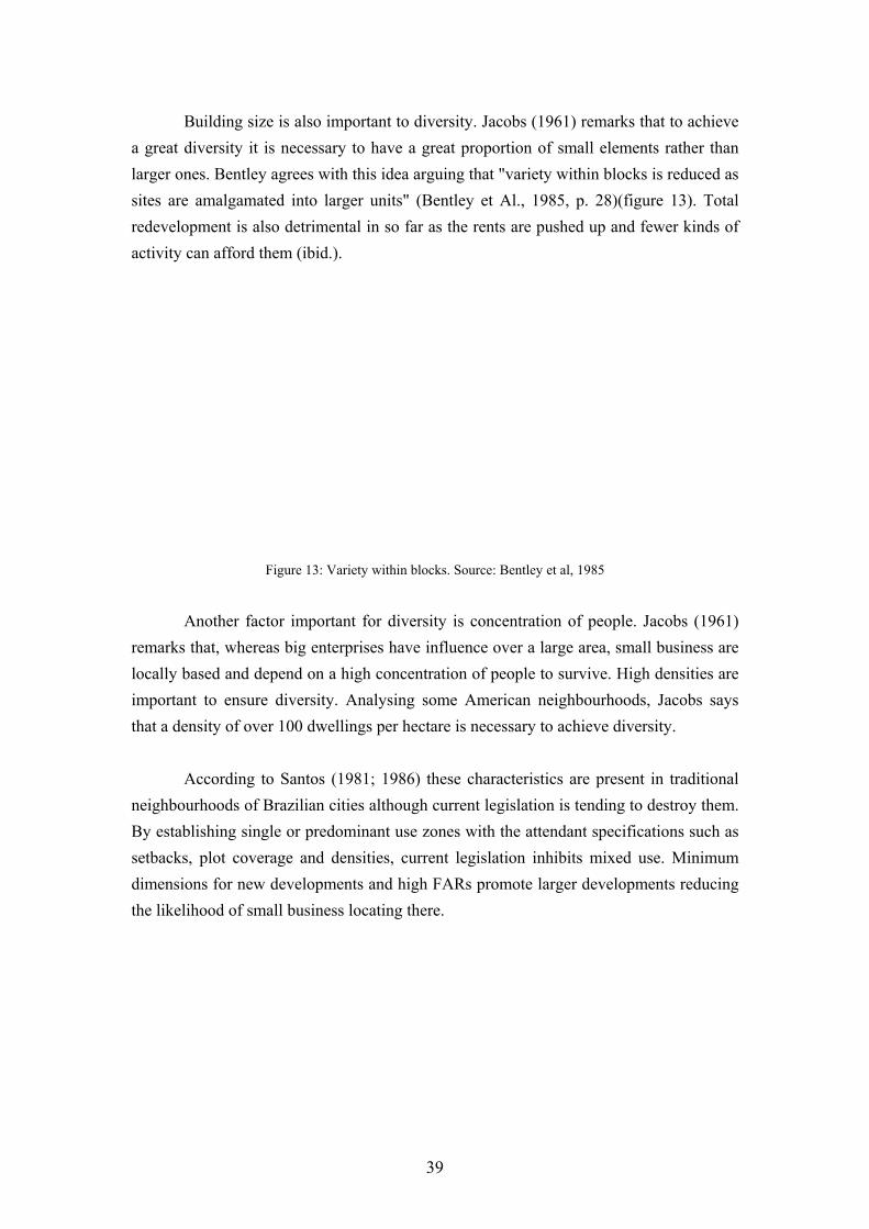
Building size is also important to diversity. Jacobs (1961) remarks that to achieve a great diversity it is necessary to have a great proportion of small elements rather than larger ones. Bentley agrees with this idea arguing that "variety within blocks is reduced as sites are amalgamated into larger units" (Bentley et Al., 1985, p. 28)(figure 13). Total redevelopment is also detrimental in so far as the rents are pushed up and fewer kinds of activity can afford them (ibid.).
Figure 13: Variety within blocks. Source: Bentley et al, 1985
Another factor important for diversity is concentration of people. Jacobs (1961) remarks that, whereas big enterprises have influence over a large area, small business are locally based and depend on a high concentration of people to survive. High densities are important to ensure diversity. Analysing some American neighbourhoods, Jacobs says that a density of over 100 dwellings per hectare is necessary to achieve diversity. According to Santos (1981; 1986) these characteristics are present in traditional neighbourhoods of Brazilian cities although current legislation is tending to destroy them. By establishing single or predominant use zones with the attendant specifications such as setbacks, plot coverage and densities, current legislation inhibits mixed use. Minimum dimensions for new developments and high FARs promote larger developments reducing the likelihood of small business locating there.
39
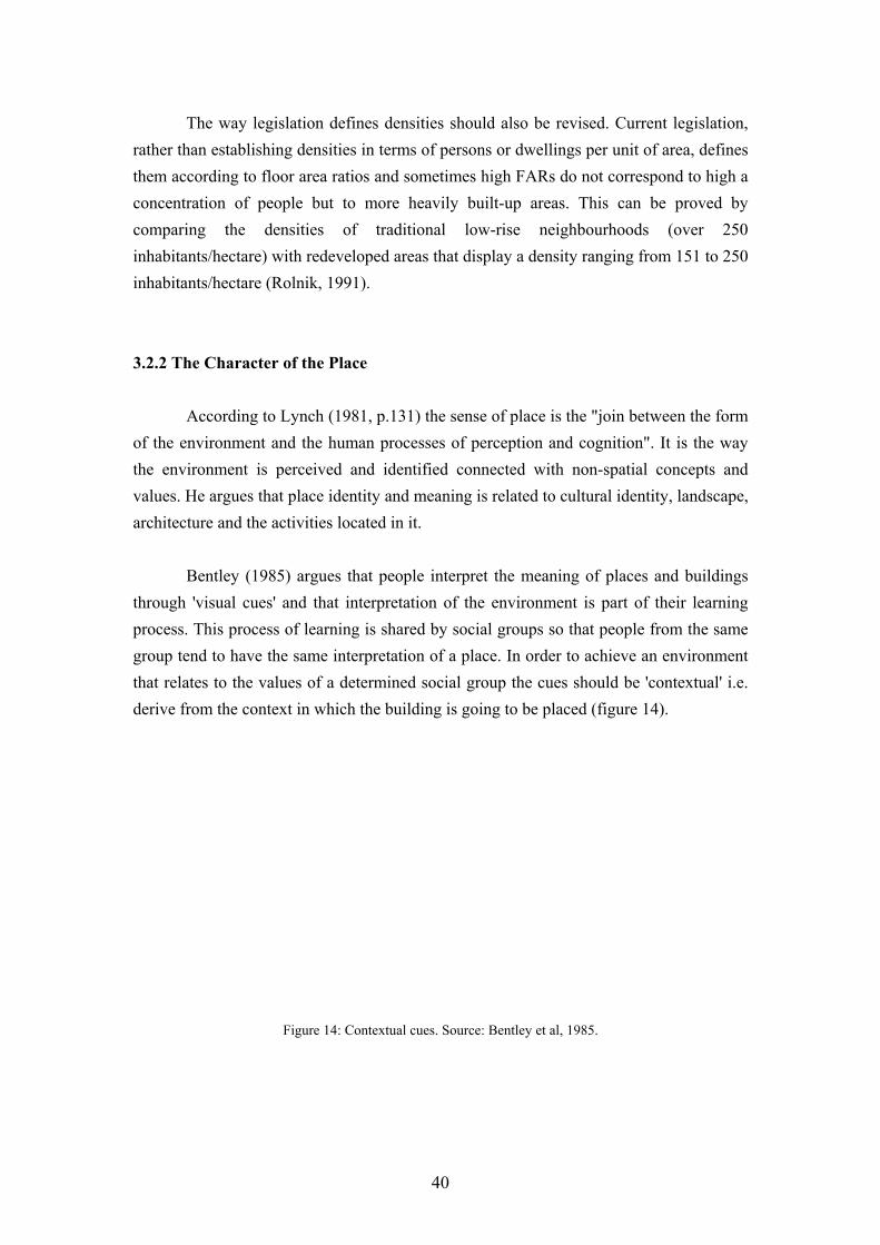
The way legislation defines densities should also be revised. Current legislation, rather than establishing densities in terms of persons or dwellings per unit of area, defines them according to floor area ratios and sometimes high FARs do not correspond to high a concentration of people but to more heavily built-up areas. This can be proved by comparing the densities of traditional low-rise neighbourhoods (over 250 inhabitants/hectare) with redeveloped areas that display a density ranging from 151 to 250 inhabitants/hectare (Rolnik, 1991). 3.2.2 The Character of the Place According to Lynch (1981, p.131) the sense of place is the "join between the form of the environment and the human processes of perception and cognition". It is the way the environment is perceived and identified connected with non-spatial concepts and values. He argues that place identity and meaning is related to cultural identity, landscape, architecture and the activities located in it. Bentley (1985) argues that people interpret the meaning of places and buildings through 'visual cues' and that interpretation of the environment is part of their learning process. This process of learning is shared by social groups so that people from the same group tend to have the same interpretation of a place. In order to achieve an environment that relates to the values of a determined social group the cues should be 'contextual' i.e. derive from the context in which the building is going to be placed (figure 14).
Figure 14: Contextual cues. Source: Bentley et al, 1985.
40
Moudon (1986) suggests that the structure of the space provides these cues. She suggests that existing urban structure can be used in a prescriptive way as a designing tool. Elements and rules can be selected from the existing built environment and used as the basis for the design of new buildings. The establishment of these elements is able promote the continuity between the existing and new buildings. The present zoning law of São Paulo has established the regulations for new developments without taking into consideration the existing urban form. It defines the building envelope through the establishment of setback, plot coverage and densities (FAR). However the definitions of the zones have merely legitimised the problem of land speculation rather proposing a coherent occupation of the land (Rolnik, 1991). The effect has been the destruction of traditional areas imposing a new pattern of development on the city. The legislation should therefore be revised to promote a kind of development more responsive to the existing city. 3.2.3 The Use of Design Guidelines to Promote Diversity and Character Some authors suggests the use of guidelines to orient new development towards achieve land use diversity and harmonisation with existing buildings (Moudon, 1986; Delafons, 1990; Lozano, 1990). Lozano (1990) agrees with the idea that present planning practices discourage diversity, noting that land use planning by way of master plans, zoning by-laws and ordinances has tended to create single use areas of considerable size. He argues that "to make grain of land use less coarse master plans and zoning must be changed" (Lozano, 1990, p.150). As an alternative he suggests 'packages' of mixed compatible land uses oriented by design guidelines. These guidelines should establish a framework within which individuals are able to make their own decisions. They should establish the rules of land use combination, determining relationships, ratios and buffers as well as physical elements. They should vary according to their objectives: residential areas above retail spaces for downtown revitalisation, residential areas with smaller minimum lots to optimise infrastructure use in the periphery, cluster residential units to preserve open space and landscape features.
41

According to Delafons (1990) some American cities have already developed design guidelines to make up for the deficiencies of the zoning system, thus achieving better results in the built environment. He shows how the city of Portland has developed design guidelines to influence new developments and encourage mixed use in the central areas. These guidelines promote mixed use by suggesting the establishment of pedestrian oriented uses on the ground floor and office/residential activities on the upper floors; physical and visual contact between commercial space and adjacent sidewalk; and preservation of the existing grid, reinforcing the small blocks and providing a greater street area. He also remarks on the use of guidelines to promote the harmonisation of new development within the existing city in an innovative way. He argues that these "do not seek the replication of existing styles...but to encourage designers to study proportions of existing buildings, how they relate to each other and to the street...and to respect the rhythm of the street and the physical terrain" (ibid. p.62). He points to the design guidelines developed for San Francisco as one example that addresses the harmonisation of the new and old buildings as well as the natural features of the city. Moudon (1986) remarks that these guidelines were developed by the San Francisco Department of City Planning and Planning Commission with the intention of preserving the character of the city (figure 15). These guidelines defined densities, plot coverage, setback, height and bulk restrictions on the basis of the character of existing buildings. They discouraged larger developments which became subject to the scrutiny of the Department of City Planning. The fine grain of existing development was also emphasised, entrances being required for every determined space on the basis of traditional dimensions of existing plots. Other aspects such as the topography, fenestration were also considered.
42

Figure 15: Urban Design Guidelines for Residential Areas of San Francisco. Source: Moudon, 1986.
According to Moudon (1986) this legislation can be seen to be successful since the new city blocks and streets clearly reinforce the city's character as low-rise, compact and narrow development and the topographical conditions still play an important role in shaping the environment. Del Rio (1990; 1992) remarks on the success of the application of design guidelines to a Brazilian context. He recalls the experience in the city of Rio de Janeiro when the small business community joined city planners on the effort to preserve a traditional commercial area from being redeveloped in the late 1970s. According to him the project was so successfully implemented that afterwards it was extended to a larger area. 3.2.4 Conclusion The present urban legislation of São Paulo based on zoning is the main factor responsible for the decline in diversity and destruction of character in the traditional neighbourhoods. There is therefore a need to revise it and propose new mechanisms for promoting mixed use development and harmonisation with the existing built environment.
43

Design guidelines seem a good alternative to traditional zoning as a means to achieving land use diversity and harmonisation with the existing environment. The successful application of these to the city of Rio de Janeiro seems to prove that they can work in a Brazilian context. These guidelines should emphasise retail or commercial uses on the ground floor; the size of blocks and lots in new developments should be controlled to favour small businesses rather then larger ones; densities instead of being established on the basis of floor area ratios should be calculated according to persons per hectare; setbacks should be avoided in commercial areas so as to promote commercial activities on the ground floor. Harmonisation can be achieved by the study of the surrounding built environment. The building envelope should be defined by way of an analysis of the average size of setback, plot coverage and heights of the surrounding buildings. Fenestration and entrances should follow the existing rhythm and details such as rooftops, doors and steps should be based on the existing pattern. 3.3 THE TRAFFIC PROBLEM Another problem arising from the previous chapter was that of traffic in São Paulo central area. The structural road network of the city is laid over the central area and as a result the inner residential neighbourhoods suffer from the danger, pollution and noise caused by heavy traffic. It is therefore necessary to devise strategies for orienting and restraining the traffic in these areas. Mawakdiye (1987) argues that the problem of traffic is caused by the existing road layout. Based on a radial system, it concentrates much of the traffic in the city centre. The 1985 Master Plan established a number of objectives aiming to tackle the traffic problem (PMSP, 1985b). The basic proposals of the plan were the creation of a ring road network to divert traffic from the centre, improvement of the public transport system, hierarchisation of the street network, establishing residential streets to avoid through-traffic and adoption of traffic management techniques to reduce the number of accidents.
44

3.3.1 The International Experience In most developed countries the preoccupation with traffic is not new. However, since the improvement in the car industry and subsequent increase in car use, traffic problems have become much worse. From the 1950s to 1970s most countries experienced an enormous increase in the car population seriously aggravating the problem of traffic (European Conference of Ministers of Transport, 1982). As a result traffic has become an even bigger concern. In 1929 Clarence Perry proposed the concept of the 'neighbourhood unit' to provide an adequate standard of living in residential areas despite the car (Appleyard, 1981). This concept suggested that social services and facilities such as schools, parks and community centres should be placed inside these 'neighbourhood units', protected from through traffic that should be confined to their periphery. This concept was largely utilised in replanning many inner cities and designing new towns in the following years (ibid.). Colin Buchanan (1963) in his famous report for the British Ministry of Transport proposed the concept of 'environmental areas' based on Perry's concept of the neighbourhood unit. According to Buchanan the city is like a building composed of rooms and corridors: the urban rooms are the places where people live, shop and entertain themselves, whereas the urban corridors constitute the network for traffic (Buchanan, 1963, p. 4). The rooms are called 'environmental areas' in which the environment has priority over traffic, whereas the network of highways interlinks different environmental areas. Buchanan also proposed the hierarchisation of roads according to the traffic. The traffic from locality to locality (through-traffic) is organised through distributors. Important distributors are fed through distributors of lesser importance and so forth (figure 16). Inside the environmental areas, traffic is restricted as the roads function is merely to serve the buildings (access roads). Despite this concept, the report has been criticised as a traffic generator on the grounds that Buchanan's suggestion that more financial resources should be spent on road improvement is considered to promote motorway construction (Appleyard, 1981).
45

Figure 16: Hierarchy of distributors. Source: Buchanan, 1963.
3.3.2 The Use of Traffic Calming Measures More recently there has been a shift from road improvement to reduction of space for cars. According to Pharoah (1992), traffic expands to fill the roadscape available, so promoting improvements in streets, especially enlargements and expansion, helps to increase traffic. He argues that the process also works the other way round: reducing the road space available for cars restrains their use. He suggests that urban regeneration policies can only be successful if they avoid traffic growth. The idea defended by Buchanan of segregating through-traffic on main streets has been shown to be successful only in particular cases (Devon County Council, 1991). As traffic increases it congests main streets, forcing the drivers (known by the British as 'rat runs') to seek ingenious routes through any other available street (Appleyard, 1981). This creates a problem especially in residential streets due to the dangers that traffic causes. However the simple closure of these streets to traffic has proved to be inconvenient as access for residents also then becomes a problem (Devon County Council, 1991).
46

Devon County Council (1991) argues that one way to tackle the problem of traffic on these streets is to adopt traffic calming measures, i.e. physical and legal ways of reducing traffic speed, deterring 'rat runners'. The Council reports that there is a link between speed and the severity of accidents: most fatal injuries occur when the speed is higher than 20 mph (approximately 30 kph). They therefore suggest that a speed lower than 20 mph should be enforced in residential areas. The Council has developed traffic calming guidelines based on their own and international experiences to contribute to the implementation of future schemes. According to these guidelines, to ensure the best results in 'calming' the traffic the measures adopted should be both designed to reduce the speed of vehicle and to help to create an environment conducive to calm driving. The guidelines reckon that physical measures based on vertical shifts in the carriageway such as humps, cushions and plateaux are the most effective means of speed reduction. However as these have a poor visual effect, the guidelines suggest combining them with supporting measures such as the reduction of the optical width through the plantation of trees to reinforce the residential aspect of the environment (figure 17).
Figure 17: Traffic calming measures. Source: Devon County Council, 1991.
47

Another well-known technique is the woonerf (residential yard) developed by the Dutch in the late 1970s (Appleyard, 1981). This constitutes a rise in the street level using bricks so that it is the same level as the sidewalk. Cars and pedestrians share the same surface and, in order to reduce vehicular speed, very severe lateral shifts occur (figure 18). Greenery and playground areas also help to give a residential aspect to the street. However this scheme faces some problems because of the financial cost of raising the whole street (Godschalk & Zeisel, 1983).
Figure 18: Woonerf scheme. Source: Appleyard, 1981.
3.3.3 Conclusion The central areas of São Paulo experience many traffic-related problems such as congestion, pollution, accidents, since the structural road network is located in that area. In order to promote the quality of life of the residential neighbourhoods of these areas a number of measures should be taken. The first step could be the adoption of Buchanan's idea of traffic hierarchisation so as to define residential areas where through traffic should be avoided. The adoption of measures to restrain through-traffic in these areas seems to be important in that it allows leisure activities such as games and parties to take place. The international experience of traffic calming measures should be applied especially those concerning speed reduction using humps, plateaux, complemented with enlargement of the sidewalk, reducing the space for cars, greenery and play grounds, all of which would give a more residential aspect to these areas.
48

Unfortunately woonerven (i.e. the establishment of shared surfaces for car and pedestrians with 90 degree lateral shifts) appear to be difficult to achieve for the case of São Paulo, due to the high costs of raising the whole street to the level of the sidewalk. 3.4 THE PROBLEM OF LAND SPECULATION Land speculation is another problem that urban regeneration policies should tackle. The previous chapter showed its negative effect on the urban environment, in displacing the existing population from central areas thus destroying the character of the city. This is the result of the actions of private developers on the built environment and it has been generally accepted and indeed promoted by the zoning laws. As the FAR in the central area can reach 4:1 (the maximum allowed in the city) these areas are more susceptible to a process of speculation and redevelopment. 3.4.1 Mechanisms for Avoiding Land Speculation Barnett (1982) recognises the negative influence of developers on the built environment. According to him private developers play an important role in shaping the American cities and the results have not been satisfactory. As he puts it: "If your aim were to create a situation in which cities were developed in a coherent fashion, you would not use the game of 'real estate' as it is now played" (Barnett, 1982, p. 58). He says that there are some alternatives to land development based on profit. One way would be the purchase of land by local authorities who could then exercise the control over development and growth as was done in the city of Stockholm at the beginning of the century. Another way would be a movement towards land and development rights nationalisation such as the one taken by the UK in the 1947 Town and Country Planning Act. However he argues that these solutions would be difficult to apply in America due to political, cultural and financial factors.
49

Moudon (1986) remarks on the possibility of downzoning, i.e. rezoning an area for lower density, as a way of avoiding the negative impacts of development. She shows how this technique was used in San Francisco to safeguard residential neighbourhoods from speculative redevelopment. This process occurred as a result of political pressure on the part of the residents on the planning agencies in the 1970s, when the results of the increase in allowable densities of the 1960s begun to be felt. Cullingworth (1993) however points to the political difficulties of downzoning. He argues that the existence of only a few cases in the history of American planning show how unstable this law is. The big problem according to him is that downzoning is likely to reduce the value of undeveloped land generally causing a great objection on the part of the landowner. In the case of São Paulo this seems also to constitute a problem. Recently the City Hall has proposed a new Master Plan reducing the FAR of the whole city to 1 (PMSP, 1992a). It also established developable and undevelopable areas within the city. Developers who wanted to build an area greater than one time the size of the plot in developable areas should buy the exceed from the Fundo de Urbanização (Urban Development Fund). The plan was badly received and opposed by private developers (Marques, 1991). As a result the new 'pro-business' administration turned the plan down. A similar problem has occurred in France where the Plafond Légal de Densité (PLD) was introduced in 1975 as a simple 1:1 plot ratio throughout the country and 1.5:1 for Paris (Davies et al, 1989). In order to encourage rehabilitation and avoid speculation developers were obliged to pay a floor area tax for development exceeding the established PLD. However this tax yielded less income than expected and was further revised to 3.0:1 in Paris due to the development disincentive it caused (ibid.). Barnett (1982) says that zoning laws have their limitations but they are the most effective tools for controlling development especially in highly complex urban centres. He suggests that such laws should be implemented in order to enhance the qualities of urban development. He remarks (Barnett, 1982, p. 67):
"If you can modify existing regulations to improve development without raising the cost to developer you have a far better chance of success than if you seek to impose new controls that have not been part of the rules up to now."
50

He suggests transference of development rights as a way of protecting the environment from speculative pressures whilst allowing the owner to get the full value of his property. He mentions the case of the Grand Central Station in New York as an example of the success of such mechanism. According to Ramati (1981) transfer of development rights (TDR) is a zoning mechanism that allows for the transfer of unused development rights from one building or area to another (figure 19). It is used primarily as an incentive to the developer to preserve an existing building or open space that is considered an important asset to the community. She notes that this mechanism has been used successfully in many American cities.
Figure 19: The transfer of development rights mechanism. Source: Zacharias, .
Gimenez (1977) defends the use of this mechanism to preserve the historical heritage of São Paulo from being destroyed and hence overcome the financial impossibility of local government protecting it through expropriation. In her report for São Paulo municipal planning agency (at that time COGEP) Gimenez proposes a list and inventory of buildings to be preserved, comparing the actual FAR with the permitted FAR in that specific zone and establishing the transferable development rights area. This would be acquired by the city hall and then sold to private developers in areas where the planning agencies considered it important to attract development.
51

Gimenez suggests that the criteria for defining the receptor areas should be the existence of under-utilised infrastructure, e.g. public transport, in areas capable to attract investment where the actual FAR is low and has not yet been revised. In 1984 this mechanism was established in bylaw 9,725 and it was successfully utilised for the first time in the late 1980s in the preservation of Mansão das Rosas. Located in the Avenida Paulista, the preservation of this eclectic coffee baron mansion faced resistance from the owner as it was located on the highest value land within the city (Marques, 1989). 3.4.2 Conclusion There are a number of mechanisms for tackling land speculation but their feasibility varies according to the context in which they are applied. Considering the problem of land speculation in the central area of São Paulo, the mechanism for tackling it should take into account the power private developers have in shaping the city. The solutions of expropriating land or nationalising development rights seems to be impossible in the present financial and political context of the city. The fact that the attempt of the city hall to down zone the FAR of the whole city to 1:1 received such a negative reaction also shows that downzoning has problems achieving political feasibility. Of all the mechanisms described above TDR seems to be the most feasible for tackling land speculation. It takes speculative pressures off areas of interest without causing financial loss for landowners and stimulates development in areas where there is a interest to develop. Its large use, especially in the USA, suggests that it can be implemented in places where the development industry is strong. The fact that São Paulo city hall has already established such a mechanism in law and the existence of at least one experience of its use demonstrates the viability of this mechanism in this context. However in order that this mechanism should not merely transfer the problems of overconcentration and speculation to the receptor areas, these should be carefully defined according to the existence of under-utilised infrastructure, presence of vacant land and capability of attracting investment.
52

3.5 COMMUNITY PARTICIPATION Another factor mentioned in previous chapters was the need for public participation and involvement in the planning process in order to achieve better social results in urban policies. It was remarked the important role played by community groups and associations, especially neighbourhood associations, in achieving improvements in the quality of life. However the need to develop mechanisms to support such participation was also noted. As Madrid is a city that has developed such mechanisms based on neighbourhood associations it seems important to study its experience. 3.5.1 The Madrid Experience Castells (1978) remarks on the importance of 'citizens' movements in the decision making process. He points out how this movement, especially through neighbourhoods associations, has played an important role in producing decisive effects on the Spanish political system, especially in the city of Madrid. Although the urban social movement in Madrid began with basic requirements of shanty towns, such as paving, lighting, sanitation (as in São Paulo) it later developed to include almost every aspect of living conditions in the city. Castells argues that the movement is an inter-class phenomenon as urban problems are similarly experienced by almost everyone and because few people benefit from the urban development process (most notably developers and land speculators). He notes a number of factors that were responsible for the success of the movement in Madrid: the existence of solidarity in the neighbourhoods enhancing their potential for organisation, the support of technicians, professionals and public opinion in general, and the use of publicity as a way of gaining support. Castells (1983) also describes how the participation of citizens in the decision making process has evolved in Madrid. Following the victory of the coalition of socialists and communists, the neighbourhood associations started to play a greater role in the planning process, taking decisions rather than simply expressing demands. The entire metropolitan process was re-designed to utilise their capacity for moving from a top down to bottom up process.
53

Neighbourhood association organisations can be of 3 types. They can have an administrative committee annually elected by a general assembly. This committee thereafter establishes work groups for different areas such as housing, paving or transport. These groups meet weekly and try to define what the problems are. The associations can have a more decentralised form of organisation with block committees and street delegations with a more intense and direct participation on the part of each member. Alternatively, where the level of organisation is not so developed, they can have frequent general meetings under the co-ordination of a strong leader. In 1978 the Programa de Acciones Immediatas -PAI (Immediate Actions Plan) was established with the intent of "making users the main resource in the planning process" (Perlman, 1983, p.211). Madrid was divided into 21 planning districts each with a professional team paid for by the Commision de Planeamiento y Coordinacion del Area Metropolitana de Madrid - COPLACO (Madrid metropolitan planning authority). Each one of these districts was supposed to prepare its own PAI. Teams worked together with local groups to prepare a detailed inventory of land use, open spaces, housing, infrastructure, transportation and so on. The local group commissions were self-organised and included local associations such as neighbourhood associations, party and trade union representatives. Each of these could debate and influence the elaboration of the document. The needs of the neighbourhood were thus identified and prioritised and then the groups put forward suggestions and proposals for meeting them. These were compiled at the district PAI level and then included in a provisional document for the whole metropolitan area. This latter was then submitted to the whole population of Madrid through public talks, videos and pamphlets. The programmes were then established and their implementation supervised by a commission comprising the community, the government and the private sector. Castells (1983) remarks that this process managed to change the urban development model and the urban policies for the city. Conservation and rehabilitation were emphasised rather than redevelopment. Gentrification and displacement in urban renewal areas was reduced. More resources were redirected to social services and infrastructure in the periphery. The construction of highways was reduced and priority was given to public transport. More parks and more pedestrian areas were created.
54

However at the metropolitan level the process seems to have failed. Perlman (1983) calls attention to the need for constant pressure from the community to be taken seriously even within the established system. She points out that the process in Madrid sometimes proved to be frustrating in that it depends on the political will of the administration. At the metropolitan level the plan has not received much support, although local authorities have been using the studies to establish priorities and orient decisions and resource allocation. Castells (1983) suggests that the increasing tension between the social movement and political parties is responsible for the failure of the settlement at a metropolitan level. 3.5.2 Conclusion The experience of Madrid shows how neighbourhood associations can influence the process of planning. By way of initial public protest that is then incorporated in the planning system, the neighbourhood associations played an important role in changing the pattern of urban development in the city. Such associations can be used to provide information about their own neighbourhood thus helping planners to define priorities when elaborating urban policies. In the case of São Paulo, where neighbourhood associations also have a strong tradition, they could be better incorporated into the planning process through the establishment of working groups in each neighbourhood. These, together with a professional team from the local authority, could establish the priorities for urban policies. However this scheme depends very much on a decentralised decision making process and for this the municipal administrative structure should be changed. This is not a new idea, the 1992 Master Plan (PMSP, 1992a) suggested the creation of 13 politically autonomous sub-prefectures but the difficulty experienced in approving this shows that the idea can come up against significant political resistance. Another important lesson from Madrid is that the political will of the administration allied to popular pressure can lead to a pattern of urban development that is less property and market oriented. This indicates that community participation in the planning process does combat land speculation in all its forms, i.e. redevelopment, gentrification and so on.
55

3.6 CONCLUSION The pattern of urban development in the city of São Paulo has had negative effects. The adoption of modern planning techniques based on zoning has resulted in a decline in diversity and the destruction of the character of the city. Public works have prioritised private transport over public transport and thus been responsible for traffic congestion and pollution in the central areas. Land speculation has displaced the poorer existing population, thus aggravating the social problem. The lack of means for community participation has also had negative effects on the poorest sector of the population. Many countries in the world have faced the same problems and developed mechanisms to tackle these problems. From a study of those a number of conclusions can be drawn that may be applied to the case of São Paulo. The American experience shows that design guidelines are a good instrument for reducing the negative effects of traditional techniques based on zoning. They can be used to promote land use diversity, orienting new developments in location of commercial activities and defining the size and shape of buildings, blocks and plots to enhance contact with the public realm. Design guidelines can also be used to promote the harmonisation of the new buildings with the existing environment through a study of the characteristics of existing buildings and using these as the basis for the elaboration for guidelines for the new constructions. The international experience also indicates the need to orient traffic and to define a hierarchy of roads according to their function. Residential streets should be subject to traffic calming measures that would allow activities such as games, leisure activities and parties. Humps, plateaux and greenery could be disposed in the streets to reduce vehicular speed and promote a more residential environment.
56
Concerning the problem of land speculation the international experience has shown that the applicability of mechanisms to tackle it depends on the existing context. In many Americans cities, where private developers have a strong influence on the shaping of the built environment, the mechanism that seems to work best is the transfer of development rights. This mechanism allows landowners from areas experiencing strong speculative pressures to sell their unused development rights to other areas. This mechanism already exists in São Paulo and could be applied to the traditional neighbourhoods to relieve speculative pressures. Finally, taking into account the existing role played by neighbourhood associations in the political process of São Paulo, the Madrid experience has proved to be of particular interest, especially concerning the participation of such associations in the planning process. They could work together with a team of professionals, making inventories of existing conditions and defining priorities for urban policies. However this would depend on the political will of local government and the capacity of the associations to mobilise public opinion and put constant pressure on political bodies.
57

CHAPTER FOUR The Proposals to São Paulo Case Study
4.1 INTRODUCTION In the previous chapter the international experience of urban regeneration implementation was assessed. It was concluded that design guidelines are an effective tool to substitute or complement zoning techniques for the promotion of land use diversity and harmonisation between old and new buildings. Regarding traffic a need to orient it and define a hierarchy of roads according to their function and capacity was noted. However such measures alone are not enough to deter 'rat-runners', and it therefore becomes necessary to define areas where concern about the environment and residential aspects have priority over traffic and to take physical and legal measures to restrain traffic in these areas. It was also suggested that the problem of land speculation should be tackled using mechanisms that take into account the existing context and factors affecting the urban development process. In places where the development industry still has great power the use of transfer of development rights was suggested as a way of avoiding speculation in areas of interest. Regarding community participation it was argued that political decentralisation is necessary and that community involvement in the planning process could be achieved through the involvement of neighbourhood associations in the establishment of priorities in urban policies. This chapter will propose the application of lessons derived from the international experience to urban regeneration in São Paulo. First it will establish a framework for ensuring community participation in the planning process. In order to do so, the urban planning process and the role of neighbourhood associations in São Paulo will be considered and then some suggestions for enhancing community participation in the planning process based on the international experience will be put forward.
58

The application of aspects of the experiences of other countries assessed will be proposed including the adoption of design guidelines, traffic calming measures and transfer of development rights to a particular central district. Although these will be proposed for a specific area they could equally well be applied to other central districts of São Paulo taking into account their particular characteristics. 4.2 URBAN PLANNING IN SÃO PAULO The beginnings of urban planning in São Paulo dates from the end of the last century (Wilheim, 1992). Wilheim notes that up to that time urban development was guided by recommendations inherited from colonial times (ibid.). According to Osello (1986) urban planning in São Paulo between 1899 to 1961 can be divided into 3 stages. The first stage dates from 1899 to 1926 and it is the period of the first urban development boom and the pre-eminence of the coffee 'barons'. Osello (1986) remarks that the urban interventions of this period were very much concerned with the beautification of the city and slum eradication and greatly influenced by European architects. As a result of the appearance of slums along with rapid urbanisation, the regulations developed during this time were concerned with health conditions and minimum dimensions for plots and buildings (ibid.). The previous legislation, Código de Posturas of 1886 (Position Code) was ineffective in orienting new development as it regulated only the size of streets and the shape and dimensions of public space. In 1916 the Código Sanitário (Sanitary Code) was enforced to inhibit the proliferation of slums and precarious housing standards, and in 1923 the first legislation to address street hierarchy, plot sizes, setbacks and plot coverage rate was drawn up.
59

The second stage covers the period from 1926 to 1945. In this period the central area started to become the commercial centre of the city and great importance was given to its accessibility. The Plano de Avenidas (Avenues Plan) dates from this time (1929). Published by the municipal engineer Prestes Maia, this plan proposed the adoption of the ring and radial road network model for the city as a way of accommodating the traffic. Some other aspects such as public transport, land use and public open space were also considered. Subsequently Maia was appointed mayor of the city and during his term of office (1938-1945) made every effort to implement the plan. However, when he left office only the radial roads were improved, thereby reinforcing the importance of the City Centre, whereas other important proposals, such as public transport improvement, were neglected. Some authors consider the urban interventions of this phase to be the main cause of the problem of traffic congestion and land speculation in the central areas (Osello, 1986; Mawakdye, 1987). The third stage comprises the years between 1945 and 1961. This period was characterised by little in the way achievement despite great ideas. According to Osello (ibid.), fifteen major plans were drawn up but few of them were enforced. He points to the problem of policy making discontinuity and political instability as the major factors responsible for this. In 16 years the city had 12 mayors with an average of 1.3 years of office for each, whereas the full mayoral mandate is of 4 years in Brazil. The establishment of the School of Architecture and Planning in 1948 much helped to develop interest in urban planning. Major attention was given to the problem of land speculation and social problems caused by rapid urbanisation, but due to the political problem very little was actually done. At least two important laws were nevertheless established: the 1955 Industrial Zoning Law and the 1957 Land Use Law. The latter for the first time established a limit to the permissible FAR in the central areas: 6 for commercial buildings and 4 for residential. It became an important tool for controlling urban development in these areas as there were some buildings which FAR was up to 22 times the plot size (Rolnik, 1991).
60

Following this last period the nature of urban planning changed. According to Bolaffi (1992), when the military seized power in 1964 urban planning acquired a national significance. With the pretext of modernisation but in reality with the objective of concentrating the political power, the generals established a national framework for urban policy in the country. In 1965 the Serviço Federal de Habitação e Urbanismo - SERFHAU (Federal Housing and Urban Development Agency) was created to finance and provide technical assistance to enable cities and states to design urban and regional master plans. A Federal Decree established that states and cities which had not drawn up their master plans by 1970 would be disqualified for federal funding. SERFHAU financed the production of master plans on the condition that they would be done by private consultants. Since most of such consultancy firms were to be found in São Paulo and Rio de Janeiro, the master plans for all the Brazilian cities were drawn up by a group of architects and planners with little knowledge of local conditions (Bolaffi, 1992). The plans were produced without the involvement of the affected population as urban planning was seen simply as a technical process for orienting the city's growth according to statistical information about population growth, water and electricity consumption, automobile congestion, etc. Following the recommendations of SERFHAU, São Paulo produced its master plan in 1968 (Bolaffi, 1992). In 1972 the municipal planning agency Cordenadoria Geral de Planejamento - COGEP was created to implement urban planning according to the master plan. By 1972 the land use legislation that still governs urban development within the city has been created. The Legislação de Uso e Ocupação do Solo Urbano, informally known as the Zoning Law, zoned the city into functional areas and defined the regulations regarding land use, FAR, plot coverage and setback for any development in the city According to Bolaffi (1992) the Zoning Law has institutionalised the urban planning process in the city ever since. COGEP recently became the Municipal Planning Secretariat - SEMPLA, which is responsible for preparing and sending the zoning laws for City Council approval, the granting of planning permissions and the preparation of the city budget.
61
4.2.1 Urban Planning Today The new 1988 Federal Constitution (Oliveira, 1989) included rulings on urban planning in the country. It established that master plans are the main tool for urban development policies. These policies must orient the social functions of the city and guarantee the population's welfare. Master plans are compulsory for cities with a population over 20,000 and they must be approved by the city councils. The Constitution does not give a ruling on community participation in the elaboration of municipal master plans, but states that this process is the responsibility of the municipalities that must regulate it through their own Lei Orgânica do Município (a set of bylaws that regulate the organisation of the municipality). However the Constitution ensures the possibility of community participation through popular amendments and bylaw proposals relating to the municipality, city or neighbourhoods, since these are subscribed to by 5% of the electorate. Despite these steps towards participation, the present state of urban planning and the administrative structure of São Paulo city hall is still too much centralised. The ex-mayor Mario Covas (1983-1985) reckons that the present centralisation of power makes the city ungovernable due to the quantity and complexity of problems of a city of 11,000,000 inhabitants (PMSP, 1992b). He says that it is necessary to redefine the levels of power within the decision making process. Some decisions of general interest such as those concerning public transport or economic development should be dealt with at a municipal level whereas others of local interest, such as those concerning paving, lighting, sewerage and piped water supply should be taken at a local level. The role of the city hall in his opinion should be to define these levels and to establish the mechanisms for community participation in the definition of priorities. Some steps in this direction were taken by the Luiza Erundina administration (1989-1993)(Kowarick et al, 1994). Elected by the Workers' Party (PT), a left wing party originating from the metalworkers union of São Paulo, and herself belonging to the working class, the mayor was committed to reforming the administrative 'machine' and reversing priorities so as to make the city hall works for the poorest sector of the population (PMSP, 1992b).
62

Despite the mayor's good intentions and some good achievements, such as community participation in the drafting of the municipal budget, little had been done to create permanent mechanisms for community participation in the decision making process by the end of her administration (Kowarick & Singer, 1994). Kowarick & Singer reckon that this was due to the difficulty of achieving political feasibility, as the mayor's party was in a minority on the city council (ibid.). The 1992 Master Plan that tried to substitute traditional zoning with macro zoning also dates from her administration (PMSP, 1992a). This plan reduced the FAR of the whole city to 1:1 and zoned the city into developable and undevelopable areas (figure 20). It also defined social interest, preservation, rural and institutional areas.
Figure 20: Macrozoning in the 1992 Master Plan. Source: PMSP, 1992a.
63

In both developable and undevelopable areas the owners could built an area equivalent to one size of the plot. However in developable areas there was a higher developable potential due to the under utilisation of the existing infrastructure. The city hall established the quantity of developable potential exceeding the FAR 1:1 for each one of these areas according to the capacity of the infrastructure. Then, private developers who wanted to build more than one size of the plot should buy the exceeding area from the city hall. As has already been mentioned the plan faced resistance from private developers as it considerably reduced their capacity to build without being taxed and in the end was turned down by the new mayor. It nevertheless had a great value, as for the first time, land use and developable potential were defined according to the capacity of existing infrastructure and to the geomorphologic characteristics of each region, rather than by market interests (Marques, 1991). 4.2.2 The Role of Neighbourhood Associations in Urban Planning Neighbourhood associations have been present in the history of São Paulo for a long time (Gohn, 1982; PMSP, 1992b). The first one was the Sociedade de Amigos da Cidade (Society of Friends of the City) established in 1934 with the purpose to supervise and influence the city growth. However this association was far from being a grassroots movement as it was composed of the São Paulo aristocracy and liberal professionals. However in the 1940s and 1950s, due to the large-scale process of urbanisation, the first urban social movements appeared especially on the city's periphery, demanding improvements in the quality of life such as pavement, lighting, public transport and sanitation (Gohn, 1982). The politicians saw in this movement an opportunity to increase their share of the vote and started a process of dialogue with the Sociedades de Amigos de Bairro (Neighbourhood Friends Society) or simply SABs as these associations are known.
64

Especially after the mid 1950s the SABs' influence on the establishment of urban policy priorities grew, as in the 1953 the direct election of the mayor was established. The role of the city hall was redefined to meet the social demands, providing more public transport, pavement, water, sewerage, health and education to needy neighbourhoods (PMSP, 1992). The political role of the SABs at this time became very important as their support was essential in electing a mayor (Gohn, 1982). However, the legitimacy of this practice has been contested due to the 'populist' aspect of politics in Brazil at that time (Caldeira, 1984). This consisted of a system based on political manipulation by politicians with personal charisma, who used rhetoric or lavish promises to appeal to the urban masses (Flynn, 1978). The SABs became the electoral base for the politicians in exchange for improvements in their neighbourhoods (Gohn, 1982). Nevertheless this period saw the first serious proposals for decentralising the political and administrative process in the city with the creation of sub-prefectures and the establishment of community participation in the planning process through the creation of neighbourhood councils based on the SABs (PMSP, 1992). However these proposals suffered resistance from the city council that saw these neighbourhood councils and sub-prefectures as a threat to their political power and even from the SABs who feared loosing idenpendence. In spite of this, in 1965 mayor Faria Lima started a process of decentralisation through the division of the city into Administrações Regionais (Regional Administrations) or simply ARs. Under the military dictatorship (1964-1985) and especially after 1968, the SABs lost most of their influence (PMSP, 1992b). This was due to the political and financial concentration of power at the federal level, mayors and state governors being appointed by the federal government rather than elected by popular vote (Gohn, 1982). The influence of SABs at that time depended very much on the mayor's political will (ibid.).
65

By the late 1970s the military regime had lost most of its power (Bolaffi, 1992). The second oil crisis and the practice of economic growth based on foreign debts had caused high rates of inflation that resulted in the demoralisation of the government. The 1978 industrial workers strikes in São Paulo started a process of social mobilisation that gave rise to the 'political opening' (Valladares, 1988). The social movement resisted control and emerged from many areas of society, from poor neighbourhoods to middle class areas, all demanding a better quality of life (ibid.). The SABs managed to free themselves from political manipulation and since then have become truly representative of the neighbourhoods (Caldeira, 1984). By the end of the 1970s there were 525 SABs in 80 neighbourhoods in São Paulo (Gohn, 1982). Nowadays they are dedicated to achieving improvements for their neighbourhoods as well as to promoting leisure, cultural and sports activities. Their main roles is one of collecting signatures for petitions and visiting the city hall and regional administrations office. The majority of them have their statutes registered in registry offices and enjoy legal, financial and political autonomy (Gohn, 1982). The board of directors is directly elected by the votes of all members. Gohn (1982) remarks that although only a small proportion of the population of the neighbourhoods are associated with the SABs, their directors are frequently asked to solve the problems of the neighbourhoods. Gohn (1982) reckons that, in the absence of official participation mechanisms in the planning process, the SABs are legitimised to act on behalf of the population. She says that the less they are involved with politicians and the more they demand, the more possibility of success they have. When they manage to achieve some improvements for their neighbourhoods they are recognised by their residents as legitimate representatives of their interests.
66

4.2.3 Enhancing Community Participation in the Planning Process As was explained in the previous sections the planning process in São Paulo is centralised too much and community participation occurs only with difficulty. The SABs and other class associations are the only tools for effecting it. It seems that, in order to ensure community participation in the planning process, it is necessary to decentralise power and incorporate these associations into the decision making process. This decentralisation should define levels of decision making so that subjects of general interest should be defined at a higher level taking into consideration the whole city, whereas subjects of local interest should be defined at a local level. At the general level there is a need to define new permitted densities according to the capacity of the existing infrastructure and environmental factors. Other subjects of city-wide interest, such as public transport, housing, economic and development policies, preservation areas, major public and green spaces, should also be defined at a municipal level. This could constitute the overall city urban development guidelines. These could be prepared under the co-ordination of SEMPLA that should draw up working teams according to these subject areas. These teams should be composed of municipal professionals and associations representative of society such as trade unions, neighbourhood and professional associations, private, commercial and industrial developers (figure 21).
SEMPLASEMPLA Community
Urban Development Guidelines
Figure 21: Suggested planning process at the Municipal level. Source: the author.
67

Within these guidelines each district should elaborate its own district plan, whereby local officials together with the SABs and other associations such as local merchants and professionals would establish the priorities for their districts (figure 22). These district plans should consist of design guidelines for new developments defining building envelopes, densities, traffic and transport measures for the area, the needs for infrastructure and extension of services such as pavement, lighting, sewerage, water supply, education and health services.
Local Authorities SABs
District Plans
Figure 22: Suggested planning process at the District level. Source: the author.
These district plans could be added to the general guidelines that would then constitute the city's master plan (figure 23). The allocation of resources for each district could be decided in discussions between SEMPLA and the district teams. Afterwards each district authority would be responsible for its own budget reallocating resources according to its district plan.
Master Plan
Urban Development Guidelines
District Plans
Figure 23: Suggested city master plan. Source: the author.
68

4.3 THE BELA VISTA CASE STUDY In this section the applicability of the international experience to São Paulo context will be suggested for the Bela Vista district. The Bela Vista district, known as Bexiga, is one of the most important and representative of the traditional inner neighbourhoods of São Paulo apart from its bohemian reputation (Marzola, 1985). The district was chosen because it is a typical low-rise development of the late 19th century, presents a great diversity of uses and a great part of its population belong to the lowest income strata. Problems of deprivation and heavy traffic due to the proximity to the City Centre, speculation and redevelopment pressures, strong local traditions, parties, an entertainment industry are all present. 4.3.1 The Bela Vista Urban Development The history of the district is closely related to the history of the city itself (Marzola, 1985). From its foundation in 1554 until the second half of the 19th century, São Paulo's functions varied from a simple trading post and advanced military base to a student town (Morse, 1971). At this time Bela Vista was farmland where slaves used to hide and the gentry used to hunt. The coffee boom in the São Paulo state of the late 19th century and the subsequent attraction of thousands of immigrants (mostly Italians) and the abolition of slavery caused the city's first great expansion. Landowners with estates close to the city started developing their lands to accommodate the growing urban population. The development of the area started in 1878 following the pattern of the working class neighbourhoods of the time: dense and low-rise blocks consisting of narrow, long plots along narrow and steep streets (Marzola, 1985). Toledo (1983) states that while the municipal rules set a road width of 16m, the Bela Vista streets used to be 10m wide. The plots, with an average area about 200 m², were small when compared to those of higher income developments of the time, whose area varied from 900 to 1,500 m². The plots were narrow and long with a width varying from 5 to 6m and a depth ranging from 50 to 60m.
69

The buildings were built without projection following the typologies of the time under the supervision of Italian master builders who brought new building techniques and were influenced by the neo-classical Italian architectural style (Toledo, 1983). They were built without frontal setback and were generally semidetached with a high basement. The lateral setback was used as a corridor to give access and provide insulation and ventilation to different rooms (figure 24). This constituted the lower income housing typology of São Paulo for decades (Caldeira, 1986).
Figure 24: Housing typology of São Paulo, beginning of 20th century. Source: Caldeira, 1986.
Since the beginning the district has been a characteristically working class neighbourhood (Marzola, 1985). The former inhabitants were generally Italians artisans small-scale merchants and freed African slaves. The Italians generally used to live on the upper floors and at the front whereas the Africans lived at the back or in the basements where the rent was lower (Pinto, 1987). The poorest used to live in cortiços i.e. a form of collective housing where people live in rented or sub-leted rooms and share facilities such as toilets and services (Batley, 1982). In 1910 the area was named Bela Vista district due to the wonderful view of the City Centre from the area's hills (figure 25). Toledo (1983) notes that regulations restricting building heights were established for the area in 1934 in order to safeguard major views. Unfortunately he reckons that the more recent process of redevelopment destroyed these views.
70

Figure 25: View towards the City Centre from Ingeleses Hill, Bela Vista, 1925. Source: Toledo, 1983.
Land use diversity has also been a tradition in the area. By the beginning of the 20th century the district already displayed a rich mixture of uses with strong local commerce, bakeries, grocery stores, artisan's shops and houses, whereas in the higher class developments the only use was residential (Marzola, 1985). In the 1930s the first cantinas appeared (restaurants similar to the Italian trattorie) along with the first entertainment related establishments such as cinemas and theatres. Since the 1940s the city has suffered a process of metropolisation due to the industrialisation. A great number of migrants came to the city from the poorest parts of the country attracted by the industries. The Italians and their descendants moved out of Bela Vista due to upward mobility and were replaced by Nordestinos (people from the North-eastern Brazil). Housing conditions became worse and a considerable number of old houses were converted into cortiços. During the 1960s and 1970s the district underwent a major restructuring of its roads network. The construction of the Radial Leste, a fly-over to divert the east-west traffic from the city centre, and other works such as road enlargements, destroyed part of the area. Many houses were expropriated and part of the population displaced in order to carry out the works. Marzola (1985, p.108) gives a good picture of this 'bulldozer' process when she describes the remaining houses as "halfway cut balancing themselves over the ravines".
71

4.3.2 Bela Vista Today Present day Bela Vista is a district, that together with Liberdade, Brás, Luz, Bom Retiro, Campos Elísios, Santa Efigênia and Consolação, constitute a ring around the Sé district (the City Centre), defined as a transition zone (Marzola, 1985)(figure 26). these neighbourhoods are characterised by low-rise neighbourhoods, the presence of deprived areas with a high concentration of cortiços, heavy traffic and strong local commerce.
Figure 26: Transition zone around the City Centre. Source: Mazola, 1985.
Bela Vista lies between the Sé district (figure 27), the traditional Central Business District, and the Avenida Paulista region (figure 28), which since the late 1950s has been transformed into the new business district. Due to this the area suffers from speculative pressure from both sides (Marzola, 1985). From the Paulista Avenue there is pressure for high-rise middle and upper class residential developments and from the CBD for expansion of the offices and commercial activities.
72
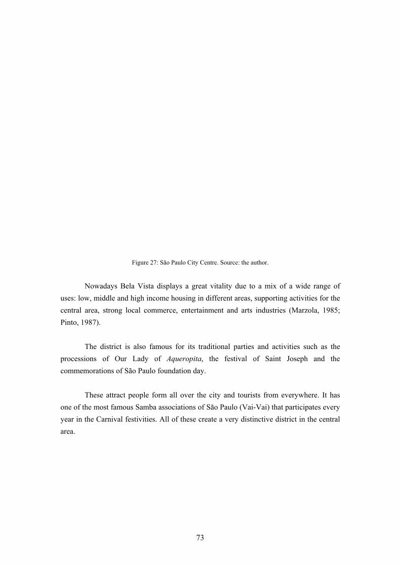
Figure 27: São Paulo City Centre. Source: the author.
Nowadays Bela Vista displays a great vitality due to a mix of a wide range of uses: low, middle and high income housing in different areas, supporting activities for the central area, strong local commerce, entertainment and arts industries (Marzola, 1985; Pinto, 1987). The district is also famous for its traditional parties and activities such as the processions of Our Lady of Aqueropita, the festival of Saint Joseph and the commemorations of São Paulo foundation day. These attract people form all over the city and tourists from everywhere. It has one of the most famous Samba associations of São Paulo (Vai-Vai) that participates every year in the Carnival festivities. All of these create a very distinctive district in the central area.
73

Figure 28: Avenida Paulista. Source: the author.
74

4.3.3 Land Use and Character Studies of the city planning departments (PMSP, 1974; 1985a) show the characteristics of the district. According to these studies (map 1) the areas under the influence of the major avenues, Paulista, 9 de Julho and Brigadeiro Luis Antonio, and the area close to the City Centre have suffered a process of redevelopment characterised by high rise buildings sometimes of more than 10 storeys. Avenida Paulista and the City Centre host business districts; Brigadeiro Luis Antonio diverse activities and 9 de Julho low and middle income housing (map 2). The areas under Avenida Paulista's influence are characterised by high income residential developments (figure 29).
Figure 29: New residential developments. Source: the author.
75
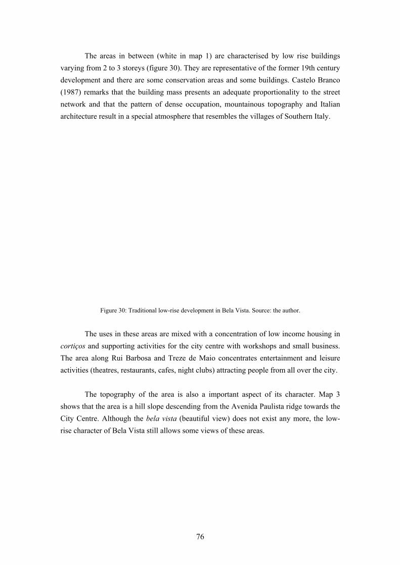
The areas in between (white in map 1) are characterised by low rise buildings varying from 2 to 3 storeys (figure 30). They are representative of the former 19th century development and there are some conservation areas and some buildings. Castelo Branco (1987) remarks that the building mass presents an adequate proportionality to the street network and that the pattern of dense occupation, mountainous topography and Italian architecture result in a special atmosphere that resembles the villages of Southern Italy.
Figure 30: Traditional low-rise development in Bela Vista. Source: the author.
The uses in these areas are mixed with a concentration of low income housing in cortiços and supporting activities for the city centre with workshops and small business. The area along Rui Barbosa and Treze de Maio concentrates entertainment and leisure activities (theatres, restaurants, cafes, night clubs) attracting people from all over the city. The topography of the area is also a important aspect of its character. Map 3 shows that the area is a hill slope descending from the Avenida Paulista ridge towards the City Centre. Although the bela vista (beautiful view) does not exist any more, the low-rise character of Bela Vista still allows some views of these areas.
76

4.4 PROPOSALS FOR BELA VISTA 4.4.1 Guidelines to Promote Land Use Diversity and the Character. It was argued in the last chapter that the present zoning law is the main factor responsible for the destruction of land use diversity and the character of the place. It was also suggested that guidelines could be drawn up to promote these qualities instead. This Section will develop some guidelines for the areas that still retain their character and mixture of uses in order to protect them from inadequate development. According to the present zoning ordinance (map 4) most of these areas belong to zones Z3, Z10 and Z12. The zoning law defines these areas as predominantly residential, of medium density with a FAR of 2.5:1 but reaching to 4:1 where plot area coverage is reduced to 35% (PMSP, 1986). The minimum setback for new buildings is 5m at both front and back, 1.5m for one lateral side up to the first floor and 3m for both lateral sides above the first floor. The minimum plot dimensions are 10m wide and 250m² in area. A new development in the area according to the present legislation would strongly contrast with the existing buildings (figure 31).
Figure 31: New development according to the present legislation. Source: the author.
77

The harmonisation of the new and the old development must be achieved by rules based on the surrounding built environment. The building envelope should be defined through analysis of the average heights, plot coverage, frontal and lateral setback of the surrounding buildings (figure 32). Entrances and fenestration should follow the existing rhythm and details such as rooftops, doors and steps should be based on the existing pattern.
Figure 32a: Proposed building envelope, plan. Source: the author.
Figure 32b: Proposed building envelope, elevation. Source: the author.
78

At the areas that present a mixture of uses the guidelines should locate retail or commercial uses on the ground floor and residential uses in the upper floors or at the back (figure 33). The size of lots in new developments should also be controlled to favour small business rather then larger ones and front setbacks should be avoided.
Figure 33: Guidelines for mixed use areas. Source: the author.
The importance of topography should be stressed. Buildings should be designed with regard to topography, subdivided into small units descending from the hills in steps. The surviving views towards the City Centre or Avenida Paulista should be protected by restricting the heights of buildings which might block them (figure 34).
Figure 34: Guidelines protecting the surviving views. Source: the author.
79

4.4.2 The Traffic Problem As was argued above, the Bela Vista lies in the central area where the city's structural road network is to be found. This results in the presence of heavy through-traffic in the neighbourhood. Map 5 shows the main roads and the concentration of through and local traffic. Through traffic is concentrated in main roads although some of it is concentrated on other types of streets. According to map 5 almost the whole district is under the influence of the public transport system of 400m radius (Murrain, 1993). Major public transport is to be found in the Avenida Paulista (underground and buses), Brigadeiro Luis Antonio (buses), Rui Barbosa/Treze de Maio (buses), 9 de Julho (trolleybus and buses). According to Rolnik (1991) the share of daily trips for each mode of transport in the São Paulo Metropolitan Region is as follows: 35% public transport, 28.8% private vehicles, 36% pedestrian trips. The lowest income population is responsible for 45% to 55% of this latter. Considering that great part of the population of the Bela Vista belongs to the lowest income groups and that the region is very well served by public transport, measures to restrain traffic are necessary to guarantee the security and the quality of the environment of this area. 4.4.3 Traffic Calming Measures The first step taken should be to classify the roads according to their priority. Through-traffic should be kept to the main avenues that would become traffic areas. Other traffic roads with the presence of pedestrian movement generators such as schools, commerce and service activities should be classified as mixed priority areas. The remaining areas where living functions take priority would constitute the environmental areas (map 6). The calming measures should vary according to the road classification. According to Devon County Council (1991), the measures for traffic areas should consist of road markings, central islands, greenery to reduce the optical width, street furniture and lighting (figure 35).
80

Figure 35: Traffic calming measures for traffic roads. Source: the author.
The mixed priority areas should have measures to restrict speeds to below 45 kph (30 mph). These would consist of vertical shifts, narrowing of the available roadscape to 5.5m and reduction of optical width through tree planting (figure 36). The environmental or living areas should have measures to restrict speed to below 30 kph (20 mph). These would consist of lateral and vertical shifts, narrowing of the available roadscape to 3.25m, reduction of optical width through tree planting and provision of equipment and activities that reinforce the residential aspect of the streets, such as playground, siting or cycling areas (figure 37).
Figure 36: Traffic calming measures for mixed priority roads. Source: the author.
81

Figure 37: Traffic calming measures for residential areas. Source: the author.
4.4.4 Land Speculation The fact that the zones Z3, Z10 and Z12 permit a FAR of up to 4:1 creates a developable potential for high-rise residential buildings in the area. As was mentioned before, areas with a FAR of 4:1 correspond to only 10% of the city area and suffer from great speculative pressures. However despite this most of the area remains low rise as shown in map 1. The reason why the area has not been developed to its maximum potential can be explained by its state of decay and deprivation. According to COGEP (PMSP, 1974) private developers interviewed say they do not invest in the area due to the presence of low class neighbours, the proliferation of deprived buildings and the difficulty in assembling lots due to their small dimensions. The same report mentions that developers would invest in the area if it were made more attractive, and therefore undertook a process of urban renewal, as the area is still considered for middle income residential buildings due to its central position and infrastructure. According to a land market research in the property section of a São Paulo newspaper (Datafolha, 1994) seven new one bedroom flats have recently been for sale in the area with an average price of R$1,189/m² (£858/m²). According to the same report the price of the area ranks the 17th highest out of 40 regions surveyed in the city, the minimum being R$679/m² (£490/m²) in the far east end periphery and the maximum being R$1,949/m² (£1,400/m²) in the high class neighbourhood of Jardins.
82

In the last chapter it was suggested that the use of TDR is a way to avoid land speculation. The areas where this mechanism should be located are the low-rise areas in the neighbourhood (map 7). To reinforce the character the new permitted densities should be based on existing densities and on the average FAR of the existing buildings. The difference between the new permitted densities and the established FAR should be bought by the city hall and transferred to areas which the planners consider of interest to developers. The receptor areas should be those whose infrastructure is under-utilised, capable to attract investment where the permitted FAR has not been revised yet, still remaining low. 4.4.5 Community Participation As has already been explained, the Bela Vista has strong community life full of traditions, parties and festivities. The district has 2 neighbourhood associations União do Bixiga and Sociedade de Defesa das Tradições e Progresso da Bela Vista - SODEPRO that act in the interest of the neighbourhood and promote parties, traditional festivities and social relations. These associations together with other district associations such as the Vai-Vai and local merchants should form a team to work with official professionals on the elaboration of the district plan and definition of priorities thereby enhancing their participation in the decision making process as explained in previous sections of this chapter.
83

4.5 CONCLUSION Urban planning in São Paulo is a recent phenomenon. It dates from the end of last century when it was mostly concerned with city beautification and slum eradication. Afterwards major attention was given to accessibility, circulation and traffic. Since 1972 urban planning has been institutionalised in the zoning law. Nowadays the planning and decision making processes are centralised too much and community participation is only possible through neighbourhoods and another representative associations. It has thus become necessary to define levels of power and to create ways to ensuring community participation. This could be achieved by defining two levels of planning. At the municipal level general decisions concerning the whole city should be taken. The planning authority, together with associations representative of society, should prepare urban development guidelines to apply to the whole city. At the local level priorities should be defined by local authorities together with neighbourhood and other kinds of local associations. They would be responsible for the elaboration of the district plan. This would consist of policies at a local level concerning infrastructure expansion, design guidelines, traffic measures, etc. As an example of a district where the lessons of the international experience in urban regeneration could be applied is the Bela Vista district. This district is highly representative of the traditional inner neighbourhoods of São Paulo. It presents a mixture of land uses with residential uses, supporting activities for the city centre, strong local commerce and entertainment and tourism industries. In order to promote the good qualities still present in this neighbourhood, as explained in the previous chapter, design guidelines should reinforce land use diversity and the preservation of the character of the place based on the architecture and topography.
84

It was suggested that commercial activities should be located on the ground floor whilst residential use should be restricted to the upper floors and the backs. The building envelopes should be defined on the basis of the average of setback, height, plot coverage. Views and the topography should be addressed by controlling the heights and position of buildings. Measures should be taken to minimise the traffic problem. Trough-traffic should be restricted to major roads by physical and legal measures that would restrain it in residential areas. Vertical and lateral shifts, narrowing of roads, reduction of optical width, greenery and leisure activities are some of the measures proposed to reduce vehicular speed and give a more residential aspect to the roads. As the district lies between the two major business districts it suffers from pressures of land speculation. However, a great part of it is still low-rise despite being surrounded by high-rise neighbourhoods. For these areas it has been suggested that the use of the transfer of development rights would be a way of avoiding land speculation and subsequent population displacement and the destruction of the character of the area. Finally this neighbourhood enjoys strong community life that is represented by its neighbourhood and other kinds of associations. These represent the neighbourhood interest and promote leisure, social and cultural activities. They could work together with official professionals to elaborate the district plan and establish priorities, ensuring community participation in the decision making process.
85

CONCLUSION The major economic restructuring that has occurred since the end of World War II has caused a dramatic change in the world scene. The New International Division of Labour has caused a shift of industries from industrialised to the Newly Industrialising Countries. As a result the whole pattern of urban development has changed in both types of countries. In the former the deindustrialisation process, allied to the development of the car industry and the rise of a new suburban pattern of middle class life has resulted in the problem of urban decline. This problem is characterised by the population and economic decline especially of inner cities caused by closure of factories, shipyards, warehouses and middle classes migration to the outskirts of the city. As a result these areas concentrate lower income sectors of the population and experiences high rates of unemployment, physical decay, traffic, pollution, a great increase in commercial activities, a reduction in residential uses and lack of public open space. In Third World countries the industrialisation process was the main factor responsible for the urban explosion. Thousands of migrants were attracted to expanding cities in search of better opportunities. For the élites of these countries the internationalisation of the economy provoked the spread of 'western' way of life. However the process of social development did not match the pace of urban growth and economic development and many governments could not provide either jobs or housing for an enormous sector of their population. The formal housing market of these countries has been unable to cope with the intensive growth and as a result there has been a proliferation of alternative forms of housing such as slum tenements, shanty towns and illegal developments. The formal sectors were also unable to provide sufficient jobs to the rapidly expanding population. As a consequence a considerable part of the population could only find opportunities in the so-called 'informal' sectors. The city of São Paulo, Brazil, is a good example of a rapidly urbanising Third World city growing 500 times in a little more than a century. The economic development due to coffee exportation allowed the city to begin its process of industrialisation at the beginning of the century. This process was afterwards accentuated by the establishment of multinational corporations in the city and its metropolitan area, especially car manufacturing industries.
86
The pattern of urban development however grew out of control. The city grew through the redevelopment of its central area and suburban sprawl. Traditional working class neighbourhoods were destroyed in a process of urban renewal displacing the poor population to the distant periphery to be replaced by higher income high-rise developments. From a social point of view this process has been shown to be negative as the displaced population has to spend more on transport and lives further from job opportunities concentrated in the central areas and usually living in worse conditions. The planning process, instead of minimising this problem, has helped to legitimate it through the establishment of zoning laws that took little account of the existing city. Land speculation has greatly influenced the way the city grew and roads and fly-over improvements and construction took precedence over more important priorities. The centralisation of power in the planning process, allied to the political problems of the country, inhibited community participation in the planning process. However, despite of the lack of official channels to ensure community participation, neighbourhood associations have fought to have their priorities addressed. The growth of the city has had a very negative impact on the traditional inner residential neighbourhoods. Apart from population displacement, the new high-rise residential developments destroyed the existing diversity of uses based on small business and informal sectors of the economy which are very important to a significant part of the population. The new pattern of growth also destroyed the identification of the inhabitant with the city resulting in an impoverishment of its social, cultural and affective relations. The priority given to road works was also negative resulting in the destruction of the physical continuity of many neighbourhoods and, far from solving the problems of traffic, brought traffic hazards and pollution to the central areas. The concentration of traffic in these areas has been showed to be negative as it inhibits the use of traditional streets for leisure and social activities. However the problems suffered by the central areas of São Paulo are not specific to this city. Many cities in the world have faced the same problems and have developed strategies to tackle these problems. The international experience shows a particular interest in subjects related to land use diversity, harmonisation of the existing and new developments, traffic calming measures, combating land speculation and involvement of neighbourhood associations in the planning process.
87

Based on these experiences it was suggested that two levels of planning should be defined: one municipal concerned with general interests, the other local concerned with local matters. Both would involve community participation in the elaboration of plans and the definition of priorities. At the municipal level matters of general interest, such as public transport, housing, economic and industrial policies, densities according to the capacity of infrastructure and geomorphology and respect for the environment, should be defined. Public participation would be involved in the elaboration of the general urban development guidelines through the collaboration of public officials and members of associations representative of society. Community participation at a local level could happen through the involvement of neighbourhood associations in the elaboration of district plans. This district plans would work within the urban development guidelines and together would constitute the city's master plan. They would comprise permitted densities, design guidelines, traffic calming measures as well as infrastructure expansion. Together with local officers these associations would be responsible for defining priorities. In order to check the applicability of the international experience at the local level, a particular district of the central area of São Paulo was chosen. This district was chosen because of its characteristics of low-rise development, concentration of the poorest sector of the population, heavy traffic, lack of public open space and high land speculation pressures. For this district the following measures were suggested: the adoption of design guidelines to promote land use diversity, harmonisation between old and new buildings and the character of the place; orientation of traffic and traffic calming measures; use of transfer of development rights to cope with land speculation; and involvement of neighbourhood associations in the decision making process The design guidelines suggested the promotion of commercial activities in the ground floor and residential use in upper floors. Setback, heights, plot coverage and densities should be defined on the basis of the existing urban pattern. Existing views and the topography should also be addressed. These measures would enhance the identification of the inhabitant with his/her neighbourhood as well as to provide the physical support for informal actives.
88

Through-traffic should be confined to main avenues by physical and legal measures restraining it in residential areas. Residential streets would be able to develop their social function hosting activities such as meetings, traditional parties, playgrounds, sitting, resting and cycling areas. Finally, land speculation should be tackled by the use of the transfer of development rights mechanism that would take speculative pressures off inner city neighbourhoods. This would avoid the displacement of the poorest sector of the population by a redevelopment process. The transferable development potential should be transferred to areas capable to attract investment, with under-utilised infrastructure which permitted densities are still low. This dissertation has tried to show that the urban development and planning processes the way in which they occurred in São Paulo, led by land speculation reasons, have had very negative effects severely damaging the quality of life of its lower income population. It has also negatively affected matters of interest to the population as a whole. This dissertation has tried to understand these processes and to suggest ways of improving them. As a result a series of mechanisms was suggested that seemed to have been successful elsewhere and which could feasibly be applied to the context of São Paulo in an effort to enhance the quality of life of the city's inhabitants.
89

BIBLIOGRAPHY APPLEYARD, D. (1981) Livable Streets. Berkeley and Los Angeles: Univeristy of California Press. ARNSTEIN, S. (1969) "A Ladder of Citizen Participation". Journal of American Institute of Planning, vol. 35, number 4, July, pp. 216-224. BARNETT, J. (1982) An Introduction to Urban Design. New York: Harper and Row Publishers. BATLEY, R. (1982) "Urban Renewal and Expulsion in São Paulo". In: GILBERT, A. & HARDOY, J. (op. cit.), pp. 231-262. BATLEY, R. (1983) Power through Bureaucracy: Urban Political Analysis in Brazil. Aldershot: Gower Publishing Co. Ltd. BAVA, S. C. (1993) "Urban Policies for Social Transformation: the Case Study of São Paulo". Cities, vol. 7, number 1, February, pp. 60-64. BENTLEY, I. et al (1985) Responsive Environments: a Manual for Designers. Oxford: Butterworth-Heinemman, Ltd. BOLAFFI, G. (1992) "Urban Planning in Brazil: Past Experience, Current Trends". Habitat International, vol. 16, number 2, pp. 99-111. BRADBURRY, K. et al (1982) Urban Decline and the Future of American Cities. Brookings Institution: Washington, D.C. BUCHANAN, C. (1963) Traffic in Towns. London: HMSO. BUTTERWORTH, D. (1981) Latin America Urbanisation. Cambridge: Cambridge University Press.

CALDEIRA, T. (1984) A Politica dos Outros: o que pensam os moradores da periferia do poder e dos poderosos. São Paulo: Editora Brasiliense. CALDEIRA, V. (1986) "A Cidade Arquitetural e a Arquitetura da Cidade". Projeto, number 85, March , pp. 80-85. CAMMACK, P. (1993) "Brazil". In: EUROPA PUBLICATIONS South America, Central America and the Caribbean 1993. London: Europa Publications, pp. 132-162. CAMPOS FILHO, C. M. (1989) Cidades Brasileiras: Seu Controle ou o Caos. São Paulo: Livraria Nobel. CARMON, N. & HILL, M. (1988) "Neighbourhood Rehabilitation without Relocation or Gentrification". Journal of American Planning Association, vol. 54, number 4, pp. 470-481. CASTELLS, M. (1978) "Urban Social Movements and the Struggle for Democracy: the Citizens' Movement in Madrid". International Journal of Urban and Regional Research, vol. 2, number 11, pp. 133-146. CASTELLS, M. (1983) The City and the Grassroots. London: Edward Arnold. CASTELLS, M. (1989) The Informational City. Oxford: Blackwell. CASTELO BRANCO, B. (1987) "Renovação Urbana no Bexiga". Revista Arq, number 2, November, pp. 11-12. COUCH, C. (1990) Urban Renewal. London: Mc Millan. CULLINGWORTH, J. (1993) The Political Culture of Planning. New York: Routledge. DATAFOLHA (1994) "Bairros em numeros". Folha de São Paulo, 9th October, Imoveis section, p. 3.

DAVIES, H. et al (1989) Planning Control in Western Europe. London: HMSO. DELAFONS, J. (1990) Aesthetic Control, a report on methods used in the USA to control the design of buildings. Institute of Urban and Regional Development, monography 41. Berkeley: University of California. DEL RIO, V. (1990) Introdução ao Desenho Urbano no Processo de Planejamento. São Paulo: Editora Pini. DEL RIO, V. (1992) "Urban Design and conflicting city images of Brazil". Cities, vol.9, number 4, pp. 270-279. DESSAI, A. & PILLAI, D. (1990) Slums and Urbanization. London: Sangan Books. DEVAS, N. & RAKODI, C. (1993) Managing Fast Growing Cities. Harlow: Longman. DEVON COUNTY COUNCIL (1991) Traffic Calming Guidelines. Devon: Devon County Council, Engineering and Planning Department. ELKIN, T. et al (1991) Reviving the City: towards a Sustainable Development. London: Friends of Earth. EUROPEAN CONFERENCE OF MINISTERS OF TRANSPORT (1982) The Future of the Use of the Car. Paris: European Conference of Ministers of Transport. FAINSTEIN, S. (1990) "The Changing World Economy and Urban Restructuring". In: JUDD, D. & PARKINSON, M. (eds.) Leadership and Urban Regeneration. Newburry Park: Sage Publictions, pp. 31-47. FEAGIN, J. & SMITH, M. (1987) "Cities and the New International Division of Labor: an overview". In: FEAGIN, J. & SMITH, M. (eds.) The Capitalist City. Oxford: Basil Balckwell, pp. 3-34.

FLYNN, P. (1978) Brazil: a Political Analysis. London: Ernest Benn. FRANKLIN, B. et al (1991) Issues in Urban Regeneration: an Annotated Bibliography. Occasional Papers in Architecture and Urban Design, number 1, Manchester: School of Architecture, Univ. of Manchester. FRIEDMANN, J. & WOLFF, G. (1982) "World city formation: an agenda for research and action". International Journal of Urban and Regional Studies, vol. 6, number 3, September, pp. 309-344. FROBEL, F. et al (1980) The new international division of labour: structural unemployment in industrialized countries and the industrialisation of developing countries. Cambridge: Cambridge University Press. GEOMAPAS (1988) Código Geomapas de Zoneamento do Município de São Paulo. São Paulo: Geomapas Editora de Mapas e Guias Ltda. GIBSON, M. & LANGSTAFF, M. (1982) An Introduction to Urban Renewal. London: Hutchinson & Co. Ltd. GILBERT, A. & HARDOY, J. (eds.)(1982) Urbanisation in Contemporary Latin America.Chichester: John Wiley and Sons. GIMENEZ, H. E. (1979) "Estudo de Implantação do Instrumento Transferência dos Direitos de Construir (Solo Criado) Aplicado às Áreas Históricas do Município de São Paulo". In COGEP/PMSP Política de Controle de Uso e Ocupação do Solo e Política de Preservação dos Bens Culturais. São Paulo: COGEP, pp. 187-192. GODSCHALK, D. & ZEISEL, J. (1983) "Coproducing Urban Renewal in the Netherlands". In: SUSSKIND, L. & ELLIOTT, M. (eds.)(op. cit.), pp. 291-341. GOHN, M. G. (1982) Reinvidicações Populares Urbanas. São Paulo: Cortez Editora. HADDAD, E. (1982) "Report on Urban Land Market Research in São Paulo, Brazil". In: CULLEN, M. & WOLLERY, S. (eds.) World Congress on Land Policy. Lexington: Lexington Books, pp. 201-215.

HARDOY, J. (1982) "The Building of Latin American Cities". In: GILBERT, A & HARDOY, J. (eds.)(op. cit.), pp. 19-33. HARVEY, D. (1989) The Condition of Post Modernity. Oxford: Blackwell. HERBERT, D. et al (1993) Cities in Space: City as Place. London: David Fulton Publishers. HMSO (1977) Policy for the Inner Cities. London: HMSO. HOLCOMB, H. & BEAUREGARD, R. (1981) Revitalizing Cities. Washington: Association of American Geographers. HOLLYDAY, J. (1973) City Centre Redevelopment. London: C. Knight. INSTITUTO DE ENGENHARIA (1988) A Cidade de São Paulo: Caminhos Possíveis. São Paulo: Instituto de Engenharia. JACOBS, J. (1961) The Death and Life of Great American Cities. New York: Random House. JONES, C. (1979) Urban Deprivation and the Inner City. London: Croom Helm. KNOX, P. (1982) Urban Social Geography. London: Longman Education. KOWARICK, L. et al (1994) Social Struggles and the City: The Case of São Paulo. New York: Monthly Review Press. KOWARICK, L. & BONDUKI, N. (1994) "Urban Space and Political Space". In: KOWARICK, L. et al (op. cit.), pp. 121-147. KOWARICK, L. & SINGER, A. (1994) "The Workers Party in São Paulo". In: KOWARICK, L. et al (op. cit.), pp. 225-256.

LAWLESS, P. (1989) Britain's Inner Cities. Second Edition, London: Paul Chapman Publishing Ltd. LOZANO, E. (1990) Community Design and the Culture of Cities. Cambridge: Cambridge University Press. LYNCH, K. (1981) A Theory of Good City Form. Cambridge: Massachusetts Institute of Technology. MARZOLA, N. (1985) Bela Vista: Historia dos Bairros de São Paulo. São Paulo: DPH. MARQUES, M. T. (1989) "Preservação: Longe do Prejuízo". A Construção São Paulo, number 2,149, 17th April, pp. 8-9. MARQUES, M. T. (1991) "Plano Diretor: Cidade Potencial". A Construção São Paulo, number 2,243, 4th Febr., pp. 5-8. MARX, M. (1991) Cidade no Brasil: terra de quem? São Paulo: Nobel SA. MAWAKDIYE, A. (1987) "Nosso Modelo Viario: Obsoleto, Provinciano". Shopping/City News - Jornal da Semana, 8th February, pp. 3. MORSE, R. (1971) "São Paulo: case study of a Latin American metropolis". In: RABINOVITZ, F. & TRUEBLOOD, F. (eds.) Latin America Urban Research. Beverly Hills: Sage Publications, pp. 151-186. MOUDON, A. (1986) Built for Change. Cambridge: Massachusetts Institute of Technology. MURRAIN, P. (1993) "Urban Expansion: look back and learn". In: HAYWARD, R. & MCGLYNN, S. (eds.) Making Better Places: Urban Design Now. Oxford: Butterworth Architecture, pp. 83-94.

NAUTA, C. et al (1982) "Rotterdam Case Study". In: NELISSEN, N. (rep.) Urban Renewal Participation Experiments. Nijmegen: Council of European Municipalities, pp. 233-244. OECD (1983) Managing Urban Change. Paris, OECD. OLIVEIRA, C. & LEITTMAN J. (1994) "Urban Environment Profile - São Paulo". Cities, Vol. 11, number 1, Jan., pp. 10-14. OLIVEIRA, J. (1989) Constituição da República Federativa do Brasil. São Paulo: Editora Saraiva. OSSELO, M. A. (1986) "Planejamento Urbano em São Paulo: 1899-1961". Projeto, number 87, May, pp. 79-85. PERLMAN, J. (1983) "Citizen Action and Participation in Madrid". In: SUSSKIND, L. & ELLIOTT, M. (eds.)(op. cit.), pp. 207-235. PHAROAH, T. (1992) Less Traffic, Better Towns. London: Friends of Earth. PINTO, V. (1987) "A cidade muda, mas o Bexiga resiste e mantem as tradições". Guia Projeto, edição 105, November, pp. 4-8. PMSP (1974) Bela Vista - Z08.010 - Plano de Renovação Urbana. São Paulo: COGEP. PMSP (1985a) Bens Culturais e Arquitetônicos do Município e Região Metropolitana de São Paulo. São Paulo: SEMPLA. PMSP (1985b) Plano Diretor do Município de São Paulo. São Paulo: SEMPLA. PMSP (1985c) Inventário da Bela Vista. São Paulo: DPH. PMSP (1986) Restrições da Legislação de Uso e Ocupação do Solo. São Paulo: SEHAB.

PMSP (1992a) Plano Diretor do Município de São Paulo. São Paulo: SEMPLA. PMSP (1992b) O Poder em São Paulo: História da Administração Pública na Cidade de 1554 a 1992. São Paulo: Cortez Editora POTTER, R. (1992) Urbanisation in the Third World. Oxford: Oxford University Press. RAMATI, R. (1981) How to save your own street. New York: Dolphin Books. RAPKIN, C. (1980) "An Evaluation of the Urban Renewal Experience in the USA". In: KOENIGSBERGER, O. et al The Work of Charles Abrams. Oxford: Pergamon Press, pp. 181-192. ROBINSON, F. (1989) Urban Regeneration Policies in Britain in the late 1980s: Who Benefits ? Centre for Urban and Regional Development Studies, discussion paper number 94. New Castle Upon Tyne: University of New Castle Upon Tyne. ROBSON, B. et al (1994) Assessing the Impact of Urban Policy. London: HMSO. ROLNIK, R. et al (1991) São Paulo: Crise e Mudança. São Paulo: SEMPLA. ROTHBLATT, D. et al (1986) Suburbia, an International assessment. Croom Helm: London. SANTOS, C. N. & VOGEL, A. (1981) Quando a Rua Vira Casa. Rio de Janeiro: Centro de Pesquisas Urbanas. SANTOS, C. N. (1986) "Preservar não é tombar, renovar não é por tudo abaixo". Projeto, number 86, April, pp. 59-63. SCHAEFFER, K. (1976) São Paulo: Urban Development and Employment. Geneve: International Labour Office. SISTEMA CARTOGRÁFICO METROPOLITANO (1985) Levantamento Aerofotogramétrico da Região Metropolitana de São Paulo. São Paulo: Secretaria de Negócios Metropolitanos.

SUSSKIND, L. & ELLIOTT, M. (eds.)(1983) Paternalism, Conflict and Coproduction. New York: Plenum Press. TOLEDO, B. L. (1983) São Paulo: Três Cidades em um Século. São Paulo: Duas Cidades. VALLADARES, L. (1988) "Urban sociology in Brazil: a research report". International Journal of Urban and Regional Research, vol. 12, number 2, pp. 285-302. WEBBER, M. (1964) "The Urban Place and the Non-Place Urban Realm". In: WEBBER, M. (ed.) Exploration into the Urban Structure. Philadelphia: University of Pennsylvania Press, pp. 79-153. WILHEIM, J. (1984) "City Profile: São Paulo". Cities, vol. 6, number 4, November, pp. 538-543. WILHEIM, J. (1992) "Urban Planning in Brazil: the Case of an Ill-developed though Modern Country". Habitat International, vol. 16, number 2, pp. 65-71. WORLD COMMISSION ON ENVIRONMENT AND DEVELOPMENT (1987) Our Common Future. Oxford: Oxford University Press. ZACHARIAS, J. (1993) "TDR for the Design of Urban Districts". Cities, vol. 10, number 4, November, pp. 299-312.