Embed Size (px)
Citation preview
Index Table of contents
Total Field Magnetic Anomaly Map of Italy andSurrounding Marine Areas at Sea Level.Recent Compilation and Scientific Significance
A. Meloni1, C. Carmisciano1, M. Chiappini1, O. Faggioni1 and I. Marson2
1Istituto Nazionale di Geofisica e Vulcanologia, via di Vigna Murata 605, Roma, 2Università di Trieste and OGS
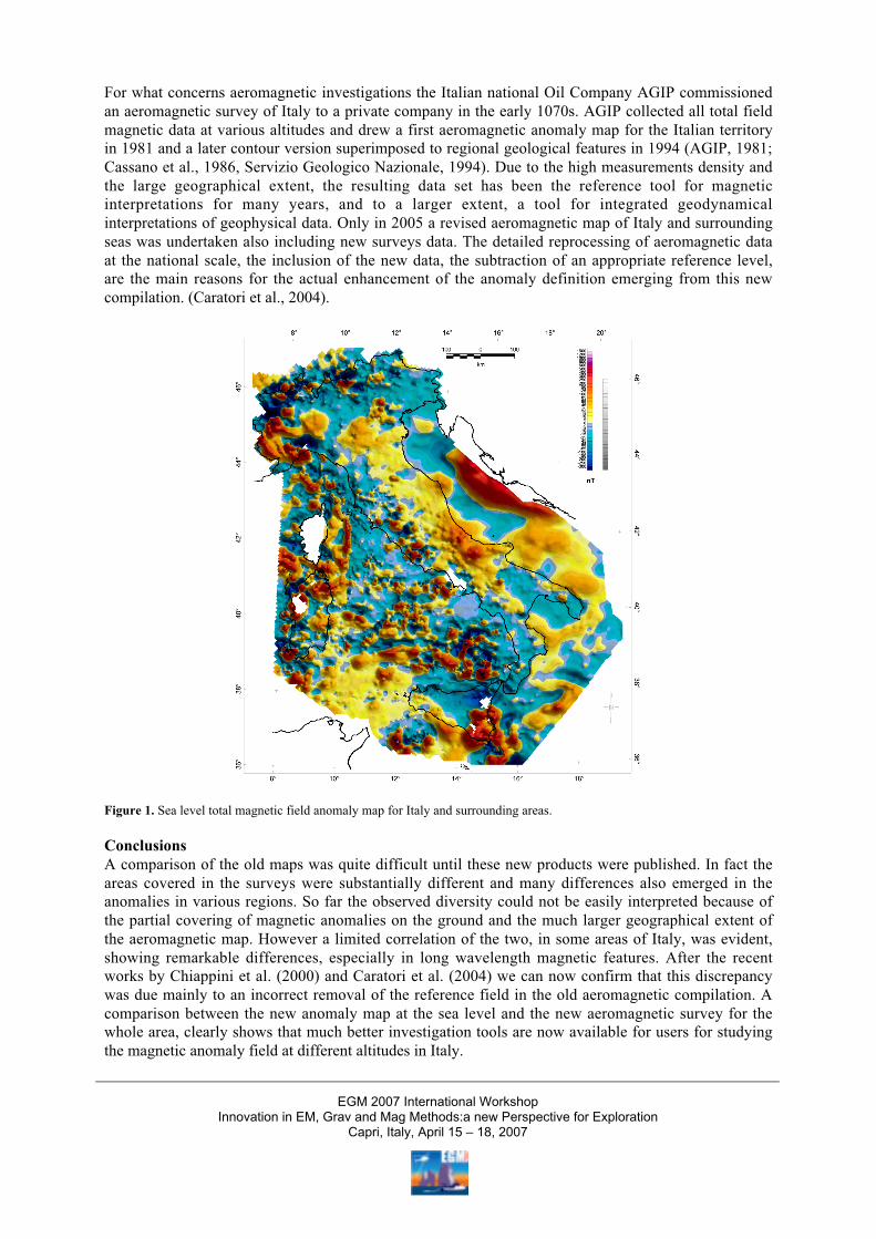
SummaryA shaded relief magnetic anomaly map of total intensity of the Earth’s magnetic field for Italy and thesurrounding seas has been produced at sea level, for the geomagnetic epoch 1979.0 (see Chiappini etal., 2000). Magnetic observations were made on shore within the framework of Progetto FinalizzatoGeodinamica of the Consiglio Nazionale delle Ricerche (PFG-CNR) between 1977 and 1981. The offshore data were taken during the period 1965-1972 by the Osservatorio Geofisico Sperimentale(OGS). This new compilation gives an unprecedented view of the magnetic anomaly field of the wholearea at ground level, which contains many imprints of the major tectonic elements of Italy, andportrays their regional characterization. In 2004 Caratori et al. have undertaken a detailed reprocessingof old aeromagnetic data taken by AGIP at the national scale, with the inclusion of new data. For thefirst time now the ground level map and the aeromagnetic map show the existence of common featuresthat allow comprehensive correct scientific investigations.
IntroductionSimilarly to gravity, also in the case of magnetic anomalies the geophysical work required to reachscientific results follows a three step process: a) measurements are taken in the field at the ground, seasurface or above, b) data elaboration, that will lead to anomalies and graphical tools, like maps, andfinally c) interpretation of results, basing on knowledge of the geology of the investigated area. InItaly, if we exclude local or regional scale magnetic investigations, efforts on a national scale devotedto realization of a national scale magnetic anomaly map started in the 1970s. Under the framework ofthe Progetto Finalizzato Geodinamica (PFG, sponsored by Consiglio Nazionale delle Ricerche CNR),Istituto Nazionale di Geofisica (ING, now INGV) involving also several Universities, carried out afirst and second order ground magnetic network for the determination of total field (and othermagnetic field elements) across the Italian peninsula and major islands. This work brought to the firstground magnetic total field anomaly map for the land areas (Molina et al., 1985; CNR-PFG, 1986 alsoin Molina et al., 1994). In the same years the Osservatorio Geofisico Sperimentale (OGS) started along series of geophysical investigations in the Mediterranean sea including magnetics (total magneticfield) and published a few sector maps for the seas surrounding Italy (Morelli et al., 1969; Morelli,1970; Morelli, 1972).
MethodologyOnly around the year 2000 INGV, with the involvement of the then Istituto di Geofisica Marina ofConsorzio Universitario di La Spezia (CUNISPE) and the OGS, launched and coordinated a program,for the realization of a digital database of magnetic anomaly, for the Italian land area and thesurrounding seas by means of the compilation of all existing marine and ground total magnetic fielddata all over and around the Italian peninsula. The realization of an integrated total magnetic fieldanomaly map took advantage of the most recent data processing techniques and the experiencegathered during the last years. The merged color shaded relief magnetic anomaly map is the finalresult of this coordinated work (see Chiappini et al., 2000).
EGM 2007 International WorkshopInnovation in EM, Grav and Mag Methods:a new Perspective for Exploration
Capri, Italy, April 15 – 18, 2007
For what concerns aeromagnetic investigations the Italian national Oil Company AGIP commissionedan aeromagnetic survey of Italy to a private company in the early 1070s. AGIP collected all total fieldmagnetic data at various altitudes and drew a first aeromagnetic anomaly map for the Italian territoryin 1981 and a later contour version superimposed to regional geological features in 1994 (AGIP, 1981;Cassano et al., 1986, Servizio Geologico Nazionale, 1994). Due to the high measurements density andthe large geographical extent, the resulting data set has been the reference tool for magneticinterpretations for many years, and to a larger extent, a tool for integrated geodynamicalinterpretations of geophysical data. Only in 2005 a revised aeromagnetic map of Italy and surroundingseas was undertaken also including new surveys data. The detailed reprocessing of aeromagnetic dataat the national scale, the inclusion of the new data, the subtraction of an appropriate reference level,are the main reasons for the actual enhancement of the anomaly definition emerging from this newcompilation. (Caratori et al., 2004).
Figure 1. Sea level total magnetic field anomaly map for Italy and surrounding areas.
ConclusionsA comparison of the old maps was quite difficult until these new products were published. In fact theareas covered in the surveys were substantially different and many differences also emerged in theanomalies in various regions. So far the observed diversity could not be easily interpreted because ofthe partial covering of magnetic anomalies on the ground and the much larger geographical extent ofthe aeromagnetic map. However a limited correlation of the two, in some areas of Italy, was evident,showing remarkable differences, especially in long wavelength magnetic features. After the recentworks by Chiappini et al. (2000) and Caratori et al. (2004) we can now confirm that this discrepancywas due mainly to an incorrect removal of the reference field in the old aeromagnetic compilation. Acomparison between the new anomaly map at the sea level and the new aeromagnetic survey for thewhole area, clearly shows that much better investigation tools are now available for users for studyingthe magnetic anomaly field at different altitudes in Italy.
EGM 2007 International WorkshopInnovation in EM, Grav and Mag Methods:a new Perspective for Exploration
Capri, Italy, April 15 – 18, 2007

In this paper, after a general information on reduction and processing procedures, the overallscientific result that emerged from the final compilation of the sea level map will also be brieflydiscussed.
ReferencesAGIP SpA. Italia, Carta Magnetica – Anomalie del Campo magnetico residuo, scale 1:500,000, S.
Donato Milanese (Italy), 1981.Cassano E, R Fichera, F. Arisi Rota, Rilievo aeromagnetico d’Italia alcuni risultati interpretativi. V
Convegno Nazionale GNGTS, 19 pp, 1986.Caratori Tontini F., P. Stefanelli, I. Giori, O. Faggioni, and C. Carmisciano, The revised aeromagnetic
map of Italy, Annals of Geophysics, 47, 1547-1556, 2004.Chiappini M., A. Meloni, E. Boschi, O. Faggioni, N. Beverini, C. Carmisciano and I. Marson, Shaded
relief magnetc anomaly map odf Italy and surrounding marine areas, Annali di Geofisica, 43, 5,983-989, 2000.
Molina F., E. Armando, R. Balia., O. Battelli, E. Bozzo, G. Budetta, G. Caneva, M. Ciminale, N. DeFlorentiis, A. De Santis, G. Dominici, M. Donnaloia, A. Elena, V. Iliceto, R. Lanza, M. Loddo,A. MELONI, E. Pinna, G. Santarato, R. Zambrano, Geomagnetic Survey of Italy. RepeatStations Network and Magnetic Maps: a Short Report. Annales Geophysicae, 3, 3, 365-368,1985.
Molina F., E. Armando, R. Balia, O. Battelli, E. Bozzo, G. Budetta, G. Caneva, M. Ciminale, N. DeFlorentiis, A. De Santis, M. Donnaloia, A. Elena, V. Iliceto, R. Lanza, M. Loddo, A. MELONI,E. Pinna, G. Santarato and R. Zambrano, Geomagnetic Survey of Italy. Repeat station networkand magnetic maps, Progetto Finalizzato Geodinamica, Pubblicazione ING, 554, 1994.
Morelli C., M.T. Carrozzo, P. Ceccherini, I. Finetti, C. Gantar, M. Pisani, and P. Schmidt, DiFriedberg, Regional geophysical study of the Adriatic sea, Boll. Geofis. Teor. Appl., 11, (41-42), 3-56, 1969.
Morelli, C., Physiography, gravity and magnetism in the Tyrrhenian sea, Boll. Geofis. Teor. Appl., 12,(48), 275-309, 1970.
Morelli, C., Bathimetry, gravity and magnetism in the strait of Sicily, Saclantcen Conf, Proc. N 7, LaSpezia, 1970.
Servizio Geologico Nazionale, Carta Aeromagnetica d’Italia, 1994.
EGM 2007 International WorkshopInnovation in EM, Grav and Mag Methods:a new Perspective for Exploration
Capri, Italy, April 15 – 18, 2007