Embed Size (px)
DESCRIPTION
Ambraseys and Moinfar, 1977
Citation preview
T h e s e i s n i i e i t y of I r a n :
T h e T o r u d e a r t h q u a k e of ¡ 2 t h f e b r u a r y ¡ 9 5 5
N . N . AMBRASEYS ( * ) - A . A . MOINFAR ( * * )
Received 011 lune 26 lb, 1977
RIASSUNTO. - Il t e r remoto di To rud del 12 Febbraio 1953 ebbe una magni-tudo Ms di 6.4 ed avvenne , dopo un lungo periodo di relativa calma, nella zona di faglia omonima ne l l ' I ran set tentr ionale , una regione desolata ai confini con il Kavir . La scossa fu sentita in un raggio di 290 km e provocò la morte di 800 persone, per lo più nel villaggio di To rud . Non c'è nessuna concreta testi-monianza che il t e r remoto sia s tato associato alla faglia. Ad ogni modo , il sisma causò la l iquefaz ione dei deposili saturi del deserto.
SUMMARY. - The Torud e a r t h q u a k e of 12lh February 1953 had a magn i tude Ms of 6.4 and it occur red , af ter a long period of relat ive quiescence, on the synonymous fault zone in nor thern Iran, a desolate region on the borders of the Kavir . T h e shock was felt wi th in a radius of 290 ki lometres and ¡1 caused the death of about 800 people, mainly in the village of To rud . There is no conclusive evidence that the ea r thquake was associated with faul t ing. However , it did cause the l iquefact ion of sa tura ted desert deposits .
INTRODUCTION.
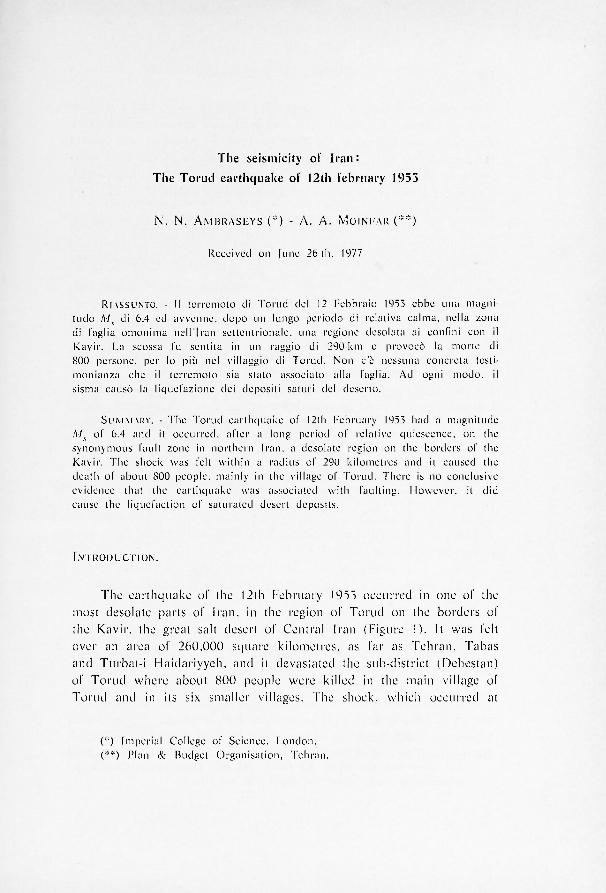
T h e e a r t h q u a k e of t h e 12 th F e b r u a r y 1 9 5 5 o c c u r r e d in o n e of t h e
m o s t d e s o l a t e p a r t s of I r a n , in t h e r e g i o n of T o r u d o n t h e b o r d e r s of
t h e K a v i r , t h e g r e a t s a l t d e s e r t of C e n t r a l I r a n ( F i g u r e I ) . I t w a s f e l t
o v e r a n a r e a of 2 6 0 , 0 0 0 s q u a r e k i l o m e t r e s , as f a r a s T e h r a n , T a b a s
a n d T u r b a t - i H a i d a r i y y e h , a n d it d e v a s t a t e d t h e s u b - d i s t r i c t ( D e h e s t a n )
of T o r u d w h e r e a b o u t 8 0 0 p e o p l e w e r e k i l l e d in t h e m a i n v i l l a g e of
T o r u d a n d in i ts s ix s m a l l e r v i l l a g e s . T h e s h o c k , w h i c h o c c u r r e d a t
(*) Imper ia l College of Science, London . (**) Plan & Budget Organisa t ion , Teh ran .
191 N. N. A M B R A S E Y S - A. A. MO IN FAR
about noon local time on Thursday 25rd Bahman 1331, had a surface-wave magni tude of 6.4 and was associated with ground deformat ions . The event was studied in the field by Prof. S. Abdal ian w h o visited the area shortly a f te r the ea r thquake ('). The results of this field study are invaluable but leave a number of impor tant quest ions unanswered , such as the extent of the meizoseismal area and the nature of the observed ground deformat ions .
In an a t tempt to supplement the informat ion already available about this important ea r thquake in Iran, and also in order to resolve the ambiguity on the nature of the ground deformat ions so far repor ted, the authors visited the site in the spring of 1975.
neighbouring towns where the shock was not felt.

T H E S E I S M I C I T Y OF I R A N : T H E T O R U D E A R T H Q U A K E ETC. 1 8 7
THE TORUD EARTHQUAKE OF 1 2 t h FEBRUARY 1 9 5 3 .
The area afTected by the Torud ear thquake belongs to the wasteland that borders to the northeast the Dasht-i Kavir, the great salt desert of Central Iran, Fig. 1. More specifically, the shock affected the Dehestan of Torud which has an area of 22,000 square kilometres and a total populat ion of about 3 ,200 sedentary people. The Dehestan consists of the capital village of To rud , which, before the ear thquake , had a populat ion of just over 200, and of six smaller villages the populat ion of which does not exceed 500. Out of 120 farmhouses and small sett lements, 50 are uninhabi ted , and most of them are scattered along the main caravan routes to the south and northeast , in the vicinity of copper and turquoise mines.
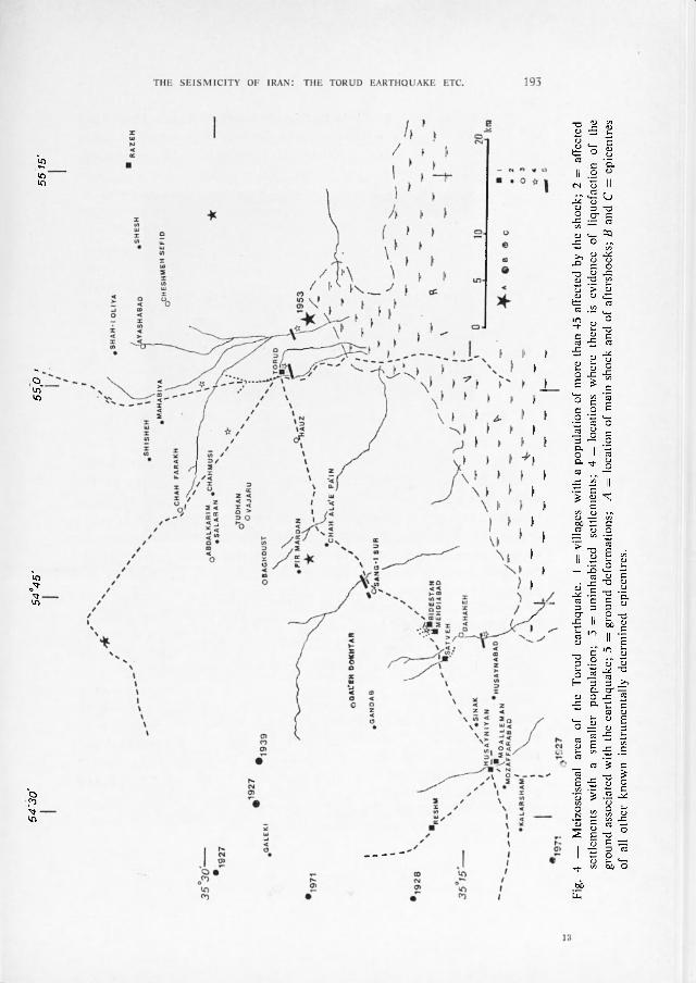
The meizoseismal area of the Torud ear thquake is shown in Fig. 4, together with the re-calculated location of the instrumental epicentre of the main shock (9) and the less accurate location of af tershocks . Table 1 lists the characterist ics of the main shock and of its af tershocks as well as the magni tudes of these events calculated f rom reported ampli tude-period readings.
T A B L E I
Time Epicentre Ms
Feb. 12 081530 35.40 — 55.08 (9) 6.4 (0.2) mp = 6.9 (0.3), r3 = 290 k m ;
r4 = 190 km; rs = 110 km (VI I I )
12 082727 36.00 — 55.00 (») Af te r shock
13 043628 35.60 — 54.70 ( l 2) 4.5 «
Apr . 1 022435 35.50 — 55.20 (3) 4.0 «
Jul. 11 152508 35.90 — 55.10C2) 4.3 (0.2) «
Jul. 24 053056 35.80 — 55.40 ( l 2) 4.5 «
Aug. 24 162030 35.40 — 54.80 4.7 ( ) .3 ) « mp = 5.2 (0.2)
Torud is the largest village affected by the ear thquake . It was built originally on the edge of a 20-metre high terrace, overlooking the desert to the south and about 50 hectars of cultivated land surrounded by waste land. In 1888 the village contained 200 to 250 dwellings. It
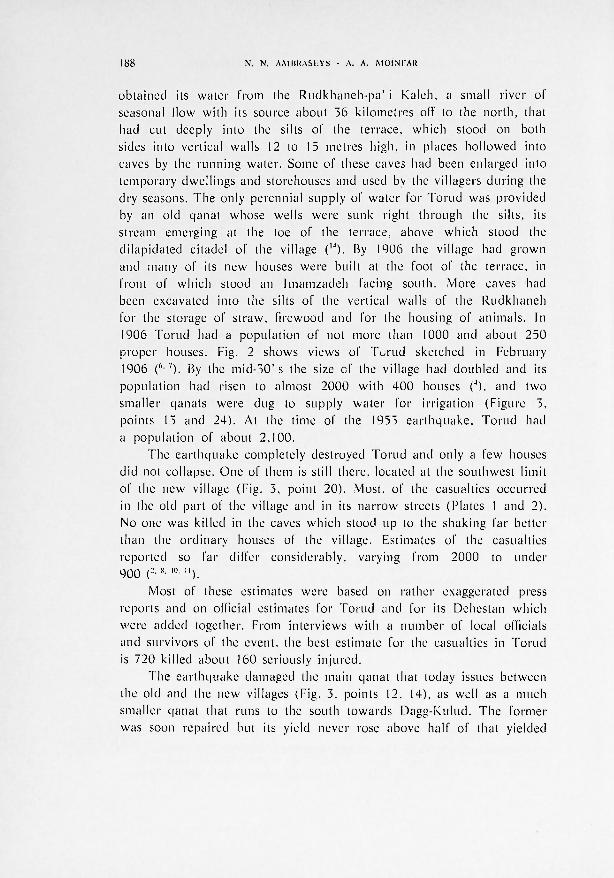
1 8 8 N. N . A M B R A S E Y S - A. A. M O IN FAR
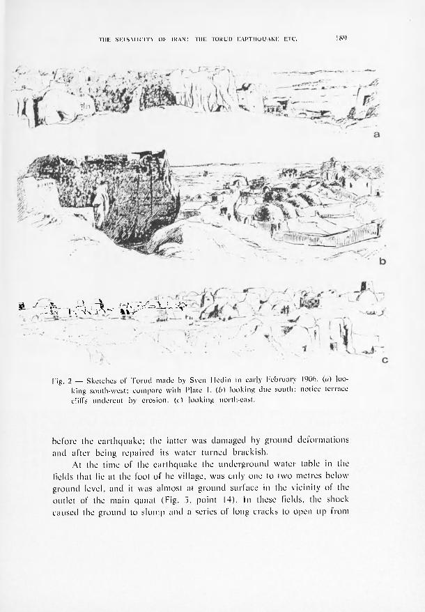
obtained its water i'rom the Rudkhaneh-pa ' i Kaleh, a small river of seasonal (low with its source about 36 ki lometres off to the nor th , that had cut deeply into the silts of the terrace, which stood on both sides into vertical walls 12 to 15 metres high, in places hol lowed into caves by the running water . Some of these caves had been enlarged into temporary dwellings and storehouses and used by the villagers dur ing the dry seasons. The only perennial supply of water for Torud was provided by an old qanat whose wells were sunk right through the silts, its s tream emerging at the toe of the terrace, above which stood the di lapidated citadel of the village ( l4). By 1906 the village had grown and many of its new houses were built at the foot of the terrace, in f ront of which stood an Imamzadeh facing south. More caves had been excavated into the silts of the vertical walls of the Rudkhaneh for the storage of s t raw, firewood and for the housing of animals . In 1906 Torud had a populat ion of not more than 1000 and about 250 proper houses. Fig. 2 shows views of Torud sketched in February 1906 ("•7). By the m i d - 5 0 ' s the size of the village had doubled and its populat ion had risen to almost 2000 with 400 houses (4), and two smaller qanats were dug to supply water for irrigation (Figure 3, points 13 and 24). At the time of the 1953 ea r thquake , Torud had a populat ion of about 2 .100.
The ea r thquake completely destroyed Torud and only a few houses did not collapse. One of them is still there, located at the southwest limit of the new village (Fig. 3, point 20). Most, of the casualties occurred in the old part of the village and in its nar row streets (Plates 1 and 2). No one was killed in the caves which stood up to the shaking far better than the ordinary houses of the village. Estimates of the casualties reported so fa r differ considerably, varying from 2000 to unde r 900 (2- 8- l0' ") .
Most of these estimates were based on rather exaggerated press reports and on official estimates for Torud and for its Dehestan which were added together. From interviews with a number of local officials and survivors of the event, the best estimate for the casualties in Torud is 720 killed about 160 seriously in jured .
The ea r thquake damaged the main qanat that today issues between the old and the new villages (Fig. 3, points 12. 14), as well as a much smaller qana t that runs to the south towards Dagg-Kulud. The former was soon repaired but its yield never rose above half of that yielded
T H E S E I S M 1CITY 01 IRAN: T H E T 0 R U I ) E A R T H Q U A K E ETC. 1 8 9
ft l - i ¡ X - ¿ V ^ "V
Fig. 2 — Sketches of Torud made by Sveri Hedin in early February 1906. (a) loo-king south-west; compare with Plate 1. (fa) looking due south: notice terrace cliffs undercut by erosion, ( t) looking north-east.
before the ea r thquake ; the latter was damaged by ground deformat ions and af ter being repaired its water turned brackish.
At the time of the ea r thquake the underground wate r lablc in the lields that lie at the foot of he village, was only one to two metres below ground level, and it was almost at ground surface in the vicinity of the outlet of the main qanat (Fig. 3, point 14). In these fields, the shock caused the ground to s lump and a series of long cracks to open up f rom
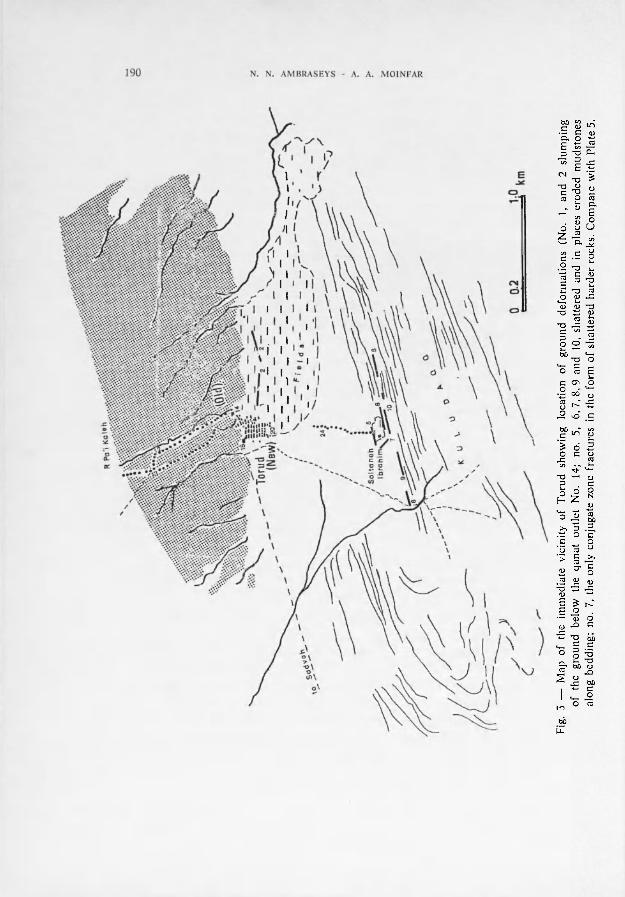
Fig.
5 —
M
ap
of
the
imm
edia
te
vici
nity
of
T
orud
sh
owin
g lo
cati
on
of
grou
nd
defo
rmat
ions
(N
o.
1, a
nd
2 sl
umpi
ng
of
the
grou
nd
belo
w
the
qana
t ou
tlet
N
o.
14;
no.
5,
6,7
,8,9
an
d 10
, sh
atte
red
and
in p
lace
s er
oded
m
udst
ones
al
ong
bedd
ing;
no
. 7,
the
onl
y co
njug
ate
zone
fra
ctur
es i
n th
e fo
rm o
f sh
atte
red
hard
er r
ocks
. C
ompa
te w
ith
Plat
e 5.

T H E S E I S M 1CITY 01 IRAN: T H E T 0 R U I ) E A R T H Q U A K E ETC. 1 9 1
1 — Ruins of old Torud and caves in 1975: compare with Figures 2a and 2b.
2 — Ruins of the upper part of old Torud , looking towards Daqq Soltaneh Ibrahim. New village, on the extreme right.
which brime and sand were ejected, part icularly in the Paredasht f a rm where they were about 20 metres long (Fig. 3, points 1, 2). These are most probably the new cracks referred to by Gansser (5). Although the cracks are no longer visible except in two places, local informat ion suggests that they were formed by the ground opening u p within a na r row zone which runs discontinuously in an east-west direction for about 800 metres, f rom just south of the outlet of the Rudkhaneh-pa ' i Kaleh to the east edge of the fields. Low adobe walls buil t af ter the ea r thquake across this zone today show no sign of subsequent displa-
1 9 2 N. N. A M B R A S E Y S - A. A. M O IN FAR
cements. Nor is there any evidence that this zone of s lumping extended beyond the limits of the fields into the pediment material and gravel fans. It is of interest that with the exception of this zone, wi th in which liquefied material was ejected to the surface of the ground, there is no evidence of mud volcanoes or ejected sand in the rest of the fields.
There is evidence, however , of extensive l iquefaction of Kavir sands south of Torud , as well as of thin dunes in the Labsureh depression, about 9 kilometres nor th of the village (Fig. 4), where allegedly a camel crossing what was previously a safe track dur ing dry weather , was swallowed up.
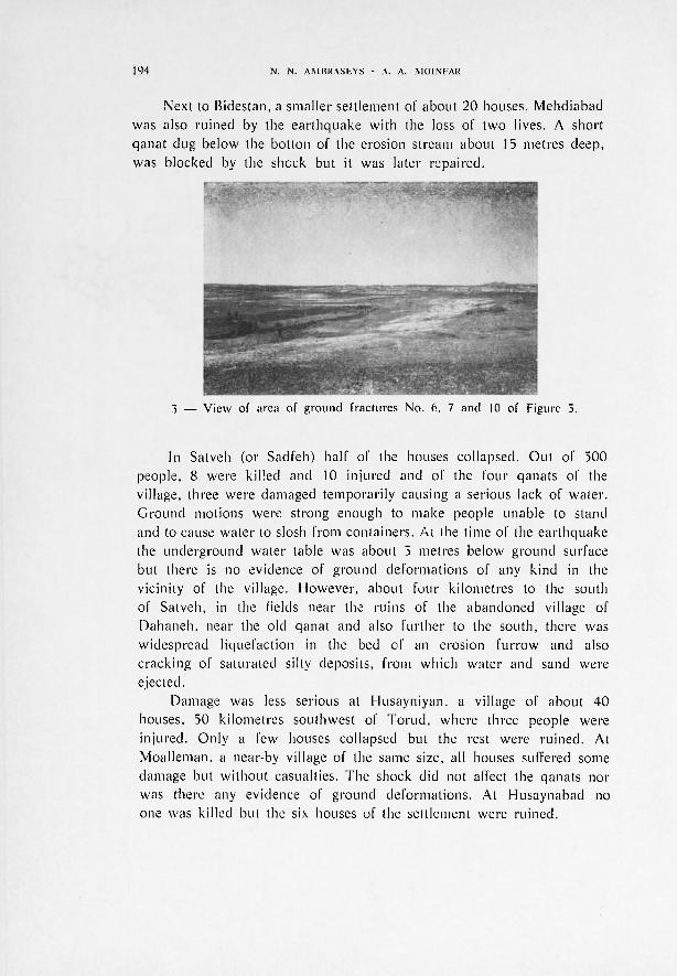
Ground deformat ions , about one kilometre to the south of Torud and near the fa rm of Sultaneh Ibrahim were reported by Abdal ian ('). This farm is situated at the fool of Kulud-Dagg, a low hill formed by the erosion of the south limb of a northeast-southwest t rending anticline of bedded Miocene saline mudstones and harder sandstones of the Upper Red Forma-tions. The hill consists of parallel ridges of the harder beds along which Abdalian mentions, in passing, the presence of a zone, about 15 metres wide and several kilometres long, within which he observed that locally the ground was d o w n t h r o w n to the south by 20 to 140 centimetres. Evidence for ground deformat ions near the fa rm is still visible but only along very short lengths along the strike of the bedding (Fig. 3, points 5, 6). Erosion has removed any evidence f rom which to judge the amount and sense of movement today. As a mat ter of fact , several parallel zones of d is turbance in the sof ter and to a lesser extent in the harder beds, are still visible south of the fa rm, most of them running east-northeast with a few dis turbed zones following a conjugate direction (Fig. 3, points 7. 8, 9, 10), plate 3 Similar local d is turbances were found fu r the r to the southeast of the f a r m in marls and sandstones near Gerda and Chah-i Morghab (Fig. 4).
The kavir lies about 10 kilometres to the south and east of Torud and is totally uninhabi ted for almost 200 kilometres.
To the southwest of the village, the first inhabited place is the small sett lement of Bidestan (Pejestan or Paiesk) which , at the time of the ear thquake , had about 100 houses and a populat ion of 480. The shock destroyed 75 houses killing 18 and injur ing 10 people, and caused s lumping of the ground within a zone two metres wide and a few tens of metres long, between the sett lement and the fields of Kelau which run parallel with the qanat . Today, the village has been rebuilt next to the ruins of its old site.
54
30'
54°4
5'
55,0
'
55 1
5'
Fig.
4
—
Mei
zose
ism
al
area
of
th
e T
orud
ea
rthq
uake
. I
= vi
llag
es
wit
h a
popu
lati
on o
f m
ore
than
45
affe
cted
by
the
shoc
k; 2
=
afle
cted
se
ttle
men
ts
wit
h a
smal
ler
popu
lati
on;
3 =
unin
habi
ted
sett
lem
ents
; 4
= lo
cati
ons
whe
re
ther
e is
ev
iden
ce
of
liqu
efac
tion
of
th
e gr
ound
ass
ocia
ted
wit
h th
e ea
rthq
uake
; 5
= gr
ound
def
orm
atio
ns;
A =
loca
tion
of
mai
n sh
ock
and
of a
fter
shoc
ks;
B an
d C
= ep
icen
tres
of
al
l ot
her
know
n in
stru
men
tall
y de
term
ined
ep
icen
tres
.
1 9 4 N. N . A M B R A S E Y S - A. A. M O I N FAR
Next to Bidestan, a smaller sett lement of about 20 houses. Mehdiabad was also ruined by the ea r thquake with the loss of two lives. A short qanat dug below the botton of the erosion stream about 15 metres deep, was blocked by the shock but it was later repaired.
3 — View of area of ground fractures No. 6, 7 and 10 of Figure 3.
In Satveh (or Sadfeh) half of the houses collapsed. Out of 500 people, 8 were killed and 10 in jured and of the four qanats of the village, three were damaged temporari ly causing a serious lack of water . Ground motions were strong enough to make people unable to stand and to cause water to slosh from containers. At the time of the ea r thquake the underground water table was about 5 metres below ground surface but there is no evidence of ground deformat ions of any kind in the vicinity of the village. However , about four kilometres to the south of Satveh, in the fields near the ruins of the abandoned village of Dahaneh , near the old qanat and also fu r the r to the south, there was widespread l iquefaction in the bed of an erosion fu r row and also cracking of saturated silty deposits, f rom which water and sand were ejected.
Damage was less serious at Husayniyan. a village of about 40 houses, 50 kilometres southwest of To rud , where three people were in jured . Only a few houses collapsed but the rest were ruined. At Moal leman, a near-by village of the same size, all houses suffered some damage but without casualties. The shock did not affect the qanats nor was there any evidence of ground deformat ions . At Husaynabad no one was killed but the six houses of the settlement were ruined.
T H E S E I S M 1CITY 01 IRAN: T H E T 0 R U I ) E A R T H Q U A K E ETC. 1 9 5
To the north of Husayniyan, the old village of Reshm sustained minor damage and only a few houses needed repair . However , the shock caused a temporary change in the yield of the spring that provided the sole source of wate r for the village. Further to the north of Reshm, at Galeki (or Galuki) a semi-abandoned village, damage was equally small .
The only other village in the area, Razeh, is about 30 kilometres northeast of Torud . No one was killed in Razeh itself, but half of its 20 old houses were shattered and some of the ruins of the old village collapsed. There was no damage to a small qanat , but the sole spring of water in the area dried up.
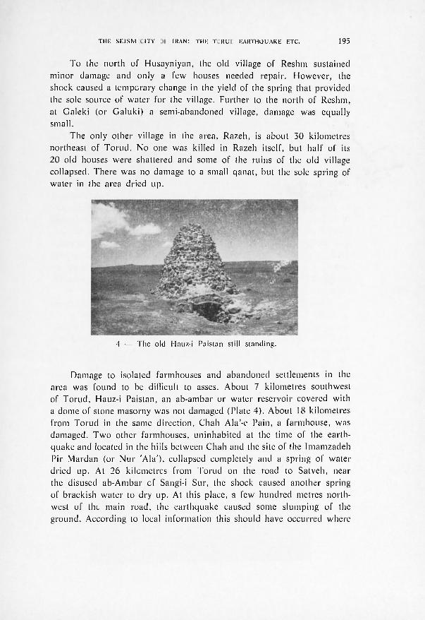
Damage to isolated fa rmhouses and abandoned settlements in the area was found to be difficult to asses. About 7 kilometres southwest of Torud , Hauz-i Paistan, an ab-ambar or water reservoir covered with a dome of stone masorny was not damaged (Plate 4). About 18 kilometres f rom Torud in the same direction, Chah Ala'-e Pain, a farmhouse , was damaged. T w o other farmhouses , uninhabi ted at the time of the earth-quake and located in the hills between Chah and the site of the Imamzadeh Pir Mardan (or Nur 'Ala ') , collapsed completely and a spring of water dried up. At 26 kilometres f rom Torud on the road to Satveh, near the disused ab-Ambar cf Sangi-i Sur, the shock caused another spring of brackish water to dry up. At this place, a few hundred metres north-west of the main road, the ear thquake caused some slumping of the ground. According to local information this should have occurred where
4 — The old Hauz-i Paistan still standing.
1 9 6 N. N. A M B R A S E Y S - A. A. M O IN FAR
a stream course running to the southwest cuts into a series of young terraces. There is some evidence here that as a result of the ea r thquake the al luvium to the southeast was d o w n t h r o w n against the brecciated volcanic rocks to the nor thwest .
Southwest of the abandoned site of Qal ' eh Dokh ta r , the qanat of G a n d a b was damaged, allegedly not by the ea r thquake of February but by a later shock. There is also some unauthent ica ted evidence that a f te r the ea r thquake and for a few years, the desolate pastures of Baghdust , Vajaru and T u d h a n were covered with a rich vegetation unusual fo r this type of terrain, perhaps suggesting a temporary change of the water table. Fur ther nor th , at the farm of Salaran and the copper mine of Chahmusi , all of the houses, of which there were 10, were damaged. In the region of Mahabiya and S'hisheh, damage was more serious. Ou t of 12 houses, 6 were destroyed wi thout casualties. The qanat at Mahabiya was not affected but the spring of water Shisheh was temporari ly blocked. The shock triggered small rockfal ls near Shisheh Oliya. At Cheshmeh Sefid, a deserted sett lement of a few ruined houses, the ea r thquake caused s lumping of the saturated ground at some distance f rom the old qanat . According to local reports there was little damage at Imamzadeh Shah-i Oliya.
Chah-i Jam, about 35 kilometres north of To rud , a small sett lement of about six houses was also damaged. There was no damage to the walled sett lement of Chah Baba, now abandoned , nor to its water supply. At Dizak, about 10 kilometres south of Shahrud , the shock cracked a few walls and in Shahrud and Damghan it caused panic. It was strongly felt at Semman, Sangsar, Miyandasht and Dashtgird. At Khur , 180 kilometres south of Torud , a few old walls collapsed. The ea r thquake was felt in Tehran , Damavand , Behshahr , Gorgan , Gonbad-i Kabus , Ja jarm, Kas'hmar, Torbat-i Haidaiyyeh, Tabas and Anarak . It was not felt in G u m m , Kashan and Mashad.
D I S C U S S I O N .
The region of Torud has never been an area of importance, being remote and arid, and as such has provided no known notices about historical ear thquakes . Gansser ( 5 ' 5 b i s), on the authori ty of local information mentions an ea r thquake early in the 19 th century that allegedly devastated the area of Reshm, an event that could have been

Iß -J
1 9 8 N . N. A M B R A S E Y S - A. A. M O I N FAR
associated with one of the large shocks of the first quar te r of the last century that affected southeast Mazanderan and Qahabras t an .
During this century, the Torud region, encompassed by 35° A' - 36°N and 54° £ - 55.50 E, has been subjected to f requent shaking of moderate intensity, mainly f rom known ear thquakes with epicentres outside the region of Torud . Some of these events are still remembered by the older inhabi tants of Torud , Satveh, Reshm and Chah-i Jam. T h e earliest ea r thquake remembered in Torud occurred around 1915 but it caused no damage. The ea r thquake of 22nd July 1927 of magni tude 6.3, is remembered vividly, part icularly for its strong af tershocks that caused minor damage in Satveh. The epicentre of this event lies outside the region of Torud , about 150 kilometres west of To rud , but nevertheless it was strongly felt , causing some panic in the village. The ea r thquake of 14th April 1928, which allegedly caused minor damage in Satveh, is usually confused with the ear thquakes of the previous year. About a decade later, there was again some slight damage in Satveh and rockfalls near Tang-i Reshm caused by the ea r thquake of 6th Apri l , 1939. Thus , the only known damaging shock in the Torud region is the ea r thquake of 12th February 1953 which was fol lowed by a long and well-established period of seismic quiescence.
There are at least four more ear thquake that are often placed erroneously in the Torud region. The first, on 10-23 January 1908, with a reported epicentre at 35.5° N - 55.5°/;, is given by Wilson (l5) on the authori ty of Shtell ' ing (13). In fact, Shtelling refers to the Silakhor ea r thquake of 1909 that took place 590 kilometres away from Torud , on the 10th January (old Style) or on the 23rd January (new Style). Wilson commits three consecutive errors therefore: he gives 1908 instead of 1909, 'he does not notice that 10 = 25 )anuary in the old and new Styles, and he does not seem to have read the paper he quotes, in which Shtelling dismisses the original location of the ea r thquake given by Gali tzin, namely 33.5° - 55.0° for a more precise one determined f rom macroseismic data .
The other three ear thquakes that are usually given the erroneous location of 35.5" - 55.0°, a location of an adopted ISS epicentre, are those of 17th September 1923 and 3rd July 1924 at 0803 and 0818 (GMT) . In fact these ea r thquakes occurred 350 kilometres away f rom Torud , near 37.8° - 57.3° where they caused considerable damage.
The Torud ea r thquake of 1955 is the only relatively large event known to have occurred on a ma jo r fault zone such as the Torud fault
T H E S E I S M 1CITY 01 I R A N : T H E T 0 R U I ) E A R T H Q U A K E ETC. 204
zone. Nei ther the magni tude of the shock nor the seismicity of the zone before and af ter this event suggest the presence of a recent active tectonic l ineament . And although there is ample evidence for a Recent faul t zone running along the Torud-Satveh-Reshm axis, the informat ion that can be gleaned today in suppor t of faul t movements associated with the 1953 ea r thquake is indeed both meager and inconclusive. The three isolated cases of limited ground deformat ions found south of Torud and Dahaneh associated with the 1953 ear thquake seem to suggest featur es of secondary nature , perhaps associated with local readjust-ments caused by movements in deeper structures. The case noticed north of Sang-i Sur may well be due to local s lumping along a pre-existing contact face, and the ground deformat ions in the fields just south of Torud are most certainly of secondary nature . While it is difficult to prove that there was no fault ing associated with the 1955 ea r thquake , the fact that our sole authori ty for it (Abdalian (1953)), did not map the fault-breaks, taken together with the absence of any conclusive field evidence today in suppor t of faul t ing, makes the conjecture of fault ing unrel iable at best.
There is conclusive evidence, however , that the Torud ea r thquake caused the l iquefaction of saturated, silty sands, both in the Kavir as well as in isolated depressions filled with aeolian deposits in the Torud area (Fig. 4). However , fluctuation of the underground water table in the Kavir is considerable. At the t ime of the 1955 ea r thquake the water table was high, almost at ground surface, and this time of the year, even under normal condit ions, caravans would follow tracks differing f rom those used dur ing the dry season to avoid being stuck in « soft » areas of the desert.
The damage caused by the Torud ear thquake is typical of other events of similar magni tude in I ran. Damage was mainly due to the poor construction of the houses and its maximum intensity should not have exceeded VII I (MM). There is no evidence that houses built on the terrace of Torud suffered more than those built e lsewhere. Nor is there any evidence f r o m the study of the ruins of the village that with the exception of the houses built on the edge of the loess terrace, that foundat ion failures contr ibuted to the destruct ion. The lack of t imber for roofing and the use of flat vaults, as well as the na r row streets, are thought to be one of the main reasons lor the large number of casualties.
2 0 0 N. N. AMBRASEYS - A. A. MO IN FAR
A C K N O W L E D G E M E N T S .
This work was sponsored jointly by the Plan & Budget Organisat ion of Iran and the Natural Envi ronment Research Council , London.
R E F E R E N C E S
( ') ABDALIAN, S., 1953. - Le tremlement de terre de Toroude en Iran. « La N a t u r e »,
(2) ANONYMOUS, 1953. - «Bul le t in Seism. Soc. A m e r . » , 43, p. 185.
( 3 ) A T L A S Z E M L E T R ' S E N I I v CCCP, 1 9 6 2 . - « A k a d e m i a N a u k » , M o s c o w .
(4) GABRIEL, A., 1953. - Durch Persiens Wüsten. S t recker & Schröder , Stut tgart .
(5) GANSSER, A., 1969. - The large earthquakes oj Iran and their geological frame.
« Eclogae Geologicae Helvet iae », 62, 2, pp . 443-466.
( 5 b i s ) G A N S S E R , A . , 1 9 7 7 . - Private communication.
(6) HEDIN, S., 1910. - Overland to India. 2 Vols., Macmil lan , London .
(7) HEDIN, S., 1918. - Eine Routenaufnahme durch Ostpersien. 2 Vols., S tockholm.
(8) KHURASAN, Ruznameh. 26-28 Bahman 1331, Tehran . (9) NOWROOZI, A., 1971. - Seismo-tectonics oj the Persian Plateau, Eastern Turkey ,
Caucasus, and Hindu-Kush regions. « B u l l . Seism. Soc. A m e r » . 61, pp . 317-341.
(10) PARHAM, B., 1972. - Reconstruction of earthquake damage-. Torucl. « Dept . Research & Planning, Ministry of Hous ing & D e v e l o p m e n t » , 52, Par t 1, Tehran .
( " ) ROTHE, J. P., 1955. - Chronique Seismologique « R e v . pour l ' E t u d e des Calamités », Geneve , 33, p. 22.
(12) RUSTANOVICH, D. N., 1967. - Seismichnost' territorii Turkmenskoy CCP i Ashkhabadskoe zemletriasenie 1948 g. « Vaproc . Inzen. Seismol. Byul. 12. Akademia N a u k », Moscow.
0 3 ) SHTELLING, E., 1910. - Svedenii o zemletr' senii v Persii 10/25 Janvar 1909goda. « Acad. Imper. Sc.. C. R. Comm. Seism. Perm. », 3iii, St. Petersbourg.
0 4 ) VAUGHAN, H . B., 1890. - Report of a journey through Persia. « Intell igence Branch Q u a r t e r Master Genera l ' s Dept . in I n d i a » , Calcut ta .
(IS) WILSON, A. T., 1930. - Earthquakes in Persia. « B u l l . School Or ient . Studies. London , 6, Pt. 1, pp . 103-131.


![Nuhosca [1953]](https://img.pdfslide.us/doc/110x75/620815b96585125f8d4e274d/nuhosca-1953.jpg)