Embed Size (px)
Citation preview

Topeka Shiner Monitoring in Minnesota
2012-2013
Brett C Nagle and Krista A Larson
Division of Ecological and Water Resources
Minnesota Department of Natural Resources
October 2013
submitted to
Richard J Baker
Endangered Species Coordinator
Division of Ecological Resources
Minnesota Department of Natural Resources
500 Lafayette Road
St Paul Minnesota 55155
TABLE OF CONTENTS
ABSTRACT 3
INTRODUCTION 4
METHODS 6
RESULTS 8
DISCUSSION 10
LITERATURE CITED 16
FIGURES 18
APPENDIX A MAPS OF STREAM SEGMENTS SAMPLED IN 2012-2013 AND OVERVIEW OF SEGMENTS
SAMPLED DURING 2004-2013
APPENDIX B TABLE 1 DESCRIPTIONS OF ALL 2012 STREAM SEGMENTS AND SITES INCLUDING
TOPEKA SHINER PRESENCEABSENCE INFORMATION
TABLE 2 DESCRIPTIONS OF ALL 2013 STREAM SEGMENTS AND SITES INCLUDING
TOPEKA SHINER PRESENCEABSENCE INFORMATION
TABLE 3 COMPLETE LIST OF FISH SPECIES CAPTURED AT SEGMENTS 141-160 2012
TABLE 4 COMPLETE LIST OF FISH SPECIES CAPTURED AT SEGMENTS 161-180 2013
APPENDIX C VOUCHER AND HABITAT PHOTOGRAPHS
2
ABSTRACT
In response to a range-wide decline in abundance and distribution the Topeka shiner (Notropis
topeka) was designated as a federally endangered species in 1999 In 2004 the Minnesota
Department of Natural Resources began a presenceabsence survey effort to monitor Minnesota
populations of Topeka Shiners at randomly selected sites within the federally designated critical
habitat for the species Averaged over the seven years of monitoring from 2004-2010 Topeka
shiners were present at 764 of randomly selected reaches of streams Results are presented for
Topeka shiner monitoring surveys conducted in 2012 and 2013 Topeka shiners were present at
40 of randomly selected segments in 2012 and 30 in 2013 Results from this and previous
sampling efforts indicate a decline in Minnesota populations of Topeka shiners Expanded
monitoring and survey efforts are recommended
3
INTRODUCTION
The Topeka shiner (Notropis topeka) was historically widespread and abundant in low
order streams throughout the central plains region of the United States Over the last several
decades it has exhibited widespread decline across much of its range and is estimated to occur in
only 10 percent of its historic geographic distribution (Tabor 2002) Although no single factor
has been identified as the causative agent in the rapid decline of this species habitat loss
resulting from the nearly wholesale conversion of the landscape for agricultural purposes has
been implicated by several researchers (Pflieger 1997 Eddy and Underhill 1974 Gelwicks and
Bruenderman 1996 Berg et al 2004) The combined effects of ecosystem alteration have led to
a decrease in base flows elevated sedimentation increased turbidity higher water temperatures
and loss of aquatic vegetation all of these factors contribute to the degradation and loss of the
Topeka shinerrsquos preferred habitat (Tabor 1993) In response to the rapid and dramatic decline in
abundance and distribution the US Fish and Wildlife Service designated the species as
endangered under the Endangered Species Act of 1973 (Tabor 1998)
Surveys conducted during the late 1990s indicated that Minnesota harbored viable
populations of Topeka shiners throughout its distribution in the state and that compared with
previous survey efforts in the 1970s and 80s these populations appeared to be stable (Dahle
2001 Hatch 2001) These findings were in sharp contrast to survey efforts in other portions of
the Topeka shinerrsquos historic range where they were sampled at only 17 of historic localities in
Kansas (Tabor 1998) and 15 of historic localities in Missouri (Gelwicks and Brunderman
1996) This discrepancy between presenceabsence at historic sites in Minnesota versus other
4
regions within the speciesrsquo range led Dahle (2001) to conclude that ldquoMinnesota populations may
represent the largest and most stable population remaining in the speciesrsquo rangerdquo
In 2004 the Minnesota Department of Natural Resources began a program to monitor
populations of Topeka shiners within the state A protocol was established (Ceas and Anderson
2004) to conduct a presenceabsence survey of Topeka shiners at twenty randomly selected
reaches of stream from within the federally-designated critical habitat in the Big Sioux and Rock
River drainages in southwestern MN Surveys were conducted annually from 2004 to 2010 and
Topeka shiners were found at an average of 764 of sites over the seven year period (Ceas and
Anderson 2004 Ceas and Monstad 2005 2006 Ceas and Plain 2007 Ceas and Larson 2008
2009 2010) These values ranged from Topeka shiners present at 90 of the 20 randomly-
selected reaches of streams in 2006 to 60 of sites in 2010 Although the annual percentage of
sites where Topeka shiners were present was relatively stable for the first six years of monitoring
(Figure 1) surveyors began to note a marked decline in relative abundance of the species as well
as a decline in the number of sites where the species was present (Ceas and Larson 2009 2010)
Results from monitoring surveys conducted in 2012 and 2013 are detailed in this report and are
consistent with a decline in the prevalence of Topeka shiners in Minnesota
5
METHODS
Methods for 2012 and 2013 Topeka shiner monitoring follow Ceas and Anderson (2004) and are
reproduced below with updated information
Selection of Stream Segments
For each year of Topeka shiner monitoring 20 one-mile reaches of stream were selected
at random from the federally designated Topeka shiner critical habitat within Minnesota
employing an ArcView extension program developed by MN DNR (Appendix A Map 1)
Landowner Contact
When possible stream segments were accessed at public rights-of-way at bridge
crossings However given that many of the randomly-selected stream segments occur on
privately-owned lands permission was obtained from landowners to access those reaches of
stream Contact information for landowners was provided to the DNR by the County Auditorrsquos
offices of Pipestone Lincoln Murray and Nobles counties Landowner contact information for
Rock County was accessed online at Rock County Assessors office Landowners received a
notice in the mail requesting access to the property to conduct aquatic surveys and when
possible were also contacted by telephone
Selection and Reconnaissance of Sampling Sites
Based on habitat preferences characterized in the literature (Minckley and Cross 1959
Bailey and Allum 1962 Pflieger 1997 Berg et al 2004 Eddy and Underhill 1974 Dahle 2001
Hatch 2001) sample sites were identified within each randomly-selected reach of stream using
6
aerial photography viewed in ArcGIS ver 100 At each sample segment a brief reconnaissance
was conducted to prioritize sampling at potential Topeka shiner habitat
Basic habitat descriptions and locality information for each of the twenty stream
segments sampled in 2012 and 2013 are presented in Tables 1 and 2 of Appendix B Lists of fish
species captured along each of the sample segments are presented in Tables 3 and 4
Fish Sampling
Presenceabsence surveys were conducted for Topeka shiners using 15rsquo x 5rsquo x 18rdquo pole
seines Sampling efforts were focused on low-flow areas along the main channel boundary
(MCB) backwaters and off-channel ponds and oxbows Seines were dragged along
unobstructed reaches of substrate and set-kicks were performed in vegetation or undercut banks
Due to substantial habitat and stream character heterogeneity across randomly selected sample
segments sampling efforts were not standardized between segments Stream segments were
sampled until either Topeka shiners were captured or all suitable Topeka shiner habitat within
the segment had been sampled In the absence of Topeka shiners or suitable habitat a minimum
of ten sites were sampled within each segment
The monitoring effort focuses on presenceabsence of Topeka shiners and no
methodologies were employed to quantify population size or numbers of individuals within the
sample reaches However within segments where Topeka shiners were sampled a qualitative
assessment of relative abundance was made based on the professional judgment of the surveyor
(Ceas and Larson 2010) While these assessments are inherently subjective by nature they are
intended to provide a coarse characterization of Topeka shiner relative abundance at sites where
they are present Sites where Topeka shiners were sampled were categorized as either
lsquoabundantrsquo (Topeka shiner is most numerous species present or gt10 individuals collected in the
7
initial seine haul at capture site) lsquocommonrsquo(Topeka shiner individuals appear in low numbers
relative to other species or 5-10 individuals captured in the initial seine haul) or lsquopresentrsquo(lt5
individuals captured after substantial sampling effort)
RESULTS
2012 Monitoring Surveys
Topeka shiners were collected at eight of the 20 one-mile stream segments 141 145
148 149 150 151 156 and 159 (Appendix A Map 2) See Figure 1 for yearly totals of
segments with Topeka shiners from 2004-2013 In all instances Topeka shiners were captured in
areas of low flow pool or backwater habitat no individuals were captured in free-flowing
reaches of stream Segments 151 and 156 were the only reaches of stream where Topeka shiners
were captured at the first sample site Habitat and voucher photographs for 2012 stream
segments are presented in Appendix C
Very few Topeka shiners were captured during the 2012 surveys Of the sites where
Topeka shiners were captured only two yielded shiners in high numbers At the remaining six
capture sites fewer than five individuals were captured after substantial seining effort
Three sample segments contained off-channel pond habitat (segments 144 153 and 156)
but Topeka shiners were not found in any of them The off-channel ponds along segment 144
were dominated by fathead minnow (Pimephales promelas) and black bullhead (Ameiurus
melas) and no Topeka shiners were captured The off-channel ponds along segment 153 were
nearly dry and contained thick mats of filamentous algae and duckweed no fish were captured
8
The pond near the north end of segment 156 was not sampled as large numbers of Topeka
shiners were captured observed in a pool elsewhere in the segment
A total of 35 fish species were collected during the 2012 surveys Plains topminnow a
Threatened species in MN was collected in three segments (sites 154-11 Map 16 156-1 Map
18 158-4 Map 20) A complete list of fish species collected in each segment is presented in
Table 3
2013 Monitoring Surveys
Topeka shiners were collected at six of the 20 one-mile stream segments 161 168 169
174 175 and 180 (Appendix A Map 2) As with the 2012 surveys Topeka shiners were
captured in areas of low flow pool or backwater habitat in all instances no individuals were
captured in free-flowing reaches of stream Segments 168 and 180 were the only reaches of
stream where Topeka shiners were captured at the first sample site Habitat and voucher
photographs for 2013 stream segments are presented in Appendix C
Very few Topeka shiners were captured during the 2013 surveys Of the sites where
Topeka shiners were captured only two yielded shiners in high numbers At the remaining four
capture sites fewer than ten individuals were captured after substantial seining effort
Four of the sample segments had adjacent off-channel ponds 172 175 177 and 180 Of
these the artificially constructed live stock pond just south of Champepadan Creek (segment
175) was the only pond where Topeka shiners were captured A single individual was captured in
this pond along with thousands of fathead minnows (Pimephales promelas) in spawning
condition and several black bullheads (Ameiurus melas) Segment 172rsquos pond was an excavated
livestock pond that did not contain Topeka shiners The off-channel ponds to the west of segment
9
177 (Rock River) appeared to be remnants of large holding ponds and contained thick
filamentous algae and some submerged macrophytes no fish were captured Segment 180 had a
small off-channel pond on the north side of the stream but the pond did not contain Topeka
shiners despite the large numbers sampled in the pool at the bridge crossing and along the
stream
A total of 27 fish species were collected during the 2013 surveys Plains topminnow were
collected at three sites along segment 178 (178-5 178-9 and 178-11 Map 40) A complete list
of fish species collected in each segment is presented in Table 4
DISCUSSION
Monitoring surveys conducted in 2012 and 2013 found Topeka shiners at 40 and 30
respectively the lowest percentages of randomly-selected sites since the monitoring began in
2004 (Figure 1) While absence at some sites may be attributable to distributional and
geomorphic factors associated with randomly selected sites falling outside of preferred habitats
the near absence of Topeka shiners in areas with historically strong populations (eg Kanaranzi
Creek) is of particular concern
2012 Absence localities
As mentioned above the randomized segment selection process may result in some
segments falling on reaches of stream that are less likely to contain Topeka shiners The
following section describes segments of streams that did not contain Topeka shiners but
exhibited suitable habitat andor contained historic records of the species from previous MN
DNR monitoring surveys (2004-2010) Refer to Table 1 for basic habitat descriptions and
10
coordinates of sample sites within each segment Refer to Appendix C for habitat photographs of
the segments described below
Segment 144 (North Branch Pipestone Creek) exhibited suitable Topeka shiner habitat in
that it is a very low gradient reach of stream with adjacent off-channel pond habitat
Throughout the previous monitoring effort from 2004-2010 Topeka shiners were collected at
1515 sites in the Pipestone Creek watershed
Segment 146 (Split Rock Creek) contained suitable habitat a large shallow pooled area
with sandy substrate was present at the bridge crossing with County Road 53 as well as off-
channel ponds along the segment Monitoring efforts during 2004-2010 documented Topeka
shiners at 99 sample segments in the Split Rock Creek watershed
Segment 154 (Rock River) exhibited the least signs of human disturbance of any of the
2012 segments and had an intact riparian corridor of willow and cottonwood trees Ample side
channels and backwater habitats were located behind gravel bars along the main channel
boundary Previous monitoring surveys during 2004-2010 found Topeka shiners at 1011 sites
sampled on the main stem of the Rock River and the species was common at a locality just
upstream of this segment in 2006
Segment 158 (Kanaranzi Creek) was located in the middle reaches of the watershed
below the confluence with the east branch of the creek just upstream of Adrian Although some
evidence of bank alteration and rip rapping was present along reaches of this segment ample
suitable backwater habitats and side channels were sampled behind gravel bars along the main
channel boundary Of the 10 segments of Kanaranzi Creek sampled below Adrian in 2004-2010
surveys only one (segment 79 in 2007) did not contain Topeka shiners
11
The remaining segments of stream that did not contain Topeka shiners either occurred in
regions that have not historically exhibited large populations andor the natural character of the
stream did not offer suitable habitat (Segments 142 143 147 153 155) or the segment
exhibited signs of substantial alterations to the stream in the form of drainage tiles
channelization or bank modifications (Segments 152 157 160)
2013 Absence localities
As above the following section describes segments of streams that did not contain
Topeka shiners but exhibited suitable habitat andor contained records of the species from
previous MN DNR monitoring surveys (2004-2010) Refer to Table 2 for basic habitat
descriptions and sample site coordinates Refer to Appendix C for habitat photographs of the
segments described below
Segment 165 (North Branch Pipestone Creek) contained suitable habitat in a pooled area
at a bridge crossing and an oxbow backwater The Pipestone Creek watershed has historically
high numbers of sites with Topeka shiners (see above)
Segment 171 (Rock River) was sampled at a period of high water after recent rains but
backwater and side channel areas were present along a wide shallow reach in the northern
portion of the segment Previous monitoring surveys during 2004-2010 found Topeka shiners at
1011 sites sampled on the main stem of the Rock River
Segment 176 (Kanaranzi Creek) exhibited some backwaters along the main channel
boundary and a pooled area at the County Road 15 bridge A small backwater upstream of the
bridge yielded Topeka shiners on the first seine haul during the 2005 monitoring surveys (site
12
37-1) This backwater was thoroughly sampled and no Topeka shiners were captured there or
elsewhere along the segment
Segment 177 (Rock River) was a wide free flowing stream with some braiding and
backwater habitats behind sandgravel bars along the main channel The segment contained a
historic Topeka shiner locality from an oxbow along the channel but the oxbow was nearly dry
(despite recent rains) and was devoid of fish at the time of sampling Previous monitoring
surveys collected Topeka shiners at numerous segments along this reach of the Rock River (see
above)
Segment 178 (Kanaranzi Creek) exhibited suitable Topeka shiner habitat in backwaters
separated from the main channel by sand bars Backwater areas along the main channel were
filled with deep silt deposits from a recent period of high flow sampling was difficult Previous
monitoring surveys in this region of the Kanaranzi Creek watershed collected Topeka shiners
(see above)
Segment 179 (East Branch Kanaranzi Creek) exhibited suitable habitat in a pooled
backwater area at the upstream end of the segment This pool was thoroughly sampled and no
Topeka shiners were captured here or elsewhere along the segment A monitoring survey in 2008
found Topeka shiners in abundance in this pool
The remaining segments of stream that did not contain Topeka shiners either occurred in
regions that have not historically exhibited large populations andor the natural character of the
stream did not offer suitable habitat (Segments 162 164 167) or the segment exhibited little or
no suitable habitat due to substantial alterations to the stream in the form of drainage tiles
channelization or bank modifications (Segments 163 166 170 172 173)
13
Plains Topminnow
Plains topminnow (Fundulus sciadicus) is a Threatened Species in Minnesota Although
survey efforts specifically targeted Topeka shiners survey efforts were focused on backwaters
low-flow areas and pool habitats which is also the preferred habitat of the plains topminnow
(Pflieger 1997) Despite intense survey effort in suitable plains topminnow habitat the species
was documented at only 320 segments in 2012 and at 120 segments in 2013 The low number
of segments where the species was documented and scarcity of individuals suggest that this
taxon is in need of additional protection and management
Conclusions
The protocol employed in Minnesotarsquos Topeka shiner monitoring effort was designed to
detect changes in the speciesrsquo presence within the state (Ceas and Anderson 2004) Data
collected over the past nine years of monitoring provide detailed documentation of a shift in the
prevalence of Topeka shiners in Minnesota In the five year period from the onset of monitoring
in 2004 to 2008 Topeka shiners were present at an average of 80 of sites The next four cycles
of monitoring reported an annual drop in the number of sites were the species was present
falling steadily from 80 of sites in 2008 to 30 of sites in 2013 (Ceas and Larson 2008 2009
2010) (Figure 1) Not only have the last four monitoring periods demonstrated a decrease in the
number of sites where the species are present but have also shown a distinct decline in the
qualitative assessments of relative abundance Ceas and Larson (2008) ranked 11 of the sites
where shiners were present as lsquocommonrsquo or lsquoabundantrsquo and this value fell to two sites by 2010
(Figure 2) The downward trend in distribution and abundance of Topeka shiners noted by Ceas
and Larson (2010) is reinforced by recent survey efforts presented here surveys conducted in
14
2012 and 2013 exhibit still lower numbers of sites where Topeka shiners were present with the
percentage of sites falling to 40 and 30 respectively These findings are further bolstered by a
recent study in Iowa that demonstrates a similar pattern surveys conducted in Iowa during 2010-
2011 only collected Topeka shiners 43 of sites where the species was present in 1997-2000
(Bakevich 2013)
Although sampling effort is not standardized among sample segments a general trend of
increased sample effort is observed throughout the monitoring effort Averaged over the period
from 2004 to 2009 Topeka shiners were collected at the first sample site at over ten of the
segments This value dropped to six segments in 2010 and to two segments in 2012 and 2013
This trend of greater sampling effort yielding fewer and fewer individuals is further indication of
a decline in Minnesota populations of Topeka shiners
Having detected what appears to be a significant decline in Minnesota populations of
Topeka shiners it is recommended that a larger survey effort be implemented to evaluate shiner
populations at historic localities from this monitoring program and other studies as well as
continuing to monitor sites at randomly-selected localities It is critical to determine if sites that
historically harbored large viable populations are in decline as well as the observed trend in the
randomly-selected monitoring sites
15
LITERATURE CITED
Bailey R M and M O Allum 1962 Fishes of South Dakota Miscellaneous
Publications of the Museum of Zoology University of Michigan 119 68-70
Bakevich BD 2013 Habitat Fish Species and Fish Assemblage Associations of the Topeka
Shiner in West-Central Iowa North American Journal of Fisheries Management 33
1258-1268
Berg J A T A Petersen Y Anderson and R Baker 2004 Hydrogeology of the Rock River
watershed Minnesota and associated off-channel habitats of the Topeka shiner
Minnesota Department of Natural Resources Report
Ceas P A and Y C Anderson 2004 Results of a pilot monitoring project for Topeka shiners
in southwestern Minnesota Minnesota Department of Natural Resources Report
Ceas P A and Y A Monstad 2005 Results of a pilot monitoring project for Topeka shiners
in southwestern Minnesota Year two Minnesota Department of Natural Resources
Report
Ceas P A and Y A Monstad 2006 Topeka shiner monitoring in Minnesota Year three
Minnesota Department of Natural Resources Report
Ceas P A and A M Plain 2007 Topeka shiner monitoring in Minnesota Year four
Minnesota Department of Natural Resources Report
Ceas P A and K A Larson 2008 Topeka shiner monitoring in Minnesota Year five
Minnesota Department of Natural Resources Report
16
Ceas P A and K A Larson 2009 Topeka shiner monitoring in Minnesota Year six
Minnesota Department of Natural Resources Report
Dahle S P 2001 Studies of Topeka shiner (Notropis Topeka) life history and distribution in
Minnesota MS Thesis University of Minnesota St Paul
Eddy S and J C Underhill 1974 Northern fishes with special reference to the Upper
Mississippi Valley 2nd edition University of Minnesota Press Minneapolis
Gelwicks G and S A Bruenderman 1996 Status survey for the Topeka shiner in
Missouri Unpublished report Missouri Department of Conservation
Hatch J T 2001 What we know about Minnesotarsquos first endangered fish species the Topeka
shiner Journal of the Minnesota Academy of Science 6539-46
Minckley W L and F B Cross 1959 Distribution habitat and abundance of the
Topeka shiner Notropis topeka (Gilbert) in Kansas American Midland Naturalist
61 210-217
Pflieger W L 1997 The fishes of Missouri Missouri Department of Conservation
Tabor V M 1993 Status report on Topeka shiner (Notropis topeka) USDI Fish and Wildlife
Service Kansas State Office Manhattan
Tabor V M 1998 Final rule to list the Topeka shiner as endangered Federal Register
6369008-69021
Tabor V M 2002 Endangered and Threatened Wildlife and Plants Designation of critical
habitat for the Topeka shiner Federal Register 6754261-54306
17
0
10
20
30
40
50
60
70
80
90
100
04 05 06 07 08 09 10 12 13
Figure 1 Percentage of randomly selected stream segments where Topeka shiners were captured 2004-2013
0
2
4
6
8
10
12
06 07 08 09 10 12 13
Figure 2 Number of sites where Topeka shiners were considered lsquocommonrsquo or lsquoabundantrsquo 2006-2013
18
Appendix A- Maps of Stream Segments
Map 1 Overview of 180 one-mile stream segments sampled during 2004-2013
Map 2 Presenceabsence of Topeka shiners at segments sampled during 2004-2013
Maps 3-42 Aerial views of the 40 sample segments that were sampled in 2012 and 2013
0114
South
Dak
ota
Iowa
168
sectbrvbar90
0159
0175
QR23
QR267
QR266
QR270
QR91
QR30
Iona
Jasper
Adrian
Wilmont
Slayton
Ruthton
Russell
Luverne
Balaton
Magnolia
Florence
Edgerton
Pipestone Lake Wilson
Lake Benton
NOBLES
MURRAY
ROCK
LYON
PIPESTONE
LINCOLN
160
159
158
157 156
154
153
152
151
150
149
148
147
145
144
143 142
141
155
146
180
169
178 177
176
175
174 173
163
164
179
170 167
166 165
162
172
161
171
Map 1 Overview of Random Segments2004-2013
2013 Segments 2012 Segments 2004-2010 Segments T Shiner critical habitat
Popula ed Places t Interstate Federal Trunk State Trunk Counties in Minnesota
sup2
5 25 0 5 10 Miles
0114Tracy
Map 2 Overview of segments where Topeka Shiners were found 2004-2013
2013 Random Segments Topekas found (n = 6
n = 14
)
)
Topekas not found ( )
ts )
2012 Random SegmenTopekas found (n = 8)Topekas not found (n = 12)
2004-2010 Random Segments Topekas found (n = 107)Topekas not found (n = 33)T Shiner critical habitat Populated Places Interstate Federal Trunk State Trunk Counties in Minnesota
sup2
South
Dak
ota
)
)
)
)
)
)
)
)
)
)
)
)
)
)
)
))
)
)
)
Iowa
sectbrvbar90
0159
0175
QR23
QR267
QR266
QR270
QR91
QR30
Iona
Jasper
Adrian
Wilmont
Slayton
Ruthton
Russell
Luverne
Balaton
Magnolia
Florence
Edgerton
Pipestone Lake Wilson
Lake Benton
NOBLES
MURRAY
ROCK
LYON
PIPESTONE
LINCOLN
157147
155 156
160 158
154
159
152 153
151
150
148
149 146
145
144
142 143
141
179
176
177 178 180
175
174 173 172
171
169 170 168 167
166 165
164
163
162
161
5 25 0 5 10 Miles
141-1 141-2
0 008 016 024 032 004 Miles
Map 3 Segment 141
acute Lincoln County
142-9
142-1
142-8 142-7 142-6
142-5142-4
142-10
142-3 142-2
0 008 016 024 032 004 Miles
Map 4 Segment 142
acutePipestone County
143-9
143-8 143-7
143-6
143-2
143-5 143-4
143-3
143-1 143-10
0 0085 017 0255 034 00425 Miles
Map 5 Segment 143
acutePipestone County
144-1
144-9
144-8
144-7
144-6 144-5
144-4
144-3
144-2
144-10
0 008 016 024 032 004 Miles
Map 6 Segment 144
acutePipestone County
145-5
145-4
145-3
145-2
145-6
145-1
0 008 016 024 032 004 Miles
Map 7 Segment 145
acutePipestone County
146-1
146-9
146-8 146-7 146-6
146-5 146-4 146-3
146-10
146-2
0 008 016 024 032 004 Miles
Map 8 Segment 146
acutePipestone County
147-9 147-8
147-7
147-6 147-5
147-4
147-3 147-2
147-1
147-13
147-12
147-11
147-10
0 008 016 024 032 004 Miles
Map 9 Segment 147
acute Nobles County
148-4148-3
148-2
148-1
0 008 016 024 032 004 Miles
Map 10 Segment 148
acutePipestone County
149-2
149-1 149-4
149-3
0 008 016 024 032 004 Miles
Map 11 Segment 149
acutePipestone County
150-4 150-3
150-2
150-1
0 008 016 024 032 004 Miles
Map 12 Segment 150
acute Rock County
151-1
0 008 016 024 032 004 Miles
Map 13 Segment 151
acute Rock County
152-9
152-8
152-7 152-6
152-5
152-4 152-3
152-2 152-1
152-10
0 008 016 024 032 004 Miles
Map 14 Segment 152
acute Rock County
153-9 153-8
153-7
153-4 153-5
153-6
153-3
153-2 153-1
153-10
0 008 016 024 032 004 Miles
Map 15 Segment 153
acute Rock County
154-9 154-8 154-7 154-6
154-5 154-4
154-3 154-1
154-17
154-16
154-15 154-14
154-13 154-12
154-11 154-10
154-2
0 008 016 024 032 004 Miles
Map 16 Segment 154
acute Rock County
155-9 155-8
155-7
155-6
155-5155-4 155-2
155-10
155-3 155-1
0 008 016 024 032 004 Miles
Map 17 Segment 155
acute Nobles County
156-1
0 008 016 024 032 004 Miles
Map 18 Segment 156
acute Nobles County
157-9157-8
157-7
157-6
157-5
157-4157-3
157-2
157-1
157-12
157-11157-10
Map 19 Segment 157
acute Nobles County
0 008 016 024 032004 Miles
158-9
158-8 158-7
158-6
158-5
158-4158-3
158-2 158-1
158-15 158-13
158-12158-11
158-10
158-14
Map 20 Segment 158
acute Nobles County
0 008 016 024 032 004 Miles
159-9 159-8
159-6
159-4
159-12 159-11
159-10
159-7 159-5
159-3 159-2
159-1
Map 21 Segment 159
acute Nobles County
0 0055 011 0165 022 00275 Miles
160-9
160-8160-7
160-6 160-5
160-4
160-3 160-2
160-1
160-25
160-23
160-22
160-21160-20
160-19 160-18
160-16
160-14
160-13 160-12
160-11
160-24
160-17 160-15
160-10
Map 22 Segment 160
acute Nobles County
0 008 016 024 032 004 Miles
161-9
161-8 161-7
161-6161-5
161-4
161-3 161-2
161-1
161-15
161-14
161-13
161-12 161-11 161-10
Map 23 Segment 161 Lincoln County
acute 0 004 008 016 024 032 Miles
162-9 162-7 162-8
162-6 162-5
162-4 162-3
162-2162-1
162-10
Map 24 Segment 162Pipestone County
acute 0 004 008 016 024 032 Miles
163-9 163-8
163-7
163-6
163-5
163-4
163-3 163-15
163-14 163-13
163-12 163-11
163-10
163-2163-1
Map 25 Segment 163Pipestone County
acute 0 0045 009 018 027 036Miles
164-9
164-7
164-6
164-5
164-4 164-3
164-2 164-1 164-11
164-10 164-8
Map 26 Segment 164Pipestone County
acute 0 004 008 016 024 032 Miles
165-9 165-8
165-6
165-5 165-4
165-2
165-16 165-15
165-14
165-13
165-11 165-10
165-7
165-3 165-1
165-12
Map 27 Segment 165Pipestone County
acute 0 0075 015 03 045 06 Miles
166-9166-8
166-7 166-6
166-5
166-4
166-3 166-2
166-1
166-10
Map 28 Segment 166Pipestone County
acute 0 004 008 016 024 032 Miles
167-9167-8167-7
167-4 167-2
167-1
167-12 167-11
167-10
167-6
167-5
167-3
Map 29 Segment 167Pipestone County
acute 0 004 008 016 024 032 Miles
168-1
Map 30 Segment 168Pipestone County
acute 0 004 008 016 024 032 Miles
169-2
169-1 Map 31 Segment 169
Pipestone County
acute 0 004 008 016 024 032 Miles
170-8
170-7 170-6
170-5
170-9
170-4
170-3
170-2
170-1
170-10
Map 32 Segment 170 Murray County
acute 0 004 008 016 024 032 Miles
171-2
171-9
171-8 171-7
171-6
171-5
171-4 171-3
171-1
171-10
Map 33 Segment 171 Rock County
acute 0 004 008 016 024 032 Miles
172-9 172-8
172-7
172-6 172-5
172-4
172-3 172-2 172-1
172-11 172-10
Map 34 Segment 172 Rock County
acute 0 004 008 016 024 032 Miles
173-9 173-8
173-6 173-5
173-4173-3
173-2173-1
173-10 173-7
Map 35 Segment 173Rock County
acute 0 005 01 02 03 04Miles
174-2
174-1
Map 36 Segment 174 Rock County
acute 0 004 008 016 024 032 Miles
175-8
175-7
175-5
175-4
175-3 175-2175-1
175-6
Map 37 Segment 175Rock County
acute 0 004 008 016 024 032Miles
176-2176-1
176-3
176-6 176-5 176-4
176-7
176-8
176-9176-10
176-11 176-12
176-13
Map 38 Segment 176Rock County
acute 0 004 008 016 024 032Miles
177-9 177-8177-7
177-4
177-3
177-2 177-1
177-12
177-11
177-10
177-6177-5
Map 39 Segment 177Rock County
acute 0 004008 016 024 032Miles
178-11 178-12
178-10
178-9
178-8
178-1 178-2 178-3
178-7
178-5
178-4 178-6 Map 40 Segment 178
Rock County
acute 0 004 008 016 024 032 Miles
179-9
179-8
179-7
179-6
179-5
179-4
179-3179-2
179-12
179-11
179-10
179-1
Map 41 Segment 179Nobles County
acute 0 004 008 016 024 032Miles
180-1
Map 42 Segment 180 Nobles County
acute 0 004 008 016 024 032 Miles
Appendix B- Tables 1- 4
Table 1 2012 Segments Samples Sites and Topeka Shiner PresenceAbsence
Table 2 2013 Segments Samples Sites and Topeka Shiner PresenceAbsence
Table 3 List of Fish Species Collected at Segments 141-160 2012
Table 4 List of Fish Species Collected at Segments 161-180 2013
Table 1 Locations of the twenty stream Segments (sites 141-160) sampled in 2012 corresponding sampling sites within each
segment and a brief habitat description for each site from which Topeka shiners were collected Included are a
Common Location descriptor (approximate mileage amp direction to nearest townhighways) the TownshipRange
for the 20 Segments and UTM coordinates for each sampling site Habitat type is an aproximate characterization
of the specific sample site within the sample reach pooled areas along the stream channel (pool) low-flow reaches
of stream and backwater habitats along the main channel boundary (in-channelMCB) ponds adjacent to the sample
reach that are not connected to the main channel of the stream (pool off-channel)
Segment Stream Name amp Common Location
County T R Section(s) Township Name Site Number Habitat Type Latitude Longitude
141 Medary Creek 7 mi W Lake Benson
Lincoln 109 46 8 Verdi 141-1 in-channelMCB 4425815 -9642240
141-2 pool 4425819 -9642236
Habitat Description narrow (2-4m) headwater stream little to no flow
Topeka shiner present single Topeka shiner collected among submerged macrophytes in pool at bend in stream
Substrate = sandsilt mixture
(Table 1 continued on next page)
Table 1 Continued
Segment Stream Name amp Common Location
County T R Section(s) Township Name Site Number Habitat Type Latitude Longitude
142 Willow Creek at Co Rd 8 1 mi N 12 mi W Holland
Pipestone 108 46 31 Altona 142-1 pool 4411068 -9642268
107 46 6 142-2 pool 4411055 -9642243
142-3 in-channelMCB 4411061 -9642221
142-4 in-channelMCB 4411047 -9642223
142-5 in-channelMCB 4411043 -9642211
142-6 in-channelMCB 4411018 -9642220
142-7 in-channelMCB 4411019 -9642201
142-8 in-channelMCB 4411019 -9642194
142-9 in-channelMCB 4411113 -9642301
142-10 in-channelMCB 4411116 -9642346
Habitat Description narrow (2-m) headwater stream little or no OCH present Sampled pool at CR 8 bridge
Current very slow Pooled areas separated by very narrow flowing channel with hard substrate
No Topeka shiners captured
Substrate = silt sand gravel
143 E Branch Flandreau Creek 4 mi N 5 mi W Holland
Pipestone 108 45 18-20 Fountain Prairie 143-1 pool 4415401 -9629187
143-2 pool 4415404 -9629184
143-3 pool 4415410 -9629186
143-4 pool 4415429 -9629205
143-5 in-channelMCB 4415441 -9629212
143-6 pool 4415331 -9628520
143-7 pool 4415321 -9628527
143-8 pool 4415323 -9628568
143-9 in-channelMCB 4415329 -9628580
143-10 in-channelMCB 4415327 -9628601
Habitat Description low water very narrow (1m) gently-flowing stream in channel with littleno OCH between pooled areas
at bridges sampled pools at bridges at CR 10 bride and NS gravel cross road
No Topeka shiners captured
Substrate = firm sand gravel in-channel deep silt in pools
Table 1 Continued
Segment Stream Name amp Common Location
County T R Section(s) Township Name Site Number Habitat Type Latitude Longitude
144 N Branch Pipestone Creek 4 mi W 25 mi N Pipestone
Pipestone 107 46 29 32 Troy 144-1 in-channelMCB 4404130 -9639968
144-2 in-channelMCB 4404120 -9639945
144-3 in-channelMCB 4404122 -9640006
144-4 in-channelMCB 4404082 -9640085
144-5 pool off-channel 4404061 -9640078
144-6 in-channelMCB 4404015 -9640137
144-7 in-channelMCB 4403929 -9640102
144-8 pool off-channel 4403667 -9640429
144-9 pool off-channel 4403342 -9640218
144-10 pool off-channel 4403321 -9640217
Habitat Description slowly flowing water through majority of segment very little OCH along stream channel
sampled slackwater at bends and OC pools in adjacent pastures
No Topeka shiners captured
Substrate = silt gravel sand
Table 1 Continued
Segment Stream Name amp Common Location
County T R Section(s) Township Name Site Number Habitat Type Latitude Longitude
145 Pipestone Creek 4 mi W 2 mi N Ihlen
Pipestone 106 47 35 36 Sweet 145-1 pool 4393698 -9644445
105 47 2 145-2 pool 4393703 -9644465
145-3 pool 4393711 -9644491
145-4 pool 4393716 -9644545
145-5 pool 4393729 -9644589
145-6 pool 4393742 -9644625
Habitat Description low water Very narrow headwater stream (05 m) that is nearly dry between pools sampled in stagnant
pooled area upstream of a small boulder dam Floating mats of filamentous algae some submerged macrophytes
Topeka shiner present three captured at down stream end of pooled area
Substrate = silt clay some boulders sand
146 Split Rock Creek 15 mi N 05 mi E Jasper
Pipestone 105 46 28 29 Eden 146-1 pool 4387271 -9638712
146-2 pool 4387293 -9638684
146-3 pool 4387306 -9638659
146-4 pool 4387321 -9638572
146-5 in-channelMCB 4387320 -9638548
146-6 pool off-channel 4387264 -9638386
146-7 pool off-channel 4387263 -9638364
146-8 pool 4387273 -9638244
146-9 pool 4387324 -9638217
146-10 pool 4387539 -9638146
Habitat Description very low water shallow sandy pool at CR 53 bridge narow (2-3 m) channel between pooled areas
No Topeka shiners captured
Substrate = boulder gravel sand Deep silt along margins of pools
Table 1 Continued
Segment Stream Name amp Common Location
County T R Section(s) Township Name Site Number Habitat Type Latitude Longitude
147 Kanaranzi Creek 15 mi W 1 mi N Lismore
Nobles 103 42 17 18 Altona 147-1 in-channelMCB 4373149 -9591764
147-2 in-channelMCB 4373161 -9591743
147-3 in-channelMCB 4373182 -9591719
147-4 in-channelMCB 4373199 -9591705
147-5 in-channelMCB 4373202 -9591686
147-6 in-channelMCB 4373128 -9591596
147-7 in-channelMCB 4373100 -9591516
147-8 in-channelMCB 4373022 -9591492
147-9 in-channelMCB 4373007 -9591488
147-10 in-channelMCB 4372980 -9591491
147-11 in-channelMCB 4372904 -9591487
147-12 in-channelMCB 4372874 -9591463
147-13 in-channelMCB 4372779 -9591314
Habitat Description very low water narrow (2-3 m) channel high steep banks littleno OCH S end of segment ditched
No Topeka shiners captured
Substrate = gravel silt muck
148 Rock River 25 mi E 1 mi S Hatfield
Pipestone 106 44 33 Burke 148-1 in-channelMCB 4394307 -9614039
148-2 in-channelMCB 4394304 -9614026
148-3 in-channelMCB 4394280 -9613970
148-4 pool 4394283 -9613991
Habitat Description low water 3m wide flowing stream N end of segment nearly dry some backwater OCH present
Topeka shiner present two individuals captured in 20m x 3m backwater pool adjacent to the main channel
Substrate = sand gravel muck
Table 1 Continued
Segment Stream Name amp Common Location
County T R Section(s) Township Name Site Number Habitat Type Latitude Longitude
149 Rock River 1 mi SW of Edgerton
Pipestone 105 44 33 Osborne 149-1 pool 4385836 -9613494
149-2 pool 4385839 -9613508
149-3 in-channelMCB 4385830 -9613528
149-4 in-channelMCB 4385809 -9613627
Habitat Description low water 13m wide flowing stream small backwaters along MCB and pools at bridge
Topeka shiner present one individual captured in small backwater along MCB
Substrate = Gravel sand cobble Deep silt in off-channel areaspools
150 Split Rock Creek 6 mi S 2 mi W Jasper
Rock 104 47 35 Rose Dell 150-1 in-channelMCB 4377128 -9643910
150-2 in-channelMCB 4377116 -9643912
150-3 in-channelMCB 4377114 -9643931
150-4 in-channelMCB 4377149 -9643814
Habitat Description 15m wide slowly flowing stream with high steep eroded banks Low water
Topeka shiner present two individuals captured in 15m x 25m shallow silted puddle along MCB
Substrate = gravel sand silt
Table 1 Continued
Segment Stream Name amp Common Location
County T R Section(s) Township Name Site Number Habitat Type Latitude Longitude
151 Beaver Creek E 45 mi N 35 W Luverne along CSAH 20
Rock 103 45 18 19 Mound 151-1 pool 4371768 -9628182
Habitat Description 80m x 40m pool downstream of bridge no flow deep (1m) silt over clay Topeka shiner abundant 18 individuals captured in single seine haul in pool Substrate = deep (1m) silt over clay
152 Beaver Creek 35 mi W 15 mi S Beaver Creek along CSAH 7
Rock 102 47 35 36 Beaver Creek 152-1 in-channelMCB 4359418 -9643251
152-2 in-channelMCB 4359419 -9643293
152-3 in-channelMCB 4359420 -9643288
152-4 in-channelMCB 4359426 -9643393
152-5 in-channelMCB 4359423 -9643445
152-6 in-channelMCB 4359427 -9643467
152-7 in-channelMCB 4359421 -9643060
152-8 in-channelMCB 4359404 -9643035
152-9 in-channelMCB 4359305 -9643008
152-10 in-channelMCB 4359301 -9642999
Habitat Description 4m wide slowly flowing stream with high steep banks No OCH present Sampled slow water areas
along MCB
No Topeka shiners captured
Substrate = Silt sand gravel
Table 1 Continued
Segment Stream Name amp Common Location
County T R Section(s) Township Name Site Number Habitat Type Latitude Longitude
153 Beaver Creek 1 mi N 175 mi E Beaver Creek
Rock 102 46 14 23 Beaver Creek 153-1 in-channelMCB 4363076 -9632975
153-2 in-channelMCB 4363049 -9633007
153-3 in-channelMCB 4362954 -9632909
153-4 in-channelMCB 4362915 -9633117
153-5 in-channelMCB 4362911 -9633148
153-6 in-channelMCB 4362835 -9633249
153-7 in-channelMCB 4363324 -9632725
153-8 in-channelMCB 4363240 -9632740
153-9 in-channelMCB 4363233 -9632762
153-10 in-channelMCB 4363224 -9632770
Habitat Description 3m wide slowly flowing streamHigh steep banks Lots of bank erosion and very little OCH Off
channel ponds along northern 13 of segment were dry Water very low Cattle in stream Sampled slack water along MCB
No Topeka shiners captured
Substrate = firm sandsilt in backwater sandgravel in main channel
Table 1 Continued
Segment Stream Name amp Common Location
County T R Section(s) Township Name Site Number Habitat Type Latitude Longitude
154 Rock River 4mi S 25 mi W Steen
Rock 101 45 13 Clinton 154-1 pool 4355354 -9618125
154-2 in-channelMCB 4355362 -9618154
154-3 in-channelMCB 4355350 -9618191
154-4 in-channelMCB 4355254 -9618127
154-5 pool 4355287 -9617972
154-6 in-channelMCB 4355211 -9618013
154-7 in-channelMCB 4355206 -9618099
154-8 in-channelMCB 4355216 -9618146
154-9 in-channelMCB 4355197 -9618235
154-10 in-channelMCB 4355121 -9618336
154-11 in-channelMCB 4355081 -9618361
154-12 in-channelMCB 4355022 -9618309
154-13 in-channelMCB 4354985 -9618238
154-14 riffle 4354849 -9618238
154-15 in-channelMCB 4354810 -9618156
154-16 in-channelMCB 4354787 -9618069
154-17 in-channelMCB 4354709 -9618012
Habitat Description Wide (10m) flowing stream with ample OCH Channel is braided along meanders
with backwater habitat along sandgravel bars Wooded riparian corridor
No Topeka shiners captured
Substrate = gravel sand silt
Table 1 Continued
Segment Stream Name amp Common Location
County T R Section(s) Township Name Site Number Habitat Type Latitude Longitude
155 Elk Creek 3 mi N 3 mi E Magnolia along CSAH 19
Nobles 103 43 29 32 Lismore 155-1 pool 4368849 -9602497
155-2 pool 4368832 -9602512
155-3 pool 4368842 -9602019
155-4 in-channelMCB 4368859 -9602008
155-5 in-channelMCB 4368861 -9602002
155-6 in-channelMCB 4368868 -9601990
155-7 in-channelMCB 4368870 -9601969
155-8 in-channelMCB 4368877 -9601940
155-9 in-channelMCB 4368896 -9601932
155-10 in-channelMCB 4368923 -9601916
Habitat Description Water very low Narrow (2m) intermittent stream Stream bed is dry in places between isolated pools
No flow Sampled at pooled areas at culverts at CH 19
No Topeka shiners captured
Substrate = silt muck gravel
156 Elk Creek 4 mi N 4 mi E Magnolia along CSAH 14
Nobles 103 43 21 28 Lismore 156-1 pool 4370276 -9600072
Habitat Description very small headwater stream (1m) that is nearly dry between pools Sampled on margin of 20m x 50m
pool at bridge Pool depth gt 2m Thick mats of floating filamentous algae pool depth and submerged macrophytes
made seining difficult
Topeka shiner abundant 5 individuals captured in single kick set on margin of pool Numerous male Topeka shiners were observed defending cleared patches of gravel along the margin of the pool Substrate = silt over gravel
Table 1 Continued
Segment Stream Name amp Common Location
County T R Section(s) Township Name Site Number Habitat Type Latitude Longitude
157 Kanaranzi Creek 15 mi E 2 mi S Lismore
Nobles 103 42 17 19 20 Larkin 157-1 pool 4371762 -9591115
157-2 pool 4371757 -9591102
157-3 pool 4371753 -9591108
157-4 pool 4371755 -9591112
157-5 pool 4371785 -9591112
157-6 pool 4371786 -9591115
157-7 pool 4371793 -9591111
157-8 in-channelMCB 4371818 -9591105
157-9 in-channelMCB 4371820 -9591097
157-10 in-channelMCB 4371829 -9591093
157-11 in-channelMCB 4371835 -9591097
157-12 in-channelMCB 4371785 -9591100
Habitat Description Stream has been ditchedchannelized High banks and no OCH is present except for a pooled area upstream of a beaver dam that is S of the bridge No Topeka shiners captured Substrate = silt muck sand
Table 1 Continued
Segment Stream Name amp Common Location
County T R Section(s) Township Name Site Number Habitat Type Latitude Longitude
158 Kanaranzi Creek 2 mi E 35 mi S Magnolia
Nobles 102 43 31 32 Westside 158-1 pool 4359742 -9603359
158-2 pool 4359741 -9603408
158-3 in-channelMCB 4359686 -9603499
158-4 in-channelMCB 4359660 -9603513
158-5 in-channelMCB 4359620 -9603518
158-6 pool 4359584 -9603554
158-7 in-channelMCB 4359590 -9603589
158-8 in-channelMCB 4359600 -9603617
158-9 in-channelMCB 4359555 -9603658
158-10 in-channelMCB 4359527 -9603683
158-11 in-channelMCB 4359463 -9603681
158-12 in-channelMCB 4359454 -9603681
158-13 in-channelMCB 4359416 -9603690
158-14 in-channelMCB 4359399 -9603722
158-15 in-channelMCB 4359383 -9603735
Habitat Description 4m wide slowly flowing stream Sampled backwater and off-channel habitats along MCB and side channels Hard gravelsand substrate in channel Ample low-flow habitat along sandgravel bars No Topeka shiners captured Substrate = sand gravel silt
Table 1 Continued
Segment Stream Name amp Common Location
County T R Section(s) Township Name Site Number Habitat Type Latitude Longitude
159 Kanaranzi Creek 1 mi NW Adrian along CSAH 35
Nobles 102 43 13 Westside 159-1 pool 4364453 -9595165
159-2 pool 4364481 -9595166
159-3 pool 4364479 -9595182
159-4 pool 4364461 -9595195
159-5 in-channelMCB 4364438 -9595194
159-6 in-channelMCB 4364427 -9595224
159-7 in-channelMCB 4364406 -9595307
159-8 in-channelMCB 4364407 -9595333
159-9 in-channelMCB 4364401 -9595360
159-10 pool 4364448 -9595347
159-11 in-channelMCB 4364467 -9595077
159-12 in-channelMCB 4364500 -9594982
Habitat Description Flowing 7m wide stream Abundant backwaters pools and OCH along MCB
Topeka shiner present a single individual captured in a side channel over gravelsand mix after much effort
Substrate = gravel sand silt
Table 1 Contined
Segment Stream Name amp Common Location
County T R Section(s) Township Name Site Number Habitat Type Latitude Longitude
160 Little Rock River 1 mi E 4 mi S Rushmore
Nobles 101 41 16 17 Ransom 160-1 in-channelMCB 4355809 -9577372
160-2 in-channelMCB 4355819 -9577356
160-3 in-channelMCB 4355826 -9577324
160-4 in-channelMCB 4355820 -9577237
160-5 in-channelMCB 4355819 -9577193
160-6 in-channelMCB 4355824 -9577181
160-7 in-channelMCB 4355803 -9577151
160-8 in-channelMCB 4355800 -9577123
160-9 in-channelMCB 4355810 -9577124
160-10 in-channelMCB 4355827 -9577099
160-11 in-channelMCB 4355803 -9576997
160-12 in-channelMCB 4355766 -9576964
160-13 in-channelMCB 4355763 -9576986
160-14 in-channelMCB 4355706 -9576972
160-15 in-channelMCB 4355811 -9577403
160-16 in-channelMCB 4355798 -9577529
160-17 in-channelMCB 4355760 -9577529
160-18 in-channelMCB 4355759 -9577500
160-19 in-channelMCB 4355736 -9577556
Table 1 Site 160 Continued Table 1 Concluded
Segment Stream Name amp Common Location
County T R Section(s) Township Name Site Number Habitat Type Latitude Longitude
160 Little Rock River 1 mi E 4 mi S Rushmore
160-20 in-channelMCB 4355748 -9577608
160-21 in-channelMCB 4355752 -9577642
160-22 in-channelMCB 4355689 -9577684
160-23 in-channelMCB 4355681 -9577736
160-24 in-channelMCB 4355642 -9577828
160-25 in-channelMCB 4355622 -9577895
Habitat Description Slowly flowing 3m wide stream with high steep banks Little or no OCH Portions of this stream
appear to have been ditched and rip-rapped
No Topeka shiners captured
Substrate = gravel sand muck
Table 2 Locations of the twenty stream Segments (sites 161-180) sampled in 2013 corresponding sampling sites within
each segment and a brief habitat description for each site from which Topeka shiners were collected Included
are a Common Location descriptor (approximate mileage amp direction to nearest townhighways) the
TownshipRange for the 20 Segments and UTM coordinates for each sampling site Habitat type is an aproximate
characterization of the specific sample site within the sample reach pooled areas along the stream channel (pool)
low-flow reaches of stream and backwater habitats along the main channel boundary (in-channelMCB) ponds
adjacent to the sample reach that are not connected to the main channel of the stream (pool off-channel)
Segment Stream Name amp Common Location
County T R Section(s) Township Name Site Number Habitat Type Latitude Longitude
161 Medary Creek 7 mi W Lake Benson
Lincoln 109 46 7 Verdi 161-1 in-channelMCB 4425807000 -9642702300
161-2 in-channelMCB 4425815900 -9642724800
161-3 in-channelMCB 4425836800 -9642739100
161-4 in-channelMCB 4425898800 -9642738400
161-5 in-channelMCB 4425902800 -9642724500
161-6 in-channelMCB 4425904800 -9642721000
161-7 in-channelMCB 4425924400 -9642696700
161-8 in-channelMCB 4425928300 -9642687800
161-9 in-channelMCB 4425931400 -9642670400
161-10 in-channelMCB 4425936800 -9642650600
161-11 in-channelMCB 4425928700 -9642638400
161-12 in-channelMCB 4425969600 -9642576100
161-13 pool 4426041100 -9642542500
161-14 in-channelMCB 4426093000 -9642681600
161-15 in-channelMCB 4426018800 -9642819900
Habitat Description narrow (2m) flowing headwater stream beaver dams along sample reach
Topeka shiner present nine Topeka shiners captured in a flowing pool downstream of a beaver dam
Thousands of fish downstream of dam and almost none in the upstream sites 1-14
Substrate = cobble gravel silt
Table 2 Continued
Segment Stream Name amp Common Location
County T R Section(s) Township Name Site Number Habitat Type Latitude Longitude
162 Willow Creek 13 mi W Ruthton
Pipestone 108 46 4 29 Altona 162-1 in-channelMCB 4418795200 -9636967900
162-2 in-channelMCB 4418776900 -9636978700
162-3 in-channelMCB 4418554500 -9637231900
162-4 pool 4418587700 -9637323700
162-5 pool 4418588600 -9637353100
162-6 pool 4418597900 -9637352800
162-7 pool 4418617800 -9637343500
162-8 pool 4418608500 -9637352600
162-9 pool 4418659800 -9637532400
162-10 pool 4418647400 -9637460200
Habitat Description very narrow (1m) headwater stream slow flow large pool (sites 4-8) appears to be an excavated pond
metal debris and fencing material made seining difficult Seined pooled areas in cattail beds
No Topeka shiners captured Substrate = sand gravel silt
Table 2 Continued
Segment Stream Name amp Common Location
County T R Section(s) Township Name Site Number Habitat Type Latitude Longitude
163 Flandreau Creek 4 mi N 5 mi W Holland
Pipestone 108 46 29 Altona 163-1 pool 4412550100 -9639615400
163-2 pool 4412552400 -9639616700
163-3 pool 4412550000 -9639640600
163-4 in-channelMCB 4412625200 -9639662400
163-5 in-channelMCB 4412595100 -9639579900
163-6 in-channelMCB 4412681700 -9639517200
163-7 pool 4412703400 -9639517600
163-8 pool 4412761900 -9639631000
163-9 pool 4412764600 -9639631600
163-10 pool 4412782600 -9639590000
163-11 pool 4412754600 -9639531600
163-12 pool 4412762600 -9639632100
163-13 in-channelMCB 4413017900 -9639591600
163-14 in-channelMCB 4413084800 -9639438100
163-15 pool 4412573500 -9639553100
Habitat Description 3m wide flowing stream Channel appears to have been ditched most of plotted reach is dry Seined in heavily vegetated stagnant pools No Topeka shiners captured Substrate = firm sand gravel in-channel deep silt along MCB
Table 2 Continued
Segment Stream Name amp Common Location
County T R Section(s) Township Name Site Number Habitat Type Latitude Longitude
164 Flandreau Creek 65 mi W 55 mi N Pipestone
Pipestone 107 47 13 14 Troy 164-1 pool 4408042400 -9644734000
164-2 pool 4408043100 -9644720500
164-3 pool 4408042200 -9644708000
164-4 pool 4407996200 -9644910500
164-5 in-channelMCB 4407938200 -9644906400
164-6 in-channelMCB 4407760400 -9644847500
164-7 in-channelMCB 4407796600 -9644913300
164-8 in-channelMCB 4407806300 -9644950500
164-9 in-channelMCB 4407797700 -9644981100
164-10 in-channelMCB 4407809800 -9644991500
164-11 pool 4408029200 -9645104800
Habitat Description flowing 3-5m wide stream with firm gravel substrate in thalweg Sampled pooled area at bridge
some off-channel habitat at sites 4 and 11 Banks are steep along most of the reach with little slackwater habitat along MCB
No Topeka shiners captured
Substrate = gravel sand cobble in-channel Deep silt in low-flow areas
Table 2 Continued
Segment Stream Name amp Common Location
County T R Section(s) Township Name Site Number Habitat Type Latitude Longitude
165 North Branch Pipestone Creek 4 mi W 3 mi N Pipestone
Pipestone 107 46 29 Troy 165-1 pool 4404501300 -9639278100
165-2 pool 4404481000 -9639316800
165-3 pool 4404472800 -9639315500
165-4 in-channelMCB 4404457500 -9639325200
165-5 in-channelMCB 4404434800 -9639340300
165-6 in-channelMCB 4404446400 -9639386900
165-7 in-channelMCB 4404320300 -9639371300
165-8 pool 4404299200 -9639403700
165-9 pool 4404302200 -9639429200
165-10 pool 4404289200 -9639430300
165-11 pool 4404283700 -9639418700
165-12 in-channelMCB 4404212300 -9639411800
165-13 in-channelMCB 4404195800 -9639463400
165-14 in-channelMCB 4404244400 -9639645200
165-15 in-channelMCB 4404163700 -9639819800
165-16 in-channelMCB 4404165900 -9639797900
Habitat Description moderately flowing 3-5m wide stream Recent increase in stream level some submerged terrestrial
grasses along MCB Sites 8-11 in oxbow Submerged terrestrial grasses in oxbow
No Topeka shiners captured
Substrate = sand gravel silt
Table 2 Continued
Segment Stream Name amp Common Location
County T R Section(s) Township Name Site Number Habitat Type Latitude Longitude
166 Pipestone Creek 35 mi W 1 mi N Pipestone
Pipestone 106 46 4 5 Sweet 166-1 in-channelMCB 4401330100 -9638708400
166-2 in-channelMCB 4401347000 -9638709700
166-3 in-channelMCB 4401345500 -9638703700
166-4 in-channelMCB 4401355800 -9638703000
166-5 in-channelMCB 4401541200 -9638596400
166-6 in-channelMCB 4401618700 -9638658000
166-7 in-channelMCB 4401623400 -9638660800
166-8 in-channelMCB 4401625200 -9638646200
166-9 in-channelMCB 4401633300 -9638635600
166-10 in-channelMCB 4401740500 -9638517300
Habitat Description 10m wide slowly flowing stream Sampled along MCB in slack water West end of segment appears
to have been ditched Littleno OCH Drainage tiles along E reach of segment
No Topeka shiners captured
Substrate = cobble gravel sand Deep silt along margins of pools
Table 2 Continued
Segment Stream Name amp Common Location
County T R Section(s) Township Name Site Number Habitat Type Latitude Longitude
167 Split Rock Creek 15 mi N 1 mi E Ihlen
Pipestone 105 46 3 Eden 167-1 pool 4392585400 -9634993300
167-2 in-channelMCB 4392638100 -9635031600
167-3 pool 4392643100 -9635103600
167-4 pool 4392638200 -9635101900
167-5 pool 4392633000 -9635108800
167-6 pool 4392633200 -9635116400
167-7 pool 4392635700 -9635131600
167-8 pool 4392636400 -9635139100
167-9 pool 4392635900 -9635156000
167-10 in-channelMCB 4392470900 -9635255600
167-11 in-channelMCB 4392465600 -9635242800
167-12 in-channelMCB 4392447500 -9635240300
Habitat Description very small headwater stream (~1m) water low isolated series of pools along streambed No Topeka shiners captured Substrate = sand gravel silt
168 Split Rock Creek 15 mi N 05 mi E Jasper
Pipestone 105 46 28 29 Eden 168-1 in-channelMCB 4387771400 -9638026400
Habitat Description high water 4m wide flowing stream submerged terrestrial grasses on margins
Topeka shiner common 6 individuals captured on first seine haul in pooled area at MCB just downstream of culvert
Substrate = boulder cobble sand
Table 2 Continued
Segment Stream Name amp Common Location
County T R Section(s) Township Name Site Number Habitat Type Latitude Longitude
169 Rock River 1 mi SW of Edgerton
Pipestone 105 44 17 18 Osborne 169-1 pool 4389371700 -9616564700
169-2 in-channelMCB 4389439900 -9616531800
Habitat Description Swiftly flowing 10m wide stream at high water Sampled pooled area at outside bend of stream
over deep silt
Topeka shiner present four individuals captured in four seine hauls in a 1m wide drainage channel that joins a
retention pond to the Rock River
Substrate = Silt gravel Deep silt in off-channel areaspools
170 Chanarambie Creek 05 mi S 05 mi E Chandler
Murray 104 47 35 Fenton 170-1 in-channelMCB 4392093400 -9593156600
170-2 in-channelMCB 4391890200 -9593079300
170-3 in-channelMCB 4391841400 -9593168100
170-4 in-channelMCB 4391784300 -9593090300
170-5 in-channelMCB 4391783100 -9593060700
170-6 in-channelMCB 4391790600 -9593061100
170-7 in-channelMCB 4391796700 -9593025000
170-8 in-channelMCB 4391792000 -9592982800
170-9 in-channelMCB 4392105300 -9593062100
170-10 in-channelMCB 4392122900 -9593165100
Habitat Description narrow (1-2m) headwater stream Stream is flowing swiftly and little or no OCH is present
most of the segment appears to have been channelized
No Topeka shiners captured
Substrate = silt sand
Table 2 Continued
Segment Stream Name amp Common Location
County T R Section(s) Township Name Site Number Habitat Type Latitude Longitude
171 Rock River 4 mi S Edgerton
Rock 104 44 8 9 Battle Plain 171-1 in-channelMCB 4382021200 -9613013100
171-2 pool 4382126400 -9613470300
171-3 in-channelMCB 4382025300 -9612974300
171-4 in-channelMCB 4382027100 -9612961600
171-5 in-channelMCB 4382145400 -9613302800
171-6 in-channelMCB 4382380700 -9613520900
171-7 in-channelMCB 4382367500 -9613527700
171-8 in-channelMCB 4382359000 -9613532400
171-9 in-channelMCB 4382405300 -9613495400
171-10 in-channelMCB 4382271200 -9613570400
Habitat Description High water 8-12m wide swiftly flowing stream Stream is full to high banks Much of slackwater
areas along MCB likely inudndated Sampled in backwaters sites 6-9
No Topeka shiners captured
Substrate = Sand gravel silt
Table 2 Continued
Segment Stream Name amp Common Location
County T R Section(s) Township Name Site Number Habitat Type Latitude Longitude
172 Rock River tributary 1 mi E Hardwick
Rock 104 44 30 31 Battle Plain 172-1 pool 4377538900 -9617075500
172-2 pool 4377529200 -9617075600
172-3 pool 4377514700 -9617079800
172-4 in-channelMCB 4377386200 -9617079600
172-5 in-channelMCB 4377247100 -9617207900
172-6 in-channelMCB 4377241900 -9617224500
172-7 in-channelMCB 4377245200 -9617219500
172-8 in-channelMCB 4376956400 -9616914600
172-9 pool off-channel 4376998700 -9616876000
172-10 in-channelMCB 4377058800 -9616855700
172-11 in-channelMCB 4377043200 -9616826600
Habitat Description 3m wide slowly flowing pasture stream with high trampled banks Much of reach appears to
have been channelized no OCH present along MCBSampled in stock pond at site 9 Some submerged macrophytes
No Topeka shiners captured
Substrate = sand silt muck
Table 2 Continued
Segment Stream Name amp Common Location
County T R Section(s) Township Name Site Number Habitat Type Latitude Longitude
173 Mound Creek 1 mi N 175 mi E Beaver Creek
Rock 103 45 2 11 Mound 173-1 in-channelMCB 4374749900 -9620089200
173-2 in-channelMCB 4374756900 -9620094400
173-3 in-channelMCB 4374763700 -9620090700
173-4 in-channelMCB 4374842800 -9619838100
173-5 in-channelMCB 4374844000 -9619833200
173-6 in-channelMCB 4374889800 -9619789300
173-7 in-channelMCB 4374839600 -9619885800
173-8 in-channelMCB 4374827900 -9619934500
173-9 in-channelMCB 4374817000 -9619966400
173-10 in-channelMCB 4374799700 -9620048400
Habitat Description Entire reach of sement has been channelized Stream is 1-2m wide and constantly flowing High
banks No OCH
No Topeka shiners captured
Substrate = gravel sand silt
Table 2 Continued
Segment Stream Name amp Common Location
County T R Section(s) Township Name Site Number Habitat Type Latitude Longitude
174 Rock River tributary 55 mi N 4 mi E Luverne
Rock 103 44 8 9 Vienna 174-1 pool 4373333900 -9613250300
174-2 pool 4373322100 -9613262700
Habitat Description Narrow (2-3m) wide flowing headwater stream Sampled in deep silted pool at bridge Topeka shiner present two individuals captured over gravel in pooled area at bridge Much of the pool is filled with deep (gt05m) silt No Topeka shiners collected in silted portion of pool Substrate = gravel sand silt
Table 2 Continued
Segment Stream Name amp Common Location
County T R Section(s) Township Name Site Number Habitat Type Latitude Longitude
175 Champepadan Creek 4mi N 5 mi E Luverne
Rock 103 44 21 22 Vienna 175-1 pool 4371002900 -9611238300
175-2 pool 4371001900 -9611232600
175-3 pool 4371008300 -9611238900
175-4 in-channelMCB 4370955000 -9611142300
175-5 in-channelMCB 4371042200 -9610763900
175-6 in-channelMCB 4371007000 -9610720000
175-7 in-channelMCB 4370984100 -9610706400
175-8 pooloff-channel 4370971600 -9610709700
Habitat Description 3m wide stream with moderate flow Native prairie has been planted along both banks for the entire reach
No flow Sampled at pooled areas at culverts at CH 19
Topeka shiner present one individual captured in deep livestock pond S of stream Depth (gt2m) made seining in pond difficult
Substrate = sand silt gravel
Table 2 Continued
Segment Stream Name amp Common Location
County T R Section(s) Township Name Site Number Habitat Type Latitude Longitude
176 Kanaranzi Creek 2 mi W 35 mi N Ellworth
Rock 101 44 12 Kanaranzi 176-1 pool 4357304000 -9606413600
176-2 pool 4357305400 -9606410500
176-3 pool 4357249700 -9606408600
176-4 in-channelMCB 4357200500 -9606350300
176-5 in-channelMCB 4357204500 -9606354600
176-6 in-channelMCB 4357211400 -9606360400
176-7 in-channelMCB 4357127700 -9606357500
176-8 in-channelMCB 4357090500 -9606197900
176-9 in-channelMCB 4356817400 -9606275000
176-10 in-channelMCB 4356807000 -9606273900
176-11 in-channelMCB 4356639200 -9606408000
176-12 in-channelMCB 4356632100 -9606416000
176-13 in-channelMCB 4356598300 -9606381200
Habitat Description 10m wide flowing stream Very little OCH Very deep silt along MCB Sampled pooled area
at bridge High eroded banks
No Topeka shiners captured
Substrate = silt over gravel
Table 2 Continued
Segment Stream Name amp Common Location
County T R Section(s) Township Name Site Number Habitat Type Latitude Longitude
177 Rock River 05 mi N 4 mi E Steen
Rock 101 45 25 Clinton 177-1 pool 4352588900 -9618721100
177-2 pool 4352592700 -9618726600
177-3 in-channelMCB 4352519900 -9618594900
177-4 in-channelMCB 4352297500 -9618558400
177-5 in-channelMCB 4352147800 -9618456000
177-6 in-channelMCB 4352143300 -9618458200
177-7 in-channelMCB 4352125000 -9618453100
177-8 in-channelMCB 4352121500 -9618442200
177-9 in-channelMCB 4352106600 -9618444000
177-10 in-channelMCB 4352727900 -9618684800
177-11 pool 4352783000 -9618770800
177-12 pooloff-channel 4352663200 -9619046500
Habitat Description 11m wide flowing stream with wide channel sand bars and some braiding Firm gravel in thalweg Oxbow in middle of reach is nearly dry (lt25 cm) No fish observed culicid fly larvae abundant No Topeka shiners captured Substrate = sand gravel silt
Table 2 Continued
Segment Stream Name amp Common Location
County T R Section(s) Township Name Site Number Habitat Type Latitude Longitude
178 Kanaranzi Creek 2 mi W Ellsworth
Rock 101 44 25 36 Kanaranzi 178-1 pool 4351441400 -9605867000
178-2 in-channelMCB 4351404500 -9605846000
178-3 in-channelMCB 4351378800 -9605844300
178-4 pool 4351349700 -9605841200
178-5 pool 4351358400 -9605829800
178-6 pool 4351351800 -9605816800
178-7 in-channelMCB 4351355800 -9605866900
178-8 in-channelMCB 4351549000 -9605823700
178-9 in-channelMCB 4351891800 -9605895600
178-10 in-channelMCB 4351866200 -9605881400
178-11 pool 4352078500 -9606070000
178-12 pool 4352046000 -9606082200
Habitat Description 7-9m wide flowing stream Sampled backwater and off-channel habitats along MCB and side channels Recent high flow has filled in off-channel areas with deep silt Seining difficult No Topeka shiners captured Substrate = sand silt gravel
Table 2 Concluded
Segment Stream Name amp Common Location
County T R Section(s) Township Name Site Number Habitat Type Latitude Longitude
179 East Branch Kanaranzi Creek 15 mi N 15 mi E Adrian
Nobles 102 42 8 Olney 179-1 pool 4365932900 -9590462700
179-2 pool 4365928900 -9590449500
179-3 pool 4365930600 -9590463300
179-4 pool 4365908000 -9590420300
179-5 in-channelMCB 4365679800 -9590378600
179-6 in-channelMCB 4365661000 -9590387800
179-7 in-channelMCB 4365604000 -9590417100
179-8 in-channelMCB 4365508100 -9590385200
179-9 in-channelMCB 4365460100 -9590342200
179-10 pool 4365434900 -9590020100
179-11 in-channelMCB 4365507700 -9590154900
179-12 in-channelMCB 4365588000 -9589900200
Habitat Description Flowing 9m wide stream Stream is full to high banks very little slackwater habitat present at this site
No Topeka shiners captured
Substrate = sand silt gravel
180 Little Rock River 8 mi E Ellsworth
Nobles 101 42 26 Little Rock 180-1 in-channelMCB 4352838500 -9584615900
Habitat Description Sampled large pooled area at bridge no discernible flow silt over gravel substrate Channel downstream
of pool is a 2-3 m wide flowing stream with a firm sandgravel substrate
Topeka shiner abundant fourteen individuals captured in first seine haul in pool fifteen individuals captured in second seine
haul near outlet of the pool
Substrate = gravel sand silt
Table 3 Complete List of Fish Species Captured at Segments 141-160 2012
Species 141 142 143 144 145 146 147 148 149 150 151 152 153 154 155 156 157 158 159 160 Campostoma anomalum X X X X X X X X X X X X X X Chrosomus erythrogaster X X Cyprinella lutrensis X X X X X X X X X Cyprinus carpio X X X X X Hybognathus hankinsoni X X X X X X X Luxilus cornutus X X X X X X X X X X X X X Notropis dorsalis X X X X X X X X X X X Notropis stramineus X X X X X X X X X X X X X X X Notropis topeka X X X X X X X X Pimephales notatus X X X X X X X X X X X X Pimephales promelas X X X X X X X X X X X X X X X X X X Rhinichthys atratulus X X X X X X Semotilus atromaculatus X X X X X X X X X X X X X X X X X X Carpiodes cyprinus X Carpiodes sp (YOY) X X X Catostomus commersoni X X X X X X X X X X X X X X X Moxostoma macrolepidotum X X Ameiurus melas X X X X X X X X X X X X X Ameiurus natalis X Ictalurus punctatus X X X X Noturus flavus X X X X Noturus gyrinus X X X X X Esox lucius X X Percopsis omiscomaycus X Fundulus sciadicus X X X Culaea inconstans X X X X X Lepomis cyanellus X X X X X X X Lepomis humilis X X X X X X X X X X X Lepomis macrochirus X X X X X Micropterus dolomieui X Micropterus salmoides X X Pomoxis nigromaculatus X X Etheostoma exile X X X X X Etheostoma nigrum X X X X X X X X X X X X X X X X X Perca flavescens X X Percina maculata X X X X
Table 4 Complete List of Fish Species Captured at Segments 161-180 2013
Species 161 162 163 164 165 166 167 168 169 170 171 172 173 174 175 176 177 178 179 180
Campostoma anomalum X X X X X X X X X X X X X X
Cyprinella lutrensis X X X X X X X X X X
Cyprinus carpio X X X
Hybognathus hankinsoni X X X X X
Luxilus cornutus X X X X X X X X X X X X X
Notropis dorsalis X X X X X X X X X X X X X X
Notropis stramineus X X X X X X X X X X X X X X
Notropis topeka X X X X X X
Pimephales notatus X X X X X X X X X X X X
Pimephales promelas X X X X X X X X X X X X X X X X X X
Rhinichthys atratulus X X X X X X X X X X X
Semotilus atromaculatus X X X X X X X X X X X X X X X X
Carpiodes cyprinus X X
Catostomus commersoni X X X X X X X X X X X X X
Moxostoma erythrurum X X X
Moxostoma macrolepidotum X X
Ameiurus melas X X X X X X X X X X
Noturus flavus X X X
Esox lucius X X
Percopsis omiscomaycus X
Fundulus sciadicus X
Culaea inconstans X X X X
Lepomis cyanellus X X X X X X
Lepomis humilis X X X X X X X X X
Etheostoma exile X X
Etheostoma nigrum X X X X X X X X X X
Percina maculata X X
Appendix C- Habitat and Voucher Photographs
Habitat photographs for segments in which no Topeka shiners were captured are representative
of the habitat along the one-mile reach of stream Habitat photographs from segments where
Topeka shiners were present represent the specific site where they were collected Voucher
photographs are presented for each of the sites were Topeka shiners were collected
Site 141-2 Medary Creek voucher and habitat photos
Segment 142 Willow Creek no Topeka shiners captured
Segment 143 East Branch Flandrau Creek no Topeka shiners captured
Segment 144 North Branch Pipestone Creek no Topeka shiners captured
Site 145-6 Pipestone Creek voucher photo
Site 145-6 Pipestone Creek habitat photo
Segment 146 Split Rock Creek no Topeka shiners captured No habitat photo
Segment 147 Kanaranzi Creek no Topeka shiners captured
Site 148-4 Rock River voucher and habitat photos
Site 149-4 Rock River voucher and habitat photos
Site 150-4 Split Rock Creek voucher and habitat photos
Site 151-1 Beaver Creek voucher and habitat photos
Segment 152 Beaver Creek no Topeka shiners captured
Segment 153 Beaver Creek no Topeka shiners captured
Segment 154 Rock River no Topeka shiners captured
Segment 155 Elk Creek no Topeka shiners captured
Site 156-1 Elk Creek voucher and habitat photos
Segment 157 Kanaranzi Creek no Topeka shiners captured
Segment 158 Kanaranzi Creek no Topeka shiners captured
Site 159-1 Kanaranzi Creek voucher and habitat photos
Segment 160 Little Rock River no Topeka shiners captured
Site 161-15 Medary Creek voucher photo
Site 161-15 Medary Creek habitat photo
Segment 162 Willow Creek no Topeka shiners captured No habitat photo
Segment 163 Flandrau Creek no Topeka shiners captured
Segment 164 Flandrau Creek no Topeka shiners captured
Segment 165 North Branch Pipestone Creek no Topeka Shiners captured
Segment 166 Pipestone Creek no Topeka Shiners captured
Segment 167 Tributary to Split Rock Creek no Topeka Shiners captured No habitat
photo
Site 168-1 Split Rock Creek voucher photo
Site 168-1 Split Rock Creek habitat photo
Site 169-2 Rock River voucher photo
Site 169-2 Rock River habitat photo
Segment 170 Chanarambie Creek no Topeka shiners captured
Segment 171 Rock River no Topeka shiners captured
Segment 172 Tributary to Rock River no Topeka shiners captured
Segment 173 Blue Mound Creek no Topeka shiners
Site 174-2 Tributary to Rock River voucher photo
Site 174-2 Tributary to Rock River habitat photo
Site 175-8 Champepadan Creek voucher photo
Site 175-8 Champepadan Creek habitat photo
Segment 176 Kanaranzi Creek no Topekas captured
Segment 177 Rock River no Topeka shiners captured
Segment 178 Kanaranzi Creek no Topeka shiners captured
Segment 179 East Branch Kanaranzi Creek no Topeka shiners captured
Site 180-1 West Branch Little Rock River voucher photo
Site 180-1 West Branch Little Rock River habitat photo

The remaining segments of stream that did not contain Topeka shiners either occurred in
regions that have not historically exhibited large populations andor the natural character of the
stream did not offer suitable habitat (Segments 142 143 147 153 155) or the segment
exhibited signs of substantial alterations to the stream in the form of drainage tiles
channelization or bank modifications (Segments 152 157 160)
2013 Absence localities
As above the following section describes segments of streams that did not contain
Topeka shiners but exhibited suitable habitat andor contained records of the species from
previous MN DNR monitoring surveys (2004-2010) Refer to Table 2 for basic habitat
descriptions and sample site coordinates Refer to Appendix C for habitat photographs of the
segments described below
Segment 165 (North Branch Pipestone Creek) contained suitable habitat in a pooled area
at a bridge crossing and an oxbow backwater The Pipestone Creek watershed has historically
high numbers of sites with Topeka shiners (see above)
Segment 171 (Rock River) was sampled at a period of high water after recent rains but
backwater and side channel areas were present along a wide shallow reach in the northern
portion of the segment Previous monitoring surveys during 2004-2010 found Topeka shiners at
1011 sites sampled on the main stem of the Rock River
Segment 176 (Kanaranzi Creek) exhibited some backwaters along the main channel
boundary and a pooled area at the County Road 15 bridge A small backwater upstream of the
bridge yielded Topeka shiners on the first seine haul during the 2005 monitoring surveys (site
12
37-1) This backwater was thoroughly sampled and no Topeka shiners were captured there or
elsewhere along the segment
Segment 177 (Rock River) was a wide free flowing stream with some braiding and
backwater habitats behind sandgravel bars along the main channel The segment contained a
historic Topeka shiner locality from an oxbow along the channel but the oxbow was nearly dry
(despite recent rains) and was devoid of fish at the time of sampling Previous monitoring
surveys collected Topeka shiners at numerous segments along this reach of the Rock River (see
above)
Segment 178 (Kanaranzi Creek) exhibited suitable Topeka shiner habitat in backwaters
separated from the main channel by sand bars Backwater areas along the main channel were
filled with deep silt deposits from a recent period of high flow sampling was difficult Previous
monitoring surveys in this region of the Kanaranzi Creek watershed collected Topeka shiners
(see above)
Segment 179 (East Branch Kanaranzi Creek) exhibited suitable habitat in a pooled
backwater area at the upstream end of the segment This pool was thoroughly sampled and no
Topeka shiners were captured here or elsewhere along the segment A monitoring survey in 2008
found Topeka shiners in abundance in this pool
The remaining segments of stream that did not contain Topeka shiners either occurred in
regions that have not historically exhibited large populations andor the natural character of the
stream did not offer suitable habitat (Segments 162 164 167) or the segment exhibited little or
no suitable habitat due to substantial alterations to the stream in the form of drainage tiles
channelization or bank modifications (Segments 163 166 170 172 173)
13
Plains Topminnow
Plains topminnow (Fundulus sciadicus) is a Threatened Species in Minnesota Although
survey efforts specifically targeted Topeka shiners survey efforts were focused on backwaters
low-flow areas and pool habitats which is also the preferred habitat of the plains topminnow
(Pflieger 1997) Despite intense survey effort in suitable plains topminnow habitat the species
was documented at only 320 segments in 2012 and at 120 segments in 2013 The low number
of segments where the species was documented and scarcity of individuals suggest that this
taxon is in need of additional protection and management
Conclusions
The protocol employed in Minnesotarsquos Topeka shiner monitoring effort was designed to
detect changes in the speciesrsquo presence within the state (Ceas and Anderson 2004) Data
collected over the past nine years of monitoring provide detailed documentation of a shift in the
prevalence of Topeka shiners in Minnesota In the five year period from the onset of monitoring
in 2004 to 2008 Topeka shiners were present at an average of 80 of sites The next four cycles
of monitoring reported an annual drop in the number of sites were the species was present
falling steadily from 80 of sites in 2008 to 30 of sites in 2013 (Ceas and Larson 2008 2009
2010) (Figure 1) Not only have the last four monitoring periods demonstrated a decrease in the
number of sites where the species are present but have also shown a distinct decline in the
qualitative assessments of relative abundance Ceas and Larson (2008) ranked 11 of the sites
where shiners were present as lsquocommonrsquo or lsquoabundantrsquo and this value fell to two sites by 2010
(Figure 2) The downward trend in distribution and abundance of Topeka shiners noted by Ceas
and Larson (2010) is reinforced by recent survey efforts presented here surveys conducted in
14
2012 and 2013 exhibit still lower numbers of sites where Topeka shiners were present with the
percentage of sites falling to 40 and 30 respectively These findings are further bolstered by a
recent study in Iowa that demonstrates a similar pattern surveys conducted in Iowa during 2010-
2011 only collected Topeka shiners 43 of sites where the species was present in 1997-2000
(Bakevich 2013)
Although sampling effort is not standardized among sample segments a general trend of
increased sample effort is observed throughout the monitoring effort Averaged over the period
from 2004 to 2009 Topeka shiners were collected at the first sample site at over ten of the
segments This value dropped to six segments in 2010 and to two segments in 2012 and 2013
This trend of greater sampling effort yielding fewer and fewer individuals is further indication of
a decline in Minnesota populations of Topeka shiners
Having detected what appears to be a significant decline in Minnesota populations of
Topeka shiners it is recommended that a larger survey effort be implemented to evaluate shiner
populations at historic localities from this monitoring program and other studies as well as
continuing to monitor sites at randomly-selected localities It is critical to determine if sites that
historically harbored large viable populations are in decline as well as the observed trend in the
randomly-selected monitoring sites
15
LITERATURE CITED
Bailey R M and M O Allum 1962 Fishes of South Dakota Miscellaneous
Publications of the Museum of Zoology University of Michigan 119 68-70
Bakevich BD 2013 Habitat Fish Species and Fish Assemblage Associations of the Topeka
Shiner in West-Central Iowa North American Journal of Fisheries Management 33
1258-1268
Berg J A T A Petersen Y Anderson and R Baker 2004 Hydrogeology of the Rock River
watershed Minnesota and associated off-channel habitats of the Topeka shiner
Minnesota Department of Natural Resources Report
Ceas P A and Y C Anderson 2004 Results of a pilot monitoring project for Topeka shiners
in southwestern Minnesota Minnesota Department of Natural Resources Report
Ceas P A and Y A Monstad 2005 Results of a pilot monitoring project for Topeka shiners
in southwestern Minnesota Year two Minnesota Department of Natural Resources
Report
Ceas P A and Y A Monstad 2006 Topeka shiner monitoring in Minnesota Year three
Minnesota Department of Natural Resources Report
Ceas P A and A M Plain 2007 Topeka shiner monitoring in Minnesota Year four
Minnesota Department of Natural Resources Report
Ceas P A and K A Larson 2008 Topeka shiner monitoring in Minnesota Year five
Minnesota Department of Natural Resources Report
16
Ceas P A and K A Larson 2009 Topeka shiner monitoring in Minnesota Year six
Minnesota Department of Natural Resources Report
Dahle S P 2001 Studies of Topeka shiner (Notropis Topeka) life history and distribution in
Minnesota MS Thesis University of Minnesota St Paul
Eddy S and J C Underhill 1974 Northern fishes with special reference to the Upper
Mississippi Valley 2nd edition University of Minnesota Press Minneapolis
Gelwicks G and S A Bruenderman 1996 Status survey for the Topeka shiner in
Missouri Unpublished report Missouri Department of Conservation
Hatch J T 2001 What we know about Minnesotarsquos first endangered fish species the Topeka
shiner Journal of the Minnesota Academy of Science 6539-46
Minckley W L and F B Cross 1959 Distribution habitat and abundance of the
Topeka shiner Notropis topeka (Gilbert) in Kansas American Midland Naturalist
61 210-217
Pflieger W L 1997 The fishes of Missouri Missouri Department of Conservation
Tabor V M 1993 Status report on Topeka shiner (Notropis topeka) USDI Fish and Wildlife
Service Kansas State Office Manhattan
Tabor V M 1998 Final rule to list the Topeka shiner as endangered Federal Register
6369008-69021
Tabor V M 2002 Endangered and Threatened Wildlife and Plants Designation of critical
habitat for the Topeka shiner Federal Register 6754261-54306
17
0
10
20
30
40
50
60
70
80
90
100
04 05 06 07 08 09 10 12 13
Figure 1 Percentage of randomly selected stream segments where Topeka shiners were captured 2004-2013
0
2
4
6
8
10
12
06 07 08 09 10 12 13
Figure 2 Number of sites where Topeka shiners were considered lsquocommonrsquo or lsquoabundantrsquo 2006-2013
18
Appendix A- Maps of Stream Segments
Map 1 Overview of 180 one-mile stream segments sampled during 2004-2013
Map 2 Presenceabsence of Topeka shiners at segments sampled during 2004-2013
Maps 3-42 Aerial views of the 40 sample segments that were sampled in 2012 and 2013
0114
South
Dak
ota
Iowa
168
sectbrvbar90
0159
0175
QR23
QR267
QR266
QR270
QR91
QR30
Iona
Jasper
Adrian
Wilmont
Slayton
Ruthton
Russell
Luverne
Balaton
Magnolia
Florence
Edgerton
Pipestone Lake Wilson
Lake Benton
NOBLES
MURRAY
ROCK
LYON
PIPESTONE
LINCOLN
160
159
158
157 156
154
153
152
151
150
149
148
147
145
144
143 142
141
155
146
180
169
178 177
176
175
174 173
163
164
179
170 167
166 165
162
172
161
171
Map 1 Overview of Random Segments2004-2013
2013 Segments 2012 Segments 2004-2010 Segments T Shiner critical habitat
Popula ed Places t Interstate Federal Trunk State Trunk Counties in Minnesota
sup2
5 25 0 5 10 Miles
0114Tracy
Map 2 Overview of segments where Topeka Shiners were found 2004-2013
2013 Random Segments Topekas found (n = 6
n = 14
)
)
Topekas not found ( )
ts )
2012 Random SegmenTopekas found (n = 8)Topekas not found (n = 12)
2004-2010 Random Segments Topekas found (n = 107)Topekas not found (n = 33)T Shiner critical habitat Populated Places Interstate Federal Trunk State Trunk Counties in Minnesota
sup2
South
Dak
ota
)
)
)
)
)
)
)
)
)
)
)
)
)
)
)
))
)
)
)
Iowa
sectbrvbar90
0159
0175
QR23
QR267
QR266
QR270
QR91
QR30
Iona
Jasper
Adrian
Wilmont
Slayton
Ruthton
Russell
Luverne
Balaton
Magnolia
Florence
Edgerton
Pipestone Lake Wilson
Lake Benton
NOBLES
MURRAY
ROCK
LYON
PIPESTONE
LINCOLN
157147
155 156
160 158
154
159
152 153
151
150
148
149 146
145
144
142 143
141
179
176
177 178 180
175
174 173 172
171
169 170 168 167
166 165
164
163
162
161
5 25 0 5 10 Miles
141-1 141-2
0 008 016 024 032 004 Miles
Map 3 Segment 141
acute Lincoln County
142-9
142-1
142-8 142-7 142-6
142-5142-4
142-10
142-3 142-2
0 008 016 024 032 004 Miles
Map 4 Segment 142
acutePipestone County
143-9
143-8 143-7
143-6
143-2
143-5 143-4
143-3
143-1 143-10
0 0085 017 0255 034 00425 Miles
Map 5 Segment 143
acutePipestone County
144-1
144-9
144-8
144-7
144-6 144-5
144-4
144-3
144-2
144-10
0 008 016 024 032 004 Miles
Map 6 Segment 144
acutePipestone County
145-5
145-4
145-3
145-2
145-6
145-1
0 008 016 024 032 004 Miles
Map 7 Segment 145
acutePipestone County
146-1
146-9
146-8 146-7 146-6
146-5 146-4 146-3
146-10
146-2
0 008 016 024 032 004 Miles
Map 8 Segment 146
acutePipestone County
147-9 147-8
147-7
147-6 147-5
147-4
147-3 147-2
147-1
147-13
147-12
147-11
147-10
0 008 016 024 032 004 Miles
Map 9 Segment 147
acute Nobles County
148-4148-3
148-2
148-1
0 008 016 024 032 004 Miles
Map 10 Segment 148
acutePipestone County
149-2
149-1 149-4
149-3
0 008 016 024 032 004 Miles
Map 11 Segment 149
acutePipestone County
150-4 150-3
150-2
150-1
0 008 016 024 032 004 Miles
Map 12 Segment 150
acute Rock County
151-1
0 008 016 024 032 004 Miles
Map 13 Segment 151
acute Rock County
152-9
152-8
152-7 152-6
152-5
152-4 152-3
152-2 152-1
152-10
0 008 016 024 032 004 Miles
Map 14 Segment 152
acute Rock County
153-9 153-8
153-7
153-4 153-5
153-6
153-3
153-2 153-1
153-10
0 008 016 024 032 004 Miles
Map 15 Segment 153
acute Rock County
154-9 154-8 154-7 154-6
154-5 154-4
154-3 154-1
154-17
154-16
154-15 154-14
154-13 154-12
154-11 154-10
154-2
0 008 016 024 032 004 Miles
Map 16 Segment 154
acute Rock County
155-9 155-8
155-7
155-6
155-5155-4 155-2
155-10
155-3 155-1
0 008 016 024 032 004 Miles
Map 17 Segment 155
acute Nobles County
156-1
0 008 016 024 032 004 Miles
Map 18 Segment 156
acute Nobles County
157-9157-8
157-7
157-6
157-5
157-4157-3
157-2
157-1
157-12
157-11157-10
Map 19 Segment 157
acute Nobles County
0 008 016 024 032004 Miles
158-9
158-8 158-7
158-6
158-5
158-4158-3
158-2 158-1
158-15 158-13
158-12158-11
158-10
158-14
Map 20 Segment 158
acute Nobles County
0 008 016 024 032 004 Miles
159-9 159-8
159-6
159-4
159-12 159-11
159-10
159-7 159-5
159-3 159-2
159-1
Map 21 Segment 159
acute Nobles County
0 0055 011 0165 022 00275 Miles
160-9
160-8160-7
160-6 160-5
160-4
160-3 160-2
160-1
160-25
160-23
160-22
160-21160-20
160-19 160-18
160-16
160-14
160-13 160-12
160-11
160-24
160-17 160-15
160-10
Map 22 Segment 160
acute Nobles County
0 008 016 024 032 004 Miles
161-9
161-8 161-7
161-6161-5
161-4
161-3 161-2
161-1
161-15
161-14
161-13
161-12 161-11 161-10
Map 23 Segment 161 Lincoln County
acute 0 004 008 016 024 032 Miles
162-9 162-7 162-8
162-6 162-5
162-4 162-3
162-2162-1
162-10
Map 24 Segment 162Pipestone County
acute 0 004 008 016 024 032 Miles
163-9 163-8
163-7
163-6
163-5
163-4
163-3 163-15
163-14 163-13
163-12 163-11
163-10
163-2163-1
Map 25 Segment 163Pipestone County
acute 0 0045 009 018 027 036Miles
164-9
164-7
164-6
164-5
164-4 164-3
164-2 164-1 164-11
164-10 164-8
Map 26 Segment 164Pipestone County
acute 0 004 008 016 024 032 Miles
165-9 165-8
165-6
165-5 165-4
165-2
165-16 165-15
165-14
165-13
165-11 165-10
165-7
165-3 165-1
165-12
Map 27 Segment 165Pipestone County
acute 0 0075 015 03 045 06 Miles
166-9166-8
166-7 166-6
166-5
166-4
166-3 166-2
166-1
166-10
Map 28 Segment 166Pipestone County
acute 0 004 008 016 024 032 Miles
167-9167-8167-7
167-4 167-2
167-1
167-12 167-11
167-10
167-6
167-5
167-3
Map 29 Segment 167Pipestone County
acute 0 004 008 016 024 032 Miles
168-1
Map 30 Segment 168Pipestone County
acute 0 004 008 016 024 032 Miles
169-2
169-1 Map 31 Segment 169
Pipestone County
acute 0 004 008 016 024 032 Miles
170-8
170-7 170-6
170-5
170-9
170-4
170-3
170-2
170-1
170-10
Map 32 Segment 170 Murray County
acute 0 004 008 016 024 032 Miles
171-2
171-9
171-8 171-7
171-6
171-5
171-4 171-3
171-1
171-10
Map 33 Segment 171 Rock County
acute 0 004 008 016 024 032 Miles
172-9 172-8
172-7
172-6 172-5
172-4
172-3 172-2 172-1
172-11 172-10
Map 34 Segment 172 Rock County
acute 0 004 008 016 024 032 Miles
173-9 173-8
173-6 173-5
173-4173-3
173-2173-1
173-10 173-7
Map 35 Segment 173Rock County
acute 0 005 01 02 03 04Miles
174-2
174-1
Map 36 Segment 174 Rock County
acute 0 004 008 016 024 032 Miles
175-8
175-7
175-5
175-4
175-3 175-2175-1
175-6
Map 37 Segment 175Rock County
acute 0 004 008 016 024 032Miles
176-2176-1
176-3
176-6 176-5 176-4
176-7
176-8
176-9176-10
176-11 176-12
176-13
Map 38 Segment 176Rock County
acute 0 004 008 016 024 032Miles
177-9 177-8177-7
177-4
177-3
177-2 177-1
177-12
177-11
177-10
177-6177-5
Map 39 Segment 177Rock County
acute 0 004008 016 024 032Miles
178-11 178-12
178-10
178-9
178-8
178-1 178-2 178-3
178-7
178-5
178-4 178-6 Map 40 Segment 178
Rock County
acute 0 004 008 016 024 032 Miles
179-9
179-8
179-7
179-6
179-5
179-4
179-3179-2
179-12
179-11
179-10
179-1
Map 41 Segment 179Nobles County
acute 0 004 008 016 024 032Miles
180-1
Map 42 Segment 180 Nobles County
acute 0 004 008 016 024 032 Miles
Appendix B- Tables 1- 4
Table 1 2012 Segments Samples Sites and Topeka Shiner PresenceAbsence
Table 2 2013 Segments Samples Sites and Topeka Shiner PresenceAbsence
Table 3 List of Fish Species Collected at Segments 141-160 2012
Table 4 List of Fish Species Collected at Segments 161-180 2013
Table 1 Locations of the twenty stream Segments (sites 141-160) sampled in 2012 corresponding sampling sites within each
segment and a brief habitat description for each site from which Topeka shiners were collected Included are a
Common Location descriptor (approximate mileage amp direction to nearest townhighways) the TownshipRange
for the 20 Segments and UTM coordinates for each sampling site Habitat type is an aproximate characterization
of the specific sample site within the sample reach pooled areas along the stream channel (pool) low-flow reaches
of stream and backwater habitats along the main channel boundary (in-channelMCB) ponds adjacent to the sample
reach that are not connected to the main channel of the stream (pool off-channel)
Segment Stream Name amp Common Location
County T R Section(s) Township Name Site Number Habitat Type Latitude Longitude
141 Medary Creek 7 mi W Lake Benson
Lincoln 109 46 8 Verdi 141-1 in-channelMCB 4425815 -9642240
141-2 pool 4425819 -9642236
Habitat Description narrow (2-4m) headwater stream little to no flow
Topeka shiner present single Topeka shiner collected among submerged macrophytes in pool at bend in stream
Substrate = sandsilt mixture
(Table 1 continued on next page)
Table 1 Continued
Segment Stream Name amp Common Location
County T R Section(s) Township Name Site Number Habitat Type Latitude Longitude
142 Willow Creek at Co Rd 8 1 mi N 12 mi W Holland
Pipestone 108 46 31 Altona 142-1 pool 4411068 -9642268
107 46 6 142-2 pool 4411055 -9642243
142-3 in-channelMCB 4411061 -9642221
142-4 in-channelMCB 4411047 -9642223
142-5 in-channelMCB 4411043 -9642211
142-6 in-channelMCB 4411018 -9642220
142-7 in-channelMCB 4411019 -9642201
142-8 in-channelMCB 4411019 -9642194
142-9 in-channelMCB 4411113 -9642301
142-10 in-channelMCB 4411116 -9642346
Habitat Description narrow (2-m) headwater stream little or no OCH present Sampled pool at CR 8 bridge
Current very slow Pooled areas separated by very narrow flowing channel with hard substrate
No Topeka shiners captured
Substrate = silt sand gravel
143 E Branch Flandreau Creek 4 mi N 5 mi W Holland
Pipestone 108 45 18-20 Fountain Prairie 143-1 pool 4415401 -9629187
143-2 pool 4415404 -9629184
143-3 pool 4415410 -9629186
143-4 pool 4415429 -9629205
143-5 in-channelMCB 4415441 -9629212
143-6 pool 4415331 -9628520
143-7 pool 4415321 -9628527
143-8 pool 4415323 -9628568
143-9 in-channelMCB 4415329 -9628580
143-10 in-channelMCB 4415327 -9628601
Habitat Description low water very narrow (1m) gently-flowing stream in channel with littleno OCH between pooled areas
at bridges sampled pools at bridges at CR 10 bride and NS gravel cross road
No Topeka shiners captured
Substrate = firm sand gravel in-channel deep silt in pools
Table 1 Continued
Segment Stream Name amp Common Location
County T R Section(s) Township Name Site Number Habitat Type Latitude Longitude
144 N Branch Pipestone Creek 4 mi W 25 mi N Pipestone
Pipestone 107 46 29 32 Troy 144-1 in-channelMCB 4404130 -9639968
144-2 in-channelMCB 4404120 -9639945
144-3 in-channelMCB 4404122 -9640006
144-4 in-channelMCB 4404082 -9640085
144-5 pool off-channel 4404061 -9640078
144-6 in-channelMCB 4404015 -9640137
144-7 in-channelMCB 4403929 -9640102
144-8 pool off-channel 4403667 -9640429
144-9 pool off-channel 4403342 -9640218
144-10 pool off-channel 4403321 -9640217
Habitat Description slowly flowing water through majority of segment very little OCH along stream channel
sampled slackwater at bends and OC pools in adjacent pastures
No Topeka shiners captured
Substrate = silt gravel sand
Table 1 Continued
Segment Stream Name amp Common Location
County T R Section(s) Township Name Site Number Habitat Type Latitude Longitude
145 Pipestone Creek 4 mi W 2 mi N Ihlen
Pipestone 106 47 35 36 Sweet 145-1 pool 4393698 -9644445
105 47 2 145-2 pool 4393703 -9644465
145-3 pool 4393711 -9644491
145-4 pool 4393716 -9644545
145-5 pool 4393729 -9644589
145-6 pool 4393742 -9644625
Habitat Description low water Very narrow headwater stream (05 m) that is nearly dry between pools sampled in stagnant
pooled area upstream of a small boulder dam Floating mats of filamentous algae some submerged macrophytes
Topeka shiner present three captured at down stream end of pooled area
Substrate = silt clay some boulders sand
146 Split Rock Creek 15 mi N 05 mi E Jasper
Pipestone 105 46 28 29 Eden 146-1 pool 4387271 -9638712
146-2 pool 4387293 -9638684
146-3 pool 4387306 -9638659
146-4 pool 4387321 -9638572
146-5 in-channelMCB 4387320 -9638548
146-6 pool off-channel 4387264 -9638386
146-7 pool off-channel 4387263 -9638364
146-8 pool 4387273 -9638244
146-9 pool 4387324 -9638217
146-10 pool 4387539 -9638146
Habitat Description very low water shallow sandy pool at CR 53 bridge narow (2-3 m) channel between pooled areas
No Topeka shiners captured
Substrate = boulder gravel sand Deep silt along margins of pools
Table 1 Continued
Segment Stream Name amp Common Location
County T R Section(s) Township Name Site Number Habitat Type Latitude Longitude
147 Kanaranzi Creek 15 mi W 1 mi N Lismore
Nobles 103 42 17 18 Altona 147-1 in-channelMCB 4373149 -9591764
147-2 in-channelMCB 4373161 -9591743
147-3 in-channelMCB 4373182 -9591719
147-4 in-channelMCB 4373199 -9591705
147-5 in-channelMCB 4373202 -9591686
147-6 in-channelMCB 4373128 -9591596
147-7 in-channelMCB 4373100 -9591516
147-8 in-channelMCB 4373022 -9591492
147-9 in-channelMCB 4373007 -9591488
147-10 in-channelMCB 4372980 -9591491
147-11 in-channelMCB 4372904 -9591487
147-12 in-channelMCB 4372874 -9591463
147-13 in-channelMCB 4372779 -9591314
Habitat Description very low water narrow (2-3 m) channel high steep banks littleno OCH S end of segment ditched
No Topeka shiners captured
Substrate = gravel silt muck
148 Rock River 25 mi E 1 mi S Hatfield
Pipestone 106 44 33 Burke 148-1 in-channelMCB 4394307 -9614039
148-2 in-channelMCB 4394304 -9614026
148-3 in-channelMCB 4394280 -9613970
148-4 pool 4394283 -9613991
Habitat Description low water 3m wide flowing stream N end of segment nearly dry some backwater OCH present
Topeka shiner present two individuals captured in 20m x 3m backwater pool adjacent to the main channel
Substrate = sand gravel muck
Table 1 Continued
Segment Stream Name amp Common Location
County T R Section(s) Township Name Site Number Habitat Type Latitude Longitude
149 Rock River 1 mi SW of Edgerton
Pipestone 105 44 33 Osborne 149-1 pool 4385836 -9613494
149-2 pool 4385839 -9613508
149-3 in-channelMCB 4385830 -9613528
149-4 in-channelMCB 4385809 -9613627
Habitat Description low water 13m wide flowing stream small backwaters along MCB and pools at bridge
Topeka shiner present one individual captured in small backwater along MCB
Substrate = Gravel sand cobble Deep silt in off-channel areaspools
150 Split Rock Creek 6 mi S 2 mi W Jasper
Rock 104 47 35 Rose Dell 150-1 in-channelMCB 4377128 -9643910
150-2 in-channelMCB 4377116 -9643912
150-3 in-channelMCB 4377114 -9643931
150-4 in-channelMCB 4377149 -9643814
Habitat Description 15m wide slowly flowing stream with high steep eroded banks Low water
Topeka shiner present two individuals captured in 15m x 25m shallow silted puddle along MCB
Substrate = gravel sand silt
Table 1 Continued
Segment Stream Name amp Common Location
County T R Section(s) Township Name Site Number Habitat Type Latitude Longitude
151 Beaver Creek E 45 mi N 35 W Luverne along CSAH 20
Rock 103 45 18 19 Mound 151-1 pool 4371768 -9628182
Habitat Description 80m x 40m pool downstream of bridge no flow deep (1m) silt over clay Topeka shiner abundant 18 individuals captured in single seine haul in pool Substrate = deep (1m) silt over clay
152 Beaver Creek 35 mi W 15 mi S Beaver Creek along CSAH 7
Rock 102 47 35 36 Beaver Creek 152-1 in-channelMCB 4359418 -9643251
152-2 in-channelMCB 4359419 -9643293
152-3 in-channelMCB 4359420 -9643288
152-4 in-channelMCB 4359426 -9643393
152-5 in-channelMCB 4359423 -9643445
152-6 in-channelMCB 4359427 -9643467
152-7 in-channelMCB 4359421 -9643060
152-8 in-channelMCB 4359404 -9643035
152-9 in-channelMCB 4359305 -9643008
152-10 in-channelMCB 4359301 -9642999
Habitat Description 4m wide slowly flowing stream with high steep banks No OCH present Sampled slow water areas
along MCB
No Topeka shiners captured
Substrate = Silt sand gravel
Table 1 Continued
Segment Stream Name amp Common Location
County T R Section(s) Township Name Site Number Habitat Type Latitude Longitude
153 Beaver Creek 1 mi N 175 mi E Beaver Creek
Rock 102 46 14 23 Beaver Creek 153-1 in-channelMCB 4363076 -9632975
153-2 in-channelMCB 4363049 -9633007
153-3 in-channelMCB 4362954 -9632909
153-4 in-channelMCB 4362915 -9633117
153-5 in-channelMCB 4362911 -9633148
153-6 in-channelMCB 4362835 -9633249
153-7 in-channelMCB 4363324 -9632725
153-8 in-channelMCB 4363240 -9632740
153-9 in-channelMCB 4363233 -9632762
153-10 in-channelMCB 4363224 -9632770
Habitat Description 3m wide slowly flowing streamHigh steep banks Lots of bank erosion and very little OCH Off
channel ponds along northern 13 of segment were dry Water very low Cattle in stream Sampled slack water along MCB
No Topeka shiners captured
Substrate = firm sandsilt in backwater sandgravel in main channel
Table 1 Continued
Segment Stream Name amp Common Location
County T R Section(s) Township Name Site Number Habitat Type Latitude Longitude
154 Rock River 4mi S 25 mi W Steen
Rock 101 45 13 Clinton 154-1 pool 4355354 -9618125
154-2 in-channelMCB 4355362 -9618154
154-3 in-channelMCB 4355350 -9618191
154-4 in-channelMCB 4355254 -9618127
154-5 pool 4355287 -9617972
154-6 in-channelMCB 4355211 -9618013
154-7 in-channelMCB 4355206 -9618099
154-8 in-channelMCB 4355216 -9618146
154-9 in-channelMCB 4355197 -9618235
154-10 in-channelMCB 4355121 -9618336
154-11 in-channelMCB 4355081 -9618361
154-12 in-channelMCB 4355022 -9618309
154-13 in-channelMCB 4354985 -9618238
154-14 riffle 4354849 -9618238
154-15 in-channelMCB 4354810 -9618156
154-16 in-channelMCB 4354787 -9618069
154-17 in-channelMCB 4354709 -9618012
Habitat Description Wide (10m) flowing stream with ample OCH Channel is braided along meanders
with backwater habitat along sandgravel bars Wooded riparian corridor
No Topeka shiners captured
Substrate = gravel sand silt
Table 1 Continued
Segment Stream Name amp Common Location
County T R Section(s) Township Name Site Number Habitat Type Latitude Longitude
155 Elk Creek 3 mi N 3 mi E Magnolia along CSAH 19
Nobles 103 43 29 32 Lismore 155-1 pool 4368849 -9602497
155-2 pool 4368832 -9602512
155-3 pool 4368842 -9602019
155-4 in-channelMCB 4368859 -9602008
155-5 in-channelMCB 4368861 -9602002
155-6 in-channelMCB 4368868 -9601990
155-7 in-channelMCB 4368870 -9601969
155-8 in-channelMCB 4368877 -9601940
155-9 in-channelMCB 4368896 -9601932
155-10 in-channelMCB 4368923 -9601916
Habitat Description Water very low Narrow (2m) intermittent stream Stream bed is dry in places between isolated pools
No flow Sampled at pooled areas at culverts at CH 19
No Topeka shiners captured
Substrate = silt muck gravel
156 Elk Creek 4 mi N 4 mi E Magnolia along CSAH 14
Nobles 103 43 21 28 Lismore 156-1 pool 4370276 -9600072
Habitat Description very small headwater stream (1m) that is nearly dry between pools Sampled on margin of 20m x 50m
pool at bridge Pool depth gt 2m Thick mats of floating filamentous algae pool depth and submerged macrophytes
made seining difficult
Topeka shiner abundant 5 individuals captured in single kick set on margin of pool Numerous male Topeka shiners were observed defending cleared patches of gravel along the margin of the pool Substrate = silt over gravel
Table 1 Continued
Segment Stream Name amp Common Location
County T R Section(s) Township Name Site Number Habitat Type Latitude Longitude
157 Kanaranzi Creek 15 mi E 2 mi S Lismore
Nobles 103 42 17 19 20 Larkin 157-1 pool 4371762 -9591115
157-2 pool 4371757 -9591102
157-3 pool 4371753 -9591108
157-4 pool 4371755 -9591112
157-5 pool 4371785 -9591112
157-6 pool 4371786 -9591115
157-7 pool 4371793 -9591111
157-8 in-channelMCB 4371818 -9591105
157-9 in-channelMCB 4371820 -9591097
157-10 in-channelMCB 4371829 -9591093
157-11 in-channelMCB 4371835 -9591097
157-12 in-channelMCB 4371785 -9591100
Habitat Description Stream has been ditchedchannelized High banks and no OCH is present except for a pooled area upstream of a beaver dam that is S of the bridge No Topeka shiners captured Substrate = silt muck sand
Table 1 Continued
Segment Stream Name amp Common Location
County T R Section(s) Township Name Site Number Habitat Type Latitude Longitude
158 Kanaranzi Creek 2 mi E 35 mi S Magnolia
Nobles 102 43 31 32 Westside 158-1 pool 4359742 -9603359
158-2 pool 4359741 -9603408
158-3 in-channelMCB 4359686 -9603499
158-4 in-channelMCB 4359660 -9603513
158-5 in-channelMCB 4359620 -9603518
158-6 pool 4359584 -9603554
158-7 in-channelMCB 4359590 -9603589
158-8 in-channelMCB 4359600 -9603617
158-9 in-channelMCB 4359555 -9603658
158-10 in-channelMCB 4359527 -9603683
158-11 in-channelMCB 4359463 -9603681
158-12 in-channelMCB 4359454 -9603681
158-13 in-channelMCB 4359416 -9603690
158-14 in-channelMCB 4359399 -9603722
158-15 in-channelMCB 4359383 -9603735
Habitat Description 4m wide slowly flowing stream Sampled backwater and off-channel habitats along MCB and side channels Hard gravelsand substrate in channel Ample low-flow habitat along sandgravel bars No Topeka shiners captured Substrate = sand gravel silt
Table 1 Continued
Segment Stream Name amp Common Location
County T R Section(s) Township Name Site Number Habitat Type Latitude Longitude
159 Kanaranzi Creek 1 mi NW Adrian along CSAH 35
Nobles 102 43 13 Westside 159-1 pool 4364453 -9595165
159-2 pool 4364481 -9595166
159-3 pool 4364479 -9595182
159-4 pool 4364461 -9595195
159-5 in-channelMCB 4364438 -9595194
159-6 in-channelMCB 4364427 -9595224
159-7 in-channelMCB 4364406 -9595307
159-8 in-channelMCB 4364407 -9595333
159-9 in-channelMCB 4364401 -9595360
159-10 pool 4364448 -9595347
159-11 in-channelMCB 4364467 -9595077
159-12 in-channelMCB 4364500 -9594982
Habitat Description Flowing 7m wide stream Abundant backwaters pools and OCH along MCB
Topeka shiner present a single individual captured in a side channel over gravelsand mix after much effort
Substrate = gravel sand silt
Table 1 Contined
Segment Stream Name amp Common Location
County T R Section(s) Township Name Site Number Habitat Type Latitude Longitude
160 Little Rock River 1 mi E 4 mi S Rushmore
Nobles 101 41 16 17 Ransom 160-1 in-channelMCB 4355809 -9577372
160-2 in-channelMCB 4355819 -9577356
160-3 in-channelMCB 4355826 -9577324
160-4 in-channelMCB 4355820 -9577237
160-5 in-channelMCB 4355819 -9577193
160-6 in-channelMCB 4355824 -9577181
160-7 in-channelMCB 4355803 -9577151
160-8 in-channelMCB 4355800 -9577123
160-9 in-channelMCB 4355810 -9577124
160-10 in-channelMCB 4355827 -9577099
160-11 in-channelMCB 4355803 -9576997
160-12 in-channelMCB 4355766 -9576964
160-13 in-channelMCB 4355763 -9576986
160-14 in-channelMCB 4355706 -9576972
160-15 in-channelMCB 4355811 -9577403
160-16 in-channelMCB 4355798 -9577529
160-17 in-channelMCB 4355760 -9577529
160-18 in-channelMCB 4355759 -9577500
160-19 in-channelMCB 4355736 -9577556
Table 1 Site 160 Continued Table 1 Concluded
Segment Stream Name amp Common Location
County T R Section(s) Township Name Site Number Habitat Type Latitude Longitude
160 Little Rock River 1 mi E 4 mi S Rushmore
160-20 in-channelMCB 4355748 -9577608
160-21 in-channelMCB 4355752 -9577642
160-22 in-channelMCB 4355689 -9577684
160-23 in-channelMCB 4355681 -9577736
160-24 in-channelMCB 4355642 -9577828
160-25 in-channelMCB 4355622 -9577895
Habitat Description Slowly flowing 3m wide stream with high steep banks Little or no OCH Portions of this stream
appear to have been ditched and rip-rapped
No Topeka shiners captured
Substrate = gravel sand muck
Table 2 Locations of the twenty stream Segments (sites 161-180) sampled in 2013 corresponding sampling sites within
each segment and a brief habitat description for each site from which Topeka shiners were collected Included
are a Common Location descriptor (approximate mileage amp direction to nearest townhighways) the
TownshipRange for the 20 Segments and UTM coordinates for each sampling site Habitat type is an aproximate
characterization of the specific sample site within the sample reach pooled areas along the stream channel (pool)
low-flow reaches of stream and backwater habitats along the main channel boundary (in-channelMCB) ponds
adjacent to the sample reach that are not connected to the main channel of the stream (pool off-channel)
Segment Stream Name amp Common Location
County T R Section(s) Township Name Site Number Habitat Type Latitude Longitude
161 Medary Creek 7 mi W Lake Benson
Lincoln 109 46 7 Verdi 161-1 in-channelMCB 4425807000 -9642702300
161-2 in-channelMCB 4425815900 -9642724800
161-3 in-channelMCB 4425836800 -9642739100
161-4 in-channelMCB 4425898800 -9642738400
161-5 in-channelMCB 4425902800 -9642724500
161-6 in-channelMCB 4425904800 -9642721000
161-7 in-channelMCB 4425924400 -9642696700
161-8 in-channelMCB 4425928300 -9642687800
161-9 in-channelMCB 4425931400 -9642670400
161-10 in-channelMCB 4425936800 -9642650600
161-11 in-channelMCB 4425928700 -9642638400
161-12 in-channelMCB 4425969600 -9642576100
161-13 pool 4426041100 -9642542500
161-14 in-channelMCB 4426093000 -9642681600
161-15 in-channelMCB 4426018800 -9642819900
Habitat Description narrow (2m) flowing headwater stream beaver dams along sample reach
Topeka shiner present nine Topeka shiners captured in a flowing pool downstream of a beaver dam
Thousands of fish downstream of dam and almost none in the upstream sites 1-14
Substrate = cobble gravel silt
Table 2 Continued
Segment Stream Name amp Common Location
County T R Section(s) Township Name Site Number Habitat Type Latitude Longitude
162 Willow Creek 13 mi W Ruthton
Pipestone 108 46 4 29 Altona 162-1 in-channelMCB 4418795200 -9636967900
162-2 in-channelMCB 4418776900 -9636978700
162-3 in-channelMCB 4418554500 -9637231900
162-4 pool 4418587700 -9637323700
162-5 pool 4418588600 -9637353100
162-6 pool 4418597900 -9637352800
162-7 pool 4418617800 -9637343500
162-8 pool 4418608500 -9637352600
162-9 pool 4418659800 -9637532400
162-10 pool 4418647400 -9637460200
Habitat Description very narrow (1m) headwater stream slow flow large pool (sites 4-8) appears to be an excavated pond
metal debris and fencing material made seining difficult Seined pooled areas in cattail beds
No Topeka shiners captured Substrate = sand gravel silt
Table 2 Continued
Segment Stream Name amp Common Location
County T R Section(s) Township Name Site Number Habitat Type Latitude Longitude
163 Flandreau Creek 4 mi N 5 mi W Holland
Pipestone 108 46 29 Altona 163-1 pool 4412550100 -9639615400
163-2 pool 4412552400 -9639616700
163-3 pool 4412550000 -9639640600
163-4 in-channelMCB 4412625200 -9639662400
163-5 in-channelMCB 4412595100 -9639579900
163-6 in-channelMCB 4412681700 -9639517200
163-7 pool 4412703400 -9639517600
163-8 pool 4412761900 -9639631000
163-9 pool 4412764600 -9639631600
163-10 pool 4412782600 -9639590000
163-11 pool 4412754600 -9639531600
163-12 pool 4412762600 -9639632100
163-13 in-channelMCB 4413017900 -9639591600
163-14 in-channelMCB 4413084800 -9639438100
163-15 pool 4412573500 -9639553100
Habitat Description 3m wide flowing stream Channel appears to have been ditched most of plotted reach is dry Seined in heavily vegetated stagnant pools No Topeka shiners captured Substrate = firm sand gravel in-channel deep silt along MCB
Table 2 Continued
Segment Stream Name amp Common Location
County T R Section(s) Township Name Site Number Habitat Type Latitude Longitude
164 Flandreau Creek 65 mi W 55 mi N Pipestone
Pipestone 107 47 13 14 Troy 164-1 pool 4408042400 -9644734000
164-2 pool 4408043100 -9644720500
164-3 pool 4408042200 -9644708000
164-4 pool 4407996200 -9644910500
164-5 in-channelMCB 4407938200 -9644906400
164-6 in-channelMCB 4407760400 -9644847500
164-7 in-channelMCB 4407796600 -9644913300
164-8 in-channelMCB 4407806300 -9644950500
164-9 in-channelMCB 4407797700 -9644981100
164-10 in-channelMCB 4407809800 -9644991500
164-11 pool 4408029200 -9645104800
Habitat Description flowing 3-5m wide stream with firm gravel substrate in thalweg Sampled pooled area at bridge
some off-channel habitat at sites 4 and 11 Banks are steep along most of the reach with little slackwater habitat along MCB
No Topeka shiners captured
Substrate = gravel sand cobble in-channel Deep silt in low-flow areas
Table 2 Continued
Segment Stream Name amp Common Location
County T R Section(s) Township Name Site Number Habitat Type Latitude Longitude
165 North Branch Pipestone Creek 4 mi W 3 mi N Pipestone
Pipestone 107 46 29 Troy 165-1 pool 4404501300 -9639278100
165-2 pool 4404481000 -9639316800
165-3 pool 4404472800 -9639315500
165-4 in-channelMCB 4404457500 -9639325200
165-5 in-channelMCB 4404434800 -9639340300
165-6 in-channelMCB 4404446400 -9639386900
165-7 in-channelMCB 4404320300 -9639371300
165-8 pool 4404299200 -9639403700
165-9 pool 4404302200 -9639429200
165-10 pool 4404289200 -9639430300
165-11 pool 4404283700 -9639418700
165-12 in-channelMCB 4404212300 -9639411800
165-13 in-channelMCB 4404195800 -9639463400
165-14 in-channelMCB 4404244400 -9639645200
165-15 in-channelMCB 4404163700 -9639819800
165-16 in-channelMCB 4404165900 -9639797900
Habitat Description moderately flowing 3-5m wide stream Recent increase in stream level some submerged terrestrial
grasses along MCB Sites 8-11 in oxbow Submerged terrestrial grasses in oxbow
No Topeka shiners captured
Substrate = sand gravel silt
Table 2 Continued
Segment Stream Name amp Common Location
County T R Section(s) Township Name Site Number Habitat Type Latitude Longitude
166 Pipestone Creek 35 mi W 1 mi N Pipestone
Pipestone 106 46 4 5 Sweet 166-1 in-channelMCB 4401330100 -9638708400
166-2 in-channelMCB 4401347000 -9638709700
166-3 in-channelMCB 4401345500 -9638703700
166-4 in-channelMCB 4401355800 -9638703000
166-5 in-channelMCB 4401541200 -9638596400
166-6 in-channelMCB 4401618700 -9638658000
166-7 in-channelMCB 4401623400 -9638660800
166-8 in-channelMCB 4401625200 -9638646200
166-9 in-channelMCB 4401633300 -9638635600
166-10 in-channelMCB 4401740500 -9638517300
Habitat Description 10m wide slowly flowing stream Sampled along MCB in slack water West end of segment appears
to have been ditched Littleno OCH Drainage tiles along E reach of segment
No Topeka shiners captured
Substrate = cobble gravel sand Deep silt along margins of pools
Table 2 Continued
Segment Stream Name amp Common Location
County T R Section(s) Township Name Site Number Habitat Type Latitude Longitude
167 Split Rock Creek 15 mi N 1 mi E Ihlen
Pipestone 105 46 3 Eden 167-1 pool 4392585400 -9634993300
167-2 in-channelMCB 4392638100 -9635031600
167-3 pool 4392643100 -9635103600
167-4 pool 4392638200 -9635101900
167-5 pool 4392633000 -9635108800
167-6 pool 4392633200 -9635116400
167-7 pool 4392635700 -9635131600
167-8 pool 4392636400 -9635139100
167-9 pool 4392635900 -9635156000
167-10 in-channelMCB 4392470900 -9635255600
167-11 in-channelMCB 4392465600 -9635242800
167-12 in-channelMCB 4392447500 -9635240300
Habitat Description very small headwater stream (~1m) water low isolated series of pools along streambed No Topeka shiners captured Substrate = sand gravel silt
168 Split Rock Creek 15 mi N 05 mi E Jasper
Pipestone 105 46 28 29 Eden 168-1 in-channelMCB 4387771400 -9638026400
Habitat Description high water 4m wide flowing stream submerged terrestrial grasses on margins
Topeka shiner common 6 individuals captured on first seine haul in pooled area at MCB just downstream of culvert
Substrate = boulder cobble sand
Table 2 Continued
Segment Stream Name amp Common Location
County T R Section(s) Township Name Site Number Habitat Type Latitude Longitude
169 Rock River 1 mi SW of Edgerton
Pipestone 105 44 17 18 Osborne 169-1 pool 4389371700 -9616564700
169-2 in-channelMCB 4389439900 -9616531800
Habitat Description Swiftly flowing 10m wide stream at high water Sampled pooled area at outside bend of stream
over deep silt
Topeka shiner present four individuals captured in four seine hauls in a 1m wide drainage channel that joins a
retention pond to the Rock River
Substrate = Silt gravel Deep silt in off-channel areaspools
170 Chanarambie Creek 05 mi S 05 mi E Chandler
Murray 104 47 35 Fenton 170-1 in-channelMCB 4392093400 -9593156600
170-2 in-channelMCB 4391890200 -9593079300
170-3 in-channelMCB 4391841400 -9593168100
170-4 in-channelMCB 4391784300 -9593090300
170-5 in-channelMCB 4391783100 -9593060700
170-6 in-channelMCB 4391790600 -9593061100
170-7 in-channelMCB 4391796700 -9593025000
170-8 in-channelMCB 4391792000 -9592982800
170-9 in-channelMCB 4392105300 -9593062100
170-10 in-channelMCB 4392122900 -9593165100
Habitat Description narrow (1-2m) headwater stream Stream is flowing swiftly and little or no OCH is present
most of the segment appears to have been channelized
No Topeka shiners captured
Substrate = silt sand
Table 2 Continued
Segment Stream Name amp Common Location
County T R Section(s) Township Name Site Number Habitat Type Latitude Longitude
171 Rock River 4 mi S Edgerton
Rock 104 44 8 9 Battle Plain 171-1 in-channelMCB 4382021200 -9613013100
171-2 pool 4382126400 -9613470300
171-3 in-channelMCB 4382025300 -9612974300
171-4 in-channelMCB 4382027100 -9612961600
171-5 in-channelMCB 4382145400 -9613302800
171-6 in-channelMCB 4382380700 -9613520900
171-7 in-channelMCB 4382367500 -9613527700
171-8 in-channelMCB 4382359000 -9613532400
171-9 in-channelMCB 4382405300 -9613495400
171-10 in-channelMCB 4382271200 -9613570400
Habitat Description High water 8-12m wide swiftly flowing stream Stream is full to high banks Much of slackwater
areas along MCB likely inudndated Sampled in backwaters sites 6-9
No Topeka shiners captured
Substrate = Sand gravel silt
Table 2 Continued
Segment Stream Name amp Common Location
County T R Section(s) Township Name Site Number Habitat Type Latitude Longitude
172 Rock River tributary 1 mi E Hardwick
Rock 104 44 30 31 Battle Plain 172-1 pool 4377538900 -9617075500
172-2 pool 4377529200 -9617075600
172-3 pool 4377514700 -9617079800
172-4 in-channelMCB 4377386200 -9617079600
172-5 in-channelMCB 4377247100 -9617207900
172-6 in-channelMCB 4377241900 -9617224500
172-7 in-channelMCB 4377245200 -9617219500
172-8 in-channelMCB 4376956400 -9616914600
172-9 pool off-channel 4376998700 -9616876000
172-10 in-channelMCB 4377058800 -9616855700
172-11 in-channelMCB 4377043200 -9616826600
Habitat Description 3m wide slowly flowing pasture stream with high trampled banks Much of reach appears to
have been channelized no OCH present along MCBSampled in stock pond at site 9 Some submerged macrophytes
No Topeka shiners captured
Substrate = sand silt muck
Table 2 Continued
Segment Stream Name amp Common Location
County T R Section(s) Township Name Site Number Habitat Type Latitude Longitude
173 Mound Creek 1 mi N 175 mi E Beaver Creek
Rock 103 45 2 11 Mound 173-1 in-channelMCB 4374749900 -9620089200
173-2 in-channelMCB 4374756900 -9620094400
173-3 in-channelMCB 4374763700 -9620090700
173-4 in-channelMCB 4374842800 -9619838100
173-5 in-channelMCB 4374844000 -9619833200
173-6 in-channelMCB 4374889800 -9619789300
173-7 in-channelMCB 4374839600 -9619885800
173-8 in-channelMCB 4374827900 -9619934500
173-9 in-channelMCB 4374817000 -9619966400
173-10 in-channelMCB 4374799700 -9620048400
Habitat Description Entire reach of sement has been channelized Stream is 1-2m wide and constantly flowing High
banks No OCH
No Topeka shiners captured
Substrate = gravel sand silt
Table 2 Continued
Segment Stream Name amp Common Location
County T R Section(s) Township Name Site Number Habitat Type Latitude Longitude
174 Rock River tributary 55 mi N 4 mi E Luverne
Rock 103 44 8 9 Vienna 174-1 pool 4373333900 -9613250300
174-2 pool 4373322100 -9613262700
Habitat Description Narrow (2-3m) wide flowing headwater stream Sampled in deep silted pool at bridge Topeka shiner present two individuals captured over gravel in pooled area at bridge Much of the pool is filled with deep (gt05m) silt No Topeka shiners collected in silted portion of pool Substrate = gravel sand silt
Table 2 Continued
Segment Stream Name amp Common Location
County T R Section(s) Township Name Site Number Habitat Type Latitude Longitude
175 Champepadan Creek 4mi N 5 mi E Luverne
Rock 103 44 21 22 Vienna 175-1 pool 4371002900 -9611238300
175-2 pool 4371001900 -9611232600
175-3 pool 4371008300 -9611238900
175-4 in-channelMCB 4370955000 -9611142300
175-5 in-channelMCB 4371042200 -9610763900
175-6 in-channelMCB 4371007000 -9610720000
175-7 in-channelMCB 4370984100 -9610706400
175-8 pooloff-channel 4370971600 -9610709700
Habitat Description 3m wide stream with moderate flow Native prairie has been planted along both banks for the entire reach
No flow Sampled at pooled areas at culverts at CH 19
Topeka shiner present one individual captured in deep livestock pond S of stream Depth (gt2m) made seining in pond difficult
Substrate = sand silt gravel
Table 2 Continued
Segment Stream Name amp Common Location
County T R Section(s) Township Name Site Number Habitat Type Latitude Longitude
176 Kanaranzi Creek 2 mi W 35 mi N Ellworth
Rock 101 44 12 Kanaranzi 176-1 pool 4357304000 -9606413600
176-2 pool 4357305400 -9606410500
176-3 pool 4357249700 -9606408600
176-4 in-channelMCB 4357200500 -9606350300
176-5 in-channelMCB 4357204500 -9606354600
176-6 in-channelMCB 4357211400 -9606360400
176-7 in-channelMCB 4357127700 -9606357500
176-8 in-channelMCB 4357090500 -9606197900
176-9 in-channelMCB 4356817400 -9606275000
176-10 in-channelMCB 4356807000 -9606273900
176-11 in-channelMCB 4356639200 -9606408000
176-12 in-channelMCB 4356632100 -9606416000
176-13 in-channelMCB 4356598300 -9606381200
Habitat Description 10m wide flowing stream Very little OCH Very deep silt along MCB Sampled pooled area
at bridge High eroded banks
No Topeka shiners captured
Substrate = silt over gravel
Table 2 Continued
Segment Stream Name amp Common Location
County T R Section(s) Township Name Site Number Habitat Type Latitude Longitude
177 Rock River 05 mi N 4 mi E Steen
Rock 101 45 25 Clinton 177-1 pool 4352588900 -9618721100
177-2 pool 4352592700 -9618726600
177-3 in-channelMCB 4352519900 -9618594900
177-4 in-channelMCB 4352297500 -9618558400
177-5 in-channelMCB 4352147800 -9618456000
177-6 in-channelMCB 4352143300 -9618458200
177-7 in-channelMCB 4352125000 -9618453100
177-8 in-channelMCB 4352121500 -9618442200
177-9 in-channelMCB 4352106600 -9618444000
177-10 in-channelMCB 4352727900 -9618684800
177-11 pool 4352783000 -9618770800
177-12 pooloff-channel 4352663200 -9619046500
Habitat Description 11m wide flowing stream with wide channel sand bars and some braiding Firm gravel in thalweg Oxbow in middle of reach is nearly dry (lt25 cm) No fish observed culicid fly larvae abundant No Topeka shiners captured Substrate = sand gravel silt
Table 2 Continued
Segment Stream Name amp Common Location
County T R Section(s) Township Name Site Number Habitat Type Latitude Longitude
178 Kanaranzi Creek 2 mi W Ellsworth
Rock 101 44 25 36 Kanaranzi 178-1 pool 4351441400 -9605867000
178-2 in-channelMCB 4351404500 -9605846000
178-3 in-channelMCB 4351378800 -9605844300
178-4 pool 4351349700 -9605841200
178-5 pool 4351358400 -9605829800
178-6 pool 4351351800 -9605816800
178-7 in-channelMCB 4351355800 -9605866900
178-8 in-channelMCB 4351549000 -9605823700
178-9 in-channelMCB 4351891800 -9605895600
178-10 in-channelMCB 4351866200 -9605881400
178-11 pool 4352078500 -9606070000
178-12 pool 4352046000 -9606082200
Habitat Description 7-9m wide flowing stream Sampled backwater and off-channel habitats along MCB and side channels Recent high flow has filled in off-channel areas with deep silt Seining difficult No Topeka shiners captured Substrate = sand silt gravel
Table 2 Concluded
Segment Stream Name amp Common Location
County T R Section(s) Township Name Site Number Habitat Type Latitude Longitude
179 East Branch Kanaranzi Creek 15 mi N 15 mi E Adrian
Nobles 102 42 8 Olney 179-1 pool 4365932900 -9590462700
179-2 pool 4365928900 -9590449500
179-3 pool 4365930600 -9590463300
179-4 pool 4365908000 -9590420300
179-5 in-channelMCB 4365679800 -9590378600
179-6 in-channelMCB 4365661000 -9590387800
179-7 in-channelMCB 4365604000 -9590417100
179-8 in-channelMCB 4365508100 -9590385200
179-9 in-channelMCB 4365460100 -9590342200
179-10 pool 4365434900 -9590020100
179-11 in-channelMCB 4365507700 -9590154900
179-12 in-channelMCB 4365588000 -9589900200
Habitat Description Flowing 9m wide stream Stream is full to high banks very little slackwater habitat present at this site
No Topeka shiners captured
Substrate = sand silt gravel
180 Little Rock River 8 mi E Ellsworth
Nobles 101 42 26 Little Rock 180-1 in-channelMCB 4352838500 -9584615900
Habitat Description Sampled large pooled area at bridge no discernible flow silt over gravel substrate Channel downstream
of pool is a 2-3 m wide flowing stream with a firm sandgravel substrate
Topeka shiner abundant fourteen individuals captured in first seine haul in pool fifteen individuals captured in second seine
haul near outlet of the pool
Substrate = gravel sand silt
Table 3 Complete List of Fish Species Captured at Segments 141-160 2012
Species 141 142 143 144 145 146 147 148 149 150 151 152 153 154 155 156 157 158 159 160 Campostoma anomalum X X X X X X X X X X X X X X Chrosomus erythrogaster X X Cyprinella lutrensis X X X X X X X X X Cyprinus carpio X X X X X Hybognathus hankinsoni X X X X X X X Luxilus cornutus X X X X X X X X X X X X X Notropis dorsalis X X X X X X X X X X X Notropis stramineus X X X X X X X X X X X X X X X Notropis topeka X X X X X X X X Pimephales notatus X X X X X X X X X X X X Pimephales promelas X X X X X X X X X X X X X X X X X X Rhinichthys atratulus X X X X X X Semotilus atromaculatus X X X X X X X X X X X X X X X X X X Carpiodes cyprinus X Carpiodes sp (YOY) X X X Catostomus commersoni X X X X X X X X X X X X X X X Moxostoma macrolepidotum X X Ameiurus melas X X X X X X X X X X X X X Ameiurus natalis X Ictalurus punctatus X X X X Noturus flavus X X X X Noturus gyrinus X X X X X Esox lucius X X Percopsis omiscomaycus X Fundulus sciadicus X X X Culaea inconstans X X X X X Lepomis cyanellus X X X X X X X Lepomis humilis X X X X X X X X X X X Lepomis macrochirus X X X X X Micropterus dolomieui X Micropterus salmoides X X Pomoxis nigromaculatus X X Etheostoma exile X X X X X Etheostoma nigrum X X X X X X X X X X X X X X X X X Perca flavescens X X Percina maculata X X X X
Table 4 Complete List of Fish Species Captured at Segments 161-180 2013
Species 161 162 163 164 165 166 167 168 169 170 171 172 173 174 175 176 177 178 179 180
Campostoma anomalum X X X X X X X X X X X X X X
Cyprinella lutrensis X X X X X X X X X X
Cyprinus carpio X X X
Hybognathus hankinsoni X X X X X
Luxilus cornutus X X X X X X X X X X X X X
Notropis dorsalis X X X X X X X X X X X X X X
Notropis stramineus X X X X X X X X X X X X X X
Notropis topeka X X X X X X
Pimephales notatus X X X X X X X X X X X X
Pimephales promelas X X X X X X X X X X X X X X X X X X
Rhinichthys atratulus X X X X X X X X X X X
Semotilus atromaculatus X X X X X X X X X X X X X X X X
Carpiodes cyprinus X X
Catostomus commersoni X X X X X X X X X X X X X
Moxostoma erythrurum X X X
Moxostoma macrolepidotum X X
Ameiurus melas X X X X X X X X X X
Noturus flavus X X X
Esox lucius X X
Percopsis omiscomaycus X
Fundulus sciadicus X
Culaea inconstans X X X X
Lepomis cyanellus X X X X X X
Lepomis humilis X X X X X X X X X
Etheostoma exile X X
Etheostoma nigrum X X X X X X X X X X
Percina maculata X X
Appendix C- Habitat and Voucher Photographs
Habitat photographs for segments in which no Topeka shiners were captured are representative
of the habitat along the one-mile reach of stream Habitat photographs from segments where
Topeka shiners were present represent the specific site where they were collected Voucher
photographs are presented for each of the sites were Topeka shiners were collected
Site 141-2 Medary Creek voucher and habitat photos
Segment 142 Willow Creek no Topeka shiners captured
Segment 143 East Branch Flandrau Creek no Topeka shiners captured
Segment 144 North Branch Pipestone Creek no Topeka shiners captured
Site 145-6 Pipestone Creek voucher photo
Site 145-6 Pipestone Creek habitat photo
Segment 146 Split Rock Creek no Topeka shiners captured No habitat photo
Segment 147 Kanaranzi Creek no Topeka shiners captured
Site 148-4 Rock River voucher and habitat photos
Site 149-4 Rock River voucher and habitat photos
Site 150-4 Split Rock Creek voucher and habitat photos
Site 151-1 Beaver Creek voucher and habitat photos
Segment 152 Beaver Creek no Topeka shiners captured
Segment 153 Beaver Creek no Topeka shiners captured
Segment 154 Rock River no Topeka shiners captured
Segment 155 Elk Creek no Topeka shiners captured
Site 156-1 Elk Creek voucher and habitat photos
Segment 157 Kanaranzi Creek no Topeka shiners captured
Segment 158 Kanaranzi Creek no Topeka shiners captured
Site 159-1 Kanaranzi Creek voucher and habitat photos
Segment 160 Little Rock River no Topeka shiners captured
Site 161-15 Medary Creek voucher photo
Site 161-15 Medary Creek habitat photo
Segment 162 Willow Creek no Topeka shiners captured No habitat photo
Segment 163 Flandrau Creek no Topeka shiners captured
Segment 164 Flandrau Creek no Topeka shiners captured
Segment 165 North Branch Pipestone Creek no Topeka Shiners captured
Segment 166 Pipestone Creek no Topeka Shiners captured
Segment 167 Tributary to Split Rock Creek no Topeka Shiners captured No habitat
photo
Site 168-1 Split Rock Creek voucher photo
Site 168-1 Split Rock Creek habitat photo
Site 169-2 Rock River voucher photo
Site 169-2 Rock River habitat photo
Segment 170 Chanarambie Creek no Topeka shiners captured
Segment 171 Rock River no Topeka shiners captured
Segment 172 Tributary to Rock River no Topeka shiners captured
Segment 173 Blue Mound Creek no Topeka shiners
Site 174-2 Tributary to Rock River voucher photo
Site 174-2 Tributary to Rock River habitat photo
Site 175-8 Champepadan Creek voucher photo
Site 175-8 Champepadan Creek habitat photo
Segment 176 Kanaranzi Creek no Topekas captured
Segment 177 Rock River no Topeka shiners captured
Segment 178 Kanaranzi Creek no Topeka shiners captured
Segment 179 East Branch Kanaranzi Creek no Topeka shiners captured
Site 180-1 West Branch Little Rock River voucher photo
Site 180-1 West Branch Little Rock River habitat photo
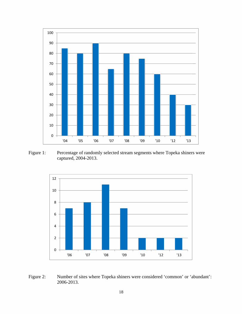
0
10
20
30
40
50
60
70
80
90
100
04 05 06 07 08 09 10 12 13
Figure 1 Percentage of randomly selected stream segments where Topeka shiners were captured 2004-2013
0
2
4
6
8
10
12
06 07 08 09 10 12 13
Figure 2 Number of sites where Topeka shiners were considered lsquocommonrsquo or lsquoabundantrsquo 2006-2013
18
Appendix A- Maps of Stream Segments
Map 1 Overview of 180 one-mile stream segments sampled during 2004-2013
Map 2 Presenceabsence of Topeka shiners at segments sampled during 2004-2013
Maps 3-42 Aerial views of the 40 sample segments that were sampled in 2012 and 2013
0114
South
Dak
ota
Iowa
168
sectbrvbar90
0159
0175
QR23
QR267
QR266
QR270
QR91
QR30
Iona
Jasper
Adrian
Wilmont
Slayton
Ruthton
Russell
Luverne
Balaton
Magnolia
Florence
Edgerton
Pipestone Lake Wilson
Lake Benton
NOBLES
MURRAY
ROCK
LYON
PIPESTONE
LINCOLN
160
159
158
157 156
154
153
152
151
150
149
148
147
145
144
143 142
141
155
146
180
169
178 177
176
175
174 173
163
164
179
170 167
166 165
162
172
161
171
Map 1 Overview of Random Segments2004-2013
2013 Segments 2012 Segments 2004-2010 Segments T Shiner critical habitat
Popula ed Places t Interstate Federal Trunk State Trunk Counties in Minnesota
sup2
5 25 0 5 10 Miles
0114Tracy
Map 2 Overview of segments where Topeka Shiners were found 2004-2013
2013 Random Segments Topekas found (n = 6
n = 14
)
)
Topekas not found ( )
ts )
2012 Random SegmenTopekas found (n = 8)Topekas not found (n = 12)
2004-2010 Random Segments Topekas found (n = 107)Topekas not found (n = 33)T Shiner critical habitat Populated Places Interstate Federal Trunk State Trunk Counties in Minnesota
sup2
South
Dak
ota
)
)
)
)
)
)
)
)
)
)
)
)
)
)
)
))
)
)
)
Iowa
sectbrvbar90
0159
0175
QR23
QR267
QR266
QR270
QR91
QR30
Iona
Jasper
Adrian
Wilmont
Slayton
Ruthton
Russell
Luverne
Balaton
Magnolia
Florence
Edgerton
Pipestone Lake Wilson
Lake Benton
NOBLES
MURRAY
ROCK
LYON
PIPESTONE
LINCOLN
157147
155 156
160 158
154
159
152 153
151
150
148
149 146
145
144
142 143
141
179
176
177 178 180
175
174 173 172
171
169 170 168 167
166 165
164
163
162
161
5 25 0 5 10 Miles
141-1 141-2
0 008 016 024 032 004 Miles
Map 3 Segment 141
acute Lincoln County
142-9
142-1
142-8 142-7 142-6
142-5142-4
142-10
142-3 142-2
0 008 016 024 032 004 Miles
Map 4 Segment 142
acutePipestone County
143-9
143-8 143-7
143-6
143-2
143-5 143-4
143-3
143-1 143-10
0 0085 017 0255 034 00425 Miles
Map 5 Segment 143
acutePipestone County
144-1
144-9
144-8
144-7
144-6 144-5
144-4
144-3
144-2
144-10
0 008 016 024 032 004 Miles
Map 6 Segment 144
acutePipestone County
145-5
145-4
145-3
145-2
145-6
145-1
0 008 016 024 032 004 Miles
Map 7 Segment 145
acutePipestone County
146-1
146-9
146-8 146-7 146-6
146-5 146-4 146-3
146-10
146-2
0 008 016 024 032 004 Miles
Map 8 Segment 146
acutePipestone County
147-9 147-8
147-7
147-6 147-5
147-4
147-3 147-2
147-1
147-13
147-12
147-11
147-10
0 008 016 024 032 004 Miles
Map 9 Segment 147
acute Nobles County
148-4148-3
148-2
148-1
0 008 016 024 032 004 Miles
Map 10 Segment 148
acutePipestone County
149-2
149-1 149-4
149-3
0 008 016 024 032 004 Miles
Map 11 Segment 149
acutePipestone County
150-4 150-3
150-2
150-1
0 008 016 024 032 004 Miles
Map 12 Segment 150
acute Rock County
151-1
0 008 016 024 032 004 Miles
Map 13 Segment 151
acute Rock County
152-9
152-8
152-7 152-6
152-5
152-4 152-3
152-2 152-1
152-10
0 008 016 024 032 004 Miles
Map 14 Segment 152
acute Rock County
153-9 153-8
153-7
153-4 153-5
153-6
153-3
153-2 153-1
153-10
0 008 016 024 032 004 Miles
Map 15 Segment 153
acute Rock County
154-9 154-8 154-7 154-6
154-5 154-4
154-3 154-1
154-17
154-16
154-15 154-14
154-13 154-12
154-11 154-10
154-2
0 008 016 024 032 004 Miles
Map 16 Segment 154
acute Rock County
155-9 155-8
155-7
155-6
155-5155-4 155-2
155-10
155-3 155-1
0 008 016 024 032 004 Miles
Map 17 Segment 155
acute Nobles County
156-1
0 008 016 024 032 004 Miles
Map 18 Segment 156
acute Nobles County
157-9157-8
157-7
157-6
157-5
157-4157-3
157-2
157-1
157-12
157-11157-10
Map 19 Segment 157
acute Nobles County
0 008 016 024 032004 Miles
158-9
158-8 158-7
158-6
158-5
158-4158-3
158-2 158-1
158-15 158-13
158-12158-11
158-10
158-14
Map 20 Segment 158
acute Nobles County
0 008 016 024 032 004 Miles
159-9 159-8
159-6
159-4
159-12 159-11
159-10
159-7 159-5
159-3 159-2
159-1
Map 21 Segment 159
acute Nobles County
0 0055 011 0165 022 00275 Miles
160-9
160-8160-7
160-6 160-5
160-4
160-3 160-2
160-1
160-25
160-23
160-22
160-21160-20
160-19 160-18
160-16
160-14
160-13 160-12
160-11
160-24
160-17 160-15
160-10
Map 22 Segment 160
acute Nobles County
0 008 016 024 032 004 Miles
161-9
161-8 161-7
161-6161-5
161-4
161-3 161-2
161-1
161-15
161-14
161-13
161-12 161-11 161-10
Map 23 Segment 161 Lincoln County
acute 0 004 008 016 024 032 Miles
162-9 162-7 162-8
162-6 162-5
162-4 162-3
162-2162-1
162-10
Map 24 Segment 162Pipestone County
acute 0 004 008 016 024 032 Miles
163-9 163-8
163-7
163-6
163-5
163-4
163-3 163-15
163-14 163-13
163-12 163-11
163-10
163-2163-1
Map 25 Segment 163Pipestone County
acute 0 0045 009 018 027 036Miles
164-9
164-7
164-6
164-5
164-4 164-3
164-2 164-1 164-11
164-10 164-8
Map 26 Segment 164Pipestone County
acute 0 004 008 016 024 032 Miles
165-9 165-8
165-6
165-5 165-4
165-2
165-16 165-15
165-14
165-13
165-11 165-10
165-7
165-3 165-1
165-12
Map 27 Segment 165Pipestone County
acute 0 0075 015 03 045 06 Miles
166-9166-8
166-7 166-6
166-5
166-4
166-3 166-2
166-1
166-10
Map 28 Segment 166Pipestone County
acute 0 004 008 016 024 032 Miles
167-9167-8167-7
167-4 167-2
167-1
167-12 167-11
167-10
167-6
167-5
167-3
Map 29 Segment 167Pipestone County
acute 0 004 008 016 024 032 Miles
168-1
Map 30 Segment 168Pipestone County
acute 0 004 008 016 024 032 Miles
169-2
169-1 Map 31 Segment 169
Pipestone County
acute 0 004 008 016 024 032 Miles
170-8
170-7 170-6
170-5
170-9
170-4
170-3
170-2
170-1
170-10
Map 32 Segment 170 Murray County
acute 0 004 008 016 024 032 Miles
171-2
171-9
171-8 171-7
171-6
171-5
171-4 171-3
171-1
171-10
Map 33 Segment 171 Rock County
acute 0 004 008 016 024 032 Miles
172-9 172-8
172-7
172-6 172-5
172-4
172-3 172-2 172-1
172-11 172-10
Map 34 Segment 172 Rock County
acute 0 004 008 016 024 032 Miles
173-9 173-8
173-6 173-5
173-4173-3
173-2173-1
173-10 173-7
Map 35 Segment 173Rock County
acute 0 005 01 02 03 04Miles
174-2
174-1
Map 36 Segment 174 Rock County
acute 0 004 008 016 024 032 Miles
175-8
175-7
175-5
175-4
175-3 175-2175-1
175-6
Map 37 Segment 175Rock County
acute 0 004 008 016 024 032Miles
176-2176-1
176-3
176-6 176-5 176-4
176-7
176-8
176-9176-10
176-11 176-12
176-13
Map 38 Segment 176Rock County
acute 0 004 008 016 024 032Miles
177-9 177-8177-7
177-4
177-3
177-2 177-1
177-12
177-11
177-10
177-6177-5
Map 39 Segment 177Rock County
acute 0 004008 016 024 032Miles
178-11 178-12
178-10
178-9
178-8
178-1 178-2 178-3
178-7
178-5
178-4 178-6 Map 40 Segment 178
Rock County
acute 0 004 008 016 024 032 Miles
179-9
179-8
179-7
179-6
179-5
179-4
179-3179-2
179-12
179-11
179-10
179-1
Map 41 Segment 179Nobles County
acute 0 004 008 016 024 032Miles
180-1
Map 42 Segment 180 Nobles County
acute 0 004 008 016 024 032 Miles
Appendix B- Tables 1- 4
Table 1 2012 Segments Samples Sites and Topeka Shiner PresenceAbsence
Table 2 2013 Segments Samples Sites and Topeka Shiner PresenceAbsence
Table 3 List of Fish Species Collected at Segments 141-160 2012
Table 4 List of Fish Species Collected at Segments 161-180 2013
Table 1 Locations of the twenty stream Segments (sites 141-160) sampled in 2012 corresponding sampling sites within each
segment and a brief habitat description for each site from which Topeka shiners were collected Included are a
Common Location descriptor (approximate mileage amp direction to nearest townhighways) the TownshipRange
for the 20 Segments and UTM coordinates for each sampling site Habitat type is an aproximate characterization
of the specific sample site within the sample reach pooled areas along the stream channel (pool) low-flow reaches
of stream and backwater habitats along the main channel boundary (in-channelMCB) ponds adjacent to the sample
reach that are not connected to the main channel of the stream (pool off-channel)
Segment Stream Name amp Common Location
County T R Section(s) Township Name Site Number Habitat Type Latitude Longitude
141 Medary Creek 7 mi W Lake Benson
Lincoln 109 46 8 Verdi 141-1 in-channelMCB 4425815 -9642240
141-2 pool 4425819 -9642236
Habitat Description narrow (2-4m) headwater stream little to no flow
Topeka shiner present single Topeka shiner collected among submerged macrophytes in pool at bend in stream
Substrate = sandsilt mixture
(Table 1 continued on next page)
Table 1 Continued
Segment Stream Name amp Common Location
County T R Section(s) Township Name Site Number Habitat Type Latitude Longitude
142 Willow Creek at Co Rd 8 1 mi N 12 mi W Holland
Pipestone 108 46 31 Altona 142-1 pool 4411068 -9642268
107 46 6 142-2 pool 4411055 -9642243
142-3 in-channelMCB 4411061 -9642221
142-4 in-channelMCB 4411047 -9642223
142-5 in-channelMCB 4411043 -9642211
142-6 in-channelMCB 4411018 -9642220
142-7 in-channelMCB 4411019 -9642201
142-8 in-channelMCB 4411019 -9642194
142-9 in-channelMCB 4411113 -9642301
142-10 in-channelMCB 4411116 -9642346
Habitat Description narrow (2-m) headwater stream little or no OCH present Sampled pool at CR 8 bridge
Current very slow Pooled areas separated by very narrow flowing channel with hard substrate
No Topeka shiners captured
Substrate = silt sand gravel
143 E Branch Flandreau Creek 4 mi N 5 mi W Holland
Pipestone 108 45 18-20 Fountain Prairie 143-1 pool 4415401 -9629187
143-2 pool 4415404 -9629184
143-3 pool 4415410 -9629186
143-4 pool 4415429 -9629205
143-5 in-channelMCB 4415441 -9629212
143-6 pool 4415331 -9628520
143-7 pool 4415321 -9628527
143-8 pool 4415323 -9628568
143-9 in-channelMCB 4415329 -9628580
143-10 in-channelMCB 4415327 -9628601
Habitat Description low water very narrow (1m) gently-flowing stream in channel with littleno OCH between pooled areas
at bridges sampled pools at bridges at CR 10 bride and NS gravel cross road
No Topeka shiners captured
Substrate = firm sand gravel in-channel deep silt in pools
Table 1 Continued
Segment Stream Name amp Common Location
County T R Section(s) Township Name Site Number Habitat Type Latitude Longitude
144 N Branch Pipestone Creek 4 mi W 25 mi N Pipestone
Pipestone 107 46 29 32 Troy 144-1 in-channelMCB 4404130 -9639968
144-2 in-channelMCB 4404120 -9639945
144-3 in-channelMCB 4404122 -9640006
144-4 in-channelMCB 4404082 -9640085
144-5 pool off-channel 4404061 -9640078
144-6 in-channelMCB 4404015 -9640137
144-7 in-channelMCB 4403929 -9640102
144-8 pool off-channel 4403667 -9640429
144-9 pool off-channel 4403342 -9640218
144-10 pool off-channel 4403321 -9640217
Habitat Description slowly flowing water through majority of segment very little OCH along stream channel
sampled slackwater at bends and OC pools in adjacent pastures
No Topeka shiners captured
Substrate = silt gravel sand
Table 1 Continued
Segment Stream Name amp Common Location
County T R Section(s) Township Name Site Number Habitat Type Latitude Longitude
145 Pipestone Creek 4 mi W 2 mi N Ihlen
Pipestone 106 47 35 36 Sweet 145-1 pool 4393698 -9644445
105 47 2 145-2 pool 4393703 -9644465
145-3 pool 4393711 -9644491
145-4 pool 4393716 -9644545
145-5 pool 4393729 -9644589
145-6 pool 4393742 -9644625
Habitat Description low water Very narrow headwater stream (05 m) that is nearly dry between pools sampled in stagnant
pooled area upstream of a small boulder dam Floating mats of filamentous algae some submerged macrophytes
Topeka shiner present three captured at down stream end of pooled area
Substrate = silt clay some boulders sand
146 Split Rock Creek 15 mi N 05 mi E Jasper
Pipestone 105 46 28 29 Eden 146-1 pool 4387271 -9638712
146-2 pool 4387293 -9638684
146-3 pool 4387306 -9638659
146-4 pool 4387321 -9638572
146-5 in-channelMCB 4387320 -9638548
146-6 pool off-channel 4387264 -9638386
146-7 pool off-channel 4387263 -9638364
146-8 pool 4387273 -9638244
146-9 pool 4387324 -9638217
146-10 pool 4387539 -9638146
Habitat Description very low water shallow sandy pool at CR 53 bridge narow (2-3 m) channel between pooled areas
No Topeka shiners captured
Substrate = boulder gravel sand Deep silt along margins of pools
Table 1 Continued
Segment Stream Name amp Common Location
County T R Section(s) Township Name Site Number Habitat Type Latitude Longitude
147 Kanaranzi Creek 15 mi W 1 mi N Lismore
Nobles 103 42 17 18 Altona 147-1 in-channelMCB 4373149 -9591764
147-2 in-channelMCB 4373161 -9591743
147-3 in-channelMCB 4373182 -9591719
147-4 in-channelMCB 4373199 -9591705
147-5 in-channelMCB 4373202 -9591686
147-6 in-channelMCB 4373128 -9591596
147-7 in-channelMCB 4373100 -9591516
147-8 in-channelMCB 4373022 -9591492
147-9 in-channelMCB 4373007 -9591488
147-10 in-channelMCB 4372980 -9591491
147-11 in-channelMCB 4372904 -9591487
147-12 in-channelMCB 4372874 -9591463
147-13 in-channelMCB 4372779 -9591314
Habitat Description very low water narrow (2-3 m) channel high steep banks littleno OCH S end of segment ditched
No Topeka shiners captured
Substrate = gravel silt muck
148 Rock River 25 mi E 1 mi S Hatfield
Pipestone 106 44 33 Burke 148-1 in-channelMCB 4394307 -9614039
148-2 in-channelMCB 4394304 -9614026
148-3 in-channelMCB 4394280 -9613970
148-4 pool 4394283 -9613991
Habitat Description low water 3m wide flowing stream N end of segment nearly dry some backwater OCH present
Topeka shiner present two individuals captured in 20m x 3m backwater pool adjacent to the main channel
Substrate = sand gravel muck
Table 1 Continued
Segment Stream Name amp Common Location
County T R Section(s) Township Name Site Number Habitat Type Latitude Longitude
149 Rock River 1 mi SW of Edgerton
Pipestone 105 44 33 Osborne 149-1 pool 4385836 -9613494
149-2 pool 4385839 -9613508
149-3 in-channelMCB 4385830 -9613528
149-4 in-channelMCB 4385809 -9613627
Habitat Description low water 13m wide flowing stream small backwaters along MCB and pools at bridge
Topeka shiner present one individual captured in small backwater along MCB
Substrate = Gravel sand cobble Deep silt in off-channel areaspools
150 Split Rock Creek 6 mi S 2 mi W Jasper
Rock 104 47 35 Rose Dell 150-1 in-channelMCB 4377128 -9643910
150-2 in-channelMCB 4377116 -9643912
150-3 in-channelMCB 4377114 -9643931
150-4 in-channelMCB 4377149 -9643814
Habitat Description 15m wide slowly flowing stream with high steep eroded banks Low water
Topeka shiner present two individuals captured in 15m x 25m shallow silted puddle along MCB
Substrate = gravel sand silt
Table 1 Continued
Segment Stream Name amp Common Location
County T R Section(s) Township Name Site Number Habitat Type Latitude Longitude
151 Beaver Creek E 45 mi N 35 W Luverne along CSAH 20
Rock 103 45 18 19 Mound 151-1 pool 4371768 -9628182
Habitat Description 80m x 40m pool downstream of bridge no flow deep (1m) silt over clay Topeka shiner abundant 18 individuals captured in single seine haul in pool Substrate = deep (1m) silt over clay
152 Beaver Creek 35 mi W 15 mi S Beaver Creek along CSAH 7
Rock 102 47 35 36 Beaver Creek 152-1 in-channelMCB 4359418 -9643251
152-2 in-channelMCB 4359419 -9643293
152-3 in-channelMCB 4359420 -9643288
152-4 in-channelMCB 4359426 -9643393
152-5 in-channelMCB 4359423 -9643445
152-6 in-channelMCB 4359427 -9643467
152-7 in-channelMCB 4359421 -9643060
152-8 in-channelMCB 4359404 -9643035
152-9 in-channelMCB 4359305 -9643008
152-10 in-channelMCB 4359301 -9642999
Habitat Description 4m wide slowly flowing stream with high steep banks No OCH present Sampled slow water areas
along MCB
No Topeka shiners captured
Substrate = Silt sand gravel
Table 1 Continued
Segment Stream Name amp Common Location
County T R Section(s) Township Name Site Number Habitat Type Latitude Longitude
153 Beaver Creek 1 mi N 175 mi E Beaver Creek
Rock 102 46 14 23 Beaver Creek 153-1 in-channelMCB 4363076 -9632975
153-2 in-channelMCB 4363049 -9633007
153-3 in-channelMCB 4362954 -9632909
153-4 in-channelMCB 4362915 -9633117
153-5 in-channelMCB 4362911 -9633148
153-6 in-channelMCB 4362835 -9633249
153-7 in-channelMCB 4363324 -9632725
153-8 in-channelMCB 4363240 -9632740
153-9 in-channelMCB 4363233 -9632762
153-10 in-channelMCB 4363224 -9632770
Habitat Description 3m wide slowly flowing streamHigh steep banks Lots of bank erosion and very little OCH Off
channel ponds along northern 13 of segment were dry Water very low Cattle in stream Sampled slack water along MCB
No Topeka shiners captured
Substrate = firm sandsilt in backwater sandgravel in main channel
Table 1 Continued
Segment Stream Name amp Common Location
County T R Section(s) Township Name Site Number Habitat Type Latitude Longitude
154 Rock River 4mi S 25 mi W Steen
Rock 101 45 13 Clinton 154-1 pool 4355354 -9618125
154-2 in-channelMCB 4355362 -9618154
154-3 in-channelMCB 4355350 -9618191
154-4 in-channelMCB 4355254 -9618127
154-5 pool 4355287 -9617972
154-6 in-channelMCB 4355211 -9618013
154-7 in-channelMCB 4355206 -9618099
154-8 in-channelMCB 4355216 -9618146
154-9 in-channelMCB 4355197 -9618235
154-10 in-channelMCB 4355121 -9618336
154-11 in-channelMCB 4355081 -9618361
154-12 in-channelMCB 4355022 -9618309
154-13 in-channelMCB 4354985 -9618238
154-14 riffle 4354849 -9618238
154-15 in-channelMCB 4354810 -9618156
154-16 in-channelMCB 4354787 -9618069
154-17 in-channelMCB 4354709 -9618012
Habitat Description Wide (10m) flowing stream with ample OCH Channel is braided along meanders
with backwater habitat along sandgravel bars Wooded riparian corridor
No Topeka shiners captured
Substrate = gravel sand silt
Table 1 Continued
Segment Stream Name amp Common Location
County T R Section(s) Township Name Site Number Habitat Type Latitude Longitude
155 Elk Creek 3 mi N 3 mi E Magnolia along CSAH 19
Nobles 103 43 29 32 Lismore 155-1 pool 4368849 -9602497
155-2 pool 4368832 -9602512
155-3 pool 4368842 -9602019
155-4 in-channelMCB 4368859 -9602008
155-5 in-channelMCB 4368861 -9602002
155-6 in-channelMCB 4368868 -9601990
155-7 in-channelMCB 4368870 -9601969
155-8 in-channelMCB 4368877 -9601940
155-9 in-channelMCB 4368896 -9601932
155-10 in-channelMCB 4368923 -9601916
Habitat Description Water very low Narrow (2m) intermittent stream Stream bed is dry in places between isolated pools
No flow Sampled at pooled areas at culverts at CH 19
No Topeka shiners captured
Substrate = silt muck gravel
156 Elk Creek 4 mi N 4 mi E Magnolia along CSAH 14
Nobles 103 43 21 28 Lismore 156-1 pool 4370276 -9600072
Habitat Description very small headwater stream (1m) that is nearly dry between pools Sampled on margin of 20m x 50m
pool at bridge Pool depth gt 2m Thick mats of floating filamentous algae pool depth and submerged macrophytes
made seining difficult
Topeka shiner abundant 5 individuals captured in single kick set on margin of pool Numerous male Topeka shiners were observed defending cleared patches of gravel along the margin of the pool Substrate = silt over gravel
Table 1 Continued
Segment Stream Name amp Common Location
County T R Section(s) Township Name Site Number Habitat Type Latitude Longitude
157 Kanaranzi Creek 15 mi E 2 mi S Lismore
Nobles 103 42 17 19 20 Larkin 157-1 pool 4371762 -9591115
157-2 pool 4371757 -9591102
157-3 pool 4371753 -9591108
157-4 pool 4371755 -9591112
157-5 pool 4371785 -9591112
157-6 pool 4371786 -9591115
157-7 pool 4371793 -9591111
157-8 in-channelMCB 4371818 -9591105
157-9 in-channelMCB 4371820 -9591097
157-10 in-channelMCB 4371829 -9591093
157-11 in-channelMCB 4371835 -9591097
157-12 in-channelMCB 4371785 -9591100
Habitat Description Stream has been ditchedchannelized High banks and no OCH is present except for a pooled area upstream of a beaver dam that is S of the bridge No Topeka shiners captured Substrate = silt muck sand
Table 1 Continued
Segment Stream Name amp Common Location
County T R Section(s) Township Name Site Number Habitat Type Latitude Longitude
158 Kanaranzi Creek 2 mi E 35 mi S Magnolia
Nobles 102 43 31 32 Westside 158-1 pool 4359742 -9603359
158-2 pool 4359741 -9603408
158-3 in-channelMCB 4359686 -9603499
158-4 in-channelMCB 4359660 -9603513
158-5 in-channelMCB 4359620 -9603518
158-6 pool 4359584 -9603554
158-7 in-channelMCB 4359590 -9603589
158-8 in-channelMCB 4359600 -9603617
158-9 in-channelMCB 4359555 -9603658
158-10 in-channelMCB 4359527 -9603683
158-11 in-channelMCB 4359463 -9603681
158-12 in-channelMCB 4359454 -9603681
158-13 in-channelMCB 4359416 -9603690
158-14 in-channelMCB 4359399 -9603722
158-15 in-channelMCB 4359383 -9603735
Habitat Description 4m wide slowly flowing stream Sampled backwater and off-channel habitats along MCB and side channels Hard gravelsand substrate in channel Ample low-flow habitat along sandgravel bars No Topeka shiners captured Substrate = sand gravel silt
Table 1 Continued
Segment Stream Name amp Common Location
County T R Section(s) Township Name Site Number Habitat Type Latitude Longitude
159 Kanaranzi Creek 1 mi NW Adrian along CSAH 35
Nobles 102 43 13 Westside 159-1 pool 4364453 -9595165
159-2 pool 4364481 -9595166
159-3 pool 4364479 -9595182
159-4 pool 4364461 -9595195
159-5 in-channelMCB 4364438 -9595194
159-6 in-channelMCB 4364427 -9595224
159-7 in-channelMCB 4364406 -9595307
159-8 in-channelMCB 4364407 -9595333
159-9 in-channelMCB 4364401 -9595360
159-10 pool 4364448 -9595347
159-11 in-channelMCB 4364467 -9595077
159-12 in-channelMCB 4364500 -9594982
Habitat Description Flowing 7m wide stream Abundant backwaters pools and OCH along MCB
Topeka shiner present a single individual captured in a side channel over gravelsand mix after much effort
Substrate = gravel sand silt
Table 1 Contined
Segment Stream Name amp Common Location
County T R Section(s) Township Name Site Number Habitat Type Latitude Longitude
160 Little Rock River 1 mi E 4 mi S Rushmore
Nobles 101 41 16 17 Ransom 160-1 in-channelMCB 4355809 -9577372
160-2 in-channelMCB 4355819 -9577356
160-3 in-channelMCB 4355826 -9577324
160-4 in-channelMCB 4355820 -9577237
160-5 in-channelMCB 4355819 -9577193
160-6 in-channelMCB 4355824 -9577181
160-7 in-channelMCB 4355803 -9577151
160-8 in-channelMCB 4355800 -9577123
160-9 in-channelMCB 4355810 -9577124
160-10 in-channelMCB 4355827 -9577099
160-11 in-channelMCB 4355803 -9576997
160-12 in-channelMCB 4355766 -9576964
160-13 in-channelMCB 4355763 -9576986
160-14 in-channelMCB 4355706 -9576972
160-15 in-channelMCB 4355811 -9577403
160-16 in-channelMCB 4355798 -9577529
160-17 in-channelMCB 4355760 -9577529
160-18 in-channelMCB 4355759 -9577500
160-19 in-channelMCB 4355736 -9577556
Table 1 Site 160 Continued Table 1 Concluded
Segment Stream Name amp Common Location
County T R Section(s) Township Name Site Number Habitat Type Latitude Longitude
160 Little Rock River 1 mi E 4 mi S Rushmore
160-20 in-channelMCB 4355748 -9577608
160-21 in-channelMCB 4355752 -9577642
160-22 in-channelMCB 4355689 -9577684
160-23 in-channelMCB 4355681 -9577736
160-24 in-channelMCB 4355642 -9577828
160-25 in-channelMCB 4355622 -9577895
Habitat Description Slowly flowing 3m wide stream with high steep banks Little or no OCH Portions of this stream
appear to have been ditched and rip-rapped
No Topeka shiners captured
Substrate = gravel sand muck
Table 2 Locations of the twenty stream Segments (sites 161-180) sampled in 2013 corresponding sampling sites within
each segment and a brief habitat description for each site from which Topeka shiners were collected Included
are a Common Location descriptor (approximate mileage amp direction to nearest townhighways) the
TownshipRange for the 20 Segments and UTM coordinates for each sampling site Habitat type is an aproximate
characterization of the specific sample site within the sample reach pooled areas along the stream channel (pool)
low-flow reaches of stream and backwater habitats along the main channel boundary (in-channelMCB) ponds
adjacent to the sample reach that are not connected to the main channel of the stream (pool off-channel)
Segment Stream Name amp Common Location
County T R Section(s) Township Name Site Number Habitat Type Latitude Longitude
161 Medary Creek 7 mi W Lake Benson
Lincoln 109 46 7 Verdi 161-1 in-channelMCB 4425807000 -9642702300
161-2 in-channelMCB 4425815900 -9642724800
161-3 in-channelMCB 4425836800 -9642739100
161-4 in-channelMCB 4425898800 -9642738400
161-5 in-channelMCB 4425902800 -9642724500
161-6 in-channelMCB 4425904800 -9642721000
161-7 in-channelMCB 4425924400 -9642696700
161-8 in-channelMCB 4425928300 -9642687800
161-9 in-channelMCB 4425931400 -9642670400
161-10 in-channelMCB 4425936800 -9642650600
161-11 in-channelMCB 4425928700 -9642638400
161-12 in-channelMCB 4425969600 -9642576100
161-13 pool 4426041100 -9642542500
161-14 in-channelMCB 4426093000 -9642681600
161-15 in-channelMCB 4426018800 -9642819900
Habitat Description narrow (2m) flowing headwater stream beaver dams along sample reach
Topeka shiner present nine Topeka shiners captured in a flowing pool downstream of a beaver dam
Thousands of fish downstream of dam and almost none in the upstream sites 1-14
Substrate = cobble gravel silt
Table 2 Continued
Segment Stream Name amp Common Location
County T R Section(s) Township Name Site Number Habitat Type Latitude Longitude
162 Willow Creek 13 mi W Ruthton
Pipestone 108 46 4 29 Altona 162-1 in-channelMCB 4418795200 -9636967900
162-2 in-channelMCB 4418776900 -9636978700
162-3 in-channelMCB 4418554500 -9637231900
162-4 pool 4418587700 -9637323700
162-5 pool 4418588600 -9637353100
162-6 pool 4418597900 -9637352800
162-7 pool 4418617800 -9637343500
162-8 pool 4418608500 -9637352600
162-9 pool 4418659800 -9637532400
162-10 pool 4418647400 -9637460200
Habitat Description very narrow (1m) headwater stream slow flow large pool (sites 4-8) appears to be an excavated pond
metal debris and fencing material made seining difficult Seined pooled areas in cattail beds
No Topeka shiners captured Substrate = sand gravel silt
Table 2 Continued
Segment Stream Name amp Common Location
County T R Section(s) Township Name Site Number Habitat Type Latitude Longitude
163 Flandreau Creek 4 mi N 5 mi W Holland
Pipestone 108 46 29 Altona 163-1 pool 4412550100 -9639615400
163-2 pool 4412552400 -9639616700
163-3 pool 4412550000 -9639640600
163-4 in-channelMCB 4412625200 -9639662400
163-5 in-channelMCB 4412595100 -9639579900
163-6 in-channelMCB 4412681700 -9639517200
163-7 pool 4412703400 -9639517600
163-8 pool 4412761900 -9639631000
163-9 pool 4412764600 -9639631600
163-10 pool 4412782600 -9639590000
163-11 pool 4412754600 -9639531600
163-12 pool 4412762600 -9639632100
163-13 in-channelMCB 4413017900 -9639591600
163-14 in-channelMCB 4413084800 -9639438100
163-15 pool 4412573500 -9639553100
Habitat Description 3m wide flowing stream Channel appears to have been ditched most of plotted reach is dry Seined in heavily vegetated stagnant pools No Topeka shiners captured Substrate = firm sand gravel in-channel deep silt along MCB
Table 2 Continued
Segment Stream Name amp Common Location
County T R Section(s) Township Name Site Number Habitat Type Latitude Longitude
164 Flandreau Creek 65 mi W 55 mi N Pipestone
Pipestone 107 47 13 14 Troy 164-1 pool 4408042400 -9644734000
164-2 pool 4408043100 -9644720500
164-3 pool 4408042200 -9644708000
164-4 pool 4407996200 -9644910500
164-5 in-channelMCB 4407938200 -9644906400
164-6 in-channelMCB 4407760400 -9644847500
164-7 in-channelMCB 4407796600 -9644913300
164-8 in-channelMCB 4407806300 -9644950500
164-9 in-channelMCB 4407797700 -9644981100
164-10 in-channelMCB 4407809800 -9644991500
164-11 pool 4408029200 -9645104800
Habitat Description flowing 3-5m wide stream with firm gravel substrate in thalweg Sampled pooled area at bridge
some off-channel habitat at sites 4 and 11 Banks are steep along most of the reach with little slackwater habitat along MCB
No Topeka shiners captured
Substrate = gravel sand cobble in-channel Deep silt in low-flow areas
Table 2 Continued
Segment Stream Name amp Common Location
County T R Section(s) Township Name Site Number Habitat Type Latitude Longitude
165 North Branch Pipestone Creek 4 mi W 3 mi N Pipestone
Pipestone 107 46 29 Troy 165-1 pool 4404501300 -9639278100
165-2 pool 4404481000 -9639316800
165-3 pool 4404472800 -9639315500
165-4 in-channelMCB 4404457500 -9639325200
165-5 in-channelMCB 4404434800 -9639340300
165-6 in-channelMCB 4404446400 -9639386900
165-7 in-channelMCB 4404320300 -9639371300
165-8 pool 4404299200 -9639403700
165-9 pool 4404302200 -9639429200
165-10 pool 4404289200 -9639430300
165-11 pool 4404283700 -9639418700
165-12 in-channelMCB 4404212300 -9639411800
165-13 in-channelMCB 4404195800 -9639463400
165-14 in-channelMCB 4404244400 -9639645200
165-15 in-channelMCB 4404163700 -9639819800
165-16 in-channelMCB 4404165900 -9639797900
Habitat Description moderately flowing 3-5m wide stream Recent increase in stream level some submerged terrestrial
grasses along MCB Sites 8-11 in oxbow Submerged terrestrial grasses in oxbow
No Topeka shiners captured
Substrate = sand gravel silt
Table 2 Continued
Segment Stream Name amp Common Location
County T R Section(s) Township Name Site Number Habitat Type Latitude Longitude
166 Pipestone Creek 35 mi W 1 mi N Pipestone
Pipestone 106 46 4 5 Sweet 166-1 in-channelMCB 4401330100 -9638708400
166-2 in-channelMCB 4401347000 -9638709700
166-3 in-channelMCB 4401345500 -9638703700
166-4 in-channelMCB 4401355800 -9638703000
166-5 in-channelMCB 4401541200 -9638596400
166-6 in-channelMCB 4401618700 -9638658000
166-7 in-channelMCB 4401623400 -9638660800
166-8 in-channelMCB 4401625200 -9638646200
166-9 in-channelMCB 4401633300 -9638635600
166-10 in-channelMCB 4401740500 -9638517300
Habitat Description 10m wide slowly flowing stream Sampled along MCB in slack water West end of segment appears
to have been ditched Littleno OCH Drainage tiles along E reach of segment
No Topeka shiners captured
Substrate = cobble gravel sand Deep silt along margins of pools
Table 2 Continued
Segment Stream Name amp Common Location
County T R Section(s) Township Name Site Number Habitat Type Latitude Longitude
167 Split Rock Creek 15 mi N 1 mi E Ihlen
Pipestone 105 46 3 Eden 167-1 pool 4392585400 -9634993300
167-2 in-channelMCB 4392638100 -9635031600
167-3 pool 4392643100 -9635103600
167-4 pool 4392638200 -9635101900
167-5 pool 4392633000 -9635108800
167-6 pool 4392633200 -9635116400
167-7 pool 4392635700 -9635131600
167-8 pool 4392636400 -9635139100
167-9 pool 4392635900 -9635156000
167-10 in-channelMCB 4392470900 -9635255600
167-11 in-channelMCB 4392465600 -9635242800
167-12 in-channelMCB 4392447500 -9635240300
Habitat Description very small headwater stream (~1m) water low isolated series of pools along streambed No Topeka shiners captured Substrate = sand gravel silt
168 Split Rock Creek 15 mi N 05 mi E Jasper
Pipestone 105 46 28 29 Eden 168-1 in-channelMCB 4387771400 -9638026400
Habitat Description high water 4m wide flowing stream submerged terrestrial grasses on margins
Topeka shiner common 6 individuals captured on first seine haul in pooled area at MCB just downstream of culvert
Substrate = boulder cobble sand
Table 2 Continued
Segment Stream Name amp Common Location
County T R Section(s) Township Name Site Number Habitat Type Latitude Longitude
169 Rock River 1 mi SW of Edgerton
Pipestone 105 44 17 18 Osborne 169-1 pool 4389371700 -9616564700
169-2 in-channelMCB 4389439900 -9616531800
Habitat Description Swiftly flowing 10m wide stream at high water Sampled pooled area at outside bend of stream
over deep silt
Topeka shiner present four individuals captured in four seine hauls in a 1m wide drainage channel that joins a
retention pond to the Rock River
Substrate = Silt gravel Deep silt in off-channel areaspools
170 Chanarambie Creek 05 mi S 05 mi E Chandler
Murray 104 47 35 Fenton 170-1 in-channelMCB 4392093400 -9593156600
170-2 in-channelMCB 4391890200 -9593079300
170-3 in-channelMCB 4391841400 -9593168100
170-4 in-channelMCB 4391784300 -9593090300
170-5 in-channelMCB 4391783100 -9593060700
170-6 in-channelMCB 4391790600 -9593061100
170-7 in-channelMCB 4391796700 -9593025000
170-8 in-channelMCB 4391792000 -9592982800
170-9 in-channelMCB 4392105300 -9593062100
170-10 in-channelMCB 4392122900 -9593165100
Habitat Description narrow (1-2m) headwater stream Stream is flowing swiftly and little or no OCH is present
most of the segment appears to have been channelized
No Topeka shiners captured
Substrate = silt sand
Table 2 Continued
Segment Stream Name amp Common Location
County T R Section(s) Township Name Site Number Habitat Type Latitude Longitude
171 Rock River 4 mi S Edgerton
Rock 104 44 8 9 Battle Plain 171-1 in-channelMCB 4382021200 -9613013100
171-2 pool 4382126400 -9613470300
171-3 in-channelMCB 4382025300 -9612974300
171-4 in-channelMCB 4382027100 -9612961600
171-5 in-channelMCB 4382145400 -9613302800
171-6 in-channelMCB 4382380700 -9613520900
171-7 in-channelMCB 4382367500 -9613527700
171-8 in-channelMCB 4382359000 -9613532400
171-9 in-channelMCB 4382405300 -9613495400
171-10 in-channelMCB 4382271200 -9613570400
Habitat Description High water 8-12m wide swiftly flowing stream Stream is full to high banks Much of slackwater
areas along MCB likely inudndated Sampled in backwaters sites 6-9
No Topeka shiners captured
Substrate = Sand gravel silt
Table 2 Continued
Segment Stream Name amp Common Location
County T R Section(s) Township Name Site Number Habitat Type Latitude Longitude
172 Rock River tributary 1 mi E Hardwick
Rock 104 44 30 31 Battle Plain 172-1 pool 4377538900 -9617075500
172-2 pool 4377529200 -9617075600
172-3 pool 4377514700 -9617079800
172-4 in-channelMCB 4377386200 -9617079600
172-5 in-channelMCB 4377247100 -9617207900
172-6 in-channelMCB 4377241900 -9617224500
172-7 in-channelMCB 4377245200 -9617219500
172-8 in-channelMCB 4376956400 -9616914600
172-9 pool off-channel 4376998700 -9616876000
172-10 in-channelMCB 4377058800 -9616855700
172-11 in-channelMCB 4377043200 -9616826600
Habitat Description 3m wide slowly flowing pasture stream with high trampled banks Much of reach appears to
have been channelized no OCH present along MCBSampled in stock pond at site 9 Some submerged macrophytes
No Topeka shiners captured
Substrate = sand silt muck
Table 2 Continued
Segment Stream Name amp Common Location
County T R Section(s) Township Name Site Number Habitat Type Latitude Longitude
173 Mound Creek 1 mi N 175 mi E Beaver Creek
Rock 103 45 2 11 Mound 173-1 in-channelMCB 4374749900 -9620089200
173-2 in-channelMCB 4374756900 -9620094400
173-3 in-channelMCB 4374763700 -9620090700
173-4 in-channelMCB 4374842800 -9619838100
173-5 in-channelMCB 4374844000 -9619833200
173-6 in-channelMCB 4374889800 -9619789300
173-7 in-channelMCB 4374839600 -9619885800
173-8 in-channelMCB 4374827900 -9619934500
173-9 in-channelMCB 4374817000 -9619966400
173-10 in-channelMCB 4374799700 -9620048400
Habitat Description Entire reach of sement has been channelized Stream is 1-2m wide and constantly flowing High
banks No OCH
No Topeka shiners captured
Substrate = gravel sand silt
Table 2 Continued
Segment Stream Name amp Common Location
County T R Section(s) Township Name Site Number Habitat Type Latitude Longitude
174 Rock River tributary 55 mi N 4 mi E Luverne
Rock 103 44 8 9 Vienna 174-1 pool 4373333900 -9613250300
174-2 pool 4373322100 -9613262700
Habitat Description Narrow (2-3m) wide flowing headwater stream Sampled in deep silted pool at bridge Topeka shiner present two individuals captured over gravel in pooled area at bridge Much of the pool is filled with deep (gt05m) silt No Topeka shiners collected in silted portion of pool Substrate = gravel sand silt
Table 2 Continued
Segment Stream Name amp Common Location
County T R Section(s) Township Name Site Number Habitat Type Latitude Longitude
175 Champepadan Creek 4mi N 5 mi E Luverne
Rock 103 44 21 22 Vienna 175-1 pool 4371002900 -9611238300
175-2 pool 4371001900 -9611232600
175-3 pool 4371008300 -9611238900
175-4 in-channelMCB 4370955000 -9611142300
175-5 in-channelMCB 4371042200 -9610763900
175-6 in-channelMCB 4371007000 -9610720000
175-7 in-channelMCB 4370984100 -9610706400
175-8 pooloff-channel 4370971600 -9610709700
Habitat Description 3m wide stream with moderate flow Native prairie has been planted along both banks for the entire reach
No flow Sampled at pooled areas at culverts at CH 19
Topeka shiner present one individual captured in deep livestock pond S of stream Depth (gt2m) made seining in pond difficult
Substrate = sand silt gravel
Table 2 Continued
Segment Stream Name amp Common Location
County T R Section(s) Township Name Site Number Habitat Type Latitude Longitude
176 Kanaranzi Creek 2 mi W 35 mi N Ellworth
Rock 101 44 12 Kanaranzi 176-1 pool 4357304000 -9606413600
176-2 pool 4357305400 -9606410500
176-3 pool 4357249700 -9606408600
176-4 in-channelMCB 4357200500 -9606350300
176-5 in-channelMCB 4357204500 -9606354600
176-6 in-channelMCB 4357211400 -9606360400
176-7 in-channelMCB 4357127700 -9606357500
176-8 in-channelMCB 4357090500 -9606197900
176-9 in-channelMCB 4356817400 -9606275000
176-10 in-channelMCB 4356807000 -9606273900
176-11 in-channelMCB 4356639200 -9606408000
176-12 in-channelMCB 4356632100 -9606416000
176-13 in-channelMCB 4356598300 -9606381200
Habitat Description 10m wide flowing stream Very little OCH Very deep silt along MCB Sampled pooled area
at bridge High eroded banks
No Topeka shiners captured
Substrate = silt over gravel
Table 2 Continued
Segment Stream Name amp Common Location
County T R Section(s) Township Name Site Number Habitat Type Latitude Longitude
177 Rock River 05 mi N 4 mi E Steen
Rock 101 45 25 Clinton 177-1 pool 4352588900 -9618721100
177-2 pool 4352592700 -9618726600
177-3 in-channelMCB 4352519900 -9618594900
177-4 in-channelMCB 4352297500 -9618558400
177-5 in-channelMCB 4352147800 -9618456000
177-6 in-channelMCB 4352143300 -9618458200
177-7 in-channelMCB 4352125000 -9618453100
177-8 in-channelMCB 4352121500 -9618442200
177-9 in-channelMCB 4352106600 -9618444000
177-10 in-channelMCB 4352727900 -9618684800
177-11 pool 4352783000 -9618770800
177-12 pooloff-channel 4352663200 -9619046500
Habitat Description 11m wide flowing stream with wide channel sand bars and some braiding Firm gravel in thalweg Oxbow in middle of reach is nearly dry (lt25 cm) No fish observed culicid fly larvae abundant No Topeka shiners captured Substrate = sand gravel silt
Table 2 Continued
Segment Stream Name amp Common Location
County T R Section(s) Township Name Site Number Habitat Type Latitude Longitude
178 Kanaranzi Creek 2 mi W Ellsworth
Rock 101 44 25 36 Kanaranzi 178-1 pool 4351441400 -9605867000
178-2 in-channelMCB 4351404500 -9605846000
178-3 in-channelMCB 4351378800 -9605844300
178-4 pool 4351349700 -9605841200
178-5 pool 4351358400 -9605829800
178-6 pool 4351351800 -9605816800
178-7 in-channelMCB 4351355800 -9605866900
178-8 in-channelMCB 4351549000 -9605823700
178-9 in-channelMCB 4351891800 -9605895600
178-10 in-channelMCB 4351866200 -9605881400
178-11 pool 4352078500 -9606070000
178-12 pool 4352046000 -9606082200
Habitat Description 7-9m wide flowing stream Sampled backwater and off-channel habitats along MCB and side channels Recent high flow has filled in off-channel areas with deep silt Seining difficult No Topeka shiners captured Substrate = sand silt gravel
Table 2 Concluded
Segment Stream Name amp Common Location
County T R Section(s) Township Name Site Number Habitat Type Latitude Longitude
179 East Branch Kanaranzi Creek 15 mi N 15 mi E Adrian
Nobles 102 42 8 Olney 179-1 pool 4365932900 -9590462700
179-2 pool 4365928900 -9590449500
179-3 pool 4365930600 -9590463300
179-4 pool 4365908000 -9590420300
179-5 in-channelMCB 4365679800 -9590378600
179-6 in-channelMCB 4365661000 -9590387800
179-7 in-channelMCB 4365604000 -9590417100
179-8 in-channelMCB 4365508100 -9590385200
179-9 in-channelMCB 4365460100 -9590342200
179-10 pool 4365434900 -9590020100
179-11 in-channelMCB 4365507700 -9590154900
179-12 in-channelMCB 4365588000 -9589900200
Habitat Description Flowing 9m wide stream Stream is full to high banks very little slackwater habitat present at this site
No Topeka shiners captured
Substrate = sand silt gravel
180 Little Rock River 8 mi E Ellsworth
Nobles 101 42 26 Little Rock 180-1 in-channelMCB 4352838500 -9584615900
Habitat Description Sampled large pooled area at bridge no discernible flow silt over gravel substrate Channel downstream
of pool is a 2-3 m wide flowing stream with a firm sandgravel substrate
Topeka shiner abundant fourteen individuals captured in first seine haul in pool fifteen individuals captured in second seine
haul near outlet of the pool
Substrate = gravel sand silt
Table 3 Complete List of Fish Species Captured at Segments 141-160 2012
Species 141 142 143 144 145 146 147 148 149 150 151 152 153 154 155 156 157 158 159 160 Campostoma anomalum X X X X X X X X X X X X X X Chrosomus erythrogaster X X Cyprinella lutrensis X X X X X X X X X Cyprinus carpio X X X X X Hybognathus hankinsoni X X X X X X X Luxilus cornutus X X X X X X X X X X X X X Notropis dorsalis X X X X X X X X X X X Notropis stramineus X X X X X X X X X X X X X X X Notropis topeka X X X X X X X X Pimephales notatus X X X X X X X X X X X X Pimephales promelas X X X X X X X X X X X X X X X X X X Rhinichthys atratulus X X X X X X Semotilus atromaculatus X X X X X X X X X X X X X X X X X X Carpiodes cyprinus X Carpiodes sp (YOY) X X X Catostomus commersoni X X X X X X X X X X X X X X X Moxostoma macrolepidotum X X Ameiurus melas X X X X X X X X X X X X X Ameiurus natalis X Ictalurus punctatus X X X X Noturus flavus X X X X Noturus gyrinus X X X X X Esox lucius X X Percopsis omiscomaycus X Fundulus sciadicus X X X Culaea inconstans X X X X X Lepomis cyanellus X X X X X X X Lepomis humilis X X X X X X X X X X X Lepomis macrochirus X X X X X Micropterus dolomieui X Micropterus salmoides X X Pomoxis nigromaculatus X X Etheostoma exile X X X X X Etheostoma nigrum X X X X X X X X X X X X X X X X X Perca flavescens X X Percina maculata X X X X
Table 4 Complete List of Fish Species Captured at Segments 161-180 2013
Species 161 162 163 164 165 166 167 168 169 170 171 172 173 174 175 176 177 178 179 180
Campostoma anomalum X X X X X X X X X X X X X X
Cyprinella lutrensis X X X X X X X X X X
Cyprinus carpio X X X
Hybognathus hankinsoni X X X X X
Luxilus cornutus X X X X X X X X X X X X X
Notropis dorsalis X X X X X X X X X X X X X X
Notropis stramineus X X X X X X X X X X X X X X
Notropis topeka X X X X X X
Pimephales notatus X X X X X X X X X X X X
Pimephales promelas X X X X X X X X X X X X X X X X X X
Rhinichthys atratulus X X X X X X X X X X X
Semotilus atromaculatus X X X X X X X X X X X X X X X X
Carpiodes cyprinus X X
Catostomus commersoni X X X X X X X X X X X X X
Moxostoma erythrurum X X X
Moxostoma macrolepidotum X X
Ameiurus melas X X X X X X X X X X
Noturus flavus X X X
Esox lucius X X
Percopsis omiscomaycus X
Fundulus sciadicus X
Culaea inconstans X X X X
Lepomis cyanellus X X X X X X
Lepomis humilis X X X X X X X X X
Etheostoma exile X X
Etheostoma nigrum X X X X X X X X X X
Percina maculata X X
Appendix C- Habitat and Voucher Photographs
Habitat photographs for segments in which no Topeka shiners were captured are representative
of the habitat along the one-mile reach of stream Habitat photographs from segments where
Topeka shiners were present represent the specific site where they were collected Voucher
photographs are presented for each of the sites were Topeka shiners were collected
Site 141-2 Medary Creek voucher and habitat photos
Segment 142 Willow Creek no Topeka shiners captured
Segment 143 East Branch Flandrau Creek no Topeka shiners captured
Segment 144 North Branch Pipestone Creek no Topeka shiners captured
Site 145-6 Pipestone Creek voucher photo
Site 145-6 Pipestone Creek habitat photo
Segment 146 Split Rock Creek no Topeka shiners captured No habitat photo
Segment 147 Kanaranzi Creek no Topeka shiners captured
Site 148-4 Rock River voucher and habitat photos
Site 149-4 Rock River voucher and habitat photos
Site 150-4 Split Rock Creek voucher and habitat photos
Site 151-1 Beaver Creek voucher and habitat photos
Segment 152 Beaver Creek no Topeka shiners captured
Segment 153 Beaver Creek no Topeka shiners captured
Segment 154 Rock River no Topeka shiners captured
Segment 155 Elk Creek no Topeka shiners captured
Site 156-1 Elk Creek voucher and habitat photos
Segment 157 Kanaranzi Creek no Topeka shiners captured
Segment 158 Kanaranzi Creek no Topeka shiners captured
Site 159-1 Kanaranzi Creek voucher and habitat photos
Segment 160 Little Rock River no Topeka shiners captured
Site 161-15 Medary Creek voucher photo
Site 161-15 Medary Creek habitat photo
Segment 162 Willow Creek no Topeka shiners captured No habitat photo
Segment 163 Flandrau Creek no Topeka shiners captured
Segment 164 Flandrau Creek no Topeka shiners captured
Segment 165 North Branch Pipestone Creek no Topeka Shiners captured
Segment 166 Pipestone Creek no Topeka Shiners captured
Segment 167 Tributary to Split Rock Creek no Topeka Shiners captured No habitat
photo
Site 168-1 Split Rock Creek voucher photo
Site 168-1 Split Rock Creek habitat photo
Site 169-2 Rock River voucher photo
Site 169-2 Rock River habitat photo
Segment 170 Chanarambie Creek no Topeka shiners captured
Segment 171 Rock River no Topeka shiners captured
Segment 172 Tributary to Rock River no Topeka shiners captured
Segment 173 Blue Mound Creek no Topeka shiners
Site 174-2 Tributary to Rock River voucher photo
Site 174-2 Tributary to Rock River habitat photo
Site 175-8 Champepadan Creek voucher photo
Site 175-8 Champepadan Creek habitat photo
Segment 176 Kanaranzi Creek no Topekas captured
Segment 177 Rock River no Topeka shiners captured
Segment 178 Kanaranzi Creek no Topeka shiners captured
Segment 179 East Branch Kanaranzi Creek no Topeka shiners captured
Site 180-1 West Branch Little Rock River voucher photo
Site 180-1 West Branch Little Rock River habitat photo
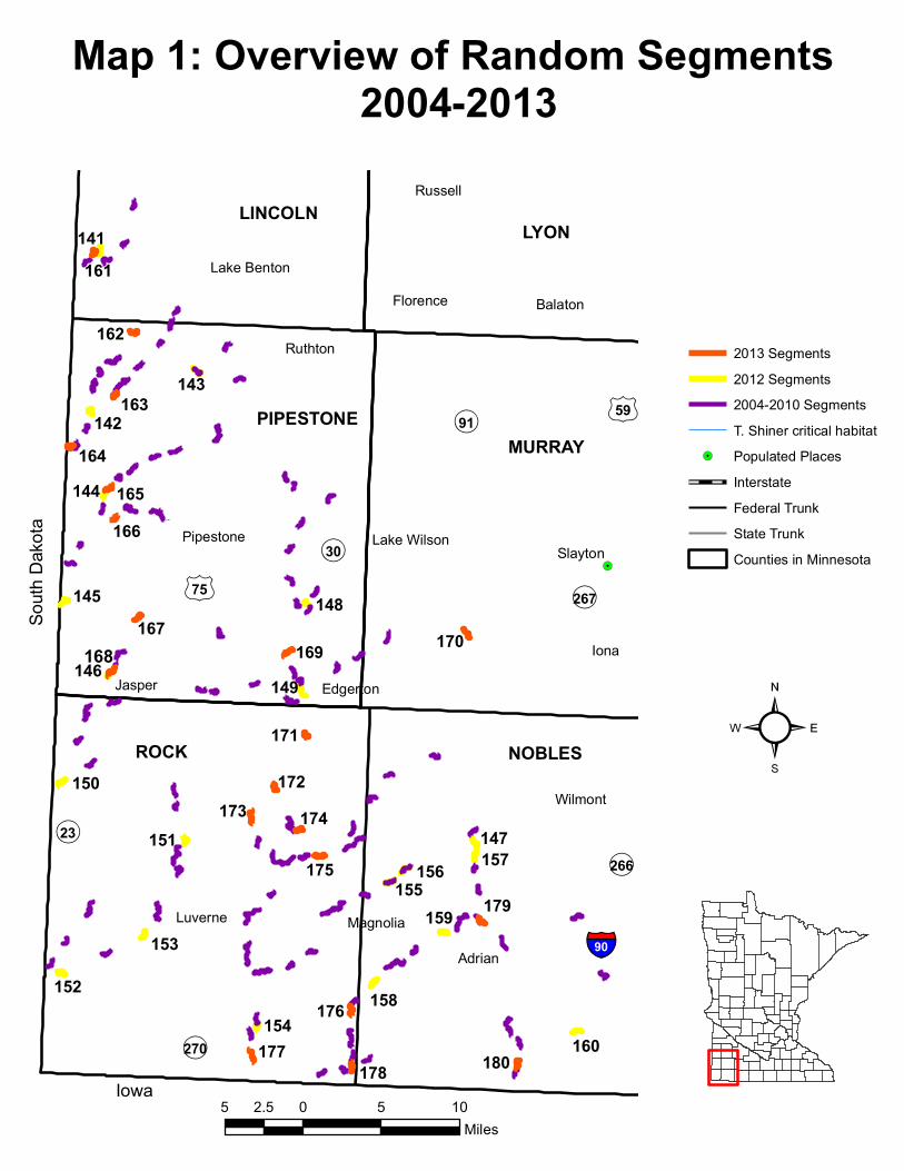
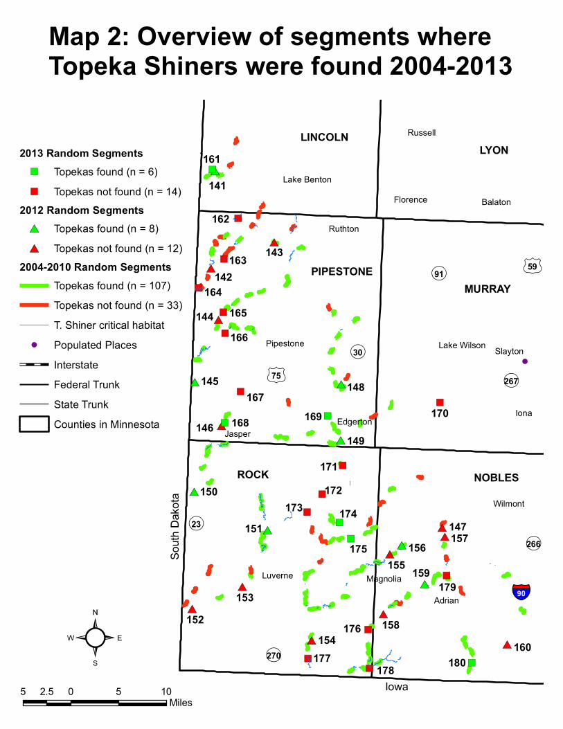
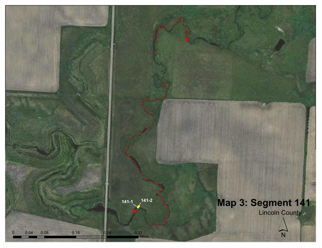
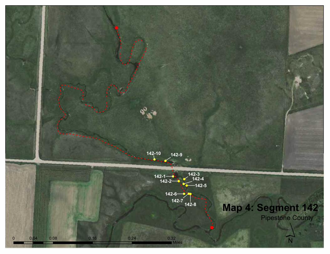
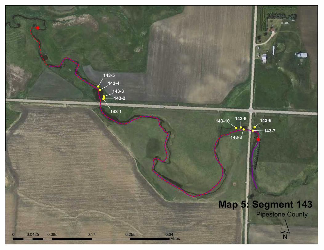
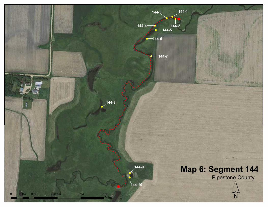
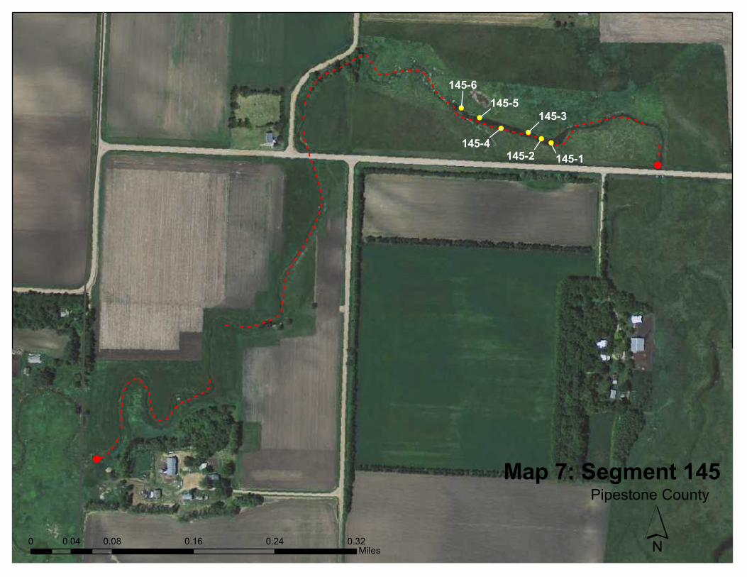
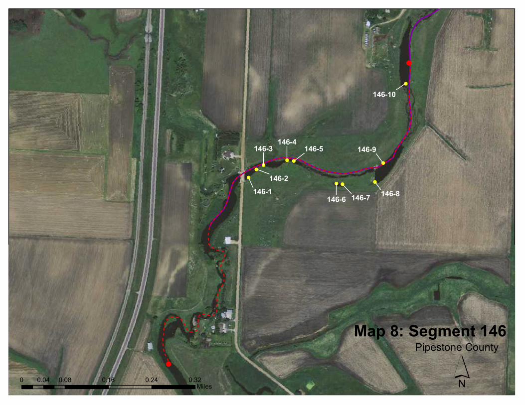
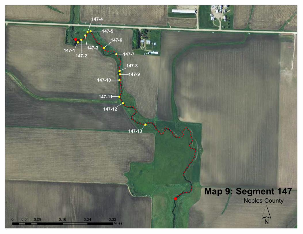
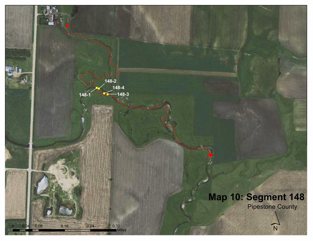
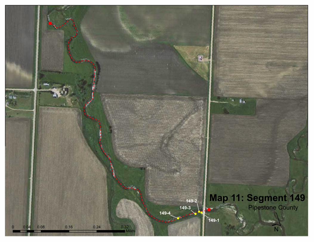
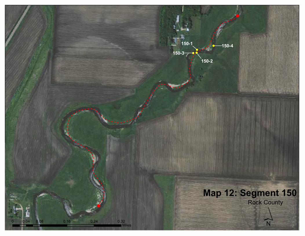
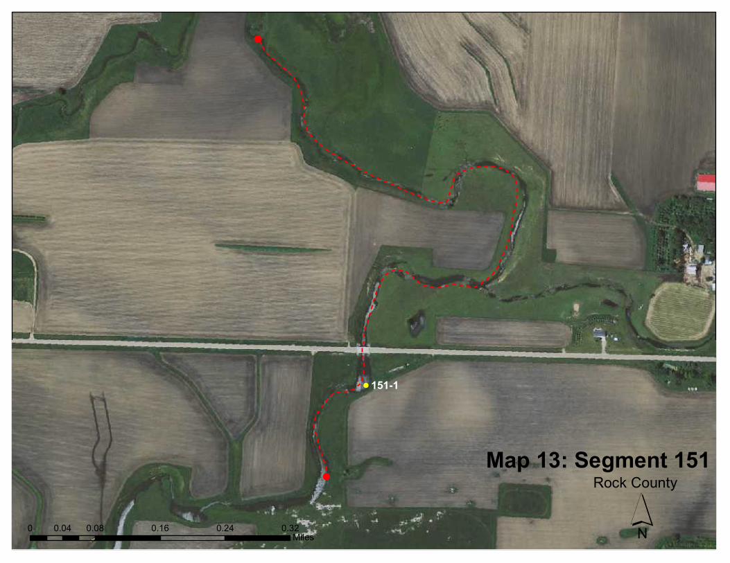
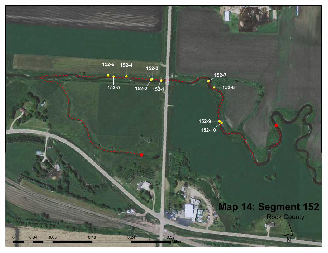
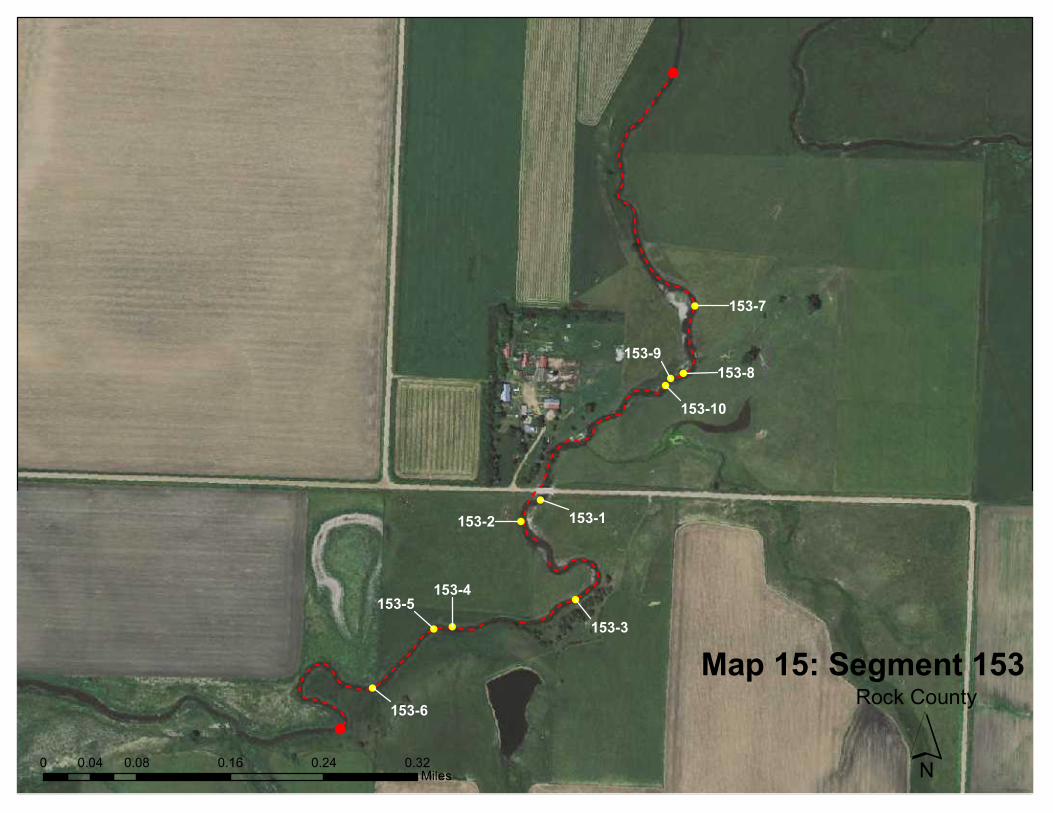
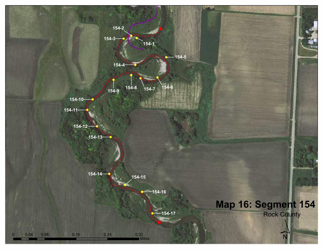
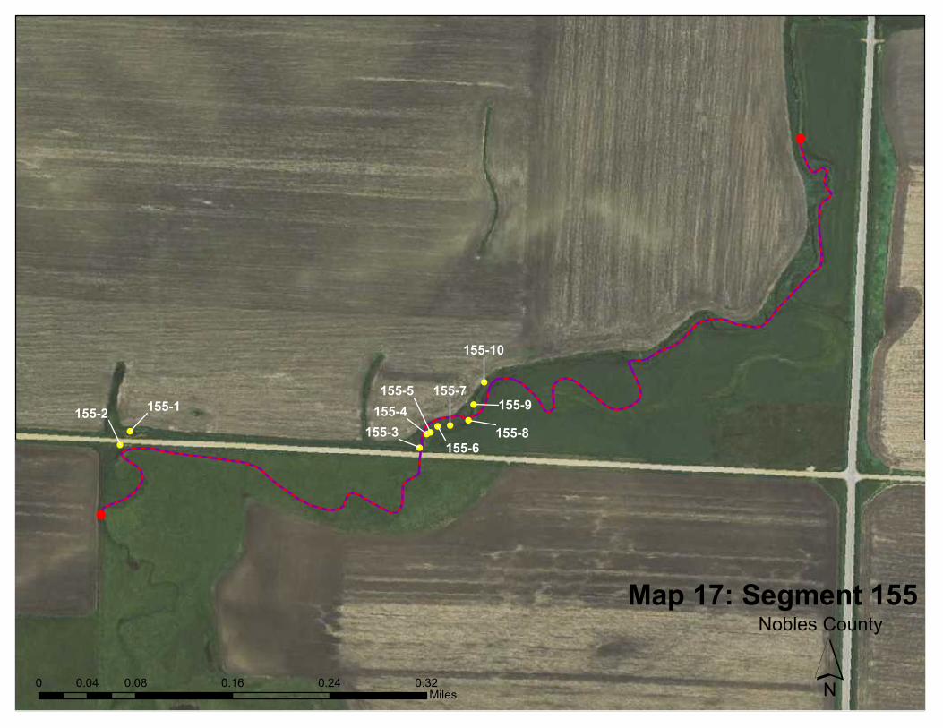
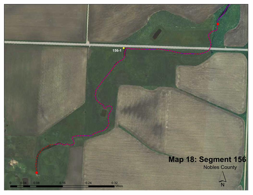
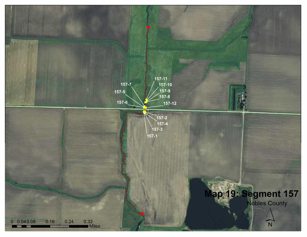
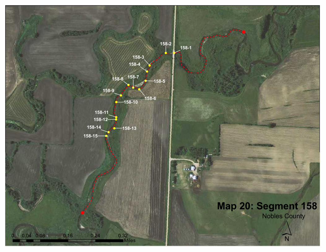
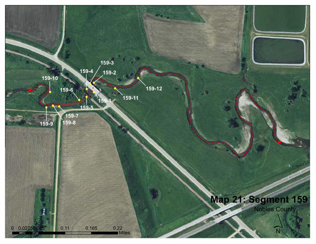
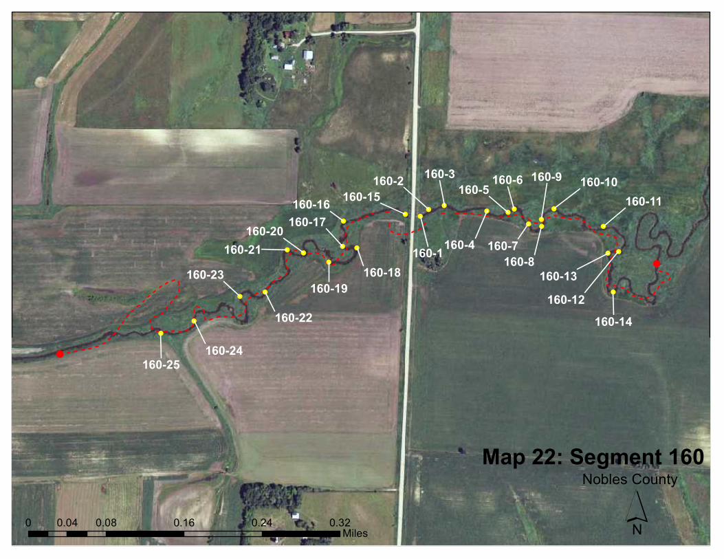
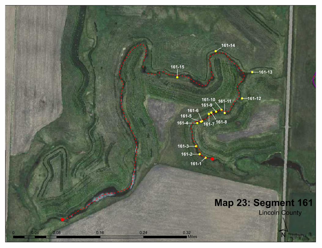
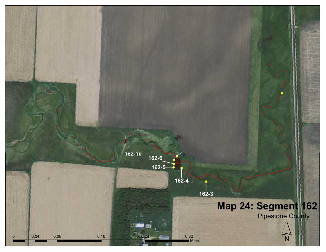
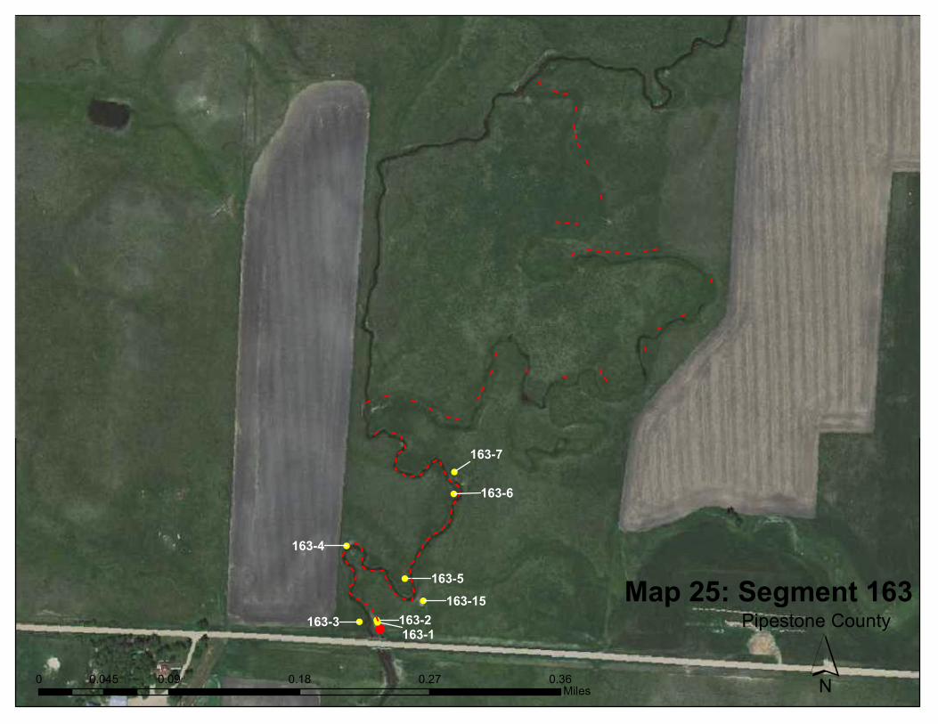
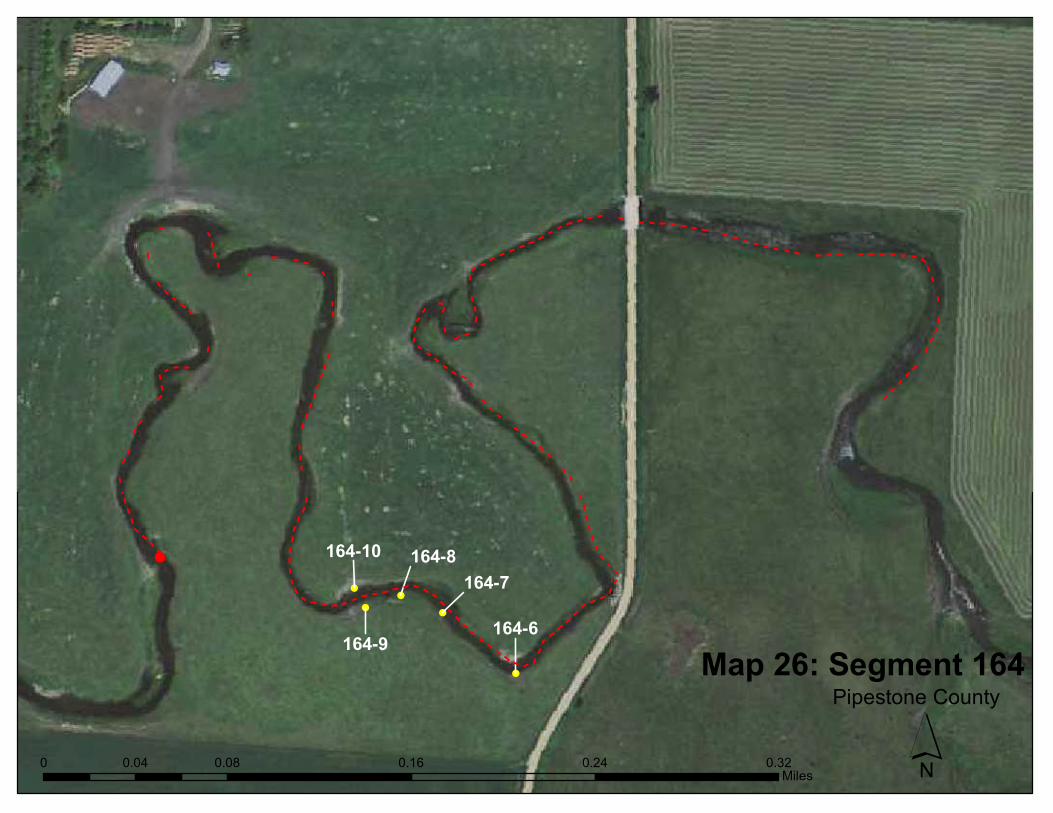
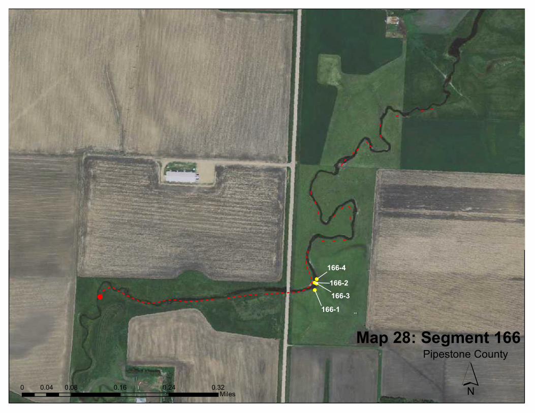
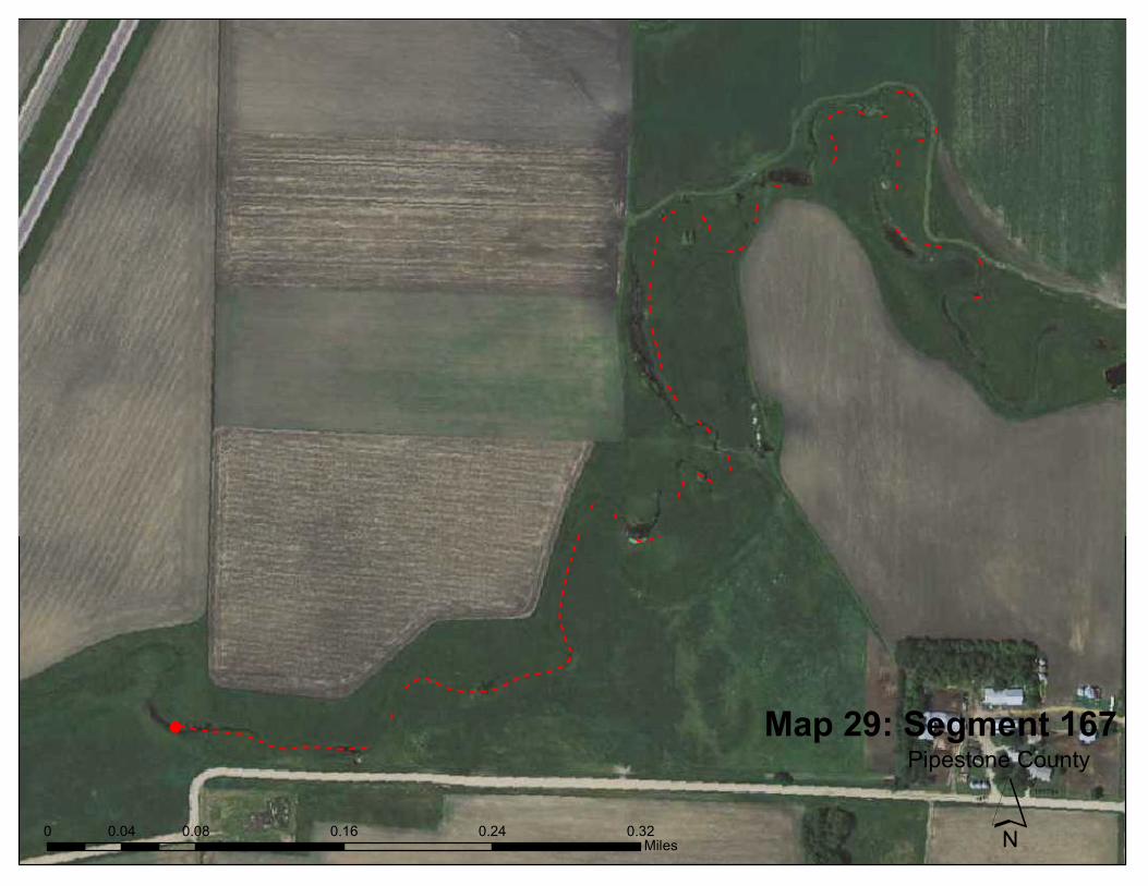
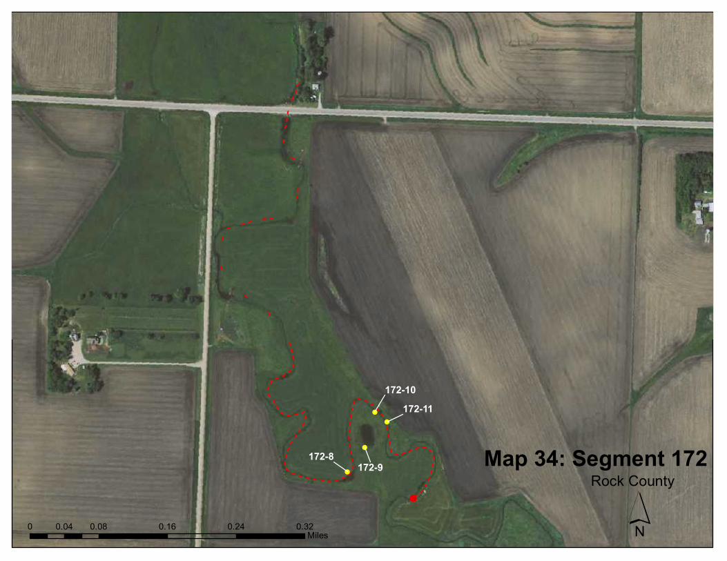
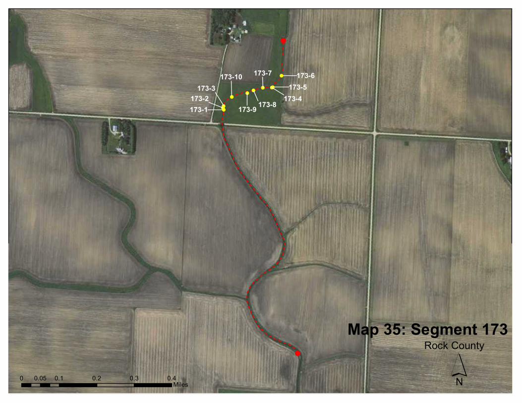
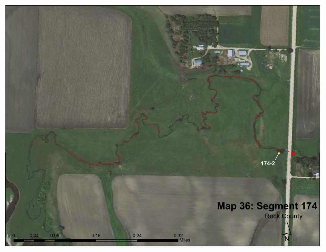
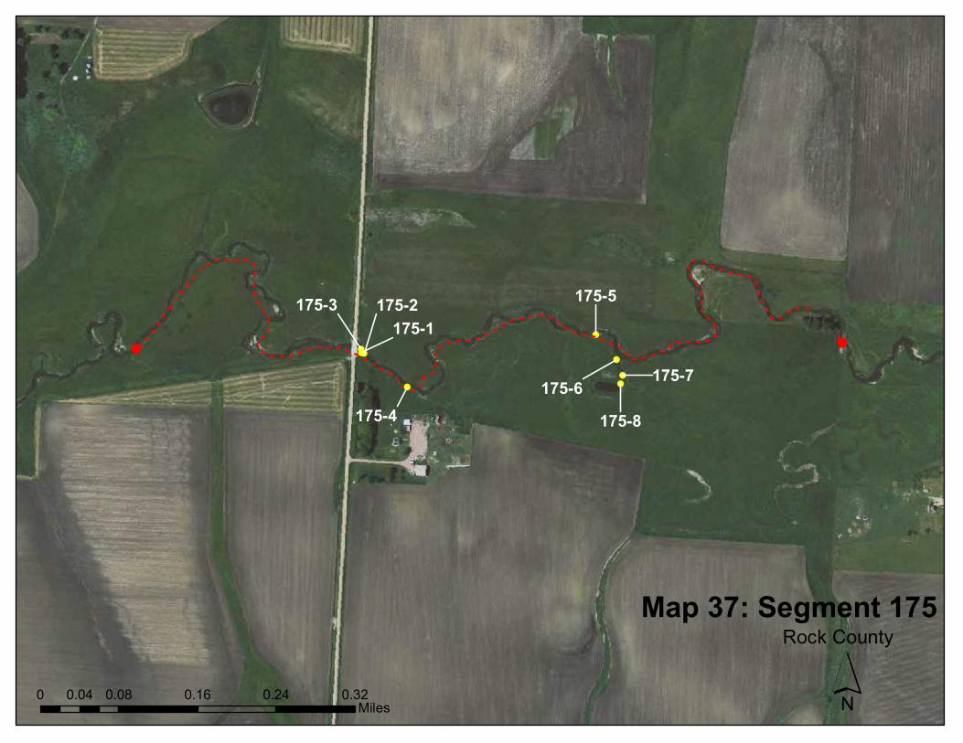
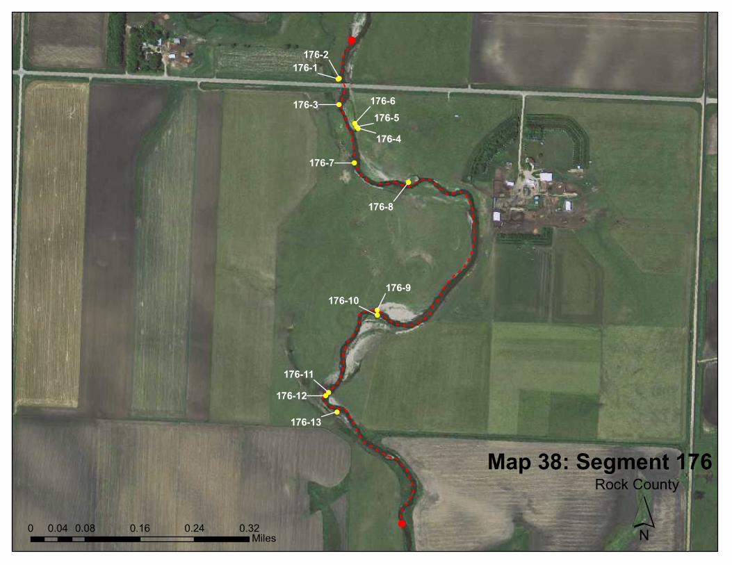
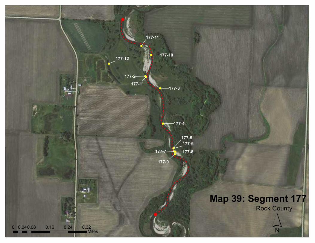
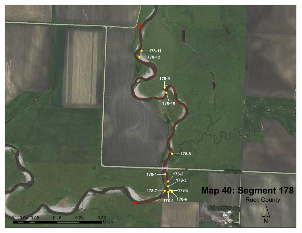
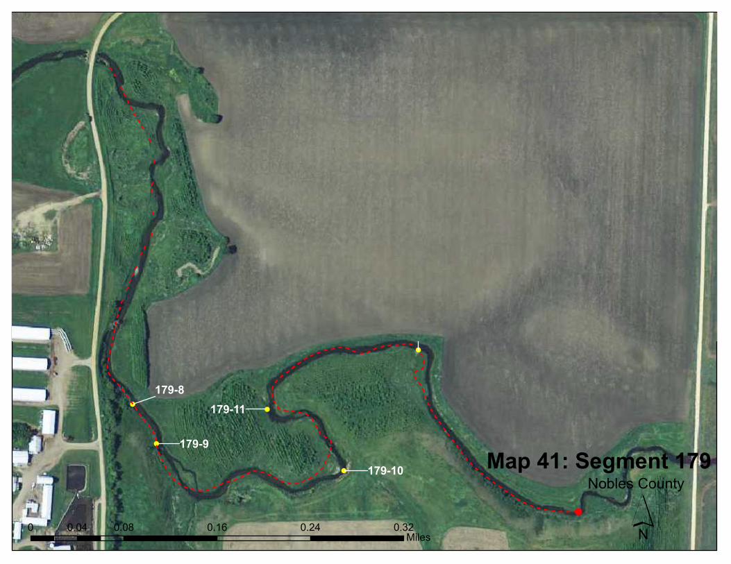
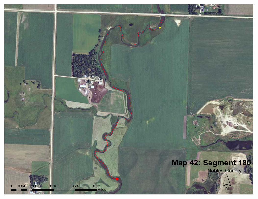
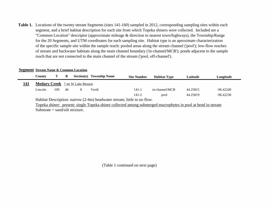
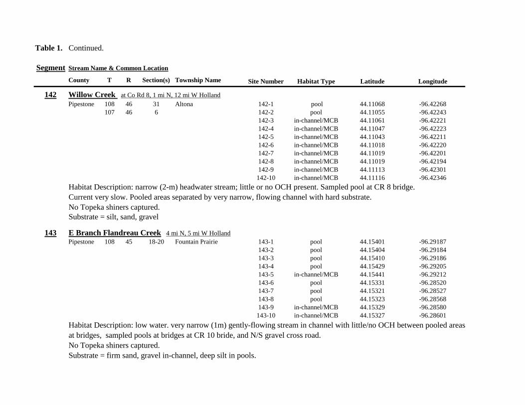
Table 1 Continued
Segment Stream Name amp Common Location
County T R Section(s) Township Name Site Number Habitat Type Latitude Longitude
142 Willow Creek at Co Rd 8 1 mi N 12 mi W Holland
Pipestone 108 46 31 Altona 142-1 pool 4411068 -9642268
107 46 6 142-2 pool 4411055 -9642243
142-3 in-channelMCB 4411061 -9642221
142-4 in-channelMCB 4411047 -9642223
142-5 in-channelMCB 4411043 -9642211
142-6 in-channelMCB 4411018 -9642220
142-7 in-channelMCB 4411019 -9642201
142-8 in-channelMCB 4411019 -9642194
142-9 in-channelMCB 4411113 -9642301
142-10 in-channelMCB 4411116 -9642346
Habitat Description narrow (2-m) headwater stream little or no OCH present Sampled pool at CR 8 bridge
Current very slow Pooled areas separated by very narrow flowing channel with hard substrate
No Topeka shiners captured
Substrate = silt sand gravel
143 E Branch Flandreau Creek 4 mi N 5 mi W Holland
Pipestone 108 45 18-20 Fountain Prairie 143-1 pool 4415401 -9629187
143-2 pool 4415404 -9629184
143-3 pool 4415410 -9629186
143-4 pool 4415429 -9629205
143-5 in-channelMCB 4415441 -9629212
143-6 pool 4415331 -9628520
143-7 pool 4415321 -9628527
143-8 pool 4415323 -9628568
143-9 in-channelMCB 4415329 -9628580
143-10 in-channelMCB 4415327 -9628601
Habitat Description low water very narrow (1m) gently-flowing stream in channel with littleno OCH between pooled areas
at bridges sampled pools at bridges at CR 10 bride and NS gravel cross road
No Topeka shiners captured
Substrate = firm sand gravel in-channel deep silt in pools
Table 1 Continued
Segment Stream Name amp Common Location
County T R Section(s) Township Name Site Number Habitat Type Latitude Longitude
144 N Branch Pipestone Creek 4 mi W 25 mi N Pipestone
Pipestone 107 46 29 32 Troy 144-1 in-channelMCB 4404130 -9639968
144-2 in-channelMCB 4404120 -9639945
144-3 in-channelMCB 4404122 -9640006
144-4 in-channelMCB 4404082 -9640085
144-5 pool off-channel 4404061 -9640078
144-6 in-channelMCB 4404015 -9640137
144-7 in-channelMCB 4403929 -9640102
144-8 pool off-channel 4403667 -9640429
144-9 pool off-channel 4403342 -9640218
144-10 pool off-channel 4403321 -9640217
Habitat Description slowly flowing water through majority of segment very little OCH along stream channel
sampled slackwater at bends and OC pools in adjacent pastures
No Topeka shiners captured
Substrate = silt gravel sand
Table 1 Continued
Segment Stream Name amp Common Location
County T R Section(s) Township Name Site Number Habitat Type Latitude Longitude
145 Pipestone Creek 4 mi W 2 mi N Ihlen
Pipestone 106 47 35 36 Sweet 145-1 pool 4393698 -9644445
105 47 2 145-2 pool 4393703 -9644465
145-3 pool 4393711 -9644491
145-4 pool 4393716 -9644545
145-5 pool 4393729 -9644589
145-6 pool 4393742 -9644625
Habitat Description low water Very narrow headwater stream (05 m) that is nearly dry between pools sampled in stagnant
pooled area upstream of a small boulder dam Floating mats of filamentous algae some submerged macrophytes
Topeka shiner present three captured at down stream end of pooled area
Substrate = silt clay some boulders sand
146 Split Rock Creek 15 mi N 05 mi E Jasper
Pipestone 105 46 28 29 Eden 146-1 pool 4387271 -9638712
146-2 pool 4387293 -9638684
146-3 pool 4387306 -9638659
146-4 pool 4387321 -9638572
146-5 in-channelMCB 4387320 -9638548
146-6 pool off-channel 4387264 -9638386
146-7 pool off-channel 4387263 -9638364
146-8 pool 4387273 -9638244
146-9 pool 4387324 -9638217
146-10 pool 4387539 -9638146
Habitat Description very low water shallow sandy pool at CR 53 bridge narow (2-3 m) channel between pooled areas
No Topeka shiners captured
Substrate = boulder gravel sand Deep silt along margins of pools
Table 1 Continued
Segment Stream Name amp Common Location
County T R Section(s) Township Name Site Number Habitat Type Latitude Longitude
147 Kanaranzi Creek 15 mi W 1 mi N Lismore
Nobles 103 42 17 18 Altona 147-1 in-channelMCB 4373149 -9591764
147-2 in-channelMCB 4373161 -9591743
147-3 in-channelMCB 4373182 -9591719
147-4 in-channelMCB 4373199 -9591705
147-5 in-channelMCB 4373202 -9591686
147-6 in-channelMCB 4373128 -9591596
147-7 in-channelMCB 4373100 -9591516
147-8 in-channelMCB 4373022 -9591492
147-9 in-channelMCB 4373007 -9591488
147-10 in-channelMCB 4372980 -9591491
147-11 in-channelMCB 4372904 -9591487
147-12 in-channelMCB 4372874 -9591463
147-13 in-channelMCB 4372779 -9591314
Habitat Description very low water narrow (2-3 m) channel high steep banks littleno OCH S end of segment ditched
No Topeka shiners captured
Substrate = gravel silt muck
148 Rock River 25 mi E 1 mi S Hatfield
Pipestone 106 44 33 Burke 148-1 in-channelMCB 4394307 -9614039
148-2 in-channelMCB 4394304 -9614026
148-3 in-channelMCB 4394280 -9613970
148-4 pool 4394283 -9613991
Habitat Description low water 3m wide flowing stream N end of segment nearly dry some backwater OCH present
Topeka shiner present two individuals captured in 20m x 3m backwater pool adjacent to the main channel
Substrate = sand gravel muck
Table 1 Continued
Segment Stream Name amp Common Location
County T R Section(s) Township Name Site Number Habitat Type Latitude Longitude
149 Rock River 1 mi SW of Edgerton
Pipestone 105 44 33 Osborne 149-1 pool 4385836 -9613494
149-2 pool 4385839 -9613508
149-3 in-channelMCB 4385830 -9613528
149-4 in-channelMCB 4385809 -9613627
Habitat Description low water 13m wide flowing stream small backwaters along MCB and pools at bridge
Topeka shiner present one individual captured in small backwater along MCB
Substrate = Gravel sand cobble Deep silt in off-channel areaspools
150 Split Rock Creek 6 mi S 2 mi W Jasper
Rock 104 47 35 Rose Dell 150-1 in-channelMCB 4377128 -9643910
150-2 in-channelMCB 4377116 -9643912
150-3 in-channelMCB 4377114 -9643931
150-4 in-channelMCB 4377149 -9643814
Habitat Description 15m wide slowly flowing stream with high steep eroded banks Low water
Topeka shiner present two individuals captured in 15m x 25m shallow silted puddle along MCB
Substrate = gravel sand silt
Table 1 Continued
Segment Stream Name amp Common Location
County T R Section(s) Township Name Site Number Habitat Type Latitude Longitude
151 Beaver Creek E 45 mi N 35 W Luverne along CSAH 20
Rock 103 45 18 19 Mound 151-1 pool 4371768 -9628182
Habitat Description 80m x 40m pool downstream of bridge no flow deep (1m) silt over clay Topeka shiner abundant 18 individuals captured in single seine haul in pool Substrate = deep (1m) silt over clay
152 Beaver Creek 35 mi W 15 mi S Beaver Creek along CSAH 7
Rock 102 47 35 36 Beaver Creek 152-1 in-channelMCB 4359418 -9643251
152-2 in-channelMCB 4359419 -9643293
152-3 in-channelMCB 4359420 -9643288
152-4 in-channelMCB 4359426 -9643393
152-5 in-channelMCB 4359423 -9643445
152-6 in-channelMCB 4359427 -9643467
152-7 in-channelMCB 4359421 -9643060
152-8 in-channelMCB 4359404 -9643035
152-9 in-channelMCB 4359305 -9643008
152-10 in-channelMCB 4359301 -9642999
Habitat Description 4m wide slowly flowing stream with high steep banks No OCH present Sampled slow water areas
along MCB
No Topeka shiners captured
Substrate = Silt sand gravel
Table 1 Continued
Segment Stream Name amp Common Location
County T R Section(s) Township Name Site Number Habitat Type Latitude Longitude
153 Beaver Creek 1 mi N 175 mi E Beaver Creek
Rock 102 46 14 23 Beaver Creek 153-1 in-channelMCB 4363076 -9632975
153-2 in-channelMCB 4363049 -9633007
153-3 in-channelMCB 4362954 -9632909
153-4 in-channelMCB 4362915 -9633117
153-5 in-channelMCB 4362911 -9633148
153-6 in-channelMCB 4362835 -9633249
153-7 in-channelMCB 4363324 -9632725
153-8 in-channelMCB 4363240 -9632740
153-9 in-channelMCB 4363233 -9632762
153-10 in-channelMCB 4363224 -9632770
Habitat Description 3m wide slowly flowing streamHigh steep banks Lots of bank erosion and very little OCH Off
channel ponds along northern 13 of segment were dry Water very low Cattle in stream Sampled slack water along MCB
No Topeka shiners captured
Substrate = firm sandsilt in backwater sandgravel in main channel
Table 1 Continued
Segment Stream Name amp Common Location
County T R Section(s) Township Name Site Number Habitat Type Latitude Longitude
154 Rock River 4mi S 25 mi W Steen
Rock 101 45 13 Clinton 154-1 pool 4355354 -9618125
154-2 in-channelMCB 4355362 -9618154
154-3 in-channelMCB 4355350 -9618191
154-4 in-channelMCB 4355254 -9618127
154-5 pool 4355287 -9617972
154-6 in-channelMCB 4355211 -9618013
154-7 in-channelMCB 4355206 -9618099
154-8 in-channelMCB 4355216 -9618146
154-9 in-channelMCB 4355197 -9618235
154-10 in-channelMCB 4355121 -9618336
154-11 in-channelMCB 4355081 -9618361
154-12 in-channelMCB 4355022 -9618309
154-13 in-channelMCB 4354985 -9618238
154-14 riffle 4354849 -9618238
154-15 in-channelMCB 4354810 -9618156
154-16 in-channelMCB 4354787 -9618069
154-17 in-channelMCB 4354709 -9618012
Habitat Description Wide (10m) flowing stream with ample OCH Channel is braided along meanders
with backwater habitat along sandgravel bars Wooded riparian corridor
No Topeka shiners captured
Substrate = gravel sand silt
Table 1 Continued
Segment Stream Name amp Common Location
County T R Section(s) Township Name Site Number Habitat Type Latitude Longitude
155 Elk Creek 3 mi N 3 mi E Magnolia along CSAH 19
Nobles 103 43 29 32 Lismore 155-1 pool 4368849 -9602497
155-2 pool 4368832 -9602512
155-3 pool 4368842 -9602019
155-4 in-channelMCB 4368859 -9602008
155-5 in-channelMCB 4368861 -9602002
155-6 in-channelMCB 4368868 -9601990
155-7 in-channelMCB 4368870 -9601969
155-8 in-channelMCB 4368877 -9601940
155-9 in-channelMCB 4368896 -9601932
155-10 in-channelMCB 4368923 -9601916
Habitat Description Water very low Narrow (2m) intermittent stream Stream bed is dry in places between isolated pools
No flow Sampled at pooled areas at culverts at CH 19
No Topeka shiners captured
Substrate = silt muck gravel
156 Elk Creek 4 mi N 4 mi E Magnolia along CSAH 14
Nobles 103 43 21 28 Lismore 156-1 pool 4370276 -9600072
Habitat Description very small headwater stream (1m) that is nearly dry between pools Sampled on margin of 20m x 50m
pool at bridge Pool depth gt 2m Thick mats of floating filamentous algae pool depth and submerged macrophytes
made seining difficult
Topeka shiner abundant 5 individuals captured in single kick set on margin of pool Numerous male Topeka shiners were observed defending cleared patches of gravel along the margin of the pool Substrate = silt over gravel
Table 1 Continued
Segment Stream Name amp Common Location
County T R Section(s) Township Name Site Number Habitat Type Latitude Longitude
157 Kanaranzi Creek 15 mi E 2 mi S Lismore
Nobles 103 42 17 19 20 Larkin 157-1 pool 4371762 -9591115
157-2 pool 4371757 -9591102
157-3 pool 4371753 -9591108
157-4 pool 4371755 -9591112
157-5 pool 4371785 -9591112
157-6 pool 4371786 -9591115
157-7 pool 4371793 -9591111
157-8 in-channelMCB 4371818 -9591105
157-9 in-channelMCB 4371820 -9591097
157-10 in-channelMCB 4371829 -9591093
157-11 in-channelMCB 4371835 -9591097
157-12 in-channelMCB 4371785 -9591100
Habitat Description Stream has been ditchedchannelized High banks and no OCH is present except for a pooled area upstream of a beaver dam that is S of the bridge No Topeka shiners captured Substrate = silt muck sand
Table 1 Continued
Segment Stream Name amp Common Location
County T R Section(s) Township Name Site Number Habitat Type Latitude Longitude
158 Kanaranzi Creek 2 mi E 35 mi S Magnolia
Nobles 102 43 31 32 Westside 158-1 pool 4359742 -9603359
158-2 pool 4359741 -9603408
158-3 in-channelMCB 4359686 -9603499
158-4 in-channelMCB 4359660 -9603513
158-5 in-channelMCB 4359620 -9603518
158-6 pool 4359584 -9603554
158-7 in-channelMCB 4359590 -9603589
158-8 in-channelMCB 4359600 -9603617
158-9 in-channelMCB 4359555 -9603658
158-10 in-channelMCB 4359527 -9603683
158-11 in-channelMCB 4359463 -9603681
158-12 in-channelMCB 4359454 -9603681
158-13 in-channelMCB 4359416 -9603690
158-14 in-channelMCB 4359399 -9603722
158-15 in-channelMCB 4359383 -9603735
Habitat Description 4m wide slowly flowing stream Sampled backwater and off-channel habitats along MCB and side channels Hard gravelsand substrate in channel Ample low-flow habitat along sandgravel bars No Topeka shiners captured Substrate = sand gravel silt
Table 1 Continued
Segment Stream Name amp Common Location
County T R Section(s) Township Name Site Number Habitat Type Latitude Longitude
159 Kanaranzi Creek 1 mi NW Adrian along CSAH 35
Nobles 102 43 13 Westside 159-1 pool 4364453 -9595165
159-2 pool 4364481 -9595166
159-3 pool 4364479 -9595182
159-4 pool 4364461 -9595195
159-5 in-channelMCB 4364438 -9595194
159-6 in-channelMCB 4364427 -9595224
159-7 in-channelMCB 4364406 -9595307
159-8 in-channelMCB 4364407 -9595333
159-9 in-channelMCB 4364401 -9595360
159-10 pool 4364448 -9595347
159-11 in-channelMCB 4364467 -9595077
159-12 in-channelMCB 4364500 -9594982
Habitat Description Flowing 7m wide stream Abundant backwaters pools and OCH along MCB
Topeka shiner present a single individual captured in a side channel over gravelsand mix after much effort
Substrate = gravel sand silt
Table 1 Contined
Segment Stream Name amp Common Location
County T R Section(s) Township Name Site Number Habitat Type Latitude Longitude
160 Little Rock River 1 mi E 4 mi S Rushmore
Nobles 101 41 16 17 Ransom 160-1 in-channelMCB 4355809 -9577372
160-2 in-channelMCB 4355819 -9577356
160-3 in-channelMCB 4355826 -9577324
160-4 in-channelMCB 4355820 -9577237
160-5 in-channelMCB 4355819 -9577193
160-6 in-channelMCB 4355824 -9577181
160-7 in-channelMCB 4355803 -9577151
160-8 in-channelMCB 4355800 -9577123
160-9 in-channelMCB 4355810 -9577124
160-10 in-channelMCB 4355827 -9577099
160-11 in-channelMCB 4355803 -9576997
160-12 in-channelMCB 4355766 -9576964
160-13 in-channelMCB 4355763 -9576986
160-14 in-channelMCB 4355706 -9576972
160-15 in-channelMCB 4355811 -9577403
160-16 in-channelMCB 4355798 -9577529
160-17 in-channelMCB 4355760 -9577529
160-18 in-channelMCB 4355759 -9577500
160-19 in-channelMCB 4355736 -9577556
Table 1 Site 160 Continued Table 1 Concluded
Segment Stream Name amp Common Location
County T R Section(s) Township Name Site Number Habitat Type Latitude Longitude
160 Little Rock River 1 mi E 4 mi S Rushmore
160-20 in-channelMCB 4355748 -9577608
160-21 in-channelMCB 4355752 -9577642
160-22 in-channelMCB 4355689 -9577684
160-23 in-channelMCB 4355681 -9577736
160-24 in-channelMCB 4355642 -9577828
160-25 in-channelMCB 4355622 -9577895
Habitat Description Slowly flowing 3m wide stream with high steep banks Little or no OCH Portions of this stream
appear to have been ditched and rip-rapped
No Topeka shiners captured
Substrate = gravel sand muck
Table 2 Locations of the twenty stream Segments (sites 161-180) sampled in 2013 corresponding sampling sites within
each segment and a brief habitat description for each site from which Topeka shiners were collected Included
are a Common Location descriptor (approximate mileage amp direction to nearest townhighways) the
TownshipRange for the 20 Segments and UTM coordinates for each sampling site Habitat type is an aproximate
characterization of the specific sample site within the sample reach pooled areas along the stream channel (pool)
low-flow reaches of stream and backwater habitats along the main channel boundary (in-channelMCB) ponds
adjacent to the sample reach that are not connected to the main channel of the stream (pool off-channel)
Segment Stream Name amp Common Location
County T R Section(s) Township Name Site Number Habitat Type Latitude Longitude
161 Medary Creek 7 mi W Lake Benson
Lincoln 109 46 7 Verdi 161-1 in-channelMCB 4425807000 -9642702300
161-2 in-channelMCB 4425815900 -9642724800
161-3 in-channelMCB 4425836800 -9642739100
161-4 in-channelMCB 4425898800 -9642738400
161-5 in-channelMCB 4425902800 -9642724500
161-6 in-channelMCB 4425904800 -9642721000
161-7 in-channelMCB 4425924400 -9642696700
161-8 in-channelMCB 4425928300 -9642687800
161-9 in-channelMCB 4425931400 -9642670400
161-10 in-channelMCB 4425936800 -9642650600
161-11 in-channelMCB 4425928700 -9642638400
161-12 in-channelMCB 4425969600 -9642576100
161-13 pool 4426041100 -9642542500
161-14 in-channelMCB 4426093000 -9642681600
161-15 in-channelMCB 4426018800 -9642819900
Habitat Description narrow (2m) flowing headwater stream beaver dams along sample reach
Topeka shiner present nine Topeka shiners captured in a flowing pool downstream of a beaver dam
Thousands of fish downstream of dam and almost none in the upstream sites 1-14
Substrate = cobble gravel silt
Table 2 Continued
Segment Stream Name amp Common Location
County T R Section(s) Township Name Site Number Habitat Type Latitude Longitude
162 Willow Creek 13 mi W Ruthton
Pipestone 108 46 4 29 Altona 162-1 in-channelMCB 4418795200 -9636967900
162-2 in-channelMCB 4418776900 -9636978700
162-3 in-channelMCB 4418554500 -9637231900
162-4 pool 4418587700 -9637323700
162-5 pool 4418588600 -9637353100
162-6 pool 4418597900 -9637352800
162-7 pool 4418617800 -9637343500
162-8 pool 4418608500 -9637352600
162-9 pool 4418659800 -9637532400
162-10 pool 4418647400 -9637460200
Habitat Description very narrow (1m) headwater stream slow flow large pool (sites 4-8) appears to be an excavated pond
metal debris and fencing material made seining difficult Seined pooled areas in cattail beds
No Topeka shiners captured Substrate = sand gravel silt
Table 2 Continued
Segment Stream Name amp Common Location
County T R Section(s) Township Name Site Number Habitat Type Latitude Longitude
163 Flandreau Creek 4 mi N 5 mi W Holland
Pipestone 108 46 29 Altona 163-1 pool 4412550100 -9639615400
163-2 pool 4412552400 -9639616700
163-3 pool 4412550000 -9639640600
163-4 in-channelMCB 4412625200 -9639662400
163-5 in-channelMCB 4412595100 -9639579900
163-6 in-channelMCB 4412681700 -9639517200
163-7 pool 4412703400 -9639517600
163-8 pool 4412761900 -9639631000
163-9 pool 4412764600 -9639631600
163-10 pool 4412782600 -9639590000
163-11 pool 4412754600 -9639531600
163-12 pool 4412762600 -9639632100
163-13 in-channelMCB 4413017900 -9639591600
163-14 in-channelMCB 4413084800 -9639438100
163-15 pool 4412573500 -9639553100
Habitat Description 3m wide flowing stream Channel appears to have been ditched most of plotted reach is dry Seined in heavily vegetated stagnant pools No Topeka shiners captured Substrate = firm sand gravel in-channel deep silt along MCB
Table 2 Continued
Segment Stream Name amp Common Location
County T R Section(s) Township Name Site Number Habitat Type Latitude Longitude
164 Flandreau Creek 65 mi W 55 mi N Pipestone
Pipestone 107 47 13 14 Troy 164-1 pool 4408042400 -9644734000
164-2 pool 4408043100 -9644720500
164-3 pool 4408042200 -9644708000
164-4 pool 4407996200 -9644910500
164-5 in-channelMCB 4407938200 -9644906400
164-6 in-channelMCB 4407760400 -9644847500
164-7 in-channelMCB 4407796600 -9644913300
164-8 in-channelMCB 4407806300 -9644950500
164-9 in-channelMCB 4407797700 -9644981100
164-10 in-channelMCB 4407809800 -9644991500
164-11 pool 4408029200 -9645104800
Habitat Description flowing 3-5m wide stream with firm gravel substrate in thalweg Sampled pooled area at bridge
some off-channel habitat at sites 4 and 11 Banks are steep along most of the reach with little slackwater habitat along MCB
No Topeka shiners captured
Substrate = gravel sand cobble in-channel Deep silt in low-flow areas
Table 2 Continued
Segment Stream Name amp Common Location
County T R Section(s) Township Name Site Number Habitat Type Latitude Longitude
165 North Branch Pipestone Creek 4 mi W 3 mi N Pipestone
Pipestone 107 46 29 Troy 165-1 pool 4404501300 -9639278100
165-2 pool 4404481000 -9639316800
165-3 pool 4404472800 -9639315500
165-4 in-channelMCB 4404457500 -9639325200
165-5 in-channelMCB 4404434800 -9639340300
165-6 in-channelMCB 4404446400 -9639386900
165-7 in-channelMCB 4404320300 -9639371300
165-8 pool 4404299200 -9639403700
165-9 pool 4404302200 -9639429200
165-10 pool 4404289200 -9639430300
165-11 pool 4404283700 -9639418700
165-12 in-channelMCB 4404212300 -9639411800
165-13 in-channelMCB 4404195800 -9639463400
165-14 in-channelMCB 4404244400 -9639645200
165-15 in-channelMCB 4404163700 -9639819800
165-16 in-channelMCB 4404165900 -9639797900
Habitat Description moderately flowing 3-5m wide stream Recent increase in stream level some submerged terrestrial
grasses along MCB Sites 8-11 in oxbow Submerged terrestrial grasses in oxbow
No Topeka shiners captured
Substrate = sand gravel silt
Table 2 Continued
Segment Stream Name amp Common Location
County T R Section(s) Township Name Site Number Habitat Type Latitude Longitude
166 Pipestone Creek 35 mi W 1 mi N Pipestone
Pipestone 106 46 4 5 Sweet 166-1 in-channelMCB 4401330100 -9638708400
166-2 in-channelMCB 4401347000 -9638709700
166-3 in-channelMCB 4401345500 -9638703700
166-4 in-channelMCB 4401355800 -9638703000
166-5 in-channelMCB 4401541200 -9638596400
166-6 in-channelMCB 4401618700 -9638658000
166-7 in-channelMCB 4401623400 -9638660800
166-8 in-channelMCB 4401625200 -9638646200
166-9 in-channelMCB 4401633300 -9638635600
166-10 in-channelMCB 4401740500 -9638517300
Habitat Description 10m wide slowly flowing stream Sampled along MCB in slack water West end of segment appears
to have been ditched Littleno OCH Drainage tiles along E reach of segment
No Topeka shiners captured
Substrate = cobble gravel sand Deep silt along margins of pools
Table 2 Continued
Segment Stream Name amp Common Location
County T R Section(s) Township Name Site Number Habitat Type Latitude Longitude
167 Split Rock Creek 15 mi N 1 mi E Ihlen
Pipestone 105 46 3 Eden 167-1 pool 4392585400 -9634993300
167-2 in-channelMCB 4392638100 -9635031600
167-3 pool 4392643100 -9635103600
167-4 pool 4392638200 -9635101900
167-5 pool 4392633000 -9635108800
167-6 pool 4392633200 -9635116400
167-7 pool 4392635700 -9635131600
167-8 pool 4392636400 -9635139100
167-9 pool 4392635900 -9635156000
167-10 in-channelMCB 4392470900 -9635255600
167-11 in-channelMCB 4392465600 -9635242800
167-12 in-channelMCB 4392447500 -9635240300
Habitat Description very small headwater stream (~1m) water low isolated series of pools along streambed No Topeka shiners captured Substrate = sand gravel silt
168 Split Rock Creek 15 mi N 05 mi E Jasper
Pipestone 105 46 28 29 Eden 168-1 in-channelMCB 4387771400 -9638026400
Habitat Description high water 4m wide flowing stream submerged terrestrial grasses on margins
Topeka shiner common 6 individuals captured on first seine haul in pooled area at MCB just downstream of culvert
Substrate = boulder cobble sand
Table 2 Continued
Segment Stream Name amp Common Location
County T R Section(s) Township Name Site Number Habitat Type Latitude Longitude
169 Rock River 1 mi SW of Edgerton
Pipestone 105 44 17 18 Osborne 169-1 pool 4389371700 -9616564700
169-2 in-channelMCB 4389439900 -9616531800
Habitat Description Swiftly flowing 10m wide stream at high water Sampled pooled area at outside bend of stream
over deep silt
Topeka shiner present four individuals captured in four seine hauls in a 1m wide drainage channel that joins a
retention pond to the Rock River
Substrate = Silt gravel Deep silt in off-channel areaspools
170 Chanarambie Creek 05 mi S 05 mi E Chandler
Murray 104 47 35 Fenton 170-1 in-channelMCB 4392093400 -9593156600
170-2 in-channelMCB 4391890200 -9593079300
170-3 in-channelMCB 4391841400 -9593168100
170-4 in-channelMCB 4391784300 -9593090300
170-5 in-channelMCB 4391783100 -9593060700
170-6 in-channelMCB 4391790600 -9593061100
170-7 in-channelMCB 4391796700 -9593025000
170-8 in-channelMCB 4391792000 -9592982800
170-9 in-channelMCB 4392105300 -9593062100
170-10 in-channelMCB 4392122900 -9593165100
Habitat Description narrow (1-2m) headwater stream Stream is flowing swiftly and little or no OCH is present
most of the segment appears to have been channelized
No Topeka shiners captured
Substrate = silt sand
Table 2 Continued
Segment Stream Name amp Common Location
County T R Section(s) Township Name Site Number Habitat Type Latitude Longitude
171 Rock River 4 mi S Edgerton
Rock 104 44 8 9 Battle Plain 171-1 in-channelMCB 4382021200 -9613013100
171-2 pool 4382126400 -9613470300
171-3 in-channelMCB 4382025300 -9612974300
171-4 in-channelMCB 4382027100 -9612961600
171-5 in-channelMCB 4382145400 -9613302800
171-6 in-channelMCB 4382380700 -9613520900
171-7 in-channelMCB 4382367500 -9613527700
171-8 in-channelMCB 4382359000 -9613532400
171-9 in-channelMCB 4382405300 -9613495400
171-10 in-channelMCB 4382271200 -9613570400
Habitat Description High water 8-12m wide swiftly flowing stream Stream is full to high banks Much of slackwater
areas along MCB likely inudndated Sampled in backwaters sites 6-9
No Topeka shiners captured
Substrate = Sand gravel silt
Table 2 Continued
Segment Stream Name amp Common Location
County T R Section(s) Township Name Site Number Habitat Type Latitude Longitude
172 Rock River tributary 1 mi E Hardwick
Rock 104 44 30 31 Battle Plain 172-1 pool 4377538900 -9617075500
172-2 pool 4377529200 -9617075600
172-3 pool 4377514700 -9617079800
172-4 in-channelMCB 4377386200 -9617079600
172-5 in-channelMCB 4377247100 -9617207900
172-6 in-channelMCB 4377241900 -9617224500
172-7 in-channelMCB 4377245200 -9617219500
172-8 in-channelMCB 4376956400 -9616914600
172-9 pool off-channel 4376998700 -9616876000
172-10 in-channelMCB 4377058800 -9616855700
172-11 in-channelMCB 4377043200 -9616826600
Habitat Description 3m wide slowly flowing pasture stream with high trampled banks Much of reach appears to
have been channelized no OCH present along MCBSampled in stock pond at site 9 Some submerged macrophytes
No Topeka shiners captured
Substrate = sand silt muck
Table 2 Continued
Segment Stream Name amp Common Location
County T R Section(s) Township Name Site Number Habitat Type Latitude Longitude
173 Mound Creek 1 mi N 175 mi E Beaver Creek
Rock 103 45 2 11 Mound 173-1 in-channelMCB 4374749900 -9620089200
173-2 in-channelMCB 4374756900 -9620094400
173-3 in-channelMCB 4374763700 -9620090700
173-4 in-channelMCB 4374842800 -9619838100
173-5 in-channelMCB 4374844000 -9619833200
173-6 in-channelMCB 4374889800 -9619789300
173-7 in-channelMCB 4374839600 -9619885800
173-8 in-channelMCB 4374827900 -9619934500
173-9 in-channelMCB 4374817000 -9619966400
173-10 in-channelMCB 4374799700 -9620048400
Habitat Description Entire reach of sement has been channelized Stream is 1-2m wide and constantly flowing High
banks No OCH
No Topeka shiners captured
Substrate = gravel sand silt
Table 2 Continued
Segment Stream Name amp Common Location
County T R Section(s) Township Name Site Number Habitat Type Latitude Longitude
174 Rock River tributary 55 mi N 4 mi E Luverne
Rock 103 44 8 9 Vienna 174-1 pool 4373333900 -9613250300
174-2 pool 4373322100 -9613262700
Habitat Description Narrow (2-3m) wide flowing headwater stream Sampled in deep silted pool at bridge Topeka shiner present two individuals captured over gravel in pooled area at bridge Much of the pool is filled with deep (gt05m) silt No Topeka shiners collected in silted portion of pool Substrate = gravel sand silt
Table 2 Continued
Segment Stream Name amp Common Location
County T R Section(s) Township Name Site Number Habitat Type Latitude Longitude
175 Champepadan Creek 4mi N 5 mi E Luverne
Rock 103 44 21 22 Vienna 175-1 pool 4371002900 -9611238300
175-2 pool 4371001900 -9611232600
175-3 pool 4371008300 -9611238900
175-4 in-channelMCB 4370955000 -9611142300
175-5 in-channelMCB 4371042200 -9610763900
175-6 in-channelMCB 4371007000 -9610720000
175-7 in-channelMCB 4370984100 -9610706400
175-8 pooloff-channel 4370971600 -9610709700
Habitat Description 3m wide stream with moderate flow Native prairie has been planted along both banks for the entire reach
No flow Sampled at pooled areas at culverts at CH 19
Topeka shiner present one individual captured in deep livestock pond S of stream Depth (gt2m) made seining in pond difficult
Substrate = sand silt gravel
Table 2 Continued
Segment Stream Name amp Common Location
County T R Section(s) Township Name Site Number Habitat Type Latitude Longitude
176 Kanaranzi Creek 2 mi W 35 mi N Ellworth
Rock 101 44 12 Kanaranzi 176-1 pool 4357304000 -9606413600
176-2 pool 4357305400 -9606410500
176-3 pool 4357249700 -9606408600
176-4 in-channelMCB 4357200500 -9606350300
176-5 in-channelMCB 4357204500 -9606354600
176-6 in-channelMCB 4357211400 -9606360400
176-7 in-channelMCB 4357127700 -9606357500
176-8 in-channelMCB 4357090500 -9606197900
176-9 in-channelMCB 4356817400 -9606275000
176-10 in-channelMCB 4356807000 -9606273900
176-11 in-channelMCB 4356639200 -9606408000
176-12 in-channelMCB 4356632100 -9606416000
176-13 in-channelMCB 4356598300 -9606381200
Habitat Description 10m wide flowing stream Very little OCH Very deep silt along MCB Sampled pooled area
at bridge High eroded banks
No Topeka shiners captured
Substrate = silt over gravel
Table 2 Continued
Segment Stream Name amp Common Location
County T R Section(s) Township Name Site Number Habitat Type Latitude Longitude
177 Rock River 05 mi N 4 mi E Steen
Rock 101 45 25 Clinton 177-1 pool 4352588900 -9618721100
177-2 pool 4352592700 -9618726600
177-3 in-channelMCB 4352519900 -9618594900
177-4 in-channelMCB 4352297500 -9618558400
177-5 in-channelMCB 4352147800 -9618456000
177-6 in-channelMCB 4352143300 -9618458200
177-7 in-channelMCB 4352125000 -9618453100
177-8 in-channelMCB 4352121500 -9618442200
177-9 in-channelMCB 4352106600 -9618444000
177-10 in-channelMCB 4352727900 -9618684800
177-11 pool 4352783000 -9618770800
177-12 pooloff-channel 4352663200 -9619046500
Habitat Description 11m wide flowing stream with wide channel sand bars and some braiding Firm gravel in thalweg Oxbow in middle of reach is nearly dry (lt25 cm) No fish observed culicid fly larvae abundant No Topeka shiners captured Substrate = sand gravel silt
Table 2 Continued
Segment Stream Name amp Common Location
County T R Section(s) Township Name Site Number Habitat Type Latitude Longitude
178 Kanaranzi Creek 2 mi W Ellsworth
Rock 101 44 25 36 Kanaranzi 178-1 pool 4351441400 -9605867000
178-2 in-channelMCB 4351404500 -9605846000
178-3 in-channelMCB 4351378800 -9605844300
178-4 pool 4351349700 -9605841200
178-5 pool 4351358400 -9605829800
178-6 pool 4351351800 -9605816800
178-7 in-channelMCB 4351355800 -9605866900
178-8 in-channelMCB 4351549000 -9605823700
178-9 in-channelMCB 4351891800 -9605895600
178-10 in-channelMCB 4351866200 -9605881400
178-11 pool 4352078500 -9606070000
178-12 pool 4352046000 -9606082200
Habitat Description 7-9m wide flowing stream Sampled backwater and off-channel habitats along MCB and side channels Recent high flow has filled in off-channel areas with deep silt Seining difficult No Topeka shiners captured Substrate = sand silt gravel
Table 2 Concluded
Segment Stream Name amp Common Location
County T R Section(s) Township Name Site Number Habitat Type Latitude Longitude
179 East Branch Kanaranzi Creek 15 mi N 15 mi E Adrian
Nobles 102 42 8 Olney 179-1 pool 4365932900 -9590462700
179-2 pool 4365928900 -9590449500
179-3 pool 4365930600 -9590463300
179-4 pool 4365908000 -9590420300
179-5 in-channelMCB 4365679800 -9590378600
179-6 in-channelMCB 4365661000 -9590387800
179-7 in-channelMCB 4365604000 -9590417100
179-8 in-channelMCB 4365508100 -9590385200
179-9 in-channelMCB 4365460100 -9590342200
179-10 pool 4365434900 -9590020100
179-11 in-channelMCB 4365507700 -9590154900
179-12 in-channelMCB 4365588000 -9589900200
Habitat Description Flowing 9m wide stream Stream is full to high banks very little slackwater habitat present at this site
No Topeka shiners captured
Substrate = sand silt gravel
180 Little Rock River 8 mi E Ellsworth
Nobles 101 42 26 Little Rock 180-1 in-channelMCB 4352838500 -9584615900
Habitat Description Sampled large pooled area at bridge no discernible flow silt over gravel substrate Channel downstream
of pool is a 2-3 m wide flowing stream with a firm sandgravel substrate
Topeka shiner abundant fourteen individuals captured in first seine haul in pool fifteen individuals captured in second seine
haul near outlet of the pool
Substrate = gravel sand silt
Table 3 Complete List of Fish Species Captured at Segments 141-160 2012
Species 141 142 143 144 145 146 147 148 149 150 151 152 153 154 155 156 157 158 159 160 Campostoma anomalum X X X X X X X X X X X X X X Chrosomus erythrogaster X X Cyprinella lutrensis X X X X X X X X X Cyprinus carpio X X X X X Hybognathus hankinsoni X X X X X X X Luxilus cornutus X X X X X X X X X X X X X Notropis dorsalis X X X X X X X X X X X Notropis stramineus X X X X X X X X X X X X X X X Notropis topeka X X X X X X X X Pimephales notatus X X X X X X X X X X X X Pimephales promelas X X X X X X X X X X X X X X X X X X Rhinichthys atratulus X X X X X X Semotilus atromaculatus X X X X X X X X X X X X X X X X X X Carpiodes cyprinus X Carpiodes sp (YOY) X X X Catostomus commersoni X X X X X X X X X X X X X X X Moxostoma macrolepidotum X X Ameiurus melas X X X X X X X X X X X X X Ameiurus natalis X Ictalurus punctatus X X X X Noturus flavus X X X X Noturus gyrinus X X X X X Esox lucius X X Percopsis omiscomaycus X Fundulus sciadicus X X X Culaea inconstans X X X X X Lepomis cyanellus X X X X X X X Lepomis humilis X X X X X X X X X X X Lepomis macrochirus X X X X X Micropterus dolomieui X Micropterus salmoides X X Pomoxis nigromaculatus X X Etheostoma exile X X X X X Etheostoma nigrum X X X X X X X X X X X X X X X X X Perca flavescens X X Percina maculata X X X X
Table 4 Complete List of Fish Species Captured at Segments 161-180 2013
Species 161 162 163 164 165 166 167 168 169 170 171 172 173 174 175 176 177 178 179 180
Campostoma anomalum X X X X X X X X X X X X X X
Cyprinella lutrensis X X X X X X X X X X
Cyprinus carpio X X X
Hybognathus hankinsoni X X X X X
Luxilus cornutus X X X X X X X X X X X X X
Notropis dorsalis X X X X X X X X X X X X X X
Notropis stramineus X X X X X X X X X X X X X X
Notropis topeka X X X X X X
Pimephales notatus X X X X X X X X X X X X
Pimephales promelas X X X X X X X X X X X X X X X X X X
Rhinichthys atratulus X X X X X X X X X X X
Semotilus atromaculatus X X X X X X X X X X X X X X X X
Carpiodes cyprinus X X
Catostomus commersoni X X X X X X X X X X X X X
Moxostoma erythrurum X X X
Moxostoma macrolepidotum X X
Ameiurus melas X X X X X X X X X X
Noturus flavus X X X
Esox lucius X X
Percopsis omiscomaycus X
Fundulus sciadicus X
Culaea inconstans X X X X
Lepomis cyanellus X X X X X X
Lepomis humilis X X X X X X X X X
Etheostoma exile X X
Etheostoma nigrum X X X X X X X X X X
Percina maculata X X
Appendix C- Habitat and Voucher Photographs
Habitat photographs for segments in which no Topeka shiners were captured are representative
of the habitat along the one-mile reach of stream Habitat photographs from segments where
Topeka shiners were present represent the specific site where they were collected Voucher
photographs are presented for each of the sites were Topeka shiners were collected
Site 141-2 Medary Creek voucher and habitat photos
Segment 142 Willow Creek no Topeka shiners captured
Segment 143 East Branch Flandrau Creek no Topeka shiners captured
Segment 144 North Branch Pipestone Creek no Topeka shiners captured
Site 145-6 Pipestone Creek voucher photo
Site 145-6 Pipestone Creek habitat photo
Segment 146 Split Rock Creek no Topeka shiners captured No habitat photo
Segment 147 Kanaranzi Creek no Topeka shiners captured
Site 148-4 Rock River voucher and habitat photos
Site 149-4 Rock River voucher and habitat photos
Site 150-4 Split Rock Creek voucher and habitat photos
Site 151-1 Beaver Creek voucher and habitat photos
Segment 152 Beaver Creek no Topeka shiners captured
Segment 153 Beaver Creek no Topeka shiners captured
Segment 154 Rock River no Topeka shiners captured
Segment 155 Elk Creek no Topeka shiners captured
Site 156-1 Elk Creek voucher and habitat photos
Segment 157 Kanaranzi Creek no Topeka shiners captured
Segment 158 Kanaranzi Creek no Topeka shiners captured
Site 159-1 Kanaranzi Creek voucher and habitat photos
Segment 160 Little Rock River no Topeka shiners captured
Site 161-15 Medary Creek voucher photo
Site 161-15 Medary Creek habitat photo
Segment 162 Willow Creek no Topeka shiners captured No habitat photo
Segment 163 Flandrau Creek no Topeka shiners captured
Segment 164 Flandrau Creek no Topeka shiners captured
Segment 165 North Branch Pipestone Creek no Topeka Shiners captured
Segment 166 Pipestone Creek no Topeka Shiners captured
Segment 167 Tributary to Split Rock Creek no Topeka Shiners captured No habitat
photo
Site 168-1 Split Rock Creek voucher photo
Site 168-1 Split Rock Creek habitat photo
Site 169-2 Rock River voucher photo
Site 169-2 Rock River habitat photo
Segment 170 Chanarambie Creek no Topeka shiners captured
Segment 171 Rock River no Topeka shiners captured
Segment 172 Tributary to Rock River no Topeka shiners captured
Segment 173 Blue Mound Creek no Topeka shiners
Site 174-2 Tributary to Rock River voucher photo
Site 174-2 Tributary to Rock River habitat photo
Site 175-8 Champepadan Creek voucher photo
Site 175-8 Champepadan Creek habitat photo
Segment 176 Kanaranzi Creek no Topekas captured
Segment 177 Rock River no Topeka shiners captured
Segment 178 Kanaranzi Creek no Topeka shiners captured
Segment 179 East Branch Kanaranzi Creek no Topeka shiners captured
Site 180-1 West Branch Little Rock River voucher photo
Site 180-1 West Branch Little Rock River habitat photo
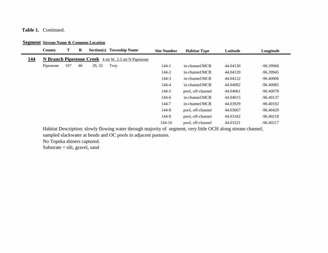
Table 1 Continued
Segment Stream Name amp Common Location
County T R Section(s) Township Name Site Number Habitat Type Latitude Longitude
144 N Branch Pipestone Creek 4 mi W 25 mi N Pipestone
Pipestone 107 46 29 32 Troy 144-1 in-channelMCB 4404130 -9639968
144-2 in-channelMCB 4404120 -9639945
144-3 in-channelMCB 4404122 -9640006
144-4 in-channelMCB 4404082 -9640085
144-5 pool off-channel 4404061 -9640078
144-6 in-channelMCB 4404015 -9640137
144-7 in-channelMCB 4403929 -9640102
144-8 pool off-channel 4403667 -9640429
144-9 pool off-channel 4403342 -9640218
144-10 pool off-channel 4403321 -9640217
Habitat Description slowly flowing water through majority of segment very little OCH along stream channel
sampled slackwater at bends and OC pools in adjacent pastures
No Topeka shiners captured
Substrate = silt gravel sand
Table 1 Continued
Segment Stream Name amp Common Location
County T R Section(s) Township Name Site Number Habitat Type Latitude Longitude
145 Pipestone Creek 4 mi W 2 mi N Ihlen
Pipestone 106 47 35 36 Sweet 145-1 pool 4393698 -9644445
105 47 2 145-2 pool 4393703 -9644465
145-3 pool 4393711 -9644491
145-4 pool 4393716 -9644545
145-5 pool 4393729 -9644589
145-6 pool 4393742 -9644625
Habitat Description low water Very narrow headwater stream (05 m) that is nearly dry between pools sampled in stagnant
pooled area upstream of a small boulder dam Floating mats of filamentous algae some submerged macrophytes
Topeka shiner present three captured at down stream end of pooled area
Substrate = silt clay some boulders sand
146 Split Rock Creek 15 mi N 05 mi E Jasper
Pipestone 105 46 28 29 Eden 146-1 pool 4387271 -9638712
146-2 pool 4387293 -9638684
146-3 pool 4387306 -9638659
146-4 pool 4387321 -9638572
146-5 in-channelMCB 4387320 -9638548
146-6 pool off-channel 4387264 -9638386
146-7 pool off-channel 4387263 -9638364
146-8 pool 4387273 -9638244
146-9 pool 4387324 -9638217
146-10 pool 4387539 -9638146
Habitat Description very low water shallow sandy pool at CR 53 bridge narow (2-3 m) channel between pooled areas
No Topeka shiners captured
Substrate = boulder gravel sand Deep silt along margins of pools
Table 1 Continued
Segment Stream Name amp Common Location
County T R Section(s) Township Name Site Number Habitat Type Latitude Longitude
147 Kanaranzi Creek 15 mi W 1 mi N Lismore
Nobles 103 42 17 18 Altona 147-1 in-channelMCB 4373149 -9591764
147-2 in-channelMCB 4373161 -9591743
147-3 in-channelMCB 4373182 -9591719
147-4 in-channelMCB 4373199 -9591705
147-5 in-channelMCB 4373202 -9591686
147-6 in-channelMCB 4373128 -9591596
147-7 in-channelMCB 4373100 -9591516
147-8 in-channelMCB 4373022 -9591492
147-9 in-channelMCB 4373007 -9591488
147-10 in-channelMCB 4372980 -9591491
147-11 in-channelMCB 4372904 -9591487
147-12 in-channelMCB 4372874 -9591463
147-13 in-channelMCB 4372779 -9591314
Habitat Description very low water narrow (2-3 m) channel high steep banks littleno OCH S end of segment ditched
No Topeka shiners captured
Substrate = gravel silt muck
148 Rock River 25 mi E 1 mi S Hatfield
Pipestone 106 44 33 Burke 148-1 in-channelMCB 4394307 -9614039
148-2 in-channelMCB 4394304 -9614026
148-3 in-channelMCB 4394280 -9613970
148-4 pool 4394283 -9613991
Habitat Description low water 3m wide flowing stream N end of segment nearly dry some backwater OCH present
Topeka shiner present two individuals captured in 20m x 3m backwater pool adjacent to the main channel
Substrate = sand gravel muck
Table 1 Continued
Segment Stream Name amp Common Location
County T R Section(s) Township Name Site Number Habitat Type Latitude Longitude
149 Rock River 1 mi SW of Edgerton
Pipestone 105 44 33 Osborne 149-1 pool 4385836 -9613494
149-2 pool 4385839 -9613508
149-3 in-channelMCB 4385830 -9613528
149-4 in-channelMCB 4385809 -9613627
Habitat Description low water 13m wide flowing stream small backwaters along MCB and pools at bridge
Topeka shiner present one individual captured in small backwater along MCB
Substrate = Gravel sand cobble Deep silt in off-channel areaspools
150 Split Rock Creek 6 mi S 2 mi W Jasper
Rock 104 47 35 Rose Dell 150-1 in-channelMCB 4377128 -9643910
150-2 in-channelMCB 4377116 -9643912
150-3 in-channelMCB 4377114 -9643931
150-4 in-channelMCB 4377149 -9643814
Habitat Description 15m wide slowly flowing stream with high steep eroded banks Low water
Topeka shiner present two individuals captured in 15m x 25m shallow silted puddle along MCB
Substrate = gravel sand silt
Table 1 Continued
Segment Stream Name amp Common Location
County T R Section(s) Township Name Site Number Habitat Type Latitude Longitude
151 Beaver Creek E 45 mi N 35 W Luverne along CSAH 20
Rock 103 45 18 19 Mound 151-1 pool 4371768 -9628182
Habitat Description 80m x 40m pool downstream of bridge no flow deep (1m) silt over clay Topeka shiner abundant 18 individuals captured in single seine haul in pool Substrate = deep (1m) silt over clay
152 Beaver Creek 35 mi W 15 mi S Beaver Creek along CSAH 7
Rock 102 47 35 36 Beaver Creek 152-1 in-channelMCB 4359418 -9643251
152-2 in-channelMCB 4359419 -9643293
152-3 in-channelMCB 4359420 -9643288
152-4 in-channelMCB 4359426 -9643393
152-5 in-channelMCB 4359423 -9643445
152-6 in-channelMCB 4359427 -9643467
152-7 in-channelMCB 4359421 -9643060
152-8 in-channelMCB 4359404 -9643035
152-9 in-channelMCB 4359305 -9643008
152-10 in-channelMCB 4359301 -9642999
Habitat Description 4m wide slowly flowing stream with high steep banks No OCH present Sampled slow water areas
along MCB
No Topeka shiners captured
Substrate = Silt sand gravel
Table 1 Continued
Segment Stream Name amp Common Location
County T R Section(s) Township Name Site Number Habitat Type Latitude Longitude
153 Beaver Creek 1 mi N 175 mi E Beaver Creek
Rock 102 46 14 23 Beaver Creek 153-1 in-channelMCB 4363076 -9632975
153-2 in-channelMCB 4363049 -9633007
153-3 in-channelMCB 4362954 -9632909
153-4 in-channelMCB 4362915 -9633117
153-5 in-channelMCB 4362911 -9633148
153-6 in-channelMCB 4362835 -9633249
153-7 in-channelMCB 4363324 -9632725
153-8 in-channelMCB 4363240 -9632740
153-9 in-channelMCB 4363233 -9632762
153-10 in-channelMCB 4363224 -9632770
Habitat Description 3m wide slowly flowing streamHigh steep banks Lots of bank erosion and very little OCH Off
channel ponds along northern 13 of segment were dry Water very low Cattle in stream Sampled slack water along MCB
No Topeka shiners captured
Substrate = firm sandsilt in backwater sandgravel in main channel
Table 1 Continued
Segment Stream Name amp Common Location
County T R Section(s) Township Name Site Number Habitat Type Latitude Longitude
154 Rock River 4mi S 25 mi W Steen
Rock 101 45 13 Clinton 154-1 pool 4355354 -9618125
154-2 in-channelMCB 4355362 -9618154
154-3 in-channelMCB 4355350 -9618191
154-4 in-channelMCB 4355254 -9618127
154-5 pool 4355287 -9617972
154-6 in-channelMCB 4355211 -9618013
154-7 in-channelMCB 4355206 -9618099
154-8 in-channelMCB 4355216 -9618146
154-9 in-channelMCB 4355197 -9618235
154-10 in-channelMCB 4355121 -9618336
154-11 in-channelMCB 4355081 -9618361
154-12 in-channelMCB 4355022 -9618309
154-13 in-channelMCB 4354985 -9618238
154-14 riffle 4354849 -9618238
154-15 in-channelMCB 4354810 -9618156
154-16 in-channelMCB 4354787 -9618069
154-17 in-channelMCB 4354709 -9618012
Habitat Description Wide (10m) flowing stream with ample OCH Channel is braided along meanders
with backwater habitat along sandgravel bars Wooded riparian corridor
No Topeka shiners captured
Substrate = gravel sand silt
Table 1 Continued
Segment Stream Name amp Common Location
County T R Section(s) Township Name Site Number Habitat Type Latitude Longitude
155 Elk Creek 3 mi N 3 mi E Magnolia along CSAH 19
Nobles 103 43 29 32 Lismore 155-1 pool 4368849 -9602497
155-2 pool 4368832 -9602512
155-3 pool 4368842 -9602019
155-4 in-channelMCB 4368859 -9602008
155-5 in-channelMCB 4368861 -9602002
155-6 in-channelMCB 4368868 -9601990
155-7 in-channelMCB 4368870 -9601969
155-8 in-channelMCB 4368877 -9601940
155-9 in-channelMCB 4368896 -9601932
155-10 in-channelMCB 4368923 -9601916
Habitat Description Water very low Narrow (2m) intermittent stream Stream bed is dry in places between isolated pools
No flow Sampled at pooled areas at culverts at CH 19
No Topeka shiners captured
Substrate = silt muck gravel
156 Elk Creek 4 mi N 4 mi E Magnolia along CSAH 14
Nobles 103 43 21 28 Lismore 156-1 pool 4370276 -9600072
Habitat Description very small headwater stream (1m) that is nearly dry between pools Sampled on margin of 20m x 50m
pool at bridge Pool depth gt 2m Thick mats of floating filamentous algae pool depth and submerged macrophytes
made seining difficult
Topeka shiner abundant 5 individuals captured in single kick set on margin of pool Numerous male Topeka shiners were observed defending cleared patches of gravel along the margin of the pool Substrate = silt over gravel
Table 1 Continued
Segment Stream Name amp Common Location
County T R Section(s) Township Name Site Number Habitat Type Latitude Longitude
157 Kanaranzi Creek 15 mi E 2 mi S Lismore
Nobles 103 42 17 19 20 Larkin 157-1 pool 4371762 -9591115
157-2 pool 4371757 -9591102
157-3 pool 4371753 -9591108
157-4 pool 4371755 -9591112
157-5 pool 4371785 -9591112
157-6 pool 4371786 -9591115
157-7 pool 4371793 -9591111
157-8 in-channelMCB 4371818 -9591105
157-9 in-channelMCB 4371820 -9591097
157-10 in-channelMCB 4371829 -9591093
157-11 in-channelMCB 4371835 -9591097
157-12 in-channelMCB 4371785 -9591100
Habitat Description Stream has been ditchedchannelized High banks and no OCH is present except for a pooled area upstream of a beaver dam that is S of the bridge No Topeka shiners captured Substrate = silt muck sand
Table 1 Continued
Segment Stream Name amp Common Location
County T R Section(s) Township Name Site Number Habitat Type Latitude Longitude
158 Kanaranzi Creek 2 mi E 35 mi S Magnolia
Nobles 102 43 31 32 Westside 158-1 pool 4359742 -9603359
158-2 pool 4359741 -9603408
158-3 in-channelMCB 4359686 -9603499
158-4 in-channelMCB 4359660 -9603513
158-5 in-channelMCB 4359620 -9603518
158-6 pool 4359584 -9603554
158-7 in-channelMCB 4359590 -9603589
158-8 in-channelMCB 4359600 -9603617
158-9 in-channelMCB 4359555 -9603658
158-10 in-channelMCB 4359527 -9603683
158-11 in-channelMCB 4359463 -9603681
158-12 in-channelMCB 4359454 -9603681
158-13 in-channelMCB 4359416 -9603690
158-14 in-channelMCB 4359399 -9603722
158-15 in-channelMCB 4359383 -9603735
Habitat Description 4m wide slowly flowing stream Sampled backwater and off-channel habitats along MCB and side channels Hard gravelsand substrate in channel Ample low-flow habitat along sandgravel bars No Topeka shiners captured Substrate = sand gravel silt
Table 1 Continued
Segment Stream Name amp Common Location
County T R Section(s) Township Name Site Number Habitat Type Latitude Longitude
159 Kanaranzi Creek 1 mi NW Adrian along CSAH 35
Nobles 102 43 13 Westside 159-1 pool 4364453 -9595165
159-2 pool 4364481 -9595166
159-3 pool 4364479 -9595182
159-4 pool 4364461 -9595195
159-5 in-channelMCB 4364438 -9595194
159-6 in-channelMCB 4364427 -9595224
159-7 in-channelMCB 4364406 -9595307
159-8 in-channelMCB 4364407 -9595333
159-9 in-channelMCB 4364401 -9595360
159-10 pool 4364448 -9595347
159-11 in-channelMCB 4364467 -9595077
159-12 in-channelMCB 4364500 -9594982
Habitat Description Flowing 7m wide stream Abundant backwaters pools and OCH along MCB
Topeka shiner present a single individual captured in a side channel over gravelsand mix after much effort
Substrate = gravel sand silt
Table 1 Contined
Segment Stream Name amp Common Location
County T R Section(s) Township Name Site Number Habitat Type Latitude Longitude
160 Little Rock River 1 mi E 4 mi S Rushmore
Nobles 101 41 16 17 Ransom 160-1 in-channelMCB 4355809 -9577372
160-2 in-channelMCB 4355819 -9577356
160-3 in-channelMCB 4355826 -9577324
160-4 in-channelMCB 4355820 -9577237
160-5 in-channelMCB 4355819 -9577193
160-6 in-channelMCB 4355824 -9577181
160-7 in-channelMCB 4355803 -9577151
160-8 in-channelMCB 4355800 -9577123
160-9 in-channelMCB 4355810 -9577124
160-10 in-channelMCB 4355827 -9577099
160-11 in-channelMCB 4355803 -9576997
160-12 in-channelMCB 4355766 -9576964
160-13 in-channelMCB 4355763 -9576986
160-14 in-channelMCB 4355706 -9576972
160-15 in-channelMCB 4355811 -9577403
160-16 in-channelMCB 4355798 -9577529
160-17 in-channelMCB 4355760 -9577529
160-18 in-channelMCB 4355759 -9577500
160-19 in-channelMCB 4355736 -9577556
Table 1 Site 160 Continued Table 1 Concluded
Segment Stream Name amp Common Location
County T R Section(s) Township Name Site Number Habitat Type Latitude Longitude
160 Little Rock River 1 mi E 4 mi S Rushmore
160-20 in-channelMCB 4355748 -9577608
160-21 in-channelMCB 4355752 -9577642
160-22 in-channelMCB 4355689 -9577684
160-23 in-channelMCB 4355681 -9577736
160-24 in-channelMCB 4355642 -9577828
160-25 in-channelMCB 4355622 -9577895
Habitat Description Slowly flowing 3m wide stream with high steep banks Little or no OCH Portions of this stream
appear to have been ditched and rip-rapped
No Topeka shiners captured
Substrate = gravel sand muck
Table 2 Locations of the twenty stream Segments (sites 161-180) sampled in 2013 corresponding sampling sites within
each segment and a brief habitat description for each site from which Topeka shiners were collected Included
are a Common Location descriptor (approximate mileage amp direction to nearest townhighways) the
TownshipRange for the 20 Segments and UTM coordinates for each sampling site Habitat type is an aproximate
characterization of the specific sample site within the sample reach pooled areas along the stream channel (pool)
low-flow reaches of stream and backwater habitats along the main channel boundary (in-channelMCB) ponds
adjacent to the sample reach that are not connected to the main channel of the stream (pool off-channel)
Segment Stream Name amp Common Location
County T R Section(s) Township Name Site Number Habitat Type Latitude Longitude
161 Medary Creek 7 mi W Lake Benson
Lincoln 109 46 7 Verdi 161-1 in-channelMCB 4425807000 -9642702300
161-2 in-channelMCB 4425815900 -9642724800
161-3 in-channelMCB 4425836800 -9642739100
161-4 in-channelMCB 4425898800 -9642738400
161-5 in-channelMCB 4425902800 -9642724500
161-6 in-channelMCB 4425904800 -9642721000
161-7 in-channelMCB 4425924400 -9642696700
161-8 in-channelMCB 4425928300 -9642687800
161-9 in-channelMCB 4425931400 -9642670400
161-10 in-channelMCB 4425936800 -9642650600
161-11 in-channelMCB 4425928700 -9642638400
161-12 in-channelMCB 4425969600 -9642576100
161-13 pool 4426041100 -9642542500
161-14 in-channelMCB 4426093000 -9642681600
161-15 in-channelMCB 4426018800 -9642819900
Habitat Description narrow (2m) flowing headwater stream beaver dams along sample reach
Topeka shiner present nine Topeka shiners captured in a flowing pool downstream of a beaver dam
Thousands of fish downstream of dam and almost none in the upstream sites 1-14
Substrate = cobble gravel silt
Table 2 Continued
Segment Stream Name amp Common Location
County T R Section(s) Township Name Site Number Habitat Type Latitude Longitude
162 Willow Creek 13 mi W Ruthton
Pipestone 108 46 4 29 Altona 162-1 in-channelMCB 4418795200 -9636967900
162-2 in-channelMCB 4418776900 -9636978700
162-3 in-channelMCB 4418554500 -9637231900
162-4 pool 4418587700 -9637323700
162-5 pool 4418588600 -9637353100
162-6 pool 4418597900 -9637352800
162-7 pool 4418617800 -9637343500
162-8 pool 4418608500 -9637352600
162-9 pool 4418659800 -9637532400
162-10 pool 4418647400 -9637460200
Habitat Description very narrow (1m) headwater stream slow flow large pool (sites 4-8) appears to be an excavated pond
metal debris and fencing material made seining difficult Seined pooled areas in cattail beds
No Topeka shiners captured Substrate = sand gravel silt
Table 2 Continued
Segment Stream Name amp Common Location
County T R Section(s) Township Name Site Number Habitat Type Latitude Longitude
163 Flandreau Creek 4 mi N 5 mi W Holland
Pipestone 108 46 29 Altona 163-1 pool 4412550100 -9639615400
163-2 pool 4412552400 -9639616700
163-3 pool 4412550000 -9639640600
163-4 in-channelMCB 4412625200 -9639662400
163-5 in-channelMCB 4412595100 -9639579900
163-6 in-channelMCB 4412681700 -9639517200
163-7 pool 4412703400 -9639517600
163-8 pool 4412761900 -9639631000
163-9 pool 4412764600 -9639631600
163-10 pool 4412782600 -9639590000
163-11 pool 4412754600 -9639531600
163-12 pool 4412762600 -9639632100
163-13 in-channelMCB 4413017900 -9639591600
163-14 in-channelMCB 4413084800 -9639438100
163-15 pool 4412573500 -9639553100
Habitat Description 3m wide flowing stream Channel appears to have been ditched most of plotted reach is dry Seined in heavily vegetated stagnant pools No Topeka shiners captured Substrate = firm sand gravel in-channel deep silt along MCB
Table 2 Continued
Segment Stream Name amp Common Location
County T R Section(s) Township Name Site Number Habitat Type Latitude Longitude
164 Flandreau Creek 65 mi W 55 mi N Pipestone
Pipestone 107 47 13 14 Troy 164-1 pool 4408042400 -9644734000
164-2 pool 4408043100 -9644720500
164-3 pool 4408042200 -9644708000
164-4 pool 4407996200 -9644910500
164-5 in-channelMCB 4407938200 -9644906400
164-6 in-channelMCB 4407760400 -9644847500
164-7 in-channelMCB 4407796600 -9644913300
164-8 in-channelMCB 4407806300 -9644950500
164-9 in-channelMCB 4407797700 -9644981100
164-10 in-channelMCB 4407809800 -9644991500
164-11 pool 4408029200 -9645104800
Habitat Description flowing 3-5m wide stream with firm gravel substrate in thalweg Sampled pooled area at bridge
some off-channel habitat at sites 4 and 11 Banks are steep along most of the reach with little slackwater habitat along MCB
No Topeka shiners captured
Substrate = gravel sand cobble in-channel Deep silt in low-flow areas
Table 2 Continued
Segment Stream Name amp Common Location
County T R Section(s) Township Name Site Number Habitat Type Latitude Longitude
165 North Branch Pipestone Creek 4 mi W 3 mi N Pipestone
Pipestone 107 46 29 Troy 165-1 pool 4404501300 -9639278100
165-2 pool 4404481000 -9639316800
165-3 pool 4404472800 -9639315500
165-4 in-channelMCB 4404457500 -9639325200
165-5 in-channelMCB 4404434800 -9639340300
165-6 in-channelMCB 4404446400 -9639386900
165-7 in-channelMCB 4404320300 -9639371300
165-8 pool 4404299200 -9639403700
165-9 pool 4404302200 -9639429200
165-10 pool 4404289200 -9639430300
165-11 pool 4404283700 -9639418700
165-12 in-channelMCB 4404212300 -9639411800
165-13 in-channelMCB 4404195800 -9639463400
165-14 in-channelMCB 4404244400 -9639645200
165-15 in-channelMCB 4404163700 -9639819800
165-16 in-channelMCB 4404165900 -9639797900
Habitat Description moderately flowing 3-5m wide stream Recent increase in stream level some submerged terrestrial
grasses along MCB Sites 8-11 in oxbow Submerged terrestrial grasses in oxbow
No Topeka shiners captured
Substrate = sand gravel silt
Table 2 Continued
Segment Stream Name amp Common Location
County T R Section(s) Township Name Site Number Habitat Type Latitude Longitude
166 Pipestone Creek 35 mi W 1 mi N Pipestone
Pipestone 106 46 4 5 Sweet 166-1 in-channelMCB 4401330100 -9638708400
166-2 in-channelMCB 4401347000 -9638709700
166-3 in-channelMCB 4401345500 -9638703700
166-4 in-channelMCB 4401355800 -9638703000
166-5 in-channelMCB 4401541200 -9638596400
166-6 in-channelMCB 4401618700 -9638658000
166-7 in-channelMCB 4401623400 -9638660800
166-8 in-channelMCB 4401625200 -9638646200
166-9 in-channelMCB 4401633300 -9638635600
166-10 in-channelMCB 4401740500 -9638517300
Habitat Description 10m wide slowly flowing stream Sampled along MCB in slack water West end of segment appears
to have been ditched Littleno OCH Drainage tiles along E reach of segment
No Topeka shiners captured
Substrate = cobble gravel sand Deep silt along margins of pools
Table 2 Continued
Segment Stream Name amp Common Location
County T R Section(s) Township Name Site Number Habitat Type Latitude Longitude
167 Split Rock Creek 15 mi N 1 mi E Ihlen
Pipestone 105 46 3 Eden 167-1 pool 4392585400 -9634993300
167-2 in-channelMCB 4392638100 -9635031600
167-3 pool 4392643100 -9635103600
167-4 pool 4392638200 -9635101900
167-5 pool 4392633000 -9635108800
167-6 pool 4392633200 -9635116400
167-7 pool 4392635700 -9635131600
167-8 pool 4392636400 -9635139100
167-9 pool 4392635900 -9635156000
167-10 in-channelMCB 4392470900 -9635255600
167-11 in-channelMCB 4392465600 -9635242800
167-12 in-channelMCB 4392447500 -9635240300
Habitat Description very small headwater stream (~1m) water low isolated series of pools along streambed No Topeka shiners captured Substrate = sand gravel silt
168 Split Rock Creek 15 mi N 05 mi E Jasper
Pipestone 105 46 28 29 Eden 168-1 in-channelMCB 4387771400 -9638026400
Habitat Description high water 4m wide flowing stream submerged terrestrial grasses on margins
Topeka shiner common 6 individuals captured on first seine haul in pooled area at MCB just downstream of culvert
Substrate = boulder cobble sand
Table 2 Continued
Segment Stream Name amp Common Location
County T R Section(s) Township Name Site Number Habitat Type Latitude Longitude
169 Rock River 1 mi SW of Edgerton
Pipestone 105 44 17 18 Osborne 169-1 pool 4389371700 -9616564700
169-2 in-channelMCB 4389439900 -9616531800
Habitat Description Swiftly flowing 10m wide stream at high water Sampled pooled area at outside bend of stream
over deep silt
Topeka shiner present four individuals captured in four seine hauls in a 1m wide drainage channel that joins a
retention pond to the Rock River
Substrate = Silt gravel Deep silt in off-channel areaspools
170 Chanarambie Creek 05 mi S 05 mi E Chandler
Murray 104 47 35 Fenton 170-1 in-channelMCB 4392093400 -9593156600
170-2 in-channelMCB 4391890200 -9593079300
170-3 in-channelMCB 4391841400 -9593168100
170-4 in-channelMCB 4391784300 -9593090300
170-5 in-channelMCB 4391783100 -9593060700
170-6 in-channelMCB 4391790600 -9593061100
170-7 in-channelMCB 4391796700 -9593025000
170-8 in-channelMCB 4391792000 -9592982800
170-9 in-channelMCB 4392105300 -9593062100
170-10 in-channelMCB 4392122900 -9593165100
Habitat Description narrow (1-2m) headwater stream Stream is flowing swiftly and little or no OCH is present
most of the segment appears to have been channelized
No Topeka shiners captured
Substrate = silt sand
Table 2 Continued
Segment Stream Name amp Common Location
County T R Section(s) Township Name Site Number Habitat Type Latitude Longitude
171 Rock River 4 mi S Edgerton
Rock 104 44 8 9 Battle Plain 171-1 in-channelMCB 4382021200 -9613013100
171-2 pool 4382126400 -9613470300
171-3 in-channelMCB 4382025300 -9612974300
171-4 in-channelMCB 4382027100 -9612961600
171-5 in-channelMCB 4382145400 -9613302800
171-6 in-channelMCB 4382380700 -9613520900
171-7 in-channelMCB 4382367500 -9613527700
171-8 in-channelMCB 4382359000 -9613532400
171-9 in-channelMCB 4382405300 -9613495400
171-10 in-channelMCB 4382271200 -9613570400
Habitat Description High water 8-12m wide swiftly flowing stream Stream is full to high banks Much of slackwater
areas along MCB likely inudndated Sampled in backwaters sites 6-9
No Topeka shiners captured
Substrate = Sand gravel silt
Table 2 Continued
Segment Stream Name amp Common Location
County T R Section(s) Township Name Site Number Habitat Type Latitude Longitude
172 Rock River tributary 1 mi E Hardwick
Rock 104 44 30 31 Battle Plain 172-1 pool 4377538900 -9617075500
172-2 pool 4377529200 -9617075600
172-3 pool 4377514700 -9617079800
172-4 in-channelMCB 4377386200 -9617079600
172-5 in-channelMCB 4377247100 -9617207900
172-6 in-channelMCB 4377241900 -9617224500
172-7 in-channelMCB 4377245200 -9617219500
172-8 in-channelMCB 4376956400 -9616914600
172-9 pool off-channel 4376998700 -9616876000
172-10 in-channelMCB 4377058800 -9616855700
172-11 in-channelMCB 4377043200 -9616826600
Habitat Description 3m wide slowly flowing pasture stream with high trampled banks Much of reach appears to
have been channelized no OCH present along MCBSampled in stock pond at site 9 Some submerged macrophytes
No Topeka shiners captured
Substrate = sand silt muck
Table 2 Continued
Segment Stream Name amp Common Location
County T R Section(s) Township Name Site Number Habitat Type Latitude Longitude
173 Mound Creek 1 mi N 175 mi E Beaver Creek
Rock 103 45 2 11 Mound 173-1 in-channelMCB 4374749900 -9620089200
173-2 in-channelMCB 4374756900 -9620094400
173-3 in-channelMCB 4374763700 -9620090700
173-4 in-channelMCB 4374842800 -9619838100
173-5 in-channelMCB 4374844000 -9619833200
173-6 in-channelMCB 4374889800 -9619789300
173-7 in-channelMCB 4374839600 -9619885800
173-8 in-channelMCB 4374827900 -9619934500
173-9 in-channelMCB 4374817000 -9619966400
173-10 in-channelMCB 4374799700 -9620048400
Habitat Description Entire reach of sement has been channelized Stream is 1-2m wide and constantly flowing High
banks No OCH
No Topeka shiners captured
Substrate = gravel sand silt
Table 2 Continued
Segment Stream Name amp Common Location
County T R Section(s) Township Name Site Number Habitat Type Latitude Longitude
174 Rock River tributary 55 mi N 4 mi E Luverne
Rock 103 44 8 9 Vienna 174-1 pool 4373333900 -9613250300
174-2 pool 4373322100 -9613262700
Habitat Description Narrow (2-3m) wide flowing headwater stream Sampled in deep silted pool at bridge Topeka shiner present two individuals captured over gravel in pooled area at bridge Much of the pool is filled with deep (gt05m) silt No Topeka shiners collected in silted portion of pool Substrate = gravel sand silt
Table 2 Continued
Segment Stream Name amp Common Location
County T R Section(s) Township Name Site Number Habitat Type Latitude Longitude
175 Champepadan Creek 4mi N 5 mi E Luverne
Rock 103 44 21 22 Vienna 175-1 pool 4371002900 -9611238300
175-2 pool 4371001900 -9611232600
175-3 pool 4371008300 -9611238900
175-4 in-channelMCB 4370955000 -9611142300
175-5 in-channelMCB 4371042200 -9610763900
175-6 in-channelMCB 4371007000 -9610720000
175-7 in-channelMCB 4370984100 -9610706400
175-8 pooloff-channel 4370971600 -9610709700
Habitat Description 3m wide stream with moderate flow Native prairie has been planted along both banks for the entire reach
No flow Sampled at pooled areas at culverts at CH 19
Topeka shiner present one individual captured in deep livestock pond S of stream Depth (gt2m) made seining in pond difficult
Substrate = sand silt gravel
Table 2 Continued
Segment Stream Name amp Common Location
County T R Section(s) Township Name Site Number Habitat Type Latitude Longitude
176 Kanaranzi Creek 2 mi W 35 mi N Ellworth
Rock 101 44 12 Kanaranzi 176-1 pool 4357304000 -9606413600
176-2 pool 4357305400 -9606410500
176-3 pool 4357249700 -9606408600
176-4 in-channelMCB 4357200500 -9606350300
176-5 in-channelMCB 4357204500 -9606354600
176-6 in-channelMCB 4357211400 -9606360400
176-7 in-channelMCB 4357127700 -9606357500
176-8 in-channelMCB 4357090500 -9606197900
176-9 in-channelMCB 4356817400 -9606275000
176-10 in-channelMCB 4356807000 -9606273900
176-11 in-channelMCB 4356639200 -9606408000
176-12 in-channelMCB 4356632100 -9606416000
176-13 in-channelMCB 4356598300 -9606381200
Habitat Description 10m wide flowing stream Very little OCH Very deep silt along MCB Sampled pooled area
at bridge High eroded banks
No Topeka shiners captured
Substrate = silt over gravel
Table 2 Continued
Segment Stream Name amp Common Location
County T R Section(s) Township Name Site Number Habitat Type Latitude Longitude
177 Rock River 05 mi N 4 mi E Steen
Rock 101 45 25 Clinton 177-1 pool 4352588900 -9618721100
177-2 pool 4352592700 -9618726600
177-3 in-channelMCB 4352519900 -9618594900
177-4 in-channelMCB 4352297500 -9618558400
177-5 in-channelMCB 4352147800 -9618456000
177-6 in-channelMCB 4352143300 -9618458200
177-7 in-channelMCB 4352125000 -9618453100
177-8 in-channelMCB 4352121500 -9618442200
177-9 in-channelMCB 4352106600 -9618444000
177-10 in-channelMCB 4352727900 -9618684800
177-11 pool 4352783000 -9618770800
177-12 pooloff-channel 4352663200 -9619046500
Habitat Description 11m wide flowing stream with wide channel sand bars and some braiding Firm gravel in thalweg Oxbow in middle of reach is nearly dry (lt25 cm) No fish observed culicid fly larvae abundant No Topeka shiners captured Substrate = sand gravel silt
Table 2 Continued
Segment Stream Name amp Common Location
County T R Section(s) Township Name Site Number Habitat Type Latitude Longitude
178 Kanaranzi Creek 2 mi W Ellsworth
Rock 101 44 25 36 Kanaranzi 178-1 pool 4351441400 -9605867000
178-2 in-channelMCB 4351404500 -9605846000
178-3 in-channelMCB 4351378800 -9605844300
178-4 pool 4351349700 -9605841200
178-5 pool 4351358400 -9605829800
178-6 pool 4351351800 -9605816800
178-7 in-channelMCB 4351355800 -9605866900
178-8 in-channelMCB 4351549000 -9605823700
178-9 in-channelMCB 4351891800 -9605895600
178-10 in-channelMCB 4351866200 -9605881400
178-11 pool 4352078500 -9606070000
178-12 pool 4352046000 -9606082200
Habitat Description 7-9m wide flowing stream Sampled backwater and off-channel habitats along MCB and side channels Recent high flow has filled in off-channel areas with deep silt Seining difficult No Topeka shiners captured Substrate = sand silt gravel
Table 2 Concluded
Segment Stream Name amp Common Location
County T R Section(s) Township Name Site Number Habitat Type Latitude Longitude
179 East Branch Kanaranzi Creek 15 mi N 15 mi E Adrian
Nobles 102 42 8 Olney 179-1 pool 4365932900 -9590462700
179-2 pool 4365928900 -9590449500
179-3 pool 4365930600 -9590463300
179-4 pool 4365908000 -9590420300
179-5 in-channelMCB 4365679800 -9590378600
179-6 in-channelMCB 4365661000 -9590387800
179-7 in-channelMCB 4365604000 -9590417100
179-8 in-channelMCB 4365508100 -9590385200
179-9 in-channelMCB 4365460100 -9590342200
179-10 pool 4365434900 -9590020100
179-11 in-channelMCB 4365507700 -9590154900
179-12 in-channelMCB 4365588000 -9589900200
Habitat Description Flowing 9m wide stream Stream is full to high banks very little slackwater habitat present at this site
No Topeka shiners captured
Substrate = sand silt gravel
180 Little Rock River 8 mi E Ellsworth
Nobles 101 42 26 Little Rock 180-1 in-channelMCB 4352838500 -9584615900
Habitat Description Sampled large pooled area at bridge no discernible flow silt over gravel substrate Channel downstream
of pool is a 2-3 m wide flowing stream with a firm sandgravel substrate
Topeka shiner abundant fourteen individuals captured in first seine haul in pool fifteen individuals captured in second seine
haul near outlet of the pool
Substrate = gravel sand silt
Table 3 Complete List of Fish Species Captured at Segments 141-160 2012
Species 141 142 143 144 145 146 147 148 149 150 151 152 153 154 155 156 157 158 159 160 Campostoma anomalum X X X X X X X X X X X X X X Chrosomus erythrogaster X X Cyprinella lutrensis X X X X X X X X X Cyprinus carpio X X X X X Hybognathus hankinsoni X X X X X X X Luxilus cornutus X X X X X X X X X X X X X Notropis dorsalis X X X X X X X X X X X Notropis stramineus X X X X X X X X X X X X X X X Notropis topeka X X X X X X X X Pimephales notatus X X X X X X X X X X X X Pimephales promelas X X X X X X X X X X X X X X X X X X Rhinichthys atratulus X X X X X X Semotilus atromaculatus X X X X X X X X X X X X X X X X X X Carpiodes cyprinus X Carpiodes sp (YOY) X X X Catostomus commersoni X X X X X X X X X X X X X X X Moxostoma macrolepidotum X X Ameiurus melas X X X X X X X X X X X X X Ameiurus natalis X Ictalurus punctatus X X X X Noturus flavus X X X X Noturus gyrinus X X X X X Esox lucius X X Percopsis omiscomaycus X Fundulus sciadicus X X X Culaea inconstans X X X X X Lepomis cyanellus X X X X X X X Lepomis humilis X X X X X X X X X X X Lepomis macrochirus X X X X X Micropterus dolomieui X Micropterus salmoides X X Pomoxis nigromaculatus X X Etheostoma exile X X X X X Etheostoma nigrum X X X X X X X X X X X X X X X X X Perca flavescens X X Percina maculata X X X X
Table 4 Complete List of Fish Species Captured at Segments 161-180 2013
Species 161 162 163 164 165 166 167 168 169 170 171 172 173 174 175 176 177 178 179 180
Campostoma anomalum X X X X X X X X X X X X X X
Cyprinella lutrensis X X X X X X X X X X
Cyprinus carpio X X X
Hybognathus hankinsoni X X X X X
Luxilus cornutus X X X X X X X X X X X X X
Notropis dorsalis X X X X X X X X X X X X X X
Notropis stramineus X X X X X X X X X X X X X X
Notropis topeka X X X X X X
Pimephales notatus X X X X X X X X X X X X
Pimephales promelas X X X X X X X X X X X X X X X X X X
Rhinichthys atratulus X X X X X X X X X X X
Semotilus atromaculatus X X X X X X X X X X X X X X X X
Carpiodes cyprinus X X
Catostomus commersoni X X X X X X X X X X X X X
Moxostoma erythrurum X X X
Moxostoma macrolepidotum X X
Ameiurus melas X X X X X X X X X X
Noturus flavus X X X
Esox lucius X X
Percopsis omiscomaycus X
Fundulus sciadicus X
Culaea inconstans X X X X
Lepomis cyanellus X X X X X X
Lepomis humilis X X X X X X X X X
Etheostoma exile X X
Etheostoma nigrum X X X X X X X X X X
Percina maculata X X
Appendix C- Habitat and Voucher Photographs
Habitat photographs for segments in which no Topeka shiners were captured are representative
of the habitat along the one-mile reach of stream Habitat photographs from segments where
Topeka shiners were present represent the specific site where they were collected Voucher
photographs are presented for each of the sites were Topeka shiners were collected
Site 141-2 Medary Creek voucher and habitat photos
Segment 142 Willow Creek no Topeka shiners captured
Segment 143 East Branch Flandrau Creek no Topeka shiners captured
Segment 144 North Branch Pipestone Creek no Topeka shiners captured
Site 145-6 Pipestone Creek voucher photo
Site 145-6 Pipestone Creek habitat photo
Segment 146 Split Rock Creek no Topeka shiners captured No habitat photo
Segment 147 Kanaranzi Creek no Topeka shiners captured
Site 148-4 Rock River voucher and habitat photos
Site 149-4 Rock River voucher and habitat photos
Site 150-4 Split Rock Creek voucher and habitat photos
Site 151-1 Beaver Creek voucher and habitat photos
Segment 152 Beaver Creek no Topeka shiners captured
Segment 153 Beaver Creek no Topeka shiners captured
Segment 154 Rock River no Topeka shiners captured
Segment 155 Elk Creek no Topeka shiners captured
Site 156-1 Elk Creek voucher and habitat photos
Segment 157 Kanaranzi Creek no Topeka shiners captured
Segment 158 Kanaranzi Creek no Topeka shiners captured
Site 159-1 Kanaranzi Creek voucher and habitat photos
Segment 160 Little Rock River no Topeka shiners captured
Site 161-15 Medary Creek voucher photo
Site 161-15 Medary Creek habitat photo
Segment 162 Willow Creek no Topeka shiners captured No habitat photo
Segment 163 Flandrau Creek no Topeka shiners captured
Segment 164 Flandrau Creek no Topeka shiners captured
Segment 165 North Branch Pipestone Creek no Topeka Shiners captured
Segment 166 Pipestone Creek no Topeka Shiners captured
Segment 167 Tributary to Split Rock Creek no Topeka Shiners captured No habitat
photo
Site 168-1 Split Rock Creek voucher photo
Site 168-1 Split Rock Creek habitat photo
Site 169-2 Rock River voucher photo
Site 169-2 Rock River habitat photo
Segment 170 Chanarambie Creek no Topeka shiners captured
Segment 171 Rock River no Topeka shiners captured
Segment 172 Tributary to Rock River no Topeka shiners captured
Segment 173 Blue Mound Creek no Topeka shiners
Site 174-2 Tributary to Rock River voucher photo
Site 174-2 Tributary to Rock River habitat photo
Site 175-8 Champepadan Creek voucher photo
Site 175-8 Champepadan Creek habitat photo
Segment 176 Kanaranzi Creek no Topekas captured
Segment 177 Rock River no Topeka shiners captured
Segment 178 Kanaranzi Creek no Topeka shiners captured
Segment 179 East Branch Kanaranzi Creek no Topeka shiners captured
Site 180-1 West Branch Little Rock River voucher photo
Site 180-1 West Branch Little Rock River habitat photo
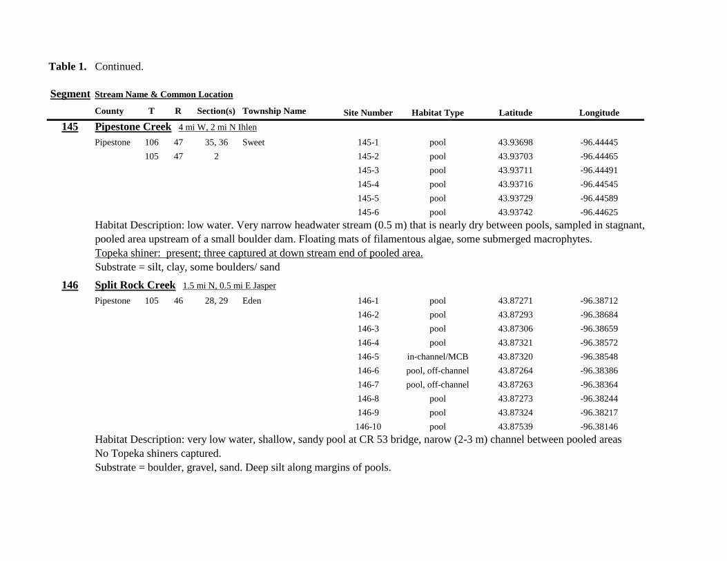
Table 1 Continued
Segment Stream Name amp Common Location
County T R Section(s) Township Name Site Number Habitat Type Latitude Longitude
145 Pipestone Creek 4 mi W 2 mi N Ihlen
Pipestone 106 47 35 36 Sweet 145-1 pool 4393698 -9644445
105 47 2 145-2 pool 4393703 -9644465
145-3 pool 4393711 -9644491
145-4 pool 4393716 -9644545
145-5 pool 4393729 -9644589
145-6 pool 4393742 -9644625
Habitat Description low water Very narrow headwater stream (05 m) that is nearly dry between pools sampled in stagnant
pooled area upstream of a small boulder dam Floating mats of filamentous algae some submerged macrophytes
Topeka shiner present three captured at down stream end of pooled area
Substrate = silt clay some boulders sand
146 Split Rock Creek 15 mi N 05 mi E Jasper
Pipestone 105 46 28 29 Eden 146-1 pool 4387271 -9638712
146-2 pool 4387293 -9638684
146-3 pool 4387306 -9638659
146-4 pool 4387321 -9638572
146-5 in-channelMCB 4387320 -9638548
146-6 pool off-channel 4387264 -9638386
146-7 pool off-channel 4387263 -9638364
146-8 pool 4387273 -9638244
146-9 pool 4387324 -9638217
146-10 pool 4387539 -9638146
Habitat Description very low water shallow sandy pool at CR 53 bridge narow (2-3 m) channel between pooled areas
No Topeka shiners captured
Substrate = boulder gravel sand Deep silt along margins of pools
Table 1 Continued
Segment Stream Name amp Common Location
County T R Section(s) Township Name Site Number Habitat Type Latitude Longitude
147 Kanaranzi Creek 15 mi W 1 mi N Lismore
Nobles 103 42 17 18 Altona 147-1 in-channelMCB 4373149 -9591764
147-2 in-channelMCB 4373161 -9591743
147-3 in-channelMCB 4373182 -9591719
147-4 in-channelMCB 4373199 -9591705
147-5 in-channelMCB 4373202 -9591686
147-6 in-channelMCB 4373128 -9591596
147-7 in-channelMCB 4373100 -9591516
147-8 in-channelMCB 4373022 -9591492
147-9 in-channelMCB 4373007 -9591488
147-10 in-channelMCB 4372980 -9591491
147-11 in-channelMCB 4372904 -9591487
147-12 in-channelMCB 4372874 -9591463
147-13 in-channelMCB 4372779 -9591314
Habitat Description very low water narrow (2-3 m) channel high steep banks littleno OCH S end of segment ditched
No Topeka shiners captured
Substrate = gravel silt muck
148 Rock River 25 mi E 1 mi S Hatfield
Pipestone 106 44 33 Burke 148-1 in-channelMCB 4394307 -9614039
148-2 in-channelMCB 4394304 -9614026
148-3 in-channelMCB 4394280 -9613970
148-4 pool 4394283 -9613991
Habitat Description low water 3m wide flowing stream N end of segment nearly dry some backwater OCH present
Topeka shiner present two individuals captured in 20m x 3m backwater pool adjacent to the main channel
Substrate = sand gravel muck
Table 1 Continued
Segment Stream Name amp Common Location
County T R Section(s) Township Name Site Number Habitat Type Latitude Longitude
149 Rock River 1 mi SW of Edgerton
Pipestone 105 44 33 Osborne 149-1 pool 4385836 -9613494
149-2 pool 4385839 -9613508
149-3 in-channelMCB 4385830 -9613528
149-4 in-channelMCB 4385809 -9613627
Habitat Description low water 13m wide flowing stream small backwaters along MCB and pools at bridge
Topeka shiner present one individual captured in small backwater along MCB
Substrate = Gravel sand cobble Deep silt in off-channel areaspools
150 Split Rock Creek 6 mi S 2 mi W Jasper
Rock 104 47 35 Rose Dell 150-1 in-channelMCB 4377128 -9643910
150-2 in-channelMCB 4377116 -9643912
150-3 in-channelMCB 4377114 -9643931
150-4 in-channelMCB 4377149 -9643814
Habitat Description 15m wide slowly flowing stream with high steep eroded banks Low water
Topeka shiner present two individuals captured in 15m x 25m shallow silted puddle along MCB
Substrate = gravel sand silt
Table 1 Continued
Segment Stream Name amp Common Location
County T R Section(s) Township Name Site Number Habitat Type Latitude Longitude
151 Beaver Creek E 45 mi N 35 W Luverne along CSAH 20
Rock 103 45 18 19 Mound 151-1 pool 4371768 -9628182
Habitat Description 80m x 40m pool downstream of bridge no flow deep (1m) silt over clay Topeka shiner abundant 18 individuals captured in single seine haul in pool Substrate = deep (1m) silt over clay
152 Beaver Creek 35 mi W 15 mi S Beaver Creek along CSAH 7
Rock 102 47 35 36 Beaver Creek 152-1 in-channelMCB 4359418 -9643251
152-2 in-channelMCB 4359419 -9643293
152-3 in-channelMCB 4359420 -9643288
152-4 in-channelMCB 4359426 -9643393
152-5 in-channelMCB 4359423 -9643445
152-6 in-channelMCB 4359427 -9643467
152-7 in-channelMCB 4359421 -9643060
152-8 in-channelMCB 4359404 -9643035
152-9 in-channelMCB 4359305 -9643008
152-10 in-channelMCB 4359301 -9642999
Habitat Description 4m wide slowly flowing stream with high steep banks No OCH present Sampled slow water areas
along MCB
No Topeka shiners captured
Substrate = Silt sand gravel
Table 1 Continued
Segment Stream Name amp Common Location
County T R Section(s) Township Name Site Number Habitat Type Latitude Longitude
153 Beaver Creek 1 mi N 175 mi E Beaver Creek
Rock 102 46 14 23 Beaver Creek 153-1 in-channelMCB 4363076 -9632975
153-2 in-channelMCB 4363049 -9633007
153-3 in-channelMCB 4362954 -9632909
153-4 in-channelMCB 4362915 -9633117
153-5 in-channelMCB 4362911 -9633148
153-6 in-channelMCB 4362835 -9633249
153-7 in-channelMCB 4363324 -9632725
153-8 in-channelMCB 4363240 -9632740
153-9 in-channelMCB 4363233 -9632762
153-10 in-channelMCB 4363224 -9632770
Habitat Description 3m wide slowly flowing streamHigh steep banks Lots of bank erosion and very little OCH Off
channel ponds along northern 13 of segment were dry Water very low Cattle in stream Sampled slack water along MCB
No Topeka shiners captured
Substrate = firm sandsilt in backwater sandgravel in main channel
Table 1 Continued
Segment Stream Name amp Common Location
County T R Section(s) Township Name Site Number Habitat Type Latitude Longitude
154 Rock River 4mi S 25 mi W Steen
Rock 101 45 13 Clinton 154-1 pool 4355354 -9618125
154-2 in-channelMCB 4355362 -9618154
154-3 in-channelMCB 4355350 -9618191
154-4 in-channelMCB 4355254 -9618127
154-5 pool 4355287 -9617972
154-6 in-channelMCB 4355211 -9618013
154-7 in-channelMCB 4355206 -9618099
154-8 in-channelMCB 4355216 -9618146
154-9 in-channelMCB 4355197 -9618235
154-10 in-channelMCB 4355121 -9618336
154-11 in-channelMCB 4355081 -9618361
154-12 in-channelMCB 4355022 -9618309
154-13 in-channelMCB 4354985 -9618238
154-14 riffle 4354849 -9618238
154-15 in-channelMCB 4354810 -9618156
154-16 in-channelMCB 4354787 -9618069
154-17 in-channelMCB 4354709 -9618012
Habitat Description Wide (10m) flowing stream with ample OCH Channel is braided along meanders
with backwater habitat along sandgravel bars Wooded riparian corridor
No Topeka shiners captured
Substrate = gravel sand silt
Table 1 Continued
Segment Stream Name amp Common Location
County T R Section(s) Township Name Site Number Habitat Type Latitude Longitude
155 Elk Creek 3 mi N 3 mi E Magnolia along CSAH 19
Nobles 103 43 29 32 Lismore 155-1 pool 4368849 -9602497
155-2 pool 4368832 -9602512
155-3 pool 4368842 -9602019
155-4 in-channelMCB 4368859 -9602008
155-5 in-channelMCB 4368861 -9602002
155-6 in-channelMCB 4368868 -9601990
155-7 in-channelMCB 4368870 -9601969
155-8 in-channelMCB 4368877 -9601940
155-9 in-channelMCB 4368896 -9601932
155-10 in-channelMCB 4368923 -9601916
Habitat Description Water very low Narrow (2m) intermittent stream Stream bed is dry in places between isolated pools
No flow Sampled at pooled areas at culverts at CH 19
No Topeka shiners captured
Substrate = silt muck gravel
156 Elk Creek 4 mi N 4 mi E Magnolia along CSAH 14
Nobles 103 43 21 28 Lismore 156-1 pool 4370276 -9600072
Habitat Description very small headwater stream (1m) that is nearly dry between pools Sampled on margin of 20m x 50m
pool at bridge Pool depth gt 2m Thick mats of floating filamentous algae pool depth and submerged macrophytes
made seining difficult
Topeka shiner abundant 5 individuals captured in single kick set on margin of pool Numerous male Topeka shiners were observed defending cleared patches of gravel along the margin of the pool Substrate = silt over gravel
Table 1 Continued
Segment Stream Name amp Common Location
County T R Section(s) Township Name Site Number Habitat Type Latitude Longitude
157 Kanaranzi Creek 15 mi E 2 mi S Lismore
Nobles 103 42 17 19 20 Larkin 157-1 pool 4371762 -9591115
157-2 pool 4371757 -9591102
157-3 pool 4371753 -9591108
157-4 pool 4371755 -9591112
157-5 pool 4371785 -9591112
157-6 pool 4371786 -9591115
157-7 pool 4371793 -9591111
157-8 in-channelMCB 4371818 -9591105
157-9 in-channelMCB 4371820 -9591097
157-10 in-channelMCB 4371829 -9591093
157-11 in-channelMCB 4371835 -9591097
157-12 in-channelMCB 4371785 -9591100
Habitat Description Stream has been ditchedchannelized High banks and no OCH is present except for a pooled area upstream of a beaver dam that is S of the bridge No Topeka shiners captured Substrate = silt muck sand
Table 1 Continued
Segment Stream Name amp Common Location
County T R Section(s) Township Name Site Number Habitat Type Latitude Longitude
158 Kanaranzi Creek 2 mi E 35 mi S Magnolia
Nobles 102 43 31 32 Westside 158-1 pool 4359742 -9603359
158-2 pool 4359741 -9603408
158-3 in-channelMCB 4359686 -9603499
158-4 in-channelMCB 4359660 -9603513
158-5 in-channelMCB 4359620 -9603518
158-6 pool 4359584 -9603554
158-7 in-channelMCB 4359590 -9603589
158-8 in-channelMCB 4359600 -9603617
158-9 in-channelMCB 4359555 -9603658
158-10 in-channelMCB 4359527 -9603683
158-11 in-channelMCB 4359463 -9603681
158-12 in-channelMCB 4359454 -9603681
158-13 in-channelMCB 4359416 -9603690
158-14 in-channelMCB 4359399 -9603722
158-15 in-channelMCB 4359383 -9603735
Habitat Description 4m wide slowly flowing stream Sampled backwater and off-channel habitats along MCB and side channels Hard gravelsand substrate in channel Ample low-flow habitat along sandgravel bars No Topeka shiners captured Substrate = sand gravel silt
Table 1 Continued
Segment Stream Name amp Common Location
County T R Section(s) Township Name Site Number Habitat Type Latitude Longitude
159 Kanaranzi Creek 1 mi NW Adrian along CSAH 35
Nobles 102 43 13 Westside 159-1 pool 4364453 -9595165
159-2 pool 4364481 -9595166
159-3 pool 4364479 -9595182
159-4 pool 4364461 -9595195
159-5 in-channelMCB 4364438 -9595194
159-6 in-channelMCB 4364427 -9595224
159-7 in-channelMCB 4364406 -9595307
159-8 in-channelMCB 4364407 -9595333
159-9 in-channelMCB 4364401 -9595360
159-10 pool 4364448 -9595347
159-11 in-channelMCB 4364467 -9595077
159-12 in-channelMCB 4364500 -9594982
Habitat Description Flowing 7m wide stream Abundant backwaters pools and OCH along MCB
Topeka shiner present a single individual captured in a side channel over gravelsand mix after much effort
Substrate = gravel sand silt
Table 1 Contined
Segment Stream Name amp Common Location
County T R Section(s) Township Name Site Number Habitat Type Latitude Longitude
160 Little Rock River 1 mi E 4 mi S Rushmore
Nobles 101 41 16 17 Ransom 160-1 in-channelMCB 4355809 -9577372
160-2 in-channelMCB 4355819 -9577356
160-3 in-channelMCB 4355826 -9577324
160-4 in-channelMCB 4355820 -9577237
160-5 in-channelMCB 4355819 -9577193
160-6 in-channelMCB 4355824 -9577181
160-7 in-channelMCB 4355803 -9577151
160-8 in-channelMCB 4355800 -9577123
160-9 in-channelMCB 4355810 -9577124
160-10 in-channelMCB 4355827 -9577099
160-11 in-channelMCB 4355803 -9576997
160-12 in-channelMCB 4355766 -9576964
160-13 in-channelMCB 4355763 -9576986
160-14 in-channelMCB 4355706 -9576972
160-15 in-channelMCB 4355811 -9577403
160-16 in-channelMCB 4355798 -9577529
160-17 in-channelMCB 4355760 -9577529
160-18 in-channelMCB 4355759 -9577500
160-19 in-channelMCB 4355736 -9577556
Table 1 Site 160 Continued Table 1 Concluded
Segment Stream Name amp Common Location
County T R Section(s) Township Name Site Number Habitat Type Latitude Longitude
160 Little Rock River 1 mi E 4 mi S Rushmore
160-20 in-channelMCB 4355748 -9577608
160-21 in-channelMCB 4355752 -9577642
160-22 in-channelMCB 4355689 -9577684
160-23 in-channelMCB 4355681 -9577736
160-24 in-channelMCB 4355642 -9577828
160-25 in-channelMCB 4355622 -9577895
Habitat Description Slowly flowing 3m wide stream with high steep banks Little or no OCH Portions of this stream
appear to have been ditched and rip-rapped
No Topeka shiners captured
Substrate = gravel sand muck
Table 2 Locations of the twenty stream Segments (sites 161-180) sampled in 2013 corresponding sampling sites within
each segment and a brief habitat description for each site from which Topeka shiners were collected Included
are a Common Location descriptor (approximate mileage amp direction to nearest townhighways) the
TownshipRange for the 20 Segments and UTM coordinates for each sampling site Habitat type is an aproximate
characterization of the specific sample site within the sample reach pooled areas along the stream channel (pool)
low-flow reaches of stream and backwater habitats along the main channel boundary (in-channelMCB) ponds
adjacent to the sample reach that are not connected to the main channel of the stream (pool off-channel)
Segment Stream Name amp Common Location
County T R Section(s) Township Name Site Number Habitat Type Latitude Longitude
161 Medary Creek 7 mi W Lake Benson
Lincoln 109 46 7 Verdi 161-1 in-channelMCB 4425807000 -9642702300
161-2 in-channelMCB 4425815900 -9642724800
161-3 in-channelMCB 4425836800 -9642739100
161-4 in-channelMCB 4425898800 -9642738400
161-5 in-channelMCB 4425902800 -9642724500
161-6 in-channelMCB 4425904800 -9642721000
161-7 in-channelMCB 4425924400 -9642696700
161-8 in-channelMCB 4425928300 -9642687800
161-9 in-channelMCB 4425931400 -9642670400
161-10 in-channelMCB 4425936800 -9642650600
161-11 in-channelMCB 4425928700 -9642638400
161-12 in-channelMCB 4425969600 -9642576100
161-13 pool 4426041100 -9642542500
161-14 in-channelMCB 4426093000 -9642681600
161-15 in-channelMCB 4426018800 -9642819900
Habitat Description narrow (2m) flowing headwater stream beaver dams along sample reach
Topeka shiner present nine Topeka shiners captured in a flowing pool downstream of a beaver dam
Thousands of fish downstream of dam and almost none in the upstream sites 1-14
Substrate = cobble gravel silt
Table 2 Continued
Segment Stream Name amp Common Location
County T R Section(s) Township Name Site Number Habitat Type Latitude Longitude
162 Willow Creek 13 mi W Ruthton
Pipestone 108 46 4 29 Altona 162-1 in-channelMCB 4418795200 -9636967900
162-2 in-channelMCB 4418776900 -9636978700
162-3 in-channelMCB 4418554500 -9637231900
162-4 pool 4418587700 -9637323700
162-5 pool 4418588600 -9637353100
162-6 pool 4418597900 -9637352800
162-7 pool 4418617800 -9637343500
162-8 pool 4418608500 -9637352600
162-9 pool 4418659800 -9637532400
162-10 pool 4418647400 -9637460200
Habitat Description very narrow (1m) headwater stream slow flow large pool (sites 4-8) appears to be an excavated pond
metal debris and fencing material made seining difficult Seined pooled areas in cattail beds
No Topeka shiners captured Substrate = sand gravel silt
Table 2 Continued
Segment Stream Name amp Common Location
County T R Section(s) Township Name Site Number Habitat Type Latitude Longitude
163 Flandreau Creek 4 mi N 5 mi W Holland
Pipestone 108 46 29 Altona 163-1 pool 4412550100 -9639615400
163-2 pool 4412552400 -9639616700
163-3 pool 4412550000 -9639640600
163-4 in-channelMCB 4412625200 -9639662400
163-5 in-channelMCB 4412595100 -9639579900
163-6 in-channelMCB 4412681700 -9639517200
163-7 pool 4412703400 -9639517600
163-8 pool 4412761900 -9639631000
163-9 pool 4412764600 -9639631600
163-10 pool 4412782600 -9639590000
163-11 pool 4412754600 -9639531600
163-12 pool 4412762600 -9639632100
163-13 in-channelMCB 4413017900 -9639591600
163-14 in-channelMCB 4413084800 -9639438100
163-15 pool 4412573500 -9639553100
Habitat Description 3m wide flowing stream Channel appears to have been ditched most of plotted reach is dry Seined in heavily vegetated stagnant pools No Topeka shiners captured Substrate = firm sand gravel in-channel deep silt along MCB
Table 2 Continued
Segment Stream Name amp Common Location
County T R Section(s) Township Name Site Number Habitat Type Latitude Longitude
164 Flandreau Creek 65 mi W 55 mi N Pipestone
Pipestone 107 47 13 14 Troy 164-1 pool 4408042400 -9644734000
164-2 pool 4408043100 -9644720500
164-3 pool 4408042200 -9644708000
164-4 pool 4407996200 -9644910500
164-5 in-channelMCB 4407938200 -9644906400
164-6 in-channelMCB 4407760400 -9644847500
164-7 in-channelMCB 4407796600 -9644913300
164-8 in-channelMCB 4407806300 -9644950500
164-9 in-channelMCB 4407797700 -9644981100
164-10 in-channelMCB 4407809800 -9644991500
164-11 pool 4408029200 -9645104800
Habitat Description flowing 3-5m wide stream with firm gravel substrate in thalweg Sampled pooled area at bridge
some off-channel habitat at sites 4 and 11 Banks are steep along most of the reach with little slackwater habitat along MCB
No Topeka shiners captured
Substrate = gravel sand cobble in-channel Deep silt in low-flow areas
Table 2 Continued
Segment Stream Name amp Common Location
County T R Section(s) Township Name Site Number Habitat Type Latitude Longitude
165 North Branch Pipestone Creek 4 mi W 3 mi N Pipestone
Pipestone 107 46 29 Troy 165-1 pool 4404501300 -9639278100
165-2 pool 4404481000 -9639316800
165-3 pool 4404472800 -9639315500
165-4 in-channelMCB 4404457500 -9639325200
165-5 in-channelMCB 4404434800 -9639340300
165-6 in-channelMCB 4404446400 -9639386900
165-7 in-channelMCB 4404320300 -9639371300
165-8 pool 4404299200 -9639403700
165-9 pool 4404302200 -9639429200
165-10 pool 4404289200 -9639430300
165-11 pool 4404283700 -9639418700
165-12 in-channelMCB 4404212300 -9639411800
165-13 in-channelMCB 4404195800 -9639463400
165-14 in-channelMCB 4404244400 -9639645200
165-15 in-channelMCB 4404163700 -9639819800
165-16 in-channelMCB 4404165900 -9639797900
Habitat Description moderately flowing 3-5m wide stream Recent increase in stream level some submerged terrestrial
grasses along MCB Sites 8-11 in oxbow Submerged terrestrial grasses in oxbow
No Topeka shiners captured
Substrate = sand gravel silt
Table 2 Continued
Segment Stream Name amp Common Location
County T R Section(s) Township Name Site Number Habitat Type Latitude Longitude
166 Pipestone Creek 35 mi W 1 mi N Pipestone
Pipestone 106 46 4 5 Sweet 166-1 in-channelMCB 4401330100 -9638708400
166-2 in-channelMCB 4401347000 -9638709700
166-3 in-channelMCB 4401345500 -9638703700
166-4 in-channelMCB 4401355800 -9638703000
166-5 in-channelMCB 4401541200 -9638596400
166-6 in-channelMCB 4401618700 -9638658000
166-7 in-channelMCB 4401623400 -9638660800
166-8 in-channelMCB 4401625200 -9638646200
166-9 in-channelMCB 4401633300 -9638635600
166-10 in-channelMCB 4401740500 -9638517300
Habitat Description 10m wide slowly flowing stream Sampled along MCB in slack water West end of segment appears
to have been ditched Littleno OCH Drainage tiles along E reach of segment
No Topeka shiners captured
Substrate = cobble gravel sand Deep silt along margins of pools
Table 2 Continued
Segment Stream Name amp Common Location
County T R Section(s) Township Name Site Number Habitat Type Latitude Longitude
167 Split Rock Creek 15 mi N 1 mi E Ihlen
Pipestone 105 46 3 Eden 167-1 pool 4392585400 -9634993300
167-2 in-channelMCB 4392638100 -9635031600
167-3 pool 4392643100 -9635103600
167-4 pool 4392638200 -9635101900
167-5 pool 4392633000 -9635108800
167-6 pool 4392633200 -9635116400
167-7 pool 4392635700 -9635131600
167-8 pool 4392636400 -9635139100
167-9 pool 4392635900 -9635156000
167-10 in-channelMCB 4392470900 -9635255600
167-11 in-channelMCB 4392465600 -9635242800
167-12 in-channelMCB 4392447500 -9635240300
Habitat Description very small headwater stream (~1m) water low isolated series of pools along streambed No Topeka shiners captured Substrate = sand gravel silt
168 Split Rock Creek 15 mi N 05 mi E Jasper
Pipestone 105 46 28 29 Eden 168-1 in-channelMCB 4387771400 -9638026400
Habitat Description high water 4m wide flowing stream submerged terrestrial grasses on margins
Topeka shiner common 6 individuals captured on first seine haul in pooled area at MCB just downstream of culvert
Substrate = boulder cobble sand
Table 2 Continued
Segment Stream Name amp Common Location
County T R Section(s) Township Name Site Number Habitat Type Latitude Longitude
169 Rock River 1 mi SW of Edgerton
Pipestone 105 44 17 18 Osborne 169-1 pool 4389371700 -9616564700
169-2 in-channelMCB 4389439900 -9616531800
Habitat Description Swiftly flowing 10m wide stream at high water Sampled pooled area at outside bend of stream
over deep silt
Topeka shiner present four individuals captured in four seine hauls in a 1m wide drainage channel that joins a
retention pond to the Rock River
Substrate = Silt gravel Deep silt in off-channel areaspools
170 Chanarambie Creek 05 mi S 05 mi E Chandler
Murray 104 47 35 Fenton 170-1 in-channelMCB 4392093400 -9593156600
170-2 in-channelMCB 4391890200 -9593079300
170-3 in-channelMCB 4391841400 -9593168100
170-4 in-channelMCB 4391784300 -9593090300
170-5 in-channelMCB 4391783100 -9593060700
170-6 in-channelMCB 4391790600 -9593061100
170-7 in-channelMCB 4391796700 -9593025000
170-8 in-channelMCB 4391792000 -9592982800
170-9 in-channelMCB 4392105300 -9593062100
170-10 in-channelMCB 4392122900 -9593165100
Habitat Description narrow (1-2m) headwater stream Stream is flowing swiftly and little or no OCH is present
most of the segment appears to have been channelized
No Topeka shiners captured
Substrate = silt sand
Table 2 Continued
Segment Stream Name amp Common Location
County T R Section(s) Township Name Site Number Habitat Type Latitude Longitude
171 Rock River 4 mi S Edgerton
Rock 104 44 8 9 Battle Plain 171-1 in-channelMCB 4382021200 -9613013100
171-2 pool 4382126400 -9613470300
171-3 in-channelMCB 4382025300 -9612974300
171-4 in-channelMCB 4382027100 -9612961600
171-5 in-channelMCB 4382145400 -9613302800
171-6 in-channelMCB 4382380700 -9613520900
171-7 in-channelMCB 4382367500 -9613527700
171-8 in-channelMCB 4382359000 -9613532400
171-9 in-channelMCB 4382405300 -9613495400
171-10 in-channelMCB 4382271200 -9613570400
Habitat Description High water 8-12m wide swiftly flowing stream Stream is full to high banks Much of slackwater
areas along MCB likely inudndated Sampled in backwaters sites 6-9
No Topeka shiners captured
Substrate = Sand gravel silt
Table 2 Continued
Segment Stream Name amp Common Location
County T R Section(s) Township Name Site Number Habitat Type Latitude Longitude
172 Rock River tributary 1 mi E Hardwick
Rock 104 44 30 31 Battle Plain 172-1 pool 4377538900 -9617075500
172-2 pool 4377529200 -9617075600
172-3 pool 4377514700 -9617079800
172-4 in-channelMCB 4377386200 -9617079600
172-5 in-channelMCB 4377247100 -9617207900
172-6 in-channelMCB 4377241900 -9617224500
172-7 in-channelMCB 4377245200 -9617219500
172-8 in-channelMCB 4376956400 -9616914600
172-9 pool off-channel 4376998700 -9616876000
172-10 in-channelMCB 4377058800 -9616855700
172-11 in-channelMCB 4377043200 -9616826600
Habitat Description 3m wide slowly flowing pasture stream with high trampled banks Much of reach appears to
have been channelized no OCH present along MCBSampled in stock pond at site 9 Some submerged macrophytes
No Topeka shiners captured
Substrate = sand silt muck
Table 2 Continued
Segment Stream Name amp Common Location
County T R Section(s) Township Name Site Number Habitat Type Latitude Longitude
173 Mound Creek 1 mi N 175 mi E Beaver Creek
Rock 103 45 2 11 Mound 173-1 in-channelMCB 4374749900 -9620089200
173-2 in-channelMCB 4374756900 -9620094400
173-3 in-channelMCB 4374763700 -9620090700
173-4 in-channelMCB 4374842800 -9619838100
173-5 in-channelMCB 4374844000 -9619833200
173-6 in-channelMCB 4374889800 -9619789300
173-7 in-channelMCB 4374839600 -9619885800
173-8 in-channelMCB 4374827900 -9619934500
173-9 in-channelMCB 4374817000 -9619966400
173-10 in-channelMCB 4374799700 -9620048400
Habitat Description Entire reach of sement has been channelized Stream is 1-2m wide and constantly flowing High
banks No OCH
No Topeka shiners captured
Substrate = gravel sand silt
Table 2 Continued
Segment Stream Name amp Common Location
County T R Section(s) Township Name Site Number Habitat Type Latitude Longitude
174 Rock River tributary 55 mi N 4 mi E Luverne
Rock 103 44 8 9 Vienna 174-1 pool 4373333900 -9613250300
174-2 pool 4373322100 -9613262700
Habitat Description Narrow (2-3m) wide flowing headwater stream Sampled in deep silted pool at bridge Topeka shiner present two individuals captured over gravel in pooled area at bridge Much of the pool is filled with deep (gt05m) silt No Topeka shiners collected in silted portion of pool Substrate = gravel sand silt
Table 2 Continued
Segment Stream Name amp Common Location
County T R Section(s) Township Name Site Number Habitat Type Latitude Longitude
175 Champepadan Creek 4mi N 5 mi E Luverne
Rock 103 44 21 22 Vienna 175-1 pool 4371002900 -9611238300
175-2 pool 4371001900 -9611232600
175-3 pool 4371008300 -9611238900
175-4 in-channelMCB 4370955000 -9611142300
175-5 in-channelMCB 4371042200 -9610763900
175-6 in-channelMCB 4371007000 -9610720000
175-7 in-channelMCB 4370984100 -9610706400
175-8 pooloff-channel 4370971600 -9610709700
Habitat Description 3m wide stream with moderate flow Native prairie has been planted along both banks for the entire reach
No flow Sampled at pooled areas at culverts at CH 19
Topeka shiner present one individual captured in deep livestock pond S of stream Depth (gt2m) made seining in pond difficult
Substrate = sand silt gravel
Table 2 Continued
Segment Stream Name amp Common Location
County T R Section(s) Township Name Site Number Habitat Type Latitude Longitude
176 Kanaranzi Creek 2 mi W 35 mi N Ellworth
Rock 101 44 12 Kanaranzi 176-1 pool 4357304000 -9606413600
176-2 pool 4357305400 -9606410500
176-3 pool 4357249700 -9606408600
176-4 in-channelMCB 4357200500 -9606350300
176-5 in-channelMCB 4357204500 -9606354600
176-6 in-channelMCB 4357211400 -9606360400
176-7 in-channelMCB 4357127700 -9606357500
176-8 in-channelMCB 4357090500 -9606197900
176-9 in-channelMCB 4356817400 -9606275000
176-10 in-channelMCB 4356807000 -9606273900
176-11 in-channelMCB 4356639200 -9606408000
176-12 in-channelMCB 4356632100 -9606416000
176-13 in-channelMCB 4356598300 -9606381200
Habitat Description 10m wide flowing stream Very little OCH Very deep silt along MCB Sampled pooled area
at bridge High eroded banks
No Topeka shiners captured
Substrate = silt over gravel
Table 2 Continued
Segment Stream Name amp Common Location
County T R Section(s) Township Name Site Number Habitat Type Latitude Longitude
177 Rock River 05 mi N 4 mi E Steen
Rock 101 45 25 Clinton 177-1 pool 4352588900 -9618721100
177-2 pool 4352592700 -9618726600
177-3 in-channelMCB 4352519900 -9618594900
177-4 in-channelMCB 4352297500 -9618558400
177-5 in-channelMCB 4352147800 -9618456000
177-6 in-channelMCB 4352143300 -9618458200
177-7 in-channelMCB 4352125000 -9618453100
177-8 in-channelMCB 4352121500 -9618442200
177-9 in-channelMCB 4352106600 -9618444000
177-10 in-channelMCB 4352727900 -9618684800
177-11 pool 4352783000 -9618770800
177-12 pooloff-channel 4352663200 -9619046500
Habitat Description 11m wide flowing stream with wide channel sand bars and some braiding Firm gravel in thalweg Oxbow in middle of reach is nearly dry (lt25 cm) No fish observed culicid fly larvae abundant No Topeka shiners captured Substrate = sand gravel silt
Table 2 Continued
Segment Stream Name amp Common Location
County T R Section(s) Township Name Site Number Habitat Type Latitude Longitude
178 Kanaranzi Creek 2 mi W Ellsworth
Rock 101 44 25 36 Kanaranzi 178-1 pool 4351441400 -9605867000
178-2 in-channelMCB 4351404500 -9605846000
178-3 in-channelMCB 4351378800 -9605844300
178-4 pool 4351349700 -9605841200
178-5 pool 4351358400 -9605829800
178-6 pool 4351351800 -9605816800
178-7 in-channelMCB 4351355800 -9605866900
178-8 in-channelMCB 4351549000 -9605823700
178-9 in-channelMCB 4351891800 -9605895600
178-10 in-channelMCB 4351866200 -9605881400
178-11 pool 4352078500 -9606070000
178-12 pool 4352046000 -9606082200
Habitat Description 7-9m wide flowing stream Sampled backwater and off-channel habitats along MCB and side channels Recent high flow has filled in off-channel areas with deep silt Seining difficult No Topeka shiners captured Substrate = sand silt gravel
Table 2 Concluded
Segment Stream Name amp Common Location
County T R Section(s) Township Name Site Number Habitat Type Latitude Longitude
179 East Branch Kanaranzi Creek 15 mi N 15 mi E Adrian
Nobles 102 42 8 Olney 179-1 pool 4365932900 -9590462700
179-2 pool 4365928900 -9590449500
179-3 pool 4365930600 -9590463300
179-4 pool 4365908000 -9590420300
179-5 in-channelMCB 4365679800 -9590378600
179-6 in-channelMCB 4365661000 -9590387800
179-7 in-channelMCB 4365604000 -9590417100
179-8 in-channelMCB 4365508100 -9590385200
179-9 in-channelMCB 4365460100 -9590342200
179-10 pool 4365434900 -9590020100
179-11 in-channelMCB 4365507700 -9590154900
179-12 in-channelMCB 4365588000 -9589900200
Habitat Description Flowing 9m wide stream Stream is full to high banks very little slackwater habitat present at this site
No Topeka shiners captured
Substrate = sand silt gravel
180 Little Rock River 8 mi E Ellsworth
Nobles 101 42 26 Little Rock 180-1 in-channelMCB 4352838500 -9584615900
Habitat Description Sampled large pooled area at bridge no discernible flow silt over gravel substrate Channel downstream
of pool is a 2-3 m wide flowing stream with a firm sandgravel substrate
Topeka shiner abundant fourteen individuals captured in first seine haul in pool fifteen individuals captured in second seine
haul near outlet of the pool
Substrate = gravel sand silt
Table 3 Complete List of Fish Species Captured at Segments 141-160 2012
Species 141 142 143 144 145 146 147 148 149 150 151 152 153 154 155 156 157 158 159 160 Campostoma anomalum X X X X X X X X X X X X X X Chrosomus erythrogaster X X Cyprinella lutrensis X X X X X X X X X Cyprinus carpio X X X X X Hybognathus hankinsoni X X X X X X X Luxilus cornutus X X X X X X X X X X X X X Notropis dorsalis X X X X X X X X X X X Notropis stramineus X X X X X X X X X X X X X X X Notropis topeka X X X X X X X X Pimephales notatus X X X X X X X X X X X X Pimephales promelas X X X X X X X X X X X X X X X X X X Rhinichthys atratulus X X X X X X Semotilus atromaculatus X X X X X X X X X X X X X X X X X X Carpiodes cyprinus X Carpiodes sp (YOY) X X X Catostomus commersoni X X X X X X X X X X X X X X X Moxostoma macrolepidotum X X Ameiurus melas X X X X X X X X X X X X X Ameiurus natalis X Ictalurus punctatus X X X X Noturus flavus X X X X Noturus gyrinus X X X X X Esox lucius X X Percopsis omiscomaycus X Fundulus sciadicus X X X Culaea inconstans X X X X X Lepomis cyanellus X X X X X X X Lepomis humilis X X X X X X X X X X X Lepomis macrochirus X X X X X Micropterus dolomieui X Micropterus salmoides X X Pomoxis nigromaculatus X X Etheostoma exile X X X X X Etheostoma nigrum X X X X X X X X X X X X X X X X X Perca flavescens X X Percina maculata X X X X
Table 4 Complete List of Fish Species Captured at Segments 161-180 2013
Species 161 162 163 164 165 166 167 168 169 170 171 172 173 174 175 176 177 178 179 180
Campostoma anomalum X X X X X X X X X X X X X X
Cyprinella lutrensis X X X X X X X X X X
Cyprinus carpio X X X
Hybognathus hankinsoni X X X X X
Luxilus cornutus X X X X X X X X X X X X X
Notropis dorsalis X X X X X X X X X X X X X X
Notropis stramineus X X X X X X X X X X X X X X
Notropis topeka X X X X X X
Pimephales notatus X X X X X X X X X X X X
Pimephales promelas X X X X X X X X X X X X X X X X X X
Rhinichthys atratulus X X X X X X X X X X X
Semotilus atromaculatus X X X X X X X X X X X X X X X X
Carpiodes cyprinus X X
Catostomus commersoni X X X X X X X X X X X X X
Moxostoma erythrurum X X X
Moxostoma macrolepidotum X X
Ameiurus melas X X X X X X X X X X
Noturus flavus X X X
Esox lucius X X
Percopsis omiscomaycus X
Fundulus sciadicus X
Culaea inconstans X X X X
Lepomis cyanellus X X X X X X
Lepomis humilis X X X X X X X X X
Etheostoma exile X X
Etheostoma nigrum X X X X X X X X X X
Percina maculata X X
Appendix C- Habitat and Voucher Photographs
Habitat photographs for segments in which no Topeka shiners were captured are representative
of the habitat along the one-mile reach of stream Habitat photographs from segments where
Topeka shiners were present represent the specific site where they were collected Voucher
photographs are presented for each of the sites were Topeka shiners were collected
Site 141-2 Medary Creek voucher and habitat photos
Segment 142 Willow Creek no Topeka shiners captured
Segment 143 East Branch Flandrau Creek no Topeka shiners captured
Segment 144 North Branch Pipestone Creek no Topeka shiners captured
Site 145-6 Pipestone Creek voucher photo
Site 145-6 Pipestone Creek habitat photo
Segment 146 Split Rock Creek no Topeka shiners captured No habitat photo
Segment 147 Kanaranzi Creek no Topeka shiners captured
Site 148-4 Rock River voucher and habitat photos
Site 149-4 Rock River voucher and habitat photos
Site 150-4 Split Rock Creek voucher and habitat photos
Site 151-1 Beaver Creek voucher and habitat photos
Segment 152 Beaver Creek no Topeka shiners captured
Segment 153 Beaver Creek no Topeka shiners captured
Segment 154 Rock River no Topeka shiners captured
Segment 155 Elk Creek no Topeka shiners captured
Site 156-1 Elk Creek voucher and habitat photos
Segment 157 Kanaranzi Creek no Topeka shiners captured
Segment 158 Kanaranzi Creek no Topeka shiners captured
Site 159-1 Kanaranzi Creek voucher and habitat photos
Segment 160 Little Rock River no Topeka shiners captured
Site 161-15 Medary Creek voucher photo
Site 161-15 Medary Creek habitat photo
Segment 162 Willow Creek no Topeka shiners captured No habitat photo
Segment 163 Flandrau Creek no Topeka shiners captured
Segment 164 Flandrau Creek no Topeka shiners captured
Segment 165 North Branch Pipestone Creek no Topeka Shiners captured
Segment 166 Pipestone Creek no Topeka Shiners captured
Segment 167 Tributary to Split Rock Creek no Topeka Shiners captured No habitat
photo
Site 168-1 Split Rock Creek voucher photo
Site 168-1 Split Rock Creek habitat photo
Site 169-2 Rock River voucher photo
Site 169-2 Rock River habitat photo
Segment 170 Chanarambie Creek no Topeka shiners captured
Segment 171 Rock River no Topeka shiners captured
Segment 172 Tributary to Rock River no Topeka shiners captured
Segment 173 Blue Mound Creek no Topeka shiners
Site 174-2 Tributary to Rock River voucher photo
Site 174-2 Tributary to Rock River habitat photo
Site 175-8 Champepadan Creek voucher photo
Site 175-8 Champepadan Creek habitat photo
Segment 176 Kanaranzi Creek no Topekas captured
Segment 177 Rock River no Topeka shiners captured
Segment 178 Kanaranzi Creek no Topeka shiners captured
Segment 179 East Branch Kanaranzi Creek no Topeka shiners captured
Site 180-1 West Branch Little Rock River voucher photo
Site 180-1 West Branch Little Rock River habitat photo
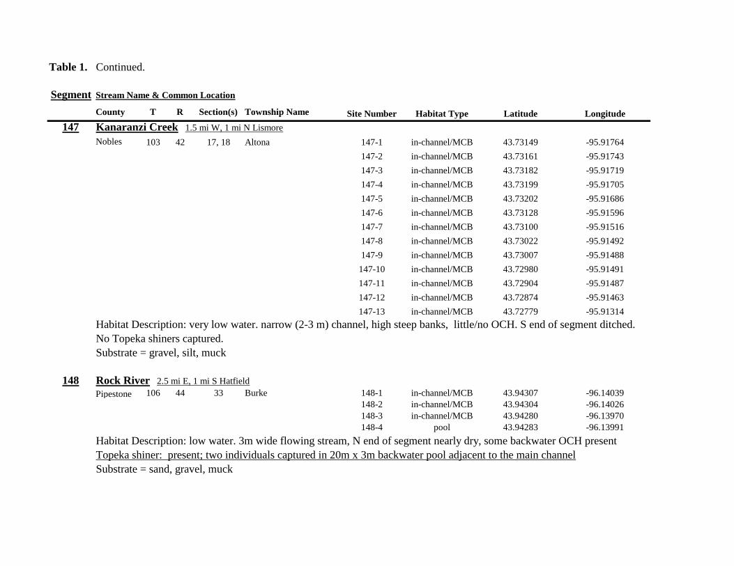
Table 1 Continued
Segment Stream Name amp Common Location
County T R Section(s) Township Name Site Number Habitat Type Latitude Longitude
147 Kanaranzi Creek 15 mi W 1 mi N Lismore
Nobles 103 42 17 18 Altona 147-1 in-channelMCB 4373149 -9591764
147-2 in-channelMCB 4373161 -9591743
147-3 in-channelMCB 4373182 -9591719
147-4 in-channelMCB 4373199 -9591705
147-5 in-channelMCB 4373202 -9591686
147-6 in-channelMCB 4373128 -9591596
147-7 in-channelMCB 4373100 -9591516
147-8 in-channelMCB 4373022 -9591492
147-9 in-channelMCB 4373007 -9591488
147-10 in-channelMCB 4372980 -9591491
147-11 in-channelMCB 4372904 -9591487
147-12 in-channelMCB 4372874 -9591463
147-13 in-channelMCB 4372779 -9591314
Habitat Description very low water narrow (2-3 m) channel high steep banks littleno OCH S end of segment ditched
No Topeka shiners captured
Substrate = gravel silt muck
148 Rock River 25 mi E 1 mi S Hatfield
Pipestone 106 44 33 Burke 148-1 in-channelMCB 4394307 -9614039
148-2 in-channelMCB 4394304 -9614026
148-3 in-channelMCB 4394280 -9613970
148-4 pool 4394283 -9613991
Habitat Description low water 3m wide flowing stream N end of segment nearly dry some backwater OCH present
Topeka shiner present two individuals captured in 20m x 3m backwater pool adjacent to the main channel
Substrate = sand gravel muck
Table 1 Continued
Segment Stream Name amp Common Location
County T R Section(s) Township Name Site Number Habitat Type Latitude Longitude
149 Rock River 1 mi SW of Edgerton
Pipestone 105 44 33 Osborne 149-1 pool 4385836 -9613494
149-2 pool 4385839 -9613508
149-3 in-channelMCB 4385830 -9613528
149-4 in-channelMCB 4385809 -9613627
Habitat Description low water 13m wide flowing stream small backwaters along MCB and pools at bridge
Topeka shiner present one individual captured in small backwater along MCB
Substrate = Gravel sand cobble Deep silt in off-channel areaspools
150 Split Rock Creek 6 mi S 2 mi W Jasper
Rock 104 47 35 Rose Dell 150-1 in-channelMCB 4377128 -9643910
150-2 in-channelMCB 4377116 -9643912
150-3 in-channelMCB 4377114 -9643931
150-4 in-channelMCB 4377149 -9643814
Habitat Description 15m wide slowly flowing stream with high steep eroded banks Low water
Topeka shiner present two individuals captured in 15m x 25m shallow silted puddle along MCB
Substrate = gravel sand silt
Table 1 Continued
Segment Stream Name amp Common Location
County T R Section(s) Township Name Site Number Habitat Type Latitude Longitude
151 Beaver Creek E 45 mi N 35 W Luverne along CSAH 20
Rock 103 45 18 19 Mound 151-1 pool 4371768 -9628182
Habitat Description 80m x 40m pool downstream of bridge no flow deep (1m) silt over clay Topeka shiner abundant 18 individuals captured in single seine haul in pool Substrate = deep (1m) silt over clay
152 Beaver Creek 35 mi W 15 mi S Beaver Creek along CSAH 7
Rock 102 47 35 36 Beaver Creek 152-1 in-channelMCB 4359418 -9643251
152-2 in-channelMCB 4359419 -9643293
152-3 in-channelMCB 4359420 -9643288
152-4 in-channelMCB 4359426 -9643393
152-5 in-channelMCB 4359423 -9643445
152-6 in-channelMCB 4359427 -9643467
152-7 in-channelMCB 4359421 -9643060
152-8 in-channelMCB 4359404 -9643035
152-9 in-channelMCB 4359305 -9643008
152-10 in-channelMCB 4359301 -9642999
Habitat Description 4m wide slowly flowing stream with high steep banks No OCH present Sampled slow water areas
along MCB
No Topeka shiners captured
Substrate = Silt sand gravel
Table 1 Continued
Segment Stream Name amp Common Location
County T R Section(s) Township Name Site Number Habitat Type Latitude Longitude
153 Beaver Creek 1 mi N 175 mi E Beaver Creek
Rock 102 46 14 23 Beaver Creek 153-1 in-channelMCB 4363076 -9632975
153-2 in-channelMCB 4363049 -9633007
153-3 in-channelMCB 4362954 -9632909
153-4 in-channelMCB 4362915 -9633117
153-5 in-channelMCB 4362911 -9633148
153-6 in-channelMCB 4362835 -9633249
153-7 in-channelMCB 4363324 -9632725
153-8 in-channelMCB 4363240 -9632740
153-9 in-channelMCB 4363233 -9632762
153-10 in-channelMCB 4363224 -9632770
Habitat Description 3m wide slowly flowing streamHigh steep banks Lots of bank erosion and very little OCH Off
channel ponds along northern 13 of segment were dry Water very low Cattle in stream Sampled slack water along MCB
No Topeka shiners captured
Substrate = firm sandsilt in backwater sandgravel in main channel
Table 1 Continued
Segment Stream Name amp Common Location
County T R Section(s) Township Name Site Number Habitat Type Latitude Longitude
154 Rock River 4mi S 25 mi W Steen
Rock 101 45 13 Clinton 154-1 pool 4355354 -9618125
154-2 in-channelMCB 4355362 -9618154
154-3 in-channelMCB 4355350 -9618191
154-4 in-channelMCB 4355254 -9618127
154-5 pool 4355287 -9617972
154-6 in-channelMCB 4355211 -9618013
154-7 in-channelMCB 4355206 -9618099
154-8 in-channelMCB 4355216 -9618146
154-9 in-channelMCB 4355197 -9618235
154-10 in-channelMCB 4355121 -9618336
154-11 in-channelMCB 4355081 -9618361
154-12 in-channelMCB 4355022 -9618309
154-13 in-channelMCB 4354985 -9618238
154-14 riffle 4354849 -9618238
154-15 in-channelMCB 4354810 -9618156
154-16 in-channelMCB 4354787 -9618069
154-17 in-channelMCB 4354709 -9618012
Habitat Description Wide (10m) flowing stream with ample OCH Channel is braided along meanders
with backwater habitat along sandgravel bars Wooded riparian corridor
No Topeka shiners captured
Substrate = gravel sand silt
Table 1 Continued
Segment Stream Name amp Common Location
County T R Section(s) Township Name Site Number Habitat Type Latitude Longitude
155 Elk Creek 3 mi N 3 mi E Magnolia along CSAH 19
Nobles 103 43 29 32 Lismore 155-1 pool 4368849 -9602497
155-2 pool 4368832 -9602512
155-3 pool 4368842 -9602019
155-4 in-channelMCB 4368859 -9602008
155-5 in-channelMCB 4368861 -9602002
155-6 in-channelMCB 4368868 -9601990
155-7 in-channelMCB 4368870 -9601969
155-8 in-channelMCB 4368877 -9601940
155-9 in-channelMCB 4368896 -9601932
155-10 in-channelMCB 4368923 -9601916
Habitat Description Water very low Narrow (2m) intermittent stream Stream bed is dry in places between isolated pools
No flow Sampled at pooled areas at culverts at CH 19
No Topeka shiners captured
Substrate = silt muck gravel
156 Elk Creek 4 mi N 4 mi E Magnolia along CSAH 14
Nobles 103 43 21 28 Lismore 156-1 pool 4370276 -9600072
Habitat Description very small headwater stream (1m) that is nearly dry between pools Sampled on margin of 20m x 50m
pool at bridge Pool depth gt 2m Thick mats of floating filamentous algae pool depth and submerged macrophytes
made seining difficult
Topeka shiner abundant 5 individuals captured in single kick set on margin of pool Numerous male Topeka shiners were observed defending cleared patches of gravel along the margin of the pool Substrate = silt over gravel
Table 1 Continued
Segment Stream Name amp Common Location
County T R Section(s) Township Name Site Number Habitat Type Latitude Longitude
157 Kanaranzi Creek 15 mi E 2 mi S Lismore
Nobles 103 42 17 19 20 Larkin 157-1 pool 4371762 -9591115
157-2 pool 4371757 -9591102
157-3 pool 4371753 -9591108
157-4 pool 4371755 -9591112
157-5 pool 4371785 -9591112
157-6 pool 4371786 -9591115
157-7 pool 4371793 -9591111
157-8 in-channelMCB 4371818 -9591105
157-9 in-channelMCB 4371820 -9591097
157-10 in-channelMCB 4371829 -9591093
157-11 in-channelMCB 4371835 -9591097
157-12 in-channelMCB 4371785 -9591100
Habitat Description Stream has been ditchedchannelized High banks and no OCH is present except for a pooled area upstream of a beaver dam that is S of the bridge No Topeka shiners captured Substrate = silt muck sand
Table 1 Continued
Segment Stream Name amp Common Location
County T R Section(s) Township Name Site Number Habitat Type Latitude Longitude
158 Kanaranzi Creek 2 mi E 35 mi S Magnolia
Nobles 102 43 31 32 Westside 158-1 pool 4359742 -9603359
158-2 pool 4359741 -9603408
158-3 in-channelMCB 4359686 -9603499
158-4 in-channelMCB 4359660 -9603513
158-5 in-channelMCB 4359620 -9603518
158-6 pool 4359584 -9603554
158-7 in-channelMCB 4359590 -9603589
158-8 in-channelMCB 4359600 -9603617
158-9 in-channelMCB 4359555 -9603658
158-10 in-channelMCB 4359527 -9603683
158-11 in-channelMCB 4359463 -9603681
158-12 in-channelMCB 4359454 -9603681
158-13 in-channelMCB 4359416 -9603690
158-14 in-channelMCB 4359399 -9603722
158-15 in-channelMCB 4359383 -9603735
Habitat Description 4m wide slowly flowing stream Sampled backwater and off-channel habitats along MCB and side channels Hard gravelsand substrate in channel Ample low-flow habitat along sandgravel bars No Topeka shiners captured Substrate = sand gravel silt
Table 1 Continued
Segment Stream Name amp Common Location
County T R Section(s) Township Name Site Number Habitat Type Latitude Longitude
159 Kanaranzi Creek 1 mi NW Adrian along CSAH 35
Nobles 102 43 13 Westside 159-1 pool 4364453 -9595165
159-2 pool 4364481 -9595166
159-3 pool 4364479 -9595182
159-4 pool 4364461 -9595195
159-5 in-channelMCB 4364438 -9595194
159-6 in-channelMCB 4364427 -9595224
159-7 in-channelMCB 4364406 -9595307
159-8 in-channelMCB 4364407 -9595333
159-9 in-channelMCB 4364401 -9595360
159-10 pool 4364448 -9595347
159-11 in-channelMCB 4364467 -9595077
159-12 in-channelMCB 4364500 -9594982
Habitat Description Flowing 7m wide stream Abundant backwaters pools and OCH along MCB
Topeka shiner present a single individual captured in a side channel over gravelsand mix after much effort
Substrate = gravel sand silt
Table 1 Contined
Segment Stream Name amp Common Location
County T R Section(s) Township Name Site Number Habitat Type Latitude Longitude
160 Little Rock River 1 mi E 4 mi S Rushmore
Nobles 101 41 16 17 Ransom 160-1 in-channelMCB 4355809 -9577372
160-2 in-channelMCB 4355819 -9577356
160-3 in-channelMCB 4355826 -9577324
160-4 in-channelMCB 4355820 -9577237
160-5 in-channelMCB 4355819 -9577193
160-6 in-channelMCB 4355824 -9577181
160-7 in-channelMCB 4355803 -9577151
160-8 in-channelMCB 4355800 -9577123
160-9 in-channelMCB 4355810 -9577124
160-10 in-channelMCB 4355827 -9577099
160-11 in-channelMCB 4355803 -9576997
160-12 in-channelMCB 4355766 -9576964
160-13 in-channelMCB 4355763 -9576986
160-14 in-channelMCB 4355706 -9576972
160-15 in-channelMCB 4355811 -9577403
160-16 in-channelMCB 4355798 -9577529
160-17 in-channelMCB 4355760 -9577529
160-18 in-channelMCB 4355759 -9577500
160-19 in-channelMCB 4355736 -9577556
Table 1 Site 160 Continued Table 1 Concluded
Segment Stream Name amp Common Location
County T R Section(s) Township Name Site Number Habitat Type Latitude Longitude
160 Little Rock River 1 mi E 4 mi S Rushmore
160-20 in-channelMCB 4355748 -9577608
160-21 in-channelMCB 4355752 -9577642
160-22 in-channelMCB 4355689 -9577684
160-23 in-channelMCB 4355681 -9577736
160-24 in-channelMCB 4355642 -9577828
160-25 in-channelMCB 4355622 -9577895
Habitat Description Slowly flowing 3m wide stream with high steep banks Little or no OCH Portions of this stream
appear to have been ditched and rip-rapped
No Topeka shiners captured
Substrate = gravel sand muck
Table 2 Locations of the twenty stream Segments (sites 161-180) sampled in 2013 corresponding sampling sites within
each segment and a brief habitat description for each site from which Topeka shiners were collected Included
are a Common Location descriptor (approximate mileage amp direction to nearest townhighways) the
TownshipRange for the 20 Segments and UTM coordinates for each sampling site Habitat type is an aproximate
characterization of the specific sample site within the sample reach pooled areas along the stream channel (pool)
low-flow reaches of stream and backwater habitats along the main channel boundary (in-channelMCB) ponds
adjacent to the sample reach that are not connected to the main channel of the stream (pool off-channel)
Segment Stream Name amp Common Location
County T R Section(s) Township Name Site Number Habitat Type Latitude Longitude
161 Medary Creek 7 mi W Lake Benson
Lincoln 109 46 7 Verdi 161-1 in-channelMCB 4425807000 -9642702300
161-2 in-channelMCB 4425815900 -9642724800
161-3 in-channelMCB 4425836800 -9642739100
161-4 in-channelMCB 4425898800 -9642738400
161-5 in-channelMCB 4425902800 -9642724500
161-6 in-channelMCB 4425904800 -9642721000
161-7 in-channelMCB 4425924400 -9642696700
161-8 in-channelMCB 4425928300 -9642687800
161-9 in-channelMCB 4425931400 -9642670400
161-10 in-channelMCB 4425936800 -9642650600
161-11 in-channelMCB 4425928700 -9642638400
161-12 in-channelMCB 4425969600 -9642576100
161-13 pool 4426041100 -9642542500
161-14 in-channelMCB 4426093000 -9642681600
161-15 in-channelMCB 4426018800 -9642819900
Habitat Description narrow (2m) flowing headwater stream beaver dams along sample reach
Topeka shiner present nine Topeka shiners captured in a flowing pool downstream of a beaver dam
Thousands of fish downstream of dam and almost none in the upstream sites 1-14
Substrate = cobble gravel silt
Table 2 Continued
Segment Stream Name amp Common Location
County T R Section(s) Township Name Site Number Habitat Type Latitude Longitude
162 Willow Creek 13 mi W Ruthton
Pipestone 108 46 4 29 Altona 162-1 in-channelMCB 4418795200 -9636967900
162-2 in-channelMCB 4418776900 -9636978700
162-3 in-channelMCB 4418554500 -9637231900
162-4 pool 4418587700 -9637323700
162-5 pool 4418588600 -9637353100
162-6 pool 4418597900 -9637352800
162-7 pool 4418617800 -9637343500
162-8 pool 4418608500 -9637352600
162-9 pool 4418659800 -9637532400
162-10 pool 4418647400 -9637460200
Habitat Description very narrow (1m) headwater stream slow flow large pool (sites 4-8) appears to be an excavated pond
metal debris and fencing material made seining difficult Seined pooled areas in cattail beds
No Topeka shiners captured Substrate = sand gravel silt
Table 2 Continued
Segment Stream Name amp Common Location
County T R Section(s) Township Name Site Number Habitat Type Latitude Longitude
163 Flandreau Creek 4 mi N 5 mi W Holland
Pipestone 108 46 29 Altona 163-1 pool 4412550100 -9639615400
163-2 pool 4412552400 -9639616700
163-3 pool 4412550000 -9639640600
163-4 in-channelMCB 4412625200 -9639662400
163-5 in-channelMCB 4412595100 -9639579900
163-6 in-channelMCB 4412681700 -9639517200
163-7 pool 4412703400 -9639517600
163-8 pool 4412761900 -9639631000
163-9 pool 4412764600 -9639631600
163-10 pool 4412782600 -9639590000
163-11 pool 4412754600 -9639531600
163-12 pool 4412762600 -9639632100
163-13 in-channelMCB 4413017900 -9639591600
163-14 in-channelMCB 4413084800 -9639438100
163-15 pool 4412573500 -9639553100
Habitat Description 3m wide flowing stream Channel appears to have been ditched most of plotted reach is dry Seined in heavily vegetated stagnant pools No Topeka shiners captured Substrate = firm sand gravel in-channel deep silt along MCB
Table 2 Continued
Segment Stream Name amp Common Location
County T R Section(s) Township Name Site Number Habitat Type Latitude Longitude
164 Flandreau Creek 65 mi W 55 mi N Pipestone
Pipestone 107 47 13 14 Troy 164-1 pool 4408042400 -9644734000
164-2 pool 4408043100 -9644720500
164-3 pool 4408042200 -9644708000
164-4 pool 4407996200 -9644910500
164-5 in-channelMCB 4407938200 -9644906400
164-6 in-channelMCB 4407760400 -9644847500
164-7 in-channelMCB 4407796600 -9644913300
164-8 in-channelMCB 4407806300 -9644950500
164-9 in-channelMCB 4407797700 -9644981100
164-10 in-channelMCB 4407809800 -9644991500
164-11 pool 4408029200 -9645104800
Habitat Description flowing 3-5m wide stream with firm gravel substrate in thalweg Sampled pooled area at bridge
some off-channel habitat at sites 4 and 11 Banks are steep along most of the reach with little slackwater habitat along MCB
No Topeka shiners captured
Substrate = gravel sand cobble in-channel Deep silt in low-flow areas
Table 2 Continued
Segment Stream Name amp Common Location
County T R Section(s) Township Name Site Number Habitat Type Latitude Longitude
165 North Branch Pipestone Creek 4 mi W 3 mi N Pipestone
Pipestone 107 46 29 Troy 165-1 pool 4404501300 -9639278100
165-2 pool 4404481000 -9639316800
165-3 pool 4404472800 -9639315500
165-4 in-channelMCB 4404457500 -9639325200
165-5 in-channelMCB 4404434800 -9639340300
165-6 in-channelMCB 4404446400 -9639386900
165-7 in-channelMCB 4404320300 -9639371300
165-8 pool 4404299200 -9639403700
165-9 pool 4404302200 -9639429200
165-10 pool 4404289200 -9639430300
165-11 pool 4404283700 -9639418700
165-12 in-channelMCB 4404212300 -9639411800
165-13 in-channelMCB 4404195800 -9639463400
165-14 in-channelMCB 4404244400 -9639645200
165-15 in-channelMCB 4404163700 -9639819800
165-16 in-channelMCB 4404165900 -9639797900
Habitat Description moderately flowing 3-5m wide stream Recent increase in stream level some submerged terrestrial
grasses along MCB Sites 8-11 in oxbow Submerged terrestrial grasses in oxbow
No Topeka shiners captured
Substrate = sand gravel silt
Table 2 Continued
Segment Stream Name amp Common Location
County T R Section(s) Township Name Site Number Habitat Type Latitude Longitude
166 Pipestone Creek 35 mi W 1 mi N Pipestone
Pipestone 106 46 4 5 Sweet 166-1 in-channelMCB 4401330100 -9638708400
166-2 in-channelMCB 4401347000 -9638709700
166-3 in-channelMCB 4401345500 -9638703700
166-4 in-channelMCB 4401355800 -9638703000
166-5 in-channelMCB 4401541200 -9638596400
166-6 in-channelMCB 4401618700 -9638658000
166-7 in-channelMCB 4401623400 -9638660800
166-8 in-channelMCB 4401625200 -9638646200
166-9 in-channelMCB 4401633300 -9638635600
166-10 in-channelMCB 4401740500 -9638517300
Habitat Description 10m wide slowly flowing stream Sampled along MCB in slack water West end of segment appears
to have been ditched Littleno OCH Drainage tiles along E reach of segment
No Topeka shiners captured
Substrate = cobble gravel sand Deep silt along margins of pools
Table 2 Continued
Segment Stream Name amp Common Location
County T R Section(s) Township Name Site Number Habitat Type Latitude Longitude
167 Split Rock Creek 15 mi N 1 mi E Ihlen
Pipestone 105 46 3 Eden 167-1 pool 4392585400 -9634993300
167-2 in-channelMCB 4392638100 -9635031600
167-3 pool 4392643100 -9635103600
167-4 pool 4392638200 -9635101900
167-5 pool 4392633000 -9635108800
167-6 pool 4392633200 -9635116400
167-7 pool 4392635700 -9635131600
167-8 pool 4392636400 -9635139100
167-9 pool 4392635900 -9635156000
167-10 in-channelMCB 4392470900 -9635255600
167-11 in-channelMCB 4392465600 -9635242800
167-12 in-channelMCB 4392447500 -9635240300
Habitat Description very small headwater stream (~1m) water low isolated series of pools along streambed No Topeka shiners captured Substrate = sand gravel silt
168 Split Rock Creek 15 mi N 05 mi E Jasper
Pipestone 105 46 28 29 Eden 168-1 in-channelMCB 4387771400 -9638026400
Habitat Description high water 4m wide flowing stream submerged terrestrial grasses on margins
Topeka shiner common 6 individuals captured on first seine haul in pooled area at MCB just downstream of culvert
Substrate = boulder cobble sand
Table 2 Continued
Segment Stream Name amp Common Location
County T R Section(s) Township Name Site Number Habitat Type Latitude Longitude
169 Rock River 1 mi SW of Edgerton
Pipestone 105 44 17 18 Osborne 169-1 pool 4389371700 -9616564700
169-2 in-channelMCB 4389439900 -9616531800
Habitat Description Swiftly flowing 10m wide stream at high water Sampled pooled area at outside bend of stream
over deep silt
Topeka shiner present four individuals captured in four seine hauls in a 1m wide drainage channel that joins a
retention pond to the Rock River
Substrate = Silt gravel Deep silt in off-channel areaspools
170 Chanarambie Creek 05 mi S 05 mi E Chandler
Murray 104 47 35 Fenton 170-1 in-channelMCB 4392093400 -9593156600
170-2 in-channelMCB 4391890200 -9593079300
170-3 in-channelMCB 4391841400 -9593168100
170-4 in-channelMCB 4391784300 -9593090300
170-5 in-channelMCB 4391783100 -9593060700
170-6 in-channelMCB 4391790600 -9593061100
170-7 in-channelMCB 4391796700 -9593025000
170-8 in-channelMCB 4391792000 -9592982800
170-9 in-channelMCB 4392105300 -9593062100
170-10 in-channelMCB 4392122900 -9593165100
Habitat Description narrow (1-2m) headwater stream Stream is flowing swiftly and little or no OCH is present
most of the segment appears to have been channelized
No Topeka shiners captured
Substrate = silt sand
Table 2 Continued
Segment Stream Name amp Common Location
County T R Section(s) Township Name Site Number Habitat Type Latitude Longitude
171 Rock River 4 mi S Edgerton
Rock 104 44 8 9 Battle Plain 171-1 in-channelMCB 4382021200 -9613013100
171-2 pool 4382126400 -9613470300
171-3 in-channelMCB 4382025300 -9612974300
171-4 in-channelMCB 4382027100 -9612961600
171-5 in-channelMCB 4382145400 -9613302800
171-6 in-channelMCB 4382380700 -9613520900
171-7 in-channelMCB 4382367500 -9613527700
171-8 in-channelMCB 4382359000 -9613532400
171-9 in-channelMCB 4382405300 -9613495400
171-10 in-channelMCB 4382271200 -9613570400
Habitat Description High water 8-12m wide swiftly flowing stream Stream is full to high banks Much of slackwater
areas along MCB likely inudndated Sampled in backwaters sites 6-9
No Topeka shiners captured
Substrate = Sand gravel silt
Table 2 Continued
Segment Stream Name amp Common Location
County T R Section(s) Township Name Site Number Habitat Type Latitude Longitude
172 Rock River tributary 1 mi E Hardwick
Rock 104 44 30 31 Battle Plain 172-1 pool 4377538900 -9617075500
172-2 pool 4377529200 -9617075600
172-3 pool 4377514700 -9617079800
172-4 in-channelMCB 4377386200 -9617079600
172-5 in-channelMCB 4377247100 -9617207900
172-6 in-channelMCB 4377241900 -9617224500
172-7 in-channelMCB 4377245200 -9617219500
172-8 in-channelMCB 4376956400 -9616914600
172-9 pool off-channel 4376998700 -9616876000
172-10 in-channelMCB 4377058800 -9616855700
172-11 in-channelMCB 4377043200 -9616826600
Habitat Description 3m wide slowly flowing pasture stream with high trampled banks Much of reach appears to
have been channelized no OCH present along MCBSampled in stock pond at site 9 Some submerged macrophytes
No Topeka shiners captured
Substrate = sand silt muck
Table 2 Continued
Segment Stream Name amp Common Location
County T R Section(s) Township Name Site Number Habitat Type Latitude Longitude
173 Mound Creek 1 mi N 175 mi E Beaver Creek
Rock 103 45 2 11 Mound 173-1 in-channelMCB 4374749900 -9620089200
173-2 in-channelMCB 4374756900 -9620094400
173-3 in-channelMCB 4374763700 -9620090700
173-4 in-channelMCB 4374842800 -9619838100
173-5 in-channelMCB 4374844000 -9619833200
173-6 in-channelMCB 4374889800 -9619789300
173-7 in-channelMCB 4374839600 -9619885800
173-8 in-channelMCB 4374827900 -9619934500
173-9 in-channelMCB 4374817000 -9619966400
173-10 in-channelMCB 4374799700 -9620048400
Habitat Description Entire reach of sement has been channelized Stream is 1-2m wide and constantly flowing High
banks No OCH
No Topeka shiners captured
Substrate = gravel sand silt
Table 2 Continued
Segment Stream Name amp Common Location
County T R Section(s) Township Name Site Number Habitat Type Latitude Longitude
174 Rock River tributary 55 mi N 4 mi E Luverne
Rock 103 44 8 9 Vienna 174-1 pool 4373333900 -9613250300
174-2 pool 4373322100 -9613262700
Habitat Description Narrow (2-3m) wide flowing headwater stream Sampled in deep silted pool at bridge Topeka shiner present two individuals captured over gravel in pooled area at bridge Much of the pool is filled with deep (gt05m) silt No Topeka shiners collected in silted portion of pool Substrate = gravel sand silt
Table 2 Continued
Segment Stream Name amp Common Location
County T R Section(s) Township Name Site Number Habitat Type Latitude Longitude
175 Champepadan Creek 4mi N 5 mi E Luverne
Rock 103 44 21 22 Vienna 175-1 pool 4371002900 -9611238300
175-2 pool 4371001900 -9611232600
175-3 pool 4371008300 -9611238900
175-4 in-channelMCB 4370955000 -9611142300
175-5 in-channelMCB 4371042200 -9610763900
175-6 in-channelMCB 4371007000 -9610720000
175-7 in-channelMCB 4370984100 -9610706400
175-8 pooloff-channel 4370971600 -9610709700
Habitat Description 3m wide stream with moderate flow Native prairie has been planted along both banks for the entire reach
No flow Sampled at pooled areas at culverts at CH 19
Topeka shiner present one individual captured in deep livestock pond S of stream Depth (gt2m) made seining in pond difficult
Substrate = sand silt gravel
Table 2 Continued
Segment Stream Name amp Common Location
County T R Section(s) Township Name Site Number Habitat Type Latitude Longitude
176 Kanaranzi Creek 2 mi W 35 mi N Ellworth
Rock 101 44 12 Kanaranzi 176-1 pool 4357304000 -9606413600
176-2 pool 4357305400 -9606410500
176-3 pool 4357249700 -9606408600
176-4 in-channelMCB 4357200500 -9606350300
176-5 in-channelMCB 4357204500 -9606354600
176-6 in-channelMCB 4357211400 -9606360400
176-7 in-channelMCB 4357127700 -9606357500
176-8 in-channelMCB 4357090500 -9606197900
176-9 in-channelMCB 4356817400 -9606275000
176-10 in-channelMCB 4356807000 -9606273900
176-11 in-channelMCB 4356639200 -9606408000
176-12 in-channelMCB 4356632100 -9606416000
176-13 in-channelMCB 4356598300 -9606381200
Habitat Description 10m wide flowing stream Very little OCH Very deep silt along MCB Sampled pooled area
at bridge High eroded banks
No Topeka shiners captured
Substrate = silt over gravel
Table 2 Continued
Segment Stream Name amp Common Location
County T R Section(s) Township Name Site Number Habitat Type Latitude Longitude
177 Rock River 05 mi N 4 mi E Steen
Rock 101 45 25 Clinton 177-1 pool 4352588900 -9618721100
177-2 pool 4352592700 -9618726600
177-3 in-channelMCB 4352519900 -9618594900
177-4 in-channelMCB 4352297500 -9618558400
177-5 in-channelMCB 4352147800 -9618456000
177-6 in-channelMCB 4352143300 -9618458200
177-7 in-channelMCB 4352125000 -9618453100
177-8 in-channelMCB 4352121500 -9618442200
177-9 in-channelMCB 4352106600 -9618444000
177-10 in-channelMCB 4352727900 -9618684800
177-11 pool 4352783000 -9618770800
177-12 pooloff-channel 4352663200 -9619046500
Habitat Description 11m wide flowing stream with wide channel sand bars and some braiding Firm gravel in thalweg Oxbow in middle of reach is nearly dry (lt25 cm) No fish observed culicid fly larvae abundant No Topeka shiners captured Substrate = sand gravel silt
Table 2 Continued
Segment Stream Name amp Common Location
County T R Section(s) Township Name Site Number Habitat Type Latitude Longitude
178 Kanaranzi Creek 2 mi W Ellsworth
Rock 101 44 25 36 Kanaranzi 178-1 pool 4351441400 -9605867000
178-2 in-channelMCB 4351404500 -9605846000
178-3 in-channelMCB 4351378800 -9605844300
178-4 pool 4351349700 -9605841200
178-5 pool 4351358400 -9605829800
178-6 pool 4351351800 -9605816800
178-7 in-channelMCB 4351355800 -9605866900
178-8 in-channelMCB 4351549000 -9605823700
178-9 in-channelMCB 4351891800 -9605895600
178-10 in-channelMCB 4351866200 -9605881400
178-11 pool 4352078500 -9606070000
178-12 pool 4352046000 -9606082200
Habitat Description 7-9m wide flowing stream Sampled backwater and off-channel habitats along MCB and side channels Recent high flow has filled in off-channel areas with deep silt Seining difficult No Topeka shiners captured Substrate = sand silt gravel
Table 2 Concluded
Segment Stream Name amp Common Location
County T R Section(s) Township Name Site Number Habitat Type Latitude Longitude
179 East Branch Kanaranzi Creek 15 mi N 15 mi E Adrian
Nobles 102 42 8 Olney 179-1 pool 4365932900 -9590462700
179-2 pool 4365928900 -9590449500
179-3 pool 4365930600 -9590463300
179-4 pool 4365908000 -9590420300
179-5 in-channelMCB 4365679800 -9590378600
179-6 in-channelMCB 4365661000 -9590387800
179-7 in-channelMCB 4365604000 -9590417100
179-8 in-channelMCB 4365508100 -9590385200
179-9 in-channelMCB 4365460100 -9590342200
179-10 pool 4365434900 -9590020100
179-11 in-channelMCB 4365507700 -9590154900
179-12 in-channelMCB 4365588000 -9589900200
Habitat Description Flowing 9m wide stream Stream is full to high banks very little slackwater habitat present at this site
No Topeka shiners captured
Substrate = sand silt gravel
180 Little Rock River 8 mi E Ellsworth
Nobles 101 42 26 Little Rock 180-1 in-channelMCB 4352838500 -9584615900
Habitat Description Sampled large pooled area at bridge no discernible flow silt over gravel substrate Channel downstream
of pool is a 2-3 m wide flowing stream with a firm sandgravel substrate
Topeka shiner abundant fourteen individuals captured in first seine haul in pool fifteen individuals captured in second seine
haul near outlet of the pool
Substrate = gravel sand silt
Table 3 Complete List of Fish Species Captured at Segments 141-160 2012
Species 141 142 143 144 145 146 147 148 149 150 151 152 153 154 155 156 157 158 159 160 Campostoma anomalum X X X X X X X X X X X X X X Chrosomus erythrogaster X X Cyprinella lutrensis X X X X X X X X X Cyprinus carpio X X X X X Hybognathus hankinsoni X X X X X X X Luxilus cornutus X X X X X X X X X X X X X Notropis dorsalis X X X X X X X X X X X Notropis stramineus X X X X X X X X X X X X X X X Notropis topeka X X X X X X X X Pimephales notatus X X X X X X X X X X X X Pimephales promelas X X X X X X X X X X X X X X X X X X Rhinichthys atratulus X X X X X X Semotilus atromaculatus X X X X X X X X X X X X X X X X X X Carpiodes cyprinus X Carpiodes sp (YOY) X X X Catostomus commersoni X X X X X X X X X X X X X X X Moxostoma macrolepidotum X X Ameiurus melas X X X X X X X X X X X X X Ameiurus natalis X Ictalurus punctatus X X X X Noturus flavus X X X X Noturus gyrinus X X X X X Esox lucius X X Percopsis omiscomaycus X Fundulus sciadicus X X X Culaea inconstans X X X X X Lepomis cyanellus X X X X X X X Lepomis humilis X X X X X X X X X X X Lepomis macrochirus X X X X X Micropterus dolomieui X Micropterus salmoides X X Pomoxis nigromaculatus X X Etheostoma exile X X X X X Etheostoma nigrum X X X X X X X X X X X X X X X X X Perca flavescens X X Percina maculata X X X X
Table 4 Complete List of Fish Species Captured at Segments 161-180 2013
Species 161 162 163 164 165 166 167 168 169 170 171 172 173 174 175 176 177 178 179 180
Campostoma anomalum X X X X X X X X X X X X X X
Cyprinella lutrensis X X X X X X X X X X
Cyprinus carpio X X X
Hybognathus hankinsoni X X X X X
Luxilus cornutus X X X X X X X X X X X X X
Notropis dorsalis X X X X X X X X X X X X X X
Notropis stramineus X X X X X X X X X X X X X X
Notropis topeka X X X X X X
Pimephales notatus X X X X X X X X X X X X
Pimephales promelas X X X X X X X X X X X X X X X X X X
Rhinichthys atratulus X X X X X X X X X X X
Semotilus atromaculatus X X X X X X X X X X X X X X X X
Carpiodes cyprinus X X
Catostomus commersoni X X X X X X X X X X X X X
Moxostoma erythrurum X X X
Moxostoma macrolepidotum X X
Ameiurus melas X X X X X X X X X X
Noturus flavus X X X
Esox lucius X X
Percopsis omiscomaycus X
Fundulus sciadicus X
Culaea inconstans X X X X
Lepomis cyanellus X X X X X X
Lepomis humilis X X X X X X X X X
Etheostoma exile X X
Etheostoma nigrum X X X X X X X X X X
Percina maculata X X
Appendix C- Habitat and Voucher Photographs
Habitat photographs for segments in which no Topeka shiners were captured are representative
of the habitat along the one-mile reach of stream Habitat photographs from segments where
Topeka shiners were present represent the specific site where they were collected Voucher
photographs are presented for each of the sites were Topeka shiners were collected
Site 141-2 Medary Creek voucher and habitat photos
Segment 142 Willow Creek no Topeka shiners captured
Segment 143 East Branch Flandrau Creek no Topeka shiners captured
Segment 144 North Branch Pipestone Creek no Topeka shiners captured
Site 145-6 Pipestone Creek voucher photo
Site 145-6 Pipestone Creek habitat photo
Segment 146 Split Rock Creek no Topeka shiners captured No habitat photo
Segment 147 Kanaranzi Creek no Topeka shiners captured
Site 148-4 Rock River voucher and habitat photos
Site 149-4 Rock River voucher and habitat photos
Site 150-4 Split Rock Creek voucher and habitat photos
Site 151-1 Beaver Creek voucher and habitat photos
Segment 152 Beaver Creek no Topeka shiners captured
Segment 153 Beaver Creek no Topeka shiners captured
Segment 154 Rock River no Topeka shiners captured
Segment 155 Elk Creek no Topeka shiners captured
Site 156-1 Elk Creek voucher and habitat photos
Segment 157 Kanaranzi Creek no Topeka shiners captured
Segment 158 Kanaranzi Creek no Topeka shiners captured
Site 159-1 Kanaranzi Creek voucher and habitat photos
Segment 160 Little Rock River no Topeka shiners captured
Site 161-15 Medary Creek voucher photo
Site 161-15 Medary Creek habitat photo
Segment 162 Willow Creek no Topeka shiners captured No habitat photo
Segment 163 Flandrau Creek no Topeka shiners captured
Segment 164 Flandrau Creek no Topeka shiners captured
Segment 165 North Branch Pipestone Creek no Topeka Shiners captured
Segment 166 Pipestone Creek no Topeka Shiners captured
Segment 167 Tributary to Split Rock Creek no Topeka Shiners captured No habitat
photo
Site 168-1 Split Rock Creek voucher photo
Site 168-1 Split Rock Creek habitat photo
Site 169-2 Rock River voucher photo
Site 169-2 Rock River habitat photo
Segment 170 Chanarambie Creek no Topeka shiners captured
Segment 171 Rock River no Topeka shiners captured
Segment 172 Tributary to Rock River no Topeka shiners captured
Segment 173 Blue Mound Creek no Topeka shiners
Site 174-2 Tributary to Rock River voucher photo
Site 174-2 Tributary to Rock River habitat photo
Site 175-8 Champepadan Creek voucher photo
Site 175-8 Champepadan Creek habitat photo
Segment 176 Kanaranzi Creek no Topekas captured
Segment 177 Rock River no Topeka shiners captured
Segment 178 Kanaranzi Creek no Topeka shiners captured
Segment 179 East Branch Kanaranzi Creek no Topeka shiners captured
Site 180-1 West Branch Little Rock River voucher photo
Site 180-1 West Branch Little Rock River habitat photo
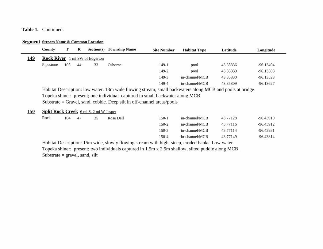
Table 1 Continued
Segment Stream Name amp Common Location
County T R Section(s) Township Name Site Number Habitat Type Latitude Longitude
149 Rock River 1 mi SW of Edgerton
Pipestone 105 44 33 Osborne 149-1 pool 4385836 -9613494
149-2 pool 4385839 -9613508
149-3 in-channelMCB 4385830 -9613528
149-4 in-channelMCB 4385809 -9613627
Habitat Description low water 13m wide flowing stream small backwaters along MCB and pools at bridge
Topeka shiner present one individual captured in small backwater along MCB
Substrate = Gravel sand cobble Deep silt in off-channel areaspools
150 Split Rock Creek 6 mi S 2 mi W Jasper
Rock 104 47 35 Rose Dell 150-1 in-channelMCB 4377128 -9643910
150-2 in-channelMCB 4377116 -9643912
150-3 in-channelMCB 4377114 -9643931
150-4 in-channelMCB 4377149 -9643814
Habitat Description 15m wide slowly flowing stream with high steep eroded banks Low water
Topeka shiner present two individuals captured in 15m x 25m shallow silted puddle along MCB
Substrate = gravel sand silt
Table 1 Continued
Segment Stream Name amp Common Location
County T R Section(s) Township Name Site Number Habitat Type Latitude Longitude
151 Beaver Creek E 45 mi N 35 W Luverne along CSAH 20
Rock 103 45 18 19 Mound 151-1 pool 4371768 -9628182
Habitat Description 80m x 40m pool downstream of bridge no flow deep (1m) silt over clay Topeka shiner abundant 18 individuals captured in single seine haul in pool Substrate = deep (1m) silt over clay
152 Beaver Creek 35 mi W 15 mi S Beaver Creek along CSAH 7
Rock 102 47 35 36 Beaver Creek 152-1 in-channelMCB 4359418 -9643251
152-2 in-channelMCB 4359419 -9643293
152-3 in-channelMCB 4359420 -9643288
152-4 in-channelMCB 4359426 -9643393
152-5 in-channelMCB 4359423 -9643445
152-6 in-channelMCB 4359427 -9643467
152-7 in-channelMCB 4359421 -9643060
152-8 in-channelMCB 4359404 -9643035
152-9 in-channelMCB 4359305 -9643008
152-10 in-channelMCB 4359301 -9642999
Habitat Description 4m wide slowly flowing stream with high steep banks No OCH present Sampled slow water areas
along MCB
No Topeka shiners captured
Substrate = Silt sand gravel
Table 1 Continued
Segment Stream Name amp Common Location
County T R Section(s) Township Name Site Number Habitat Type Latitude Longitude
153 Beaver Creek 1 mi N 175 mi E Beaver Creek
Rock 102 46 14 23 Beaver Creek 153-1 in-channelMCB 4363076 -9632975
153-2 in-channelMCB 4363049 -9633007
153-3 in-channelMCB 4362954 -9632909
153-4 in-channelMCB 4362915 -9633117
153-5 in-channelMCB 4362911 -9633148
153-6 in-channelMCB 4362835 -9633249
153-7 in-channelMCB 4363324 -9632725
153-8 in-channelMCB 4363240 -9632740
153-9 in-channelMCB 4363233 -9632762
153-10 in-channelMCB 4363224 -9632770
Habitat Description 3m wide slowly flowing streamHigh steep banks Lots of bank erosion and very little OCH Off
channel ponds along northern 13 of segment were dry Water very low Cattle in stream Sampled slack water along MCB
No Topeka shiners captured
Substrate = firm sandsilt in backwater sandgravel in main channel
Table 1 Continued
Segment Stream Name amp Common Location
County T R Section(s) Township Name Site Number Habitat Type Latitude Longitude
154 Rock River 4mi S 25 mi W Steen
Rock 101 45 13 Clinton 154-1 pool 4355354 -9618125
154-2 in-channelMCB 4355362 -9618154
154-3 in-channelMCB 4355350 -9618191
154-4 in-channelMCB 4355254 -9618127
154-5 pool 4355287 -9617972
154-6 in-channelMCB 4355211 -9618013
154-7 in-channelMCB 4355206 -9618099
154-8 in-channelMCB 4355216 -9618146
154-9 in-channelMCB 4355197 -9618235
154-10 in-channelMCB 4355121 -9618336
154-11 in-channelMCB 4355081 -9618361
154-12 in-channelMCB 4355022 -9618309
154-13 in-channelMCB 4354985 -9618238
154-14 riffle 4354849 -9618238
154-15 in-channelMCB 4354810 -9618156
154-16 in-channelMCB 4354787 -9618069
154-17 in-channelMCB 4354709 -9618012
Habitat Description Wide (10m) flowing stream with ample OCH Channel is braided along meanders
with backwater habitat along sandgravel bars Wooded riparian corridor
No Topeka shiners captured
Substrate = gravel sand silt
Table 1 Continued
Segment Stream Name amp Common Location
County T R Section(s) Township Name Site Number Habitat Type Latitude Longitude
155 Elk Creek 3 mi N 3 mi E Magnolia along CSAH 19
Nobles 103 43 29 32 Lismore 155-1 pool 4368849 -9602497
155-2 pool 4368832 -9602512
155-3 pool 4368842 -9602019
155-4 in-channelMCB 4368859 -9602008
155-5 in-channelMCB 4368861 -9602002
155-6 in-channelMCB 4368868 -9601990
155-7 in-channelMCB 4368870 -9601969
155-8 in-channelMCB 4368877 -9601940
155-9 in-channelMCB 4368896 -9601932
155-10 in-channelMCB 4368923 -9601916
Habitat Description Water very low Narrow (2m) intermittent stream Stream bed is dry in places between isolated pools
No flow Sampled at pooled areas at culverts at CH 19
No Topeka shiners captured
Substrate = silt muck gravel
156 Elk Creek 4 mi N 4 mi E Magnolia along CSAH 14
Nobles 103 43 21 28 Lismore 156-1 pool 4370276 -9600072
Habitat Description very small headwater stream (1m) that is nearly dry between pools Sampled on margin of 20m x 50m
pool at bridge Pool depth gt 2m Thick mats of floating filamentous algae pool depth and submerged macrophytes
made seining difficult
Topeka shiner abundant 5 individuals captured in single kick set on margin of pool Numerous male Topeka shiners were observed defending cleared patches of gravel along the margin of the pool Substrate = silt over gravel
Table 1 Continued
Segment Stream Name amp Common Location
County T R Section(s) Township Name Site Number Habitat Type Latitude Longitude
157 Kanaranzi Creek 15 mi E 2 mi S Lismore
Nobles 103 42 17 19 20 Larkin 157-1 pool 4371762 -9591115
157-2 pool 4371757 -9591102
157-3 pool 4371753 -9591108
157-4 pool 4371755 -9591112
157-5 pool 4371785 -9591112
157-6 pool 4371786 -9591115
157-7 pool 4371793 -9591111
157-8 in-channelMCB 4371818 -9591105
157-9 in-channelMCB 4371820 -9591097
157-10 in-channelMCB 4371829 -9591093
157-11 in-channelMCB 4371835 -9591097
157-12 in-channelMCB 4371785 -9591100
Habitat Description Stream has been ditchedchannelized High banks and no OCH is present except for a pooled area upstream of a beaver dam that is S of the bridge No Topeka shiners captured Substrate = silt muck sand
Table 1 Continued
Segment Stream Name amp Common Location
County T R Section(s) Township Name Site Number Habitat Type Latitude Longitude
158 Kanaranzi Creek 2 mi E 35 mi S Magnolia
Nobles 102 43 31 32 Westside 158-1 pool 4359742 -9603359
158-2 pool 4359741 -9603408
158-3 in-channelMCB 4359686 -9603499
158-4 in-channelMCB 4359660 -9603513
158-5 in-channelMCB 4359620 -9603518
158-6 pool 4359584 -9603554
158-7 in-channelMCB 4359590 -9603589
158-8 in-channelMCB 4359600 -9603617
158-9 in-channelMCB 4359555 -9603658
158-10 in-channelMCB 4359527 -9603683
158-11 in-channelMCB 4359463 -9603681
158-12 in-channelMCB 4359454 -9603681
158-13 in-channelMCB 4359416 -9603690
158-14 in-channelMCB 4359399 -9603722
158-15 in-channelMCB 4359383 -9603735
Habitat Description 4m wide slowly flowing stream Sampled backwater and off-channel habitats along MCB and side channels Hard gravelsand substrate in channel Ample low-flow habitat along sandgravel bars No Topeka shiners captured Substrate = sand gravel silt
Table 1 Continued
Segment Stream Name amp Common Location
County T R Section(s) Township Name Site Number Habitat Type Latitude Longitude
159 Kanaranzi Creek 1 mi NW Adrian along CSAH 35
Nobles 102 43 13 Westside 159-1 pool 4364453 -9595165
159-2 pool 4364481 -9595166
159-3 pool 4364479 -9595182
159-4 pool 4364461 -9595195
159-5 in-channelMCB 4364438 -9595194
159-6 in-channelMCB 4364427 -9595224
159-7 in-channelMCB 4364406 -9595307
159-8 in-channelMCB 4364407 -9595333
159-9 in-channelMCB 4364401 -9595360
159-10 pool 4364448 -9595347
159-11 in-channelMCB 4364467 -9595077
159-12 in-channelMCB 4364500 -9594982
Habitat Description Flowing 7m wide stream Abundant backwaters pools and OCH along MCB
Topeka shiner present a single individual captured in a side channel over gravelsand mix after much effort
Substrate = gravel sand silt
Table 1 Contined
Segment Stream Name amp Common Location
County T R Section(s) Township Name Site Number Habitat Type Latitude Longitude
160 Little Rock River 1 mi E 4 mi S Rushmore
Nobles 101 41 16 17 Ransom 160-1 in-channelMCB 4355809 -9577372
160-2 in-channelMCB 4355819 -9577356
160-3 in-channelMCB 4355826 -9577324
160-4 in-channelMCB 4355820 -9577237
160-5 in-channelMCB 4355819 -9577193
160-6 in-channelMCB 4355824 -9577181
160-7 in-channelMCB 4355803 -9577151
160-8 in-channelMCB 4355800 -9577123
160-9 in-channelMCB 4355810 -9577124
160-10 in-channelMCB 4355827 -9577099
160-11 in-channelMCB 4355803 -9576997
160-12 in-channelMCB 4355766 -9576964
160-13 in-channelMCB 4355763 -9576986
160-14 in-channelMCB 4355706 -9576972
160-15 in-channelMCB 4355811 -9577403
160-16 in-channelMCB 4355798 -9577529
160-17 in-channelMCB 4355760 -9577529
160-18 in-channelMCB 4355759 -9577500
160-19 in-channelMCB 4355736 -9577556
Table 1 Site 160 Continued Table 1 Concluded
Segment Stream Name amp Common Location
County T R Section(s) Township Name Site Number Habitat Type Latitude Longitude
160 Little Rock River 1 mi E 4 mi S Rushmore
160-20 in-channelMCB 4355748 -9577608
160-21 in-channelMCB 4355752 -9577642
160-22 in-channelMCB 4355689 -9577684
160-23 in-channelMCB 4355681 -9577736
160-24 in-channelMCB 4355642 -9577828
160-25 in-channelMCB 4355622 -9577895
Habitat Description Slowly flowing 3m wide stream with high steep banks Little or no OCH Portions of this stream
appear to have been ditched and rip-rapped
No Topeka shiners captured
Substrate = gravel sand muck
Table 2 Locations of the twenty stream Segments (sites 161-180) sampled in 2013 corresponding sampling sites within
each segment and a brief habitat description for each site from which Topeka shiners were collected Included
are a Common Location descriptor (approximate mileage amp direction to nearest townhighways) the
TownshipRange for the 20 Segments and UTM coordinates for each sampling site Habitat type is an aproximate
characterization of the specific sample site within the sample reach pooled areas along the stream channel (pool)
low-flow reaches of stream and backwater habitats along the main channel boundary (in-channelMCB) ponds
adjacent to the sample reach that are not connected to the main channel of the stream (pool off-channel)
Segment Stream Name amp Common Location
County T R Section(s) Township Name Site Number Habitat Type Latitude Longitude
161 Medary Creek 7 mi W Lake Benson
Lincoln 109 46 7 Verdi 161-1 in-channelMCB 4425807000 -9642702300
161-2 in-channelMCB 4425815900 -9642724800
161-3 in-channelMCB 4425836800 -9642739100
161-4 in-channelMCB 4425898800 -9642738400
161-5 in-channelMCB 4425902800 -9642724500
161-6 in-channelMCB 4425904800 -9642721000
161-7 in-channelMCB 4425924400 -9642696700
161-8 in-channelMCB 4425928300 -9642687800
161-9 in-channelMCB 4425931400 -9642670400
161-10 in-channelMCB 4425936800 -9642650600
161-11 in-channelMCB 4425928700 -9642638400
161-12 in-channelMCB 4425969600 -9642576100
161-13 pool 4426041100 -9642542500
161-14 in-channelMCB 4426093000 -9642681600
161-15 in-channelMCB 4426018800 -9642819900
Habitat Description narrow (2m) flowing headwater stream beaver dams along sample reach
Topeka shiner present nine Topeka shiners captured in a flowing pool downstream of a beaver dam
Thousands of fish downstream of dam and almost none in the upstream sites 1-14
Substrate = cobble gravel silt
Table 2 Continued
Segment Stream Name amp Common Location
County T R Section(s) Township Name Site Number Habitat Type Latitude Longitude
162 Willow Creek 13 mi W Ruthton
Pipestone 108 46 4 29 Altona 162-1 in-channelMCB 4418795200 -9636967900
162-2 in-channelMCB 4418776900 -9636978700
162-3 in-channelMCB 4418554500 -9637231900
162-4 pool 4418587700 -9637323700
162-5 pool 4418588600 -9637353100
162-6 pool 4418597900 -9637352800
162-7 pool 4418617800 -9637343500
162-8 pool 4418608500 -9637352600
162-9 pool 4418659800 -9637532400
162-10 pool 4418647400 -9637460200
Habitat Description very narrow (1m) headwater stream slow flow large pool (sites 4-8) appears to be an excavated pond
metal debris and fencing material made seining difficult Seined pooled areas in cattail beds
No Topeka shiners captured Substrate = sand gravel silt
Table 2 Continued
Segment Stream Name amp Common Location
County T R Section(s) Township Name Site Number Habitat Type Latitude Longitude
163 Flandreau Creek 4 mi N 5 mi W Holland
Pipestone 108 46 29 Altona 163-1 pool 4412550100 -9639615400
163-2 pool 4412552400 -9639616700
163-3 pool 4412550000 -9639640600
163-4 in-channelMCB 4412625200 -9639662400
163-5 in-channelMCB 4412595100 -9639579900
163-6 in-channelMCB 4412681700 -9639517200
163-7 pool 4412703400 -9639517600
163-8 pool 4412761900 -9639631000
163-9 pool 4412764600 -9639631600
163-10 pool 4412782600 -9639590000
163-11 pool 4412754600 -9639531600
163-12 pool 4412762600 -9639632100
163-13 in-channelMCB 4413017900 -9639591600
163-14 in-channelMCB 4413084800 -9639438100
163-15 pool 4412573500 -9639553100
Habitat Description 3m wide flowing stream Channel appears to have been ditched most of plotted reach is dry Seined in heavily vegetated stagnant pools No Topeka shiners captured Substrate = firm sand gravel in-channel deep silt along MCB
Table 2 Continued
Segment Stream Name amp Common Location
County T R Section(s) Township Name Site Number Habitat Type Latitude Longitude
164 Flandreau Creek 65 mi W 55 mi N Pipestone
Pipestone 107 47 13 14 Troy 164-1 pool 4408042400 -9644734000
164-2 pool 4408043100 -9644720500
164-3 pool 4408042200 -9644708000
164-4 pool 4407996200 -9644910500
164-5 in-channelMCB 4407938200 -9644906400
164-6 in-channelMCB 4407760400 -9644847500
164-7 in-channelMCB 4407796600 -9644913300
164-8 in-channelMCB 4407806300 -9644950500
164-9 in-channelMCB 4407797700 -9644981100
164-10 in-channelMCB 4407809800 -9644991500
164-11 pool 4408029200 -9645104800
Habitat Description flowing 3-5m wide stream with firm gravel substrate in thalweg Sampled pooled area at bridge
some off-channel habitat at sites 4 and 11 Banks are steep along most of the reach with little slackwater habitat along MCB
No Topeka shiners captured
Substrate = gravel sand cobble in-channel Deep silt in low-flow areas
Table 2 Continued
Segment Stream Name amp Common Location
County T R Section(s) Township Name Site Number Habitat Type Latitude Longitude
165 North Branch Pipestone Creek 4 mi W 3 mi N Pipestone
Pipestone 107 46 29 Troy 165-1 pool 4404501300 -9639278100
165-2 pool 4404481000 -9639316800
165-3 pool 4404472800 -9639315500
165-4 in-channelMCB 4404457500 -9639325200
165-5 in-channelMCB 4404434800 -9639340300
165-6 in-channelMCB 4404446400 -9639386900
165-7 in-channelMCB 4404320300 -9639371300
165-8 pool 4404299200 -9639403700
165-9 pool 4404302200 -9639429200
165-10 pool 4404289200 -9639430300
165-11 pool 4404283700 -9639418700
165-12 in-channelMCB 4404212300 -9639411800
165-13 in-channelMCB 4404195800 -9639463400
165-14 in-channelMCB 4404244400 -9639645200
165-15 in-channelMCB 4404163700 -9639819800
165-16 in-channelMCB 4404165900 -9639797900
Habitat Description moderately flowing 3-5m wide stream Recent increase in stream level some submerged terrestrial
grasses along MCB Sites 8-11 in oxbow Submerged terrestrial grasses in oxbow
No Topeka shiners captured
Substrate = sand gravel silt
Table 2 Continued
Segment Stream Name amp Common Location
County T R Section(s) Township Name Site Number Habitat Type Latitude Longitude
166 Pipestone Creek 35 mi W 1 mi N Pipestone
Pipestone 106 46 4 5 Sweet 166-1 in-channelMCB 4401330100 -9638708400
166-2 in-channelMCB 4401347000 -9638709700
166-3 in-channelMCB 4401345500 -9638703700
166-4 in-channelMCB 4401355800 -9638703000
166-5 in-channelMCB 4401541200 -9638596400
166-6 in-channelMCB 4401618700 -9638658000
166-7 in-channelMCB 4401623400 -9638660800
166-8 in-channelMCB 4401625200 -9638646200
166-9 in-channelMCB 4401633300 -9638635600
166-10 in-channelMCB 4401740500 -9638517300
Habitat Description 10m wide slowly flowing stream Sampled along MCB in slack water West end of segment appears
to have been ditched Littleno OCH Drainage tiles along E reach of segment
No Topeka shiners captured
Substrate = cobble gravel sand Deep silt along margins of pools
Table 2 Continued
Segment Stream Name amp Common Location
County T R Section(s) Township Name Site Number Habitat Type Latitude Longitude
167 Split Rock Creek 15 mi N 1 mi E Ihlen
Pipestone 105 46 3 Eden 167-1 pool 4392585400 -9634993300
167-2 in-channelMCB 4392638100 -9635031600
167-3 pool 4392643100 -9635103600
167-4 pool 4392638200 -9635101900
167-5 pool 4392633000 -9635108800
167-6 pool 4392633200 -9635116400
167-7 pool 4392635700 -9635131600
167-8 pool 4392636400 -9635139100
167-9 pool 4392635900 -9635156000
167-10 in-channelMCB 4392470900 -9635255600
167-11 in-channelMCB 4392465600 -9635242800
167-12 in-channelMCB 4392447500 -9635240300
Habitat Description very small headwater stream (~1m) water low isolated series of pools along streambed No Topeka shiners captured Substrate = sand gravel silt
168 Split Rock Creek 15 mi N 05 mi E Jasper
Pipestone 105 46 28 29 Eden 168-1 in-channelMCB 4387771400 -9638026400
Habitat Description high water 4m wide flowing stream submerged terrestrial grasses on margins
Topeka shiner common 6 individuals captured on first seine haul in pooled area at MCB just downstream of culvert
Substrate = boulder cobble sand
Table 2 Continued
Segment Stream Name amp Common Location
County T R Section(s) Township Name Site Number Habitat Type Latitude Longitude
169 Rock River 1 mi SW of Edgerton
Pipestone 105 44 17 18 Osborne 169-1 pool 4389371700 -9616564700
169-2 in-channelMCB 4389439900 -9616531800
Habitat Description Swiftly flowing 10m wide stream at high water Sampled pooled area at outside bend of stream
over deep silt
Topeka shiner present four individuals captured in four seine hauls in a 1m wide drainage channel that joins a
retention pond to the Rock River
Substrate = Silt gravel Deep silt in off-channel areaspools
170 Chanarambie Creek 05 mi S 05 mi E Chandler
Murray 104 47 35 Fenton 170-1 in-channelMCB 4392093400 -9593156600
170-2 in-channelMCB 4391890200 -9593079300
170-3 in-channelMCB 4391841400 -9593168100
170-4 in-channelMCB 4391784300 -9593090300
170-5 in-channelMCB 4391783100 -9593060700
170-6 in-channelMCB 4391790600 -9593061100
170-7 in-channelMCB 4391796700 -9593025000
170-8 in-channelMCB 4391792000 -9592982800
170-9 in-channelMCB 4392105300 -9593062100
170-10 in-channelMCB 4392122900 -9593165100
Habitat Description narrow (1-2m) headwater stream Stream is flowing swiftly and little or no OCH is present
most of the segment appears to have been channelized
No Topeka shiners captured
Substrate = silt sand
Table 2 Continued
Segment Stream Name amp Common Location
County T R Section(s) Township Name Site Number Habitat Type Latitude Longitude
171 Rock River 4 mi S Edgerton
Rock 104 44 8 9 Battle Plain 171-1 in-channelMCB 4382021200 -9613013100
171-2 pool 4382126400 -9613470300
171-3 in-channelMCB 4382025300 -9612974300
171-4 in-channelMCB 4382027100 -9612961600
171-5 in-channelMCB 4382145400 -9613302800
171-6 in-channelMCB 4382380700 -9613520900
171-7 in-channelMCB 4382367500 -9613527700
171-8 in-channelMCB 4382359000 -9613532400
171-9 in-channelMCB 4382405300 -9613495400
171-10 in-channelMCB 4382271200 -9613570400
Habitat Description High water 8-12m wide swiftly flowing stream Stream is full to high banks Much of slackwater
areas along MCB likely inudndated Sampled in backwaters sites 6-9
No Topeka shiners captured
Substrate = Sand gravel silt
Table 2 Continued
Segment Stream Name amp Common Location
County T R Section(s) Township Name Site Number Habitat Type Latitude Longitude
172 Rock River tributary 1 mi E Hardwick
Rock 104 44 30 31 Battle Plain 172-1 pool 4377538900 -9617075500
172-2 pool 4377529200 -9617075600
172-3 pool 4377514700 -9617079800
172-4 in-channelMCB 4377386200 -9617079600
172-5 in-channelMCB 4377247100 -9617207900
172-6 in-channelMCB 4377241900 -9617224500
172-7 in-channelMCB 4377245200 -9617219500
172-8 in-channelMCB 4376956400 -9616914600
172-9 pool off-channel 4376998700 -9616876000
172-10 in-channelMCB 4377058800 -9616855700
172-11 in-channelMCB 4377043200 -9616826600
Habitat Description 3m wide slowly flowing pasture stream with high trampled banks Much of reach appears to
have been channelized no OCH present along MCBSampled in stock pond at site 9 Some submerged macrophytes
No Topeka shiners captured
Substrate = sand silt muck
Table 2 Continued
Segment Stream Name amp Common Location
County T R Section(s) Township Name Site Number Habitat Type Latitude Longitude
173 Mound Creek 1 mi N 175 mi E Beaver Creek
Rock 103 45 2 11 Mound 173-1 in-channelMCB 4374749900 -9620089200
173-2 in-channelMCB 4374756900 -9620094400
173-3 in-channelMCB 4374763700 -9620090700
173-4 in-channelMCB 4374842800 -9619838100
173-5 in-channelMCB 4374844000 -9619833200
173-6 in-channelMCB 4374889800 -9619789300
173-7 in-channelMCB 4374839600 -9619885800
173-8 in-channelMCB 4374827900 -9619934500
173-9 in-channelMCB 4374817000 -9619966400
173-10 in-channelMCB 4374799700 -9620048400
Habitat Description Entire reach of sement has been channelized Stream is 1-2m wide and constantly flowing High
banks No OCH
No Topeka shiners captured
Substrate = gravel sand silt
Table 2 Continued
Segment Stream Name amp Common Location
County T R Section(s) Township Name Site Number Habitat Type Latitude Longitude
174 Rock River tributary 55 mi N 4 mi E Luverne
Rock 103 44 8 9 Vienna 174-1 pool 4373333900 -9613250300
174-2 pool 4373322100 -9613262700
Habitat Description Narrow (2-3m) wide flowing headwater stream Sampled in deep silted pool at bridge Topeka shiner present two individuals captured over gravel in pooled area at bridge Much of the pool is filled with deep (gt05m) silt No Topeka shiners collected in silted portion of pool Substrate = gravel sand silt
Table 2 Continued
Segment Stream Name amp Common Location
County T R Section(s) Township Name Site Number Habitat Type Latitude Longitude
175 Champepadan Creek 4mi N 5 mi E Luverne
Rock 103 44 21 22 Vienna 175-1 pool 4371002900 -9611238300
175-2 pool 4371001900 -9611232600
175-3 pool 4371008300 -9611238900
175-4 in-channelMCB 4370955000 -9611142300
175-5 in-channelMCB 4371042200 -9610763900
175-6 in-channelMCB 4371007000 -9610720000
175-7 in-channelMCB 4370984100 -9610706400
175-8 pooloff-channel 4370971600 -9610709700
Habitat Description 3m wide stream with moderate flow Native prairie has been planted along both banks for the entire reach
No flow Sampled at pooled areas at culverts at CH 19
Topeka shiner present one individual captured in deep livestock pond S of stream Depth (gt2m) made seining in pond difficult
Substrate = sand silt gravel
Table 2 Continued
Segment Stream Name amp Common Location
County T R Section(s) Township Name Site Number Habitat Type Latitude Longitude
176 Kanaranzi Creek 2 mi W 35 mi N Ellworth
Rock 101 44 12 Kanaranzi 176-1 pool 4357304000 -9606413600
176-2 pool 4357305400 -9606410500
176-3 pool 4357249700 -9606408600
176-4 in-channelMCB 4357200500 -9606350300
176-5 in-channelMCB 4357204500 -9606354600
176-6 in-channelMCB 4357211400 -9606360400
176-7 in-channelMCB 4357127700 -9606357500
176-8 in-channelMCB 4357090500 -9606197900
176-9 in-channelMCB 4356817400 -9606275000
176-10 in-channelMCB 4356807000 -9606273900
176-11 in-channelMCB 4356639200 -9606408000
176-12 in-channelMCB 4356632100 -9606416000
176-13 in-channelMCB 4356598300 -9606381200
Habitat Description 10m wide flowing stream Very little OCH Very deep silt along MCB Sampled pooled area
at bridge High eroded banks
No Topeka shiners captured
Substrate = silt over gravel
Table 2 Continued
Segment Stream Name amp Common Location
County T R Section(s) Township Name Site Number Habitat Type Latitude Longitude
177 Rock River 05 mi N 4 mi E Steen
Rock 101 45 25 Clinton 177-1 pool 4352588900 -9618721100
177-2 pool 4352592700 -9618726600
177-3 in-channelMCB 4352519900 -9618594900
177-4 in-channelMCB 4352297500 -9618558400
177-5 in-channelMCB 4352147800 -9618456000
177-6 in-channelMCB 4352143300 -9618458200
177-7 in-channelMCB 4352125000 -9618453100
177-8 in-channelMCB 4352121500 -9618442200
177-9 in-channelMCB 4352106600 -9618444000
177-10 in-channelMCB 4352727900 -9618684800
177-11 pool 4352783000 -9618770800
177-12 pooloff-channel 4352663200 -9619046500
Habitat Description 11m wide flowing stream with wide channel sand bars and some braiding Firm gravel in thalweg Oxbow in middle of reach is nearly dry (lt25 cm) No fish observed culicid fly larvae abundant No Topeka shiners captured Substrate = sand gravel silt
Table 2 Continued
Segment Stream Name amp Common Location
County T R Section(s) Township Name Site Number Habitat Type Latitude Longitude
178 Kanaranzi Creek 2 mi W Ellsworth
Rock 101 44 25 36 Kanaranzi 178-1 pool 4351441400 -9605867000
178-2 in-channelMCB 4351404500 -9605846000
178-3 in-channelMCB 4351378800 -9605844300
178-4 pool 4351349700 -9605841200
178-5 pool 4351358400 -9605829800
178-6 pool 4351351800 -9605816800
178-7 in-channelMCB 4351355800 -9605866900
178-8 in-channelMCB 4351549000 -9605823700
178-9 in-channelMCB 4351891800 -9605895600
178-10 in-channelMCB 4351866200 -9605881400
178-11 pool 4352078500 -9606070000
178-12 pool 4352046000 -9606082200
Habitat Description 7-9m wide flowing stream Sampled backwater and off-channel habitats along MCB and side channels Recent high flow has filled in off-channel areas with deep silt Seining difficult No Topeka shiners captured Substrate = sand silt gravel
Table 2 Concluded
Segment Stream Name amp Common Location
County T R Section(s) Township Name Site Number Habitat Type Latitude Longitude
179 East Branch Kanaranzi Creek 15 mi N 15 mi E Adrian
Nobles 102 42 8 Olney 179-1 pool 4365932900 -9590462700
179-2 pool 4365928900 -9590449500
179-3 pool 4365930600 -9590463300
179-4 pool 4365908000 -9590420300
179-5 in-channelMCB 4365679800 -9590378600
179-6 in-channelMCB 4365661000 -9590387800
179-7 in-channelMCB 4365604000 -9590417100
179-8 in-channelMCB 4365508100 -9590385200
179-9 in-channelMCB 4365460100 -9590342200
179-10 pool 4365434900 -9590020100
179-11 in-channelMCB 4365507700 -9590154900
179-12 in-channelMCB 4365588000 -9589900200
Habitat Description Flowing 9m wide stream Stream is full to high banks very little slackwater habitat present at this site
No Topeka shiners captured
Substrate = sand silt gravel
180 Little Rock River 8 mi E Ellsworth
Nobles 101 42 26 Little Rock 180-1 in-channelMCB 4352838500 -9584615900
Habitat Description Sampled large pooled area at bridge no discernible flow silt over gravel substrate Channel downstream
of pool is a 2-3 m wide flowing stream with a firm sandgravel substrate
Topeka shiner abundant fourteen individuals captured in first seine haul in pool fifteen individuals captured in second seine
haul near outlet of the pool
Substrate = gravel sand silt
Table 3 Complete List of Fish Species Captured at Segments 141-160 2012
Species 141 142 143 144 145 146 147 148 149 150 151 152 153 154 155 156 157 158 159 160 Campostoma anomalum X X X X X X X X X X X X X X Chrosomus erythrogaster X X Cyprinella lutrensis X X X X X X X X X Cyprinus carpio X X X X X Hybognathus hankinsoni X X X X X X X Luxilus cornutus X X X X X X X X X X X X X Notropis dorsalis X X X X X X X X X X X Notropis stramineus X X X X X X X X X X X X X X X Notropis topeka X X X X X X X X Pimephales notatus X X X X X X X X X X X X Pimephales promelas X X X X X X X X X X X X X X X X X X Rhinichthys atratulus X X X X X X Semotilus atromaculatus X X X X X X X X X X X X X X X X X X Carpiodes cyprinus X Carpiodes sp (YOY) X X X Catostomus commersoni X X X X X X X X X X X X X X X Moxostoma macrolepidotum X X Ameiurus melas X X X X X X X X X X X X X Ameiurus natalis X Ictalurus punctatus X X X X Noturus flavus X X X X Noturus gyrinus X X X X X Esox lucius X X Percopsis omiscomaycus X Fundulus sciadicus X X X Culaea inconstans X X X X X Lepomis cyanellus X X X X X X X Lepomis humilis X X X X X X X X X X X Lepomis macrochirus X X X X X Micropterus dolomieui X Micropterus salmoides X X Pomoxis nigromaculatus X X Etheostoma exile X X X X X Etheostoma nigrum X X X X X X X X X X X X X X X X X Perca flavescens X X Percina maculata X X X X
Table 4 Complete List of Fish Species Captured at Segments 161-180 2013
Species 161 162 163 164 165 166 167 168 169 170 171 172 173 174 175 176 177 178 179 180
Campostoma anomalum X X X X X X X X X X X X X X
Cyprinella lutrensis X X X X X X X X X X
Cyprinus carpio X X X
Hybognathus hankinsoni X X X X X
Luxilus cornutus X X X X X X X X X X X X X
Notropis dorsalis X X X X X X X X X X X X X X
Notropis stramineus X X X X X X X X X X X X X X
Notropis topeka X X X X X X
Pimephales notatus X X X X X X X X X X X X
Pimephales promelas X X X X X X X X X X X X X X X X X X
Rhinichthys atratulus X X X X X X X X X X X
Semotilus atromaculatus X X X X X X X X X X X X X X X X
Carpiodes cyprinus X X
Catostomus commersoni X X X X X X X X X X X X X
Moxostoma erythrurum X X X
Moxostoma macrolepidotum X X
Ameiurus melas X X X X X X X X X X
Noturus flavus X X X
Esox lucius X X
Percopsis omiscomaycus X
Fundulus sciadicus X
Culaea inconstans X X X X
Lepomis cyanellus X X X X X X
Lepomis humilis X X X X X X X X X
Etheostoma exile X X
Etheostoma nigrum X X X X X X X X X X
Percina maculata X X
Appendix C- Habitat and Voucher Photographs
Habitat photographs for segments in which no Topeka shiners were captured are representative
of the habitat along the one-mile reach of stream Habitat photographs from segments where
Topeka shiners were present represent the specific site where they were collected Voucher
photographs are presented for each of the sites were Topeka shiners were collected
Site 141-2 Medary Creek voucher and habitat photos
Segment 142 Willow Creek no Topeka shiners captured
Segment 143 East Branch Flandrau Creek no Topeka shiners captured
Segment 144 North Branch Pipestone Creek no Topeka shiners captured
Site 145-6 Pipestone Creek voucher photo
Site 145-6 Pipestone Creek habitat photo
Segment 146 Split Rock Creek no Topeka shiners captured No habitat photo
Segment 147 Kanaranzi Creek no Topeka shiners captured
Site 148-4 Rock River voucher and habitat photos
Site 149-4 Rock River voucher and habitat photos
Site 150-4 Split Rock Creek voucher and habitat photos
Site 151-1 Beaver Creek voucher and habitat photos
Segment 152 Beaver Creek no Topeka shiners captured
Segment 153 Beaver Creek no Topeka shiners captured
Segment 154 Rock River no Topeka shiners captured
Segment 155 Elk Creek no Topeka shiners captured
Site 156-1 Elk Creek voucher and habitat photos
Segment 157 Kanaranzi Creek no Topeka shiners captured
Segment 158 Kanaranzi Creek no Topeka shiners captured
Site 159-1 Kanaranzi Creek voucher and habitat photos
Segment 160 Little Rock River no Topeka shiners captured
Site 161-15 Medary Creek voucher photo
Site 161-15 Medary Creek habitat photo
Segment 162 Willow Creek no Topeka shiners captured No habitat photo
Segment 163 Flandrau Creek no Topeka shiners captured
Segment 164 Flandrau Creek no Topeka shiners captured
Segment 165 North Branch Pipestone Creek no Topeka Shiners captured
Segment 166 Pipestone Creek no Topeka Shiners captured
Segment 167 Tributary to Split Rock Creek no Topeka Shiners captured No habitat
photo
Site 168-1 Split Rock Creek voucher photo
Site 168-1 Split Rock Creek habitat photo
Site 169-2 Rock River voucher photo
Site 169-2 Rock River habitat photo
Segment 170 Chanarambie Creek no Topeka shiners captured
Segment 171 Rock River no Topeka shiners captured
Segment 172 Tributary to Rock River no Topeka shiners captured
Segment 173 Blue Mound Creek no Topeka shiners
Site 174-2 Tributary to Rock River voucher photo
Site 174-2 Tributary to Rock River habitat photo
Site 175-8 Champepadan Creek voucher photo
Site 175-8 Champepadan Creek habitat photo
Segment 176 Kanaranzi Creek no Topekas captured
Segment 177 Rock River no Topeka shiners captured
Segment 178 Kanaranzi Creek no Topeka shiners captured
Segment 179 East Branch Kanaranzi Creek no Topeka shiners captured
Site 180-1 West Branch Little Rock River voucher photo
Site 180-1 West Branch Little Rock River habitat photo
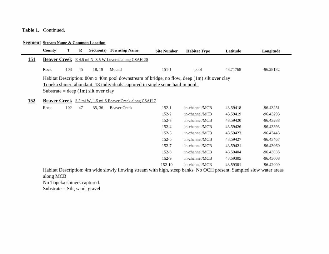
Table 1 Continued
Segment Stream Name amp Common Location
County T R Section(s) Township Name Site Number Habitat Type Latitude Longitude
151 Beaver Creek E 45 mi N 35 W Luverne along CSAH 20
Rock 103 45 18 19 Mound 151-1 pool 4371768 -9628182
Habitat Description 80m x 40m pool downstream of bridge no flow deep (1m) silt over clay Topeka shiner abundant 18 individuals captured in single seine haul in pool Substrate = deep (1m) silt over clay
152 Beaver Creek 35 mi W 15 mi S Beaver Creek along CSAH 7
Rock 102 47 35 36 Beaver Creek 152-1 in-channelMCB 4359418 -9643251
152-2 in-channelMCB 4359419 -9643293
152-3 in-channelMCB 4359420 -9643288
152-4 in-channelMCB 4359426 -9643393
152-5 in-channelMCB 4359423 -9643445
152-6 in-channelMCB 4359427 -9643467
152-7 in-channelMCB 4359421 -9643060
152-8 in-channelMCB 4359404 -9643035
152-9 in-channelMCB 4359305 -9643008
152-10 in-channelMCB 4359301 -9642999
Habitat Description 4m wide slowly flowing stream with high steep banks No OCH present Sampled slow water areas
along MCB
No Topeka shiners captured
Substrate = Silt sand gravel
Table 1 Continued
Segment Stream Name amp Common Location
County T R Section(s) Township Name Site Number Habitat Type Latitude Longitude
153 Beaver Creek 1 mi N 175 mi E Beaver Creek
Rock 102 46 14 23 Beaver Creek 153-1 in-channelMCB 4363076 -9632975
153-2 in-channelMCB 4363049 -9633007
153-3 in-channelMCB 4362954 -9632909
153-4 in-channelMCB 4362915 -9633117
153-5 in-channelMCB 4362911 -9633148
153-6 in-channelMCB 4362835 -9633249
153-7 in-channelMCB 4363324 -9632725
153-8 in-channelMCB 4363240 -9632740
153-9 in-channelMCB 4363233 -9632762
153-10 in-channelMCB 4363224 -9632770
Habitat Description 3m wide slowly flowing streamHigh steep banks Lots of bank erosion and very little OCH Off
channel ponds along northern 13 of segment were dry Water very low Cattle in stream Sampled slack water along MCB
No Topeka shiners captured
Substrate = firm sandsilt in backwater sandgravel in main channel
Table 1 Continued
Segment Stream Name amp Common Location
County T R Section(s) Township Name Site Number Habitat Type Latitude Longitude
154 Rock River 4mi S 25 mi W Steen
Rock 101 45 13 Clinton 154-1 pool 4355354 -9618125
154-2 in-channelMCB 4355362 -9618154
154-3 in-channelMCB 4355350 -9618191
154-4 in-channelMCB 4355254 -9618127
154-5 pool 4355287 -9617972
154-6 in-channelMCB 4355211 -9618013
154-7 in-channelMCB 4355206 -9618099
154-8 in-channelMCB 4355216 -9618146
154-9 in-channelMCB 4355197 -9618235
154-10 in-channelMCB 4355121 -9618336
154-11 in-channelMCB 4355081 -9618361
154-12 in-channelMCB 4355022 -9618309
154-13 in-channelMCB 4354985 -9618238
154-14 riffle 4354849 -9618238
154-15 in-channelMCB 4354810 -9618156
154-16 in-channelMCB 4354787 -9618069
154-17 in-channelMCB 4354709 -9618012
Habitat Description Wide (10m) flowing stream with ample OCH Channel is braided along meanders
with backwater habitat along sandgravel bars Wooded riparian corridor
No Topeka shiners captured
Substrate = gravel sand silt
Table 1 Continued
Segment Stream Name amp Common Location
County T R Section(s) Township Name Site Number Habitat Type Latitude Longitude
155 Elk Creek 3 mi N 3 mi E Magnolia along CSAH 19
Nobles 103 43 29 32 Lismore 155-1 pool 4368849 -9602497
155-2 pool 4368832 -9602512
155-3 pool 4368842 -9602019
155-4 in-channelMCB 4368859 -9602008
155-5 in-channelMCB 4368861 -9602002
155-6 in-channelMCB 4368868 -9601990
155-7 in-channelMCB 4368870 -9601969
155-8 in-channelMCB 4368877 -9601940
155-9 in-channelMCB 4368896 -9601932
155-10 in-channelMCB 4368923 -9601916
Habitat Description Water very low Narrow (2m) intermittent stream Stream bed is dry in places between isolated pools
No flow Sampled at pooled areas at culverts at CH 19
No Topeka shiners captured
Substrate = silt muck gravel
156 Elk Creek 4 mi N 4 mi E Magnolia along CSAH 14
Nobles 103 43 21 28 Lismore 156-1 pool 4370276 -9600072
Habitat Description very small headwater stream (1m) that is nearly dry between pools Sampled on margin of 20m x 50m
pool at bridge Pool depth gt 2m Thick mats of floating filamentous algae pool depth and submerged macrophytes
made seining difficult
Topeka shiner abundant 5 individuals captured in single kick set on margin of pool Numerous male Topeka shiners were observed defending cleared patches of gravel along the margin of the pool Substrate = silt over gravel
Table 1 Continued
Segment Stream Name amp Common Location
County T R Section(s) Township Name Site Number Habitat Type Latitude Longitude
157 Kanaranzi Creek 15 mi E 2 mi S Lismore
Nobles 103 42 17 19 20 Larkin 157-1 pool 4371762 -9591115
157-2 pool 4371757 -9591102
157-3 pool 4371753 -9591108
157-4 pool 4371755 -9591112
157-5 pool 4371785 -9591112
157-6 pool 4371786 -9591115
157-7 pool 4371793 -9591111
157-8 in-channelMCB 4371818 -9591105
157-9 in-channelMCB 4371820 -9591097
157-10 in-channelMCB 4371829 -9591093
157-11 in-channelMCB 4371835 -9591097
157-12 in-channelMCB 4371785 -9591100
Habitat Description Stream has been ditchedchannelized High banks and no OCH is present except for a pooled area upstream of a beaver dam that is S of the bridge No Topeka shiners captured Substrate = silt muck sand
Table 1 Continued
Segment Stream Name amp Common Location
County T R Section(s) Township Name Site Number Habitat Type Latitude Longitude
158 Kanaranzi Creek 2 mi E 35 mi S Magnolia
Nobles 102 43 31 32 Westside 158-1 pool 4359742 -9603359
158-2 pool 4359741 -9603408
158-3 in-channelMCB 4359686 -9603499
158-4 in-channelMCB 4359660 -9603513
158-5 in-channelMCB 4359620 -9603518
158-6 pool 4359584 -9603554
158-7 in-channelMCB 4359590 -9603589
158-8 in-channelMCB 4359600 -9603617
158-9 in-channelMCB 4359555 -9603658
158-10 in-channelMCB 4359527 -9603683
158-11 in-channelMCB 4359463 -9603681
158-12 in-channelMCB 4359454 -9603681
158-13 in-channelMCB 4359416 -9603690
158-14 in-channelMCB 4359399 -9603722
158-15 in-channelMCB 4359383 -9603735
Habitat Description 4m wide slowly flowing stream Sampled backwater and off-channel habitats along MCB and side channels Hard gravelsand substrate in channel Ample low-flow habitat along sandgravel bars No Topeka shiners captured Substrate = sand gravel silt
Table 1 Continued
Segment Stream Name amp Common Location
County T R Section(s) Township Name Site Number Habitat Type Latitude Longitude
159 Kanaranzi Creek 1 mi NW Adrian along CSAH 35
Nobles 102 43 13 Westside 159-1 pool 4364453 -9595165
159-2 pool 4364481 -9595166
159-3 pool 4364479 -9595182
159-4 pool 4364461 -9595195
159-5 in-channelMCB 4364438 -9595194
159-6 in-channelMCB 4364427 -9595224
159-7 in-channelMCB 4364406 -9595307
159-8 in-channelMCB 4364407 -9595333
159-9 in-channelMCB 4364401 -9595360
159-10 pool 4364448 -9595347
159-11 in-channelMCB 4364467 -9595077
159-12 in-channelMCB 4364500 -9594982
Habitat Description Flowing 7m wide stream Abundant backwaters pools and OCH along MCB
Topeka shiner present a single individual captured in a side channel over gravelsand mix after much effort
Substrate = gravel sand silt
Table 1 Contined
Segment Stream Name amp Common Location
County T R Section(s) Township Name Site Number Habitat Type Latitude Longitude
160 Little Rock River 1 mi E 4 mi S Rushmore
Nobles 101 41 16 17 Ransom 160-1 in-channelMCB 4355809 -9577372
160-2 in-channelMCB 4355819 -9577356
160-3 in-channelMCB 4355826 -9577324
160-4 in-channelMCB 4355820 -9577237
160-5 in-channelMCB 4355819 -9577193
160-6 in-channelMCB 4355824 -9577181
160-7 in-channelMCB 4355803 -9577151
160-8 in-channelMCB 4355800 -9577123
160-9 in-channelMCB 4355810 -9577124
160-10 in-channelMCB 4355827 -9577099
160-11 in-channelMCB 4355803 -9576997
160-12 in-channelMCB 4355766 -9576964
160-13 in-channelMCB 4355763 -9576986
160-14 in-channelMCB 4355706 -9576972
160-15 in-channelMCB 4355811 -9577403
160-16 in-channelMCB 4355798 -9577529
160-17 in-channelMCB 4355760 -9577529
160-18 in-channelMCB 4355759 -9577500
160-19 in-channelMCB 4355736 -9577556
Table 1 Site 160 Continued Table 1 Concluded
Segment Stream Name amp Common Location
County T R Section(s) Township Name Site Number Habitat Type Latitude Longitude
160 Little Rock River 1 mi E 4 mi S Rushmore
160-20 in-channelMCB 4355748 -9577608
160-21 in-channelMCB 4355752 -9577642
160-22 in-channelMCB 4355689 -9577684
160-23 in-channelMCB 4355681 -9577736
160-24 in-channelMCB 4355642 -9577828
160-25 in-channelMCB 4355622 -9577895
Habitat Description Slowly flowing 3m wide stream with high steep banks Little or no OCH Portions of this stream
appear to have been ditched and rip-rapped
No Topeka shiners captured
Substrate = gravel sand muck
Table 2 Locations of the twenty stream Segments (sites 161-180) sampled in 2013 corresponding sampling sites within
each segment and a brief habitat description for each site from which Topeka shiners were collected Included
are a Common Location descriptor (approximate mileage amp direction to nearest townhighways) the
TownshipRange for the 20 Segments and UTM coordinates for each sampling site Habitat type is an aproximate
characterization of the specific sample site within the sample reach pooled areas along the stream channel (pool)
low-flow reaches of stream and backwater habitats along the main channel boundary (in-channelMCB) ponds
adjacent to the sample reach that are not connected to the main channel of the stream (pool off-channel)
Segment Stream Name amp Common Location
County T R Section(s) Township Name Site Number Habitat Type Latitude Longitude
161 Medary Creek 7 mi W Lake Benson
Lincoln 109 46 7 Verdi 161-1 in-channelMCB 4425807000 -9642702300
161-2 in-channelMCB 4425815900 -9642724800
161-3 in-channelMCB 4425836800 -9642739100
161-4 in-channelMCB 4425898800 -9642738400
161-5 in-channelMCB 4425902800 -9642724500
161-6 in-channelMCB 4425904800 -9642721000
161-7 in-channelMCB 4425924400 -9642696700
161-8 in-channelMCB 4425928300 -9642687800
161-9 in-channelMCB 4425931400 -9642670400
161-10 in-channelMCB 4425936800 -9642650600
161-11 in-channelMCB 4425928700 -9642638400
161-12 in-channelMCB 4425969600 -9642576100
161-13 pool 4426041100 -9642542500
161-14 in-channelMCB 4426093000 -9642681600
161-15 in-channelMCB 4426018800 -9642819900
Habitat Description narrow (2m) flowing headwater stream beaver dams along sample reach
Topeka shiner present nine Topeka shiners captured in a flowing pool downstream of a beaver dam
Thousands of fish downstream of dam and almost none in the upstream sites 1-14
Substrate = cobble gravel silt
Table 2 Continued
Segment Stream Name amp Common Location
County T R Section(s) Township Name Site Number Habitat Type Latitude Longitude
162 Willow Creek 13 mi W Ruthton
Pipestone 108 46 4 29 Altona 162-1 in-channelMCB 4418795200 -9636967900
162-2 in-channelMCB 4418776900 -9636978700
162-3 in-channelMCB 4418554500 -9637231900
162-4 pool 4418587700 -9637323700
162-5 pool 4418588600 -9637353100
162-6 pool 4418597900 -9637352800
162-7 pool 4418617800 -9637343500
162-8 pool 4418608500 -9637352600
162-9 pool 4418659800 -9637532400
162-10 pool 4418647400 -9637460200
Habitat Description very narrow (1m) headwater stream slow flow large pool (sites 4-8) appears to be an excavated pond
metal debris and fencing material made seining difficult Seined pooled areas in cattail beds
No Topeka shiners captured Substrate = sand gravel silt
Table 2 Continued
Segment Stream Name amp Common Location
County T R Section(s) Township Name Site Number Habitat Type Latitude Longitude
163 Flandreau Creek 4 mi N 5 mi W Holland
Pipestone 108 46 29 Altona 163-1 pool 4412550100 -9639615400
163-2 pool 4412552400 -9639616700
163-3 pool 4412550000 -9639640600
163-4 in-channelMCB 4412625200 -9639662400
163-5 in-channelMCB 4412595100 -9639579900
163-6 in-channelMCB 4412681700 -9639517200
163-7 pool 4412703400 -9639517600
163-8 pool 4412761900 -9639631000
163-9 pool 4412764600 -9639631600
163-10 pool 4412782600 -9639590000
163-11 pool 4412754600 -9639531600
163-12 pool 4412762600 -9639632100
163-13 in-channelMCB 4413017900 -9639591600
163-14 in-channelMCB 4413084800 -9639438100
163-15 pool 4412573500 -9639553100
Habitat Description 3m wide flowing stream Channel appears to have been ditched most of plotted reach is dry Seined in heavily vegetated stagnant pools No Topeka shiners captured Substrate = firm sand gravel in-channel deep silt along MCB
Table 2 Continued
Segment Stream Name amp Common Location
County T R Section(s) Township Name Site Number Habitat Type Latitude Longitude
164 Flandreau Creek 65 mi W 55 mi N Pipestone
Pipestone 107 47 13 14 Troy 164-1 pool 4408042400 -9644734000
164-2 pool 4408043100 -9644720500
164-3 pool 4408042200 -9644708000
164-4 pool 4407996200 -9644910500
164-5 in-channelMCB 4407938200 -9644906400
164-6 in-channelMCB 4407760400 -9644847500
164-7 in-channelMCB 4407796600 -9644913300
164-8 in-channelMCB 4407806300 -9644950500
164-9 in-channelMCB 4407797700 -9644981100
164-10 in-channelMCB 4407809800 -9644991500
164-11 pool 4408029200 -9645104800
Habitat Description flowing 3-5m wide stream with firm gravel substrate in thalweg Sampled pooled area at bridge
some off-channel habitat at sites 4 and 11 Banks are steep along most of the reach with little slackwater habitat along MCB
No Topeka shiners captured
Substrate = gravel sand cobble in-channel Deep silt in low-flow areas
Table 2 Continued
Segment Stream Name amp Common Location
County T R Section(s) Township Name Site Number Habitat Type Latitude Longitude
165 North Branch Pipestone Creek 4 mi W 3 mi N Pipestone
Pipestone 107 46 29 Troy 165-1 pool 4404501300 -9639278100
165-2 pool 4404481000 -9639316800
165-3 pool 4404472800 -9639315500
165-4 in-channelMCB 4404457500 -9639325200
165-5 in-channelMCB 4404434800 -9639340300
165-6 in-channelMCB 4404446400 -9639386900
165-7 in-channelMCB 4404320300 -9639371300
165-8 pool 4404299200 -9639403700
165-9 pool 4404302200 -9639429200
165-10 pool 4404289200 -9639430300
165-11 pool 4404283700 -9639418700
165-12 in-channelMCB 4404212300 -9639411800
165-13 in-channelMCB 4404195800 -9639463400
165-14 in-channelMCB 4404244400 -9639645200
165-15 in-channelMCB 4404163700 -9639819800
165-16 in-channelMCB 4404165900 -9639797900
Habitat Description moderately flowing 3-5m wide stream Recent increase in stream level some submerged terrestrial
grasses along MCB Sites 8-11 in oxbow Submerged terrestrial grasses in oxbow
No Topeka shiners captured
Substrate = sand gravel silt
Table 2 Continued
Segment Stream Name amp Common Location
County T R Section(s) Township Name Site Number Habitat Type Latitude Longitude
166 Pipestone Creek 35 mi W 1 mi N Pipestone
Pipestone 106 46 4 5 Sweet 166-1 in-channelMCB 4401330100 -9638708400
166-2 in-channelMCB 4401347000 -9638709700
166-3 in-channelMCB 4401345500 -9638703700
166-4 in-channelMCB 4401355800 -9638703000
166-5 in-channelMCB 4401541200 -9638596400
166-6 in-channelMCB 4401618700 -9638658000
166-7 in-channelMCB 4401623400 -9638660800
166-8 in-channelMCB 4401625200 -9638646200
166-9 in-channelMCB 4401633300 -9638635600
166-10 in-channelMCB 4401740500 -9638517300
Habitat Description 10m wide slowly flowing stream Sampled along MCB in slack water West end of segment appears
to have been ditched Littleno OCH Drainage tiles along E reach of segment
No Topeka shiners captured
Substrate = cobble gravel sand Deep silt along margins of pools
Table 2 Continued
Segment Stream Name amp Common Location
County T R Section(s) Township Name Site Number Habitat Type Latitude Longitude
167 Split Rock Creek 15 mi N 1 mi E Ihlen
Pipestone 105 46 3 Eden 167-1 pool 4392585400 -9634993300
167-2 in-channelMCB 4392638100 -9635031600
167-3 pool 4392643100 -9635103600
167-4 pool 4392638200 -9635101900
167-5 pool 4392633000 -9635108800
167-6 pool 4392633200 -9635116400
167-7 pool 4392635700 -9635131600
167-8 pool 4392636400 -9635139100
167-9 pool 4392635900 -9635156000
167-10 in-channelMCB 4392470900 -9635255600
167-11 in-channelMCB 4392465600 -9635242800
167-12 in-channelMCB 4392447500 -9635240300
Habitat Description very small headwater stream (~1m) water low isolated series of pools along streambed No Topeka shiners captured Substrate = sand gravel silt
168 Split Rock Creek 15 mi N 05 mi E Jasper
Pipestone 105 46 28 29 Eden 168-1 in-channelMCB 4387771400 -9638026400
Habitat Description high water 4m wide flowing stream submerged terrestrial grasses on margins
Topeka shiner common 6 individuals captured on first seine haul in pooled area at MCB just downstream of culvert
Substrate = boulder cobble sand
Table 2 Continued
Segment Stream Name amp Common Location
County T R Section(s) Township Name Site Number Habitat Type Latitude Longitude
169 Rock River 1 mi SW of Edgerton
Pipestone 105 44 17 18 Osborne 169-1 pool 4389371700 -9616564700
169-2 in-channelMCB 4389439900 -9616531800
Habitat Description Swiftly flowing 10m wide stream at high water Sampled pooled area at outside bend of stream
over deep silt
Topeka shiner present four individuals captured in four seine hauls in a 1m wide drainage channel that joins a
retention pond to the Rock River
Substrate = Silt gravel Deep silt in off-channel areaspools
170 Chanarambie Creek 05 mi S 05 mi E Chandler
Murray 104 47 35 Fenton 170-1 in-channelMCB 4392093400 -9593156600
170-2 in-channelMCB 4391890200 -9593079300
170-3 in-channelMCB 4391841400 -9593168100
170-4 in-channelMCB 4391784300 -9593090300
170-5 in-channelMCB 4391783100 -9593060700
170-6 in-channelMCB 4391790600 -9593061100
170-7 in-channelMCB 4391796700 -9593025000
170-8 in-channelMCB 4391792000 -9592982800
170-9 in-channelMCB 4392105300 -9593062100
170-10 in-channelMCB 4392122900 -9593165100
Habitat Description narrow (1-2m) headwater stream Stream is flowing swiftly and little or no OCH is present
most of the segment appears to have been channelized
No Topeka shiners captured
Substrate = silt sand
Table 2 Continued
Segment Stream Name amp Common Location
County T R Section(s) Township Name Site Number Habitat Type Latitude Longitude
171 Rock River 4 mi S Edgerton
Rock 104 44 8 9 Battle Plain 171-1 in-channelMCB 4382021200 -9613013100
171-2 pool 4382126400 -9613470300
171-3 in-channelMCB 4382025300 -9612974300
171-4 in-channelMCB 4382027100 -9612961600
171-5 in-channelMCB 4382145400 -9613302800
171-6 in-channelMCB 4382380700 -9613520900
171-7 in-channelMCB 4382367500 -9613527700
171-8 in-channelMCB 4382359000 -9613532400
171-9 in-channelMCB 4382405300 -9613495400
171-10 in-channelMCB 4382271200 -9613570400
Habitat Description High water 8-12m wide swiftly flowing stream Stream is full to high banks Much of slackwater
areas along MCB likely inudndated Sampled in backwaters sites 6-9
No Topeka shiners captured
Substrate = Sand gravel silt
Table 2 Continued
Segment Stream Name amp Common Location
County T R Section(s) Township Name Site Number Habitat Type Latitude Longitude
172 Rock River tributary 1 mi E Hardwick
Rock 104 44 30 31 Battle Plain 172-1 pool 4377538900 -9617075500
172-2 pool 4377529200 -9617075600
172-3 pool 4377514700 -9617079800
172-4 in-channelMCB 4377386200 -9617079600
172-5 in-channelMCB 4377247100 -9617207900
172-6 in-channelMCB 4377241900 -9617224500
172-7 in-channelMCB 4377245200 -9617219500
172-8 in-channelMCB 4376956400 -9616914600
172-9 pool off-channel 4376998700 -9616876000
172-10 in-channelMCB 4377058800 -9616855700
172-11 in-channelMCB 4377043200 -9616826600
Habitat Description 3m wide slowly flowing pasture stream with high trampled banks Much of reach appears to
have been channelized no OCH present along MCBSampled in stock pond at site 9 Some submerged macrophytes
No Topeka shiners captured
Substrate = sand silt muck
Table 2 Continued
Segment Stream Name amp Common Location
County T R Section(s) Township Name Site Number Habitat Type Latitude Longitude
173 Mound Creek 1 mi N 175 mi E Beaver Creek
Rock 103 45 2 11 Mound 173-1 in-channelMCB 4374749900 -9620089200
173-2 in-channelMCB 4374756900 -9620094400
173-3 in-channelMCB 4374763700 -9620090700
173-4 in-channelMCB 4374842800 -9619838100
173-5 in-channelMCB 4374844000 -9619833200
173-6 in-channelMCB 4374889800 -9619789300
173-7 in-channelMCB 4374839600 -9619885800
173-8 in-channelMCB 4374827900 -9619934500
173-9 in-channelMCB 4374817000 -9619966400
173-10 in-channelMCB 4374799700 -9620048400
Habitat Description Entire reach of sement has been channelized Stream is 1-2m wide and constantly flowing High
banks No OCH
No Topeka shiners captured
Substrate = gravel sand silt
Table 2 Continued
Segment Stream Name amp Common Location
County T R Section(s) Township Name Site Number Habitat Type Latitude Longitude
174 Rock River tributary 55 mi N 4 mi E Luverne
Rock 103 44 8 9 Vienna 174-1 pool 4373333900 -9613250300
174-2 pool 4373322100 -9613262700
Habitat Description Narrow (2-3m) wide flowing headwater stream Sampled in deep silted pool at bridge Topeka shiner present two individuals captured over gravel in pooled area at bridge Much of the pool is filled with deep (gt05m) silt No Topeka shiners collected in silted portion of pool Substrate = gravel sand silt
Table 2 Continued
Segment Stream Name amp Common Location
County T R Section(s) Township Name Site Number Habitat Type Latitude Longitude
175 Champepadan Creek 4mi N 5 mi E Luverne
Rock 103 44 21 22 Vienna 175-1 pool 4371002900 -9611238300
175-2 pool 4371001900 -9611232600
175-3 pool 4371008300 -9611238900
175-4 in-channelMCB 4370955000 -9611142300
175-5 in-channelMCB 4371042200 -9610763900
175-6 in-channelMCB 4371007000 -9610720000
175-7 in-channelMCB 4370984100 -9610706400
175-8 pooloff-channel 4370971600 -9610709700
Habitat Description 3m wide stream with moderate flow Native prairie has been planted along both banks for the entire reach
No flow Sampled at pooled areas at culverts at CH 19
Topeka shiner present one individual captured in deep livestock pond S of stream Depth (gt2m) made seining in pond difficult
Substrate = sand silt gravel
Table 2 Continued
Segment Stream Name amp Common Location
County T R Section(s) Township Name Site Number Habitat Type Latitude Longitude
176 Kanaranzi Creek 2 mi W 35 mi N Ellworth
Rock 101 44 12 Kanaranzi 176-1 pool 4357304000 -9606413600
176-2 pool 4357305400 -9606410500
176-3 pool 4357249700 -9606408600
176-4 in-channelMCB 4357200500 -9606350300
176-5 in-channelMCB 4357204500 -9606354600
176-6 in-channelMCB 4357211400 -9606360400
176-7 in-channelMCB 4357127700 -9606357500
176-8 in-channelMCB 4357090500 -9606197900
176-9 in-channelMCB 4356817400 -9606275000
176-10 in-channelMCB 4356807000 -9606273900
176-11 in-channelMCB 4356639200 -9606408000
176-12 in-channelMCB 4356632100 -9606416000
176-13 in-channelMCB 4356598300 -9606381200
Habitat Description 10m wide flowing stream Very little OCH Very deep silt along MCB Sampled pooled area
at bridge High eroded banks
No Topeka shiners captured
Substrate = silt over gravel
Table 2 Continued
Segment Stream Name amp Common Location
County T R Section(s) Township Name Site Number Habitat Type Latitude Longitude
177 Rock River 05 mi N 4 mi E Steen
Rock 101 45 25 Clinton 177-1 pool 4352588900 -9618721100
177-2 pool 4352592700 -9618726600
177-3 in-channelMCB 4352519900 -9618594900
177-4 in-channelMCB 4352297500 -9618558400
177-5 in-channelMCB 4352147800 -9618456000
177-6 in-channelMCB 4352143300 -9618458200
177-7 in-channelMCB 4352125000 -9618453100
177-8 in-channelMCB 4352121500 -9618442200
177-9 in-channelMCB 4352106600 -9618444000
177-10 in-channelMCB 4352727900 -9618684800
177-11 pool 4352783000 -9618770800
177-12 pooloff-channel 4352663200 -9619046500
Habitat Description 11m wide flowing stream with wide channel sand bars and some braiding Firm gravel in thalweg Oxbow in middle of reach is nearly dry (lt25 cm) No fish observed culicid fly larvae abundant No Topeka shiners captured Substrate = sand gravel silt
Table 2 Continued
Segment Stream Name amp Common Location
County T R Section(s) Township Name Site Number Habitat Type Latitude Longitude
178 Kanaranzi Creek 2 mi W Ellsworth
Rock 101 44 25 36 Kanaranzi 178-1 pool 4351441400 -9605867000
178-2 in-channelMCB 4351404500 -9605846000
178-3 in-channelMCB 4351378800 -9605844300
178-4 pool 4351349700 -9605841200
178-5 pool 4351358400 -9605829800
178-6 pool 4351351800 -9605816800
178-7 in-channelMCB 4351355800 -9605866900
178-8 in-channelMCB 4351549000 -9605823700
178-9 in-channelMCB 4351891800 -9605895600
178-10 in-channelMCB 4351866200 -9605881400
178-11 pool 4352078500 -9606070000
178-12 pool 4352046000 -9606082200
Habitat Description 7-9m wide flowing stream Sampled backwater and off-channel habitats along MCB and side channels Recent high flow has filled in off-channel areas with deep silt Seining difficult No Topeka shiners captured Substrate = sand silt gravel
Table 2 Concluded
Segment Stream Name amp Common Location
County T R Section(s) Township Name Site Number Habitat Type Latitude Longitude
179 East Branch Kanaranzi Creek 15 mi N 15 mi E Adrian
Nobles 102 42 8 Olney 179-1 pool 4365932900 -9590462700
179-2 pool 4365928900 -9590449500
179-3 pool 4365930600 -9590463300
179-4 pool 4365908000 -9590420300
179-5 in-channelMCB 4365679800 -9590378600
179-6 in-channelMCB 4365661000 -9590387800
179-7 in-channelMCB 4365604000 -9590417100
179-8 in-channelMCB 4365508100 -9590385200
179-9 in-channelMCB 4365460100 -9590342200
179-10 pool 4365434900 -9590020100
179-11 in-channelMCB 4365507700 -9590154900
179-12 in-channelMCB 4365588000 -9589900200
Habitat Description Flowing 9m wide stream Stream is full to high banks very little slackwater habitat present at this site
No Topeka shiners captured
Substrate = sand silt gravel
180 Little Rock River 8 mi E Ellsworth
Nobles 101 42 26 Little Rock 180-1 in-channelMCB 4352838500 -9584615900
Habitat Description Sampled large pooled area at bridge no discernible flow silt over gravel substrate Channel downstream
of pool is a 2-3 m wide flowing stream with a firm sandgravel substrate
Topeka shiner abundant fourteen individuals captured in first seine haul in pool fifteen individuals captured in second seine
haul near outlet of the pool
Substrate = gravel sand silt
Table 3 Complete List of Fish Species Captured at Segments 141-160 2012
Species 141 142 143 144 145 146 147 148 149 150 151 152 153 154 155 156 157 158 159 160 Campostoma anomalum X X X X X X X X X X X X X X Chrosomus erythrogaster X X Cyprinella lutrensis X X X X X X X X X Cyprinus carpio X X X X X Hybognathus hankinsoni X X X X X X X Luxilus cornutus X X X X X X X X X X X X X Notropis dorsalis X X X X X X X X X X X Notropis stramineus X X X X X X X X X X X X X X X Notropis topeka X X X X X X X X Pimephales notatus X X X X X X X X X X X X Pimephales promelas X X X X X X X X X X X X X X X X X X Rhinichthys atratulus X X X X X X Semotilus atromaculatus X X X X X X X X X X X X X X X X X X Carpiodes cyprinus X Carpiodes sp (YOY) X X X Catostomus commersoni X X X X X X X X X X X X X X X Moxostoma macrolepidotum X X Ameiurus melas X X X X X X X X X X X X X Ameiurus natalis X Ictalurus punctatus X X X X Noturus flavus X X X X Noturus gyrinus X X X X X Esox lucius X X Percopsis omiscomaycus X Fundulus sciadicus X X X Culaea inconstans X X X X X Lepomis cyanellus X X X X X X X Lepomis humilis X X X X X X X X X X X Lepomis macrochirus X X X X X Micropterus dolomieui X Micropterus salmoides X X Pomoxis nigromaculatus X X Etheostoma exile X X X X X Etheostoma nigrum X X X X X X X X X X X X X X X X X Perca flavescens X X Percina maculata X X X X
Table 4 Complete List of Fish Species Captured at Segments 161-180 2013
Species 161 162 163 164 165 166 167 168 169 170 171 172 173 174 175 176 177 178 179 180
Campostoma anomalum X X X X X X X X X X X X X X
Cyprinella lutrensis X X X X X X X X X X
Cyprinus carpio X X X
Hybognathus hankinsoni X X X X X
Luxilus cornutus X X X X X X X X X X X X X
Notropis dorsalis X X X X X X X X X X X X X X
Notropis stramineus X X X X X X X X X X X X X X
Notropis topeka X X X X X X
Pimephales notatus X X X X X X X X X X X X
Pimephales promelas X X X X X X X X X X X X X X X X X X
Rhinichthys atratulus X X X X X X X X X X X
Semotilus atromaculatus X X X X X X X X X X X X X X X X
Carpiodes cyprinus X X
Catostomus commersoni X X X X X X X X X X X X X
Moxostoma erythrurum X X X
Moxostoma macrolepidotum X X
Ameiurus melas X X X X X X X X X X
Noturus flavus X X X
Esox lucius X X
Percopsis omiscomaycus X
Fundulus sciadicus X
Culaea inconstans X X X X
Lepomis cyanellus X X X X X X
Lepomis humilis X X X X X X X X X
Etheostoma exile X X
Etheostoma nigrum X X X X X X X X X X
Percina maculata X X
Appendix C- Habitat and Voucher Photographs
Habitat photographs for segments in which no Topeka shiners were captured are representative
of the habitat along the one-mile reach of stream Habitat photographs from segments where
Topeka shiners were present represent the specific site where they were collected Voucher
photographs are presented for each of the sites were Topeka shiners were collected
Site 141-2 Medary Creek voucher and habitat photos
Segment 142 Willow Creek no Topeka shiners captured
Segment 143 East Branch Flandrau Creek no Topeka shiners captured
Segment 144 North Branch Pipestone Creek no Topeka shiners captured
Site 145-6 Pipestone Creek voucher photo
Site 145-6 Pipestone Creek habitat photo
Segment 146 Split Rock Creek no Topeka shiners captured No habitat photo
Segment 147 Kanaranzi Creek no Topeka shiners captured
Site 148-4 Rock River voucher and habitat photos
Site 149-4 Rock River voucher and habitat photos
Site 150-4 Split Rock Creek voucher and habitat photos
Site 151-1 Beaver Creek voucher and habitat photos
Segment 152 Beaver Creek no Topeka shiners captured
Segment 153 Beaver Creek no Topeka shiners captured
Segment 154 Rock River no Topeka shiners captured
Segment 155 Elk Creek no Topeka shiners captured
Site 156-1 Elk Creek voucher and habitat photos
Segment 157 Kanaranzi Creek no Topeka shiners captured
Segment 158 Kanaranzi Creek no Topeka shiners captured
Site 159-1 Kanaranzi Creek voucher and habitat photos
Segment 160 Little Rock River no Topeka shiners captured
Site 161-15 Medary Creek voucher photo
Site 161-15 Medary Creek habitat photo
Segment 162 Willow Creek no Topeka shiners captured No habitat photo
Segment 163 Flandrau Creek no Topeka shiners captured
Segment 164 Flandrau Creek no Topeka shiners captured
Segment 165 North Branch Pipestone Creek no Topeka Shiners captured
Segment 166 Pipestone Creek no Topeka Shiners captured
Segment 167 Tributary to Split Rock Creek no Topeka Shiners captured No habitat
photo
Site 168-1 Split Rock Creek voucher photo
Site 168-1 Split Rock Creek habitat photo
Site 169-2 Rock River voucher photo
Site 169-2 Rock River habitat photo
Segment 170 Chanarambie Creek no Topeka shiners captured
Segment 171 Rock River no Topeka shiners captured
Segment 172 Tributary to Rock River no Topeka shiners captured
Segment 173 Blue Mound Creek no Topeka shiners
Site 174-2 Tributary to Rock River voucher photo
Site 174-2 Tributary to Rock River habitat photo
Site 175-8 Champepadan Creek voucher photo
Site 175-8 Champepadan Creek habitat photo
Segment 176 Kanaranzi Creek no Topekas captured
Segment 177 Rock River no Topeka shiners captured
Segment 178 Kanaranzi Creek no Topeka shiners captured
Segment 179 East Branch Kanaranzi Creek no Topeka shiners captured
Site 180-1 West Branch Little Rock River voucher photo
Site 180-1 West Branch Little Rock River habitat photo
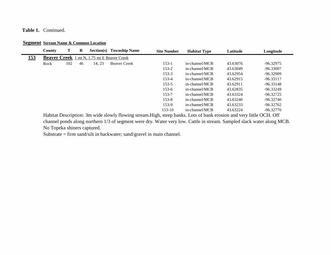
Table 1 Continued
Segment Stream Name amp Common Location
County T R Section(s) Township Name Site Number Habitat Type Latitude Longitude
153 Beaver Creek 1 mi N 175 mi E Beaver Creek
Rock 102 46 14 23 Beaver Creek 153-1 in-channelMCB 4363076 -9632975
153-2 in-channelMCB 4363049 -9633007
153-3 in-channelMCB 4362954 -9632909
153-4 in-channelMCB 4362915 -9633117
153-5 in-channelMCB 4362911 -9633148
153-6 in-channelMCB 4362835 -9633249
153-7 in-channelMCB 4363324 -9632725
153-8 in-channelMCB 4363240 -9632740
153-9 in-channelMCB 4363233 -9632762
153-10 in-channelMCB 4363224 -9632770
Habitat Description 3m wide slowly flowing streamHigh steep banks Lots of bank erosion and very little OCH Off
channel ponds along northern 13 of segment were dry Water very low Cattle in stream Sampled slack water along MCB
No Topeka shiners captured
Substrate = firm sandsilt in backwater sandgravel in main channel
Table 1 Continued
Segment Stream Name amp Common Location
County T R Section(s) Township Name Site Number Habitat Type Latitude Longitude
154 Rock River 4mi S 25 mi W Steen
Rock 101 45 13 Clinton 154-1 pool 4355354 -9618125
154-2 in-channelMCB 4355362 -9618154
154-3 in-channelMCB 4355350 -9618191
154-4 in-channelMCB 4355254 -9618127
154-5 pool 4355287 -9617972
154-6 in-channelMCB 4355211 -9618013
154-7 in-channelMCB 4355206 -9618099
154-8 in-channelMCB 4355216 -9618146
154-9 in-channelMCB 4355197 -9618235
154-10 in-channelMCB 4355121 -9618336
154-11 in-channelMCB 4355081 -9618361
154-12 in-channelMCB 4355022 -9618309
154-13 in-channelMCB 4354985 -9618238
154-14 riffle 4354849 -9618238
154-15 in-channelMCB 4354810 -9618156
154-16 in-channelMCB 4354787 -9618069
154-17 in-channelMCB 4354709 -9618012
Habitat Description Wide (10m) flowing stream with ample OCH Channel is braided along meanders
with backwater habitat along sandgravel bars Wooded riparian corridor
No Topeka shiners captured
Substrate = gravel sand silt
Table 1 Continued
Segment Stream Name amp Common Location
County T R Section(s) Township Name Site Number Habitat Type Latitude Longitude
155 Elk Creek 3 mi N 3 mi E Magnolia along CSAH 19
Nobles 103 43 29 32 Lismore 155-1 pool 4368849 -9602497
155-2 pool 4368832 -9602512
155-3 pool 4368842 -9602019
155-4 in-channelMCB 4368859 -9602008
155-5 in-channelMCB 4368861 -9602002
155-6 in-channelMCB 4368868 -9601990
155-7 in-channelMCB 4368870 -9601969
155-8 in-channelMCB 4368877 -9601940
155-9 in-channelMCB 4368896 -9601932
155-10 in-channelMCB 4368923 -9601916
Habitat Description Water very low Narrow (2m) intermittent stream Stream bed is dry in places between isolated pools
No flow Sampled at pooled areas at culverts at CH 19
No Topeka shiners captured
Substrate = silt muck gravel
156 Elk Creek 4 mi N 4 mi E Magnolia along CSAH 14
Nobles 103 43 21 28 Lismore 156-1 pool 4370276 -9600072
Habitat Description very small headwater stream (1m) that is nearly dry between pools Sampled on margin of 20m x 50m
pool at bridge Pool depth gt 2m Thick mats of floating filamentous algae pool depth and submerged macrophytes
made seining difficult
Topeka shiner abundant 5 individuals captured in single kick set on margin of pool Numerous male Topeka shiners were observed defending cleared patches of gravel along the margin of the pool Substrate = silt over gravel
Table 1 Continued
Segment Stream Name amp Common Location
County T R Section(s) Township Name Site Number Habitat Type Latitude Longitude
157 Kanaranzi Creek 15 mi E 2 mi S Lismore
Nobles 103 42 17 19 20 Larkin 157-1 pool 4371762 -9591115
157-2 pool 4371757 -9591102
157-3 pool 4371753 -9591108
157-4 pool 4371755 -9591112
157-5 pool 4371785 -9591112
157-6 pool 4371786 -9591115
157-7 pool 4371793 -9591111
157-8 in-channelMCB 4371818 -9591105
157-9 in-channelMCB 4371820 -9591097
157-10 in-channelMCB 4371829 -9591093
157-11 in-channelMCB 4371835 -9591097
157-12 in-channelMCB 4371785 -9591100
Habitat Description Stream has been ditchedchannelized High banks and no OCH is present except for a pooled area upstream of a beaver dam that is S of the bridge No Topeka shiners captured Substrate = silt muck sand
Table 1 Continued
Segment Stream Name amp Common Location
County T R Section(s) Township Name Site Number Habitat Type Latitude Longitude
158 Kanaranzi Creek 2 mi E 35 mi S Magnolia
Nobles 102 43 31 32 Westside 158-1 pool 4359742 -9603359
158-2 pool 4359741 -9603408
158-3 in-channelMCB 4359686 -9603499
158-4 in-channelMCB 4359660 -9603513
158-5 in-channelMCB 4359620 -9603518
158-6 pool 4359584 -9603554
158-7 in-channelMCB 4359590 -9603589
158-8 in-channelMCB 4359600 -9603617
158-9 in-channelMCB 4359555 -9603658
158-10 in-channelMCB 4359527 -9603683
158-11 in-channelMCB 4359463 -9603681
158-12 in-channelMCB 4359454 -9603681
158-13 in-channelMCB 4359416 -9603690
158-14 in-channelMCB 4359399 -9603722
158-15 in-channelMCB 4359383 -9603735
Habitat Description 4m wide slowly flowing stream Sampled backwater and off-channel habitats along MCB and side channels Hard gravelsand substrate in channel Ample low-flow habitat along sandgravel bars No Topeka shiners captured Substrate = sand gravel silt
Table 1 Continued
Segment Stream Name amp Common Location
County T R Section(s) Township Name Site Number Habitat Type Latitude Longitude
159 Kanaranzi Creek 1 mi NW Adrian along CSAH 35
Nobles 102 43 13 Westside 159-1 pool 4364453 -9595165
159-2 pool 4364481 -9595166
159-3 pool 4364479 -9595182
159-4 pool 4364461 -9595195
159-5 in-channelMCB 4364438 -9595194
159-6 in-channelMCB 4364427 -9595224
159-7 in-channelMCB 4364406 -9595307
159-8 in-channelMCB 4364407 -9595333
159-9 in-channelMCB 4364401 -9595360
159-10 pool 4364448 -9595347
159-11 in-channelMCB 4364467 -9595077
159-12 in-channelMCB 4364500 -9594982
Habitat Description Flowing 7m wide stream Abundant backwaters pools and OCH along MCB
Topeka shiner present a single individual captured in a side channel over gravelsand mix after much effort
Substrate = gravel sand silt
Table 1 Contined
Segment Stream Name amp Common Location
County T R Section(s) Township Name Site Number Habitat Type Latitude Longitude
160 Little Rock River 1 mi E 4 mi S Rushmore
Nobles 101 41 16 17 Ransom 160-1 in-channelMCB 4355809 -9577372
160-2 in-channelMCB 4355819 -9577356
160-3 in-channelMCB 4355826 -9577324
160-4 in-channelMCB 4355820 -9577237
160-5 in-channelMCB 4355819 -9577193
160-6 in-channelMCB 4355824 -9577181
160-7 in-channelMCB 4355803 -9577151
160-8 in-channelMCB 4355800 -9577123
160-9 in-channelMCB 4355810 -9577124
160-10 in-channelMCB 4355827 -9577099
160-11 in-channelMCB 4355803 -9576997
160-12 in-channelMCB 4355766 -9576964
160-13 in-channelMCB 4355763 -9576986
160-14 in-channelMCB 4355706 -9576972
160-15 in-channelMCB 4355811 -9577403
160-16 in-channelMCB 4355798 -9577529
160-17 in-channelMCB 4355760 -9577529
160-18 in-channelMCB 4355759 -9577500
160-19 in-channelMCB 4355736 -9577556
Table 1 Site 160 Continued Table 1 Concluded
Segment Stream Name amp Common Location
County T R Section(s) Township Name Site Number Habitat Type Latitude Longitude
160 Little Rock River 1 mi E 4 mi S Rushmore
160-20 in-channelMCB 4355748 -9577608
160-21 in-channelMCB 4355752 -9577642
160-22 in-channelMCB 4355689 -9577684
160-23 in-channelMCB 4355681 -9577736
160-24 in-channelMCB 4355642 -9577828
160-25 in-channelMCB 4355622 -9577895
Habitat Description Slowly flowing 3m wide stream with high steep banks Little or no OCH Portions of this stream
appear to have been ditched and rip-rapped
No Topeka shiners captured
Substrate = gravel sand muck
Table 2 Locations of the twenty stream Segments (sites 161-180) sampled in 2013 corresponding sampling sites within
each segment and a brief habitat description for each site from which Topeka shiners were collected Included
are a Common Location descriptor (approximate mileage amp direction to nearest townhighways) the
TownshipRange for the 20 Segments and UTM coordinates for each sampling site Habitat type is an aproximate
characterization of the specific sample site within the sample reach pooled areas along the stream channel (pool)
low-flow reaches of stream and backwater habitats along the main channel boundary (in-channelMCB) ponds
adjacent to the sample reach that are not connected to the main channel of the stream (pool off-channel)
Segment Stream Name amp Common Location
County T R Section(s) Township Name Site Number Habitat Type Latitude Longitude
161 Medary Creek 7 mi W Lake Benson
Lincoln 109 46 7 Verdi 161-1 in-channelMCB 4425807000 -9642702300
161-2 in-channelMCB 4425815900 -9642724800
161-3 in-channelMCB 4425836800 -9642739100
161-4 in-channelMCB 4425898800 -9642738400
161-5 in-channelMCB 4425902800 -9642724500
161-6 in-channelMCB 4425904800 -9642721000
161-7 in-channelMCB 4425924400 -9642696700
161-8 in-channelMCB 4425928300 -9642687800
161-9 in-channelMCB 4425931400 -9642670400
161-10 in-channelMCB 4425936800 -9642650600
161-11 in-channelMCB 4425928700 -9642638400
161-12 in-channelMCB 4425969600 -9642576100
161-13 pool 4426041100 -9642542500
161-14 in-channelMCB 4426093000 -9642681600
161-15 in-channelMCB 4426018800 -9642819900
Habitat Description narrow (2m) flowing headwater stream beaver dams along sample reach
Topeka shiner present nine Topeka shiners captured in a flowing pool downstream of a beaver dam
Thousands of fish downstream of dam and almost none in the upstream sites 1-14
Substrate = cobble gravel silt
Table 2 Continued
Segment Stream Name amp Common Location
County T R Section(s) Township Name Site Number Habitat Type Latitude Longitude
162 Willow Creek 13 mi W Ruthton
Pipestone 108 46 4 29 Altona 162-1 in-channelMCB 4418795200 -9636967900
162-2 in-channelMCB 4418776900 -9636978700
162-3 in-channelMCB 4418554500 -9637231900
162-4 pool 4418587700 -9637323700
162-5 pool 4418588600 -9637353100
162-6 pool 4418597900 -9637352800
162-7 pool 4418617800 -9637343500
162-8 pool 4418608500 -9637352600
162-9 pool 4418659800 -9637532400
162-10 pool 4418647400 -9637460200
Habitat Description very narrow (1m) headwater stream slow flow large pool (sites 4-8) appears to be an excavated pond
metal debris and fencing material made seining difficult Seined pooled areas in cattail beds
No Topeka shiners captured Substrate = sand gravel silt
Table 2 Continued
Segment Stream Name amp Common Location
County T R Section(s) Township Name Site Number Habitat Type Latitude Longitude
163 Flandreau Creek 4 mi N 5 mi W Holland
Pipestone 108 46 29 Altona 163-1 pool 4412550100 -9639615400
163-2 pool 4412552400 -9639616700
163-3 pool 4412550000 -9639640600
163-4 in-channelMCB 4412625200 -9639662400
163-5 in-channelMCB 4412595100 -9639579900
163-6 in-channelMCB 4412681700 -9639517200
163-7 pool 4412703400 -9639517600
163-8 pool 4412761900 -9639631000
163-9 pool 4412764600 -9639631600
163-10 pool 4412782600 -9639590000
163-11 pool 4412754600 -9639531600
163-12 pool 4412762600 -9639632100
163-13 in-channelMCB 4413017900 -9639591600
163-14 in-channelMCB 4413084800 -9639438100
163-15 pool 4412573500 -9639553100
Habitat Description 3m wide flowing stream Channel appears to have been ditched most of plotted reach is dry Seined in heavily vegetated stagnant pools No Topeka shiners captured Substrate = firm sand gravel in-channel deep silt along MCB
Table 2 Continued
Segment Stream Name amp Common Location
County T R Section(s) Township Name Site Number Habitat Type Latitude Longitude
164 Flandreau Creek 65 mi W 55 mi N Pipestone
Pipestone 107 47 13 14 Troy 164-1 pool 4408042400 -9644734000
164-2 pool 4408043100 -9644720500
164-3 pool 4408042200 -9644708000
164-4 pool 4407996200 -9644910500
164-5 in-channelMCB 4407938200 -9644906400
164-6 in-channelMCB 4407760400 -9644847500
164-7 in-channelMCB 4407796600 -9644913300
164-8 in-channelMCB 4407806300 -9644950500
164-9 in-channelMCB 4407797700 -9644981100
164-10 in-channelMCB 4407809800 -9644991500
164-11 pool 4408029200 -9645104800
Habitat Description flowing 3-5m wide stream with firm gravel substrate in thalweg Sampled pooled area at bridge
some off-channel habitat at sites 4 and 11 Banks are steep along most of the reach with little slackwater habitat along MCB
No Topeka shiners captured
Substrate = gravel sand cobble in-channel Deep silt in low-flow areas
Table 2 Continued
Segment Stream Name amp Common Location
County T R Section(s) Township Name Site Number Habitat Type Latitude Longitude
165 North Branch Pipestone Creek 4 mi W 3 mi N Pipestone
Pipestone 107 46 29 Troy 165-1 pool 4404501300 -9639278100
165-2 pool 4404481000 -9639316800
165-3 pool 4404472800 -9639315500
165-4 in-channelMCB 4404457500 -9639325200
165-5 in-channelMCB 4404434800 -9639340300
165-6 in-channelMCB 4404446400 -9639386900
165-7 in-channelMCB 4404320300 -9639371300
165-8 pool 4404299200 -9639403700
165-9 pool 4404302200 -9639429200
165-10 pool 4404289200 -9639430300
165-11 pool 4404283700 -9639418700
165-12 in-channelMCB 4404212300 -9639411800
165-13 in-channelMCB 4404195800 -9639463400
165-14 in-channelMCB 4404244400 -9639645200
165-15 in-channelMCB 4404163700 -9639819800
165-16 in-channelMCB 4404165900 -9639797900
Habitat Description moderately flowing 3-5m wide stream Recent increase in stream level some submerged terrestrial
grasses along MCB Sites 8-11 in oxbow Submerged terrestrial grasses in oxbow
No Topeka shiners captured
Substrate = sand gravel silt
Table 2 Continued
Segment Stream Name amp Common Location
County T R Section(s) Township Name Site Number Habitat Type Latitude Longitude
166 Pipestone Creek 35 mi W 1 mi N Pipestone
Pipestone 106 46 4 5 Sweet 166-1 in-channelMCB 4401330100 -9638708400
166-2 in-channelMCB 4401347000 -9638709700
166-3 in-channelMCB 4401345500 -9638703700
166-4 in-channelMCB 4401355800 -9638703000
166-5 in-channelMCB 4401541200 -9638596400
166-6 in-channelMCB 4401618700 -9638658000
166-7 in-channelMCB 4401623400 -9638660800
166-8 in-channelMCB 4401625200 -9638646200
166-9 in-channelMCB 4401633300 -9638635600
166-10 in-channelMCB 4401740500 -9638517300
Habitat Description 10m wide slowly flowing stream Sampled along MCB in slack water West end of segment appears
to have been ditched Littleno OCH Drainage tiles along E reach of segment
No Topeka shiners captured
Substrate = cobble gravel sand Deep silt along margins of pools
Table 2 Continued
Segment Stream Name amp Common Location
County T R Section(s) Township Name Site Number Habitat Type Latitude Longitude
167 Split Rock Creek 15 mi N 1 mi E Ihlen
Pipestone 105 46 3 Eden 167-1 pool 4392585400 -9634993300
167-2 in-channelMCB 4392638100 -9635031600
167-3 pool 4392643100 -9635103600
167-4 pool 4392638200 -9635101900
167-5 pool 4392633000 -9635108800
167-6 pool 4392633200 -9635116400
167-7 pool 4392635700 -9635131600
167-8 pool 4392636400 -9635139100
167-9 pool 4392635900 -9635156000
167-10 in-channelMCB 4392470900 -9635255600
167-11 in-channelMCB 4392465600 -9635242800
167-12 in-channelMCB 4392447500 -9635240300
Habitat Description very small headwater stream (~1m) water low isolated series of pools along streambed No Topeka shiners captured Substrate = sand gravel silt
168 Split Rock Creek 15 mi N 05 mi E Jasper
Pipestone 105 46 28 29 Eden 168-1 in-channelMCB 4387771400 -9638026400
Habitat Description high water 4m wide flowing stream submerged terrestrial grasses on margins
Topeka shiner common 6 individuals captured on first seine haul in pooled area at MCB just downstream of culvert
Substrate = boulder cobble sand
Table 2 Continued
Segment Stream Name amp Common Location
County T R Section(s) Township Name Site Number Habitat Type Latitude Longitude
169 Rock River 1 mi SW of Edgerton
Pipestone 105 44 17 18 Osborne 169-1 pool 4389371700 -9616564700
169-2 in-channelMCB 4389439900 -9616531800
Habitat Description Swiftly flowing 10m wide stream at high water Sampled pooled area at outside bend of stream
over deep silt
Topeka shiner present four individuals captured in four seine hauls in a 1m wide drainage channel that joins a
retention pond to the Rock River
Substrate = Silt gravel Deep silt in off-channel areaspools
170 Chanarambie Creek 05 mi S 05 mi E Chandler
Murray 104 47 35 Fenton 170-1 in-channelMCB 4392093400 -9593156600
170-2 in-channelMCB 4391890200 -9593079300
170-3 in-channelMCB 4391841400 -9593168100
170-4 in-channelMCB 4391784300 -9593090300
170-5 in-channelMCB 4391783100 -9593060700
170-6 in-channelMCB 4391790600 -9593061100
170-7 in-channelMCB 4391796700 -9593025000
170-8 in-channelMCB 4391792000 -9592982800
170-9 in-channelMCB 4392105300 -9593062100
170-10 in-channelMCB 4392122900 -9593165100
Habitat Description narrow (1-2m) headwater stream Stream is flowing swiftly and little or no OCH is present
most of the segment appears to have been channelized
No Topeka shiners captured
Substrate = silt sand
Table 2 Continued
Segment Stream Name amp Common Location
County T R Section(s) Township Name Site Number Habitat Type Latitude Longitude
171 Rock River 4 mi S Edgerton
Rock 104 44 8 9 Battle Plain 171-1 in-channelMCB 4382021200 -9613013100
171-2 pool 4382126400 -9613470300
171-3 in-channelMCB 4382025300 -9612974300
171-4 in-channelMCB 4382027100 -9612961600
171-5 in-channelMCB 4382145400 -9613302800
171-6 in-channelMCB 4382380700 -9613520900
171-7 in-channelMCB 4382367500 -9613527700
171-8 in-channelMCB 4382359000 -9613532400
171-9 in-channelMCB 4382405300 -9613495400
171-10 in-channelMCB 4382271200 -9613570400
Habitat Description High water 8-12m wide swiftly flowing stream Stream is full to high banks Much of slackwater
areas along MCB likely inudndated Sampled in backwaters sites 6-9
No Topeka shiners captured
Substrate = Sand gravel silt
Table 2 Continued
Segment Stream Name amp Common Location
County T R Section(s) Township Name Site Number Habitat Type Latitude Longitude
172 Rock River tributary 1 mi E Hardwick
Rock 104 44 30 31 Battle Plain 172-1 pool 4377538900 -9617075500
172-2 pool 4377529200 -9617075600
172-3 pool 4377514700 -9617079800
172-4 in-channelMCB 4377386200 -9617079600
172-5 in-channelMCB 4377247100 -9617207900
172-6 in-channelMCB 4377241900 -9617224500
172-7 in-channelMCB 4377245200 -9617219500
172-8 in-channelMCB 4376956400 -9616914600
172-9 pool off-channel 4376998700 -9616876000
172-10 in-channelMCB 4377058800 -9616855700
172-11 in-channelMCB 4377043200 -9616826600
Habitat Description 3m wide slowly flowing pasture stream with high trampled banks Much of reach appears to
have been channelized no OCH present along MCBSampled in stock pond at site 9 Some submerged macrophytes
No Topeka shiners captured
Substrate = sand silt muck
Table 2 Continued
Segment Stream Name amp Common Location
County T R Section(s) Township Name Site Number Habitat Type Latitude Longitude
173 Mound Creek 1 mi N 175 mi E Beaver Creek
Rock 103 45 2 11 Mound 173-1 in-channelMCB 4374749900 -9620089200
173-2 in-channelMCB 4374756900 -9620094400
173-3 in-channelMCB 4374763700 -9620090700
173-4 in-channelMCB 4374842800 -9619838100
173-5 in-channelMCB 4374844000 -9619833200
173-6 in-channelMCB 4374889800 -9619789300
173-7 in-channelMCB 4374839600 -9619885800
173-8 in-channelMCB 4374827900 -9619934500
173-9 in-channelMCB 4374817000 -9619966400
173-10 in-channelMCB 4374799700 -9620048400
Habitat Description Entire reach of sement has been channelized Stream is 1-2m wide and constantly flowing High
banks No OCH
No Topeka shiners captured
Substrate = gravel sand silt
Table 2 Continued
Segment Stream Name amp Common Location
County T R Section(s) Township Name Site Number Habitat Type Latitude Longitude
174 Rock River tributary 55 mi N 4 mi E Luverne
Rock 103 44 8 9 Vienna 174-1 pool 4373333900 -9613250300
174-2 pool 4373322100 -9613262700
Habitat Description Narrow (2-3m) wide flowing headwater stream Sampled in deep silted pool at bridge Topeka shiner present two individuals captured over gravel in pooled area at bridge Much of the pool is filled with deep (gt05m) silt No Topeka shiners collected in silted portion of pool Substrate = gravel sand silt
Table 2 Continued
Segment Stream Name amp Common Location
County T R Section(s) Township Name Site Number Habitat Type Latitude Longitude
175 Champepadan Creek 4mi N 5 mi E Luverne
Rock 103 44 21 22 Vienna 175-1 pool 4371002900 -9611238300
175-2 pool 4371001900 -9611232600
175-3 pool 4371008300 -9611238900
175-4 in-channelMCB 4370955000 -9611142300
175-5 in-channelMCB 4371042200 -9610763900
175-6 in-channelMCB 4371007000 -9610720000
175-7 in-channelMCB 4370984100 -9610706400
175-8 pooloff-channel 4370971600 -9610709700
Habitat Description 3m wide stream with moderate flow Native prairie has been planted along both banks for the entire reach
No flow Sampled at pooled areas at culverts at CH 19
Topeka shiner present one individual captured in deep livestock pond S of stream Depth (gt2m) made seining in pond difficult
Substrate = sand silt gravel
Table 2 Continued
Segment Stream Name amp Common Location
County T R Section(s) Township Name Site Number Habitat Type Latitude Longitude
176 Kanaranzi Creek 2 mi W 35 mi N Ellworth
Rock 101 44 12 Kanaranzi 176-1 pool 4357304000 -9606413600
176-2 pool 4357305400 -9606410500
176-3 pool 4357249700 -9606408600
176-4 in-channelMCB 4357200500 -9606350300
176-5 in-channelMCB 4357204500 -9606354600
176-6 in-channelMCB 4357211400 -9606360400
176-7 in-channelMCB 4357127700 -9606357500
176-8 in-channelMCB 4357090500 -9606197900
176-9 in-channelMCB 4356817400 -9606275000
176-10 in-channelMCB 4356807000 -9606273900
176-11 in-channelMCB 4356639200 -9606408000
176-12 in-channelMCB 4356632100 -9606416000
176-13 in-channelMCB 4356598300 -9606381200
Habitat Description 10m wide flowing stream Very little OCH Very deep silt along MCB Sampled pooled area
at bridge High eroded banks
No Topeka shiners captured
Substrate = silt over gravel
Table 2 Continued
Segment Stream Name amp Common Location
County T R Section(s) Township Name Site Number Habitat Type Latitude Longitude
177 Rock River 05 mi N 4 mi E Steen
Rock 101 45 25 Clinton 177-1 pool 4352588900 -9618721100
177-2 pool 4352592700 -9618726600
177-3 in-channelMCB 4352519900 -9618594900
177-4 in-channelMCB 4352297500 -9618558400
177-5 in-channelMCB 4352147800 -9618456000
177-6 in-channelMCB 4352143300 -9618458200
177-7 in-channelMCB 4352125000 -9618453100
177-8 in-channelMCB 4352121500 -9618442200
177-9 in-channelMCB 4352106600 -9618444000
177-10 in-channelMCB 4352727900 -9618684800
177-11 pool 4352783000 -9618770800
177-12 pooloff-channel 4352663200 -9619046500
Habitat Description 11m wide flowing stream with wide channel sand bars and some braiding Firm gravel in thalweg Oxbow in middle of reach is nearly dry (lt25 cm) No fish observed culicid fly larvae abundant No Topeka shiners captured Substrate = sand gravel silt
Table 2 Continued
Segment Stream Name amp Common Location
County T R Section(s) Township Name Site Number Habitat Type Latitude Longitude
178 Kanaranzi Creek 2 mi W Ellsworth
Rock 101 44 25 36 Kanaranzi 178-1 pool 4351441400 -9605867000
178-2 in-channelMCB 4351404500 -9605846000
178-3 in-channelMCB 4351378800 -9605844300
178-4 pool 4351349700 -9605841200
178-5 pool 4351358400 -9605829800
178-6 pool 4351351800 -9605816800
178-7 in-channelMCB 4351355800 -9605866900
178-8 in-channelMCB 4351549000 -9605823700
178-9 in-channelMCB 4351891800 -9605895600
178-10 in-channelMCB 4351866200 -9605881400
178-11 pool 4352078500 -9606070000
178-12 pool 4352046000 -9606082200
Habitat Description 7-9m wide flowing stream Sampled backwater and off-channel habitats along MCB and side channels Recent high flow has filled in off-channel areas with deep silt Seining difficult No Topeka shiners captured Substrate = sand silt gravel
Table 2 Concluded
Segment Stream Name amp Common Location
County T R Section(s) Township Name Site Number Habitat Type Latitude Longitude
179 East Branch Kanaranzi Creek 15 mi N 15 mi E Adrian
Nobles 102 42 8 Olney 179-1 pool 4365932900 -9590462700
179-2 pool 4365928900 -9590449500
179-3 pool 4365930600 -9590463300
179-4 pool 4365908000 -9590420300
179-5 in-channelMCB 4365679800 -9590378600
179-6 in-channelMCB 4365661000 -9590387800
179-7 in-channelMCB 4365604000 -9590417100
179-8 in-channelMCB 4365508100 -9590385200
179-9 in-channelMCB 4365460100 -9590342200
179-10 pool 4365434900 -9590020100
179-11 in-channelMCB 4365507700 -9590154900
179-12 in-channelMCB 4365588000 -9589900200
Habitat Description Flowing 9m wide stream Stream is full to high banks very little slackwater habitat present at this site
No Topeka shiners captured
Substrate = sand silt gravel
180 Little Rock River 8 mi E Ellsworth
Nobles 101 42 26 Little Rock 180-1 in-channelMCB 4352838500 -9584615900
Habitat Description Sampled large pooled area at bridge no discernible flow silt over gravel substrate Channel downstream
of pool is a 2-3 m wide flowing stream with a firm sandgravel substrate
Topeka shiner abundant fourteen individuals captured in first seine haul in pool fifteen individuals captured in second seine
haul near outlet of the pool
Substrate = gravel sand silt
Table 3 Complete List of Fish Species Captured at Segments 141-160 2012
Species 141 142 143 144 145 146 147 148 149 150 151 152 153 154 155 156 157 158 159 160 Campostoma anomalum X X X X X X X X X X X X X X Chrosomus erythrogaster X X Cyprinella lutrensis X X X X X X X X X Cyprinus carpio X X X X X Hybognathus hankinsoni X X X X X X X Luxilus cornutus X X X X X X X X X X X X X Notropis dorsalis X X X X X X X X X X X Notropis stramineus X X X X X X X X X X X X X X X Notropis topeka X X X X X X X X Pimephales notatus X X X X X X X X X X X X Pimephales promelas X X X X X X X X X X X X X X X X X X Rhinichthys atratulus X X X X X X Semotilus atromaculatus X X X X X X X X X X X X X X X X X X Carpiodes cyprinus X Carpiodes sp (YOY) X X X Catostomus commersoni X X X X X X X X X X X X X X X Moxostoma macrolepidotum X X Ameiurus melas X X X X X X X X X X X X X Ameiurus natalis X Ictalurus punctatus X X X X Noturus flavus X X X X Noturus gyrinus X X X X X Esox lucius X X Percopsis omiscomaycus X Fundulus sciadicus X X X Culaea inconstans X X X X X Lepomis cyanellus X X X X X X X Lepomis humilis X X X X X X X X X X X Lepomis macrochirus X X X X X Micropterus dolomieui X Micropterus salmoides X X Pomoxis nigromaculatus X X Etheostoma exile X X X X X Etheostoma nigrum X X X X X X X X X X X X X X X X X Perca flavescens X X Percina maculata X X X X
Table 4 Complete List of Fish Species Captured at Segments 161-180 2013
Species 161 162 163 164 165 166 167 168 169 170 171 172 173 174 175 176 177 178 179 180
Campostoma anomalum X X X X X X X X X X X X X X
Cyprinella lutrensis X X X X X X X X X X
Cyprinus carpio X X X
Hybognathus hankinsoni X X X X X
Luxilus cornutus X X X X X X X X X X X X X
Notropis dorsalis X X X X X X X X X X X X X X
Notropis stramineus X X X X X X X X X X X X X X
Notropis topeka X X X X X X
Pimephales notatus X X X X X X X X X X X X
Pimephales promelas X X X X X X X X X X X X X X X X X X
Rhinichthys atratulus X X X X X X X X X X X
Semotilus atromaculatus X X X X X X X X X X X X X X X X
Carpiodes cyprinus X X
Catostomus commersoni X X X X X X X X X X X X X
Moxostoma erythrurum X X X
Moxostoma macrolepidotum X X
Ameiurus melas X X X X X X X X X X
Noturus flavus X X X
Esox lucius X X
Percopsis omiscomaycus X
Fundulus sciadicus X
Culaea inconstans X X X X
Lepomis cyanellus X X X X X X
Lepomis humilis X X X X X X X X X
Etheostoma exile X X
Etheostoma nigrum X X X X X X X X X X
Percina maculata X X
Appendix C- Habitat and Voucher Photographs
Habitat photographs for segments in which no Topeka shiners were captured are representative
of the habitat along the one-mile reach of stream Habitat photographs from segments where
Topeka shiners were present represent the specific site where they were collected Voucher
photographs are presented for each of the sites were Topeka shiners were collected
Site 141-2 Medary Creek voucher and habitat photos
Segment 142 Willow Creek no Topeka shiners captured
Segment 143 East Branch Flandrau Creek no Topeka shiners captured
Segment 144 North Branch Pipestone Creek no Topeka shiners captured
Site 145-6 Pipestone Creek voucher photo
Site 145-6 Pipestone Creek habitat photo
Segment 146 Split Rock Creek no Topeka shiners captured No habitat photo
Segment 147 Kanaranzi Creek no Topeka shiners captured
Site 148-4 Rock River voucher and habitat photos
Site 149-4 Rock River voucher and habitat photos
Site 150-4 Split Rock Creek voucher and habitat photos
Site 151-1 Beaver Creek voucher and habitat photos
Segment 152 Beaver Creek no Topeka shiners captured
Segment 153 Beaver Creek no Topeka shiners captured
Segment 154 Rock River no Topeka shiners captured
Segment 155 Elk Creek no Topeka shiners captured
Site 156-1 Elk Creek voucher and habitat photos
Segment 157 Kanaranzi Creek no Topeka shiners captured
Segment 158 Kanaranzi Creek no Topeka shiners captured
Site 159-1 Kanaranzi Creek voucher and habitat photos
Segment 160 Little Rock River no Topeka shiners captured
Site 161-15 Medary Creek voucher photo
Site 161-15 Medary Creek habitat photo
Segment 162 Willow Creek no Topeka shiners captured No habitat photo
Segment 163 Flandrau Creek no Topeka shiners captured
Segment 164 Flandrau Creek no Topeka shiners captured
Segment 165 North Branch Pipestone Creek no Topeka Shiners captured
Segment 166 Pipestone Creek no Topeka Shiners captured
Segment 167 Tributary to Split Rock Creek no Topeka Shiners captured No habitat
photo
Site 168-1 Split Rock Creek voucher photo
Site 168-1 Split Rock Creek habitat photo
Site 169-2 Rock River voucher photo
Site 169-2 Rock River habitat photo
Segment 170 Chanarambie Creek no Topeka shiners captured
Segment 171 Rock River no Topeka shiners captured
Segment 172 Tributary to Rock River no Topeka shiners captured
Segment 173 Blue Mound Creek no Topeka shiners
Site 174-2 Tributary to Rock River voucher photo
Site 174-2 Tributary to Rock River habitat photo
Site 175-8 Champepadan Creek voucher photo
Site 175-8 Champepadan Creek habitat photo
Segment 176 Kanaranzi Creek no Topekas captured
Segment 177 Rock River no Topeka shiners captured
Segment 178 Kanaranzi Creek no Topeka shiners captured
Segment 179 East Branch Kanaranzi Creek no Topeka shiners captured
Site 180-1 West Branch Little Rock River voucher photo
Site 180-1 West Branch Little Rock River habitat photo
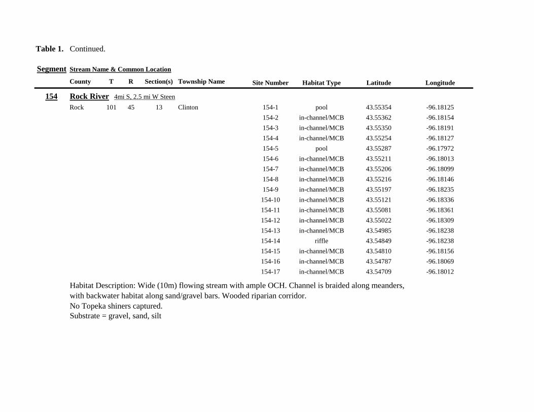
Table 1 Continued
Segment Stream Name amp Common Location
County T R Section(s) Township Name Site Number Habitat Type Latitude Longitude
154 Rock River 4mi S 25 mi W Steen
Rock 101 45 13 Clinton 154-1 pool 4355354 -9618125
154-2 in-channelMCB 4355362 -9618154
154-3 in-channelMCB 4355350 -9618191
154-4 in-channelMCB 4355254 -9618127
154-5 pool 4355287 -9617972
154-6 in-channelMCB 4355211 -9618013
154-7 in-channelMCB 4355206 -9618099
154-8 in-channelMCB 4355216 -9618146
154-9 in-channelMCB 4355197 -9618235
154-10 in-channelMCB 4355121 -9618336
154-11 in-channelMCB 4355081 -9618361
154-12 in-channelMCB 4355022 -9618309
154-13 in-channelMCB 4354985 -9618238
154-14 riffle 4354849 -9618238
154-15 in-channelMCB 4354810 -9618156
154-16 in-channelMCB 4354787 -9618069
154-17 in-channelMCB 4354709 -9618012
Habitat Description Wide (10m) flowing stream with ample OCH Channel is braided along meanders
with backwater habitat along sandgravel bars Wooded riparian corridor
No Topeka shiners captured
Substrate = gravel sand silt
Table 1 Continued
Segment Stream Name amp Common Location
County T R Section(s) Township Name Site Number Habitat Type Latitude Longitude
155 Elk Creek 3 mi N 3 mi E Magnolia along CSAH 19
Nobles 103 43 29 32 Lismore 155-1 pool 4368849 -9602497
155-2 pool 4368832 -9602512
155-3 pool 4368842 -9602019
155-4 in-channelMCB 4368859 -9602008
155-5 in-channelMCB 4368861 -9602002
155-6 in-channelMCB 4368868 -9601990
155-7 in-channelMCB 4368870 -9601969
155-8 in-channelMCB 4368877 -9601940
155-9 in-channelMCB 4368896 -9601932
155-10 in-channelMCB 4368923 -9601916
Habitat Description Water very low Narrow (2m) intermittent stream Stream bed is dry in places between isolated pools
No flow Sampled at pooled areas at culverts at CH 19
No Topeka shiners captured
Substrate = silt muck gravel
156 Elk Creek 4 mi N 4 mi E Magnolia along CSAH 14
Nobles 103 43 21 28 Lismore 156-1 pool 4370276 -9600072
Habitat Description very small headwater stream (1m) that is nearly dry between pools Sampled on margin of 20m x 50m
pool at bridge Pool depth gt 2m Thick mats of floating filamentous algae pool depth and submerged macrophytes
made seining difficult
Topeka shiner abundant 5 individuals captured in single kick set on margin of pool Numerous male Topeka shiners were observed defending cleared patches of gravel along the margin of the pool Substrate = silt over gravel
Table 1 Continued
Segment Stream Name amp Common Location
County T R Section(s) Township Name Site Number Habitat Type Latitude Longitude
157 Kanaranzi Creek 15 mi E 2 mi S Lismore
Nobles 103 42 17 19 20 Larkin 157-1 pool 4371762 -9591115
157-2 pool 4371757 -9591102
157-3 pool 4371753 -9591108
157-4 pool 4371755 -9591112
157-5 pool 4371785 -9591112
157-6 pool 4371786 -9591115
157-7 pool 4371793 -9591111
157-8 in-channelMCB 4371818 -9591105
157-9 in-channelMCB 4371820 -9591097
157-10 in-channelMCB 4371829 -9591093
157-11 in-channelMCB 4371835 -9591097
157-12 in-channelMCB 4371785 -9591100
Habitat Description Stream has been ditchedchannelized High banks and no OCH is present except for a pooled area upstream of a beaver dam that is S of the bridge No Topeka shiners captured Substrate = silt muck sand
Table 1 Continued
Segment Stream Name amp Common Location
County T R Section(s) Township Name Site Number Habitat Type Latitude Longitude
158 Kanaranzi Creek 2 mi E 35 mi S Magnolia
Nobles 102 43 31 32 Westside 158-1 pool 4359742 -9603359
158-2 pool 4359741 -9603408
158-3 in-channelMCB 4359686 -9603499
158-4 in-channelMCB 4359660 -9603513
158-5 in-channelMCB 4359620 -9603518
158-6 pool 4359584 -9603554
158-7 in-channelMCB 4359590 -9603589
158-8 in-channelMCB 4359600 -9603617
158-9 in-channelMCB 4359555 -9603658
158-10 in-channelMCB 4359527 -9603683
158-11 in-channelMCB 4359463 -9603681
158-12 in-channelMCB 4359454 -9603681
158-13 in-channelMCB 4359416 -9603690
158-14 in-channelMCB 4359399 -9603722
158-15 in-channelMCB 4359383 -9603735
Habitat Description 4m wide slowly flowing stream Sampled backwater and off-channel habitats along MCB and side channels Hard gravelsand substrate in channel Ample low-flow habitat along sandgravel bars No Topeka shiners captured Substrate = sand gravel silt
Table 1 Continued
Segment Stream Name amp Common Location
County T R Section(s) Township Name Site Number Habitat Type Latitude Longitude
159 Kanaranzi Creek 1 mi NW Adrian along CSAH 35
Nobles 102 43 13 Westside 159-1 pool 4364453 -9595165
159-2 pool 4364481 -9595166
159-3 pool 4364479 -9595182
159-4 pool 4364461 -9595195
159-5 in-channelMCB 4364438 -9595194
159-6 in-channelMCB 4364427 -9595224
159-7 in-channelMCB 4364406 -9595307
159-8 in-channelMCB 4364407 -9595333
159-9 in-channelMCB 4364401 -9595360
159-10 pool 4364448 -9595347
159-11 in-channelMCB 4364467 -9595077
159-12 in-channelMCB 4364500 -9594982
Habitat Description Flowing 7m wide stream Abundant backwaters pools and OCH along MCB
Topeka shiner present a single individual captured in a side channel over gravelsand mix after much effort
Substrate = gravel sand silt
Table 1 Contined
Segment Stream Name amp Common Location
County T R Section(s) Township Name Site Number Habitat Type Latitude Longitude
160 Little Rock River 1 mi E 4 mi S Rushmore
Nobles 101 41 16 17 Ransom 160-1 in-channelMCB 4355809 -9577372
160-2 in-channelMCB 4355819 -9577356
160-3 in-channelMCB 4355826 -9577324
160-4 in-channelMCB 4355820 -9577237
160-5 in-channelMCB 4355819 -9577193
160-6 in-channelMCB 4355824 -9577181
160-7 in-channelMCB 4355803 -9577151
160-8 in-channelMCB 4355800 -9577123
160-9 in-channelMCB 4355810 -9577124
160-10 in-channelMCB 4355827 -9577099
160-11 in-channelMCB 4355803 -9576997
160-12 in-channelMCB 4355766 -9576964
160-13 in-channelMCB 4355763 -9576986
160-14 in-channelMCB 4355706 -9576972
160-15 in-channelMCB 4355811 -9577403
160-16 in-channelMCB 4355798 -9577529
160-17 in-channelMCB 4355760 -9577529
160-18 in-channelMCB 4355759 -9577500
160-19 in-channelMCB 4355736 -9577556
Table 1 Site 160 Continued Table 1 Concluded
Segment Stream Name amp Common Location
County T R Section(s) Township Name Site Number Habitat Type Latitude Longitude
160 Little Rock River 1 mi E 4 mi S Rushmore
160-20 in-channelMCB 4355748 -9577608
160-21 in-channelMCB 4355752 -9577642
160-22 in-channelMCB 4355689 -9577684
160-23 in-channelMCB 4355681 -9577736
160-24 in-channelMCB 4355642 -9577828
160-25 in-channelMCB 4355622 -9577895
Habitat Description Slowly flowing 3m wide stream with high steep banks Little or no OCH Portions of this stream
appear to have been ditched and rip-rapped
No Topeka shiners captured
Substrate = gravel sand muck
Table 2 Locations of the twenty stream Segments (sites 161-180) sampled in 2013 corresponding sampling sites within
each segment and a brief habitat description for each site from which Topeka shiners were collected Included
are a Common Location descriptor (approximate mileage amp direction to nearest townhighways) the
TownshipRange for the 20 Segments and UTM coordinates for each sampling site Habitat type is an aproximate
characterization of the specific sample site within the sample reach pooled areas along the stream channel (pool)
low-flow reaches of stream and backwater habitats along the main channel boundary (in-channelMCB) ponds
adjacent to the sample reach that are not connected to the main channel of the stream (pool off-channel)
Segment Stream Name amp Common Location
County T R Section(s) Township Name Site Number Habitat Type Latitude Longitude
161 Medary Creek 7 mi W Lake Benson
Lincoln 109 46 7 Verdi 161-1 in-channelMCB 4425807000 -9642702300
161-2 in-channelMCB 4425815900 -9642724800
161-3 in-channelMCB 4425836800 -9642739100
161-4 in-channelMCB 4425898800 -9642738400
161-5 in-channelMCB 4425902800 -9642724500
161-6 in-channelMCB 4425904800 -9642721000
161-7 in-channelMCB 4425924400 -9642696700
161-8 in-channelMCB 4425928300 -9642687800
161-9 in-channelMCB 4425931400 -9642670400
161-10 in-channelMCB 4425936800 -9642650600
161-11 in-channelMCB 4425928700 -9642638400
161-12 in-channelMCB 4425969600 -9642576100
161-13 pool 4426041100 -9642542500
161-14 in-channelMCB 4426093000 -9642681600
161-15 in-channelMCB 4426018800 -9642819900
Habitat Description narrow (2m) flowing headwater stream beaver dams along sample reach
Topeka shiner present nine Topeka shiners captured in a flowing pool downstream of a beaver dam
Thousands of fish downstream of dam and almost none in the upstream sites 1-14
Substrate = cobble gravel silt
Table 2 Continued
Segment Stream Name amp Common Location
County T R Section(s) Township Name Site Number Habitat Type Latitude Longitude
162 Willow Creek 13 mi W Ruthton
Pipestone 108 46 4 29 Altona 162-1 in-channelMCB 4418795200 -9636967900
162-2 in-channelMCB 4418776900 -9636978700
162-3 in-channelMCB 4418554500 -9637231900
162-4 pool 4418587700 -9637323700
162-5 pool 4418588600 -9637353100
162-6 pool 4418597900 -9637352800
162-7 pool 4418617800 -9637343500
162-8 pool 4418608500 -9637352600
162-9 pool 4418659800 -9637532400
162-10 pool 4418647400 -9637460200
Habitat Description very narrow (1m) headwater stream slow flow large pool (sites 4-8) appears to be an excavated pond
metal debris and fencing material made seining difficult Seined pooled areas in cattail beds
No Topeka shiners captured Substrate = sand gravel silt
Table 2 Continued
Segment Stream Name amp Common Location
County T R Section(s) Township Name Site Number Habitat Type Latitude Longitude
163 Flandreau Creek 4 mi N 5 mi W Holland
Pipestone 108 46 29 Altona 163-1 pool 4412550100 -9639615400
163-2 pool 4412552400 -9639616700
163-3 pool 4412550000 -9639640600
163-4 in-channelMCB 4412625200 -9639662400
163-5 in-channelMCB 4412595100 -9639579900
163-6 in-channelMCB 4412681700 -9639517200
163-7 pool 4412703400 -9639517600
163-8 pool 4412761900 -9639631000
163-9 pool 4412764600 -9639631600
163-10 pool 4412782600 -9639590000
163-11 pool 4412754600 -9639531600
163-12 pool 4412762600 -9639632100
163-13 in-channelMCB 4413017900 -9639591600
163-14 in-channelMCB 4413084800 -9639438100
163-15 pool 4412573500 -9639553100
Habitat Description 3m wide flowing stream Channel appears to have been ditched most of plotted reach is dry Seined in heavily vegetated stagnant pools No Topeka shiners captured Substrate = firm sand gravel in-channel deep silt along MCB
Table 2 Continued
Segment Stream Name amp Common Location
County T R Section(s) Township Name Site Number Habitat Type Latitude Longitude
164 Flandreau Creek 65 mi W 55 mi N Pipestone
Pipestone 107 47 13 14 Troy 164-1 pool 4408042400 -9644734000
164-2 pool 4408043100 -9644720500
164-3 pool 4408042200 -9644708000
164-4 pool 4407996200 -9644910500
164-5 in-channelMCB 4407938200 -9644906400
164-6 in-channelMCB 4407760400 -9644847500
164-7 in-channelMCB 4407796600 -9644913300
164-8 in-channelMCB 4407806300 -9644950500
164-9 in-channelMCB 4407797700 -9644981100
164-10 in-channelMCB 4407809800 -9644991500
164-11 pool 4408029200 -9645104800
Habitat Description flowing 3-5m wide stream with firm gravel substrate in thalweg Sampled pooled area at bridge
some off-channel habitat at sites 4 and 11 Banks are steep along most of the reach with little slackwater habitat along MCB
No Topeka shiners captured
Substrate = gravel sand cobble in-channel Deep silt in low-flow areas
Table 2 Continued
Segment Stream Name amp Common Location
County T R Section(s) Township Name Site Number Habitat Type Latitude Longitude
165 North Branch Pipestone Creek 4 mi W 3 mi N Pipestone
Pipestone 107 46 29 Troy 165-1 pool 4404501300 -9639278100
165-2 pool 4404481000 -9639316800
165-3 pool 4404472800 -9639315500
165-4 in-channelMCB 4404457500 -9639325200
165-5 in-channelMCB 4404434800 -9639340300
165-6 in-channelMCB 4404446400 -9639386900
165-7 in-channelMCB 4404320300 -9639371300
165-8 pool 4404299200 -9639403700
165-9 pool 4404302200 -9639429200
165-10 pool 4404289200 -9639430300
165-11 pool 4404283700 -9639418700
165-12 in-channelMCB 4404212300 -9639411800
165-13 in-channelMCB 4404195800 -9639463400
165-14 in-channelMCB 4404244400 -9639645200
165-15 in-channelMCB 4404163700 -9639819800
165-16 in-channelMCB 4404165900 -9639797900
Habitat Description moderately flowing 3-5m wide stream Recent increase in stream level some submerged terrestrial
grasses along MCB Sites 8-11 in oxbow Submerged terrestrial grasses in oxbow
No Topeka shiners captured
Substrate = sand gravel silt
Table 2 Continued
Segment Stream Name amp Common Location
County T R Section(s) Township Name Site Number Habitat Type Latitude Longitude
166 Pipestone Creek 35 mi W 1 mi N Pipestone
Pipestone 106 46 4 5 Sweet 166-1 in-channelMCB 4401330100 -9638708400
166-2 in-channelMCB 4401347000 -9638709700
166-3 in-channelMCB 4401345500 -9638703700
166-4 in-channelMCB 4401355800 -9638703000
166-5 in-channelMCB 4401541200 -9638596400
166-6 in-channelMCB 4401618700 -9638658000
166-7 in-channelMCB 4401623400 -9638660800
166-8 in-channelMCB 4401625200 -9638646200
166-9 in-channelMCB 4401633300 -9638635600
166-10 in-channelMCB 4401740500 -9638517300
Habitat Description 10m wide slowly flowing stream Sampled along MCB in slack water West end of segment appears
to have been ditched Littleno OCH Drainage tiles along E reach of segment
No Topeka shiners captured
Substrate = cobble gravel sand Deep silt along margins of pools
Table 2 Continued
Segment Stream Name amp Common Location
County T R Section(s) Township Name Site Number Habitat Type Latitude Longitude
167 Split Rock Creek 15 mi N 1 mi E Ihlen
Pipestone 105 46 3 Eden 167-1 pool 4392585400 -9634993300
167-2 in-channelMCB 4392638100 -9635031600
167-3 pool 4392643100 -9635103600
167-4 pool 4392638200 -9635101900
167-5 pool 4392633000 -9635108800
167-6 pool 4392633200 -9635116400
167-7 pool 4392635700 -9635131600
167-8 pool 4392636400 -9635139100
167-9 pool 4392635900 -9635156000
167-10 in-channelMCB 4392470900 -9635255600
167-11 in-channelMCB 4392465600 -9635242800
167-12 in-channelMCB 4392447500 -9635240300
Habitat Description very small headwater stream (~1m) water low isolated series of pools along streambed No Topeka shiners captured Substrate = sand gravel silt
168 Split Rock Creek 15 mi N 05 mi E Jasper
Pipestone 105 46 28 29 Eden 168-1 in-channelMCB 4387771400 -9638026400
Habitat Description high water 4m wide flowing stream submerged terrestrial grasses on margins
Topeka shiner common 6 individuals captured on first seine haul in pooled area at MCB just downstream of culvert
Substrate = boulder cobble sand
Table 2 Continued
Segment Stream Name amp Common Location
County T R Section(s) Township Name Site Number Habitat Type Latitude Longitude
169 Rock River 1 mi SW of Edgerton
Pipestone 105 44 17 18 Osborne 169-1 pool 4389371700 -9616564700
169-2 in-channelMCB 4389439900 -9616531800
Habitat Description Swiftly flowing 10m wide stream at high water Sampled pooled area at outside bend of stream
over deep silt
Topeka shiner present four individuals captured in four seine hauls in a 1m wide drainage channel that joins a
retention pond to the Rock River
Substrate = Silt gravel Deep silt in off-channel areaspools
170 Chanarambie Creek 05 mi S 05 mi E Chandler
Murray 104 47 35 Fenton 170-1 in-channelMCB 4392093400 -9593156600
170-2 in-channelMCB 4391890200 -9593079300
170-3 in-channelMCB 4391841400 -9593168100
170-4 in-channelMCB 4391784300 -9593090300
170-5 in-channelMCB 4391783100 -9593060700
170-6 in-channelMCB 4391790600 -9593061100
170-7 in-channelMCB 4391796700 -9593025000
170-8 in-channelMCB 4391792000 -9592982800
170-9 in-channelMCB 4392105300 -9593062100
170-10 in-channelMCB 4392122900 -9593165100
Habitat Description narrow (1-2m) headwater stream Stream is flowing swiftly and little or no OCH is present
most of the segment appears to have been channelized
No Topeka shiners captured
Substrate = silt sand
Table 2 Continued
Segment Stream Name amp Common Location
County T R Section(s) Township Name Site Number Habitat Type Latitude Longitude
171 Rock River 4 mi S Edgerton
Rock 104 44 8 9 Battle Plain 171-1 in-channelMCB 4382021200 -9613013100
171-2 pool 4382126400 -9613470300
171-3 in-channelMCB 4382025300 -9612974300
171-4 in-channelMCB 4382027100 -9612961600
171-5 in-channelMCB 4382145400 -9613302800
171-6 in-channelMCB 4382380700 -9613520900
171-7 in-channelMCB 4382367500 -9613527700
171-8 in-channelMCB 4382359000 -9613532400
171-9 in-channelMCB 4382405300 -9613495400
171-10 in-channelMCB 4382271200 -9613570400
Habitat Description High water 8-12m wide swiftly flowing stream Stream is full to high banks Much of slackwater
areas along MCB likely inudndated Sampled in backwaters sites 6-9
No Topeka shiners captured
Substrate = Sand gravel silt
Table 2 Continued
Segment Stream Name amp Common Location
County T R Section(s) Township Name Site Number Habitat Type Latitude Longitude
172 Rock River tributary 1 mi E Hardwick
Rock 104 44 30 31 Battle Plain 172-1 pool 4377538900 -9617075500
172-2 pool 4377529200 -9617075600
172-3 pool 4377514700 -9617079800
172-4 in-channelMCB 4377386200 -9617079600
172-5 in-channelMCB 4377247100 -9617207900
172-6 in-channelMCB 4377241900 -9617224500
172-7 in-channelMCB 4377245200 -9617219500
172-8 in-channelMCB 4376956400 -9616914600
172-9 pool off-channel 4376998700 -9616876000
172-10 in-channelMCB 4377058800 -9616855700
172-11 in-channelMCB 4377043200 -9616826600
Habitat Description 3m wide slowly flowing pasture stream with high trampled banks Much of reach appears to
have been channelized no OCH present along MCBSampled in stock pond at site 9 Some submerged macrophytes
No Topeka shiners captured
Substrate = sand silt muck
Table 2 Continued
Segment Stream Name amp Common Location
County T R Section(s) Township Name Site Number Habitat Type Latitude Longitude
173 Mound Creek 1 mi N 175 mi E Beaver Creek
Rock 103 45 2 11 Mound 173-1 in-channelMCB 4374749900 -9620089200
173-2 in-channelMCB 4374756900 -9620094400
173-3 in-channelMCB 4374763700 -9620090700
173-4 in-channelMCB 4374842800 -9619838100
173-5 in-channelMCB 4374844000 -9619833200
173-6 in-channelMCB 4374889800 -9619789300
173-7 in-channelMCB 4374839600 -9619885800
173-8 in-channelMCB 4374827900 -9619934500
173-9 in-channelMCB 4374817000 -9619966400
173-10 in-channelMCB 4374799700 -9620048400
Habitat Description Entire reach of sement has been channelized Stream is 1-2m wide and constantly flowing High
banks No OCH
No Topeka shiners captured
Substrate = gravel sand silt
Table 2 Continued
Segment Stream Name amp Common Location
County T R Section(s) Township Name Site Number Habitat Type Latitude Longitude
174 Rock River tributary 55 mi N 4 mi E Luverne
Rock 103 44 8 9 Vienna 174-1 pool 4373333900 -9613250300
174-2 pool 4373322100 -9613262700
Habitat Description Narrow (2-3m) wide flowing headwater stream Sampled in deep silted pool at bridge Topeka shiner present two individuals captured over gravel in pooled area at bridge Much of the pool is filled with deep (gt05m) silt No Topeka shiners collected in silted portion of pool Substrate = gravel sand silt
Table 2 Continued
Segment Stream Name amp Common Location
County T R Section(s) Township Name Site Number Habitat Type Latitude Longitude
175 Champepadan Creek 4mi N 5 mi E Luverne
Rock 103 44 21 22 Vienna 175-1 pool 4371002900 -9611238300
175-2 pool 4371001900 -9611232600
175-3 pool 4371008300 -9611238900
175-4 in-channelMCB 4370955000 -9611142300
175-5 in-channelMCB 4371042200 -9610763900
175-6 in-channelMCB 4371007000 -9610720000
175-7 in-channelMCB 4370984100 -9610706400
175-8 pooloff-channel 4370971600 -9610709700
Habitat Description 3m wide stream with moderate flow Native prairie has been planted along both banks for the entire reach
No flow Sampled at pooled areas at culverts at CH 19
Topeka shiner present one individual captured in deep livestock pond S of stream Depth (gt2m) made seining in pond difficult
Substrate = sand silt gravel
Table 2 Continued
Segment Stream Name amp Common Location
County T R Section(s) Township Name Site Number Habitat Type Latitude Longitude
176 Kanaranzi Creek 2 mi W 35 mi N Ellworth
Rock 101 44 12 Kanaranzi 176-1 pool 4357304000 -9606413600
176-2 pool 4357305400 -9606410500
176-3 pool 4357249700 -9606408600
176-4 in-channelMCB 4357200500 -9606350300
176-5 in-channelMCB 4357204500 -9606354600
176-6 in-channelMCB 4357211400 -9606360400
176-7 in-channelMCB 4357127700 -9606357500
176-8 in-channelMCB 4357090500 -9606197900
176-9 in-channelMCB 4356817400 -9606275000
176-10 in-channelMCB 4356807000 -9606273900
176-11 in-channelMCB 4356639200 -9606408000
176-12 in-channelMCB 4356632100 -9606416000
176-13 in-channelMCB 4356598300 -9606381200
Habitat Description 10m wide flowing stream Very little OCH Very deep silt along MCB Sampled pooled area
at bridge High eroded banks
No Topeka shiners captured
Substrate = silt over gravel
Table 2 Continued
Segment Stream Name amp Common Location
County T R Section(s) Township Name Site Number Habitat Type Latitude Longitude
177 Rock River 05 mi N 4 mi E Steen
Rock 101 45 25 Clinton 177-1 pool 4352588900 -9618721100
177-2 pool 4352592700 -9618726600
177-3 in-channelMCB 4352519900 -9618594900
177-4 in-channelMCB 4352297500 -9618558400
177-5 in-channelMCB 4352147800 -9618456000
177-6 in-channelMCB 4352143300 -9618458200
177-7 in-channelMCB 4352125000 -9618453100
177-8 in-channelMCB 4352121500 -9618442200
177-9 in-channelMCB 4352106600 -9618444000
177-10 in-channelMCB 4352727900 -9618684800
177-11 pool 4352783000 -9618770800
177-12 pooloff-channel 4352663200 -9619046500
Habitat Description 11m wide flowing stream with wide channel sand bars and some braiding Firm gravel in thalweg Oxbow in middle of reach is nearly dry (lt25 cm) No fish observed culicid fly larvae abundant No Topeka shiners captured Substrate = sand gravel silt
Table 2 Continued
Segment Stream Name amp Common Location
County T R Section(s) Township Name Site Number Habitat Type Latitude Longitude
178 Kanaranzi Creek 2 mi W Ellsworth
Rock 101 44 25 36 Kanaranzi 178-1 pool 4351441400 -9605867000
178-2 in-channelMCB 4351404500 -9605846000
178-3 in-channelMCB 4351378800 -9605844300
178-4 pool 4351349700 -9605841200
178-5 pool 4351358400 -9605829800
178-6 pool 4351351800 -9605816800
178-7 in-channelMCB 4351355800 -9605866900
178-8 in-channelMCB 4351549000 -9605823700
178-9 in-channelMCB 4351891800 -9605895600
178-10 in-channelMCB 4351866200 -9605881400
178-11 pool 4352078500 -9606070000
178-12 pool 4352046000 -9606082200
Habitat Description 7-9m wide flowing stream Sampled backwater and off-channel habitats along MCB and side channels Recent high flow has filled in off-channel areas with deep silt Seining difficult No Topeka shiners captured Substrate = sand silt gravel
Table 2 Concluded
Segment Stream Name amp Common Location
County T R Section(s) Township Name Site Number Habitat Type Latitude Longitude
179 East Branch Kanaranzi Creek 15 mi N 15 mi E Adrian
Nobles 102 42 8 Olney 179-1 pool 4365932900 -9590462700
179-2 pool 4365928900 -9590449500
179-3 pool 4365930600 -9590463300
179-4 pool 4365908000 -9590420300
179-5 in-channelMCB 4365679800 -9590378600
179-6 in-channelMCB 4365661000 -9590387800
179-7 in-channelMCB 4365604000 -9590417100
179-8 in-channelMCB 4365508100 -9590385200
179-9 in-channelMCB 4365460100 -9590342200
179-10 pool 4365434900 -9590020100
179-11 in-channelMCB 4365507700 -9590154900
179-12 in-channelMCB 4365588000 -9589900200
Habitat Description Flowing 9m wide stream Stream is full to high banks very little slackwater habitat present at this site
No Topeka shiners captured
Substrate = sand silt gravel
180 Little Rock River 8 mi E Ellsworth
Nobles 101 42 26 Little Rock 180-1 in-channelMCB 4352838500 -9584615900
Habitat Description Sampled large pooled area at bridge no discernible flow silt over gravel substrate Channel downstream
of pool is a 2-3 m wide flowing stream with a firm sandgravel substrate
Topeka shiner abundant fourteen individuals captured in first seine haul in pool fifteen individuals captured in second seine
haul near outlet of the pool
Substrate = gravel sand silt
Table 3 Complete List of Fish Species Captured at Segments 141-160 2012
Species 141 142 143 144 145 146 147 148 149 150 151 152 153 154 155 156 157 158 159 160 Campostoma anomalum X X X X X X X X X X X X X X Chrosomus erythrogaster X X Cyprinella lutrensis X X X X X X X X X Cyprinus carpio X X X X X Hybognathus hankinsoni X X X X X X X Luxilus cornutus X X X X X X X X X X X X X Notropis dorsalis X X X X X X X X X X X Notropis stramineus X X X X X X X X X X X X X X X Notropis topeka X X X X X X X X Pimephales notatus X X X X X X X X X X X X Pimephales promelas X X X X X X X X X X X X X X X X X X Rhinichthys atratulus X X X X X X Semotilus atromaculatus X X X X X X X X X X X X X X X X X X Carpiodes cyprinus X Carpiodes sp (YOY) X X X Catostomus commersoni X X X X X X X X X X X X X X X Moxostoma macrolepidotum X X Ameiurus melas X X X X X X X X X X X X X Ameiurus natalis X Ictalurus punctatus X X X X Noturus flavus X X X X Noturus gyrinus X X X X X Esox lucius X X Percopsis omiscomaycus X Fundulus sciadicus X X X Culaea inconstans X X X X X Lepomis cyanellus X X X X X X X Lepomis humilis X X X X X X X X X X X Lepomis macrochirus X X X X X Micropterus dolomieui X Micropterus salmoides X X Pomoxis nigromaculatus X X Etheostoma exile X X X X X Etheostoma nigrum X X X X X X X X X X X X X X X X X Perca flavescens X X Percina maculata X X X X
Table 4 Complete List of Fish Species Captured at Segments 161-180 2013
Species 161 162 163 164 165 166 167 168 169 170 171 172 173 174 175 176 177 178 179 180
Campostoma anomalum X X X X X X X X X X X X X X
Cyprinella lutrensis X X X X X X X X X X
Cyprinus carpio X X X
Hybognathus hankinsoni X X X X X
Luxilus cornutus X X X X X X X X X X X X X
Notropis dorsalis X X X X X X X X X X X X X X
Notropis stramineus X X X X X X X X X X X X X X
Notropis topeka X X X X X X
Pimephales notatus X X X X X X X X X X X X
Pimephales promelas X X X X X X X X X X X X X X X X X X
Rhinichthys atratulus X X X X X X X X X X X
Semotilus atromaculatus X X X X X X X X X X X X X X X X
Carpiodes cyprinus X X
Catostomus commersoni X X X X X X X X X X X X X
Moxostoma erythrurum X X X
Moxostoma macrolepidotum X X
Ameiurus melas X X X X X X X X X X
Noturus flavus X X X
Esox lucius X X
Percopsis omiscomaycus X
Fundulus sciadicus X
Culaea inconstans X X X X
Lepomis cyanellus X X X X X X
Lepomis humilis X X X X X X X X X
Etheostoma exile X X
Etheostoma nigrum X X X X X X X X X X
Percina maculata X X
Appendix C- Habitat and Voucher Photographs
Habitat photographs for segments in which no Topeka shiners were captured are representative
of the habitat along the one-mile reach of stream Habitat photographs from segments where
Topeka shiners were present represent the specific site where they were collected Voucher
photographs are presented for each of the sites were Topeka shiners were collected
Site 141-2 Medary Creek voucher and habitat photos
Segment 142 Willow Creek no Topeka shiners captured
Segment 143 East Branch Flandrau Creek no Topeka shiners captured
Segment 144 North Branch Pipestone Creek no Topeka shiners captured
Site 145-6 Pipestone Creek voucher photo
Site 145-6 Pipestone Creek habitat photo
Segment 146 Split Rock Creek no Topeka shiners captured No habitat photo
Segment 147 Kanaranzi Creek no Topeka shiners captured
Site 148-4 Rock River voucher and habitat photos
Site 149-4 Rock River voucher and habitat photos
Site 150-4 Split Rock Creek voucher and habitat photos
Site 151-1 Beaver Creek voucher and habitat photos
Segment 152 Beaver Creek no Topeka shiners captured
Segment 153 Beaver Creek no Topeka shiners captured
Segment 154 Rock River no Topeka shiners captured
Segment 155 Elk Creek no Topeka shiners captured
Site 156-1 Elk Creek voucher and habitat photos
Segment 157 Kanaranzi Creek no Topeka shiners captured
Segment 158 Kanaranzi Creek no Topeka shiners captured
Site 159-1 Kanaranzi Creek voucher and habitat photos
Segment 160 Little Rock River no Topeka shiners captured
Site 161-15 Medary Creek voucher photo
Site 161-15 Medary Creek habitat photo
Segment 162 Willow Creek no Topeka shiners captured No habitat photo
Segment 163 Flandrau Creek no Topeka shiners captured
Segment 164 Flandrau Creek no Topeka shiners captured
Segment 165 North Branch Pipestone Creek no Topeka Shiners captured
Segment 166 Pipestone Creek no Topeka Shiners captured
Segment 167 Tributary to Split Rock Creek no Topeka Shiners captured No habitat
photo
Site 168-1 Split Rock Creek voucher photo
Site 168-1 Split Rock Creek habitat photo
Site 169-2 Rock River voucher photo
Site 169-2 Rock River habitat photo
Segment 170 Chanarambie Creek no Topeka shiners captured
Segment 171 Rock River no Topeka shiners captured
Segment 172 Tributary to Rock River no Topeka shiners captured
Segment 173 Blue Mound Creek no Topeka shiners
Site 174-2 Tributary to Rock River voucher photo
Site 174-2 Tributary to Rock River habitat photo
Site 175-8 Champepadan Creek voucher photo
Site 175-8 Champepadan Creek habitat photo
Segment 176 Kanaranzi Creek no Topekas captured
Segment 177 Rock River no Topeka shiners captured
Segment 178 Kanaranzi Creek no Topeka shiners captured
Segment 179 East Branch Kanaranzi Creek no Topeka shiners captured
Site 180-1 West Branch Little Rock River voucher photo
Site 180-1 West Branch Little Rock River habitat photo
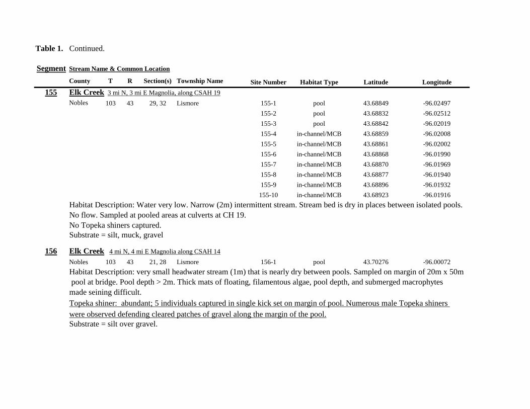
Table 1 Continued
Segment Stream Name amp Common Location
County T R Section(s) Township Name Site Number Habitat Type Latitude Longitude
155 Elk Creek 3 mi N 3 mi E Magnolia along CSAH 19
Nobles 103 43 29 32 Lismore 155-1 pool 4368849 -9602497
155-2 pool 4368832 -9602512
155-3 pool 4368842 -9602019
155-4 in-channelMCB 4368859 -9602008
155-5 in-channelMCB 4368861 -9602002
155-6 in-channelMCB 4368868 -9601990
155-7 in-channelMCB 4368870 -9601969
155-8 in-channelMCB 4368877 -9601940
155-9 in-channelMCB 4368896 -9601932
155-10 in-channelMCB 4368923 -9601916
Habitat Description Water very low Narrow (2m) intermittent stream Stream bed is dry in places between isolated pools
No flow Sampled at pooled areas at culverts at CH 19
No Topeka shiners captured
Substrate = silt muck gravel
156 Elk Creek 4 mi N 4 mi E Magnolia along CSAH 14
Nobles 103 43 21 28 Lismore 156-1 pool 4370276 -9600072
Habitat Description very small headwater stream (1m) that is nearly dry between pools Sampled on margin of 20m x 50m
pool at bridge Pool depth gt 2m Thick mats of floating filamentous algae pool depth and submerged macrophytes
made seining difficult
Topeka shiner abundant 5 individuals captured in single kick set on margin of pool Numerous male Topeka shiners were observed defending cleared patches of gravel along the margin of the pool Substrate = silt over gravel
Table 1 Continued
Segment Stream Name amp Common Location
County T R Section(s) Township Name Site Number Habitat Type Latitude Longitude
157 Kanaranzi Creek 15 mi E 2 mi S Lismore
Nobles 103 42 17 19 20 Larkin 157-1 pool 4371762 -9591115
157-2 pool 4371757 -9591102
157-3 pool 4371753 -9591108
157-4 pool 4371755 -9591112
157-5 pool 4371785 -9591112
157-6 pool 4371786 -9591115
157-7 pool 4371793 -9591111
157-8 in-channelMCB 4371818 -9591105
157-9 in-channelMCB 4371820 -9591097
157-10 in-channelMCB 4371829 -9591093
157-11 in-channelMCB 4371835 -9591097
157-12 in-channelMCB 4371785 -9591100
Habitat Description Stream has been ditchedchannelized High banks and no OCH is present except for a pooled area upstream of a beaver dam that is S of the bridge No Topeka shiners captured Substrate = silt muck sand
Table 1 Continued
Segment Stream Name amp Common Location
County T R Section(s) Township Name Site Number Habitat Type Latitude Longitude
158 Kanaranzi Creek 2 mi E 35 mi S Magnolia
Nobles 102 43 31 32 Westside 158-1 pool 4359742 -9603359
158-2 pool 4359741 -9603408
158-3 in-channelMCB 4359686 -9603499
158-4 in-channelMCB 4359660 -9603513
158-5 in-channelMCB 4359620 -9603518
158-6 pool 4359584 -9603554
158-7 in-channelMCB 4359590 -9603589
158-8 in-channelMCB 4359600 -9603617
158-9 in-channelMCB 4359555 -9603658
158-10 in-channelMCB 4359527 -9603683
158-11 in-channelMCB 4359463 -9603681
158-12 in-channelMCB 4359454 -9603681
158-13 in-channelMCB 4359416 -9603690
158-14 in-channelMCB 4359399 -9603722
158-15 in-channelMCB 4359383 -9603735
Habitat Description 4m wide slowly flowing stream Sampled backwater and off-channel habitats along MCB and side channels Hard gravelsand substrate in channel Ample low-flow habitat along sandgravel bars No Topeka shiners captured Substrate = sand gravel silt
Table 1 Continued
Segment Stream Name amp Common Location
County T R Section(s) Township Name Site Number Habitat Type Latitude Longitude
159 Kanaranzi Creek 1 mi NW Adrian along CSAH 35
Nobles 102 43 13 Westside 159-1 pool 4364453 -9595165
159-2 pool 4364481 -9595166
159-3 pool 4364479 -9595182
159-4 pool 4364461 -9595195
159-5 in-channelMCB 4364438 -9595194
159-6 in-channelMCB 4364427 -9595224
159-7 in-channelMCB 4364406 -9595307
159-8 in-channelMCB 4364407 -9595333
159-9 in-channelMCB 4364401 -9595360
159-10 pool 4364448 -9595347
159-11 in-channelMCB 4364467 -9595077
159-12 in-channelMCB 4364500 -9594982
Habitat Description Flowing 7m wide stream Abundant backwaters pools and OCH along MCB
Topeka shiner present a single individual captured in a side channel over gravelsand mix after much effort
Substrate = gravel sand silt
Table 1 Contined
Segment Stream Name amp Common Location
County T R Section(s) Township Name Site Number Habitat Type Latitude Longitude
160 Little Rock River 1 mi E 4 mi S Rushmore
Nobles 101 41 16 17 Ransom 160-1 in-channelMCB 4355809 -9577372
160-2 in-channelMCB 4355819 -9577356
160-3 in-channelMCB 4355826 -9577324
160-4 in-channelMCB 4355820 -9577237
160-5 in-channelMCB 4355819 -9577193
160-6 in-channelMCB 4355824 -9577181
160-7 in-channelMCB 4355803 -9577151
160-8 in-channelMCB 4355800 -9577123
160-9 in-channelMCB 4355810 -9577124
160-10 in-channelMCB 4355827 -9577099
160-11 in-channelMCB 4355803 -9576997
160-12 in-channelMCB 4355766 -9576964
160-13 in-channelMCB 4355763 -9576986
160-14 in-channelMCB 4355706 -9576972
160-15 in-channelMCB 4355811 -9577403
160-16 in-channelMCB 4355798 -9577529
160-17 in-channelMCB 4355760 -9577529
160-18 in-channelMCB 4355759 -9577500
160-19 in-channelMCB 4355736 -9577556
Table 1 Site 160 Continued Table 1 Concluded
Segment Stream Name amp Common Location
County T R Section(s) Township Name Site Number Habitat Type Latitude Longitude
160 Little Rock River 1 mi E 4 mi S Rushmore
160-20 in-channelMCB 4355748 -9577608
160-21 in-channelMCB 4355752 -9577642
160-22 in-channelMCB 4355689 -9577684
160-23 in-channelMCB 4355681 -9577736
160-24 in-channelMCB 4355642 -9577828
160-25 in-channelMCB 4355622 -9577895
Habitat Description Slowly flowing 3m wide stream with high steep banks Little or no OCH Portions of this stream
appear to have been ditched and rip-rapped
No Topeka shiners captured
Substrate = gravel sand muck
Table 2 Locations of the twenty stream Segments (sites 161-180) sampled in 2013 corresponding sampling sites within
each segment and a brief habitat description for each site from which Topeka shiners were collected Included
are a Common Location descriptor (approximate mileage amp direction to nearest townhighways) the
TownshipRange for the 20 Segments and UTM coordinates for each sampling site Habitat type is an aproximate
characterization of the specific sample site within the sample reach pooled areas along the stream channel (pool)
low-flow reaches of stream and backwater habitats along the main channel boundary (in-channelMCB) ponds
adjacent to the sample reach that are not connected to the main channel of the stream (pool off-channel)
Segment Stream Name amp Common Location
County T R Section(s) Township Name Site Number Habitat Type Latitude Longitude
161 Medary Creek 7 mi W Lake Benson
Lincoln 109 46 7 Verdi 161-1 in-channelMCB 4425807000 -9642702300
161-2 in-channelMCB 4425815900 -9642724800
161-3 in-channelMCB 4425836800 -9642739100
161-4 in-channelMCB 4425898800 -9642738400
161-5 in-channelMCB 4425902800 -9642724500
161-6 in-channelMCB 4425904800 -9642721000
161-7 in-channelMCB 4425924400 -9642696700
161-8 in-channelMCB 4425928300 -9642687800
161-9 in-channelMCB 4425931400 -9642670400
161-10 in-channelMCB 4425936800 -9642650600
161-11 in-channelMCB 4425928700 -9642638400
161-12 in-channelMCB 4425969600 -9642576100
161-13 pool 4426041100 -9642542500
161-14 in-channelMCB 4426093000 -9642681600
161-15 in-channelMCB 4426018800 -9642819900
Habitat Description narrow (2m) flowing headwater stream beaver dams along sample reach
Topeka shiner present nine Topeka shiners captured in a flowing pool downstream of a beaver dam
Thousands of fish downstream of dam and almost none in the upstream sites 1-14
Substrate = cobble gravel silt
Table 2 Continued
Segment Stream Name amp Common Location
County T R Section(s) Township Name Site Number Habitat Type Latitude Longitude
162 Willow Creek 13 mi W Ruthton
Pipestone 108 46 4 29 Altona 162-1 in-channelMCB 4418795200 -9636967900
162-2 in-channelMCB 4418776900 -9636978700
162-3 in-channelMCB 4418554500 -9637231900
162-4 pool 4418587700 -9637323700
162-5 pool 4418588600 -9637353100
162-6 pool 4418597900 -9637352800
162-7 pool 4418617800 -9637343500
162-8 pool 4418608500 -9637352600
162-9 pool 4418659800 -9637532400
162-10 pool 4418647400 -9637460200
Habitat Description very narrow (1m) headwater stream slow flow large pool (sites 4-8) appears to be an excavated pond
metal debris and fencing material made seining difficult Seined pooled areas in cattail beds
No Topeka shiners captured Substrate = sand gravel silt
Table 2 Continued
Segment Stream Name amp Common Location
County T R Section(s) Township Name Site Number Habitat Type Latitude Longitude
163 Flandreau Creek 4 mi N 5 mi W Holland
Pipestone 108 46 29 Altona 163-1 pool 4412550100 -9639615400
163-2 pool 4412552400 -9639616700
163-3 pool 4412550000 -9639640600
163-4 in-channelMCB 4412625200 -9639662400
163-5 in-channelMCB 4412595100 -9639579900
163-6 in-channelMCB 4412681700 -9639517200
163-7 pool 4412703400 -9639517600
163-8 pool 4412761900 -9639631000
163-9 pool 4412764600 -9639631600
163-10 pool 4412782600 -9639590000
163-11 pool 4412754600 -9639531600
163-12 pool 4412762600 -9639632100
163-13 in-channelMCB 4413017900 -9639591600
163-14 in-channelMCB 4413084800 -9639438100
163-15 pool 4412573500 -9639553100
Habitat Description 3m wide flowing stream Channel appears to have been ditched most of plotted reach is dry Seined in heavily vegetated stagnant pools No Topeka shiners captured Substrate = firm sand gravel in-channel deep silt along MCB
Table 2 Continued
Segment Stream Name amp Common Location
County T R Section(s) Township Name Site Number Habitat Type Latitude Longitude
164 Flandreau Creek 65 mi W 55 mi N Pipestone
Pipestone 107 47 13 14 Troy 164-1 pool 4408042400 -9644734000
164-2 pool 4408043100 -9644720500
164-3 pool 4408042200 -9644708000
164-4 pool 4407996200 -9644910500
164-5 in-channelMCB 4407938200 -9644906400
164-6 in-channelMCB 4407760400 -9644847500
164-7 in-channelMCB 4407796600 -9644913300
164-8 in-channelMCB 4407806300 -9644950500
164-9 in-channelMCB 4407797700 -9644981100
164-10 in-channelMCB 4407809800 -9644991500
164-11 pool 4408029200 -9645104800
Habitat Description flowing 3-5m wide stream with firm gravel substrate in thalweg Sampled pooled area at bridge
some off-channel habitat at sites 4 and 11 Banks are steep along most of the reach with little slackwater habitat along MCB
No Topeka shiners captured
Substrate = gravel sand cobble in-channel Deep silt in low-flow areas
Table 2 Continued
Segment Stream Name amp Common Location
County T R Section(s) Township Name Site Number Habitat Type Latitude Longitude
165 North Branch Pipestone Creek 4 mi W 3 mi N Pipestone
Pipestone 107 46 29 Troy 165-1 pool 4404501300 -9639278100
165-2 pool 4404481000 -9639316800
165-3 pool 4404472800 -9639315500
165-4 in-channelMCB 4404457500 -9639325200
165-5 in-channelMCB 4404434800 -9639340300
165-6 in-channelMCB 4404446400 -9639386900
165-7 in-channelMCB 4404320300 -9639371300
165-8 pool 4404299200 -9639403700
165-9 pool 4404302200 -9639429200
165-10 pool 4404289200 -9639430300
165-11 pool 4404283700 -9639418700
165-12 in-channelMCB 4404212300 -9639411800
165-13 in-channelMCB 4404195800 -9639463400
165-14 in-channelMCB 4404244400 -9639645200
165-15 in-channelMCB 4404163700 -9639819800
165-16 in-channelMCB 4404165900 -9639797900
Habitat Description moderately flowing 3-5m wide stream Recent increase in stream level some submerged terrestrial
grasses along MCB Sites 8-11 in oxbow Submerged terrestrial grasses in oxbow
No Topeka shiners captured
Substrate = sand gravel silt
Table 2 Continued
Segment Stream Name amp Common Location
County T R Section(s) Township Name Site Number Habitat Type Latitude Longitude
166 Pipestone Creek 35 mi W 1 mi N Pipestone
Pipestone 106 46 4 5 Sweet 166-1 in-channelMCB 4401330100 -9638708400
166-2 in-channelMCB 4401347000 -9638709700
166-3 in-channelMCB 4401345500 -9638703700
166-4 in-channelMCB 4401355800 -9638703000
166-5 in-channelMCB 4401541200 -9638596400
166-6 in-channelMCB 4401618700 -9638658000
166-7 in-channelMCB 4401623400 -9638660800
166-8 in-channelMCB 4401625200 -9638646200
166-9 in-channelMCB 4401633300 -9638635600
166-10 in-channelMCB 4401740500 -9638517300
Habitat Description 10m wide slowly flowing stream Sampled along MCB in slack water West end of segment appears
to have been ditched Littleno OCH Drainage tiles along E reach of segment
No Topeka shiners captured
Substrate = cobble gravel sand Deep silt along margins of pools
Table 2 Continued
Segment Stream Name amp Common Location
County T R Section(s) Township Name Site Number Habitat Type Latitude Longitude
167 Split Rock Creek 15 mi N 1 mi E Ihlen
Pipestone 105 46 3 Eden 167-1 pool 4392585400 -9634993300
167-2 in-channelMCB 4392638100 -9635031600
167-3 pool 4392643100 -9635103600
167-4 pool 4392638200 -9635101900
167-5 pool 4392633000 -9635108800
167-6 pool 4392633200 -9635116400
167-7 pool 4392635700 -9635131600
167-8 pool 4392636400 -9635139100
167-9 pool 4392635900 -9635156000
167-10 in-channelMCB 4392470900 -9635255600
167-11 in-channelMCB 4392465600 -9635242800
167-12 in-channelMCB 4392447500 -9635240300
Habitat Description very small headwater stream (~1m) water low isolated series of pools along streambed No Topeka shiners captured Substrate = sand gravel silt
168 Split Rock Creek 15 mi N 05 mi E Jasper
Pipestone 105 46 28 29 Eden 168-1 in-channelMCB 4387771400 -9638026400
Habitat Description high water 4m wide flowing stream submerged terrestrial grasses on margins
Topeka shiner common 6 individuals captured on first seine haul in pooled area at MCB just downstream of culvert
Substrate = boulder cobble sand
Table 2 Continued
Segment Stream Name amp Common Location
County T R Section(s) Township Name Site Number Habitat Type Latitude Longitude
169 Rock River 1 mi SW of Edgerton
Pipestone 105 44 17 18 Osborne 169-1 pool 4389371700 -9616564700
169-2 in-channelMCB 4389439900 -9616531800
Habitat Description Swiftly flowing 10m wide stream at high water Sampled pooled area at outside bend of stream
over deep silt
Topeka shiner present four individuals captured in four seine hauls in a 1m wide drainage channel that joins a
retention pond to the Rock River
Substrate = Silt gravel Deep silt in off-channel areaspools
170 Chanarambie Creek 05 mi S 05 mi E Chandler
Murray 104 47 35 Fenton 170-1 in-channelMCB 4392093400 -9593156600
170-2 in-channelMCB 4391890200 -9593079300
170-3 in-channelMCB 4391841400 -9593168100
170-4 in-channelMCB 4391784300 -9593090300
170-5 in-channelMCB 4391783100 -9593060700
170-6 in-channelMCB 4391790600 -9593061100
170-7 in-channelMCB 4391796700 -9593025000
170-8 in-channelMCB 4391792000 -9592982800
170-9 in-channelMCB 4392105300 -9593062100
170-10 in-channelMCB 4392122900 -9593165100
Habitat Description narrow (1-2m) headwater stream Stream is flowing swiftly and little or no OCH is present
most of the segment appears to have been channelized
No Topeka shiners captured
Substrate = silt sand
Table 2 Continued
Segment Stream Name amp Common Location
County T R Section(s) Township Name Site Number Habitat Type Latitude Longitude
171 Rock River 4 mi S Edgerton
Rock 104 44 8 9 Battle Plain 171-1 in-channelMCB 4382021200 -9613013100
171-2 pool 4382126400 -9613470300
171-3 in-channelMCB 4382025300 -9612974300
171-4 in-channelMCB 4382027100 -9612961600
171-5 in-channelMCB 4382145400 -9613302800
171-6 in-channelMCB 4382380700 -9613520900
171-7 in-channelMCB 4382367500 -9613527700
171-8 in-channelMCB 4382359000 -9613532400
171-9 in-channelMCB 4382405300 -9613495400
171-10 in-channelMCB 4382271200 -9613570400
Habitat Description High water 8-12m wide swiftly flowing stream Stream is full to high banks Much of slackwater
areas along MCB likely inudndated Sampled in backwaters sites 6-9
No Topeka shiners captured
Substrate = Sand gravel silt
Table 2 Continued
Segment Stream Name amp Common Location
County T R Section(s) Township Name Site Number Habitat Type Latitude Longitude
172 Rock River tributary 1 mi E Hardwick
Rock 104 44 30 31 Battle Plain 172-1 pool 4377538900 -9617075500
172-2 pool 4377529200 -9617075600
172-3 pool 4377514700 -9617079800
172-4 in-channelMCB 4377386200 -9617079600
172-5 in-channelMCB 4377247100 -9617207900
172-6 in-channelMCB 4377241900 -9617224500
172-7 in-channelMCB 4377245200 -9617219500
172-8 in-channelMCB 4376956400 -9616914600
172-9 pool off-channel 4376998700 -9616876000
172-10 in-channelMCB 4377058800 -9616855700
172-11 in-channelMCB 4377043200 -9616826600
Habitat Description 3m wide slowly flowing pasture stream with high trampled banks Much of reach appears to
have been channelized no OCH present along MCBSampled in stock pond at site 9 Some submerged macrophytes
No Topeka shiners captured
Substrate = sand silt muck
Table 2 Continued
Segment Stream Name amp Common Location
County T R Section(s) Township Name Site Number Habitat Type Latitude Longitude
173 Mound Creek 1 mi N 175 mi E Beaver Creek
Rock 103 45 2 11 Mound 173-1 in-channelMCB 4374749900 -9620089200
173-2 in-channelMCB 4374756900 -9620094400
173-3 in-channelMCB 4374763700 -9620090700
173-4 in-channelMCB 4374842800 -9619838100
173-5 in-channelMCB 4374844000 -9619833200
173-6 in-channelMCB 4374889800 -9619789300
173-7 in-channelMCB 4374839600 -9619885800
173-8 in-channelMCB 4374827900 -9619934500
173-9 in-channelMCB 4374817000 -9619966400
173-10 in-channelMCB 4374799700 -9620048400
Habitat Description Entire reach of sement has been channelized Stream is 1-2m wide and constantly flowing High
banks No OCH
No Topeka shiners captured
Substrate = gravel sand silt
Table 2 Continued
Segment Stream Name amp Common Location
County T R Section(s) Township Name Site Number Habitat Type Latitude Longitude
174 Rock River tributary 55 mi N 4 mi E Luverne
Rock 103 44 8 9 Vienna 174-1 pool 4373333900 -9613250300
174-2 pool 4373322100 -9613262700
Habitat Description Narrow (2-3m) wide flowing headwater stream Sampled in deep silted pool at bridge Topeka shiner present two individuals captured over gravel in pooled area at bridge Much of the pool is filled with deep (gt05m) silt No Topeka shiners collected in silted portion of pool Substrate = gravel sand silt
Table 2 Continued
Segment Stream Name amp Common Location
County T R Section(s) Township Name Site Number Habitat Type Latitude Longitude
175 Champepadan Creek 4mi N 5 mi E Luverne
Rock 103 44 21 22 Vienna 175-1 pool 4371002900 -9611238300
175-2 pool 4371001900 -9611232600
175-3 pool 4371008300 -9611238900
175-4 in-channelMCB 4370955000 -9611142300
175-5 in-channelMCB 4371042200 -9610763900
175-6 in-channelMCB 4371007000 -9610720000
175-7 in-channelMCB 4370984100 -9610706400
175-8 pooloff-channel 4370971600 -9610709700
Habitat Description 3m wide stream with moderate flow Native prairie has been planted along both banks for the entire reach
No flow Sampled at pooled areas at culverts at CH 19
Topeka shiner present one individual captured in deep livestock pond S of stream Depth (gt2m) made seining in pond difficult
Substrate = sand silt gravel
Table 2 Continued
Segment Stream Name amp Common Location
County T R Section(s) Township Name Site Number Habitat Type Latitude Longitude
176 Kanaranzi Creek 2 mi W 35 mi N Ellworth
Rock 101 44 12 Kanaranzi 176-1 pool 4357304000 -9606413600
176-2 pool 4357305400 -9606410500
176-3 pool 4357249700 -9606408600
176-4 in-channelMCB 4357200500 -9606350300
176-5 in-channelMCB 4357204500 -9606354600
176-6 in-channelMCB 4357211400 -9606360400
176-7 in-channelMCB 4357127700 -9606357500
176-8 in-channelMCB 4357090500 -9606197900
176-9 in-channelMCB 4356817400 -9606275000
176-10 in-channelMCB 4356807000 -9606273900
176-11 in-channelMCB 4356639200 -9606408000
176-12 in-channelMCB 4356632100 -9606416000
176-13 in-channelMCB 4356598300 -9606381200
Habitat Description 10m wide flowing stream Very little OCH Very deep silt along MCB Sampled pooled area
at bridge High eroded banks
No Topeka shiners captured
Substrate = silt over gravel
Table 2 Continued
Segment Stream Name amp Common Location
County T R Section(s) Township Name Site Number Habitat Type Latitude Longitude
177 Rock River 05 mi N 4 mi E Steen
Rock 101 45 25 Clinton 177-1 pool 4352588900 -9618721100
177-2 pool 4352592700 -9618726600
177-3 in-channelMCB 4352519900 -9618594900
177-4 in-channelMCB 4352297500 -9618558400
177-5 in-channelMCB 4352147800 -9618456000
177-6 in-channelMCB 4352143300 -9618458200
177-7 in-channelMCB 4352125000 -9618453100
177-8 in-channelMCB 4352121500 -9618442200
177-9 in-channelMCB 4352106600 -9618444000
177-10 in-channelMCB 4352727900 -9618684800
177-11 pool 4352783000 -9618770800
177-12 pooloff-channel 4352663200 -9619046500
Habitat Description 11m wide flowing stream with wide channel sand bars and some braiding Firm gravel in thalweg Oxbow in middle of reach is nearly dry (lt25 cm) No fish observed culicid fly larvae abundant No Topeka shiners captured Substrate = sand gravel silt
Table 2 Continued
Segment Stream Name amp Common Location
County T R Section(s) Township Name Site Number Habitat Type Latitude Longitude
178 Kanaranzi Creek 2 mi W Ellsworth
Rock 101 44 25 36 Kanaranzi 178-1 pool 4351441400 -9605867000
178-2 in-channelMCB 4351404500 -9605846000
178-3 in-channelMCB 4351378800 -9605844300
178-4 pool 4351349700 -9605841200
178-5 pool 4351358400 -9605829800
178-6 pool 4351351800 -9605816800
178-7 in-channelMCB 4351355800 -9605866900
178-8 in-channelMCB 4351549000 -9605823700
178-9 in-channelMCB 4351891800 -9605895600
178-10 in-channelMCB 4351866200 -9605881400
178-11 pool 4352078500 -9606070000
178-12 pool 4352046000 -9606082200
Habitat Description 7-9m wide flowing stream Sampled backwater and off-channel habitats along MCB and side channels Recent high flow has filled in off-channel areas with deep silt Seining difficult No Topeka shiners captured Substrate = sand silt gravel
Table 2 Concluded
Segment Stream Name amp Common Location
County T R Section(s) Township Name Site Number Habitat Type Latitude Longitude
179 East Branch Kanaranzi Creek 15 mi N 15 mi E Adrian
Nobles 102 42 8 Olney 179-1 pool 4365932900 -9590462700
179-2 pool 4365928900 -9590449500
179-3 pool 4365930600 -9590463300
179-4 pool 4365908000 -9590420300
179-5 in-channelMCB 4365679800 -9590378600
179-6 in-channelMCB 4365661000 -9590387800
179-7 in-channelMCB 4365604000 -9590417100
179-8 in-channelMCB 4365508100 -9590385200
179-9 in-channelMCB 4365460100 -9590342200
179-10 pool 4365434900 -9590020100
179-11 in-channelMCB 4365507700 -9590154900
179-12 in-channelMCB 4365588000 -9589900200
Habitat Description Flowing 9m wide stream Stream is full to high banks very little slackwater habitat present at this site
No Topeka shiners captured
Substrate = sand silt gravel
180 Little Rock River 8 mi E Ellsworth
Nobles 101 42 26 Little Rock 180-1 in-channelMCB 4352838500 -9584615900
Habitat Description Sampled large pooled area at bridge no discernible flow silt over gravel substrate Channel downstream
of pool is a 2-3 m wide flowing stream with a firm sandgravel substrate
Topeka shiner abundant fourteen individuals captured in first seine haul in pool fifteen individuals captured in second seine
haul near outlet of the pool
Substrate = gravel sand silt
Table 3 Complete List of Fish Species Captured at Segments 141-160 2012
Species 141 142 143 144 145 146 147 148 149 150 151 152 153 154 155 156 157 158 159 160 Campostoma anomalum X X X X X X X X X X X X X X Chrosomus erythrogaster X X Cyprinella lutrensis X X X X X X X X X Cyprinus carpio X X X X X Hybognathus hankinsoni X X X X X X X Luxilus cornutus X X X X X X X X X X X X X Notropis dorsalis X X X X X X X X X X X Notropis stramineus X X X X X X X X X X X X X X X Notropis topeka X X X X X X X X Pimephales notatus X X X X X X X X X X X X Pimephales promelas X X X X X X X X X X X X X X X X X X Rhinichthys atratulus X X X X X X Semotilus atromaculatus X X X X X X X X X X X X X X X X X X Carpiodes cyprinus X Carpiodes sp (YOY) X X X Catostomus commersoni X X X X X X X X X X X X X X X Moxostoma macrolepidotum X X Ameiurus melas X X X X X X X X X X X X X Ameiurus natalis X Ictalurus punctatus X X X X Noturus flavus X X X X Noturus gyrinus X X X X X Esox lucius X X Percopsis omiscomaycus X Fundulus sciadicus X X X Culaea inconstans X X X X X Lepomis cyanellus X X X X X X X Lepomis humilis X X X X X X X X X X X Lepomis macrochirus X X X X X Micropterus dolomieui X Micropterus salmoides X X Pomoxis nigromaculatus X X Etheostoma exile X X X X X Etheostoma nigrum X X X X X X X X X X X X X X X X X Perca flavescens X X Percina maculata X X X X
Table 4 Complete List of Fish Species Captured at Segments 161-180 2013
Species 161 162 163 164 165 166 167 168 169 170 171 172 173 174 175 176 177 178 179 180
Campostoma anomalum X X X X X X X X X X X X X X
Cyprinella lutrensis X X X X X X X X X X
Cyprinus carpio X X X
Hybognathus hankinsoni X X X X X
Luxilus cornutus X X X X X X X X X X X X X
Notropis dorsalis X X X X X X X X X X X X X X
Notropis stramineus X X X X X X X X X X X X X X
Notropis topeka X X X X X X
Pimephales notatus X X X X X X X X X X X X
Pimephales promelas X X X X X X X X X X X X X X X X X X
Rhinichthys atratulus X X X X X X X X X X X
Semotilus atromaculatus X X X X X X X X X X X X X X X X
Carpiodes cyprinus X X
Catostomus commersoni X X X X X X X X X X X X X
Moxostoma erythrurum X X X
Moxostoma macrolepidotum X X
Ameiurus melas X X X X X X X X X X
Noturus flavus X X X
Esox lucius X X
Percopsis omiscomaycus X
Fundulus sciadicus X
Culaea inconstans X X X X
Lepomis cyanellus X X X X X X
Lepomis humilis X X X X X X X X X
Etheostoma exile X X
Etheostoma nigrum X X X X X X X X X X
Percina maculata X X
Appendix C- Habitat and Voucher Photographs
Habitat photographs for segments in which no Topeka shiners were captured are representative
of the habitat along the one-mile reach of stream Habitat photographs from segments where
Topeka shiners were present represent the specific site where they were collected Voucher
photographs are presented for each of the sites were Topeka shiners were collected
Site 141-2 Medary Creek voucher and habitat photos
Segment 142 Willow Creek no Topeka shiners captured
Segment 143 East Branch Flandrau Creek no Topeka shiners captured
Segment 144 North Branch Pipestone Creek no Topeka shiners captured
Site 145-6 Pipestone Creek voucher photo
Site 145-6 Pipestone Creek habitat photo
Segment 146 Split Rock Creek no Topeka shiners captured No habitat photo
Segment 147 Kanaranzi Creek no Topeka shiners captured
Site 148-4 Rock River voucher and habitat photos
Site 149-4 Rock River voucher and habitat photos
Site 150-4 Split Rock Creek voucher and habitat photos
Site 151-1 Beaver Creek voucher and habitat photos
Segment 152 Beaver Creek no Topeka shiners captured
Segment 153 Beaver Creek no Topeka shiners captured
Segment 154 Rock River no Topeka shiners captured
Segment 155 Elk Creek no Topeka shiners captured
Site 156-1 Elk Creek voucher and habitat photos
Segment 157 Kanaranzi Creek no Topeka shiners captured
Segment 158 Kanaranzi Creek no Topeka shiners captured
Site 159-1 Kanaranzi Creek voucher and habitat photos
Segment 160 Little Rock River no Topeka shiners captured
Site 161-15 Medary Creek voucher photo
Site 161-15 Medary Creek habitat photo
Segment 162 Willow Creek no Topeka shiners captured No habitat photo
Segment 163 Flandrau Creek no Topeka shiners captured
Segment 164 Flandrau Creek no Topeka shiners captured
Segment 165 North Branch Pipestone Creek no Topeka Shiners captured
Segment 166 Pipestone Creek no Topeka Shiners captured
Segment 167 Tributary to Split Rock Creek no Topeka Shiners captured No habitat
photo
Site 168-1 Split Rock Creek voucher photo
Site 168-1 Split Rock Creek habitat photo
Site 169-2 Rock River voucher photo
Site 169-2 Rock River habitat photo
Segment 170 Chanarambie Creek no Topeka shiners captured
Segment 171 Rock River no Topeka shiners captured
Segment 172 Tributary to Rock River no Topeka shiners captured
Segment 173 Blue Mound Creek no Topeka shiners
Site 174-2 Tributary to Rock River voucher photo
Site 174-2 Tributary to Rock River habitat photo
Site 175-8 Champepadan Creek voucher photo
Site 175-8 Champepadan Creek habitat photo
Segment 176 Kanaranzi Creek no Topekas captured
Segment 177 Rock River no Topeka shiners captured
Segment 178 Kanaranzi Creek no Topeka shiners captured
Segment 179 East Branch Kanaranzi Creek no Topeka shiners captured
Site 180-1 West Branch Little Rock River voucher photo
Site 180-1 West Branch Little Rock River habitat photo
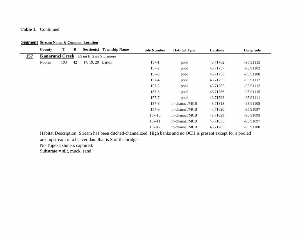
Table 1 Continued
Segment Stream Name amp Common Location
County T R Section(s) Township Name Site Number Habitat Type Latitude Longitude
157 Kanaranzi Creek 15 mi E 2 mi S Lismore
Nobles 103 42 17 19 20 Larkin 157-1 pool 4371762 -9591115
157-2 pool 4371757 -9591102
157-3 pool 4371753 -9591108
157-4 pool 4371755 -9591112
157-5 pool 4371785 -9591112
157-6 pool 4371786 -9591115
157-7 pool 4371793 -9591111
157-8 in-channelMCB 4371818 -9591105
157-9 in-channelMCB 4371820 -9591097
157-10 in-channelMCB 4371829 -9591093
157-11 in-channelMCB 4371835 -9591097
157-12 in-channelMCB 4371785 -9591100
Habitat Description Stream has been ditchedchannelized High banks and no OCH is present except for a pooled area upstream of a beaver dam that is S of the bridge No Topeka shiners captured Substrate = silt muck sand
Table 1 Continued
Segment Stream Name amp Common Location
County T R Section(s) Township Name Site Number Habitat Type Latitude Longitude
158 Kanaranzi Creek 2 mi E 35 mi S Magnolia
Nobles 102 43 31 32 Westside 158-1 pool 4359742 -9603359
158-2 pool 4359741 -9603408
158-3 in-channelMCB 4359686 -9603499
158-4 in-channelMCB 4359660 -9603513
158-5 in-channelMCB 4359620 -9603518
158-6 pool 4359584 -9603554
158-7 in-channelMCB 4359590 -9603589
158-8 in-channelMCB 4359600 -9603617
158-9 in-channelMCB 4359555 -9603658
158-10 in-channelMCB 4359527 -9603683
158-11 in-channelMCB 4359463 -9603681
158-12 in-channelMCB 4359454 -9603681
158-13 in-channelMCB 4359416 -9603690
158-14 in-channelMCB 4359399 -9603722
158-15 in-channelMCB 4359383 -9603735
Habitat Description 4m wide slowly flowing stream Sampled backwater and off-channel habitats along MCB and side channels Hard gravelsand substrate in channel Ample low-flow habitat along sandgravel bars No Topeka shiners captured Substrate = sand gravel silt
Table 1 Continued
Segment Stream Name amp Common Location
County T R Section(s) Township Name Site Number Habitat Type Latitude Longitude
159 Kanaranzi Creek 1 mi NW Adrian along CSAH 35
Nobles 102 43 13 Westside 159-1 pool 4364453 -9595165
159-2 pool 4364481 -9595166
159-3 pool 4364479 -9595182
159-4 pool 4364461 -9595195
159-5 in-channelMCB 4364438 -9595194
159-6 in-channelMCB 4364427 -9595224
159-7 in-channelMCB 4364406 -9595307
159-8 in-channelMCB 4364407 -9595333
159-9 in-channelMCB 4364401 -9595360
159-10 pool 4364448 -9595347
159-11 in-channelMCB 4364467 -9595077
159-12 in-channelMCB 4364500 -9594982
Habitat Description Flowing 7m wide stream Abundant backwaters pools and OCH along MCB
Topeka shiner present a single individual captured in a side channel over gravelsand mix after much effort
Substrate = gravel sand silt
Table 1 Contined
Segment Stream Name amp Common Location
County T R Section(s) Township Name Site Number Habitat Type Latitude Longitude
160 Little Rock River 1 mi E 4 mi S Rushmore
Nobles 101 41 16 17 Ransom 160-1 in-channelMCB 4355809 -9577372
160-2 in-channelMCB 4355819 -9577356
160-3 in-channelMCB 4355826 -9577324
160-4 in-channelMCB 4355820 -9577237
160-5 in-channelMCB 4355819 -9577193
160-6 in-channelMCB 4355824 -9577181
160-7 in-channelMCB 4355803 -9577151
160-8 in-channelMCB 4355800 -9577123
160-9 in-channelMCB 4355810 -9577124
160-10 in-channelMCB 4355827 -9577099
160-11 in-channelMCB 4355803 -9576997
160-12 in-channelMCB 4355766 -9576964
160-13 in-channelMCB 4355763 -9576986
160-14 in-channelMCB 4355706 -9576972
160-15 in-channelMCB 4355811 -9577403
160-16 in-channelMCB 4355798 -9577529
160-17 in-channelMCB 4355760 -9577529
160-18 in-channelMCB 4355759 -9577500
160-19 in-channelMCB 4355736 -9577556
Table 1 Site 160 Continued Table 1 Concluded
Segment Stream Name amp Common Location
County T R Section(s) Township Name Site Number Habitat Type Latitude Longitude
160 Little Rock River 1 mi E 4 mi S Rushmore
160-20 in-channelMCB 4355748 -9577608
160-21 in-channelMCB 4355752 -9577642
160-22 in-channelMCB 4355689 -9577684
160-23 in-channelMCB 4355681 -9577736
160-24 in-channelMCB 4355642 -9577828
160-25 in-channelMCB 4355622 -9577895
Habitat Description Slowly flowing 3m wide stream with high steep banks Little or no OCH Portions of this stream
appear to have been ditched and rip-rapped
No Topeka shiners captured
Substrate = gravel sand muck
Table 2 Locations of the twenty stream Segments (sites 161-180) sampled in 2013 corresponding sampling sites within
each segment and a brief habitat description for each site from which Topeka shiners were collected Included
are a Common Location descriptor (approximate mileage amp direction to nearest townhighways) the
TownshipRange for the 20 Segments and UTM coordinates for each sampling site Habitat type is an aproximate
characterization of the specific sample site within the sample reach pooled areas along the stream channel (pool)
low-flow reaches of stream and backwater habitats along the main channel boundary (in-channelMCB) ponds
adjacent to the sample reach that are not connected to the main channel of the stream (pool off-channel)
Segment Stream Name amp Common Location
County T R Section(s) Township Name Site Number Habitat Type Latitude Longitude
161 Medary Creek 7 mi W Lake Benson
Lincoln 109 46 7 Verdi 161-1 in-channelMCB 4425807000 -9642702300
161-2 in-channelMCB 4425815900 -9642724800
161-3 in-channelMCB 4425836800 -9642739100
161-4 in-channelMCB 4425898800 -9642738400
161-5 in-channelMCB 4425902800 -9642724500
161-6 in-channelMCB 4425904800 -9642721000
161-7 in-channelMCB 4425924400 -9642696700
161-8 in-channelMCB 4425928300 -9642687800
161-9 in-channelMCB 4425931400 -9642670400
161-10 in-channelMCB 4425936800 -9642650600
161-11 in-channelMCB 4425928700 -9642638400
161-12 in-channelMCB 4425969600 -9642576100
161-13 pool 4426041100 -9642542500
161-14 in-channelMCB 4426093000 -9642681600
161-15 in-channelMCB 4426018800 -9642819900
Habitat Description narrow (2m) flowing headwater stream beaver dams along sample reach
Topeka shiner present nine Topeka shiners captured in a flowing pool downstream of a beaver dam
Thousands of fish downstream of dam and almost none in the upstream sites 1-14
Substrate = cobble gravel silt
Table 2 Continued
Segment Stream Name amp Common Location
County T R Section(s) Township Name Site Number Habitat Type Latitude Longitude
162 Willow Creek 13 mi W Ruthton
Pipestone 108 46 4 29 Altona 162-1 in-channelMCB 4418795200 -9636967900
162-2 in-channelMCB 4418776900 -9636978700
162-3 in-channelMCB 4418554500 -9637231900
162-4 pool 4418587700 -9637323700
162-5 pool 4418588600 -9637353100
162-6 pool 4418597900 -9637352800
162-7 pool 4418617800 -9637343500
162-8 pool 4418608500 -9637352600
162-9 pool 4418659800 -9637532400
162-10 pool 4418647400 -9637460200
Habitat Description very narrow (1m) headwater stream slow flow large pool (sites 4-8) appears to be an excavated pond
metal debris and fencing material made seining difficult Seined pooled areas in cattail beds
No Topeka shiners captured Substrate = sand gravel silt
Table 2 Continued
Segment Stream Name amp Common Location
County T R Section(s) Township Name Site Number Habitat Type Latitude Longitude
163 Flandreau Creek 4 mi N 5 mi W Holland
Pipestone 108 46 29 Altona 163-1 pool 4412550100 -9639615400
163-2 pool 4412552400 -9639616700
163-3 pool 4412550000 -9639640600
163-4 in-channelMCB 4412625200 -9639662400
163-5 in-channelMCB 4412595100 -9639579900
163-6 in-channelMCB 4412681700 -9639517200
163-7 pool 4412703400 -9639517600
163-8 pool 4412761900 -9639631000
163-9 pool 4412764600 -9639631600
163-10 pool 4412782600 -9639590000
163-11 pool 4412754600 -9639531600
163-12 pool 4412762600 -9639632100
163-13 in-channelMCB 4413017900 -9639591600
163-14 in-channelMCB 4413084800 -9639438100
163-15 pool 4412573500 -9639553100
Habitat Description 3m wide flowing stream Channel appears to have been ditched most of plotted reach is dry Seined in heavily vegetated stagnant pools No Topeka shiners captured Substrate = firm sand gravel in-channel deep silt along MCB
Table 2 Continued
Segment Stream Name amp Common Location
County T R Section(s) Township Name Site Number Habitat Type Latitude Longitude
164 Flandreau Creek 65 mi W 55 mi N Pipestone
Pipestone 107 47 13 14 Troy 164-1 pool 4408042400 -9644734000
164-2 pool 4408043100 -9644720500
164-3 pool 4408042200 -9644708000
164-4 pool 4407996200 -9644910500
164-5 in-channelMCB 4407938200 -9644906400
164-6 in-channelMCB 4407760400 -9644847500
164-7 in-channelMCB 4407796600 -9644913300
164-8 in-channelMCB 4407806300 -9644950500
164-9 in-channelMCB 4407797700 -9644981100
164-10 in-channelMCB 4407809800 -9644991500
164-11 pool 4408029200 -9645104800
Habitat Description flowing 3-5m wide stream with firm gravel substrate in thalweg Sampled pooled area at bridge
some off-channel habitat at sites 4 and 11 Banks are steep along most of the reach with little slackwater habitat along MCB
No Topeka shiners captured
Substrate = gravel sand cobble in-channel Deep silt in low-flow areas
Table 2 Continued
Segment Stream Name amp Common Location
County T R Section(s) Township Name Site Number Habitat Type Latitude Longitude
165 North Branch Pipestone Creek 4 mi W 3 mi N Pipestone
Pipestone 107 46 29 Troy 165-1 pool 4404501300 -9639278100
165-2 pool 4404481000 -9639316800
165-3 pool 4404472800 -9639315500
165-4 in-channelMCB 4404457500 -9639325200
165-5 in-channelMCB 4404434800 -9639340300
165-6 in-channelMCB 4404446400 -9639386900
165-7 in-channelMCB 4404320300 -9639371300
165-8 pool 4404299200 -9639403700
165-9 pool 4404302200 -9639429200
165-10 pool 4404289200 -9639430300
165-11 pool 4404283700 -9639418700
165-12 in-channelMCB 4404212300 -9639411800
165-13 in-channelMCB 4404195800 -9639463400
165-14 in-channelMCB 4404244400 -9639645200
165-15 in-channelMCB 4404163700 -9639819800
165-16 in-channelMCB 4404165900 -9639797900
Habitat Description moderately flowing 3-5m wide stream Recent increase in stream level some submerged terrestrial
grasses along MCB Sites 8-11 in oxbow Submerged terrestrial grasses in oxbow
No Topeka shiners captured
Substrate = sand gravel silt
Table 2 Continued
Segment Stream Name amp Common Location
County T R Section(s) Township Name Site Number Habitat Type Latitude Longitude
166 Pipestone Creek 35 mi W 1 mi N Pipestone
Pipestone 106 46 4 5 Sweet 166-1 in-channelMCB 4401330100 -9638708400
166-2 in-channelMCB 4401347000 -9638709700
166-3 in-channelMCB 4401345500 -9638703700
166-4 in-channelMCB 4401355800 -9638703000
166-5 in-channelMCB 4401541200 -9638596400
166-6 in-channelMCB 4401618700 -9638658000
166-7 in-channelMCB 4401623400 -9638660800
166-8 in-channelMCB 4401625200 -9638646200
166-9 in-channelMCB 4401633300 -9638635600
166-10 in-channelMCB 4401740500 -9638517300
Habitat Description 10m wide slowly flowing stream Sampled along MCB in slack water West end of segment appears
to have been ditched Littleno OCH Drainage tiles along E reach of segment
No Topeka shiners captured
Substrate = cobble gravel sand Deep silt along margins of pools
Table 2 Continued
Segment Stream Name amp Common Location
County T R Section(s) Township Name Site Number Habitat Type Latitude Longitude
167 Split Rock Creek 15 mi N 1 mi E Ihlen
Pipestone 105 46 3 Eden 167-1 pool 4392585400 -9634993300
167-2 in-channelMCB 4392638100 -9635031600
167-3 pool 4392643100 -9635103600
167-4 pool 4392638200 -9635101900
167-5 pool 4392633000 -9635108800
167-6 pool 4392633200 -9635116400
167-7 pool 4392635700 -9635131600
167-8 pool 4392636400 -9635139100
167-9 pool 4392635900 -9635156000
167-10 in-channelMCB 4392470900 -9635255600
167-11 in-channelMCB 4392465600 -9635242800
167-12 in-channelMCB 4392447500 -9635240300
Habitat Description very small headwater stream (~1m) water low isolated series of pools along streambed No Topeka shiners captured Substrate = sand gravel silt
168 Split Rock Creek 15 mi N 05 mi E Jasper
Pipestone 105 46 28 29 Eden 168-1 in-channelMCB 4387771400 -9638026400
Habitat Description high water 4m wide flowing stream submerged terrestrial grasses on margins
Topeka shiner common 6 individuals captured on first seine haul in pooled area at MCB just downstream of culvert
Substrate = boulder cobble sand
Table 2 Continued
Segment Stream Name amp Common Location
County T R Section(s) Township Name Site Number Habitat Type Latitude Longitude
169 Rock River 1 mi SW of Edgerton
Pipestone 105 44 17 18 Osborne 169-1 pool 4389371700 -9616564700
169-2 in-channelMCB 4389439900 -9616531800
Habitat Description Swiftly flowing 10m wide stream at high water Sampled pooled area at outside bend of stream
over deep silt
Topeka shiner present four individuals captured in four seine hauls in a 1m wide drainage channel that joins a
retention pond to the Rock River
Substrate = Silt gravel Deep silt in off-channel areaspools
170 Chanarambie Creek 05 mi S 05 mi E Chandler
Murray 104 47 35 Fenton 170-1 in-channelMCB 4392093400 -9593156600
170-2 in-channelMCB 4391890200 -9593079300
170-3 in-channelMCB 4391841400 -9593168100
170-4 in-channelMCB 4391784300 -9593090300
170-5 in-channelMCB 4391783100 -9593060700
170-6 in-channelMCB 4391790600 -9593061100
170-7 in-channelMCB 4391796700 -9593025000
170-8 in-channelMCB 4391792000 -9592982800
170-9 in-channelMCB 4392105300 -9593062100
170-10 in-channelMCB 4392122900 -9593165100
Habitat Description narrow (1-2m) headwater stream Stream is flowing swiftly and little or no OCH is present
most of the segment appears to have been channelized
No Topeka shiners captured
Substrate = silt sand
Table 2 Continued
Segment Stream Name amp Common Location
County T R Section(s) Township Name Site Number Habitat Type Latitude Longitude
171 Rock River 4 mi S Edgerton
Rock 104 44 8 9 Battle Plain 171-1 in-channelMCB 4382021200 -9613013100
171-2 pool 4382126400 -9613470300
171-3 in-channelMCB 4382025300 -9612974300
171-4 in-channelMCB 4382027100 -9612961600
171-5 in-channelMCB 4382145400 -9613302800
171-6 in-channelMCB 4382380700 -9613520900
171-7 in-channelMCB 4382367500 -9613527700
171-8 in-channelMCB 4382359000 -9613532400
171-9 in-channelMCB 4382405300 -9613495400
171-10 in-channelMCB 4382271200 -9613570400
Habitat Description High water 8-12m wide swiftly flowing stream Stream is full to high banks Much of slackwater
areas along MCB likely inudndated Sampled in backwaters sites 6-9
No Topeka shiners captured
Substrate = Sand gravel silt
Table 2 Continued
Segment Stream Name amp Common Location
County T R Section(s) Township Name Site Number Habitat Type Latitude Longitude
172 Rock River tributary 1 mi E Hardwick
Rock 104 44 30 31 Battle Plain 172-1 pool 4377538900 -9617075500
172-2 pool 4377529200 -9617075600
172-3 pool 4377514700 -9617079800
172-4 in-channelMCB 4377386200 -9617079600
172-5 in-channelMCB 4377247100 -9617207900
172-6 in-channelMCB 4377241900 -9617224500
172-7 in-channelMCB 4377245200 -9617219500
172-8 in-channelMCB 4376956400 -9616914600
172-9 pool off-channel 4376998700 -9616876000
172-10 in-channelMCB 4377058800 -9616855700
172-11 in-channelMCB 4377043200 -9616826600
Habitat Description 3m wide slowly flowing pasture stream with high trampled banks Much of reach appears to
have been channelized no OCH present along MCBSampled in stock pond at site 9 Some submerged macrophytes
No Topeka shiners captured
Substrate = sand silt muck
Table 2 Continued
Segment Stream Name amp Common Location
County T R Section(s) Township Name Site Number Habitat Type Latitude Longitude
173 Mound Creek 1 mi N 175 mi E Beaver Creek
Rock 103 45 2 11 Mound 173-1 in-channelMCB 4374749900 -9620089200
173-2 in-channelMCB 4374756900 -9620094400
173-3 in-channelMCB 4374763700 -9620090700
173-4 in-channelMCB 4374842800 -9619838100
173-5 in-channelMCB 4374844000 -9619833200
173-6 in-channelMCB 4374889800 -9619789300
173-7 in-channelMCB 4374839600 -9619885800
173-8 in-channelMCB 4374827900 -9619934500
173-9 in-channelMCB 4374817000 -9619966400
173-10 in-channelMCB 4374799700 -9620048400
Habitat Description Entire reach of sement has been channelized Stream is 1-2m wide and constantly flowing High
banks No OCH
No Topeka shiners captured
Substrate = gravel sand silt
Table 2 Continued
Segment Stream Name amp Common Location
County T R Section(s) Township Name Site Number Habitat Type Latitude Longitude
174 Rock River tributary 55 mi N 4 mi E Luverne
Rock 103 44 8 9 Vienna 174-1 pool 4373333900 -9613250300
174-2 pool 4373322100 -9613262700
Habitat Description Narrow (2-3m) wide flowing headwater stream Sampled in deep silted pool at bridge Topeka shiner present two individuals captured over gravel in pooled area at bridge Much of the pool is filled with deep (gt05m) silt No Topeka shiners collected in silted portion of pool Substrate = gravel sand silt
Table 2 Continued
Segment Stream Name amp Common Location
County T R Section(s) Township Name Site Number Habitat Type Latitude Longitude
175 Champepadan Creek 4mi N 5 mi E Luverne
Rock 103 44 21 22 Vienna 175-1 pool 4371002900 -9611238300
175-2 pool 4371001900 -9611232600
175-3 pool 4371008300 -9611238900
175-4 in-channelMCB 4370955000 -9611142300
175-5 in-channelMCB 4371042200 -9610763900
175-6 in-channelMCB 4371007000 -9610720000
175-7 in-channelMCB 4370984100 -9610706400
175-8 pooloff-channel 4370971600 -9610709700
Habitat Description 3m wide stream with moderate flow Native prairie has been planted along both banks for the entire reach
No flow Sampled at pooled areas at culverts at CH 19
Topeka shiner present one individual captured in deep livestock pond S of stream Depth (gt2m) made seining in pond difficult
Substrate = sand silt gravel
Table 2 Continued
Segment Stream Name amp Common Location
County T R Section(s) Township Name Site Number Habitat Type Latitude Longitude
176 Kanaranzi Creek 2 mi W 35 mi N Ellworth
Rock 101 44 12 Kanaranzi 176-1 pool 4357304000 -9606413600
176-2 pool 4357305400 -9606410500
176-3 pool 4357249700 -9606408600
176-4 in-channelMCB 4357200500 -9606350300
176-5 in-channelMCB 4357204500 -9606354600
176-6 in-channelMCB 4357211400 -9606360400
176-7 in-channelMCB 4357127700 -9606357500
176-8 in-channelMCB 4357090500 -9606197900
176-9 in-channelMCB 4356817400 -9606275000
176-10 in-channelMCB 4356807000 -9606273900
176-11 in-channelMCB 4356639200 -9606408000
176-12 in-channelMCB 4356632100 -9606416000
176-13 in-channelMCB 4356598300 -9606381200
Habitat Description 10m wide flowing stream Very little OCH Very deep silt along MCB Sampled pooled area
at bridge High eroded banks
No Topeka shiners captured
Substrate = silt over gravel
Table 2 Continued
Segment Stream Name amp Common Location
County T R Section(s) Township Name Site Number Habitat Type Latitude Longitude
177 Rock River 05 mi N 4 mi E Steen
Rock 101 45 25 Clinton 177-1 pool 4352588900 -9618721100
177-2 pool 4352592700 -9618726600
177-3 in-channelMCB 4352519900 -9618594900
177-4 in-channelMCB 4352297500 -9618558400
177-5 in-channelMCB 4352147800 -9618456000
177-6 in-channelMCB 4352143300 -9618458200
177-7 in-channelMCB 4352125000 -9618453100
177-8 in-channelMCB 4352121500 -9618442200
177-9 in-channelMCB 4352106600 -9618444000
177-10 in-channelMCB 4352727900 -9618684800
177-11 pool 4352783000 -9618770800
177-12 pooloff-channel 4352663200 -9619046500
Habitat Description 11m wide flowing stream with wide channel sand bars and some braiding Firm gravel in thalweg Oxbow in middle of reach is nearly dry (lt25 cm) No fish observed culicid fly larvae abundant No Topeka shiners captured Substrate = sand gravel silt
Table 2 Continued
Segment Stream Name amp Common Location
County T R Section(s) Township Name Site Number Habitat Type Latitude Longitude
178 Kanaranzi Creek 2 mi W Ellsworth
Rock 101 44 25 36 Kanaranzi 178-1 pool 4351441400 -9605867000
178-2 in-channelMCB 4351404500 -9605846000
178-3 in-channelMCB 4351378800 -9605844300
178-4 pool 4351349700 -9605841200
178-5 pool 4351358400 -9605829800
178-6 pool 4351351800 -9605816800
178-7 in-channelMCB 4351355800 -9605866900
178-8 in-channelMCB 4351549000 -9605823700
178-9 in-channelMCB 4351891800 -9605895600
178-10 in-channelMCB 4351866200 -9605881400
178-11 pool 4352078500 -9606070000
178-12 pool 4352046000 -9606082200
Habitat Description 7-9m wide flowing stream Sampled backwater and off-channel habitats along MCB and side channels Recent high flow has filled in off-channel areas with deep silt Seining difficult No Topeka shiners captured Substrate = sand silt gravel
Table 2 Concluded
Segment Stream Name amp Common Location
County T R Section(s) Township Name Site Number Habitat Type Latitude Longitude
179 East Branch Kanaranzi Creek 15 mi N 15 mi E Adrian
Nobles 102 42 8 Olney 179-1 pool 4365932900 -9590462700
179-2 pool 4365928900 -9590449500
179-3 pool 4365930600 -9590463300
179-4 pool 4365908000 -9590420300
179-5 in-channelMCB 4365679800 -9590378600
179-6 in-channelMCB 4365661000 -9590387800
179-7 in-channelMCB 4365604000 -9590417100
179-8 in-channelMCB 4365508100 -9590385200
179-9 in-channelMCB 4365460100 -9590342200
179-10 pool 4365434900 -9590020100
179-11 in-channelMCB 4365507700 -9590154900
179-12 in-channelMCB 4365588000 -9589900200
Habitat Description Flowing 9m wide stream Stream is full to high banks very little slackwater habitat present at this site
No Topeka shiners captured
Substrate = sand silt gravel
180 Little Rock River 8 mi E Ellsworth
Nobles 101 42 26 Little Rock 180-1 in-channelMCB 4352838500 -9584615900
Habitat Description Sampled large pooled area at bridge no discernible flow silt over gravel substrate Channel downstream
of pool is a 2-3 m wide flowing stream with a firm sandgravel substrate
Topeka shiner abundant fourteen individuals captured in first seine haul in pool fifteen individuals captured in second seine
haul near outlet of the pool
Substrate = gravel sand silt
Table 3 Complete List of Fish Species Captured at Segments 141-160 2012
Species 141 142 143 144 145 146 147 148 149 150 151 152 153 154 155 156 157 158 159 160 Campostoma anomalum X X X X X X X X X X X X X X Chrosomus erythrogaster X X Cyprinella lutrensis X X X X X X X X X Cyprinus carpio X X X X X Hybognathus hankinsoni X X X X X X X Luxilus cornutus X X X X X X X X X X X X X Notropis dorsalis X X X X X X X X X X X Notropis stramineus X X X X X X X X X X X X X X X Notropis topeka X X X X X X X X Pimephales notatus X X X X X X X X X X X X Pimephales promelas X X X X X X X X X X X X X X X X X X Rhinichthys atratulus X X X X X X Semotilus atromaculatus X X X X X X X X X X X X X X X X X X Carpiodes cyprinus X Carpiodes sp (YOY) X X X Catostomus commersoni X X X X X X X X X X X X X X X Moxostoma macrolepidotum X X Ameiurus melas X X X X X X X X X X X X X Ameiurus natalis X Ictalurus punctatus X X X X Noturus flavus X X X X Noturus gyrinus X X X X X Esox lucius X X Percopsis omiscomaycus X Fundulus sciadicus X X X Culaea inconstans X X X X X Lepomis cyanellus X X X X X X X Lepomis humilis X X X X X X X X X X X Lepomis macrochirus X X X X X Micropterus dolomieui X Micropterus salmoides X X Pomoxis nigromaculatus X X Etheostoma exile X X X X X Etheostoma nigrum X X X X X X X X X X X X X X X X X Perca flavescens X X Percina maculata X X X X
Table 4 Complete List of Fish Species Captured at Segments 161-180 2013
Species 161 162 163 164 165 166 167 168 169 170 171 172 173 174 175 176 177 178 179 180
Campostoma anomalum X X X X X X X X X X X X X X
Cyprinella lutrensis X X X X X X X X X X
Cyprinus carpio X X X
Hybognathus hankinsoni X X X X X
Luxilus cornutus X X X X X X X X X X X X X
Notropis dorsalis X X X X X X X X X X X X X X
Notropis stramineus X X X X X X X X X X X X X X
Notropis topeka X X X X X X
Pimephales notatus X X X X X X X X X X X X
Pimephales promelas X X X X X X X X X X X X X X X X X X
Rhinichthys atratulus X X X X X X X X X X X
Semotilus atromaculatus X X X X X X X X X X X X X X X X
Carpiodes cyprinus X X
Catostomus commersoni X X X X X X X X X X X X X
Moxostoma erythrurum X X X
Moxostoma macrolepidotum X X
Ameiurus melas X X X X X X X X X X
Noturus flavus X X X
Esox lucius X X
Percopsis omiscomaycus X
Fundulus sciadicus X
Culaea inconstans X X X X
Lepomis cyanellus X X X X X X
Lepomis humilis X X X X X X X X X
Etheostoma exile X X
Etheostoma nigrum X X X X X X X X X X
Percina maculata X X
Appendix C- Habitat and Voucher Photographs
Habitat photographs for segments in which no Topeka shiners were captured are representative
of the habitat along the one-mile reach of stream Habitat photographs from segments where
Topeka shiners were present represent the specific site where they were collected Voucher
photographs are presented for each of the sites were Topeka shiners were collected
Site 141-2 Medary Creek voucher and habitat photos
Segment 142 Willow Creek no Topeka shiners captured
Segment 143 East Branch Flandrau Creek no Topeka shiners captured
Segment 144 North Branch Pipestone Creek no Topeka shiners captured
Site 145-6 Pipestone Creek voucher photo
Site 145-6 Pipestone Creek habitat photo
Segment 146 Split Rock Creek no Topeka shiners captured No habitat photo
Segment 147 Kanaranzi Creek no Topeka shiners captured
Site 148-4 Rock River voucher and habitat photos
Site 149-4 Rock River voucher and habitat photos
Site 150-4 Split Rock Creek voucher and habitat photos
Site 151-1 Beaver Creek voucher and habitat photos
Segment 152 Beaver Creek no Topeka shiners captured
Segment 153 Beaver Creek no Topeka shiners captured
Segment 154 Rock River no Topeka shiners captured
Segment 155 Elk Creek no Topeka shiners captured
Site 156-1 Elk Creek voucher and habitat photos
Segment 157 Kanaranzi Creek no Topeka shiners captured
Segment 158 Kanaranzi Creek no Topeka shiners captured
Site 159-1 Kanaranzi Creek voucher and habitat photos
Segment 160 Little Rock River no Topeka shiners captured
Site 161-15 Medary Creek voucher photo
Site 161-15 Medary Creek habitat photo
Segment 162 Willow Creek no Topeka shiners captured No habitat photo
Segment 163 Flandrau Creek no Topeka shiners captured
Segment 164 Flandrau Creek no Topeka shiners captured
Segment 165 North Branch Pipestone Creek no Topeka Shiners captured
Segment 166 Pipestone Creek no Topeka Shiners captured
Segment 167 Tributary to Split Rock Creek no Topeka Shiners captured No habitat
photo
Site 168-1 Split Rock Creek voucher photo
Site 168-1 Split Rock Creek habitat photo
Site 169-2 Rock River voucher photo
Site 169-2 Rock River habitat photo
Segment 170 Chanarambie Creek no Topeka shiners captured
Segment 171 Rock River no Topeka shiners captured
Segment 172 Tributary to Rock River no Topeka shiners captured
Segment 173 Blue Mound Creek no Topeka shiners
Site 174-2 Tributary to Rock River voucher photo
Site 174-2 Tributary to Rock River habitat photo
Site 175-8 Champepadan Creek voucher photo
Site 175-8 Champepadan Creek habitat photo
Segment 176 Kanaranzi Creek no Topekas captured
Segment 177 Rock River no Topeka shiners captured
Segment 178 Kanaranzi Creek no Topeka shiners captured
Segment 179 East Branch Kanaranzi Creek no Topeka shiners captured
Site 180-1 West Branch Little Rock River voucher photo
Site 180-1 West Branch Little Rock River habitat photo
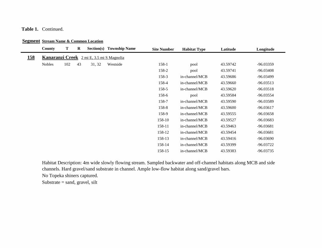
Table 1 Continued
Segment Stream Name amp Common Location
County T R Section(s) Township Name Site Number Habitat Type Latitude Longitude
158 Kanaranzi Creek 2 mi E 35 mi S Magnolia
Nobles 102 43 31 32 Westside 158-1 pool 4359742 -9603359
158-2 pool 4359741 -9603408
158-3 in-channelMCB 4359686 -9603499
158-4 in-channelMCB 4359660 -9603513
158-5 in-channelMCB 4359620 -9603518
158-6 pool 4359584 -9603554
158-7 in-channelMCB 4359590 -9603589
158-8 in-channelMCB 4359600 -9603617
158-9 in-channelMCB 4359555 -9603658
158-10 in-channelMCB 4359527 -9603683
158-11 in-channelMCB 4359463 -9603681
158-12 in-channelMCB 4359454 -9603681
158-13 in-channelMCB 4359416 -9603690
158-14 in-channelMCB 4359399 -9603722
158-15 in-channelMCB 4359383 -9603735
Habitat Description 4m wide slowly flowing stream Sampled backwater and off-channel habitats along MCB and side channels Hard gravelsand substrate in channel Ample low-flow habitat along sandgravel bars No Topeka shiners captured Substrate = sand gravel silt
Table 1 Continued
Segment Stream Name amp Common Location
County T R Section(s) Township Name Site Number Habitat Type Latitude Longitude
159 Kanaranzi Creek 1 mi NW Adrian along CSAH 35
Nobles 102 43 13 Westside 159-1 pool 4364453 -9595165
159-2 pool 4364481 -9595166
159-3 pool 4364479 -9595182
159-4 pool 4364461 -9595195
159-5 in-channelMCB 4364438 -9595194
159-6 in-channelMCB 4364427 -9595224
159-7 in-channelMCB 4364406 -9595307
159-8 in-channelMCB 4364407 -9595333
159-9 in-channelMCB 4364401 -9595360
159-10 pool 4364448 -9595347
159-11 in-channelMCB 4364467 -9595077
159-12 in-channelMCB 4364500 -9594982
Habitat Description Flowing 7m wide stream Abundant backwaters pools and OCH along MCB
Topeka shiner present a single individual captured in a side channel over gravelsand mix after much effort
Substrate = gravel sand silt
Table 1 Contined
Segment Stream Name amp Common Location
County T R Section(s) Township Name Site Number Habitat Type Latitude Longitude
160 Little Rock River 1 mi E 4 mi S Rushmore
Nobles 101 41 16 17 Ransom 160-1 in-channelMCB 4355809 -9577372
160-2 in-channelMCB 4355819 -9577356
160-3 in-channelMCB 4355826 -9577324
160-4 in-channelMCB 4355820 -9577237
160-5 in-channelMCB 4355819 -9577193
160-6 in-channelMCB 4355824 -9577181
160-7 in-channelMCB 4355803 -9577151
160-8 in-channelMCB 4355800 -9577123
160-9 in-channelMCB 4355810 -9577124
160-10 in-channelMCB 4355827 -9577099
160-11 in-channelMCB 4355803 -9576997
160-12 in-channelMCB 4355766 -9576964
160-13 in-channelMCB 4355763 -9576986
160-14 in-channelMCB 4355706 -9576972
160-15 in-channelMCB 4355811 -9577403
160-16 in-channelMCB 4355798 -9577529
160-17 in-channelMCB 4355760 -9577529
160-18 in-channelMCB 4355759 -9577500
160-19 in-channelMCB 4355736 -9577556
Table 1 Site 160 Continued Table 1 Concluded
Segment Stream Name amp Common Location
County T R Section(s) Township Name Site Number Habitat Type Latitude Longitude
160 Little Rock River 1 mi E 4 mi S Rushmore
160-20 in-channelMCB 4355748 -9577608
160-21 in-channelMCB 4355752 -9577642
160-22 in-channelMCB 4355689 -9577684
160-23 in-channelMCB 4355681 -9577736
160-24 in-channelMCB 4355642 -9577828
160-25 in-channelMCB 4355622 -9577895
Habitat Description Slowly flowing 3m wide stream with high steep banks Little or no OCH Portions of this stream
appear to have been ditched and rip-rapped
No Topeka shiners captured
Substrate = gravel sand muck
Table 2 Locations of the twenty stream Segments (sites 161-180) sampled in 2013 corresponding sampling sites within
each segment and a brief habitat description for each site from which Topeka shiners were collected Included
are a Common Location descriptor (approximate mileage amp direction to nearest townhighways) the
TownshipRange for the 20 Segments and UTM coordinates for each sampling site Habitat type is an aproximate
characterization of the specific sample site within the sample reach pooled areas along the stream channel (pool)
low-flow reaches of stream and backwater habitats along the main channel boundary (in-channelMCB) ponds
adjacent to the sample reach that are not connected to the main channel of the stream (pool off-channel)
Segment Stream Name amp Common Location
County T R Section(s) Township Name Site Number Habitat Type Latitude Longitude
161 Medary Creek 7 mi W Lake Benson
Lincoln 109 46 7 Verdi 161-1 in-channelMCB 4425807000 -9642702300
161-2 in-channelMCB 4425815900 -9642724800
161-3 in-channelMCB 4425836800 -9642739100
161-4 in-channelMCB 4425898800 -9642738400
161-5 in-channelMCB 4425902800 -9642724500
161-6 in-channelMCB 4425904800 -9642721000
161-7 in-channelMCB 4425924400 -9642696700
161-8 in-channelMCB 4425928300 -9642687800
161-9 in-channelMCB 4425931400 -9642670400
161-10 in-channelMCB 4425936800 -9642650600
161-11 in-channelMCB 4425928700 -9642638400
161-12 in-channelMCB 4425969600 -9642576100
161-13 pool 4426041100 -9642542500
161-14 in-channelMCB 4426093000 -9642681600
161-15 in-channelMCB 4426018800 -9642819900
Habitat Description narrow (2m) flowing headwater stream beaver dams along sample reach
Topeka shiner present nine Topeka shiners captured in a flowing pool downstream of a beaver dam
Thousands of fish downstream of dam and almost none in the upstream sites 1-14
Substrate = cobble gravel silt
Table 2 Continued
Segment Stream Name amp Common Location
County T R Section(s) Township Name Site Number Habitat Type Latitude Longitude
162 Willow Creek 13 mi W Ruthton
Pipestone 108 46 4 29 Altona 162-1 in-channelMCB 4418795200 -9636967900
162-2 in-channelMCB 4418776900 -9636978700
162-3 in-channelMCB 4418554500 -9637231900
162-4 pool 4418587700 -9637323700
162-5 pool 4418588600 -9637353100
162-6 pool 4418597900 -9637352800
162-7 pool 4418617800 -9637343500
162-8 pool 4418608500 -9637352600
162-9 pool 4418659800 -9637532400
162-10 pool 4418647400 -9637460200
Habitat Description very narrow (1m) headwater stream slow flow large pool (sites 4-8) appears to be an excavated pond
metal debris and fencing material made seining difficult Seined pooled areas in cattail beds
No Topeka shiners captured Substrate = sand gravel silt
Table 2 Continued
Segment Stream Name amp Common Location
County T R Section(s) Township Name Site Number Habitat Type Latitude Longitude
163 Flandreau Creek 4 mi N 5 mi W Holland
Pipestone 108 46 29 Altona 163-1 pool 4412550100 -9639615400
163-2 pool 4412552400 -9639616700
163-3 pool 4412550000 -9639640600
163-4 in-channelMCB 4412625200 -9639662400
163-5 in-channelMCB 4412595100 -9639579900
163-6 in-channelMCB 4412681700 -9639517200
163-7 pool 4412703400 -9639517600
163-8 pool 4412761900 -9639631000
163-9 pool 4412764600 -9639631600
163-10 pool 4412782600 -9639590000
163-11 pool 4412754600 -9639531600
163-12 pool 4412762600 -9639632100
163-13 in-channelMCB 4413017900 -9639591600
163-14 in-channelMCB 4413084800 -9639438100
163-15 pool 4412573500 -9639553100
Habitat Description 3m wide flowing stream Channel appears to have been ditched most of plotted reach is dry Seined in heavily vegetated stagnant pools No Topeka shiners captured Substrate = firm sand gravel in-channel deep silt along MCB
Table 2 Continued
Segment Stream Name amp Common Location
County T R Section(s) Township Name Site Number Habitat Type Latitude Longitude
164 Flandreau Creek 65 mi W 55 mi N Pipestone
Pipestone 107 47 13 14 Troy 164-1 pool 4408042400 -9644734000
164-2 pool 4408043100 -9644720500
164-3 pool 4408042200 -9644708000
164-4 pool 4407996200 -9644910500
164-5 in-channelMCB 4407938200 -9644906400
164-6 in-channelMCB 4407760400 -9644847500
164-7 in-channelMCB 4407796600 -9644913300
164-8 in-channelMCB 4407806300 -9644950500
164-9 in-channelMCB 4407797700 -9644981100
164-10 in-channelMCB 4407809800 -9644991500
164-11 pool 4408029200 -9645104800
Habitat Description flowing 3-5m wide stream with firm gravel substrate in thalweg Sampled pooled area at bridge
some off-channel habitat at sites 4 and 11 Banks are steep along most of the reach with little slackwater habitat along MCB
No Topeka shiners captured
Substrate = gravel sand cobble in-channel Deep silt in low-flow areas
Table 2 Continued
Segment Stream Name amp Common Location
County T R Section(s) Township Name Site Number Habitat Type Latitude Longitude
165 North Branch Pipestone Creek 4 mi W 3 mi N Pipestone
Pipestone 107 46 29 Troy 165-1 pool 4404501300 -9639278100
165-2 pool 4404481000 -9639316800
165-3 pool 4404472800 -9639315500
165-4 in-channelMCB 4404457500 -9639325200
165-5 in-channelMCB 4404434800 -9639340300
165-6 in-channelMCB 4404446400 -9639386900
165-7 in-channelMCB 4404320300 -9639371300
165-8 pool 4404299200 -9639403700
165-9 pool 4404302200 -9639429200
165-10 pool 4404289200 -9639430300
165-11 pool 4404283700 -9639418700
165-12 in-channelMCB 4404212300 -9639411800
165-13 in-channelMCB 4404195800 -9639463400
165-14 in-channelMCB 4404244400 -9639645200
165-15 in-channelMCB 4404163700 -9639819800
165-16 in-channelMCB 4404165900 -9639797900
Habitat Description moderately flowing 3-5m wide stream Recent increase in stream level some submerged terrestrial
grasses along MCB Sites 8-11 in oxbow Submerged terrestrial grasses in oxbow
No Topeka shiners captured
Substrate = sand gravel silt
Table 2 Continued
Segment Stream Name amp Common Location
County T R Section(s) Township Name Site Number Habitat Type Latitude Longitude
166 Pipestone Creek 35 mi W 1 mi N Pipestone
Pipestone 106 46 4 5 Sweet 166-1 in-channelMCB 4401330100 -9638708400
166-2 in-channelMCB 4401347000 -9638709700
166-3 in-channelMCB 4401345500 -9638703700
166-4 in-channelMCB 4401355800 -9638703000
166-5 in-channelMCB 4401541200 -9638596400
166-6 in-channelMCB 4401618700 -9638658000
166-7 in-channelMCB 4401623400 -9638660800
166-8 in-channelMCB 4401625200 -9638646200
166-9 in-channelMCB 4401633300 -9638635600
166-10 in-channelMCB 4401740500 -9638517300
Habitat Description 10m wide slowly flowing stream Sampled along MCB in slack water West end of segment appears
to have been ditched Littleno OCH Drainage tiles along E reach of segment
No Topeka shiners captured
Substrate = cobble gravel sand Deep silt along margins of pools
Table 2 Continued
Segment Stream Name amp Common Location
County T R Section(s) Township Name Site Number Habitat Type Latitude Longitude
167 Split Rock Creek 15 mi N 1 mi E Ihlen
Pipestone 105 46 3 Eden 167-1 pool 4392585400 -9634993300
167-2 in-channelMCB 4392638100 -9635031600
167-3 pool 4392643100 -9635103600
167-4 pool 4392638200 -9635101900
167-5 pool 4392633000 -9635108800
167-6 pool 4392633200 -9635116400
167-7 pool 4392635700 -9635131600
167-8 pool 4392636400 -9635139100
167-9 pool 4392635900 -9635156000
167-10 in-channelMCB 4392470900 -9635255600
167-11 in-channelMCB 4392465600 -9635242800
167-12 in-channelMCB 4392447500 -9635240300
Habitat Description very small headwater stream (~1m) water low isolated series of pools along streambed No Topeka shiners captured Substrate = sand gravel silt
168 Split Rock Creek 15 mi N 05 mi E Jasper
Pipestone 105 46 28 29 Eden 168-1 in-channelMCB 4387771400 -9638026400
Habitat Description high water 4m wide flowing stream submerged terrestrial grasses on margins
Topeka shiner common 6 individuals captured on first seine haul in pooled area at MCB just downstream of culvert
Substrate = boulder cobble sand
Table 2 Continued
Segment Stream Name amp Common Location
County T R Section(s) Township Name Site Number Habitat Type Latitude Longitude
169 Rock River 1 mi SW of Edgerton
Pipestone 105 44 17 18 Osborne 169-1 pool 4389371700 -9616564700
169-2 in-channelMCB 4389439900 -9616531800
Habitat Description Swiftly flowing 10m wide stream at high water Sampled pooled area at outside bend of stream
over deep silt
Topeka shiner present four individuals captured in four seine hauls in a 1m wide drainage channel that joins a
retention pond to the Rock River
Substrate = Silt gravel Deep silt in off-channel areaspools
170 Chanarambie Creek 05 mi S 05 mi E Chandler
Murray 104 47 35 Fenton 170-1 in-channelMCB 4392093400 -9593156600
170-2 in-channelMCB 4391890200 -9593079300
170-3 in-channelMCB 4391841400 -9593168100
170-4 in-channelMCB 4391784300 -9593090300
170-5 in-channelMCB 4391783100 -9593060700
170-6 in-channelMCB 4391790600 -9593061100
170-7 in-channelMCB 4391796700 -9593025000
170-8 in-channelMCB 4391792000 -9592982800
170-9 in-channelMCB 4392105300 -9593062100
170-10 in-channelMCB 4392122900 -9593165100
Habitat Description narrow (1-2m) headwater stream Stream is flowing swiftly and little or no OCH is present
most of the segment appears to have been channelized
No Topeka shiners captured
Substrate = silt sand
Table 2 Continued
Segment Stream Name amp Common Location
County T R Section(s) Township Name Site Number Habitat Type Latitude Longitude
171 Rock River 4 mi S Edgerton
Rock 104 44 8 9 Battle Plain 171-1 in-channelMCB 4382021200 -9613013100
171-2 pool 4382126400 -9613470300
171-3 in-channelMCB 4382025300 -9612974300
171-4 in-channelMCB 4382027100 -9612961600
171-5 in-channelMCB 4382145400 -9613302800
171-6 in-channelMCB 4382380700 -9613520900
171-7 in-channelMCB 4382367500 -9613527700
171-8 in-channelMCB 4382359000 -9613532400
171-9 in-channelMCB 4382405300 -9613495400
171-10 in-channelMCB 4382271200 -9613570400
Habitat Description High water 8-12m wide swiftly flowing stream Stream is full to high banks Much of slackwater
areas along MCB likely inudndated Sampled in backwaters sites 6-9
No Topeka shiners captured
Substrate = Sand gravel silt
Table 2 Continued
Segment Stream Name amp Common Location
County T R Section(s) Township Name Site Number Habitat Type Latitude Longitude
172 Rock River tributary 1 mi E Hardwick
Rock 104 44 30 31 Battle Plain 172-1 pool 4377538900 -9617075500
172-2 pool 4377529200 -9617075600
172-3 pool 4377514700 -9617079800
172-4 in-channelMCB 4377386200 -9617079600
172-5 in-channelMCB 4377247100 -9617207900
172-6 in-channelMCB 4377241900 -9617224500
172-7 in-channelMCB 4377245200 -9617219500
172-8 in-channelMCB 4376956400 -9616914600
172-9 pool off-channel 4376998700 -9616876000
172-10 in-channelMCB 4377058800 -9616855700
172-11 in-channelMCB 4377043200 -9616826600
Habitat Description 3m wide slowly flowing pasture stream with high trampled banks Much of reach appears to
have been channelized no OCH present along MCBSampled in stock pond at site 9 Some submerged macrophytes
No Topeka shiners captured
Substrate = sand silt muck
Table 2 Continued
Segment Stream Name amp Common Location
County T R Section(s) Township Name Site Number Habitat Type Latitude Longitude
173 Mound Creek 1 mi N 175 mi E Beaver Creek
Rock 103 45 2 11 Mound 173-1 in-channelMCB 4374749900 -9620089200
173-2 in-channelMCB 4374756900 -9620094400
173-3 in-channelMCB 4374763700 -9620090700
173-4 in-channelMCB 4374842800 -9619838100
173-5 in-channelMCB 4374844000 -9619833200
173-6 in-channelMCB 4374889800 -9619789300
173-7 in-channelMCB 4374839600 -9619885800
173-8 in-channelMCB 4374827900 -9619934500
173-9 in-channelMCB 4374817000 -9619966400
173-10 in-channelMCB 4374799700 -9620048400
Habitat Description Entire reach of sement has been channelized Stream is 1-2m wide and constantly flowing High
banks No OCH
No Topeka shiners captured
Substrate = gravel sand silt
Table 2 Continued
Segment Stream Name amp Common Location
County T R Section(s) Township Name Site Number Habitat Type Latitude Longitude
174 Rock River tributary 55 mi N 4 mi E Luverne
Rock 103 44 8 9 Vienna 174-1 pool 4373333900 -9613250300
174-2 pool 4373322100 -9613262700
Habitat Description Narrow (2-3m) wide flowing headwater stream Sampled in deep silted pool at bridge Topeka shiner present two individuals captured over gravel in pooled area at bridge Much of the pool is filled with deep (gt05m) silt No Topeka shiners collected in silted portion of pool Substrate = gravel sand silt
Table 2 Continued
Segment Stream Name amp Common Location
County T R Section(s) Township Name Site Number Habitat Type Latitude Longitude
175 Champepadan Creek 4mi N 5 mi E Luverne
Rock 103 44 21 22 Vienna 175-1 pool 4371002900 -9611238300
175-2 pool 4371001900 -9611232600
175-3 pool 4371008300 -9611238900
175-4 in-channelMCB 4370955000 -9611142300
175-5 in-channelMCB 4371042200 -9610763900
175-6 in-channelMCB 4371007000 -9610720000
175-7 in-channelMCB 4370984100 -9610706400
175-8 pooloff-channel 4370971600 -9610709700
Habitat Description 3m wide stream with moderate flow Native prairie has been planted along both banks for the entire reach
No flow Sampled at pooled areas at culverts at CH 19
Topeka shiner present one individual captured in deep livestock pond S of stream Depth (gt2m) made seining in pond difficult
Substrate = sand silt gravel
Table 2 Continued
Segment Stream Name amp Common Location
County T R Section(s) Township Name Site Number Habitat Type Latitude Longitude
176 Kanaranzi Creek 2 mi W 35 mi N Ellworth
Rock 101 44 12 Kanaranzi 176-1 pool 4357304000 -9606413600
176-2 pool 4357305400 -9606410500
176-3 pool 4357249700 -9606408600
176-4 in-channelMCB 4357200500 -9606350300
176-5 in-channelMCB 4357204500 -9606354600
176-6 in-channelMCB 4357211400 -9606360400
176-7 in-channelMCB 4357127700 -9606357500
176-8 in-channelMCB 4357090500 -9606197900
176-9 in-channelMCB 4356817400 -9606275000
176-10 in-channelMCB 4356807000 -9606273900
176-11 in-channelMCB 4356639200 -9606408000
176-12 in-channelMCB 4356632100 -9606416000
176-13 in-channelMCB 4356598300 -9606381200
Habitat Description 10m wide flowing stream Very little OCH Very deep silt along MCB Sampled pooled area
at bridge High eroded banks
No Topeka shiners captured
Substrate = silt over gravel
Table 2 Continued
Segment Stream Name amp Common Location
County T R Section(s) Township Name Site Number Habitat Type Latitude Longitude
177 Rock River 05 mi N 4 mi E Steen
Rock 101 45 25 Clinton 177-1 pool 4352588900 -9618721100
177-2 pool 4352592700 -9618726600
177-3 in-channelMCB 4352519900 -9618594900
177-4 in-channelMCB 4352297500 -9618558400
177-5 in-channelMCB 4352147800 -9618456000
177-6 in-channelMCB 4352143300 -9618458200
177-7 in-channelMCB 4352125000 -9618453100
177-8 in-channelMCB 4352121500 -9618442200
177-9 in-channelMCB 4352106600 -9618444000
177-10 in-channelMCB 4352727900 -9618684800
177-11 pool 4352783000 -9618770800
177-12 pooloff-channel 4352663200 -9619046500
Habitat Description 11m wide flowing stream with wide channel sand bars and some braiding Firm gravel in thalweg Oxbow in middle of reach is nearly dry (lt25 cm) No fish observed culicid fly larvae abundant No Topeka shiners captured Substrate = sand gravel silt
Table 2 Continued
Segment Stream Name amp Common Location
County T R Section(s) Township Name Site Number Habitat Type Latitude Longitude
178 Kanaranzi Creek 2 mi W Ellsworth
Rock 101 44 25 36 Kanaranzi 178-1 pool 4351441400 -9605867000
178-2 in-channelMCB 4351404500 -9605846000
178-3 in-channelMCB 4351378800 -9605844300
178-4 pool 4351349700 -9605841200
178-5 pool 4351358400 -9605829800
178-6 pool 4351351800 -9605816800
178-7 in-channelMCB 4351355800 -9605866900
178-8 in-channelMCB 4351549000 -9605823700
178-9 in-channelMCB 4351891800 -9605895600
178-10 in-channelMCB 4351866200 -9605881400
178-11 pool 4352078500 -9606070000
178-12 pool 4352046000 -9606082200
Habitat Description 7-9m wide flowing stream Sampled backwater and off-channel habitats along MCB and side channels Recent high flow has filled in off-channel areas with deep silt Seining difficult No Topeka shiners captured Substrate = sand silt gravel
Table 2 Concluded
Segment Stream Name amp Common Location
County T R Section(s) Township Name Site Number Habitat Type Latitude Longitude
179 East Branch Kanaranzi Creek 15 mi N 15 mi E Adrian
Nobles 102 42 8 Olney 179-1 pool 4365932900 -9590462700
179-2 pool 4365928900 -9590449500
179-3 pool 4365930600 -9590463300
179-4 pool 4365908000 -9590420300
179-5 in-channelMCB 4365679800 -9590378600
179-6 in-channelMCB 4365661000 -9590387800
179-7 in-channelMCB 4365604000 -9590417100
179-8 in-channelMCB 4365508100 -9590385200
179-9 in-channelMCB 4365460100 -9590342200
179-10 pool 4365434900 -9590020100
179-11 in-channelMCB 4365507700 -9590154900
179-12 in-channelMCB 4365588000 -9589900200
Habitat Description Flowing 9m wide stream Stream is full to high banks very little slackwater habitat present at this site
No Topeka shiners captured
Substrate = sand silt gravel
180 Little Rock River 8 mi E Ellsworth
Nobles 101 42 26 Little Rock 180-1 in-channelMCB 4352838500 -9584615900
Habitat Description Sampled large pooled area at bridge no discernible flow silt over gravel substrate Channel downstream
of pool is a 2-3 m wide flowing stream with a firm sandgravel substrate
Topeka shiner abundant fourteen individuals captured in first seine haul in pool fifteen individuals captured in second seine
haul near outlet of the pool
Substrate = gravel sand silt
Table 3 Complete List of Fish Species Captured at Segments 141-160 2012
Species 141 142 143 144 145 146 147 148 149 150 151 152 153 154 155 156 157 158 159 160 Campostoma anomalum X X X X X X X X X X X X X X Chrosomus erythrogaster X X Cyprinella lutrensis X X X X X X X X X Cyprinus carpio X X X X X Hybognathus hankinsoni X X X X X X X Luxilus cornutus X X X X X X X X X X X X X Notropis dorsalis X X X X X X X X X X X Notropis stramineus X X X X X X X X X X X X X X X Notropis topeka X X X X X X X X Pimephales notatus X X X X X X X X X X X X Pimephales promelas X X X X X X X X X X X X X X X X X X Rhinichthys atratulus X X X X X X Semotilus atromaculatus X X X X X X X X X X X X X X X X X X Carpiodes cyprinus X Carpiodes sp (YOY) X X X Catostomus commersoni X X X X X X X X X X X X X X X Moxostoma macrolepidotum X X Ameiurus melas X X X X X X X X X X X X X Ameiurus natalis X Ictalurus punctatus X X X X Noturus flavus X X X X Noturus gyrinus X X X X X Esox lucius X X Percopsis omiscomaycus X Fundulus sciadicus X X X Culaea inconstans X X X X X Lepomis cyanellus X X X X X X X Lepomis humilis X X X X X X X X X X X Lepomis macrochirus X X X X X Micropterus dolomieui X Micropterus salmoides X X Pomoxis nigromaculatus X X Etheostoma exile X X X X X Etheostoma nigrum X X X X X X X X X X X X X X X X X Perca flavescens X X Percina maculata X X X X
Table 4 Complete List of Fish Species Captured at Segments 161-180 2013
Species 161 162 163 164 165 166 167 168 169 170 171 172 173 174 175 176 177 178 179 180
Campostoma anomalum X X X X X X X X X X X X X X
Cyprinella lutrensis X X X X X X X X X X
Cyprinus carpio X X X
Hybognathus hankinsoni X X X X X
Luxilus cornutus X X X X X X X X X X X X X
Notropis dorsalis X X X X X X X X X X X X X X
Notropis stramineus X X X X X X X X X X X X X X
Notropis topeka X X X X X X
Pimephales notatus X X X X X X X X X X X X
Pimephales promelas X X X X X X X X X X X X X X X X X X
Rhinichthys atratulus X X X X X X X X X X X
Semotilus atromaculatus X X X X X X X X X X X X X X X X
Carpiodes cyprinus X X
Catostomus commersoni X X X X X X X X X X X X X
Moxostoma erythrurum X X X
Moxostoma macrolepidotum X X
Ameiurus melas X X X X X X X X X X
Noturus flavus X X X
Esox lucius X X
Percopsis omiscomaycus X
Fundulus sciadicus X
Culaea inconstans X X X X
Lepomis cyanellus X X X X X X
Lepomis humilis X X X X X X X X X
Etheostoma exile X X
Etheostoma nigrum X X X X X X X X X X
Percina maculata X X
Appendix C- Habitat and Voucher Photographs
Habitat photographs for segments in which no Topeka shiners were captured are representative
of the habitat along the one-mile reach of stream Habitat photographs from segments where
Topeka shiners were present represent the specific site where they were collected Voucher
photographs are presented for each of the sites were Topeka shiners were collected
Site 141-2 Medary Creek voucher and habitat photos
Segment 142 Willow Creek no Topeka shiners captured
Segment 143 East Branch Flandrau Creek no Topeka shiners captured
Segment 144 North Branch Pipestone Creek no Topeka shiners captured
Site 145-6 Pipestone Creek voucher photo
Site 145-6 Pipestone Creek habitat photo
Segment 146 Split Rock Creek no Topeka shiners captured No habitat photo
Segment 147 Kanaranzi Creek no Topeka shiners captured
Site 148-4 Rock River voucher and habitat photos
Site 149-4 Rock River voucher and habitat photos
Site 150-4 Split Rock Creek voucher and habitat photos
Site 151-1 Beaver Creek voucher and habitat photos
Segment 152 Beaver Creek no Topeka shiners captured
Segment 153 Beaver Creek no Topeka shiners captured
Segment 154 Rock River no Topeka shiners captured
Segment 155 Elk Creek no Topeka shiners captured
Site 156-1 Elk Creek voucher and habitat photos
Segment 157 Kanaranzi Creek no Topeka shiners captured
Segment 158 Kanaranzi Creek no Topeka shiners captured
Site 159-1 Kanaranzi Creek voucher and habitat photos
Segment 160 Little Rock River no Topeka shiners captured
Site 161-15 Medary Creek voucher photo
Site 161-15 Medary Creek habitat photo
Segment 162 Willow Creek no Topeka shiners captured No habitat photo
Segment 163 Flandrau Creek no Topeka shiners captured
Segment 164 Flandrau Creek no Topeka shiners captured
Segment 165 North Branch Pipestone Creek no Topeka Shiners captured
Segment 166 Pipestone Creek no Topeka Shiners captured
Segment 167 Tributary to Split Rock Creek no Topeka Shiners captured No habitat
photo
Site 168-1 Split Rock Creek voucher photo
Site 168-1 Split Rock Creek habitat photo
Site 169-2 Rock River voucher photo
Site 169-2 Rock River habitat photo
Segment 170 Chanarambie Creek no Topeka shiners captured
Segment 171 Rock River no Topeka shiners captured
Segment 172 Tributary to Rock River no Topeka shiners captured
Segment 173 Blue Mound Creek no Topeka shiners
Site 174-2 Tributary to Rock River voucher photo
Site 174-2 Tributary to Rock River habitat photo
Site 175-8 Champepadan Creek voucher photo
Site 175-8 Champepadan Creek habitat photo
Segment 176 Kanaranzi Creek no Topekas captured
Segment 177 Rock River no Topeka shiners captured
Segment 178 Kanaranzi Creek no Topeka shiners captured
Segment 179 East Branch Kanaranzi Creek no Topeka shiners captured
Site 180-1 West Branch Little Rock River voucher photo
Site 180-1 West Branch Little Rock River habitat photo
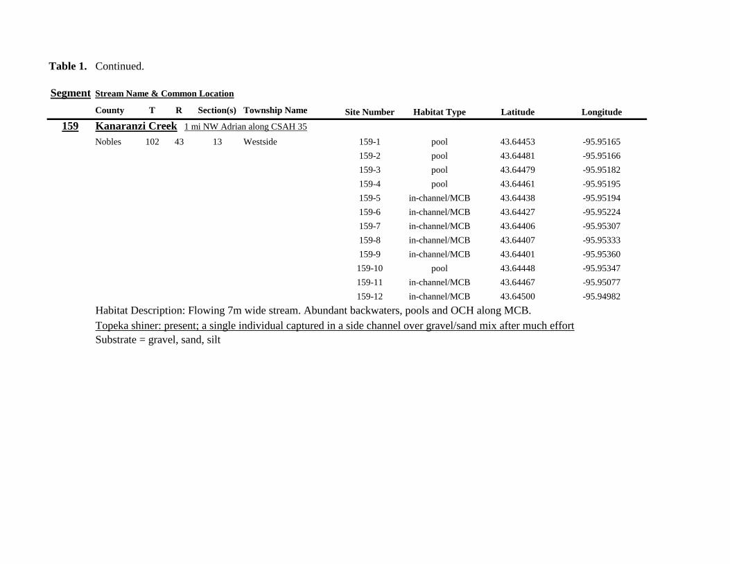
Table 1 Continued
Segment Stream Name amp Common Location
County T R Section(s) Township Name Site Number Habitat Type Latitude Longitude
159 Kanaranzi Creek 1 mi NW Adrian along CSAH 35
Nobles 102 43 13 Westside 159-1 pool 4364453 -9595165
159-2 pool 4364481 -9595166
159-3 pool 4364479 -9595182
159-4 pool 4364461 -9595195
159-5 in-channelMCB 4364438 -9595194
159-6 in-channelMCB 4364427 -9595224
159-7 in-channelMCB 4364406 -9595307
159-8 in-channelMCB 4364407 -9595333
159-9 in-channelMCB 4364401 -9595360
159-10 pool 4364448 -9595347
159-11 in-channelMCB 4364467 -9595077
159-12 in-channelMCB 4364500 -9594982
Habitat Description Flowing 7m wide stream Abundant backwaters pools and OCH along MCB
Topeka shiner present a single individual captured in a side channel over gravelsand mix after much effort
Substrate = gravel sand silt
Table 1 Contined
Segment Stream Name amp Common Location
County T R Section(s) Township Name Site Number Habitat Type Latitude Longitude
160 Little Rock River 1 mi E 4 mi S Rushmore
Nobles 101 41 16 17 Ransom 160-1 in-channelMCB 4355809 -9577372
160-2 in-channelMCB 4355819 -9577356
160-3 in-channelMCB 4355826 -9577324
160-4 in-channelMCB 4355820 -9577237
160-5 in-channelMCB 4355819 -9577193
160-6 in-channelMCB 4355824 -9577181
160-7 in-channelMCB 4355803 -9577151
160-8 in-channelMCB 4355800 -9577123
160-9 in-channelMCB 4355810 -9577124
160-10 in-channelMCB 4355827 -9577099
160-11 in-channelMCB 4355803 -9576997
160-12 in-channelMCB 4355766 -9576964
160-13 in-channelMCB 4355763 -9576986
160-14 in-channelMCB 4355706 -9576972
160-15 in-channelMCB 4355811 -9577403
160-16 in-channelMCB 4355798 -9577529
160-17 in-channelMCB 4355760 -9577529
160-18 in-channelMCB 4355759 -9577500
160-19 in-channelMCB 4355736 -9577556
Table 1 Site 160 Continued Table 1 Concluded
Segment Stream Name amp Common Location
County T R Section(s) Township Name Site Number Habitat Type Latitude Longitude
160 Little Rock River 1 mi E 4 mi S Rushmore
160-20 in-channelMCB 4355748 -9577608
160-21 in-channelMCB 4355752 -9577642
160-22 in-channelMCB 4355689 -9577684
160-23 in-channelMCB 4355681 -9577736
160-24 in-channelMCB 4355642 -9577828
160-25 in-channelMCB 4355622 -9577895
Habitat Description Slowly flowing 3m wide stream with high steep banks Little or no OCH Portions of this stream
appear to have been ditched and rip-rapped
No Topeka shiners captured
Substrate = gravel sand muck
Table 2 Locations of the twenty stream Segments (sites 161-180) sampled in 2013 corresponding sampling sites within
each segment and a brief habitat description for each site from which Topeka shiners were collected Included
are a Common Location descriptor (approximate mileage amp direction to nearest townhighways) the
TownshipRange for the 20 Segments and UTM coordinates for each sampling site Habitat type is an aproximate
characterization of the specific sample site within the sample reach pooled areas along the stream channel (pool)
low-flow reaches of stream and backwater habitats along the main channel boundary (in-channelMCB) ponds
adjacent to the sample reach that are not connected to the main channel of the stream (pool off-channel)
Segment Stream Name amp Common Location
County T R Section(s) Township Name Site Number Habitat Type Latitude Longitude
161 Medary Creek 7 mi W Lake Benson
Lincoln 109 46 7 Verdi 161-1 in-channelMCB 4425807000 -9642702300
161-2 in-channelMCB 4425815900 -9642724800
161-3 in-channelMCB 4425836800 -9642739100
161-4 in-channelMCB 4425898800 -9642738400
161-5 in-channelMCB 4425902800 -9642724500
161-6 in-channelMCB 4425904800 -9642721000
161-7 in-channelMCB 4425924400 -9642696700
161-8 in-channelMCB 4425928300 -9642687800
161-9 in-channelMCB 4425931400 -9642670400
161-10 in-channelMCB 4425936800 -9642650600
161-11 in-channelMCB 4425928700 -9642638400
161-12 in-channelMCB 4425969600 -9642576100
161-13 pool 4426041100 -9642542500
161-14 in-channelMCB 4426093000 -9642681600
161-15 in-channelMCB 4426018800 -9642819900
Habitat Description narrow (2m) flowing headwater stream beaver dams along sample reach
Topeka shiner present nine Topeka shiners captured in a flowing pool downstream of a beaver dam
Thousands of fish downstream of dam and almost none in the upstream sites 1-14
Substrate = cobble gravel silt
Table 2 Continued
Segment Stream Name amp Common Location
County T R Section(s) Township Name Site Number Habitat Type Latitude Longitude
162 Willow Creek 13 mi W Ruthton
Pipestone 108 46 4 29 Altona 162-1 in-channelMCB 4418795200 -9636967900
162-2 in-channelMCB 4418776900 -9636978700
162-3 in-channelMCB 4418554500 -9637231900
162-4 pool 4418587700 -9637323700
162-5 pool 4418588600 -9637353100
162-6 pool 4418597900 -9637352800
162-7 pool 4418617800 -9637343500
162-8 pool 4418608500 -9637352600
162-9 pool 4418659800 -9637532400
162-10 pool 4418647400 -9637460200
Habitat Description very narrow (1m) headwater stream slow flow large pool (sites 4-8) appears to be an excavated pond
metal debris and fencing material made seining difficult Seined pooled areas in cattail beds
No Topeka shiners captured Substrate = sand gravel silt
Table 2 Continued
Segment Stream Name amp Common Location
County T R Section(s) Township Name Site Number Habitat Type Latitude Longitude
163 Flandreau Creek 4 mi N 5 mi W Holland
Pipestone 108 46 29 Altona 163-1 pool 4412550100 -9639615400
163-2 pool 4412552400 -9639616700
163-3 pool 4412550000 -9639640600
163-4 in-channelMCB 4412625200 -9639662400
163-5 in-channelMCB 4412595100 -9639579900
163-6 in-channelMCB 4412681700 -9639517200
163-7 pool 4412703400 -9639517600
163-8 pool 4412761900 -9639631000
163-9 pool 4412764600 -9639631600
163-10 pool 4412782600 -9639590000
163-11 pool 4412754600 -9639531600
163-12 pool 4412762600 -9639632100
163-13 in-channelMCB 4413017900 -9639591600
163-14 in-channelMCB 4413084800 -9639438100
163-15 pool 4412573500 -9639553100
Habitat Description 3m wide flowing stream Channel appears to have been ditched most of plotted reach is dry Seined in heavily vegetated stagnant pools No Topeka shiners captured Substrate = firm sand gravel in-channel deep silt along MCB
Table 2 Continued
Segment Stream Name amp Common Location
County T R Section(s) Township Name Site Number Habitat Type Latitude Longitude
164 Flandreau Creek 65 mi W 55 mi N Pipestone
Pipestone 107 47 13 14 Troy 164-1 pool 4408042400 -9644734000
164-2 pool 4408043100 -9644720500
164-3 pool 4408042200 -9644708000
164-4 pool 4407996200 -9644910500
164-5 in-channelMCB 4407938200 -9644906400
164-6 in-channelMCB 4407760400 -9644847500
164-7 in-channelMCB 4407796600 -9644913300
164-8 in-channelMCB 4407806300 -9644950500
164-9 in-channelMCB 4407797700 -9644981100
164-10 in-channelMCB 4407809800 -9644991500
164-11 pool 4408029200 -9645104800
Habitat Description flowing 3-5m wide stream with firm gravel substrate in thalweg Sampled pooled area at bridge
some off-channel habitat at sites 4 and 11 Banks are steep along most of the reach with little slackwater habitat along MCB
No Topeka shiners captured
Substrate = gravel sand cobble in-channel Deep silt in low-flow areas
Table 2 Continued
Segment Stream Name amp Common Location
County T R Section(s) Township Name Site Number Habitat Type Latitude Longitude
165 North Branch Pipestone Creek 4 mi W 3 mi N Pipestone
Pipestone 107 46 29 Troy 165-1 pool 4404501300 -9639278100
165-2 pool 4404481000 -9639316800
165-3 pool 4404472800 -9639315500
165-4 in-channelMCB 4404457500 -9639325200
165-5 in-channelMCB 4404434800 -9639340300
165-6 in-channelMCB 4404446400 -9639386900
165-7 in-channelMCB 4404320300 -9639371300
165-8 pool 4404299200 -9639403700
165-9 pool 4404302200 -9639429200
165-10 pool 4404289200 -9639430300
165-11 pool 4404283700 -9639418700
165-12 in-channelMCB 4404212300 -9639411800
165-13 in-channelMCB 4404195800 -9639463400
165-14 in-channelMCB 4404244400 -9639645200
165-15 in-channelMCB 4404163700 -9639819800
165-16 in-channelMCB 4404165900 -9639797900
Habitat Description moderately flowing 3-5m wide stream Recent increase in stream level some submerged terrestrial
grasses along MCB Sites 8-11 in oxbow Submerged terrestrial grasses in oxbow
No Topeka shiners captured
Substrate = sand gravel silt
Table 2 Continued
Segment Stream Name amp Common Location
County T R Section(s) Township Name Site Number Habitat Type Latitude Longitude
166 Pipestone Creek 35 mi W 1 mi N Pipestone
Pipestone 106 46 4 5 Sweet 166-1 in-channelMCB 4401330100 -9638708400
166-2 in-channelMCB 4401347000 -9638709700
166-3 in-channelMCB 4401345500 -9638703700
166-4 in-channelMCB 4401355800 -9638703000
166-5 in-channelMCB 4401541200 -9638596400
166-6 in-channelMCB 4401618700 -9638658000
166-7 in-channelMCB 4401623400 -9638660800
166-8 in-channelMCB 4401625200 -9638646200
166-9 in-channelMCB 4401633300 -9638635600
166-10 in-channelMCB 4401740500 -9638517300
Habitat Description 10m wide slowly flowing stream Sampled along MCB in slack water West end of segment appears
to have been ditched Littleno OCH Drainage tiles along E reach of segment
No Topeka shiners captured
Substrate = cobble gravel sand Deep silt along margins of pools
Table 2 Continued
Segment Stream Name amp Common Location
County T R Section(s) Township Name Site Number Habitat Type Latitude Longitude
167 Split Rock Creek 15 mi N 1 mi E Ihlen
Pipestone 105 46 3 Eden 167-1 pool 4392585400 -9634993300
167-2 in-channelMCB 4392638100 -9635031600
167-3 pool 4392643100 -9635103600
167-4 pool 4392638200 -9635101900
167-5 pool 4392633000 -9635108800
167-6 pool 4392633200 -9635116400
167-7 pool 4392635700 -9635131600
167-8 pool 4392636400 -9635139100
167-9 pool 4392635900 -9635156000
167-10 in-channelMCB 4392470900 -9635255600
167-11 in-channelMCB 4392465600 -9635242800
167-12 in-channelMCB 4392447500 -9635240300
Habitat Description very small headwater stream (~1m) water low isolated series of pools along streambed No Topeka shiners captured Substrate = sand gravel silt
168 Split Rock Creek 15 mi N 05 mi E Jasper
Pipestone 105 46 28 29 Eden 168-1 in-channelMCB 4387771400 -9638026400
Habitat Description high water 4m wide flowing stream submerged terrestrial grasses on margins
Topeka shiner common 6 individuals captured on first seine haul in pooled area at MCB just downstream of culvert
Substrate = boulder cobble sand
Table 2 Continued
Segment Stream Name amp Common Location
County T R Section(s) Township Name Site Number Habitat Type Latitude Longitude
169 Rock River 1 mi SW of Edgerton
Pipestone 105 44 17 18 Osborne 169-1 pool 4389371700 -9616564700
169-2 in-channelMCB 4389439900 -9616531800
Habitat Description Swiftly flowing 10m wide stream at high water Sampled pooled area at outside bend of stream
over deep silt
Topeka shiner present four individuals captured in four seine hauls in a 1m wide drainage channel that joins a
retention pond to the Rock River
Substrate = Silt gravel Deep silt in off-channel areaspools
170 Chanarambie Creek 05 mi S 05 mi E Chandler
Murray 104 47 35 Fenton 170-1 in-channelMCB 4392093400 -9593156600
170-2 in-channelMCB 4391890200 -9593079300
170-3 in-channelMCB 4391841400 -9593168100
170-4 in-channelMCB 4391784300 -9593090300
170-5 in-channelMCB 4391783100 -9593060700
170-6 in-channelMCB 4391790600 -9593061100
170-7 in-channelMCB 4391796700 -9593025000
170-8 in-channelMCB 4391792000 -9592982800
170-9 in-channelMCB 4392105300 -9593062100
170-10 in-channelMCB 4392122900 -9593165100
Habitat Description narrow (1-2m) headwater stream Stream is flowing swiftly and little or no OCH is present
most of the segment appears to have been channelized
No Topeka shiners captured
Substrate = silt sand
Table 2 Continued
Segment Stream Name amp Common Location
County T R Section(s) Township Name Site Number Habitat Type Latitude Longitude
171 Rock River 4 mi S Edgerton
Rock 104 44 8 9 Battle Plain 171-1 in-channelMCB 4382021200 -9613013100
171-2 pool 4382126400 -9613470300
171-3 in-channelMCB 4382025300 -9612974300
171-4 in-channelMCB 4382027100 -9612961600
171-5 in-channelMCB 4382145400 -9613302800
171-6 in-channelMCB 4382380700 -9613520900
171-7 in-channelMCB 4382367500 -9613527700
171-8 in-channelMCB 4382359000 -9613532400
171-9 in-channelMCB 4382405300 -9613495400
171-10 in-channelMCB 4382271200 -9613570400
Habitat Description High water 8-12m wide swiftly flowing stream Stream is full to high banks Much of slackwater
areas along MCB likely inudndated Sampled in backwaters sites 6-9
No Topeka shiners captured
Substrate = Sand gravel silt
Table 2 Continued
Segment Stream Name amp Common Location
County T R Section(s) Township Name Site Number Habitat Type Latitude Longitude
172 Rock River tributary 1 mi E Hardwick
Rock 104 44 30 31 Battle Plain 172-1 pool 4377538900 -9617075500
172-2 pool 4377529200 -9617075600
172-3 pool 4377514700 -9617079800
172-4 in-channelMCB 4377386200 -9617079600
172-5 in-channelMCB 4377247100 -9617207900
172-6 in-channelMCB 4377241900 -9617224500
172-7 in-channelMCB 4377245200 -9617219500
172-8 in-channelMCB 4376956400 -9616914600
172-9 pool off-channel 4376998700 -9616876000
172-10 in-channelMCB 4377058800 -9616855700
172-11 in-channelMCB 4377043200 -9616826600
Habitat Description 3m wide slowly flowing pasture stream with high trampled banks Much of reach appears to
have been channelized no OCH present along MCBSampled in stock pond at site 9 Some submerged macrophytes
No Topeka shiners captured
Substrate = sand silt muck
Table 2 Continued
Segment Stream Name amp Common Location
County T R Section(s) Township Name Site Number Habitat Type Latitude Longitude
173 Mound Creek 1 mi N 175 mi E Beaver Creek
Rock 103 45 2 11 Mound 173-1 in-channelMCB 4374749900 -9620089200
173-2 in-channelMCB 4374756900 -9620094400
173-3 in-channelMCB 4374763700 -9620090700
173-4 in-channelMCB 4374842800 -9619838100
173-5 in-channelMCB 4374844000 -9619833200
173-6 in-channelMCB 4374889800 -9619789300
173-7 in-channelMCB 4374839600 -9619885800
173-8 in-channelMCB 4374827900 -9619934500
173-9 in-channelMCB 4374817000 -9619966400
173-10 in-channelMCB 4374799700 -9620048400
Habitat Description Entire reach of sement has been channelized Stream is 1-2m wide and constantly flowing High
banks No OCH
No Topeka shiners captured
Substrate = gravel sand silt
Table 2 Continued
Segment Stream Name amp Common Location
County T R Section(s) Township Name Site Number Habitat Type Latitude Longitude
174 Rock River tributary 55 mi N 4 mi E Luverne
Rock 103 44 8 9 Vienna 174-1 pool 4373333900 -9613250300
174-2 pool 4373322100 -9613262700
Habitat Description Narrow (2-3m) wide flowing headwater stream Sampled in deep silted pool at bridge Topeka shiner present two individuals captured over gravel in pooled area at bridge Much of the pool is filled with deep (gt05m) silt No Topeka shiners collected in silted portion of pool Substrate = gravel sand silt
Table 2 Continued
Segment Stream Name amp Common Location
County T R Section(s) Township Name Site Number Habitat Type Latitude Longitude
175 Champepadan Creek 4mi N 5 mi E Luverne
Rock 103 44 21 22 Vienna 175-1 pool 4371002900 -9611238300
175-2 pool 4371001900 -9611232600
175-3 pool 4371008300 -9611238900
175-4 in-channelMCB 4370955000 -9611142300
175-5 in-channelMCB 4371042200 -9610763900
175-6 in-channelMCB 4371007000 -9610720000
175-7 in-channelMCB 4370984100 -9610706400
175-8 pooloff-channel 4370971600 -9610709700
Habitat Description 3m wide stream with moderate flow Native prairie has been planted along both banks for the entire reach
No flow Sampled at pooled areas at culverts at CH 19
Topeka shiner present one individual captured in deep livestock pond S of stream Depth (gt2m) made seining in pond difficult
Substrate = sand silt gravel
Table 2 Continued
Segment Stream Name amp Common Location
County T R Section(s) Township Name Site Number Habitat Type Latitude Longitude
176 Kanaranzi Creek 2 mi W 35 mi N Ellworth
Rock 101 44 12 Kanaranzi 176-1 pool 4357304000 -9606413600
176-2 pool 4357305400 -9606410500
176-3 pool 4357249700 -9606408600
176-4 in-channelMCB 4357200500 -9606350300
176-5 in-channelMCB 4357204500 -9606354600
176-6 in-channelMCB 4357211400 -9606360400
176-7 in-channelMCB 4357127700 -9606357500
176-8 in-channelMCB 4357090500 -9606197900
176-9 in-channelMCB 4356817400 -9606275000
176-10 in-channelMCB 4356807000 -9606273900
176-11 in-channelMCB 4356639200 -9606408000
176-12 in-channelMCB 4356632100 -9606416000
176-13 in-channelMCB 4356598300 -9606381200
Habitat Description 10m wide flowing stream Very little OCH Very deep silt along MCB Sampled pooled area
at bridge High eroded banks
No Topeka shiners captured
Substrate = silt over gravel
Table 2 Continued
Segment Stream Name amp Common Location
County T R Section(s) Township Name Site Number Habitat Type Latitude Longitude
177 Rock River 05 mi N 4 mi E Steen
Rock 101 45 25 Clinton 177-1 pool 4352588900 -9618721100
177-2 pool 4352592700 -9618726600
177-3 in-channelMCB 4352519900 -9618594900
177-4 in-channelMCB 4352297500 -9618558400
177-5 in-channelMCB 4352147800 -9618456000
177-6 in-channelMCB 4352143300 -9618458200
177-7 in-channelMCB 4352125000 -9618453100
177-8 in-channelMCB 4352121500 -9618442200
177-9 in-channelMCB 4352106600 -9618444000
177-10 in-channelMCB 4352727900 -9618684800
177-11 pool 4352783000 -9618770800
177-12 pooloff-channel 4352663200 -9619046500
Habitat Description 11m wide flowing stream with wide channel sand bars and some braiding Firm gravel in thalweg Oxbow in middle of reach is nearly dry (lt25 cm) No fish observed culicid fly larvae abundant No Topeka shiners captured Substrate = sand gravel silt
Table 2 Continued
Segment Stream Name amp Common Location
County T R Section(s) Township Name Site Number Habitat Type Latitude Longitude
178 Kanaranzi Creek 2 mi W Ellsworth
Rock 101 44 25 36 Kanaranzi 178-1 pool 4351441400 -9605867000
178-2 in-channelMCB 4351404500 -9605846000
178-3 in-channelMCB 4351378800 -9605844300
178-4 pool 4351349700 -9605841200
178-5 pool 4351358400 -9605829800
178-6 pool 4351351800 -9605816800
178-7 in-channelMCB 4351355800 -9605866900
178-8 in-channelMCB 4351549000 -9605823700
178-9 in-channelMCB 4351891800 -9605895600
178-10 in-channelMCB 4351866200 -9605881400
178-11 pool 4352078500 -9606070000
178-12 pool 4352046000 -9606082200
Habitat Description 7-9m wide flowing stream Sampled backwater and off-channel habitats along MCB and side channels Recent high flow has filled in off-channel areas with deep silt Seining difficult No Topeka shiners captured Substrate = sand silt gravel
Table 2 Concluded
Segment Stream Name amp Common Location
County T R Section(s) Township Name Site Number Habitat Type Latitude Longitude
179 East Branch Kanaranzi Creek 15 mi N 15 mi E Adrian
Nobles 102 42 8 Olney 179-1 pool 4365932900 -9590462700
179-2 pool 4365928900 -9590449500
179-3 pool 4365930600 -9590463300
179-4 pool 4365908000 -9590420300
179-5 in-channelMCB 4365679800 -9590378600
179-6 in-channelMCB 4365661000 -9590387800
179-7 in-channelMCB 4365604000 -9590417100
179-8 in-channelMCB 4365508100 -9590385200
179-9 in-channelMCB 4365460100 -9590342200
179-10 pool 4365434900 -9590020100
179-11 in-channelMCB 4365507700 -9590154900
179-12 in-channelMCB 4365588000 -9589900200
Habitat Description Flowing 9m wide stream Stream is full to high banks very little slackwater habitat present at this site
No Topeka shiners captured
Substrate = sand silt gravel
180 Little Rock River 8 mi E Ellsworth
Nobles 101 42 26 Little Rock 180-1 in-channelMCB 4352838500 -9584615900
Habitat Description Sampled large pooled area at bridge no discernible flow silt over gravel substrate Channel downstream
of pool is a 2-3 m wide flowing stream with a firm sandgravel substrate
Topeka shiner abundant fourteen individuals captured in first seine haul in pool fifteen individuals captured in second seine
haul near outlet of the pool
Substrate = gravel sand silt
Table 3 Complete List of Fish Species Captured at Segments 141-160 2012
Species 141 142 143 144 145 146 147 148 149 150 151 152 153 154 155 156 157 158 159 160 Campostoma anomalum X X X X X X X X X X X X X X Chrosomus erythrogaster X X Cyprinella lutrensis X X X X X X X X X Cyprinus carpio X X X X X Hybognathus hankinsoni X X X X X X X Luxilus cornutus X X X X X X X X X X X X X Notropis dorsalis X X X X X X X X X X X Notropis stramineus X X X X X X X X X X X X X X X Notropis topeka X X X X X X X X Pimephales notatus X X X X X X X X X X X X Pimephales promelas X X X X X X X X X X X X X X X X X X Rhinichthys atratulus X X X X X X Semotilus atromaculatus X X X X X X X X X X X X X X X X X X Carpiodes cyprinus X Carpiodes sp (YOY) X X X Catostomus commersoni X X X X X X X X X X X X X X X Moxostoma macrolepidotum X X Ameiurus melas X X X X X X X X X X X X X Ameiurus natalis X Ictalurus punctatus X X X X Noturus flavus X X X X Noturus gyrinus X X X X X Esox lucius X X Percopsis omiscomaycus X Fundulus sciadicus X X X Culaea inconstans X X X X X Lepomis cyanellus X X X X X X X Lepomis humilis X X X X X X X X X X X Lepomis macrochirus X X X X X Micropterus dolomieui X Micropterus salmoides X X Pomoxis nigromaculatus X X Etheostoma exile X X X X X Etheostoma nigrum X X X X X X X X X X X X X X X X X Perca flavescens X X Percina maculata X X X X
Table 4 Complete List of Fish Species Captured at Segments 161-180 2013
Species 161 162 163 164 165 166 167 168 169 170 171 172 173 174 175 176 177 178 179 180
Campostoma anomalum X X X X X X X X X X X X X X
Cyprinella lutrensis X X X X X X X X X X
Cyprinus carpio X X X
Hybognathus hankinsoni X X X X X
Luxilus cornutus X X X X X X X X X X X X X
Notropis dorsalis X X X X X X X X X X X X X X
Notropis stramineus X X X X X X X X X X X X X X
Notropis topeka X X X X X X
Pimephales notatus X X X X X X X X X X X X
Pimephales promelas X X X X X X X X X X X X X X X X X X
Rhinichthys atratulus X X X X X X X X X X X
Semotilus atromaculatus X X X X X X X X X X X X X X X X
Carpiodes cyprinus X X
Catostomus commersoni X X X X X X X X X X X X X
Moxostoma erythrurum X X X
Moxostoma macrolepidotum X X
Ameiurus melas X X X X X X X X X X
Noturus flavus X X X
Esox lucius X X
Percopsis omiscomaycus X
Fundulus sciadicus X
Culaea inconstans X X X X
Lepomis cyanellus X X X X X X
Lepomis humilis X X X X X X X X X
Etheostoma exile X X
Etheostoma nigrum X X X X X X X X X X
Percina maculata X X
Appendix C- Habitat and Voucher Photographs
Habitat photographs for segments in which no Topeka shiners were captured are representative
of the habitat along the one-mile reach of stream Habitat photographs from segments where
Topeka shiners were present represent the specific site where they were collected Voucher
photographs are presented for each of the sites were Topeka shiners were collected
Site 141-2 Medary Creek voucher and habitat photos
Segment 142 Willow Creek no Topeka shiners captured
Segment 143 East Branch Flandrau Creek no Topeka shiners captured
Segment 144 North Branch Pipestone Creek no Topeka shiners captured
Site 145-6 Pipestone Creek voucher photo
Site 145-6 Pipestone Creek habitat photo
Segment 146 Split Rock Creek no Topeka shiners captured No habitat photo
Segment 147 Kanaranzi Creek no Topeka shiners captured
Site 148-4 Rock River voucher and habitat photos
Site 149-4 Rock River voucher and habitat photos
Site 150-4 Split Rock Creek voucher and habitat photos
Site 151-1 Beaver Creek voucher and habitat photos
Segment 152 Beaver Creek no Topeka shiners captured
Segment 153 Beaver Creek no Topeka shiners captured
Segment 154 Rock River no Topeka shiners captured
Segment 155 Elk Creek no Topeka shiners captured
Site 156-1 Elk Creek voucher and habitat photos
Segment 157 Kanaranzi Creek no Topeka shiners captured
Segment 158 Kanaranzi Creek no Topeka shiners captured
Site 159-1 Kanaranzi Creek voucher and habitat photos
Segment 160 Little Rock River no Topeka shiners captured
Site 161-15 Medary Creek voucher photo
Site 161-15 Medary Creek habitat photo
Segment 162 Willow Creek no Topeka shiners captured No habitat photo
Segment 163 Flandrau Creek no Topeka shiners captured
Segment 164 Flandrau Creek no Topeka shiners captured
Segment 165 North Branch Pipestone Creek no Topeka Shiners captured
Segment 166 Pipestone Creek no Topeka Shiners captured
Segment 167 Tributary to Split Rock Creek no Topeka Shiners captured No habitat
photo
Site 168-1 Split Rock Creek voucher photo
Site 168-1 Split Rock Creek habitat photo
Site 169-2 Rock River voucher photo
Site 169-2 Rock River habitat photo
Segment 170 Chanarambie Creek no Topeka shiners captured
Segment 171 Rock River no Topeka shiners captured
Segment 172 Tributary to Rock River no Topeka shiners captured
Segment 173 Blue Mound Creek no Topeka shiners
Site 174-2 Tributary to Rock River voucher photo
Site 174-2 Tributary to Rock River habitat photo
Site 175-8 Champepadan Creek voucher photo
Site 175-8 Champepadan Creek habitat photo
Segment 176 Kanaranzi Creek no Topekas captured
Segment 177 Rock River no Topeka shiners captured
Segment 178 Kanaranzi Creek no Topeka shiners captured
Segment 179 East Branch Kanaranzi Creek no Topeka shiners captured
Site 180-1 West Branch Little Rock River voucher photo
Site 180-1 West Branch Little Rock River habitat photo
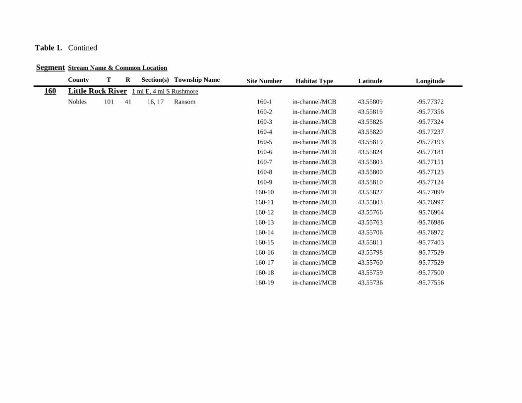
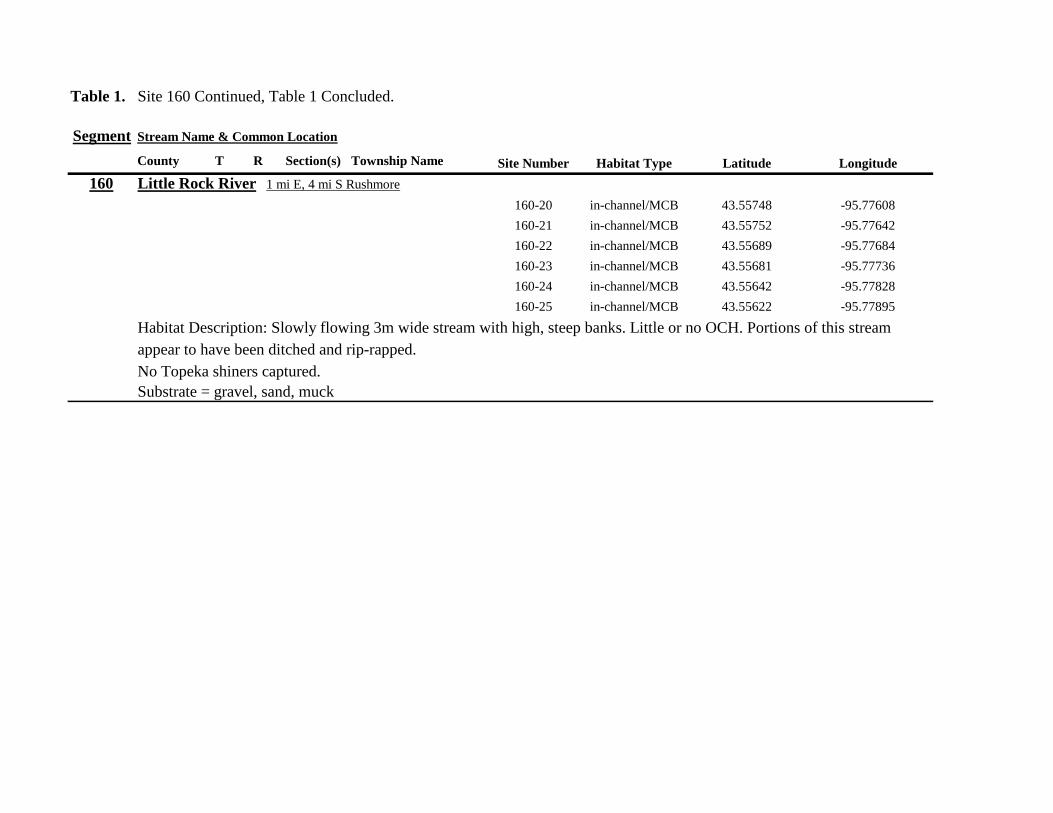
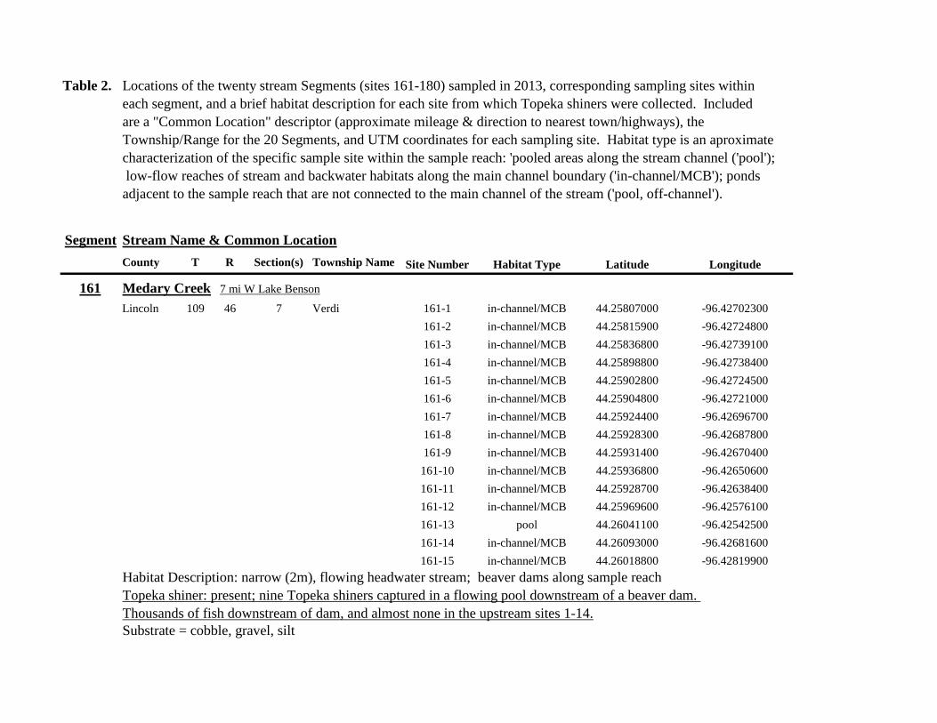
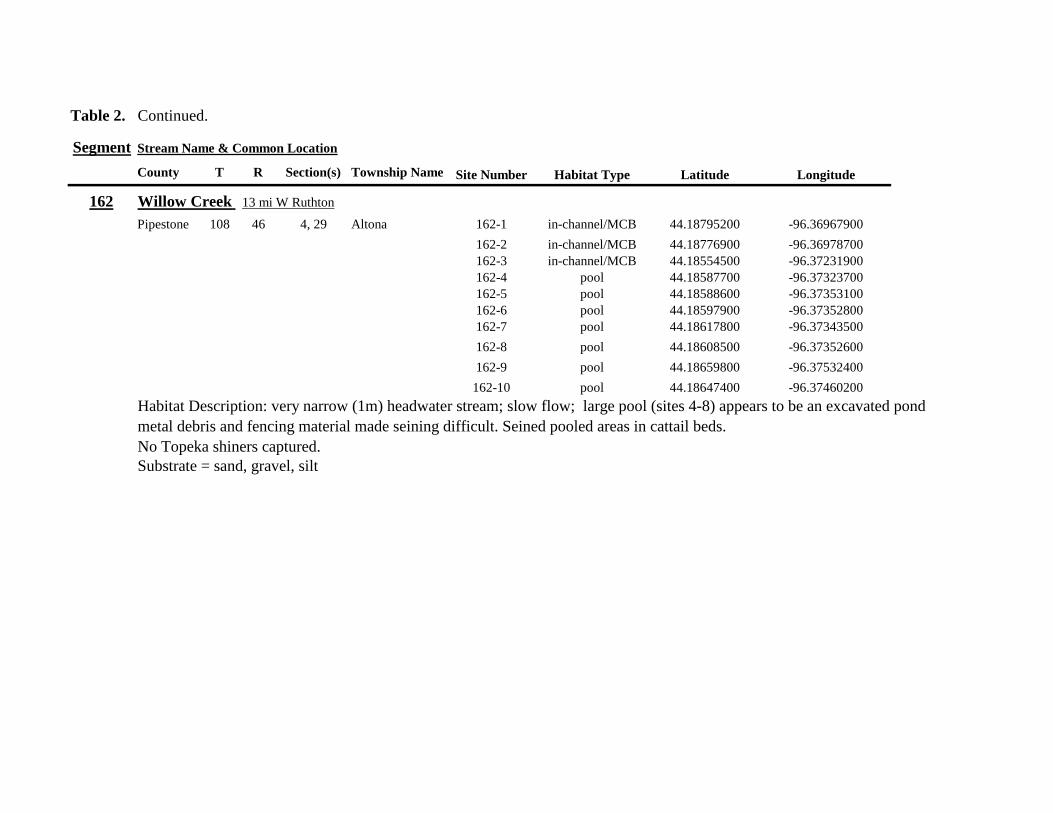
Table 2 Continued
Segment Stream Name amp Common Location
County T R Section(s) Township Name Site Number Habitat Type Latitude Longitude
162 Willow Creek 13 mi W Ruthton
Pipestone 108 46 4 29 Altona 162-1 in-channelMCB 4418795200 -9636967900
162-2 in-channelMCB 4418776900 -9636978700
162-3 in-channelMCB 4418554500 -9637231900
162-4 pool 4418587700 -9637323700
162-5 pool 4418588600 -9637353100
162-6 pool 4418597900 -9637352800
162-7 pool 4418617800 -9637343500
162-8 pool 4418608500 -9637352600
162-9 pool 4418659800 -9637532400
162-10 pool 4418647400 -9637460200
Habitat Description very narrow (1m) headwater stream slow flow large pool (sites 4-8) appears to be an excavated pond
metal debris and fencing material made seining difficult Seined pooled areas in cattail beds
No Topeka shiners captured Substrate = sand gravel silt
Table 2 Continued
Segment Stream Name amp Common Location
County T R Section(s) Township Name Site Number Habitat Type Latitude Longitude
163 Flandreau Creek 4 mi N 5 mi W Holland
Pipestone 108 46 29 Altona 163-1 pool 4412550100 -9639615400
163-2 pool 4412552400 -9639616700
163-3 pool 4412550000 -9639640600
163-4 in-channelMCB 4412625200 -9639662400
163-5 in-channelMCB 4412595100 -9639579900
163-6 in-channelMCB 4412681700 -9639517200
163-7 pool 4412703400 -9639517600
163-8 pool 4412761900 -9639631000
163-9 pool 4412764600 -9639631600
163-10 pool 4412782600 -9639590000
163-11 pool 4412754600 -9639531600
163-12 pool 4412762600 -9639632100
163-13 in-channelMCB 4413017900 -9639591600
163-14 in-channelMCB 4413084800 -9639438100
163-15 pool 4412573500 -9639553100
Habitat Description 3m wide flowing stream Channel appears to have been ditched most of plotted reach is dry Seined in heavily vegetated stagnant pools No Topeka shiners captured Substrate = firm sand gravel in-channel deep silt along MCB
Table 2 Continued
Segment Stream Name amp Common Location
County T R Section(s) Township Name Site Number Habitat Type Latitude Longitude
164 Flandreau Creek 65 mi W 55 mi N Pipestone
Pipestone 107 47 13 14 Troy 164-1 pool 4408042400 -9644734000
164-2 pool 4408043100 -9644720500
164-3 pool 4408042200 -9644708000
164-4 pool 4407996200 -9644910500
164-5 in-channelMCB 4407938200 -9644906400
164-6 in-channelMCB 4407760400 -9644847500
164-7 in-channelMCB 4407796600 -9644913300
164-8 in-channelMCB 4407806300 -9644950500
164-9 in-channelMCB 4407797700 -9644981100
164-10 in-channelMCB 4407809800 -9644991500
164-11 pool 4408029200 -9645104800
Habitat Description flowing 3-5m wide stream with firm gravel substrate in thalweg Sampled pooled area at bridge
some off-channel habitat at sites 4 and 11 Banks are steep along most of the reach with little slackwater habitat along MCB
No Topeka shiners captured
Substrate = gravel sand cobble in-channel Deep silt in low-flow areas
Table 2 Continued
Segment Stream Name amp Common Location
County T R Section(s) Township Name Site Number Habitat Type Latitude Longitude
165 North Branch Pipestone Creek 4 mi W 3 mi N Pipestone
Pipestone 107 46 29 Troy 165-1 pool 4404501300 -9639278100
165-2 pool 4404481000 -9639316800
165-3 pool 4404472800 -9639315500
165-4 in-channelMCB 4404457500 -9639325200
165-5 in-channelMCB 4404434800 -9639340300
165-6 in-channelMCB 4404446400 -9639386900
165-7 in-channelMCB 4404320300 -9639371300
165-8 pool 4404299200 -9639403700
165-9 pool 4404302200 -9639429200
165-10 pool 4404289200 -9639430300
165-11 pool 4404283700 -9639418700
165-12 in-channelMCB 4404212300 -9639411800
165-13 in-channelMCB 4404195800 -9639463400
165-14 in-channelMCB 4404244400 -9639645200
165-15 in-channelMCB 4404163700 -9639819800
165-16 in-channelMCB 4404165900 -9639797900
Habitat Description moderately flowing 3-5m wide stream Recent increase in stream level some submerged terrestrial
grasses along MCB Sites 8-11 in oxbow Submerged terrestrial grasses in oxbow
No Topeka shiners captured
Substrate = sand gravel silt
Table 2 Continued
Segment Stream Name amp Common Location
County T R Section(s) Township Name Site Number Habitat Type Latitude Longitude
166 Pipestone Creek 35 mi W 1 mi N Pipestone
Pipestone 106 46 4 5 Sweet 166-1 in-channelMCB 4401330100 -9638708400
166-2 in-channelMCB 4401347000 -9638709700
166-3 in-channelMCB 4401345500 -9638703700
166-4 in-channelMCB 4401355800 -9638703000
166-5 in-channelMCB 4401541200 -9638596400
166-6 in-channelMCB 4401618700 -9638658000
166-7 in-channelMCB 4401623400 -9638660800
166-8 in-channelMCB 4401625200 -9638646200
166-9 in-channelMCB 4401633300 -9638635600
166-10 in-channelMCB 4401740500 -9638517300
Habitat Description 10m wide slowly flowing stream Sampled along MCB in slack water West end of segment appears
to have been ditched Littleno OCH Drainage tiles along E reach of segment
No Topeka shiners captured
Substrate = cobble gravel sand Deep silt along margins of pools
Table 2 Continued
Segment Stream Name amp Common Location
County T R Section(s) Township Name Site Number Habitat Type Latitude Longitude
167 Split Rock Creek 15 mi N 1 mi E Ihlen
Pipestone 105 46 3 Eden 167-1 pool 4392585400 -9634993300
167-2 in-channelMCB 4392638100 -9635031600
167-3 pool 4392643100 -9635103600
167-4 pool 4392638200 -9635101900
167-5 pool 4392633000 -9635108800
167-6 pool 4392633200 -9635116400
167-7 pool 4392635700 -9635131600
167-8 pool 4392636400 -9635139100
167-9 pool 4392635900 -9635156000
167-10 in-channelMCB 4392470900 -9635255600
167-11 in-channelMCB 4392465600 -9635242800
167-12 in-channelMCB 4392447500 -9635240300
Habitat Description very small headwater stream (~1m) water low isolated series of pools along streambed No Topeka shiners captured Substrate = sand gravel silt
168 Split Rock Creek 15 mi N 05 mi E Jasper
Pipestone 105 46 28 29 Eden 168-1 in-channelMCB 4387771400 -9638026400
Habitat Description high water 4m wide flowing stream submerged terrestrial grasses on margins
Topeka shiner common 6 individuals captured on first seine haul in pooled area at MCB just downstream of culvert
Substrate = boulder cobble sand
Table 2 Continued
Segment Stream Name amp Common Location
County T R Section(s) Township Name Site Number Habitat Type Latitude Longitude
169 Rock River 1 mi SW of Edgerton
Pipestone 105 44 17 18 Osborne 169-1 pool 4389371700 -9616564700
169-2 in-channelMCB 4389439900 -9616531800
Habitat Description Swiftly flowing 10m wide stream at high water Sampled pooled area at outside bend of stream
over deep silt
Topeka shiner present four individuals captured in four seine hauls in a 1m wide drainage channel that joins a
retention pond to the Rock River
Substrate = Silt gravel Deep silt in off-channel areaspools
170 Chanarambie Creek 05 mi S 05 mi E Chandler
Murray 104 47 35 Fenton 170-1 in-channelMCB 4392093400 -9593156600
170-2 in-channelMCB 4391890200 -9593079300
170-3 in-channelMCB 4391841400 -9593168100
170-4 in-channelMCB 4391784300 -9593090300
170-5 in-channelMCB 4391783100 -9593060700
170-6 in-channelMCB 4391790600 -9593061100
170-7 in-channelMCB 4391796700 -9593025000
170-8 in-channelMCB 4391792000 -9592982800
170-9 in-channelMCB 4392105300 -9593062100
170-10 in-channelMCB 4392122900 -9593165100
Habitat Description narrow (1-2m) headwater stream Stream is flowing swiftly and little or no OCH is present
most of the segment appears to have been channelized
No Topeka shiners captured
Substrate = silt sand
Table 2 Continued
Segment Stream Name amp Common Location
County T R Section(s) Township Name Site Number Habitat Type Latitude Longitude
171 Rock River 4 mi S Edgerton
Rock 104 44 8 9 Battle Plain 171-1 in-channelMCB 4382021200 -9613013100
171-2 pool 4382126400 -9613470300
171-3 in-channelMCB 4382025300 -9612974300
171-4 in-channelMCB 4382027100 -9612961600
171-5 in-channelMCB 4382145400 -9613302800
171-6 in-channelMCB 4382380700 -9613520900
171-7 in-channelMCB 4382367500 -9613527700
171-8 in-channelMCB 4382359000 -9613532400
171-9 in-channelMCB 4382405300 -9613495400
171-10 in-channelMCB 4382271200 -9613570400
Habitat Description High water 8-12m wide swiftly flowing stream Stream is full to high banks Much of slackwater
areas along MCB likely inudndated Sampled in backwaters sites 6-9
No Topeka shiners captured
Substrate = Sand gravel silt
Table 2 Continued
Segment Stream Name amp Common Location
County T R Section(s) Township Name Site Number Habitat Type Latitude Longitude
172 Rock River tributary 1 mi E Hardwick
Rock 104 44 30 31 Battle Plain 172-1 pool 4377538900 -9617075500
172-2 pool 4377529200 -9617075600
172-3 pool 4377514700 -9617079800
172-4 in-channelMCB 4377386200 -9617079600
172-5 in-channelMCB 4377247100 -9617207900
172-6 in-channelMCB 4377241900 -9617224500
172-7 in-channelMCB 4377245200 -9617219500
172-8 in-channelMCB 4376956400 -9616914600
172-9 pool off-channel 4376998700 -9616876000
172-10 in-channelMCB 4377058800 -9616855700
172-11 in-channelMCB 4377043200 -9616826600
Habitat Description 3m wide slowly flowing pasture stream with high trampled banks Much of reach appears to
have been channelized no OCH present along MCBSampled in stock pond at site 9 Some submerged macrophytes
No Topeka shiners captured
Substrate = sand silt muck
Table 2 Continued
Segment Stream Name amp Common Location
County T R Section(s) Township Name Site Number Habitat Type Latitude Longitude
173 Mound Creek 1 mi N 175 mi E Beaver Creek
Rock 103 45 2 11 Mound 173-1 in-channelMCB 4374749900 -9620089200
173-2 in-channelMCB 4374756900 -9620094400
173-3 in-channelMCB 4374763700 -9620090700
173-4 in-channelMCB 4374842800 -9619838100
173-5 in-channelMCB 4374844000 -9619833200
173-6 in-channelMCB 4374889800 -9619789300
173-7 in-channelMCB 4374839600 -9619885800
173-8 in-channelMCB 4374827900 -9619934500
173-9 in-channelMCB 4374817000 -9619966400
173-10 in-channelMCB 4374799700 -9620048400
Habitat Description Entire reach of sement has been channelized Stream is 1-2m wide and constantly flowing High
banks No OCH
No Topeka shiners captured
Substrate = gravel sand silt
Table 2 Continued
Segment Stream Name amp Common Location
County T R Section(s) Township Name Site Number Habitat Type Latitude Longitude
174 Rock River tributary 55 mi N 4 mi E Luverne
Rock 103 44 8 9 Vienna 174-1 pool 4373333900 -9613250300
174-2 pool 4373322100 -9613262700
Habitat Description Narrow (2-3m) wide flowing headwater stream Sampled in deep silted pool at bridge Topeka shiner present two individuals captured over gravel in pooled area at bridge Much of the pool is filled with deep (gt05m) silt No Topeka shiners collected in silted portion of pool Substrate = gravel sand silt
Table 2 Continued
Segment Stream Name amp Common Location
County T R Section(s) Township Name Site Number Habitat Type Latitude Longitude
175 Champepadan Creek 4mi N 5 mi E Luverne
Rock 103 44 21 22 Vienna 175-1 pool 4371002900 -9611238300
175-2 pool 4371001900 -9611232600
175-3 pool 4371008300 -9611238900
175-4 in-channelMCB 4370955000 -9611142300
175-5 in-channelMCB 4371042200 -9610763900
175-6 in-channelMCB 4371007000 -9610720000
175-7 in-channelMCB 4370984100 -9610706400
175-8 pooloff-channel 4370971600 -9610709700
Habitat Description 3m wide stream with moderate flow Native prairie has been planted along both banks for the entire reach
No flow Sampled at pooled areas at culverts at CH 19
Topeka shiner present one individual captured in deep livestock pond S of stream Depth (gt2m) made seining in pond difficult
Substrate = sand silt gravel
Table 2 Continued
Segment Stream Name amp Common Location
County T R Section(s) Township Name Site Number Habitat Type Latitude Longitude
176 Kanaranzi Creek 2 mi W 35 mi N Ellworth
Rock 101 44 12 Kanaranzi 176-1 pool 4357304000 -9606413600
176-2 pool 4357305400 -9606410500
176-3 pool 4357249700 -9606408600
176-4 in-channelMCB 4357200500 -9606350300
176-5 in-channelMCB 4357204500 -9606354600
176-6 in-channelMCB 4357211400 -9606360400
176-7 in-channelMCB 4357127700 -9606357500
176-8 in-channelMCB 4357090500 -9606197900
176-9 in-channelMCB 4356817400 -9606275000
176-10 in-channelMCB 4356807000 -9606273900
176-11 in-channelMCB 4356639200 -9606408000
176-12 in-channelMCB 4356632100 -9606416000
176-13 in-channelMCB 4356598300 -9606381200
Habitat Description 10m wide flowing stream Very little OCH Very deep silt along MCB Sampled pooled area
at bridge High eroded banks
No Topeka shiners captured
Substrate = silt over gravel
Table 2 Continued
Segment Stream Name amp Common Location
County T R Section(s) Township Name Site Number Habitat Type Latitude Longitude
177 Rock River 05 mi N 4 mi E Steen
Rock 101 45 25 Clinton 177-1 pool 4352588900 -9618721100
177-2 pool 4352592700 -9618726600
177-3 in-channelMCB 4352519900 -9618594900
177-4 in-channelMCB 4352297500 -9618558400
177-5 in-channelMCB 4352147800 -9618456000
177-6 in-channelMCB 4352143300 -9618458200
177-7 in-channelMCB 4352125000 -9618453100
177-8 in-channelMCB 4352121500 -9618442200
177-9 in-channelMCB 4352106600 -9618444000
177-10 in-channelMCB 4352727900 -9618684800
177-11 pool 4352783000 -9618770800
177-12 pooloff-channel 4352663200 -9619046500
Habitat Description 11m wide flowing stream with wide channel sand bars and some braiding Firm gravel in thalweg Oxbow in middle of reach is nearly dry (lt25 cm) No fish observed culicid fly larvae abundant No Topeka shiners captured Substrate = sand gravel silt
Table 2 Continued
Segment Stream Name amp Common Location
County T R Section(s) Township Name Site Number Habitat Type Latitude Longitude
178 Kanaranzi Creek 2 mi W Ellsworth
Rock 101 44 25 36 Kanaranzi 178-1 pool 4351441400 -9605867000
178-2 in-channelMCB 4351404500 -9605846000
178-3 in-channelMCB 4351378800 -9605844300
178-4 pool 4351349700 -9605841200
178-5 pool 4351358400 -9605829800
178-6 pool 4351351800 -9605816800
178-7 in-channelMCB 4351355800 -9605866900
178-8 in-channelMCB 4351549000 -9605823700
178-9 in-channelMCB 4351891800 -9605895600
178-10 in-channelMCB 4351866200 -9605881400
178-11 pool 4352078500 -9606070000
178-12 pool 4352046000 -9606082200
Habitat Description 7-9m wide flowing stream Sampled backwater and off-channel habitats along MCB and side channels Recent high flow has filled in off-channel areas with deep silt Seining difficult No Topeka shiners captured Substrate = sand silt gravel
Table 2 Concluded
Segment Stream Name amp Common Location
County T R Section(s) Township Name Site Number Habitat Type Latitude Longitude
179 East Branch Kanaranzi Creek 15 mi N 15 mi E Adrian
Nobles 102 42 8 Olney 179-1 pool 4365932900 -9590462700
179-2 pool 4365928900 -9590449500
179-3 pool 4365930600 -9590463300
179-4 pool 4365908000 -9590420300
179-5 in-channelMCB 4365679800 -9590378600
179-6 in-channelMCB 4365661000 -9590387800
179-7 in-channelMCB 4365604000 -9590417100
179-8 in-channelMCB 4365508100 -9590385200
179-9 in-channelMCB 4365460100 -9590342200
179-10 pool 4365434900 -9590020100
179-11 in-channelMCB 4365507700 -9590154900
179-12 in-channelMCB 4365588000 -9589900200
Habitat Description Flowing 9m wide stream Stream is full to high banks very little slackwater habitat present at this site
No Topeka shiners captured
Substrate = sand silt gravel
180 Little Rock River 8 mi E Ellsworth
Nobles 101 42 26 Little Rock 180-1 in-channelMCB 4352838500 -9584615900
Habitat Description Sampled large pooled area at bridge no discernible flow silt over gravel substrate Channel downstream
of pool is a 2-3 m wide flowing stream with a firm sandgravel substrate
Topeka shiner abundant fourteen individuals captured in first seine haul in pool fifteen individuals captured in second seine
haul near outlet of the pool
Substrate = gravel sand silt
Table 3 Complete List of Fish Species Captured at Segments 141-160 2012
Species 141 142 143 144 145 146 147 148 149 150 151 152 153 154 155 156 157 158 159 160 Campostoma anomalum X X X X X X X X X X X X X X Chrosomus erythrogaster X X Cyprinella lutrensis X X X X X X X X X Cyprinus carpio X X X X X Hybognathus hankinsoni X X X X X X X Luxilus cornutus X X X X X X X X X X X X X Notropis dorsalis X X X X X X X X X X X Notropis stramineus X X X X X X X X X X X X X X X Notropis topeka X X X X X X X X Pimephales notatus X X X X X X X X X X X X Pimephales promelas X X X X X X X X X X X X X X X X X X Rhinichthys atratulus X X X X X X Semotilus atromaculatus X X X X X X X X X X X X X X X X X X Carpiodes cyprinus X Carpiodes sp (YOY) X X X Catostomus commersoni X X X X X X X X X X X X X X X Moxostoma macrolepidotum X X Ameiurus melas X X X X X X X X X X X X X Ameiurus natalis X Ictalurus punctatus X X X X Noturus flavus X X X X Noturus gyrinus X X X X X Esox lucius X X Percopsis omiscomaycus X Fundulus sciadicus X X X Culaea inconstans X X X X X Lepomis cyanellus X X X X X X X Lepomis humilis X X X X X X X X X X X Lepomis macrochirus X X X X X Micropterus dolomieui X Micropterus salmoides X X Pomoxis nigromaculatus X X Etheostoma exile X X X X X Etheostoma nigrum X X X X X X X X X X X X X X X X X Perca flavescens X X Percina maculata X X X X
Table 4 Complete List of Fish Species Captured at Segments 161-180 2013
Species 161 162 163 164 165 166 167 168 169 170 171 172 173 174 175 176 177 178 179 180
Campostoma anomalum X X X X X X X X X X X X X X
Cyprinella lutrensis X X X X X X X X X X
Cyprinus carpio X X X
Hybognathus hankinsoni X X X X X
Luxilus cornutus X X X X X X X X X X X X X
Notropis dorsalis X X X X X X X X X X X X X X
Notropis stramineus X X X X X X X X X X X X X X
Notropis topeka X X X X X X
Pimephales notatus X X X X X X X X X X X X
Pimephales promelas X X X X X X X X X X X X X X X X X X
Rhinichthys atratulus X X X X X X X X X X X
Semotilus atromaculatus X X X X X X X X X X X X X X X X
Carpiodes cyprinus X X
Catostomus commersoni X X X X X X X X X X X X X
Moxostoma erythrurum X X X
Moxostoma macrolepidotum X X
Ameiurus melas X X X X X X X X X X
Noturus flavus X X X
Esox lucius X X
Percopsis omiscomaycus X
Fundulus sciadicus X
Culaea inconstans X X X X
Lepomis cyanellus X X X X X X
Lepomis humilis X X X X X X X X X
Etheostoma exile X X
Etheostoma nigrum X X X X X X X X X X
Percina maculata X X
Appendix C- Habitat and Voucher Photographs
Habitat photographs for segments in which no Topeka shiners were captured are representative
of the habitat along the one-mile reach of stream Habitat photographs from segments where
Topeka shiners were present represent the specific site where they were collected Voucher
photographs are presented for each of the sites were Topeka shiners were collected
Site 141-2 Medary Creek voucher and habitat photos
Segment 142 Willow Creek no Topeka shiners captured
Segment 143 East Branch Flandrau Creek no Topeka shiners captured
Segment 144 North Branch Pipestone Creek no Topeka shiners captured
Site 145-6 Pipestone Creek voucher photo
Site 145-6 Pipestone Creek habitat photo
Segment 146 Split Rock Creek no Topeka shiners captured No habitat photo
Segment 147 Kanaranzi Creek no Topeka shiners captured
Site 148-4 Rock River voucher and habitat photos
Site 149-4 Rock River voucher and habitat photos
Site 150-4 Split Rock Creek voucher and habitat photos
Site 151-1 Beaver Creek voucher and habitat photos
Segment 152 Beaver Creek no Topeka shiners captured
Segment 153 Beaver Creek no Topeka shiners captured
Segment 154 Rock River no Topeka shiners captured
Segment 155 Elk Creek no Topeka shiners captured
Site 156-1 Elk Creek voucher and habitat photos
Segment 157 Kanaranzi Creek no Topeka shiners captured
Segment 158 Kanaranzi Creek no Topeka shiners captured
Site 159-1 Kanaranzi Creek voucher and habitat photos
Segment 160 Little Rock River no Topeka shiners captured
Site 161-15 Medary Creek voucher photo
Site 161-15 Medary Creek habitat photo
Segment 162 Willow Creek no Topeka shiners captured No habitat photo
Segment 163 Flandrau Creek no Topeka shiners captured
Segment 164 Flandrau Creek no Topeka shiners captured
Segment 165 North Branch Pipestone Creek no Topeka Shiners captured
Segment 166 Pipestone Creek no Topeka Shiners captured
Segment 167 Tributary to Split Rock Creek no Topeka Shiners captured No habitat
photo
Site 168-1 Split Rock Creek voucher photo
Site 168-1 Split Rock Creek habitat photo
Site 169-2 Rock River voucher photo
Site 169-2 Rock River habitat photo
Segment 170 Chanarambie Creek no Topeka shiners captured
Segment 171 Rock River no Topeka shiners captured
Segment 172 Tributary to Rock River no Topeka shiners captured
Segment 173 Blue Mound Creek no Topeka shiners
Site 174-2 Tributary to Rock River voucher photo
Site 174-2 Tributary to Rock River habitat photo
Site 175-8 Champepadan Creek voucher photo
Site 175-8 Champepadan Creek habitat photo
Segment 176 Kanaranzi Creek no Topekas captured
Segment 177 Rock River no Topeka shiners captured
Segment 178 Kanaranzi Creek no Topeka shiners captured
Segment 179 East Branch Kanaranzi Creek no Topeka shiners captured
Site 180-1 West Branch Little Rock River voucher photo
Site 180-1 West Branch Little Rock River habitat photo
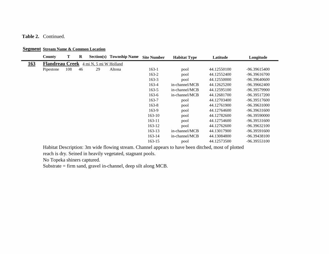
Table 2 Continued
Segment Stream Name amp Common Location
County T R Section(s) Township Name Site Number Habitat Type Latitude Longitude
163 Flandreau Creek 4 mi N 5 mi W Holland
Pipestone 108 46 29 Altona 163-1 pool 4412550100 -9639615400
163-2 pool 4412552400 -9639616700
163-3 pool 4412550000 -9639640600
163-4 in-channelMCB 4412625200 -9639662400
163-5 in-channelMCB 4412595100 -9639579900
163-6 in-channelMCB 4412681700 -9639517200
163-7 pool 4412703400 -9639517600
163-8 pool 4412761900 -9639631000
163-9 pool 4412764600 -9639631600
163-10 pool 4412782600 -9639590000
163-11 pool 4412754600 -9639531600
163-12 pool 4412762600 -9639632100
163-13 in-channelMCB 4413017900 -9639591600
163-14 in-channelMCB 4413084800 -9639438100
163-15 pool 4412573500 -9639553100
Habitat Description 3m wide flowing stream Channel appears to have been ditched most of plotted reach is dry Seined in heavily vegetated stagnant pools No Topeka shiners captured Substrate = firm sand gravel in-channel deep silt along MCB
Table 2 Continued
Segment Stream Name amp Common Location
County T R Section(s) Township Name Site Number Habitat Type Latitude Longitude
164 Flandreau Creek 65 mi W 55 mi N Pipestone
Pipestone 107 47 13 14 Troy 164-1 pool 4408042400 -9644734000
164-2 pool 4408043100 -9644720500
164-3 pool 4408042200 -9644708000
164-4 pool 4407996200 -9644910500
164-5 in-channelMCB 4407938200 -9644906400
164-6 in-channelMCB 4407760400 -9644847500
164-7 in-channelMCB 4407796600 -9644913300
164-8 in-channelMCB 4407806300 -9644950500
164-9 in-channelMCB 4407797700 -9644981100
164-10 in-channelMCB 4407809800 -9644991500
164-11 pool 4408029200 -9645104800
Habitat Description flowing 3-5m wide stream with firm gravel substrate in thalweg Sampled pooled area at bridge
some off-channel habitat at sites 4 and 11 Banks are steep along most of the reach with little slackwater habitat along MCB
No Topeka shiners captured
Substrate = gravel sand cobble in-channel Deep silt in low-flow areas
Table 2 Continued
Segment Stream Name amp Common Location
County T R Section(s) Township Name Site Number Habitat Type Latitude Longitude
165 North Branch Pipestone Creek 4 mi W 3 mi N Pipestone
Pipestone 107 46 29 Troy 165-1 pool 4404501300 -9639278100
165-2 pool 4404481000 -9639316800
165-3 pool 4404472800 -9639315500
165-4 in-channelMCB 4404457500 -9639325200
165-5 in-channelMCB 4404434800 -9639340300
165-6 in-channelMCB 4404446400 -9639386900
165-7 in-channelMCB 4404320300 -9639371300
165-8 pool 4404299200 -9639403700
165-9 pool 4404302200 -9639429200
165-10 pool 4404289200 -9639430300
165-11 pool 4404283700 -9639418700
165-12 in-channelMCB 4404212300 -9639411800
165-13 in-channelMCB 4404195800 -9639463400
165-14 in-channelMCB 4404244400 -9639645200
165-15 in-channelMCB 4404163700 -9639819800
165-16 in-channelMCB 4404165900 -9639797900
Habitat Description moderately flowing 3-5m wide stream Recent increase in stream level some submerged terrestrial
grasses along MCB Sites 8-11 in oxbow Submerged terrestrial grasses in oxbow
No Topeka shiners captured
Substrate = sand gravel silt
Table 2 Continued
Segment Stream Name amp Common Location
County T R Section(s) Township Name Site Number Habitat Type Latitude Longitude
166 Pipestone Creek 35 mi W 1 mi N Pipestone
Pipestone 106 46 4 5 Sweet 166-1 in-channelMCB 4401330100 -9638708400
166-2 in-channelMCB 4401347000 -9638709700
166-3 in-channelMCB 4401345500 -9638703700
166-4 in-channelMCB 4401355800 -9638703000
166-5 in-channelMCB 4401541200 -9638596400
166-6 in-channelMCB 4401618700 -9638658000
166-7 in-channelMCB 4401623400 -9638660800
166-8 in-channelMCB 4401625200 -9638646200
166-9 in-channelMCB 4401633300 -9638635600
166-10 in-channelMCB 4401740500 -9638517300
Habitat Description 10m wide slowly flowing stream Sampled along MCB in slack water West end of segment appears
to have been ditched Littleno OCH Drainage tiles along E reach of segment
No Topeka shiners captured
Substrate = cobble gravel sand Deep silt along margins of pools
Table 2 Continued
Segment Stream Name amp Common Location
County T R Section(s) Township Name Site Number Habitat Type Latitude Longitude
167 Split Rock Creek 15 mi N 1 mi E Ihlen
Pipestone 105 46 3 Eden 167-1 pool 4392585400 -9634993300
167-2 in-channelMCB 4392638100 -9635031600
167-3 pool 4392643100 -9635103600
167-4 pool 4392638200 -9635101900
167-5 pool 4392633000 -9635108800
167-6 pool 4392633200 -9635116400
167-7 pool 4392635700 -9635131600
167-8 pool 4392636400 -9635139100
167-9 pool 4392635900 -9635156000
167-10 in-channelMCB 4392470900 -9635255600
167-11 in-channelMCB 4392465600 -9635242800
167-12 in-channelMCB 4392447500 -9635240300
Habitat Description very small headwater stream (~1m) water low isolated series of pools along streambed No Topeka shiners captured Substrate = sand gravel silt
168 Split Rock Creek 15 mi N 05 mi E Jasper
Pipestone 105 46 28 29 Eden 168-1 in-channelMCB 4387771400 -9638026400
Habitat Description high water 4m wide flowing stream submerged terrestrial grasses on margins
Topeka shiner common 6 individuals captured on first seine haul in pooled area at MCB just downstream of culvert
Substrate = boulder cobble sand
Table 2 Continued
Segment Stream Name amp Common Location
County T R Section(s) Township Name Site Number Habitat Type Latitude Longitude
169 Rock River 1 mi SW of Edgerton
Pipestone 105 44 17 18 Osborne 169-1 pool 4389371700 -9616564700
169-2 in-channelMCB 4389439900 -9616531800
Habitat Description Swiftly flowing 10m wide stream at high water Sampled pooled area at outside bend of stream
over deep silt
Topeka shiner present four individuals captured in four seine hauls in a 1m wide drainage channel that joins a
retention pond to the Rock River
Substrate = Silt gravel Deep silt in off-channel areaspools
170 Chanarambie Creek 05 mi S 05 mi E Chandler
Murray 104 47 35 Fenton 170-1 in-channelMCB 4392093400 -9593156600
170-2 in-channelMCB 4391890200 -9593079300
170-3 in-channelMCB 4391841400 -9593168100
170-4 in-channelMCB 4391784300 -9593090300
170-5 in-channelMCB 4391783100 -9593060700
170-6 in-channelMCB 4391790600 -9593061100
170-7 in-channelMCB 4391796700 -9593025000
170-8 in-channelMCB 4391792000 -9592982800
170-9 in-channelMCB 4392105300 -9593062100
170-10 in-channelMCB 4392122900 -9593165100
Habitat Description narrow (1-2m) headwater stream Stream is flowing swiftly and little or no OCH is present
most of the segment appears to have been channelized
No Topeka shiners captured
Substrate = silt sand
Table 2 Continued
Segment Stream Name amp Common Location
County T R Section(s) Township Name Site Number Habitat Type Latitude Longitude
171 Rock River 4 mi S Edgerton
Rock 104 44 8 9 Battle Plain 171-1 in-channelMCB 4382021200 -9613013100
171-2 pool 4382126400 -9613470300
171-3 in-channelMCB 4382025300 -9612974300
171-4 in-channelMCB 4382027100 -9612961600
171-5 in-channelMCB 4382145400 -9613302800
171-6 in-channelMCB 4382380700 -9613520900
171-7 in-channelMCB 4382367500 -9613527700
171-8 in-channelMCB 4382359000 -9613532400
171-9 in-channelMCB 4382405300 -9613495400
171-10 in-channelMCB 4382271200 -9613570400
Habitat Description High water 8-12m wide swiftly flowing stream Stream is full to high banks Much of slackwater
areas along MCB likely inudndated Sampled in backwaters sites 6-9
No Topeka shiners captured
Substrate = Sand gravel silt
Table 2 Continued
Segment Stream Name amp Common Location
County T R Section(s) Township Name Site Number Habitat Type Latitude Longitude
172 Rock River tributary 1 mi E Hardwick
Rock 104 44 30 31 Battle Plain 172-1 pool 4377538900 -9617075500
172-2 pool 4377529200 -9617075600
172-3 pool 4377514700 -9617079800
172-4 in-channelMCB 4377386200 -9617079600
172-5 in-channelMCB 4377247100 -9617207900
172-6 in-channelMCB 4377241900 -9617224500
172-7 in-channelMCB 4377245200 -9617219500
172-8 in-channelMCB 4376956400 -9616914600
172-9 pool off-channel 4376998700 -9616876000
172-10 in-channelMCB 4377058800 -9616855700
172-11 in-channelMCB 4377043200 -9616826600
Habitat Description 3m wide slowly flowing pasture stream with high trampled banks Much of reach appears to
have been channelized no OCH present along MCBSampled in stock pond at site 9 Some submerged macrophytes
No Topeka shiners captured
Substrate = sand silt muck
Table 2 Continued
Segment Stream Name amp Common Location
County T R Section(s) Township Name Site Number Habitat Type Latitude Longitude
173 Mound Creek 1 mi N 175 mi E Beaver Creek
Rock 103 45 2 11 Mound 173-1 in-channelMCB 4374749900 -9620089200
173-2 in-channelMCB 4374756900 -9620094400
173-3 in-channelMCB 4374763700 -9620090700
173-4 in-channelMCB 4374842800 -9619838100
173-5 in-channelMCB 4374844000 -9619833200
173-6 in-channelMCB 4374889800 -9619789300
173-7 in-channelMCB 4374839600 -9619885800
173-8 in-channelMCB 4374827900 -9619934500
173-9 in-channelMCB 4374817000 -9619966400
173-10 in-channelMCB 4374799700 -9620048400
Habitat Description Entire reach of sement has been channelized Stream is 1-2m wide and constantly flowing High
banks No OCH
No Topeka shiners captured
Substrate = gravel sand silt
Table 2 Continued
Segment Stream Name amp Common Location
County T R Section(s) Township Name Site Number Habitat Type Latitude Longitude
174 Rock River tributary 55 mi N 4 mi E Luverne
Rock 103 44 8 9 Vienna 174-1 pool 4373333900 -9613250300
174-2 pool 4373322100 -9613262700
Habitat Description Narrow (2-3m) wide flowing headwater stream Sampled in deep silted pool at bridge Topeka shiner present two individuals captured over gravel in pooled area at bridge Much of the pool is filled with deep (gt05m) silt No Topeka shiners collected in silted portion of pool Substrate = gravel sand silt
Table 2 Continued
Segment Stream Name amp Common Location
County T R Section(s) Township Name Site Number Habitat Type Latitude Longitude
175 Champepadan Creek 4mi N 5 mi E Luverne
Rock 103 44 21 22 Vienna 175-1 pool 4371002900 -9611238300
175-2 pool 4371001900 -9611232600
175-3 pool 4371008300 -9611238900
175-4 in-channelMCB 4370955000 -9611142300
175-5 in-channelMCB 4371042200 -9610763900
175-6 in-channelMCB 4371007000 -9610720000
175-7 in-channelMCB 4370984100 -9610706400
175-8 pooloff-channel 4370971600 -9610709700
Habitat Description 3m wide stream with moderate flow Native prairie has been planted along both banks for the entire reach
No flow Sampled at pooled areas at culverts at CH 19
Topeka shiner present one individual captured in deep livestock pond S of stream Depth (gt2m) made seining in pond difficult
Substrate = sand silt gravel
Table 2 Continued
Segment Stream Name amp Common Location
County T R Section(s) Township Name Site Number Habitat Type Latitude Longitude
176 Kanaranzi Creek 2 mi W 35 mi N Ellworth
Rock 101 44 12 Kanaranzi 176-1 pool 4357304000 -9606413600
176-2 pool 4357305400 -9606410500
176-3 pool 4357249700 -9606408600
176-4 in-channelMCB 4357200500 -9606350300
176-5 in-channelMCB 4357204500 -9606354600
176-6 in-channelMCB 4357211400 -9606360400
176-7 in-channelMCB 4357127700 -9606357500
176-8 in-channelMCB 4357090500 -9606197900
176-9 in-channelMCB 4356817400 -9606275000
176-10 in-channelMCB 4356807000 -9606273900
176-11 in-channelMCB 4356639200 -9606408000
176-12 in-channelMCB 4356632100 -9606416000
176-13 in-channelMCB 4356598300 -9606381200
Habitat Description 10m wide flowing stream Very little OCH Very deep silt along MCB Sampled pooled area
at bridge High eroded banks
No Topeka shiners captured
Substrate = silt over gravel
Table 2 Continued
Segment Stream Name amp Common Location
County T R Section(s) Township Name Site Number Habitat Type Latitude Longitude
177 Rock River 05 mi N 4 mi E Steen
Rock 101 45 25 Clinton 177-1 pool 4352588900 -9618721100
177-2 pool 4352592700 -9618726600
177-3 in-channelMCB 4352519900 -9618594900
177-4 in-channelMCB 4352297500 -9618558400
177-5 in-channelMCB 4352147800 -9618456000
177-6 in-channelMCB 4352143300 -9618458200
177-7 in-channelMCB 4352125000 -9618453100
177-8 in-channelMCB 4352121500 -9618442200
177-9 in-channelMCB 4352106600 -9618444000
177-10 in-channelMCB 4352727900 -9618684800
177-11 pool 4352783000 -9618770800
177-12 pooloff-channel 4352663200 -9619046500
Habitat Description 11m wide flowing stream with wide channel sand bars and some braiding Firm gravel in thalweg Oxbow in middle of reach is nearly dry (lt25 cm) No fish observed culicid fly larvae abundant No Topeka shiners captured Substrate = sand gravel silt
Table 2 Continued
Segment Stream Name amp Common Location
County T R Section(s) Township Name Site Number Habitat Type Latitude Longitude
178 Kanaranzi Creek 2 mi W Ellsworth
Rock 101 44 25 36 Kanaranzi 178-1 pool 4351441400 -9605867000
178-2 in-channelMCB 4351404500 -9605846000
178-3 in-channelMCB 4351378800 -9605844300
178-4 pool 4351349700 -9605841200
178-5 pool 4351358400 -9605829800
178-6 pool 4351351800 -9605816800
178-7 in-channelMCB 4351355800 -9605866900
178-8 in-channelMCB 4351549000 -9605823700
178-9 in-channelMCB 4351891800 -9605895600
178-10 in-channelMCB 4351866200 -9605881400
178-11 pool 4352078500 -9606070000
178-12 pool 4352046000 -9606082200
Habitat Description 7-9m wide flowing stream Sampled backwater and off-channel habitats along MCB and side channels Recent high flow has filled in off-channel areas with deep silt Seining difficult No Topeka shiners captured Substrate = sand silt gravel
Table 2 Concluded
Segment Stream Name amp Common Location
County T R Section(s) Township Name Site Number Habitat Type Latitude Longitude
179 East Branch Kanaranzi Creek 15 mi N 15 mi E Adrian
Nobles 102 42 8 Olney 179-1 pool 4365932900 -9590462700
179-2 pool 4365928900 -9590449500
179-3 pool 4365930600 -9590463300
179-4 pool 4365908000 -9590420300
179-5 in-channelMCB 4365679800 -9590378600
179-6 in-channelMCB 4365661000 -9590387800
179-7 in-channelMCB 4365604000 -9590417100
179-8 in-channelMCB 4365508100 -9590385200
179-9 in-channelMCB 4365460100 -9590342200
179-10 pool 4365434900 -9590020100
179-11 in-channelMCB 4365507700 -9590154900
179-12 in-channelMCB 4365588000 -9589900200
Habitat Description Flowing 9m wide stream Stream is full to high banks very little slackwater habitat present at this site
No Topeka shiners captured
Substrate = sand silt gravel
180 Little Rock River 8 mi E Ellsworth
Nobles 101 42 26 Little Rock 180-1 in-channelMCB 4352838500 -9584615900
Habitat Description Sampled large pooled area at bridge no discernible flow silt over gravel substrate Channel downstream
of pool is a 2-3 m wide flowing stream with a firm sandgravel substrate
Topeka shiner abundant fourteen individuals captured in first seine haul in pool fifteen individuals captured in second seine
haul near outlet of the pool
Substrate = gravel sand silt
Table 3 Complete List of Fish Species Captured at Segments 141-160 2012
Species 141 142 143 144 145 146 147 148 149 150 151 152 153 154 155 156 157 158 159 160 Campostoma anomalum X X X X X X X X X X X X X X Chrosomus erythrogaster X X Cyprinella lutrensis X X X X X X X X X Cyprinus carpio X X X X X Hybognathus hankinsoni X X X X X X X Luxilus cornutus X X X X X X X X X X X X X Notropis dorsalis X X X X X X X X X X X Notropis stramineus X X X X X X X X X X X X X X X Notropis topeka X X X X X X X X Pimephales notatus X X X X X X X X X X X X Pimephales promelas X X X X X X X X X X X X X X X X X X Rhinichthys atratulus X X X X X X Semotilus atromaculatus X X X X X X X X X X X X X X X X X X Carpiodes cyprinus X Carpiodes sp (YOY) X X X Catostomus commersoni X X X X X X X X X X X X X X X Moxostoma macrolepidotum X X Ameiurus melas X X X X X X X X X X X X X Ameiurus natalis X Ictalurus punctatus X X X X Noturus flavus X X X X Noturus gyrinus X X X X X Esox lucius X X Percopsis omiscomaycus X Fundulus sciadicus X X X Culaea inconstans X X X X X Lepomis cyanellus X X X X X X X Lepomis humilis X X X X X X X X X X X Lepomis macrochirus X X X X X Micropterus dolomieui X Micropterus salmoides X X Pomoxis nigromaculatus X X Etheostoma exile X X X X X Etheostoma nigrum X X X X X X X X X X X X X X X X X Perca flavescens X X Percina maculata X X X X
Table 4 Complete List of Fish Species Captured at Segments 161-180 2013
Species 161 162 163 164 165 166 167 168 169 170 171 172 173 174 175 176 177 178 179 180
Campostoma anomalum X X X X X X X X X X X X X X
Cyprinella lutrensis X X X X X X X X X X
Cyprinus carpio X X X
Hybognathus hankinsoni X X X X X
Luxilus cornutus X X X X X X X X X X X X X
Notropis dorsalis X X X X X X X X X X X X X X
Notropis stramineus X X X X X X X X X X X X X X
Notropis topeka X X X X X X
Pimephales notatus X X X X X X X X X X X X
Pimephales promelas X X X X X X X X X X X X X X X X X X
Rhinichthys atratulus X X X X X X X X X X X
Semotilus atromaculatus X X X X X X X X X X X X X X X X
Carpiodes cyprinus X X
Catostomus commersoni X X X X X X X X X X X X X
Moxostoma erythrurum X X X
Moxostoma macrolepidotum X X
Ameiurus melas X X X X X X X X X X
Noturus flavus X X X
Esox lucius X X
Percopsis omiscomaycus X
Fundulus sciadicus X
Culaea inconstans X X X X
Lepomis cyanellus X X X X X X
Lepomis humilis X X X X X X X X X
Etheostoma exile X X
Etheostoma nigrum X X X X X X X X X X
Percina maculata X X
Appendix C- Habitat and Voucher Photographs
Habitat photographs for segments in which no Topeka shiners were captured are representative
of the habitat along the one-mile reach of stream Habitat photographs from segments where
Topeka shiners were present represent the specific site where they were collected Voucher
photographs are presented for each of the sites were Topeka shiners were collected
Site 141-2 Medary Creek voucher and habitat photos
Segment 142 Willow Creek no Topeka shiners captured
Segment 143 East Branch Flandrau Creek no Topeka shiners captured
Segment 144 North Branch Pipestone Creek no Topeka shiners captured
Site 145-6 Pipestone Creek voucher photo
Site 145-6 Pipestone Creek habitat photo
Segment 146 Split Rock Creek no Topeka shiners captured No habitat photo
Segment 147 Kanaranzi Creek no Topeka shiners captured
Site 148-4 Rock River voucher and habitat photos
Site 149-4 Rock River voucher and habitat photos
Site 150-4 Split Rock Creek voucher and habitat photos
Site 151-1 Beaver Creek voucher and habitat photos
Segment 152 Beaver Creek no Topeka shiners captured
Segment 153 Beaver Creek no Topeka shiners captured
Segment 154 Rock River no Topeka shiners captured
Segment 155 Elk Creek no Topeka shiners captured
Site 156-1 Elk Creek voucher and habitat photos
Segment 157 Kanaranzi Creek no Topeka shiners captured
Segment 158 Kanaranzi Creek no Topeka shiners captured
Site 159-1 Kanaranzi Creek voucher and habitat photos
Segment 160 Little Rock River no Topeka shiners captured
Site 161-15 Medary Creek voucher photo
Site 161-15 Medary Creek habitat photo
Segment 162 Willow Creek no Topeka shiners captured No habitat photo
Segment 163 Flandrau Creek no Topeka shiners captured
Segment 164 Flandrau Creek no Topeka shiners captured
Segment 165 North Branch Pipestone Creek no Topeka Shiners captured
Segment 166 Pipestone Creek no Topeka Shiners captured
Segment 167 Tributary to Split Rock Creek no Topeka Shiners captured No habitat
photo
Site 168-1 Split Rock Creek voucher photo
Site 168-1 Split Rock Creek habitat photo
Site 169-2 Rock River voucher photo
Site 169-2 Rock River habitat photo
Segment 170 Chanarambie Creek no Topeka shiners captured
Segment 171 Rock River no Topeka shiners captured
Segment 172 Tributary to Rock River no Topeka shiners captured
Segment 173 Blue Mound Creek no Topeka shiners
Site 174-2 Tributary to Rock River voucher photo
Site 174-2 Tributary to Rock River habitat photo
Site 175-8 Champepadan Creek voucher photo
Site 175-8 Champepadan Creek habitat photo
Segment 176 Kanaranzi Creek no Topekas captured
Segment 177 Rock River no Topeka shiners captured
Segment 178 Kanaranzi Creek no Topeka shiners captured
Segment 179 East Branch Kanaranzi Creek no Topeka shiners captured
Site 180-1 West Branch Little Rock River voucher photo
Site 180-1 West Branch Little Rock River habitat photo
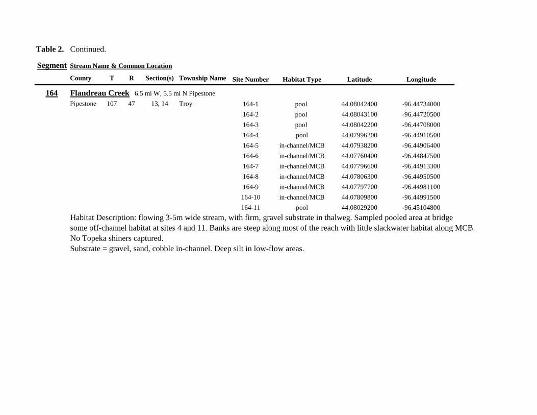
Table 2 Continued
Segment Stream Name amp Common Location
County T R Section(s) Township Name Site Number Habitat Type Latitude Longitude
164 Flandreau Creek 65 mi W 55 mi N Pipestone
Pipestone 107 47 13 14 Troy 164-1 pool 4408042400 -9644734000
164-2 pool 4408043100 -9644720500
164-3 pool 4408042200 -9644708000
164-4 pool 4407996200 -9644910500
164-5 in-channelMCB 4407938200 -9644906400
164-6 in-channelMCB 4407760400 -9644847500
164-7 in-channelMCB 4407796600 -9644913300
164-8 in-channelMCB 4407806300 -9644950500
164-9 in-channelMCB 4407797700 -9644981100
164-10 in-channelMCB 4407809800 -9644991500
164-11 pool 4408029200 -9645104800
Habitat Description flowing 3-5m wide stream with firm gravel substrate in thalweg Sampled pooled area at bridge
some off-channel habitat at sites 4 and 11 Banks are steep along most of the reach with little slackwater habitat along MCB
No Topeka shiners captured
Substrate = gravel sand cobble in-channel Deep silt in low-flow areas
Table 2 Continued
Segment Stream Name amp Common Location
County T R Section(s) Township Name Site Number Habitat Type Latitude Longitude
165 North Branch Pipestone Creek 4 mi W 3 mi N Pipestone
Pipestone 107 46 29 Troy 165-1 pool 4404501300 -9639278100
165-2 pool 4404481000 -9639316800
165-3 pool 4404472800 -9639315500
165-4 in-channelMCB 4404457500 -9639325200
165-5 in-channelMCB 4404434800 -9639340300
165-6 in-channelMCB 4404446400 -9639386900
165-7 in-channelMCB 4404320300 -9639371300
165-8 pool 4404299200 -9639403700
165-9 pool 4404302200 -9639429200
165-10 pool 4404289200 -9639430300
165-11 pool 4404283700 -9639418700
165-12 in-channelMCB 4404212300 -9639411800
165-13 in-channelMCB 4404195800 -9639463400
165-14 in-channelMCB 4404244400 -9639645200
165-15 in-channelMCB 4404163700 -9639819800
165-16 in-channelMCB 4404165900 -9639797900
Habitat Description moderately flowing 3-5m wide stream Recent increase in stream level some submerged terrestrial
grasses along MCB Sites 8-11 in oxbow Submerged terrestrial grasses in oxbow
No Topeka shiners captured
Substrate = sand gravel silt
Table 2 Continued
Segment Stream Name amp Common Location
County T R Section(s) Township Name Site Number Habitat Type Latitude Longitude
166 Pipestone Creek 35 mi W 1 mi N Pipestone
Pipestone 106 46 4 5 Sweet 166-1 in-channelMCB 4401330100 -9638708400
166-2 in-channelMCB 4401347000 -9638709700
166-3 in-channelMCB 4401345500 -9638703700
166-4 in-channelMCB 4401355800 -9638703000
166-5 in-channelMCB 4401541200 -9638596400
166-6 in-channelMCB 4401618700 -9638658000
166-7 in-channelMCB 4401623400 -9638660800
166-8 in-channelMCB 4401625200 -9638646200
166-9 in-channelMCB 4401633300 -9638635600
166-10 in-channelMCB 4401740500 -9638517300
Habitat Description 10m wide slowly flowing stream Sampled along MCB in slack water West end of segment appears
to have been ditched Littleno OCH Drainage tiles along E reach of segment
No Topeka shiners captured
Substrate = cobble gravel sand Deep silt along margins of pools
Table 2 Continued
Segment Stream Name amp Common Location
County T R Section(s) Township Name Site Number Habitat Type Latitude Longitude
167 Split Rock Creek 15 mi N 1 mi E Ihlen
Pipestone 105 46 3 Eden 167-1 pool 4392585400 -9634993300
167-2 in-channelMCB 4392638100 -9635031600
167-3 pool 4392643100 -9635103600
167-4 pool 4392638200 -9635101900
167-5 pool 4392633000 -9635108800
167-6 pool 4392633200 -9635116400
167-7 pool 4392635700 -9635131600
167-8 pool 4392636400 -9635139100
167-9 pool 4392635900 -9635156000
167-10 in-channelMCB 4392470900 -9635255600
167-11 in-channelMCB 4392465600 -9635242800
167-12 in-channelMCB 4392447500 -9635240300
Habitat Description very small headwater stream (~1m) water low isolated series of pools along streambed No Topeka shiners captured Substrate = sand gravel silt
168 Split Rock Creek 15 mi N 05 mi E Jasper
Pipestone 105 46 28 29 Eden 168-1 in-channelMCB 4387771400 -9638026400
Habitat Description high water 4m wide flowing stream submerged terrestrial grasses on margins
Topeka shiner common 6 individuals captured on first seine haul in pooled area at MCB just downstream of culvert
Substrate = boulder cobble sand
Table 2 Continued
Segment Stream Name amp Common Location
County T R Section(s) Township Name Site Number Habitat Type Latitude Longitude
169 Rock River 1 mi SW of Edgerton
Pipestone 105 44 17 18 Osborne 169-1 pool 4389371700 -9616564700
169-2 in-channelMCB 4389439900 -9616531800
Habitat Description Swiftly flowing 10m wide stream at high water Sampled pooled area at outside bend of stream
over deep silt
Topeka shiner present four individuals captured in four seine hauls in a 1m wide drainage channel that joins a
retention pond to the Rock River
Substrate = Silt gravel Deep silt in off-channel areaspools
170 Chanarambie Creek 05 mi S 05 mi E Chandler
Murray 104 47 35 Fenton 170-1 in-channelMCB 4392093400 -9593156600
170-2 in-channelMCB 4391890200 -9593079300
170-3 in-channelMCB 4391841400 -9593168100
170-4 in-channelMCB 4391784300 -9593090300
170-5 in-channelMCB 4391783100 -9593060700
170-6 in-channelMCB 4391790600 -9593061100
170-7 in-channelMCB 4391796700 -9593025000
170-8 in-channelMCB 4391792000 -9592982800
170-9 in-channelMCB 4392105300 -9593062100
170-10 in-channelMCB 4392122900 -9593165100
Habitat Description narrow (1-2m) headwater stream Stream is flowing swiftly and little or no OCH is present
most of the segment appears to have been channelized
No Topeka shiners captured
Substrate = silt sand
Table 2 Continued
Segment Stream Name amp Common Location
County T R Section(s) Township Name Site Number Habitat Type Latitude Longitude
171 Rock River 4 mi S Edgerton
Rock 104 44 8 9 Battle Plain 171-1 in-channelMCB 4382021200 -9613013100
171-2 pool 4382126400 -9613470300
171-3 in-channelMCB 4382025300 -9612974300
171-4 in-channelMCB 4382027100 -9612961600
171-5 in-channelMCB 4382145400 -9613302800
171-6 in-channelMCB 4382380700 -9613520900
171-7 in-channelMCB 4382367500 -9613527700
171-8 in-channelMCB 4382359000 -9613532400
171-9 in-channelMCB 4382405300 -9613495400
171-10 in-channelMCB 4382271200 -9613570400
Habitat Description High water 8-12m wide swiftly flowing stream Stream is full to high banks Much of slackwater
areas along MCB likely inudndated Sampled in backwaters sites 6-9
No Topeka shiners captured
Substrate = Sand gravel silt
Table 2 Continued
Segment Stream Name amp Common Location
County T R Section(s) Township Name Site Number Habitat Type Latitude Longitude
172 Rock River tributary 1 mi E Hardwick
Rock 104 44 30 31 Battle Plain 172-1 pool 4377538900 -9617075500
172-2 pool 4377529200 -9617075600
172-3 pool 4377514700 -9617079800
172-4 in-channelMCB 4377386200 -9617079600
172-5 in-channelMCB 4377247100 -9617207900
172-6 in-channelMCB 4377241900 -9617224500
172-7 in-channelMCB 4377245200 -9617219500
172-8 in-channelMCB 4376956400 -9616914600
172-9 pool off-channel 4376998700 -9616876000
172-10 in-channelMCB 4377058800 -9616855700
172-11 in-channelMCB 4377043200 -9616826600
Habitat Description 3m wide slowly flowing pasture stream with high trampled banks Much of reach appears to
have been channelized no OCH present along MCBSampled in stock pond at site 9 Some submerged macrophytes
No Topeka shiners captured
Substrate = sand silt muck
Table 2 Continued
Segment Stream Name amp Common Location
County T R Section(s) Township Name Site Number Habitat Type Latitude Longitude
173 Mound Creek 1 mi N 175 mi E Beaver Creek
Rock 103 45 2 11 Mound 173-1 in-channelMCB 4374749900 -9620089200
173-2 in-channelMCB 4374756900 -9620094400
173-3 in-channelMCB 4374763700 -9620090700
173-4 in-channelMCB 4374842800 -9619838100
173-5 in-channelMCB 4374844000 -9619833200
173-6 in-channelMCB 4374889800 -9619789300
173-7 in-channelMCB 4374839600 -9619885800
173-8 in-channelMCB 4374827900 -9619934500
173-9 in-channelMCB 4374817000 -9619966400
173-10 in-channelMCB 4374799700 -9620048400
Habitat Description Entire reach of sement has been channelized Stream is 1-2m wide and constantly flowing High
banks No OCH
No Topeka shiners captured
Substrate = gravel sand silt
Table 2 Continued
Segment Stream Name amp Common Location
County T R Section(s) Township Name Site Number Habitat Type Latitude Longitude
174 Rock River tributary 55 mi N 4 mi E Luverne
Rock 103 44 8 9 Vienna 174-1 pool 4373333900 -9613250300
174-2 pool 4373322100 -9613262700
Habitat Description Narrow (2-3m) wide flowing headwater stream Sampled in deep silted pool at bridge Topeka shiner present two individuals captured over gravel in pooled area at bridge Much of the pool is filled with deep (gt05m) silt No Topeka shiners collected in silted portion of pool Substrate = gravel sand silt
Table 2 Continued
Segment Stream Name amp Common Location
County T R Section(s) Township Name Site Number Habitat Type Latitude Longitude
175 Champepadan Creek 4mi N 5 mi E Luverne
Rock 103 44 21 22 Vienna 175-1 pool 4371002900 -9611238300
175-2 pool 4371001900 -9611232600
175-3 pool 4371008300 -9611238900
175-4 in-channelMCB 4370955000 -9611142300
175-5 in-channelMCB 4371042200 -9610763900
175-6 in-channelMCB 4371007000 -9610720000
175-7 in-channelMCB 4370984100 -9610706400
175-8 pooloff-channel 4370971600 -9610709700
Habitat Description 3m wide stream with moderate flow Native prairie has been planted along both banks for the entire reach
No flow Sampled at pooled areas at culverts at CH 19
Topeka shiner present one individual captured in deep livestock pond S of stream Depth (gt2m) made seining in pond difficult
Substrate = sand silt gravel
Table 2 Continued
Segment Stream Name amp Common Location
County T R Section(s) Township Name Site Number Habitat Type Latitude Longitude
176 Kanaranzi Creek 2 mi W 35 mi N Ellworth
Rock 101 44 12 Kanaranzi 176-1 pool 4357304000 -9606413600
176-2 pool 4357305400 -9606410500
176-3 pool 4357249700 -9606408600
176-4 in-channelMCB 4357200500 -9606350300
176-5 in-channelMCB 4357204500 -9606354600
176-6 in-channelMCB 4357211400 -9606360400
176-7 in-channelMCB 4357127700 -9606357500
176-8 in-channelMCB 4357090500 -9606197900
176-9 in-channelMCB 4356817400 -9606275000
176-10 in-channelMCB 4356807000 -9606273900
176-11 in-channelMCB 4356639200 -9606408000
176-12 in-channelMCB 4356632100 -9606416000
176-13 in-channelMCB 4356598300 -9606381200
Habitat Description 10m wide flowing stream Very little OCH Very deep silt along MCB Sampled pooled area
at bridge High eroded banks
No Topeka shiners captured
Substrate = silt over gravel
Table 2 Continued
Segment Stream Name amp Common Location
County T R Section(s) Township Name Site Number Habitat Type Latitude Longitude
177 Rock River 05 mi N 4 mi E Steen
Rock 101 45 25 Clinton 177-1 pool 4352588900 -9618721100
177-2 pool 4352592700 -9618726600
177-3 in-channelMCB 4352519900 -9618594900
177-4 in-channelMCB 4352297500 -9618558400
177-5 in-channelMCB 4352147800 -9618456000
177-6 in-channelMCB 4352143300 -9618458200
177-7 in-channelMCB 4352125000 -9618453100
177-8 in-channelMCB 4352121500 -9618442200
177-9 in-channelMCB 4352106600 -9618444000
177-10 in-channelMCB 4352727900 -9618684800
177-11 pool 4352783000 -9618770800
177-12 pooloff-channel 4352663200 -9619046500
Habitat Description 11m wide flowing stream with wide channel sand bars and some braiding Firm gravel in thalweg Oxbow in middle of reach is nearly dry (lt25 cm) No fish observed culicid fly larvae abundant No Topeka shiners captured Substrate = sand gravel silt
Table 2 Continued
Segment Stream Name amp Common Location
County T R Section(s) Township Name Site Number Habitat Type Latitude Longitude
178 Kanaranzi Creek 2 mi W Ellsworth
Rock 101 44 25 36 Kanaranzi 178-1 pool 4351441400 -9605867000
178-2 in-channelMCB 4351404500 -9605846000
178-3 in-channelMCB 4351378800 -9605844300
178-4 pool 4351349700 -9605841200
178-5 pool 4351358400 -9605829800
178-6 pool 4351351800 -9605816800
178-7 in-channelMCB 4351355800 -9605866900
178-8 in-channelMCB 4351549000 -9605823700
178-9 in-channelMCB 4351891800 -9605895600
178-10 in-channelMCB 4351866200 -9605881400
178-11 pool 4352078500 -9606070000
178-12 pool 4352046000 -9606082200
Habitat Description 7-9m wide flowing stream Sampled backwater and off-channel habitats along MCB and side channels Recent high flow has filled in off-channel areas with deep silt Seining difficult No Topeka shiners captured Substrate = sand silt gravel
Table 2 Concluded
Segment Stream Name amp Common Location
County T R Section(s) Township Name Site Number Habitat Type Latitude Longitude
179 East Branch Kanaranzi Creek 15 mi N 15 mi E Adrian
Nobles 102 42 8 Olney 179-1 pool 4365932900 -9590462700
179-2 pool 4365928900 -9590449500
179-3 pool 4365930600 -9590463300
179-4 pool 4365908000 -9590420300
179-5 in-channelMCB 4365679800 -9590378600
179-6 in-channelMCB 4365661000 -9590387800
179-7 in-channelMCB 4365604000 -9590417100
179-8 in-channelMCB 4365508100 -9590385200
179-9 in-channelMCB 4365460100 -9590342200
179-10 pool 4365434900 -9590020100
179-11 in-channelMCB 4365507700 -9590154900
179-12 in-channelMCB 4365588000 -9589900200
Habitat Description Flowing 9m wide stream Stream is full to high banks very little slackwater habitat present at this site
No Topeka shiners captured
Substrate = sand silt gravel
180 Little Rock River 8 mi E Ellsworth
Nobles 101 42 26 Little Rock 180-1 in-channelMCB 4352838500 -9584615900
Habitat Description Sampled large pooled area at bridge no discernible flow silt over gravel substrate Channel downstream
of pool is a 2-3 m wide flowing stream with a firm sandgravel substrate
Topeka shiner abundant fourteen individuals captured in first seine haul in pool fifteen individuals captured in second seine
haul near outlet of the pool
Substrate = gravel sand silt
Table 3 Complete List of Fish Species Captured at Segments 141-160 2012
Species 141 142 143 144 145 146 147 148 149 150 151 152 153 154 155 156 157 158 159 160 Campostoma anomalum X X X X X X X X X X X X X X Chrosomus erythrogaster X X Cyprinella lutrensis X X X X X X X X X Cyprinus carpio X X X X X Hybognathus hankinsoni X X X X X X X Luxilus cornutus X X X X X X X X X X X X X Notropis dorsalis X X X X X X X X X X X Notropis stramineus X X X X X X X X X X X X X X X Notropis topeka X X X X X X X X Pimephales notatus X X X X X X X X X X X X Pimephales promelas X X X X X X X X X X X X X X X X X X Rhinichthys atratulus X X X X X X Semotilus atromaculatus X X X X X X X X X X X X X X X X X X Carpiodes cyprinus X Carpiodes sp (YOY) X X X Catostomus commersoni X X X X X X X X X X X X X X X Moxostoma macrolepidotum X X Ameiurus melas X X X X X X X X X X X X X Ameiurus natalis X Ictalurus punctatus X X X X Noturus flavus X X X X Noturus gyrinus X X X X X Esox lucius X X Percopsis omiscomaycus X Fundulus sciadicus X X X Culaea inconstans X X X X X Lepomis cyanellus X X X X X X X Lepomis humilis X X X X X X X X X X X Lepomis macrochirus X X X X X Micropterus dolomieui X Micropterus salmoides X X Pomoxis nigromaculatus X X Etheostoma exile X X X X X Etheostoma nigrum X X X X X X X X X X X X X X X X X Perca flavescens X X Percina maculata X X X X
Table 4 Complete List of Fish Species Captured at Segments 161-180 2013
Species 161 162 163 164 165 166 167 168 169 170 171 172 173 174 175 176 177 178 179 180
Campostoma anomalum X X X X X X X X X X X X X X
Cyprinella lutrensis X X X X X X X X X X
Cyprinus carpio X X X
Hybognathus hankinsoni X X X X X
Luxilus cornutus X X X X X X X X X X X X X
Notropis dorsalis X X X X X X X X X X X X X X
Notropis stramineus X X X X X X X X X X X X X X
Notropis topeka X X X X X X
Pimephales notatus X X X X X X X X X X X X
Pimephales promelas X X X X X X X X X X X X X X X X X X
Rhinichthys atratulus X X X X X X X X X X X
Semotilus atromaculatus X X X X X X X X X X X X X X X X
Carpiodes cyprinus X X
Catostomus commersoni X X X X X X X X X X X X X
Moxostoma erythrurum X X X
Moxostoma macrolepidotum X X
Ameiurus melas X X X X X X X X X X
Noturus flavus X X X
Esox lucius X X
Percopsis omiscomaycus X
Fundulus sciadicus X
Culaea inconstans X X X X
Lepomis cyanellus X X X X X X
Lepomis humilis X X X X X X X X X
Etheostoma exile X X
Etheostoma nigrum X X X X X X X X X X
Percina maculata X X
Appendix C- Habitat and Voucher Photographs
Habitat photographs for segments in which no Topeka shiners were captured are representative
of the habitat along the one-mile reach of stream Habitat photographs from segments where
Topeka shiners were present represent the specific site where they were collected Voucher
photographs are presented for each of the sites were Topeka shiners were collected
Site 141-2 Medary Creek voucher and habitat photos
Segment 142 Willow Creek no Topeka shiners captured
Segment 143 East Branch Flandrau Creek no Topeka shiners captured
Segment 144 North Branch Pipestone Creek no Topeka shiners captured
Site 145-6 Pipestone Creek voucher photo
Site 145-6 Pipestone Creek habitat photo
Segment 146 Split Rock Creek no Topeka shiners captured No habitat photo
Segment 147 Kanaranzi Creek no Topeka shiners captured
Site 148-4 Rock River voucher and habitat photos
Site 149-4 Rock River voucher and habitat photos
Site 150-4 Split Rock Creek voucher and habitat photos
Site 151-1 Beaver Creek voucher and habitat photos
Segment 152 Beaver Creek no Topeka shiners captured
Segment 153 Beaver Creek no Topeka shiners captured
Segment 154 Rock River no Topeka shiners captured
Segment 155 Elk Creek no Topeka shiners captured
Site 156-1 Elk Creek voucher and habitat photos
Segment 157 Kanaranzi Creek no Topeka shiners captured
Segment 158 Kanaranzi Creek no Topeka shiners captured
Site 159-1 Kanaranzi Creek voucher and habitat photos
Segment 160 Little Rock River no Topeka shiners captured
Site 161-15 Medary Creek voucher photo
Site 161-15 Medary Creek habitat photo
Segment 162 Willow Creek no Topeka shiners captured No habitat photo
Segment 163 Flandrau Creek no Topeka shiners captured
Segment 164 Flandrau Creek no Topeka shiners captured
Segment 165 North Branch Pipestone Creek no Topeka Shiners captured
Segment 166 Pipestone Creek no Topeka Shiners captured
Segment 167 Tributary to Split Rock Creek no Topeka Shiners captured No habitat
photo
Site 168-1 Split Rock Creek voucher photo
Site 168-1 Split Rock Creek habitat photo
Site 169-2 Rock River voucher photo
Site 169-2 Rock River habitat photo
Segment 170 Chanarambie Creek no Topeka shiners captured
Segment 171 Rock River no Topeka shiners captured
Segment 172 Tributary to Rock River no Topeka shiners captured
Segment 173 Blue Mound Creek no Topeka shiners
Site 174-2 Tributary to Rock River voucher photo
Site 174-2 Tributary to Rock River habitat photo
Site 175-8 Champepadan Creek voucher photo
Site 175-8 Champepadan Creek habitat photo
Segment 176 Kanaranzi Creek no Topekas captured
Segment 177 Rock River no Topeka shiners captured
Segment 178 Kanaranzi Creek no Topeka shiners captured
Segment 179 East Branch Kanaranzi Creek no Topeka shiners captured
Site 180-1 West Branch Little Rock River voucher photo
Site 180-1 West Branch Little Rock River habitat photo
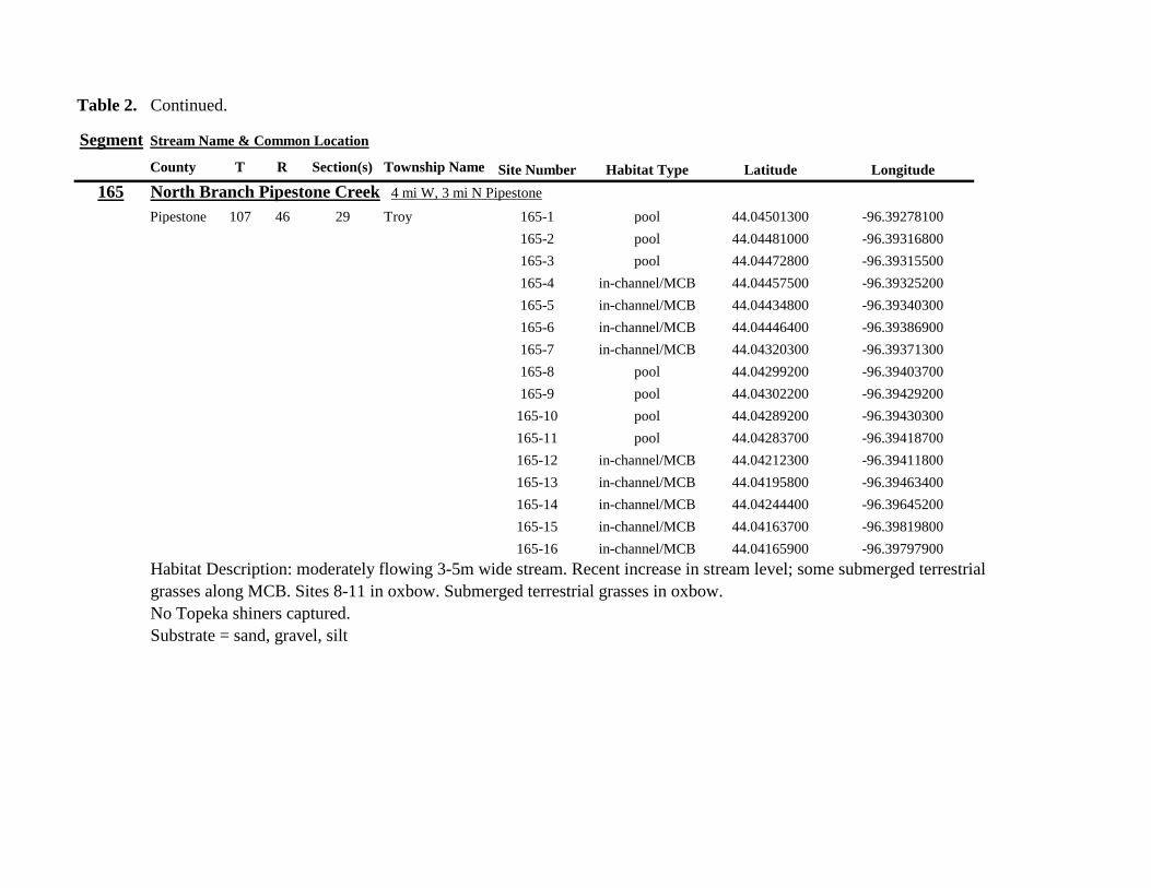
Table 2 Continued
Segment Stream Name amp Common Location
County T R Section(s) Township Name Site Number Habitat Type Latitude Longitude
165 North Branch Pipestone Creek 4 mi W 3 mi N Pipestone
Pipestone 107 46 29 Troy 165-1 pool 4404501300 -9639278100
165-2 pool 4404481000 -9639316800
165-3 pool 4404472800 -9639315500
165-4 in-channelMCB 4404457500 -9639325200
165-5 in-channelMCB 4404434800 -9639340300
165-6 in-channelMCB 4404446400 -9639386900
165-7 in-channelMCB 4404320300 -9639371300
165-8 pool 4404299200 -9639403700
165-9 pool 4404302200 -9639429200
165-10 pool 4404289200 -9639430300
165-11 pool 4404283700 -9639418700
165-12 in-channelMCB 4404212300 -9639411800
165-13 in-channelMCB 4404195800 -9639463400
165-14 in-channelMCB 4404244400 -9639645200
165-15 in-channelMCB 4404163700 -9639819800
165-16 in-channelMCB 4404165900 -9639797900
Habitat Description moderately flowing 3-5m wide stream Recent increase in stream level some submerged terrestrial
grasses along MCB Sites 8-11 in oxbow Submerged terrestrial grasses in oxbow
No Topeka shiners captured
Substrate = sand gravel silt
Table 2 Continued
Segment Stream Name amp Common Location
County T R Section(s) Township Name Site Number Habitat Type Latitude Longitude
166 Pipestone Creek 35 mi W 1 mi N Pipestone
Pipestone 106 46 4 5 Sweet 166-1 in-channelMCB 4401330100 -9638708400
166-2 in-channelMCB 4401347000 -9638709700
166-3 in-channelMCB 4401345500 -9638703700
166-4 in-channelMCB 4401355800 -9638703000
166-5 in-channelMCB 4401541200 -9638596400
166-6 in-channelMCB 4401618700 -9638658000
166-7 in-channelMCB 4401623400 -9638660800
166-8 in-channelMCB 4401625200 -9638646200
166-9 in-channelMCB 4401633300 -9638635600
166-10 in-channelMCB 4401740500 -9638517300
Habitat Description 10m wide slowly flowing stream Sampled along MCB in slack water West end of segment appears
to have been ditched Littleno OCH Drainage tiles along E reach of segment
No Topeka shiners captured
Substrate = cobble gravel sand Deep silt along margins of pools
Table 2 Continued
Segment Stream Name amp Common Location
County T R Section(s) Township Name Site Number Habitat Type Latitude Longitude
167 Split Rock Creek 15 mi N 1 mi E Ihlen
Pipestone 105 46 3 Eden 167-1 pool 4392585400 -9634993300
167-2 in-channelMCB 4392638100 -9635031600
167-3 pool 4392643100 -9635103600
167-4 pool 4392638200 -9635101900
167-5 pool 4392633000 -9635108800
167-6 pool 4392633200 -9635116400
167-7 pool 4392635700 -9635131600
167-8 pool 4392636400 -9635139100
167-9 pool 4392635900 -9635156000
167-10 in-channelMCB 4392470900 -9635255600
167-11 in-channelMCB 4392465600 -9635242800
167-12 in-channelMCB 4392447500 -9635240300
Habitat Description very small headwater stream (~1m) water low isolated series of pools along streambed No Topeka shiners captured Substrate = sand gravel silt
168 Split Rock Creek 15 mi N 05 mi E Jasper
Pipestone 105 46 28 29 Eden 168-1 in-channelMCB 4387771400 -9638026400
Habitat Description high water 4m wide flowing stream submerged terrestrial grasses on margins
Topeka shiner common 6 individuals captured on first seine haul in pooled area at MCB just downstream of culvert
Substrate = boulder cobble sand
Table 2 Continued
Segment Stream Name amp Common Location
County T R Section(s) Township Name Site Number Habitat Type Latitude Longitude
169 Rock River 1 mi SW of Edgerton
Pipestone 105 44 17 18 Osborne 169-1 pool 4389371700 -9616564700
169-2 in-channelMCB 4389439900 -9616531800
Habitat Description Swiftly flowing 10m wide stream at high water Sampled pooled area at outside bend of stream
over deep silt
Topeka shiner present four individuals captured in four seine hauls in a 1m wide drainage channel that joins a
retention pond to the Rock River
Substrate = Silt gravel Deep silt in off-channel areaspools
170 Chanarambie Creek 05 mi S 05 mi E Chandler
Murray 104 47 35 Fenton 170-1 in-channelMCB 4392093400 -9593156600
170-2 in-channelMCB 4391890200 -9593079300
170-3 in-channelMCB 4391841400 -9593168100
170-4 in-channelMCB 4391784300 -9593090300
170-5 in-channelMCB 4391783100 -9593060700
170-6 in-channelMCB 4391790600 -9593061100
170-7 in-channelMCB 4391796700 -9593025000
170-8 in-channelMCB 4391792000 -9592982800
170-9 in-channelMCB 4392105300 -9593062100
170-10 in-channelMCB 4392122900 -9593165100
Habitat Description narrow (1-2m) headwater stream Stream is flowing swiftly and little or no OCH is present
most of the segment appears to have been channelized
No Topeka shiners captured
Substrate = silt sand
Table 2 Continued
Segment Stream Name amp Common Location
County T R Section(s) Township Name Site Number Habitat Type Latitude Longitude
171 Rock River 4 mi S Edgerton
Rock 104 44 8 9 Battle Plain 171-1 in-channelMCB 4382021200 -9613013100
171-2 pool 4382126400 -9613470300
171-3 in-channelMCB 4382025300 -9612974300
171-4 in-channelMCB 4382027100 -9612961600
171-5 in-channelMCB 4382145400 -9613302800
171-6 in-channelMCB 4382380700 -9613520900
171-7 in-channelMCB 4382367500 -9613527700
171-8 in-channelMCB 4382359000 -9613532400
171-9 in-channelMCB 4382405300 -9613495400
171-10 in-channelMCB 4382271200 -9613570400
Habitat Description High water 8-12m wide swiftly flowing stream Stream is full to high banks Much of slackwater
areas along MCB likely inudndated Sampled in backwaters sites 6-9
No Topeka shiners captured
Substrate = Sand gravel silt
Table 2 Continued
Segment Stream Name amp Common Location
County T R Section(s) Township Name Site Number Habitat Type Latitude Longitude
172 Rock River tributary 1 mi E Hardwick
Rock 104 44 30 31 Battle Plain 172-1 pool 4377538900 -9617075500
172-2 pool 4377529200 -9617075600
172-3 pool 4377514700 -9617079800
172-4 in-channelMCB 4377386200 -9617079600
172-5 in-channelMCB 4377247100 -9617207900
172-6 in-channelMCB 4377241900 -9617224500
172-7 in-channelMCB 4377245200 -9617219500
172-8 in-channelMCB 4376956400 -9616914600
172-9 pool off-channel 4376998700 -9616876000
172-10 in-channelMCB 4377058800 -9616855700
172-11 in-channelMCB 4377043200 -9616826600
Habitat Description 3m wide slowly flowing pasture stream with high trampled banks Much of reach appears to
have been channelized no OCH present along MCBSampled in stock pond at site 9 Some submerged macrophytes
No Topeka shiners captured
Substrate = sand silt muck
Table 2 Continued
Segment Stream Name amp Common Location
County T R Section(s) Township Name Site Number Habitat Type Latitude Longitude
173 Mound Creek 1 mi N 175 mi E Beaver Creek
Rock 103 45 2 11 Mound 173-1 in-channelMCB 4374749900 -9620089200
173-2 in-channelMCB 4374756900 -9620094400
173-3 in-channelMCB 4374763700 -9620090700
173-4 in-channelMCB 4374842800 -9619838100
173-5 in-channelMCB 4374844000 -9619833200
173-6 in-channelMCB 4374889800 -9619789300
173-7 in-channelMCB 4374839600 -9619885800
173-8 in-channelMCB 4374827900 -9619934500
173-9 in-channelMCB 4374817000 -9619966400
173-10 in-channelMCB 4374799700 -9620048400
Habitat Description Entire reach of sement has been channelized Stream is 1-2m wide and constantly flowing High
banks No OCH
No Topeka shiners captured
Substrate = gravel sand silt
Table 2 Continued
Segment Stream Name amp Common Location
County T R Section(s) Township Name Site Number Habitat Type Latitude Longitude
174 Rock River tributary 55 mi N 4 mi E Luverne
Rock 103 44 8 9 Vienna 174-1 pool 4373333900 -9613250300
174-2 pool 4373322100 -9613262700
Habitat Description Narrow (2-3m) wide flowing headwater stream Sampled in deep silted pool at bridge Topeka shiner present two individuals captured over gravel in pooled area at bridge Much of the pool is filled with deep (gt05m) silt No Topeka shiners collected in silted portion of pool Substrate = gravel sand silt
Table 2 Continued
Segment Stream Name amp Common Location
County T R Section(s) Township Name Site Number Habitat Type Latitude Longitude
175 Champepadan Creek 4mi N 5 mi E Luverne
Rock 103 44 21 22 Vienna 175-1 pool 4371002900 -9611238300
175-2 pool 4371001900 -9611232600
175-3 pool 4371008300 -9611238900
175-4 in-channelMCB 4370955000 -9611142300
175-5 in-channelMCB 4371042200 -9610763900
175-6 in-channelMCB 4371007000 -9610720000
175-7 in-channelMCB 4370984100 -9610706400
175-8 pooloff-channel 4370971600 -9610709700
Habitat Description 3m wide stream with moderate flow Native prairie has been planted along both banks for the entire reach
No flow Sampled at pooled areas at culverts at CH 19
Topeka shiner present one individual captured in deep livestock pond S of stream Depth (gt2m) made seining in pond difficult
Substrate = sand silt gravel
Table 2 Continued
Segment Stream Name amp Common Location
County T R Section(s) Township Name Site Number Habitat Type Latitude Longitude
176 Kanaranzi Creek 2 mi W 35 mi N Ellworth
Rock 101 44 12 Kanaranzi 176-1 pool 4357304000 -9606413600
176-2 pool 4357305400 -9606410500
176-3 pool 4357249700 -9606408600
176-4 in-channelMCB 4357200500 -9606350300
176-5 in-channelMCB 4357204500 -9606354600
176-6 in-channelMCB 4357211400 -9606360400
176-7 in-channelMCB 4357127700 -9606357500
176-8 in-channelMCB 4357090500 -9606197900
176-9 in-channelMCB 4356817400 -9606275000
176-10 in-channelMCB 4356807000 -9606273900
176-11 in-channelMCB 4356639200 -9606408000
176-12 in-channelMCB 4356632100 -9606416000
176-13 in-channelMCB 4356598300 -9606381200
Habitat Description 10m wide flowing stream Very little OCH Very deep silt along MCB Sampled pooled area
at bridge High eroded banks
No Topeka shiners captured
Substrate = silt over gravel
Table 2 Continued
Segment Stream Name amp Common Location
County T R Section(s) Township Name Site Number Habitat Type Latitude Longitude
177 Rock River 05 mi N 4 mi E Steen
Rock 101 45 25 Clinton 177-1 pool 4352588900 -9618721100
177-2 pool 4352592700 -9618726600
177-3 in-channelMCB 4352519900 -9618594900
177-4 in-channelMCB 4352297500 -9618558400
177-5 in-channelMCB 4352147800 -9618456000
177-6 in-channelMCB 4352143300 -9618458200
177-7 in-channelMCB 4352125000 -9618453100
177-8 in-channelMCB 4352121500 -9618442200
177-9 in-channelMCB 4352106600 -9618444000
177-10 in-channelMCB 4352727900 -9618684800
177-11 pool 4352783000 -9618770800
177-12 pooloff-channel 4352663200 -9619046500
Habitat Description 11m wide flowing stream with wide channel sand bars and some braiding Firm gravel in thalweg Oxbow in middle of reach is nearly dry (lt25 cm) No fish observed culicid fly larvae abundant No Topeka shiners captured Substrate = sand gravel silt
Table 2 Continued
Segment Stream Name amp Common Location
County T R Section(s) Township Name Site Number Habitat Type Latitude Longitude
178 Kanaranzi Creek 2 mi W Ellsworth
Rock 101 44 25 36 Kanaranzi 178-1 pool 4351441400 -9605867000
178-2 in-channelMCB 4351404500 -9605846000
178-3 in-channelMCB 4351378800 -9605844300
178-4 pool 4351349700 -9605841200
178-5 pool 4351358400 -9605829800
178-6 pool 4351351800 -9605816800
178-7 in-channelMCB 4351355800 -9605866900
178-8 in-channelMCB 4351549000 -9605823700
178-9 in-channelMCB 4351891800 -9605895600
178-10 in-channelMCB 4351866200 -9605881400
178-11 pool 4352078500 -9606070000
178-12 pool 4352046000 -9606082200
Habitat Description 7-9m wide flowing stream Sampled backwater and off-channel habitats along MCB and side channels Recent high flow has filled in off-channel areas with deep silt Seining difficult No Topeka shiners captured Substrate = sand silt gravel
Table 2 Concluded
Segment Stream Name amp Common Location
County T R Section(s) Township Name Site Number Habitat Type Latitude Longitude
179 East Branch Kanaranzi Creek 15 mi N 15 mi E Adrian
Nobles 102 42 8 Olney 179-1 pool 4365932900 -9590462700
179-2 pool 4365928900 -9590449500
179-3 pool 4365930600 -9590463300
179-4 pool 4365908000 -9590420300
179-5 in-channelMCB 4365679800 -9590378600
179-6 in-channelMCB 4365661000 -9590387800
179-7 in-channelMCB 4365604000 -9590417100
179-8 in-channelMCB 4365508100 -9590385200
179-9 in-channelMCB 4365460100 -9590342200
179-10 pool 4365434900 -9590020100
179-11 in-channelMCB 4365507700 -9590154900
179-12 in-channelMCB 4365588000 -9589900200
Habitat Description Flowing 9m wide stream Stream is full to high banks very little slackwater habitat present at this site
No Topeka shiners captured
Substrate = sand silt gravel
180 Little Rock River 8 mi E Ellsworth
Nobles 101 42 26 Little Rock 180-1 in-channelMCB 4352838500 -9584615900
Habitat Description Sampled large pooled area at bridge no discernible flow silt over gravel substrate Channel downstream
of pool is a 2-3 m wide flowing stream with a firm sandgravel substrate
Topeka shiner abundant fourteen individuals captured in first seine haul in pool fifteen individuals captured in second seine
haul near outlet of the pool
Substrate = gravel sand silt
Table 3 Complete List of Fish Species Captured at Segments 141-160 2012
Species 141 142 143 144 145 146 147 148 149 150 151 152 153 154 155 156 157 158 159 160 Campostoma anomalum X X X X X X X X X X X X X X Chrosomus erythrogaster X X Cyprinella lutrensis X X X X X X X X X Cyprinus carpio X X X X X Hybognathus hankinsoni X X X X X X X Luxilus cornutus X X X X X X X X X X X X X Notropis dorsalis X X X X X X X X X X X Notropis stramineus X X X X X X X X X X X X X X X Notropis topeka X X X X X X X X Pimephales notatus X X X X X X X X X X X X Pimephales promelas X X X X X X X X X X X X X X X X X X Rhinichthys atratulus X X X X X X Semotilus atromaculatus X X X X X X X X X X X X X X X X X X Carpiodes cyprinus X Carpiodes sp (YOY) X X X Catostomus commersoni X X X X X X X X X X X X X X X Moxostoma macrolepidotum X X Ameiurus melas X X X X X X X X X X X X X Ameiurus natalis X Ictalurus punctatus X X X X Noturus flavus X X X X Noturus gyrinus X X X X X Esox lucius X X Percopsis omiscomaycus X Fundulus sciadicus X X X Culaea inconstans X X X X X Lepomis cyanellus X X X X X X X Lepomis humilis X X X X X X X X X X X Lepomis macrochirus X X X X X Micropterus dolomieui X Micropterus salmoides X X Pomoxis nigromaculatus X X Etheostoma exile X X X X X Etheostoma nigrum X X X X X X X X X X X X X X X X X Perca flavescens X X Percina maculata X X X X
Table 4 Complete List of Fish Species Captured at Segments 161-180 2013
Species 161 162 163 164 165 166 167 168 169 170 171 172 173 174 175 176 177 178 179 180
Campostoma anomalum X X X X X X X X X X X X X X
Cyprinella lutrensis X X X X X X X X X X
Cyprinus carpio X X X
Hybognathus hankinsoni X X X X X
Luxilus cornutus X X X X X X X X X X X X X
Notropis dorsalis X X X X X X X X X X X X X X
Notropis stramineus X X X X X X X X X X X X X X
Notropis topeka X X X X X X
Pimephales notatus X X X X X X X X X X X X
Pimephales promelas X X X X X X X X X X X X X X X X X X
Rhinichthys atratulus X X X X X X X X X X X
Semotilus atromaculatus X X X X X X X X X X X X X X X X
Carpiodes cyprinus X X
Catostomus commersoni X X X X X X X X X X X X X
Moxostoma erythrurum X X X
Moxostoma macrolepidotum X X
Ameiurus melas X X X X X X X X X X
Noturus flavus X X X
Esox lucius X X
Percopsis omiscomaycus X
Fundulus sciadicus X
Culaea inconstans X X X X
Lepomis cyanellus X X X X X X
Lepomis humilis X X X X X X X X X
Etheostoma exile X X
Etheostoma nigrum X X X X X X X X X X
Percina maculata X X
Appendix C- Habitat and Voucher Photographs
Habitat photographs for segments in which no Topeka shiners were captured are representative
of the habitat along the one-mile reach of stream Habitat photographs from segments where
Topeka shiners were present represent the specific site where they were collected Voucher
photographs are presented for each of the sites were Topeka shiners were collected
Site 141-2 Medary Creek voucher and habitat photos
Segment 142 Willow Creek no Topeka shiners captured
Segment 143 East Branch Flandrau Creek no Topeka shiners captured
Segment 144 North Branch Pipestone Creek no Topeka shiners captured
Site 145-6 Pipestone Creek voucher photo
Site 145-6 Pipestone Creek habitat photo
Segment 146 Split Rock Creek no Topeka shiners captured No habitat photo
Segment 147 Kanaranzi Creek no Topeka shiners captured
Site 148-4 Rock River voucher and habitat photos
Site 149-4 Rock River voucher and habitat photos
Site 150-4 Split Rock Creek voucher and habitat photos
Site 151-1 Beaver Creek voucher and habitat photos
Segment 152 Beaver Creek no Topeka shiners captured
Segment 153 Beaver Creek no Topeka shiners captured
Segment 154 Rock River no Topeka shiners captured
Segment 155 Elk Creek no Topeka shiners captured
Site 156-1 Elk Creek voucher and habitat photos
Segment 157 Kanaranzi Creek no Topeka shiners captured
Segment 158 Kanaranzi Creek no Topeka shiners captured
Site 159-1 Kanaranzi Creek voucher and habitat photos
Segment 160 Little Rock River no Topeka shiners captured
Site 161-15 Medary Creek voucher photo
Site 161-15 Medary Creek habitat photo
Segment 162 Willow Creek no Topeka shiners captured No habitat photo
Segment 163 Flandrau Creek no Topeka shiners captured
Segment 164 Flandrau Creek no Topeka shiners captured
Segment 165 North Branch Pipestone Creek no Topeka Shiners captured
Segment 166 Pipestone Creek no Topeka Shiners captured
Segment 167 Tributary to Split Rock Creek no Topeka Shiners captured No habitat
photo
Site 168-1 Split Rock Creek voucher photo
Site 168-1 Split Rock Creek habitat photo
Site 169-2 Rock River voucher photo
Site 169-2 Rock River habitat photo
Segment 170 Chanarambie Creek no Topeka shiners captured
Segment 171 Rock River no Topeka shiners captured
Segment 172 Tributary to Rock River no Topeka shiners captured
Segment 173 Blue Mound Creek no Topeka shiners
Site 174-2 Tributary to Rock River voucher photo
Site 174-2 Tributary to Rock River habitat photo
Site 175-8 Champepadan Creek voucher photo
Site 175-8 Champepadan Creek habitat photo
Segment 176 Kanaranzi Creek no Topekas captured
Segment 177 Rock River no Topeka shiners captured
Segment 178 Kanaranzi Creek no Topeka shiners captured
Segment 179 East Branch Kanaranzi Creek no Topeka shiners captured
Site 180-1 West Branch Little Rock River voucher photo
Site 180-1 West Branch Little Rock River habitat photo
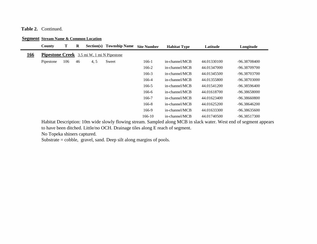
Table 2 Continued
Segment Stream Name amp Common Location
County T R Section(s) Township Name Site Number Habitat Type Latitude Longitude
166 Pipestone Creek 35 mi W 1 mi N Pipestone
Pipestone 106 46 4 5 Sweet 166-1 in-channelMCB 4401330100 -9638708400
166-2 in-channelMCB 4401347000 -9638709700
166-3 in-channelMCB 4401345500 -9638703700
166-4 in-channelMCB 4401355800 -9638703000
166-5 in-channelMCB 4401541200 -9638596400
166-6 in-channelMCB 4401618700 -9638658000
166-7 in-channelMCB 4401623400 -9638660800
166-8 in-channelMCB 4401625200 -9638646200
166-9 in-channelMCB 4401633300 -9638635600
166-10 in-channelMCB 4401740500 -9638517300
Habitat Description 10m wide slowly flowing stream Sampled along MCB in slack water West end of segment appears
to have been ditched Littleno OCH Drainage tiles along E reach of segment
No Topeka shiners captured
Substrate = cobble gravel sand Deep silt along margins of pools
Table 2 Continued
Segment Stream Name amp Common Location
County T R Section(s) Township Name Site Number Habitat Type Latitude Longitude
167 Split Rock Creek 15 mi N 1 mi E Ihlen
Pipestone 105 46 3 Eden 167-1 pool 4392585400 -9634993300
167-2 in-channelMCB 4392638100 -9635031600
167-3 pool 4392643100 -9635103600
167-4 pool 4392638200 -9635101900
167-5 pool 4392633000 -9635108800
167-6 pool 4392633200 -9635116400
167-7 pool 4392635700 -9635131600
167-8 pool 4392636400 -9635139100
167-9 pool 4392635900 -9635156000
167-10 in-channelMCB 4392470900 -9635255600
167-11 in-channelMCB 4392465600 -9635242800
167-12 in-channelMCB 4392447500 -9635240300
Habitat Description very small headwater stream (~1m) water low isolated series of pools along streambed No Topeka shiners captured Substrate = sand gravel silt
168 Split Rock Creek 15 mi N 05 mi E Jasper
Pipestone 105 46 28 29 Eden 168-1 in-channelMCB 4387771400 -9638026400
Habitat Description high water 4m wide flowing stream submerged terrestrial grasses on margins
Topeka shiner common 6 individuals captured on first seine haul in pooled area at MCB just downstream of culvert
Substrate = boulder cobble sand
Table 2 Continued
Segment Stream Name amp Common Location
County T R Section(s) Township Name Site Number Habitat Type Latitude Longitude
169 Rock River 1 mi SW of Edgerton
Pipestone 105 44 17 18 Osborne 169-1 pool 4389371700 -9616564700
169-2 in-channelMCB 4389439900 -9616531800
Habitat Description Swiftly flowing 10m wide stream at high water Sampled pooled area at outside bend of stream
over deep silt
Topeka shiner present four individuals captured in four seine hauls in a 1m wide drainage channel that joins a
retention pond to the Rock River
Substrate = Silt gravel Deep silt in off-channel areaspools
170 Chanarambie Creek 05 mi S 05 mi E Chandler
Murray 104 47 35 Fenton 170-1 in-channelMCB 4392093400 -9593156600
170-2 in-channelMCB 4391890200 -9593079300
170-3 in-channelMCB 4391841400 -9593168100
170-4 in-channelMCB 4391784300 -9593090300
170-5 in-channelMCB 4391783100 -9593060700
170-6 in-channelMCB 4391790600 -9593061100
170-7 in-channelMCB 4391796700 -9593025000
170-8 in-channelMCB 4391792000 -9592982800
170-9 in-channelMCB 4392105300 -9593062100
170-10 in-channelMCB 4392122900 -9593165100
Habitat Description narrow (1-2m) headwater stream Stream is flowing swiftly and little or no OCH is present
most of the segment appears to have been channelized
No Topeka shiners captured
Substrate = silt sand
Table 2 Continued
Segment Stream Name amp Common Location
County T R Section(s) Township Name Site Number Habitat Type Latitude Longitude
171 Rock River 4 mi S Edgerton
Rock 104 44 8 9 Battle Plain 171-1 in-channelMCB 4382021200 -9613013100
171-2 pool 4382126400 -9613470300
171-3 in-channelMCB 4382025300 -9612974300
171-4 in-channelMCB 4382027100 -9612961600
171-5 in-channelMCB 4382145400 -9613302800
171-6 in-channelMCB 4382380700 -9613520900
171-7 in-channelMCB 4382367500 -9613527700
171-8 in-channelMCB 4382359000 -9613532400
171-9 in-channelMCB 4382405300 -9613495400
171-10 in-channelMCB 4382271200 -9613570400
Habitat Description High water 8-12m wide swiftly flowing stream Stream is full to high banks Much of slackwater
areas along MCB likely inudndated Sampled in backwaters sites 6-9
No Topeka shiners captured
Substrate = Sand gravel silt
Table 2 Continued
Segment Stream Name amp Common Location
County T R Section(s) Township Name Site Number Habitat Type Latitude Longitude
172 Rock River tributary 1 mi E Hardwick
Rock 104 44 30 31 Battle Plain 172-1 pool 4377538900 -9617075500
172-2 pool 4377529200 -9617075600
172-3 pool 4377514700 -9617079800
172-4 in-channelMCB 4377386200 -9617079600
172-5 in-channelMCB 4377247100 -9617207900
172-6 in-channelMCB 4377241900 -9617224500
172-7 in-channelMCB 4377245200 -9617219500
172-8 in-channelMCB 4376956400 -9616914600
172-9 pool off-channel 4376998700 -9616876000
172-10 in-channelMCB 4377058800 -9616855700
172-11 in-channelMCB 4377043200 -9616826600
Habitat Description 3m wide slowly flowing pasture stream with high trampled banks Much of reach appears to
have been channelized no OCH present along MCBSampled in stock pond at site 9 Some submerged macrophytes
No Topeka shiners captured
Substrate = sand silt muck
Table 2 Continued
Segment Stream Name amp Common Location
County T R Section(s) Township Name Site Number Habitat Type Latitude Longitude
173 Mound Creek 1 mi N 175 mi E Beaver Creek
Rock 103 45 2 11 Mound 173-1 in-channelMCB 4374749900 -9620089200
173-2 in-channelMCB 4374756900 -9620094400
173-3 in-channelMCB 4374763700 -9620090700
173-4 in-channelMCB 4374842800 -9619838100
173-5 in-channelMCB 4374844000 -9619833200
173-6 in-channelMCB 4374889800 -9619789300
173-7 in-channelMCB 4374839600 -9619885800
173-8 in-channelMCB 4374827900 -9619934500
173-9 in-channelMCB 4374817000 -9619966400
173-10 in-channelMCB 4374799700 -9620048400
Habitat Description Entire reach of sement has been channelized Stream is 1-2m wide and constantly flowing High
banks No OCH
No Topeka shiners captured
Substrate = gravel sand silt
Table 2 Continued
Segment Stream Name amp Common Location
County T R Section(s) Township Name Site Number Habitat Type Latitude Longitude
174 Rock River tributary 55 mi N 4 mi E Luverne
Rock 103 44 8 9 Vienna 174-1 pool 4373333900 -9613250300
174-2 pool 4373322100 -9613262700
Habitat Description Narrow (2-3m) wide flowing headwater stream Sampled in deep silted pool at bridge Topeka shiner present two individuals captured over gravel in pooled area at bridge Much of the pool is filled with deep (gt05m) silt No Topeka shiners collected in silted portion of pool Substrate = gravel sand silt
Table 2 Continued
Segment Stream Name amp Common Location
County T R Section(s) Township Name Site Number Habitat Type Latitude Longitude
175 Champepadan Creek 4mi N 5 mi E Luverne
Rock 103 44 21 22 Vienna 175-1 pool 4371002900 -9611238300
175-2 pool 4371001900 -9611232600
175-3 pool 4371008300 -9611238900
175-4 in-channelMCB 4370955000 -9611142300
175-5 in-channelMCB 4371042200 -9610763900
175-6 in-channelMCB 4371007000 -9610720000
175-7 in-channelMCB 4370984100 -9610706400
175-8 pooloff-channel 4370971600 -9610709700
Habitat Description 3m wide stream with moderate flow Native prairie has been planted along both banks for the entire reach
No flow Sampled at pooled areas at culverts at CH 19
Topeka shiner present one individual captured in deep livestock pond S of stream Depth (gt2m) made seining in pond difficult
Substrate = sand silt gravel
Table 2 Continued
Segment Stream Name amp Common Location
County T R Section(s) Township Name Site Number Habitat Type Latitude Longitude
176 Kanaranzi Creek 2 mi W 35 mi N Ellworth
Rock 101 44 12 Kanaranzi 176-1 pool 4357304000 -9606413600
176-2 pool 4357305400 -9606410500
176-3 pool 4357249700 -9606408600
176-4 in-channelMCB 4357200500 -9606350300
176-5 in-channelMCB 4357204500 -9606354600
176-6 in-channelMCB 4357211400 -9606360400
176-7 in-channelMCB 4357127700 -9606357500
176-8 in-channelMCB 4357090500 -9606197900
176-9 in-channelMCB 4356817400 -9606275000
176-10 in-channelMCB 4356807000 -9606273900
176-11 in-channelMCB 4356639200 -9606408000
176-12 in-channelMCB 4356632100 -9606416000
176-13 in-channelMCB 4356598300 -9606381200
Habitat Description 10m wide flowing stream Very little OCH Very deep silt along MCB Sampled pooled area
at bridge High eroded banks
No Topeka shiners captured
Substrate = silt over gravel
Table 2 Continued
Segment Stream Name amp Common Location
County T R Section(s) Township Name Site Number Habitat Type Latitude Longitude
177 Rock River 05 mi N 4 mi E Steen
Rock 101 45 25 Clinton 177-1 pool 4352588900 -9618721100
177-2 pool 4352592700 -9618726600
177-3 in-channelMCB 4352519900 -9618594900
177-4 in-channelMCB 4352297500 -9618558400
177-5 in-channelMCB 4352147800 -9618456000
177-6 in-channelMCB 4352143300 -9618458200
177-7 in-channelMCB 4352125000 -9618453100
177-8 in-channelMCB 4352121500 -9618442200
177-9 in-channelMCB 4352106600 -9618444000
177-10 in-channelMCB 4352727900 -9618684800
177-11 pool 4352783000 -9618770800
177-12 pooloff-channel 4352663200 -9619046500
Habitat Description 11m wide flowing stream with wide channel sand bars and some braiding Firm gravel in thalweg Oxbow in middle of reach is nearly dry (lt25 cm) No fish observed culicid fly larvae abundant No Topeka shiners captured Substrate = sand gravel silt
Table 2 Continued
Segment Stream Name amp Common Location
County T R Section(s) Township Name Site Number Habitat Type Latitude Longitude
178 Kanaranzi Creek 2 mi W Ellsworth
Rock 101 44 25 36 Kanaranzi 178-1 pool 4351441400 -9605867000
178-2 in-channelMCB 4351404500 -9605846000
178-3 in-channelMCB 4351378800 -9605844300
178-4 pool 4351349700 -9605841200
178-5 pool 4351358400 -9605829800
178-6 pool 4351351800 -9605816800
178-7 in-channelMCB 4351355800 -9605866900
178-8 in-channelMCB 4351549000 -9605823700
178-9 in-channelMCB 4351891800 -9605895600
178-10 in-channelMCB 4351866200 -9605881400
178-11 pool 4352078500 -9606070000
178-12 pool 4352046000 -9606082200
Habitat Description 7-9m wide flowing stream Sampled backwater and off-channel habitats along MCB and side channels Recent high flow has filled in off-channel areas with deep silt Seining difficult No Topeka shiners captured Substrate = sand silt gravel
Table 2 Concluded
Segment Stream Name amp Common Location
County T R Section(s) Township Name Site Number Habitat Type Latitude Longitude
179 East Branch Kanaranzi Creek 15 mi N 15 mi E Adrian
Nobles 102 42 8 Olney 179-1 pool 4365932900 -9590462700
179-2 pool 4365928900 -9590449500
179-3 pool 4365930600 -9590463300
179-4 pool 4365908000 -9590420300
179-5 in-channelMCB 4365679800 -9590378600
179-6 in-channelMCB 4365661000 -9590387800
179-7 in-channelMCB 4365604000 -9590417100
179-8 in-channelMCB 4365508100 -9590385200
179-9 in-channelMCB 4365460100 -9590342200
179-10 pool 4365434900 -9590020100
179-11 in-channelMCB 4365507700 -9590154900
179-12 in-channelMCB 4365588000 -9589900200
Habitat Description Flowing 9m wide stream Stream is full to high banks very little slackwater habitat present at this site
No Topeka shiners captured
Substrate = sand silt gravel
180 Little Rock River 8 mi E Ellsworth
Nobles 101 42 26 Little Rock 180-1 in-channelMCB 4352838500 -9584615900
Habitat Description Sampled large pooled area at bridge no discernible flow silt over gravel substrate Channel downstream
of pool is a 2-3 m wide flowing stream with a firm sandgravel substrate
Topeka shiner abundant fourteen individuals captured in first seine haul in pool fifteen individuals captured in second seine
haul near outlet of the pool
Substrate = gravel sand silt
Table 3 Complete List of Fish Species Captured at Segments 141-160 2012
Species 141 142 143 144 145 146 147 148 149 150 151 152 153 154 155 156 157 158 159 160 Campostoma anomalum X X X X X X X X X X X X X X Chrosomus erythrogaster X X Cyprinella lutrensis X X X X X X X X X Cyprinus carpio X X X X X Hybognathus hankinsoni X X X X X X X Luxilus cornutus X X X X X X X X X X X X X Notropis dorsalis X X X X X X X X X X X Notropis stramineus X X X X X X X X X X X X X X X Notropis topeka X X X X X X X X Pimephales notatus X X X X X X X X X X X X Pimephales promelas X X X X X X X X X X X X X X X X X X Rhinichthys atratulus X X X X X X Semotilus atromaculatus X X X X X X X X X X X X X X X X X X Carpiodes cyprinus X Carpiodes sp (YOY) X X X Catostomus commersoni X X X X X X X X X X X X X X X Moxostoma macrolepidotum X X Ameiurus melas X X X X X X X X X X X X X Ameiurus natalis X Ictalurus punctatus X X X X Noturus flavus X X X X Noturus gyrinus X X X X X Esox lucius X X Percopsis omiscomaycus X Fundulus sciadicus X X X Culaea inconstans X X X X X Lepomis cyanellus X X X X X X X Lepomis humilis X X X X X X X X X X X Lepomis macrochirus X X X X X Micropterus dolomieui X Micropterus salmoides X X Pomoxis nigromaculatus X X Etheostoma exile X X X X X Etheostoma nigrum X X X X X X X X X X X X X X X X X Perca flavescens X X Percina maculata X X X X
Table 4 Complete List of Fish Species Captured at Segments 161-180 2013
Species 161 162 163 164 165 166 167 168 169 170 171 172 173 174 175 176 177 178 179 180
Campostoma anomalum X X X X X X X X X X X X X X
Cyprinella lutrensis X X X X X X X X X X
Cyprinus carpio X X X
Hybognathus hankinsoni X X X X X
Luxilus cornutus X X X X X X X X X X X X X
Notropis dorsalis X X X X X X X X X X X X X X
Notropis stramineus X X X X X X X X X X X X X X
Notropis topeka X X X X X X
Pimephales notatus X X X X X X X X X X X X
Pimephales promelas X X X X X X X X X X X X X X X X X X
Rhinichthys atratulus X X X X X X X X X X X
Semotilus atromaculatus X X X X X X X X X X X X X X X X
Carpiodes cyprinus X X
Catostomus commersoni X X X X X X X X X X X X X
Moxostoma erythrurum X X X
Moxostoma macrolepidotum X X
Ameiurus melas X X X X X X X X X X
Noturus flavus X X X
Esox lucius X X
Percopsis omiscomaycus X
Fundulus sciadicus X
Culaea inconstans X X X X
Lepomis cyanellus X X X X X X
Lepomis humilis X X X X X X X X X
Etheostoma exile X X
Etheostoma nigrum X X X X X X X X X X
Percina maculata X X
Appendix C- Habitat and Voucher Photographs
Habitat photographs for segments in which no Topeka shiners were captured are representative
of the habitat along the one-mile reach of stream Habitat photographs from segments where
Topeka shiners were present represent the specific site where they were collected Voucher
photographs are presented for each of the sites were Topeka shiners were collected
Site 141-2 Medary Creek voucher and habitat photos
Segment 142 Willow Creek no Topeka shiners captured
Segment 143 East Branch Flandrau Creek no Topeka shiners captured
Segment 144 North Branch Pipestone Creek no Topeka shiners captured
Site 145-6 Pipestone Creek voucher photo
Site 145-6 Pipestone Creek habitat photo
Segment 146 Split Rock Creek no Topeka shiners captured No habitat photo
Segment 147 Kanaranzi Creek no Topeka shiners captured
Site 148-4 Rock River voucher and habitat photos
Site 149-4 Rock River voucher and habitat photos
Site 150-4 Split Rock Creek voucher and habitat photos
Site 151-1 Beaver Creek voucher and habitat photos
Segment 152 Beaver Creek no Topeka shiners captured
Segment 153 Beaver Creek no Topeka shiners captured
Segment 154 Rock River no Topeka shiners captured
Segment 155 Elk Creek no Topeka shiners captured
Site 156-1 Elk Creek voucher and habitat photos
Segment 157 Kanaranzi Creek no Topeka shiners captured
Segment 158 Kanaranzi Creek no Topeka shiners captured
Site 159-1 Kanaranzi Creek voucher and habitat photos
Segment 160 Little Rock River no Topeka shiners captured
Site 161-15 Medary Creek voucher photo
Site 161-15 Medary Creek habitat photo
Segment 162 Willow Creek no Topeka shiners captured No habitat photo
Segment 163 Flandrau Creek no Topeka shiners captured
Segment 164 Flandrau Creek no Topeka shiners captured
Segment 165 North Branch Pipestone Creek no Topeka Shiners captured
Segment 166 Pipestone Creek no Topeka Shiners captured
Segment 167 Tributary to Split Rock Creek no Topeka Shiners captured No habitat
photo
Site 168-1 Split Rock Creek voucher photo
Site 168-1 Split Rock Creek habitat photo
Site 169-2 Rock River voucher photo
Site 169-2 Rock River habitat photo
Segment 170 Chanarambie Creek no Topeka shiners captured
Segment 171 Rock River no Topeka shiners captured
Segment 172 Tributary to Rock River no Topeka shiners captured
Segment 173 Blue Mound Creek no Topeka shiners
Site 174-2 Tributary to Rock River voucher photo
Site 174-2 Tributary to Rock River habitat photo
Site 175-8 Champepadan Creek voucher photo
Site 175-8 Champepadan Creek habitat photo
Segment 176 Kanaranzi Creek no Topekas captured
Segment 177 Rock River no Topeka shiners captured
Segment 178 Kanaranzi Creek no Topeka shiners captured
Segment 179 East Branch Kanaranzi Creek no Topeka shiners captured
Site 180-1 West Branch Little Rock River voucher photo
Site 180-1 West Branch Little Rock River habitat photo
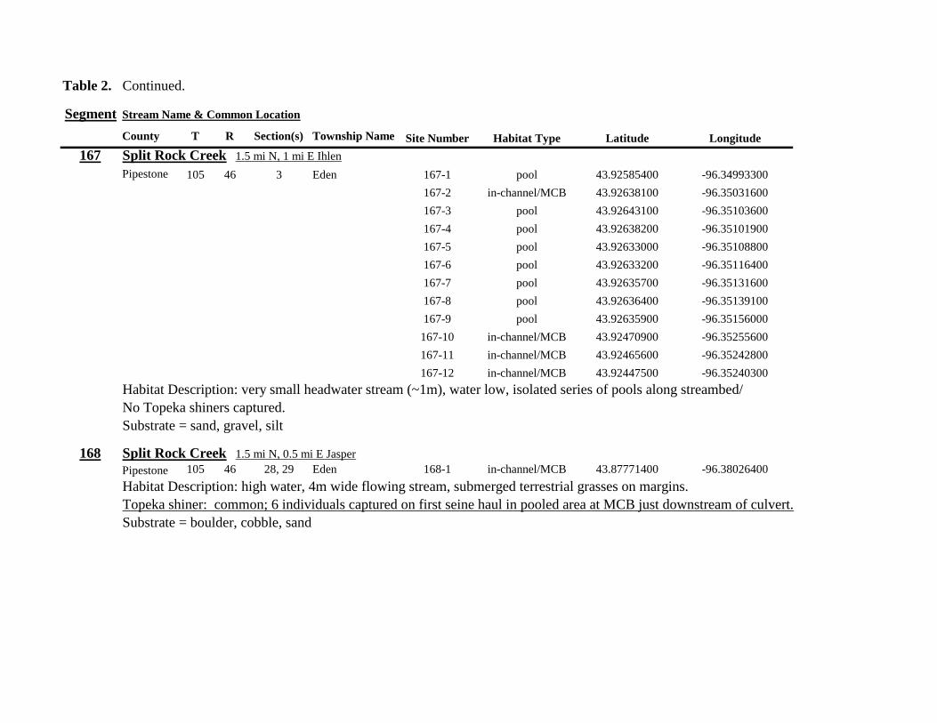
Table 2 Continued
Segment Stream Name amp Common Location
County T R Section(s) Township Name Site Number Habitat Type Latitude Longitude
167 Split Rock Creek 15 mi N 1 mi E Ihlen
Pipestone 105 46 3 Eden 167-1 pool 4392585400 -9634993300
167-2 in-channelMCB 4392638100 -9635031600
167-3 pool 4392643100 -9635103600
167-4 pool 4392638200 -9635101900
167-5 pool 4392633000 -9635108800
167-6 pool 4392633200 -9635116400
167-7 pool 4392635700 -9635131600
167-8 pool 4392636400 -9635139100
167-9 pool 4392635900 -9635156000
167-10 in-channelMCB 4392470900 -9635255600
167-11 in-channelMCB 4392465600 -9635242800
167-12 in-channelMCB 4392447500 -9635240300
Habitat Description very small headwater stream (~1m) water low isolated series of pools along streambed No Topeka shiners captured Substrate = sand gravel silt
168 Split Rock Creek 15 mi N 05 mi E Jasper
Pipestone 105 46 28 29 Eden 168-1 in-channelMCB 4387771400 -9638026400
Habitat Description high water 4m wide flowing stream submerged terrestrial grasses on margins
Topeka shiner common 6 individuals captured on first seine haul in pooled area at MCB just downstream of culvert
Substrate = boulder cobble sand
Table 2 Continued
Segment Stream Name amp Common Location
County T R Section(s) Township Name Site Number Habitat Type Latitude Longitude
169 Rock River 1 mi SW of Edgerton
Pipestone 105 44 17 18 Osborne 169-1 pool 4389371700 -9616564700
169-2 in-channelMCB 4389439900 -9616531800
Habitat Description Swiftly flowing 10m wide stream at high water Sampled pooled area at outside bend of stream
over deep silt
Topeka shiner present four individuals captured in four seine hauls in a 1m wide drainage channel that joins a
retention pond to the Rock River
Substrate = Silt gravel Deep silt in off-channel areaspools
170 Chanarambie Creek 05 mi S 05 mi E Chandler
Murray 104 47 35 Fenton 170-1 in-channelMCB 4392093400 -9593156600
170-2 in-channelMCB 4391890200 -9593079300
170-3 in-channelMCB 4391841400 -9593168100
170-4 in-channelMCB 4391784300 -9593090300
170-5 in-channelMCB 4391783100 -9593060700
170-6 in-channelMCB 4391790600 -9593061100
170-7 in-channelMCB 4391796700 -9593025000
170-8 in-channelMCB 4391792000 -9592982800
170-9 in-channelMCB 4392105300 -9593062100
170-10 in-channelMCB 4392122900 -9593165100
Habitat Description narrow (1-2m) headwater stream Stream is flowing swiftly and little or no OCH is present
most of the segment appears to have been channelized
No Topeka shiners captured
Substrate = silt sand
Table 2 Continued
Segment Stream Name amp Common Location
County T R Section(s) Township Name Site Number Habitat Type Latitude Longitude
171 Rock River 4 mi S Edgerton
Rock 104 44 8 9 Battle Plain 171-1 in-channelMCB 4382021200 -9613013100
171-2 pool 4382126400 -9613470300
171-3 in-channelMCB 4382025300 -9612974300
171-4 in-channelMCB 4382027100 -9612961600
171-5 in-channelMCB 4382145400 -9613302800
171-6 in-channelMCB 4382380700 -9613520900
171-7 in-channelMCB 4382367500 -9613527700
171-8 in-channelMCB 4382359000 -9613532400
171-9 in-channelMCB 4382405300 -9613495400
171-10 in-channelMCB 4382271200 -9613570400
Habitat Description High water 8-12m wide swiftly flowing stream Stream is full to high banks Much of slackwater
areas along MCB likely inudndated Sampled in backwaters sites 6-9
No Topeka shiners captured
Substrate = Sand gravel silt
Table 2 Continued
Segment Stream Name amp Common Location
County T R Section(s) Township Name Site Number Habitat Type Latitude Longitude
172 Rock River tributary 1 mi E Hardwick
Rock 104 44 30 31 Battle Plain 172-1 pool 4377538900 -9617075500
172-2 pool 4377529200 -9617075600
172-3 pool 4377514700 -9617079800
172-4 in-channelMCB 4377386200 -9617079600
172-5 in-channelMCB 4377247100 -9617207900
172-6 in-channelMCB 4377241900 -9617224500
172-7 in-channelMCB 4377245200 -9617219500
172-8 in-channelMCB 4376956400 -9616914600
172-9 pool off-channel 4376998700 -9616876000
172-10 in-channelMCB 4377058800 -9616855700
172-11 in-channelMCB 4377043200 -9616826600
Habitat Description 3m wide slowly flowing pasture stream with high trampled banks Much of reach appears to
have been channelized no OCH present along MCBSampled in stock pond at site 9 Some submerged macrophytes
No Topeka shiners captured
Substrate = sand silt muck
Table 2 Continued
Segment Stream Name amp Common Location
County T R Section(s) Township Name Site Number Habitat Type Latitude Longitude
173 Mound Creek 1 mi N 175 mi E Beaver Creek
Rock 103 45 2 11 Mound 173-1 in-channelMCB 4374749900 -9620089200
173-2 in-channelMCB 4374756900 -9620094400
173-3 in-channelMCB 4374763700 -9620090700
173-4 in-channelMCB 4374842800 -9619838100
173-5 in-channelMCB 4374844000 -9619833200
173-6 in-channelMCB 4374889800 -9619789300
173-7 in-channelMCB 4374839600 -9619885800
173-8 in-channelMCB 4374827900 -9619934500
173-9 in-channelMCB 4374817000 -9619966400
173-10 in-channelMCB 4374799700 -9620048400
Habitat Description Entire reach of sement has been channelized Stream is 1-2m wide and constantly flowing High
banks No OCH
No Topeka shiners captured
Substrate = gravel sand silt
Table 2 Continued
Segment Stream Name amp Common Location
County T R Section(s) Township Name Site Number Habitat Type Latitude Longitude
174 Rock River tributary 55 mi N 4 mi E Luverne
Rock 103 44 8 9 Vienna 174-1 pool 4373333900 -9613250300
174-2 pool 4373322100 -9613262700
Habitat Description Narrow (2-3m) wide flowing headwater stream Sampled in deep silted pool at bridge Topeka shiner present two individuals captured over gravel in pooled area at bridge Much of the pool is filled with deep (gt05m) silt No Topeka shiners collected in silted portion of pool Substrate = gravel sand silt
Table 2 Continued
Segment Stream Name amp Common Location
County T R Section(s) Township Name Site Number Habitat Type Latitude Longitude
175 Champepadan Creek 4mi N 5 mi E Luverne
Rock 103 44 21 22 Vienna 175-1 pool 4371002900 -9611238300
175-2 pool 4371001900 -9611232600
175-3 pool 4371008300 -9611238900
175-4 in-channelMCB 4370955000 -9611142300
175-5 in-channelMCB 4371042200 -9610763900
175-6 in-channelMCB 4371007000 -9610720000
175-7 in-channelMCB 4370984100 -9610706400
175-8 pooloff-channel 4370971600 -9610709700
Habitat Description 3m wide stream with moderate flow Native prairie has been planted along both banks for the entire reach
No flow Sampled at pooled areas at culverts at CH 19
Topeka shiner present one individual captured in deep livestock pond S of stream Depth (gt2m) made seining in pond difficult
Substrate = sand silt gravel
Table 2 Continued
Segment Stream Name amp Common Location
County T R Section(s) Township Name Site Number Habitat Type Latitude Longitude
176 Kanaranzi Creek 2 mi W 35 mi N Ellworth
Rock 101 44 12 Kanaranzi 176-1 pool 4357304000 -9606413600
176-2 pool 4357305400 -9606410500
176-3 pool 4357249700 -9606408600
176-4 in-channelMCB 4357200500 -9606350300
176-5 in-channelMCB 4357204500 -9606354600
176-6 in-channelMCB 4357211400 -9606360400
176-7 in-channelMCB 4357127700 -9606357500
176-8 in-channelMCB 4357090500 -9606197900
176-9 in-channelMCB 4356817400 -9606275000
176-10 in-channelMCB 4356807000 -9606273900
176-11 in-channelMCB 4356639200 -9606408000
176-12 in-channelMCB 4356632100 -9606416000
176-13 in-channelMCB 4356598300 -9606381200
Habitat Description 10m wide flowing stream Very little OCH Very deep silt along MCB Sampled pooled area
at bridge High eroded banks
No Topeka shiners captured
Substrate = silt over gravel
Table 2 Continued
Segment Stream Name amp Common Location
County T R Section(s) Township Name Site Number Habitat Type Latitude Longitude
177 Rock River 05 mi N 4 mi E Steen
Rock 101 45 25 Clinton 177-1 pool 4352588900 -9618721100
177-2 pool 4352592700 -9618726600
177-3 in-channelMCB 4352519900 -9618594900
177-4 in-channelMCB 4352297500 -9618558400
177-5 in-channelMCB 4352147800 -9618456000
177-6 in-channelMCB 4352143300 -9618458200
177-7 in-channelMCB 4352125000 -9618453100
177-8 in-channelMCB 4352121500 -9618442200
177-9 in-channelMCB 4352106600 -9618444000
177-10 in-channelMCB 4352727900 -9618684800
177-11 pool 4352783000 -9618770800
177-12 pooloff-channel 4352663200 -9619046500
Habitat Description 11m wide flowing stream with wide channel sand bars and some braiding Firm gravel in thalweg Oxbow in middle of reach is nearly dry (lt25 cm) No fish observed culicid fly larvae abundant No Topeka shiners captured Substrate = sand gravel silt
Table 2 Continued
Segment Stream Name amp Common Location
County T R Section(s) Township Name Site Number Habitat Type Latitude Longitude
178 Kanaranzi Creek 2 mi W Ellsworth
Rock 101 44 25 36 Kanaranzi 178-1 pool 4351441400 -9605867000
178-2 in-channelMCB 4351404500 -9605846000
178-3 in-channelMCB 4351378800 -9605844300
178-4 pool 4351349700 -9605841200
178-5 pool 4351358400 -9605829800
178-6 pool 4351351800 -9605816800
178-7 in-channelMCB 4351355800 -9605866900
178-8 in-channelMCB 4351549000 -9605823700
178-9 in-channelMCB 4351891800 -9605895600
178-10 in-channelMCB 4351866200 -9605881400
178-11 pool 4352078500 -9606070000
178-12 pool 4352046000 -9606082200
Habitat Description 7-9m wide flowing stream Sampled backwater and off-channel habitats along MCB and side channels Recent high flow has filled in off-channel areas with deep silt Seining difficult No Topeka shiners captured Substrate = sand silt gravel
Table 2 Concluded
Segment Stream Name amp Common Location
County T R Section(s) Township Name Site Number Habitat Type Latitude Longitude
179 East Branch Kanaranzi Creek 15 mi N 15 mi E Adrian
Nobles 102 42 8 Olney 179-1 pool 4365932900 -9590462700
179-2 pool 4365928900 -9590449500
179-3 pool 4365930600 -9590463300
179-4 pool 4365908000 -9590420300
179-5 in-channelMCB 4365679800 -9590378600
179-6 in-channelMCB 4365661000 -9590387800
179-7 in-channelMCB 4365604000 -9590417100
179-8 in-channelMCB 4365508100 -9590385200
179-9 in-channelMCB 4365460100 -9590342200
179-10 pool 4365434900 -9590020100
179-11 in-channelMCB 4365507700 -9590154900
179-12 in-channelMCB 4365588000 -9589900200
Habitat Description Flowing 9m wide stream Stream is full to high banks very little slackwater habitat present at this site
No Topeka shiners captured
Substrate = sand silt gravel
180 Little Rock River 8 mi E Ellsworth
Nobles 101 42 26 Little Rock 180-1 in-channelMCB 4352838500 -9584615900
Habitat Description Sampled large pooled area at bridge no discernible flow silt over gravel substrate Channel downstream
of pool is a 2-3 m wide flowing stream with a firm sandgravel substrate
Topeka shiner abundant fourteen individuals captured in first seine haul in pool fifteen individuals captured in second seine
haul near outlet of the pool
Substrate = gravel sand silt
Table 3 Complete List of Fish Species Captured at Segments 141-160 2012
Species 141 142 143 144 145 146 147 148 149 150 151 152 153 154 155 156 157 158 159 160 Campostoma anomalum X X X X X X X X X X X X X X Chrosomus erythrogaster X X Cyprinella lutrensis X X X X X X X X X Cyprinus carpio X X X X X Hybognathus hankinsoni X X X X X X X Luxilus cornutus X X X X X X X X X X X X X Notropis dorsalis X X X X X X X X X X X Notropis stramineus X X X X X X X X X X X X X X X Notropis topeka X X X X X X X X Pimephales notatus X X X X X X X X X X X X Pimephales promelas X X X X X X X X X X X X X X X X X X Rhinichthys atratulus X X X X X X Semotilus atromaculatus X X X X X X X X X X X X X X X X X X Carpiodes cyprinus X Carpiodes sp (YOY) X X X Catostomus commersoni X X X X X X X X X X X X X X X Moxostoma macrolepidotum X X Ameiurus melas X X X X X X X X X X X X X Ameiurus natalis X Ictalurus punctatus X X X X Noturus flavus X X X X Noturus gyrinus X X X X X Esox lucius X X Percopsis omiscomaycus X Fundulus sciadicus X X X Culaea inconstans X X X X X Lepomis cyanellus X X X X X X X Lepomis humilis X X X X X X X X X X X Lepomis macrochirus X X X X X Micropterus dolomieui X Micropterus salmoides X X Pomoxis nigromaculatus X X Etheostoma exile X X X X X Etheostoma nigrum X X X X X X X X X X X X X X X X X Perca flavescens X X Percina maculata X X X X
Table 4 Complete List of Fish Species Captured at Segments 161-180 2013
Species 161 162 163 164 165 166 167 168 169 170 171 172 173 174 175 176 177 178 179 180
Campostoma anomalum X X X X X X X X X X X X X X
Cyprinella lutrensis X X X X X X X X X X
Cyprinus carpio X X X
Hybognathus hankinsoni X X X X X
Luxilus cornutus X X X X X X X X X X X X X
Notropis dorsalis X X X X X X X X X X X X X X
Notropis stramineus X X X X X X X X X X X X X X
Notropis topeka X X X X X X
Pimephales notatus X X X X X X X X X X X X
Pimephales promelas X X X X X X X X X X X X X X X X X X
Rhinichthys atratulus X X X X X X X X X X X
Semotilus atromaculatus X X X X X X X X X X X X X X X X
Carpiodes cyprinus X X
Catostomus commersoni X X X X X X X X X X X X X
Moxostoma erythrurum X X X
Moxostoma macrolepidotum X X
Ameiurus melas X X X X X X X X X X
Noturus flavus X X X
Esox lucius X X
Percopsis omiscomaycus X
Fundulus sciadicus X
Culaea inconstans X X X X
Lepomis cyanellus X X X X X X
Lepomis humilis X X X X X X X X X
Etheostoma exile X X
Etheostoma nigrum X X X X X X X X X X
Percina maculata X X
Appendix C- Habitat and Voucher Photographs
Habitat photographs for segments in which no Topeka shiners were captured are representative
of the habitat along the one-mile reach of stream Habitat photographs from segments where
Topeka shiners were present represent the specific site where they were collected Voucher
photographs are presented for each of the sites were Topeka shiners were collected
Site 141-2 Medary Creek voucher and habitat photos
Segment 142 Willow Creek no Topeka shiners captured
Segment 143 East Branch Flandrau Creek no Topeka shiners captured
Segment 144 North Branch Pipestone Creek no Topeka shiners captured
Site 145-6 Pipestone Creek voucher photo
Site 145-6 Pipestone Creek habitat photo
Segment 146 Split Rock Creek no Topeka shiners captured No habitat photo
Segment 147 Kanaranzi Creek no Topeka shiners captured
Site 148-4 Rock River voucher and habitat photos
Site 149-4 Rock River voucher and habitat photos
Site 150-4 Split Rock Creek voucher and habitat photos
Site 151-1 Beaver Creek voucher and habitat photos
Segment 152 Beaver Creek no Topeka shiners captured
Segment 153 Beaver Creek no Topeka shiners captured
Segment 154 Rock River no Topeka shiners captured
Segment 155 Elk Creek no Topeka shiners captured
Site 156-1 Elk Creek voucher and habitat photos
Segment 157 Kanaranzi Creek no Topeka shiners captured
Segment 158 Kanaranzi Creek no Topeka shiners captured
Site 159-1 Kanaranzi Creek voucher and habitat photos
Segment 160 Little Rock River no Topeka shiners captured
Site 161-15 Medary Creek voucher photo
Site 161-15 Medary Creek habitat photo
Segment 162 Willow Creek no Topeka shiners captured No habitat photo
Segment 163 Flandrau Creek no Topeka shiners captured
Segment 164 Flandrau Creek no Topeka shiners captured
Segment 165 North Branch Pipestone Creek no Topeka Shiners captured
Segment 166 Pipestone Creek no Topeka Shiners captured
Segment 167 Tributary to Split Rock Creek no Topeka Shiners captured No habitat
photo
Site 168-1 Split Rock Creek voucher photo
Site 168-1 Split Rock Creek habitat photo
Site 169-2 Rock River voucher photo
Site 169-2 Rock River habitat photo
Segment 170 Chanarambie Creek no Topeka shiners captured
Segment 171 Rock River no Topeka shiners captured
Segment 172 Tributary to Rock River no Topeka shiners captured
Segment 173 Blue Mound Creek no Topeka shiners
Site 174-2 Tributary to Rock River voucher photo
Site 174-2 Tributary to Rock River habitat photo
Site 175-8 Champepadan Creek voucher photo
Site 175-8 Champepadan Creek habitat photo
Segment 176 Kanaranzi Creek no Topekas captured
Segment 177 Rock River no Topeka shiners captured
Segment 178 Kanaranzi Creek no Topeka shiners captured
Segment 179 East Branch Kanaranzi Creek no Topeka shiners captured
Site 180-1 West Branch Little Rock River voucher photo
Site 180-1 West Branch Little Rock River habitat photo
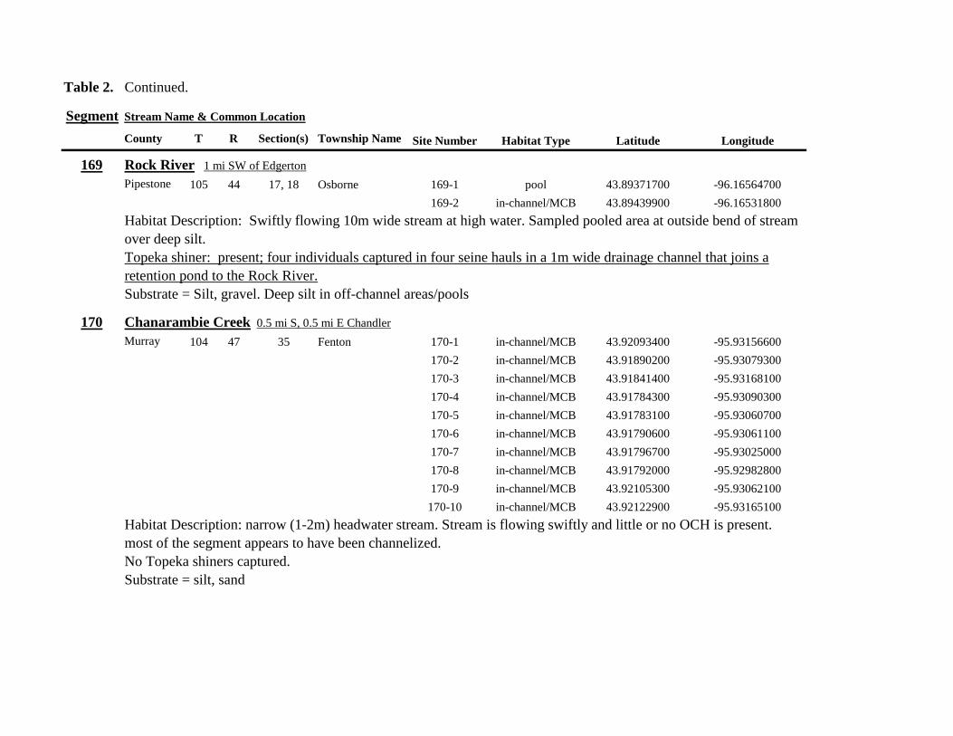
Table 2 Continued
Segment Stream Name amp Common Location
County T R Section(s) Township Name Site Number Habitat Type Latitude Longitude
169 Rock River 1 mi SW of Edgerton
Pipestone 105 44 17 18 Osborne 169-1 pool 4389371700 -9616564700
169-2 in-channelMCB 4389439900 -9616531800
Habitat Description Swiftly flowing 10m wide stream at high water Sampled pooled area at outside bend of stream
over deep silt
Topeka shiner present four individuals captured in four seine hauls in a 1m wide drainage channel that joins a
retention pond to the Rock River
Substrate = Silt gravel Deep silt in off-channel areaspools
170 Chanarambie Creek 05 mi S 05 mi E Chandler
Murray 104 47 35 Fenton 170-1 in-channelMCB 4392093400 -9593156600
170-2 in-channelMCB 4391890200 -9593079300
170-3 in-channelMCB 4391841400 -9593168100
170-4 in-channelMCB 4391784300 -9593090300
170-5 in-channelMCB 4391783100 -9593060700
170-6 in-channelMCB 4391790600 -9593061100
170-7 in-channelMCB 4391796700 -9593025000
170-8 in-channelMCB 4391792000 -9592982800
170-9 in-channelMCB 4392105300 -9593062100
170-10 in-channelMCB 4392122900 -9593165100
Habitat Description narrow (1-2m) headwater stream Stream is flowing swiftly and little or no OCH is present
most of the segment appears to have been channelized
No Topeka shiners captured
Substrate = silt sand
Table 2 Continued
Segment Stream Name amp Common Location
County T R Section(s) Township Name Site Number Habitat Type Latitude Longitude
171 Rock River 4 mi S Edgerton
Rock 104 44 8 9 Battle Plain 171-1 in-channelMCB 4382021200 -9613013100
171-2 pool 4382126400 -9613470300
171-3 in-channelMCB 4382025300 -9612974300
171-4 in-channelMCB 4382027100 -9612961600
171-5 in-channelMCB 4382145400 -9613302800
171-6 in-channelMCB 4382380700 -9613520900
171-7 in-channelMCB 4382367500 -9613527700
171-8 in-channelMCB 4382359000 -9613532400
171-9 in-channelMCB 4382405300 -9613495400
171-10 in-channelMCB 4382271200 -9613570400
Habitat Description High water 8-12m wide swiftly flowing stream Stream is full to high banks Much of slackwater
areas along MCB likely inudndated Sampled in backwaters sites 6-9
No Topeka shiners captured
Substrate = Sand gravel silt
Table 2 Continued
Segment Stream Name amp Common Location
County T R Section(s) Township Name Site Number Habitat Type Latitude Longitude
172 Rock River tributary 1 mi E Hardwick
Rock 104 44 30 31 Battle Plain 172-1 pool 4377538900 -9617075500
172-2 pool 4377529200 -9617075600
172-3 pool 4377514700 -9617079800
172-4 in-channelMCB 4377386200 -9617079600
172-5 in-channelMCB 4377247100 -9617207900
172-6 in-channelMCB 4377241900 -9617224500
172-7 in-channelMCB 4377245200 -9617219500
172-8 in-channelMCB 4376956400 -9616914600
172-9 pool off-channel 4376998700 -9616876000
172-10 in-channelMCB 4377058800 -9616855700
172-11 in-channelMCB 4377043200 -9616826600
Habitat Description 3m wide slowly flowing pasture stream with high trampled banks Much of reach appears to
have been channelized no OCH present along MCBSampled in stock pond at site 9 Some submerged macrophytes
No Topeka shiners captured
Substrate = sand silt muck
Table 2 Continued
Segment Stream Name amp Common Location
County T R Section(s) Township Name Site Number Habitat Type Latitude Longitude
173 Mound Creek 1 mi N 175 mi E Beaver Creek
Rock 103 45 2 11 Mound 173-1 in-channelMCB 4374749900 -9620089200
173-2 in-channelMCB 4374756900 -9620094400
173-3 in-channelMCB 4374763700 -9620090700
173-4 in-channelMCB 4374842800 -9619838100
173-5 in-channelMCB 4374844000 -9619833200
173-6 in-channelMCB 4374889800 -9619789300
173-7 in-channelMCB 4374839600 -9619885800
173-8 in-channelMCB 4374827900 -9619934500
173-9 in-channelMCB 4374817000 -9619966400
173-10 in-channelMCB 4374799700 -9620048400
Habitat Description Entire reach of sement has been channelized Stream is 1-2m wide and constantly flowing High
banks No OCH
No Topeka shiners captured
Substrate = gravel sand silt
Table 2 Continued
Segment Stream Name amp Common Location
County T R Section(s) Township Name Site Number Habitat Type Latitude Longitude
174 Rock River tributary 55 mi N 4 mi E Luverne
Rock 103 44 8 9 Vienna 174-1 pool 4373333900 -9613250300
174-2 pool 4373322100 -9613262700
Habitat Description Narrow (2-3m) wide flowing headwater stream Sampled in deep silted pool at bridge Topeka shiner present two individuals captured over gravel in pooled area at bridge Much of the pool is filled with deep (gt05m) silt No Topeka shiners collected in silted portion of pool Substrate = gravel sand silt
Table 2 Continued
Segment Stream Name amp Common Location
County T R Section(s) Township Name Site Number Habitat Type Latitude Longitude
175 Champepadan Creek 4mi N 5 mi E Luverne
Rock 103 44 21 22 Vienna 175-1 pool 4371002900 -9611238300
175-2 pool 4371001900 -9611232600
175-3 pool 4371008300 -9611238900
175-4 in-channelMCB 4370955000 -9611142300
175-5 in-channelMCB 4371042200 -9610763900
175-6 in-channelMCB 4371007000 -9610720000
175-7 in-channelMCB 4370984100 -9610706400
175-8 pooloff-channel 4370971600 -9610709700
Habitat Description 3m wide stream with moderate flow Native prairie has been planted along both banks for the entire reach
No flow Sampled at pooled areas at culverts at CH 19
Topeka shiner present one individual captured in deep livestock pond S of stream Depth (gt2m) made seining in pond difficult
Substrate = sand silt gravel
Table 2 Continued
Segment Stream Name amp Common Location
County T R Section(s) Township Name Site Number Habitat Type Latitude Longitude
176 Kanaranzi Creek 2 mi W 35 mi N Ellworth
Rock 101 44 12 Kanaranzi 176-1 pool 4357304000 -9606413600
176-2 pool 4357305400 -9606410500
176-3 pool 4357249700 -9606408600
176-4 in-channelMCB 4357200500 -9606350300
176-5 in-channelMCB 4357204500 -9606354600
176-6 in-channelMCB 4357211400 -9606360400
176-7 in-channelMCB 4357127700 -9606357500
176-8 in-channelMCB 4357090500 -9606197900
176-9 in-channelMCB 4356817400 -9606275000
176-10 in-channelMCB 4356807000 -9606273900
176-11 in-channelMCB 4356639200 -9606408000
176-12 in-channelMCB 4356632100 -9606416000
176-13 in-channelMCB 4356598300 -9606381200
Habitat Description 10m wide flowing stream Very little OCH Very deep silt along MCB Sampled pooled area
at bridge High eroded banks
No Topeka shiners captured
Substrate = silt over gravel
Table 2 Continued
Segment Stream Name amp Common Location
County T R Section(s) Township Name Site Number Habitat Type Latitude Longitude
177 Rock River 05 mi N 4 mi E Steen
Rock 101 45 25 Clinton 177-1 pool 4352588900 -9618721100
177-2 pool 4352592700 -9618726600
177-3 in-channelMCB 4352519900 -9618594900
177-4 in-channelMCB 4352297500 -9618558400
177-5 in-channelMCB 4352147800 -9618456000
177-6 in-channelMCB 4352143300 -9618458200
177-7 in-channelMCB 4352125000 -9618453100
177-8 in-channelMCB 4352121500 -9618442200
177-9 in-channelMCB 4352106600 -9618444000
177-10 in-channelMCB 4352727900 -9618684800
177-11 pool 4352783000 -9618770800
177-12 pooloff-channel 4352663200 -9619046500
Habitat Description 11m wide flowing stream with wide channel sand bars and some braiding Firm gravel in thalweg Oxbow in middle of reach is nearly dry (lt25 cm) No fish observed culicid fly larvae abundant No Topeka shiners captured Substrate = sand gravel silt
Table 2 Continued
Segment Stream Name amp Common Location
County T R Section(s) Township Name Site Number Habitat Type Latitude Longitude
178 Kanaranzi Creek 2 mi W Ellsworth
Rock 101 44 25 36 Kanaranzi 178-1 pool 4351441400 -9605867000
178-2 in-channelMCB 4351404500 -9605846000
178-3 in-channelMCB 4351378800 -9605844300
178-4 pool 4351349700 -9605841200
178-5 pool 4351358400 -9605829800
178-6 pool 4351351800 -9605816800
178-7 in-channelMCB 4351355800 -9605866900
178-8 in-channelMCB 4351549000 -9605823700
178-9 in-channelMCB 4351891800 -9605895600
178-10 in-channelMCB 4351866200 -9605881400
178-11 pool 4352078500 -9606070000
178-12 pool 4352046000 -9606082200
Habitat Description 7-9m wide flowing stream Sampled backwater and off-channel habitats along MCB and side channels Recent high flow has filled in off-channel areas with deep silt Seining difficult No Topeka shiners captured Substrate = sand silt gravel
Table 2 Concluded
Segment Stream Name amp Common Location
County T R Section(s) Township Name Site Number Habitat Type Latitude Longitude
179 East Branch Kanaranzi Creek 15 mi N 15 mi E Adrian
Nobles 102 42 8 Olney 179-1 pool 4365932900 -9590462700
179-2 pool 4365928900 -9590449500
179-3 pool 4365930600 -9590463300
179-4 pool 4365908000 -9590420300
179-5 in-channelMCB 4365679800 -9590378600
179-6 in-channelMCB 4365661000 -9590387800
179-7 in-channelMCB 4365604000 -9590417100
179-8 in-channelMCB 4365508100 -9590385200
179-9 in-channelMCB 4365460100 -9590342200
179-10 pool 4365434900 -9590020100
179-11 in-channelMCB 4365507700 -9590154900
179-12 in-channelMCB 4365588000 -9589900200
Habitat Description Flowing 9m wide stream Stream is full to high banks very little slackwater habitat present at this site
No Topeka shiners captured
Substrate = sand silt gravel
180 Little Rock River 8 mi E Ellsworth
Nobles 101 42 26 Little Rock 180-1 in-channelMCB 4352838500 -9584615900
Habitat Description Sampled large pooled area at bridge no discernible flow silt over gravel substrate Channel downstream
of pool is a 2-3 m wide flowing stream with a firm sandgravel substrate
Topeka shiner abundant fourteen individuals captured in first seine haul in pool fifteen individuals captured in second seine
haul near outlet of the pool
Substrate = gravel sand silt
Table 3 Complete List of Fish Species Captured at Segments 141-160 2012
Species 141 142 143 144 145 146 147 148 149 150 151 152 153 154 155 156 157 158 159 160 Campostoma anomalum X X X X X X X X X X X X X X Chrosomus erythrogaster X X Cyprinella lutrensis X X X X X X X X X Cyprinus carpio X X X X X Hybognathus hankinsoni X X X X X X X Luxilus cornutus X X X X X X X X X X X X X Notropis dorsalis X X X X X X X X X X X Notropis stramineus X X X X X X X X X X X X X X X Notropis topeka X X X X X X X X Pimephales notatus X X X X X X X X X X X X Pimephales promelas X X X X X X X X X X X X X X X X X X Rhinichthys atratulus X X X X X X Semotilus atromaculatus X X X X X X X X X X X X X X X X X X Carpiodes cyprinus X Carpiodes sp (YOY) X X X Catostomus commersoni X X X X X X X X X X X X X X X Moxostoma macrolepidotum X X Ameiurus melas X X X X X X X X X X X X X Ameiurus natalis X Ictalurus punctatus X X X X Noturus flavus X X X X Noturus gyrinus X X X X X Esox lucius X X Percopsis omiscomaycus X Fundulus sciadicus X X X Culaea inconstans X X X X X Lepomis cyanellus X X X X X X X Lepomis humilis X X X X X X X X X X X Lepomis macrochirus X X X X X Micropterus dolomieui X Micropterus salmoides X X Pomoxis nigromaculatus X X Etheostoma exile X X X X X Etheostoma nigrum X X X X X X X X X X X X X X X X X Perca flavescens X X Percina maculata X X X X
Table 4 Complete List of Fish Species Captured at Segments 161-180 2013
Species 161 162 163 164 165 166 167 168 169 170 171 172 173 174 175 176 177 178 179 180
Campostoma anomalum X X X X X X X X X X X X X X
Cyprinella lutrensis X X X X X X X X X X
Cyprinus carpio X X X
Hybognathus hankinsoni X X X X X
Luxilus cornutus X X X X X X X X X X X X X
Notropis dorsalis X X X X X X X X X X X X X X
Notropis stramineus X X X X X X X X X X X X X X
Notropis topeka X X X X X X
Pimephales notatus X X X X X X X X X X X X
Pimephales promelas X X X X X X X X X X X X X X X X X X
Rhinichthys atratulus X X X X X X X X X X X
Semotilus atromaculatus X X X X X X X X X X X X X X X X
Carpiodes cyprinus X X
Catostomus commersoni X X X X X X X X X X X X X
Moxostoma erythrurum X X X
Moxostoma macrolepidotum X X
Ameiurus melas X X X X X X X X X X
Noturus flavus X X X
Esox lucius X X
Percopsis omiscomaycus X
Fundulus sciadicus X
Culaea inconstans X X X X
Lepomis cyanellus X X X X X X
Lepomis humilis X X X X X X X X X
Etheostoma exile X X
Etheostoma nigrum X X X X X X X X X X
Percina maculata X X
Appendix C- Habitat and Voucher Photographs
Habitat photographs for segments in which no Topeka shiners were captured are representative
of the habitat along the one-mile reach of stream Habitat photographs from segments where
Topeka shiners were present represent the specific site where they were collected Voucher
photographs are presented for each of the sites were Topeka shiners were collected
Site 141-2 Medary Creek voucher and habitat photos
Segment 142 Willow Creek no Topeka shiners captured
Segment 143 East Branch Flandrau Creek no Topeka shiners captured
Segment 144 North Branch Pipestone Creek no Topeka shiners captured
Site 145-6 Pipestone Creek voucher photo
Site 145-6 Pipestone Creek habitat photo
Segment 146 Split Rock Creek no Topeka shiners captured No habitat photo
Segment 147 Kanaranzi Creek no Topeka shiners captured
Site 148-4 Rock River voucher and habitat photos
Site 149-4 Rock River voucher and habitat photos
Site 150-4 Split Rock Creek voucher and habitat photos
Site 151-1 Beaver Creek voucher and habitat photos
Segment 152 Beaver Creek no Topeka shiners captured
Segment 153 Beaver Creek no Topeka shiners captured
Segment 154 Rock River no Topeka shiners captured
Segment 155 Elk Creek no Topeka shiners captured
Site 156-1 Elk Creek voucher and habitat photos
Segment 157 Kanaranzi Creek no Topeka shiners captured
Segment 158 Kanaranzi Creek no Topeka shiners captured
Site 159-1 Kanaranzi Creek voucher and habitat photos
Segment 160 Little Rock River no Topeka shiners captured
Site 161-15 Medary Creek voucher photo
Site 161-15 Medary Creek habitat photo
Segment 162 Willow Creek no Topeka shiners captured No habitat photo
Segment 163 Flandrau Creek no Topeka shiners captured
Segment 164 Flandrau Creek no Topeka shiners captured
Segment 165 North Branch Pipestone Creek no Topeka Shiners captured
Segment 166 Pipestone Creek no Topeka Shiners captured
Segment 167 Tributary to Split Rock Creek no Topeka Shiners captured No habitat
photo
Site 168-1 Split Rock Creek voucher photo
Site 168-1 Split Rock Creek habitat photo
Site 169-2 Rock River voucher photo
Site 169-2 Rock River habitat photo
Segment 170 Chanarambie Creek no Topeka shiners captured
Segment 171 Rock River no Topeka shiners captured
Segment 172 Tributary to Rock River no Topeka shiners captured
Segment 173 Blue Mound Creek no Topeka shiners
Site 174-2 Tributary to Rock River voucher photo
Site 174-2 Tributary to Rock River habitat photo
Site 175-8 Champepadan Creek voucher photo
Site 175-8 Champepadan Creek habitat photo
Segment 176 Kanaranzi Creek no Topekas captured
Segment 177 Rock River no Topeka shiners captured
Segment 178 Kanaranzi Creek no Topeka shiners captured
Segment 179 East Branch Kanaranzi Creek no Topeka shiners captured
Site 180-1 West Branch Little Rock River voucher photo
Site 180-1 West Branch Little Rock River habitat photo
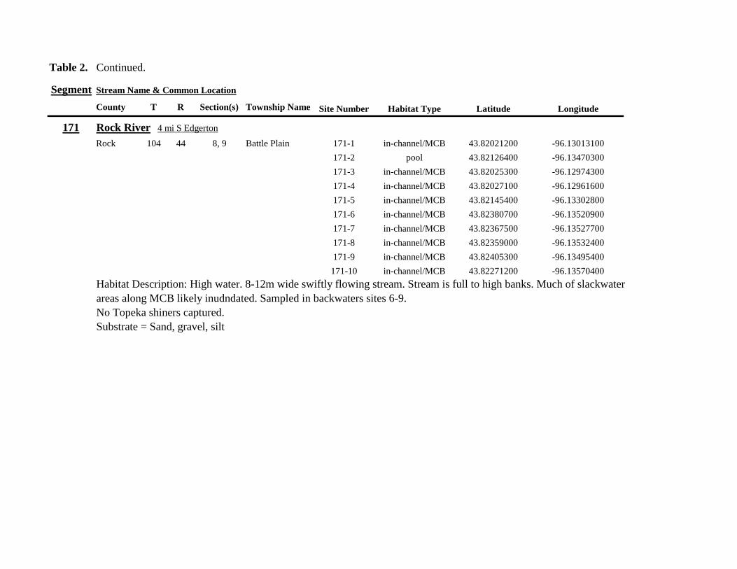
Table 2 Continued
Segment Stream Name amp Common Location
County T R Section(s) Township Name Site Number Habitat Type Latitude Longitude
171 Rock River 4 mi S Edgerton
Rock 104 44 8 9 Battle Plain 171-1 in-channelMCB 4382021200 -9613013100
171-2 pool 4382126400 -9613470300
171-3 in-channelMCB 4382025300 -9612974300
171-4 in-channelMCB 4382027100 -9612961600
171-5 in-channelMCB 4382145400 -9613302800
171-6 in-channelMCB 4382380700 -9613520900
171-7 in-channelMCB 4382367500 -9613527700
171-8 in-channelMCB 4382359000 -9613532400
171-9 in-channelMCB 4382405300 -9613495400
171-10 in-channelMCB 4382271200 -9613570400
Habitat Description High water 8-12m wide swiftly flowing stream Stream is full to high banks Much of slackwater
areas along MCB likely inudndated Sampled in backwaters sites 6-9
No Topeka shiners captured
Substrate = Sand gravel silt
Table 2 Continued
Segment Stream Name amp Common Location
County T R Section(s) Township Name Site Number Habitat Type Latitude Longitude
172 Rock River tributary 1 mi E Hardwick
Rock 104 44 30 31 Battle Plain 172-1 pool 4377538900 -9617075500
172-2 pool 4377529200 -9617075600
172-3 pool 4377514700 -9617079800
172-4 in-channelMCB 4377386200 -9617079600
172-5 in-channelMCB 4377247100 -9617207900
172-6 in-channelMCB 4377241900 -9617224500
172-7 in-channelMCB 4377245200 -9617219500
172-8 in-channelMCB 4376956400 -9616914600
172-9 pool off-channel 4376998700 -9616876000
172-10 in-channelMCB 4377058800 -9616855700
172-11 in-channelMCB 4377043200 -9616826600
Habitat Description 3m wide slowly flowing pasture stream with high trampled banks Much of reach appears to
have been channelized no OCH present along MCBSampled in stock pond at site 9 Some submerged macrophytes
No Topeka shiners captured
Substrate = sand silt muck
Table 2 Continued
Segment Stream Name amp Common Location
County T R Section(s) Township Name Site Number Habitat Type Latitude Longitude
173 Mound Creek 1 mi N 175 mi E Beaver Creek
Rock 103 45 2 11 Mound 173-1 in-channelMCB 4374749900 -9620089200
173-2 in-channelMCB 4374756900 -9620094400
173-3 in-channelMCB 4374763700 -9620090700
173-4 in-channelMCB 4374842800 -9619838100
173-5 in-channelMCB 4374844000 -9619833200
173-6 in-channelMCB 4374889800 -9619789300
173-7 in-channelMCB 4374839600 -9619885800
173-8 in-channelMCB 4374827900 -9619934500
173-9 in-channelMCB 4374817000 -9619966400
173-10 in-channelMCB 4374799700 -9620048400
Habitat Description Entire reach of sement has been channelized Stream is 1-2m wide and constantly flowing High
banks No OCH
No Topeka shiners captured
Substrate = gravel sand silt
Table 2 Continued
Segment Stream Name amp Common Location
County T R Section(s) Township Name Site Number Habitat Type Latitude Longitude
174 Rock River tributary 55 mi N 4 mi E Luverne
Rock 103 44 8 9 Vienna 174-1 pool 4373333900 -9613250300
174-2 pool 4373322100 -9613262700
Habitat Description Narrow (2-3m) wide flowing headwater stream Sampled in deep silted pool at bridge Topeka shiner present two individuals captured over gravel in pooled area at bridge Much of the pool is filled with deep (gt05m) silt No Topeka shiners collected in silted portion of pool Substrate = gravel sand silt
Table 2 Continued
Segment Stream Name amp Common Location
County T R Section(s) Township Name Site Number Habitat Type Latitude Longitude
175 Champepadan Creek 4mi N 5 mi E Luverne
Rock 103 44 21 22 Vienna 175-1 pool 4371002900 -9611238300
175-2 pool 4371001900 -9611232600
175-3 pool 4371008300 -9611238900
175-4 in-channelMCB 4370955000 -9611142300
175-5 in-channelMCB 4371042200 -9610763900
175-6 in-channelMCB 4371007000 -9610720000
175-7 in-channelMCB 4370984100 -9610706400
175-8 pooloff-channel 4370971600 -9610709700
Habitat Description 3m wide stream with moderate flow Native prairie has been planted along both banks for the entire reach
No flow Sampled at pooled areas at culverts at CH 19
Topeka shiner present one individual captured in deep livestock pond S of stream Depth (gt2m) made seining in pond difficult
Substrate = sand silt gravel
Table 2 Continued
Segment Stream Name amp Common Location
County T R Section(s) Township Name Site Number Habitat Type Latitude Longitude
176 Kanaranzi Creek 2 mi W 35 mi N Ellworth
Rock 101 44 12 Kanaranzi 176-1 pool 4357304000 -9606413600
176-2 pool 4357305400 -9606410500
176-3 pool 4357249700 -9606408600
176-4 in-channelMCB 4357200500 -9606350300
176-5 in-channelMCB 4357204500 -9606354600
176-6 in-channelMCB 4357211400 -9606360400
176-7 in-channelMCB 4357127700 -9606357500
176-8 in-channelMCB 4357090500 -9606197900
176-9 in-channelMCB 4356817400 -9606275000
176-10 in-channelMCB 4356807000 -9606273900
176-11 in-channelMCB 4356639200 -9606408000
176-12 in-channelMCB 4356632100 -9606416000
176-13 in-channelMCB 4356598300 -9606381200
Habitat Description 10m wide flowing stream Very little OCH Very deep silt along MCB Sampled pooled area
at bridge High eroded banks
No Topeka shiners captured
Substrate = silt over gravel
Table 2 Continued
Segment Stream Name amp Common Location
County T R Section(s) Township Name Site Number Habitat Type Latitude Longitude
177 Rock River 05 mi N 4 mi E Steen
Rock 101 45 25 Clinton 177-1 pool 4352588900 -9618721100
177-2 pool 4352592700 -9618726600
177-3 in-channelMCB 4352519900 -9618594900
177-4 in-channelMCB 4352297500 -9618558400
177-5 in-channelMCB 4352147800 -9618456000
177-6 in-channelMCB 4352143300 -9618458200
177-7 in-channelMCB 4352125000 -9618453100
177-8 in-channelMCB 4352121500 -9618442200
177-9 in-channelMCB 4352106600 -9618444000
177-10 in-channelMCB 4352727900 -9618684800
177-11 pool 4352783000 -9618770800
177-12 pooloff-channel 4352663200 -9619046500
Habitat Description 11m wide flowing stream with wide channel sand bars and some braiding Firm gravel in thalweg Oxbow in middle of reach is nearly dry (lt25 cm) No fish observed culicid fly larvae abundant No Topeka shiners captured Substrate = sand gravel silt
Table 2 Continued
Segment Stream Name amp Common Location
County T R Section(s) Township Name Site Number Habitat Type Latitude Longitude
178 Kanaranzi Creek 2 mi W Ellsworth
Rock 101 44 25 36 Kanaranzi 178-1 pool 4351441400 -9605867000
178-2 in-channelMCB 4351404500 -9605846000
178-3 in-channelMCB 4351378800 -9605844300
178-4 pool 4351349700 -9605841200
178-5 pool 4351358400 -9605829800
178-6 pool 4351351800 -9605816800
178-7 in-channelMCB 4351355800 -9605866900
178-8 in-channelMCB 4351549000 -9605823700
178-9 in-channelMCB 4351891800 -9605895600
178-10 in-channelMCB 4351866200 -9605881400
178-11 pool 4352078500 -9606070000
178-12 pool 4352046000 -9606082200
Habitat Description 7-9m wide flowing stream Sampled backwater and off-channel habitats along MCB and side channels Recent high flow has filled in off-channel areas with deep silt Seining difficult No Topeka shiners captured Substrate = sand silt gravel
Table 2 Concluded
Segment Stream Name amp Common Location
County T R Section(s) Township Name Site Number Habitat Type Latitude Longitude
179 East Branch Kanaranzi Creek 15 mi N 15 mi E Adrian
Nobles 102 42 8 Olney 179-1 pool 4365932900 -9590462700
179-2 pool 4365928900 -9590449500
179-3 pool 4365930600 -9590463300
179-4 pool 4365908000 -9590420300
179-5 in-channelMCB 4365679800 -9590378600
179-6 in-channelMCB 4365661000 -9590387800
179-7 in-channelMCB 4365604000 -9590417100
179-8 in-channelMCB 4365508100 -9590385200
179-9 in-channelMCB 4365460100 -9590342200
179-10 pool 4365434900 -9590020100
179-11 in-channelMCB 4365507700 -9590154900
179-12 in-channelMCB 4365588000 -9589900200
Habitat Description Flowing 9m wide stream Stream is full to high banks very little slackwater habitat present at this site
No Topeka shiners captured
Substrate = sand silt gravel
180 Little Rock River 8 mi E Ellsworth
Nobles 101 42 26 Little Rock 180-1 in-channelMCB 4352838500 -9584615900
Habitat Description Sampled large pooled area at bridge no discernible flow silt over gravel substrate Channel downstream
of pool is a 2-3 m wide flowing stream with a firm sandgravel substrate
Topeka shiner abundant fourteen individuals captured in first seine haul in pool fifteen individuals captured in second seine
haul near outlet of the pool
Substrate = gravel sand silt
Table 3 Complete List of Fish Species Captured at Segments 141-160 2012
Species 141 142 143 144 145 146 147 148 149 150 151 152 153 154 155 156 157 158 159 160 Campostoma anomalum X X X X X X X X X X X X X X Chrosomus erythrogaster X X Cyprinella lutrensis X X X X X X X X X Cyprinus carpio X X X X X Hybognathus hankinsoni X X X X X X X Luxilus cornutus X X X X X X X X X X X X X Notropis dorsalis X X X X X X X X X X X Notropis stramineus X X X X X X X X X X X X X X X Notropis topeka X X X X X X X X Pimephales notatus X X X X X X X X X X X X Pimephales promelas X X X X X X X X X X X X X X X X X X Rhinichthys atratulus X X X X X X Semotilus atromaculatus X X X X X X X X X X X X X X X X X X Carpiodes cyprinus X Carpiodes sp (YOY) X X X Catostomus commersoni X X X X X X X X X X X X X X X Moxostoma macrolepidotum X X Ameiurus melas X X X X X X X X X X X X X Ameiurus natalis X Ictalurus punctatus X X X X Noturus flavus X X X X Noturus gyrinus X X X X X Esox lucius X X Percopsis omiscomaycus X Fundulus sciadicus X X X Culaea inconstans X X X X X Lepomis cyanellus X X X X X X X Lepomis humilis X X X X X X X X X X X Lepomis macrochirus X X X X X Micropterus dolomieui X Micropterus salmoides X X Pomoxis nigromaculatus X X Etheostoma exile X X X X X Etheostoma nigrum X X X X X X X X X X X X X X X X X Perca flavescens X X Percina maculata X X X X
Table 4 Complete List of Fish Species Captured at Segments 161-180 2013
Species 161 162 163 164 165 166 167 168 169 170 171 172 173 174 175 176 177 178 179 180
Campostoma anomalum X X X X X X X X X X X X X X
Cyprinella lutrensis X X X X X X X X X X
Cyprinus carpio X X X
Hybognathus hankinsoni X X X X X
Luxilus cornutus X X X X X X X X X X X X X
Notropis dorsalis X X X X X X X X X X X X X X
Notropis stramineus X X X X X X X X X X X X X X
Notropis topeka X X X X X X
Pimephales notatus X X X X X X X X X X X X
Pimephales promelas X X X X X X X X X X X X X X X X X X
Rhinichthys atratulus X X X X X X X X X X X
Semotilus atromaculatus X X X X X X X X X X X X X X X X
Carpiodes cyprinus X X
Catostomus commersoni X X X X X X X X X X X X X
Moxostoma erythrurum X X X
Moxostoma macrolepidotum X X
Ameiurus melas X X X X X X X X X X
Noturus flavus X X X
Esox lucius X X
Percopsis omiscomaycus X
Fundulus sciadicus X
Culaea inconstans X X X X
Lepomis cyanellus X X X X X X
Lepomis humilis X X X X X X X X X
Etheostoma exile X X
Etheostoma nigrum X X X X X X X X X X
Percina maculata X X
Appendix C- Habitat and Voucher Photographs
Habitat photographs for segments in which no Topeka shiners were captured are representative
of the habitat along the one-mile reach of stream Habitat photographs from segments where
Topeka shiners were present represent the specific site where they were collected Voucher
photographs are presented for each of the sites were Topeka shiners were collected
Site 141-2 Medary Creek voucher and habitat photos
Segment 142 Willow Creek no Topeka shiners captured
Segment 143 East Branch Flandrau Creek no Topeka shiners captured
Segment 144 North Branch Pipestone Creek no Topeka shiners captured
Site 145-6 Pipestone Creek voucher photo
Site 145-6 Pipestone Creek habitat photo
Segment 146 Split Rock Creek no Topeka shiners captured No habitat photo
Segment 147 Kanaranzi Creek no Topeka shiners captured
Site 148-4 Rock River voucher and habitat photos
Site 149-4 Rock River voucher and habitat photos
Site 150-4 Split Rock Creek voucher and habitat photos
Site 151-1 Beaver Creek voucher and habitat photos
Segment 152 Beaver Creek no Topeka shiners captured
Segment 153 Beaver Creek no Topeka shiners captured
Segment 154 Rock River no Topeka shiners captured
Segment 155 Elk Creek no Topeka shiners captured
Site 156-1 Elk Creek voucher and habitat photos
Segment 157 Kanaranzi Creek no Topeka shiners captured
Segment 158 Kanaranzi Creek no Topeka shiners captured
Site 159-1 Kanaranzi Creek voucher and habitat photos
Segment 160 Little Rock River no Topeka shiners captured
Site 161-15 Medary Creek voucher photo
Site 161-15 Medary Creek habitat photo
Segment 162 Willow Creek no Topeka shiners captured No habitat photo
Segment 163 Flandrau Creek no Topeka shiners captured
Segment 164 Flandrau Creek no Topeka shiners captured
Segment 165 North Branch Pipestone Creek no Topeka Shiners captured
Segment 166 Pipestone Creek no Topeka Shiners captured
Segment 167 Tributary to Split Rock Creek no Topeka Shiners captured No habitat
photo
Site 168-1 Split Rock Creek voucher photo
Site 168-1 Split Rock Creek habitat photo
Site 169-2 Rock River voucher photo
Site 169-2 Rock River habitat photo
Segment 170 Chanarambie Creek no Topeka shiners captured
Segment 171 Rock River no Topeka shiners captured
Segment 172 Tributary to Rock River no Topeka shiners captured
Segment 173 Blue Mound Creek no Topeka shiners
Site 174-2 Tributary to Rock River voucher photo
Site 174-2 Tributary to Rock River habitat photo
Site 175-8 Champepadan Creek voucher photo
Site 175-8 Champepadan Creek habitat photo
Segment 176 Kanaranzi Creek no Topekas captured
Segment 177 Rock River no Topeka shiners captured
Segment 178 Kanaranzi Creek no Topeka shiners captured
Segment 179 East Branch Kanaranzi Creek no Topeka shiners captured
Site 180-1 West Branch Little Rock River voucher photo
Site 180-1 West Branch Little Rock River habitat photo
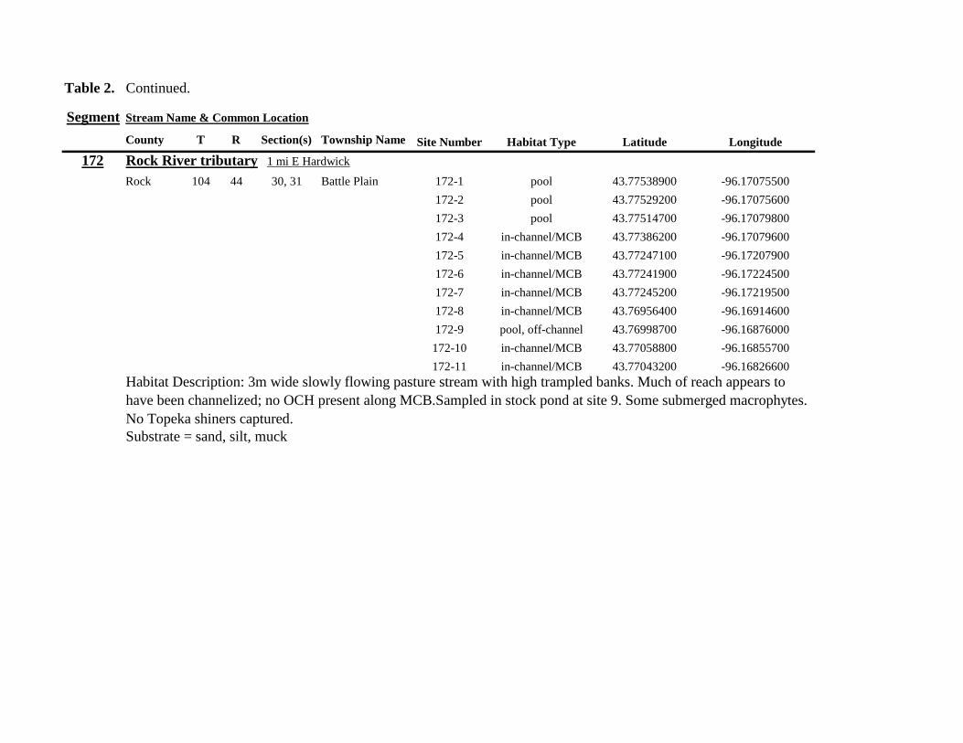
Table 2 Continued
Segment Stream Name amp Common Location
County T R Section(s) Township Name Site Number Habitat Type Latitude Longitude
172 Rock River tributary 1 mi E Hardwick
Rock 104 44 30 31 Battle Plain 172-1 pool 4377538900 -9617075500
172-2 pool 4377529200 -9617075600
172-3 pool 4377514700 -9617079800
172-4 in-channelMCB 4377386200 -9617079600
172-5 in-channelMCB 4377247100 -9617207900
172-6 in-channelMCB 4377241900 -9617224500
172-7 in-channelMCB 4377245200 -9617219500
172-8 in-channelMCB 4376956400 -9616914600
172-9 pool off-channel 4376998700 -9616876000
172-10 in-channelMCB 4377058800 -9616855700
172-11 in-channelMCB 4377043200 -9616826600
Habitat Description 3m wide slowly flowing pasture stream with high trampled banks Much of reach appears to
have been channelized no OCH present along MCBSampled in stock pond at site 9 Some submerged macrophytes
No Topeka shiners captured
Substrate = sand silt muck
Table 2 Continued
Segment Stream Name amp Common Location
County T R Section(s) Township Name Site Number Habitat Type Latitude Longitude
173 Mound Creek 1 mi N 175 mi E Beaver Creek
Rock 103 45 2 11 Mound 173-1 in-channelMCB 4374749900 -9620089200
173-2 in-channelMCB 4374756900 -9620094400
173-3 in-channelMCB 4374763700 -9620090700
173-4 in-channelMCB 4374842800 -9619838100
173-5 in-channelMCB 4374844000 -9619833200
173-6 in-channelMCB 4374889800 -9619789300
173-7 in-channelMCB 4374839600 -9619885800
173-8 in-channelMCB 4374827900 -9619934500
173-9 in-channelMCB 4374817000 -9619966400
173-10 in-channelMCB 4374799700 -9620048400
Habitat Description Entire reach of sement has been channelized Stream is 1-2m wide and constantly flowing High
banks No OCH
No Topeka shiners captured
Substrate = gravel sand silt
Table 2 Continued
Segment Stream Name amp Common Location
County T R Section(s) Township Name Site Number Habitat Type Latitude Longitude
174 Rock River tributary 55 mi N 4 mi E Luverne
Rock 103 44 8 9 Vienna 174-1 pool 4373333900 -9613250300
174-2 pool 4373322100 -9613262700
Habitat Description Narrow (2-3m) wide flowing headwater stream Sampled in deep silted pool at bridge Topeka shiner present two individuals captured over gravel in pooled area at bridge Much of the pool is filled with deep (gt05m) silt No Topeka shiners collected in silted portion of pool Substrate = gravel sand silt
Table 2 Continued
Segment Stream Name amp Common Location
County T R Section(s) Township Name Site Number Habitat Type Latitude Longitude
175 Champepadan Creek 4mi N 5 mi E Luverne
Rock 103 44 21 22 Vienna 175-1 pool 4371002900 -9611238300
175-2 pool 4371001900 -9611232600
175-3 pool 4371008300 -9611238900
175-4 in-channelMCB 4370955000 -9611142300
175-5 in-channelMCB 4371042200 -9610763900
175-6 in-channelMCB 4371007000 -9610720000
175-7 in-channelMCB 4370984100 -9610706400
175-8 pooloff-channel 4370971600 -9610709700
Habitat Description 3m wide stream with moderate flow Native prairie has been planted along both banks for the entire reach
No flow Sampled at pooled areas at culverts at CH 19
Topeka shiner present one individual captured in deep livestock pond S of stream Depth (gt2m) made seining in pond difficult
Substrate = sand silt gravel
Table 2 Continued
Segment Stream Name amp Common Location
County T R Section(s) Township Name Site Number Habitat Type Latitude Longitude
176 Kanaranzi Creek 2 mi W 35 mi N Ellworth
Rock 101 44 12 Kanaranzi 176-1 pool 4357304000 -9606413600
176-2 pool 4357305400 -9606410500
176-3 pool 4357249700 -9606408600
176-4 in-channelMCB 4357200500 -9606350300
176-5 in-channelMCB 4357204500 -9606354600
176-6 in-channelMCB 4357211400 -9606360400
176-7 in-channelMCB 4357127700 -9606357500
176-8 in-channelMCB 4357090500 -9606197900
176-9 in-channelMCB 4356817400 -9606275000
176-10 in-channelMCB 4356807000 -9606273900
176-11 in-channelMCB 4356639200 -9606408000
176-12 in-channelMCB 4356632100 -9606416000
176-13 in-channelMCB 4356598300 -9606381200
Habitat Description 10m wide flowing stream Very little OCH Very deep silt along MCB Sampled pooled area
at bridge High eroded banks
No Topeka shiners captured
Substrate = silt over gravel
Table 2 Continued
Segment Stream Name amp Common Location
County T R Section(s) Township Name Site Number Habitat Type Latitude Longitude
177 Rock River 05 mi N 4 mi E Steen
Rock 101 45 25 Clinton 177-1 pool 4352588900 -9618721100
177-2 pool 4352592700 -9618726600
177-3 in-channelMCB 4352519900 -9618594900
177-4 in-channelMCB 4352297500 -9618558400
177-5 in-channelMCB 4352147800 -9618456000
177-6 in-channelMCB 4352143300 -9618458200
177-7 in-channelMCB 4352125000 -9618453100
177-8 in-channelMCB 4352121500 -9618442200
177-9 in-channelMCB 4352106600 -9618444000
177-10 in-channelMCB 4352727900 -9618684800
177-11 pool 4352783000 -9618770800
177-12 pooloff-channel 4352663200 -9619046500
Habitat Description 11m wide flowing stream with wide channel sand bars and some braiding Firm gravel in thalweg Oxbow in middle of reach is nearly dry (lt25 cm) No fish observed culicid fly larvae abundant No Topeka shiners captured Substrate = sand gravel silt
Table 2 Continued
Segment Stream Name amp Common Location
County T R Section(s) Township Name Site Number Habitat Type Latitude Longitude
178 Kanaranzi Creek 2 mi W Ellsworth
Rock 101 44 25 36 Kanaranzi 178-1 pool 4351441400 -9605867000
178-2 in-channelMCB 4351404500 -9605846000
178-3 in-channelMCB 4351378800 -9605844300
178-4 pool 4351349700 -9605841200
178-5 pool 4351358400 -9605829800
178-6 pool 4351351800 -9605816800
178-7 in-channelMCB 4351355800 -9605866900
178-8 in-channelMCB 4351549000 -9605823700
178-9 in-channelMCB 4351891800 -9605895600
178-10 in-channelMCB 4351866200 -9605881400
178-11 pool 4352078500 -9606070000
178-12 pool 4352046000 -9606082200
Habitat Description 7-9m wide flowing stream Sampled backwater and off-channel habitats along MCB and side channels Recent high flow has filled in off-channel areas with deep silt Seining difficult No Topeka shiners captured Substrate = sand silt gravel
Table 2 Concluded
Segment Stream Name amp Common Location
County T R Section(s) Township Name Site Number Habitat Type Latitude Longitude
179 East Branch Kanaranzi Creek 15 mi N 15 mi E Adrian
Nobles 102 42 8 Olney 179-1 pool 4365932900 -9590462700
179-2 pool 4365928900 -9590449500
179-3 pool 4365930600 -9590463300
179-4 pool 4365908000 -9590420300
179-5 in-channelMCB 4365679800 -9590378600
179-6 in-channelMCB 4365661000 -9590387800
179-7 in-channelMCB 4365604000 -9590417100
179-8 in-channelMCB 4365508100 -9590385200
179-9 in-channelMCB 4365460100 -9590342200
179-10 pool 4365434900 -9590020100
179-11 in-channelMCB 4365507700 -9590154900
179-12 in-channelMCB 4365588000 -9589900200
Habitat Description Flowing 9m wide stream Stream is full to high banks very little slackwater habitat present at this site
No Topeka shiners captured
Substrate = sand silt gravel
180 Little Rock River 8 mi E Ellsworth
Nobles 101 42 26 Little Rock 180-1 in-channelMCB 4352838500 -9584615900
Habitat Description Sampled large pooled area at bridge no discernible flow silt over gravel substrate Channel downstream
of pool is a 2-3 m wide flowing stream with a firm sandgravel substrate
Topeka shiner abundant fourteen individuals captured in first seine haul in pool fifteen individuals captured in second seine
haul near outlet of the pool
Substrate = gravel sand silt
Table 3 Complete List of Fish Species Captured at Segments 141-160 2012
Species 141 142 143 144 145 146 147 148 149 150 151 152 153 154 155 156 157 158 159 160 Campostoma anomalum X X X X X X X X X X X X X X Chrosomus erythrogaster X X Cyprinella lutrensis X X X X X X X X X Cyprinus carpio X X X X X Hybognathus hankinsoni X X X X X X X Luxilus cornutus X X X X X X X X X X X X X Notropis dorsalis X X X X X X X X X X X Notropis stramineus X X X X X X X X X X X X X X X Notropis topeka X X X X X X X X Pimephales notatus X X X X X X X X X X X X Pimephales promelas X X X X X X X X X X X X X X X X X X Rhinichthys atratulus X X X X X X Semotilus atromaculatus X X X X X X X X X X X X X X X X X X Carpiodes cyprinus X Carpiodes sp (YOY) X X X Catostomus commersoni X X X X X X X X X X X X X X X Moxostoma macrolepidotum X X Ameiurus melas X X X X X X X X X X X X X Ameiurus natalis X Ictalurus punctatus X X X X Noturus flavus X X X X Noturus gyrinus X X X X X Esox lucius X X Percopsis omiscomaycus X Fundulus sciadicus X X X Culaea inconstans X X X X X Lepomis cyanellus X X X X X X X Lepomis humilis X X X X X X X X X X X Lepomis macrochirus X X X X X Micropterus dolomieui X Micropterus salmoides X X Pomoxis nigromaculatus X X Etheostoma exile X X X X X Etheostoma nigrum X X X X X X X X X X X X X X X X X Perca flavescens X X Percina maculata X X X X
Table 4 Complete List of Fish Species Captured at Segments 161-180 2013
Species 161 162 163 164 165 166 167 168 169 170 171 172 173 174 175 176 177 178 179 180
Campostoma anomalum X X X X X X X X X X X X X X
Cyprinella lutrensis X X X X X X X X X X
Cyprinus carpio X X X
Hybognathus hankinsoni X X X X X
Luxilus cornutus X X X X X X X X X X X X X
Notropis dorsalis X X X X X X X X X X X X X X
Notropis stramineus X X X X X X X X X X X X X X
Notropis topeka X X X X X X
Pimephales notatus X X X X X X X X X X X X
Pimephales promelas X X X X X X X X X X X X X X X X X X
Rhinichthys atratulus X X X X X X X X X X X
Semotilus atromaculatus X X X X X X X X X X X X X X X X
Carpiodes cyprinus X X
Catostomus commersoni X X X X X X X X X X X X X
Moxostoma erythrurum X X X
Moxostoma macrolepidotum X X
Ameiurus melas X X X X X X X X X X
Noturus flavus X X X
Esox lucius X X
Percopsis omiscomaycus X
Fundulus sciadicus X
Culaea inconstans X X X X
Lepomis cyanellus X X X X X X
Lepomis humilis X X X X X X X X X
Etheostoma exile X X
Etheostoma nigrum X X X X X X X X X X
Percina maculata X X
Appendix C- Habitat and Voucher Photographs
Habitat photographs for segments in which no Topeka shiners were captured are representative
of the habitat along the one-mile reach of stream Habitat photographs from segments where
Topeka shiners were present represent the specific site where they were collected Voucher
photographs are presented for each of the sites were Topeka shiners were collected
Site 141-2 Medary Creek voucher and habitat photos
Segment 142 Willow Creek no Topeka shiners captured
Segment 143 East Branch Flandrau Creek no Topeka shiners captured
Segment 144 North Branch Pipestone Creek no Topeka shiners captured
Site 145-6 Pipestone Creek voucher photo
Site 145-6 Pipestone Creek habitat photo
Segment 146 Split Rock Creek no Topeka shiners captured No habitat photo
Segment 147 Kanaranzi Creek no Topeka shiners captured
Site 148-4 Rock River voucher and habitat photos
Site 149-4 Rock River voucher and habitat photos
Site 150-4 Split Rock Creek voucher and habitat photos
Site 151-1 Beaver Creek voucher and habitat photos
Segment 152 Beaver Creek no Topeka shiners captured
Segment 153 Beaver Creek no Topeka shiners captured
Segment 154 Rock River no Topeka shiners captured
Segment 155 Elk Creek no Topeka shiners captured
Site 156-1 Elk Creek voucher and habitat photos
Segment 157 Kanaranzi Creek no Topeka shiners captured
Segment 158 Kanaranzi Creek no Topeka shiners captured
Site 159-1 Kanaranzi Creek voucher and habitat photos
Segment 160 Little Rock River no Topeka shiners captured
Site 161-15 Medary Creek voucher photo
Site 161-15 Medary Creek habitat photo
Segment 162 Willow Creek no Topeka shiners captured No habitat photo
Segment 163 Flandrau Creek no Topeka shiners captured
Segment 164 Flandrau Creek no Topeka shiners captured
Segment 165 North Branch Pipestone Creek no Topeka Shiners captured
Segment 166 Pipestone Creek no Topeka Shiners captured
Segment 167 Tributary to Split Rock Creek no Topeka Shiners captured No habitat
photo
Site 168-1 Split Rock Creek voucher photo
Site 168-1 Split Rock Creek habitat photo
Site 169-2 Rock River voucher photo
Site 169-2 Rock River habitat photo
Segment 170 Chanarambie Creek no Topeka shiners captured
Segment 171 Rock River no Topeka shiners captured
Segment 172 Tributary to Rock River no Topeka shiners captured
Segment 173 Blue Mound Creek no Topeka shiners
Site 174-2 Tributary to Rock River voucher photo
Site 174-2 Tributary to Rock River habitat photo
Site 175-8 Champepadan Creek voucher photo
Site 175-8 Champepadan Creek habitat photo
Segment 176 Kanaranzi Creek no Topekas captured
Segment 177 Rock River no Topeka shiners captured
Segment 178 Kanaranzi Creek no Topeka shiners captured
Segment 179 East Branch Kanaranzi Creek no Topeka shiners captured
Site 180-1 West Branch Little Rock River voucher photo
Site 180-1 West Branch Little Rock River habitat photo
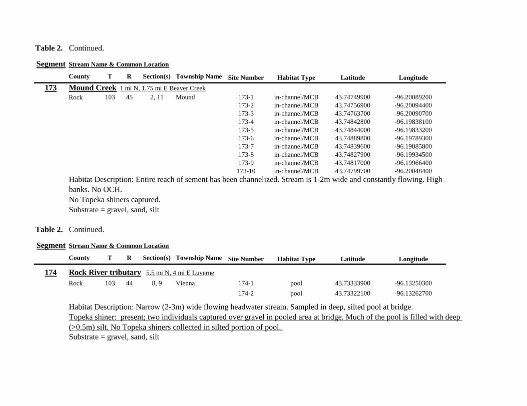
Table 2 Continued
Segment Stream Name amp Common Location
County T R Section(s) Township Name Site Number Habitat Type Latitude Longitude
173 Mound Creek 1 mi N 175 mi E Beaver Creek
Rock 103 45 2 11 Mound 173-1 in-channelMCB 4374749900 -9620089200
173-2 in-channelMCB 4374756900 -9620094400
173-3 in-channelMCB 4374763700 -9620090700
173-4 in-channelMCB 4374842800 -9619838100
173-5 in-channelMCB 4374844000 -9619833200
173-6 in-channelMCB 4374889800 -9619789300
173-7 in-channelMCB 4374839600 -9619885800
173-8 in-channelMCB 4374827900 -9619934500
173-9 in-channelMCB 4374817000 -9619966400
173-10 in-channelMCB 4374799700 -9620048400
Habitat Description Entire reach of sement has been channelized Stream is 1-2m wide and constantly flowing High
banks No OCH
No Topeka shiners captured
Substrate = gravel sand silt
Table 2 Continued
Segment Stream Name amp Common Location
County T R Section(s) Township Name Site Number Habitat Type Latitude Longitude
174 Rock River tributary 55 mi N 4 mi E Luverne
Rock 103 44 8 9 Vienna 174-1 pool 4373333900 -9613250300
174-2 pool 4373322100 -9613262700
Habitat Description Narrow (2-3m) wide flowing headwater stream Sampled in deep silted pool at bridge Topeka shiner present two individuals captured over gravel in pooled area at bridge Much of the pool is filled with deep (gt05m) silt No Topeka shiners collected in silted portion of pool Substrate = gravel sand silt
Table 2 Continued
Segment Stream Name amp Common Location
County T R Section(s) Township Name Site Number Habitat Type Latitude Longitude
175 Champepadan Creek 4mi N 5 mi E Luverne
Rock 103 44 21 22 Vienna 175-1 pool 4371002900 -9611238300
175-2 pool 4371001900 -9611232600
175-3 pool 4371008300 -9611238900
175-4 in-channelMCB 4370955000 -9611142300
175-5 in-channelMCB 4371042200 -9610763900
175-6 in-channelMCB 4371007000 -9610720000
175-7 in-channelMCB 4370984100 -9610706400
175-8 pooloff-channel 4370971600 -9610709700
Habitat Description 3m wide stream with moderate flow Native prairie has been planted along both banks for the entire reach
No flow Sampled at pooled areas at culverts at CH 19
Topeka shiner present one individual captured in deep livestock pond S of stream Depth (gt2m) made seining in pond difficult
Substrate = sand silt gravel
Table 2 Continued
Segment Stream Name amp Common Location
County T R Section(s) Township Name Site Number Habitat Type Latitude Longitude
176 Kanaranzi Creek 2 mi W 35 mi N Ellworth
Rock 101 44 12 Kanaranzi 176-1 pool 4357304000 -9606413600
176-2 pool 4357305400 -9606410500
176-3 pool 4357249700 -9606408600
176-4 in-channelMCB 4357200500 -9606350300
176-5 in-channelMCB 4357204500 -9606354600
176-6 in-channelMCB 4357211400 -9606360400
176-7 in-channelMCB 4357127700 -9606357500
176-8 in-channelMCB 4357090500 -9606197900
176-9 in-channelMCB 4356817400 -9606275000
176-10 in-channelMCB 4356807000 -9606273900
176-11 in-channelMCB 4356639200 -9606408000
176-12 in-channelMCB 4356632100 -9606416000
176-13 in-channelMCB 4356598300 -9606381200
Habitat Description 10m wide flowing stream Very little OCH Very deep silt along MCB Sampled pooled area
at bridge High eroded banks
No Topeka shiners captured
Substrate = silt over gravel
Table 2 Continued
Segment Stream Name amp Common Location
County T R Section(s) Township Name Site Number Habitat Type Latitude Longitude
177 Rock River 05 mi N 4 mi E Steen
Rock 101 45 25 Clinton 177-1 pool 4352588900 -9618721100
177-2 pool 4352592700 -9618726600
177-3 in-channelMCB 4352519900 -9618594900
177-4 in-channelMCB 4352297500 -9618558400
177-5 in-channelMCB 4352147800 -9618456000
177-6 in-channelMCB 4352143300 -9618458200
177-7 in-channelMCB 4352125000 -9618453100
177-8 in-channelMCB 4352121500 -9618442200
177-9 in-channelMCB 4352106600 -9618444000
177-10 in-channelMCB 4352727900 -9618684800
177-11 pool 4352783000 -9618770800
177-12 pooloff-channel 4352663200 -9619046500
Habitat Description 11m wide flowing stream with wide channel sand bars and some braiding Firm gravel in thalweg Oxbow in middle of reach is nearly dry (lt25 cm) No fish observed culicid fly larvae abundant No Topeka shiners captured Substrate = sand gravel silt
Table 2 Continued
Segment Stream Name amp Common Location
County T R Section(s) Township Name Site Number Habitat Type Latitude Longitude
178 Kanaranzi Creek 2 mi W Ellsworth
Rock 101 44 25 36 Kanaranzi 178-1 pool 4351441400 -9605867000
178-2 in-channelMCB 4351404500 -9605846000
178-3 in-channelMCB 4351378800 -9605844300
178-4 pool 4351349700 -9605841200
178-5 pool 4351358400 -9605829800
178-6 pool 4351351800 -9605816800
178-7 in-channelMCB 4351355800 -9605866900
178-8 in-channelMCB 4351549000 -9605823700
178-9 in-channelMCB 4351891800 -9605895600
178-10 in-channelMCB 4351866200 -9605881400
178-11 pool 4352078500 -9606070000
178-12 pool 4352046000 -9606082200
Habitat Description 7-9m wide flowing stream Sampled backwater and off-channel habitats along MCB and side channels Recent high flow has filled in off-channel areas with deep silt Seining difficult No Topeka shiners captured Substrate = sand silt gravel
Table 2 Concluded
Segment Stream Name amp Common Location
County T R Section(s) Township Name Site Number Habitat Type Latitude Longitude
179 East Branch Kanaranzi Creek 15 mi N 15 mi E Adrian
Nobles 102 42 8 Olney 179-1 pool 4365932900 -9590462700
179-2 pool 4365928900 -9590449500
179-3 pool 4365930600 -9590463300
179-4 pool 4365908000 -9590420300
179-5 in-channelMCB 4365679800 -9590378600
179-6 in-channelMCB 4365661000 -9590387800
179-7 in-channelMCB 4365604000 -9590417100
179-8 in-channelMCB 4365508100 -9590385200
179-9 in-channelMCB 4365460100 -9590342200
179-10 pool 4365434900 -9590020100
179-11 in-channelMCB 4365507700 -9590154900
179-12 in-channelMCB 4365588000 -9589900200
Habitat Description Flowing 9m wide stream Stream is full to high banks very little slackwater habitat present at this site
No Topeka shiners captured
Substrate = sand silt gravel
180 Little Rock River 8 mi E Ellsworth
Nobles 101 42 26 Little Rock 180-1 in-channelMCB 4352838500 -9584615900
Habitat Description Sampled large pooled area at bridge no discernible flow silt over gravel substrate Channel downstream
of pool is a 2-3 m wide flowing stream with a firm sandgravel substrate
Topeka shiner abundant fourteen individuals captured in first seine haul in pool fifteen individuals captured in second seine
haul near outlet of the pool
Substrate = gravel sand silt
Table 3 Complete List of Fish Species Captured at Segments 141-160 2012
Species 141 142 143 144 145 146 147 148 149 150 151 152 153 154 155 156 157 158 159 160 Campostoma anomalum X X X X X X X X X X X X X X Chrosomus erythrogaster X X Cyprinella lutrensis X X X X X X X X X Cyprinus carpio X X X X X Hybognathus hankinsoni X X X X X X X Luxilus cornutus X X X X X X X X X X X X X Notropis dorsalis X X X X X X X X X X X Notropis stramineus X X X X X X X X X X X X X X X Notropis topeka X X X X X X X X Pimephales notatus X X X X X X X X X X X X Pimephales promelas X X X X X X X X X X X X X X X X X X Rhinichthys atratulus X X X X X X Semotilus atromaculatus X X X X X X X X X X X X X X X X X X Carpiodes cyprinus X Carpiodes sp (YOY) X X X Catostomus commersoni X X X X X X X X X X X X X X X Moxostoma macrolepidotum X X Ameiurus melas X X X X X X X X X X X X X Ameiurus natalis X Ictalurus punctatus X X X X Noturus flavus X X X X Noturus gyrinus X X X X X Esox lucius X X Percopsis omiscomaycus X Fundulus sciadicus X X X Culaea inconstans X X X X X Lepomis cyanellus X X X X X X X Lepomis humilis X X X X X X X X X X X Lepomis macrochirus X X X X X Micropterus dolomieui X Micropterus salmoides X X Pomoxis nigromaculatus X X Etheostoma exile X X X X X Etheostoma nigrum X X X X X X X X X X X X X X X X X Perca flavescens X X Percina maculata X X X X
Table 4 Complete List of Fish Species Captured at Segments 161-180 2013
Species 161 162 163 164 165 166 167 168 169 170 171 172 173 174 175 176 177 178 179 180
Campostoma anomalum X X X X X X X X X X X X X X
Cyprinella lutrensis X X X X X X X X X X
Cyprinus carpio X X X
Hybognathus hankinsoni X X X X X
Luxilus cornutus X X X X X X X X X X X X X
Notropis dorsalis X X X X X X X X X X X X X X
Notropis stramineus X X X X X X X X X X X X X X
Notropis topeka X X X X X X
Pimephales notatus X X X X X X X X X X X X
Pimephales promelas X X X X X X X X X X X X X X X X X X
Rhinichthys atratulus X X X X X X X X X X X
Semotilus atromaculatus X X X X X X X X X X X X X X X X
Carpiodes cyprinus X X
Catostomus commersoni X X X X X X X X X X X X X
Moxostoma erythrurum X X X
Moxostoma macrolepidotum X X
Ameiurus melas X X X X X X X X X X
Noturus flavus X X X
Esox lucius X X
Percopsis omiscomaycus X
Fundulus sciadicus X
Culaea inconstans X X X X
Lepomis cyanellus X X X X X X
Lepomis humilis X X X X X X X X X
Etheostoma exile X X
Etheostoma nigrum X X X X X X X X X X
Percina maculata X X
Appendix C- Habitat and Voucher Photographs
Habitat photographs for segments in which no Topeka shiners were captured are representative
of the habitat along the one-mile reach of stream Habitat photographs from segments where
Topeka shiners were present represent the specific site where they were collected Voucher
photographs are presented for each of the sites were Topeka shiners were collected
Site 141-2 Medary Creek voucher and habitat photos
Segment 142 Willow Creek no Topeka shiners captured
Segment 143 East Branch Flandrau Creek no Topeka shiners captured
Segment 144 North Branch Pipestone Creek no Topeka shiners captured
Site 145-6 Pipestone Creek voucher photo
Site 145-6 Pipestone Creek habitat photo
Segment 146 Split Rock Creek no Topeka shiners captured No habitat photo
Segment 147 Kanaranzi Creek no Topeka shiners captured
Site 148-4 Rock River voucher and habitat photos
Site 149-4 Rock River voucher and habitat photos
Site 150-4 Split Rock Creek voucher and habitat photos
Site 151-1 Beaver Creek voucher and habitat photos
Segment 152 Beaver Creek no Topeka shiners captured
Segment 153 Beaver Creek no Topeka shiners captured
Segment 154 Rock River no Topeka shiners captured
Segment 155 Elk Creek no Topeka shiners captured
Site 156-1 Elk Creek voucher and habitat photos
Segment 157 Kanaranzi Creek no Topeka shiners captured
Segment 158 Kanaranzi Creek no Topeka shiners captured
Site 159-1 Kanaranzi Creek voucher and habitat photos
Segment 160 Little Rock River no Topeka shiners captured
Site 161-15 Medary Creek voucher photo
Site 161-15 Medary Creek habitat photo
Segment 162 Willow Creek no Topeka shiners captured No habitat photo
Segment 163 Flandrau Creek no Topeka shiners captured
Segment 164 Flandrau Creek no Topeka shiners captured
Segment 165 North Branch Pipestone Creek no Topeka Shiners captured
Segment 166 Pipestone Creek no Topeka Shiners captured
Segment 167 Tributary to Split Rock Creek no Topeka Shiners captured No habitat
photo
Site 168-1 Split Rock Creek voucher photo
Site 168-1 Split Rock Creek habitat photo
Site 169-2 Rock River voucher photo
Site 169-2 Rock River habitat photo
Segment 170 Chanarambie Creek no Topeka shiners captured
Segment 171 Rock River no Topeka shiners captured
Segment 172 Tributary to Rock River no Topeka shiners captured
Segment 173 Blue Mound Creek no Topeka shiners
Site 174-2 Tributary to Rock River voucher photo
Site 174-2 Tributary to Rock River habitat photo
Site 175-8 Champepadan Creek voucher photo
Site 175-8 Champepadan Creek habitat photo
Segment 176 Kanaranzi Creek no Topekas captured
Segment 177 Rock River no Topeka shiners captured
Segment 178 Kanaranzi Creek no Topeka shiners captured
Segment 179 East Branch Kanaranzi Creek no Topeka shiners captured
Site 180-1 West Branch Little Rock River voucher photo
Site 180-1 West Branch Little Rock River habitat photo
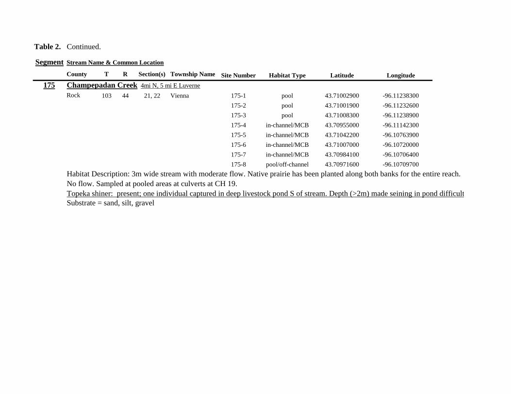
Table 2 Continued
Segment Stream Name amp Common Location
County T R Section(s) Township Name Site Number Habitat Type Latitude Longitude
175 Champepadan Creek 4mi N 5 mi E Luverne
Rock 103 44 21 22 Vienna 175-1 pool 4371002900 -9611238300
175-2 pool 4371001900 -9611232600
175-3 pool 4371008300 -9611238900
175-4 in-channelMCB 4370955000 -9611142300
175-5 in-channelMCB 4371042200 -9610763900
175-6 in-channelMCB 4371007000 -9610720000
175-7 in-channelMCB 4370984100 -9610706400
175-8 pooloff-channel 4370971600 -9610709700
Habitat Description 3m wide stream with moderate flow Native prairie has been planted along both banks for the entire reach
No flow Sampled at pooled areas at culverts at CH 19
Topeka shiner present one individual captured in deep livestock pond S of stream Depth (gt2m) made seining in pond difficult
Substrate = sand silt gravel
Table 2 Continued
Segment Stream Name amp Common Location
County T R Section(s) Township Name Site Number Habitat Type Latitude Longitude
176 Kanaranzi Creek 2 mi W 35 mi N Ellworth
Rock 101 44 12 Kanaranzi 176-1 pool 4357304000 -9606413600
176-2 pool 4357305400 -9606410500
176-3 pool 4357249700 -9606408600
176-4 in-channelMCB 4357200500 -9606350300
176-5 in-channelMCB 4357204500 -9606354600
176-6 in-channelMCB 4357211400 -9606360400
176-7 in-channelMCB 4357127700 -9606357500
176-8 in-channelMCB 4357090500 -9606197900
176-9 in-channelMCB 4356817400 -9606275000
176-10 in-channelMCB 4356807000 -9606273900
176-11 in-channelMCB 4356639200 -9606408000
176-12 in-channelMCB 4356632100 -9606416000
176-13 in-channelMCB 4356598300 -9606381200
Habitat Description 10m wide flowing stream Very little OCH Very deep silt along MCB Sampled pooled area
at bridge High eroded banks
No Topeka shiners captured
Substrate = silt over gravel
Table 2 Continued
Segment Stream Name amp Common Location
County T R Section(s) Township Name Site Number Habitat Type Latitude Longitude
177 Rock River 05 mi N 4 mi E Steen
Rock 101 45 25 Clinton 177-1 pool 4352588900 -9618721100
177-2 pool 4352592700 -9618726600
177-3 in-channelMCB 4352519900 -9618594900
177-4 in-channelMCB 4352297500 -9618558400
177-5 in-channelMCB 4352147800 -9618456000
177-6 in-channelMCB 4352143300 -9618458200
177-7 in-channelMCB 4352125000 -9618453100
177-8 in-channelMCB 4352121500 -9618442200
177-9 in-channelMCB 4352106600 -9618444000
177-10 in-channelMCB 4352727900 -9618684800
177-11 pool 4352783000 -9618770800
177-12 pooloff-channel 4352663200 -9619046500
Habitat Description 11m wide flowing stream with wide channel sand bars and some braiding Firm gravel in thalweg Oxbow in middle of reach is nearly dry (lt25 cm) No fish observed culicid fly larvae abundant No Topeka shiners captured Substrate = sand gravel silt
Table 2 Continued
Segment Stream Name amp Common Location
County T R Section(s) Township Name Site Number Habitat Type Latitude Longitude
178 Kanaranzi Creek 2 mi W Ellsworth
Rock 101 44 25 36 Kanaranzi 178-1 pool 4351441400 -9605867000
178-2 in-channelMCB 4351404500 -9605846000
178-3 in-channelMCB 4351378800 -9605844300
178-4 pool 4351349700 -9605841200
178-5 pool 4351358400 -9605829800
178-6 pool 4351351800 -9605816800
178-7 in-channelMCB 4351355800 -9605866900
178-8 in-channelMCB 4351549000 -9605823700
178-9 in-channelMCB 4351891800 -9605895600
178-10 in-channelMCB 4351866200 -9605881400
178-11 pool 4352078500 -9606070000
178-12 pool 4352046000 -9606082200
Habitat Description 7-9m wide flowing stream Sampled backwater and off-channel habitats along MCB and side channels Recent high flow has filled in off-channel areas with deep silt Seining difficult No Topeka shiners captured Substrate = sand silt gravel
Table 2 Concluded
Segment Stream Name amp Common Location
County T R Section(s) Township Name Site Number Habitat Type Latitude Longitude
179 East Branch Kanaranzi Creek 15 mi N 15 mi E Adrian
Nobles 102 42 8 Olney 179-1 pool 4365932900 -9590462700
179-2 pool 4365928900 -9590449500
179-3 pool 4365930600 -9590463300
179-4 pool 4365908000 -9590420300
179-5 in-channelMCB 4365679800 -9590378600
179-6 in-channelMCB 4365661000 -9590387800
179-7 in-channelMCB 4365604000 -9590417100
179-8 in-channelMCB 4365508100 -9590385200
179-9 in-channelMCB 4365460100 -9590342200
179-10 pool 4365434900 -9590020100
179-11 in-channelMCB 4365507700 -9590154900
179-12 in-channelMCB 4365588000 -9589900200
Habitat Description Flowing 9m wide stream Stream is full to high banks very little slackwater habitat present at this site
No Topeka shiners captured
Substrate = sand silt gravel
180 Little Rock River 8 mi E Ellsworth
Nobles 101 42 26 Little Rock 180-1 in-channelMCB 4352838500 -9584615900
Habitat Description Sampled large pooled area at bridge no discernible flow silt over gravel substrate Channel downstream
of pool is a 2-3 m wide flowing stream with a firm sandgravel substrate
Topeka shiner abundant fourteen individuals captured in first seine haul in pool fifteen individuals captured in second seine
haul near outlet of the pool
Substrate = gravel sand silt
Table 3 Complete List of Fish Species Captured at Segments 141-160 2012
Species 141 142 143 144 145 146 147 148 149 150 151 152 153 154 155 156 157 158 159 160 Campostoma anomalum X X X X X X X X X X X X X X Chrosomus erythrogaster X X Cyprinella lutrensis X X X X X X X X X Cyprinus carpio X X X X X Hybognathus hankinsoni X X X X X X X Luxilus cornutus X X X X X X X X X X X X X Notropis dorsalis X X X X X X X X X X X Notropis stramineus X X X X X X X X X X X X X X X Notropis topeka X X X X X X X X Pimephales notatus X X X X X X X X X X X X Pimephales promelas X X X X X X X X X X X X X X X X X X Rhinichthys atratulus X X X X X X Semotilus atromaculatus X X X X X X X X X X X X X X X X X X Carpiodes cyprinus X Carpiodes sp (YOY) X X X Catostomus commersoni X X X X X X X X X X X X X X X Moxostoma macrolepidotum X X Ameiurus melas X X X X X X X X X X X X X Ameiurus natalis X Ictalurus punctatus X X X X Noturus flavus X X X X Noturus gyrinus X X X X X Esox lucius X X Percopsis omiscomaycus X Fundulus sciadicus X X X Culaea inconstans X X X X X Lepomis cyanellus X X X X X X X Lepomis humilis X X X X X X X X X X X Lepomis macrochirus X X X X X Micropterus dolomieui X Micropterus salmoides X X Pomoxis nigromaculatus X X Etheostoma exile X X X X X Etheostoma nigrum X X X X X X X X X X X X X X X X X Perca flavescens X X Percina maculata X X X X
Table 4 Complete List of Fish Species Captured at Segments 161-180 2013
Species 161 162 163 164 165 166 167 168 169 170 171 172 173 174 175 176 177 178 179 180
Campostoma anomalum X X X X X X X X X X X X X X
Cyprinella lutrensis X X X X X X X X X X
Cyprinus carpio X X X
Hybognathus hankinsoni X X X X X
Luxilus cornutus X X X X X X X X X X X X X
Notropis dorsalis X X X X X X X X X X X X X X
Notropis stramineus X X X X X X X X X X X X X X
Notropis topeka X X X X X X
Pimephales notatus X X X X X X X X X X X X
Pimephales promelas X X X X X X X X X X X X X X X X X X
Rhinichthys atratulus X X X X X X X X X X X
Semotilus atromaculatus X X X X X X X X X X X X X X X X
Carpiodes cyprinus X X
Catostomus commersoni X X X X X X X X X X X X X
Moxostoma erythrurum X X X
Moxostoma macrolepidotum X X
Ameiurus melas X X X X X X X X X X
Noturus flavus X X X
Esox lucius X X
Percopsis omiscomaycus X
Fundulus sciadicus X
Culaea inconstans X X X X
Lepomis cyanellus X X X X X X
Lepomis humilis X X X X X X X X X
Etheostoma exile X X
Etheostoma nigrum X X X X X X X X X X
Percina maculata X X
Appendix C- Habitat and Voucher Photographs
Habitat photographs for segments in which no Topeka shiners were captured are representative
of the habitat along the one-mile reach of stream Habitat photographs from segments where
Topeka shiners were present represent the specific site where they were collected Voucher
photographs are presented for each of the sites were Topeka shiners were collected
Site 141-2 Medary Creek voucher and habitat photos
Segment 142 Willow Creek no Topeka shiners captured
Segment 143 East Branch Flandrau Creek no Topeka shiners captured
Segment 144 North Branch Pipestone Creek no Topeka shiners captured
Site 145-6 Pipestone Creek voucher photo
Site 145-6 Pipestone Creek habitat photo
Segment 146 Split Rock Creek no Topeka shiners captured No habitat photo
Segment 147 Kanaranzi Creek no Topeka shiners captured
Site 148-4 Rock River voucher and habitat photos
Site 149-4 Rock River voucher and habitat photos
Site 150-4 Split Rock Creek voucher and habitat photos
Site 151-1 Beaver Creek voucher and habitat photos
Segment 152 Beaver Creek no Topeka shiners captured
Segment 153 Beaver Creek no Topeka shiners captured
Segment 154 Rock River no Topeka shiners captured
Segment 155 Elk Creek no Topeka shiners captured
Site 156-1 Elk Creek voucher and habitat photos
Segment 157 Kanaranzi Creek no Topeka shiners captured
Segment 158 Kanaranzi Creek no Topeka shiners captured
Site 159-1 Kanaranzi Creek voucher and habitat photos
Segment 160 Little Rock River no Topeka shiners captured
Site 161-15 Medary Creek voucher photo
Site 161-15 Medary Creek habitat photo
Segment 162 Willow Creek no Topeka shiners captured No habitat photo
Segment 163 Flandrau Creek no Topeka shiners captured
Segment 164 Flandrau Creek no Topeka shiners captured
Segment 165 North Branch Pipestone Creek no Topeka Shiners captured
Segment 166 Pipestone Creek no Topeka Shiners captured
Segment 167 Tributary to Split Rock Creek no Topeka Shiners captured No habitat
photo
Site 168-1 Split Rock Creek voucher photo
Site 168-1 Split Rock Creek habitat photo
Site 169-2 Rock River voucher photo
Site 169-2 Rock River habitat photo
Segment 170 Chanarambie Creek no Topeka shiners captured
Segment 171 Rock River no Topeka shiners captured
Segment 172 Tributary to Rock River no Topeka shiners captured
Segment 173 Blue Mound Creek no Topeka shiners
Site 174-2 Tributary to Rock River voucher photo
Site 174-2 Tributary to Rock River habitat photo
Site 175-8 Champepadan Creek voucher photo
Site 175-8 Champepadan Creek habitat photo
Segment 176 Kanaranzi Creek no Topekas captured
Segment 177 Rock River no Topeka shiners captured
Segment 178 Kanaranzi Creek no Topeka shiners captured
Segment 179 East Branch Kanaranzi Creek no Topeka shiners captured
Site 180-1 West Branch Little Rock River voucher photo
Site 180-1 West Branch Little Rock River habitat photo
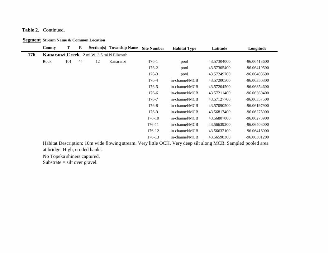
Table 2 Continued
Segment Stream Name amp Common Location
County T R Section(s) Township Name Site Number Habitat Type Latitude Longitude
176 Kanaranzi Creek 2 mi W 35 mi N Ellworth
Rock 101 44 12 Kanaranzi 176-1 pool 4357304000 -9606413600
176-2 pool 4357305400 -9606410500
176-3 pool 4357249700 -9606408600
176-4 in-channelMCB 4357200500 -9606350300
176-5 in-channelMCB 4357204500 -9606354600
176-6 in-channelMCB 4357211400 -9606360400
176-7 in-channelMCB 4357127700 -9606357500
176-8 in-channelMCB 4357090500 -9606197900
176-9 in-channelMCB 4356817400 -9606275000
176-10 in-channelMCB 4356807000 -9606273900
176-11 in-channelMCB 4356639200 -9606408000
176-12 in-channelMCB 4356632100 -9606416000
176-13 in-channelMCB 4356598300 -9606381200
Habitat Description 10m wide flowing stream Very little OCH Very deep silt along MCB Sampled pooled area
at bridge High eroded banks
No Topeka shiners captured
Substrate = silt over gravel
Table 2 Continued
Segment Stream Name amp Common Location
County T R Section(s) Township Name Site Number Habitat Type Latitude Longitude
177 Rock River 05 mi N 4 mi E Steen
Rock 101 45 25 Clinton 177-1 pool 4352588900 -9618721100
177-2 pool 4352592700 -9618726600
177-3 in-channelMCB 4352519900 -9618594900
177-4 in-channelMCB 4352297500 -9618558400
177-5 in-channelMCB 4352147800 -9618456000
177-6 in-channelMCB 4352143300 -9618458200
177-7 in-channelMCB 4352125000 -9618453100
177-8 in-channelMCB 4352121500 -9618442200
177-9 in-channelMCB 4352106600 -9618444000
177-10 in-channelMCB 4352727900 -9618684800
177-11 pool 4352783000 -9618770800
177-12 pooloff-channel 4352663200 -9619046500
Habitat Description 11m wide flowing stream with wide channel sand bars and some braiding Firm gravel in thalweg Oxbow in middle of reach is nearly dry (lt25 cm) No fish observed culicid fly larvae abundant No Topeka shiners captured Substrate = sand gravel silt
Table 2 Continued
Segment Stream Name amp Common Location
County T R Section(s) Township Name Site Number Habitat Type Latitude Longitude
178 Kanaranzi Creek 2 mi W Ellsworth
Rock 101 44 25 36 Kanaranzi 178-1 pool 4351441400 -9605867000
178-2 in-channelMCB 4351404500 -9605846000
178-3 in-channelMCB 4351378800 -9605844300
178-4 pool 4351349700 -9605841200
178-5 pool 4351358400 -9605829800
178-6 pool 4351351800 -9605816800
178-7 in-channelMCB 4351355800 -9605866900
178-8 in-channelMCB 4351549000 -9605823700
178-9 in-channelMCB 4351891800 -9605895600
178-10 in-channelMCB 4351866200 -9605881400
178-11 pool 4352078500 -9606070000
178-12 pool 4352046000 -9606082200
Habitat Description 7-9m wide flowing stream Sampled backwater and off-channel habitats along MCB and side channels Recent high flow has filled in off-channel areas with deep silt Seining difficult No Topeka shiners captured Substrate = sand silt gravel
Table 2 Concluded
Segment Stream Name amp Common Location
County T R Section(s) Township Name Site Number Habitat Type Latitude Longitude
179 East Branch Kanaranzi Creek 15 mi N 15 mi E Adrian
Nobles 102 42 8 Olney 179-1 pool 4365932900 -9590462700
179-2 pool 4365928900 -9590449500
179-3 pool 4365930600 -9590463300
179-4 pool 4365908000 -9590420300
179-5 in-channelMCB 4365679800 -9590378600
179-6 in-channelMCB 4365661000 -9590387800
179-7 in-channelMCB 4365604000 -9590417100
179-8 in-channelMCB 4365508100 -9590385200
179-9 in-channelMCB 4365460100 -9590342200
179-10 pool 4365434900 -9590020100
179-11 in-channelMCB 4365507700 -9590154900
179-12 in-channelMCB 4365588000 -9589900200
Habitat Description Flowing 9m wide stream Stream is full to high banks very little slackwater habitat present at this site
No Topeka shiners captured
Substrate = sand silt gravel
180 Little Rock River 8 mi E Ellsworth
Nobles 101 42 26 Little Rock 180-1 in-channelMCB 4352838500 -9584615900
Habitat Description Sampled large pooled area at bridge no discernible flow silt over gravel substrate Channel downstream
of pool is a 2-3 m wide flowing stream with a firm sandgravel substrate
Topeka shiner abundant fourteen individuals captured in first seine haul in pool fifteen individuals captured in second seine
haul near outlet of the pool
Substrate = gravel sand silt
Table 3 Complete List of Fish Species Captured at Segments 141-160 2012
Species 141 142 143 144 145 146 147 148 149 150 151 152 153 154 155 156 157 158 159 160 Campostoma anomalum X X X X X X X X X X X X X X Chrosomus erythrogaster X X Cyprinella lutrensis X X X X X X X X X Cyprinus carpio X X X X X Hybognathus hankinsoni X X X X X X X Luxilus cornutus X X X X X X X X X X X X X Notropis dorsalis X X X X X X X X X X X Notropis stramineus X X X X X X X X X X X X X X X Notropis topeka X X X X X X X X Pimephales notatus X X X X X X X X X X X X Pimephales promelas X X X X X X X X X X X X X X X X X X Rhinichthys atratulus X X X X X X Semotilus atromaculatus X X X X X X X X X X X X X X X X X X Carpiodes cyprinus X Carpiodes sp (YOY) X X X Catostomus commersoni X X X X X X X X X X X X X X X Moxostoma macrolepidotum X X Ameiurus melas X X X X X X X X X X X X X Ameiurus natalis X Ictalurus punctatus X X X X Noturus flavus X X X X Noturus gyrinus X X X X X Esox lucius X X Percopsis omiscomaycus X Fundulus sciadicus X X X Culaea inconstans X X X X X Lepomis cyanellus X X X X X X X Lepomis humilis X X X X X X X X X X X Lepomis macrochirus X X X X X Micropterus dolomieui X Micropterus salmoides X X Pomoxis nigromaculatus X X Etheostoma exile X X X X X Etheostoma nigrum X X X X X X X X X X X X X X X X X Perca flavescens X X Percina maculata X X X X
Table 4 Complete List of Fish Species Captured at Segments 161-180 2013
Species 161 162 163 164 165 166 167 168 169 170 171 172 173 174 175 176 177 178 179 180
Campostoma anomalum X X X X X X X X X X X X X X
Cyprinella lutrensis X X X X X X X X X X
Cyprinus carpio X X X
Hybognathus hankinsoni X X X X X
Luxilus cornutus X X X X X X X X X X X X X
Notropis dorsalis X X X X X X X X X X X X X X
Notropis stramineus X X X X X X X X X X X X X X
Notropis topeka X X X X X X
Pimephales notatus X X X X X X X X X X X X
Pimephales promelas X X X X X X X X X X X X X X X X X X
Rhinichthys atratulus X X X X X X X X X X X
Semotilus atromaculatus X X X X X X X X X X X X X X X X
Carpiodes cyprinus X X
Catostomus commersoni X X X X X X X X X X X X X
Moxostoma erythrurum X X X
Moxostoma macrolepidotum X X
Ameiurus melas X X X X X X X X X X
Noturus flavus X X X
Esox lucius X X
Percopsis omiscomaycus X
Fundulus sciadicus X
Culaea inconstans X X X X
Lepomis cyanellus X X X X X X
Lepomis humilis X X X X X X X X X
Etheostoma exile X X
Etheostoma nigrum X X X X X X X X X X
Percina maculata X X
Appendix C- Habitat and Voucher Photographs
Habitat photographs for segments in which no Topeka shiners were captured are representative
of the habitat along the one-mile reach of stream Habitat photographs from segments where
Topeka shiners were present represent the specific site where they were collected Voucher
photographs are presented for each of the sites were Topeka shiners were collected
Site 141-2 Medary Creek voucher and habitat photos
Segment 142 Willow Creek no Topeka shiners captured
Segment 143 East Branch Flandrau Creek no Topeka shiners captured
Segment 144 North Branch Pipestone Creek no Topeka shiners captured
Site 145-6 Pipestone Creek voucher photo
Site 145-6 Pipestone Creek habitat photo
Segment 146 Split Rock Creek no Topeka shiners captured No habitat photo
Segment 147 Kanaranzi Creek no Topeka shiners captured
Site 148-4 Rock River voucher and habitat photos
Site 149-4 Rock River voucher and habitat photos
Site 150-4 Split Rock Creek voucher and habitat photos
Site 151-1 Beaver Creek voucher and habitat photos
Segment 152 Beaver Creek no Topeka shiners captured
Segment 153 Beaver Creek no Topeka shiners captured
Segment 154 Rock River no Topeka shiners captured
Segment 155 Elk Creek no Topeka shiners captured
Site 156-1 Elk Creek voucher and habitat photos
Segment 157 Kanaranzi Creek no Topeka shiners captured
Segment 158 Kanaranzi Creek no Topeka shiners captured
Site 159-1 Kanaranzi Creek voucher and habitat photos
Segment 160 Little Rock River no Topeka shiners captured
Site 161-15 Medary Creek voucher photo
Site 161-15 Medary Creek habitat photo
Segment 162 Willow Creek no Topeka shiners captured No habitat photo
Segment 163 Flandrau Creek no Topeka shiners captured
Segment 164 Flandrau Creek no Topeka shiners captured
Segment 165 North Branch Pipestone Creek no Topeka Shiners captured
Segment 166 Pipestone Creek no Topeka Shiners captured
Segment 167 Tributary to Split Rock Creek no Topeka Shiners captured No habitat
photo
Site 168-1 Split Rock Creek voucher photo
Site 168-1 Split Rock Creek habitat photo
Site 169-2 Rock River voucher photo
Site 169-2 Rock River habitat photo
Segment 170 Chanarambie Creek no Topeka shiners captured
Segment 171 Rock River no Topeka shiners captured
Segment 172 Tributary to Rock River no Topeka shiners captured
Segment 173 Blue Mound Creek no Topeka shiners
Site 174-2 Tributary to Rock River voucher photo
Site 174-2 Tributary to Rock River habitat photo
Site 175-8 Champepadan Creek voucher photo
Site 175-8 Champepadan Creek habitat photo
Segment 176 Kanaranzi Creek no Topekas captured
Segment 177 Rock River no Topeka shiners captured
Segment 178 Kanaranzi Creek no Topeka shiners captured
Segment 179 East Branch Kanaranzi Creek no Topeka shiners captured
Site 180-1 West Branch Little Rock River voucher photo
Site 180-1 West Branch Little Rock River habitat photo
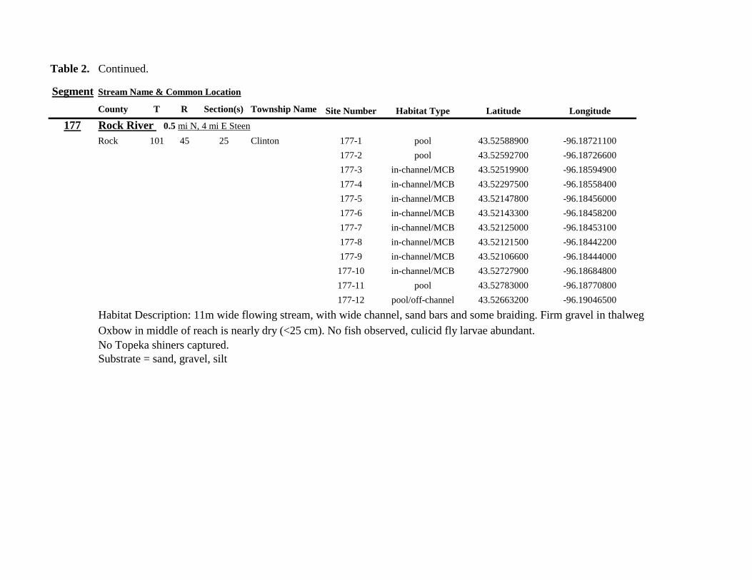
Table 2 Continued
Segment Stream Name amp Common Location
County T R Section(s) Township Name Site Number Habitat Type Latitude Longitude
177 Rock River 05 mi N 4 mi E Steen
Rock 101 45 25 Clinton 177-1 pool 4352588900 -9618721100
177-2 pool 4352592700 -9618726600
177-3 in-channelMCB 4352519900 -9618594900
177-4 in-channelMCB 4352297500 -9618558400
177-5 in-channelMCB 4352147800 -9618456000
177-6 in-channelMCB 4352143300 -9618458200
177-7 in-channelMCB 4352125000 -9618453100
177-8 in-channelMCB 4352121500 -9618442200
177-9 in-channelMCB 4352106600 -9618444000
177-10 in-channelMCB 4352727900 -9618684800
177-11 pool 4352783000 -9618770800
177-12 pooloff-channel 4352663200 -9619046500
Habitat Description 11m wide flowing stream with wide channel sand bars and some braiding Firm gravel in thalweg Oxbow in middle of reach is nearly dry (lt25 cm) No fish observed culicid fly larvae abundant No Topeka shiners captured Substrate = sand gravel silt
Table 2 Continued
Segment Stream Name amp Common Location
County T R Section(s) Township Name Site Number Habitat Type Latitude Longitude
178 Kanaranzi Creek 2 mi W Ellsworth
Rock 101 44 25 36 Kanaranzi 178-1 pool 4351441400 -9605867000
178-2 in-channelMCB 4351404500 -9605846000
178-3 in-channelMCB 4351378800 -9605844300
178-4 pool 4351349700 -9605841200
178-5 pool 4351358400 -9605829800
178-6 pool 4351351800 -9605816800
178-7 in-channelMCB 4351355800 -9605866900
178-8 in-channelMCB 4351549000 -9605823700
178-9 in-channelMCB 4351891800 -9605895600
178-10 in-channelMCB 4351866200 -9605881400
178-11 pool 4352078500 -9606070000
178-12 pool 4352046000 -9606082200
Habitat Description 7-9m wide flowing stream Sampled backwater and off-channel habitats along MCB and side channels Recent high flow has filled in off-channel areas with deep silt Seining difficult No Topeka shiners captured Substrate = sand silt gravel
Table 2 Concluded
Segment Stream Name amp Common Location
County T R Section(s) Township Name Site Number Habitat Type Latitude Longitude
179 East Branch Kanaranzi Creek 15 mi N 15 mi E Adrian
Nobles 102 42 8 Olney 179-1 pool 4365932900 -9590462700
179-2 pool 4365928900 -9590449500
179-3 pool 4365930600 -9590463300
179-4 pool 4365908000 -9590420300
179-5 in-channelMCB 4365679800 -9590378600
179-6 in-channelMCB 4365661000 -9590387800
179-7 in-channelMCB 4365604000 -9590417100
179-8 in-channelMCB 4365508100 -9590385200
179-9 in-channelMCB 4365460100 -9590342200
179-10 pool 4365434900 -9590020100
179-11 in-channelMCB 4365507700 -9590154900
179-12 in-channelMCB 4365588000 -9589900200
Habitat Description Flowing 9m wide stream Stream is full to high banks very little slackwater habitat present at this site
No Topeka shiners captured
Substrate = sand silt gravel
180 Little Rock River 8 mi E Ellsworth
Nobles 101 42 26 Little Rock 180-1 in-channelMCB 4352838500 -9584615900
Habitat Description Sampled large pooled area at bridge no discernible flow silt over gravel substrate Channel downstream
of pool is a 2-3 m wide flowing stream with a firm sandgravel substrate
Topeka shiner abundant fourteen individuals captured in first seine haul in pool fifteen individuals captured in second seine
haul near outlet of the pool
Substrate = gravel sand silt
Table 3 Complete List of Fish Species Captured at Segments 141-160 2012
Species 141 142 143 144 145 146 147 148 149 150 151 152 153 154 155 156 157 158 159 160 Campostoma anomalum X X X X X X X X X X X X X X Chrosomus erythrogaster X X Cyprinella lutrensis X X X X X X X X X Cyprinus carpio X X X X X Hybognathus hankinsoni X X X X X X X Luxilus cornutus X X X X X X X X X X X X X Notropis dorsalis X X X X X X X X X X X Notropis stramineus X X X X X X X X X X X X X X X Notropis topeka X X X X X X X X Pimephales notatus X X X X X X X X X X X X Pimephales promelas X X X X X X X X X X X X X X X X X X Rhinichthys atratulus X X X X X X Semotilus atromaculatus X X X X X X X X X X X X X X X X X X Carpiodes cyprinus X Carpiodes sp (YOY) X X X Catostomus commersoni X X X X X X X X X X X X X X X Moxostoma macrolepidotum X X Ameiurus melas X X X X X X X X X X X X X Ameiurus natalis X Ictalurus punctatus X X X X Noturus flavus X X X X Noturus gyrinus X X X X X Esox lucius X X Percopsis omiscomaycus X Fundulus sciadicus X X X Culaea inconstans X X X X X Lepomis cyanellus X X X X X X X Lepomis humilis X X X X X X X X X X X Lepomis macrochirus X X X X X Micropterus dolomieui X Micropterus salmoides X X Pomoxis nigromaculatus X X Etheostoma exile X X X X X Etheostoma nigrum X X X X X X X X X X X X X X X X X Perca flavescens X X Percina maculata X X X X
Table 4 Complete List of Fish Species Captured at Segments 161-180 2013
Species 161 162 163 164 165 166 167 168 169 170 171 172 173 174 175 176 177 178 179 180
Campostoma anomalum X X X X X X X X X X X X X X
Cyprinella lutrensis X X X X X X X X X X
Cyprinus carpio X X X
Hybognathus hankinsoni X X X X X
Luxilus cornutus X X X X X X X X X X X X X
Notropis dorsalis X X X X X X X X X X X X X X
Notropis stramineus X X X X X X X X X X X X X X
Notropis topeka X X X X X X
Pimephales notatus X X X X X X X X X X X X
Pimephales promelas X X X X X X X X X X X X X X X X X X
Rhinichthys atratulus X X X X X X X X X X X
Semotilus atromaculatus X X X X X X X X X X X X X X X X
Carpiodes cyprinus X X
Catostomus commersoni X X X X X X X X X X X X X
Moxostoma erythrurum X X X
Moxostoma macrolepidotum X X
Ameiurus melas X X X X X X X X X X
Noturus flavus X X X
Esox lucius X X
Percopsis omiscomaycus X
Fundulus sciadicus X
Culaea inconstans X X X X
Lepomis cyanellus X X X X X X
Lepomis humilis X X X X X X X X X
Etheostoma exile X X
Etheostoma nigrum X X X X X X X X X X
Percina maculata X X
Appendix C- Habitat and Voucher Photographs
Habitat photographs for segments in which no Topeka shiners were captured are representative
of the habitat along the one-mile reach of stream Habitat photographs from segments where
Topeka shiners were present represent the specific site where they were collected Voucher
photographs are presented for each of the sites were Topeka shiners were collected
Site 141-2 Medary Creek voucher and habitat photos
Segment 142 Willow Creek no Topeka shiners captured
Segment 143 East Branch Flandrau Creek no Topeka shiners captured
Segment 144 North Branch Pipestone Creek no Topeka shiners captured
Site 145-6 Pipestone Creek voucher photo
Site 145-6 Pipestone Creek habitat photo
Segment 146 Split Rock Creek no Topeka shiners captured No habitat photo
Segment 147 Kanaranzi Creek no Topeka shiners captured
Site 148-4 Rock River voucher and habitat photos
Site 149-4 Rock River voucher and habitat photos
Site 150-4 Split Rock Creek voucher and habitat photos
Site 151-1 Beaver Creek voucher and habitat photos
Segment 152 Beaver Creek no Topeka shiners captured
Segment 153 Beaver Creek no Topeka shiners captured
Segment 154 Rock River no Topeka shiners captured
Segment 155 Elk Creek no Topeka shiners captured
Site 156-1 Elk Creek voucher and habitat photos
Segment 157 Kanaranzi Creek no Topeka shiners captured
Segment 158 Kanaranzi Creek no Topeka shiners captured
Site 159-1 Kanaranzi Creek voucher and habitat photos
Segment 160 Little Rock River no Topeka shiners captured
Site 161-15 Medary Creek voucher photo
Site 161-15 Medary Creek habitat photo
Segment 162 Willow Creek no Topeka shiners captured No habitat photo
Segment 163 Flandrau Creek no Topeka shiners captured
Segment 164 Flandrau Creek no Topeka shiners captured
Segment 165 North Branch Pipestone Creek no Topeka Shiners captured
Segment 166 Pipestone Creek no Topeka Shiners captured
Segment 167 Tributary to Split Rock Creek no Topeka Shiners captured No habitat
photo
Site 168-1 Split Rock Creek voucher photo
Site 168-1 Split Rock Creek habitat photo
Site 169-2 Rock River voucher photo
Site 169-2 Rock River habitat photo
Segment 170 Chanarambie Creek no Topeka shiners captured
Segment 171 Rock River no Topeka shiners captured
Segment 172 Tributary to Rock River no Topeka shiners captured
Segment 173 Blue Mound Creek no Topeka shiners
Site 174-2 Tributary to Rock River voucher photo
Site 174-2 Tributary to Rock River habitat photo
Site 175-8 Champepadan Creek voucher photo
Site 175-8 Champepadan Creek habitat photo
Segment 176 Kanaranzi Creek no Topekas captured
Segment 177 Rock River no Topeka shiners captured
Segment 178 Kanaranzi Creek no Topeka shiners captured
Segment 179 East Branch Kanaranzi Creek no Topeka shiners captured
Site 180-1 West Branch Little Rock River voucher photo
Site 180-1 West Branch Little Rock River habitat photo
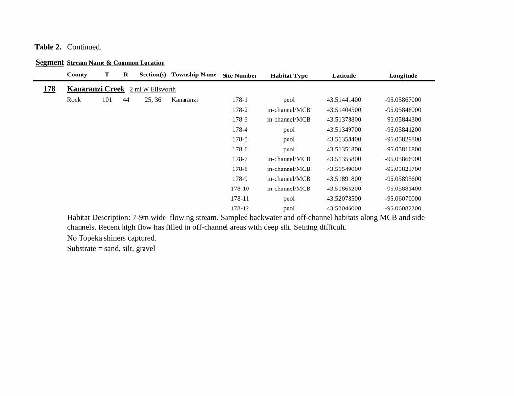
Table 2 Continued
Segment Stream Name amp Common Location
County T R Section(s) Township Name Site Number Habitat Type Latitude Longitude
178 Kanaranzi Creek 2 mi W Ellsworth
Rock 101 44 25 36 Kanaranzi 178-1 pool 4351441400 -9605867000
178-2 in-channelMCB 4351404500 -9605846000
178-3 in-channelMCB 4351378800 -9605844300
178-4 pool 4351349700 -9605841200
178-5 pool 4351358400 -9605829800
178-6 pool 4351351800 -9605816800
178-7 in-channelMCB 4351355800 -9605866900
178-8 in-channelMCB 4351549000 -9605823700
178-9 in-channelMCB 4351891800 -9605895600
178-10 in-channelMCB 4351866200 -9605881400
178-11 pool 4352078500 -9606070000
178-12 pool 4352046000 -9606082200
Habitat Description 7-9m wide flowing stream Sampled backwater and off-channel habitats along MCB and side channels Recent high flow has filled in off-channel areas with deep silt Seining difficult No Topeka shiners captured Substrate = sand silt gravel
Table 2 Concluded
Segment Stream Name amp Common Location
County T R Section(s) Township Name Site Number Habitat Type Latitude Longitude
179 East Branch Kanaranzi Creek 15 mi N 15 mi E Adrian
Nobles 102 42 8 Olney 179-1 pool 4365932900 -9590462700
179-2 pool 4365928900 -9590449500
179-3 pool 4365930600 -9590463300
179-4 pool 4365908000 -9590420300
179-5 in-channelMCB 4365679800 -9590378600
179-6 in-channelMCB 4365661000 -9590387800
179-7 in-channelMCB 4365604000 -9590417100
179-8 in-channelMCB 4365508100 -9590385200
179-9 in-channelMCB 4365460100 -9590342200
179-10 pool 4365434900 -9590020100
179-11 in-channelMCB 4365507700 -9590154900
179-12 in-channelMCB 4365588000 -9589900200
Habitat Description Flowing 9m wide stream Stream is full to high banks very little slackwater habitat present at this site
No Topeka shiners captured
Substrate = sand silt gravel
180 Little Rock River 8 mi E Ellsworth
Nobles 101 42 26 Little Rock 180-1 in-channelMCB 4352838500 -9584615900
Habitat Description Sampled large pooled area at bridge no discernible flow silt over gravel substrate Channel downstream
of pool is a 2-3 m wide flowing stream with a firm sandgravel substrate
Topeka shiner abundant fourteen individuals captured in first seine haul in pool fifteen individuals captured in second seine
haul near outlet of the pool
Substrate = gravel sand silt
Table 3 Complete List of Fish Species Captured at Segments 141-160 2012
Species 141 142 143 144 145 146 147 148 149 150 151 152 153 154 155 156 157 158 159 160 Campostoma anomalum X X X X X X X X X X X X X X Chrosomus erythrogaster X X Cyprinella lutrensis X X X X X X X X X Cyprinus carpio X X X X X Hybognathus hankinsoni X X X X X X X Luxilus cornutus X X X X X X X X X X X X X Notropis dorsalis X X X X X X X X X X X Notropis stramineus X X X X X X X X X X X X X X X Notropis topeka X X X X X X X X Pimephales notatus X X X X X X X X X X X X Pimephales promelas X X X X X X X X X X X X X X X X X X Rhinichthys atratulus X X X X X X Semotilus atromaculatus X X X X X X X X X X X X X X X X X X Carpiodes cyprinus X Carpiodes sp (YOY) X X X Catostomus commersoni X X X X X X X X X X X X X X X Moxostoma macrolepidotum X X Ameiurus melas X X X X X X X X X X X X X Ameiurus natalis X Ictalurus punctatus X X X X Noturus flavus X X X X Noturus gyrinus X X X X X Esox lucius X X Percopsis omiscomaycus X Fundulus sciadicus X X X Culaea inconstans X X X X X Lepomis cyanellus X X X X X X X Lepomis humilis X X X X X X X X X X X Lepomis macrochirus X X X X X Micropterus dolomieui X Micropterus salmoides X X Pomoxis nigromaculatus X X Etheostoma exile X X X X X Etheostoma nigrum X X X X X X X X X X X X X X X X X Perca flavescens X X Percina maculata X X X X
Table 4 Complete List of Fish Species Captured at Segments 161-180 2013
Species 161 162 163 164 165 166 167 168 169 170 171 172 173 174 175 176 177 178 179 180
Campostoma anomalum X X X X X X X X X X X X X X
Cyprinella lutrensis X X X X X X X X X X
Cyprinus carpio X X X
Hybognathus hankinsoni X X X X X
Luxilus cornutus X X X X X X X X X X X X X
Notropis dorsalis X X X X X X X X X X X X X X
Notropis stramineus X X X X X X X X X X X X X X
Notropis topeka X X X X X X
Pimephales notatus X X X X X X X X X X X X
Pimephales promelas X X X X X X X X X X X X X X X X X X
Rhinichthys atratulus X X X X X X X X X X X
Semotilus atromaculatus X X X X X X X X X X X X X X X X
Carpiodes cyprinus X X
Catostomus commersoni X X X X X X X X X X X X X
Moxostoma erythrurum X X X
Moxostoma macrolepidotum X X
Ameiurus melas X X X X X X X X X X
Noturus flavus X X X
Esox lucius X X
Percopsis omiscomaycus X
Fundulus sciadicus X
Culaea inconstans X X X X
Lepomis cyanellus X X X X X X
Lepomis humilis X X X X X X X X X
Etheostoma exile X X
Etheostoma nigrum X X X X X X X X X X
Percina maculata X X
Appendix C- Habitat and Voucher Photographs
Habitat photographs for segments in which no Topeka shiners were captured are representative
of the habitat along the one-mile reach of stream Habitat photographs from segments where
Topeka shiners were present represent the specific site where they were collected Voucher
photographs are presented for each of the sites were Topeka shiners were collected
Site 141-2 Medary Creek voucher and habitat photos
Segment 142 Willow Creek no Topeka shiners captured
Segment 143 East Branch Flandrau Creek no Topeka shiners captured
Segment 144 North Branch Pipestone Creek no Topeka shiners captured
Site 145-6 Pipestone Creek voucher photo
Site 145-6 Pipestone Creek habitat photo
Segment 146 Split Rock Creek no Topeka shiners captured No habitat photo
Segment 147 Kanaranzi Creek no Topeka shiners captured
Site 148-4 Rock River voucher and habitat photos
Site 149-4 Rock River voucher and habitat photos
Site 150-4 Split Rock Creek voucher and habitat photos
Site 151-1 Beaver Creek voucher and habitat photos
Segment 152 Beaver Creek no Topeka shiners captured
Segment 153 Beaver Creek no Topeka shiners captured
Segment 154 Rock River no Topeka shiners captured
Segment 155 Elk Creek no Topeka shiners captured
Site 156-1 Elk Creek voucher and habitat photos
Segment 157 Kanaranzi Creek no Topeka shiners captured
Segment 158 Kanaranzi Creek no Topeka shiners captured
Site 159-1 Kanaranzi Creek voucher and habitat photos
Segment 160 Little Rock River no Topeka shiners captured
Site 161-15 Medary Creek voucher photo
Site 161-15 Medary Creek habitat photo
Segment 162 Willow Creek no Topeka shiners captured No habitat photo
Segment 163 Flandrau Creek no Topeka shiners captured
Segment 164 Flandrau Creek no Topeka shiners captured
Segment 165 North Branch Pipestone Creek no Topeka Shiners captured
Segment 166 Pipestone Creek no Topeka Shiners captured
Segment 167 Tributary to Split Rock Creek no Topeka Shiners captured No habitat
photo
Site 168-1 Split Rock Creek voucher photo
Site 168-1 Split Rock Creek habitat photo
Site 169-2 Rock River voucher photo
Site 169-2 Rock River habitat photo
Segment 170 Chanarambie Creek no Topeka shiners captured
Segment 171 Rock River no Topeka shiners captured
Segment 172 Tributary to Rock River no Topeka shiners captured
Segment 173 Blue Mound Creek no Topeka shiners
Site 174-2 Tributary to Rock River voucher photo
Site 174-2 Tributary to Rock River habitat photo
Site 175-8 Champepadan Creek voucher photo
Site 175-8 Champepadan Creek habitat photo
Segment 176 Kanaranzi Creek no Topekas captured
Segment 177 Rock River no Topeka shiners captured
Segment 178 Kanaranzi Creek no Topeka shiners captured
Segment 179 East Branch Kanaranzi Creek no Topeka shiners captured
Site 180-1 West Branch Little Rock River voucher photo
Site 180-1 West Branch Little Rock River habitat photo
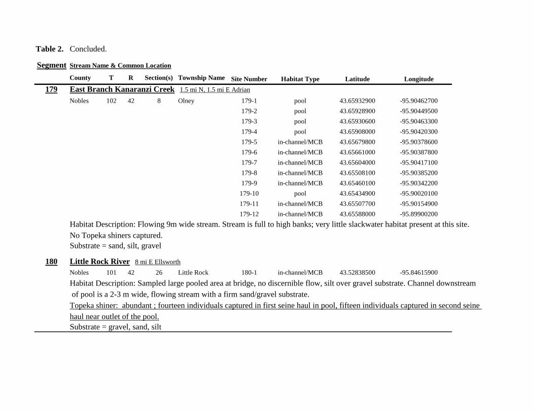
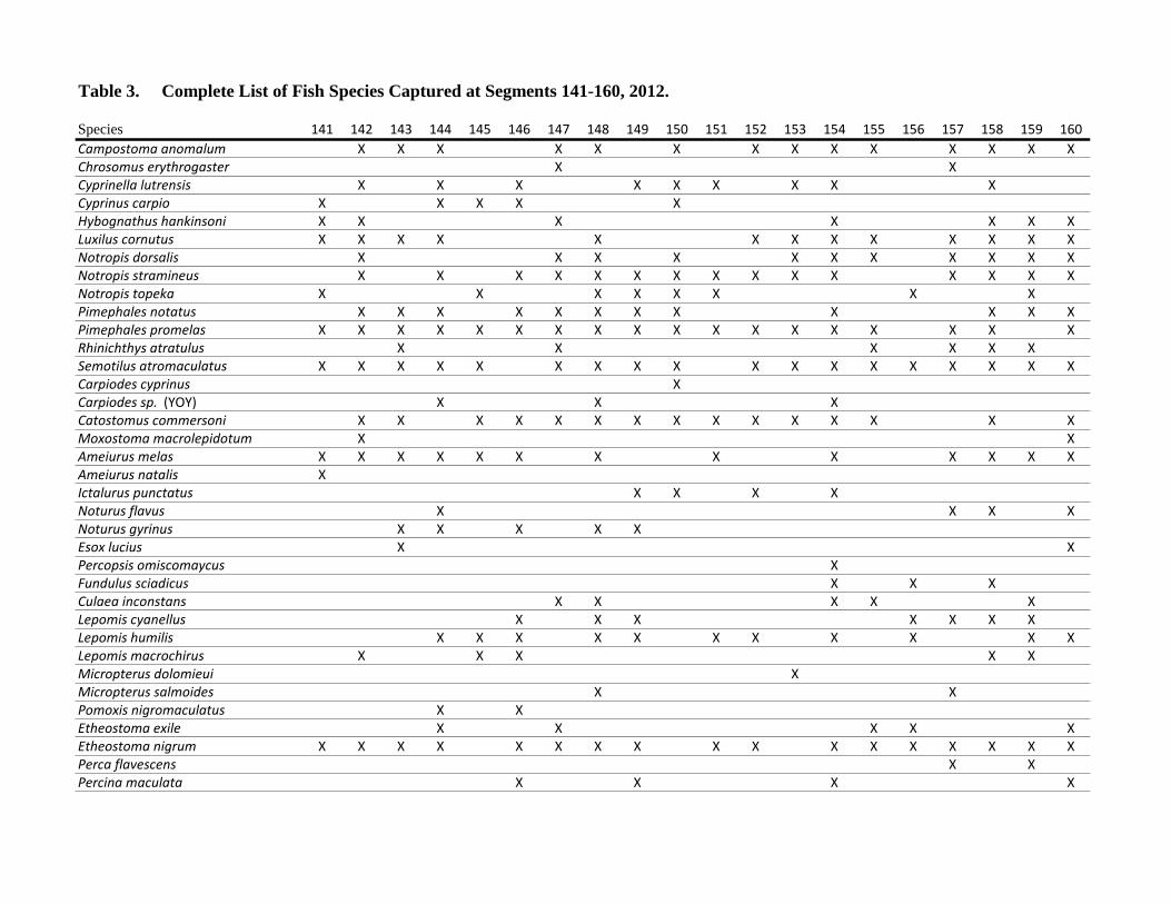
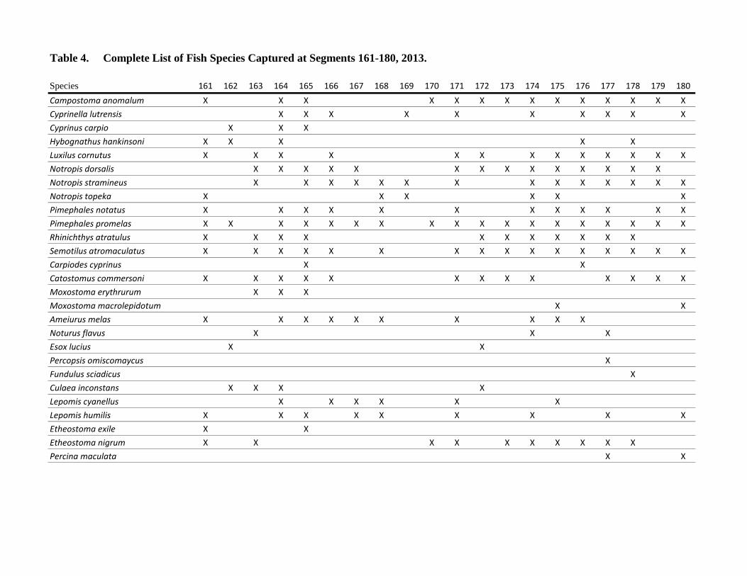
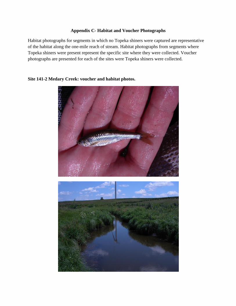
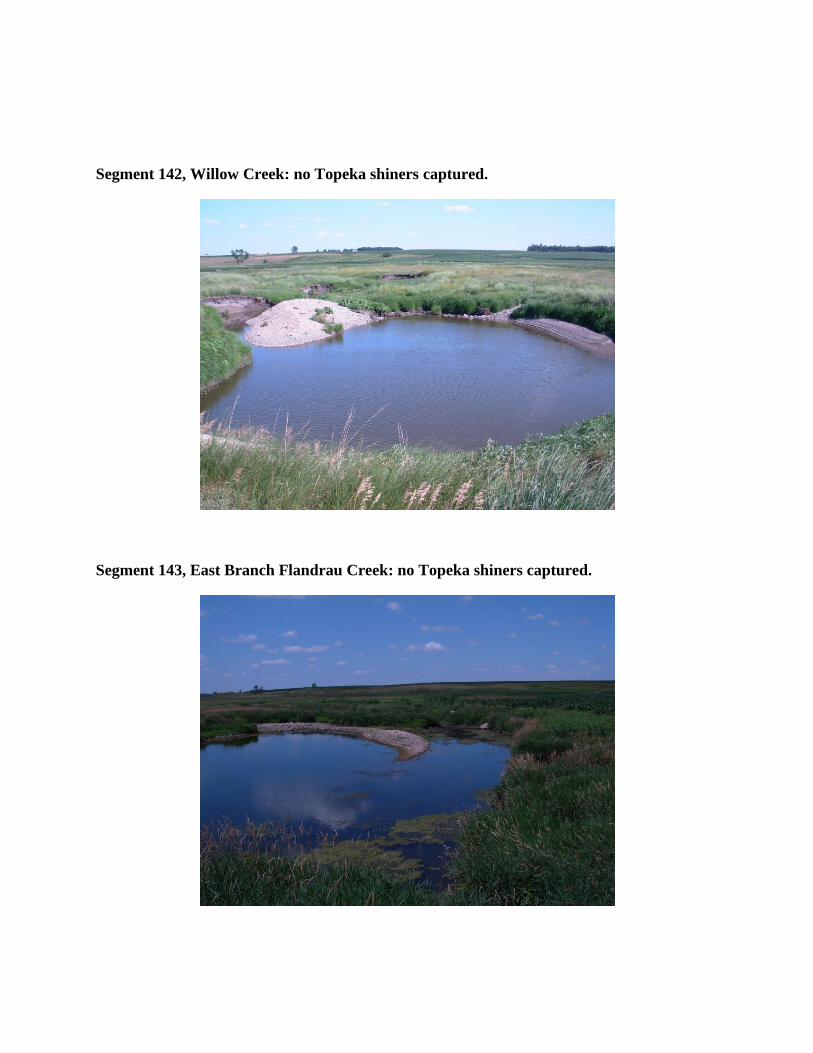
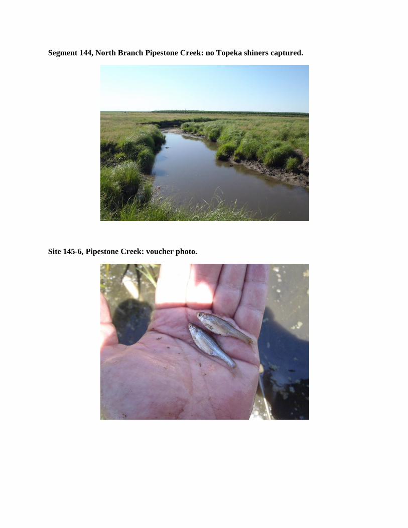
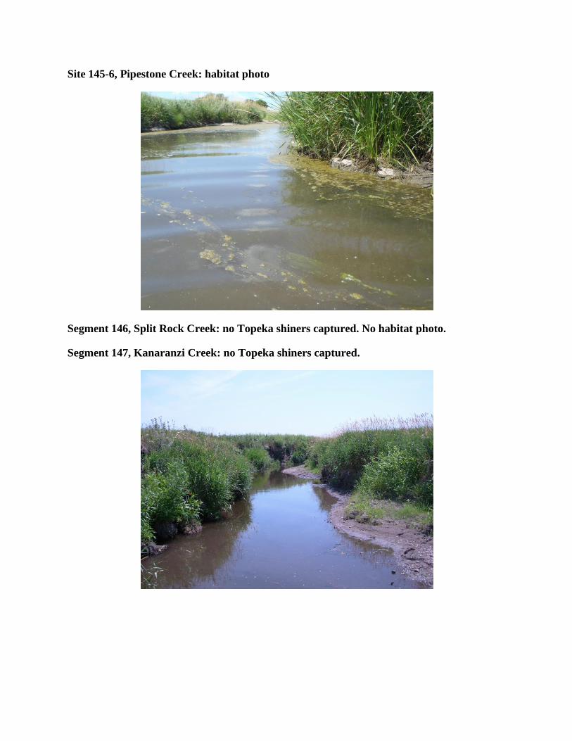
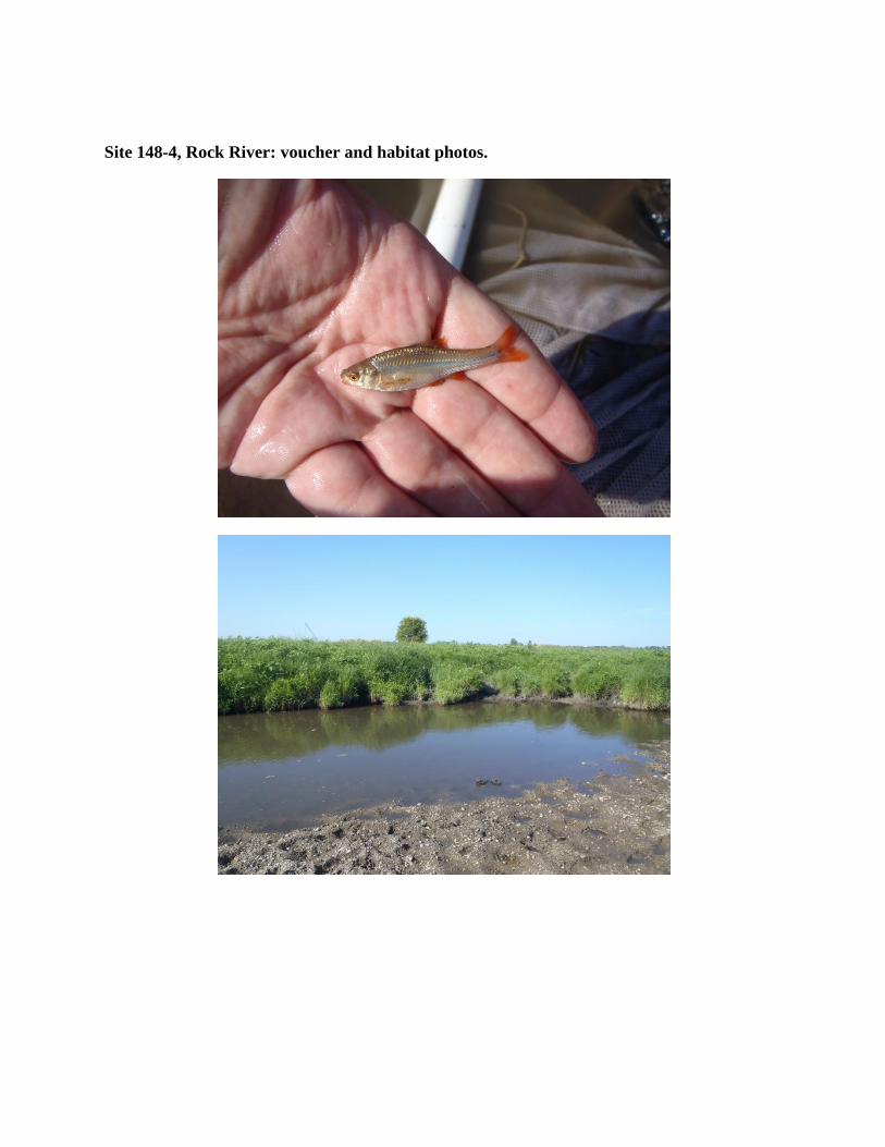
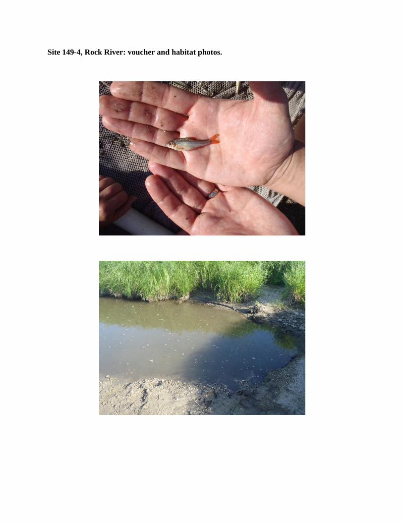
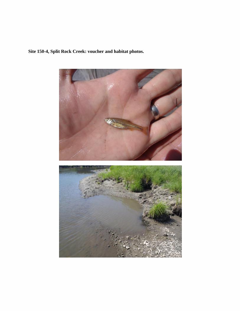
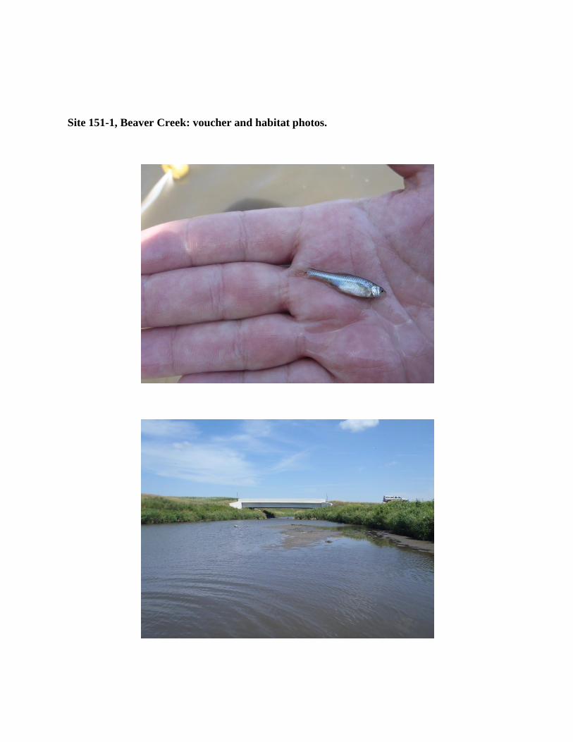
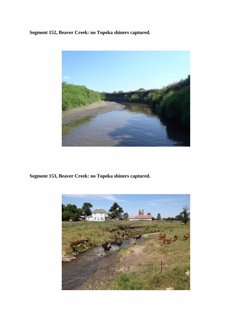
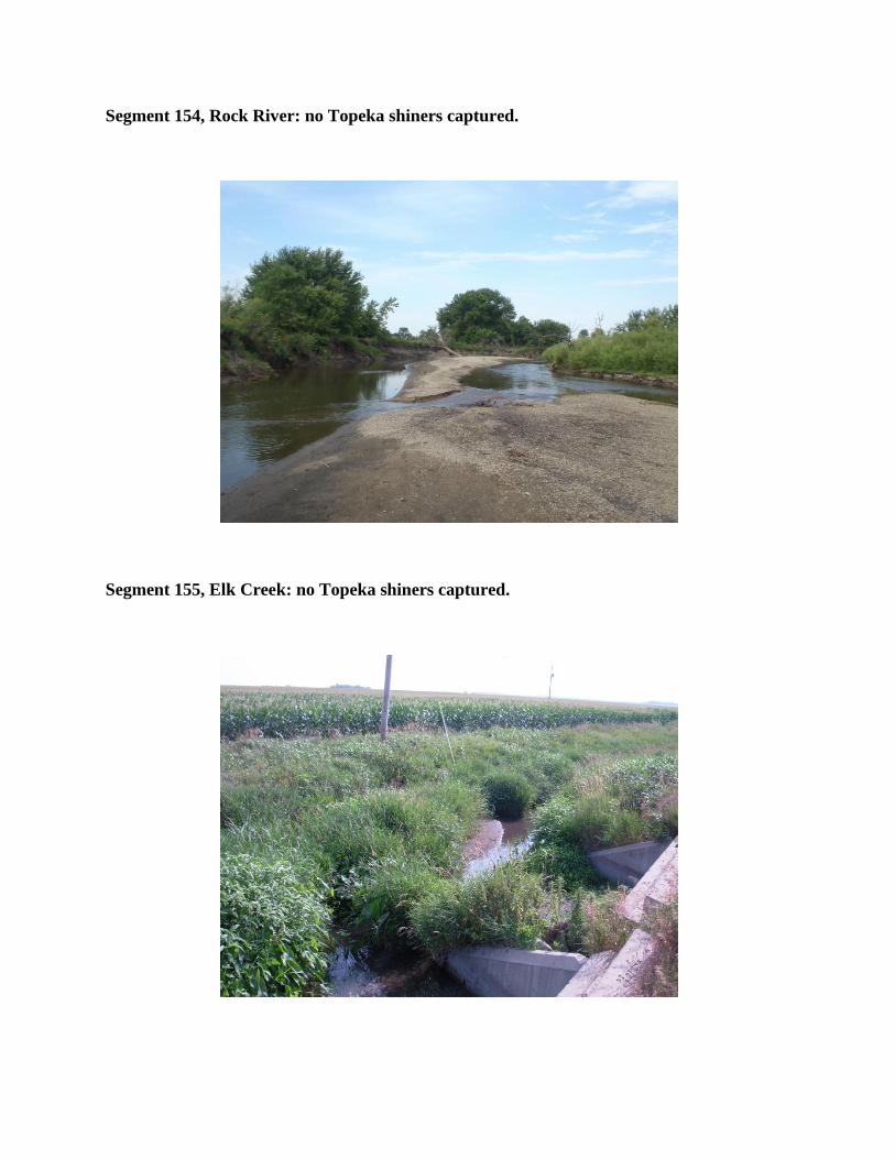
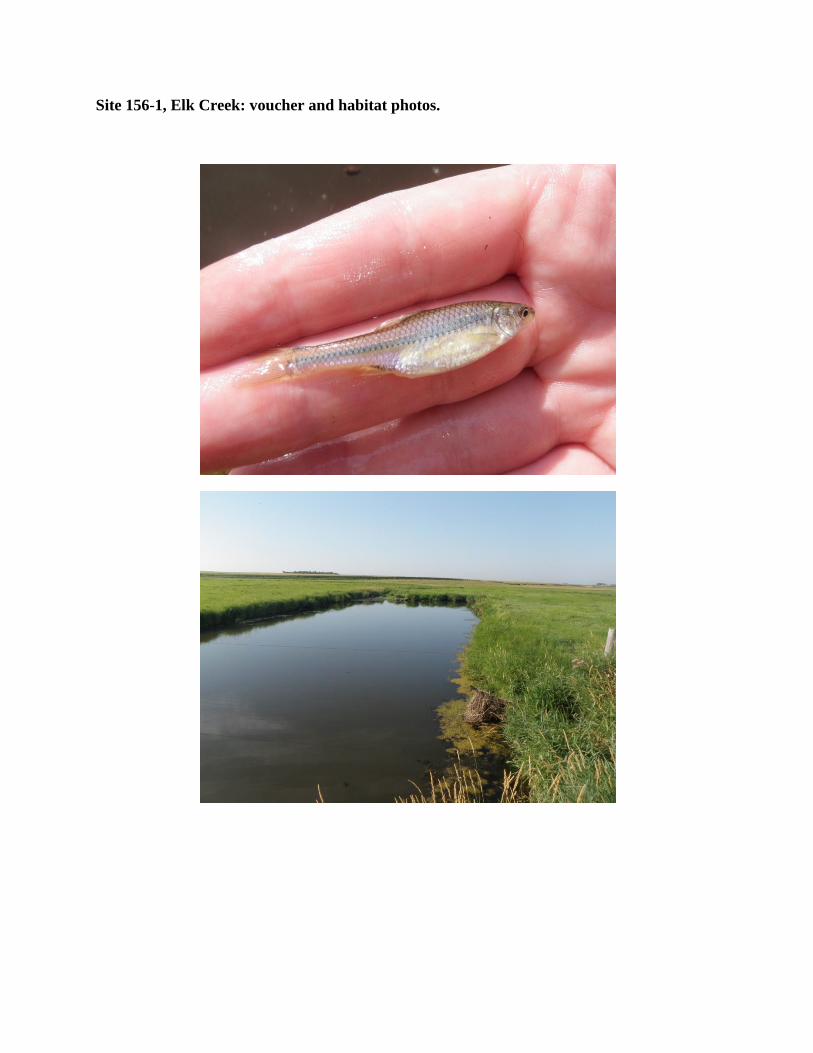
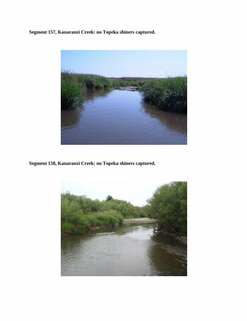
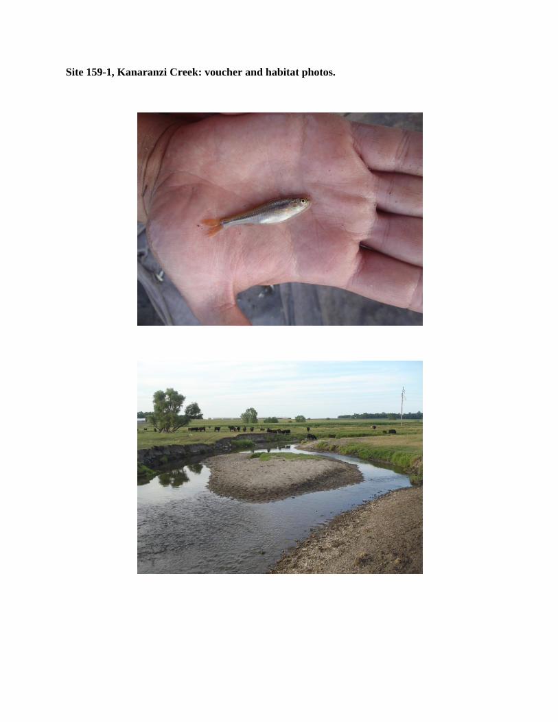
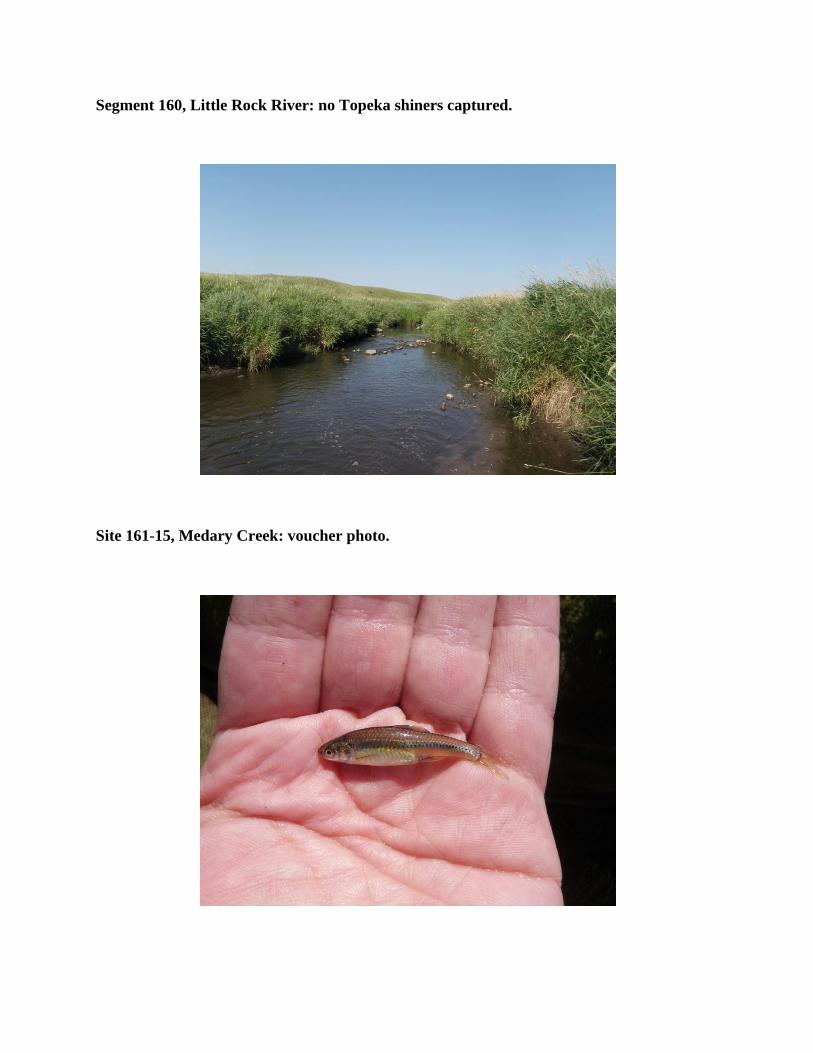
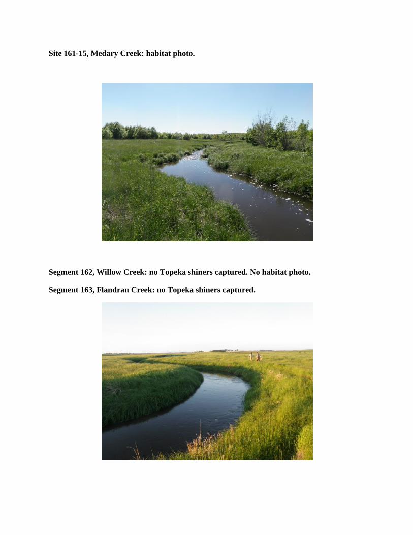
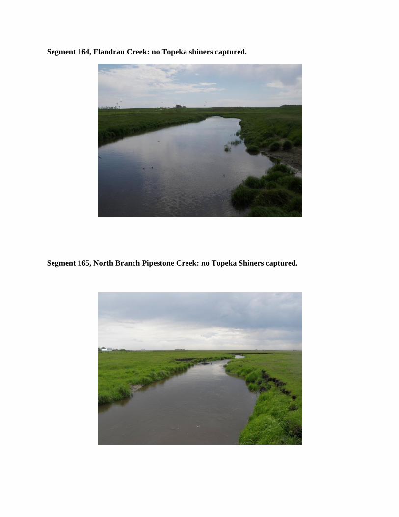
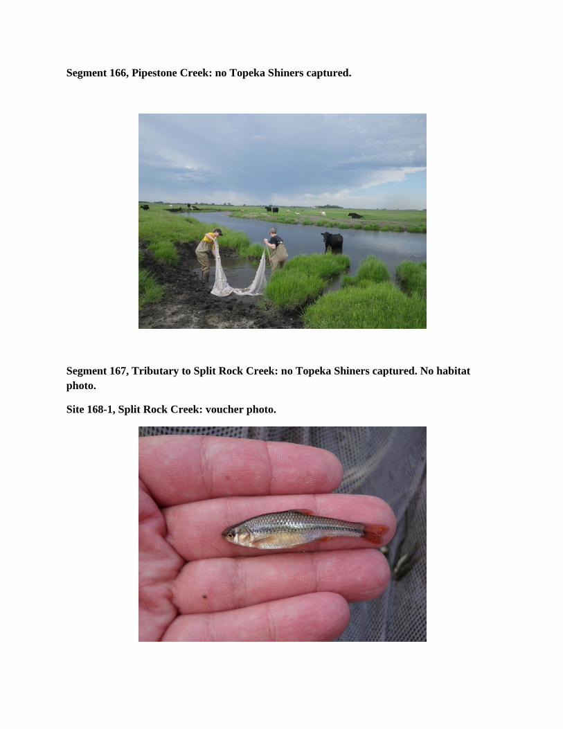
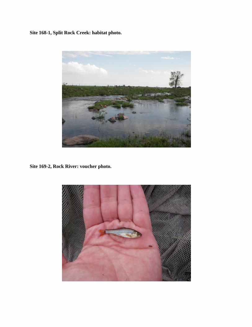
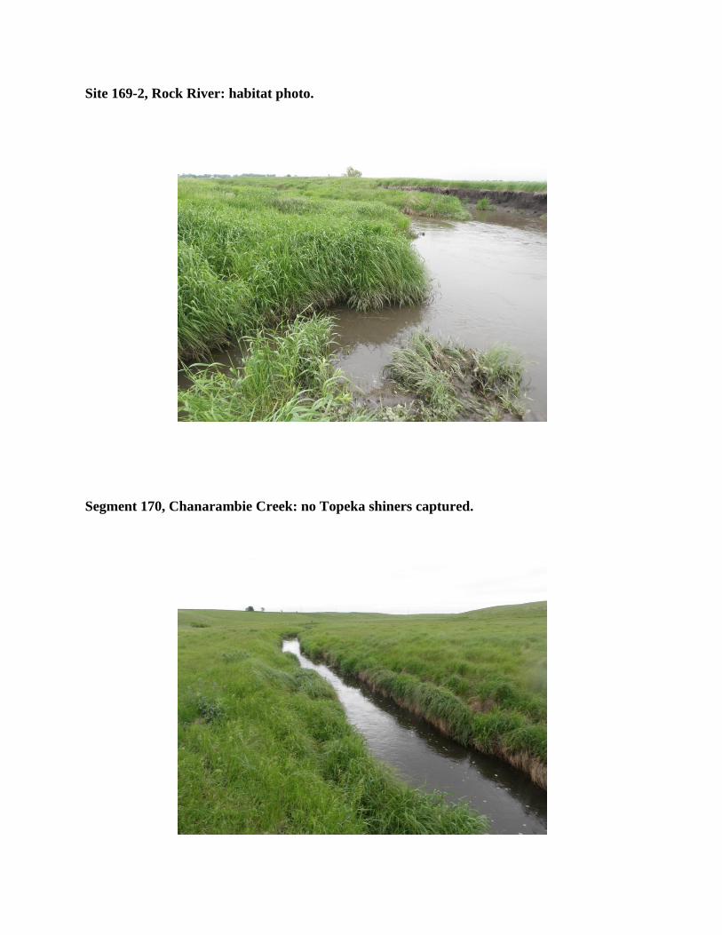
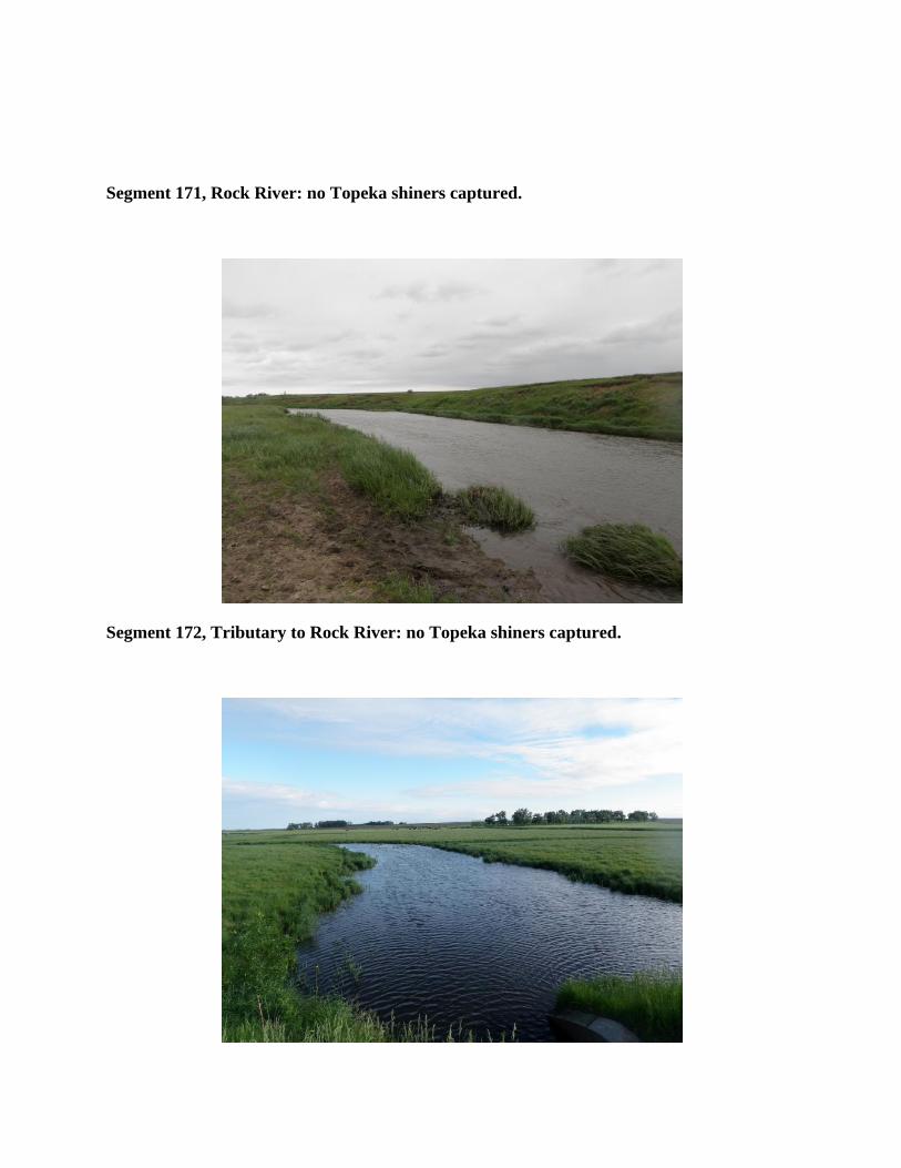
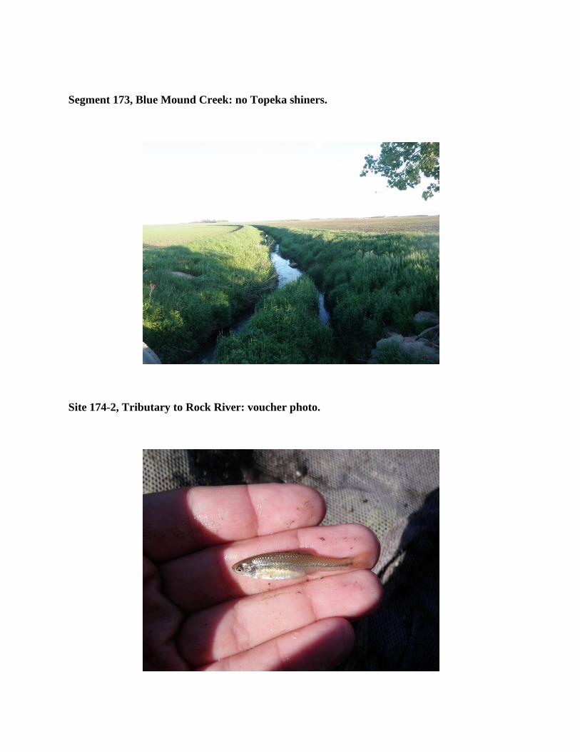
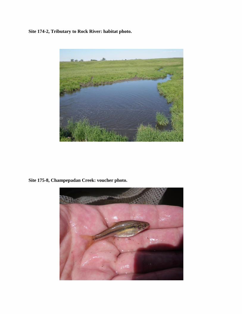
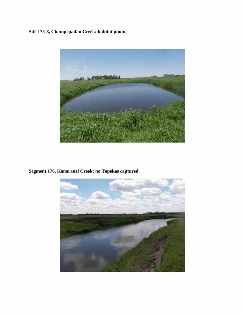
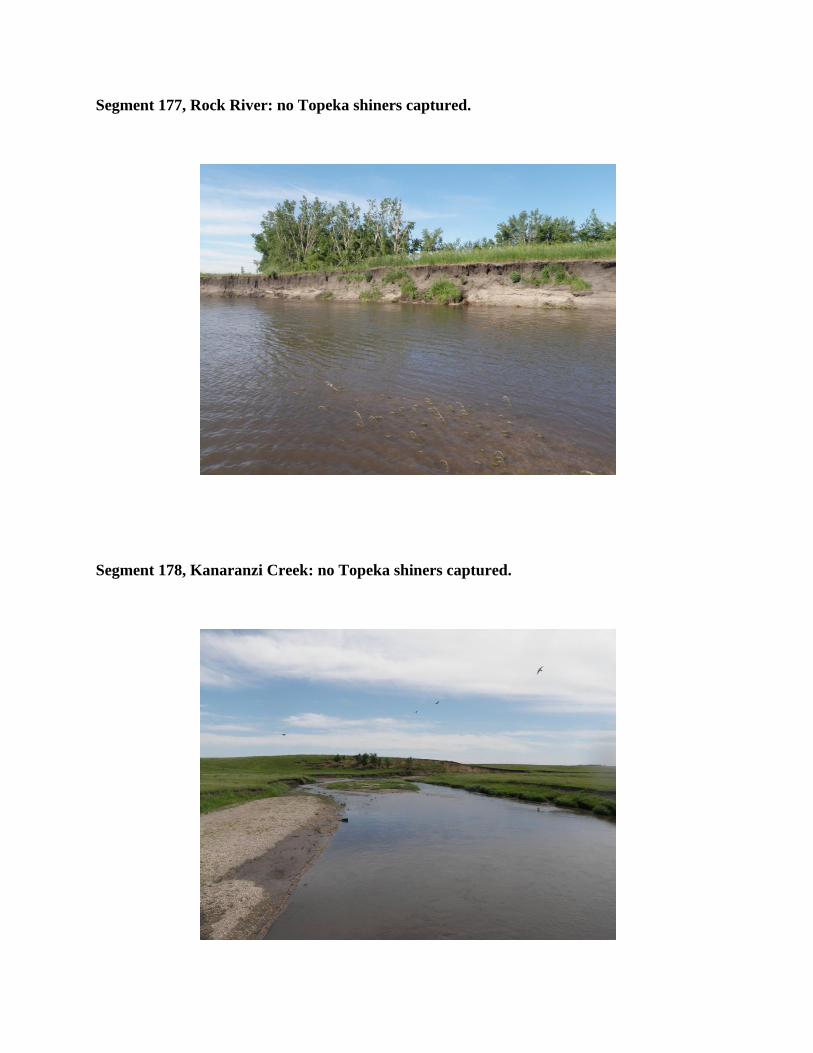
Segment 177 Rock River no Topeka shiners captured
Segment 178 Kanaranzi Creek no Topeka shiners captured
Segment 179 East Branch Kanaranzi Creek no Topeka shiners captured
Site 180-1 West Branch Little Rock River voucher photo
Site 180-1 West Branch Little Rock River habitat photo
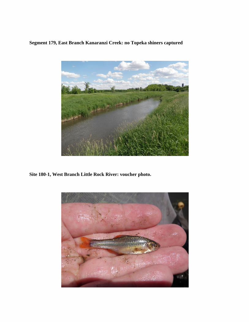
Segment 179 East Branch Kanaranzi Creek no Topeka shiners captured
Site 180-1 West Branch Little Rock River voucher photo
Site 180-1 West Branch Little Rock River habitat photo
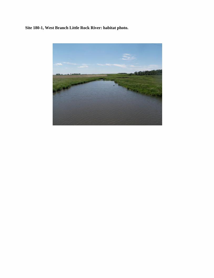
Site 180-1 West Branch Little Rock River habitat photo