Embed Size (px)
Citation preview
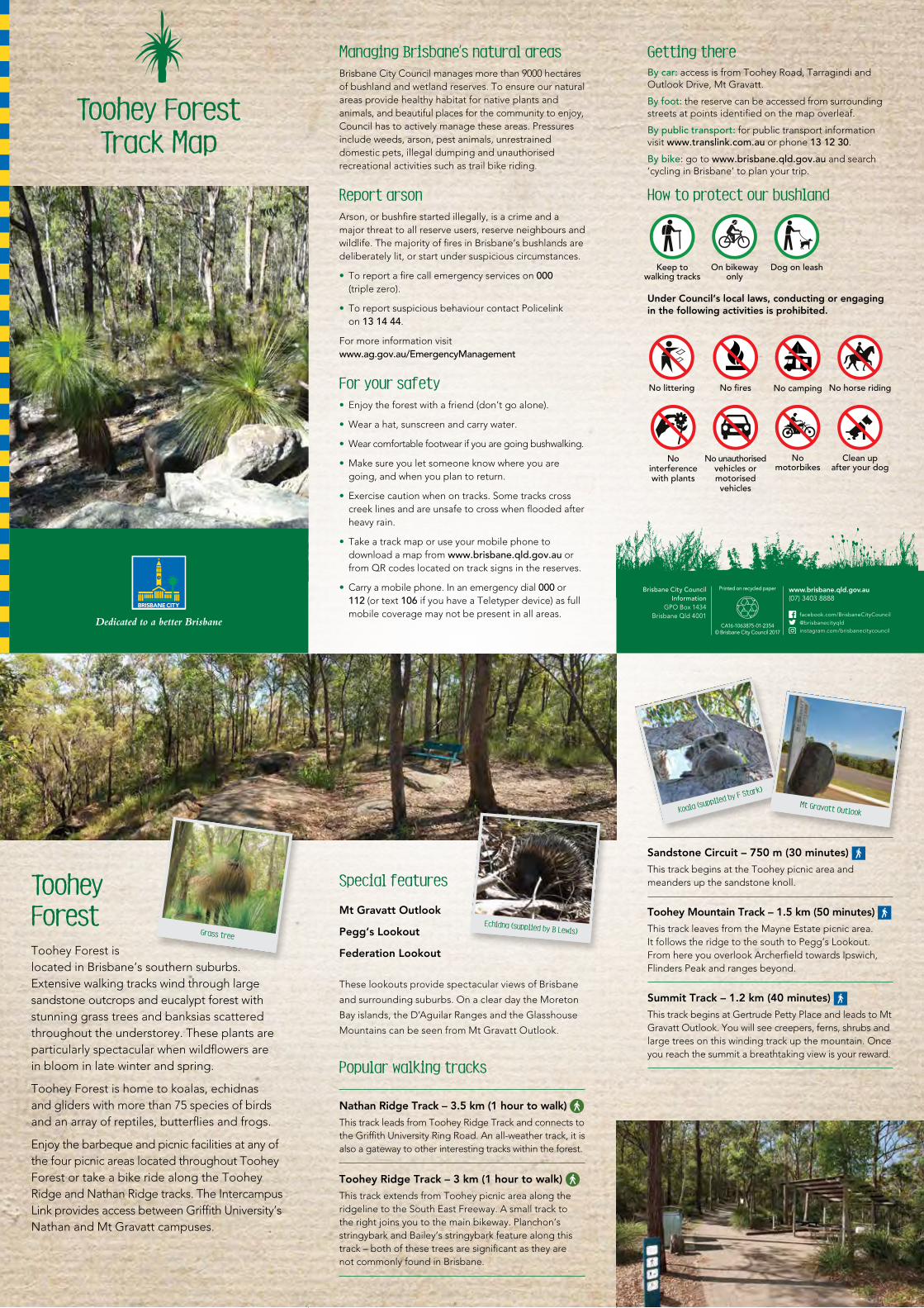
Managing Brisbane’s natural areasBrisbane City Council manages more than 9000 hectares of bushland and wetland reserves. To ensure our natural areas provide healthy habitat for native plants and animals, and beautiful places for the community to enjoy, Council has to actively manage these areas. Pressures include weeds, arson, pest animals, unrestrained domestic pets, illegal dumping and unauthorised recreational activities such as trail bike riding.
Report arsonArson, or bushfire started illegally, is a crime and a major threat to all reserve users, reserve neighbours and wildlife. The majority of fires in Brisbane’s bushlands are deliberately lit, or start under suspicious circumstances.
• To report a fire call emergency services on 000 (triple zero).
• To report suspicious behaviour contact Policelink on 13 14 44.
For more information visit www.ag.gov.au/EmergencyManagement
For your safety• Enjoy the forest with a friend (don’t go alone).
• Wear a hat, sunscreen and carry water.
• Wear comfortable footwear if you are going bushwalking.
• Make sure you let someone know where you are going, and when you plan to return.
• Exercise caution when on tracks. Some tracks cross creek lines and are unsafe to cross when flooded after heavy rain.
• Take a track map or use your mobile phone to download a map from www.brisbane.qld.gov.au or from QR codes located on track signs in the reserves.
• Carry a mobile phone. In an emergency dial 000 or 112 (or text 106 if you have a Teletyper device) as full mobile coverage may not be present in all areas.
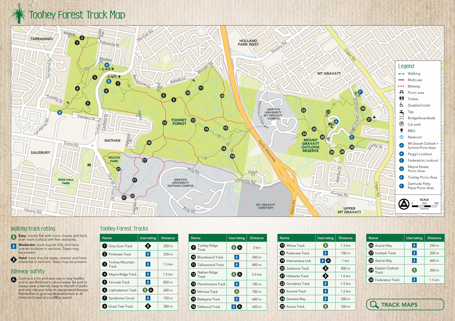
Getting thereBy car: access is from Toohey Road, Tarragindi and Outlook Drive, Mt Gravatt.
By foot: the reserve can be accessed from surrounding streets at points identified on the map overleaf.
By public transport: for public transport information visit www.translink.com.au or phone 13 12 30.
By bike: go to www.brisbane.qld.gov.au and search ‘cycling in Brisbane’ to plan your trip.
How to protect our bushland
Keep to walking tracks
On bikeway only
Dog on leash
Under Council’s local laws, conducting or engaging in the following activities is prohibited.
No littering No fires No camping No horse riding
No interference with plants
No unauthorised vehicles or motorised vehicles
No motorbikes
Clean up after your dog
Special features
Mt Gravatt Outlook
Pegg’s Lookout
Federation Lookout
These lookouts provide spectacular views of Brisbane
and surrounding suburbs. On a clear day the Moreton
Bay islands, the D’Aguilar Ranges and the Glasshouse
Mountains can be seen from Mt Gravatt Outlook.
Popular walking tracks
Nathan Ridge Track – 3.5 km (1 hour to walk)
This track leads from Toohey Ridge Track and connects to the Griffith University Ring Road. An all-weather track, it is also a gateway to other interesting tracks within the forest.
Toohey Ridge Track – 3 km (1 hour to walk)
This track extends from Toohey picnic area along the ridgeline to the South East Freeway. A small track to the right joins you to the main bikeway. Planchon’s stringybark and Bailey’s stringybark feature along this track – both of these trees are significant as they are not commonly found in Brisbane.
Sandstone Circuit – 750 m (30 minutes)
This track begins at the Toohey picnic area and meanders up the sandstone knoll.
Toohey Mountain Track – 1.5 km (50 minutes)
This track leaves from the Mayne Estate picnic area. It follows the ridge to the south to Pegg’s Lookout. From here you overlook Archerfield towards Ipswich, Flinders Peak and ranges beyond.
Summit Track – 1.2 km (40 minutes)
This track begins at Gertrude Petty Place and leads to Mt Gravatt Outlook. You will see creepers, ferns, shrubs and large trees on this winding track up the mountain. Once you reach the summit a breathtaking view is your reward.
Echidna (supplied by B Lewis)
Koala (supplied by F Stark)
Mt Gravatt Outlook
Toohey ForestToohey Forest is located in Brisbane’s southern suburbs. Extensive walking tracks wind through large sandstone outcrops and eucalypt forest with stunning grass trees and banksias scattered throughout the understorey. These plants are particularly spectacular when wildflowers are in bloom in late winter and spring.
Toohey Forest is home to koalas, echidnas and gliders with more than 75 species of birds and an array of reptiles, butterflies and frogs.
Enjoy the barbeque and picnic facilities at any of the four picnic areas located throughout Toohey Forest or take a bike ride along the Toohey Ridge and Nathan Ridge tracks. The Intercampus Link provides access between Griffith University’s Nathan and Mt Gravatt campuses.
Grass tree
Toohey ForestTrack Map
Brisbane City CouncilInformation
GPO Box 1434Brisbane Qld 4001
Printed on recycled paper
CA16-1063875-01-2354© Brisbane City Council 2017
www.brisbane.qld.gov.au (07) 3403 8888
facebook.com/[email protected]/brisbanecitycouncil
TOOHEY FOREST
RUSS HALLPARK
MOUNTGRAVATTOUTLOOKRESERVE
GRIFFITHUNIVERSITY
MT GRAVATT CAMPUS
GRIFFITHUNIVERSITY
NATHAN CAMPUS
ANZSTADIUM
MT GRAVATTCEMETERY
Kessels Rd
Mai
ns R
d
Tooh
ey R
d
Tooh
ey R
dC
anfie
ld S
t
Del
lwoo
dSt
HettonSt
Orange
Low
ndes
St
Grove R
d
Trou
ght
on R
d
Timothy StA
ndre
wA
ve
Pallaranda St
MayfieldRd
Isabella St
Monash Rd
Che
val
St
MadangSt
Pacific Motorway
Logan Rd
Logan R
d
Aza
nian
St
Klumpp Rd
ForestCt
Nursery
Rd
Fernvale Rd
Weller Rd
Marshall R
d
Evans Rd
Henson Rd
Mou
nt
Gra
v att
Loo
kout
Dr
Tarr
agin
di R
d
Tarra
gindi Rd
WILCOXPARK
NATHAN
SALISBURY
UPPERMT GRAVATT
MACGREGOR
MT GRAVATT
TARRAGINDI HOLLANDPARK WEST
University Rd
Ring Rd
Ring Rd
Messine
s Ridge
Rd
Gra
nby St
Barne hurst S t
Flanders St
2
4
5
3
6
7
9
1213
14 15
16
17
18
19
22
2425
27
3028 29
26
23
1011
8
1
B
A
C
21
20
30
E
D
F
17
2117
Toohey Forest Track Map
Walking track rating Easy: mostly flat with minor slopes and fairly even track surface with few obstacles.
Moderate: track may be hilly and have uneven surfaces in sections. Steps may be present.
Hard: track may be steep, uneven and have obstacles in sections. Steps may be present.
Bikeway safetyCycling is a fun and easy way to stay healthy and to see Brisbane’s natural areas. Be sure to always wear a helmet, keep to the left of paths and only ride your bike on designated bikeways. Remember to give way to pedestrians at all times and travel at a suitable speed.
Toohey Forest Tracks
Name Use/rating Distance
1 Grey Gum Track 250 m
2 Fimbriata Track 250 m
3Toohey Mountain Track
1.5 km
4 Mayne Ridge Track 1.5 km
5 Fernvale Track 850 m
6 Lophostemon Track 600 m
7 Sandstone Circuit 750 m
8 Grass Tree Track 300 m
Name Use/rating Distance
9Toohey Ridge Track 3 km
10 Bloodwood Track 500 m
11 Tallowwood Track 800 m
12Nathan Ridge Track 3.5 km
13 Planchoniana Track 700 m
14 Mimosa Track 700 m
15 Baileyana Track 600 m
16 Dellwood Track 650 m
Name Use/rating Distance
17 Wilcox Track 1.3 km
18 Pultenaea Track 700 m
19 Intercampus Link 1 km
20 Jacksonia Track 800 m
21 Hibbertia Track 1.6 km
22 Goodenia Track 1.5 km
23 Summit Track 1.2 km
24 Daviesia Way 300 m
25 Acacia Track 550 m
Name Use/rating Distance
26 Acacia Way 250 m
27 Ironbark Track 200 m
28 Azania Way 600 m
29Eastern Outlook Track
200 m
30 Federation Track 1.5 km
LegendWalking
Multi-use
Bikeway
Picnic area
Toilets
Disabled toilet
Tap
Bridge/boardwalk
Car park
BBQ
Reservoir
Mt Gravatt Outlook + Summit Picnic Area
Pegg’s Lookout
Federation Lookout
Mayne Estate Picnic Area
Toohey Picnic Area
Gertrude Petty Place Picnic Area
0 200 400
metres
SCALE
A
B
C
D
E
F
TRACK MAPS