Embed Size (px)
Citation preview

TOO WILD TO DRILL A

The connection between people and nature runs deep, and the sights, sounds and smells of the great outdoors instantly remind us of how strong that connection is. Whether we’re laughing with our kids at the local fishing hole, hiking or hunting in the backcountry, or taking in the view at a scenic overlook, we all share a sense of wonder about what the natural world has to offer us. Americans around the nation are blessed with incredible wildlands out our back doors. The health of our public lands and wild places is directly tied to the health of our families, communities and economy.
Unfortunately, our public lands and clean air and water are under attack. The Trump administration and some in Congress harbor deep ties to fossil fuel and mining interests, and today, resource extraction lobbyists see an unprecedented opportunity to open vast swaths of our public lands. Recent proposals to open the Arctic National Wildlife Refuge to drilling and shrink or eliminate protected lands around the country underscore how serious this threat is.
Though some places are appropriate for responsible energy development, the current agenda in Washington, D.C. to aggressively prioritize oil, gas and coal production at the expense of all else threatens to push drilling and mining deeper into our wildest forests, deserts and grasslands. Places where families camp and hike today could soon be covered with mazes of pipelines, drill rigs and heavy machinery, or contaminated with leaks and spills.
This report highlights 15 American places that are simply too important, too special, too valuable to be destroyed for short-lived commercial gains. From a Blue Ribbon fishing stretch of the Yellowstone River to some of the most scenic areas on the Appalachian Trail, these public lands and waters help tell our story and define our nation. These places are Too Wild To Drill—they are irreplaceable, and we must protect them.
Jamie Williams, President
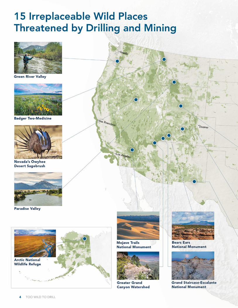
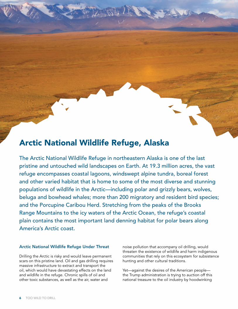
6 Arctic National Wildlife Refuge, Alaska
8 Greater Grand Canyon Watershed, Arizona
10 Mojave Trails National Monument, California
12 North Fork of the Gunnison, Colorado
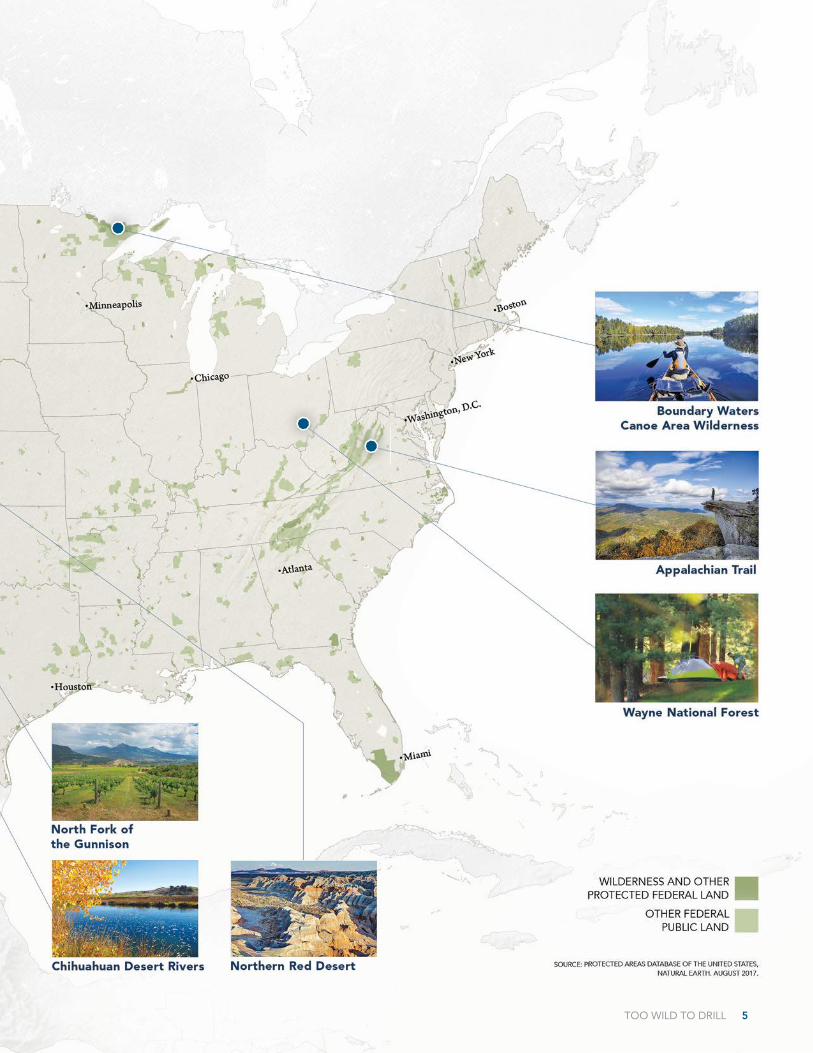
14 Boundary Waters Canoe Area Wilderness, Minnesota
16 Badger-Two Medicine, Montana
18 Paradise Valley, Montana
20 Chihuahuan Desert Rivers, New Mexico
22 Owyhee Desert Sagebrush, Nevada
24 Wayne National Forest, Ohio
26 Bears Ears National Monument, Utah
28 Grand Staircase-Escalante National Monument, Utah
30 Appalachian Trail, Virginia
32 Green River Valley, Washington
34 Northern Red Desert, Wyoming
Table of Contents
Outdoor recreation generates $887 billion nationally in consumer spending each year and 7.6 million jobs, which depend on protected wildlands.
$887BILLION
TOO WILD TO DRILL 1
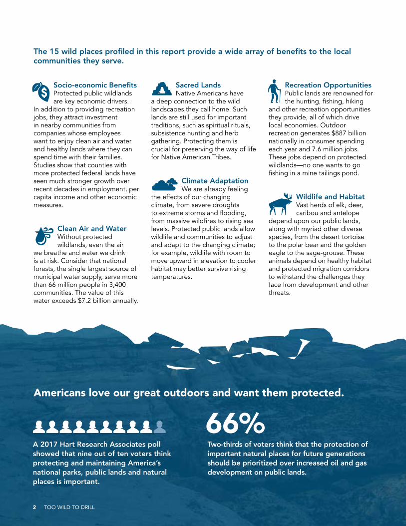
A 2017 Hart Research Associates poll showed that nine out of ten voters think protecting and maintaining America’s national parks, public lands and natural places is important.
Socio-economic Benefits Protected public wildlands are key economic drivers.
In addition to providing recreation jobs, they attract investment in nearby communities from companies whose employees want to enjoy clean air and water and healthy lands where they can spend time with their families. Studies show that counties with more protected federal lands have seen much stronger growth over recent decades in employment, per capita income and other economic measures.
Clean Air and Water Without protected wildlands, even the air
we breathe and water we drink is at risk. Consider that national forests, the single largest source of municipal water supply, serve more than 66 million people in 3,400 communities. The value of this water exceeds $7.2 billion annually.
Sacred Lands Native Americans have
a deep connection to the wild landscapes they call home. Such lands are still used for important traditions, such as spiritual rituals, subsistence hunting and herb gathering. Protecting them is crucial for preserving the way of life for Native American Tribes.
Climate AdaptationWe are already feeling
the effects of our changing climate, from severe droughts to extreme storms and flooding, from massive wildfires to rising sea levels. Protected public lands allow wildlife and communities to adjust and adapt to the changing climate; for example, wildlife with room to move upward in elevation to cooler habitat may better survive rising temperatures.
Recreation OpportunitiesPublic lands are renowned for the hunting, fishing, hiking
and other recreation opportunities they provide, all of which drive local economies. Outdoor recreation generates $887 billion nationally in consumer spending each year and 7.6 million jobs. These jobs depend on protected wildlands—no one wants to go fishing in a mine tailings pond.
Wildlife and HabitatVast herds of elk, deer, caribou and antelope
depend upon our public lands, along with myriad other diverse species, from the desert tortoise to the polar bear and the golden eagle to the sage-grouse. These animals depend on healthy habitat and protected migration corridors to withstand the challenges they face from development and other threats.
The 15 wild places profiled in this report provide a wide array of benefits to the local communities they serve.
Americans love our great outdoors and want them protected.
Two-thirds of voters think that the protection of important natural places for future generations should be prioritized over increased oil and gas development on public lands.
66%
2 TOO WILD TO DRILL
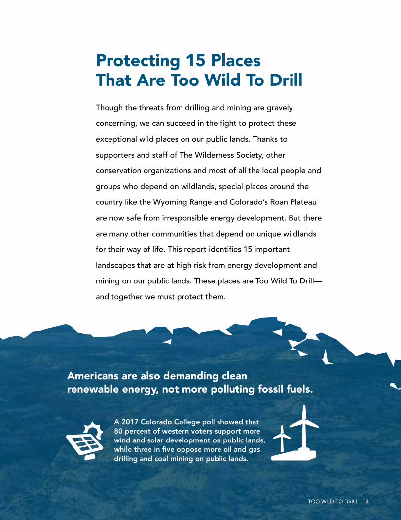
Protecting 15 Places That Are Too Wild To DrillThough the threats from drilling and mining are gravely
concerning, we can succeed in the fight to protect these
exceptional wild places on our public lands. Thanks to
supporters and staff of The Wilderness Society, other
conservation organizations and most of all the local people and
groups who depend on wildlands, special places around the
country like the Wyoming Range and Colorado’s Roan Plateau
are now safe from irresponsible energy development. But there
are many other communities that depend on unique wildlands
for their way of life. This report identifies 15 important
landscapes that are at high risk from energy development and
mining on our public lands. These places are Too Wild To Drill—
and together we must protect them.
A 2017 Colorado College poll showed that 80 percent of western voters support more wind and solar development on public lands, while three in five oppose more oil and gas drilling and coal mining on public lands.
Americans are also demanding clean renewable energy, not more polluting fossil fuels.
TOO WILD TO DRILL 3
4 TOO WILD TO DRILL
TOO WILD TO DRILL 5
6 TOO WILD TO DRILL
Arctic National Wildlife Refuge Under Threat
Drilling the Arctic is risky and would leave permanent scars on this pristine land. Oil and gas drilling requires massive infrastructure to extract and transport the oil, which would have devastating effects on the land and wildlife in the refuge. Chronic spills of oil and other toxic substances, as well as the air, water and
noise pollution that accompany oil drilling, would threaten the existence of wildlife and harm indigenous communities that rely on this ecosystem for subsistence hunting and other cultural traditions.
Yet—against the desires of the American people—the Trump administration is trying to auction off this national treasure to the oil industry by hoodwinking
Arctic National Wildlife Refuge, Alaska
The Arctic National Wildlife Refuge in northeastern Alaska is one of the last pristine and untouched wild landscapes on Earth. At 19.3 million acres, the vast refuge encompasses coastal lagoons, windswept alpine tundra, boreal forest and other varied habitat that is home to some of the most diverse and stunning populations of wildlife in the Arctic—including polar and grizzly bears, wolves, beluga and bowhead whales; more than 200 migratory and resident bird species; and the Porcupine Caribou Herd. Stretching from the peaks of the Brooks Range Mountains to the icy waters of the Arctic Ocean, the refuge’s coastal plain contains the most important land denning habitat for polar bears along America’s Arctic coast.
TOO WILD TO DRILL 7
Congress into authorizing drilling on an unrelated budget proposal.
Protecting the Arctic National Wildlife Refuge
Republicans and Democrats alike have supported designating wilderness in the Arctic Refuge, and virtually all of the Arctic Refuge has been recommended for permanent protection as designated wilderness by the U.S. Fish and Wildlife Service. We need to continue to protect and preserve the Arctic National Wildlife Refuge as one of the last untouched, pristine places in America. Congress should reject President Donald Trump’s call to open up this wild place to oil drilling.
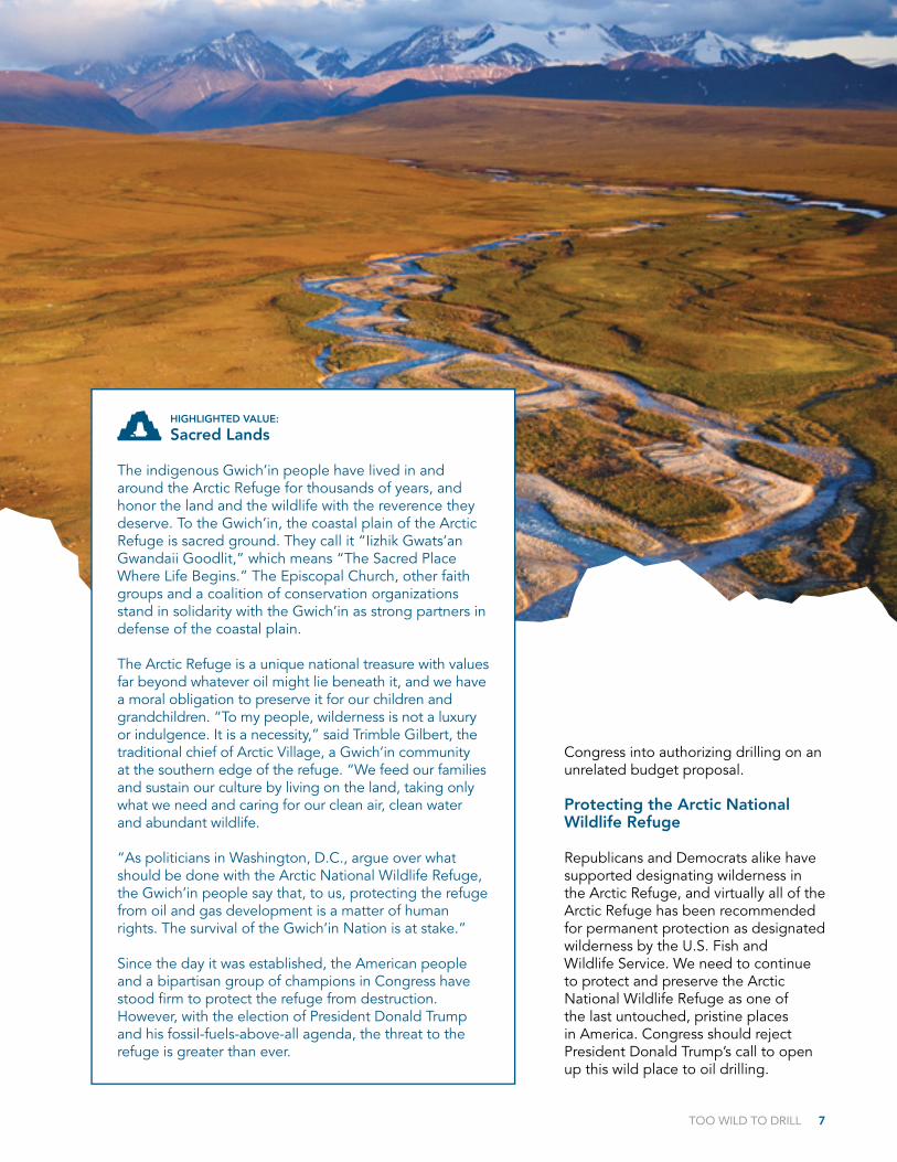
HIGHLIGHTED VALUE:
Sacred Lands
The indigenous Gwich’in people have lived in and around the Arctic Refuge for thousands of years, and honor the land and the wildlife with the reverence they deserve. To the Gwich’in, the coastal plain of the Arctic Refuge is sacred ground. They call it “Iizhik Gwats’an Gwandaii Goodlit,” which means “The Sacred Place Where Life Begins.” The Episcopal Church, other faith groups and a coalition of conservation organizations stand in solidarity with the Gwich’in as strong partners in defense of the coastal plain.
The Arctic Refuge is a unique national treasure with values far beyond whatever oil might lie beneath it, and we have a moral obligation to preserve it for our children and grandchildren. “To my people, wilderness is not a luxury or indulgence. It is a necessity,” said Trimble Gilbert, the traditional chief of Arctic Village, a Gwich’in community at the southern edge of the refuge. “We feed our families and sustain our culture by living on the land, taking only what we need and caring for our clean air, clean water and abundant wildlife.
“As politicians in Washington, D.C., argue over what should be done with the Arctic National Wildlife Refuge, the Gwich’in people say that, to us, protecting the refuge from oil and gas development is a matter of human rights. The survival of the Gwich’in Nation is at stake.”
Since the day it was established, the American people and a bipartisan group of champions in Congress have stood firm to protect the refuge from destruction. However, with the election of President Donald Trump and his fossil-fuels-above-all agenda, the threat to the refuge is greater than ever.

President Theodore Roosevelt set aside 800,000 acres of the Grand Canyon as a national monument in 1908, and it was designated as a national park in 1919. More than 5 million visitors now enjoy Grand Canyon National Park annually, and many also explore the surrounding region. Efforts to protect areas around the Grand Canyon, including the Greater Grand Canyon Watershed, have continued throughout the 20th century. The Wilderness Society and our partners have made significant conservation gains through designations of wilderness areas, national monuments and other protected areas in the Arizona Strip region. Most recently, there have been ongoing efforts to designate the Greater Grand Canyon Watershed as a national monument.
This region has an incredibly rich history, and was home to Clovis, Basketmaker and Puebloan peoples. More than 3,000 documented Native American archaeological sites represent just a fraction of the human history of the area. Some sites date from as far back as 11,500 years ago. Today, many Native Americans still have strong ties to the landscape and live nearby. A 20-year hold on new mining claims currently protects about one million acres of the area from mining. It is supported by Havasupai, Hualapai, Kaibab-Paiute, Navajo and Hopi leaders.
Greater Grand Canyon Watershed, Arizona
The Greater Grand Canyon Watershed is a natural wonder that embraces one of America’s most spectacular landscapes—the Grand Canyon. Stretching across hundreds of thousands of acres of the “Arizona Strip” and on land both north and south of the Grand Canyon, this area is one of the wildest and most ecologically significant regions in the West.
8 TOO WILD TO DRILL

TOO WILD TO DRILL 9
Visitors from around the globe help support local economies as they visit the area for world-class hunting, fishing, backpacking, camping and other recreation. Protection of other areas within the broader region has significantly increased economic benefits to local communities as well. For example, in 2015 travel and tourism represented about 35 percent of total private wage and salary employment in Coconino County, home to the nearby Vermilion Cliffs National Monument. Though these values clearly speak to the importance of protecting the area, the Greater Grand Canyon Watershed is facing renewed threats from proposed uranium mining that could be devastating to the scenic beauty and clean water of the region.
Greater Grand Canyon Watershed Under Threat
Despite America’s love for the Grand Canyon and the incredible resources found within the Greater Grand Canyon Watershed, there has been a call to open the area to uranium mining, rolling back a 20-year moratorium on new mining leases put in place by former Interior Secretary Ken Salazar in 2012. This is not the first time this region has been threatened with mining, with a handful of Congressmen pursuing legislation in recent years that would strip current protections. Uranium mining in this sensitive and stunningly beautiful area would destroy crucial wildlife habitat, devastate the tourism-based economy and put drinking water for the 25 million people who depend on the Colorado River at risk.
Protecting the Greater Grand Canyon Watershed
The Greater Grand Canyon Watershed deserves the same respect as the Grand Canyon. To preserve this incredible landscape, the Interior Department should leave the existing mineral withdrawal in place, and Congress should pass legislation to permanently close the lands to mining.
“Leave it as it is. The ages have
been at work on it, and man can
only mar it. What you can do
is to keep it for your children,
your children’s children and for
all who come after you, as one
of the great sights which every
American, if he can travel at all,
should see.”
— Teddy Roosevelt after his first visit to the Grand Canyon, 1903
HIGHLIGHTED VALUE:
Wildlife and Habitat
The Kaibab-Paunsagunt Wildlife Corridor is a critical wildlife movement corridor that runs through the heart of this landscape and connects Grand Canyon National Park with Grand Staircase-Escalante National Monument. The resident trophy-quality mule deer herd uses this corridor to move safely among areas for breeding and birthing, and to survive changing seasons. The corridor also provides important habitat for mountain lions and the endangered California condor.
National forest lands within the watershed include the North Kaibab, which contains the most intact, largely unprotected old-growth forest in the Southwest, including huge stands of towering old-growth ponderosa pines, considered an endangered ecosystem. Ranging from the arid Great Basin Desert to Rocky Mountain forests, the region can also provide important information for study of climate adaptation and resiliency.

10 TOO WILD TO DRILL
Mojave Trails contains unique geological features like the Pisgah Lava Flow and Marble Mountain Fossil Beds and includes 350,000 acres of designated wilderness. The six wilderness areas at the core of the monument include the Sheephole Valley, Cadiz Dunes and Piute Mountain wilderness areas, with several more designated wilderness areas adjacent to the monument boundaries. The vast desert landscape provides exceptional opportunities to experience solitude and primitive recreation. Here visitors can hike, camp, hunt, search for fossils and much more in the monument and the large, unprotected swath of roadless lands around the Iron Mountains.
Mojave Trails also contains a rich amount of cultural and historic resources, including ancient Native American trading routes, World War II-era training camps and the longest undeveloped stretch of Route 66 in the country.
Though Mojave Trails clearly deserves its protected status as a national monument, the Trump administration has been pursuing illegal efforts to open these lands to mining and other development.
Mojave Trails National Monument Under Threat
Mojave Trails National Monument is one of 27 national monuments the Trump administration placed under an unprecedented review in the spring of 2017. While Mojave Trails was legitimately designated by President Barack Obama under the authority of the Antiquities Act, Trump’s team has been working to remove protections to appease extractive industries seeking to increase their operations and profits at the expense of irreplaceable historic and natural resources.
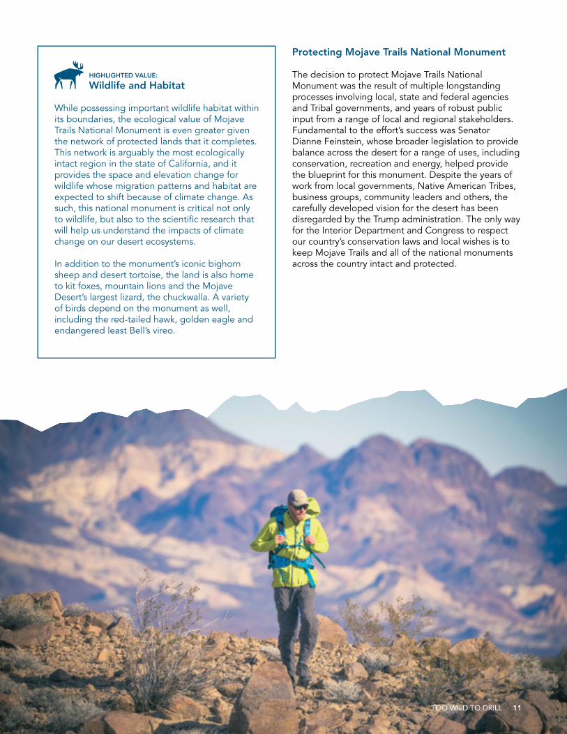
Mojave Trails National Monument, California
Mojave Trails National Monument protects a stunning array of desert plant life and wildlife habitat across 1.6 million acres in southern California and represents the key last piece in a corridor of fully protected lands between Joshua Tree National Park and Mojave National Preserve.
Protecting Mojave Trails National Monument
The decision to protect Mojave Trails National Monument was the result of multiple longstanding processes involving local, state and federal agencies and Tribal governments, and years of robust public input from a range of local and regional stakeholders. Fundamental to the effort’s success was Senator Dianne Feinstein, whose broader legislation to provide balance across the desert for a range of uses, including conservation, recreation and energy, helped provide the blueprint for this monument. Despite the years of work from local governments, Native American Tribes, business groups, community leaders and others, the carefully developed vision for the desert has been disregarded by the Trump administration. The only way for the Interior Department and Congress to respect our country’s conservation laws and local wishes is to keep Mojave Trails and all of the national monuments across the country intact and protected.
HIGHLIGHTED VALUE:
Wildlife and Habitat
While possessing important wildlife habitat within its boundaries, the ecological value of Mojave Trails National Monument is even greater given the network of protected lands that it completes. This network is arguably the most ecologically intact region in the state of California, and it provides the space and elevation change for wildlife whose migration patterns and habitat are expected to shift because of climate change. As such, this national monument is critical not only to wildlife, but also to the scientific research that will help us understand the impacts of climate change on our desert ecosystems.
In addition to the monument’s iconic bighorn sheep and desert tortoise, the land is also home to kit foxes, mountain lions and the Mojave Desert’s largest lizard, the chuckwalla. A variety of birds depend on the monument as well, including the red-tailed hawk, golden eagle and endangered least Bell’s vireo.
TOO WILD TO DRILL 11

12 TOO WILD TO DRILL
North Fork of the Gunnison, Colorado
The North Fork of the Gunnison River makes its way out of Colorado’s wild forests in the Thompson Divide area, through the fertile North Fork Valley, finally joining the mighty Gunnison River just after it roars out of Black Canyon of the Gunnison National Park. Locally referred to as the North Fork, this river emerges from some of Colorado’s most spectacular high-country wildlands and sustains a thriving farming and ranching community and Colorado’s highest concentration of organic farms.
The North Fork is also a wildlife haven. The adjacent West Elk Mountains and the flanks that extend onto lower-elevation public lands provide for an abundance of wildlife, from moose, bear and lynx in the upper reaches to fox, coyote, elk and deer in the bottomlands. Yellow-billed cuckoos nest in the riparian vegetation along the river and its tributaries, while wintering bald eagles also frequent the area.
Colorado’s celebrated Thompson Divide sits at the top of the watershed for the North Fork, and these upper reaches in the Clear Fork, Muddy Country and surrounding roadless areas showcase the state’s iconic wilderness values. Downriver, the North Fork Valley is known for its starry skies, rural charm and stunning views. Wineries, markets and family farms, along with healthy waters, abundant wildlife and world-class recreation opportunities are the backbone of the area’s growing economy.

TOO WILD TO DRILL 13
The oil and gas industry has set its sights on the landscape surrounding the North Fork of the Gunnison. From the roadless forests in the Thompson Divide to the orchards and farmlands in the valley, leasing and drilling proposals threaten to destroy this beautiful landscape and the economy it supports.
North Fork of the Gunnison Under Threat
In 2011 and 2012, the Bureau of Land Management (BLM) proposed leasing public lands in the North Fork Valley for oil and gas development. The community joined together to oppose the lease sales and proposed a locally grown vision for the North Fork Valley that would keep energy development away from sensitive areas. The BLM agreed to consider the North Fork Citizens’ Alternative in the agency’s land use plan revision, but so far has not identified the community vision as the preferred approach. With the Trump administration now in charge of finalizing the land use plan, the future for the North Fork Valley is more threatened than ever.
The risks aren’t limited to the valley either. High above the valley floor, the wild roadless forests where the North Fork headwaters are formed are also threatened by drilling. Oil and gas companies that own leases in and around the Gunnison National Forest are exploiting loopholes to keep the leases past their expirations. Some leaseholders are proposing major drilling projects, including the North Fork Mancos Master Development Plan.
Protecting the North Fork of the Gunnison
With the oil and gas industry attacking the North Fork of the Gunnison from every angle, protecting this important watershed has reached a critical point. The BLM and U.S. Forest Service need to step back and update land use plans to protect the landscape’s resources from destructive oil and gas drilling, including adopting the North Fork Citizens’ Alternative. Until long-term plans are in place that reflect the community’s vision for their future and the extraordinary values of the roadless forest areas, the BLM must not issue new oil and gas leases and must prohibit companies from exploiting loopholes to keep leases on the books that should have expired. And ongoing development plans—like the North Fork Mancos—demand rigorous environmental analysis and protective measures, such as limiting the amount, timing and location of permitted drilling.
“Anything that threatens the
safety of our food crops threatens
everything we do.”
— Jeff Schwartz, Owner, Delicious Orchards and Big B’s Fabulous Juices, Paonia, Colorado
HIGHLIGHTED VALUE:
Clean Air and Water
The North Fork Valley is a hub of organic agriculture and is one of only two federally recognized wine regions in Colorado. Water quantity and quality are both of utmost importance to farmers and the agricultural economy.
However, maintaining the valley’s clean water supply relies on protecting the North Fork and the area’s water systems. Surface contamination and spills, which occur regularly in Colorado oil and gas fields, could spread rapidly though the irrigation systems that water the valley. Oil and gas development can contaminate water supplies, both above- and below-ground, and harm water bodies, rivers and source areas. That is a risk too great for farmers and ranchers in the valley.
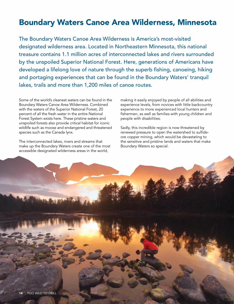
Boundary Waters Canoe Area Wilderness, Minnesota
The Boundary Waters Canoe Area Wilderness is America’s most-visited designated wilderness area. Located in Northeastern Minnesota, this national treasure contains 1.1 million acres of interconnected lakes and rivers surrounded by the unspoiled Superior National Forest. Here, generations of Americans have developed a lifelong love of nature through the superb fishing, canoeing, hiking and portaging experiences that can be found in the Boundary Waters’ tranquil lakes, trails and more than 1,200 miles of canoe routes.
Some of the world’s cleanest waters can be found in the Boundary Waters Canoe Area Wilderness. Combined with the waters of the Superior National Forest, 20 percent of all the fresh water in the entire National Forest System exists here. These pristine waters and unspoiled forests also provide critical habitat for iconic wildlife such as moose and endangered and threatened species such as the Canada lynx.
The interconnected lakes, rivers and streams that make up the Boundary Waters create one of the most accessible designated wilderness areas in the world,
making it easily enjoyed by people of all abilities and experience levels, from novices with little backcountry experience to more experienced local hunters and fishermen, as well as families with young children and people with disabilities.
Sadly, this incredible region is now threatened by renewed pressure to open the watershed to sulfide-ore copper mining, which would be devastating to the sensitive and pristine lands and waters that make Boundary Waters so special.
14 TOO WILD TO DRILL
TOO WILD TO DRILL 15
HIGHLIGHTED VALUE:
Socio-economic Benefits
Over the past four decades, communities in Northeastern Minnesota have built a diverse, resilient economy based on a variety of commercial and recreational activities that depend on a healthy Boundary Waters. The Boundary Waters is the economic lifeblood of this wilderness-based economy and Northeastern Minnesota’s lucrative tourism industry. Tourism in this region generates $913 million in revenue and supports more than 17,000 local jobs annually. The Boundary Waters makes Northeastern Minnesota a world-class outdoor recreation destination, attracting hundreds of thousands of visitors every year from around the country to Duluth, Ely, Grand Marais and other towns.
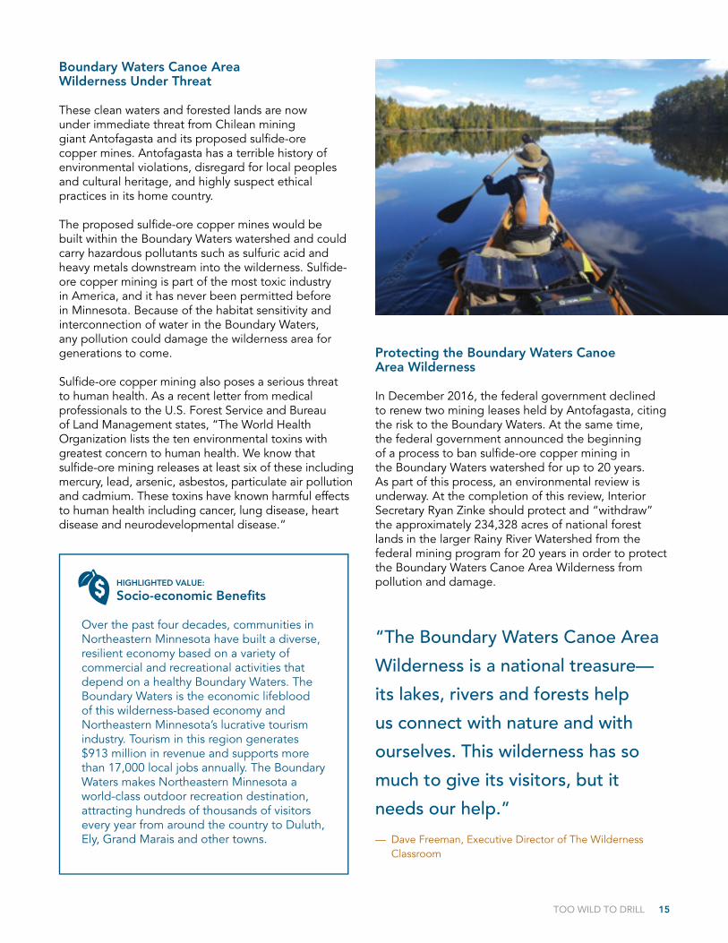
Boundary Waters Canoe Area Wilderness Under Threat
These clean waters and forested lands are now under immediate threat from Chilean mining giant Antofagasta and its proposed sulfide-ore copper mines. Antofagasta has a terrible history of environmental violations, disregard for local peoples and cultural heritage, and highly suspect ethical practices in its home country.
The proposed sulfide-ore copper mines would be built within the Boundary Waters watershed and could carry hazardous pollutants such as sulfuric acid and heavy metals downstream into the wilderness. Sulfide-ore copper mining is part of the most toxic industry in America, and it has never been permitted before in Minnesota. Because of the habitat sensitivity and interconnection of water in the Boundary Waters, any pollution could damage the wilderness area for generations to come.
Sulfide-ore copper mining also poses a serious threat to human health. As a recent letter from medical professionals to the U.S. Forest Service and Bureau of Land Management states, “The World Health Organization lists the ten environmental toxins with greatest concern to human health. We know that sulfide-ore mining releases at least six of these including mercury, lead, arsenic, asbestos, particulate air pollution and cadmium. These toxins have known harmful effects to human health including cancer, lung disease, heart disease and neurodevelopmental disease.”
Protecting the Boundary Waters Canoe Area Wilderness
In December 2016, the federal government declined to renew two mining leases held by Antofagasta, citing the risk to the Boundary Waters. At the same time, the federal government announced the beginning of a process to ban sulfide-ore copper mining in the Boundary Waters watershed for up to 20 years. As part of this process, an environmental review is underway. At the completion of this review, Interior Secretary Ryan Zinke should protect and “withdraw” the approximately 234,328 acres of national forest lands in the larger Rainy River Watershed from the federal mining program for 20 years in order to protect the Boundary Waters Canoe Area Wilderness from pollution and damage.
“The Boundary Waters Canoe Area
Wilderness is a national treasure—
its lakes, rivers and forests help
us connect with nature and with
ourselves. This wilderness has so
much to give its visitors, but it
needs our help.”
— Dave Freeman, Executive Director of The Wilderness Classroom

16 TOO WILD TO DRILL
Badger-Two Medicine, Montana
Culture and wildlands converge in the 130,000-acre Badger-Two Medicine area of the Helena-Lewis and Clark National Forest in northwestern Montana. For the Blackfeet Nation, the Badger-Two Medicine is considered the cradle of their culture, home of their creation story and the sacred Sun Dance that links millennia of history and culture with current and future generations. It is also ecologically irreplaceable: a place teeming with native wildlife species, including grizzly bear, genetically pure cutthroat trout, wolves, wolverine and elk. The Badger-Two Medicine is the connective habitat that provides needed migration paths between Glacier National Park and the Bob Marshall Wilderness Complex, as well as critical sanctuary for plants and wildlife. It is also the headwaters of two major waterways that feed the Blackfeet Reservation and the entire northern plains of Montana.
TOO WILD TO DRILL 17
HIGHLIGHTED VALUE:
Sacred Lands
To the Blackfeet people, the Rocky Mountains are the “backbone of the world,” and all the mountains, rivers, plants and animals of the Badger-Two Medicine are interpreted as sacred spirits who offer guidance for human life. Considered the home of Na’pi, the creator of the Blackfeet, the entire Badger-Two Medicine is sacred to the Blackfeet people. As such, it is a federally recognized Traditional Cultural District.
In addition to the Blackfeet Nation, a strong majority of Montanans oppose drilling in the Badger-Two Medicine. The Rocky Mountain Tribal Leaders Council, National Congress of American Indians, Glacier County Commissioners, retired Glacier National Park superintendents and retired leadership from the U.S. Forest Service and Bureau of Land Management also oppose drilling in the Badger-Two Medicine. And U.S. agencies, including the Advisory Council on Historic Preservation, Agriculture Department and Interior Department, had recommended all of the Badger-Two Medicine leases be canceled.
In 2006, bipartisan legislation was passed to prohibit future federal energy leasing along the Rocky Mountain Front, including in the Badger, and to provide tax incentives for leaseholders to sell or donate existing leases. Under the law, all but 18 of the illegally-issued leases were retired—but resolution remained just out of reach. Then in 2015, the Blackfeet Nation, hunters, anglers and conservationists worked together to urge the government to exercise its authority and do the right thing—either cancel the remaining leases or work with the leaseholders to negotiate a settlement that would result in retirement of the Badger leases. It worked. In 2016 and 2017, the final leases were voluntarily relinquished or cancelled, and the Badger-Two Medicine was finally free of oil and gas leases.
This area is so important culturally and ecologically that it’s hard to imagine it ever being considered for energy development, but that’s what happened in the 1980s. Most of the area was leased for oil and gas drilling, in violation of bedrock environmental laws and without consultation with the Blackfeet Nation. From the moment of leasing, the decision has been mired in controversy and legal battles. And for over 30 years, the leases were suspended while the federal government tried to figure out how to fix its mistake.
After decades of work to eliminate the illegally issued oil and gas leases from the Badger-Two Medicine, the Blackfeet Nation, The Wilderness Society and the many others who fought to protect this incredible place declared victory in early 2017, when then-Interior Secretary Sally Jewell cancelled the final two leases in the Badger-Two Medicine. Sadly, the celebration was short-lived. Emboldened by the Trump administration’s pro-fossil fuels agenda, past leaseholders are looking to their friends in the White House to hand this landscape back over to the oil and gas industry.
Badger-Two Medicine Under Threat
Unfortunately, two oil and gas companies are suing the government over their cancelled leases. If successful in court, they could force the federal government to reinstate their leases so they may be allowed to pursue roadbuilding and exploratory drilling in the heart of the Badger-Two Medicine. With the new administration, we fear the Interior Department could also fail to defend the case or even enter into a sweetheart settlement reinstating these illegal leases.
Protecting the Badger-Two Medicine
Reinstating illegal oil and gas leases in the Badger-Two Medicine would reopen decades-old conflicts that have rightfully been put to rest. This irreplaceable land should be left wild for the wildlife that depend upon it, as well as for the Blackfeet people. Interior Secretary Ryan Zinke should stand with the Blackfeet and Montanans and ensure that the area is not desecrated by energy companies.
“The fate of the Blackfeet Nation and
our confederated Tribes is bound to the
fate of the Badger-Two Medicine and we
refuse to accept any activities within the
Ceded Strip that violate this Traditional
Cultural Site and our Treaty Rights.”
— Chief Earl Old Person, 2007

18 TOO WILD TO DRILL
Today, Yellowstone is celebrated more than ever. Millions of tourists visit the park every year, many of them passing through Montana’s Paradise Valley, the northern gateway to Yellowstone. As its name suggests, Paradise Valley is a scenic destination in its own right, a bucolic valley surrounding the Yellowstone River with the snowy peaks of the Absaroka Beartooth Wilderness and wildlife-rich Gallatin Range looming in the distance.
Paradise Valley is an economic hub of tourism-based businesses, as well as many other businesses and hardworking Montanans who choose to make their homes in this special place. But now their livelihoods—and the valley itself—are threatened by two foreign mining companies who could degrade Paradise Valley in pursuit of corporate profits. If they have their way, destructive gold mining will begin at the edge of the park and next door to the Abasaroka Beartooth Wilderness, ruining scenic values and putting the Yellowstone River at risk for contamination.
Paradise Valley, Montana
There’s a reason Yellowstone National Park was the first national park designated in the United States. Even back in 1872, the rare and extraordinary values of Yellowstone were recognized as national treasures, leading Congress to set them aside for the future enjoyment of all Americans. The park, and the greater area surrounding it, is a place of otherworldly qualities: rocketing geysers, colorful hot springs and bubbling mudpots; endless miles of rushing rivers and oxbow streams; and thick pine forests teeming with grazing bison and elk. The Greater Yellowstone Ecosystem is a haven for vanishing wildlife species such as grizzly bears, gray wolves and lynx, and its world-renowned scenery encompasses ten Wilderness Areas and several million additional acres that have been recommended for wilderness designation.

TOO WILD TO DRILL 19
Paradise Valley Under Threat
Foreign mining companies are proposing two gold mines in Paradise Valley, on the border of Yellowstone National Park and near the Yellowstone River. These mines could transform portions of Paradise Valley into an industrial area, degrading scenic landscapes, tainting the Yellowstone River and disturbing the abundant wildlife and character of the charming western towns that give the valley its deserved name.
Gold mines are notorious for their disastrous impacts to the environment—poisoning rivers and drinking water, leaching toxic tailings, polluting the air and killing wildlife. Mining in this place would also bring daily industrial-level truck traffic, creating noise and air pollution. Mining here could diminish the tourism and recreation-based economy of Paradise Valley, trading in an economic engine that is sustainable over the long term for the boom-and-bust cycle of the extractive industry.
Protecting Paradise Valley
While the Forest Service has imposed a temporary freeze on new mining claims in the upper Paradise Valley, this will expire in 2018, and a more permanent and comprehensive solution is needed. Thankfully, Montana Senator Jon Tester introduced the Yellowstone Gateway Protection Act in April 2017, which would permanently close 30,000 acres of federal lands in the Paradise Valley—including the area of the two proposed mines—to any new mining claims. The bill enjoys widespread support, including from 360 businesses in the area, the Park County Commission and Montana’s largest newspaper, but it still needs support from Montana’s full congressional delegation. We call on Montana Senator Steve Daines to support this legislation, as it’s critical that Congress pass this bill unchanged in the next year.
HIGHLIGHTED VALUE:
Socio-economic Benefits
Paradise Valley has the only year-round driving entrance to Yellowstone National Park, a park that welcomed 4.25 million visitors in 2016. This enormous tourism draw makes Park County, the home of Paradise Valley, the highest-ranking tourism county in Montana in terms of non-resident traveler spending. Visitors who can’t find lodging in Yellowstone frequently seek out rooms and meals in the towns of Livingston and Gardiner. And it’s not just the park that draws tourists—people visit Paradise Valley for iconic western recreation experiences, including some of the best fly fishing in the country. The Upper Yellowstone River, which runs through Park County, drives $70 million a year in direct expenditures on its own.
In addition to the booming tourism industry, Paradise Valley sustains local entrepreneurs and a workforce that chooses to live in the valley for its natural amenities, such as recreation opportunities, clean air and water, and quality of life. This important piece of the local economy could collapse without those environmental attributes. According to a 2016 economic study of Park County, large-scale mining could lead to long-term economic impairment and stagnation.

Here, the Delaware, Pecos and Black rivers support rare and valuable riparian areas, creating literal oases within this arid landscape that sustain special, threatened and endangered species, such as the Bell’s vireo, plainbelly watersnake, river cooter and Mexican tetra. These places are also an important stop for birds making their way across the Southwest. The Delaware River is designated an Important Bird Area by the Audubon Society for the diverse resident and migratory bird populations found here.
Beneath the distinct karst landscape surrounding these rivers, sensitive cave ecosystems weave below ground, filtering groundwater and potentially harboring species yet to be discovered. This vast underground world has reaches that are still unexplored, some of which may connect with the cave systems of nearby Carlsbad Caverns National Park.
These desert rivers also attract recreational users to their shores and waters. Birders enjoy spectacular birdwatching; fisherman search for perfect pools;
hunters seek game; and cavers explore below ground.Despite the tremendous value of this landscape, it is currently threatened by rampant oil and gas drilling. The National Park Service has repeatedly raised concerns about oil and gas drilling near Carlsbad Caverns National Park, citing threats to park resources.
Chihuahuan Desert Rivers Under Threat
The federal and state lands surrounding the rivers are largely leased for oil and gas. Twisted among the wells and pads is a spider web of pipelines and roads that contribute to habitat loss and fragmentation. The Permian Basin in southeastern New Mexico is one of the most developed oil and gas regions in the western U.S., and continues to rapidly expand.
Chihuahuan Desert Rivers, New Mexico
Southern New Mexico’s Chihuahuan Desert, a vast expanse of rolling grasslands dotted with remote desert mountains, is a unique and highly threatened ecosystem. South of Carlsbad, the public lands around Carlsbad Caverns National Park are home to a thriving Chihuahuan Desert river system. Riparian areas in the Chihuahuan Desert, while rare, are some of the most biologically rich places in North America.
20 TOO WILD TO DRILL

According to the Bureau of Land Management’s (BLM) own analysis, the Carlsbad area is expected to see 800 new oil and gas wells per year moving forward. These developments show no sign of slowing as large companies flock to this production hot spot.
Oil and gas development can be devastating to the Desert Rivers ecosystems. Toxic spills and production activities can result in surface and groundwater contamination, habitat fragmentation, increased road traffic and air pollution. Growing water demand
associated with hydraulic fracturing in this water-limited region is of particular concern, as are potential impacts to riparian water resources and wildlife species.
The BLM is currently revising its land management plan for the area, which could hand more of our public lands over to the oil and gas industry without putting necessary safeguards in place.
Protecting the Chihuahuan Desert Rivers
The BLM must act swiftly to protect the Chihuahuan Desert Rivers from destructive oil and gas drilling, both in the Carlsbad resource management plan currently under revision and when it considers specific leasing and drilling proposals in the area. For now, there is only a small amount of energy infrastructure in the riparian areas, giving the BLM an opportunity to ensure the development explosion in the Permian Basin doesn’t permanently destroy rare desert river systems, remaining intact grasslands and sensitive cave ecosystems.
At both the planning and project levels, the BLM should evaluate and adopt well-accepted climate adaptation strategies, such as reducing non-climate stresses like disturbances associated with energy development. The revised Carlsbad management plan should put special management designations in place to limit oil and gas drilling and ensure it is conducted responsibly and with reduced impacts to climate change where it does occur.
HIGHLIGHTED VALUE:
Climate Adaptation
Places such as the Chihuahuan Desert Rivers serve a critical function for our public lands to adapt to and endure climate change. The area contains valuable riparian habitat for fish and wildlife resources and can act as a refuge for species under stress. A study by Conservation Science Partners, a non-profit research collective, shows that the Desert Rivers area exhibits potentially high resilience to climate change and, if left intact, has the potential to function as an important stronghold of species diversity under a changing climate.
TOO WILD TO DRILL 21
To address the greater sage-grouse’s perilous existence, the Bureau of Land Management (BLM) and U.S. Forest Service undertook an unprecedented rangewide conservation effort for sagebrush habitat across the West, culminating in multiple regional management plans for conserving greater sage-grouse habitat on public lands. These plans, finalized in 2015, represent the best chance for rescuing the sage-grouse and keeping it off the Endangered Species list. The plans merge the best available science with the wisdom of local and state agencies, the region’s conservationists, ranchers, hunters and other interest groups.
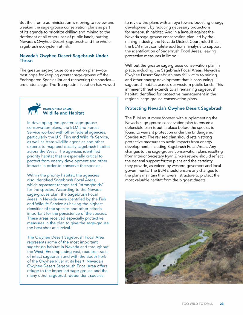
Through the greater sage-grouse conservation plans, the federal agencies focused on protecting the most important habitat that merits the highest levels of protection, while managing additional habitat with lesser protections. The Sagebrush Focal Area found in Nevada’s Owyhee Desert, which includes wild public lands surrounding the Owyhee Canyon Wilderness Study Area, is a remote sagebrush landscape that must remain wild for the sake of the sage-grouse.
Owyhee Desert Sagebrush, Nevada
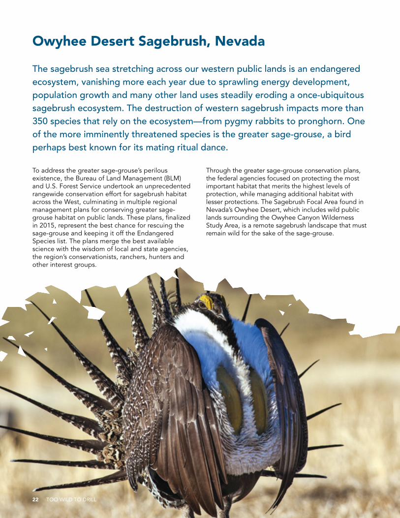
The sagebrush sea stretching across our western public lands is an endangered ecosystem, vanishing more each year due to sprawling energy development, population growth and many other land uses steadily eroding a once-ubiquitous sagebrush ecosystem. The destruction of western sagebrush impacts more than 350 species that rely on the ecosystem—from pygmy rabbits to pronghorn. One of the more imminently threatened species is the greater sage-grouse, a bird perhaps best known for its mating ritual dance.
22 TOO WILD TO DRILL
But the Trump administration is moving to review and weaken the sage-grouse conservation plans as part of its agenda to prioritize drilling and mining to the detriment of all other uses of public lands, putting Nevada’s Owyhee Desert Sagebrush and the whole sagebrush ecosystem at risk.
Nevada’s Owyhee Desert Sagebrush Under Threat
The greater sage-grouse conservation plans—our best hope for keeping greater sage-grouse off the Endangered Species list and recovering the species—are under siege. The Trump administration has vowed
to review the plans with an eye toward boosting energy development by reducing necessary protections for sagebrush habitat. And in a lawsuit against the Nevada sage-grouse conservation plan led by the mining industry, the Nevada District Court ruled that the BLM must complete additional analysis to support the identification of Sagebrush Focal Areas, leaving protective measures in limbo.
Without the greater sage-grouse conservation plan in place, including the Sagebrush Focal Areas, Nevada’s Owyhee Desert Sagebrush may fall victim to mining and other energy development that is consuming sagebrush habitat across our western public lands. This imminent threat extends to all remaining sagebrush habitat identified for protective management in the regional sage-grouse conservation plans.
Protecting Nevada’s Owyhee Desert Sagebrush
The BLM must move forward with supplementing the Nevada sage-grouse conservation plan to ensure a defensible plan is put in place before the species is found to warrant protection under the Endangered Species Act. The revised plan should retain strong protective measures to avoid impacts from energy development, including Sagebrush Focal Areas. Any changes to the sage-grouse conservation plans resulting from Interior Secretary Ryan Zinke’s review should reflect the general support for the plans and the certainty they provide, as voiced by western governors and local governments. The BLM should ensure any changes to the plans maintain their overall structure to protect the most valuable habitat from the biggest threats.
HIGHLIGHTED VALUE:
Wildlife and Habitat
In developing the greater sage-grouse conservation plans, the BLM and Forest Service worked with other federal agencies, particularly the U.S. Fish and Wildlife Service, as well as state wildlife agencies and other experts to map and classify sagebrush habitat across the West. The agencies identified priority habitat that is especially critical to protect from energy development and other impacts in order to conserve the species.
Within the priority habitat, the agencies also identified Sagebrush Focal Areas, which represent recognized “strongholds” for the species. According to the Nevada sage-grouse plan, the Sagebrush Focal Areas in Nevada were identified by the Fish and Wildlife Service as having the highest densities of the species and other criteria important for the persistence of the species. These areas received especially protective measures in the plan to give the sage-grouse the best shot at survival.
The Owyhee Desert Sagebrush Focal Area represents some of the most important sagebrush habitat in Nevada and throughout the West. Encompassing vast, roadless tracts of intact sagebrush and with the South Fork of the Owyhee River at its heart, Nevada’s Owyhee Desert Sagebrush Focal Area offers refuge to the imperiled sage-grouse and the many other sagebrush-dependent species.
TOO WILD TO DRILL 23

Wayne National Forest, Ohio
“The Wayne,” as local residents affectionately refer to Ohio’s only national forest, draws nearly a quarter of a million visitors each year to hike and ride its trails, paddle its rivers and streams, and take in the forest’s scenery and unique history. Home to hundreds of species of birds, mammals, trees, fish and amphibians, the Wayne spans roughly 250,000 acres of public land across three units in southeast Ohio. The forest also includes the Little Muskingum River—a tributary to the Ohio River, which borders the Wayne on its southeast boundary and provides clean drinking water for millions of Americans.
Despite the clear values of protecting this area, it is at risk of being used for industrial purposes to the detriment of the forest’s many other uses. Much of the Wayne is targeted for shale gas drilling and fracking, which could render it a gas field instead of the outdoor recreation playground it is today.
Wayne National Forest Under Threat
Advancements in fracking technology have led to a proliferation of drilling on our public lands, and the oil and gas industry has set its sights on developing the Wayne. In 2016, the Bureau of Land Management (BLM) finalized an oil and gas leasing plan for the eastern part of the Wayne that allows for 40,000 acres of the forest to be leased for drilling. In late 2016 and early 2017, the
BLM leased nearly 2,000 acres of the forest, and more lease sales are on the horizon. The Ohio Environmental Council and other groups filed a lawsuit in May 2017 challenging the BLM’s recent lease sales and its larger leasing plan for violating federal environmental laws and threatening the tranquility and recreation values the forest provides.
Threats to the Wayne are not new. In the 1980s, the Wayne was targeted to be sold off “to improve management of federal assets” by disposing of those that were perceived by some as difficult or uneconomic to manage.
24 TOO WILD TO DRILL
TOO WILD TO DRILL 25
HIGHLIGHTED VALUE:
Recreation Opportunities
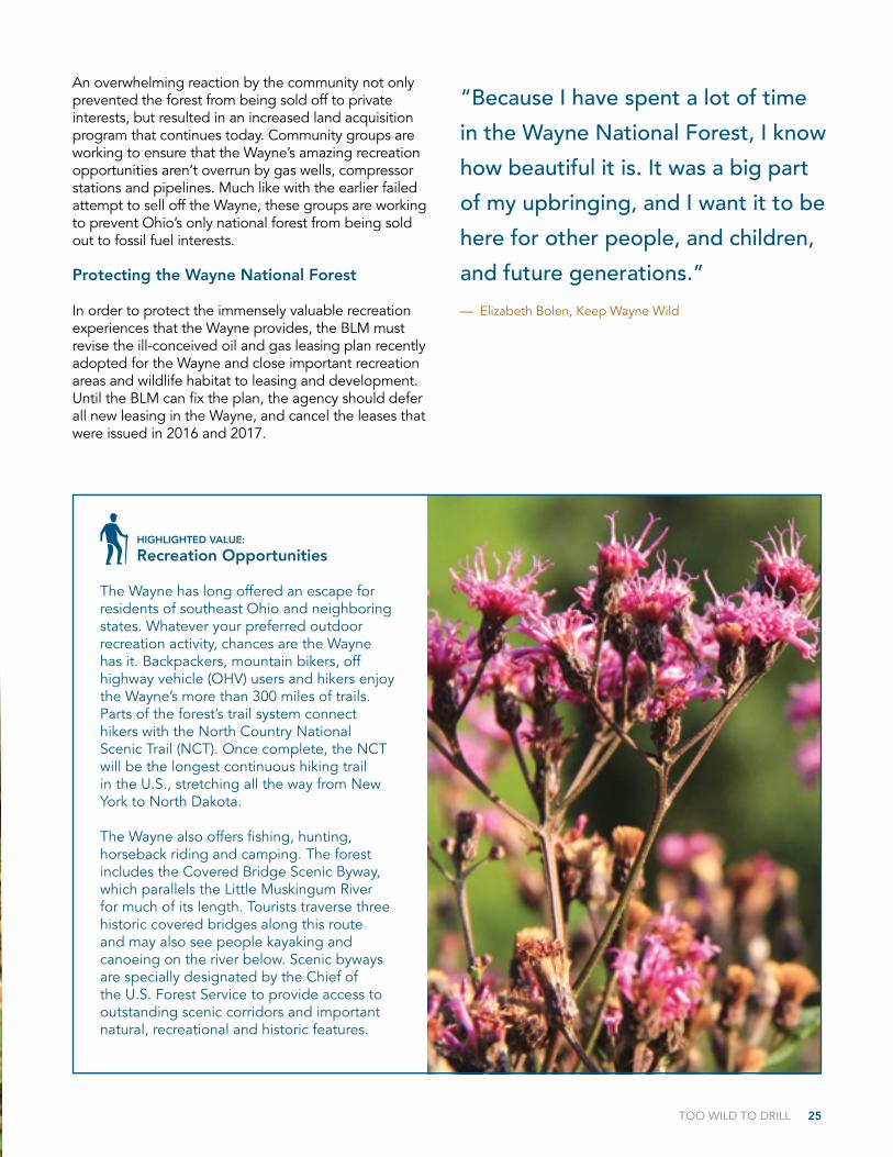
The Wayne has long offered an escape for residents of southeast Ohio and neighboring states. Whatever your preferred outdoor recreation activity, chances are the Wayne has it. Backpackers, mountain bikers, off highway vehicle (OHV) users and hikers enjoy the Wayne’s more than 300 miles of trails. Parts of the forest’s trail system connect hikers with the North Country National Scenic Trail (NCT). Once complete, the NCT will be the longest continuous hiking trail in the U.S., stretching all the way from New York to North Dakota.
The Wayne also offers fishing, hunting, horseback riding and camping. The forest includes the Covered Bridge Scenic Byway, which parallels the Little Muskingum River for much of its length. Tourists traverse three historic covered bridges along this route and may also see people kayaking and canoeing on the river below. Scenic byways are specially designated by the Chief of the U.S. Forest Service to provide access to outstanding scenic corridors and important natural, recreational and historic features.
An overwhelming reaction by the community not only prevented the forest from being sold off to private interests, but resulted in an increased land acquisition program that continues today. Community groups are working to ensure that the Wayne’s amazing recreation opportunities aren’t overrun by gas wells, compressor stations and pipelines. Much like with the earlier failed attempt to sell off the Wayne, these groups are working to prevent Ohio’s only national forest from being sold out to fossil fuel interests.
Protecting the Wayne National Forest
In order to protect the immensely valuable recreation experiences that the Wayne provides, the BLM must revise the ill-conceived oil and gas leasing plan recently adopted for the Wayne and close important recreation areas and wildlife habitat to leasing and development. Until the BLM can fix the plan, the agency should defer all new leasing in the Wayne, and cancel the leases that were issued in 2016 and 2017.
“Because I have spent a lot of time
in the Wayne National Forest, I know
how beautiful it is. It was a big part
of my upbringing, and I want it to be
here for other people, and children,
and future generations.”
— Elizabeth Bolen, Keep Wayne Wild
26 TOO WILD TO DRILL
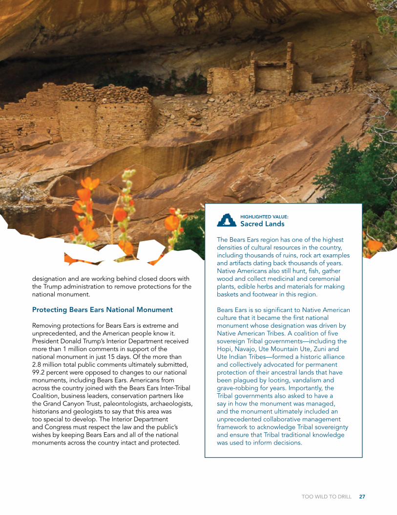
Bears Ears National Monument, Utah
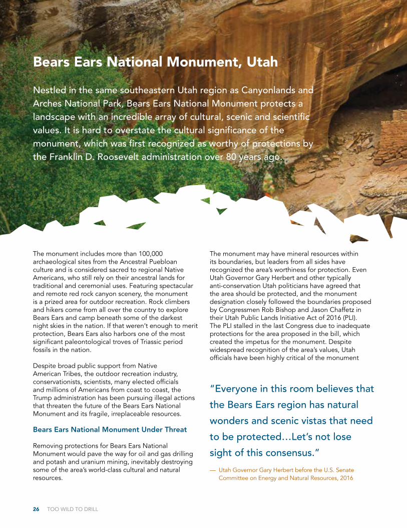
Nestled in the same southeastern Utah region as Canyonlands and Arches National Park, Bears Ears National Monument protects a landscape with an incredible array of cultural, scenic and scientific values. It is hard to overstate the cultural significance of the monument, which was first recognized as worthy of protections by the Franklin D. Roosevelt administration over 80 years ago.
The monument includes more than 100,000 archaeological sites from the Ancestral Puebloan culture and is considered sacred to regional Native Americans, who still rely on their ancestral lands for traditional and ceremonial uses. Featuring spectacular and remote red rock canyon scenery, the monument is a prized area for outdoor recreation. Rock climbers and hikers come from all over the country to explore Bears Ears and camp beneath some of the darkest night skies in the nation. If that weren’t enough to merit protection, Bears Ears also harbors one of the most significant paleontological troves of Triassic period fossils in the nation.
Despite broad public support from Native American Tribes, the outdoor recreation industry, conservationists, scientists, many elected officials and millions of Americans from coast to coast, the Trump administration has been pursuing illegal actions that threaten the future of the Bears Ears National Monument and its fragile, irreplaceable resources.
Bears Ears National Monument Under Threat
Removing protections for Bears Ears National Monument would pave the way for oil and gas drilling and potash and uranium mining, inevitably destroying some of the area’s world-class cultural and natural resources.
The monument may have mineral resources within its boundaries, but leaders from all sides have recognized the area’s worthiness for protection. Even Utah Governor Gary Herbert and other typically anti-conservation Utah politicians have agreed that the area should be protected, and the monument designation closely followed the boundaries proposed by Congressmen Rob Bishop and Jason Chaffetz in their Utah Public Lands Initiative Act of 2016 (PLI). The PLI stalled in the last Congress due to inadequate protections for the area proposed in the bill, which created the impetus for the monument. Despite widespread recognition of the area’s values, Utah officials have been highly critical of the monument
“Everyone in this room believes that
the Bears Ears region has natural
wonders and scenic vistas that need
to be protected…Let’s not lose
sight of this consensus.”
— Utah Governor Gary Herbert before the U.S. Senate Committee on Energy and Natural Resources, 2016
TOO WILD TO DRILL 27
HIGHLIGHTED VALUE:
Sacred Lands
The Bears Ears region has one of the highest densities of cultural resources in the country, including thousands of ruins, rock art examples and artifacts dating back thousands of years. Native Americans also still hunt, fish, gather wood and collect medicinal and ceremonial plants, edible herbs and materials for making baskets and footwear in this region.
Bears Ears is so significant to Native American culture that it became the first national monument whose designation was driven by Native American Tribes. A coalition of five sovereign Tribal governments—including the Hopi, Navajo, Ute Mountain Ute, Zuni and Ute Indian Tribes—formed a historic alliance and collectively advocated for permanent protection of their ancestral lands that have been plagued by looting, vandalism and grave-robbing for years. Importantly, the Tribal governments also asked to have a say in how the monument was managed, and the monument ultimately included an unprecedented collaborative management framework to acknowledge Tribal sovereignty and ensure that Tribal traditional knowledge was used to inform decisions.
designation and are working behind closed doors with the Trump administration to remove protections for the national monument.
Protecting Bears Ears National Monument
Removing protections for Bears Ears is extreme and unprecedented, and the American people know it. President Donald Trump’s Interior Department received more than 1 million comments in support of the national monument in just 15 days. Of the more than 2.8 million total public comments ultimately submitted, 99.2 percent were opposed to changes to our national monuments, including Bears Ears. Americans from across the country joined with the Bears Ears Inter-Tribal Coalition, business leaders, conservation partners like the Grand Canyon Trust, paleontologists, archaeologists, historians and geologists to say that this area was too special to develop. The Interior Department and Congress must respect the law and the public’s wishes by keeping Bears Ears and all of the national monuments across the country intact and protected.
28 TOO WILD TO DRILL
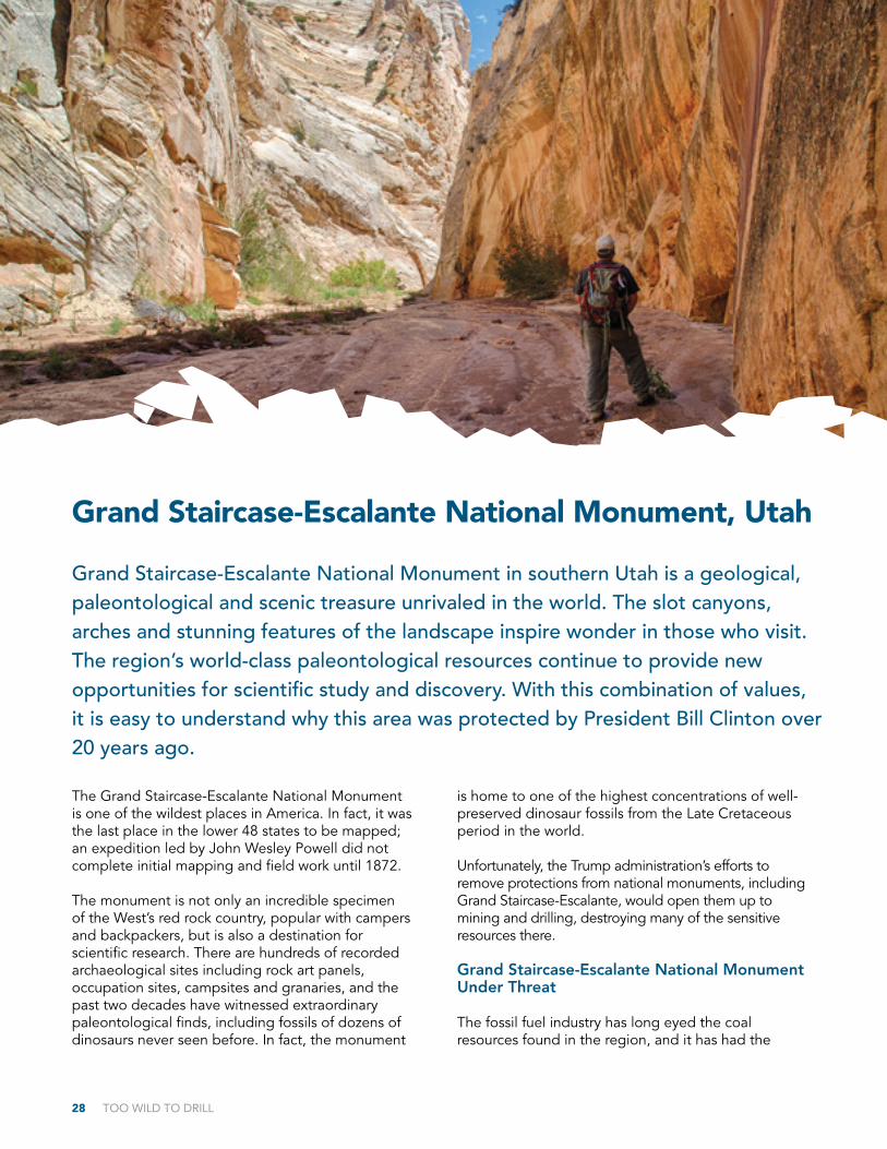
The Grand Staircase-Escalante National Monument is one of the wildest places in America. In fact, it was the last place in the lower 48 states to be mapped; an expedition led by John Wesley Powell did not complete initial mapping and field work until 1872.
The monument is not only an incredible specimen of the West’s red rock country, popular with campers and backpackers, but is also a destination for scientific research. There are hundreds of recorded archaeological sites including rock art panels, occupation sites, campsites and granaries, and the past two decades have witnessed extraordinary paleontological finds, including fossils of dozens of dinosaurs never seen before. In fact, the monument
is home to one of the highest concentrations of well-preserved dinosaur fossils from the Late Cretaceous period in the world.
Unfortunately, the Trump administration’s efforts to remove protections from national monuments, including Grand Staircase-Escalante, would open them up to mining and drilling, destroying many of the sensitive resources there.
Grand Staircase-Escalante National Monument Under Threat
The fossil fuel industry has long eyed the coal resources found in the region, and it has had the
Grand Staircase-Escalante National Monument, Utah
Grand Staircase-Escalante National Monument in southern Utah is a geological, paleontological and scenic treasure unrivaled in the world. The slot canyons, arches and stunning features of the landscape inspire wonder in those who visit. The region’s world-class paleontological resources continue to provide new opportunities for scientific study and discovery. With this combination of values, it is easy to understand why this area was protected by President Bill Clinton over 20 years ago.
TOO WILD TO DRILL 29
HIGHLIGHTED VALUE:
Socio-economic Benefits
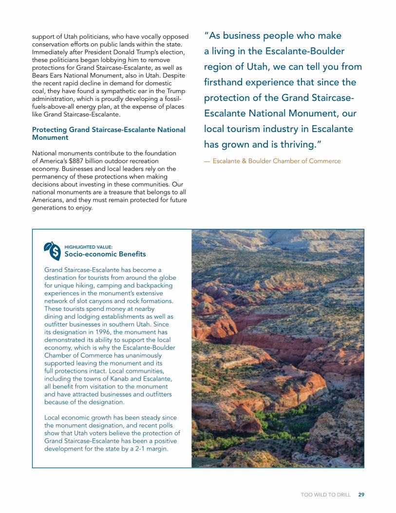
Grand Staircase-Escalante has become a destination for tourists from around the globe for unique hiking, camping and backpacking experiences in the monument’s extensive network of slot canyons and rock formations. These tourists spend money at nearby dining and lodging establishments as well as outfitter businesses in southern Utah. Since its designation in 1996, the monument has demonstrated its ability to support the local economy, which is why the Escalante-Boulder Chamber of Commerce has unanimously supported leaving the monument and its full protections intact. Local communities, including the towns of Kanab and Escalante, all benefit from visitation to the monument and have attracted businesses and outfitters because of the designation.
Local economic growth has been steady since the monument designation, and recent polls show that Utah voters believe the protection of Grand Staircase-Escalante has been a positive development for the state by a 2-1 margin.
support of Utah politicians, who have vocally opposed conservation efforts on public lands within the state. Immediately after President Donald Trump’s election, these politicians began lobbying him to remove protections for Grand Staircase-Escalante, as well as Bears Ears National Monument, also in Utah. Despite the recent rapid decline in demand for domestic coal, they have found a sympathetic ear in the Trump administration, which is proudly developing a fossil-fuels-above-all energy plan, at the expense of places like Grand Staircase-Escalante.
Protecting Grand Staircase-Escalante National Monument
National monuments contribute to the foundation of America’s $887 billion outdoor recreation economy. Businesses and local leaders rely on the permanency of these protections when making decisions about investing in these communities. Our national monuments are a treasure that belongs to all Americans, and they must remain protected for future generations to enjoy.
“As business people who make
a living in the Escalante-Boulder
region of Utah, we can tell you from
firsthand experience that since the
protection of the Grand Staircase-
Escalante National Monument, our
local tourism industry in Escalante
has grown and is thriving.”
— Escalante & Boulder Chamber of Commerce
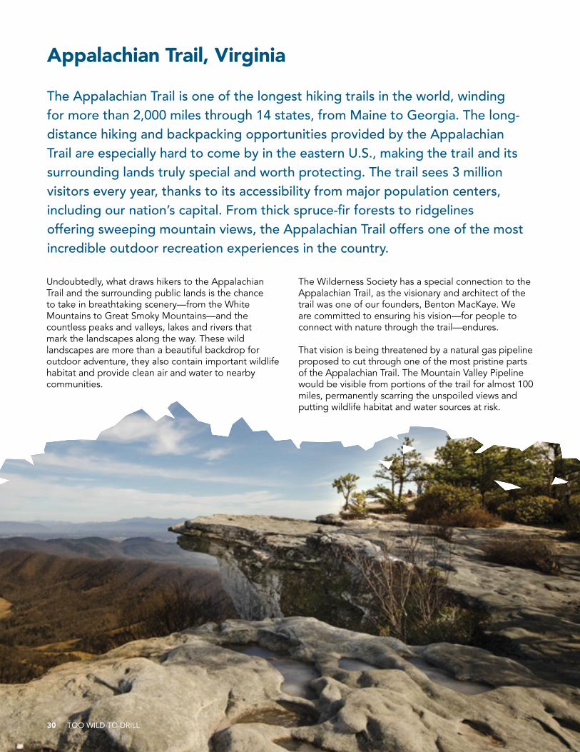
Appalachian Trail, Virginia
The Appalachian Trail is one of the longest hiking trails in the world, winding for more than 2,000 miles through 14 states, from Maine to Georgia. The long-distance hiking and backpacking opportunities provided by the Appalachian Trail are especially hard to come by in the eastern U.S., making the trail and its surrounding lands truly special and worth protecting. The trail sees 3 million visitors every year, thanks to its accessibility from major population centers, including our nation’s capital. From thick spruce-fir forests to ridgelines offering sweeping mountain views, the Appalachian Trail offers one of the most incredible outdoor recreation experiences in the country.
Undoubtedly, what draws hikers to the Appalachian Trail and the surrounding public lands is the chance to take in breathtaking scenery—from the White Mountains to Great Smoky Mountains—and the countless peaks and valleys, lakes and rivers that mark the landscapes along the way. These wild landscapes are more than a beautiful backdrop for outdoor adventure, they also contain important wildlife habitat and provide clean air and water to nearby communities.
The Wilderness Society has a special connection to the Appalachian Trail, as the visionary and architect of the trail was one of our founders, Benton MacKaye. We are committed to ensuring his vision—for people to connect with nature through the trail—endures.
That vision is being threatened by a natural gas pipeline proposed to cut through one of the most pristine parts of the Appalachian Trail. The Mountain Valley Pipeline would be visible from portions of the trail for almost 100 miles, permanently scarring the unspoiled views and putting wildlife habitat and water sources at risk.
30 TOO WILD TO DRILL
TOO WILD TO DRILL 31
Appalachian Trail Under Threat
The proposed 300-mile Mountain Valley Pipeline would originate in West Virginia and cut across the Appalachian Mountains within the Jefferson National Forest in Virginia. The route proposed for the pipeline would severely impact recreation experiences on the Appalachian Trail by ruining scenic vistas. Specifically, the pipeline would cut across the trail immediately adjacent to the Peters Mountain Wilderness and cut right through the Brush Mountain inventoried roadless area.
Besides destroying renowned scenery along the Appalachian Trail, the Mountain Valley Pipeline presents unacceptable risks to water sources and species habitat. The pipeline would traverse sensitive “karst topography” with underground streams, caves and sinkholes, putting the drinking water of nearby communities at risk of contamination. It would cross pristine streams in the Jefferson National Forest, causing erosion of sediment into the water during construction and impacting threatened, endangered and rare species. Adding to the risk, the pipeline would cross two seismic zones, making construction dangerous, with serious long-term public safety concerns if the pipeline were to rupture.
Protecting the Appalachian Trail
The Mountain Valley Pipeline would severely impact wildland values, water quality and recreation experiences along the Appalachian Trail. Yet the Forest Service and Federal Energy Regulatory Commission are plowing ahead with the approval process with minimal community involvement and barebones analysis of the resources at stake. The agencies must go back to the drawing board and analyze the environmental impacts in depth with public engagement, including considering alternate routes and other options to avoid or offset impacts.
HIGHLIGHTED VALUE:
Recreation Opportunities
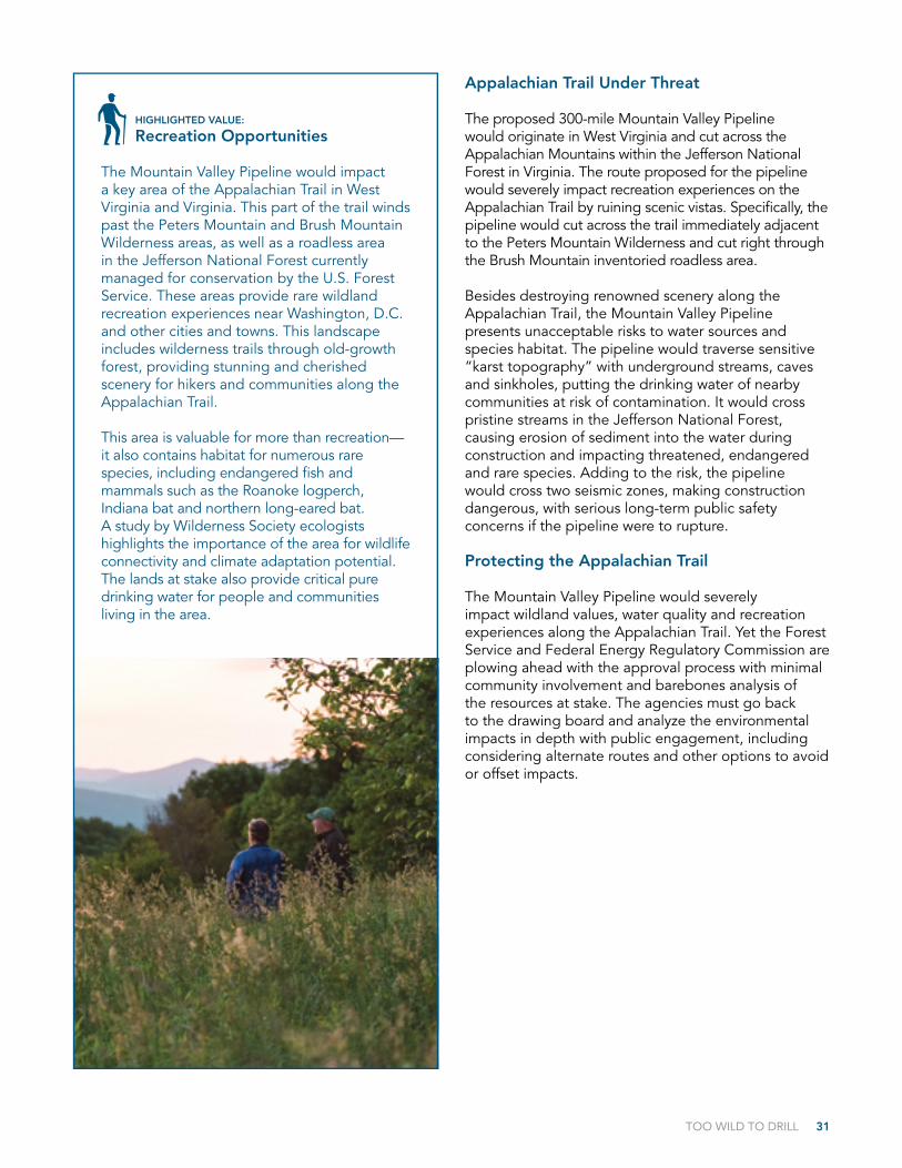
The Mountain Valley Pipeline would impact a key area of the Appalachian Trail in West Virginia and Virginia. This part of the trail winds past the Peters Mountain and Brush Mountain Wilderness areas, as well as a roadless area in the Jefferson National Forest currently managed for conservation by the U.S. Forest Service. These areas provide rare wildland recreation experiences near Washington, D.C. and other cities and towns. This landscape includes wilderness trails through old-growth forest, providing stunning and cherished scenery for hikers and communities along the Appalachian Trail.
This area is valuable for more than recreation—it also contains habitat for numerous rare species, including endangered fish and mammals such as the Roanoke logperch, Indiana bat and northern long-eared bat. A study by Wilderness Society ecologists highlights the importance of the area for wildlife connectivity and climate adaptation potential. The lands at stake also provide critical pure drinking water for people and communities living in the area.

32 TOO WILD TO DRILL
Green River Valley, Washington
The Green River Valley is a remote destination for true wilderness recreation experiences in Washington’s South Cascades. Located more than two hours from Portland, and accessible only by one single-lane U.S. Forest Service road, the valley is sought out by hunters, anglers, equestrians and backpackers looking to escape into the Washington wilderness. Here, the Green River winds in and out of the iconic Mount St. Helens National Volcanic Monument, along whose northeastern border the valley is situated. The Green River Valley is a place of stunning scenery and unbound backcountry recreation opportunities.

TOO WILD TO DRILL 33
HIGHLIGHTED VALUE:
Recreation Opportunities
The Green River Valley is a unique landscape and a prime recreation destination for a wide variety of adventure-seekers, from anglers and hikers to equestrians and hunters. The valley lies within the blast zone of the 1980 eruption of Mount St. Helens. The topography of the valley shielded some pockets of ancient forest from the blast, creating a unique patchwork of blast zone and old-growth forest. Within the valley, this patchwork provides a variety of recreation opportunities and unique beauty, from the cool, clear waters of the Green River to wildflower-strewn slopes.
The Green River is designated a Wild Steelhead Gene Bank by the Washington Department of Fish and Wildlife, drawing anglers from afar to the river and its tributaries. Hikers and backpackers enjoy extensive trails in and around the Mount Margaret Backcountry and the Goat Mountain Trail, which offers stunning views of Mount St. Helens amid turquoise alpine lakes. Equestrians find camping and horse trails at the Green River Horse Camp, and hunters descend on the valley for elk season.
The Green River Valley was once considered for inclusion in the Mount St. Helens National Volcanic Monument, but was ultimately left out due to existing mining claims that would have been potentially expensive to purchase. Following the monument designation, the company that held the claims abandoned them, and ultimately the Forest Service purchased 166 acres of the land with funding from the Land and Water Conservation Fund (LWCF), a program intended to promote conservation and recreation on public lands.
Despite the understanding that the area would remain protected from mining in perpetuity, the Forest Service is now considering a proposal for exploratory drilling and potential mining for copper, gold and other hardrock minerals in the Green River Valley—a proposal that could turn these lands acquired through the LWCF into an industrial wasteland.
Green River Valley Under Threat
A Canadian mining company has been trying for more than a decade to conduct exploratory drilling for copper, gold and molybdenum in the Green River Valley, on the very land that was protected for its conservation and recreation values decades ago. Mining activities would not only permanently destroy the beauty of the valley and myriad recreational opportunities, they would also pollute the Green River, which provides critical aquatic habitat and drinking water for the downstream communities of Kelso and Castle Rock.
Low levels of acid mine drainage and increased copper levels have already occurred nearby from historical mining sites, suggesting a large-scale mine in this area would seriously impact the Green River. The Cowlitz Indian Tribe is also opposed to mining activity in this area, due to possible impacts to cultural and conservation values.
In 2014, a court decision invalidated the exploratory drilling permits because the Bureau of Land Management and Forest Service did not consider impacts to recreation as required by the LWCF acquisition. Now the agencies are preparing to issue revised exploratory drilling permits, which would open the door to industrialization of this wild landscape.
Protecting the Green River Valley
The Green River Valley is no place for an industrial hardrock mine. Years ago, the Forest Service acquired these lands with the express purpose to preserve the area’s scenic beauty and the ecological integrity of the Green River that flows into the Mount St. Helens National Volcanic Monument. It is time the Forest Service lives up to that promise by stopping this exploratory drilling in its tracks. In the long term, we need to permanently protect the Green River Valley from mining and other energy development so that future generations can experience the valley’s stunning beauty and outstanding recreation opportunities.
34 TOO WILD TO DRILL
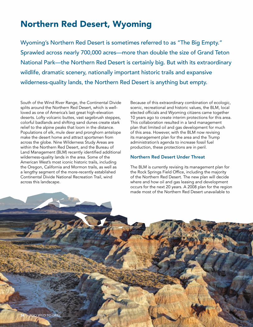
South of the Wind River Range, the Continental Divide splits around the Northern Red Desert, which is well-loved as one of America’s last great high-elevation deserts. Lofty volcanic buttes, vast sagebrush steppes, colorful badlands and shifting sand dunes create stark relief to the alpine peaks that loom in the distance. Populations of elk, mule deer and pronghorn antelope make the desert home and attract sportsmen from across the globe. Nine Wilderness Study Areas are within the Northern Red Desert, and the Bureau of Land Management (BLM) recently identified additional wilderness-quality lands in the area. Some of the American West’s most iconic historic trails, including the Oregon, California and Mormon trails, as well as a lengthy segment of the more-recently established Continental Divide National Recreation Trail, wind across this landscape.
Because of this extraordinary combination of ecologic, scenic, recreational and historic values, the BLM, local elected officials and Wyoming citizens came together 10 years ago to create interim protections for this area. This collaboration resulted in a land management plan that limited oil and gas development for much of this area. However, with the BLM now revising its management plan for the area and the Trump administration’s agenda to increase fossil fuel production, these protections are in peril.
Northern Red Desert Under Threat
The BLM is currently revising its management plan for the Rock Springs Field Office, including the majority of the Northern Red Desert. The new plan will decide where and how oil and gas leasing and development occurs for the next 20 years. A 2008 plan for the region made most of the Northern Red Desert unavailable to
Northern Red Desert, Wyoming
Wyoming’s Northern Red Desert is sometimes referred to as “The Big Empty.”
Sprawled across nearly 700,000 acres—more than double the size of Grand Teton
National Park—the Northern Red Desert is certainly big. But with its extraordinary
wildlife, dramatic scenery, nationally important historic trails and expansive
wilderness-quality lands, the Northern Red Desert is anything but empty.
TOO WILD TO DRILL 35
new leasing or surface disturbance from oil and gas drilling, and only 25,000 acres are leased currently. But with the Trump administration explicitly prioritizing oil and gas development over all other uses of public lands, all of these protections are in grave danger of being rescinded.
Protecting the Northern Red Desert
The BLM must ensure that the upcoming Rock Springs Resource Management Plan supports and enhances the existing protections for the Northern Red Desert. These protections have provided a refuge for wildlife
from oil and gas development in the region, creating an important island of unleased and undeveloped lands amidst a sea of well pads, pipelines and access roads to the west and south especially. The new land use plan should expand on existing protections by closing the entire Northern Red Desert to new oil and gas leasing; minimizing the impacts of off-road vehicle use on important wildlife and rare plant habitats; formally recognizing and protecting the nationally important wildlife migration corridors that traverse through the region, including the Red Desert to Hoback mule deer migration route; and protecting the extensive wilderness-quality lands in the area.
HIGHLIGHTED VALUE:
Wildlife and Habitat
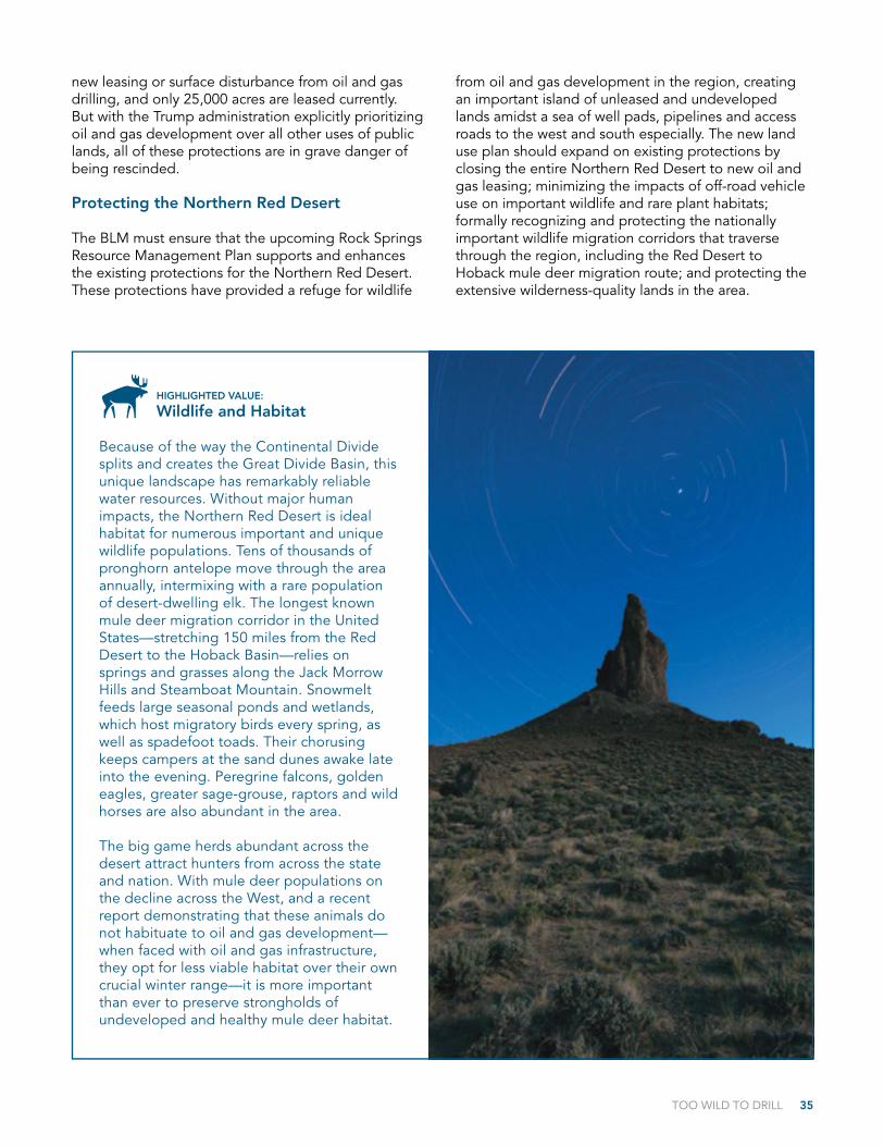
Because of the way the Continental Divide splits and creates the Great Divide Basin, this unique landscape has remarkably reliable water resources. Without major human impacts, the Northern Red Desert is ideal habitat for numerous important and unique wildlife populations. Tens of thousands of pronghorn antelope move through the area annually, intermixing with a rare population of desert-dwelling elk. The longest known mule deer migration corridor in the United States—stretching 150 miles from the Red Desert to the Hoback Basin—relies on springs and grasses along the Jack Morrow Hills and Steamboat Mountain. Snowmelt feeds large seasonal ponds and wetlands, which host migratory birds every spring, as well as spadefoot toads. Their chorusing keeps campers at the sand dunes awake late into the evening. Peregrine falcons, golden eagles, greater sage-grouse, raptors and wild horses are also abundant in the area.
The big game herds abundant across the desert attract hunters from across the state and nation. With mule deer populations on the decline across the West, and a recent report demonstrating that these animals do not habituate to oil and gas development—when faced with oil and gas infrastructure, they opt for less viable habitat over their own crucial winter range—it is more important than ever to preserve strongholds of undeveloped and healthy mule deer habitat.
36 TOO WILD TO DRILL
Photo credits
Cover and backcover Florian Schulz
Inside cover and p. 1 Mason Cummings
p. 2-3 Bob Wick, BLM
p. 4 Green River Valley photo by Trip Jennings, Balance Media; Badger-Two Medicine photo by tonybynum.com; Nevada’s Owyhee Desert Sagebrush photo by Bob Wick, BLM; Paradise Valley photo by William Campbell; Arctic National Wildlife Refuge photo by Florian Schulz; Mojave Trails National Monument photo by Bob Wick, BLM; Greater Grand Canyon Watershed photo by Jessica Pope; Bears Ears National Monument photo by Mason Cummings/TWS; Grand Staircase-Escalante National Monument photo by Bob Wick, BLM
p. 5 North Fork of the Gunnison photo by Mason Cummings/TWS; Chihuahuan Desert Rivers photo by Gosia Allison-Kosior; Northern Red Desert photo by Kathy Lichtendahl; Wayne National Forest photo by Rebecca Pollard; Appalachian Trail photo by Frank Kehren, flickr; Boundary Waters Canoe Area Wilderness photo by Dave Freeman
p. 6-7 Florian Schulz
p. 8-9 Jessica Pope
p. 10 Bob Wick, BLM
p. 11 Mason Cummings
p. 12 Jim Brett
p. 13 Mason Cummings
p. 14-15 Dave Freeman
p. 16 Tony Bynum (tonybynum.com)
p. 18-19 William Campbell
p. 20-21 Gosia Allison-Kosior
p. 22 Bob Wick, BLM
p. 23 Scott Moore, Friends of Nevada Wilderness
p. 24-25 Rebecca Pollard
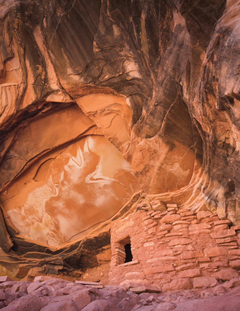
p. 26-27 Photo courtesy of Bears Ears Coalition, photo by Josh Ewing
p. 28-29 Bob Wick, BLM
p. 30 ksteryous, flickr
p. 31 Appalachian Trail Conservancy
p. 32 Michael Sulis
p. 34 Kathy Lichtendahl
p. 35 Scott Copeland
Inside back cover Mason Cummings
September 2017
For more information, please contact:Alex Daue, Assistant Director, Energy & Climate Program(303) [email protected] www.wilderness.org/toowild
TOO WILD TO DRILL C
D TOO WILD TO DRILL
1615 M Street, NWWashington, DC 20036
1-800-THE-WILDwww.wilderness.org/toowild