Embed Size (px)
Citation preview
NEW YORK STATE DEPARTMENT OF ENVIRONMENTAL CONSERVATION
Tompkins County Deer Management Focus Area Boundary
For ease of reference, the DMFA boundary description has been separated into segments along Cayuga Lake
and through each town that is partially incorporated into the DMFA.
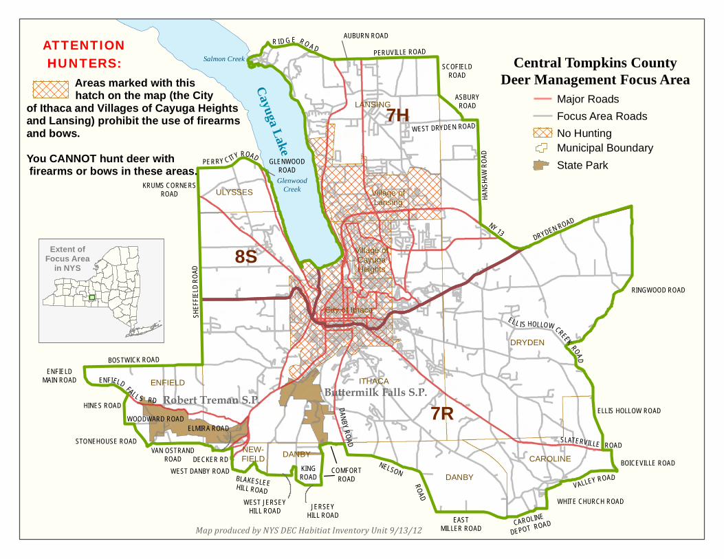
Lakeshore Those parts of Tompkins County beginning at the mouth of Glenwood Creek near Duboise Corner(Town of Ulysses) and
southerly along the west shore of Cayuga Lake; thence easterly and all other variations thereof along the south shore of
Cayuga Lake; thence northerly along the east shore of Cayuga Lake to the mouth of Salmon Creek near Myers;
Town of Lansing
Thence northeasterly along Salmon Creek to Ridge Road (34B); thence easterly along Ridge Road (34B) to Auburn Road (34
& 34B) in south Lansing; thence easterly along Auburn Road (34 &34B) to Peruville Road (34B) near Terpening Corners;
thence easterly along Peruville Road (34B) to Scofield Road in Howland Corners; thence southerly along Scofield Road to
Asbury Road;
Town of Dryden Thence southeasterly along Asbury Road to West Dryden Road; thence easterly along West Dryden Road to Hanshaw Road;
thence southerly along Hanshaw Road to State Highway 13; thence easterly along State Highway 13 to Dryden Road (State
Highway 13 & 366); thence easterly along Dryden Road (State Highway 13 & 366) to Dryden Road (13); thence easterly
along Dryden Road (13) to Ringwood Road; thence southerly and southwesterly along Ringwood Road to Ellis Hollow Creek
Road; thence southerly along Ellis Hollow Creek Road to Ellis Hollow Road; thence southeasterly along Ellis Hollow Road to
Slaterville Road (79);
Town of Caroline
Thence easterly along Slaterville Road (79) to Boiceville Road; thence southerly along Boiceville Road to Valley Road; thence
westerly along Valley Road to White Church Road; thence westerly and southerly along White Church Road to Caroline
Depot Road; thence westerly along Caroline Depot Road to Coddington Road; thence southerly along Coddington Road to
East Miller Road;
Town of Danby Thence westerly along East Miller Road to Nelson Road; thence northerly and westerly along Nelson Road to Danby Road
(96B); thence northerly along Danby Road to Comfort Road; thence westerly and southerly along Comfort Road to Jersey
Hill Road; thence westerly along Jersey Hill Road to West King Road; thence westerly and northerly along West King Road to
West Jersey Hill Road; thence southerly and westerly along West Jersey Hill Road to Blakeslee Hill Road;
Town of Newfield
Thence westerly along Blakeslee Hill Road to West Danby Road (34 & 96); thence northerly along West Danby Road (34 &
96) to Decker Road; thence northerly along Decker Road to Elmira Road (13); thence westerly along Elmira Road (13) to the
intersection of Millard Hill Road and Van Ostrand Road; thence westerly along Van Ostrand Road to Douglas Road; thence
northwesterly along Douglas Road to Stone house Road;
Town of Enfield
Thence northwesterly along Stonehouse Road to Woodard Road; thence westerly along Woodard Road to Hines Road;
thence northerly along Hines Road to Enfield Falls Road (327); thence northwesterly along Enfield Falls Road (327) to Enfield
Main Road (327); thence northerly along Enfield Main Road (327) to Bostwick Road; thence easterly along Bostwick Road to
Sheffield Road; thence northerly along Sheffield Road to Krums Corners Road; thence northerly along Krums Corners Road
to Perry City Road;
Town of Ulysses
Thence easterly along Perry City Road to Glenwood Road; thence southeasterly along Glenwood Road to Glenwood Creek;
thence easterly along Glenwood Creek to the point of beginning.
LANSING
Village ofLansing
Village ofCayugaHeights
City of Ithaca
ITHACA
ULYSSES
ENFIELD
DRYDEN
CAROLINEDANBY
NEW-FIELD DANBY
SHEF
FIELD
ROAD
KRUMS CORNERSROAD
PERRY C ITY ROAD
BOSTWICK ROAD
ENFIELD FALL S RD
WOODWARD ROADHINES ROAD
STONEHOUSE ROADVAN OSTRAND
ROAD
ELMIRA ROAD
WEST DANBY ROADBLAKESLEEHILL ROAD
KINGROAD
JERSEYHILL ROAD
COMFORTROAD
NELSON
ROAD
DANBY ROAD
EASTMILLER ROAD CAROLINE
DEPOT ROAD
WHITE CHURCH ROADVALLEY ROAD
SLATERVILLE ROAD
ELLIS HOLLOW ROAD
EL L IS HOLLOW CREEK ROAD
RINGWOOD ROAD
DRYDEN ROADNY 13
HANS
HAW
ROAD
WEST DRYDEN ROAD
ASBURYROAD
PERUVILLE ROADSCOFIELD
ROAD
AUBURN ROADR ID G E R O A D
DECKER RD
WEST JERSEYHILL ROAD
ENFIELDMAIN ROAD
BOICEVILLE ROAD
Salmon Creek
GlenwoodCreek
GLENWOODROAD
Cayuga Lake
Buttermilk Falls S.P.Robert Treman S.P.
7H
8S
7R
Major RoadsFocus Area RoadsNo Hunting
Central Tompkins CountyDeer Management Focus Area
Map produced by NYS DEC Habitiat Inventory Unit 9/13/12
Extent ofFocus Area
in NYS
Municipal BoundaryState Park
Areas marked with this hatch on the map (the City of Ithaca and Villages of Cayuga Heightsand Lansing) prohibit the use of firearms and bows. You CANNOT hunt deer with firearms or bows in these areas.
ATTENTIONHUNTERS: