Embed Size (px)
Citation preview
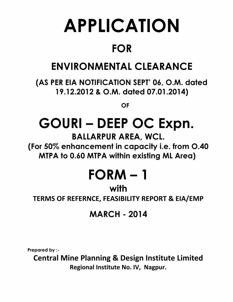
APPLICATIONFOR
ENVIRONMENTAL CLEARANCE
(AS PER EIA NOTIFICATION SEPT’ 06, O.M. dated 19.12.2012 & O.M. dated 07.01.2014)
OF
GOURI – DEEP OC Expn. BALLARPUR AREA, WCL.
(For 50% enhancement in capacity i.e. from O.40 MTPA to 0.60 MTPA within existing ML Area)
FORM – 1with
TERMS OF REFERNCE, FEASIBILITY REPORT & EIA/EMP
MARCH - 2014
Prepared by :-
Central Mine Planning & Design Institute LimitedRegional Institute No. IV, Nagpur.
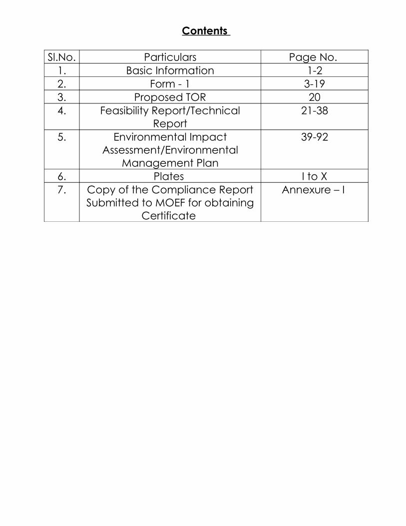
Contents
Sl.No. Particulars Page No. 1. Basic Information 1-22. Form - 1 3-193. Proposed TOR 204. Feasibility Report/Technical
Report21-38
5. Environmental Impact Assessment/Environmental
Management Plan
39-92
6. Plates I to X7. Copy of the Compliance Report
Submitted to MOEF for obtaining Certificate
Annexure – I
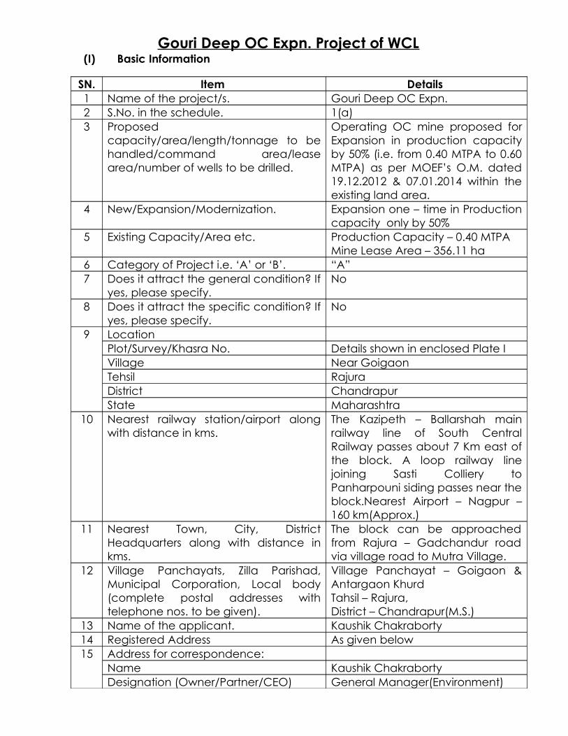
Gouri Deep OC Expn. Project of WCL(I) Basic Information
SN. Item Details 1 Name of the project/s. Gouri Deep OC Expn.2 S.No. in the schedule. 1(a)3 Proposed
capacity/area/length/tonnage to be handled/command area/lease area/number of wells to be drilled.
Operating OC mine proposed for Expansion in production capacity by 50% (i.e. from 0.40 MTPA to 0.60 MTPA) as per MOEF’s O.M. dated 19.12.2012 & 07.01.2014 within the existing land area.
4 New/Expansion/Modernization. Expansion one – time in Production capacity only by 50%
5 Existing Capacity/Area etc. Production Capacity – 0.40 MTPAMine Lease Area – 356.11 ha
6 Category of Project i.e. ‘A’ or ‘B’. “A”7 Does it attract the general condition? If
yes, please specify.No
8 Does it attract the specific condition? If yes, please specify.
No
9 Location Plot/Survey/Khasra No. Details shown in enclosed Plate IVillage Near GoigaonTehsil RajuraDistrict ChandrapurState Maharashtra
10 Nearest railway station/airport along with distance in kms.
The Kazipeth – Ballarshah main railway line of South Central Railway passes about 7 Km east of the block. A loop railway line joining Sasti Colliery to Panharpouni siding passes near the block.Nearest Airport – Nagpur – 160 km(Approx.)
11 Nearest Town, City, District Headquarters along with distance in kms.
The block can be approached from Rajura – Gadchandur road via village road to Mutra Village.
12 Village Panchayats, Zilla Parishad, Municipal Corporation, Local body (complete postal addresses with telephone nos. to be given).
Village Panchayat – Goigaon & Antargaon KhurdTahsil – Rajura,District – Chandrapur(M.S.)
13 Name of the applicant. Kaushik Chakraborty14 Registered Address As given below15 Address for correspondence:
Name Kaushik ChakrabortyDesignation (Owner/Partner/CEO) General Manager(Environment)
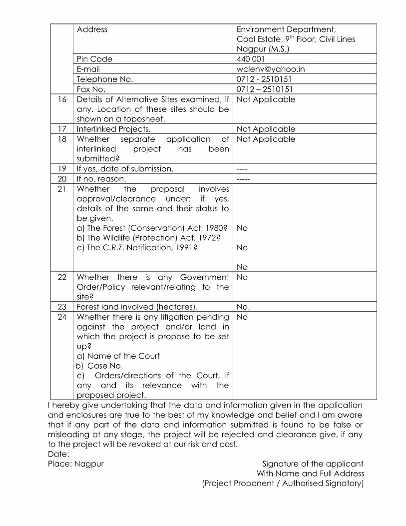
Address Environment Department,Coal Estate, 9th Floor, Civil LinesNagpur (M.S.)
Pin Code 440 001E-mail [email protected] No. 0712 - 2510151Fax No. 0712 – 2510151
16 Details of Alternative Sites examined, if any. Location of these sites should be shown on a toposheet.
Not Applicable
17 Interlinked Projects. Not Applicable18 Whether separate application of
interlinked project has been submitted?
Not Applicable
19 If yes, date of submission. ----20 If no, reason. -----21 Whether the proposal involves
approval/clearance under: if yes, details of the same and their status to be given.a) The Forest (Conservation) Act, 1980?b) The Wildlife (Protection) Act, 1972?c) The C.R.Z. Notification, 1991?
No
No
No22 Whether there is any Government
Order/Policy relevant/relating to the site?
No
23 Forest land involved (hectares). No.24 Whether there is any litigation pending
against the project and/or land in which the project is propose to be set up?a) Name of the Courtb) Case No.c) Orders/directions of the Court, if any and its relevance with the proposed project.
No
I hereby give undertaking that the data and information given in the application and enclosures are true to the best of my knowledge and belief and I am aware that if any part of the data and information submitted is found to be false or misleading at any stage, the project will be rejected and clearance give, if any to the project will be revoked at our risk and cost.Date: Place: Nagpur Signature of the applicant
With Name and Full Address(Project Proponent / Authorised Signatory)
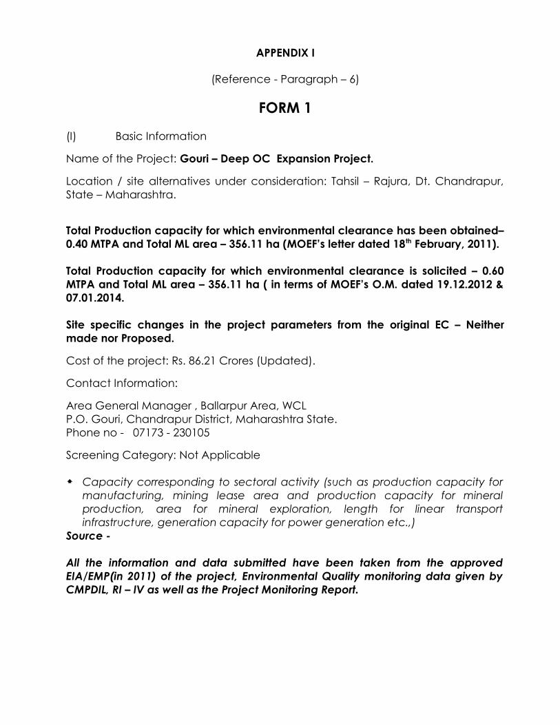
APPENDIX I
(Reference - Paragraph – 6)
FORM 1
(I) Basic Information
Name of the Project: Gouri – Deep OC Expansion Project.
Location / site alternatives under consideration: Tahsil – Rajura, Dt. Chandrapur, State – Maharashtra.
Total Production capacity for which environmental clearance has been obtained– 0.40 MTPA and Total ML area – 356.11 ha (MOEF’s letter dated 18th February, 2011).
Total Production capacity for which environmental clearance is solicited – 0.60 MTPA and Total ML area – 356.11 ha ( in terms of MOEF’s O.M. dated 19.12.2012 & 07.01.2014.
Site specific changes in the project parameters from the original EC – Neither made nor Proposed.
Cost of the project: Rs. 86.21 Crores (Updated).
Contact Information:
Area General Manager , Ballarpur Area, WCL P.O. Gouri, Chandrapur District, Maharashtra State.Phone no - 07173 - 230105
Screening Category: Not Applicable
Capacity corresponding to sectoral activity (such as production capacity for manufacturing, mining lease area and production capacity for mineral production, area for mineral exploration, length for linear transport infrastructure, generation capacity for power generation etc.,)
Source -
All the information and data submitted have been taken from the approved EIA/EMP(in 2011) of the project, Environmental Quality monitoring data given by CMPDIL, RI – IV as well as the Project Monitoring Report.

(II) Activity
1. Construction, operation or decommissioning of the Project involving actions, which will cause physical changes in the locality (topography, land use, changes in water bodies, etc.)
S.No.
Information/Checklist confirmation
Yes/No
Details thereof (with approximate quantities /rates, wherever possible) with source of information data
1.1 Permanent or temporary change in land use, land cover or topography including increase in intensity of land use (with respect to local land use plan)
Yes The subject mine has been opened on 22.11.2012 after obtaining of EC from MOEF in 2011.There is no increase in land area beyond the already approved environmental clearance. The approved land area for Gouri Deep OC mine is 356.11 ha.
The Pre – Mining land use pattern is as follows :-
Tenancy / Agricultural land – 339.43 haGovt./other land – 16.68 haForest Land - Nil
Land use plan during operation of the project:1) Excavation area = 92.45 ha2) Infrastructure = 5.0 ha3) OB dump = 94.12 ha4 )safety zone, boundary adjustment & Misc = 154.54 ha5) land for colony =10 ha.
1.2 Clearance of existing land, vegetation
and buildings?
Yes The total provision for land for the subject mine under relevant acts is as follows:S.No
Land particulars
CBA Act 1957(ha)
Forest Act 1980(ha)
Total Land (ha)
1 Agriculture 339.43 Nil 339.432 Govt/Othe
r16.68 Nil 16.68
3 Forest Nil Nil NilTotal 356.11 Nil 356.11
Out of the above, 317.45 ha of tenancy/ agricultural land and 16.68 ha of Govt. land amounting to 334.13 ha have been acquired.
1.3 Creation of new land uses?
No No new land is being proposed beyond the approved land use pattern.
1.4 Pre-construction investigations e.g. bore houses, soil testing?
No Pre – construction activities involved boreholes drilled to prove coal reserves towards assessing feasibility of coal mining and the same were also carried out here. Density of boreholes for quarriable area is 28/sq.km.
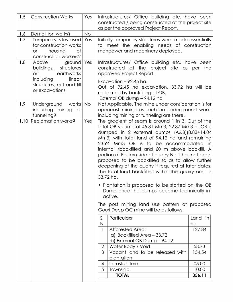
1.5 Construction Works Yes Infrastructures/ Office building etc. have been constructed / being constructed at the project site as per the approved Project Report.
1.6 Demolition works? No1.7 Temporary sites used
for construction works or housing of construction workers?
Yes Initially temporary structures were made essentially to meet the enabling needs of construction manpower and machinery deployed.
1.8 Above ground buildings, structures or earthworks including linear structures, cut and fill or excavations
Yes Infrastructures/ Office building etc. have been constructed at the project site as per the approved Project Report.
Excavation – 92.45 ha.Out of 92.45 ha excavation, 33.72 ha will be reclaimed by backfilling of OB. External OB dump – 94.12 ha
1.9 Underground works including mining or tunneling?
No Not Applicable. The mine under consideration is for opencast mining as such no underground works including mining or tunneling are there.
1.10 Reclamation works? Yes The gradient of seam is around 1 in 3. Out of the total OB volume of 45.81 Mm3, 22.87 Mm3 of OB is dumped in 2 external dumps (A&B)(8.83+14.04 Mm3) with total land of 94.12 ha and remaining 23.94 Mm3 OB is to be accommodated in internal /backfilled and 60 m above backfill. A portion of Eastern side of quarry No 1 has not been proposed to be backfilled so as to allow further deepening of the quarry if required at later dates. The total land backfilled within the quarry area is 33.72 ha.
Plantation is proposed to be started on the OB Dump once the dumps become technically in- active.
The post mining land use pattern at proposed Gouri Deep OC mine will be as follows:
SN
Particulars Land in ha
1 Afforested Area:a) Backfilled Area – 33.72
b) External OB Dump – 94.12
127.84
2 Water Body / Void 58.733 Vacant land to be released with
plantation154.54
4 Infrastructure 05.005 Township 10.00
TOTAL 356.11
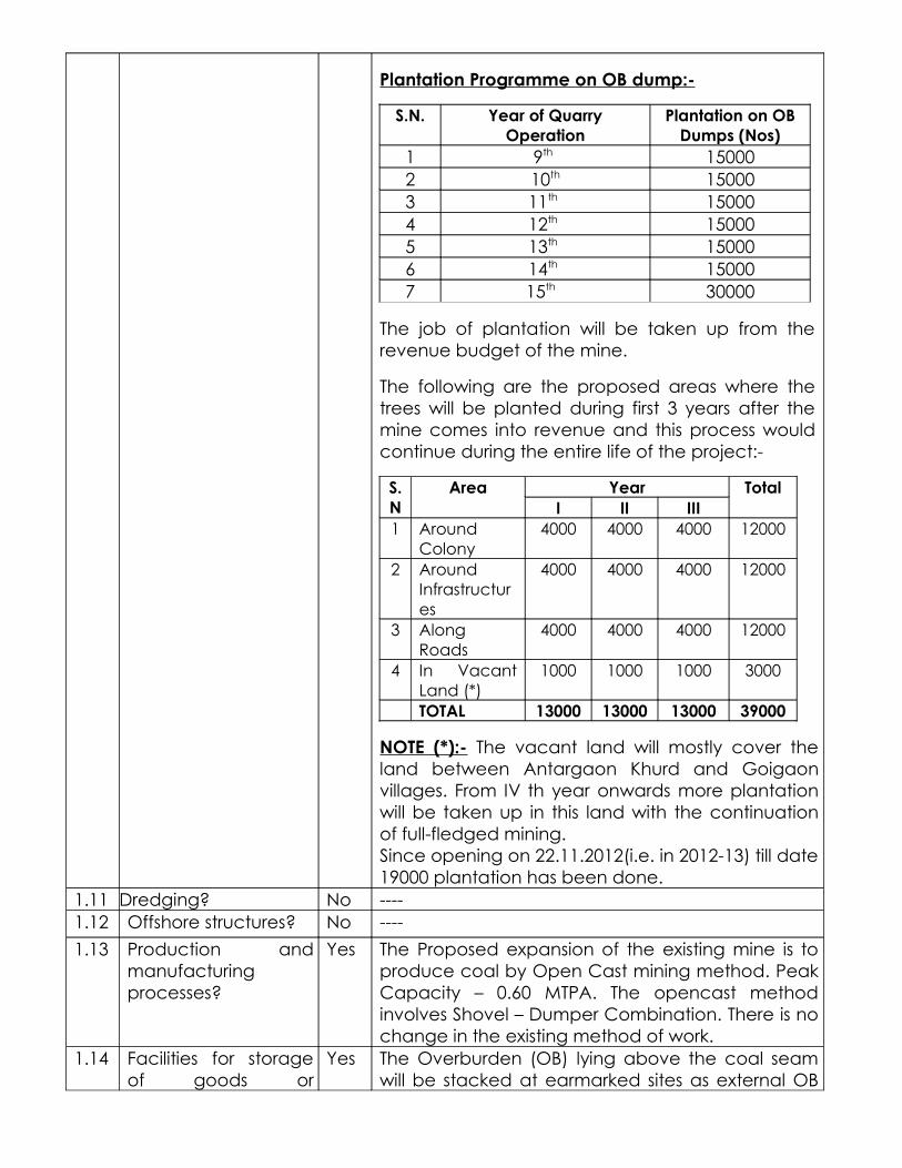
Plantation Programme on OB dump:-
S.N. Year of Quarry Operation
Plantation on OB Dumps (Nos)
1 9th 150002 10th 150003 11th 150004 12th 150005 13th 150006 14th 150007 15th 30000
The job of plantation will be taken up from the revenue budget of the mine.
The following are the proposed areas where the trees will be planted during first 3 years after the mine comes into revenue and this process would continue during the entire life of the project:-
S.N
Area Year TotalI II III
1 Around Colony
4000 4000 4000 12000
2 Around Infrastructures
4000 4000 4000 12000
3 Along Roads
4000 4000 4000 12000
4 In Vacant Land (*)
1000 1000 1000 3000
TOTAL 13000 13000 13000 39000
NOTE (*):- The vacant land will mostly cover the land between Antargaon Khurd and Goigaon villages. From IV th year onwards more plantation will be taken up in this land with the continuation of full-fledged mining.Since opening on 22.11.2012(i.e. in 2012-13) till date 19000 plantation has been done.
1.11 Dredging? No ----1.12 Offshore structures? No ----
1.13 Production and manufacturing processes?
Yes The Proposed expansion of the existing mine is to produce coal by Open Cast mining method. Peak Capacity – 0.60 MTPA. The opencast method involves Shovel – Dumper Combination. There is no change in the existing method of work.
1.14 Facilities for storage of goods or
Yes The Overburden (OB) lying above the coal seam will be stacked at earmarked sites as external OB

materials? dump and also will be accommodated in the decoaled void as internal dump. Coal will be stored in the earmarked site in the Coal Stock Yard.The storage of goods and other material are made in Designated Store. Explosives are stored in Magazine approved by Chief Controller of Explosives.
1.15 Facilities for treatment or disposal of solid waste or liquid effluents?
Yes Solid waste;SlNo
Particulars
Disposal of Solid Waste (Mm3)External OB Internal
OBTotal OB
1 Solid waste (OB)
22.87 23.94 46.81
Liquid effluent :a) Mine pumped out water: - Initial sedimentation in the mine sump provided at the floor of the seam and then treatment in sedimentation pond on surface.b) Workshop Effluent: - In designated Workshop Effluent Treatment Plant with zero discharge.
1.16 Facilities for long term housing of operational workers?
Yes Housing for operational workers has already been envisaged in the PR. There are in total 222 quarters as per details given below: -Miners Quarters – 142 nos. ‘ A’ type - 06 nos. ‘B’ Type - 41 nos ‘C’ Type – 18 nos Hostel – 15 nos.
1.17 New road, rail or sea traffic during construction or operation?
Yes New road to be constructed and used during mine life.i) Approach road from Rajura- Gadchandur Road
via Matra village - 3.5 KmService road – 1Km, Haul road – 1.2 +0.4 Km
1.18 New road, rail, air waterborne or other transport infrastructure including new or altered routes and stations, ports, airports etc?
Yes New roads as give in 1.17No altered routes as per PR.
1.19 Closure or diversion of existing transport routes or infrastructure
No ---
leading to changes in traffic movements?
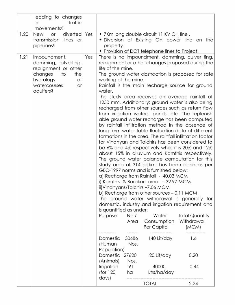
1.20 New or diverted transmission lines or pipelines?
Yes 7Km long double circuit 11 KV OH line . Diversion of Existing OH power line on the
property. Provision of DOT telephone lines to Project.
1.21 Impoundment, damming, culverting, realignment or other changes to the hydrology of watercourses or aquifers?
Yes There is no impoundment, damming, culver ting, realignment or other changes proposed during the life of the mine. The ground water abstraction is proposed for safe working of the mine.Rainfall is the main recharge source for ground water.The study area receives an average rainfall of 1250 mm. Additionally; ground water is also being recharged from other sources such as return flow from irrigation waters, ponds, etc. The replenish able ground water recharge has been computed by rainfall infiltration method in the absence of long-term water table fluctuation data of different formations in the area. The rainfall infiltration factor for Vindhyan and Talchirs has been considered to be 6% and 4% respectively while it is 20% and 12% about 15% in alluvium and Kamthis respectively. The ground water balance computation for this study area of 314 sq.km. has been done as per GEC-1997 norms and is furnished below:a) Recharge from Rainfall - 40.03 MCMi) Kamthis & Barakars area – 32.97 MCMii)Vindhyans/Talchirs –7.06 MCMb) Recharge from other sources – 0.11 MCMThe ground water withdrawal is generally for domestic, industry and irrigation requirement and is quantified as under:Purpose No./ Water Total Quantity Area Consumption Withdrawal Per Capita (MCM)---------- ------- ------------- -------------Domestic 30686 140 Lit/day 1.6(Human Nos.Population)Domestic 27620 20 Lit/day 0.20(Animals) Nos.Irrigation 91 40000 0.44(for 120 ha Ltrs/ha/daydays) -------------------------------------------------- TOTAL 2.24
In the opencast mines, the different aquifers overlying the working coal seam would be contributing ground water to the mine by gravity drainage since they are exposed/removed at the time. The anticipated ground water inflow to the mine is to the tune of 6048 m3/day at the final quarry depth of 130 m. As such, due to this pumping, cone of depression would be formed. The shape and extent of the cone would depend on mainly hydraulic conductivity and specific yield of aquifers, mine depth, area etc.Generally, steep draw-down cone would be formed in poor potential aquifers thereby the influence area is to small distance and reverse is established in respect of aquifers with high hydraulic conductivity. The radius of mine influence area has been estimated for Gouri-Deep OCM by using Sichardt formula based on the above-mentioned aquifer and mine parameters and works out to about 1000 m at final mine depth of 130 m. It may be appropriate to mention here that the presence of prominent boundaries/water bodies, faults and also inter-fringing of sandstone and shale beds may restrict the propagation of draw-down cone. Mine induced effect may be distinctly noticed within a distance of 500 m from the mine edge in the down-dip side and becomes milder/insignificant thereafter. However, the effect is limited/negligible in the up-dip side of the incrop zone due to shallow mine depth and area and further mine development is towards dip side only.Ground Water Balancei) Gross Ground Water Recharge – 40.14 MCMii) Natural Discharge to Drains and Other Losses (Approx 10% of item (i) – 4.01 MCMiii) Net Annual Ground Water Availability – 36.13 MCMiv) Allocation/Projection upto next 25 years for domestic and industrial use – 0.75 MCMv) Annual Ground Water Draft for all uses–14.93 MCMvi) Ground Water Balance (item iii, iv & v)–21.2 MCM
1.22 Stream crossings? No ---1.23 Abstraction or
transfers of water form ground or
Yes Due to excavation strata seepage water will get accumulated at the floor of the coal seam in the sump having capacity to deal with peak rainfall. In

surface waters? order to maintain the working faces dry for coal production this water is to be pumped out daily. The quantity of daily pumped out water comes to peak 6048 m3 / day at the max depth of 130m. The detailed of assessment of ground water has been given in point no 1.21.
1.24 Changes in water bodies or the land surface affecting drainage or run-off?
No --
1.25 Transport of personnel or materials for construction, operation or decommissioning?
Yes i) The personnel are using their own transport.ii) Decommissioning s not envisaged in near future
as the mine is proposed to get further deepening.
1.26 Long-term dismantling or decommissioning or restoration works?
No Proposed mine hence not envisaged at present.
1.27 Ongoing activity during decommissioning which could have an impact on the environment?
No Proposed mine hence not envisaged at present.
1.28 Influx of people to an area in either temporarily or permanently?
Yes Temporarily influx – Approximately – 3000.
1.29 Introduction of alien species?
No ---
1.30 Loss of native species or genetic diversity?
No ---
1.31 Any other actions? No

2. Use of Natural resources for construction or operation of the Project (such as land, water, materials or energy, especially any resources which are non-renewable or in short supply):
SN Information/checklist confirmation
Yes/No
Details thereof (with approximate quantities /rates, wherever possible) with source of information data
2.1 Land especially undeveloped or agricultural land (ha)
Yes There is no forestland involved in the project.Tenancy/Agri .Land = 339.43 haGiovt/Other land = 16.68 haPhysical possession of land =Nil.
2.2 Water (expected source & competing users) unit: KLD
Yes Source – Mine Pumped out Water at final depth of the quarry:-.
Quantity – 6048 KLD.
Consumption at site – 355.00 KLD.
Competing Users –
Domestic – 30686 nos - @ 140 litres/person/day – total – 1.60 Million Cubic Metre/ Year.
Domestic (Animals) – 27620 nos – @ 20 lit /day – 0.20 Million cubic meter/ Year
Irrigation - 91 ha - @ 40000 lit/ha/day for 120 days in a year – 0.44 Million cubic meter/ Year.
Existing Mine Pumping surrounding area – 11.94 Million cubic meter/ Year.
2.3 Minerals (MT) Yes / Coal
Sanctioned coal production capacity – 0.60 MTPA.
Coal Reserve = 7.66 million Tonnes.2.4
Construction material – stone,
a aggregates, sand / soil (expected source – ( MT)
Yes Requirement is as per specifications for the construction works being done as per approved PR.
2.5 Forests and timber (source – MT) No ---2.6 Energy including electricity and
fuels (source, competing users) Unit: fuel (MT), energy (MW)
Yes Electricity – Source – Maharashtra State Electricity Generation Company – MAHAGENCO. Consumption – 1.655 MW.
Diesel – 12500 litres/month2.7 Any other natural resources (use
appropriate standard units)No ----

3. Use, storage, transport, handling or production of substances or materials, which could be harmful to human health or the environment or raise concerns about actual or perceived risks to human health.
S.No.
Information/Checklist confirmation Yes/No Details thereof (with approximate quantities/rates, wherever possible) with source of information data
3.1 Use of substances or materials, which are hazardous (as per MSIHC rules) to human health or the environment (flora, fauna, and water supplies)
No ---
3.2 Changes in occurrence of disease or affect disease vectors (e.g. insect or water borne diseases)
No --
3.3 Affect the welfare of people e.g. by changing living conditions?
No --
3.4 Vulnerable groups of people who could be affected by the project e.g. hospital patients, children, the elderly etc.,
No ---
3.5 Any other cause No ---
4. Production of solid wastes during construction or operation or decommissioning (MT/month)
S.No. Information/Checklist confirmation
Yes/No Details thereof (with approximate quantities/rates, wherever possible) with source of information data
4.1 Spoil, overburden or mine wastes Yes Overburden consisting of Alluvium, Shale & Sand Stone.Total Quantity – 46.81 Million Cubic Meter.
4.2 Municipal waste (domestic and or commercial wastes)
No
4.3 Hazardous wastes (as per Hazardous Waste Management Rules)
Yes Used oil & WETP sludge will be disposed off as per Consent to Operate conditions.
4.4 Other industrial process wastes No ---4.5 Surplus product No ---
4.6 Sewage sludge or other sludge from effluent treatment
Yes WETP – 110 Cubic Metre / Year, Disposal –as per Consent to Operate Conditions.Sedimentation Pond – 600 cubic metre / Year – Disposal – through secured land fill.Kitchen Waste – 800 kg/ month , Disposal – through secured land fill.
4.7 Construction or demolition wastes No Not envisaged at present.
4.8 Redundant machinery or equipment
No Not envisaged at present.
4.9 Contaminated soils or other materials
No
4.10 Agricultural wastes No ---
4.11 Other solid wastes No ---
5. Release of pollutants or any hazardous, toxic or noxious substances to air (Kg/hr)
S.No. Information/Checklist confirmation
Yes/No Details thereof (with approximate quantities/rates, wherever possible) with source of information data
5.1 Emissions from combustion of fossil fuels from stationary or mobile sources
Yes Operation of HEMMs leads to generation of Sox and NOx. The quantum is measured through ambient air quality monitoring in the mine activity area every fortnight as per Environment Protection Amendment Rule, 2000.
5.2 Emissions from production processes
Yes Dust particles including coal dust. The quantum is measured through ambient air quality monitoring in the mine activity area every fortnight as per Environment Protection Amendment Rule, 2000.
5.3 Emissions from materials handling including storage or transport
Yes Dust particles including coal dust. The quantum is measured through ambient air quality monitoring in the mine activity area every fortnight as per Environment Protection Amendment Rule, 2000.
5.4 Emissions from construction activities including plant and equipment
No ---
5.5 Dust or odours from handling of materials including construction materials, sewage and waste
No ---
5.6 Emissions from incineration of waste
No ---
5.7 Emissions from burning of waste in open air (e.g. slash materials, construction debris)
No ---
5.8 Emissions from any other sources
No ---
6. Generation of Noise and Vibration, and Emissions of Light and Heat:
S.No. Information/Checklist confirmation
Yes/No Details thereof (with approximate quantities/rates, wherever possible) with source of information data with source of information data
6.1 From operation of equipment e.g. engines, ventilation plant, crushers
Yes Operation of HEMMs / Machineries. The quantum of Noise generation is and will continue to be measured through ambient noise quality monitoring in the mine activity area every fortnight as per Environment Protection Amendment Rule, 2000.
6.2 From industrial or similar processes
No
6.3 From construction or demolition
No
6.4 From blasting or piling Yes Blasting – InstantaneousIs and will continue to be maintained within the permissible limits as specified by DGMS.
6.5 From construction or operational traffic
Yes Operational – through movement of coal transportation trucks and dumpers. The quantum of Noise is and will continue to be measured through ambient noise quality monitoring in the mine activity area every fortnight as per Environment Protection Amendment Rule, 2000.
6.6 From lighting or cooling systems
No ---
6.7 From any other sources No ---

7. Risks of contamination of land or water from releases of pollutants into the ground or into sewers, surface waters, groundwater, coastal waters or the sea:
S.No. Information/Checklist confirmation
Yes/No Details thereof (with approximate quantities/rates, wherever possible) with source of information data
7.1 From handling, storage, use or spillage of hazardous materials
Yes Used Oil & WETP sludge will be disposed as per Consent to operate conditions.
7.2 From discharge of sewage or other effluents to water or the land (expected mode and place of discharge)
Yes The mine is yet to start and the treated mine pumped out water will be proposed to discharge into local nullah. Quality parameters will be monitored every fortnight. Quantity of Final discharge – 5918 KLD.
WETP – 110 Cubic Metre / Year , Disposal –as per Consent to Operate Conditions.
Sedimentation Pond – 600 cubic metre / Year – Disposal – as per Consent to Operate Conditions.
7.3 By deposition of pollutants emitted to air into the land or into water
Yes Fugitive emission into air from external OB dumps and coal & OB handling. Monitoring of Fugitive dust will be proposed to carry out at two locations viz. Weigh Bridge and CHP.
7.4 From any other source No ---
7.5 Is there a risk of long term build up of pollutants in the environment from these sources?
No ---
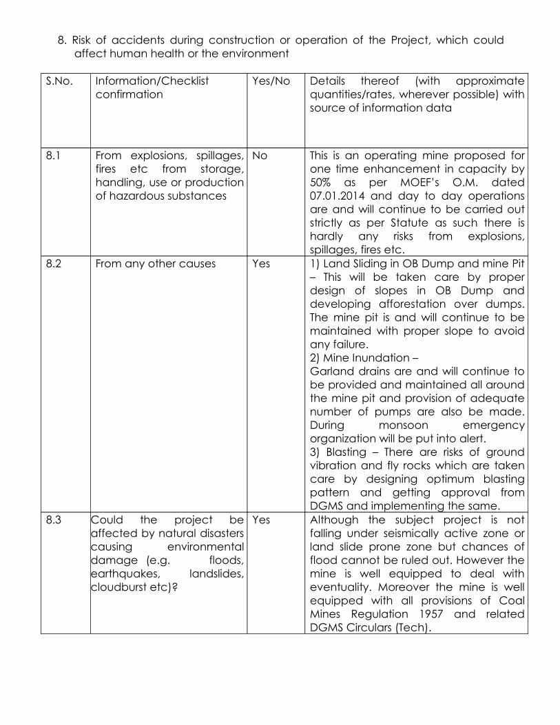
8. Risk of accidents during construction or operation of the Project, which could affect human health or the environment
S.No. Information/Checklist confirmation
Yes/No Details thereof (with approximate quantities/rates, wherever possible) with source of information data
8.1 From explosions, spillages, fires etc from storage, handling, use or production of hazardous substances
No This is an operating mine proposed for one time enhancement in capacity by 50% as per MOEF’s O.M. dated 07.01.2014 and day to day operations are and will continue to be carried out strictly as per Statute as such there is hardly any risks from explosions, spillages, fires etc.
8.2 From any other causes Yes 1) Land Sliding in OB Dump and mine Pit – This will be taken care by proper design of slopes in OB Dump and developing afforestation over dumps. The mine pit is and will continue to be maintained with proper slope to avoid any failure.2) Mine Inundation –Garland drains are and will continue to be provided and maintained all around the mine pit and provision of adequate number of pumps are also be made. During monsoon emergency organization will be put into alert.3) Blasting – There are risks of ground vibration and fly rocks which are taken care by designing optimum blasting pattern and getting approval from DGMS and implementing the same.
8.3 Could the project be affected by natural disasters causing environmental damage (e.g. floods, earthquakes, landslides, cloudburst etc)?
Yes Although the subject project is not falling under seismically active zone or land slide prone zone but chances of flood cannot be ruled out. However the mine is well equipped to deal with eventuality. Moreover the mine is well equipped with all provisions of Coal Mines Regulation 1957 and related DGMS Circulars (Tech).

9. Factors which should be considered (such as consequential development) which could lead to environmental effects or the potential for cumulative impacts with other existing or planned activities in the locality
9.1 Lead to development of supporting. ancillary development or
development stimulated by the project which could have impact on the environment e.g.:
• Supporting infrastructure (roads, power supply, waste or waste water treatment, etc.)• housing development• extractive industries• supply industries
• other
Yes Economic growth associated with coal mining activities lead to semi Urban like development. This will supports further development of ancillary and supporting industries and other related activities. The opening of this project has led to development of housing, roads, ancillary industries, Improvement in social & living standards and provides opportunities of direct & indirect employment to local community.
9.2 Lead to after-use of the site, which could have an impact on the environment
Yes The degraded land is proposed to be biologically reclaimed which will improve the green cover in the area.Out of the total land of 356.11 ha, at the end of mining of the proposed project the final land use will be as follows :-Plantation – 127.84 ha Covering 94.12 ha in External OB dump, 33.72 ha in backfilled area.Void area =58.73 ha.Infrst & colony= 15 ha.Vacant land to be released with plantation =154.54 haMoreover the facilities created during the mine operation could assume permanent residency considering the proposed future expansion of the mine with appropriate feed to sustain the growth mechanism.
9.3 Set a precedent for later developments
Activities detailed out in previous paragraphs above do culminate in conjunction with local set – up and in a number of cases has set precedence of economic development leading to overall socio – economic growth of the area.
9.4 Have cumulative effects due to proximity to other existing or planned projects with similar effects
Yes Coal occurs in layers continues for large distances. Associated mining activities with such closely located centers along with other related service sectors etc. could have an cumulative impact.
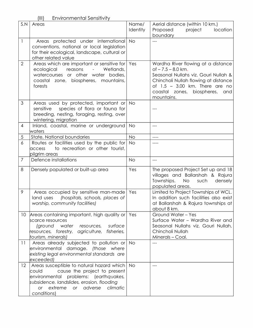
(III) Environmental SensitivityS.N Areas Name/
IdentityAerial distance (within 10 km.)Proposed project location boundary
1 Areas protected under international conventions, national or local legislation for their ecological, landscape, cultural or other related value
No ---
2 Areas which are important or sensitive for ecological reasons - Wetlands, watercourses or other water bodies, coastal zone, biospheres, mountains, forests
Yes Wardha River flowing at a distance of – 7.5 – 8.0 km.Seasonal Nullahs viz. Gouri Nullah & Chincholi Nullah flowing at distance of 1.5 – 3.00 km. There are no coastal zones, biospheres, and mountains.
3 Areas used by protected, important or sensitive species of flora or fauna for breeding, nesting, foraging, resting, over wintering, migration
No---
4 Inland, coastal, marine or underground waters
No ---
5 State, National boundaries No ----6 Routes or facilities used by the public for
access to recreation or other tourist, pilgrim areas
No ----
7 Defence installations No ---
8 Densely populated or built-up area Yes The proposed Project Set up and 18 villages and Ballarshah & Rajura Townships. No such densely populated areas.
9 Areas occupied by sensitive man-made land uses (hospitals, schools, places of worship, community facilities)
Yes Limited to Project Townships of WCL. In addition such facilities also exist at Ballarshah & Rajura townships at about 8 km.
10 Areas containing important, high quality or scarce resources (ground water resources, surface resources, forestry, agriculture, fisheries, tourism, minerals)
Yes Ground Water – YesSurface Water – Wardha River and Seasonal Nullahs viz. Gouri Nullah, Chincholi NullahMinerals – Coal.
11 Areas already subjected to pollution or environmental damage. (those where existing legal environmental standards are exceeded)
No ---
12 Areas susceptible to natural hazard which could cause the project to present environmental problems: (earthquakes, subsidence, landslides, erosion, flooding or extreme or adverse climatic conditions)
No ---

PROPOSED
TERMS OF REFERENCE
OFGOURI DEEP OPENCAST EXPANSION PROJECT
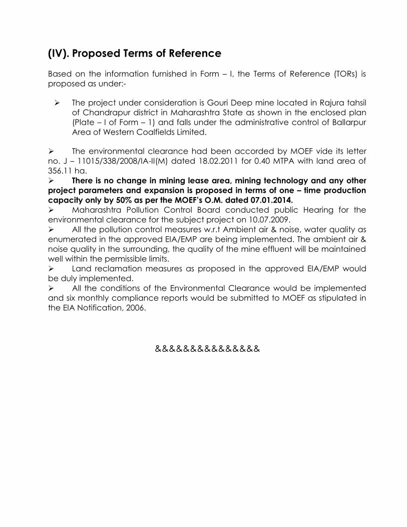
(IV). Proposed Terms of Reference
Based on the information furnished in Form – I, the Terms of Reference (TORs) is proposed as under:-
The project under consideration is Gouri Deep mine located in Rajura tahsil of Chandrapur district in Maharashtra State as shown in the enclosed plan (Plate – I of Form – 1) and falls under the administrative control of Ballarpur Area of Western Coalfields Limited.
The environmental clearance had been accorded by MOEF vide its letter no. J – 11015/338/2008/IA-II(M) dated 18.02.2011 for 0.40 MTPA with land area of 356.11 ha. There is no change in mining lease area, mining technology and any other project parameters and expansion is proposed in terms of one – time production capacity only by 50% as per the MOEF’s O.M. dated 07.01.2014. Maharashtra Pollution Control Board conducted public Hearing for the environmental clearance for the subject project on 10.07.2009. All the pollution control measures w.r.t Ambient air & noise, water quality as enumerated in the approved EIA/EMP are being implemented. The ambient air & noise quality in the surrounding, the quality of the mine effluent will be maintained well within the permissible limits. Land reclamation measures as proposed in the approved EIA/EMP would be duly implemented. All the conditions of the Environmental Clearance would be implemented and six monthly compliance reports would be submitted to MOEF as stipulated in the EIA Notification, 2006.
&&&&&&&&&&&&&&&

FEASIBILITY REPORT/
TECHNICAL REPORTOF
GOURI - DEEP OC EXPN.BALLARPUR AREA ,WCL
(For enhancement in capacity from 0.40 MTPA to 0.60 MTPA)
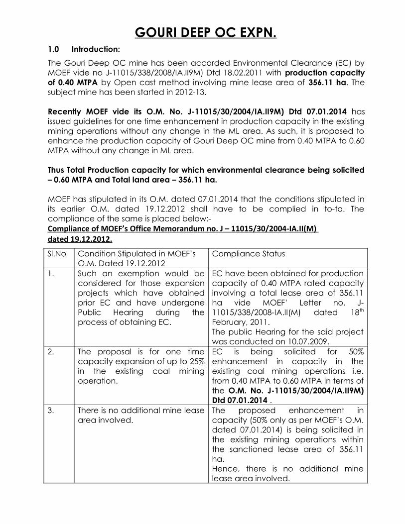
GOURI DEEP OC EXPN.1.0 Introduction:
The Gouri Deep OC mine has been accorded Environmental Clearance (EC) by MOEF vide no J-11015/338/2008/IA.II9M) Dtd 18.02.2011 with production capacity of 0.40 MTPA by Open cast method involving mine lease area of 356.11 ha. The subject mine has been started in 2012-13. Recently MOEF vide its O.M. No. J-11015/30/2004/IA.II9M) Dtd 07.01.2014 has issued guidelines for one time enhancement in production capacity in the existing mining operations without any change in the ML area. As such, it is proposed to enhance the production capacity of Gouri Deep OC mine from 0.40 MTPA to 0.60 MTPA without any change in ML area.
Thus Total Production capacity for which environmental clearance being solicited – 0.60 MTPA and Total land area – 356.11 ha.
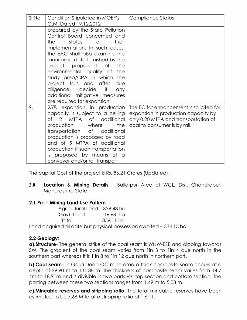
MOEF has stipulated in its O.M. dated 07.01.2014 that the conditions stipulated in its earlier O.M. dated 19.12.2012 shall have to be complied in to-to. The compliance of the same is placed below:-Compliance of MOEF’s Office Memorandum no. J – 11015/30/2004-IA.II(M) dated 19.12.2012.
Sl.No Condition Stipulated in MOEF’s O.M. Dated 19.12.2012
Compliance Status
1. Such an exemption would be considered for those expansion projects which have obtained prior EC and have undergone Public Hearing during the process of obtaining EC.
EC have been obtained for production capacity of 0.40 MTPA rated capacity involving a total lease area of 356.11 ha vide MOEF’ Letter no. J-11015/338/2008-IA.II(M) dated 18th
February, 2011.The public Hearing for the said project was conducted on 10.07.2009.
2. The proposal is for one time capacity expansion of up to 25% in the existing coal mining operation.
EC is being solicited for 50% enhancement in capacity in the existing coal mining operations i.e. from 0.40 MTPA to 0.60 MTPA in terms of the O.M. No. J-11015/30/2004/IA.II9M) Dtd 07.01.2014 .
3. There is no additional mine lease area involved.
The proposed enhancement in capacity (50% only as per MOEF’s O.M. dated 07.01.2014) is being solicited in the existing mining operations within the sanctioned lease area of 356.11 ha.Hence, there is no additional mine lease area involved.

Sl.No Condition Stipulated in MOEF’s O.M. Dated 19.12.2012
Compliance Status
4. There is no change in Mining Method (underground to Opencast)
The proposed enhancement in capacity is being solicited in the existing mining operations.Hence there is no change in the method of mining.
5. Application for the expansion project shall include a certified report of the Regional Office of the MOEF on the issues of compliance of EC conditions stipulated for the existing project for which EC for the expansion is being sought and necessary actions taken there upon by the EAC, in terms of the MOEF circular No. J -11011/618/2010-IA.II(I) dated 30.05.2012.
Regular Six- Monthly Report is sent to MOEF.Necessary application with compliance report for obtaining Certificate from MOEF, Bhopal has already been submitted.
6. Details of court cases, if any, pending in any court of law against the project as well as directions passed by any court relating to the project shall be furnished by the proponent directly to the Environment Appraisal Committee (EAC). The EAC will deliberate upon the same and the gist of the discussion will be reflected in the minutes of the EAC meeting.
Nil
7. Details of notices, if any, issued to the project under section 5 of the Environment (Protection) Act, 1986 will be reported by the proponent directly to the EAC. The EAC will deliberate upon the same and the gist of the discussion will be reflected in the minutes of the EAC meeting.
Nil
8. If the project falls in a Critically Polluted Area (CPA) wherein the moratorium has been lifted, the EAC shall examine the measures required to be implemented by the project proponent under the Environmental Action Plan
The project does not fall in the list of coal mines under Chandrapur Industrial Cluster as mentioned in the Action Plan prepared by Maharashtra Pollution Control Board (MPCB).
Sl.No Condition Stipulated in MOEF’s O.M. Dated 19.12.2012
Compliance Status
prepared by the State Pollution Control Board concerned and the status of their implementation. In such cases, the EAC shall also examine the monitoring data furnished by the project proponent of the environmental quality of the study area/CPA in which the project falls and after due diligence, decide if any additional mitigative measures are required for expansion.
9. 25% expansion in production capacity is subject to a ceiling of 2 MTPA of additional production where the transportation of additional production is proposed by road and of 5 MTPA of additional production if such transportation is proposed by means of a conveyor and/or rail transport
The EC for enhancement is solicited for expansion in production capacity by only 0.20 MTPA and transportation of coal to consumer is by rail.
The capital Cost of the project is Rs. 86.21 Crores (Updated).
2.0 Location & Mining Details – Ballarpur Area of WCL, Dist. Chandrapur, Maharashtra State.
2.1 Pre – Mining Land Use Pattern – Agricultural Land – 339.43 ha
Govt. Land - 16.68 ha Total - 356.11 haLand acquired till date but physical possession awaited – 334.13 ha.
2.2 Geology: a).Structure- The genera; strike of the coal seam is WNW-ESE and dipping towards SW. The gradient of the coal seam varies from 1in 3 to 1in 4 due north in the southern part whereas it is 1 in 8 to 1in 12 due north in northern part.
b).Coal Seam- In Gauri Deep OC mine area a thick composite seam occurs at a depth of 29.90 m to 134.38 m. The thickness of composite seam varies from 14.7 4m to 18.91m and is divisible in two parts viz. top section and bottom section. The parting between these two sections ranges from 1.49 m to 5.03 m.
c).Mineable reserves and stripping ratio: The total mineable reserves have been estimated to be 7.66 M.te at a stripping ratio of 1:6.11.

d). Target & Life- The peak production capacity of the mine is now proposed at 0.60 MTPA keeping a life of 15 years (Revenue life).
e).Mining Method- Considering the geo-mining conditions of the Gauri Deep OC i.e. steep gradient of seam variable thickness of thin parting, Shovel Dumper system of mine with horizontal slicing has been proposed. The benches will have working and nonworking width of 30 m & 20 m respectively. The maximum height of OB bench has been envisaged to be 10 m . The bench slope will be 70 degree in OB and coal. The quarry has been envisaged mine coal in 5 m slices using Backhoe Dumper combination. Mineable area has been divided into two quarries vIz. Quarry -I and Quarry-II which would be worked in a sequence such that internal dumping (in Quarry-I) is maximized. Quarry-I is envisaged to get exhausted in 15th year. But before completion of these quarry in the 9 th year Quarry-II will be opened by extending the benches at the corresponding level in Quarry-I. Backfilling in Quarry-I will start in 15th year and will continue till the end of mine life,
3.0 Geo-Mining Parameters:-
The geo-mining parameters of the proposed quarry are as under:-
S.N. Particulars Quarry - I Quarry - II1 Quarry Area (ha)
a) On Surfaceb) At Floor
44.1520.20
48.3022.35
2 Average strike length of quarry at floor (m)
1100 950
3 Average width of quarry (m)a) On Surfaceb) At Floor
390200
450240
4 Average depth of quarry (m)a) Initialb) Ultimate
42100
35130
5 Gradient of coal seam 1 in 4 1 in 36 Effective seam thickness (m) 14.00 13.507 Average thickness of OB (m)
a) At incrop side limitb) At dip side limit
3684
30115
8 Average quality of coal (Grade) ‘E’ ‘E’9 Total volume of OB including access
trench and batter (Mm3)19.54 27.27
10 Volume of OB in Access Trench (Mm3) 0.83 --11 Mineable coal reserve (Mt) 3.55 4.1112 Average stripping ratio (M3/t) 5.50 6.63
(with intermediate batter considered in Quarry – I)
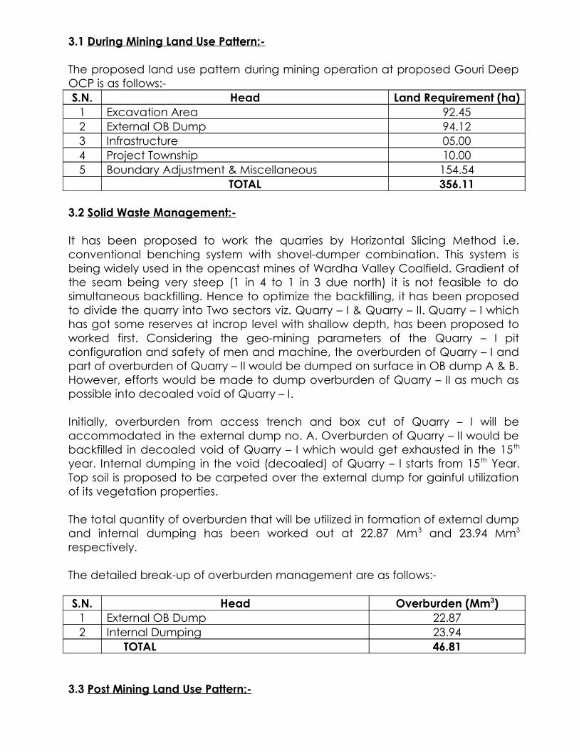
3.1 During Mining Land Use Pattern:-
The proposed land use pattern during mining operation at proposed Gouri Deep OCP is as follows:-S.N. Head Land Requirement (ha)
1 Excavation Area 92.452 External OB Dump 94.123 Infrastructure 05.004 Project Township 10.005 Boundary Adjustment & Miscellaneous 154.54
TOTAL 356.11
3.2 Solid Waste Management:-
It has been proposed to work the quarries by Horizontal Slicing Method i.e. conventional benching system with shovel-dumper combination. This system is being widely used in the opencast mines of Wardha Valley Coalfield. Gradient of the seam being very steep (1 in 4 to 1 in 3 due north) it is not feasible to do simultaneous backfilling. Hence to optimize the backfilling, it has been proposed to divide the quarry into Two sectors viz. Quarry – I & Quarry – II. Quarry – I which has got some reserves at incrop level with shallow depth, has been proposed to worked first. Considering the geo-mining parameters of the Quarry – I pit configuration and safety of men and machine, the overburden of Quarry – I and part of overburden of Quarry – II would be dumped on surface in OB dump A & B. However, efforts would be made to dump overburden of Quarry – II as much as possible into decoaled void of Quarry – I.
Initially, overburden from access trench and box cut of Quarry – I will be accommodated in the external dump no. A. Overburden of Quarry – II would be backfilled in decoaled void of Quarry – I which would get exhausted in the 15 th
year. Internal dumping in the void (decoaled) of Quarry – I starts from 15 th Year. Top soil is proposed to be carpeted over the external dump for gainful utilization of its vegetation properties.
The total quantity of overburden that will be utilized in formation of external dump and internal dumping has been worked out at 22.87 Mm3 and 23.94 Mm3
respectively.
The detailed break-up of overburden management are as follows:-
S.N. Head Overburden (Mm3)1 External OB Dump 22.872 Internal Dumping 23.94
TOTAL 46.81
3.3 Post Mining Land Use Pattern:-

The post-mining land use pattern at Gouri Deep OCP (Gouri Block) will be as follows:-S.N. Particulars Land in ha Land in ha
1 Afforested Area:b) Backfilling Areac) External OB Dump
33.7294.12
127.84
2 Water Body / Void 58.733 Vacant land to be release with plantation 154.544 Infrastructure 05.005 Township 10.00
TOTAL 356.11
3.4 Plantation Programme:-
S.N. Year of Quarry Operation Plantation on OB Dumps (Nos)1 9th 150002 10th 150003 11th 150004 12th 150005 13th 150006 14th 150007 15st 30000
The job of plantation will be taken up from the revenue budget of the mine.
The following are the proposed areas where the trees will be planted during first 3 years after the mine comes into revenue and this process would continue during the entire life of the project:-S.N. Area Year Total
I II III1 Around Colony 4000 4000 4000 120002 Around Infrastructures 4000 4000 4000 120003 Along Roads 4000 4000 4000 120004 In Vacant Land (*) 1000 1000 1000 3000
TOTAL 13000 13000 13000 39000
NOTE (*):- The vacant land will mostly cover the land between Antargaon Khurd and Goigaon villages. From IV th year onwards more plantation will be taken up in this land with the continuation of full fledged mining.
Proposed Width of Green Belt:-
a) Along the roads, 1000 saplings per km of road length in two rows on both sides of the road creating 3.0 m wide green belt on either side.
b) Around colony and infrastructure @ 2500 saplings per ha in 3 rows of plantation all around the available suitable spaces will be done keeping the width of green belt as 5.0 m.

c) In vacant land, @ 2500 saplings per ha in 2 m X 3 m grid in order to develop green patches.
Species to be Planted:- Native Species.
Date of opening of the mine – 22.11.2012.
Production of coal in 2012-13 – 22,800 tonne
Excavation of OB in 2012-13 – 11,90,580 cubic metre
Production of coal in 2013-14 – 4,00, 000 tonne (as per EC)
Excavation of OB in 2013-14 – 39, 01,500 cubic metre.
4.0 Ambient Air & Noise Quality:-
Ambient Air Quality Monitoring Locations :
S.No. Location Details Location Code
1.2.3.4.
Manager Office Mutra villageGoye Gaon VillageAntra Gaon Village
----
BGdOA-1BGOA-2BGOA-3BGOA-4
Noise Level Monitoring Location :
S.No. Location Details Location Code
1..
CHP - BGON-1
AIR QUALITY MONITORING DATA
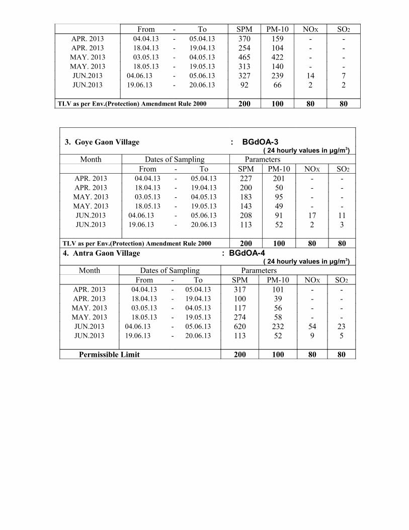
NAME OF THE COMPANY : WCL YEAR : 2013NAME OF THE AREA : BALLARPUR Q.E. : JUN.NAME OF THE PROJECT : GOURI Deep OC
1. Manager Office : BGdOA-1 ( 24 hourly values in μg/m3)
Month Dates of Sampling ParametersFrom - To SPM PM-10 NOX SO2
APR. 2013 04.04.13 - 05.04.13 318 237 - -APR. 2013 18.04.13 - 19.04.13 189 146 - -MAY. 2013 03.05.13 - 04.05.13 146 48 - -MAY. 2013 18.05.13 - 19.05.13 314 69 - -JUN.2013 19.06.13 - 20.06.13 40 38 6 6
TLV as per Env.(Protection) Amendment Rule 2000
600 300 120 120
2. Mutra Village : BGdOA-2 ( 24 hourly values in μg/m3)
Month Dates of Sampling Parameters
From - To SPM PM-10 NOX SO2
APR. 2013 04.04.13 - 05.04.13 370 159 - -APR. 2013 18.04.13 - 19.04.13 254 104 - -MAY. 2013 03.05.13 - 04.05.13 465 422 - -MAY. 2013 18.05.13 - 19.05.13 313 140 - -JUN.2013 04.06.13 - 05.06.13 327 239 14 7JUN.2013 19.06.13 - 20.06.13 92 66 2 2
TLV as per Env.(Protection) Amendment Rule 2000 200 100 80 80
3. Goye Gaon Village : BGdOA-3 ( 24 hourly values in μg/m3)
Month Dates of Sampling ParametersFrom - To SPM PM-10 NOX SO2
APR. 2013 04.04.13 - 05.04.13 227 201 - -APR. 2013 18.04.13 - 19.04.13 200 50 - -MAY. 2013 03.05.13 - 04.05.13 183 95 - -MAY. 2013 18.05.13 - 19.05.13 143 49 - -JUN.2013 04.06.13 - 05.06.13 208 91 17 11JUN.2013 19.06.13 - 20.06.13 113 52 2 3
TLV as per Env.(Protection) Amendment Rule 2000 200 100 80 80 4. Antra Gaon Village : BGdOA-4
( 24 hourly values in μg/m3)Month Dates of Sampling Parameters
From - To SPM PM-10 NOX SO2
APR. 2013 04.04.13 - 05.04.13 317 101 - -APR. 2013 18.04.13 - 19.04.13 100 39 - -MAY. 2013 03.05.13 - 04.05.13 117 56 - -MAY. 2013 18.05.13 - 19.05.13 274 58 - -JUN.2013 04.06.13 - 05.06.13 620 232 54 23JUN.2013 19.06.13 - 20.06.13 113 52 9 5
Permissible Limit 200 100 80 80
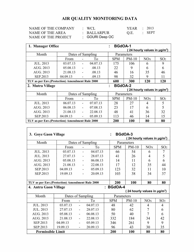
AIR QUALITY MONITORING DATA
NAME OF THE COMPANY : WCL YEAR : 2013NAME OF THE AREA : BALLARPUR Q.E. : SEPTNAME OF THE PROJECT : GOURI Deep OC
1. Manager Office : BGdOA-1 ( 24 hourly values in μg/m3)
Month Dates of Sampling ParametersFrom - To SPM PM-10 NOX SO2
JUL. 2013 03.07.13 - 04.07.13 175 106 6 9AUG. 2013 05.08.13 - .08.13 22 9 6 6AUG. 2013 21.08.13 - .08.13 46 16 35 46SEP.2013 04.09.13 - .09.13 98 32 9 11
TLV as per Env.(Protection) Amendment Rule 2000 600 300 120 120 2. Mutra Village : BGdOA-2
( 24 hourly values in μg/m3)Month Dates of Sampling Parameters
From - To SPM PM-10 NOX SO2
JUL. 2013 06.07.13 - 07.07.13 28 27 4 5AUG. 2013 06.08.13 - 07.08.13 23 17 6 5AUG. 2013 21.08.13 - 22.08.13 48 41 36 32SEP.2013 04.09.13 - 05.09.13 113 46 14 15
TLV as per Env.(Protection) Amendment Rule 2000 200 100 80 80
3. Goye Gaon Village : BGdOA-3 ( 24 hourly values in μg/m3)
Month Dates of Sampling ParametersFrom - To SPM PM-10 NOX SO2
JUL. 2013 03.07.13 - 04.07.13 66 54 6 7JUL. 2013 27.07.13 - 28.07.13 41 26 4 5AUG. 2013 05.08.13 - 06.08.13 14 11 6 6AUG. 2013 21.08.13 - 22.08.13 17 12 35 44SEP.2013 04.09.13 - 05.09.13 123 32 11 10SEP.2013 19.09.13 - 20.09.13 103 38 34 37
TLV as per Env.(Protection) Amendment Rule 2000 200 100 80 80 4. Antra Gaon Village : BGdOA-4
( 24 hourly values in μg/m3)
Month Dates of Sampling ParametersFrom - To SPM PM-10 NOX SO2
JUL. 2013 03.07.13 - 04.07.13 48 42 4 4JUL. 2013 27.07.13 - 28.07.13 80 62 7 6AUG. 2013 05.08.13 - 06.08.13 50 40 7 6AUG. 2013 21.08.13 - 22.08.13 332 184 34 42SEP.2013 04.09.13 - 05.09.13 346 261 9 9SEP.2013 19.09.13 - 20.09.13 96 43 30 35
Permissible Limit 200 100 80 80
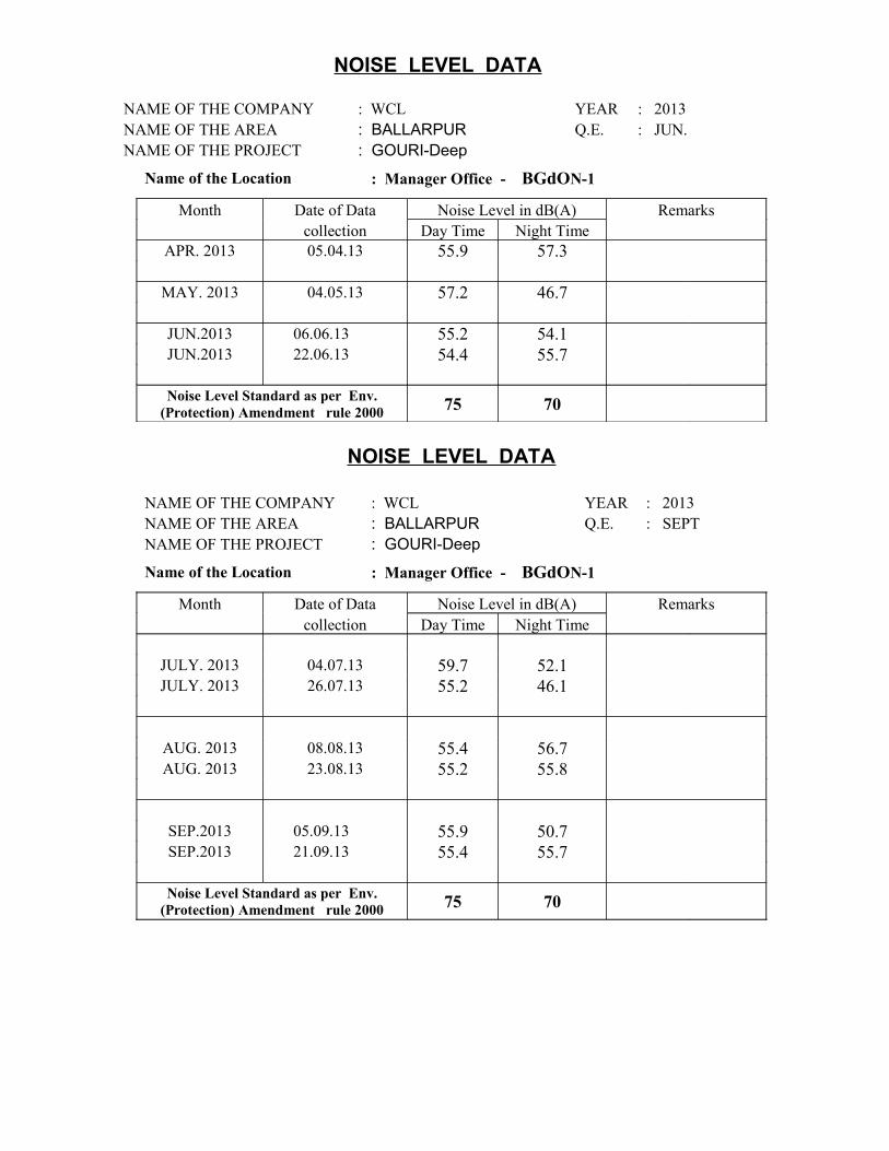
NOISE LEVEL DATA
NAME OF THE COMPANY : WCL YEAR : 2013NAME OF THE AREA : BALLARPUR Q.E. : JUN.NAME OF THE PROJECT : GOURI-Deep
Name of the Location : Manager Office - BGdON-1
Month Date of Data Noise Level in dB(A) Remarks collection Day Time Night Time
APR. 2013 05.04.13 55.9 57.3
MAY. 2013 04.05.13 57.2 46.7
JUN.2013 06.06.13 55.2 54.1JUN.2013 22.06.13 54.4 55.7
Noise Level Standard as per Env.
(Protection) Amendment rule 2000 75 70
NOISE LEVEL DATA
NAME OF THE COMPANY : WCL YEAR : 2013NAME OF THE AREA : BALLARPUR Q.E. : SEPTNAME OF THE PROJECT : GOURI-Deep
Name of the Location : Manager Office - BGdON-1
Month Date of Data Noise Level in dB(A) Remarks collection Day Time Night Time
JULY. 2013 04.07.13 59.7 52.1JULY. 2013 26.07.13 55.2 46.1
AUG. 2013 08.08.13 55.4 56.7AUG. 2013 23.08.13 55.2 55.8
SEP.2013 05.09.13 55.9 50.7SEP.2013 21.09.13 55.4 55.7
Noise Level Standard as per Env.
(Protection) Amendment rule 2000 75 70
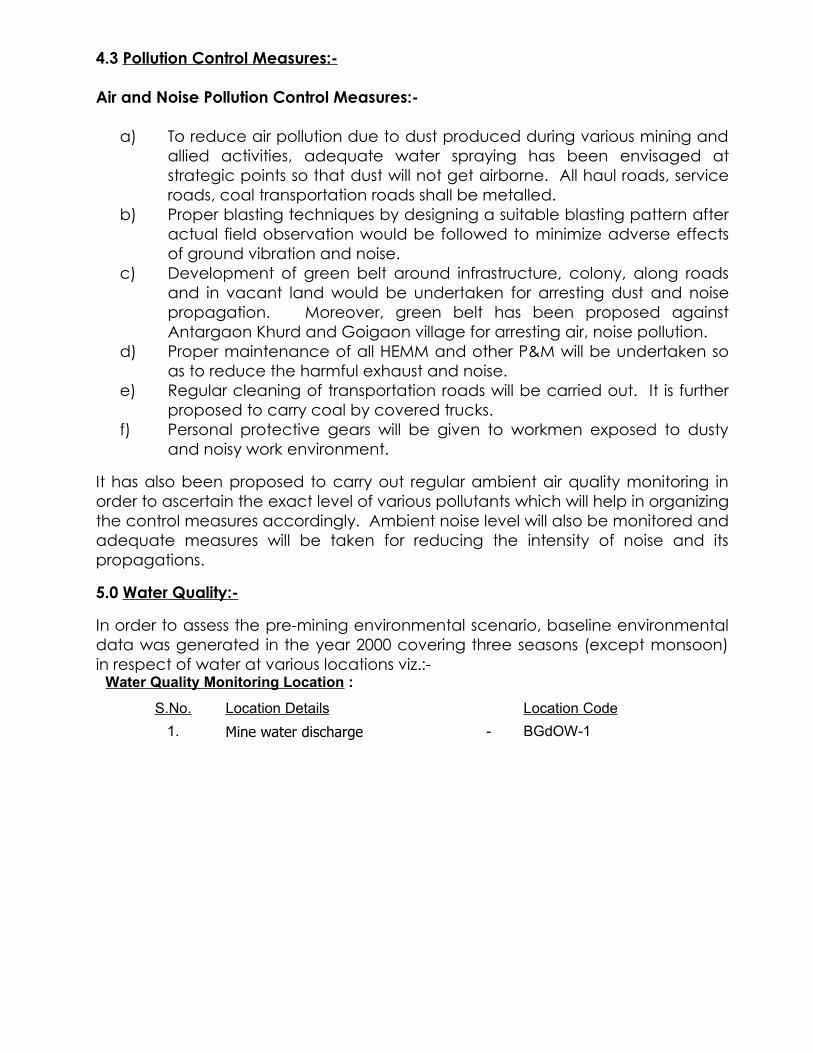
4.3 Pollution Control Measures:-
Air and Noise Pollution Control Measures:-
a) To reduce air pollution due to dust produced during various mining and allied activities, adequate water spraying has been envisaged at strategic points so that dust will not get airborne. All haul roads, service roads, coal transportation roads shall be metalled.
b) Proper blasting techniques by designing a suitable blasting pattern after actual field observation would be followed to minimize adverse effects of ground vibration and noise.
c) Development of green belt around infrastructure, colony, along roads and in vacant land would be undertaken for arresting dust and noise propagation. Moreover, green belt has been proposed against Antargaon Khurd and Goigaon village for arresting air, noise pollution.
d) Proper maintenance of all HEMM and other P&M will be undertaken so as to reduce the harmful exhaust and noise.
e) Regular cleaning of transportation roads will be carried out. It is further proposed to carry coal by covered trucks.
f) Personal protective gears will be given to workmen exposed to dusty and noisy work environment.
It has also been proposed to carry out regular ambient air quality monitoring in order to ascertain the exact level of various pollutants which will help in organizing the control measures accordingly. Ambient noise level will also be monitored and adequate measures will be taken for reducing the intensity of noise and its propagations.
5.0 Water Quality:-
In order to assess the pre-mining environmental scenario, baseline environmental data was generated in the year 2000 covering three seasons (except monsoon) in respect of water at various locations viz.:-
Water Quality Monitoring Location :
S.No. Location Details Location Code
1. Mine water discharge - BGdOW-1
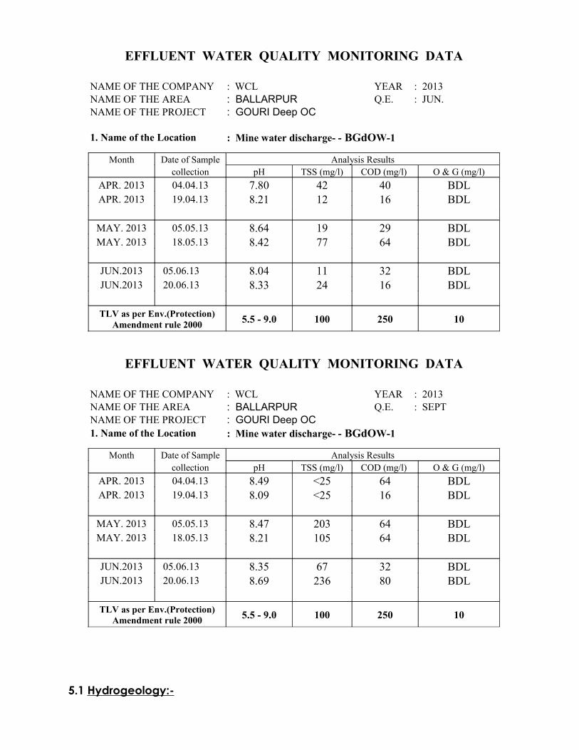
EFFLUENT WATER QUALITY MONITORING DATA
NAME OF THE COMPANY : WCL YEAR : 2013NAME OF THE AREA : BALLARPUR Q.E. : JUN.NAME OF THE PROJECT : GOURI Deep OC
1. Name of the Location : Mine water discharge- - BGdOW-1
Month Date of Sample Analysis Results collection pH TSS (mg/l) COD (mg/l) O & G (mg/l)
APR. 2013 04.04.13 7.80 42 40 BDLAPR. 2013 19.04.13 8.21 12 16 BDL
MAY. 2013 05.05.13 8.64 19 29 BDLMAY. 2013 18.05.13 8.42 77 64 BDL
JUN.2013 05.06.13 8.04 11 32 BDLJUN.2013 20.06.13 8.33 24 16 BDL
TLV as per Env.(Protection)
Amendment rule 2000 5.5 - 9.0 100 250 10
EFFLUENT WATER QUALITY MONITORING DATA
NAME OF THE COMPANY : WCL YEAR : 2013NAME OF THE AREA : BALLARPUR Q.E. : SEPTNAME OF THE PROJECT : GOURI Deep OC1. Name of the Location : Mine water discharge- - BGdOW-1
Month Date of Sample Analysis Results collection pH TSS (mg/l) COD (mg/l) O & G (mg/l)
APR. 2013 04.04.13 8.49 <25 64 BDLAPR. 2013 19.04.13 8.09 <25 16 BDL
MAY. 2013 05.05.13 8.47 203 64 BDLMAY. 2013 18.05.13 8.21 105 64 BDL
JUN.2013 05.06.13 8.35 67 32 BDLJUN.2013 20.06.13 8.69 236 80 BDL
TLV as per Env.(Protection)
Amendment rule 2000 5.5 - 9.0 100 250 10
5.1 Hydrogeology:-
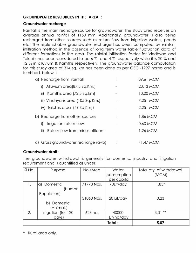
GROUNDWATER RESOURCES IN THE AREA :
Groundwater recharge
Rainfall is the main recharge source for groundwater. The study area receives an average annual rainfall of 1150 mm. Additionally, groundwater is also being recharged from other sources such as return flow from irrigation waters, ponds etc. The replenishable groundwater recharge has been computed by rainfall-infiltration method in the absence of long term water table fluctuation data of different formations in the area. The rainfall-infiltration factor for Vindhyan and Talchirs has been considered to be 6 % and 4 % respectively while it is 20 % and 12 % in alluvium & Kamthis respectively. The groundwater balance computation for this study area of 314 sq. km has been done as per GEC -1997 norms and is furnished below :-
a) Recharge from rainfall : 39.61 MCM
i) Alluvium area(87.5 Sq.Km.) - 20.13 MCM
ii) Kamthis area (72.5 Sq.km) - 10.00 MCM
iii) Vindhyans area (105 Sq. Km.) - 7.25 MCM
iv) Talchirs area (49 Sq.Km)) - 2.25 MCM
b) Recharge from other sources : 1.86 MCM
i) Irrigation return flow - 0.60 MCM
ii) Return flow from mines effluent - 1.26 MCM
c) Gross groundwater recharge (a+b) : 41.47 MCM
Groundwater draft :
The groundwater withdrawal is generally for domestic, industry and irrigation requirement and is quantified as under.
Sl No. Purpose No./Area Water consumption
per capita
Total qty. of withdrawal (MCM)
1. a) Domestic (Human Population)
b) Domestic (Animals)
71778 Nos.
31060 Nos.
70Lit/day
20 Lit/day
1.83*
0.23
2. Irrigation (for 120 days)
628 ha. 40000 Lit/ha/day
3.01 **
Total : 5.07
* Rural area only.
** Reasonable match with the draft arrived based on total irrigation dugwells/ borewells and the assigned unit annual draft.
In addition to the above, groundwater extraction is being done by the six existing mines (5 OCM + 1 UG) in the area south of the Wardha river and is to the tune of 6.30 MCM. Thus the total groundwater draft comes to 11.37 MCM. The two mines in the area north of Wardha river are also pumping meager quantity of groundwater and the quantity being pumped is utilised mostly for sandstowing, dust suppression, plantation/green belt development, water supply etc. Major portion of mine effluent is being reused/ recycled. Further, the mines area is not totally in this buffer zone. Hence, not considered in this computation.
Groundwater balance :
i) Gross groundwater recharge : 41.47 MCM
ii) Natural discharge to drains & other
losses (Approx.10 % of item (i) ) : 4.15 MCM
iii) Net annual groundwater availability : 37.32 MCM
iv) Allocation/ projection upto next
25 years for domestic & industrial use : 1.38 MCM
v) Annual groundwater draft for all uses : 11.37 MCM
vi) Groundwater balance (Item iii-iv & v) : 24.57 MCM
Level/stage of groundwater development :
Groundwater withdrawal/utilisation is mainly for domestic and irrigation use in the study area. The level/stage of groundwater development computation in the present study is 30.46 % which can be categorized as "Safe" with less than 70% value. As per GSDA and CGWB report on Chandrapur of Maharashtra, the net annual groundwater availability is to the tune of 117.41 MCM in Rajura tehsil whereas the gross groundwater draft for all uses is around 14.32 MCM (Annexure-IV). The stage of groundwater development in Rajura tehsil in which Gouri Deep OC OCM and its buffer zone located is 12.20 % and classified as "Safe" category.
5.2 Water Pollution Control Measures:-
a) Domestic Effluent :
The effluent from residential houses and service buildings are proposed to be treated in a suitable sewage treatment disposal plant.
b) Mine Discharge :
Water collected near workings will first be allowed to settle in sumps. Sufficiently large sumpage has been proposed to eliminate the discharge of suspended solids on the surface along with mine water. It will then be passed through a sedimentation pond.
The final discharge has been proposed to be utilized for various purposes like water spraying, watering of plants, HEMM washing etc. It is proposed to put the water in a closed water circuit for its recycling and reuse. The balance treated water then can be used for supplementing the shortage of water in the nearby villages. It has, therefore, been proposed to regularly monitor the quality of mine water discharge and if any undesirable element is found in the sample, it will be treated properly.
c) Effluent from Workshop, etc. :
Entire effluent from workshop will be passed through a settling tank with oil & grease trap arrangements. Clear water thus collected will be recycled on the closed water circuit for its reuse.
6.0 Rehabilitation & Resettlement:-
6.1 Rehabilitation:-
There is no house oustees involved in this project. As such, resettlement of house oustees is not required to be done. Rehabilitation involves only for land oustees.
6.2 Land Oustees:-The project has not been started as yet because the physical possession of land could not be taken in spite of the fact that acquisition process has been completed. There is no resettlement of house oustees involved in the project.
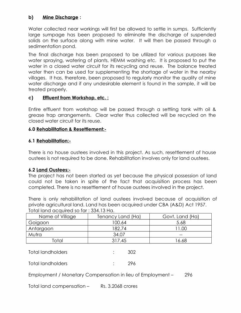
There is only rehabilitation of land oustees involved because of acquisition of private agricultural land. Land has been acquired under CBA (A&D) Act 1957.Total land acquired so far : 334.13 Ha.
Name of Village Tenancy Land (Ha) Govt. Land (Ha)Goigaon 100.64 5.68Antargaon 182.74 11.00Mutra 34.07 --
Total 317.45 16.68
Total landholders : 302
Total landholders : 296
Employment / Monetary Compensation in lieu of Employment – 296
Total land compensation – Rs. 3.2068 crores
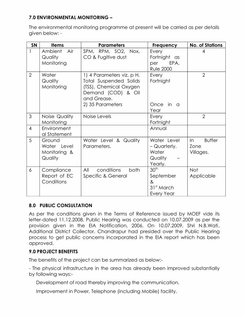
7.0 ENVIRONMENTAL MONITORING –
The environmental monitoring programme at present will be carried as per details given below: -
SN Items Parameters Frequency No. of Stations1 Ambient Air
Quality Monitoring
SPM, RPM, SO2, Nox, CO & Fugitive dust
Every Fortnight as per EPA, Rule 2000
4
2 Water Quality Monitoring
1) 4 Parameters viz. p H, Total Suspended Solids (TSS), Chemical Oxygen Demand (COD) & Oil and Grease.2) 35 Parameters
Every Fortnight
Once in a Year
2
3 Noise Quality Monitoring
Noise Levels Every Fortnight
2
4 Environmental Statement
Annual
5 Ground Water Level Monitoring & Quality
Water Level & Quality Parameters.
Water Level – Quarterly.Water Quality – Yearly.
In Buffer Zone Villages.
6 Compliance Report of EC Conditions
All conditions both Specific & General
30th
September & 31st MarchEvery Year
Not Applicable
8.0 PUBLIC CONSULTATION
As per the conditions given in the Terms of Reference issued by MOEF vide its letter-dated 11.12.2008, Public Hearing was conducted on 10.07.2009 as per the provision given in the EIA Notification, 2006. On 10.07.2009, Shri N.B.Wati , Additional District Collector, Chandrapur had presided over the Public Hearing process to get public concerns incorporated in the EIA report which has been approved.
9.0 PROJECT BENEFITS
The benefits of the project can be summarized as below:-
- The physical infrastructure in the area has already been improved substantially by following ways:-
Development of road thereby improving the communication.
Improvement in Power, Telephone (including Mobile) facility.
Improvement in Health Care facility & Educational facility.
Improvement in Market / Trade & Business.
- The social infrastructure by way of cultural mixing of people of other states with local community glorifying “UNITY IN DIVERSITY”.
- Substantial employment in the project & indirect employment for business & trading, contractor, transportation, vehicle contractor, nursery development.
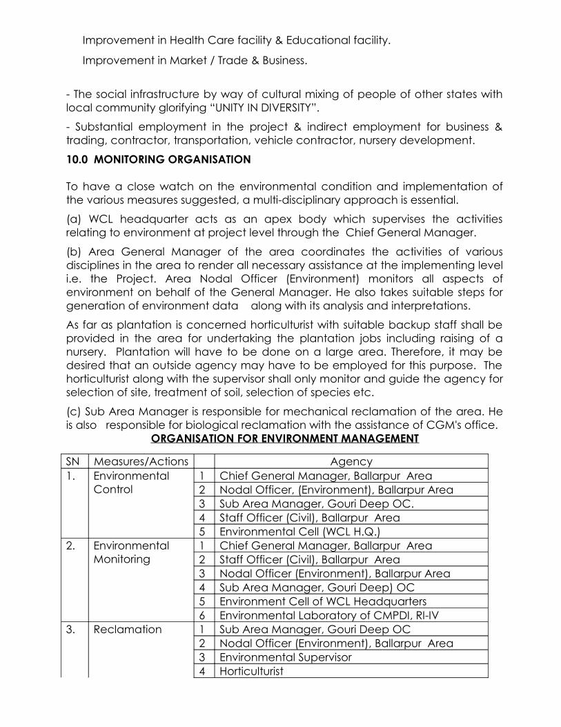
10.0 MONITORING ORGANISATION
To have a close watch on the environmental condition and implementation of the various measures suggested, a multi-disciplinary approach is essential.
(a) WCL headquarter acts as an apex body which supervises the activities relating to environment at project level through the Chief General Manager.
(b) Area General Manager of the area coordinates the activities of various disciplines in the area to render all necessary assistance at the implementing level i.e. the Project. Area Nodal Officer (Environment) monitors all aspects of environment on behalf of the General Manager. He also takes suitable steps for generation of environment data along with its analysis and interpretations.
As far as plantation is concerned horticulturist with suitable backup staff shall be provided in the area for undertaking the plantation jobs including raising of a nursery. Plantation will have to be done on a large area. Therefore, it may be desired that an outside agency may have to be employed for this purpose. The horticulturist along with the supervisor shall only monitor and guide the agency for selection of site, treatment of soil, selection of species etc.
(c) Sub Area Manager is responsible for mechanical reclamation of the area. He is also responsible for biological reclamation with the assistance of CGM's office.
ORGANISATION FOR ENVIRONMENT MANAGEMENT
SN Measures/Actions Agency1. Environmental
Control1 Chief General Manager, Ballarpur Area2 Nodal Officer, (Environment), Ballarpur Area3 Sub Area Manager, Gouri Deep OC.4 Staff Officer (Civil), Ballarpur Area5 Environmental Cell (WCL H.Q.)
2. Environmental Monitoring
1 Chief General Manager, Ballarpur Area2 Staff Officer (Civil), Ballarpur Area3 Nodal Officer (Environment), Ballarpur Area4 Sub Area Manager, Gouri Deep) OC5 Environment Cell of WCL Headquarters6 Environmental Laboratory of CMPDI, RI-IV
3. Reclamation 1 Sub Area Manager, Gouri Deep OC2 Nodal Officer (Environment), Ballarpur Area3 Environmental Supervisor4 Horticulturist

11.0 Environment Cost:-
11.1 Total Capital Cost (Rs. In Lakhs):-
S.N. Item Total Price Life in Price Depreciation1 Cost of HEMM for land
reclamation134.15 9 14.91
2 Sewerage arrangement 41.41 21 1.973 Sedimentation pond for
treatment of mine water discharge & oil & grease trap for workshop effluents
9.00 21 0.43
4 Socio-economic survey 1.00 21 0.05Total 185.56 17.36
11.2 Revenue Cost:-
As per the approved Project Report Rs. 3.00/t of coal has been kept for this purpose to cater for the following:-
(Rs. In Lakhs)S.N. Items Amount
1 Plantation/Green Belt Development/Biological Reclamation of OB Dump and Backfilled Area
8.00
2 Environmental Monitoring 2.003 Land Reclamation Measures & Miscellaneous4 Social Developmental Activities 1.505 Environmental Pollution Control Measures & Maintenance
of the system0.50
Total 12.00
*************

ENVIRONMENTAL IMPACT ASSESSMENT
&ENVIRONMENTAL
MANAGEMENT PLAN
CHAPTER – I
ANTICIPATED ENVIRONMENTAL IMPACTS &
MITIGATION MEASURES
1.0 IMPACT ASSESSMENT AND MITIGATIVE MEASURES
1.1 AIR POLLUTION IMPACT ASSESSMENT
The impact assessment has been carried out dealing with the following points:
(a) Phase-wise inventory of air pollution emission sources(b) Impact assessment
a. Phase-wise inventory of air pollution emission sources
The pollution sources are obvious and to assess the impact, the project life is divided into following time frames:
Operation phasePost-Operational stage
The activities associated with these time frames and having impact on the ambient air quality along with the pollutants are enumerated in the following sections:
Operational phase
During this phase, activities necessary for mining of coal, its handling and transport are taken up. Such activities having impact on ambient air quality are detailed below:
(i) Drilling : Dust
(ii) Blasting of coal and overburden
: Dust and noxious gases
(iii) Handling of coal : Dust and noxious gases
(iv) Overburden handling : Dust and noxious gases
(v) Dump formation (internal) : Dust and exhaust fumes from dumpers and dust till the development of green cover
(vi) Movement of vehicles : Dust and noxious fumes
Post-Operational stage
During this stage of the project, the activities related to the closure of mine are to be carried out. Preparation of mine closure plan shall be carried out during the period four to five years before the closure of the mine. Some of the activities for the closure are:
Modifications in physical and biological reclamation of backfilled area Salvaging and shifting operation of HEMMs and other equipment Clearing of coal and other materials, restoration of infrastructure area & colony area to the extent possible and necessary if not useful for other projects Management of hydrology and hydrogeology, redeployment of workforce, etc, arrangement & implementation of post-operation monitoring mainly keeping watch, vigil, etc.
The activities having impact on the ambient air quality are enumerated below:
(i) Movement of HEMMs for physical reclamation of backfilled area
: Dust and obnoxious fumes
(ii) Movement of vehicles for shifting and salvaging operation of HEMMs and other equipment
: Dust and obnoxious fumes
(iii) Movement of vehicles for clearing of coal and other materials
: Dust and obnoxious gases
b. Impact assessment
The mining and its related activities create ambient air pollution. The impact of mining on ambient air quality is highlighted in the following paragraphs:
The ambient air quality is influenced due to the presence of PM10, PM2.5, SO2, NOx, etc., which are generated due to various activities like drilling, blasting and handling related to the project. Further, the ambient air quality is affected marginally to a varying degree due to the mining activities of other nearby opencast and underground coalmines of the same coalfield. The concentration of pollutants may vary depending upon the various micro-meteorological parameters and the seasons of a year.
The baseline ambient air quality data generated surrounding the site of Gouri Deep OC before start of mining activities were discussed in the approved EIA/EMP (EC obtained on 18.02.2011) and it shows that the levels of various pollutants were within the permissible limits.
Now, with the start of the project, there is likelihood of addition of pollution to the existing concentration level of different attributes of ambient air. Efforts will be made by implementation of proper abatement measures so as to maintain the sinking capacity of ambient air to absorb the Additional load, if any, thereby
maintaining the quality of ambient air to the pre – mining level to the extent possible.
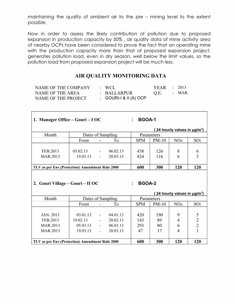
Now in order to assess the likely contribution of pollution due to proposed expansion in production capacity by 50% , air quality data of mine activity area of nearby OCPs have been considered to prove the fact that an operating mine with the production capacity more than that of proposed expansion project, generates pollution load, even in dry season, well below the limit values, so the pollution load from proposed expansion project will be much less.
AIR QUALITY MONITORING DATA
NAME OF THE COMPANY : WCL YEAR : 2013NAME OF THE AREA : BALLARPUR Q.E. : MAR.NAME OF THE PROJECT : GOURI-I & II (A) OCP
1. Manager Office – Gouri – I OC : BGOA-1
( 24 hourly values in μg/m3)Month Dates of Sampling Parameters
From - To SPM PM-10 NOX SO2
FEB.2013 05.02.13 - 06.02.13 438 126 8 6MAR.2013 19.03.13 - 20.03.13 424 116 6 3
TLV as per Env.(Protection) Amendment Rule 2000 600 300 120 120
2. Gouri Village – Gouri – II OC : BGOA-2
( 24 hourly values in μg/m3)Month Dates of Sampling Parameters
From - To SPM PM-10 NOX SO2
JAN. 2013 03.01.13 - 04.01.13 420 190 9 5FEB.2013 19.02.13 - 20.02.13 143 89 4 2MAR.2013 05.03.13 - 06.03.13 293 80 6 2MAR.2013 19.03.13 - 20.03.13 47 17 4 1
TLV as per Env.(Protection) Amendment Rule 2000 600 300 120 120
3. SAM Office – Gouri Sub Area : BGOA-3 ( 24 hourly values in μg/m3)
Month Dates of Sampling ParametersFrom - To SPM PM-10 NOX SO2
JAN. 2013 17.01.13 - 18.01.13 99 53 6 3FEB.2013 19.02.13 - 20.02.13 167 77 8 5
TLV as per Env.(Protection) Amendment Rule 2000 600 300 120 120 4. Gouri Colony / Filter Plant : BGOA-4
( 24 hourly values in μg/m3)Month Dates of Sampling Parameters
From - To SPM PM-10 NOX SO2
JAN. 2013 17.01.13 - 18.01.13 169 89 8 5FEB.2013 20.02.13 - 21.02.13 176 75 6 2
Permissible Limit 200 100 80 80
AIR QUALITY MONITORING DATA
NAME OF THE COMPANY : WCL YEAR : 2013NAME OF THE AREA : BALLARPUR Q.E. : JUN.NAME OF THE PROJECT : GOURI-I & II (A) OCP
1. Manager Office – Gouri – I OC : BGOA-1 ( 24 hourly values in μg/m3)
Month Dates of Sampling ParametersFrom - To SPM PM-10 NOX SO2
APR. 2013 05.04.13 - 06.04.13 615 533 - -APR. 2013 19.04.13 - 20.04.13 340 123 - -MAY. 2013 05.05.13 - 06.05.13 519 149 - -MAY. 2013 19.05.13 - 20.05.13 219 98 - -JUN.2013 05.06.13 - 06.06.13 161 57 16 8JUN.2013 20.06.13 - 21.06.13 181 93 2 3
TLV as per Env.(Protection) Amendment Rule 2000 600 300 120 120

2. Gouri Village – Gouri – II OC : BGOA-2
( 24 hourly values in μg/m3)Month Dates of Sampling Parameters
From - To SPM PM-10 NOX SO2
APR. 2013 03.04.13 - 04.04.13 240 211 - -APR. 2013 19.04.13 - 20.04.13 421 123 - -MAY. 2013 04.05.13 - 05.05.13 200 96 - -MAY. 2013 19.05.13 - 20.05.13 142 65 - -JUN.2013 05.06.13 - 06.06.13 80 42 23 17JUN.2013 20.06.13 - 21.06.13 61 52 2 4
TLV as per Env.(Protection) Amendment Rule 2000 600 300 120 120
3. SAM Office – Gouri Sub Area : BGOA-3
( 24 hourly values in μg/m3)Month Dates of Sampling Parameters
From - To SPM PM-10 NOX SO2
MAY. 2013 20.05.13 - 21.05.13 193 25 - -JUN.2013 21.06.13 - 22.06.13 124 30 2 2
TLV as per Env.(Protection) Amendment Rule 2000 600 300 120 120 4. Gouri Colony / Filter Plant BGOA-4
( 24 hourly values in μg/m3)Month Dates of Sampling Parameters
From - To SPM PM-10 NOX SO2
APR. 2013 05.04.13 - 06.04.13 170 117 - -APR. 2013 20.04.13 - 21.04.13 125 35 - -MAY. 2013 05.05.13 - 09.05.13 225 48 - -MAY. 2013 20.05.13 - 21.05.13 192 38 - -JUN.2013 06.06.13 - 07.06.13 47 29 45 16JUN.2013 21.06.13 - 22.06.13 74 60 2 2
Permissible Limit 200 100 80 80
AIR QUALITY MONITORING DATA
NAME OF THE COMPANY : WCL YEAR : 2013NAME OF THE AREA : BALLARPUR Q.E. : SEPTNAME OF THE PROJECT : GOURI-I & II (A) OCP
1. Manager Office – Gouri – I OC : BGOA-1 ( 24 hourly values in μg/m3)
Month Dates of Sampling ParametersFrom - To SPM PM-10 NOX SO2
JUL. 2013 06.07.13 - 07.07.13 40 28 4 6JUL. 2013 26.07.13 - 27.07.13 21 15 5 6AUG. 2013 06.08.13 - 07.08.13 7 6 7 8SEP.2013 05.09.13 - 06.09.13 167 81 9 10
TLV as per Env.(Protection) Amendment Rule 2000 600 300 120 120 2. Gouri Village – Gouri – II OC : BGOA-2
( 24 hourly values in μg/m3)Month Dates of Sampling Parameters
From - To SPM PM-10 NOX SO2
JUL. 2013 03.07.13 - 04.07.13 120 91 5 9JUL. 2013 26.07.13 - 27.07.13 114 108 6 7AUG. 2013 05.08.13 - 06.08.13 70 42 16 24AUG. 2013 22.08.13 - 23.08.13 30 23 25 38SEP.2013 19.09.13 - 20.09.13 160 101 22 44
TLV as per Env.(Protection) Amendment Rule 2000 600 300 120 120
3. SAM Office – Gouri Sub Area : BGOA-3 ( 24 hourly values in μg/m3)
Month Dates of Sampling ParametersFrom - To SPM PM-10 NOX SO2
AUG. 2013 23.08.13 - 24.08.13 44 18 28 56SEP.2013 20.09.13 - 21.09.13 106 43 30 42
TLV as per Env.(Protection) Amendment Rule 2000 600 300 120 120 4. Gouri Colony / Filter Plant : BGOA-4
( 24 hourly values in μg/m3)Month Dates of Sampling Parameters
From - To SPM PM-10 NOX SO2
JUL. 2013 05.07.13 - 06.07.13 157 71 3 7JUL. 2013 25.07.13 - 26.07.13 12 9 7 8AUG. 2013 07.08.13 - 08.08.13 33 15 5 9AUG. 2013 23.08.13 - 24.08.13 54 23 30 47SEP.2013 20.09.13 - 21.09.13 211 122 36 12
Permissible Limit 200 100 80 80
So the ambient air quality will have no harmful effect on human being, flora and fauna, soil quality, surface structures and aesthetic value of the surrounding environment as suitable mitigatory measures will be taken to make the operation eco-friendly.
Further, in order to assess the likely impact of proposed expansion of opencast mine on ambient air, numerical modeling has also been carried out by using ISCST – 3 MODEL. The results showing the Iso – Pleths both for without and with Control measures have been attached herewith in subsequent pages along with a bar – diagram of the resultant air quality. It may be seen that the resultant air pollution level will remain well within the permissible limits with the suggested contol measures in place.
AIR POLLUTION CONTROL MEASURES
Gouri Deep OC is a new mine opened only in 2012-13, the environmental monitoring data generation has been started on regular basis as per the Env (Protection) Amendment Rule published Vide Gazette of dated 25.9.2000. In addition to data generation, following abatement measures are being and will continue to be operated and maintained in order to suppress the dust and noxious gases generation during the proposed expansion to the maximum possible extent.
1.2.1 Drilling Operations
In order to reduce dust generated by drilling operation wet drilling will be done. At present drills are operated with Wet drilling system.
1.2.2 Blasting Operation
In order to minimize the generation of dust during blasting, the following measures will be adopted:
(a) Blast holes will be properly placed/spaced/positioned.(b) Blast will be properly designed in respect of hole-spacing. Hole placing and
blast design are looked into as a fresh case every time, by a competent Blasting Officer who takes into consideration the actual geo-mining conditions of the site.
(c) Blasting will be done between shifts or during the rest interval when the minimum number of persons is present around the blast area. In order to quickly disperse the dust generated in blasting operations, blasting is avoided when there is wind. Blasting is avoided in the mornings and during cloudy situations.
(d) Adaptation of Controlled Blasting Technique as permitted by DGMS.
1.2.3 Loading & Transport
The loosened overburden material as well as coal, as far as possible will be wetted first with help of water spray arrangements before the start of loading operations.
Movement of vehicles and HEMM on haul roads, particularly when they are un - metalled, is another major source of dust generation. To minimize dust generation due to this operation, the following abatement measures will be taken.
(a) All long-life haul roads and service roads will be properly constructed and metalled. Unmetalled roads will be kept free of ruts, potholes etc.
(b) All haul-roads will be regularly sprayed with water. Water sprinklers will be regularly used in the project.
(c) Overloading of vehicles will be avoided.(d) Covering of loaded trucks by tarpauline.(e) Regular cleaning of transportation roads.(f) Adequate green belt will be developed all along the coal transportation
road on both sides.
All the above-mentioned control measures will be continued during the entire life of the project.
1.2.4 OB Dumps
On the dump slopes and top surface, plantation of grass and trees will be done in phases and the details are as follows ;-
S.N. Year of Quarry Operation Plantation on OB Dumps (Nos)1 9th 150002 10th 150003 11th 150004 12th 150005 13th 150006 14th 150007 15st 30000
The job of plantation will be taken up from the revenue budget of the mine.Till date, 19000 trees have been planted during the 2013-14 Monsoon.
1.2.5 Coal Handling Plant
Lot of dust is generated in coal handling plant during operations like coal crushing, transfer and conveying. Following abatement measures will be adopted for Coal Handling Plant.
i) Enclosure of the crusher house where maximum dust is generated. Also installation of dust suppression system in the crusher house (specially above
the hopper in such a way that air borne dust is suppressed without adding much water to the coal).
ii) Minimising the height of coal-fall at transfer points (to reduce dust formation) and, if necessary, installing dust suppression measures.
iii) Enclosure of the belt conveyor to reduce the generation of dust due to blowing wind.
iv) Creation of a green belt on both sides of belt conveyors and around coal stocks and the CHP building.
Noxious gasses are emitted through exhaust fumes during the operation of diesel / petrol operated equipment. In order to reduce such emission, regular maintenance of the diesel / petrol operated vehicles will also be carried out so that the emissions from these vehicles are under control. However, wherever, the condition will permit petrol / diesel operated HEMM will be replaced by electrically operated ones.
Water sprinkling on coal stock/face, blanketing of exposed surface will be carried out to avoid spontaneous heating and minimize air pollution.
1.2.6 Ambient Air Quality Monitoring
The ambient air quality monitoring will continue to be carried out on regular basis as per the Env (Protection) Amendment Rule, 2000 so as to ascertain the likely load of various air pollutants and thereby suitably modifying the various control measures.
1.2.7 Plantation to Check Air Pollution
Plantation has been under taken in the mine area as mitigatives measure against air pollution, noise pollution and to increase the aesthetic value. The plantation will be developed at suitable places like overburden dump, along the road sides, unused land etc to arrest as well as reduce the rate of dispersion of dust generated due to various mining operations viz. quarrying, coal and OB transportation, OB dumping, CHP operation. Species to be planted (recommended by Forest Department) in the area are as follow.
a) Ornamental trees viz Gulmohar, Eucalyptus and fruit trees like Mango, Guava, Jamun and medicinal plant like Neem etc. will be planted in colony area, schools, dispensary, community buildings, play ground etc.
b) Ornamental shady trees will be planted e.g. around colony along roads, haul roads, and around industrial buildings etc.
c) The fast growing varieties of trees like Eucalyptus act as sound barriers where as Ornamental shady trees e.g. Subabul, Kikar and karanj will add to the aesthetic look of the area.

d) The Species to be planted on OB dumps etc are: Gravalia, Robusia, Punis, Vanetis, Semal, Karanj, Babul, etc
1.3 WATER QUALITY
Impact Assessment on Water:- Identification of the sources of water pollutionLikely sources of water pollution from this project along with the type of pollutants are as follows:
(i) Sanitary (domestic) wastewater : Suspended solids and BOD.
(ii) Industrial wastewater from workshop
: Suspended solids, oil & grease;
(iii) Wastewater from mine : Suspended solids of coal, clay and oil;
(iv) Surface run-off passing through coal stockpiles
: Suspended solids;
(v) Storm water from leasehold area and built-up area
: Suspended solids.
Impact assessment
Mining and its related activities may create water quality problems. The impact of mining at the project on both surface and ground water sources has been assessed and given below:
(a) Surface water sources
Deterioration of water quality and pollution of water bodies due to discharge of mine effluent, if not treated. Change in relief pattern due to mining may cause flooding, siltation, choking and pollution. Mitigatory measures would involve provision of (i) garland drains on periphery to prevent surface run-off from entering into the quarry, (ii) catch drain around the dumps for avoiding siltation and (iii) sedimentation ponds for reducing the pollution of surface water bodies.
Possible overflow of water from nearby rivers/Nallahs must be safeguarded by stone pitching and strengthening the embankment along the side of the water course
In order to assess the existing quality of mine pumped out water from Gouri Deep OC, water samples have been collected & analyzed. The detailed report has been discussed in Feasibility Report attached with this document. It is seen from the data that water quality is well within the permissible limits. It can thus be concluded that effluent from existing mine does not contain pollution load so as to affect natural water quality adversely. The proposed expansion in production capacity is proposed within the existing mine limit as such no adverse impact on water quality is anticipated.
Further, to assess the likely quality mine pumped out water as well as the quality of effluent from the Workshop effluent treatment plant, the mine water discharge quality of existing Operating opencast projects lying in the immediate vicinity of
the same area which are being monitored regularly as per Env. (Protection) Amendment Rule, 2000 have been considered. The results indicate that even in untreated condition mine pumped out water does not contain any pollution load. The details of quality monitoring data in respect of mine pumped out water for Gour – I OC, Gouri – II OC from quarter ending March 2013 to September 2013 are given below:-
EFFLUENT WATER QUALITY MONITORING DATA
NAME OF THE COMPANY : WCL YEAR : 2013NAME OF THE AREA : BALLARPUR Q.E. : MAR.NAME OF THE PROJECT : GOURI-I & II (A) OCP
1. Name of the Location : Mine water discharge- Gouri I OC - BGOW-1
Month Date of Sample Analysis Results collection pH TSS (mg/l) COD (mg/l) O & G (mg/l)
JAN. 2013 04.01.13 7.55 40 20 BDLJAN. 2013 17.01.13 7.40 12 20 BDL
FEB. 2013 05.02.13 7.50 48 60 BDLFEB. 2013 19.02.13 7.70 12 40 BDL
MAR. 2013 05.03.13 7.61 30 20 BDLMAR. 2013 19.03.13 7.57 18 20 BDL
TLV as per Env.(Protection)
Amendment rule 2000 5.5 - 9.0 100 250 10
2. Name of the Location : Mine water discharge- Gouri II OC - BGOW-2
Month Date of Sample Analysis Results collection pH TSS (mg/l) COD (mg/l) O & G (mg/l)
JAN. 2013 04.01.13 7.71 16 20 BDLJAN. 2013 17.01.13 7.76 12 40 BDL
FEB. 2013 05.02.13 7.52 16 40 BDLFEB. 2013 19.02.13 7.63 11 20 BDL
MAR. 2013 05.03.13 7.66 22 20 BDLMAR. 2013 19.03.13 7.86 24 40 BDL
TLV as per Env.(Protection)
Amendment rule 2000 5.5 - 9.0 100 250 10
3. Name of the location – ETP (workshop) discharge- Gouri I OC - BGOW-3
Month Date of Sample Analysis Results collection pH TSS (mg/l) COD (mg/l) O & G (mg/l)
JAN. 2013 04.01.13 7.92 24 20 BDLJAN. 2013 17.01.13 8.05 10 40 BDL
FEB. 2013 05.02.13 7.93 18 60 BDLFEB. 2013 19.02.13 7.28 18 60 BDL
MAR. 2013 05.03.13 7.44 14 20 BDLMAR. 2013 19.03.13 8.35 15 40 BDL
TLV as per Env.(Protection)
Amendment rule 2000 5.5 - 9.0 100 250 10
EFFLUENT WATER QUALITY MONITORING DATA
NAME OF THE COMPANY : WCL YEAR : 2013NAME OF THE AREA : BALLARPUR Q.E. : JUN.NAME OF THE PROJECT : GOURI-I & II (A) OCP
1. Name of the Location : Mine water discharge- Gouri I OC - BGOW-1
Month Date of Sample Analysis Results collection pH TSS (mg/l) COD (mg/l) O & G (mg/l)
APR. 2013 03.04.13 7.89 23 20 BDLAPR. 2013 19.04.13 7.51 06 48 BDL
MAY. 2013 05.05.13 7.93 6 32 BDLMAY. 2013 20.05.13 7.87 41 32 BDL
JUN.2013 05.06.13 7.72 19 48 BDLJUN.2013 21.06.13 7.99 12 32 BDL
TLV as per Env.(Protection)
Amendment rule 2000 5.5 - 9.0 100 250 10

2. Name of the Location : Mine water discharge- Gouri II OC - BGOW-2
Month Date of Sample Analysis Results collection pH TSS (mg/l) COD (mg/l) O & G (mg/l)
APR. 2013 19.04.13 7.77 19 48 BDL
MAY. 2013 20.05.13 7.79 217 16 BDL
TLV as per Env.(Protection) Amendment rule 2000 5.5 - 9.0 100 250 10
3. Name of the location – ETP (workshop) discharge- Gouri I OC - BGOW-3
Month Date of Sample Analysis Results collection pH TSS (mg/l) COD (mg/l) O & G (mg/l)
APR. 2013 03.04.13 8.22 18 20 BDLAPR. 2013 19.04.13 8.02 15 32 BDLMAY. 2013 05.05.13 8.54 24 48 BDLMAY. 2013 20.05.13 7.77 13 48 BDLJUN.2013 05.06.13 7.95 10 32 BDLJUN.2013 21.06.13 8.14 19 16 BDL
TLV as per Env.(Protection)
Amendment rule 2000 5.5 - 9.0 100 250 10
EFFLUENT WATER QUALITY MONITORING DATA
NAME OF THE COMPANY : WCL YEAR : 2013NAME OF THE AREA : BALLARPUR Q.E. : SEPTNAME OF THE PROJECT : GOURI-I & II (A) OCP
1. Name of the Location : Mine water discharge- Gouri I OC - BGOW-1
Month Date of Sample Analysis Results collection pH TSS (mg/l) COD (mg/l) O & G (mg/l)
JULY. 2013 05.07.13 8.14 <25 16 BDLJULY. 2013 26.07.13 7.36 36 48 BDL
AUG. 2013 06.08.13 7.47 <25 32 BDLAUG. 2013 22.08.13 7.14 <25 32 BDL
SEP.2013 05.09.13 7.11 36 36 BDLSEP.2013 19.09.13 7.36 203 64 BDL
TLV as per Env.(Protection)
Amendment rule 2000 5.5 - 9.0 100 250 10
2. Name of the Location : Mine water discharge- Gouri II OC - BGOW-2
Month Date of Sample Analysis Results collection pH TSS (mg/l) COD (mg/l) O & G (mg/l)
JULY. 2013 05.07.13 8.11 58 48 BDL
JULY. 2013 26.07.13 7.87 05 32 BDL
TLV as per Env.(Protection) Amendment rule 2000 5.5 - 9.0 100 250 10
3. Name of the location – ETP (workshop) discharge- Gouri I OC - BGOW-3
Month Date of Sample Analysis Results collection pH TSS (mg/l) COD (mg/l) O & G (mg/l)
JULY. 2013 05.07.13 8.24 <25 32 BDLJULY. 2013 26.07.13 7.69 <25 16 BDL
AUG. 2013 06.08.13 8.14 38 64 BDLAUG. 2013 22.08.13 7.76 <25 16 BDL
SEP.2013 05.09.13 8.08 43 32 BDLSEP.2013 19.09.13 7.65 <25 32 BDL
TLV as per Env.(Protection)
Amendment rule 2000 5.5 - 9.0 100 250 10
As such, in the proposed Gouri Deep OCP expansion, similar quality of mine effluent can be expected because of same hydro geological set up.
However, due care will be taken to treat the mine water discharge by sedimentation for the proposed expansion project. Effluents from workshop will be treated in ETP and moreover water will be mostly recycled in Workshop & CHP. As such, possibility of adverse impact on natural watercourses after mixing is very remote.
Garland drain around the OB dump & coal dump will be made to avoid siltation of natural water course.
Based on the data collected at similar coal mine, it can be concluded that the impact due to proposed expansion in mining operation, the adverse impacts on water both surface as well as ground water will be insignificant.

1.3.1 WATER POLLUTION CONTROL MEASURES
i) Industrial Effluent
The wastewater from workshop and CHP, which normally remain laden with oil and grease, suspended and dissolved solids etc. will be treated in the Effluent Treatment Plant (ETP – one no. ETP of 75 cubic metre per day has been provided)). Clear water coming out from the treatment plant will be taken into the closed water circuit and recycled for its reuse. All parameter of ETP waste discharge will be monitored regularly as per Env. (Protection) Amendment Rule, 2000.
ii) Mine Water
Most of the suspended particles will be settled in the sump (one sedimentation pond has already been constructed on surface of size 31.50 m X 23.00 m X 1.5 m ) and the supernatant water will be pumped out. This water will be passed through sedimentation pond on surface, before being discharged in to Natural drain.iii) Surface Run-off
Adequate numbers of vegetation will be grown on the top surface and slopes of the dumps in order to arrest the erosion of soil and it also reduces surface run-off, which helps averting siltation of Natural watercourses.
Catch drains of suitable size (existing catch drain of 2000 m long with 2.0 m X 1.0 m) will be provided around periphery of the OB dump as well as soil dumps to arrest site and sediment flows from the respective dump sites. In case of OB benches in the quarry, cross drainage will be provided which will carry silt and sediments into main sump made at the floor of the seam which will accumulate all the silts and act as first stage settling pond. The water will then be pumped out through pumps on to the surface and discharged in to surface settling tank/sedimentation pond. The clear water from the surface sedimentation tank will be used for watering the mine area, roads and green belt development. The catch drains mentioned above will be regularly desilted and maintained properly. In addition, garland drains will also be provided around the periphery of the excavated area, which will carry surface run off and the drains will be regularly desilted before onset of monsoon. These drains will allow accumulation of silt materials and sufficient retention time for settling of silt materials.
The domestic sewage disposal arrangement will be provided in the township.
Regular water quality/effluent quality monitoring is carried out and will continue to be carried out so as to ascertain the likely load of pollutants and thereby suitably modifying the control measures.
IMPACT ON HYDRO-GEOLOGICAL REGIME
The mining activity creates dis-equilibrium in environmental scenario of the area and disturbs the groundwater conditions/regime in particular. The impact on water regime due to mining activity can be broadly classified as under :

i) Impact on topography & soilii) Impact on surface water and quality iii) Impact on groundwater & quality
A brief description/out-line on these aspects are given below:
Impact on topography & soil :
A local change in ground topography will be created at Gouri Deep OC area due to mining operations such as open pit, embankments, dumps of overburden and coal, diversion of Nallah and roads, mine voids etc. As a result, there would be marginal change in the drainage and surface run-off. During these courses, soil is most susceptible for changes due to erosion, leaching phenomena/process etc. Further the fine dust particles of coal & overburden may adversely affect the of soils characteristics both physical & chemical.
Within the core zone area, cracks and loosening of soil would be resulted in due to mine and associated activities such as drilling, blasting etc thereby physical/texural changes would occur in soil/formations. This mine induced process increases the rate of infiltration and recharge. The studies carried out in Wardha Valley coalfield have established that rainfall-infiltration rates have been increased by 100% (doubled) in the core zone area of opencast mines thereby increasing the scope of groundwater recharge. So also the back filled area may be a good media for high groundwater recharge due to high induced permeability. Further, the void proposed to be left out would store substantial quantity of rain water which can be utilised for domestic & agriculture use and also for recharging the groundwater source. It may be appropriate to high light the fact that temporary groundwater loss/deficit created during active mining stage would be compensated by these different means in the post mining stage so that the initial groundwater levels are regained to normalcy at the earliest for the utility of the area. Appropriate reclamation measures would be adopted to normalize the ground topography and soil as far as possible. However, overburden dumps, embankments etc. are unavoidable structures to be left in the post mining stage.
Impact on surface water & quality :
As mentioned earlier, there would be minor change in the ground topography and infiltration capacity/rate of soil/formation due to mining operations resulting in some local change in drainage pattern and surface run-off in core zone. It is established that high infiltration zone would serve as good media for high groundwater recharge and reduces the surface run-off considerably in the core zone. In view of this, the mine has to handle more water in the monsoon besides the Additional contribution from the surface run-off from the catchment area. As such the surface run-off contribution to the Natural drains from the mining area would be minimum thereby some minor change is expected in hydrologic regime of the river/Nalla system.
The surface run-off from the dumps of overburden material and coal and mine water discharge/effluent are laden with suspended particles of coal and other associated materials. This water is collected by foot drains with stoppage arrangement and passed through sedimentation tank/pond. This treated water will be utilized for mine site requirement and the surplus would be utilized to supplement the water shortage for domestic & agriculture use of villages if required or otherwise discharged into land surface/Natural drains. The surface water i.e. Wardha river water quality is within the thresh-hold limits. Further, the groundwater quality is also satisfactory/good and its mixing is not going to adversely affect the quality of surface water.
Impact on groundwater & its quality :
Mining is associated with groundwater problems, particularly when it is below water table. The impact of mining on groundwater is dependent mainly on mine and aquifer parameters, groundwater recharge-discharge process etc. In the opencast mining, the unconfined aquifer gets affected more whereas the semi- confined aquifers are least affected due to continuous gravity drainage and conventional sump pumping or advance dewatering schemes for efficient and safe working. As such, during this exercise, basically the water level is to be depressed/depleted below the working seam depth in which case large scale mine water pumping cannot be avoided. Consequently the mine dewatering would drain out some area around the mine with decline in groundwater levels. However, these mine induced effects are temporary as increased infiltration rate at as rain water harvesting to balance the mine dewatering. Further, the mine effluent would contaminate the other resources of water if discharged untreated. However, the analytical results of untreated water from the adjacent Pauni OCM has been considered and is well within the MOEF standards as studied earlier. The expected mine effluent from Gouri Deep OC would be no different from the adjacent mine possessing almost similar hydro- geological sep-up. However, water quality monitoring would be undertaken at the stipulated intervals immediately after the mine development starts and continued during the mine life.
Groundwater inflow and mine influence area have been estimated and the groundwater monitoring would be undertaken as corrective measure to avoid adverse effects. The mine discharge after passing through sedimentation pond / tank would be discharged into land/Natural drains with earthen check dam at suitable locations so that the groundwater gets Additional recharge by the return flow. The artificial recharge by water conservation structures in mine influence area proper may not be a viable solution because of the reason that recharged water would drain to the mine at a faster rate due to the steep hydraulic gradients resulted in during mining activity. As mentioned earlier the mine impact may be for temporary period during mine life and the area would regain the normalcy/benefits in many ways by appropriate reclamation measures during post-mining period. However, the temporary water shortage in the mine influence area would be supplemented from the treated mine water discharge for both domestic & irrigation use of affected villages if any.

1.3.2 Remedial measures to control ground water depletion
The following methodology and remedial measures will be taken to minimize the mine-induced impact on ground water levels and also adverse effects in the area.
(i) Artificial recharge to ground water system at the periphery of the anticipated influence area by local stagnationin low lying areas/drains by providing low height dams/bunds or by injection of mine water discharge. Surface water through tubewells /percolation structures.
(ii) The water shortage in the villages, if any, in the influence area can be supplemented by supply of water from outside source or from the mine water after treatment.
While reclamation of the mined area, void at the deepest portion of the pit has to be left. This residual pit void would initially serve as access for future expansion and subsequently it could be backfilled.
Regular well water monitoring in nearby villages will be carried out quarterly as per MOEF’s guidelines.
1.4 NOISE QUALITY
In order to assess the existing ambient noise level in the surrounding of project site corresponding to pre-mining scenario, baseline noise level data was generated & details were given in approved EIA/EMP. All the values were found well within the permissible limit.
Proposed expansion mine would be associated with following activities that may generate noise during operation:
(a) Drilling(b) Blasting(c) Shovel operation(d) Dozing
(e) Movement of dumper(f) Operation of CHP / Workshop
The following are some of the important activities responsible for high noise level generation, with their expected noise levels :
All mining activities i.e. drilling, blasting, shoveling, dozing and dumping are associated with high noise level [about 100 dB(A)].
Operation of most HEMMs produce high noise level. The noise level are in range of 80 – 100 dB(A). Noise level have been found to be related to engine capacity.
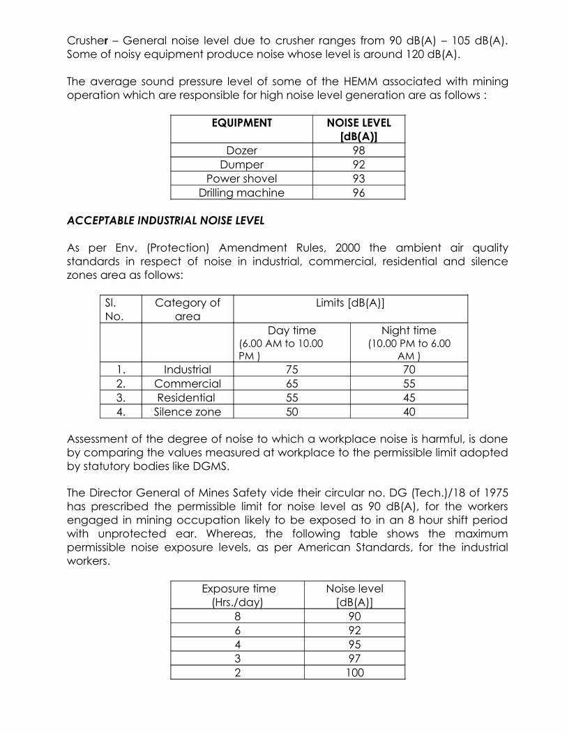
Crusher – General noise level due to crusher ranges from 90 dB(A) – 105 dB(A). Some of noisy equipment produce noise whose level is around 120 dB(A).
The average sound pressure level of some of the HEMM associated with mining operation which are responsible for high noise level generation are as follows :
EQUIPMENT NOISE LEVEL [dB(A)]
Dozer 98Dumper 92
Power shovel 93Drilling machine 96
ACCEPTABLE INDUSTRIAL NOISE LEVEL
As per Env. (Protection) Amendment Rules, 2000 the ambient air quality standards in respect of noise in industrial, commercial, residential and silence zones area as follows:
Sl. No.
Category of area
Limits [dB(A)]
Day time(6.00 AM to 10.00 PM )
Night time(10.00 PM to 6.00
AM )1. Industrial 75 702. Commercial 65 553. Residential 55 454. Silence zone 50 40
Assessment of the degree of noise to which a workplace noise is harmful, is done by comparing the values measured at workplace to the permissible limit adopted by statutory bodies like DGMS.
The Director General of Mines Safety vide their circular no. DG (Tech.)/18 of 1975 has prescribed the permissible limit for noise level as 90 dB(A), for the workers engaged in mining occupation likely to be exposed to in an 8 hour shift period with unprotected ear. Whereas, the following table shows the maximum permissible noise exposure levels, as per American Standards, for the industrial workers.
Exposure time (Hrs./day)
Noise level [dB(A)]
8 906 924 953 972 100

1.5 1021 105
0.5 1080.25 or less 115
EXPOSURE TO PULSE OR IMPACT NOISE SHOULD NOT EXCEED 140 dB(A)
Now to assess the likely contribution from proposed expansion project, the ambient noise level of operating mines of the same area has been taken into consideration. It is observed that noise level recorded near CHP & Near Manager’s Office (mine activity area & major source of noise in opencast mines) of Gouri – I & II (Amalgamated) OCP are well within the permissible limit.
NOISE LEVEL DATA
NAME OF THE COMPANY : WCL YEAR : 2013NAME OF THE AREA : BALLARPUR Q.E. : MAR.NAME OF THE PROJECT : GOURI-I & II (A) OCP
Name of the Location : CHP - BGON-1
Month Date of Data Noise Level in dB(A) Remarks collection Day Time Night Time
JAN. 2013 05.01.13 64.6 68.0JAN. 2013 18.01.13 68.9 69.7
FEB. 2013 07.02.13 66.2 61.8FEB. 2013 22.02.13 68.5 69.0
MAR. 2013 05.03.13 67.9 68.9MAR. 2013 19.03.13 70.1 65.3
Noise Level Standard as per Env.
(Protection) Amendment rule 2000 75 70

Name of the Location : Gouri Colony - BGON-2
Month Date of Data Noise Level in dB(A) Remarks collection Day Time Night Time
JAN. 2013 05.01.13 41.9 42.9JAN. 2013 18.01.13 43.5 44.9
FEB. 2013 07.02.13 45.7 44.8FEB. 2013 22.02.13 43.2 44.7
MAR. 2013 05.03.13 44.5 43.4 MAR. 2013 19.03.13 51.1 42.3
Permissible Limit 55 45
NOISE LEVEL DATA
NAME OF THE COMPANY : WCL YEAR : 2013NAME OF THE AREA : BALLARPUR Q.E. : JUN.NAME OF THE PROJECT : GOURI-I & II (A) OCP
Name of the Location : CHP - BGON-1
Month Date of Data Noise Level in dB(A) Remarks collection Day Time Night Time
APR. 2013 05.04.13 68.3 69.5APR. 2013 19.04.13 65.7 66.6
MAY. 2013 04.05.13 64.2 65.7MAY. 2013 20.05.13 66.4 68.0
JUN.2013 06.06.13 68.5 69.9JUN.2013 22.06.13 65.9 66.4
Noise Level Standard as per Env.
(Protection) Amendment rule 2000 75 70
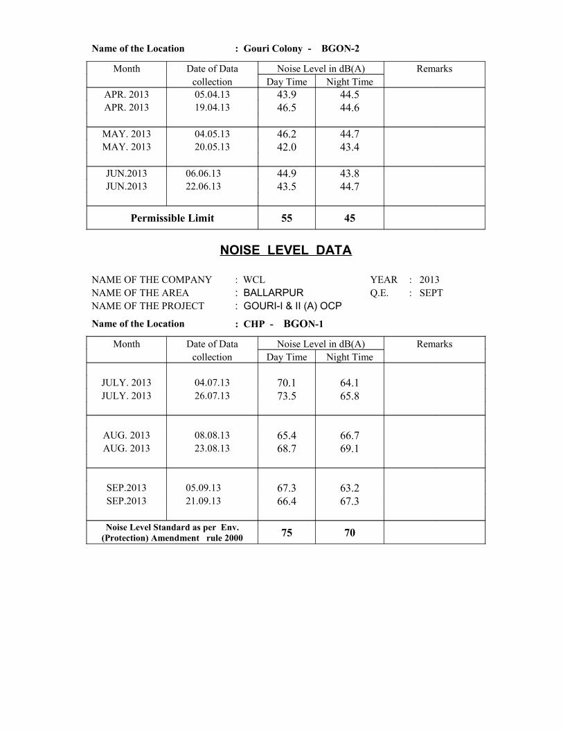
Name of the Location : Gouri Colony - BGON-2
Month Date of Data Noise Level in dB(A) Remarks collection Day Time Night Time
APR. 2013 05.04.13 43.9 44.5APR. 2013 19.04.13 46.5 44.6
MAY. 2013 04.05.13 46.2 44.7MAY. 2013 20.05.13 42.0 43.4
JUN.2013 06.06.13 44.9 43.8 JUN.2013 22.06.13 43.5 44.7
Permissible Limit 55 45
NOISE LEVEL DATA
NAME OF THE COMPANY : WCL YEAR : 2013NAME OF THE AREA : BALLARPUR Q.E. : SEPTNAME OF THE PROJECT : GOURI-I & II (A) OCP
Name of the Location : CHP - BGON-1
Month Date of Data Noise Level in dB(A) Remarks collection Day Time Night Time
JULY. 2013 04.07.13 70.1 64.1JULY. 2013 26.07.13 73.5 65.8
AUG. 2013 08.08.13 65.4 66.7AUG. 2013 23.08.13 68.7 69.1
SEP.2013 05.09.13 67.3 63.2SEP.2013 21.09.13 66.4 67.3
Noise Level Standard as per Env.
(Protection) Amendment rule 2000 75 70
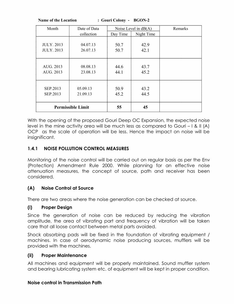
Name of the Location : Gouri Colony - BGON-2
Month Date of Data Noise Level in dB(A) Remarks collection Day Time Night Time
JULY. 2013 04.07.13 50.7 42.9JULY. 2013 26.07.13 50.7 42.1
AUG. 2013 08.08.13 44.6 43.7AUG. 2013 23.08.13 44.1 45.2
SEP.2013 05.09.13 50.9 43.2 SEP.2013 21.09.13 45.2 44.5
Permissible Limit 55 45
With the opening of the proposed Gouri Deep OC Expansion, the expected noise level in the mine activity area will be much less as compared to Gouri – I & II (A) OCP as the scale of operation will be less. Hence the impact on noise will be insignificant.
1.4.1 NOISE POLLUTION CONTROL MEASURES
Monitoring of the noise control will be carried out on regular basis as per the Env (Protection) Amendment Rule 2000. While planning for an effective noise attenuation measures, the concept of source, path and receiver has been considered.
(A) Noise Control at Source
There are two areas where the noise generation can be checked at source.
(i) Proper Design
Since the generation of noise can be reduced by reducing the vibration amplitude, the area of vibrating part and frequency of vibration will be taken care that all loose contact between metal parts avoided.
Shock absorbing pads will be fixed in the foundation of vibrating equipment / machines. In case of aerodynamic noise producing sources, mufflers will be provided with the machines.
(ii) Proper Maintenance
All machines and equipment will be properly maintained. Sound muffler system and bearing lubricating system etc. of equipment will be kept in proper condition.
Noise control in Transmission Path

The measures are to be taken for control of noise along the transmission path have been put in following two categories:
(i) Air borne path(ii) Ground borne path
(i) Air Borne Path
The control in air – borne path has been planned in a number of ways as:(a) The crusher house, screen house etc., which are source of high level noise
generation are to be enclosed.(b) Planting of furrows of trees along the thick foliage around the compound
and wall of CHP, workshop and other industrial buildings. This will reduce the spread of noise. It can be also used as an acoustic enclosure to reduce ambient noise.
(ii) Ground Borne Path
It has been proposed to provide vibration isolators in the form of vibration absorbing pads placed at the base of vibrating equipment.
(C) Noise Control at Receiver End
Even after adopting above measures, if desired noise level is not achieved at receiver end, in that case, following measures are suggested:
(a) The workers exposed to high noise level are provided with earplugs.(b) Provision of enclosed booths at the worksite to protect worker from noisy
environment.Control Of Ground Vibration
The adverse impacts due to ground vibration occurs because of blasting operations carried out in the mine. In the proposed Gouri Deep OC Expansion blasting will be carried out as per the provisions of the Statute and only after taking due permission from Directorate General Of Mines Safety (DGMS). The blasting pattern including spacing of holes, burden, charge per blast/delay etc. will be duly approved by DGMS and then only it will be practiced in the mine during actual mining operations. The blasting will be carried out under the direct supervision of a Blasting Officer and records of every blast will be monitored and maintained. In case of blasting near the habitation, separate blasting pattern will be designed and tested so as to avoid/ minimize any adverse impact of blasting/ ground vibration on the nearby structures. The approval for such type of Controlled blasting will be obtained from DGMS and will be implemented accordingly.

1.5 During Mining Land Use Pattern:-
The proposed land use pattern during expansion of mining operation is as follows:-S.N. Head Land Requirement (ha)
1 Excavation Area 92.452 External OB Dump 94.123 Infrastructure 05.004 Project Township 10.005 Boundary Adjustment & Miscellaneous 154.54
TOTAL 356.11
PRE MINING LAND USE IN CORE ZONE (CONTD..)(ALL FIGURES IN HECTARES)
339.43
16.68
AGRICULTURE LAND
OTHER(GOVT. LAND)

LAND USE DURING MINING(CORE ZONE)(ALL FIGURES IN HECTARES)
92.45
94.125.00
131.359
10.00 23.181
QUARRY AREA EXTERNAL OB DUMP
INFRASTRUCTURE DANGER ZONE
PROJECT TOWNSHIP RATIONALISATION AREA
1.5.1. Solid Waste Management:-
It has been proposed to work the quarries by Horizontal Slicing Method i.e. conventional benching system with shovel-dumper combination. This system is being widely used in the opencast mines of Wardha Valley Coalfield. Gradient of the seam being very steep (1 in 4 to 1 in 3 due north) it is not feasible to do simultaneous backfilling. Hence to optimize the backfilling, it has been proposed to divide the quarry into Two sectors viz. Quarry – I & Quarry – II. Quarry – I which has got some reserves at incrop level with shallow depth, has been proposed to worked first. Considering the geo-mining parameters of the Quarry – I pit configuration and safety of men and machine, the overburden of Quarry – I and part of overburden of Quarry – II would be dumped on surface in OB dump A & B. However, efforts would be made to dump overburden of Quarry – II as much as possible into decoaled void of Quarry – I.
Initially, overburden from access trench and box cut of Quarry – I will be accommodated in the external dump no. A. Overburden of Quarry – II would be backfilled in decoaled void of Quarry – I which would get exhausted in the 15 th year. Internal dumping in the void (decoaled) of Quarry – I starts from 15 th Year. Top soil is proposed to be carpeted over the external dump for gainful utilization of its vegetation properties.
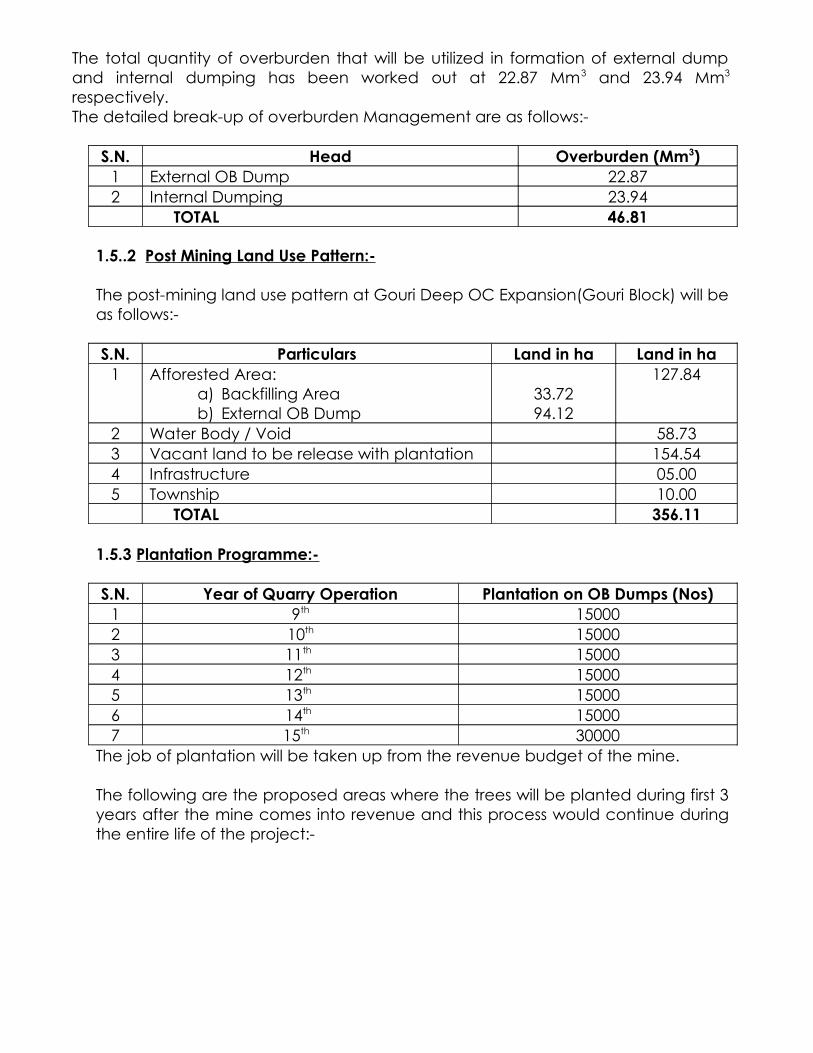
The total quantity of overburden that will be utilized in formation of external dump and internal dumping has been worked out at 22.87 Mm3 and 23.94 Mm3
respectively. The detailed break-up of overburden Management are as follows:-
S.N. Head Overburden (Mm3)1 External OB Dump 22.872 Internal Dumping 23.94
TOTAL 46.81
1.5..2 Post Mining Land Use Pattern:-
The post-mining land use pattern at Gouri Deep OC Expansion(Gouri Block) will be as follows:-
S.N. Particulars Land in ha Land in ha1 Afforested Area:
a) Backfilling Areab) External OB Dump
33.7294.12
127.84
2 Water Body / Void 58.733 Vacant land to be release with plantation 154.544 Infrastructure 05.005 Township 10.00
TOTAL 356.11
1.5.3 Plantation Programme:-
S.N. Year of Quarry Operation Plantation on OB Dumps (Nos)1 9th 150002 10th 150003 11th 150004 12th 150005 13th 150006 14th 150007 15th 30000
The job of plantation will be taken up from the revenue budget of the mine.
The following are the proposed areas where the trees will be planted during first 3 years after the mine comes into revenue and this process would continue during the entire life of the project:-

S.N. Area Year TotalI II III
1 Around Colony 4000 4000 4000 120002 Around Infrastructures 4000 4000 4000 120003 Along Roads 4000 4000 4000 120004 In Vacant Land (*) 1000 1000 1000 3000
TOTAL 13000 13000 13000 39000
NOTE (*):- The vacant land will mostly cover the land between Antargaon Khurd and Goigaon villages. From IV th year onwards more plantation will be taken up in this land with the continuation of full fledged mining.
Proposed Width of Green Belt:-
a) Along the roads, 1000 saplings per km of road length in two rows on both sides of the road creating 3.0 m wide green belt on either side.
b) Around colony and infrastructure @ 2500 saplings per ha in 3 rows of plantation all around the available suitable spaces will be done keeping the width of green belt as 5.0 m.
c) In vacant land, @ 2500 saplings per ha in 2 m X 3 m grid in order to develop green patches.
Species to be Planted:- Native Species.
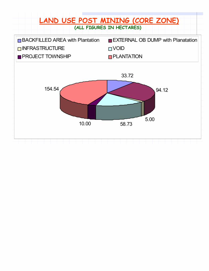
LAND USE POST MINING (CORE ZONE)(ALL FIGURES IN HECTARES)
33.72
94.12
5.0058.7310.00
154.54
BACKFILLED AREA with Plantation EXTERNAL OB DUMP with Planatation
INFRASTRUCTURE VOID
PROJECT TOWNSHIP PLANTATION
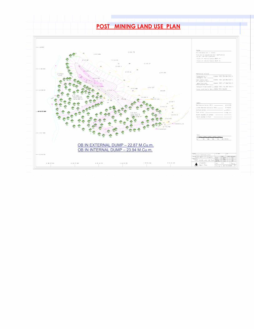
N 10 57 500
POST MINING LAND USE PLAN
OB IN EXTERNAL DUMP – 22.87 M.Cu.m.OB IN INTERNAL DUMP – 23.94 M.Cu.m.
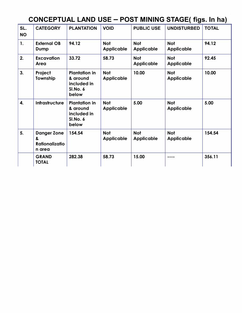
CONCEPTUAL LAND USE – POST MINING STAGE( figs. In ha)SL.
NO
CATEGORY PLANTATION VOID PUBLIC USE UNDISTURBED TOTAL
1. External OB Dump
94.12 Not Applicable
Not Applicable
Not Applicable
94.12
2. Excavation Area
33.72 58.73 Not Applicable
Not Applicable
92.45
3. Project Township
Plantation in & around included in Sl.No. 6 below
Not Applicable
10.00 Not Applicable
10.00
4. Infrastructure Plantation in & around included in Sl.No. 6 below
Not Applicable
5.00 Not Applicable
5.00
5. Danger Zone & Rationalization area
154.54 Not Applicable
Not Applicable
Not Applicable
154.54
GRAND TOTAL
282.38 58.73 15.00 ---- 356.11
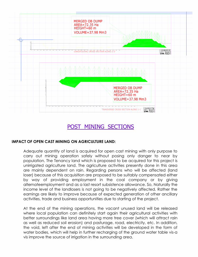
300
280
290
21 0
200
22 0
23 0
250
26 0
24 0
21 0
22 0
23 0
200
27 0
0
310
200 300250 350 500450400 650600550 800750700 850 90015010050 950 1000 1050 1100 1150 1200 1250 1300 1350 14000
TRANSVERSE CROSS SECTION ALONG 1-1'
LONGITUDINAL CROSS SECTION ALONG 2-2'
0- 50
- 40
- 30
- 20
- 10
140013501300125012001150110010501000950
0
50 100 150
T . F .N a gp ur e
G . S . G A H LOT
I .D .N AR A YA N
S . K . S IN H A
900850700 750 800550 600 650400 450 500350250 300200
310
1 40
10
0
20
30
40
50
60
70
80
90
100
1 10
1 20
1 30
2 70
150
200
2 30
2 20
2 10
1 90
1 80
1 70
1 60
2 40
2 60
250
2 30
2 20
1 90
2002 10
1 70
1 80
1 60
290
280
300
MERGED OB DUMPAREA=72.35 HaHEIGHT=60 mVOLUME=37.98 Mm3
MERGED OB DUMPAREA=72.35 HaHEIGHT=60 mVOLUME=37.98 Mm3
T .F . N ag pu re
G .S .G A HL O T
I . D .N A R AY AN
S .K . SI N H A
POST MININGPOST MINING SECTIONS
IMPACT OF OPEN CAST MINING ON AGRICULTURE LAND:
Adequate quantity of land is acquired for open cast mining with only purpose to carry out mining operation safely without posing only danger to near by population. The Tenancy land which is proposed to be acquired for this project is unirrigated agriculture land. The agriculture activities presently done in this area are mainly dependent on rain. Regarding persons who will be affected (land loser) because of this acquisition are proposed to be suitably compensated either by way of providing employment in the coal company or by giving alternateemployment and as a last resort subsistence allowance. So, Naturally the income level of the landlosers is not going to be negatively affected. Rather the earnings are likely to improve because of expected generation of other ancillary activities, trade and business opportunities due to starting of the project.
At the end of the mining operations, the vacant unused land will be released where local population can definitely start again their agricultural activities with better surroundings like land area having more tree cover (which will attract rain as well as reduced soil erosion) and pasturage, road, electricity, etc. In addition, the void, left after the end of mining activities will be developed in the form of water bodies, which will help in further recharging of the ground water table vis-a vis improve the source of irrigation in the surrounding area.

From the post – mining land use pattern of this particular project, it is seen that the vacant land released to pre-mining condition comes to 43 % of the total land (Agricultural) acquired. In addition, the backfilling area comes to 33.72 ha. In this context, it may be mentioned that, one R & D study has been completed at Ballarpur OCP of WCL to convert backfilled area into agricultural land. The results are very much encouraging. By the time, the proposed mine will be reaching the end of mine life, the technology of converting backfilled area into agricultural land will be fully established in WCL. Therefore, this 33.72 ha of backfilled area will also be available for agricultural activities at the post - mining stage. Thus, total land available for agricultural use at the end of project life would be 154.54 +33.72 =188.56 ha which is about 53% of total agricultural land acquired.
1.5.4 PROGRESSIVE & FINAL MINE CLOSURE PLAN
Mine closure plan.
Although, the mining activities may last a few decades, but they are liable to leave a long lasting impacts on the landscape, ecology and on local inhabitants. The objective of mine closure plan is aimed at restoration/reclamation of disturbed area, which should be acceptable to local community as well as regulatory authority.
Mine closure is not something that happens at the end of a mine's life rather mine closure is an ongoing series of activities starting from the planning stage of a mine and ending with a suitably restored site that can be returned to the community. The mine closure is planned in two phases:
a) The first phase/progressive site-specific closure plan includes the various activities to be implemented over the life of the mine. The required timetable for these is given in detail in the EMP/Project Report itself. The required fund – Capital and Revenue, is also given under different heads in the EMP/Project Report.
b) This plan may undergo and incorporate changes depending upon the actual site condition during implementation, legal & social requirements in future, availability of Additional coal reserves, etc. As such a detailed closure plan will be prepared before the actual closure time of the mine. This plan is the culmiNAtion of the activities given under progressive plan.
Major activities under mine closure plan
The mine closure plan includes the following major activities.
1.1 Environmental Aspects1.2 Social Aspects1.3 Safety & Technical Aspects

Environmental Aspects.
Reclamation of dumps.
During quarrying operation, OB is initially removed and kept as external dump. Coal production starts once the coal seam is touched. Once the lowest and economically mineable coal seam is exhausted, a void / decoaled area is created. The OB generated from advancing benches is then backfilled in this decoaled area as an internal dump. With the ongoing process of mining operation, the external dump and internal dump are technically reclaimed.
Backfilling of Quarry Void:
It has been proposed to work the quarries by Horizontal Slicing Method i.e. conventional benching system with shovel-dumper combination. This system is being widely used in the opencast mines of Wardha Valley Coalfield. Gradient of the seam being very steep (1 in 4 to 1 in 3 due north) it is not feasible to do simultaneous backfilling. Hence to optimize the backfilling, it has been proposed to divide the quarry into Two sectors viz. Quarry – I & Quarry – II. Quarry – I which has got some reserves at incrop level with shallow depth, has been proposed to worked first. Considering the geo-mining parameters of the Quarry – I pit configuration and safety of men and machine, the overburden of Quarry – I and part of overburden of Quarry – II would be dumped on surface in OB dump A & B. However, efforts would be made to dump overburden of Quarry – II as much as possible into decoaled void of Quarry – I.
Initially, overburden from access trench and box cut of Quarry – I will be accommodated in the external dump no. A. Overburden of Quarry – II would be backfilled in decoaled void of Quarry – I which would get exhausted in the 15 th
year. Internal dumping in the void (decoaled) of Quarry – I starts from 15 th Year. Top soil is proposed to be carpeted over the external dump for gainful utilization of its vegetation properties.
The total quantity of overburden that will be utilized in formation of external dump and internal dumping has been worked out at 22.87 Mm3 and 23.94 Mm3
respectively.
The detailed break-up of overburden Management are as follows:-
S.N. Head Overburden (Mm3)1 External OB Dump 22.872 Internal Dumping 23.94
TOTAL 46.81
Post Mining Land Use Pattern:-
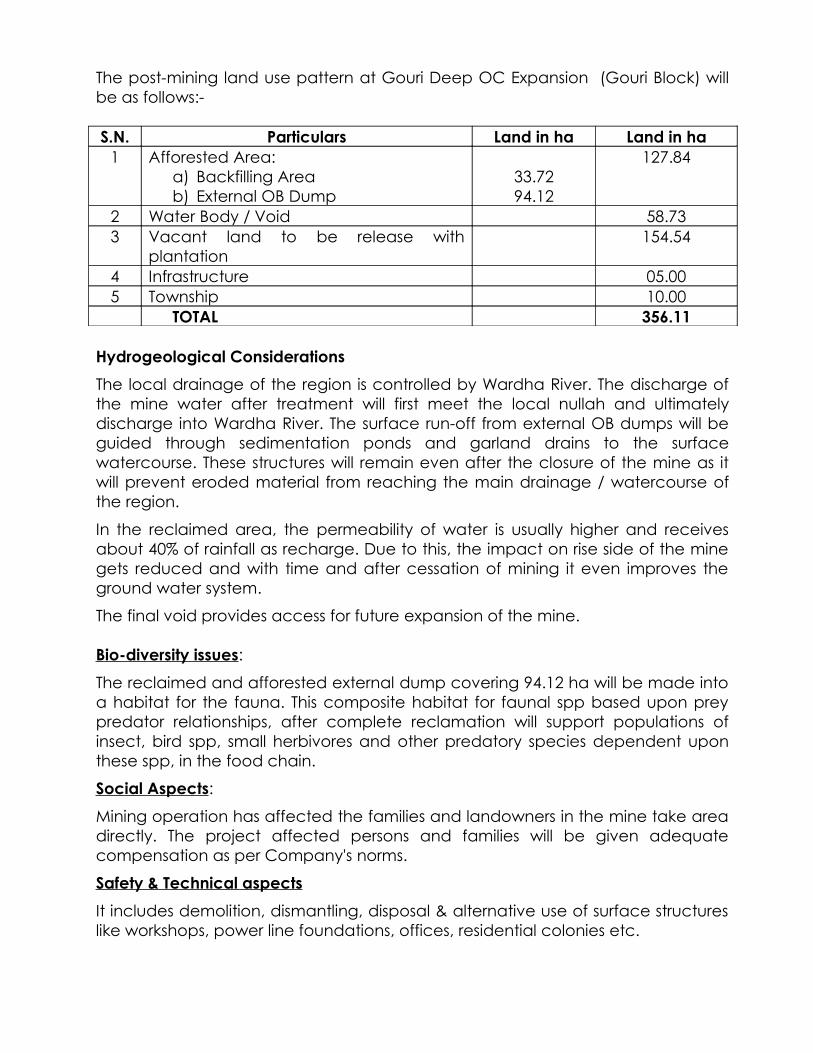
The post-mining land use pattern at Gouri Deep OC Expansion (Gouri Block) will be as follows:-
S.N. Particulars Land in ha Land in ha1 Afforested Area:
a) Backfilling Areab) External OB Dump
33.7294.12
127.84
2 Water Body / Void 58.733 Vacant land to be release with
plantation154.54
4 Infrastructure 05.005 Township 10.00
TOTAL 356.11
Hydrogeological Considerations
The local drainage of the region is controlled by Wardha River. The discharge of the mine water after treatment will first meet the local nullah and ultimately discharge into Wardha River. The surface run-off from external OB dumps will be guided through sedimentation ponds and garland drains to the surface watercourse. These structures will remain even after the closure of the mine as it will prevent eroded material from reaching the main drainage / watercourse of the region.
In the reclaimed area, the permeability of water is usually higher and receives about 40% of rainfall as recharge. Due to this, the impact on rise side of the mine gets reduced and with time and after cessation of mining it even improves the ground water system.
The final void provides access for future expansion of the mine. Bio-diversity issues:
The reclaimed and afforested external dump covering 94.12 ha will be made into a habitat for the fauna. This composite habitat for faunal spp based upon prey predator relationships, after complete reclamation will support populations of insect, bird spp, small herbivores and other predatory species dependent upon these spp, in the food chain.
Social Aspects:
Mining operation has affected the families and landowners in the mine take area directly. The project affected persons and families will be given adequate compensation as per Company's norms.
Safety & Technical aspects
It includes demolition, dismantling, disposal & alternative use of surface structures like workshops, power line foundations, offices, residential colonies etc.

Utilisation of existing surface infrastructure:
In this project, the surface structures will be utilized by the future extension of mine.
Management of Hazardous waste:
The waste oil and oil filters collected during routine maintenance of HEMMS comprise hazardous material generated during the life of mine. These will be regularly collected and auctioned to authorized recyclers and as such no hazardous material will be left at site after the closure of the mine.
Management & Use of void:
The quarry void will provide access for the future extension of the mine..
Survey records & maps:
Survey records of working showing the infrastructures, last working position, dump etc. will be maintained. A copy of the closure plan giving details of all the safety precautions taken along with maps etc. will be submitted to the Directorate General of Mines Safety.
Fencing around void for mine closure:
At the time of final closure of mine a permanent fencing will be erected around the void periphery. The physical details of the fencing are:
Height : 1.5 mRCC Posts : 1.8 m high placed at 3 m apart.Wire : Parallel lines & 2 cross lines of barbed wire.
Fund provision for mine closure:
For the effective closure of the mine, various activities are to be continued after the end of mining operation viz. land reclamation, afforestation, protective boundary/fencing, continuation of all monitoring programmes, control of all contaminated effluents, securing of all petroleum products, chemicals & waste etc.
Conclusion:
It can be seen from the points mentioned above that the activities required for mine closure are already covered in the EMP/PR of the mine. These activities are not a one-time activity to be undertaken at the end of life of mine. Most of the activities are carried out regularly over the total life span of the mine.
The project under consideration is in all likelihood get further extended towards dip which will give an Additional lease of life to the project. As such, the actual closure plan can be finalized only at the end of expansion project.
Although no statutory guidelines exist on Financial provisioning for mine closure activities as yet, but Financial provisions as foreseen on date for the project under consideration within the limits specified has been made in the report to undertake mine closure activities.
Note on creation of a Corpus Fund:
The purpose of a Corpus fund is to make available the required fund for the various activities of mine closure at the time of actual closure of the mine. In Proposed Gouri Deep OC Project the fund required for various activities for mine closure has already been provided in EMP/PR. These are provided in the approved PR of the project.
The fund provisions indicated above takes care of all the requirements of mine closure and has the commitment of the highest authority of the Company.
1.6 Occupational Health Issues
WCL has full fledged medical set up in all areas to check up and monitor all the Occupational diseases endangering the health of its precious workforce. The periodical medical Examination for all workmen is compulsory as per Statute. It is carried out once in every five years for each and every worker and proper records are maintained and submitted to Directorate General of Mines Safety as it is a statutory requirement.
In case of workers, above 50 years of age and employed in underground mine, this periodical medical examination is carried out every two and half yearly interval. In Ballarpur Area, under whose administrative control, the mine under consideration is being worked is no exception. All the statutory obligations under the Occupational health are strictly followed.
Present set up of Occupational Health Services At WCL:
WCL is having Occupational health committee at the corporate (HQ) level as well as at the unit (Area /Project level).
At corporate level, the committee consists of the following: -
Chief General Manager (Safety) Chief of Medical Services Periodical Medical Examination (PME) Incharge of HQ.
The committee scrutinizes the report of the area every quarter.
At Unit level, the committee consists of the following: - General Manager (Operations) Area Medical Officer Area Safety Officer Periodical Medical Examination(PME) Incharge of Area.

The above committee takes the review at area level every month. There are 11 hospitals having PME Centres in the hospitals. The PME Centres are well equipped with Spirometry (Lung Function test), Audiometry (for testing hearing impairment) along with the facilities for X – Ray & other bio – chemical tests.The details are as follows: -
Periodical Medical Examination(PME) Centres – 11 (Occupational Health Centres) Nos. of Doctors engaged in Periodical Medical ExamiNAtion - 11 Nos. of Doctors trained in Periodical Medical ExamiNAtion - 22 Nos. of X – Ray machines (300 mA) - 9 Nos. of X – Ray machines (500 mA) - 2 Nos. of ILO film Tests - 10 Nos. of Audiometer units - 7
(4 units are under process of procurement) Nos. of Spirometer units - 8 (3 units are under process of procurement) Nos. of Pathology Labs - 11 Nos. of X – Ray technicians - 14 Nos. of Laboratory Technicians - 22
All the PME Centres are fully computerised.
As per the Statute / Mines Act, 1952, all the workers are examined every five years and the disease profile is maintained in PME Centres in different colour codes as given below: -
Yellow Card – Hypertension Green Card – Diabetes Red Card - Ischaemic Heart Disease
Workers exposed to high decibel machineries i.e. more than 90 decibels and are found to have developed hearing impairment, are subjected to repeated audiometric tests.
In suitable cases, as per the recommendation of the Apex Medical Board, the change of job is also suggested and implemented accordingly.
In addition, the Welfare Board of WCL time to time makes visits to different area hospitals & PME Centres so as take stock of the ground realities.
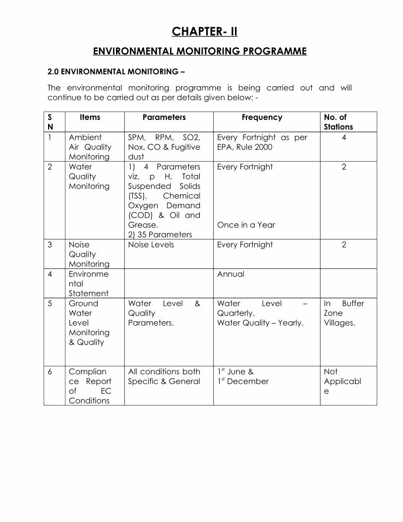
CHAPTER- II
ENVIRONMENTAL MONITORING PROGRAMME
2.0 ENVIRONMENTAL MONITORING –
The environmental monitoring programme is being carried out and will continue to be carried out as per details given below: -
SN
Items Parameters Frequency No. of Stations
1 Ambient Air Quality Monitoring
SPM, RPM, SO2, Nox, CO & Fugitive dust
Every Fortnight as per EPA, Rule 2000
4
2 Water Quality Monitoring
1) 4 Parameters viz. p H, Total Suspended Solids (TSS), Chemical Oxygen Demand (COD) & Oil and Grease.2) 35 Parameters
Every Fortnight
Once in a Year
2
3 Noise Quality Monitoring
Noise Levels Every Fortnight 2
4 Environmental Statement
Annual
5 Ground Water Level Monitoring & Quality
Water Level & Quality Parameters.
Water Level – Quarterly.Water Quality – Yearly.
In Buffer Zone Villages.
6 Compliance Report of EC Conditions
All conditions both Specific & General
1st June & 1st December
Not Applicable
CHAPTER- III
ADDITIONAL STUDIES
3.0 INTRODUCTION:
Mining is a hazardous industry. There is risk to life and property associated with various mining and allied activities of the project. As such a detailed study has been carried out covering identification and assessment of risk, and recommendation of measures to prevent damage to life and property against such risks. They are discussed below.
3.1 PUBLIC CONSULTATION
As per the conditions given in the Terms of Reference issued by MOEF vide its letter-dated 11.12.2008, Public Hearing was conducted as per the provision given in the EIA Notification, 2006. On 10.07.2009. Shri N.B.Wati,Additional District Collector,Chandrapur had presided over the Public Hearing process to get public concerns incorporated in the EIA report already approved by MOEF.
3.2 DISASTER MANAGEMENT PLAN
3.2.1 Land sliding in ob dump and mine pit:
There is only one composite coal seam, to be worked out in this opencast mine. The OB/Parting between the sections are to be removed by shovel dumper combination. It is therefore, necessary to take certain precautions while OB dumps are formed. In some cases, the top soil get mixed with rock soil in the dump, due to which there is a possibility of landslide, particularly in rainy season, unless suitable slope is maintained. Therefore, steps are to be taken at the time of dumping of OB that the slope of dump does not go beyond the prescribed limit. Further, the topsoil dumping should be separate and it can be reused on the backfilled area.
3.2.2 Slope failure in OB dump:
It may be worthwhile to mention here that if proper care is not taken in designing proper bench height and bench slope, the OB dump may fail causing damage to life and property. With this in view, a proper slope analysis has been done to determine the safe bench slope and bench height, which are given below; Maxm.projected height of dump - 60 m.
No. of terraces and height of each stage - two, max. 30 m each
Over all slope - 28 degree.

In proposed Gouri Deep OCP while forming & reclaiming external OB dumps, the above-mentioned guidelines regarding slope angle etc. are being tried.
3.2.3 MINE INUNDATION:
The mine pit receives water from three sources Namely direct precipitation over mine area, surface run-off from surrounding area and seepage from strata. In heavy rainstorms, there may be situation where the mine would be flooded.
This may cause loss of human life and equipments. To guard against this situation following steps are to be taken :
Provisions of garland drains around mine quarry has been given. This will prevent surface run-off entering the mine pit. In order to divert the rainwater around the excavated portion a garland drain will be made; which will have the gradient suitable for diverting the water to the river/or Nallah part away from the mine opening. This garland drain will be cleaned and graded before the onset of monsoon. With the advance of quarry face the position of garland drain will be shifted.
Provisions of pumps: Adequate number of pumps has been provided to drain mine water even during maximum rainfall.
3.2.4 BLASTING:
For quarrying of coal and removal of overburden, blasting has to be done by use of explosives. Flying pieces generated by blasting may prove dangerous to life and property. Hence, all the precautionary measures suggested by D.G.M.S. will be strictly followed e.g. controlled blasting etc. In addition, following precautions have been taken to avoid such dangerous situation.
(A) Blasting is to be done only once everyday.
(B) Before blasting is done, warning Sound is to be given so that people can move to safe places.
(C) Area lying within safety zone is to be fenced.
3.2.5 OTHER MEASURES:
Other measures have also been recommended for avoiding risk in mine operation. They are discussed below;
(A) Provision of proper illumination in quarry, O.B. dumps area, along roads, in workshop & other work area.
(B) Communication system - Efficient communication system (based on VHF system) have been provided for the project. This will allow proper communication link between various work centers and helps in avoiding accidents.
(C) Maintenance facilities - The project will employ a large number of HEMMs for quarrying and transportation of local and OB. Ill - maintained HEMMs may prove to be the source of grave risk. A well-equipped workshop will be provided for scheduled maintenance of HEMMs to avoid their failures.
(D) Training - Coal industry has set up a number of training institutes for imparting training to its employees. These training raise the safety awareness among workers and train them to carry out their assignments safely. (E) Medical aid - The project has provided for well equipped hospital and qualified doctors. They can attend to medical emergencies arising out of accidents. 3.2.6 CONCLUSIONS: Following conclusions may be drawn from the above discussion: (a) Coal mining is associated with a number of hazards.(b) These hazards can be identified and assessed, which has been done for this
project.(c) Preventive measures against identified risks have been provided in this report (d) With adoption of such protective measures, the operation of the mine would
be safe.
3.3 IMPACT ON SOCIO-ECONOMIC
The activities listed under the two phases of this proposed project are likely to affect the environment to varying degrees. The environment is a very complex system and so many factors are interlinked and interdependent of each other, that any prediction concerning the impact on the environment as a whole may not always be very precise. So relevant aspects of environment are isolated as parameters and the impact due to various activities on the parameters has been identified as project activities.
3.3.1 Socio-economic Impact
A) Population Growth and Migration
The opening of this project will be having an impact on the people inhabiting surrounding the project area. There will be migration of people from outside due to more job opportunities in the project area. Thus, the population in this area is likely to increase.
B) Resettlement & Rehabilitation.

There is no village falling over the core zone of the project. As such, there is no resettlement of house oustees involved in this project.
C) Transport and Communication
The provision of metalled approach road to the place of work and other places of public interests like shopping, education, medical services etc. is going to improve the existing transport & communication network.
D) Health
At present, Ballarpur Area is having a full-fledged Regional Hospital. All the medical emergencies are attended by the medical professionals of this hospital. In case of major problems, the matter is generally referred to Chandrapur which is only 36 Kms away. As such, in the Buffer Zone, health care facilities can be taken as satisfactory. With the opening of this project, the facilities created in the project are likely to be extended for neighboring population also.
The Occupational health hazard associated with coal mining is the Coal Miners’ Lung Disease (Pneumoconiosis). The disease is caused by the prolonged inhalation of coal dust particles below 3 Micron size. The disease is detected by Chest X-Rays done during periodical medical Examination among the coal mine workers. However, this disease has been detected among the underground mine workers only. As such, this Occupational disease is not expected to affect the workers of the proposed opencast project.
E) Literacy
With the development of this project, educational facilities will get a boost and facilities developed in the surrounding of the project area are going to improve further which in turn will improve the literacy of the rural areas also around this project.
Economic Impacts
Most of the people are non-workers. Remaining is engaged in Cultivation and Agriculture. With the opening of the project the Occupational structure of the area is going to change further and many people are likely to be involved in the job of mining and allied activities. Hence, income level of these people is likely to improve to significant level.
Employment opportunities and Quality of life
Employment opportunities both direct & indirect in this project are likely to cause migration from outside. Amenities like medical educational, recreational etc. will be available to local people and their quality of life will definitely improve.

Housing
For a total manpower of 480 persons, 273 nos. of quarters have been proposed to be provided giving an overall housing satisfaction of 56.88%.
Employment Opportunities
The project will create a total of 480 jobs to the professional’s skilled, semi-skilled and non-skilled workers. During operation stage, the mine will also create job opportunities in secondary, territory and informal sectors. In this area, the project would be highly beneficial for the local population.
Land House Oustees
It has already been stated that 334.13 ha of Tenancy land has been acquired. Out of which 292.28 ha of land is in physical possession.The details of rehabilitation of land losers have been given in subsequent chapter.
WCL Board has approved 297 cases of employment.
There is one village; viz. Antargaon Khurd village located at a distance of about 150 m from the western rise side quarry boundary. This village has not been proposed for shifting because adequate precautions like controlled blasting etc. will be duly taken so that there is no danger to the villagers because of mining.
SOCIO-ECONOMIC MEASURES
Resettlement & Rehabilitation Plan:
There is no Resettlement involved in this project. The affected land owners will be suitably compensated as per Company Norms.
There is only rehabilitation of land oustees involved because of acquisition of private agricultural land.
Efforts being made for taking physical possession of balance land for Gouri Deep opencast mine and expected schedule for completion of the activities:-
Land acquired under CBA (A&D) Act 1957.
Total land acquired so far (but physical possession awaited) : 334.13 Ha.
Name of Village Tenancy Land (Ha) Govt. Land (Ha)Goigaon 100.64 5.68Antargaon 182.74 11.00Mutra 34.07 --
Total 317.45 16.68

Employment / Monetary Compensation in lieu of Employment – 297
Total land compensation – Rs. 3.2068 crores
Peripheral development:
As per the present practices in WCL coal mines, adequate steps are being taken for the local villagers by providing various infrastructure and welfare facilities and giving assistance in health care in Ballarpur Area of WCL, under which the proposed Gouri Deep OC project will come into operation.
The various development works like construction of Primary, School, Post office, Shopping center, diversion of cart track for villagers, establishment of bank, diversion of irrigation canal etc; have been completed, mainly for catering to the needs/socio-economic upliftment of the neighbouring population.
It may be seen that the eco-development measures including welfare measures are regularly undertaken and, in future, the welfare measures will continue to be taken based on the assessment of the "felt needs" of the community around the project.
3.3.2 CORPORATE SOCIAL RESPONSIBILITY
In order to improve the quality of life of adjoining villages, every year WCL makes an elaborate plan and implement the same under Welfare Measures, Community Development, SC/ST Plan, Eco Development as a part of corporate social responsibility..
Community Development for local community
Looking beyond its employees, WCL also contributes to the socio – economoic emancipation of depived and downtrodden people living in villages around its mines, under its community Development, Tribal Sub Plan and Special Component Plan.
Activities undertaken and being continued are :-
Contribution and maintenance of approach roads, culverts, bridges, compound walls, tube-wells
Repairs, maintenance and provisions of furniture to village schools Organization of health camps Financial help in organizing social and cultural activities in nearby villages Awareness Programmes against social evils Promoting self-employment schemes for village youths.

Corporate Social Responsibility (CSR) – efforts made & achievement till date.
Western Coalfields Limited, a subsidiary of Coal India Limited, is a Coal mining
industry, with its business operations spread across several districts of Maharashtra
and Madhya Pradesh. Our company has a strength of 53188 employees who
work round the clock to fulfill the energy requirements of the nation.
Long before the concept of CSR gained prominence, WCL actively participated
in the development of the society through various initiatives under Community
Development Program.
WCL allocate 5 Rupee per tonne of coal produced towards CSR, which is much
above the DPE norms of allocating 5% of the total retained earnings of the
company.
In the year 2012-13, our company had allocated Rs.2155.50 Lakhs towards CSR
for carrying out 523 different activities in the rural areas at an estimated budget of
Rupees 2155.46 Lakhs, in the field of Infrastructure, Healthcare, Environment,
Social Empowerment, Water supply and Providing Drinking water facilities etc.
Out of the allocated amount, our company successfully carried out various
activities at an expenditure of Rupees 2095.57 Lakhs in the year 2012-13, as
compared to Rs.785.70 Lakhs incurred during last year. In the year 2012-13, WCL
has constructed 54,045 metres road in the rural areas, conducted 221 medical
camps that include eye-check up camp, health check up camp, family planning
camp, etc in different villages with 28,647 beneficiaries under CSR. Apart from this,
WCL has also conducted 906 camps by mobile medical vans in different villages
benefited by 68,529 villagers, organised 14 coaching camps for promotion of
sports in the villages, repaired 35 classrooms for promoting education,
constructed 30 comunity halls and installed 46 handpumps for providing clean
drinking water to the villagers.
The following chart represents the head-wise expenditure incurred under CSR in
the year 2012-13:
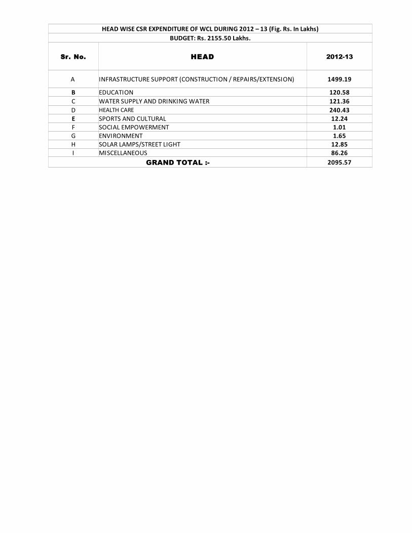
Sr. No. HEAD 2012-13
A INFRASTRUCTURE SUPPORT (CONSTRUCTION / REPAIRS/EXTENSION) 1499.19
B EDUCATION 120.58C WATER SUPPLY AND DRINKING WATER 121.36D HEALTH CARE 240.43E SPORTS AND CULTURAL 12.24F SOCIAL EMPOWERMENT 1.01G ENVIRONMENT 1.65H SOLAR LAMPS/STREET LIGHT 12.85I MISCELLANEOUS 86.26
GRAND TOTAL :- 2095.57
HEAD WISE CSR EXPENDITURE OF WCL DURING 2012 – 13 (Fig. Rs. In Lakhs)BUDGET: Rs. 2155.50 Lakhs.
CHAPTER – IV
PROJECT BENEFITS
7.0 PROJECT BENEFITS
The benefits of the project can be summarized as below:-
- The physical infrastructure in the area has already been improved substantially by following ways:-
Development of road thereby improving the communication.
Improvement in Power, Telephone (including Mobile) facility.
Improvement in Health Care facility & Educational facility.
Improvement in Market / Trade & Business.
- The social infrastructure by way of cultural mixing of people of other states with local community glorifying “UNITY IN DIVERSITY”.
- Substantial employment in the project & indirect employment for business & trading, contractor, transportation, vehicle contractor, nursery development.
WCL as a responsible corporate organization in Central India is playing a significant role in developing the region around its mines in the States of Madhya Pradesh & Maharashtra.
WCL takes up various infrastructural development works in the surrounding area covering the felt needs of the local community and the various works undertaken by WCL during last five years have been detailed out in previous chapter.
In addition to the details detailed out earlier, various other works done by WCL is also given in earlier chapter. It may be worthwhile to mention here that, with the continuation of Gouri Deep OC mine with expansion, similar works will also be taken up in and around the mine thereby developing the entire region.
CHAPTER - V
ENVIRONMENT MANAGEMENT PLAN
5.0 GENERAL
Close monitoring of the environment and implementation of various protective measures discussed in the report forms an important part of EMP. In the earlier chapters the causes of various pollutions along with the preventive and mitigating measures have been discussed. In this chapter description of the administrative aspects of ensuring that mitigative measures are implemented and their effectiveness monitored, after approval of the EIA is being discussed.
5.1 MONITORING ORGANISATION
To have a close watch on the environmental condition and implementation of the various measures suggested, a multi-disciplinary approach is essential.
(a) WCL headquarters acts as an apex body which supervises the activities relating to environment at project level through the General Manager.
(b) Area General Manager of the area coordinates the activities of various disciplines in the area to render all necessary assistance at the implementing level i.e. the Project. Area Nodal Officer (Environment) monitors all aspects of environment on behalf of the General Manager. He also takes suitable steps for generation of environment data along with its analysis and interpretations.
As far as plantation is concerned horticulturist with suitable backup staff shall be provided in the area for undertaking the plantation jobs including raising of a nursery. Plantation will have to be done on a large area. Therefore, it may be desired that an outside agency may have to be employed for this purpose. The horticulturist along with the supervisor shall only monitor and guide the agency for selection of site, treatment of soil, selection of species etc.
(c) Sub Area Manager is responsible for mechanical reclamation of the area. He is also responsible for biological reclamation with the assistance of AGM's office.

ORGANISATION FOR ENVIRONMENT MANAGEMENT
SN Measures/Actions Agency1. Environmental Control 1 Area General Manager, Ballarpur Area
2 Nodal Officer, (Environment), Ballarpur Area3 Sub Area Manager, Gouri Deep OC.4 Staff Officer (Civil), Ballarpur Area5 Environmental Cell (WCL H.Q.)
2. Environmental Monitoring
1 Area General Manager, Ballarpur Area2 Staff Officer (Civil), Ballarpur Area3 Nodal Officer (Environment), Ballarpur Area4 Sub Area Manager, Gouri Deep) OC5 Environment Cell of WCL Headquarters6 Environmental Laboratory of CMPDI, RI-IV
3. Reclamation 1 Sub Area Manager, Gouri Deep OC2 Nodal Officer (Environment), Ballarpur Area3 Environmental Supervisor4 Horticulturist
5.2 ENVIRONMENTAL COST PROJECTION
Total Capital Cost (Rs. In Lakhs):-
S.N. Item Total Price Life in
Price
Depreciation
1 Cost of HEMM for land reclamation 134.15 9 14.912 Sewerage arrangement 41.41 21 1.973 Sedimentation pond for treatment
of mine water discharge & oil &
grease trap for workshop effluents
9.00 21 0.43
4 Socio-economic survey 1.00 21 0.05Total 185.56 17.36
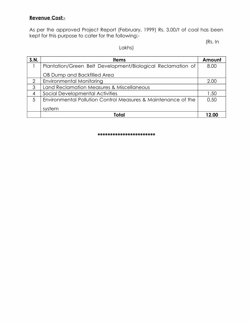
Revenue Cost:-
As per the approved Project Report (February, 1999) Rs. 3.00/t of coal has been kept for this purpose to cater for the following:-
(Rs. In Lakhs)
S.N. Items Amount1 Plantation/Green Belt Development/Biological Reclamation of
OB Dump and Backfilled Area
8.00
2 Environmental Monitoring 2.003 Land Reclamation Measures & Miscellaneous4 Social Developmental Activities 1.505 Environmental Pollution Control Measures & Maintenance of the
system
0.50
Total 12.00
***********************