Embed Size (px)
Citation preview
Rodrigo Proença de Oliveira
Hydrology, environment and water resources
2016 / 2017
Soil water
Soil, pedosphere and lithosphere
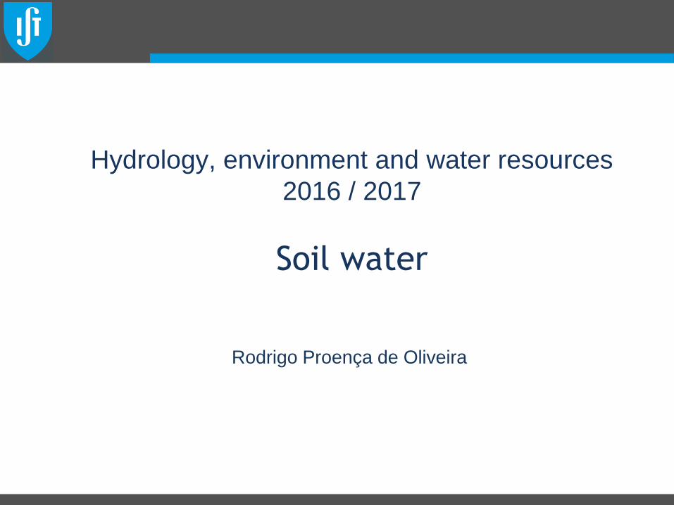
• Rock >> regolith >> soil
• Soil: Superficial layear (1-2 m) of the geologic substract (pedosphere),
that holds:
– Minerals: Sand, silt and clay - mineral nutrients
– Humus: provides nutrients, as well as the soil structure and its
ability to hold water and nutrients;
– Air: source of oxygen and CO2 requited by micro organisms
– Water: provides the environment where the chemical reactions
that hold life can occur Hydrology, environment and water resources 2016/17: @Rodrigo Proença de Oliveira 2016/17 2
desagregation+ water
+ organic matter
Solo
Lito
sfe
ra
Pe
do
sfe
ra
~2
00
m
~2 m

Regolith
Hydrology, environment and water resources 2016/17: @Rodrigo Proença de Oliveira 2016/17 3
<Earth
Moon>
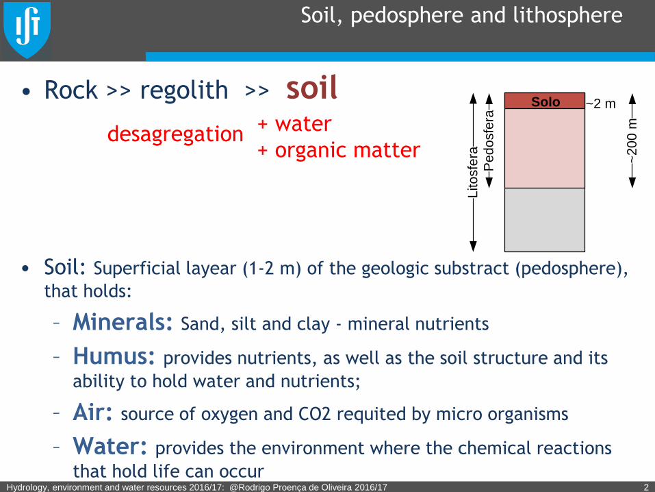
Soil
Hydrology, environment and water resources 2016/17: @Rodrigo Proença de Oliveira 2016/17 4
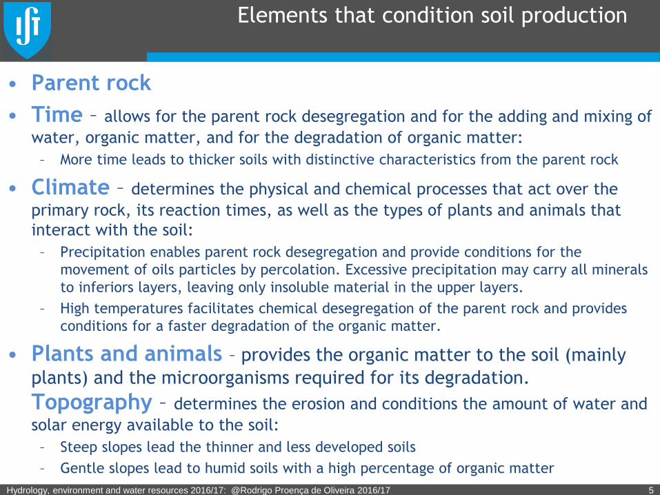
Elements that condition soil production
• Parent rock
• Time – allows for the parent rock desegregation and for the adding and mixing of
water, organic matter, and for the degradation of organic matter:
– More time leads to thicker soils with distinctive characteristics from the parent rock
• Climate – determines the physical and chemical processes that act over the
primary rock, its reaction times, as well as the types of plants and animals that
interact with the soil:
– Precipitation enables parent rock desegregation and provide conditions for the
movement of oils particles by percolation. Excessive precipitation may carry all minerals
to inferiors layers, leaving only insoluble material in the upper layers.
– High temperatures facilitates chemical desegregation of the parent rock and provides
conditions for a faster degradation of the organic matter.
• Plants and animals – provides the organic matter to the soil (mainly
plants) and the microorganisms required for its degradation.
Topography – determines the erosion and conditions the amount of water and
solar energy available to the soil:
– Steep slopes lead the thinner and less developed soils
– Gentle slopes lead to humid soils with a high percentage of organic matter
Hydrology, environment and water resources 2016/17: @Rodrigo Proença de Oliveira 2016/17 5
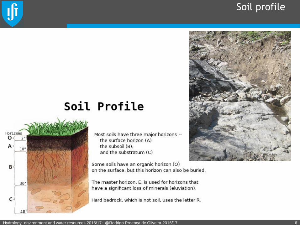
Soil profile
Hydrology, environment and water resources 2016/17: @Rodrigo Proença de Oliveira 2016/17 6
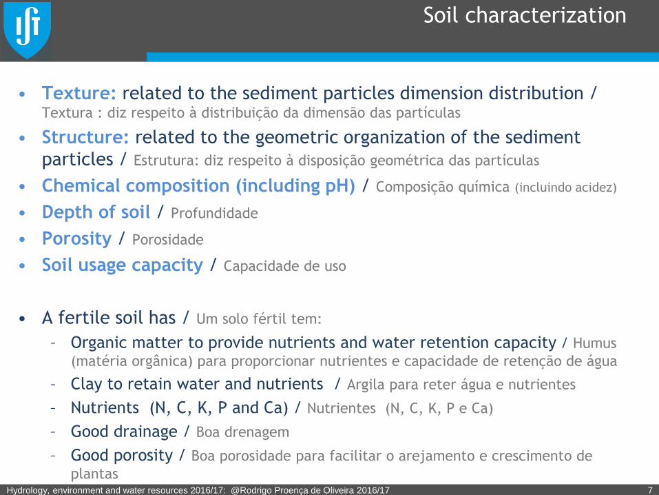
Soil characterization
• Texture: related to the sediment particles dimension distribution / Textura : diz respeito à distribuição da dimensão das partículas
• Structure: related to the geometric organization of the sediment
particles / Estrutura: diz respeito à disposição geométrica das partículas
• Chemical composition (including pH) / Composição química (incluindo acidez)
• Depth of soil / Profundidade
• Porosity / Porosidade
• Soil usage capacity / Capacidade de uso
• A fertile soil has / Um solo fértil tem:
– Organic matter to provide nutrients and water retention capacity / Humus
(matéria orgânica) para proporcionar nutrientes e capacidade de retenção de água
– Clay to retain water and nutrients / Argila para reter água e nutrientes
– Nutrients (N, C, K, P and Ca) / Nutrientes (N, C, K, P e Ca)
– Good drainage / Boa drenagem
– Good porosity / Boa porosidade para facilitar o arejamento e crescimento de
plantasHydrology, environment and water resources 2016/17: @Rodrigo Proença de Oliveira 2016/17 7
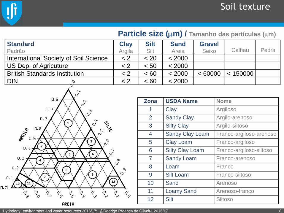
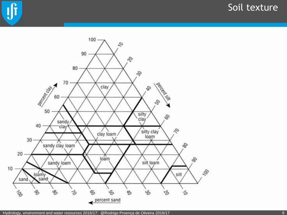
Soil texture
Hydrology, environment and water resources 2016/17: @Rodrigo Proença de Oliveira 2016/17 8
1
3
4
9
8
7
111012
2
5 6
Zona USDA Name Nome
1 Clay Argiloso
2 Sandy Clay Argilo-arenoso
3 Silty Clay Argilo-siltoso
4 Sandy Clay Loam Franco-argiloso-arenoso
5 Clay Loam Franco-argiloso
6 Silty Clay Loam Franco-argiloso-siltoso
7 Sandy Loam Franco-arenoso
8 Loam Franco
9 Silt Loam Franco-siltoso
10 Sand Arenoso
11 Loamy Sand Arenoso-franco
12 Silt Siltoso
Particle size (mm) / Tamanho das partículas (mm)
StandardPadrão
ClayArgila
SiltSilt
SandAreia
GravelSeixo Calhau Pedra
International Society of Soil Science < 2 < 20 < 2000
US Dep. of Agricuture < 2 < 50 < 2000
British Standards Institution < 2 < 60 < 2000 < 60000 < 150000
DIN < 2 < 60 < 2000
Soil texture
Hydrology, environment and water resources 2016/17: @Rodrigo Proença de Oliveira 2016/17 9
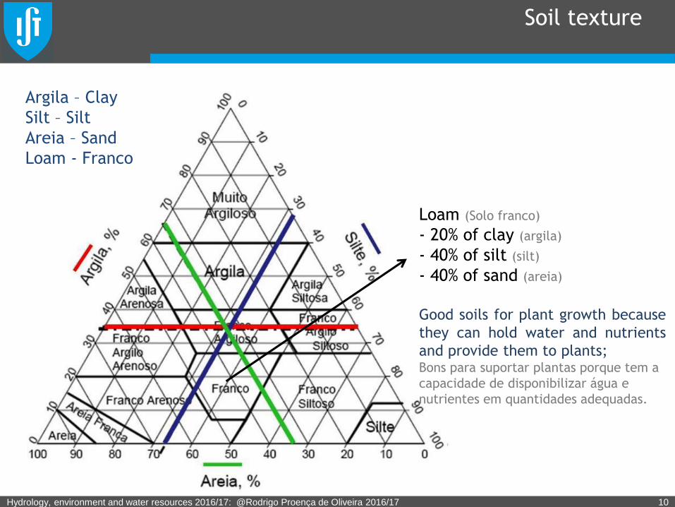
Soil texture
Hydrology, environment and water resources 2016/17: @Rodrigo Proença de Oliveira 2016/17 10
Loam (Solo franco)
- 20% of clay (argila)
- 40% of silt (silt)
- 40% of sand (areia)
Good soils for plant growth because
they can hold water and nutrients
and provide them to plants;Bons para suportar plantas porque tem a
capacidade de disponibilizar água e
nutrientes em quantidades adequadas.
Argila – Clay
Silt – Silt
Areia – Sand
Loam - Franco
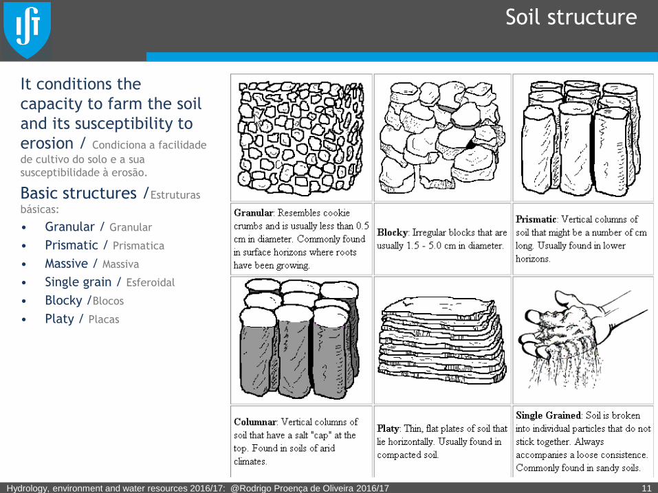
Soil structure
It conditions the
capacity to farm the soil
and its susceptibility to
erosion / Condiciona a facilidade
de cultivo do solo e a sua
susceptibilidade à erosão.
Basic structures /Estruturas
básicas:
• Granular / Granular
• Prismatic / Prismatica
• Massive / Massiva
• Single grain / Esferoidal
• Blocky /Blocos
• Platy / Placas
Hydrology, environment and water resources 2016/17: @Rodrigo Proença de Oliveira 2016/17 11
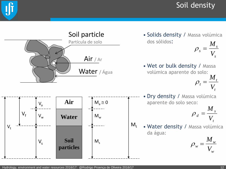
Soil density
• Solids density / Massa volúmica
dos sólidos:
•Wet or bulk density / Massa
volúmica aparente do solo:
• Dry density / Massa volúmica
aparente do solo seco:
•Water density / Massa volúmica
da água:
Hydrology, environment and water resources 2016/17: @Rodrigo Proença de Oliveira 2016/17 12
Soil particle Partícula de solo
Air / Ar
Water / Água
Soil
particles
Water
Air
Vt
Vf
Vs
Vw
Va
Mt
Ms
Mw
Ma 0
s
ss
V
M
t
tt
V
M
t
s
dV
M
w
ww
V
M
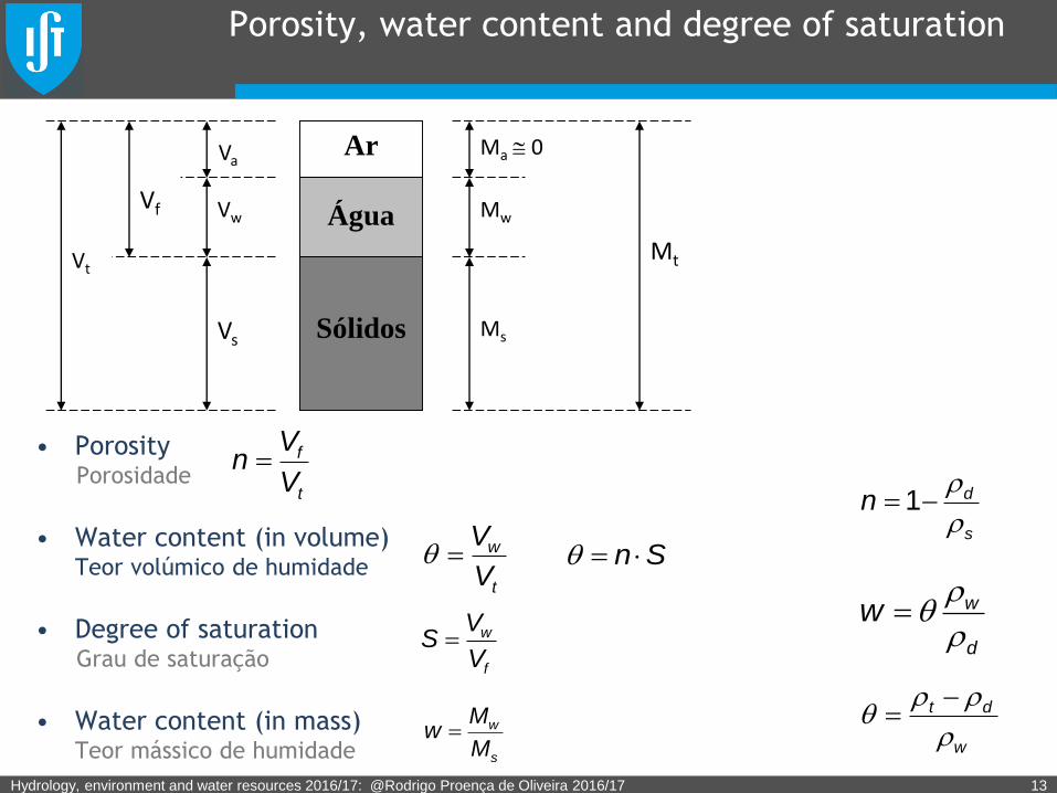
Porosity, water content and degree of saturation
• PorosityPorosidade
• Water content (in volume) Teor volúmico de humidade
• Degree of saturationGrau de saturação
• Water content (in mass) Teor mássico de humidade
Hydrology, environment and water resources 2016/17: @Rodrigo Proença de Oliveira 2016/17 13
t
f
V
Vn
t
w
V
V
f
w
V
VS
s
w
M
Mw
s
dn
1
d
ww
w
dt
Sólidos
Água
Ar
Vt
Vf
Vs
Vw
Va
Mt
Ms
Mw
Ma 0
Sn
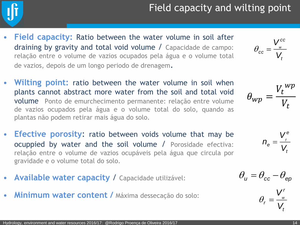
Field capacity and wilting point
• Field capacity: Ratio between the water volume in soil after
draining by gravity and total void volume / Capacidade de campo:
relação entre o volume de vazios ocupados pela água e o volume total
de vazios, depois de um longo periodo de drenagem.
• Wilting point: ratio between the water volume in soil when
plants cannot abstract more water from the soil and total void
volume Ponto de emurchecimento permanente: relação entre volume
de vazios ocupados pela água e o volume total do solo, quando as
plantas não podem retirar mais água do solo.
• Efective porosity: ratio between voids volume that may be
ocuppied by water and the soil volume / Porosidade efectiva:
relação entre o volume de vazios ocupáveis pela água que circula por
gravidade e o volume total do solo.
• Available water capacity / Capacidade utilizável:
• Minimum water content / Máxima dessecação do solo:
Hydrology, environment and water resources 2016/17: @Rodrigo Proença de Oliveira 2016/17 14
t
cc
ccV
Vw
t
e
eV
Vn f
epccu
t
r
rV
Vw
𝜃𝑤𝑝 =𝑉𝑡𝑤𝑝
𝑉𝑡
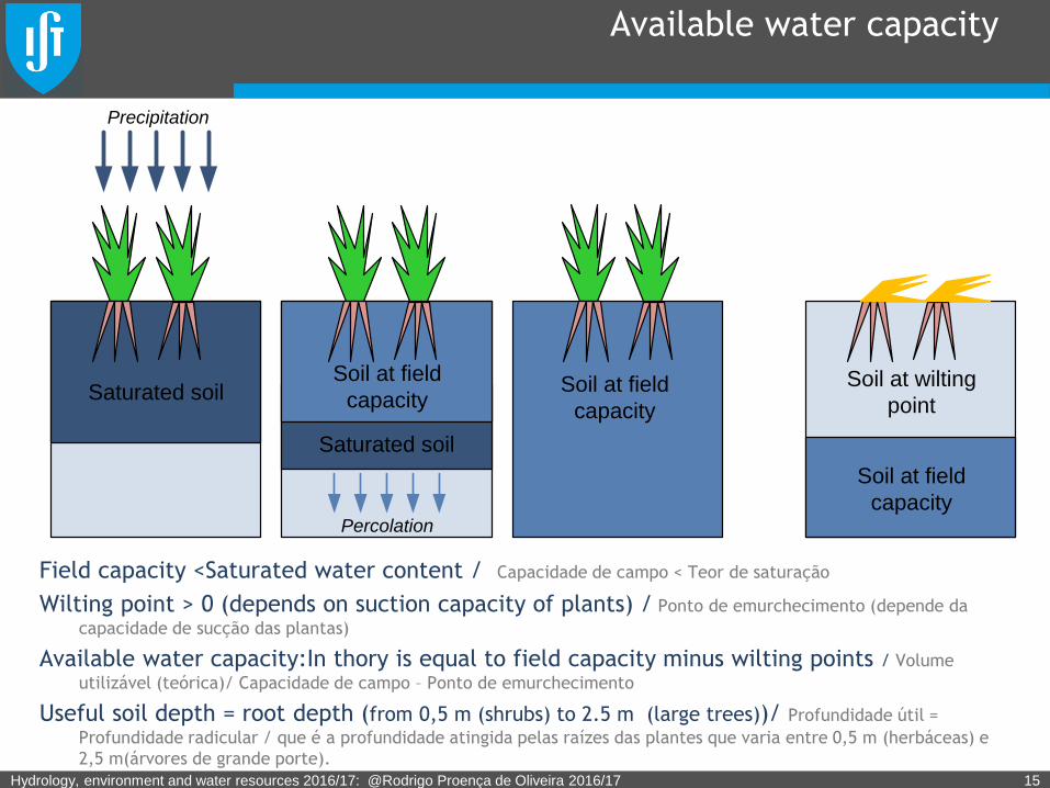
Available water capacity
Field capacity <Saturated water content / Capacidade de campo < Teor de saturação
Wilting point > 0 (depends on suction capacity of plants) / Ponto de emurchecimento (depende da
capacidade de sucção das plantas)
Available water capacity:In thory is equal to field capacity minus wilting points / Volume
utilizável (teórica)/ Capacidade de campo – Ponto de emurchecimento
Useful soil depth = root depth (from 0,5 m (shrubs) to 2.5 m (large trees))/ Profundidade útil =
Profundidade radicular / que é a profundidade atingida pelas raízes das plantes que varia entre 0,5 m (herbáceas) e
2,5 m(árvores de grande porte).
Hydrology, environment and water resources 2016/17: @Rodrigo Proença de Oliveira 2016/17 15
Precipitation
Saturated soil
Saturated soil
Soil at field
capacitySoil at field
capacity
Percolation
Soil at field
capacity
Soil at wilting
point
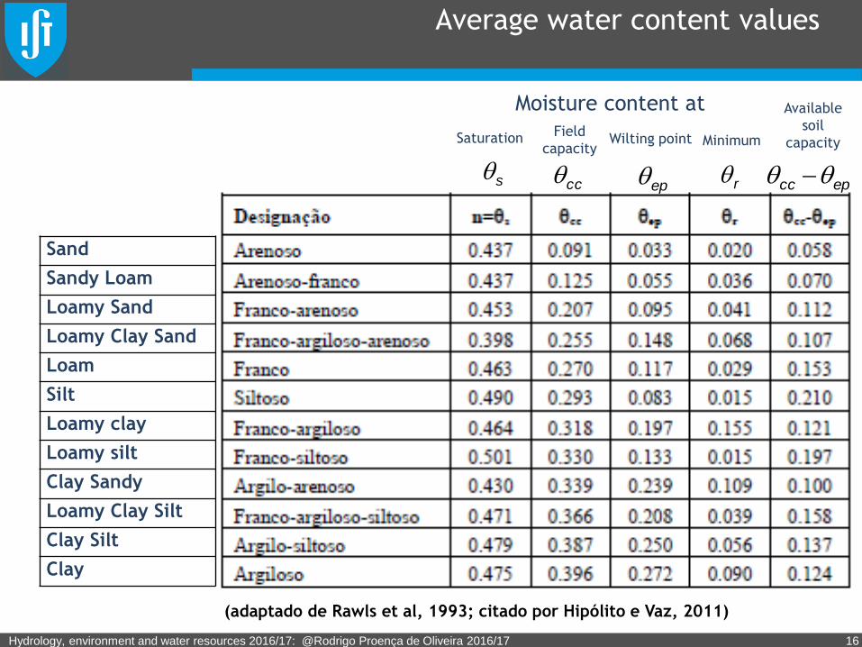
Average water content values
Hydrology, environment and water resources 2016/17: @Rodrigo Proença de Oliveira 2016/17 16
s ccep r epcc
(adaptado de Rawls et al, 1993; citado por Hipólito e Vaz, 2011)
Sand
Sandy Loam
Loamy Sand
Loamy Clay Sand
Loam
Silt
Loamy clay
Loamy silt
Clay Sandy
Loamy Clay Silt
Clay Silt
Clay
SaturationField
capacityWilting point
Moisture content at Available
soil
capacityMinimum
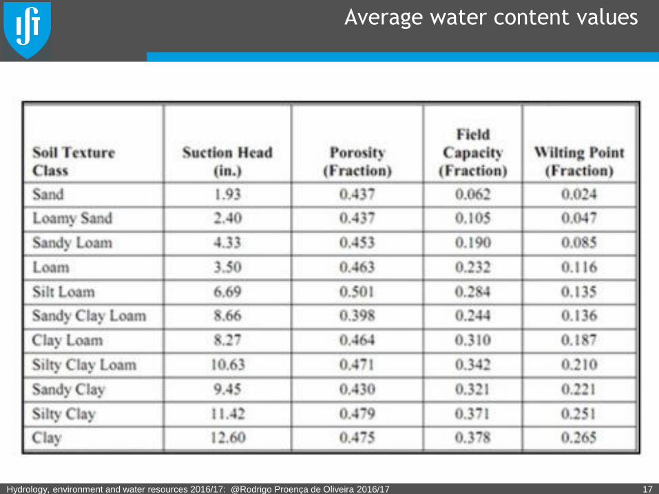
Average water content values
Hydrology, environment and water resources 2016/17: @Rodrigo Proença de Oliveira 2016/17 17
Exercise
Consider a soil with a bulk dry density of1750 kg m-3 and a solid density
of 2500 kg m-3. Determine the soil porosity and the bulk density when
saturated.
A massa volúmica aparente de um solo seco é 1750 kg m-3 e a massa volúmica dos sólidos é
2500 kg m-3. Determine a porosidade do solo e a sua massa volúmica aparente quando
saturado.
Hydrology, environment and water resources 2016/17: @Rodrigo Proença de Oliveira 2016/17 18
Exercise
Consider a soil sample in a cylinder with 5 cm of radius and 10 cm of
height. Knowing that the wet and dry masses of the sample are 331,8 g
and 302,4 g, respectively and that the solid density is 2650 kg/m3,
determine the sample water content (in volume) and saturated sample
water content (in volume).
Uma amostra de solo ocupa um cilindro de 5 cm de diâmetro e 10 cm de altura. Sabendo
que as massas húmidas e secas são, respetivamente, 331,8 g e 302,4 g e que a massa
volúmica dos sedimentos é 2650 kg/m3, determine o teor volúmico de saturação e o teor
volúmico de humidade da amostra.
Hydrology, environment and water resources 2016/17: @Rodrigo Proença de Oliveira 2016/17 19
Exercise
A contained with a hole at the bottom contains 5 l of a soil with a water
content (in volume) of 0.15. Knowing that the soild filed capacity is
0.28, compute the water quantity that drains through the bottom hole
when 1 liter of water is added to the container.
Um vaso, munido de um orifício no fundo, contém 5 l de um solo com um teor volúmico de
humidade de 0.15. Sabendo que a capacidade de campo do solo é 0.28, calcule a
quantidade de água que sairá pelo orifício quando se deitar no vaso 1 l de água.
Hydrology, environment and water resources 2016/17: @Rodrigo Proença de Oliveira 2016/17 20

Exercise
An agricultural field with 1 ha is planted with a crop with a root depth of
0.5 m. Assuming the field capacity of the soil is 0.45 and that minimum
soil water content for crop production is 0.24, compute the water
requirements to raise the water content from that minimum to the field
capacity. Assuming the average evapotranspiration is 3 mm/day,
estimate the maximum time interval between irrigation.
Num terreno com 1 ha encontra-se instalada uma cultura agrícola com a profundidade
radicular de 0.5 m. Sabendo que o solo tem uma capacidade de campo de 0.45 e que o
mínimo teor volúmico de humidade admissível para produção é 0.24, estime o volume de
água de rega para passar desse mínimo à capacidade de campo. Sabendo que a
evapotranspiração média é de 3 mm/d estime também o intervalo de tempo entre duas
regas sucessivas.
Hydrology, environment and water resources 2016/17: @Rodrigo Proença de Oliveira 2016/17 21
Exercise
An agricultural field with 1 ha has a soil with 30% sand, 60% silt and 10%
clay. Knowing that the optimal crop production requires that the soil
water content is kept higher than 50% of the available water capacity,
compute the irrigation volume, in m3, to raise the water content from its
minimum to field capacity.
Num terreno com 1 ha, o solo é fundamentalmente constituído por 30% de areia, 60% de
silte e 10% de argila e a cultura instalada tem uma profundidade radicular de 0,5 m.
Sabendo que para uma produção ótima o teor de humidade não deve baixar de 50% da água
total utilizável pelas plantas, estime o volume de rega em m3 necessário para passar do
mínimo teor admissível à capacidade de campo.
Hydrology, environment and water resources 2016/17: @Rodrigo Proença de Oliveira 2016/17 22