Embed Size (px)
Citation preview
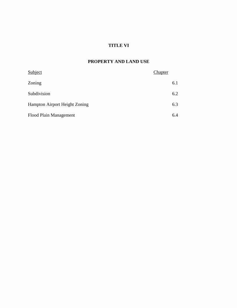
TITLE VI
PROPERTY AND LAND USE Subject Chapter Zoning 6.1 Subdivision 6.2 Hampton Airport Height Zoning 6.3 Flood Plain Management 6.4
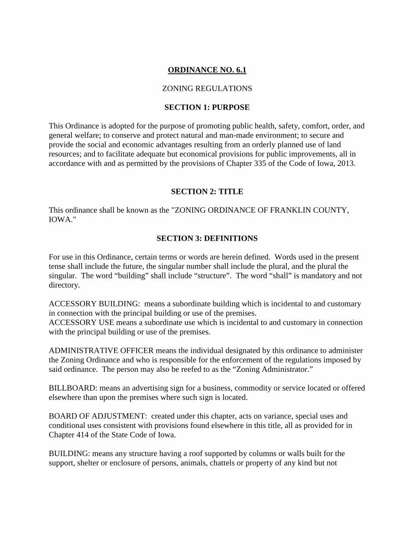
ORDINANCE NO. 6.1 ZONING REGULATIONS
SECTION 1: PURPOSE
This Ordinance is adopted for the purpose of promoting public health, safety, comfort, order, and general welfare; to conserve and protect natural and man-made environment; to secure and provide the social and economic advantages resulting from an orderly planned use of land resources; and to facilitate adequate but economical provisions for public improvements, all in accordance with and as permitted by the provisions of Chapter 335 of the Code of Iowa, 2013.
SECTION 2: TITLE
This ordinance shall be known as the "ZONING ORDINANCE OF FRANKLIN COUNTY, IOWA."
SECTION 3: DEFINITIONS
For use in this Ordinance, certain terms or words are herein defined. Words used in the present tense shall include the future, the singular number shall include the plural, and the plural the singular. The word “building” shall include “structure”. The word “shall” is mandatory and not directory. ACCESSORY BUILDING: means a subordinate building which is incidental to and customary in connection with the principal building or use of the premises. ACCESSORY USE means a subordinate use which is incidental to and customary in connection with the principal building or use of the premises. ADMINISTRATIVE OFFICER means the individual designated by this ordinance to administer the Zoning Ordinance and who is responsible for the enforcement of the regulations imposed by said ordinance. The person may also be reefed to as the “Zoning Administrator.” BILLBOARD: means an advertising sign for a business, commodity or service located or offered elsewhere than upon the premises where such sign is located. BOARD OF ADJUSTMENT: created under this chapter, acts on variance, special uses and conditional uses consistent with provisions found elsewhere in this title, all as provided for in Chapter 414 of the State Code of Iowa. BUILDING: means any structure having a roof supported by columns or walls built for the support, shelter or enclosure of persons, animals, chattels or property of any kind but not
including any vehicle, trailer (with or without wheels) nor any movable device such as furniture, machinery or equipment. HEIGHT OF BUILDING: means the vertical distance from grade to the highest point of the building or any structure attached thereto. COMMERCIAL FEEDLOT: means a commercial venture involving the assemblage of livestock for the express purpose of preparation for market, purchasing over seventy-five percent (75%) of its feed. COMMISSION: means the Zoning Commission of Franklin County. CONDITIONAL USE: means a use of property that will be permitted by the Board of Adjustment subject to the applicant meeting certain conditions and safeguards which will assure that the use will be in harmony with the general intent and purpose of the Zoning Ordinance. COUNTY: means the unincorporated portion of Franklin County. DWELLING: means any building or portion thereof which is designed and used exclusively for residential purposes. SINGLE-FAMILY DWELLING: means a detached building arranged, designed or intended to be occupied as the residence of an individual housekeeping organization and having no wall in common with an adjacent house or houses. TWO-FAMILY DWELLING: means a detached building that is arranged, designed or intended to be occupied as the residence of two individual housekeeping organizations living independently of each other. MULTI-FAMILY DWELLING: means a building or buildings designed for or occupied exclusively by more than two individual housekeeping organizations. This definition will include, but not be limited to, such buildings as are commonly referred to as apartment buildings. EARTH SHELTERED HOME: means a building designed to be used as a dwelling utilizing earth to shelter the building. The roof can be of conventional construction or covered with earth as a completed residential dwelling, as opposed to a basement with a temporary roof. FAMILY: means a group of one or more persons occupying a premises and living as a single housekeeping unit as distinguished from a group occupying a boarding house, lodging house or hotel as defined herein. FAMILY HOME: means a community-based residential home which is licensed as a residential care facility under State Code Chapter 135C or as a child foster care facility under Chapter 237 to provide room and board, personal care, habilitation services and supervision in a family
environment exclusively for not more than eight (8) developmentally disabled persons and any necessary support personnel. However, family home does not mean an individual foster care family home licensed under Chapter 237 of the State Code. FARM: means an area comprising of ten (10) or more acres which is used and primarily adapted, by reason of nature and area, for the growing of the growing of the usual farm products such as vegetables, fruits and grains, and their storage on the area, as well as the raising thereon of the swine, while so used. The term “farming” includes the operating of such an area for one or more of the above uses, including dairy farms with the necessary accessory uses for treating or storing the produce; provide, however, that the operation of such accessory uses shall be secondary to that of the normal farming activities, and provided further, that farming does not include the feeding of collected garbage or offal to swine or other animals. FARMSTEAD: means the service area of a farm which typically includes the farmhouse, outbuildings, and some trees. HOME OCCUPATION: means any occupation or profession carried on by a member of a household organization residing on the premises, in connection with which there is used no sign other than a nameplate not exceeding two (2) square feet in area; provided that the occupation or profession does not occupy more than the equivalent of fifty percent (50%) of the floor areas of one story of the dwelling; there is no display that would indicate from the exterior that the building is being utilized in whole or part for any purpose other than that of a dwelling. JUNK YARD: means an area of any lot which is used for the storage, abandonment or keeping of junk, including scrap metals or scrap material; or for the abandonment or dismantling of machinery, automobiles or other vehicles or parts thereof with a business of buying, selling or trading such items or materials. LOT: means a piece, plot or parcel of land or contiguous parcels of land as established by survey, plot or deed, occupied or to be occupied by a use, a building or a unit group of buildings and accessory buildings thereto, together with such open spaces as are required under this Ordinance. DEPTH OF A LOT: is the mean horizontal distance between the front and rear lot lines. DOUBLE FRONTAGE LOT: is a lot having a frontage on two (2) non-intersecting streets. LOT LINES: are the property lines bounding a lot. LOT OF RECORD: is a lot which is part of a subdivision recorded in the office of the County Recorder or a lot or parcel described by metes and bounds, the description of which has been so recorded. LOT WIDTH: is the width of a lot measured at the building line and at right angles to its depth.
MINERAL EXTRACTION: means the extraction of coal, gypsum, clay, stone, sand, gravel or other ores or mineral liquids or solids for sale, borrow or for processing or consumption in the regular operation of a business or governmental agency by removing any earth overburden lying above natural deposits thereof and mining directly from deposits lying exposed in their natural state, or by subsurface extraction. Removal of overburden and mining of limited amounts of any ores or mineral solids shall not be considered surface mining when done only for the purpose and to the extent necessary to determine the location, quantity, or quality of any natural deposit, so long as no ores or minerals removed during exploratory excavation or mining are sold, processed for sale, or consumed in the regular operation of a business or agency. MOBILE HOME: means a transportable, single family dwelling unit suitable for year-round occupancy, of a size of eight (8) feet by thirty two (32) feet or greater having been designed with no foundation other than wheels, jacks, piers or skirtings and containing water supply, waste disposal, heating and electrical convenience. MOBILE HOME PARK: means an approved site, lot, field or tract of land designed, maintained or used for the purpose of supplying location and accommodations for mobile homes and shall include any building, structure, vehicle or enclosure used or intended for use as a part of the equipment of such parks; unoccupied mobile homes which are parked for the purposes of inspection and sale may be placed in a mobile home park if they are incidental to the operation of said mobile home park. MOBILE HOME SPACE OR MOBILE HOME LOT: means a parcel of ground within a mobile home park designed for the accommodation of one (1) mobile home. NONCONFORMING USE: means any building or land lawfully occupied by a use at the time of passage or this zoning ordinance or amendment thereto which does not conform after the passage of this zoning ordinance or amendment thereto with the use regulation of the district in which it is situated. NURSING HOME: means a home for the aged or infirm, in which three or more persons not of the immediate family are received, kept or provided with food and shelter or care, for compensation; but not including hospitals, clinics or similar institutions. PARKING SPACE: means an area of not less than two hundred (200) square feet, plus necessary maneuvering space for the parking of a motor vehicle. Space for maneuvering, incidental to parking or un-parking, shall not encroach upon any public right-of-way. PLANNED UNIT DEVELOPMENT: means a tract of land which contains or will contain two (2) or more principle buildings or uses, the development of which is unique and of a substantially different character than that of the surrounding areas. PRINCIPAL PERMITTED USE: means those uses of property allowed as a right in the district and which may be approved by the Zoning Administrator if the other requirements of this title
are met, as differentiated from a “conditional use” that can only be approved by the Board of Adjustment after they have set conditions which must be met by the applicant to ensure that the intent and purpose of this title will be met. RECREATIONAL VEHICLE: means a transportable overnight or short term sleeping or dwelling unit of a size less than eight (8) feet by thirty two (32) feet when in transport. The term includes, but is not limited to, travel trailer, pickup camper, fold-down camper and mobilized camper. RECREATIONAL VEHICLE PARK: means an approved site, lot, field or tract of land designed, maintained or used for the purpose of supplying location and accommodations for recreational vehicles and shall include any building, structure, vehicle or enclosure used or intended for use as a part of the equipment of such parks; unoccupied recreational vehicles which are parked for the purposes of inspection and sale may be placed in a recreational vehicle park if they are incidental to the operation of said recreational vehicle park. RECREATIONAL VEHICLE SPACE OR LOT: means a parcel of ground within a recreational vehicle park designed for the accommodation of one (1) recreational vehicle. SPECIAL USE: means a “conditional use” for the purposes of this title. STRUCTURE: means anything constructed, erected or built the use of which requires location on the ground and designed for the support, enclosure, shelter or protection of persons, animals, chattels or properties of any kind, including, but without limiting the generality of the foregoing installations, such as signs, billboards, radio towers and other facilities not designed for storage of property or occupancy of persons. This definition does not include fences or walls less than six (6) feet in height. SUPERVISORS: means the Board of Supervisors of Franklin County, Iowa. VARIANCE: means an exception to the distance, area and height requirements of this title, granted by the Board of Adjustment, in appropriate cases and subject to appropriate conditions and safeguards. YARD: means an open space on the same lot with a building unoccupied and unobstructed by any portion of a structure from the ground upward, except as otherwise permitted in this title. FRONT YARD: means a yard across the full width of the lot extending in depth from the front line of the main building to the edge of the street or road right-of-way if the street or road right-of-way is by easement, or to the front line of the lot if the street or road is dedicated public property. REAR YARD: means a yard extending the full width of the lot between the main building and the rear lot line, or to the edge of right-of-way of any street or road easement.
SIDE YARD: means a yard between the main building and the side line of the lot, or to the edge of right-of-way of any street or road, and extending from the front yard line to the rear yard line. ZONING ADMINISTRATOR: means the administrative officer designated or appointed to administer and enforce the regulations contained in this Ordinance. ZONING PERMIT: means a permit issued by the enforcing officer authorizing the use of land in the manner and for the purpose specified in the application.
SECTION 4: PERMITS AND ENFORCEMENT
Permit Required. No building or part thereof shall be erected, constructed, reconstructed, converted, altered, enlarged, extended, razed, moved or used, and no land shall be used except in conformity with the regulations herein prescribed for the district in which such building or land may be situated and until a zoning permit has been issued by the Zoning Administrator as provided herein. Application for Zoning Permit. Each application for a zoning permit shall be in writing, on the standard forms of the County, and filed in the office of the Zoning Administrator. The application shall be accompanied with a plot plan of the lot upon which the building or structure is to be placed, reconstructed, enlarged or converted, showing the size of the lot, foundation dimensions, proposed front, side and rear yard depths of the proposed building or structure and any other existing accessory buildings on the lot and the flood plain delineation on the lot. The flood plain delineation shall be approved by the County Engineer and Soil Conservation Director. Issuance of Zoning Permit. If, after reviewing the application the Zoning Administrator finds the application complies with all of the provisions of these regulations, he/she shall, upon payment of the required fee as prescribed herein, issue a zoning permit therefore and retain a copy thereof as a part of the permanent records of his/her office. Refusal of Zoning Permit. If, after reviewing the application the Zoning Administrator finds the building or structure in the proposed location does not comply with the provisions of the regulations, he/she shall furnish the applicant with a statement, signed by the Zoning Administrator, refusing to issue such permit and setting forth the reason for such refusal. The refusal by the Zoning Administrator to issue a permit may be appealed by the applicant to the Board of Adjustment in the manner as provided herein. Enforcement. The Zoning Administrator shall be appointed by the Board of Supervisors to hold office for such term as the Board of Supervisors shall determine. Said Zoning Administrator shall issue all zoning permits and enforce all provisions of these regulations and shall have the right to enter public and private property for purposes of investigation and/or enforcement. Appeals from his/her decision may be made to the Board of Adjustment as provided herein.
Records. The Zoning Administrator shall keep a record in his office of all applications filed, permits issued or refused, and if refused the reason for such refusal and the final action thereon. He shall keep a record in his office of all zoning permit fees collected and shall remit the amount of such fees to the office of the Treasurer each day. Fees. Each application for zoning permit shall be accompanied by a fee according to the Fee Schedule most recently approved by the Board of Supervisors. Violation – Penalty. Any person, firm, co-partnership, corporation or other association of persons, whether acting directly or through employees or agents, that violates, disobeys, omits or neglects the provisions of this title shall be given a NOTICE OF VIOLATION either by personally giving, certified mail or served by law enforcement. This NOTICE OF VIOLATION shall identify the action required to correct the violation and give 20 days to correct it. If said violation is not corrected then a COUNTY CITATION shall be filed either by personally giving, certified mail or served by law enforcement with fines of $750 for the first offense, $1000 for the second and subsequent offences. A NOTICE OF VIOLATION may be in the form of a STOP WORK ORDER which shall instruct the violator to cease any activity until said violation is corrected. Situations where a STOP WORK ORDER may be used include but are not limited to incidences where construction has begun without a BUILDING PERMIT or where proper documentation has not been filed. Each day the violation is permitted to exist shall constitute a separate offense. The Zoning Administrator shall keep a record of violations in his office. If any person, firm, co-partnership, corporation or other association of persons, whether acting directly or through employees or agents violates, disobeys, omits or neglects the provisions of this title three (3) or more times in a three (3) year period they shall be deemed a chronic offender. Chronic Offenders shall be issued a COUNTY CITATION when the Zoning Administrator becomes aware of a violation. A NOTICE OF VIOLATION with a 20 day notice shall not be required in the case of chronic offenders. In case of a violation of any provision of this title, the proper authorities of the County, in addition to other remedies, may institute any appropriate action or proceedings to prevent or abate the illegal act.
SECTION 5: GENERAL PROVISIONS
General Provisions. The regulations herein-after set forth in this division qualify or supplement, as the case may be, the district regulations appearing elsewhere in this chapter.
1. Interpretation of Standards. In their interpretation and application, the provisions of this
ordinance shall be held to be minimum requirements. Where this ordinance imposes a greater restriction than is imposed or required by other provisions of law or by other rules or regulations or ordinances, the provisions of this ordinance shall control. Where for specific land, the requirements of any other legal provisions are more stringent or restrictive than the requirements set forth herein, nothing herein shall be construed to waive compliance with such other legal provisions.
2. Farms Exempt. Except to the extent required to implement Section 335.2 of the State Code of Iowa, 2013, no provisions adopted under this chapter applies to land, farm houses, farm barns, farm outbuildings or other buildings or structures which are primarily adopted, by reason of nature and area, for use for agricultural purposes, while so used. However, the provisions of this chapter may apply to any structure, building, dam, obstruction, deposit or excavation in or on any flood plains of any river or stream.
3. Cross Compliance. No zoning permit shall be issued for any use, building or structure
that would be in violation or create a violation of any other County or State regulations or other legal provisions. Also, no zoning permit shall be issued for any development which will involve a private on-site sewage disposal system until the County Health Officer has conducted a site evaluation and given a preliminary approval to the proposed sewage system.
4. Construction of Progress. If actual construction has legally been started on any building
or structure at the time of adoption of this ordinance, nothing contained herein shall require any change in the plans, construction or designation use of such building or part thereof.
5. Nonconforming Uses. The purpose of these nonconforming uses provisions is to
recognize those developments and property uses that are already in existence, but which may not conform to all of the other provisions of this ordinance regarding permitted uses. It is not the intent of this ordinance to create undue hardship or to unduly restrict property uses that are in existence and not creating any appreciable problems.
The lawful use of a building existing at the time of the adoption of this ordinance, or the last previous use if not being used, may be continued, even though such use does not conform with the provisions hereof. Such uses will be referred to as “existing nonconforming”. The lawful nonconforming use of a building may be expanded throughout the building, however, the building may not be enlarged or replaced, or the use of the building changed to any other nonconforming use without first having received a permit from the Board of Adjustment for a conditional use for the district in which the building is located. When a nonconforming use has been changed to a conforming use or to a more restricted nonconforming use, such use shall not thereafter be changed to a less restricted use.
6. Structures Considered Part of Building. Any portion of a building or any structure attached to the building shall be considered as part of the building for purposes of height and yard requirements of this ordinance unless otherwise provided.
7. Mobile Homes. Mobile homes may only be located in districts where they are specifically provided for and subject to meeting all County and State regulations pertaining to mobile homes. All mobile homes shall have tie-down systems installed that will meet the
standards of the State Building Code as provided for in Chapter 103A in the State Code of Iowa, 2013.
8. Mobile Home Parks. It is unlawful for any person or firm to operate a mobile home park
without the owner or lessee having first obtained a license to operate and maintain a mobile home park from the State Department of Health.
Each yard abutting on a perimeter public right-of-way shall be considered a perimeter yard and shall be a minimum of fifty (50) feet in depth. All other perimeter yards shall have a minimum depth of twenty (20) feet. Yard requirements may be increased where the Board of Adjustment deems necessary. The Board of Adjustment may require that an area with a minimum of ten (10) feet in width be reserved along the perimeter of the mobile home park and may require the erection of a decorative fence or wall six (6) feet in height within said area, to be constructed of a material which will provide a significant visual and sound barrier, and/or screen plantings to be provided and maintained with a minimum height of eight (8) feet at maturity, or as otherwise required by the Board of Adjustment. This area may be included as part of the perimeter yard depth. The minimum mobile home space shall be three thousand two hundred (3,200) square feet and shall measure at least forty (40) feet by eighty (80) feet. Mobile homes shall be located on each space so that there will be at least a twenty (20) foot clearance between each mobile home including any permanently enclosed appendage, and any driveway, walkway or mobile home space boundary, and a ten (10) foot open space at the rear of the mobile home. One (1) parking space per mobile home unit shall be provided at ten (10) feet by twenty (20) feet minimum size. Mobile home park community recreational space shall be aggregated at one hundred (100) square feet per mobile home dwelling. One (1) indirectly lighted sign may be erected facing each public street upon which the mobile home park fronts, showing the name of the mobile home park and other information pertinent thereto; provided that such sign shall not have an area of more than ten (10) square feet.
9. Planned Unit Developments. The ‘R-PUD’ and ‘C-PUD’ districts are intended to provide a means for development of a tract or tracts of land as a single entity for a number of buildings or uses, as differentiated from the traditional single lot development provided for in the other districts of this ordinance. Since planned unit developments, because of their size or intensity of land use, may have a significant effect upon services and other properties, extensive authority over their development is retained by the Supervisors and the Planning and Zoning Commission. Since it is the intent to permit flexibility of design and combination of land uses in planned unit developments, exceptions to provisions found in this ordinance (other than in the “R-PUD’ and “C-PUD’ chapters) are hereby made for planned unit developments. Any planned developments in existence or with an
approved plan for development at the time of passage of this ordinance which are zoned ‘R-PUD’ or ‘C-PUD’ by the adoption of this ordinance shall be considered as having met all of the requirements of this ordinance. All new construction, which is not covered by a plan previously approved by the County, within any ‘R-PUD’ or ‘C-PUD’ district after the effective date of this ordinance must be in compliance with the provisions of this ordinance.
10. Board of Adjustment.
a. Creation and Membership. A Board of Adjustment, to be hereinafter referred to as the
Board, is established. The Board shall consist of five (5) members appointed by the Board of Supervisors. The five members of the first Board appointed shall serve terms of one, two, three, four, and five years, respectively. Thereafter, terms shall be for five years, and vacancies shall be filled for the unexpired terms of any member whose term becomes vacant. Members shall be removable for cause by the appointing authority upon written charges and after public hearing.
b. Chairperson and Meetings.
1. The Board shall adopt its own rules of procedure, not in conflict with this title or the Iowa Statute, to enable it to perform its functions and duties.
2. The Board shall elect its own chairperson, who shall serve for one (1) year. Such chairperson, or in his/her absence the acting chairperson, may administer oaths and compel the attendance of witnesses. Meetings of the Board shall be held at the call of the chairperson and at such other times as the Board may determine. All meetings of the Board shall be open to the public.
3. The Zoning Administrator, or such other person as he/she may designate, shall serve as the secretary of the Board. In the absence of the secretary, the chairperson of the Board may appoint one of the members of the Board to act as secretary pro-tem for the meeting. The Board shall have the power to call on any County department for assistance in the performance of its duties, and it shall be the duty of such department to render such assistance as may reasonably be required.
4. The Board shall keep minutes of its proceedings, showing the vote of each member upon each question, or if absent or failing to vote, indicating such fact, and shall keep records of its examinations and other official actions, all of which shall be immediately filed in the office of the Board.
c. Appeals.
1. Appeals to the Board may be made by any person aggrieved or by any office, department, board or burden of the County affected by any decision of the Zoning Administrator. Such appeal shall be taken within a reasonable time, as provided by the rules of the Board, by filing, with the officer from whom the appeal is taken and with the Board a notice of appeal specifying the grounds thereof. The
Zoning Administrator shall forthwith transmit to the Board all the papers constituting the record upon which the action appealed from was taken.
2. Each appeal shall be in writing and accompanied by a fee according to the Fee Schedule most recently approved by the Board of Supervisors to be paid by the appellant to the Zoning Administrator.
3. The Board shall fix a reasonable time for the hearing of appeal, give public notice thereof and decide the same within a reasonable time. Upon the hearing any party may appear in person or by agent or by attorney.
4. An appeal stays all proceedings in furtherance of the action appealed from, unless the administrative office certifies to the Board, after the notice of appeal shall have been filed with him/her, that by reason of facts stated in the certificate, a stay would, in his/her opinion, cause imminent peril to life or property. In such case, proceedings shall not be stayed otherwise than by a restraining order which may be granted by the Board or by a court of record on application or notice to the administrative officer and on due cause shown.
d. Jurisdiction. The Board shall have the following powers:
1. To hear and decide appeals where it is alleged there is error in any order, requirement, decision or determination made by the Zoning Administrator in the enforcement of this title;
2. To hear and decide special exceptions to the terms of this title upon which the Board is required to pass under this title;
3. Where the street or lot layout on the ground actually varies from the street and lot lines as shown in the Zoning Map, the Board shall interpret the map and the provisions of this title for the particular district or section in question;
4. To permit the erection and use of a building or the use of premises in any location for public utility purposes which is determined reasonably necessary for the public convenience or welfare;
5. To authorize upon appeal in specific cases such variances from the terms of this title as will not be contrary to the public interest, where, owing to special conditions, a literal enforcement of the provisions herein would result in unnecessary hardship, and so that the spirit of this title shall be observed and substantial justice done. The Board, in authorizing any variance, may require any appropriate conditions and stipulations as they deem necessary and such conditions and stipulations attached to the approval shall be complied with, and a violation of those stipulations shall be considered the same as any violation of other provisions of this ordinance. In granting any variance, the Board shall give due consideration to the following requirements: a. The variance and any attached conditions would meet the general purpose of
this ordinance of promoting public health, safety, comfort, order and the general welfare.
b. The variance and any attached conditions would be in keeping with the general character of the surrounding land area, the purpose as stated for that zoning district, and the land use plan of the County.
c. The variance and any attached conditions would not result in any appreciable depreciation of adjacent property values or detract from the enjoyment and use of those adjacent properties.
6. To determine, in cases of uncertainty, the classification of any use. 7. To permit the erection and use of any accessory building on a lot before the
erection of a principal building on such lot as provided herein; provided such use is temporary and for a period of time not to exceed one (1) year.
8. To permit the extension of an existing building or use into a more restricted district immediately adjacent, under such conditions as will safeguard the character of the more restricted district provided that such extension shall not be permitted more than fifty (50) feet beyond the boundary line of the district in which such building or use is authorized.
9. Conditional use permits. The Board of Adjustment shall hold a hearing and consider any application for a conditional use permit. The Board may approve conditional use permits for any use that is in keeping with and appropriate to the uses authorized in that district.
The Board of Adjustment shall give due consideration to the following requirements in the approval or denial of any conditional use permit application: a. The conditional use approval would meet the general purpose of this
ordinance of promoting public health, safety, comfort, order and general welfare.
b. The conditional use approval would be in keeping with the general character of the surrounding area, the purpose as stated for that zoning district, and the land use plan of the County.
c. The conditional use approval would not result in any appreciable depreciation of adjacent property values or detract from the enjoyment and use of those adjacent properties.
d. The conditional use approval would not create any amounts or types of traffic that may be detrimental to others.
e. The conditional use approval would not create objectionable noise, dust, smoke or odor for nearby properties.
f. The conditional use approval would provide adequate parking area so as not to create congestion of public streets and roadways.
The Board of Adjustment may require any appropriate conditions and stipulations as they deem necessary to assure that the preceding requirements will be fully complied with. Such conditions and stipulations attached to the approval shall be complied with, and a violation of those conditions shall be considered the same as any violation of other provisions of this ordinance.
e. Powers. In exercising the above-mentioned powers, the Board of Adjustment may, in
conformity with the provisions of this title, reverse or affirm, wholly or partly, or may modify the order, requirement, decision or determination appealed from and may make
such order, requirement, decision or determination as ought to be made, and to that end shall have all powers of the officer from whom the appeal is taken.
f. Deciding Vote – Authority. The concurring vote of three (3) members of the Board of
Adjustment shall be necessary to reverse any order, requirement, decision or determination of the Zoning Administrator or to decide in favor of the applicant on any matter upon which it is required to pass under this title or to affect any variation in this title. It is not the intention to grant the Board of Adjustment the power or authority to alter or change the Zoning Ordinance or Zoning Map. Such power and authority rests solely with the Board of Supervisors in the manner hereafter provided.
g. Appeal from Decision of Board of Adjustment. Any person or persons, jointly or
severally, aggrieved by any decision of the Board of Adjustment under the provisions of this title, or any taxpayer or any officer, department, board or bureau of the County may seek such relief through the courts as provided by statute.
11. Changes and Amendments. Whenever the public necessity, convenience, general welfare
or good zoning practice requires, the Board of Supervisors may be resolution on its own action or by petition, after recommendation by the Zoning Commission, after public hearings as provided herein, amend, supplement or change the regulations, district boundaries or classifications or amendments thereof.
a. Procedure for Change. The procedure for changes and amendments will be as follows:
1. Applications for any change of district boundaries or classification of property as shown on the Zoning Maps shall be submitted to the County Zoning Commission at their public office upon such forms prescribed by it and shall be accompanied by such data and information as may be prescribed for that purpose by the County Zoning Commission so as to assure the fullest practicable presentation of facts for the permanent record. Each such application shall be verified by at least one of the owners or lessees of property within the area proposed to be reclassified, attesting to the truth and correctness of all facts and information presented with the application. Applications for amendments of the text or requirements of these regulations shall likewise be submitted to the Zoning Commission on forms prescribed by it and shall be verified by the person or persons preparing said amendment.
2. Before submitting its recommendations on a proposed amendment to the Board of Supervisors, the Zoning Commission shall hold at least one (1) public hearing thereon, notice of which shall be given to all property owners within five hundred (500) feet of the property concerned by placing said notice in the United States mail at least ten (10) days before date of such hearing. The notice shall state the place and time at which the proposed amendment to the regulations, including text and maps, may be examined. When the Zoning Commission has completed its recommendations on a proposed amendment, it shall certify the same to the Board of Supervisors.

3. After receiving the certification of said recommendations on the proposed amendment from the Zoning Commission and before adoption of such amendment, the Board of Supervisors shall hold a public hearing thereof, notice of the time and place of which shall be published one (1) time in a newspaper of general circulation in the County, not less than four (4) days nor more than twenty (20) days before the date of public hearing. In addition, notices shall be sent by the United States mail as specified in Subsection B above.
4. After receiving certification of the recommendation on the proposed amendment from the Zoning Commission and after holding the public hearing provided for, the Board of Supervisors shall consider such recommendations and vote on the adoption of the proposed amendment. The proposed amendment shall become effective by a favorable vote of a majority of the members of the Board of Supervisors.
5. Any person or persons desiring a change in the zoning classification of property shall file with the application for such change, a statement giving the names and addresses of the owners of all properties lying within five hundred (500) feet of any part of the property proposed to be changed.
6. The failure to notify as provided in Subsections B and C above shall not invalidate any recommendation of the Zoning Commission, provided such failure was not intentional, and the omission of the name of any owner of property who may, in the opinion of the Zoning Commission be affected by such amendment or change, shall not invalidate any recommendation adopted hereunder; it being the intention of this subsection to provide so far as may be, due notice to the persons substantially interested in the proposed change that an application is pending before the Zoning Commission proposing to make a change in the Zoning Maps or regulations.
7. Each application for an amendment, except those initiated by the Zoning Commission, shall be accompanied by a check payable to the Treasurer of Franklin County or a cash payment according to the Fee Schedule most recently approved by the Board of Supervisors to cover the approximate costs of this procedure and under no conditions shall said sum or any part thereof be refunded for failure of said amendment to be enacted into law and deposited within the general fund.
12. No parcel, lot or lots shall be sold, divided or set off in such a manner that either the portion
sold, divided or set off or the portion remaining would create a violation of any provisions set forth within this ordinance.
SECTION 6: Districts and District Regulations
In order to carry out the purpose and intent of these regulations, the County is hereby divided into nine (9) Zoning District classifications as follows: “A” Agricultural District “R-1” Single Family Residential District
“R-2” Multi-Family Residential District “R-PUD” Residential Planned Unit Development “C-1” Commercial District “C-PUD” Commercial Planned Unit Development “I-1” Light Industry District “I-2” Heavy Industry District “F-C” Flood Plain Conservation District (Overlay District) 1. Official Maps.
The location and boundaries of these districts are set forth on the Official Zoning District Maps which have the same force and effect as if fully set forth herein. The Official Zoning District Maps shall be on file in the office of the Zoning Administrator. If, in accordance with the provisions of these regulations, changes are made in the district boundaries or other matter portrayed on the Official Zoning District Maps, such changes shall be made promptly by the County Zoning Administrator after the amendment has been approved by the Board of Supervisors.
2. District Boundaries.
Where uncertainty exists as to the boundaries of districts shown on the Official Zoning District Maps, the following shall apply: A. Boundaries indicated as approximately following the center lines of streets,
highways, alleys or other public right-of-ways shall be construed to follow such center lines;
B. Boundaries indicated as approximately following platted lot lines shall be construed as following such lot lines;
C. Boundaries indicated as approximately following city limits shall be construed as following city limits;
D. Boundaries indicated as following railroad lines shall be construed to be midway between the main tracks;
E. Boundaries not capable of being determined in the previous four paragraphs shall be as dimensioned on the Official Zoning District Map or, if not dimensioned, shall be determined by scale shown on the map;
F. Boundaries of the “F-C” Flood Plain Conservation District are as shown on the HUD Flood Hazard Boundary maps but may require on-site determination as to where the flood hazard boundary actually is. This determination shall be made by the County Engineer.
“A” Agriculture District
1. Purpose. The “A” Agriculture District is created to provide for those lands within the County that are primarily intended to be used for agricultural purposes.
2. Principal Permitted Uses.
A. Agriculture and the usual farm buildings, structures and uses, including one mobile home on a farm if used by the owner, an immediate relative or an employee. The farmhouse, farm buildings and farm uses are exempt from any regulation and permit requirements.
B. Single-family dwellings, but only on severed farmsteads, lots with primary tree cover, or lots with a majority of the area being comprised of soils having a corn suitability rating (CSR) of less than 60 CSR. However, no such residence shall be located closer than five hundred (500) feet from any feedlot of any other person.
C. Public and private forests and wildlife preserves and similar conservation areas (no permit required).
D. Public parks. E. Accessory buildings and uses, and temporary buildings.
3. Conditional Uses.
The following uses may or may not be permitted subject to determination by the Board of Adjustment:
A. Church or other place of worship, including parish house and Sunday school building.
B. Public schools and private educational institutions having a curriculum approved by the State Department of Public Instruction or regulated by the Department of Social Services.
C. Sanitary landfills, subject to approval of the State Department of Water, Air and Waste Management.
D. Home Occupations. E. Radio and television towers and broadcasting stations, windmills or wind
generators of greater than twelve (12) feet in height (Ornamental windmills twelve (12) feet in height or less, or windmills used in pumping water on land being used for agricultural purpose are exempt from this section).
A site plan shall be submitted to the County that includes the height of the structure, dimensions of the property, location of the structure on the property, location and approximate height of overhead power or transmission lines, and location of principal and accessory structures on the applicant's property as well as surrounding properties. Any radio and television towers and broadcasting stations, windmill or wind generator must be located on a lot or property so that if it falls, it will not fall on any neighboring structures which are not owned by the person operating and
owning the radio and television towers and broadcasting stations, windmill or wind generator.
F. Publicly owned and operated buildings and facilities. G. Public golf courses and community centers; private non-commercial
recreational areas and centers, including country clubs, swimming pools and golf courses.
H. Cemeteries, including mausoleums and crematories; provided that any mausoleum or crematory shall be a distance of at least two hundred (200) feet from adjacent property and street and highway lines and provided further that any new cemetery shall contain an area of twenty (20) acres or more.
I. Commercial kennels for raising, breeding and boarding of dogs or other small animals; provided that all buildings, including runways, be at least two hundred (200) feet from all property lines.
J. Hospitals and sanitariums and charitable institutions for the treatment of diseases.
K. Stables, private and public, and riding academies and clubs, and other structures for housing animals or fowls. Any such structures must be located at least two hundred (200) feet from all boundary lines of the property on which located. Public stables and riding academies and clubs shall be permitted one double-face sign on the premises not to exceed two (2) square feet per face.
L. Nurseries and greenhouses; provided that any heating plant shall be a distance of at least two hundred (200) feet from any dwelling and from any adjoining lot lines.
M. Public and private airports and landing strips. N. Commercial feedlots, however, no part of any feedlot shall be closer than five
hundred (500) feet to any property line. The Board of Adjustment may require greater setbacks to protect nearby property when conditions warrant. Also, the provisions for drainage, sanitation and other health related matters must be approved by the County Board of Health and must meet any requirements of the State Department of Water, Air and Waste Management.
O. Sewage treatment plants and waste stabilization lagoons, public and private. No part of any treatment facility shall be closer than two hundred (200) feet from any property line.
P. Specialized raising of poultry, pigeon, rabbit and other similar animals. Q. Mineral extraction and mining, and all plants for processing gravel, sand, rock
or other such raw material provided that active engagement in such use shall not take place within three hundred (300) feet of any residence, nor within fifty (50) feet of any property line or right-of-way of any public street or highway. Each application for conditional use permit for mineral extraction shall be accompanied by a plan for reclamation or alternative use of the site upon completion of the proposed mineral extraction, and the applicant shall be required to post bond or to provide other appropriate assurance of the plan’s completion.
R. Any commercial or industrial use similar to the uses listed below that are primarily agriculturally oriented and would better serve the users in the Agricultural District than if located in the commercial or industrial districts. 1. Storage and distribution centers for agricultural chemicals, fertilizers,
feeds, seeds and related products. 2. Livestock, sale barns, stockyards or marketing agencies. 3. Commercial grain storage facilities. 4. Repair and service of agricultural implements and vehicles by the resident
operator on the same premises of his place of residence. 5. Oil and/or gas wells, drilling for oil, gas or mineral exploration, and any
related structures and installations. 4. Yard Requirements.
A. Front yard depth, fifty (50) feet. B. Side yard width, twenty-five (25) feet. C. Rear yard depth, thirty (30) feet. An accessory building may be located in a
rear yard but shall be at least five (5) feet from any property line.
5. Height Regulations. Airport height limitations shall prevail if applicable.
6. Lot Area. The minimum lot area shall be not less than twenty-one thousand seven hundred eighty (21,780) square feet or such larger size as may be determined necessary for an on-site sewage system by the County Health Officer.
“R-1” Single-Family Residential District
1. Purpose.
The “R-1” Single-Family Residential District is created to provide for rural residential subdivisions at a moderate density.
2. Principal Permitted Uses.
A. Single-family dwellings. B. Accessory buildings and temporary buildings. C. Private swimming pools, when enclosed by a non-climbable fence at least six (6)
feet in height. D. Agricultural and conservation uses. E. Family homes, as provided for in Section 414.22, State of Iowa, 2003.
3. Conditional Uses.
The following uses may or may not be permitted subject to determination by the Board of Adjustment.
A. Two-family dwellings. B. Home occupations.
C. Churches. D. Public parks and public buildings. E. Public schools and private educational institutions having a curriculum approved
by the State Department of Public Instruction or regulated by the Department of Social Services.
4. Yard Requirements.
Unless otherwise provided, each lot shall have front, side and rear yards of not less than the following:
A. Front yard depth, twenty-five (25) feet. B. Side yard width, ten (10) feet, except that a side yard abutting a street or road
shall be twenty-five (25) feet. C. Rear yard depth, twenty-five (25) feet. An accessory building may be located in a
rear yard but shall be at least five (5) feet from any property line.
5. Height Regulations. Buildings and structures in the “R-1” District shall not exceed thirty-five (35) feet in height. If said buildings or structures are to be located in an area regulated by airport height zoning, any lower height requirement of that airport height regulation shall prevail.
6. Lot Area.
The minimum lot area shall be ten thousand (10,000) square feet if serviced by a common sewer system approved by the State Department of Water, Air and Waste Management. If a private on-site sewage system is used, the minimum lot size shall be twenty-one thousand seven hundred eighty (21,780) square feet or such larger size as may be determined necessary for an on-site sewage system by the County Sanitarian.
7. Parking Requirements.
Two (2) off-street parking spaces shall be provided for each family unit in a dwelling, either within a building on the lot or on a surfaced open space on the lot.
“R-2” Multi-Family Residential District
1. Purpose. The “R-2” Multi-Family Residential District is created to provide for residential development of a higher density than is allowed in the other districts.
2. Principal Permitted Uses.
A. Single-family, two-family and multi-family dwellings. B. Family homes, as provided for in Section 414.22, State Code of Iowa. C. Accessory buildings and temporary buildings. D. Private swimming pools, when enclosed by a non-climbable fence at least six (6)
feet in height. E. Agricultural and conservation uses.

3. Conditional Uses.
The following uses may or may not be permitted subject to determination by the Board of Adjustment:
A. Mobile home parks. B. Home occupations. C. Churches. D. Public parks and public buildings and facilities. E. Public schools and private educational institutions having a curriculum approved
by the State Department of Public Instruction or regulated by the Department of Social Services.
F. Private non-commercial recreation areas and centers, such as country clubs, swimming pools and golf courses.
G. Hospitals, clinics and nursing homes. H. Group homes or halfway (rehabilitation) houses. I. Other uses such as above when there is clear evidence that such use will not
seriously affect the value and character of the surrounding neighborhood.
4. Yard Requirements. Unless otherwise provided, each lot shall have front, side and rear yards of not less than the following:
A. Front yard depth, twenty-five (25) feet. B. Side yard width, ten (10) feet, except that a side yard abutting a street or road
shall be twenty-five (25) feet. C. Rear yard depth, twenty-five (25) feet. An accessory building may be located in a
rear yard but shall be at least five (5) feet from any property line.
5. Height Regulations. Buildings and structures in the “R-2” District shall not exceed forty-five (45) feet in height. If said buildings or structures are to be located in an area regulated by airport height zoning, any lower height requirement of that airport height regulation shall prevail.
6. Lot Area.
The minimum lot area for dwellings served by a common sewer system shall be six thousand six hundred (6,600) square feet for a single-family dwelling; seven thousand five hundred (7,500) square feet for a two-family dwelling; and two thousand (2,000) square feet per unit for multi-family dwellings. If a private on-site sewage system is used, the minimum lot size shall be increased to such a size as may be determined necessary for an on-site sewage system by the County Health Officer.
7. Parking Requirements.
Two (2) off-street parking spaces shall be provided for each family unit in a dwelling, either within a building on the lot or on a surfaced open space on the lot.
“R-PUD” Residential Planned Unit Development
1. Purpose.
The “R-PUD” District is intended and designed to provide a means for the development or redevelopment of a tract or tracts of ground on a unit basis, allowing greater flexibility and diversification of land uses and building locations than the single lot method provided in the other residential districts of this ordinance. This will permit the establishment of multi and integrated use residential developments on larger tracts of land. It is further the intent of this section that the basic principles of good land use planning including an orderly and graded relationship between various types of uses be maintained.
2. Permitted Uses.
A. Dwelling units in detached, semi-detached, attached or multi-storied structures, or any combination thereof, and any accessory building.
B. Non residential uses of a religious, cultural, recreation and commercial character to the extent they are designed and intended to serve the residents of the planned unit development.
3. Procedures.
Since planned unit developments, because of their size or intensity of land use, may have a significant effect upon public services and adjacent properties, extensive authority over their development is retained by the Board of Supervisors and the Planning and Zoning Commission. The procedure for approval of a residential planned unit development shall be as follows. The owner or owners of any tract or tracts of land may petition for a zone change to “R-PUD” for a residential planned unit development. The petition shall be accompanied by evidence that the proposed development is compatible with the surrounding area, evidence showing how the owner or owners propose to maintain any common ground included and surface water drainage and sanitary sewer for the proposed development, evidence that the developer is capable of successfully completing the proposed development and preliminary plan of the proposed development, in triplicate, showing in schematic form generally the location of all proposed:
A. Building and uses, the height and exterior design of typical proposed dwellings
and the number of dwelling units in each; B. Parking areas; C. Access drives; D. Streets abutting or within the proposed development; E. Walks; F. Site topographic features; G. Landscaping and planting areas;
H. Required peripheral yards; I. Common land, recreation areas and parks; J. Existing utility or other easement; and K. Development stages and timing of each.
The petition, accompanying evidence and preliminary plan shall be referred to the Planning and Zoning Commission for study and report after public hearing. The Commission shall review the conformity of the proposed development with the standards of the Comprehensive Plan and with recognized principles of civic design, land use planning and landscape architecture. After public hearing, the Commission may approve or disapprove the preliminary plan and request for rezoning as submitted or require that the petitioner provide such additional information as the Commission may deem necessary or may require that the plan be amended to preserve the intent and purpose of this ordinance to promote public health, safety, morals and general welfare. The petition and preliminary plan as approved by the Commission, along with the Commission’s recommendation on the request for rezoning, shall then be referred to the Board of Supervisors. The Supervisors may approve or disapprove the preliminary plan and request for rezoning as reported, or may require such additional information as may be deemed necessary or changes in the plan as are necessary to preserve the intent and purpose of this ordinance to promote public health, safety, morals and general welfare. If the Supervisors approve the preliminary plan and request for rezoning, the applicant shall submit within two hundred seventy (270) days, or such longer period as may be approved by the Supervisors after recommendation by the Planning and Zoning Commission, to the Zoning Administrator a final development plan, in triplicate, of not less than one stage of the proposed development showing specifically and in detail the location of all proposed:
A. Buildings and uses, the height and exterior design of typical proposed dwellings and the number of dwelling units in each;
B. Parking areas; C. Access drives; D. Streets abutting or within the proposed development; E. Walks; F. All proposed walls and fences; G. Landscaping and planting materials, its type and size at time of installation and at
maturity; H. Required peripheral yards; I. Common land, recreation areas and parks; J. Existing utility and proposed utilities and public easements; K. Proposed signs and their areas and dimensions; L. Lighting facilities and their type and design; M. Storm and sanitary sewer lines; and N. Development stages and timing of each.
The final development plans shall be accompanied by the following required documents.
A. If the proposed development includes common land which will not be dedicated to the County and the proposed development will not be held in single ownership, proposed by-laws of a homeowner’s association fully defining the functions, responsibilities and operating procedures of the association. The proposed by-laws shall include but not be limited to provisions:
(1) Automatically extending membership in the association to all owners of
dwelling units within the development; (2) Limiting the uses of the common property to those permitted by the final
development plan; (3) Granting to each owner of a dwelling unit within the development the
right to the use and enjoyment of the common property; (4) Placing the responsibility for operation and maintenance of the common
property in the association; (5) Giving every owner of a dwelling unit voting rights in the association;
and, (6) If the development will combine rental and for sale dwelling units, stating
the relationship between renters and the homeowner’s association and the rights renters shall have to the use of the common land.
B. Performance bond or bonds approved by the County in an amount not less than the estimated cost of the bonded improvements, which bond or bonds shall insure to the County that the dedicated public streets and utilities, including sewers, located therein and other common development facilities in each stage shall be completed by the developer within the time specified on the final development plan.
C. Covenant to run with the land, in favor of the County and all persons having a possessory interest in any portion of the development premises, that the owner or owners of the land or their successors in interest will maintain all interior streets, parking areas, sidewalks, parks and plantings which have not been dedicated to the County in compliance with the ordinance of the County and the final development plan as approved by the Board of Supervisors, which covenant shall be recorded in the office of the County Recorder.
D. Additional easements or agreements required by the Supervisors at the time of preliminary plan approval.
The final development plan and required documents shall be reviewed by the Commission for compliance with the standards of this section and substantial compliance with the preliminary plan. The Commission’s recommendations and report of the final development plan shall be referred to the Supervisors. The Supervisors shall review the final development plan and approve it if it complies with the standards of this section and is in substantial compliance with the preliminary development plan.
4. Standards and Requirements – Improvements. All streets, sewers, storm sewers and other improvements must comply with County ordinances and specifications. If turning lanes or other forms of traffic controls are deemed necessary by the Supervisors, the developer shall provide the necessary improvements, subject to the approval of their location and design by the County Engineer.
5. Open Space and Recreation – Residential.
Planned unit developments shall contain open yards, open space or recreation area totaling twenty-five percent (25%) or more of the net development area. The net development area shall be defined as the gross development area minus area set aside for churches, schools and streets. Open space and recreation area may be dedicated to the County (by consent of the Supervisors) or managed by the homeowner’s association. Parking areas shall not be considered to be part of the required open space or recreation area.
6. Yard and Height Requirements.
There shall be a minimum yard requirement of twenty-five (25) feet around the boundary of the project. In the absence of an appropriate barrier, the Supervisors may require additional open space for screening be located along all or a portion of the development boundary. The height limitations of any adjacent district shall apply within one hundred twenty-five (125) feet of the development boundary. The maximum height of any structure permitted within the development shall be seventy-two (72) feet.
7. Building Permits.
No building permit for any building or structure within the development shall be issued until the final development plan is approved by the Board of Supervisors.
8. Completion.
The Supervisors may make the approval of the development plan contingent upon the completion of construction and improvements within a reasonable period of time. Failure to complete the construction and improvements within said period of time shall be deemed sufficient cause for the Supervisors to rezone the subject property to the classification effective at the time of the original request for rezoning to “R-PUD” for said development, unless an extension is recommended by the Planning and Zoning Commission and approved by the Supervisors. Any proposed change in the development plan, after approval of the final development plan by the Supervisors shall be resubmitted and considered in the same manner as the original proposal.
“C-1” Commercial District
1. Purpose. The “C-1” Commercial District is created to provide for those types of business are customarily located along major thoroughfares.
2. Principal Permitted Uses.
A. Farm supply sales. B. Automobile, truck, trailer and garden and farm implement establishments. C. Mobile home sales. D. Private clubs and lodges. E. Bowling alleys, dance halls or skating rinks. F. Drive-in restaurants or theaters. G. Petroleum service stations. H. Nurseries and greenhouses. I. Funeral homes or mortuaries. J. Veterinarian or animal hospitals or clinics. K. Motels, hotels, restaurants or cocktail lounges. L. Plumbing shops. M. Grocery stores. N. Offices and office buildings. O. Accessory buildings and uses. P. Any other retail or commercial use similar to the above involving primarily sales or
services.
3. Conditional Uses. The following may or may not be permitted subject to determination of the Board of Adjustment. A. Single-family, two-family or multi-family dwellings. B. Recreational vehicle parks or mobile home parks.
4. Yard Requirements.
Unless otherwise provided, each lot shall have front, side and rear yards of not less than the following: A. Front yard depth, twenty-five (25) feet. B. Side yard width, none required except adjoining any residential district in which case
not less than ten (10) feet. C. Rear yard depth, twenty-five (25) feet.
5. Height Regulations.
Buildings and structures in the “C-1” District shall not exceed forty-five (45) feet in height. If said buildings or structures are to be located in an area regulated by airport height zoning, any lower height requirement of that airport height regulation shall prevail.
6. Lot Area.
The lot area shall be at least twice the gross floor area of the building or buildings.
7. Parking Requirement. The parking area for any building hereinafter erected shall be as follows:
A. Retail store or service establishment. The minimum parking space requirements shall be one (1) off-street parking space for each two hundred (200) square feet of building floor area.
B. Motels and lodging houses. The minimum parking space requirements shall be one (1) off-street space for each individual sleeping room or living unit.
C. Office and funeral homes. The minimum parking space requirements shall be one (1) off-street parking space for each three hundred (300) square feet of floor space in the building devoted to the aforementioned uses.
D. Restaurants, cocktail lounges, night clubs, bowling alleys, dance halls, skating rinks or similar establishments. The minimum parking space requirements shall be one (1) off-street parking space for each one hundred (100) square feet of floor area in the building devoted to the aforementioned uses.
“C-PUD” Commercial Planned Unit Development
1. Purpose.
The “C-PUD” District is intended to provide for the development or redevelopment of a tract or tracts of ground on a unit basis for a planned business and service area characterized by a concentrated grouping of businesses and compatible uses, with various facilities designed to be used in common, such as ingress and egress roads, extensive parking facilities, etc. This type of development will include such developments as shopping centers and office complexes that are not of the traditional single-lot/single-business concept of development provided for in the “C-1” District.
2. Permitted Uses.
Any use or combination of uses permitted in the “C-1” Commercial District may be permitted in the “C-PUD” District.
3. Procedure.
Since planned unit business developments, because of their size and/or intensity of land use, may have a significant effect upon public services and other properties and facilities, extensive authority over their development is retained by the Board of Supervisors and the Planning and Zoning Commission. The procedure for approval of a commercial planned unit development shall be as follows: The owner or owners of any tract or tracts of land may petition for a zone change to “C-PUD” for a commercial planned unit development. The petition shall be accompanied by evidence that the proposed development is compatible with the surrounding area, evidence showing how the owner or owners propose to maintain any common ground or facilities included within the development, a traffic analysis of the vicinity indicating the effect of the proposed development on nearby streets and roads, evidence of the feasibility of providing adequate storm and surface water handling and sanitary sewer for the proposed development, a statement of financial responsibility to assure construction in accordance with the plan, and a preliminary plan of the proposed development, in
triplicate, showing a schematic form generally the buildings and uses, the areas to be developed as parking areas, the location of sidewalks and driveways and the points of ingress and egress including access streets where required, the location and type of landscaping, existing utility or other easements and development stages and timing of each. The petition, accompanying evidence and preliminary plan shall be referred to the Planning and Zoning Commission for study and report after public hearing. The Commission may waive the submittal requirements for any of the above required evidence or may request any additional evidence it deems necessary and appropriate in their consideration of the petition for zone change. The Commission shall review the conformity of the proposed development with the standards of the Comprehensive Plan and with recognized principles of civic design, land use planning and landscape architecture. After public hearing, the commission may approve or disapprove the preliminary plan and request for rezoning as submitted or require that the petitioner amend the plan to preserve the intent and purpose of this ordinance to promote public health, safety, morals and general welfare. The petition and preliminary plan, as approved by the Commission, along with the Commission’s recommendations on the request for rezoning shall then be referred to the Board of Supervisors. The Board may approve or disapprove the preliminary plan and request for rezoning as reported or require such changes in the plan to preserve the intent and purpose of this ordinance to promote public health, safety, morals and general welfare. If the Supervisors approve the preliminary plan and request for rezoning, the applicant shall submit within two hundred seventy (270) days, or such longer period as may be approved by the Supervisors after recommendation by the Planning and Zoning Commission, to the Zoning Administrator a final development plan, in triplicate, of not less than one stage of the proposed development showing specifically and in detail the location of all proposed:
A. Buildings and uses, including the height and exterior design; B. Parking areas; C. Access drives; D. Streets abutting or within the proposed development; E. Walks; F. All proposed walls and fences; G. Landscaping and planting materials, its type and size at time of installation and at
maturity; H. Required peripheral yards; I. Common land, recreation areas and parks; J. Existing utilities and proposed utilities and public easements; K. Proposed signs and their areas and dimensions; L. Lighting facilities and their type and design;
M. Storm and sanitary sewer lines; and N. Development stages and timing of each.
The final development plans shall be accompanied by the following required documents.
A. If the proposed development includes common land which will not be dedicated to the County, and the proposed development will not be held in single ownership, proposed by-laws of an association fully defining the functions, responsibilities and operating procedures of the association.
B. Performance bond or bonds approved by the County in an amount not less than the estimated cost of the bonded improvements, which bond or bonds shall insure to the County that the dedicated public streets and utilities, including sewers, located therein and other common development facilities in each stage shall be completed by the developer within the time specified on the final development plan.
C. Covenant to run with the land, in favor of the County and all persons having a possessory interest in any portion of the development premises, that the owner or owners of the land or their successors in interest will maintain all interior streets, parking areas, sidewalks, parks and plantings which have not been dedicated to the County in compliance with the ordinance of the County and the final development plan as approved by the Board of Supervisors, which covenant shall be recorded in the office of the County Recorder.
D. Additional easements or agreements required by the Supervisors at the time of preliminary plan approval.
The final development plan and required documents shall be reviewed by the Commission for compliance with the standards of this section and substantial compliance with the preliminary plan. The Commission’s recommendations and report of the final development plan shall be referred to the Supervisors. The Supervisors shall review the final development plan and approve it if it complies with the standards of this section and is in substantial compliance with the preliminary development plan.
4. Standards and Requirements – Improvements.
All streets, sewers, storm sewers and other improvements must comply with County ordinances and specifications. If turning lanes or other forms of traffic controls are deemed necessary by the Supervisors, the developer shall provide the necessary improvements, subject to the approval of their location and design by the County Engineer.
5. Yard and Height Requirements.
In the absence of an appropriate physical barrier, the Supervisors may require open space or screening be located along all or a portion of the development boundary. The height limitations of any adjacent district shall apply within one hundred twenty-five (125) feet of the development boundary. The maximum height of any structure permitted within the development shall be seventy-two (72) feet.
6. Building Permits.
No building permit for any building or structure within the development shall be issued until the final development plan is approved by the Board of Supervisors.
7. Completion.
The Supervisors may make the approval of the development plan contingent upon the completion of construction and improvements within a reasonable period of time. Failure to complete the construction and improvements within said period of time shall be deemed sufficient cause for the Supervisors to rezone the subject property to the classification effective at the time of the original request for rezoning to “C-PUD” for said development, unless an extension is recommended by the Planning and Zoning Commission and approved by the Supervisors. Any proposed change in the development plan, after approval of the final development plan by the Supervisors, shall be resubmitted and considered in the same manner as the original proposal.
“I-1” Light Industry District
1. Purpose. The “I-1” Light Industry District is created to provide for those commercial and light manufacturing industries which do not qualify for location in the commercial districts, but which are not heavy manufacturing industries.
2. Principal Permitted Uses.
A. Wholesale establishments. B. Truck terminals. C. Blacksmith and machine shops. D. Sheet metal shops. E. Storage and distribution warehouses. F. Printing shops. G. Builder’s or contractor’s plant or storage yard. H. Building materials sales and storage, including concrete mixing. I. Lumber yards, including millworks. J. Carpenter and cabinet shops. K. Feed stores. L. Bakery, wholesale. M. Plumbing and heating shop. N. Open yards for storage and sales. O. Automobile repair garage, including body shops. P. Raising of crops. Q. Accessory buildings. R. Any other light manufacturing or commercial enterprise similar to the above
listed uses which will not produce significant amounts of dust, noise, smoke, odor or objectionable types or amounts of vehicular traffic.
3. Conditional Uses.
The following uses may be permitted, subject to conditional approval of the Board of Adjustment:
A. Mineral extraction, provided that each application for conditional use permit be accompanied by a plan for reclamation or alternative use of the site upon completion of the proposed mineral extraction, and provided that active engagement in such use shall not take place within fifty (50) feet of any property line or within three hundred (300) feet of any residence. The applicant shall be required to post bond or to provide other appropriate assurance of the plan’s completion.
B. Oil and/or gas wells, drilling for oil, gas or mineral exploration, and any related structures or installations.
4. Yard Requirements. Unless otherwise specified, each lot shall have front, side and rear yards of not less than the following:
A. Front yard – depth, thirty (30) feet. B. Side yard – width, thirty (30) feet. C. Rear yard – depth, thirty (30) feet.
5. Height Regulations. Building structures in the “I-1” District shall not exceed sixty (60) feet in height. If said buildings or structures are to be located in an area regulated by airport height zoning, any lower height requirement of that airport height regulation shall prevail.
6. Lot Area. The principal and accessory buildings may not occupy more than fifty percent (50%) of the lot.
7. Parking Requirements. Two (2) off-street parking spaces shall be provided on the lot for every three (3) employees regularly employed at the same time, plus space to accommodate all trucks or other vehicles, including off-street loading space.
“I-2” Heavy Industry District
1. Purpose.
The “I-2” Heavy Industry District is created to provide for heavy manufacturing industries and other types of businesses that might not be compatible if permitted in the other zoning districts.
2. Principal Permitted Uses.
A. Food product manufacture, excluding fish and meats.
B. Concrete mixing, including concrete products manufacture. C. Contractor’s equipment storage yard. D. Laboratory, experimental or testing. E. Sawmill, including the manufacture of wood products. F. Manufacture and assembly from previously prepared materials such as cloth, leather,
plastics, metal, stone or wood. G. Raising of crops. H. Any other heavy industrial use similar to the above uses which would not create
excessive amounts of dust, smoke, gas, noise, fumes, odor, vibration, fire or explosion.
3. Conditional Uses.
The Board of Adjustment may approve as conditional uses those industrial uses which may prove objectionable by reason of odor, noise, smoke or hazard, such as the following: A. Slaughter houses, stock yards and meat processing plants. B. Distillation of ethanol. C. Acid or chemical manufacture or storage. D. Cement, lime, gypsum or similar material manufacture. E. Explosive manufacture or storage. F. Grain elevators, fertilizer manufacturer or storage. G. Garbage, offal or dead animal reduction. H. Petroleum refining or storage. I. Rubber goods manufacture. J. Salvage yard or junk yard providing that the premises on which such activity is
conducted shall be wholly enclosed within a building, wall or fence not less than six (6) feet in height, completely obscuring the activity.
K. Mineral extraction and mining, and all plants for processing gravel, sand, rock or other such raw material provided that active engagement in such use shall not take place within fifty (50) feet of any property line. Each application shall be accompanied by a plan for reclamation or alternative use of the site upon completion of the proposed mineral extraction and the applicant shall be required to post bond or to provide other appropriate assurance of the plan’s completion.
L. Oil and/or gas wells, drilling for oil, gas or mineral exploration, and any related structures and installations.
4. Yard Requirements.
Unless otherwise specified, each lot shall have front, side and rear yards of not less than the following: A. Front yard – depth, thirty (30) feet. B. Side yard – width, thirty (30) feet. C. Rear yard – depth, thirty (30) feet.
5. Height Regulations.
There is not height limitation within the “I-2” District unless a building or structure is to be located in an area regulated by airport height zoning.
6. Lot Area.
The principal and accessory buildings may not occupy more than fifty percent (50%) of the lot.
7. Parking Requirements.
Two (2) off-street parking spaces shall be provided on the lot for every three (3) employees regularly employed at the same time, plus space to accommodate all trucks or other vehicles, including off-street loading space.
“F” Flood Plain Conservation District
1. Purpose.
The “F” Flood Plain Conservation District is intended and designed as an overlay district that may include any of the other zoning districts. The purpose of the “F” District is to provide additional regulations pertaining to those areas in the County which are subject to flooding. The regulations for the “F” District prevail over any other district regulations pertaining to the subject property.
2. Principal Permitted Uses.
A. Public and private forests and wildlife preserves and similar conservation areas (no permit required).
B. Public and private recreational facilities such as golf courses, picnic grounds, boat launching ramps and hiking and horseback riding trails, but not including any permanent buildings.
C. Agricultural uses, but not including any permanent buildings or structures except by permit from the State Department of Water, Air and Waste Management.
D. Oil and/or gas wells, drilling for oil, gas or mineral exploration, and any related structures or installations.
3. Conditional Uses. Mineral extraction, provided each application is accompanied by a plan for reclamation or alternative use upon completion of the proposed mineral extraction. The applicant shall be required to post bond or to provide other appropriate assurance of the plan’s completion.
4. Yard Requirements.
No restrictions.
5. Height Regulations. Airport height zoning regulations will prevail if applicable.
6. Lot Area. No restrictions.
7. Parking Regulations.
Off-street parking space shall be provided as needed.
SECTION 7: VALIDITY
Should any section or provision of this ordinance be declared by a court of competent jurisdiction to be invalid, that decision shall not affect the validity of the ordinance as a whole or any part thereof, other than the part so declared to be invalid.
SECTION 8: REPEALER
All ordinances or parts of ordinances in conflict with any of the provisions of this ordinance (and specifically the Franklin County Zoning Ordinance in effect prior to the adoption of this ordinance) are hereby repealed.
SECTION 9 AMENDMENTS
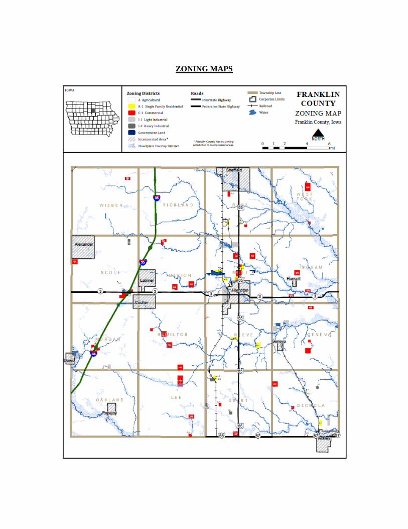
ZONING MAPS
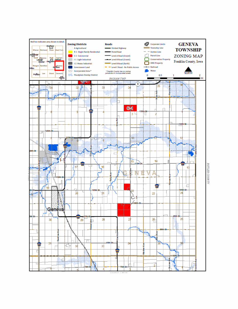
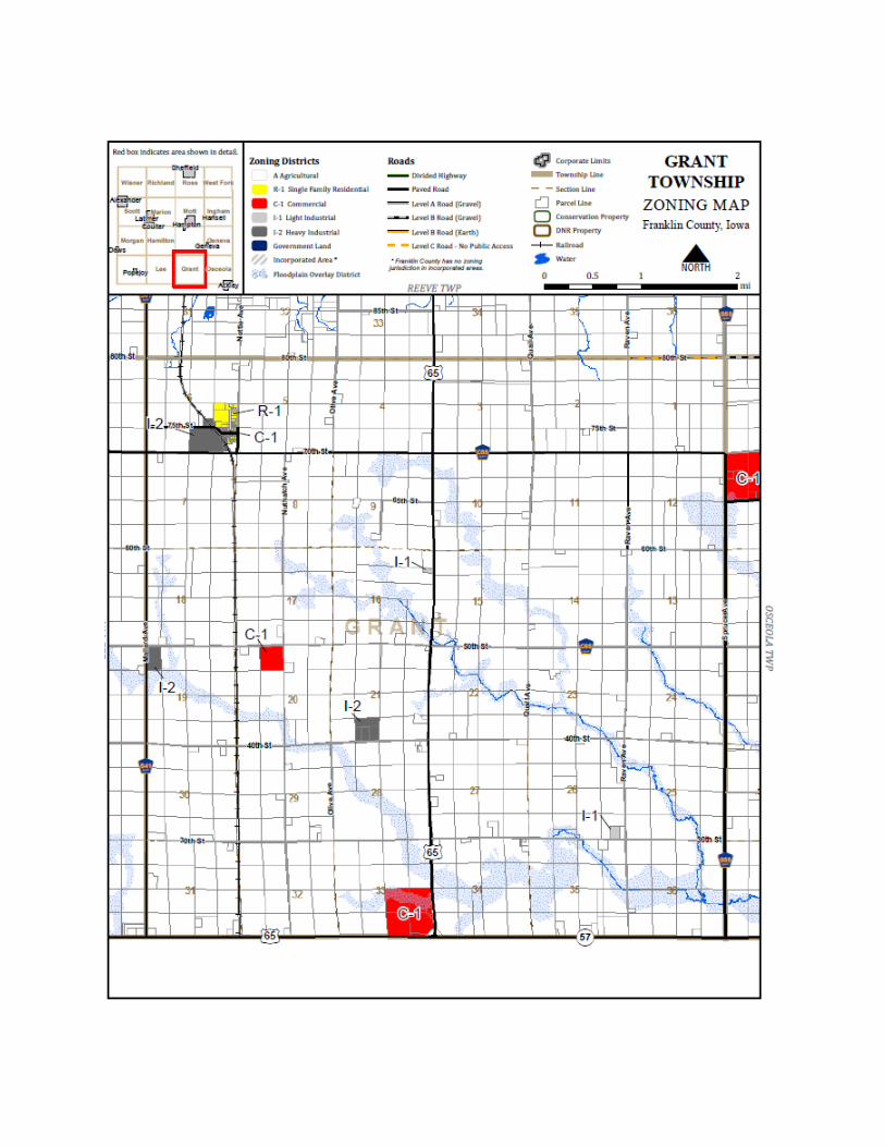
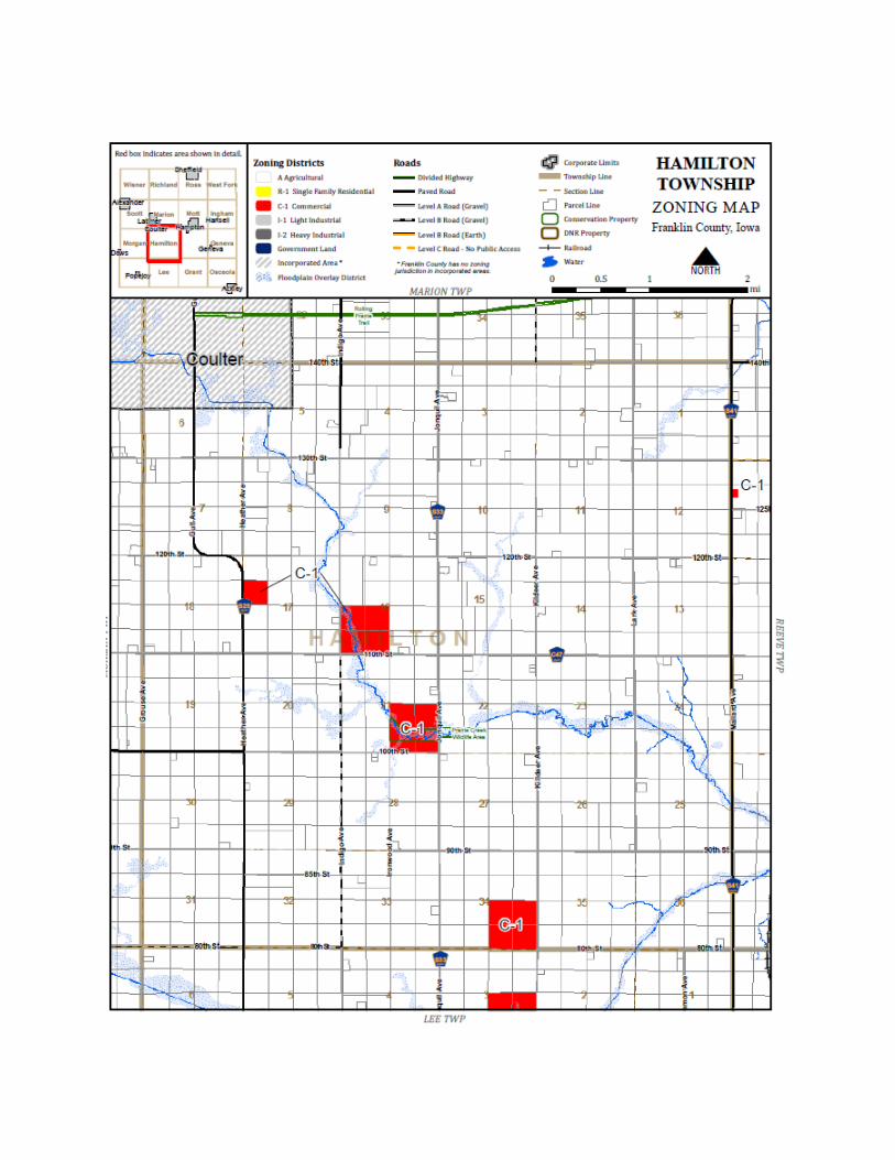
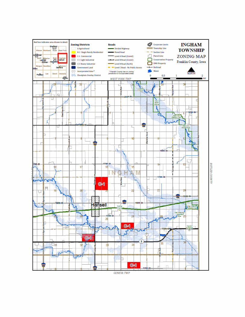
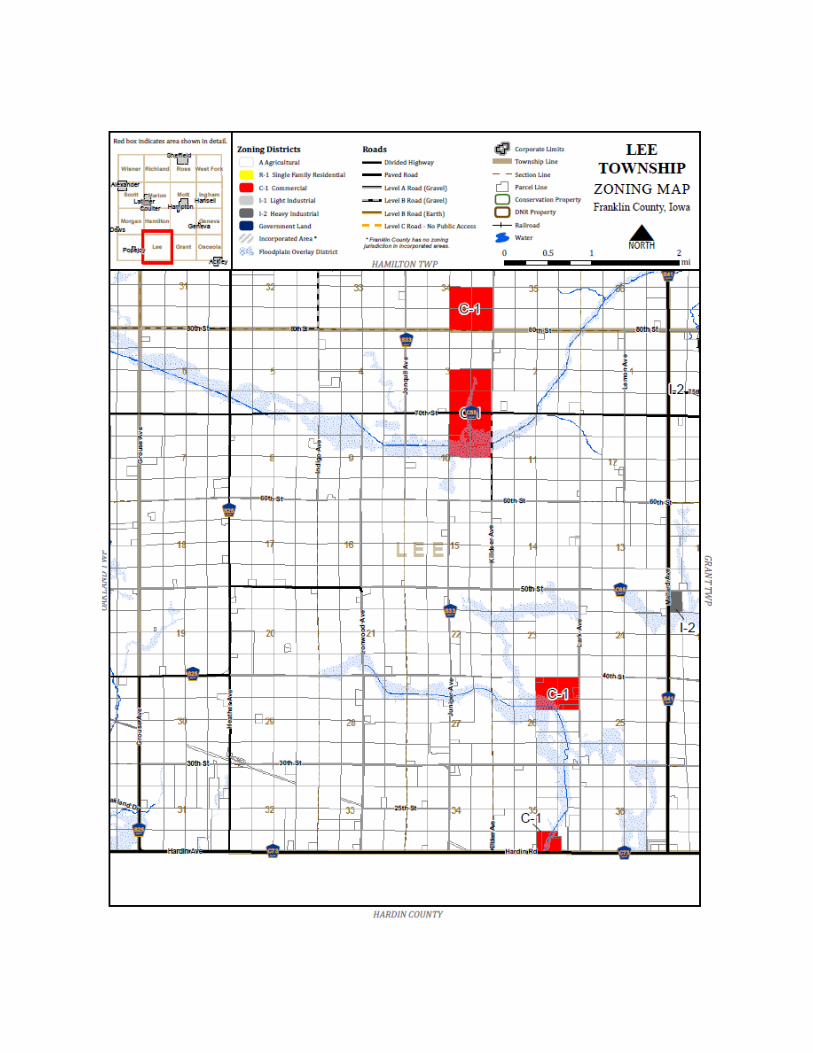
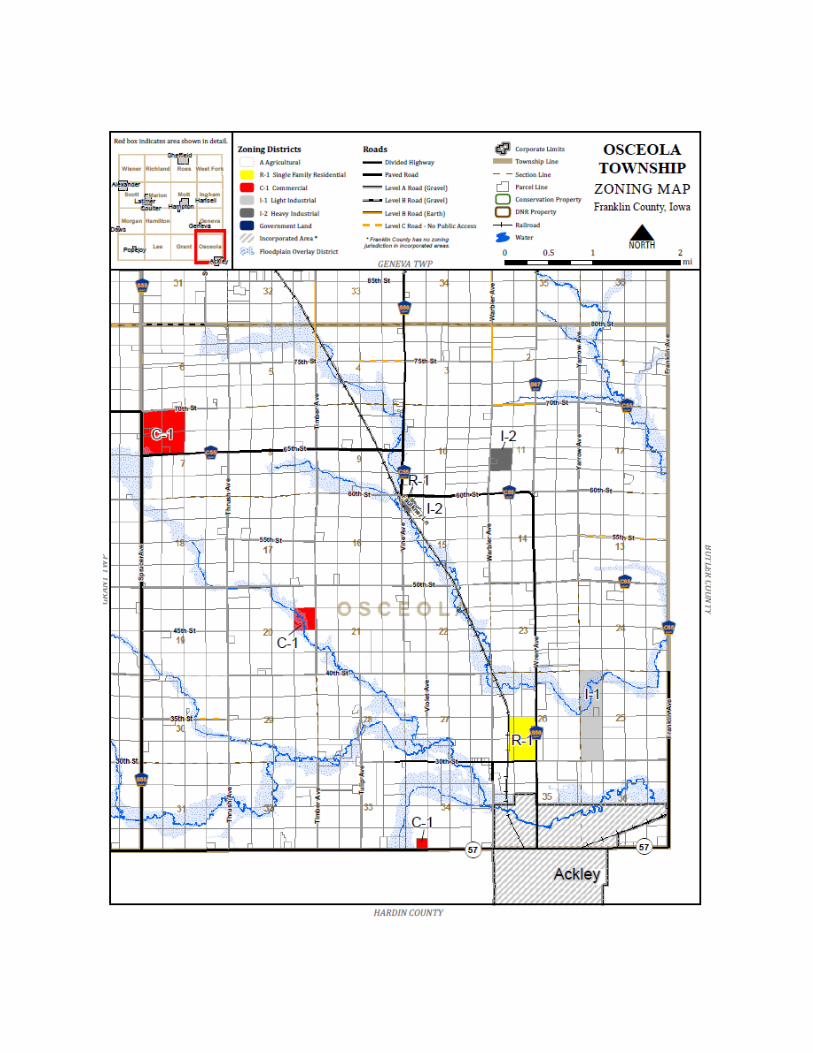
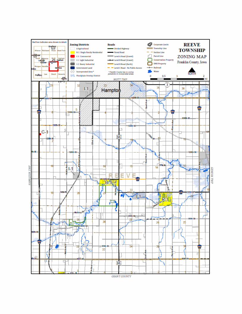
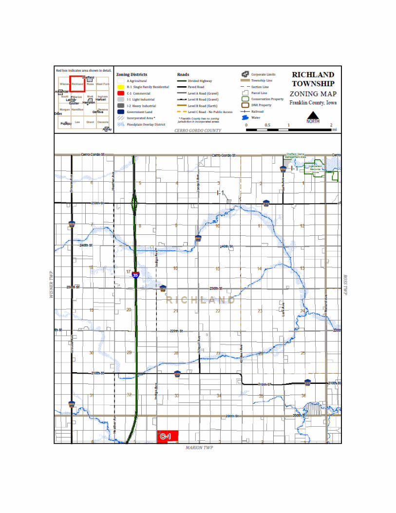
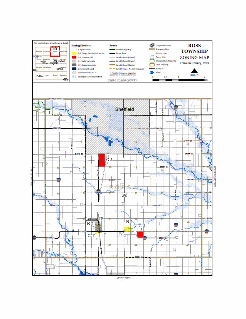
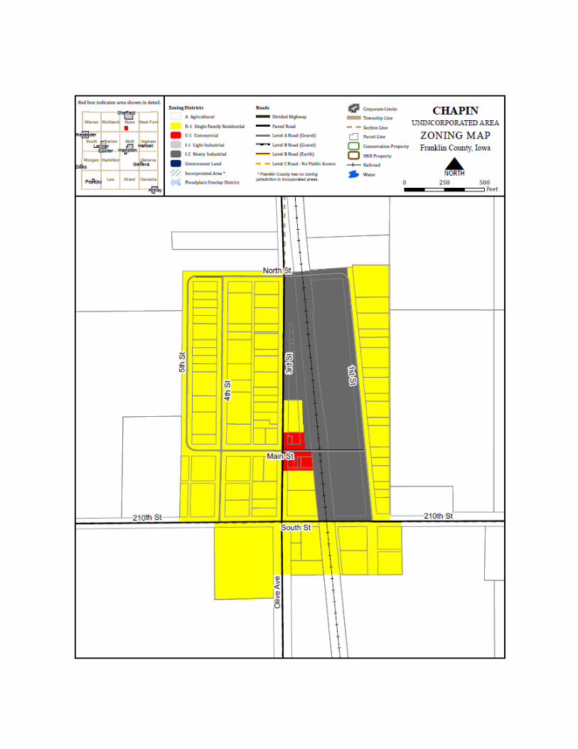
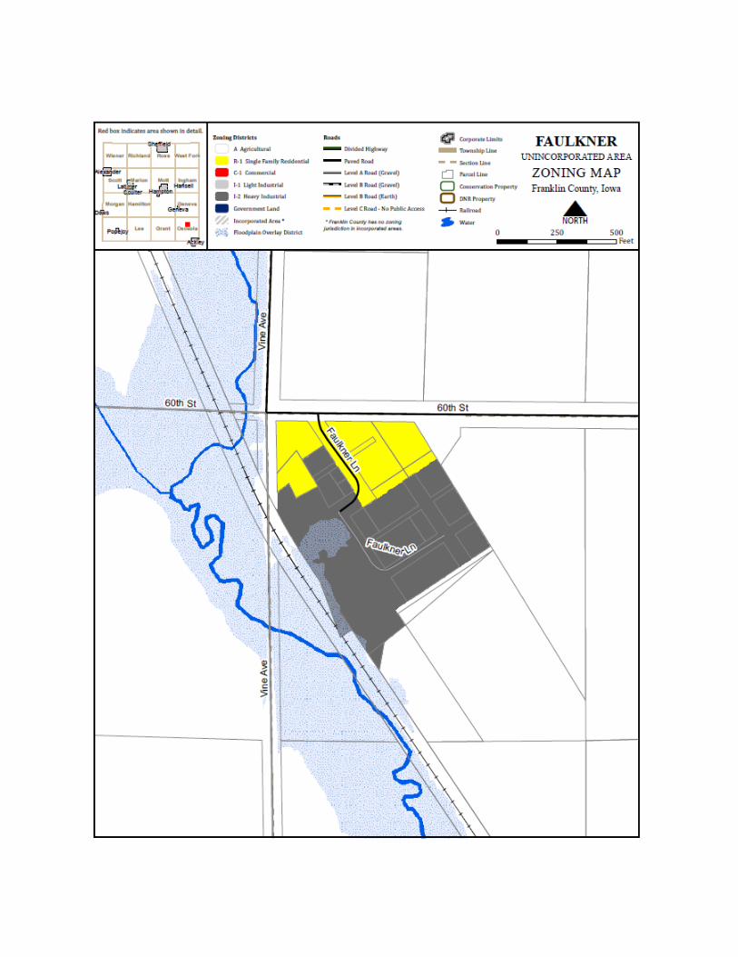
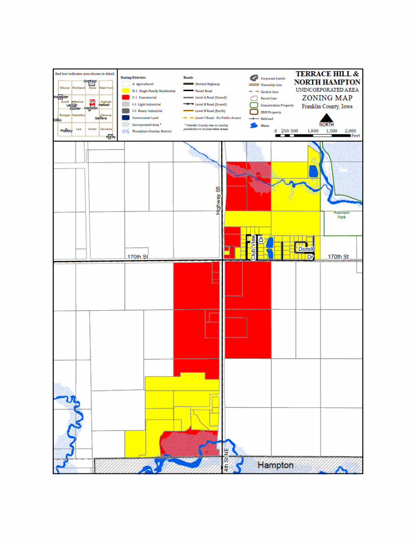
ORDINANCE NO. 6.2 SUBDIVISIONS
SECTION 1: GENERAL PROVISIONS
1. Short Title.
The ordinance shall be known as the “Land Subdivision Ordinance” of Franklin County, Iowa.
2. Purpose.
The purpose of this ordinance is to provide minimum standards for the design, development and improvement of all new subdivisions and resubdivision of land so that existing land uses will be protected, and so that growth occurs in an orderly manner, consistent with the Comprehensive Plan and to promote the public health, safety and general welfare of the citizens of Franklin County, Iowa.
3. Application.
Every owner of any tract or parcel of land who has subdivided or shall hereafter subdivide or plat said tract or parcel into three (3) or more parts, any part of which is less than twenty (20) acres for the purpose of laying out an addition, subdivision, building lot or lots, acreage or suburban lots within the County, shall cause plats of such areas to be made in the form, and containing the information, as hereinafter set forth before selling or offering for sale any lots therein contained or placing the plat on record. Subdivisions located within two (2) miles of the corporate limits of any city or town also enforcing subdivision regulations, shall be subject to both the platting regulations of the County and those of such cities or towns, and shall comply with the more restrictive regulations.
4. Recording of Plat.
In compliance with Iowa Code 354.8, no subdivision plat, resubdivision plat or street dedication within Franklin County, Iowa, shall be filed for record with the County Recorder, or recorded by the County Recorder, until a final plat of such subdivision, resubdivision or street dedication has been reviewed and approved by resolution of the governing body in accordance with the provisions of this ordinance. If the governing body waives its right to review the subdivision it will be by resolution according to Iowa Code 354.8. Upon approval of the final plat by the Governing Body, it shall be the duty of the subdivider to immediately file such plat with the County Auditor and County Recorder, as required by law. Such approval shall be revocable after thirty (30) days, unless such plat has been duly recorded, and evidence thereof filed with the Governing Body within such thirty (30) days.
5. Fees Established.
The Governing Body shall, from time to time establish by resolution, fees for the review of plats and a fee for variances requested from the Governing Body. No plat for any subdivision or resubdivision shall be considered filed with the Governing Body unless and until said plat is accompanied by the fee, as established by resolution of the Governing Body, and as required by this ordinance.
6. Penalties.
Violation – Penalty. Any person, firm, co-partnership, corporation or other association of persons, whether acting directly or through employees or agents, that violates, disobeys, omits or neglects the provisions of this title shall be given a NOTICE OF VIOLATION either by personally giving, certified mail or served by law enforcement. This NOTICE OF VIOLATION shall identify the action required to correct the violation and give 20 days to correct it. If said violation is not corrected then a COUNTY CITATION shall be filed either by personally giving, certified mail or served by law enforcement with fines of $750 for the first offense, $1000 for the second and subsequent offences. A NOTICE OF VIOLATION may be in the form of a STOP WORK ORDER which shall instruct the violator to cease any activity until said violation is corrected. Situations where a STOP WORK ORDER may be used include but are not limited to incidences where any person, firm, co-partnership, corporation or other association of persons, whether acting directly or through employees or agents disposes of or offers for sale any lot or lots within the area of jurisdiction of this ordinance, before the PLAT thereof has been approved by the Governing Body, and recorded as required by law or where proper documentation has not been filed. Each day the violation is permitted to exist shall constitute a separate offense. The Zoning Administrator shall keep a record of violations in his office. If any person, firm, co-partnership, corporation or other association of persons, whether acting directly or through employees or agents violates, disobeys, omits or neglects the provisions of this title three (3) or more times in a three (3) year period they shall be deemed a chronic offender. Chronic Offenders shall be issued a COUNTY CITATION when the Zoning Administrator becomes aware of a violation. A NOTICE OF VIOLATION with a 20 day notice shall not be required in the case of chronic offenders. In case of a violation of any provision of this title, the proper authorities of the County, in addition to other remedies, may institute any appropriate action or proceedings to prevent or abate the illegal act.
7. Building Permit to be Denied.
No building permit shall be issued for construction on any lot, parcel or tract where a subdivision is required by this ordinance, unless and until a final plat of such subdivision has been approved and recorded in accordance with this ordinance, and until the improvements required by this ordinance have been installed.
8. Access to Public Roads Access to the Secondary Road system shall be limited to two (2) per tract. Frontage roads with single access will be considered the preferred method.
SECTION 2: DEFINITIONS For the purposes of this ordinance, certain words herein shall be defined as, and interpreted as follows. Words used in the present tense shall include the future, the singular shall include the plural, the plural shall include the singular, the masculine gender shall include the feminine, the term “shall” is always mandatory, and the term “may” is permissive.
1. “Alley” shall mean public property dedicated to public use primarily for vehicular access to the back or side of properties otherwise abutting on a street.
2. “Block” shall mean an area of land within a subdivision that is entirely bounded by
streets, railroad right-of-ways, rivers, tracts of public land or the boundary of the subdivision.
3. “Comprehensive Plan” shall mean the general plan for the development of the County,
which may be titled master plan, general plan, comprehensive plan or some other title, which plan has been adopted by the Governing Body. Such Comprehensive Plan shall include any part of such plan separately adopted, and any amendment to such plan or parts thereof.
4. “County Engineer” shall mean the professional engineer registered with the State of Iowa
designated as County Engineer by the Governing Body.
5. “Cul-de-sac” shall mean a street having one end connected to another street, and the other end terminated by a vehicular turn-around.
6. “Easement” shall mean an authorization by a property owner for another to use a designated part of his property for a specified purpose.
7. “Flood hazard area” shall mean any area subject to flooding by a one percent (1%)
probability flood, otherwise referred to as a one hundred (100) year flood; as designated by the Iowa Natural Resources Council or the Federal Emergency Management Agency.
8. “Floodway” shall mean the channel of a river or other watercourse and the adjacent lands
that must be reserved in order to discharge the waters of a one hundred (100) year flood without cumulatively raising the waterway surface elevation more than one (1) foot.
9. “Governing Body” and County shall mean the Board of Supervisors of Franklin County,
Iowa.
10. “Improvements” shall mean changes to land necessary to prepare it for building sites including but not limited to grading, filling, street paving, curb paving, sidewalks, walkways, water mains, sewers, drainage ways and other public works and appurtenances.
11. “Lot” shall mean a portion of a subdivision or other parcel or tract intended as a unit for
the purpose, whether immediate or future, of transfer of ownership or building development.
12. “Lot”, The term “Corner lot” shall mean a lot situated at the intersection of two streets.
13. “Lot”, The term “Double frontage lot” shall mean any lot which is not a corner lot which
abuts two streets.
14. “Owner” shall mean the legal entity holding title to the property being subdivided, or such representative or agent as is fully empowered to act on its behalf.
15. “Planning Commission” shall mean the appointed commission designated by the
Governing Body for the purposes of this ordinance, and may also be the Zoning Commission, in which case such commission shall be known as the Planning and Zoning Commission.
16. “Plat” shall mean a map, drawing or chart on which a subdivider’s plan for the
subdivision of land is presented, which he submits for approval and intends, in final form, to record. Such Plat shall conform to all of the regulations and the standards and procedures for land surveying in accordance with Chapter 355 of the Iowa Code.
17. “Plats Officer” shall mean the individual assigned the duty to administer this ordinance
by the Governing Body or other appointing authority. The provisions of this Ordinance shall be administered by the Plats Officer, the Zoning Commission, the County Engineer, the County Auditor, and the Board of Supervisors of Franklin County. Plats shall be reviewed by the Zoning Commission and the County Engineer after which the Commission and the Engineer shall submit their recommendation and the plats to the Board of Supervisors who shall have the final power to approve or disapprove the application.
18. “Resubdivision” shall mean any subdivision of land which has previously been included
in a recorded plat. In appropriate context it may be a verb referring to the act of preparing a plat of previously subdivided land.
19. “Street” shall mean public property, not an alley, intended for vehicular circulation. In
appropriate context the term street may refer to the right-of-way bounded by the property lines of such public property, or may refer to the paving installed within such right-of-way.
20. “Street” the term “Major street” shall mean an arterial street or other street which has or
is planned to have continuity to carry traffic from one section of the County to another.
21. “Subdivider” shall mean the owner of property being subdivide, or such other person or entity empowered to act on the owner’s behalf.
22. “Subdivision” shall mean the division of land into three (3) or more parts, for the
purpose, whether immediate or future, of transfer of ownership or building development. The term, when appropriate to the context may refer to the process of subdividing or to the land subdivided. However, the sale or exchange of small parcels of land to or between the owners of adjacent platted lots where such sale or exchange does not create any additional lots, and where the land sold or exchanged constitutes less than seventy five percent (75%) of the area of the enlarged lot after such transfer, or where no parcel of less than twenty (20) acres is created, shall not be considered a subdivision.
23. “Utilities” shall mean systems for the distribution or collection of water, gas, electricity,
wastewater, telecommunications, and storm water.
24. ADD – Commission: The term “Commission” shall mean the Planning and Zoning Commission appointed by the Governing Body for the purposes of this ordinance, and may also be the zoning commission, in which case such commission shall be known as the Planning and Zoning Commission.
25. ADD – Division: The term “division” shall mean a tract or parcel of land divided into
two parcels of land by conveyance or for tax purposes. The Conveyance of an easement, other than a public highway easement, shall not be considered a division for the purposes of these regulations.
SECTION 3: IMPROVEMENTS
1. Improvements Required.
The subdivider shall, at his expense, install and construct all improvements required by this ordinance. All required improvements shall be installed and constructed in accordance with the design standards established for such improvements by the County, and as shown on the approved preliminary plat.
2. Inspection.
All improvements shall be inspected to insure compliance with the requirements of this ordinance. The cost of such inspection shall be borne by the subdivider, and shall be the actual cost of the inspection to the County.
3. Minimum Improvements.
The improvements set forth below shall be considered the minimum improvements necessary to protect the public health, safety and welfare.
A. Streets: The subdivider of the land being subdivided shall provide the grading of the
entire street right-of-way, alley or public place, and provide appropriate paving on all streets. Add-prior to application to County for inclusion into the Secondary road system. All streets or alleys shall be of such width and shall be so constructed as to meet the standards of the County.
B. Sanitary Sewer System: The subdivider of the land being platted shall make adequate provision for the disposal of sanitary sewage from the platted area with due regard being given to present or reasonably foreseeable needs. Where connection to the central sewer system, or construction of a central sewage collection and treatment system cannot reasonably be accomplished, septic systems approved by the County Health Officer (Environmentalist) may be allowed. No subdivision to be served by septic systems shall be approved until tests have been performed and the results of such tests have been provided to and reported on by the County Environmentalist. Such septic systems, if approved, may be installed by the sub-divider, or by a subsequent owner at the time development of a lot takes place.
C. Storm Sewer System: The subdivider of the land being platted shall install and construct a storm water drainage and/or storm sewer system adequate to serve the area, including anticipated extension of use to serve additional areas, so as to prevent undue runoff onto adjacent land.
D. Water System: The subdivider of the land being platted shall make appropriate provision for a suitable water supply for each platted lot or parcel. Such water supply shall be appropriate for the character of development proposed. No subdivision shall be approved until and unless the proposed system for providing water has been approved by the County Health Officer (Environmentalist). Individual wells, if approved, may be installed by the subdivider or by a subsequent owner at the time development of the lot takes place.
E. Other Improvements: The subdivider of the land being platted shall be responsible for, and the Supervisors may require improvements to prevent erosion; protection of native trees or other conservation measures; the installation of sidewalks and walkways necessary to secure pedestrian safety, grading and seeding and sodding of all lots, the planting of any required trees, and the installation of street signs and street lighting as required; and such off-site improvements as may be warranted by the impact of development of the proposed subdivision.
4. Easements Required.
A. Utility Easements: Where required for the placement of present or future utilities,
easements of not less than ten (10) feet in width shall be granted by the owner along rear, and where necessary, along side lot lines for public utility requirements. Except
where prohibited by topography, such easements shall be centered on lot lines. Easements of greater width may be required along lot lines, or across lots when necessary for the placement and maintenance of utilities. No buildings or structures except as necessary for utilities shall be permitted on such easements.
B. Easements Along Streams and Watercourses: Whenever any stream or surface watercourse is located in an area that is being subdivided, the subdivider shall, at his own expense, make adequate provisions for the proper drainage of surface water and shall also provide and dedicate to the County an easement along said streams and watercourses as necessary for the proper maintenance of the watercourse, and as approved by the County.
5. Maintenance of Improvements.
Unless otherwise approved by the Governing Body, improvements required to be installed shall remain the property and the responsibility of the subdivider, or successors in interest to the lands being subdivided. No subdivision shall be approved until and unless legal covenants, running with the land, sufficient to ensure that the County will not need to assume maintenance responsibility for any such improvement, have been approved by the County Attorney and the Governing Body.
SECTION 4: STANDARDS
1. Standard Prescribed.
The standards set forth in this ordinance shall be considered the minimum standards necessary to protect the public health, safety and general welfare.
2. Land Suitability.
No land shall be subdivided which is found to be unsuitable for subdividing by reason of flooding, ponding, poor drainage, adverse soil conditions, adverse geological formations, unsatisfactory topography or other conditions likely to be harmful to the public health, safety or general welfare, unless such unsuitable conditions are corrected to the satisfaction of the County. If land is found to be unsuitable for subdivision for any of the reasons cited in this section, the Governing Body shall state its reasons in writing and afford the subdivider an opportunity to present data regarding such unsuitability. Therefore, the Governing Body may reaffirm, modify or withdraw its determination regarding such unsuitability.
3. Lands Subject to Flooding.
No subdivision containing land located in a floodway or a flood hazard area shall be approved by the County without the approval of the appropriate State agencies. No lot
shall be located so as to include land located within a floodway or flood hazard area unless the lot is of such size and shape that it will contain a buildable area not within the floodway or flood hazard area, suitable for development as allowed by the Zoning Ordinance for the zone in which the lot is located and which can support necessary septic systems as recommended by the County Sanitarian. Land located within a flood hazard area or a floodway may be included within a plat as follows, subject to the approval of the County. A. Included within individual lots in the subdivision, subject to the limitations of this
section. B. Reserved as open space for recreation use by all owners of lots in the subdivision,
with an appropriate legal instrument, approved by the County, providing for its care and maintenance by such owners.
C. If acceptable to the County, dedicated to the County as public open space for recreation or flood control purposes.
4. Plat to Conform to Comprehensive Plan.
The arrangement, character, extent, width, grade and location of all streets, and the general nature and extent of the lots and uses proposed shall conform to the Comprehensive Plan of the County, ; and shall conform to such other plans, including but not limited to a County Road or Street Plan, a Sanitary Sewer System Plan, a Water System Plan or a Parks and Open Space Plan, provided such plan has been adopted by the County.
5. Construction Standards for Improvements.
In addition to the standards set forth in this ordinance, the County Engineer shall from time to time prepare, and the Governing Body shall from time to time, adopt by resolution, technical standards for public improvements. Such technical standards for public improvements shall contain the minimum acceptable specifications for the construction of improvements. Such technical standards may vary for classes of improvements, giving due regard to the classification of streets and roads, or other improvements, and the extent and character of the area served by the improvements. a. Subdivision Severe weather shelter required: All subdivisions with five or more manufactured homes shall be required to construct a “tornado safe above ground shelter”, or an underground shelter with enough capacity to house the total number of residents living in the subdivision on a “daily basis”. The shelter may be used for other purposes al long as it is available during severe weather and the usable area is not reduced below the capacity to house the total number of residents present on a “daily” basis.
6. Street Standards.
The following standards shall apply to all streets to be located within the subdivision. All major subdivisions shall be in areas in which the property lies immediately adjacent to or has direct access from a hard surfaced public street. In the event the proposed Subdivision is situated on an existing graveled public street it shall be the developer’s responsibility to have a hard surfaced public street constructed from the Subdivision entrance road(s) or from the Subdivision frontage to another hard surfaced public street at the developer’s expense. Such hard surfaced public street shall meet the specifications of the county engineer and are subject to the county engineer’s approval. A. Streets shall provide for the continuation of major streets from adjoining platted
areas, and the extension of major streets into adjoining unplatted areas. Where a plat encompasses the location for a major street proposed in the Comprehensive Plan or County Road or Street Plan, the plat shall provide for such major street.
B. Street grades shall align to existing streets, and all grades for streets shall be as approved by the County.
C. New arterial streets shall be located so as to not require direct access from the arterial street to abutting lots.
D. Street right-of-way and pavement widths shall be as specified in the Comprehensive Plan, County Road or Street Plan, or Technical Standards for Public Improvements (other adopted plans or standards).
E. Half-streets are prohibited, except where an existing platted half-street abuts the subdivision; a platted half-street to complete the street shall be required.
F. Minor streets should be designed to discourage through traffic while safely connecting to major streets or roads.
G. Street jogs with centerline offsets of less than one hundred twenty-five (125) feet shall be prohibited, except where topography or other physical conditions make such jogs unavoidable.
H. Streets shall intersect as nearly at right angles as possible; and no street shall intersect any other street at less than sixty (60) degrees.
I. At intersections of major streets, and otherwise as necessary, lot corner abutting the intersection shall be rounded with a radius sufficient to provide necessary space within the right-of-way for sidewalks, traffic control devices and other necessary improvements without encroachment onto the corner lots.
J. Dead end streets are prohibited, except where a street is planned to continue past the subdivider’s property, a temporary dead end may be allowed.
K. Streets which connect with other streets, or loop streets, are preferable, but cul-de-sacs may be permitted.
L. In general, alleys shall be prohibited in residential areas and required in commercial areas with normal street frontage. Dead end alleys are prohibited, unless provided with a turn-around with a minimum right-of-way diameter of one hundred (100) feet.
M. When a tract is subdivided into larger than normal lots or parcels, such lots or parcels shall be so arranged as to permit the logical location and opening of future streets and
appropriate resubdivision with provision for adequate utility connections for such resubdivision.
Easements for the future openings and extensions for such streets or utilities may, at the discretion of the Governing Body, be made a requirement of the plat.
N. Streets which are, or will become extensions of existing streets shall be given the same name as existing streets. New street names shall not be the same or sound similar to existing street names. All street names and street numbering shall be in conformance with the Franklin County Rural Addressing System and all shall be at the approval of the Governing Body.
7. Block and Lot Standards.
The following standards shall apply to the layout of blocks and lots in all subdivisions, and to the extent possible, in all resubdivisions. A. The size and shape of blocks or lots intended for commercial or industrial use shall be
adequate to provide for the use intended, and to meet the parking, loading and other requirements for such uses contained in the Zoning Ordinance.
B. Block and lot arrangement and design shall be such that all lots will provide satisfactory building sites, properly related to topography and surrounding land uses.
C. The size and shape of all lots shall comply with all requirements of the Zoning Ordinance for the zone in which the lot is located.
D. All lots shall abut a public street, or upon an approved private street, with a minimum frontage of at least thirty-five (35) feet measured (or with a minimum frontage and setbacks adequate to provide for the use intended, and to meet the requirements for such uses contained in the zoning ordinance.)as a straight line between the two front lot corners.
E. Unless unavoidable, lots shall not front, or have direct access to arterial streets or county roads. Where unavoidable, lots shall be so arranged as to minimize the number of access points.
F. All lot lines shall be at right angles to straight street lines or radial to curved street lines, except where, in the judgment of the Governing Body, a variation to this provision will provide a better street and lot layout.
G. Corner lots shall have sufficient extra width to permit the required front yard setback as specified in the Zoning Ordinance, oriented to either street.
H. Reversed frontage lots are prohibited. Double frontage lots shall only be permitted where abutting a major street and a minor street, and such lots shall front only on the minor street.
8. Parks and Open Space.
All residential subdivisions should be so designed as to meet the neighborhood park and open space needs of it or its residents. Such needs may be met by dedication and acceptance of public park land and/or by reservation by covenant of private space, providing there shall exist sufficient covenants, running with the land, to insure adequate maintenance by the property owners benefiting from such open space.
9. Storm water. To limit the impact of storm water runoff, and accompanying sediment, heat, pollutants, and energy, certain development or clearing activities shall be required to complete and implement a Storm water Pollution Prevention Plan (SWPPP).
Activities requiring a SWPPP. All applicants for major subdivisions, and
applicants for all other Franklin County permits or approvals that will result in land disturbance activity that meets NPDES Phase II or later requirements shall submit to the County a SWPPP and shall implement the plan.
Reviewing agency. No building permit, subdivision approval, or any permit allowing land disturbing activities shall be issued until the Franklin County Engineer reviews the SWPPP, when required. The Engineer shall review the SWPPP and shall submit comments to the County Planning and Development Department within thirty (30) days of a SWPPP submittal that meets these requirements.
Standards of review. All plans shall be consistent with National Pollutant Discharge
Elimination System (NPDES) Phase II requirements or latest requirements, and mitigation and management techniques, facilities, and practices shall be consistent with storm water management recommendations of the Engineer and preferred County design and management practices.
Storm water Pollution Prevention Plan information requirements. The Storm
water Pollution Prevention Plan shall provide all the information required in the Iowa NPDES General Permit No. 2 Part IV, published March, 2003, or most recent update, and shall be consistent with Iowa Rules addressing NPDES permits, including 567 Chapters 60 and 64 of the Iowa Administrative Code. The SWPPP shall identify and describe the development project or proposed vegetative clearing as described in the IDNR guidance document for Storm water Management for Construction Activities, and shall identify or provide the following information where applicable:
1. Existing zoning classifications and overlay zoning districts for land within and adjacent to the development
2. All delineated critical natural resources 3. Steep slopes, defined as slopes 14% or greater. 4. Wooded areas 5. Areas of concentrated flow including but not limited to open ditches and
grass channels
6. Flow distance from the project boundary to the nearest named receiving water
E. Storm water management performance standards. The applicant shall reduce the need for storm water conveyance or holding facilities by incorporating the use of natural topography and land cover such as natural swales and depressions as they exist prior to development to the degree that they can accommodate the additional flow of water without compromising the integrity or quality of the receiving water body.
Minimize impact to natural features. The development shall minimize impact to natural features, including steep slopes (greater than 14%), wetlands, wooded areas of significance, rare or unique species habitat, areas with delineated critical natural resources, designated or protected greenways, or County parks and open space.
Maintenance of storm water facilities. Franklin County requires that storm water facilities be maintained according to the following standards: (i) Private storm water facilities. All private storm water facilities shall be
maintained in proper condition consistent with the performance standards for which they were originally designed. 1. Maintenance plan required. No private storm water facilities shall be
approved unless a maintenance plan is provided that defines who will conduct the maintenance, the type of maintenance and the maintenance intervals. The maintenance plan shall identify who will remove settled materials from ponds, sumps, grit chambers, and other devices, including settled solids, and on what interval. All settled materials shall be removed and properly disposed of on at least a five (5) year interval. The County may grant a one to five (5) year waiver from this requirement when the owner presents evidence that the facility has additional capacity to remove settled solids in accordance with the original design capacity.
2. Maintenance-friendly design. All storm water facilities shall be designed to minimize the need for maintenance, to provide easy vehicle and personnel access for maintenance purposes, and be structurally sound. It shall be the responsibility of the applicant to obtain any necessary easements or other property interests to allow access to the facilities for inspection or maintenance.
3. Inspection. The County shall have the right to inspect all private storm water facilities during construction, during the first year of operation, and at least once every five (5) years thereafter.
Maintenance of publicly owned storm water facilities. The County shall annually perform the maintenance of County-owned storm water facilities.
Parks and School Sites Reserved: When a tract being subdivided includes lands proposed to be parks or school sites in the Comprehensive Plan or other official plan of the County, the sub-divider shall indicate such areas on the plat.
Proposed park sites shall be reserved for three (3) years, giving the County or other authorized public agency the option to purchase the land at the appraised raw land value prior to the subdivision as established by a certified land appraiser. The purchase price shall also include one-half (1/2) of the cost for grading and paving, including curbs, of the portion of any streets, that are contiguous to the site and any taxes and interest incurred by the sub-divider between the date of reservation and date of purchase by the public agency. Should the park sites not be purchased within three (3) years, the sub-divider may then revise the final plat.
Proposed school sites shall be reserved for three (3) years, giving the appropriate school district the option to purchase the land at the appraised raw land value prior to the subdivision as established by a certified land appraiser. The purchase price shall also include one-half (1/2) of the cost for grading and paving, including curbs, of the portion of any streets that are contiguous to the site and any taxes and interest incurred by the sub-divider between date of reservation and date of purchase by the school district. Should the school sites not be purchased within three (3) years, the sub-divider may then revise the final plat.
SECTION 5: PROCEDURES
1. Pre-Application Conference.
Whenever a subdivision located in the County is proposed, the owner and subdivider shall schedule a pre-application conference with the Plats Officer. The conference should be attended by the Plats Officer and such other County or utility representatives as is deemed desirable; and by the owner and his engineer and/or planner, as deemed desirable. If any portion of the land to be subdivided lies within two (2) miles of any municipality within the County, which has adopted subdivision regulations in accordance with the provisions of Chapter 354, Code of Iowa, 2013, the Plats Officer shall notify the city in writing and shall invite the appropriate city representatives to attend the pre-application conference. The purpose of such conference shall be to acquaint the County with the proposed subdivision and to acquaint the subdivider with the requirements, procedures and special problems relating to the proposed subdivision.
2. Sketch Plan Required.
For the pre-application conference, the subdivider shall provide a map or sketch showing the location of the subdivision, the general location of any proposed streets and other improvements and the general layout and arrangement of intended land uses in relation to the surrounding area.
3. Presentation to the Planning Commission or Governing Body.
The subdivider may present the sketch plan to the Planning and Zoning Commission and Governing Body for review prior to incurring significant costs preparing the preliminary or final plat.
4. Subdivision Classified.
Any proposed subdivision or resubdivision shall be classified as a minor subdivision or a major subdivision.
A. Minor Subdivision: Any subdivision which contains not more than four (4) lots
fronting on an existing street and does not require the construction of any public improvements, and which does not adversely affect the remainder of the parcel shall be classified as a minor plat.
B. Major Subdivision: Any subdivision, which in the opinion of the Governing Body, does not for any reason meet the definition of a minor subdivision, shall be classified as a major subdivision.
5. Plat Required.
In order to secure approval of any proposed subdivision, the owner and subdivider shall submit to the County plats and other information as required by this ordinance. The owner and subdivider of any major subdivision shall comply with the requirements for a preliminary plat and the requirements for a final plat shall submit to the County a Plat of Survey whenever such division requires a description to include bearing and distance measurements. Parcel descriptions shall denote no less than ¼ ¼ ¼ section without plats of surveyor. The owner and sub divider of a minor subdivision may elect to omit the submission of a preliminary plat.
6. Requirements of the Preliminary Plat.
The sub divider shall prepare and file with the Plats Officer, ten (10) copies of the preliminary plat, drawn at a scale of one inch equals one hundred feet (1” = 100’) or larger. Sheet size shall not exceed twenty-four inches by thirty-six inches (24” x 36”). Where more than one sheet is required, the sheets shall show the number of the sheet and the total number of sheets in the plat, and match lines indicating where other sheets adjoin.
The preliminary plat shall be clearly marked “Preliminary Plat” and shall show, or have attached thereto, the following:
A. Title, scale, north point and date on each sheet. B. Proposed name of the subdivision which shall not duplicate or resemble existing
subdivision names in the County. C. The name and address of the owner and the name, address and profession of the
person preparing the plat. D. A key map showing the general location of the proposed subdivision in relation to
surrounding lands. E. The names and locations of adjacent subdivisions and the names of record owners
and location of adjoining parcels of unplatted land. A list of all owners of record of property located within two hundred (200) feet of the subdivision boundary shall be attached.
F. The location of property lines, streets and alleys, easements, buildings, utilities, watercourses, tree masses and other existing features affecting the plan.
G. Existing and proposed zoning of the proposed subdivision and adjoining property. H. Contours at vertical intervals of not more than two (2) feet if the general slope of the
site is less than ten percent (10%) and at vertical intervals of not more than five (5) feet if the general slope is ten percent (10%) or greater.
I. The legal description of the area being platted. J. The boundary of the area being platted, shown as a dark line, with the approximate
length of boundary lines and the approximate location of the property in reference to known section lines.
K. The layout, numbers and approximate dimensions of proposed lots. L. The location, width and dimensions of all streets and proposed driveways. M. The proposed names for all streets in the area being platted. N. Present and proposed utility systems, including sanitary and storm sewers, other
drainage facilities, water lines, gas mains, electric utilities and other facilities. O. Proposed easements showing location, width, purposes and limitations. P. Parcels of land proposed to be dedicated or reserved for schools, parks, playgrounds
or other public, semi-public or community purposes, or shown for such purposes in the Comprehensive Plan or other adopted plans.
Q. A general summary description of any protective covenants or private restrictions to be incorporated in the final plat shall be attached.
R. Any other pertinent information as necessary. S. The fee, as required by this ordinance.
7. Procedures for Review of Preliminary Plats.
A. The Plats Officer shall provide copies of the plat to the County Engineer and such
other persons as necessary to review the plat; and shall schedule the plat for consideration by the Planning Commission. The Plats Officer shall maintain a copy of the plat for public inspection.
B. The County Engineer shall examine the plat as to its compliance with the requirements of the ordinances and standards of the County and good engineering practice and shall report his findings regarding the plat to the Planning Commission.
C. The Planning Commission shall examine the plat and the report of the County Engineer and such other information as it deems necessary or desirable, to ascertain whether the plat conforms to the ordinances of the County and conforms to the Comprehensive plan and other duly adopted plans of the County. The Planning Commission shall, within sixty (60) days of the filing of the plat with the Plats Officer, forward a report and recommendation regarding the plat to the Governing Body. If such recommendation is to disapprove or modify the plat, the reasons therefore shall be set forth in writing in the report, and a copy of the report and recommendation shall be provided to the applicant.
D. The Governing Body shall examine the plat, the report of the County Engineer, the report of the Planning Commission and such other information as it deems necessary or desirable. Upon such examination, the Governing Body shall ascertain whether the plat conforms to the ordinances and standards of the County, conforms to the Comprehensive Plan and other duly adopted plans of the County, in order to protect the public health and welfare. Following such examination, the Governing Body may approve, approve subject to conditions, or disapprove the plat. If the decision of the Governing Body is to disapprove the plat, or to approve the plat subject to conditions, the reasons therefore shall be set forth in writing in the official records of the Governing Body, and such decisions shall be provided to the applicant. Action on the preliminary plat by the Governing Body shall be taken within sixty-five (65) days of the filing of the plat with the Plats Officer, unless such time period is extended by agreement between the subdivider and the County. However, such time limitation notwithstanding, if any portion of the land to be subdivided lies within two (2) miles of any municipality within the County which has adopted subdivision regulations in accordance with the provisions of Chapter 354, Code of Iowa, 2013, the Governing Body shall defer final action on the plat until action has been taken by the municipality.
8. Duration of Approval of Preliminary Plat.
The approval of a preliminary plat by the Governing Body shall be valid for a period of one (1) year from the date of such approval; after which such approval shall be void and the subdivider shall take no action requiring the precedent approval of a preliminary plat except upon application for and approval of an extension of such period of validity by the Governing Body.
9. Authorization to Install Improvements.
The approval of the preliminary plat shall constitute authorization by the Governing Body for the installation of improvements as required by this ordinance, and as shown on the preliminary plat provided no such improvement shall be constructed or installed until and
unless the plans, profiles, cross sections and specifications for the construction of such improvement has been submitted to and approved in writing by the County Engineer.
10. Completion and Acceptance of Improvements.
Before the Governing Body will approve the final plat, any improvements to become the property of the County shall be constructed and accepted by formal resolution of the Governing Body. Before passage of said resolution of acceptance, the County Engineer shall report that said improvements meet all County specifications and ordinances or other County requirements and the agreements between the subdivider and the County. No improvements shall be designed to become the property of the county without prior written approval from the governing body based upon the recommendation of the County Engineer.
11. Performance Bond Permitted.
In lieu of the requirement that improvements be completed prior to the approval of a final plat, the sub divider may post a performance bond with the County guaranteeing that improvements not completed shall be completed within a period of one (1) year from the date of approval of such final plat.
12. Requirement of Final Plat.
The sub divider shall, within one (1) year from the date of approval of the preliminary plat, unless such time period has been extended, prepare and file with the Plats Officer, ten (10) copies of the final plat and required attachments, as set forth in this ordinance. Except for a final plat for a minor subdivision as set forth herein, no final plat shall be considered by the Governing Body until and unless a preliminary plat for the area included in the proposed final plat has been approved and has not expired and become void as set forth above. The final plat shall be drawn at a scale of one inch equals one hundred feet (1” = 100’) or larger. Sheet size shall be no greater than eighteen inches by twenty-four inches (18” x 24”) nor smaller than eight and one-half inches by eleven inches (8 ½” x 11”) and shall be of a size acceptable to the County Auditor, if more than one sheet is used, each sheet shall clearly show the number of the sheet, the total number of sheets included in the plat, and match lines indicating where other sheets adjoin. The final plat shall show the following:
A. The name of the subdivision. B. Name and address of the owner and subdivider. C. Scale and graphic bar scale, north arrow and date on each sheet. D. All monuments to be of record, as required by Chapter 354, Code of Iowa, 2013.
E. Sufficient survey data to positively describe the bounds of every lot, block, street, easement or other areas shown on the plat, as well as the outer boundaries of the subdivided lands.
F. All distance, bearing curve and other survey data as set forth in Chapter 354, Code of Iowa, 2013.
G. All adjoining properties shall be identified, and where such adjoining properties are a part of a recorded subdivision, and name of that subdivision shall be shown. If the subdivision platted is a resubdivision of a part or the whole of a previously recorded subdivision, sufficient ties shall be shown to controlling lines appearing on the earlier plat to permit an overlay to be made. Resubdivisions shall be labeled as such in a subtitle following the name of the subdivision wherever the name appears on the plat.
H. Street names and clear designation of public alleys. I. Block and lot numbers. J. Accurate dimensions for any property to be dedicated or reserved for public use, and
the purpose for which such property is dedicated or reserved for public use. K. The purpose of any easement shown on the plat shall be clearly stated and shall be
continued to only those easements pertaining to public utilities including gas, power, telephone, cable television, water, sewer; easements for ingress and egress; and such drainage easements as are deemed necessary for the orderly development of the land encompassed within the plat.
L. All interior excepted parcels, clearly indicated and labeled, “not a part of this plat”. M. A strip of land shall not be reserved by the sub divider unless the land is of sufficient
size and shape to be of some practical use as determined by the Governing Body. N. Legal description. O. The minimum unadjusted acceptable error of closure for all subdivision boundaries
shall be 1:10,000 and shall be 1:5,000 for any individual lot. P. A statement by a registered land surveyor that the plat was prepared by the surveyor
or under the surveyor’s direct personal supervision, signed and dated by the surveyor and bearing the surveyor’s Iowa registration number or seal; and a sealed certification of the accuracy of the plat by the registered land surveyor who drew the plat.
13. Attachments to the Final Plat.
The following shall be attached to and accompany any final plat:
A. A certificate by the owner and his spouse, if any, that the subdivision is with their free
consent, and is in accordance with the desire of the owner and spouse. This certificate must be signed and acknowledged by the owner and spouse before the officer authorized to take the acknowledgments of deeds.
B. A complete abstract of title and an attorney’s opinion showing that the fee title to the subdivision is free from encumbrances other than those secured by an encumbrance bond.
C. The encumbrance bond, if any.
D. A statement of restrictions of all types that run with the land and become covenants in the deeds of lots.
E. A certificate by the County Engineer that all required improvements have been satisfactorily completed in accordance with the construction plans as approved, and in substantial compliance with the approved preliminary plat. In lieu thereof, the County Auditor may certify that a bond guaranteeing completion has been approved by the County Attorney and filed with the County Auditor.
F. Where any improvements are to become the property of the County, a resolution accepting and approving such improvements, along with the maintenance bond required by this ordinance.
G. A resolution and certificate for approval by the Governing Body, and the signature of the Chairperson.
H. The applicable fee, if any. I. All attachments as specified in the Code of Iowa shall be attached and accompany
any final plat. J. On a form prescribed by the EMA director, such certification from all Township
Trustees and district fire chiefs involved in the subdivision stating that adequate fire/rescue protection will be available.
14. Procedures for the Review of Final Plats.
A. The Plats Officer shall provide copies of the plat to the County Engineer and such
other persons as are necessary to review the plat; and shall schedule that plat for review by the Governing Body. The Plats Officer shall maintain one (1) copy of the plat for the public inspection.
B. The Plats Officer and the County Engineer shall examine the plat as to its compliance with the ordinances and standards of the County and its conformance with the preliminary plat; and shall set forth their findings in writing. A copy of the findings shall be provided to the sub divider.
C. If the plat is found to substantially conform to the preliminary plat as approved, the final plat shall be forwarded to the Governing Body for review. If the plat is found not to conform to the preliminary plat, it shall be referred to the Planning Commission for review prior to review by the Governing Body. The planning Commission shall then review the plat and shall forward a written recommendation thereon to the Governing Body within sixty (60) days of the filing of the plat with the Plats Officer. If the recommendation is to disapprove the plat, or to required modification of the plat, the reasons therefore shall be set forth in writing and a copy of the recommendation shall be provided to the sub divider.
D. Upon receipt of the plat and written reports thereon, the Governing Body shall review the plat and attachments thereto. If the plat is found to conform to the ordinances and standards of the County and the Comprehensive Plan and other duly adopted plans, all as of the date of approval of the preliminary plat, and if found to substantially conform to the preliminary plat, the Governing Body shall approve the plat and shall cause its approval to be entered on the plat.
E. Action on the final plat by the Governing Body shall be taken within sixty-five (65) days of the date of such filing of the plat with the Plats Officer, unless such time period is extended by agreement between the sub divider and the County. However, such time limitation notwithstanding, if any portion of the land to be subdivided lies within two (2) miles of any municipality within the County which has adopted subdivision regulations in accordance with the provisions of Chapter 409, Code of Iowa, the Governing Body shall defer final action on the plat until action has been taken by the municipality. If the action is to disapprove the plat, the reasons therefore shall be set forth in the official records of the Governing Body and such decisions shall be provided to the sub divider.
SECTION 6: OTHER PROVISIONS
1. Variances.
Where in the case of a particular proposed subdivision, it can be shown that strict compliance with the requirements of this ordinance would result in extraordinary hardship to the sub divider because of unusual topography or other conditions, or if the subdivision in question is for the purpose of subdividing off an existing building site, the Governing Body may vary, modify or waive the requirement so that substantial justice may be done and the public interest secured; provided, however, that such variance, modification or waiver will not have the effect of nullifying the intent and purpose of this ordinance. In no case shall variance or modification be more than minimal easing of the requirements as necessary to eliminate the hardship. In so granting a variance, the Governing Body may impose such additional conditions as are necessary to secure substantially the objectives of the requirements so varied, modified, or waived. To receive a variance, a sub divider must submit a written request to the Plats Officer which will then be put on the agenda of the Governing Body to review. The decision of the Governing Body is final. If the governing body waives its right to review the subdivision it will be by resolution according to Iowa Code 354.8. In no case shall variance or modification be more than minimal easing of the requirements as necessary.
2. Severability Clause.
If any section, provision or part of this ordinance shall be adjudged invalid or unconstitutional, such adjudication shall not affect the validity of the ordinance as a whole or any section, provision or part thereof not adjudged invalid or unconstitutional.
3. Changes and Amendments.
This ordinance or any provision of this ordinance may be changed or amended from time to time by the Governing Body, provided however, that such changes or amendments
shall not become effective until after a public hearing has been held following due public notice.
4. Ordinance Not to Limit Other Ordinances.
Nothing contained herein shall serve to abrogate, limit, repeal, or otherwise modify any other ordinance or regulation except as expressly set forth herein. If any provision of this ordinance conflicts with the provisions of any other ordinance, regulation or statute, the most restrictive shall apply.
5. When Effective: This ordinance shall be effective after its final passage, approval and publication as provided by law.
ORDINANCE NO. 6.3
AN ORDINANCE ESTABLISHING HAMPTON MUNICIPAL AIRPORT HEIGHT ZONING SECTION 1: PURPOSE
An ordinance regulating and restricting the height of structures and objects of natural growth in the vicinity of the Hampton Municipal Airport by creating the appropriate zones and establishing the boundaries thereof; defining certain terms used herein; referring to the Hampton Municipal Airport Height Zoning Map which is incorporated in and made a part of this ordinance; providing for enforcement; establishing an Administrative Agency; establishing a Board of Adjustment; and imposing penalties.
This ordinance is adopted pursuant to the authority conferred on the City of Hampton and the Franklin County Board of Supervisors by Iowa Statutes Section 329.3. It is hereby found that an airport hazard endangers the lives and property of users of the Hampton Municipal Airport, and property or occupants of land in its vicinity. Accordingly, it is declared:
a. That the creation or establishment of an airport hazard is a public nuisance and an injury to the City of Hampton and Franklin County served by the Hampton Municipal Airport;
b. That it is necessary in the interest of the public health, public safety and general welfare that creation of airport hazards by prevented;
c. That this should be accomplished to the extent legally possible by proper exercise of the police power; and
d. That the prevention of the creation or establishment of airport hazards and the elimination, removal, alteration, mitigation or marking and lighting of existing airport hazards are public purposes for which the City of Hampton and Franklin County may raise and expend public funds, as an incident to the operation of airports, to acquire land or property interests therein.
SECTION 2: DEFINITIONS
1. “Airport” shall mean the Hampton Municipal Airport. 2. “Airport elevation” shall mean the highest point of an airport’s usable landing area
measured in feet above mean sea level, which elevation is established to be one thousand one hundred seventy-five (1,175) feet.
3. “Airport hazard” – Any structure or tree or use of land which would exceed the Federal obstruction standards as contained in 14 Code of Federal Regulations Sections 77.21, 77.23 and 77.25 as revised March 4, 1972, and which obstruct the air space required for the flight of aircraft and landing or takeoff at an airport or is otherwise hazardous to such landing or taking off of aircraft.
4. “Airport primary surface” – A surface longitudinally centered on a runway. When the runway has a specially prepare hard surface, the primary surface extends two hundred (200) feet beyond each end of that runway. The width of the primary surface of a runway will be that width prescribed in Part 77 of the Federal Aviation Regulations (FAR) for the most precise approach existing or planned for either end of that runway. The elevation of any point on the primary surface is the same as the elevation of the nearest point on the runway centerline.
5. “Airspace height” – For purpose of determining the height limits in all zones set forth in this ordinance and shown on the zoning map, the datum shall be mean sea level elevation unless otherwise specified.
6. “Control zone” – The airspace extending upward from the surface of the earth which may include one or more airports and is normally a circular area of five (5) statute miles in radius, with extensions where necessary to include instrument approach and departure paths.
7. “Decision height” – The height at which a decision must be made, during an ILS instrument approach to either continue to the approach or to execute a missed approach.
8. “Instrument runway” – A runway having an existing instrument approach procedure utilizing air navigation facilities or area type navigation equipment, for which an instrument approach procedure has been approved or planned.
9. “Minimum descent altitude” – The lowest altitude, expressed in feet above mean sea level, to which descent is authorized on final approach or during circle-to-land maneuvering in execution of a standard instrument approach procedure, where no electronic glide slope is provided.
10. “Minimum enroute altitude” – The altitude in effect between radio fixes which assures acceptable navigational signal coverage and meets obstruction clearance requirements between those fixes.
11. “Minimum obstruction clearance altitude” – The specified altitude in effect between radio fixes on VOR airways, off-airway routes or route segments which meets obstruction clearance requirements for the entire route segment and which assures acceptable navigational signal coverage only within twenty-two (22) miles or a VOR.
12. “Runway” – A defined area on an airport prepared for landing and takeoff of aircraft along its length.
13. “Visual runway” – A runway intended solely for the operation of aircraft using visual approach procedures with no straight-in instrument approach procedure and no instrument designation indicated on an FAA approved airport layout plan, or by any planning document submitted to the FAA by competent authority.
SECTION 3: AIRPORT ZONES AND AIRSPACE HEIGHT LIMITATIONS In order to carry out the provisions of this section, there are hereby created and established certain zones which are depicted on the Hampton Municipal Airport Height Zoning Map. A structure located in more than one (1) zone of the following zones is considered to be only in the zone with the more restrictive height limitation. The various zones are hereby established and defined as follows:
1. Horizontal Zone.
The land lying under a horizontal plane one hundred fifty (150) feet above the established airport elevation, the perimeter of which is constructed by:
A. Swinging arcs of five thousand (5,000) feet radii from the center of each end of the
primary surface of runways 17 and 35, and connecting the adjacent arcs by lines tangent to those to those arcs.
No structure shall exceed one hundred fifty (150) feet above the established airport elevation in the horizontal zone, as depicted on the Hampton Municipal Airport Height Zoning Map.
2. Conical Zone.
The land lying under a surface extending outward and upward from the periphery of the horizontal surface at a slope of twenty to one (20 to 1) for a horizontal distance of four thousand (4,000) feet.
No structures shall penetrate the conical surface in the conical zone, as depicted on the Hampton Municipal Airport Height Zoning Map.
3. Approach Zone.
The land lying under a surface longitudinally centered on the extended runway centerline and extending outward and upward from each end of the primary surface. (Note: An approach surface is applied to each end of each runway based upon the type of approach available or planned for that runway end.)
A. The inner edge of the approach surface is five hundred (500) feet for runways 17 and
35. B. The outer edge of the approach zone is two thousand (2,000) feet for runway 17 and
one thousand five hundred (1,500) feet for runway 35. C. The approach zone extends for a horizontal distance of five thousand (5,000) feet
at a slope of twenty to one (20 to 1) for runways 17 and 35.
No structure shall exceed the approach surface to any runway, as depicted on the Hampton Municipal Airport Height Zoning Map.
4. Transitional Zone.
The land lying under those surfaces extending outward and upward at right angles to the runway centerline and the runway centerline extended at a slope of seven to one (7 to 1) from the sides of the primary surface and from the sides of the approach surfaces.
No structure shall exceed the transitional surface, as depicted on the Hampton Municipal Airport Height Zoning Map.
5. No structure shall be erected in Franklin County that raises the published minimum
descent altitude or decision height for an instrument approach to any runway, nor shall any structure be erected that causes the minimum obstruction clearance altitude or minimum enroute altitude to be increased on any Federal airway in Franklin County.
SECTION 4: USE RESTRICTIONS Notwithstanding any other provisions of Section 3, no use may be made of land or water within the City of Hampton or Franklin County in such a manner as to interfere with the operation of any airborne aircraft. The following special requirements shall apply to each permitted use:
a. All lights or illumination use in conjunction with street, parking, signs or use of land and structures shall be arranged and operated in such a manner that it is not misleading or dangerous to aircraft operating from the Hampton Municipal Airport or in the vicinity thereof.
b. No operations from any use shall produce smoke, glare or other visual hazards within three (3) statute miles of any usable runway of the Hampton Municipal Airport.
c. No operations from any use in the City of Hampton or Franklin County shall produce electronic interference with navigation signals or radio communication between the airport and aircraft.
SECTION 5: LIGHTING Notwithstanding the provisions of Section 4, the owner of any structure over two hundred (200) feet above ground level must install on the structure lighting in accordance with Federal Aviation Administration (FAA), Advisory Circular 70-7460-1D and amendments. Additionally, any structure constructed after the effective date of this ordinance and exceeding nine hundred forty-nine (949) feet above ground level, must install on that structure high intensity white obstruction lights in accordance with Chapter 6 of FAA Advisory Circular 70-7460-1D and amendments. Any permit or variance granted may be so conditioned as to require the owner of the structure or growth in question to permit the City of Hampton or Franklin County, at its own expense, to install, operate and maintain thereto such markers or lights as may be necessary to indicate to pilots the presence of an airspace hazard. SECTION 6: VARIANCES
Any person desiring to erect or increase the height of any structure, or to permit the growth of any tree, or otherwise use his property in violation of any section of this ordinance, may apply to the Board of Adjustment for variance from such regulations. No application for variance to the requirements of this ordinance may be considered by the Board of Adjustment unless a copy of the application has been submitted to the Hampton Airport Manager for his opinion as to the aeronautical effect of such a variance. If the Hampton Airport Manager does not respond to the Board of Adjustment within fifteen (15) days from receipt of the copy of the application, the Board of Adjustment may make its decision to grant or deny the variance. SECTION 7: BOARD OF ADJUSTMENT
a. There is hereby created a Board of Adjustment to have and exercise the following powers:
A. To hear and decide appeals from any order, requirement, decision or determination
made by the Administrative Agency in the enforcement of this ordinance; B. To hear and decide special exemptions to the terms of this ordinance upon which such
Board of Adjustment under such regulations may be required to pass; and C. To hear and decide specific variances.
b. The Board of Adjustment shall consist of two (2) members selected by the City Council
of Hampton, two (2) members selected by the Franklin County Board of Supervisors and one (1) additional member to act as chairperson and to be selected by a majority vote of the members selected by the City Council of Hampton and the Franklin County Board of Supervisors. Members shall be removable for cause by the appointing authority upon written charges, after a public hearing. Vacancies shall be filled for the unexpired term of any member whose office becomes vacant in the dame manner in which the member was selected. The terms of the members shall be five (5) years, excepting that when the Board is first created, one (1) member appointed by each authority shall be appointed for a term of two (2) years and one (1) for a term of four (4) years.
c. The Board of Adjustment shall adopt rules for its governance and in harmony with the provisions of this ordinance. Meetings of the Board shall be held at the call of the Chairman and at such other times as the Board of Adjustment may determine. The Chairman, or in his absence the Acting Chairman, may administer oaths and compel the attendance of witnesses. All meetings of the Board of Adjustment shall be open to the public. The Board of Adjustment shall keep minutes of its proceedings showing the vote of each member upon each question, or if absent or failing to vote, indicating such fact, and shall keep records of its examinations and other official actions, all of which shall immediately be filed in the offices of the City and County Clerks, and on due cause shown.
d. The Board of Adjustment shall have the powers established in Section 414.12, Code of Iowa, 2013.
e. The concurring vote of a majority of the members of the Board of Adjustment shall be sufficient to reverse any order, requirement, decision or determination of any
administrative official or to decide in favor of the applicant on any matter upon which it is required to pass under this ordinance, or to effect variations of this ordinance.
SECTION 8: JUDICIAL REVIEW Any person aggrieved or any taxpayer affected by any decision of the Board of Adjustment, may appear to the Court of Record as provided in Section 414.15, Code of Iowa, 2003. SECTION 9: ADMINISTRATIVE AGENCY It shall be the duty of the Hampton City Zoning Officer or the Franklin County Zoning Administrator, who shall herein be referred to as the Administrative Agency, to administer the regulations prescribed herein. Applications for permits and variances shall be made to the appropriate authority having jurisdiction upon a form furnished by him. Applications required by this ordinance to be submitted to the Administrative Agency shall be promptly considered and granted or denied. Application for action by the Board of Adjustment shall be forthwith transmitted by the Administrative Agency. SECTION 10: PENALTIES Violation – Penalty. Any person, firm, co-partnership, corporation or other association of persons, whether acting directly or through employees or agents, that violates, disobeys, omits or neglects the provisions of this title shall be given a NOTICE OF VIOLATION either by personally giving, certified mail or served by law enforcement. This NOTICE OF VIOLATION shall identify the action required to correct the violation and give 20 days to correct it. If said violation is not corrected then a COUNTY CITATION shall be filed either by personally giving, certified mail or served by law enforcement with fines of $750 for the first offense, $1000 for the second and subsequent offences. A NOTICE OF VIOLATION may be in the form of a STOP WORK ORDER which shall instruct the violator to cease any activity until said violation is corrected. Situations where a STOP WORK ORDER may be used include but are not limited to incidences where construction has begun which will violate AIRSPACE HEIGHT LIMITATIONS or where proper documentation has not been filed. Each day the violation is permitted to exist shall constitute a separate offense. The Zoning Administrator shall keep a record of violations in his office. If any person, firm, co-partnership, corporation or other association of persons, whether acting directly or through employees or agents violates, disobeys, omits or neglects the provisions of this title three (3) or more times in a three (3) year period they shall be deemed a chronic offender. Chronic Offenders shall be issued a COUNTY CITATION when the Zoning Administrator becomes aware of a violation. A NOTICE OF VIOLATION with a 20 day notice shall not be required in the case of chronic offenders. In case of a violation of any provision of this title, the proper authorities of the County, in addition to other remedies, may institute any appropriate action or proceedings to prevent or abate the illegal act. SECTION 11: CONFLICTING REGULATIONS
Where there exists a conflict between any of the regulations or limitations prescribed in this ordinance or any other regulations applicable to the same area, whether the conflict be with respect to height of structures, the use of land or any other mater, the more stringent limitation or requirement shall govern and prevail. SECTION 12: SEVERABILITY If any section, provision or part of this ordinance shall be adjudged invalid or unconstitutional, such adjudication shall not affect the validity of the ordinance as a whole or any section, provision or part thereof not adjudged invalid or unconstitutional.
ORDINANCE NO. 6.4
AN ORDINANCE TO ESTABLISH MANAGEMENT AND CONTROL GUIDELINES FOR FLOOD PLAIN DEVELOPMENT
Farms and agricultural uses are NOT EXEMPT from this Ordinance per Iowa Code 335.2. SECTION 1. Statutory Authority, Findings of Fact and Purpose
A. The Legislature of the State of Iowa has in Chapter 335, Code of Iowa, as amended, delegated the power to counties to enact zoning regulations to secure safety from flood and to promote health and the general welfare.
B. Findings of Fact 1. The flood hazard areas of Franklin County are subject to periodic inundation which
can result in loss of life and property, health and safety hazards, disruption of commerce and governmental services, extraordinary public expenditures for flood protection and relief, and impairment of the tax base all of which adversely affect the public health, safety and general welfare of the community.
2. These flood losses, hazards, and related adverse effects are caused by: (i) The occupancy of flood hazard areas by uses vulnerable to flood damages which
create hazardous conditions as a result of being inadequately elevated or otherwise protected from flooding and
(ii) the cumulative effect of obstructions on the floodplain causing increases in flood heights and velocities.
SECTION 2. Definitions. Unless specifically defined below, words or phrases used in this Ordinance shall be interpreted so as to give them the meaning they have in common usage and to give this Ordinance it’s most reasonable application. For use in this ordinance, certain terms or words used herein shall be interpreted or defined as follows: BASE FLOOD – The flood having one (1) percent chance of being equaled or exceeded in any given year. (See 100-year flood). BASEMENT – Any enclosed area of a building which has its floor or lowest level below ground level (subgrade) on all sides. Also see “lowest floor.” DEVELOPMENT – Any man-made change to improved or unimproved real estate, including but not limited to building of other structures, mining, dredging, filling, grading, paving, excavation or drilling operations. EXISTING CONSTRUCTION – Any structure from which the “start of construction” commenced before the effective date of the first floodplain management regulations adopted by the county.
EXISTING FACTORY-BUILT HOME PARK OR SUBDIVISION –The preparation of additional sites by the construction of facilities for servicing the lots on which the factory-built homes are to be affixed (including at a minimum, the installation of utilities, the construction of streets, and either final site grading or the pouring of concrete pads). FACTORY-BUILT HOME – Any structure, designed for residential use which is wholly or in substantial part, made, fabricated, formed, or assembled in manufacturing facilities for installation or assembly and installation, on building site. For the purpose of this Ordinance factory-built homes include factory-built homes, manufactured homes and modular homes and also includes “recreational vehicles” which are placed on a site for greater than 180 consecutive days and not fully licensed for and ready for highway use. FACTORY-BUILT HOME PARK – A parcel or contiguous parcels of land divided into two or more factory-built home lots for sale or lease. FLOOD – A general and temporary condition of partial or complete inundation of normally dry land areas resulting from the overflow of steams or rivers or from the unusual and rapid runoff of surface waters from any source. FLOOD ELEVATION – The elevation floodwaters would reach at a particular site during the occurrence of a specific flood. For instance, the 100-year flood elevation is the elevation of flood waters related to the occurrence of the 100-year flood. FLOOD INSURANCE RATE MAP (FIRM) – The official map prepared as part of (but published separately from) the Flood Insurance Study which delineates both the flood hazard areas and the risk premium zones applicable to the community. FLOODPLAIN – Any land area susceptible to being inundated by water as a result of a flood. FLOODPLAIN MANAGEMENT – An overall program of corrective and preventive measures for reducing flood damages and promoting the rise of floodplains, including but not limited to emergency preparedness plans, flood control works, flood proofing and floodplain management regulations. FLOODPROOFING – Any combination of structural and nonstructural additions, changes, or adjustments to structures, including utility and sanitary facilities, which will reduce or eliminate flood damage to such structures. FLOODWAY – The channel of a river or steam and those portions of the floodplains adjoining the channel, which are reasonably required to carry and discharge flood waters or flood flows so that confinement of flood flows to the floodway area will not cumulatively increase the water surface elevation of the base flood by more than one (1) foot.
FLOODWAY FRINGE – Those portions of the floodplain, other than the floodway, which can be filled, leveed, or otherwise obstructed without causing substantially higher flood levels or flow velocities. HISTORIC STRUCTURE – Any structure that is:
A. Listed individually in the National Register of Historic Places, maintained by the Department of Interior or preliminarily determined by the Secretary of the Interior as meeting the requirements for individual listing of the National Register; Certified or preliminarily determined by the Secretary of the Interior as contributing to the historical significance of a registered historic district or a district preliminarily determined by the Secretary to qualify as a register historic district;
B. Individually listed on a state inventory of historic places in states with historic preservation programs which have been approved by the Secretary of the Interior; or,
C. Individually listed on a local inventory of historic places in communities with historic preservation programs that have been certified by either (i) an approved state program as determined by the Secretary of the Interior or (ii) directly by the Secretary of the Interior in states without approved programs.
LOWEST FLOOR – The floor of the lowest enclosed area in a building including a basement except when all the following criteria are met:
A. The enclosed area is designed to flood to equalize hydrostatic pressure during floods with walls or openings that satisfy the provisions of this Ordinance and
B. The enclosed area is unfinished (not carpeted, drywalled, etc.) and used solely for low damage potential uses such as building access, parking or storage, and
C. Machinery and service facilities (e.g., hot water heater, furnace, electrical service) contained in the enclosed area are located at least one (1) foot above the 100-year flood level, and
D. The enclosed area is not a “basement” as defined in this section. In cases where the lowest enclosed area satisfies criteria A, B, C, and D above, the lowest floor is the floor of the next highest enclosed area that does not satisfy the criteria above. MINOR PROJECTS – Small development activities (except for filling, grading and excavating) valued at less than $500. NEW CONSTRUCTION – (new buildings, factory-built home parks) – Those structures or development for which the start of construction commenced on or after the effective date of the first floodplain management regulations adopted by the county and includes any subsequent improvements to such structures. NEW FACTORY-BUILT HOME PARK OR SUBDIVISION – A factory-built home park or subdivision for which the construction of facilities for servicing the lots on which the factory-built homes are to be affixed (including at a minimum, the installation of utilities, the construction of streets, and either final site grading or the pouring of concrete pads) is completed
on or after the effective date of the effective date of the first floodplain management regulations adopted by the county and includes any subsequent improvements to such structures. ONE HUNDRED (100) YEAR FLOOD – A flood, the magnitude of which has a one (1) percent chance of being equaled or exceeded in any given year or which, on average, will be equaled or exceeded at least once every one hundred (100) years. RECREATIONAL VEHICLE – A vehicle which is:
A. Built on a single chassis; B. Four hundred (440) square feet or less when measured at the largest horizontal
projection; C. Designed to be self-propelled or permanently towable by a light duty truck; and D. Designed primarily not for use as a permanent dwelling but as temporary living quarters
for recreational, camping, travel, or seasonal use. ROUTINE MAINTENANCE OF EXISTING BUILDINGS AND FACILITIES - Repairs necessary to keep a structure in a safe and habitable condition that do not trigger a building permit, provided they are not associated with a general improvement of the structure or repair of a damaged structure.
Such repairs include: a. Normal maintenance of structures such as re-roofing, replacing roofing tiles and
replacing siding; b. Exterior and interior painting, papering, tiling, carpeting, cabinets, counter tops
and similar finish work; c. Basement sealing; d. Repairing or replacing damaged or broken window panes; e. Repairing plumbing systems, electrical systems, heating or air conditioning
systems and repairing wells or septic systems. SPECIAL FLOOD HAZARD AREA – The land within a community subject to the “100-year flood”. This land is identified as Zone A on the community’s Flood Insurance Rate Maps. START OF CONSTRUCTION – Includes substantial improvement, and means the date the development permit was issued, provided the actual start of construction, repair, reconstruction, rehabilitation, addition, placement, or other improvement, was within 180 days of the permit date. The actual start means either the first placement or permanent construction of a structure on a site, such as pouring of a slab or footings, the installation of pile, the construction of columns, or any work beyond the stage of excavation; or the placement of a factory-built home on a foundation. Permanent construction does not include land preparation, such as clearing, grading and filling; nor does it include the installation of streets and/or walkways; nor does it include excavation for a basement, footings, piers, or foundations or the erection of temporary forms; nor does it include the installation on the property of accessory buildings such as garages or sheds not occupied as dwelling units or not part of the main structure. For a substantial improvement, the actual start of
construction means the first alteration of any wall, ceiling, floor, other structural part of the building, whether or not that alteration affects the external dimensions of the building. STRUCTURE – Anything constructed or erected on the ground or attached to the ground, including, but not limited to, buildings, factories, sheds, cabins, factory-built homes, storage tanks, and other similar uses. SUBSTANTIAL DAMAGE – Damage of any origin sustained by a structure whereby the cost of restoring the structure to it’s before damage condition would equal or exceed fifty (50) percent of the market value of the structure before the damage occurred. SUBSTANTIAL IMPROVEMENT – Any improvement to a structure which satisfies either of the following criteria:
A. Any repair, reconstruction, or improvement of a structure, the cost of which equals or exceeds fifty (50) percent of the market value of the structure either (i) before the “start of construction” of the improvement, or (ii) if the structure has been “substantially damaged” and is being restored, before the damage occurred. The term does not, however, include any project for improvement of a structure to correct existing violations of state or local health, sanitary, or safety code specifications which have been identified by the local code enforcement official and which are the minimum necessary to ensure safe living conditions. The term also does not include any alteration necessary to ensure safe living conditions. The term also does not include any alteration of an “historic structure”, provided the alteration will not preclude the structure’s designation as an “historic structure”.
B. Any addition which increase the original floor area of a building by 25 percent or more. All additions constructed on or after the first floodplain management regulations adopted by the county shall be added to any proposed addition in determining whether the total increase in original floor space would exceed 25 percent.
VARIANCE – A grant of relief from the terms of the floodplain management regulations. VIOLATION – The failure of a structure or other development to be fully compliant with the county’s floodplain management regulations. SECTION 3. General Provisions.
1. Lands to Which Ordinance applies. The provisions of this ordinance shall apply to all lands within the jurisdiction of the County which are located within the boundaries of the Flood Plain District as established in Section 4.
2. Rules for Interpretation of the Flood Plain District Boundaries. The boundaries of the Flood Plain District areas shall be determined by scaling distances on the official Flood Insurance Rate Maps. When an interpretation is needed as to the exact location of a boundary, the Planning and Zoning Administrator, in consultation with appropriate agencies, shall make the necessary interpretation. The Board of
Adjustment shall hear and decide appeals when it is alleged that there is an error in any requirement, decision, or determination made by the Planning and Zoning Administrator in the enforcement or administration of this Ordinance.
3. Compliance. No structure or land shall hereafter be used and no structure shall be located, extended, converted or structurally altered without full compliance with the terms of this ordinance and other applicable regulations which apply to uses within the jurisdiction of this ordinance.
4. Abrogation and Greater Restrictions. It is not intended by this ordinance to repeal, abrogate or impair any existing easements, covenants or deed restrictions. However, where this ordinance imposes greater restrictions, the provision of this ordinance shall prevail. All other ordinances inconsistent with this ordinance are hereby repealed to the extent of the inconsistency only.
5. Interpretation. In their interpretation of the application, the provisions of this ordinance shall be held to minimum requirements and shall not be deemed a limitation or repeal of any other powers granted by State statutes.
6. Warning and Disclaimer of Liability. The standards required by this ordinance are considered reasonable for regulatory purposes. This ordnance does not imply that areas outside of the designated special flood hazard areas will be free from flooding or flood damages. This ordinance shall not create liability on the part of Franklin County or any officer or employee thereof for any flood damages that result from reliance on this ordinance or any administrative decision made lawfully thereunder.
SECTION 4. Establishment of Flood Plain District. The areas within the jurisdiction of Franklin County having special flood hazards are hereby designated as a Flood Plain District and shall be subject to the standards of the Flood Plain District. The Flood Plain District boundaries shall be designated as Zone A on the Flood Insurance Rate Map for Franklin County and Incorporate Areas, dated December 18, 2012, which is hereby adopted and made a part of this Ordinance.
• SECTION 5. Standards for Flood Plain District. All uses must be consistent with the need to minimize flood damage and meet the following applicable performance standards. Where floodway data and 100-year flood elevations have not been provided on the Flood Insurance Rate Map, the Iowa Department of Natural Resources shall be contacted to compute such data.
The applicant will be responsible for providing the Department of Natural Resources with sufficient technical information to make such determination.
1. All development within the Flood Plain District shall: a. Be consistent with the need to minimize flood damage. b. Use construction methods and practices that will minimize flood damage. c. Use construction materials and utility equipment that are resistant to flood damage.
d. Obtain all other necessary permits from federal, state and local governmental agencies including approval when required from the Iowa Department of Natural Resources.
2. Structures shall be designed and anchored to prevent the floatation, collapse or lateral movement of the structure or portions of the structure due to flooding. Where 100-year flood elevation is available from a Federal, State or other source, the following elevation or floodproofing standards shall be met: a. New or substantially improved residential structures shall have the lowest floor (to
include the basement) elevated to one (1) foot above the 100-year flood level. b. New or substantially improved nonresidential structures shall meet the elevation
requirements of residential structures or be floodproofed to an elevation one (1) foot above the 100-year flood level. When floodproofing is utilized, a professional engineer registered in the State of Iowa shall certify that the floodproofing methods used are adequate to withstand the flood depths, pressures, velocities, impact and uplift forces and other factors associated with the substantially impermeable to the passage of water. A record of the certification indicating the specific elevation (in relation to North American Vertical Datum) to which any structures are floodproofed shall be maintained by the Administrator.
c. Construction shall be upon compacted fill which shall, at all points, be no lower than 1.0 ft. above the 100-year flood level and extend at such elevation at least 18 feet beyond the limits of any structure erected thereon.
d. All new residential structures shall be provided with a means of access which will be passable by wheeled vehicles during the 100-year flood.
e. Alternate methods of elevating (such as piers) may be allowed subject to favorable consideration by the County Board of Adjustment, where existing topography, street grades, or other factors preclude elevating by fill. In such cases, the methods used must be adequate to support the structure as well as withstand the various forces and hazards associated with flooding.
f. Fully enclosed areas below the “lowest floor” (not including basements) that are subject to flooding shall be designed to automatically equalize hydrostatic flood forces on exterior walls by allowing for the entry and exit of floodwaters. Designs for meeting this requirement must either be certified by a registered professional engineer or meet or exceed the following minimum criteria: (1) A minimum of two (2) openings having a total net area of not less than one square
inch for every square foot enclosed area subject to flooding shall be provided. (2) The bottom of all openings shall be no higher than one foot above grade. (3) Openings may be equipped with screens, louvers, valves, or other coverings or
devices provided they permit the automatic entry and exit of floodwaters. Such areas shall be used solely for parking of vehicles, building access and low damage potential storage.
g. New and substantially improved structures must be designed (or modified) and adequately anchored to prevent flotation, collapse, or lateral movement of the structure resulting from hydrodynamic and hydrostatic loads, including the effects of buoyancy.
h. New and substantially improved structures must be constructed with electrical, heating, ventilation, plumbing, and air conditioning equipment and other service facilities that are designed and/or located so as to prevent water from entering or accumulating within the components during conditions of flooding.
i. Detached garages, sheds, and similar structures accessory to residential use are exempt from the 100-year flood elevation requirements where the following criteria are satisfied. 1) The structure shall not be used for human habitation. 2) The structure shall be designed to have low flood damage potential. 3) The structure shall be constructed and placed on the building site so as to offer
minimum resistance to the flow of floodwaters. 4) The structure shall be firmly anchored to prevent floatation which may result in
damage to other structures. 5) The structure’s service facilities such as electrical and heating equipment shall be
elevated or floodproofed to at least one foot above the 10-year flood level. 3. All factory-built homes, including those placed in existing factory-built home parks or
subdivisions, shall be elevated on a permanent foundation such that the lowest floor of the structure is a minimum of one (1) foot above the 100-year flood level. Factory-built homes shall be anchored to prevent floatation, collapse or lateral movement. Specific anchoring requirements are: a. Over-the-top ties shall be provided at each of the four (4) corners of the factory-built
home with two (2) additional ties per side at the intermediate locations and factory-built homes less than fifty (50) feet long requiring one (1) additional tie per side.
b. Frame ties shall be provided at each corner of the home with five additional ties per side at intermediate points and factory-built homes less than fifty (50) feet long requiring four (4) additional ties preside.
c. All components of the anchoring system shall be capable of carrying a force of four thousand eight hundred (4,800) pounds.
d. Any additions to factory-built homes shall be similarly anchored. 4. Subdivisions (including factory-built home parks and subdivisions) shall be consistent
with the need to minimize flood damage and shall provide adequate drainage to reduce exposure to flood hazards. Development associated with subdivisions (including the installation of public utilities) shall meet the applicable standards of this section. Subdivision proposals intended for residential use shall provide all lots with a means of access which will be passable by wheeled vehicles during the 100-year flood. Proposals for subdivisions greater than five (5) acres or fifty (50) lots (whichever is less) shall include 100-year flood elevation data for those areas located within the Floodplain (Overlay) District.
5. Utility and Sanitary Systems. a. All new and replacement sanitary sewage systems shall be designed to minimize or
eliminate infiltration of flood water into the system as well as the discharge of effluent into flood water.
b. On-Site waste disposal systems shall be located or designed to avoid impairment to the system during flooding. Wastewater treatment facilities (other than on-site
systems) shall be provided with a level of flood protection equal to or great than one (1) foot above the 100-year flood elevation.
c. New and replacement water supply systems shall be designed to minimize or eliminate infiltration of flood water into the system.
d. Utilities such as gas and electrical systems shall be located and constructed to minimize or eliminate flood damage to the systems and the risk associated with such flood damaged or impaired systems.
6. Watercourse alterations or relocations must be designed to maintain the flood carrying capacity within the altered or relocated portion. In addition, such alterations or relocations must be approved by the Department of Natural Resources.
7. Storage of materials and equipment that are flammable, explosive or injurious to human, animal, or plant life is prohibited unless elevated a minimum of one (1) foot above the 100-year flood level. Other material and equipment must either be similarly elevated or (i) not be subject to major flood damage and anchored to prevent movement due to flood waters or (ii) be readily removable from the area within the time available after flood warning.
8. Flood control structural works such as leaves, flood walls, etc. shall provide, at a minimum, protection from a 100-year flood with a minimum of 3 ft. of design freeboard shall provide for adequate interior drainage. In addition, structural flood control works shall be approved by the Department of Natural Resources.
9. Watercourse alterations or relocations must be designed to maintain the flood carrying capacity within the altered or relocated portion. In addition, such alterations or relocations must be approved by the Department of Natural Resources.
10. Recreational Vehicles a. Recreational vehicles are exempt from the requirements of Section 5.3 of this
Ordinance regarding anchoring and elevation of factory-built homes when the following criteria are satisfied. 1). The recreational vehicle shall be located on the site for less than 180 consecutive
days, and, 2). The recreational vehicle must be fully licensed and ready for highway use. A
recreational vehicle is ready for highway use if it is on its wheels or jacking system and is attached to the site only by quick disconnect type utilities and security devices and has no permanently attached additions.
b. Recreational vehicles that are located on the site for more than 180 consecutive days or are not ready for highway use must satisfy requirements of the section of this Ordinance regarding anchoring and elevation of factory-built homes.
11. Pipeline river and stream crossings shall be buried in the streambed and banks, or otherwise sufficiently protected to prevent rupture due to channel degradation and meandering.
SECTION 6. Administration. 1. Appointment, Duties and Responsibilities of Flood Plain Zoning Administrator:
a. The Franklin County Zoning Administrator is hereby appointed to implement and administer the provisions of this ordinance and will herein be referred to as the Administrator.
b. Duties of the Administrator shall include, but not necessarily limited to, the following: (1) Review all flood plain development permit applications to assure that the
provisions of this ordinance will be satisfied. (2) Review flood plain development permit applications to assure that all necessary
permits have been obtained from Federal, State or local governmental agencies including approval from the Iowa Department of Natural Resources for flood plain construction.
(3) Record and maintain a record of the elevation (in relation to North American Vertical Datum) of the lowest floor (including basement) of all new or substantially improved structures in the Flood Plain District.
(4) Record and maintain a record of the elevation (in relation to North American Vertical Datum) to which all new or substantially improved structures have been floodproofed.
(5) Notify adjacent communities/counties and the Iowa Department of Natural Resources prior to any proposed alteration or relocation of a watercourse and submit evidence of such notifications to the Federal Insurance Administrator.
(6) Keep a record of all permits, appeals and other such transactions and correspondence pertaining to the administration of this ordinance.
2. Flood Plain Development Permit. a. Permit Required.
A Flood Plain Development Permit issued by the administrator shall be secured prior to any flood plain development (any man-made change to improved or unimproved real estate, including but not limited to buildings or other structures, mining, filling, grading, paving, excavation or drilling operations), including placement of factory-built homes.
b. Application for Permit. Application shall be made on forms furnished by the Administrator and shall include the following: (1) Description of the work to be covered by the permit for which application is
made. (2) Description of the land on which the proposed work is to be done that will readily
identify and locate the work to be done. (i.e., lot, block, track, street address and legal description)
(3) Identification of the use or occupancy for which the proposed work is to be intended.
(4) Elevation (in relation to North American Vertical Datum) of the lowest floor (including basement) of buildings or of the level to which a building is to be floodproofed
(5) For buildings being improved or rebuilt, the estimated cost of the improvements and market value of the building prior to the improvements.
(6) The elevation of the 100-year flood. (7) Such other information as the Administrator deems necessary for the purpose of
this ordinance. c. Procedure for Acting on Permit.
The Administrator shall make a determination as to whether the flood plain development, as proposed, meets the applicable standards of this ordinance and shall approve or disapprove the application. In reviewing proposed development, the Administrator shall obtain, review and reasonably utilize any available flood plain information from Federal, State or other sources. For disapprovals, the applicant shall be informed, in writing, of the specific reason therefore. The Administrator shall not issue permits for variances except as directed by the County Board of Adjustment.
d. Construction and Use to be as provided in Application and Plans Floodplain Development Permits based on the basis of approved plans and applications authorize only the use, arrangement, and construction set forth in such approved plans and applications and no other use, arrangement or construction. Any use, arrangement, or construction at variance with the authorized shall be deemed a violation of this Ordinance. The applicant shall be required to submit certification by professional engineer or land surveyor, as appropriate, registered in the State of Iowa, that the finished accomplished in compliance with the provisions of this Ordinance, prior to the use of occupancy of any structure.
e. Variance a. The Board of Adjustment may authorize upon request in specific cases such
variances from the terms of this Ordinance that will not be contrary to the public interest where, owing to special conditions, a literal enforcement of the provisions of this Ordinance will result in unnecessary hardship. Variances granted must meet the following applicable standards. i. Variances hall only be granted upon: A) a showing of good and sufficient
cause, B) a determination that failure to grant the variance would result in exceptional hardship to the applicant, and C) a determination that the granting of the variance will not result in increased flood heights, additional threats to public safety, extraordinary public expense, create nuisances, cause fraud on or victimization of the public or conflict with existing local codes or ordinances.
ii. Variances shall only be granted upon a determination that the variance is the minimum necessary, considering the flood hazard, to afford relief.
iii. In cases where the variance involves a lower level of flood protection for buildings than what is ordinarily required by this Ordinance, the applicant shall be notified in writing over the signature of the Administrator that: A) the issuance of a variance will result in increased premium rates for flood insurance up to amounts as high as $25 for $100 of insurance coverage and B) such construction increase risks to life and property.
b. Factors Upon Which the Decision of the Board of Adjustment Shall be Based – In passing upon applications for Variances, the Board shall consider all relevant factors specified in other sections of this Ordinance and:
i. The danger to life and property due to increased flood heights or velocities caused by encroachments.
ii. The danger that materials may be swept on to other land or downstream to the injury of others.
iii. The proposed water supply and sanitation systems and the ability of these systems to prevent disease, contamination and unsanitary conditions.
iv. The susceptibility of the proposed facility and its contents to flood damage and the effect of such damage on the individual owner.
v. The importance of the services provided by the proposed facility to the County.
vi. The requirements of the facility for a floodplain location. vii. The availability of alternative locations not subject to flooding for the
proposed use. viii. The compatibility of the proposed use with existing development and
development anticipated in the foreseeable future. ix. The relationship of the proposed use to the comprehensive plan and floodplain
management program for the area. x. The safety of access to the property in times of flood for ordinary and
emergency vehicles. xi. The expected heights, velocity, duration, rate of rise and sediment transport of
the flood water expected at the site. xii. The cost of providing governmental services during and after flood
conditions, including maintenance and repair of public utilities (sewer, gas, electrical, and water systems), facilities, streets, and bridges.
xiii. Such other factors which are relevant to the purpose of this Ordinance. c. Conditions Attached to Variances – Upon consideration of the factors listed
above, the Board of Adjustment may attach such conditions to the granting of variances as it deems necessary to further the purpose of this Ordinance. Such conditions may include, but not necessarily be limited to: i. Modifications of waste disposal and water supply facilities.
ii. Limitation of periods of use and operation. iii. Imposition of operational controls, sureties, and deed restrictions. iv. Requirements for construction of channel modifications, dikes, levees, and
other protective measures, provided such are approved by the Department of Natural Resources and are deemed the only practical alternative to achieving the purpose of this Ordinance.
v. Floodproofing measures. 4) Nonconforming Uses.
i. A structure or the use of a structure or premises which was lawful before the passage or amendment of this Ordinance, but which is not in conformity with the provisions of this Ordinance, may be continued subject to the following conditions:
a. If such use is discontinued for (6) consecutive months, any future use of the building premises shall conform to this Ordinance.
b. Uses or adjuncts thereof that are or become nuisances shall not be entitled to continue as nonconforming uses.
ii. If any nonconforming use or structure is destroyed by any means, including flood, it shall not be reconstructed if the cost is more than fifty (50) percent of the market value of the structure before the damage occurred, unless it is reconstructed in conformity with the provisions of the Ordinance. This limitation does not include the cost of any alteration to comply with existing state or local health, sanitary, building or safety codes or regulations or the cost of any alteration of a structure listed on the National Register of Historic Places, provided that the alteration shall not preclude its continued designation.
3. Subdivision Review. The administrator shall review all subdivision proposals within the Flood Plain District to assure that such proposals are consistent with the purpose and spirit of this ordinance and shall advise the Board of Supervisors of potential conflicts. Flood plain development in connection with a subdivision shall require a Flood Plain Development Permit as provided in Section 6(2a). For proposals greater than fifty (50) lots, the subdivider shall be responsible for providing flood elevation data.
SECTION 7. Permit Fee. Each application for a Flood Plain Development Permit shall be accompanied by a fee according to the Fee Schedule most recently approved by the Board of Supervisors. SECTION 8. Special Account – Use of Account. All fees, fines and monies available or paid to the County under the provisions of this ordinance shall be placed in the County general fund and credited to a special agency account to be designated as Flood Plain Management Account. This fund shall be available to the Board of Supervisors by appropriation and shall be expended for the administration and enforcement of this ordinance and for any other expenses incurred by the County directly or indirectly due to the provisions set forth by this ordinance. Any unencumbered and any unexpended balance of this account remaining at the end of any fiscal year shall not lapse but shall be carried forward for the purposes of this ordinance until expended or until appropriated by subsequent Board action. SECTION 9. Violation – Penalty. Any person, firm, co-partnership, corporation or other association of persons, whether acting directly or through employees or agents, that violates, disobeys, omits or neglects the provisions of this title shall be given a NOTICE OF VIOLATION either by personally giving, certified mail or served by law enforcement. This NOTICE OF VIOLATION shall identify the action required to correct the violation and give 20 days to correct it. If said violation is not corrected then a COUNTY CITATION shall be filed either by personally giving, certified mail or served by law enforcement with fines of $750 for the first offense, $1000 for the second and subsequent offences.
A NOTICE OF VIOLATION may be in the form of a STOP WORK ORDER which shall instruct the violator to cease any activity until said violation is corrected. Situations where a STOP WORK ORDER may be used include but are not limited to incidences where construction has begun without a BUILDING PERMIT or where proper documentation has not been filed. Each day the violation is permitted to exist shall constitute a separate offense. The Zoning Administrator shall keep a record of violations in his office. If any person, firm, co-partnership, corporation or other association of persons, whether acting directly or through employees or agents violates, disobeys, omits or neglects the provisions of this title three (3) or more times in a three (3) year period they shall be deemed a chronic offender. Chronic Offenders shall be issued a COUNTY CITATION when the Zoning Administrator becomes aware of a violation. A NOTICE OF VIOLATION with a 20 day notice shall not be required in the case of chronic offenders. In case of a violation of any provision of this title, the proper authorities of the County, in addition to other remedies, may institute any appropriate action or proceedings to prevent or abate the illegal act. SECTION 10. Repealer. All ordinances or parts of ordinances in conflict with the provisions of this ordinance are hereby repealed. SECTION 11. Severability Clause. If any section, provision or part of this ordinance shall be adjudged invalid or unconstitutional, such adjudication shall not affect the validity of the ordinance as a whole or any section, provision or part thereof not adjudged invalid or unconstitutional.


![ENVIRONMENTAL LAND USE RESTRICTION AND PROPERTY VALUESvjel.vermontlaw.edu/files/2013/06/Environmental-Land-Use-Restrictio… · 2010] Environmental Land Use Restriction and Property](https://img.pdfslide.us/doc/110x75/5f0a264b7e708231d42a4093/environmental-land-use-restriction-and-property-2010-environmental-land-use-restriction.jpg)