Embed Size (px)
Citation preview
The “first” printed map pictures of the new world #303
1
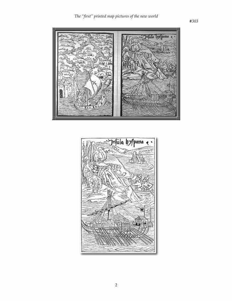
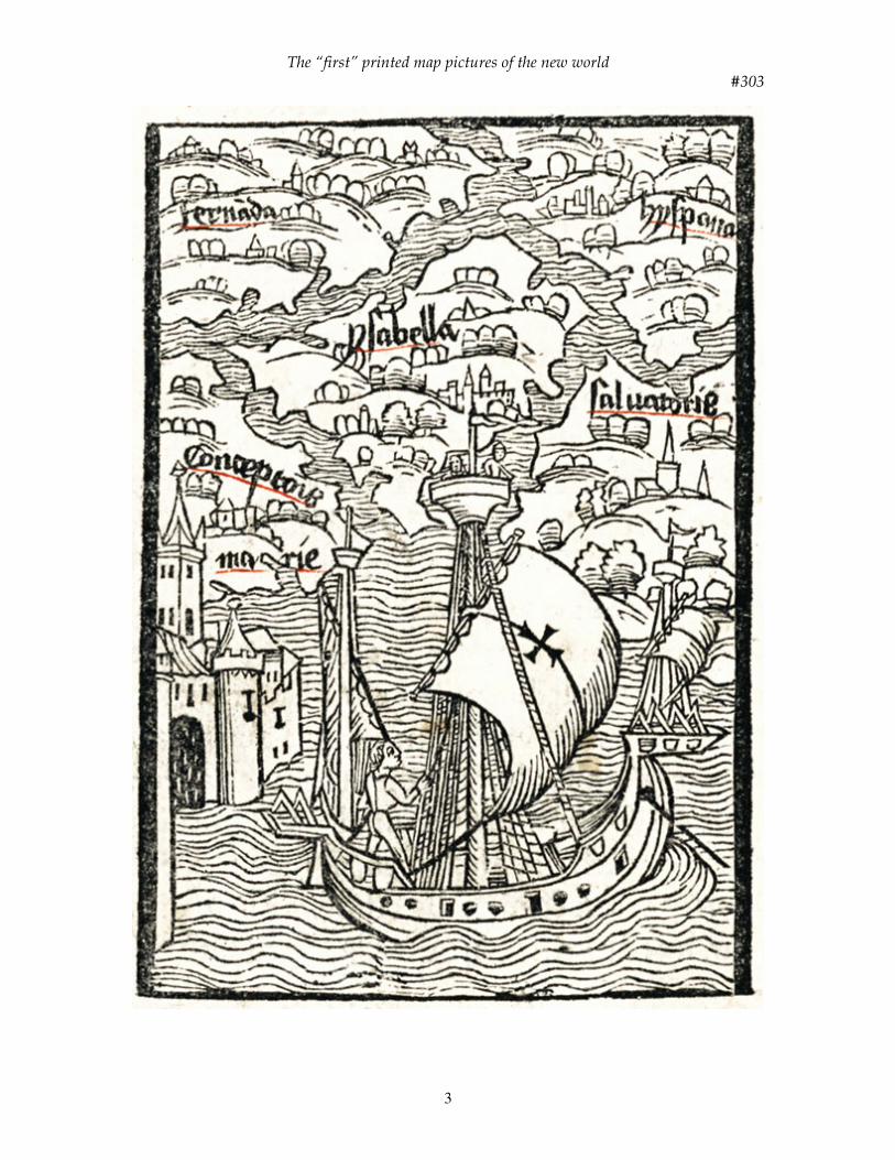
TITLE: The first printed ‘map’ pictures of the New World DATE: 1493 AUTHOR: Christopher Columbus and Carlos Verardus DESCRIPTION: The most momentous of all discoveries, Columbus’ encounter with the New World, was announced to Europe via a pamphlet. This eight-page leaflet became a best seller and informed a wide European audience for the first time of lands and peoples previously unknown. The impact of Columbus’ discoveries upon Europe was intensified by the invention of the printing press, established only a few decades earlier. Even though the Norse had gone to America, and perhaps the Chinese, Africans and later Portuguese or other Europeans might also have crossed the ocean, most of Europe remained unaware of those earlier efforts. The letter Columbus sent to his patrons, Ferdinand and Isabella, bearing the news of his return from the Ocean Sea and the discoveries of the islands of the Indies beyond the Ganges, was composed more as a public announcement than as personal correspondence. This first page of European-American history was written in Spanish and printed in Barcelona in March or April 1493. The first printing, which survives only in the New York Public Library collections, was hastily prepared from a poor copy of the manuscript. Immediately afterwards it was improved upon by a Latin translation from a better and more accurate copy of the original report. On March 15, 1493, when Columbus returned from his first voyage to the New World, he sent three letters to the Spanish Court announcing the islands lately discovered in the Sea of India. Within months this letter, De Insulis nuper inuentis [On the Islands recently discovered], was translated from Spanish to Latin, engraved on woodblocks, reprinted at Basel and distributed quickly throughout Europe. The letter was illustrated and published both as part of a book dealing with another great event in the reign of Ferdinand and Isabella - the capture of the area known as Granada from the Moors in 1492 - and also as a separate document. Altogether, Columbus’s letter appeared in nine Latin editions during the year following the initial printing in Spanish. These were issued in Rome, Paris, Antwerp and Basel. The text was translated into Tuscan verse by a Florentine poet, and five editions of the poem were published in 1493. By 1497 there was a German translation for sale in Strasburg. In this manner, some ten thousand copies of the account of Columbus’ voyage were available within five years to the comparatively few literate Europeans. The Basel editions were augmented by a series of woodcuts. These famous illustrations were totally imaginary but no less influential as the first pictures of the New World. The woodcut illustrations below (updated copies from an illustration in Bernhard von Breydenbach’s Peregrinatio in Terram Sanctam, originally published in 1486) were included as part of this public disclosure of Columbus’ letter. One of these illustrations (left below, measuring 4.5 x 3.25 inches, 11.5 x 8 cm) is a ‘map’ which shows Columbus’ ship, the Santa Maria as a multi-oared Mediterranean galley in the foreground with the islands of the Bahamas discovered and named by Columbus grouped in conventional perspective: Fernada [Long Island], Hyspana [Hispaniola, Haiti + Dominican Republic], Ysabella [Crooked Island], Saluatorie [San Salvador or Watling Island], and Conceptionis Marie [Rum Cay].
The “first” printed map pictures of the new world #303
2
The “first” printed map pictures of the new world #303
3
The “first” printed map pictures of the new world #303
4
Another woodcut (right above, measuring 4.4 x 3 inches, 11.3 x 7.5 cm) is the first depiction of an American Indian on Hispaniola with the simple Indian dwellings depicted as medieval castles. Although these are, in reality, stylized views of the islands, they are of the greatest importance as the first printed representation, of any kind, of the New World. The first accurate delineations of Columbus’ discoveries were a small hand sketch by Columbus himself (#302) and a world map drawn about 1500 by Juan de la Cosa, a pilot on Columbus’ expedition (#305). These odd depictions can be understood if one realizes that this was the first wave of news about lands outside the long-familiar Euro-Asian arena. The Admiral believed he had discovered the outer islands of Asia, and with perseverance, he could penetrate them to reach the Asian mainland. Although he did not reveal it in the letter, his elation at reaching the new lands was tempered by disappointment; he had not found great riches nor located Cathay and the Grand Khan himself. This picture-map is of primary importance as the first illustration of Columbus’ discoveries. It shows his ship among the islands of the West Indies named: Fernanda, Hyspania. Ysabella, Salvatorie, and Conceptionis Marie. It is a stylized view of the islands that, with the caravel and its lone mariner standing on the poop deck setting his mainsail, is the first item of the 500-year continuum of European-American iconography. Location: Newberry Library, Chicago References: Harrisse, H., Discovery of North America, p. 401. *Nebenzahl, K., Atlas of Columbus, pp. 28-29, Plate 9. *Skelton, R.A., Explorers’ Maps, Plate 31. Winsor, J., Narrative and Critical History of America, vol. II, p. 50. *World Encompassed, #51, Plate XVI. *illustrated