Embed Size (px)
Citation preview
Norse World Map #244
1
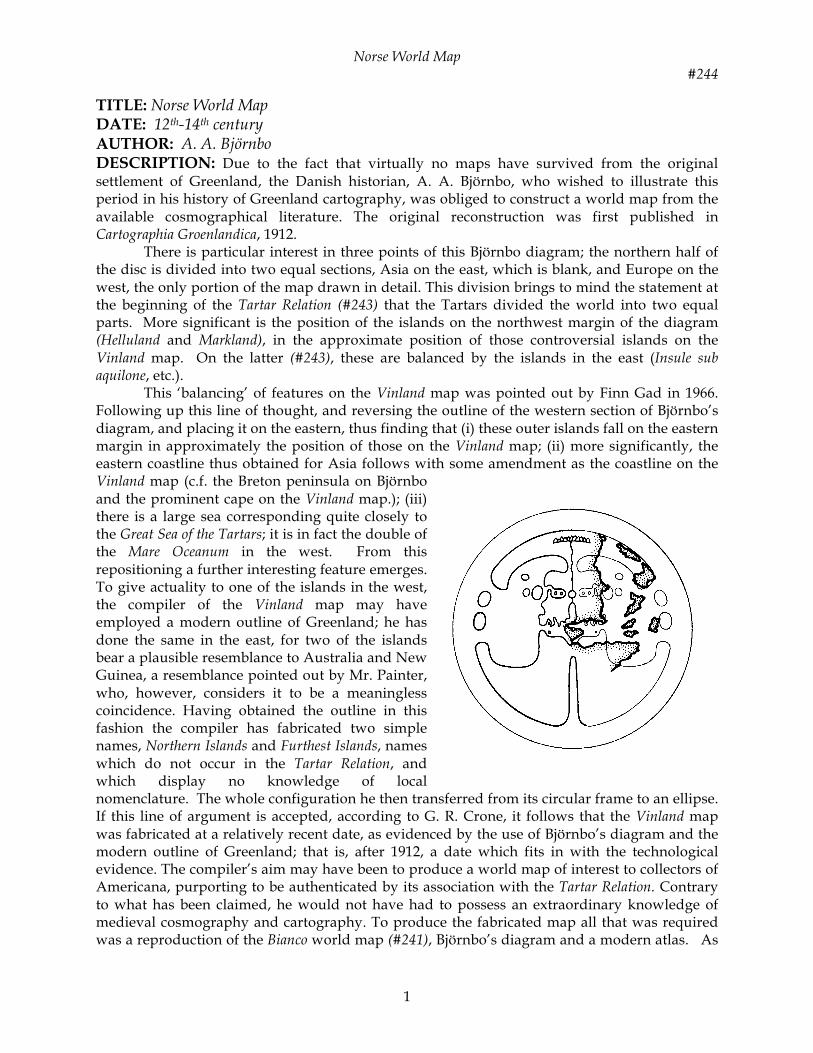
TITLE: Norse World Map DATE: 12th-14th century AUTHOR: A. A. Björnbo DESCRIPTION: Due to the fact that virtually no maps have survived from the original settlement of Greenland, the Danish historian, A. A. Björnbo, who wished to illustrate this period in his history of Greenland cartography, was obliged to construct a world map from the available cosmographical literature. The original reconstruction was first published in Cartographia Groenlandica, 1912. There is particular interest in three points of this Björnbo diagram; the northern half of the disc is divided into two equal sections, Asia on the east, which is blank, and Europe on the west, the only portion of the map drawn in detail. This division brings to mind the statement at the beginning of the Tartar Relation (#243) that the Tartars divided the world into two equal parts. More significant is the position of the islands on the northwest margin of the diagram (Helluland and Markland), in the approximate position of those controversial islands on the Vinland map. On the latter (#243), these are balanced by the islands in the east (Insule sub aquilone, etc.). This ‘balancing’ of features on the Vinland map was pointed out by Finn Gad in 1966. Following up this line of thought, and reversing the outline of the western section of Björnbo’s diagram, and placing it on the eastern, thus finding that (i) these outer islands fall on the eastern margin in approximately the position of those on the Vinland map; (ii) more significantly, the eastern coastline thus obtained for Asia follows with some amendment as the coastline on the Vinland map (c.f. the Breton peninsula on Björnbo and the prominent cape on the Vinland map.); (iii) there is a large sea corresponding quite closely to the Great Sea of the Tartars; it is in fact the double of the Mare Oceanum in the west. From this repositioning a further interesting feature emerges. To give actuality to one of the islands in the west, the compiler of the Vinland map may have employed a modern outline of Greenland; he has done the same in the east, for two of the islands bear a plausible resemblance to Australia and New Guinea, a resemblance pointed out by Mr. Painter, who, however, considers it to be a meaningless coincidence. Having obtained the outline in this fashion the compiler has fabricated two simple names, Northern Islands and Furthest Islands, names which do not occur in the Tartar Relation, and which display no knowledge of local nomenclature. The whole configuration he then transferred from its circular frame to an ellipse. If this line of argument is accepted, according to G. R. Crone, it follows that the Vinland map was fabricated at a relatively recent date, as evidenced by the use of Björnbo’s diagram and the modern outline of Greenland; that is, after 1912, a date which fits in with the technological evidence. The compiler’s aim may have been to produce a world map of interest to collectors of Americana, purporting to be authenticated by its association with the Tartar Relation. Contrary to what has been claimed, he would not have had to possess an extraordinary knowledge of medieval cosmography and cartography. To produce the fabricated map all that was required was a reproduction of the Bianco world map (#241), Björnbo’s diagram and a modern atlas. As
Norse World Map #244
2
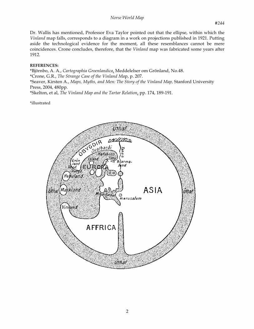
Dr. Wallis has mentioned, Professor Eva Taylor pointed out that the ellipse, within which the Vinland map falls, corresponds to a diagram in a work on projections published in 1921. Putting aside the technological evidence for the moment, all these resemblances cannot be mere coincidences. Crone concludes, therefore, that the Vinland map was fabricated some years after 1912. REFERENCES: *Björnbo, A. A., Cartographia Groenlandica, Meddelelser om Grönland, No.48. *Crone, G.R., The Strange Case of the Vinland Map, p. 207. *Seaver, Kirsten A., Maps, Myths, and Men: The Story of the Vinland Map, Stanford University Press, 2004, 480pp. *Skelton, et al, The Vinland Map and the Tartar Relation, pp. 174, 189-191. *illustrated
Norse World Map #244
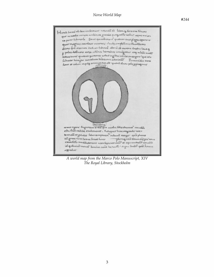
3
A world map from the Marco Polo Manuscript, XIV
The Royal Library, Stockholm


![Norse [Lustria Setting]](https://img.pdfslide.us/doc/110x75/577d1e991a28ab4e1e8ed629/norse-lustria-setting.jpg)