Embed Size (px)
Citation preview
Title A General Report of the Geological and PalaeontologicalSurvey in Maragheh Area, North-West Iran, 1973
Author(s)Kamei, Tadao; Ikeda, Jiro; Ishida, Hidemi; Ishida, Shiro;Onishi, Ikuo; Partoazar, H; Sasajima, Sadao; Nishimura,Susumu
Citation Memoirs of the Faculty of Science, Kyoto University. Series ofgeology and mineralogy (1977), 43(1-2): 131-164
Issue Date 1977-01-31
URL http://hdl.handle.net/2433/186612
Right
Type Departmental Bulletin Paper
Textversion publisher
Kyoto University
MEMolRs oF TrHE FAcuLTy oF SclENcE, KYOTO UNIvERsuTy, SERIES oF GEoL. & MINERAL. Vol. XLIII, No. 1/2, pp. 131-164, Pls 7-9, January 30, 1977
A General Survey
Report of the Geological and Paleontological
in Maragheh Area, North-West Iran, 1973
By
Tadao KAMEi*, Jiro IKEDA**, Hidemi.IsHiDA**,Shiro IsmDA*, Ikuo ONisHi**", H. PARToAzAR',
Sadao SAsAJiMA* and Susumu NIsHIMuRA"
(Received Oct. 20, 1976)
Content
Abstract ...............................................................................................................131
Introduction ..............................................,..........................................................132
Previous Works ......................................................................................................132
General Geography and Geology in Maragheh Area ......................................................134
Excavation at Dareh-e Gorg.......................................................................................136
a. Sites and Trenches ............................,.......,..,...............................................136
b. Condition of fossil preservation .....................................................................141
c. Disposition of fossil bones ...........................,...............................................141
d. Fossil specimens ..........................................................................................141
List of the collected fossils ........................................................................145
Stratigraphy ..............................................,..........................................................146
Palaeomagnetism of Pyroclastic Sediments ...................,..............................................154
Fission-track Age of Pyroclastics and Chronology of Maragheh Formation ........................157Age Estimation of Maragheh Fauna ...........................................................................159
Summary...............................................................................................................161
Acknowledgement ........................................,..........................................................162
References .................................,...............,..........,...............................................162
Abstract
The present article is a general report on the excavation of the bone beds in Maragheh area,
N. W. Iran. The excavation has been done at four sites in Dareh-e Gorg, near Mordagh, inautumn of 1973. Many fossil bones were sampled and those dispositions were recorded. The fossilmaterials excavated in this time were listed, including many cranial and postcranial bones ofiEripparion, Antelope, and other Bovidae, Carnivores, Choerolophodon, etc.
* ***** ' tt
Department of Geology and Mineralogy., Fac. Sci., Kyoto UniversityLab. Physical Anthropology, Zoological Dept., Fac. Sci., Kyoto University
Inst. Geology, Fac. Liter. and Sci., Shimane University
Geological Survey of IranDept. Earth Science, College Liberal Arts, Kyoto University
132 Tadao KAMEi et al.
The fossil bone was obtained from the sediments of 130 m thick in Mordagh area, consistingmainly of the alternations of tuffaceous sandstone and mudstone. Those are assignable to thelower part of the Maragheh Formation. The six tephra were recognized as the distinct markerbeds in those sediments. Then, the sedimentary environment is presumed. Directions of natural remanent magneti-zation of 9 sites were measured. Six pyroclastics including one ash flow of basement were datedby fission-track method and the age of the Maragheh fauna was considered as 6.6 to 6.9 my.
introduction
For the occurrences of fossil bones in the area of Maragheh in North-west Iran
many scientists have paid much attention since the middle of last century. In the
autumn of 1971, three members ofthe Kyoto University Scientific Expedition (KUSE)
team ofJapan, J. IKEDA, S. IsHiDA and N. SHiGEHARA, visited the GeologicalSurvey of Iran (GSD after their field-work in the Siwalik Hills of India and in Sinap
series of Turkey. With the collaboration scheme organized by the GSI, those three
members and F. GoLsHANi, a geologist of the GSI, have carried out a brief recon-naissance survey at Dareh-e Gorg, en route from Mordagh to Kerjaveh in Maragheh
area, during the middle of November of that year.
Having been based on the result, the team determined to conduct more detailed
excavation and geological survey around the vicinity of Maragheh. From September
12th to November lst, the KUSE team has been honorably given again the oppor-tunity to workjointly with the GSI in Maragheh area. The Japanese team con-sisted of five members, J. IKEDA, T. KAMEi, S. IsHiDA, H. IsHiDA and I. ONisHi,
and the Geological Survey of Iran has dispatched H. PARToAzAR, to work inoollaboration with the Japanese team.
In this report, those members of the joint team state the observation of field-work
and excavation at Dareh-e Gorg, and the results of the paleomagnetic study forMaragheh samples by S. SAsAJiMA of Kyoto University and the fission-track agesdetermined by S. NisHiMuRA ofthe same university are included.
Previous Works
The study of the Maragheh bone beds has been undertaken since the middle oflast century, but the story of fossil bone of the area went up in legend far more
ancient time. R.T. GuNTHER (1899), reviewing the paleontological studies on the
bone beds, wrote: "Village people regard the Mastodon bones as the remains of the
big men who lived before the fiood; but the chief man of the village classified the
bones under the heads elephant, deer, swine, unicorn and `devy', or men with hornslike genii."
It was the first scientific paper in which H.W. ABicH (1857) reported tusk of
elephant, remains of deers and fossil onager found from Maragheh which had been
Geological and Paleontological Survey in Maragheh Area, NW iran 133
sent from Russian mission KHANiKoFF to Dorpat University (now, Tortustat Uni-versity, Estonia). KHANiKoFF, who discovered Maragheh bone beds, had been inPersia in 1840. J.F. BRANDT (1870) and C. GREwiNGK (1881) studied the specimens
of Dorpat University which had been sent frorn chemist M.A. GoEBEL, who wasalso a member of KHANiKoFF expedition. Based on ABicH's and BRANDT's works, Maragheh mammals had been con-sidered as Pleistocene fauna including living ones by A. GAuDRy, 1878. E. TiETz(1881) wrote in his "Ueber einige Bildungen derjungeren Epochen in Nord-Persien",
regarding Maragheh mammals as "Steppen lehm" fauna. But another view wasmade by C. GREwiNGK in the same year. He found the presence of Hi parion,Rhinoceros non tichorhinus, Mastodon?, Helladotherium and Tragoceros in thefauna, and pointed out the close relation between Maragheh mammals and those of
Pickermi in Greece. In addition to this, he commented that the living and Pleisto-
cene forms observed in the fauna by ABicH and BikeNNDT might be the materials
derived from cave deposits nearby.
In 1884, H. PoHLiG was invited by a merchant of Tabriz and made ajourney to
Persia, He excavated the bone beds near Maragheh during the season of June andJuly. According to him, "The fossil bones have been found in the reddish marlsat more than six plaoes, at greater or less distances from the city (up to 30 miles),
and at different horizons, which, however, do not differ from each other by any
characteristics of the mammalian fauna." (1886). He intended to publish a mono-
graph of Maragheh fossils, but left only the faunal list and short comment. PoHLiGlisted sixteen species of mammals, and stated, "it seems to me therefore that a Pleisto-
cene fauna does not really oecur in the Maragheh valley". PoHLiG's collection
was mostly deposited in the Museum of Prof. Von FRiTscH at Halle. In summer of 1885, A. RoDLER and E. KiTTLE visited Maragheh and excavatedbone beds by the help of Kaiserliche naturhistorische Hofmuseum of Wien (RoDLER,
1885; KiTTLE, 1885). In the report, KiTTLE enumerated following fossil localities:
Korpan, Korpan-Mescha, Zad-Baschin, Rasat and Ketschara at Murditscha. Thosematerials excavated were sent to the Hofmuseum, and have been studied by KiTTEL
(1887), RoDLER and WEiTHoFER (1890) and G. ScHLEsiNGER (1917). Owing to theirefforts, it became clear that the Maragheh mammals have close relation with those
of Pickemi and Samos and have position in "Pontian" fauna. On the other hand, R. LyDEKKER (1886) formed a notice on fossil materials of
Maragheh which were sent from R. DAMoN to the British Museum. He, admittingthe priority of this study to PoHLiG, stated a significant meaning of the Maragheh
mammals in relation to the western limits ofthe Siwalik fauna of India. He assumed
that the Maragheh beds are of later age than the Lower Siwalik.
On September of 1899, R.T. GuNTHER visited Maragheh and stayed at the houseof Quasha MusHi who had excavated and dispatched bone materials to PoHLiG.
134 Tadao KAMEi et al.
GuNTHER made picking up fossil materials near Kirdjawa (Kerjaveh). The materials
were surveyed by C.I. Forsyth MAJoR who was working about the contemporaneous
fauna of Samos. MAJoR had already reported the remarks on Orycteropus ofMaragheh in 1893. J. de MoRGAN, a scientific mission delegated from Ministry of Public Instruction
of France, had stayed in Persia during 1889-1891. He passed Maragheh in 1889and had much interest in bone beds. His reports on the geology and paleontology
of Persia were published in 1905, but prior to this, M. Marcellin BouLE of museum
d'histore naturell de Paris got in tough with J. de MoRGAN and atso had muchinterest in Maragheh bone beds in 1897. 0n his suggestion, French expedition party
went to Persia in 1904, and excavated bone beds at Kirdjawa (Kerjaveh) near Murdi-
tchal (Mordagh) three times with twelve workers. They also carried out geological
survey at Kingir, Korpan, Chollovend and Mourandjikh. At that time, new fossil
localities were found near Kermedjawan, 26 km east of Maragheh. R. de MEcQuE-NEM, a member of this expedition, wrote short notes in 1905 and 1906. He engaged
in the paleontological works of Maragheh mammals in the museum d`histoirenaturelle and made some reports in 1908 and 1911.
In 1924 and 1925, MEcQENEM published a monograph, "Contribution a 1'etudedes fossiles de Maragha". In this paper, he described 7 families, 26 genera, 32
species ofmammals and two genera ofbirds. Among them, the discovery ofMesopi-thecus from Maragheh was noteworthy. After a long lapse of time, F. TAKAi ofTokyo University of Japan visited Maragheh and picked up some fossil bones atKarjabad in autumn of 1956 (TAKAi, 1958). In 1967, H. ToBiEN, Joh.-GutenbergUniversity of Mainz, visited Iran and excavated Maragheh bone beds. He reported
a fossil list and discussed the occurrence of fossils (ToBiEN, 1968a, b).
Recently, Dutch team of D.P.B. ERDBRiNK and others carried out fieldwork in the region in 1973, and they published excellent results on stratigraphy,
paleomagnetism and K•-Ar dating (ERDBRiNK et al. 1976).
General Geography and Geology in Maragheh Area
In the geological map of Iran arranged by NIOC, the basement of this area is
assigned to the rocks ranging chronologically from Jurassic to Mio-Pliocene, andthe overlying sediments are designated as Plio-Pleistocene (QPI).
The fossil-bearing deposits in Maragheh area is distributed widely ranging more
than 3oo Km in north-south trend and about 500 Km in east-west trend. Kuh-eSahand (3,562 m), mass of extinct volcanoe, is surrounded by those deposits within
the reach of Tabriz, Maragheh, Miandoab and Mianeh (Fig. 1). In this report,the sediments in which abundant fossil vertebrates are contained were named there-
after as the MARAGHEH FORMATION.
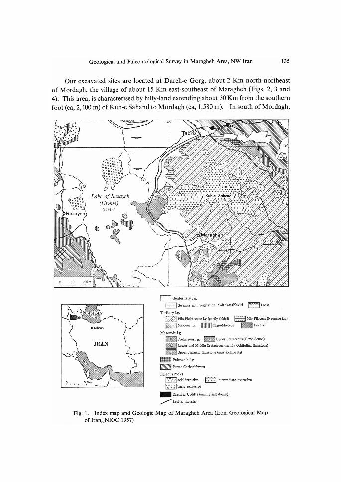
Geological and Paleontological Survey in Maragheh Area, NW Iran 135
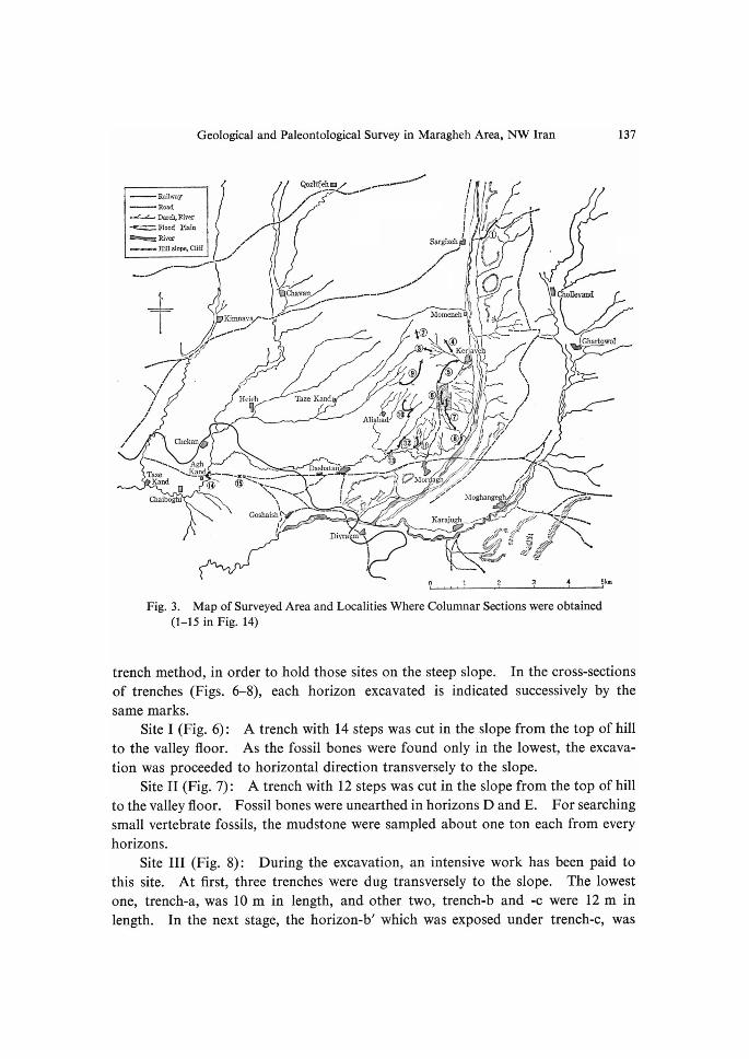
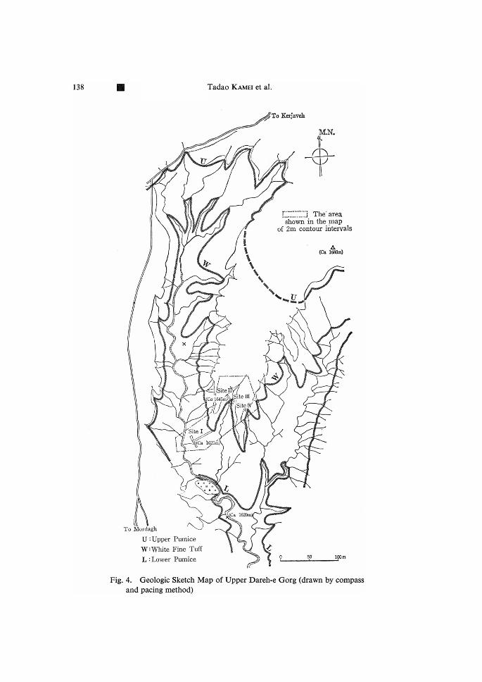
Our excavated sites are located at Dareh-e Gorg, about 2 Km north-northeast
of Mordagh, the village of about 15 Km east-southeast of Maragheh (Figs. 2, 3 and
4). This area, is characterised by hilly-land extending about 30 Km from the southern
foot (ca, 2,400 m) ofKuh-e Sahand to Mordagh (ca, 1,580 m). In south ofMordagh,
v
vvVvV
v
v vvvV vVvv.'vv
46'
1 / xvsxxXxxxxXxXx" -
xuxxXx
Tabr/z iixzxitixzii/7i/iZi-ii/i.t ziiix
lt
k
wn
x
l/ii•`.,.
xx xXx Xy xXYXv
xxxRezayeh
xx.
,#
ve
t - tt, t.ast
x /• ' tl
' x ' 'i'
0Lake ofRezayeh (Urmia) C1274rn)
ee
in asagemmp
N ..,i•, 111 • I./i,/.!/lil'
t tt/ttt ' l• 't"•'m'•.'••/i••i.va//lt/ ' .', ../s.I.l..R'/'II.wa..1' :
O 10 20km
v
x•.tt.•/,t,l'•/
',l /1/ ' •n• .,
,vet ee
tt-t ' :el, -
ttl/t + . ++ .
Zlx "11 ,-- ttt 1 ' tttttti"iiZi'"i' i'P''"
tx/ tii ii iiiiix-i"l'l'li"iili;xlix'
iltt /? +++''
'
tlli:ltil"i//t.'l'//'i'/"./i'/il"'2'ii'i'l'2""llill!''
.•. •. ..•;t;.z•i i.t .•. •;•2•.".
1 IIxt tt/t lt/ ltlt /111 l t /y-tttlttt1tl1t/t .'. .'r-'.i.'.','... It ttlll/t! ytll llt
11 1 l lt X- xv -t l-1 1- yl 1- tl ' ll + + ++ ' ++ ++-.t
.' .f ++++.++.
;+:+++.-.++ ++++.3?i++omA+l+;+;+
"' .#'+'+'+'+'#t'+ Kuh-e siaiiGn'a"+'"+
i.ii;xi.t}.il'2.i;iii'ixi.
--v tlt-++ IX/11ttt,2ii':'ixi';"}l.iE'l/l/+.•'zilti'
i'.'i'iz.;.'i"ltilli;;:'i"1
ltxttt #++ +-+-+ +++
++- +t+ ++--++ +-++++++- -++t+ +
,.v.Y ..'..'.
Iy
46'
tv 11llll
't v VvVv v ylx .I1,,pt.I..m'.•'' l...,i,
yV vVv
xti tl/i afa]i ll il
vVv .•/1v l'v. v II If vV tt
!yl vVt l/ 11ZXyt yiii{.,,.. .. ..•. t. i.l•11'l•g-.-••
"v'. ' g,},E"""•'-/.,
Z..e' fr
./ lt
lt1- I1
".i.iii.. ii./•Å}ffx ,++
.x.2 •.•;•. '•Z .
/lt 1/ //i,,s'
,ii.I'l'i'liii•i';.i'li•z'!.
X + y+ ++ tt t' t iiit'+f .. ..t,..'.x
'
x tl tx l•i'2il.iiitil•;•/Z'ti...
z•'x'7zi,iitll'ig./l.'//'.i/l'ltllll//l.'ll.'/l'l.llx
x-X/tttXltxtll ... tvt1tXxv ,/i't' ' xZity VvV tttt vVv
++tx ;+ .+ '':++++:++ "i' +
1+++++ t/ ++++t++r+ '-' 1 +++++ -- /i iiZtxi i i2.•lt.}•'•;.Z•i;;tZ.i
Z'.i.i 'fx'Z'2'•;'x2 '/.'z/.
tl1111yl1.
' lx tt tl+ lt/+ lx- + + -- -+++ /t+f't;./.i.i•l•;Zi3il.
tlitiiii.li"//i'2ilZxi',/".,ii
tl --z etl-xl -l xt t i'.' .' i2xl•2"
v v"t v
- x•ee
v
Z',lli,/z.ii,,/z.'l.ltllilt
v xtttlttZ-VvvvVv titiiiti-iitit
N ,,i• f"N...t'"t. , #• ,s• , '.
.5•i.tsab;i'-./• ,.,.. ....r'.•
l, i)' eTehran t'
s.s
'S,. IRAN .-'1.
•<'>c.,.` g,...,.
e'fftftg.rcesFT ms."wax '"
O 5COkm t - ""-"-i
.-.S.N.1 '! IF..t' eJ
t t" ') it---".-- N.N. !--.
i"'
Fig.
M Quaternary i.la
Nswarnpswithvegetation saltflatsCKawh) :-:-:---- lpess
Tert{ary i.g.
EZZZ] pllo•pleistocene i,g.fpartly folded) Ei:iiXl Mie-pliooeDeaseogene is.)
rwMiocenei.g. [MinIIIllIIoligo-Miocene wtEocene
Mesozoic i,g.
"'E,;' /l. Cretaceousi.g. wwUpper CretaceousCrltror1,Seneni
l•,ts."'/'E Lovrer and Middle Cretaoeous (rnainly Otbitolina lirnesta[ze)
ww Upper Jurassic 1imestone Cmay include KD
g$sxgg paleozoic i.g.
ww PermoCarbonifereus
1gneous rocks
"v"v'v" acid intrusiye ++-+++ intermedlate extrusive
." .' ." basic extrusiye
- Diapiric Uplifts {mainly salt domes)
/ faults, thrusts
1. Index map and Geologic Map of Maragheh Area (from Geological Mapof Iran,LNIOC 1957)

136 Tadao KAMEi et al.
rr"
3.7'
su15
NS Ns
`Plie;
p-.P
To-lt
l
0tsp ..h•
... Eli>
w"; gli21!!ITttttiO,.
X•,i)`li)ss , ,elii2i:fz'i,.iz7
-- >s tl
.NSs
Xrxs. A/ -'N -' { Bonab
i`s:
v.ll N v- INtle'(<-1/,,L>:rN<5,"'
-ywXrwgs.--en"l4 Z-t i k sNk
xk.s7AGHEH ' l-r
)r Y...{
I t.vtll/<L7/'Pa
l'i,i/
2b-
tNt
if
N
N
7
e
Ni."'` l.illllii?i'\e`,
4igg'.-ilii)N
ew-
' A tt
' ' 1,betbg,p' ,
/t NK1
'
e
eN
NID
L
):
tsf,iiiiiilliis,,ili,,gs$i,g)(
,Zi////gitrc,,SiiiX7/$/tg-/k-'i•/\'
tai--eaoo>N
Ol[,f:)X,'t-}aaj'h"
s
1t
1'
I11
k Davabumitev.,.&,/gstZiis•
NkL lt. t,:sT',r)/
Ny1
i'itttiii],,ee-(; tl ,-1.N>.i•;IS IIN`i,i•i'IIKii
NX 1-:.at\i.ity(ifillk&U/.V'ileepa/L it,-5i."
,,' +li.gN
,7
,.7(?1
XlN/ N"-n.L
,x#v2'ill'<i-kl,,;
o s lo lslanFig. 2. Topographical Map of Maragheh Area
there is mountainous and hilly area consisting of shales and sandstones belonging
to the Mesozoic marine sediments.
Hilly areas near the excavated sites are semi-desert environment with dry valleys
occasionally dissected in 20 to 30 m depth. The surface elevation of those dissected
hills has altitudes ranging from 1,650 to 1,7oo m and the topography has wide and
low relief. On the top of the hills, residual andesite gravels are scattered in con-
siderable extent. Nearly horizontal layers, mainly consisting of alternations of
tuffaceous sandstone and mudstone, crop out on the surface of slope.
Excayation at Dareh-e Gorg
a. Sites and trenches
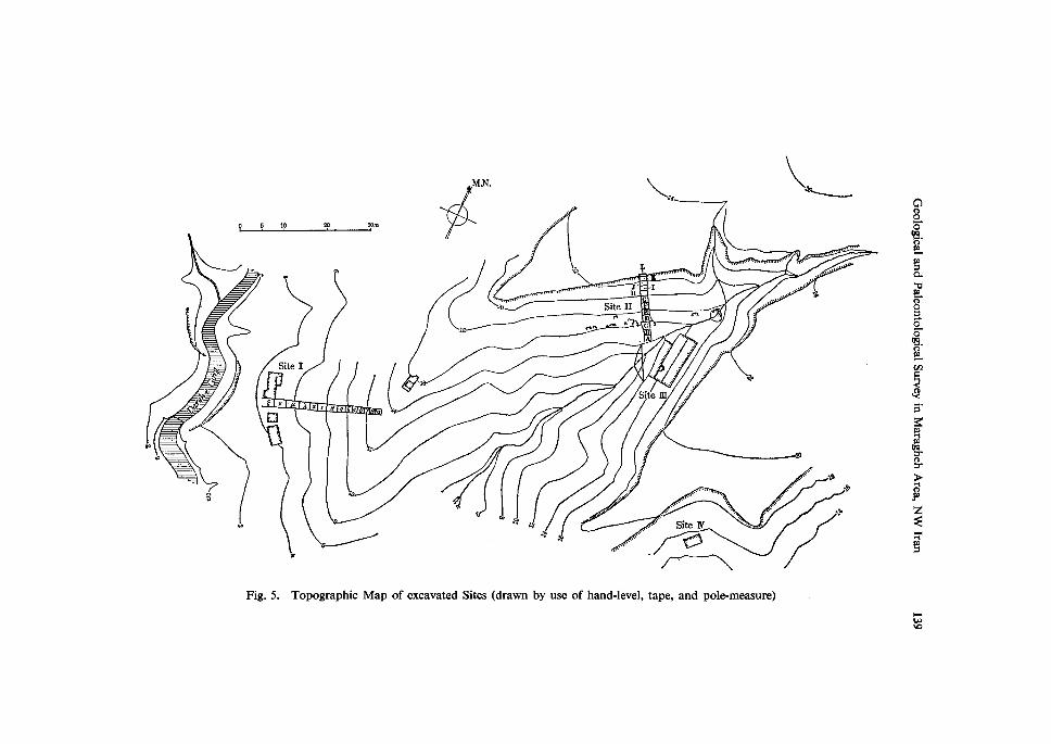
The excavation has been carried out at four sites, Site-I, II, III, and IV, in the
vicinity of Dareh-e Gorg (Fig. 5). To this excavation the team applied stepped
Geological and Paleontological Survey in Maragheh Area, NW Iran 137
Railway Road-".Dard4Rha- =Floed ?1afnN ruYernv nyM slopei Cliff
t -"'"nyvt
+
<6
.A7/
l.ttysJv-
z?7
--.- / tl'tt 'Syt 1/ 1/// oriekan
..-. [rh.zi,ili.,XN.,l2-a".nh
CbaiboghiN
Heieh
.
-/Qoz.idi.' el}YL(L..;tt"-
Chavan
t--/vt
i''it1
Taze Kand
J l ' Sargizch" x/'t
xtttt-...-....#-x
Aliabad
....-..Z" Si8idi
s@ s@ iZs{)1 cf?,t
!uaag/Åë
@
...--.X"s"-"'""---@ o x- N"-..
NtGoshaishl"
`
--- geschaSan --..- "
'<.x..'../..I' lr2",'"..,]1.li'";L"l?'....
• .".
t/
t
VrMordag e'
1KeEjay
t
>//• •
ii.tt'foSN
is..
';L2
<1{.
$ta
s
A.e k l
//I
/Ek
Ns
SN
gerS"' s'-"'
' kraingh
ncztobentt
of .•/7i•,tS7
'"-E'tt"'..---.-
,,,.,.s:>..ttl'
.,t"•1 tsi•v Zl M{ptiange h-
]n fi' a}K-abNt"i"tteii+tirttttNxs'
t .ec se Å~suif N 12
-- -- T
t"' tt / t sx x l 1.
Il
7
tl .,(:;n,
11" <N
Div,a .rrdSN
lT'
N"S"s.g..
.<tig.ssx
Ghartowolv
oFig. 3. Map of Surveyed Area and Localities Where Columnar Sections were obtained (1-15 in Fig. 14)
v />tpt--. , t-.-ps"s.S-.•"'- [lk.$'•'afr:.i-.•
="it3
3 4 Skm
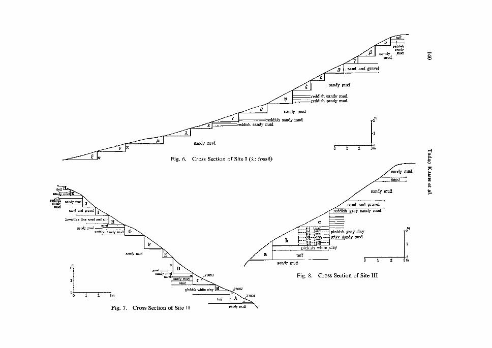
trench method, in order to hold those sites on the steep slope. In the cross-sections
of trenches (Figs. 6-8), each horizon excavated is indicated successively by the
same marks. Site I (Fig. 6) : A trench with 14 steps was cut in the slope from the top of hi11
to the valley floor. As the fossil bones were found only in the lowest, the excava-
tion was proceeded to horizontal direction transversely to the slope.
Site II (Fig. 7) : A trench with 12 steps was cut in the slope from the top of hill
to the valley floor. Fossil bones were unearthed in horizons D and E. For searching
small vertebrate fossils, the mudstone were sampled about one ton each from every
horizons.
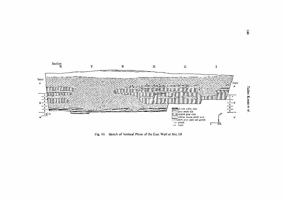
Site III (Fig. 8): During the excavation, an intensive work has been paid to
this site. At first, three trenches were dug transversely to the slope. The lowest
one, trench-a, was 10 m in length, and other two, trench-b and -c were 12 m in
length. In the next stage, the horizon-b' which was exposed under trench-c, was
138 Tadao KAMEi et al.
e7 To Keris'aych
M.N.
U'
ip
i
kX x Å~
r =T :j The' area sllown in the mapof 2m contour intervals
A {da :ma
N..U..
x
r'
iL.
x
//site r
(Ca "
(Ca' 1645m)
1
'
i'`--" '/l ite X,t site lll
i6asdi)
/
To M
/
---ktl )" " L
,
Site o
j
ordagh
U :Upper PumiceW:White Fine Tuff
L:Lower Pumice
atS-
da 16anrn
,etr O-50 m
Fig. 4. Geologic Sketch Map of Upper Dareh-e Gorg (drawn by compass and pacing method)
o 5 10 rc 30m
M.N,
" n
Å~?f
'
"
K-"
N
9
to
fi:' i
Site IIG
Site 1
v•ca
Q
g
N
t
v-A
pt
p
--l
Xrt ev
e
e
g pt
a(:6
18
.At I !tl ! ttl "
a
site m
•----
"
e
e/v
to R -N
NV.b
Site N k!S
-/"
se
Nh
ts
a85ee6'pa-
ptpavpt-
oopeopoee6'pt-
cag?
,.O,,
B'
Kmptig
gb8Z$wptp
Fig. 5. Topographic Map of excavated Sites (drawn by use of hand-level, tape, and pole-measure)
pwwo
atuff
B7
sandy mud
5 .sand and gravel
g
.
raSclislr
sandy .mud
e
v
e
t
x
A
pt
v x
e*
reddish
sandy
sandy mud
eddish sandy mud
mud
reddish sandy mudreddish sandy mud
sandy mud
Cross Section of Site I
rsandy mud
Fig. 6. (S : fossil)
o 1 2
seilsu}cl m-d K
Zreddiabsandy
mud
2M
z
o3m
sandy mud
sand
sandy rnud J
sand and gravel
sandy mud
I
leess-like fine sand and silt
sandsandy rnud --LH
reddish sandy rnud G
F
sapdy mud
sand and gravel
/ / /- C t .-'{---:JI'/LI,Uigf:-:-
.•/{ tlit":'i."ig'!///ii"tT,-I.
-l 1LM
reddish
m
E
gray sandy mud
2
1
D
Å~sand sandy rnud
- 1
//apinkish white
tuff
pinkish gray clay
a sandymud
91ay
di
m2
1
1 2o
Dsand
sand mudsand
c73oo3
pinkish white clay
o 1 2 3m
B
tuff
73oo2x
A 73oo:
sandy mud
Fig.7. Cross Section of Site II
Fig. 8. Cross Section
sandy mud
of Site III
3m
"s
8gg
5Eg-
v
Geological and Paleontological Survey in Maragheh Area, NW Iran 141
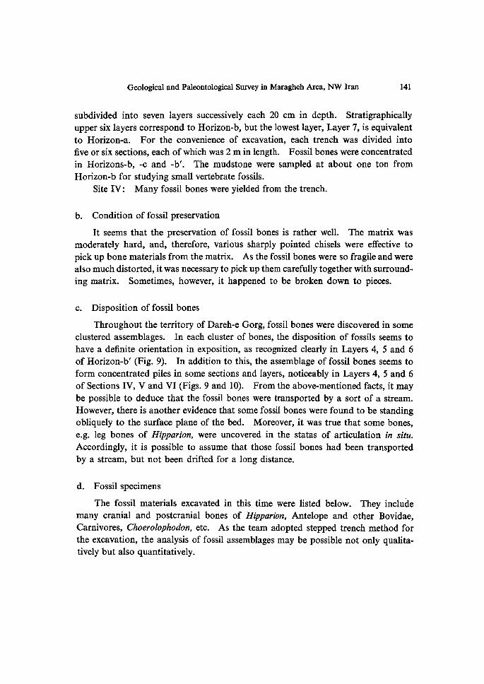
subdivided into seven layers successively each 20 cm in depth. Stratigraphicallyupper six layers correspond to Horizon-b, but the lowest layer, Layer 7, is equivalent
to Horizon-a. For the convenience of excavation, each trench was divided intofive or six sections, each of which was 2 m in length. Fossil bones were concentrated
in Horizons-b, -c and -b'. The mudstone were sampled at about one ton fromHorizon-b for studying small vertebrate fossils.
Site IV: Many fossil bones were yielded from the trench.
b. Condition offossil preservation
It seems that the preservation of fossil bones is rather well. The matrix wasmoderately hard, and, therefore, various sharply pointed chisels were effective to
pick up bone materials from the matrix. As the fossil bones were so fragile and were
also much distorted, it was necessary to pick up them carefu11y together with surround-
ing matrix. Sometimes, however, it happened to be broken down to pieces.
c. Disposition of fossil bones
Throughout the territory of Dareh-e Gorg, fossil bones were discovered in some
clustered assemblages. In each cluster of bones, the disposition of fossils seems to
have a definite orientation in exposition, as recognized clearly in Layers 4, 5 and 6
of Horizon-b' (Fig. 9). In addition to this, the assemblage of fossil bones seems to
form concentrated piles in some sections and layers, noticeably in Layers 4, 5 and 6
of Sections IV, V and VI (Figs. 9 and 10). From the above-mentioned facts, it may
be possible to deduce that the fossil bones were transported by a sort of a stream.
However, there is another evidence that some fossil bones were found to be standing
obliquely to the surface plane of the bed. Moreover, it was true that some bones,
e.g. Ieg bones of Hipparion, were uncovered in the statas of aniculation in situ.
Accordingly, it is possible to assume that those fossil bones had been transported
by a stream, but not been drifted for a long distance.
d. Fossilspecimens
The fossil materials excavated in this time were listed below. They includemany cranial and postcranial bones of Hi parion, Antelope and other Bovidae,Carnivores, Choerolophodon, etc. As the team adopted stepped trench method forthe excavation, the analysis of fossil assemblages may be possible not only qualita-
tively but also quantitatively.

142 Tadao KAMEi et al.
b'-1SectionM v rv m
"y
gNS
`JS
"'"
D 1rn
b'-2 Sectionvr v rv m"-
o
" Åë
Neb
,,,s.j}$see
6
o lm
b,-3 Section 'Vr
oe
v
s.-.......-..
N
ts
m
Fig. 9.
e
Q lrn kSketch of Horizontal Plane, Showing Fossil Disposition in Layers b' 1-6 of
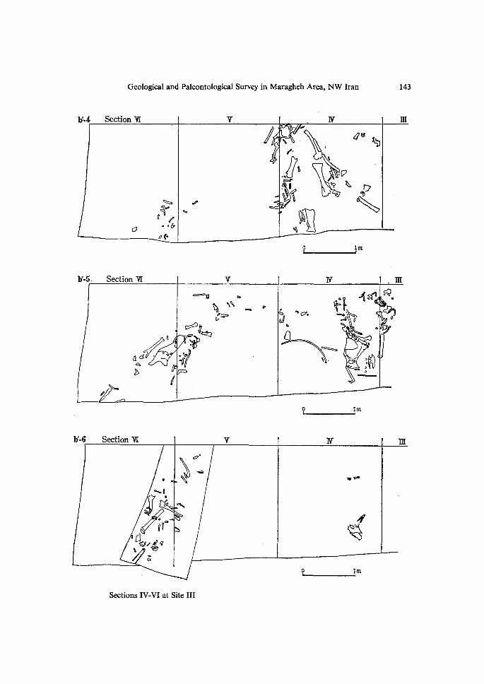
Geological and Paleontological Survey in Maragheh Area, NW Iran 143
b'•4 Sectionvr v' N m
l,
iau$"b
1•J s
o
ssu9!..0
.tc=ess!1([\"s" y•Zll7 Nsip
'
0"
O lmb'-5•Sectionvr v N .m
a4-Ab
ood
a=='ebkbNg4`.,.vPp
tf{?3i}}•5ef
e'e,ll` -ct-
ajanesN..
5==,,
s•mp:•Q-)h
ti.Il?l)zl
O lmb'-6Section'Vr v N m
0.
.g"ll
.eD
"tp"NO
;
d Noc} i
'
iCilli
o lm
Sections IV-VI at Site III
pk
Section wt y W m II I
Layer
c
:t,fit,•f.tkt•.,.,t:,--:,rl:-i.{;•:iL,-;.'t'L'.l•,l,E:,i•;.t"•:.t/fl:.f•Sy,••:••:-•••
;'•tr,•i4f•i•?'li'a•--..:.l,ij•:',-1•ii•lt.i-g•i{•i.-:.-Tt',[•;L'Lrs'ki•;=TL•rfT.x,•.,•.,-
•::l- I.lf,-:;•+.l,.ÅÄ/1"r:•::Eg•]•."A-:::t'/rl!?rl•;,•.t'i,:-F;}ÅÄ.t•t;T•.•:,L=•
' CL• r, ' = '-/,Lt.
1
2
--:f-:;i'"•:-1•;'::-:r-::iLP-'1-;..T.'.'•:t--::ÅÄT•;Ti.L'I.t•-.trt;/",:-:'tE-".i.--::;•;L•fi,'t,.4-:i./'lltt/i--:f.':-I,..tLE!,]-::.ri:ltt.ÅÄ2,l.f,'ei,'."-:•Yv-'"-*'l,:•'.2•l'i•"l:::l:•Itt•ÅÄIl't•-'-.'./"'."7-iiJ•:-:-'l:il
-.•::, J= :X• '-'.-:..:ta. =e :..= : ,•= := •.-• :l:,'::..•s ..:,.
I,:.\'k'li'tF.tLi,i'5'i.g,•,i-l•:.t,l•:.tt,.j2,-",-v".•i,i-'{-'4•;.gt:,.tit:•ti,•,:•:-:#;'•:i'di•r'.i-,..
.. r.-::k:'.tf}:'f••:V•::r•!:h'-::tr,:•+t':.';`/'t'#.t/::-;V.li-:v;':-lihSre-.Sr•:T-.1"i:;rJL"L•ÅÄ7:-::'"••r.•-L#
'-• •t" Fr•}•:,;`,T•gT::•il•#,'tte:t'El:e,:=:l:.J.
sbt . 4 5 6
t•E•}il,-:•.:,.",-...
--"r-)=- .=:'LS 't-: .
tHtJ- t- - Lt; -- ---t----t---- LAJ--vLt ---4 -l ------ -- +
g•:',y•i...'.l•tLl•.i-:i;-;•'ST,i.ll•1••l#•-,}tr,,1•l•tJl•.v.i,:fl .'--'L;:-. =' ,-1•- ;,• = •=;k, :-'.• :: J..h, •=, •,=1,':=•L Tt-::-.,:-::u.i•;lf•Ittii.A.;•r•':'t:•TU'di:•:-"•-•'fÅÄ:-i-::::::i•j•r•:•:t
rr:•?ai. ig. :-r•-.-•T•.:,t",- ':J •-• '- •-;k•tt• •tt.'•T•of ::,t
m-,-i-••
it{'•'i.,/iii•iit,rl':-l"/'l•'k,:.tL:,,f,:,/r•tlg.:.,•,tl/r/•,il,-'1/1''i:":•i-g•'-l/;-;/t:'l.e'
"-•" . L•.-• sr• •=r. =. t•..z:•r•iv s=• =•"'• :X• Lr•st• "Tdr• .v:• •:•••itt,•1•t•;•f•;:.-•4ii-:.-4;•:•l;•,-'-,!.•.lf•.111•tr,,#=,'•;,ic,.:•:,'.;•.:;.;•;•fl'
,fE-,{,g-l'tkl"il,-{'$-ii-gl-;.'ls'S,.,f;f./-E-al.illl,l:llllei-l'ii
rlSn:•'
l'iJ.::i..r'"'
.r.=:•=::tt•-;•:•E•il:ii'E••
,=',3....'. .
'+::-yttt':-I
I
sm-' •:-:i' l]'vii
:
:"",.' ::ti:•' t.)S;it/i:V:'•;"Wf':'te
'
,g,
at
1 thL 7)
EIIIiipinkish White clayE!i[l!] gray. sandy silt
[IIIIIIII]pinkish gray clay
,=.P-tN.
--'- "tex=''Sr•i•
Mreddish brown sandy mud',.Li,i',/:• dark gray sana and gravel
.,. grayel vo fossil
;::'-L-
o"-'-'tslo2m
;lr"•?,li,i'.'•'\•-:.-g•:,,tiE,•.r.{ts/t•tL••i
Itt':I'l:i,l"-i,l:'ttli-:'t'"g":;':'ll'hayer
i.tL'{t/tL,'t.t.1]t..-:$r•:.•:' •c
r.•r.,r•'•X•:•L-•s=
2 3 -b. 4 5 6 cm ro a'
HgBx>KN9pt-
Fig. 10. Sketch of Vertical Plane of the East Wall at Site III
Geological and Paleontological Survey in Maragheh Area, NW Iran 145
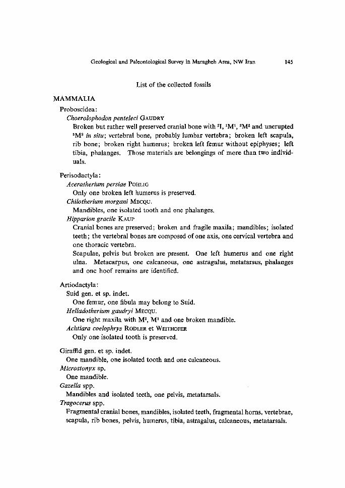
List of the collected fossils
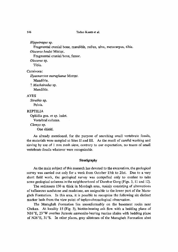
MAMMALIA Proboscidea: Choerolophodon penteleci GAuDRy Broken but rather well preserved cranial bone with 2I, iMi, 2M2 and unerupted
3MS in situ; vertebral bone, probably lumbar vertebra; broken left scapula,
rib bone; broken right humerus; broken left femur without epiphyses; left tibia, phalanges. Those materials are belongings of more than two individ-
uals.
Perisodactyla :
Aceratherium persiae PoHLiG Only one broken left humerus is preserved.
Chilotherium morgani MEcQu. Mandibles, one isolated tooth and one phalanges.
Hi parion gracile KAup Cranial bones are preserved; broken and fragile maxila; mandibles; isolated teeth ; the vertebral bones are composed of one axis, one cervical vertebra and
one thoracic vertebra.
Scapulae, pelvis but broken are present. One left humerus and one right ulna. Metacarpus, one calcaneous, one astragulus, metatarsus, phalanges and one hoof remains are identified.
Artiodactyla:
Suid gen. et sp. indet.
One femur, one fibula may belong to Suid. Helladotherium gaudryi MEcQu. One right maxila with M2, M3 and one broken mandible.
Achtiara coelophrys RoDLER et WEITHoFER Only one isolated tooth is preserved.
GiraMd gen. et sp. indet.
One mandible, one isolated tooth and one calcaneous.
Microstonyx sp. One mandible.
Mandibles and isolated teeth, one pelvis, metatarsals.
Tragocerus spp.
Fragrnental cranial bones, mandibles, isolated teeth, fragmental horns, vertebrae,
scapula, rib bones, pelvis, humerus, tibia, astragalus, calcaneous, metatarsals.
146 Tadao KAMEi et al.
Hippotragus sp.
Fragmental cranial bone, mandible, radius, ulna, metacarpus, tibia.
Oioceros boulei MEcQu.
Fragmental cranial bone, femur. Oioeeros sp.
Tibia.
Carnivora :
Hyaenarctos maraghanus MEcQu. Mandible. ? Machairodus sp.
Mandible.
AVES Struthio sp.
Pelvis.
REPTILIA Ophidia gen. et sp. indet.
Vertebral column. Clemys sp. One shield.
As already mentioned, for the purpose of searching small vertebrate fossils,the materials were sampled at Sites II and III. As the result of carefu1 washing and
sieving by use of 1 mm mesh sieve, contrary to our expectation, no traces of small
vertebrate fossils whatever were recognizable,
Stratigraphy
As the main subject of this research has devoted to the excavation, the geological
survey was carried out only for a week from October 15th to 21st. Due to a very
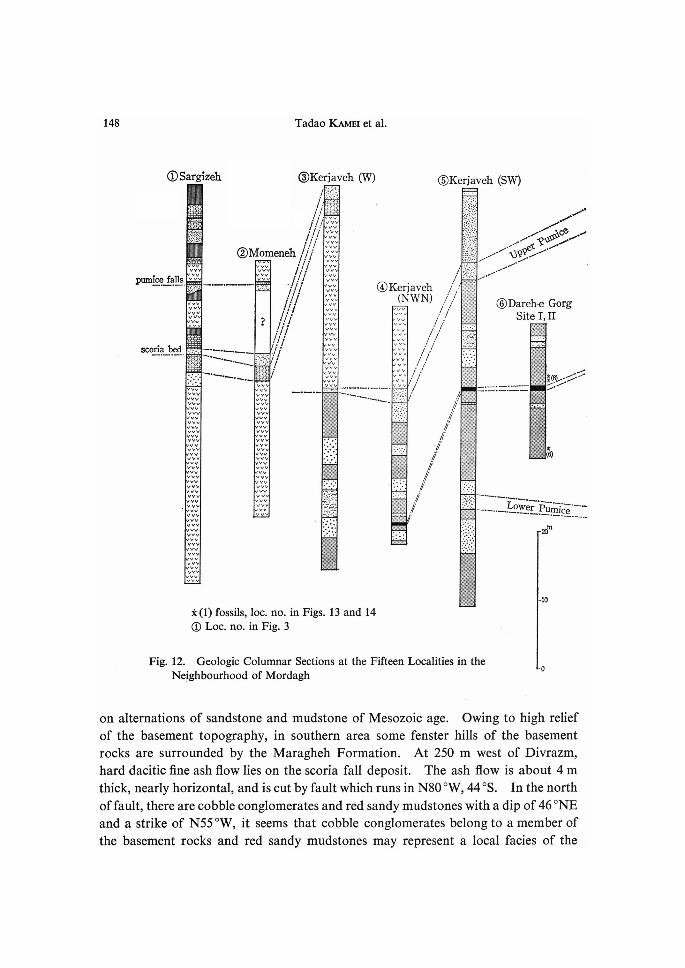
short field work, the geological survey was compelled only to confine to takesome geological columns in the neighbourhood ofDareh-e Gorg (Figs. 3, 11 and 12).
The sediments 130 m thick in Mordagh area, mainly consisting of alternationsof tuffaceous sandstone and mudstone, are assignable to the lower part of the Mara-
gheh Formation. In this area, it is possible to recognize the following six distinct
marker beds from the view point of tephro-chronological observation.
The Maragheh Formation lies unconformably on the basement rocks nearChekan. At locality 15 (Fig. 3), biotite-bearing ash flow with a bedding plane of
N16OE, 23eW overlies Jurassic ammonite-bearing marine shales with bedding plane
of N260E, 31OS. In other places, gray siltstones of the Maragheh Formation abut
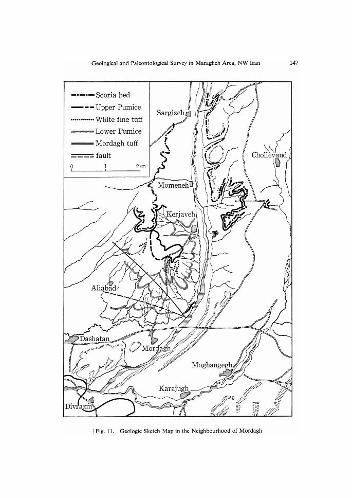
Geological and Paleontological Survey in Maragheh Area, NW Iran 147
--m-- Scoria bed
--- Upper PumiCe
"".".".. White fine tuff
-Lower PumiceN Mordagh tuff
-"--o 2km
fault
1
t : : s Sargizeh ts
ttMl h-" 1.7hhh )
h- N. C'- .) s)
.
r: N, ,J. .)b<s<,c-.-
,
MomenehN
Aliabad "-. -. N
Kerjaveh
...•.: 1
ee " 'N
t t
K
i "stt=.s"tK'
rs )--E-.t....-
-4:-scN
li -s-://`2.,,.,,,,.,Y
7'b(s:""Vtttt:
l,.- .:"'iiikuti",
A."?-:
Nt .:
1
. --:-:t-'t"
:
N`'ctl=.S2:
--.r',
v
1
:
.
.
is ,: .s." .: s- h"k "")I
S" ."NS"N"n-- .
1 Al hln hhili
Azhh
,lh
it cho>i>lievand
:, g. IN"
.J-tg.N '• nN />) tN
Ah
t
ig..t/f"/`<.- h/
sNlttt i" .sS"
-""sn -- :h ..vsw MI
N .. --.J "-vt .,vze- ,,h
tt.L' / lrt
"NNN
N
"'-""--'" "" ""h --- -d ""N "s""j """" s""NIh s""""N>"}"hh
""-""lsl-IJNh"s2"hNn
..)'" Moghangegh
t'
hA
di
-- L 1-
lh
ht
'
Eh.3
l
}t
Dash"a.t.a.n.d
7tt ."tLt""ttl"""s"-itt-"tt"tt:.
1=- . t s"' "tttd. ss it:r/'i,::-eti':'i.,,;.s,it'"'t'l:::""
S :.' s"k ttetettt. r.. -"
ts -" " stilsssN ts sslDivrazm`
-r- "ztMh ""uttc
tt;,",""'Mordag"NttS'
s"""" N""""S """"
Karajugh .<N""N"t N'- sE.klNiXN"t
!" il"!ii, 1}1• t--
h
h:
N
h .---.-2 "= .".xN";""3NN t.i/'"'-t'
sN NN-. "ssN x-NSr"
"".N"K" :.-.. S*s'
-- -;- ..l-== ..- N:-: Ei=.:' "scNlt'"3N-'
-4- Sss
lFig. 11 . Geologic Sketch Map in the Neighbourhood of Mordagh
148 Tadao KAMEi et al.
OSargizch
PumicgSqlls
scon' a bed
i,rs,,{.I,E
vev.3.
vVvVv
'i,'1:srr;•'
".' v'v
"." v"v
vVvv
vvvvvvv
vvvvv
vvvvv
vvvvvvvvvvvvvvyvvvvvvv
vvvvvvvvvv
vvvvv
vvvvVYvvvvVvvvvvv
vYvyv
vvvvv
YYvvV
vvvvv
vvvvv
vvvvvvvvvvvv
@Kerjaveh CW)./tittt )ttt
t
i' ..' r=./.,'L/:Ar
@Momenchvvvvvvvv
,,
?/liil/I/
vyVvvvv
vvvV
vvvvvvvvv
vvvVv
vvvv
vv
vvvvv
----
--------k-
?
t'
vvvyvvvYvvv
vvvv
vvvvvyvvvvvvvvvvv
vvv
vv
------t--.s."N ':'bftt' ,"
''=' f`t
vvvvvv' vVYv
.--N---.---- vvVvvv
vvv vvvvV Å}"'i't -yvvvVv----- 'I' %/E•-{i, N.
vw tt tttt
vW ' '
vvv{t
vvvvvvv.
,su,-,t/,eessXst.{
Yvvvvvvv -:- .
vvv ----.
vv ----vvv .-ivvv ----vvv --vvv x
vvvvv
-IS'S•
VYv -----vvv --.
vvvvvvvvvvvv
t-.-.t"t .t
.-;.=?ÅÄ:''r'lti'•t----
vV --' .r,
-i, --- ------.---J-
-
.
t,'
@Kerjaveh (NWN)
vVvVv I/t"J.
I5.'/t
.;V.'J
l•Xx•'--""'-N.t
.-.
@Kerjaveh (SW)
! .1•11,!
'/f/'
!1 ,/.
. 11 ti• //••
/7' I' !i . •t ,11
.,
.I
,
X(1) fossils, loc: no. in Figs. 13 and 14
@ Loc. no. in Fig. 3
•/
/111/
lf/
.x
1!'
itt'-/lil:r,:N:tC'.N1.i'J.-ltlt t-=x/ l-1!1'.'tCL•",(t4-1.•J:..-e.
"'-kt:tt/t/tXx.v
l.•!.tti.
,: !..- .i;1
i.1".t•1-tt
;;ltt- -.-
.:f,.::i• .-../Tl.- -
11////11S/l,,.
-
L- :-:
:l. :.
--.
Il,1i•tt,L,,I
/1111//ti./1i:
.t T:.'t'i
.v-' t.tt,r.:E'
ll•i•I'illl•l,i
tee;• •-
- /-6t,..'S.t"N."}v&.•-
./.-
@Dareh,e Gorg Site I, n
.,•'
es'•5(el.:X-:!!
!I1:'k'.-6.'.-e'i2----t-icll.IZ
m
Fig. 12. Geologic Columnar Sections at the Fifteen Localities in the
Nejghbourhood of Mordagh
oo
•10
o
on alternations of sandstone and mudstone of Mesozoic age. Owing to high relief
of the basement topography, in southern area some fenster hills of the basement
rocks are surrounded by the Maragheh Formation. At 250 m west of Divrazm,hard dacitic fine ash fiow lies on the scoria fall deposit. The ash flow is about 4 m
thick, nearly horizontal, and is cut by fault which runs in N80OW, 44OS. In the north
of fault, there are cobble conglomerates and red sandy mudstones with a dip of 46 ONE
and a strike of N55OW, it seems that cobble conglomerates belong to a member of
the basement rocks and red sandy mudstones may represent a local facies of the
Geological and Paleontological Survey in Maragheh Area, NW Iran 149
t
@Darche Gorg tilt,\:,
-t )'}l', -"-.b.---i--i-..
h------h----
@Mabad (NE)
------
.-,• -.".-...-.----.-.-.-.
;'i•li,
:t."r'J,`{;'
•ii-1,f.i
"ii:'stÅ}rl"
'n..e.{Xlo)
@A!iabad @Mordagh as) (N)
'ÅÄ'"'ii
:-i""h'
•s ,,='--'-=-ti-t.g.PNsinÅí....TuN.ff.h.-.-.......:"
N. }
:. l,e•Åík{'
, l I,I
i" i 'i.,iii•I:l,
, l ';,i•'ili
l.
I •:•:.:.':•
l •.•].i••:
iii,,•'}l,
.}.{-
llil.-l.
Ii' ,pt•
,11;//•1•,
l} •=t
,
?
x
dlt
x Å~ /- 1 /,
! / !
!//1
/ /
/!//
@MordaghN (NEE) .
/jl/ri
/i'i
/il'
N.,,. Nx
tlt'
/iig
/ii
II'
'cx,,
i,I
il
i.l
il
:.:.:swiandthYpTetTi"d,tle
silt
x. N
"'s'
.
Mordatutffh
rtrud
NN
.
::"[ sandy mud
::.:.: with pebble
:.:.::,
x -.t./
asih flow PUrrlice flOW tuffaceous mud pumice, fall tuff (aslt fall)t;')l ://,'t;'• pumice and sand
muddy ashv' ." volcanic spmd and muddy aslr"l•It.:'i pumice sand
;.:..: gravel
i:.:.:.:. gand
silt-•mud sandy mud-:t fine sand and sht
-
@Mordagh- Dashatan
d----pt-
@Agh Kand
-•--..Q4-g-h Kand Åë)
-•-- -#gas.,
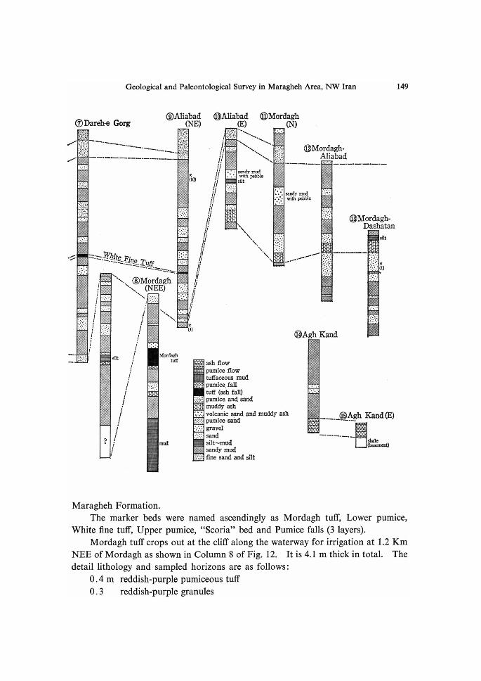
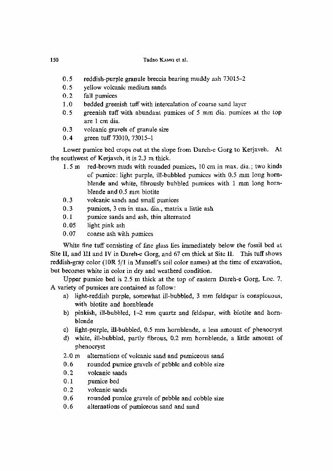
Maragheh Formation. The marker beds were named ascendingly as Mordagh tuff, Lower pumice,White fine tuff, Upper pumice, "Scoria" bed and Pumice falls (3 layers).
Mordagh tuff crops out at the cliff along the waterway for irrigation at 1.2 Km
NEE ofMordagh as shown in Column 8 ofFig. 12. It is 4.1 m thick in total. The
detail lithology and sampled horizons are as follows:
O.4 m reddish-purple pumiceous tuff
O.3 reddish-purple granules
150 Tadao KAMEi et al.
O.5O.5O.21.0
O.5
O.3
O.4
reddish-purple granule breccia bearing muddy ash 73015-2
yellow volcanic medium sandsfall pumices
bedded greenish tuff with intercalation of coarse sand layer
greenish tuff with abundant pumices of 5 mm dia. pumices at the topare 1 cm dia.
volcanic gravels of granule size
green tuff 73010, 73015-1
Lower pumice bed crops out at the slope from Dareh-e Gorg to Kerjaveh. Atthe southwest of Kerjaveh, it is 2.3 m thick.
1.5 m red-brown muds with rounded pumices, 10 cm in max. dia.; two kinds of pumice: light purple, ill-bubbled pumices with O.5 mm long horn- blende and white, fibrously bubbled pumices with 1 mm long horn- blende and O.5 mm biotite
O.3O.3O.1
O.05O.07
White fine tuff consisting of fine
Site II, and III and IV in Dareh-e
reddish-gray color (10R 5!1 in Munsell's soil
but becomes white in color in dry and weatherd condition.
Upper pumice bed is 2.5 m thick at the top of eastern Dareh-e Gorg, Loc. 7.A variety of pumices are contained as follow:
a) light-reddish purple, somewhat ill-bubbled, 3 mm feldspar is conspicuous,
with biotite and hornblende b) pinkish, ill-bubbled, 1-2 mm quartz and feldspar, with biotite and horn-
blende c) light-purple, ill-bubbled, O.5 mm hornblende, a less amount of phenocryst
d) white, ill-bubbled, partly fibrous, O.2 mm hornblende, a little amount of
phenocryst 2.0 m alternations of volcanic sand and pumiceous sand
O.6
O.2O.1
O.2O.6O.6
volcanic sands and small pumices
pumices, 3 cm in max. dia., matrix a little ash
pumice sands and ash, thin alternated
light pink ash
coarse ash with pumices
glass lies immediately below the fossil bed at Gorg, and 67 cm thick at Site II. This tuff shows color names) at the time of excavation,
rounded pumice gravels of pebble and cobble size
volcanic sands
pumice bedvolcanic sands
rounded pumice gravels of pebble and cobble size
alternations of pumiceous sand and sand
Geological and Paleontological Survey in Maragheh Area, NW Iran 151
O.5 volcanic sands with lens of pumice pebble O.6 pebble and cobble pumice gravels
O.1 ash O.5 red sandy muds
Scoria bed lying on pumice fiow deposits is O.5-2 m thick and hardjecting like eaves.
Loc. 1, east of Sargizeh O.5 m hard subangular andesite granules, O.5-1 cm dia.
O.4 red-brown pumiceous muds O.2 dark-gray volcanic sand 2.2 red-brown pumice flow
Loc. 2, western southwest of Momeneh O. 8 m hard laminated sands
10
O.3
2.0
1.2m O.4 O.25
2m Pumice fall bed consists of2 or 3 falls
The top of this bed is reverse by graded and shows convolute structure.
Loc. 2, western southwest of Momeneh O.02 m coarse (2-3 mm dia.) fall pumices, reverse by graded
O.02 graded fine (medium sandy) fall pumices O.05 graded coarse (3-5 mm dia.) fall pumices O.15 graded fall pumices
Loc. 1, east of Sargizeh O. 15 m fine laminated (medium sandy) pumices
O.03O.07O.03O.06O.02O.1
, and pro-
laminated coarse sands and granule breccias with pumices pebbleand round-subangular gravels
reddish-brown sandy muds with pumicessubround andesite pebble-bearing pumice flow
Loc, 3. west of Kerjavehangular-subangular granules with 20 cm dia. andesite gravels
3-4 cm dia. pumicevolcanic sands with breccias
pumice fiow
of small pumices, showing graded bedding.
fine ash
yellow fall pumices
fine ash
fall pumices
fine ash
fall pumices
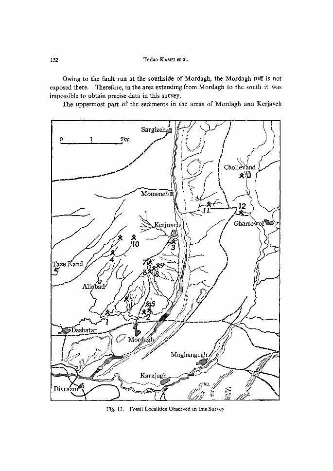
152 Tadao KAMEi et al.
Owing to the fault run at the southside of Mordagh, the Mordagh tuff is notexposed there. Therefore, in the area extending from Mordagh to the south it was
impossible to obtain precise data in this survey.
The uppermost part of the sedjments in the areas of Mordagh and Kerjaveh
o 1
---."t
.t Sargizehss tl2km l / /
** ,Å~/C/1io
Tsi,,eKand Al,.betpt
xld
Moineneh N
tt fXJ.. ,i;{8X
N,
IJ
,,tst.5-
/*slrrr2
Kerjave ss is'x //3Z
K
""s"s"
tT trtlllq""""
"""ltttt-
i .F'..ttt""N
-""s=ttl"
h
X
'1 'ashgt-a.npt..t
""""""sll"ttJtt,"l""Ztrt ttrlllll.[st'C
,F SIJIJ. -S "-- "-tl";/ "sts"S"}"1--"""" ".. l" "N N.- "x"z"" "" "il"N
7 t/ / Il (i choil81>and
l xg s,;.tv"
"x.,
v<E,\,
"gue"t"-...i.l.l-"il.'1"1
""z
-,•ti..N...siz --.-....-ce
"h"
"" /
/ t"
;5-x" Nxk..-,.. /J
b/vk / i / "sit. 7 r= .f=!:- ""."7
.tr...,s' ljitls" li/
.
"T-t--- l I ..",d. t "-:' l ..i,,,,::r S =.lr::r: 1 s
ltJttl-t-et t:. JJI
-"" N
Mor ""N """""l
ag ."""N- :"titSZ
.9'i
-
DivrazR{sSill
Karajugh
eztt
Moghangegh LL
"X."iR:N "Sx5s-LS
tti.""t-:.:a-.'
;'-' tt'" ==
E/c;t:a2'3)rt)b:w>oisE$ssss
si
}t
/ -v-zllf
l/7s?i,<Å~
I/1; NN.....,....,...
'.3'3"li"..bh"-'h'Cil(l."'!'.tlll'ii'5`'""'."t"'S:N <INN
.=.N. ::= ;s" KEIi :E-i .".x.ssv""s. N hhS sN
Fig. 13. Fossil Localities Observed in this Survey
Geological and Paleontological Survey in Maragheh Area, NW Iran 153
xgZflaEes
op
.9
6sa" ..x
-Åí..
diac
Mg"t$gE•eem<
dggb'
300?
73oo4-N?5.273ooe-N
73012r
10
eo
73019'6.6
73003-N
'XITl2XIO
x89I? X7x56
73oo273oo1----N
730i7<g:gxX23
Xl
15•.
0.5
10-
oo
7,O'
lichology
;gg18>----R-7,2
73e2ih8Z
?
40
4-•5
alt. of ss & msintercalatedash flows &falls{estirnated)
Korde deh ash fZeW
alt. of ss & msintercalatedash flows & falls,10 cm to 1 m thick,in several m. intervales
Sargizeh tuff alt. ss & ms pumice fqlls C3 Zayers) alt. ss & ms "sÅëoria" bed pumice flow
alt. $s & ms
rlPper pmice
alt. ss & rns
Othite fine tuff
alt. ss & msZDwer pumice
alt. of ss a mswith thin iine tuffs
Mordagh tuff
alt. ss & ms
biotite bearing ash flowbiotite bearing ash fiow$h & ss with JurassicA;ru Dnite
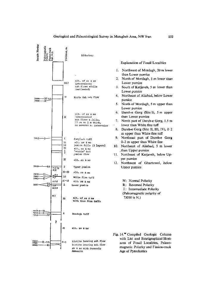
Explanation of Fossil Localities
1. Northwest of Mordagh, 20 m lower than Lower pumice 2. North of Mordagh, 5 m lower than Lower pumice 3. South of Kerjaveh, 5 m lower than Lower pumice 4. NortheastofAliabad,belowLower . pumlce 5. North of Mordagh, 5 m upper than Lower pumice 6. Dareh-e Gorg (SiteI), 5m upper than Lower pumice 7. North part of Dareh-e Gorg, 1.5 m' lower than White fine tuff 8. Dareh-e Gorg (Site II, III, IV), O-2
m upper than White fine tuff 9. Northeast part of Dareh-e Gorg O-2 m upper than White fine10. Northeast of Aliabad, 5 m lower , than Upper pumice11. Northeast of Kerjaveh, below Up- . per pumlce12. Northwest of Ghartowol, below Upper pumice
N: Normal PolarityR: ReversedPolarityI : Intermediate Polarity
(Paleomagnetic polarity of
73010 is N.)
Fig.14,VCompiled Geologic Column with List and Stratigraphical Hori- zons of Fossil Localities, Palaeo- magnetic Polarity and Fission-track Age of Pyroclastics
154 Tadao KAMEi et al,
submerges towards north in the area between Sargizeh and Agajari. To the northfrom Agajari, the upper part of the Maragheh Formation is accessible to observe.As to the upper part of this formation, the geological relation was ascertained in the
region from Sargizeh to Korde-deh, the northernmost village of this area. Theupper part of the Maragheh Formation in this area consists mainiy of alternations
of tuffaceous sandstone and mudstone with intercalations of tuff and ash fiow which
are superimposed in every 5 to 10 m intervals. The most of tuff and ash fiow beds
have a thickness of less than 1 m. At Korde-deh, a remarkable non-welding ashflow bed, called as the Korde-deh ash flow, is observed at about 40 m higher above
the river bed. The sediments, ranging from the Pumice falls of lower distinc tmarker
bed below to this upper ash flow, is estimated to be about 90 m thick. Furthermore,
the thickness of the upper part above the Korde-deh ash fiow is estimated as ap-
proximately 300 m as thick. Accordingly, the total amount of thickness of theMaragheh Formation is assumed to be within a range from 500 to 600 m (Fig. 14).
In the lower part of Maragheh Formation, eight horizons of fossil bones can be
discriminated based upon some characteristic interventions of pyroclastics.
Throughout the areas researched, the Maragheh Formation is horizontal ingeneral except for some local disturbance. Such local distortion of the geological
structure is probably due to tectonic warping depending upon the basement structure.
Furthermore, it is recongnized that the area is thrown down by south side down fault,
and those are situated in the fault zone in NW-SE direction which runs through the
northern part of Mordagh.
The Maragheh Formation is composed mainly of alternation of tuffaceoussandstone and mudstone with intercalations of volcanic ejecta such as ash fiow, ash
fall, pumice fiow and so on, Though those sediments have some intercalations of
gravels, no conspicuous conglomerate exists so far as we observed. From theobservation given to those sedirnents, it may be possible to assume that the sedi-
mentary environment had been predominated by fiuviatile condition. On the otherhand, however, the many insertion of red clay within the deposits suggests that the
land had occasionally emerged from subaquatic conditions. Moreover, well pre-served continuity of graded or reversely graded pumice fall and tuff may suggest the
presence of widespread lacustrine environment throughout this area. From theconsideration stated above, it is probable to deduce that there was the repetition of
fiuviatile, steppe and lacustrine environments. During that time, the northernvolcanoes of Mt. Sahand had provided intermitently ash and pumice flows, rangingfrom acid to intermediate type.
Palaeomagnetism of Pyroclastic Sediments
Recent geomagnetic data (1965) obtained at near Maragheh area, about 370
Geological and Paleontological Survey in -Maragheh Area, NW Iran 155
20'N in lattitude and 46020'E in longitude, are about 40E in declination, about
55.5O in inclination and about O.39 gauss in vertical component.
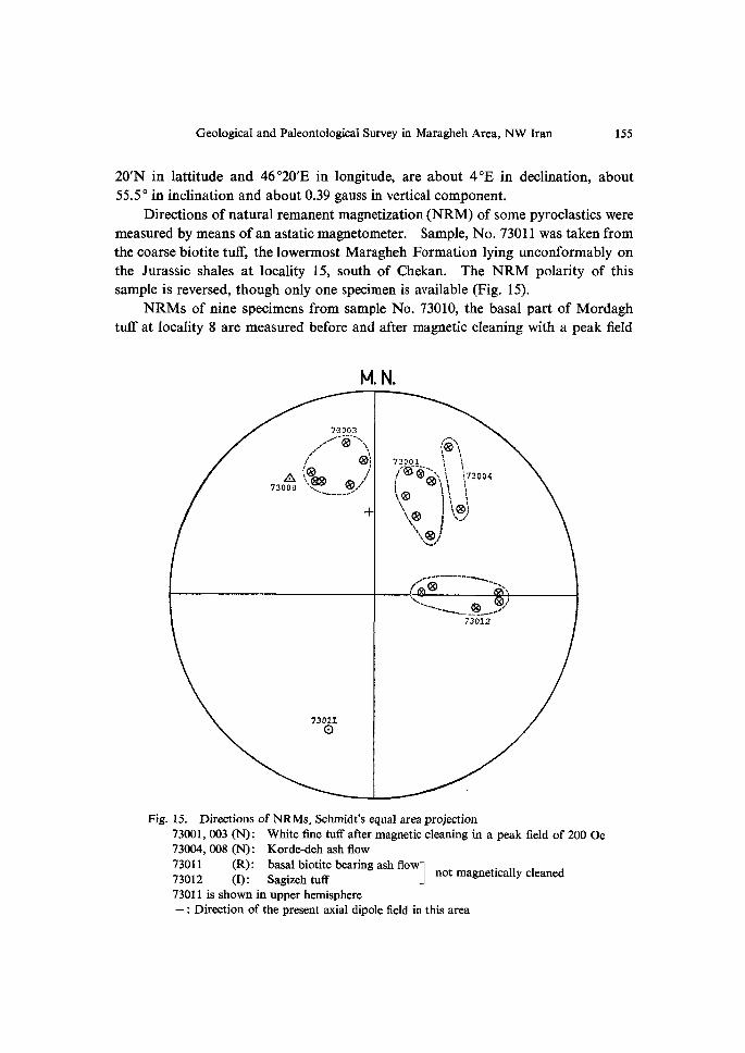
Directions of natural remanent magnetization (NRM) of some pyroclastics were
measured by means ofan astatic magnetometer. Sample, No. 73011 was taken fromthe coarse biotite tuflr, the lowermost Maragheh Formation lying unconformably on
the Jurassic shales at locality 15, south of Chekan. The NRM polarity of thissample is reversed, though only one specimen is available (Fig. 15).
NRMs of nine specimens from sample No. 73010, the basal part of Mordaghtuff at locality 8 are measured before and after rnagnetic cleaning with a peak field
M, N.
7•3003tl-' e"xsstlSl/Xl
73olt!SLs(Noo,.<E.esbx/1'
s-!------
+
t-sILX'Xit3teP-O'i-Qs-xxxxiX,ilf3oo4kXtt,x.,/fikN.x-,)iss,.Q1.-t
IX-
x-.4.......--.X....---tlt
73012
73011o
Fig. 15. Djrections of NRMs, Schmidt's equal area projection
73oo1, oo3 (N): White fine tuff after magnetic cleaning in a peak field of 200 Oe 73004, oo8 (N): Korde-deh ash flow gigll [I})l.: 8:Z:;e/iOttifftebearingaShflOW] notmagneticaiiycieaned
73011 is shown in upper hemisphere + : Direction of the present axial dipole field in this area
156 Tadao KAMEi et al.
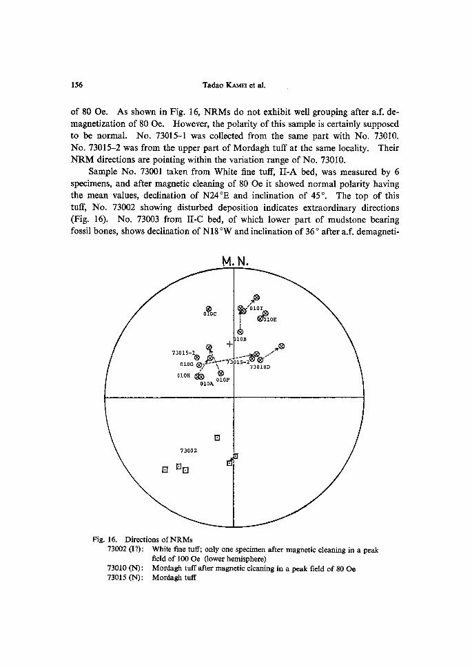
of 80 Oe. As shown in Fig. 16, NRMs do not exhibit well grouping after a.f. de-
magnetization of 80 Oe. However, the polarity of this sample is certainly supposed
to be normal. No. 73015-1 was collected from the same part with No. 73010.No. 73015-2 was from the upper part of Mordagh tuff at the same locality. TheirNRM directions are pointing within the variation range of No. 73010.
Sample No. 73001 taken from White fine tuff, II-A bed, was measured by 6specimens, and after magnetic cleaning of 80 Oe it showed normal polarity having
the mean values, declination of N240E and inclination of 450. The top of thistuff, No. 73002 showing disturbed deposition indicates extraordinary directions
(Fig. 16). No. 73oo3 from II-C bed, of which lower part of mudstone bearingfossil bones, shows declination of Nl8 OW and inclination of 36O after a.f. demagneti-
M.N.
o&oc
.xg!iRy'OIOactloE;e
iOB73ols-1CER.+
oioGXQ!.tl8})'K"-'7i
.Xo' ,'
g:1Qx•••'
73010DoioH(gibcSti:oF
OIOA
N73002
.
NNN'
Fig. 16. Directions ofNRMs 73oo2 (I?): White fine tuff; only one specimen after magnetic cleaning in a peak
field of 1oo Oe aower hemisphere) 73010 (N) : Mordagh tuff after magnetic cleaning in a peak field of 80 Oe
73015 (N): Mordagh tuff
Geological and Paleontological Survey in Maragheh Area, NW Iran 157
zation of 80 Oe (Fig. 15).
No. 73012, the basal part of Sergizeh ash flow, 8 m higher than Pumice fa11,
shows intermediate polarity, 900E in declination and 550 in inclination. Threespecimens from the lowest part of Korde-deh ash fiow, No. 73oo4 and O08 all show
normal polarity, although their declination are quite different (Fig. 15).
Thus, the NRMs of the pyroclastics intercalated in Maragheh Formation showalmost normal polarity excepting the basal one. This is not consistent with the
postulation for the stratigraphic position of the Maragheh fauna, as BERGGREN and
Van CouvERiNG (1974) considered in palaeomagnetic stratigraphy as comparativelonger reversed polarity event c of Epoch 7.
Fission-track Age of Pyroclastics and Chronology of Maragheh Formation
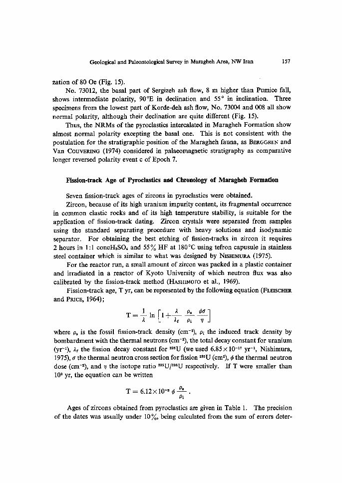
Seven fission-track ages of zircons in pyroclastics were obtained.
Zircon, because of its high uranium impurity content, its fragmental occurrence
in common clastic rocks and of its high temperature stability, is suitable for the
application of fission-track dating. Zircon crystals were separated from samples
using the standard separating procedure with heavy solutions and isodynamicseparator. For obtaining the best etching of fission-tracks in zircon it requires
2 hours in 1:1 concH2SO` and 55O/. HF at 1800C using tefron capusule in stainless
steel container which is similar to what was designed by NisHiMuRA (1975).
For the reactor run, a small amount of zircon was packed in a plastic container
and irradiated in a reactor of Kyoto University of which neutron flux was alsocalibrated by the fission-track method (HAsHiMoTo et al., 1969).
Fission-track age, T yr, can be represented by the following equation (FLEiscHER
and PRicE, 1964);
T== -1- in [i+i Pps, ÅëopO]
where p, is the fossil fission-track density (cm-2), pi the induced track density by
bombardment with the thermal neutrons (cm-2), the total decay constant for uranium
(yr-i), af the fission decay constant for 2SSU (we used 6.85Å~10-i7 yr-i, Nishimura,
1975), c the thermal neutron cross section for fission 2S5U (cm2), Åë the thermal neutron
dose (cm-2), and v the isotope ratio 235U/2SSU respectively. If T were smaller than
109 yr, the equation can be written
T=6.12Å~lo-sÅë Ps . pi Ages of zircons obtained from pyroclastics are given in Table 1. The precision
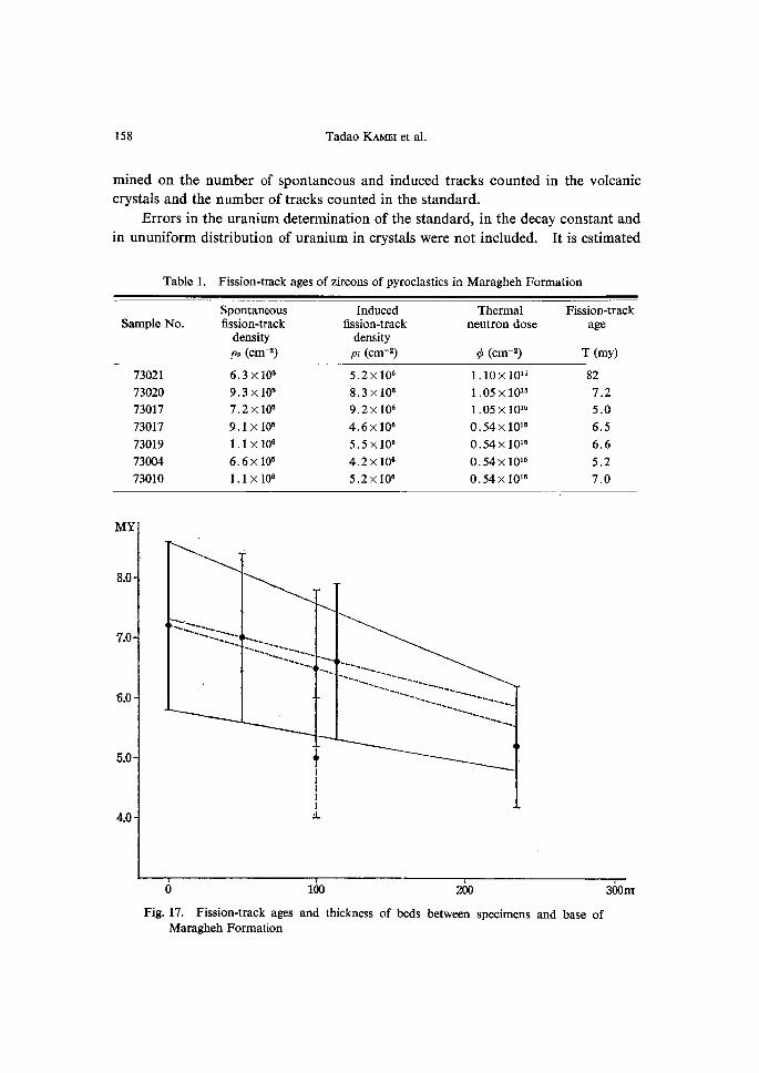
of the dates was usually under 10O/., being calculated from the sum of errors deter-
158 Tadao KAMEi et al.
mined on the number of spontaneous and induced tracks counted in the volcaniccrystals and the number of tracks counted in the standard.
Errors in the uranium determination of the standard, in the decay constant and
in ununiform distribution of uranium in crystals were not included. It is estimated
Table 1. Fission-track ages of zircons of pyroclastics in Maragheh Formation
Sarnple No.Spontaneousfission-track
density Ps (Cm-2)
Inducedfission-track
density Pi (Cm-2)
Thermalneutron dose
Åë (CM-2)
Fission-track
age
T (my)
73021
73020
73017
73017
73019
73oo4
73010
6.3Å~lo6
9.3Å~105
7.2Å~lo5
9.1Å~105
1.1Å~lo6
6.6Å~lo5
1.1Å~106
5.2Å~106
8.3Å~106
9.2Å~106
4.6Å~106
5.5Å~106
4.2Å~106
5.2Å~106
1.10Å~10i5
1.05Å~10is
1.05Å~10is
O.54Å~10is
O.54Å~10i5
O.54Å~10ifi
O.54Å~1Ois
82
72 5.0
6.5
6.6
5.2
7.0
MY
8.0
7.0
6.0
5.0
4.0
---.---- -- :------L---
-- ----- -.--h----::------..-..
----- h----- .
+l
;,
--.- -"----- ------ ---- -.- s---.-.--.s --li--------
----s- "--------- ---.-. h----- -h--.-. -----
o
Fig. 17. Fission-track ages
Maragheh Formation
1oo
and thickness of beds
2oo
between specimens and base of
3oom
Geological and Paleontological Survey in Maragheh Area, NW Iran 159
at about 5-10O/..
On the other hand, when we get the fission-track age of each crystal inone sample, the standard deviation is about 15 O/,.
Then, accuracy of these dates is under 200/.. In Fig. 17, the range of Å}20%
to each value is shown.
Age Estimation of Maragheh Fauna
A fu11 succession of the Maragheh Formation is composed mostly of the productof fluviatile deposition. Therefore, it seems that there are some diMculties in the
discussion of age estimation when we wish to combine fission-track age detemination
and paleomagnetic polarities of those deposits. In fact, the relation between the
fission-track ages and the stratigraphic horizons are examined basing on the results
of the measurement for the basal part of this Formation (Fig. 14).
At the road cut, west of Divrazum, biotite-bearing dacite ash fiow of the base-
ment is exposed. The result of fission-track age of that rock (Sample No. 73021)
is 82.0 my and suggests the surface erosion of continental environment in the Late
Cretaceous. The basal biotite tuff of Maragheh Formation (No. 73011) indicates
reversed polarity, and the same rock (No. 73020) is 7.2 my in fission-track age.
Successively, tephra layers intercalated in the Maragheh Formation have following
fission-track ages; the basal part of the Mordagh tuff (No. 73010) is 7.0 my; pumice
gravel from the Lower pumice bed (No. 73017) reveals 5.0 and 6.5 my; pumice gravel
from the Upper pumice bed (No. 73019) is 6.6 my; the lowest part of Korde-deh ash
flow is 5.2 my. Because of an internal inconsistency we may discard a value of 5.0
my for the Lower pumice. Referring to the Late Neogene paleomagneto-stratigraphy reported by BERGGRENand Van CouvERiNG (1974), the present paleomagnetic data and fission-track ages
of the Maragheh Formation are very effective in making strict correlation of Neogene
stratigraphy. The basal ash fiow (7.2 my, reversed polarity) is correlatable with
Epoch 7-b of BERGGREN and Van CouvERiNG. The Mordagh tuff (7.0 my, normalpolarity) may be correlated to the normal interval between a and b of Epoch 7.The fission-track age and the polarity of the Korde-deh ash flow, 5.2 my, normal
polarity, is inconsistent to the estimation of BERGGREN and Van CouvERiNG inpaleomagneto-stratigraphy. On the other hand, the horizon of Maragheh fauna inour excavation is represented by the White tuff and it is measured as older than 6.6 my
or younger than 6.5 my, normal polarity. Therefore, it may be reasonable to take such
assumption into consideration for the age estimation of the Maragheh fauna basing
upon the fission-track age, the geomagnetic polarity and the thickness values of the
sediments between the marker beds. On the consistency concerning the thickness and
fission-track age, it seems to be reasonable to adopt the values of7.2, 7.0 and 6.6 my
160 Tadao KAMEi et al.
for the basal ash flow, the Mordagh tuff and the Upper pumice. In this way, it may be
possible to designate the stratigraphical position of the Lower pumice to 6.8 my of the
upper part of Epoch 7, and the Korde-deh ash flow to 5.8 my of the lower part ofEpoch 5. As the result, those considerations will lead a conclusion that the White tuff
of the normal polarity is corrrelatable to the top of Epoch 7, and then, about 6.7 my.
Accordingly, it seems to be reasonable to estimate that the ages of the 12 localities of
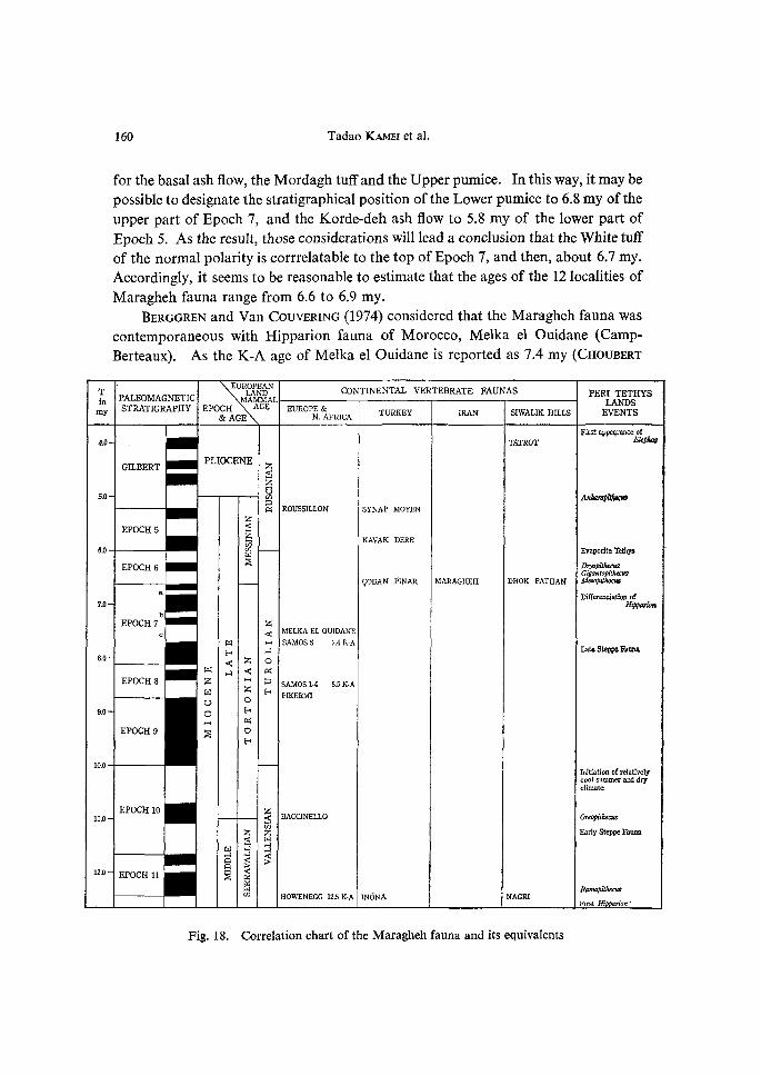
Maragheh fauna range from 6.6 to 6.9 my. BERGGREN and Van CouvERiNG (1974) considered that the Maragheh fauna wascontemporaneous with Hipparion fauna of Morocco, Melka el Ouidane (Camp-Berteaux). As the K-A age of Melka el Ouidane is reported as 7.4 my (CHouBERT
T PALEOMAGNETICEUROPEAN
LANDMAMMAL
CONTINENTALVERTEBRATEFAUNAS PERITerHYSmmy
STRATIGRAPHYEPOCH&AGE
AGE EUROPE&N.AFRICA TURKEY IRAN SIWALIKHILLS
LANDSEVENTS
Firstappearanceof4.e TATROr thphas
GILBERTPLIOCENE z$
-Z
U5,O 8 Anharmpithecrs
zec ROUSSILLON SYNAPMOYEN
EPOCH5 $kco
KAVAKDERE-6.0 8 EvaperiteCetlrys
EPOCH6 E D,)pptthecttsGigantoptthecttS
COBANPINAR MARAGHEH DHOKPATHANMesoPithecas
a Duterendationof7.0 Hi'n
Zc < MELKAELOUIDANE
m H SAMOS57.4K-Ats A ZateSteppeFauna
8,O
< Z opt A < et
EPOCH8 z H p SAMOSI•4S.5K•Am z e PIKERMro o
9.0 oect
EPocH9NE
oH
10.0Tnltiationefrelatively
cootsummeranddryclimate
EPocH10 z BACCINELLO Oreopt'thecus11.0 $Z 2 EarlyStqppeFauna<--- H
m " AAA <g <> >12,O EPOCH11 s E
Mca
Ran:aPithecrs
HOWENEGG125K•AINONA NAGRrFirstHippan'en'
Fig. 18. Correlation chart of the Maragheh fauna and its equivalents
Geological and Paleontological Survey in Maragheh Area, NW Iran 161
et al, 1968), BERGGREN and Van CouvERiNG assigned the stratigraphical position of
Maragheh fauna to thec of Epoch 7. Recently, ERDBRiNK et al. (1976) published a report, "The bone bearing bedsnear Maragheh in N.W. Iran". In the article, they stated precisely geology, strati-
graphy, K-A dating and paleomagnetic survey in the Maragheh area. Their in-vestigation is very profitable for us to make the present report. However, it should
be mentioned that the results of our survey leads to another conclusion as to the
time range of the bone bearing beds and the age of the Maragheh fauna.
According to ERDBRiNK and others, the range of the bone bearing beds nearMaragheh has a duration of about 10 mi11ion years. In opposition to this, theresult of our investigation suggests that the Maragheh fauna covers a longevity of
about 2 million years. Moreover, being taken into consideration faunal assemblage,
it seems adequate to correlate the Maragheh fauna with Late steppe fauna (7.4 my),
rather than with Early steppe fauna (12.5 my).
Here is given our tentative correlation of the Maragheh fauna with other faunas
in the neighbourhood and with BERGGREN and Van CouvERiNG's paleomagneto-stratigraphy (Fig. 18). Anyhow, it is not to say that the synthetic study on the
Maragheh fauna has important role in the study of Cenozoic vertebrate evolutionin Asia, Europe and Africa. Therefore, it is necessary to continue the study of the
Maragheh Formation, more precisely and syntheticaly from the view points ofgeology, stratigraphy, paleontology, paleomagnetism, geochronology and so on.
Summary
The geological and paleontological survey in Maragheh area was carried outby the joint team of Kyoto University and Geological Survey of Iran, 1973. Theyexcavated at four sites in the vicinity of Dareh•-e Gorg, about 2 km north-northeast
of Mordagh and about 15 km east-southeast of Maragheh. The excavation wasperformed by the stepped trench method, And the fossils were sampled qualitatively
as well as quantitatively.
There are many pockets of fossil bone assemblage. It may be possible to assume
that those fossil bones had been transported by a stream, but never been drifted for
a long distance, The collected fossils contain many mammals, birds and reptilesas listed.
The fossil-bearing sediments were named as the Maragheh Formation. It iscomposed mainly of alternation of sandstone and mudstone with intercalations ofvolcanic ejecta such as ash fiow, ash fall, pumice flow and so on. The deductionfrom the lithology reveals the repetition of fluviatile, steppe and lacustrine environ-
ments. The Maragheh Formation is estimated to be within a range from 500 to600 m in thickness. The sediments of 130 m thick distributed in Mordagh area are
162 Tadao KAMEi et al.
assignable to the lower part of this Formation.
NRMs of pyroclastic sediments shows almost normal polarity excepting thebasal one. Seven fission-track ages of zircons in 6 pyroclastic layers were given.
The fission-track agcs and paleomagnetic data were compared with the paleomagnetic
stratigraphy by BERGGREN and Van CouvERiNG (1974). It is estimated that the ages
of the Maragheh fauna range from 6.6 to 6.9 my.
Acknowledgement
Thanks are due to the Ministry of Education of Japan and Geological Surveyof Iran, for providing agrant in aid ofthis research. Gratefu1 acknowledgement is
made to Dr. N. KHADEM, the former Managing Director of the Geological Survey of
Iran, and staff members ofthe G.S.I. especially to Mr. H. TARAz, Dr, M. MEHRNusH,
Mr. M.H. NABAvi, Mr. F. GoLsHANI, for their helpful advices and help to the expedi-
tion. The authors are much indebted to Mr. R. AssEF, the PREsENT ManagingDirector of the Geological Survey of Iran for his kind permission to publish the
report. Thanks are also due to Mr. N. SHiGEHARA of Dokkyo Medical College forhis cooperation, and also to late Mr. S. OMAcHi, Mr. A. YosHiKAwA, Mr. F. OKiTsu
of Iranian Petroleum Company at Teheran for their friendly guidance and hospitality.
References
BERGGREN, W.A. and J.A. Van CouvERiNG 1974: The late Neogene-Biostratigraphy, geochrony- nology and paleoclimatology of the last 15 million years in marine and continental sequences.
Palaeogeography, Palaeoelimatology, Palaeeecology 16, 1!2, 1-216.
CHouBERT, G., R. CHARLoT, A. FAuRE-MuRET, L. HoTTiNGER, J. MARcAls, D. TissERANT and P. VmAL 1968: Note preliminaire sur le volcanism e messinien-"pontien" au Maroc. C.R. Acad. Sci. Paris, Ser. D, 266, 197-199.
ERDBRiNK, D.P.B, H.N.A. PRiEM, E.H. HEBEDA, C.C.P. DANKERs and S,A.P.L. CLoE[[iNGH 1976: The bone bearing beds near Maragheh in N. W. IRAN I. Koninkl. Nederl. Akad. van PVe- tenschappen-Amsterdam Ser. B, 79 (2), 85-101.
, , , and 1976: The bone bearing beds near Mar- agheh in N. W. IRAN II. ibid 102-113.FLEiscHER, R.L. and P.B. PRicE 1964: Techniques for geological dating of minerals by chemical etching of fission fragment tracks. Geoehim. Cosmoehim. Acta, 28, 1705-1714.GREvviNcK, C. 1881: Ueber fossile Stiugethiere von Maragha in Persien. Jahrg. Verhandl. k. k. Geologisch Reichsanstalt, Nr. 15, 296.
GuNTHER, R.T. 1899: The Pliocene Mammalia of the Bone-beds of Maragha. The Jour. of Linnean Soc. ZooL 27 (177), 376-378.HAsHiMoTo, T., S. IwATA, S. NismMuRA, T. NAKANisHi, and M. SAKANouE 1969: Measure- ments of reactor neutron flux by fission-track method. Paper 9th Ja. Conf. Radioisotopes, 231-234.KmT.E, E. 1885: Die fossile Saugethier-Fauna von Maragha in Persien. Jahrg. Verhandl. k. k. Geologisch Reichsanstalt, Nr. 16/17, 397-399.
1887: Beitrage zur Kenntniss der fossilen Saugethiere yon Maragha in Persien. I.
Geological and Paleontological Survey in Maragheh Area, NW Iran 163
Carnivoren. AnnaL k. k. Naturhistorischen Hofmuseums, 2 (4), 317-338, taf. 14-18.
LyDEKKER, R. 1886: On the Fossil Mammalia of Maragha, in North-western Persia. euart. Jour. Geol. Soc. London, 42, 173-176.MEcQuENEM, R. de 1924-1925: Contribution a 1'etude des Fossiles de Maragha. Annales de Paliontologie, 13 (1924), 135-160, pl. 19-22; 14 (1925), 1-62, pl. 1-5.
NrsHrMuRA, S. 1975: On the problem of the application of fission-track dating for tephrochrono- logy. (in Japanese) Tsukumo Earth Seience, No. 10, 1-8, College Liber. Arts, Kyoto Univ.OzANsoy, F. 1965: Etude des Gisements Continentaux et des Marnrniferes du Cenozoique de Turquie. Mtim. de la Soc, GtioL de France, N.S. 44 (1), Mem. 102, 1-92, pl 1-10.
PoHuG, H. 1884: Geologische Untersuchungen in Persien. Jahrg. Verhandl. k. k. Geologisch Reichsanst., Nr. 14, 280T284. 1886: On the Pliocene of Maragha, Persia, and its Resemblance to that of Pikermi in Greece; on Fossil Elephant Remains of Caucassia and Persia; and on the Results of a Mono- graph of the Fossil Elephants of Germany and Italy. euart. Jour. Geol. Soc. London, 42, 177-183.RoDLER, A. 1885: Das Knochenlager und die Fauna von Maragha. Jahrg. Verhandle. k. k. Geologisch Reichsanst., Nr. 14, 333-337. 1889: Ueber Urmistherium Polaki, einer neuen sivatheriiden aus dem Knochenfelde von Maragha. Denksch. d. Math.-Natur. Classe der K. Akad. der Miss.. 56.RoDLER, A. und K.A. WEiTHoFER 1890: Die Wiederkauer von Maragha. Denksch. d. Math.- Natur. Classe der K. Akad, der PViss., 52.
TAKAi, F. 1958: Vertebrate fossiles from Maragha. (in Japanese) Oriental Culture, No. 26, 7-11. Inst. Orient. Cult., Univ. Tokyo.ToBiEN, H. 1967: Subdivision ofPontian Mammalian Faunas. Commitee Mediterranean Neogene stratigraphy. Proc. IV Session, Bologna 1967 Giornale di Geologia (2) 35, 1, 1-5.
1968: Palaontologische Ausgrabungen nach jungtertiaren Wirbeltieren auf der Insel Chios (Griechenland) und bei Maragheh (NW-Iran). Jahrb. d. Ver. "Freunde der Universitb't
Mainz", 51-58.
164 Tadao KAMEI et a!•
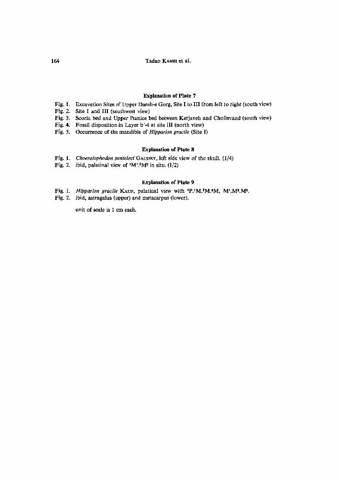
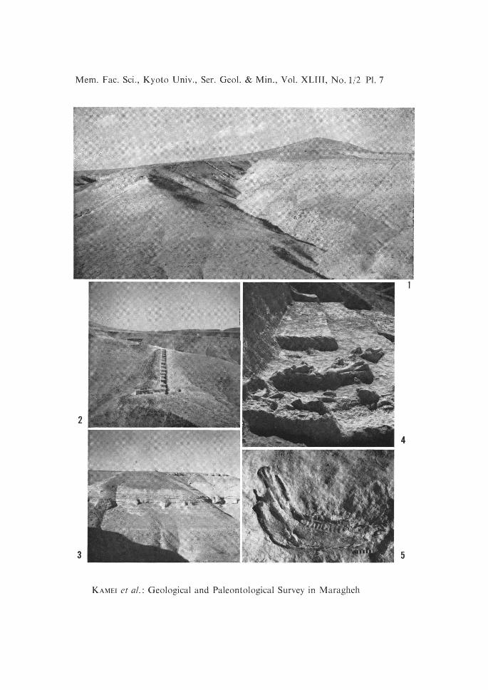
Fig. 1.
Fig. 2.
Fig. 3.
Fig. 4.
Fig. 5.
Explanation of Plate 7
Excavation Sites of Upper Dareh-e Gorg, Site I to III from left to right (south view)
Site I and III (southwest view)Scoria bed and Upper Pumice bed between Kerjaveh and Chollevand (south view)Fossil disposition in Layer b'-4 at site III (north view)
Oocurrence of the mandible of Hipparion gracile (Site I)
Fig. 1.
Fig. 2.
Explanation of Plate 8
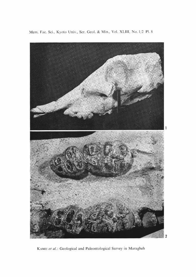
Choerolophodon penteleci GAuDRy, left side view of the sku11.
ibid, palatinal view of iM'.2Mt in situ. (112)
(1/4)
Fig. 1.
Fig. 2.
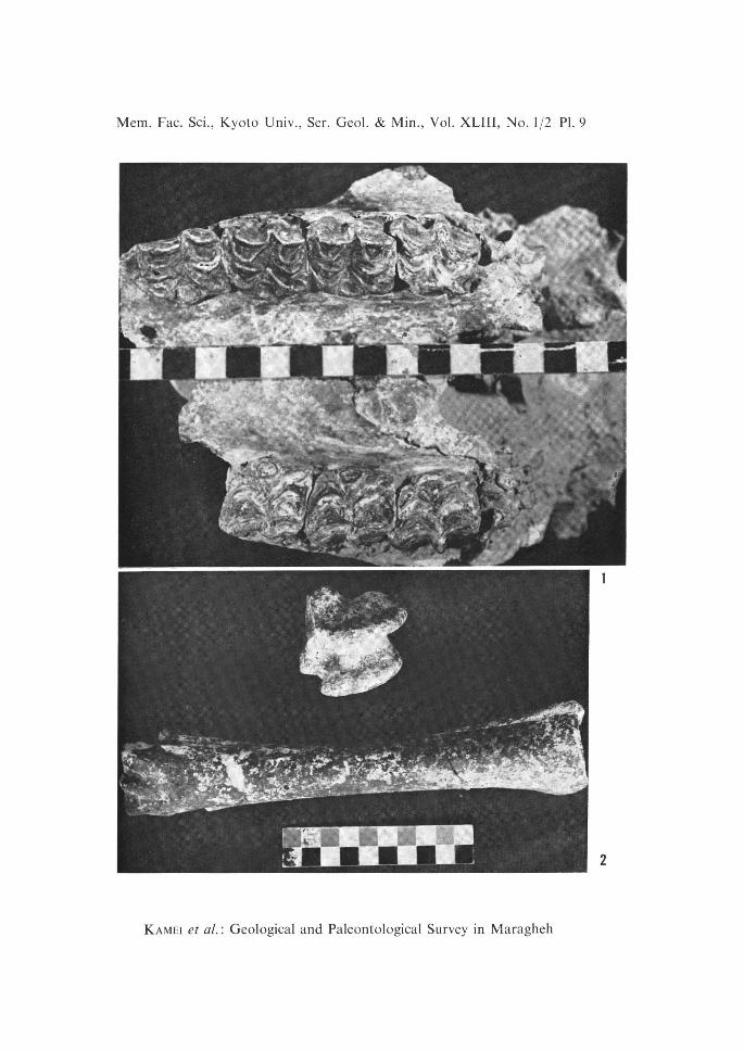
Explanation of Plate 9
Hi parion gracile KAup, palatinal view with 4P.iM.2M.8M,ibid, astragalus (upper) and metacarpus aower).
unit of seale is 1 cm each.
Mi.M2.M8.
Mem. Fac. Sci,, Kyoto Univ., Ser. Geol. & Min., Vol. XLIII, No. 112 Pl. 7
2
3
pali
':$fes ie":- ts twIdi
"'kerej
.Aewtye.
th
gf:l"'-`g",tw- igte . ,L,rew...vll:ff"it"•X':gg•"/rl2telffg,tt"S•///'ftko,,,,,
4
5
1
KAMEi et aL : Geological and Paleontological Survey in Maragheh
Mem. Fac. Sci., Kyoto Univ., Ser. Geol. & Min., Vol. XLIII, No. 1!2 Pl. 8
s':='•/g.in•s•3be'
...g '
-kt 'di't .•
=•i•g•',est.......
,. f-x
.: g, t"'$•, ',4 -,
•st- -• pa
?FfrtTitt.{'
te,$•,/k{ee,..
'l3 l :.' i $'"
1
2
KAMEi et aL: Geological and Paleontological Survey in Maragheh
Mem.Fac. Sci., Kyoto Univ., Ser, Geol. & Min., Vol. XLIII, No. If2 Pl. 9
1
2
KAMEi et al. : Geological and Paleontological Survey in Maragheh