Embed Size (px)
Citation preview
TITLE 10
Land Use Regulations
Chapter 1 ZoningChapter 2 One- and Two-Family Dwelling Building CodeChapter 3 Building RegulationsChapter 4 SubdivisionsChapter 5 Height Restrictions at Neillsville Municipal AirportChapter 6 Floodplain and Shoreland-Wetland ZoningChapter 7 One- and Two-Family Energy ConservationChapter 8 FencesChapter 9 Fair and Open Housing
CHAPTER 1
Zoning
Article A Purpose of Zoning Code; Definitions
§ 10-1-1 Title of Chapter§ 10-1-2 Intent and Purpose§ 10-1-3 Definitions§ 10-1-4 through§ 10-1-9 Reserved for Future Use
Article B General Provisions
§ 10-1-10 Minimum Requirements§ 10-1-11 Relationship With Other Laws§ 10-1-12 Effects on Existing Agreements§ 10-1-13 Scope of Regulations§ 10-1-14 Non-Conforming Buildings, Structures and Uses§ 10-1-15 Building Permit§ 10-1-16 Lot Coverage§ 10-1-17 Accessory Buildings§ 10-1-18 Yard Obstructions§ 10-1-19 Determinants As To Use Not Listed§ 10-1-20 Non-Conforming Uses§ 10-1-21 Home Occupations§ 10-1-22 Keeping of Animals§ 10-1-23 through§ 10-1-29 Reserved for Future Use
Article C Zoning Districts
§ 10-1-30 Zoning Districts Established§ 10-1-31 Zoning Maps§ 10-1-32 District Boundaries§ 10-1-33 Zoning of Streets, Alleys, Publicways, Waterways, and
Rights-of-Way
Zoning
§ 10-1-34 Residential Districts - General Purpose§ 10-1-35 R1 District - One-Family Residential District§ 10-1-36 R2 District - Two-Family Residential District§ 10-1-37 R3 District - Multiple Family Residential District§ 10-1-38 Commercial Districts - General Purpose§ 10-1-39 CL - Local Commercial District§ 10-1-40 CG - General Commercial District§ 10-1-41 CH - Commercial Highway District§ 10-1-42 IL - Light Industrial District§ 10-1-43 IG - General Industrial District§ 10-1-44 Conservancy District§ 10-1-45 Urban Transitional District§ 10-1-46 through§ 10-1-49 Reserved for Future Use
Article D Conditional Uses; Planned Unit Developments§ 10-1-50 Conditional Uses - Purposes§ 10-1-51 Where Conditional Uses Permitted§ 10-1-52 Planned Unit Developments§ 10-1-53 through§ 10-1-59 Reserved for Future Use
Article E Mobile Homes§ 10-1-60 Intent and Purpose for Mobile Homes§ 10-1-61 Occupancy Permits for Mobile Homes§ 10-1-62 Purpose of Mobile Home Parks§ 10-1-63 Placement of Mobile Home Parks§ 10-1-64 Application for Mobile Home Park§ 10-1-65 through§ 10-1-69 Reserved for Future Use
Article F Parking and Loading§ 10-1-70 Parking and Loading - Purpose§ 10-1-71 Scope of Parking and Loading§ 10-1-72 Other Parking and Loading Requirements§ 10-1-73 Size and Space Regulations§ 10-1-74 Parking Yards§ 10-1-75 Number of Parking Stalls Required§ 10-1-76 Truck Loading Areas and Parking Spaces§ 10-1-77 through§ 10-1-79 Reserved for Future Use
Article G Signs§ 10-1-80 Purpose of Article - Signs§ 10-1-81 Additional Definitions§ 10-1-82 Permits, Appeals, Indemnification, Insurance§ 10-1-83 Legal Nonconforming Signs§ 10-1-84 Maintenance, Removal and Disposition of Signs§ 10-1-85 District Regulations§ 10-1-86 Special Sign Provisions§ 10-1-87 through§ 10-1-89 Reserved for Future Use
Zoning
Article H Administration§ 10-1-90 Purpose of Article - Administration§ 10-1-91 Responsibilities of Zoning Administrator§ 10-1-92 Powers and Duties of Zoning Administrator§ 10-1-93 Zoning Board of Appeals§ 10-1-94 Appeals to the Zoning Board of Appeals§ 10-1-95 Hearing of Appeals§ 10-1-96 Conditional Uses§ 10-1-97 Complaints Regarding Conditional Uses§ 10-1-98 Variations§ 10-1-99 Amendments to Zoning Code§ 10-1-100 Penalties § 10-1-101 through§ 10-1-109 Reserved for Future Use
Article I Zoning Permit and Certificate of Zoning Compliance§ 10-1-110 Purpose of Article - Zoning Permit§ 10-1-111 Permit Definitions§ 10-1-112 Application and Issuance of a Zoning Permit§ 10-1-113 Issuance of Construction Permits§ 10-1-114 Applications and Issuance of a Certificate of Zoning
Compliance§ 10-1-115 Require Plot Plans for Certificate of Zoning Compliance§ 10-1-116 Issuance of a Certificate of Occupancy§ 10-1-117 through§ 10-1-119 Reserved for Future Use
Article J Separability§ 10-1-120 Separability
Article K Annexation§ 10-1-121 Annexed Territory
Zoning
ARTICLE A
Purpose of Zoning Code; Definitions
SEC. 10-1-1 TITLE OF CHAPTER.
This Chapter shall be known, cited and referred to as the City of Neillsville Zoning Ordinanceor Zoning Code.
SEC. 10-1-2 INTENT AND PURPOSE.
This Chapter is adopted for the following reasons:
(a) To provide for the citizens of Neillsville adequate light, pure air, safety from fire and otherdangers; to conserve the value of land and buildings; to lessen or avoid congestion of traffic inthe public streets; and to promote the public health, safety, comfort, convenience, morals andgeneral welfare;
(b) To promote the character and stability of residential, business and manufacturing areas withinthe City of Neillsville and to promote the orderly and beneficial development of such areas;
(c) To preserve the aesthetic quality of the City, and also historic and cultural areas;(d) To establish restrictions in order to attain these objectives by adopting a zoning ordinance
which will update the districts into which the City is divided, the restrictions to which land andbuildings may be subjected, the restrictions upon the location and height of buildings, therequirements upon the intensity of the use of land and buildings, the requirements of off-streetparking facilities, the provision for administration and enforcement of the Chapter, the penaltiesfor violation of the Chapter, and the procedure, powers and duties of the Board of Appeals.
SEC. 10-1-3 DEFINITIONS.
(a) WORD USAGE. Words used in the present tense include the future, words in the singularnumber include the plural number, and words in the plural number include the singularnumber; the word "shall" is mandatory and not directory. The word "person" includes anindividual, all partnerships, associations, and bodies political and corporate. The word "lot"includes the word "plot" or "parcel" or "tract." The word "used" or "occupied" as applied toany land or building shall be construed to include the words "intended," "arranged" or"designed to be used or occupied."(1) Accessory Building. A subordinate building, the use of which is purely incidental to
the permitted use of the main building, is seventy-five (75%) percent of the area of onefloor of the principal building, and is unattached from the principal building by aminimum of five (5) feet.
(2) Advertising Sign. An advertising sign, billboard, poster panel which directs attentionto a business, commodity, service or entertainment not exclusively related to thepremises where such "advertising sign" is located or to which it is affixed, but does notinclude those business signs, billboards, or poster panels which direct attention to thebusiness on the premises to a brand name of a product or commodity with which thebusiness is specifically identified and which is sold on the premises.
(3) Alley. A way which affords only a secondary means of access to abutting property.(3a) Antenna. The word antenna shall be interpreted to include satellite earth stations (dish
shaped antenna).(4) Apartment. A portion of a multiple dwelling used as a separate housing unit and
having cooking facilities and a private bath.
Zoning
(5) Automobile Wrecking Yard. Any premises on which two or more self-propelledvehicles not in running order or operating condition are stored in the open.
(6) Basement. A portion of a building or structure partly underground designed for humanoccupancy.
(7) Billboard. An advertising device, either freestanding or attached to a building, whichis used to display information not related to the use or ownership of the establishmentof the property upon which it is located.
(8) Board. The Zoning Board of Appeals.(9) Boarding House. A building, other than a hotel, where meals or lodging and meals are
provided for compensation for not more than six (6) persons.(10) Building. A structure having a roof supported by columns or walls, and intended for
the shelter, housing, or enclosure of persons, animals, or chattels; each portion of abuilding separated by a division of walls from the ground up, without openings inthose walls, is a separated building for the purpose of this Zoning Code.
(11) Building, Alterations of. Any change or rearrangement of the supporting members(such as bearing walls, beams, columns or girders) of a building, an addition to abuilding, or movement of a building from one location to another.
(12) Building, Height of. The vertical distance from the average elevation of the finishedgrade at the building line to the highest point of a flat roof, or the deck line of amansard roof, or the average height of the highest gable or gambrel, hip or pitch roof.
(13) Building, Principal. A building in which is conducted the main use of the lot on whichsaid building is located.
(14) Building Line, Front. A line parallel to the street, intersecting the foremost point ofthe building, excluding uncovered steps.
(15) Clinic. An establishment for medical examination and treatment of patients, butwithout provisions for keeping such patients overnight on the premises. For purposesof this Chapter, a doctor's or dentist's office in a residence, when it complies with therequirements of this ordinance relating to such office shall not be considered a clinic,but any doctor's or dentist's office which is not part of his home, or the office of twoor more doctors or dentists, whether in a residence or not, shall be considered a clinic.
(16) Club. An association of persons for some common purpose but not including groupsorganized primarily to render a service which is customarily carried on as a business.
(16a) Day Care Facilities, Adult And Child. An establishment or facility that is licensed bythe State of Wisconsin or certified by the County of Clark to be used to provide adultor child day care services. These facilities do not include establishments or facilitiesthat provide adult or child care services to individuals after 9:00 p.m. and before 5:00a.m. unless specifically approved by the Common Council. These facilities do notinclude babysitting or day care facilities that are unlicensed or uncertified.
(17) Dwelling Unit. Any room or group of rooms located within a dwelling and forminga single habitable unit, with facilities which are used or intended to be used for living,sleeping, cooking, and eating.
(18) Dwelling, Single Family. A detached building designed for and occupied exclusivelyby one (1) family.
(19) Dwelling, Two Family. A detached building designed for and occupied exclusivelyby two (2) families living independently of each other.
(20) Dwelling, Multiple. A building or portion thereof used or designated as a residencefor three (3) or more families as separate housekeeping units, including apartments,apartment hotels, and townhouses.
(21) Family. Any number of individuals living and cooking together on the premises as asingle housekeeping unit.
(22) Forest Industries. The cutting and storing of forest products, the operation of portablesawmills, the production of maple syrup and sugar.
Zoning
(23) Garage, Public. A building or portion thereof used for the housing or care of motorvehicles for the general public or where such vehicles are equipped or repaired forremuneration or kept for hire or sale. This may include premises commonly knownas "gasoline stations" or "service stations."
(24) Gasoline Station. Any area of land, including structures thereon, that is used for thesale of gasoline or other motor vehicle fuel, and oil or other lubrication substances;sale of motor vehicle accessories; and which may include facilities used or designedto be used for polishing, greasing, washing, spraying, dry cleaning, or otherwisecleaning such vehicles.
(25) Home Occupation. Any occupation for gain or support conducted entirely within abuilding by resident occupants, which is customarily incidental to the principal use ofthe premises; does not exceed fifteen (15%) percent of the area of any floor; and noarticle is sold or offered for sale except such as is produced by such home occupation. A household occupation includes such uses as babysitting, millinery, dressmaking,canning, laundering, and crafts, but does not include the display of any goods nor suchoccupations as barbering, beauty shops, dance schools, real estate brokerage, or photo-graphic studios.
(25a) Home Offices, Non-professional Repair And Service Provider. Offices used by thebelow noted that do not exceed one-half (1/2) of the area of only one (1) floor of theresidence and only one (1) non-residential person is employed at the office. Theseoffices are not to be used for the actual physical service work or employment for retailor wholesale customers unless specifically approved by the Common Council.a. Residences of the following persons primarily involved in the following repair
work or employment where they have established a home office:1. Carpenters2. Plumbers3. Electricians4. Painters5. Well drillers6. Masons7. Dry wallers8. Air condition and refrigeration contractors9. Excavating contractors10. Furnance and heating contractors11. Related home, appliance and structure repair services
b. Residences of the following persons primarily involved in the followingnon-professional service work or employment where they have established ahome office:1. Barbers2. Beauticians3. Real estate agents4. Insurance agents5. Stock brokers6. Computer services7. Appraisal services8. Photograghers9. Assessor services10. Tree and landscape services11. Tax and accounting services12. Travel agents13. Home health services14. Janitor services15. Mail order services
Zoning
16. Music training services17. Specialty items and printing services18. Taxidermists19. Small engine repair services20. Other similar retail service providers
(26) Hospital. Unless otherwise specified, the term "hospital" shall be deemed to includesanitarium, sanatorium, preventorium, rest home, nursing home, convalescent homeand any other place for the diagnosis, treatment or other care of ailments. Shall belimited to places for the diagnosis, treatment or other care of human ailments withprovisions for keeping such patients overnight on the premises.
(27) Hotel. An establishment for transient guests having sleeping rooms without individualcooking facilities for more than six (6) persons for compensation and may or may notprovide meals.
(28) Interchange. A grade-separated intersection with one (1) or more direct connectionsfor vehicular travel between the intersecting streets or highways.
(29) Junkyard. An open space where waste, used, or secondhand materials are bought, sold,exchanged, stored, baled, packed, disassembled or handled, including but not limitedto, scrap iron and other metals, paper, rags, rubber, tires, and bottles. A "junkyard"also includes an auto wrecking yard, but does not include uses established entirelywithin closed buildings.
(30) Loading Area. A completely off-street space or berth on the same lot for the loadingor unloading of freight carriers, having adequate ingress or egress to a public street oralley.
(31) Lot. A division of land occupied or designed to be occupied by one building and itsaccessory buildings or uses, including open spaces required by this Ordinance. A lotmay be a parcel of land designated in a plat laid out prior to the effective date of thisamendment, whether or not such division abuts a public street or other officiallyapproved place recorded in the office of the Register of Deeds, or any part of a largerdivision when such parts comply with the requirements of this Chapter as to width andarea for the district in which it is located. No land included in any street, highway orrailroad right-of-way shall be included in computing lot area.
(32) Lot Coverage. The percent of the area of a lot occupied by buildings or structuresincluding accessory buildings or structures.
(33) Modular Units. A detached single or double family dwelling unit designed for long-term occupancy and containing sleeping accommodations, a flush toilet, a tub orshower bath, and kitchen facilities with plumbing and electrical connections providedfor attachment to outside systems; which is or was designed to be mounted on apermanent foundation.
(34) Mobile Home. A detached single or double family dwelling unit designed for long-term occupancy and containing sleeping accommodations, a flush toilet, a tub orshower bath, and kitchen facilities with plumbing and electrical connections providedfor attachment to outside systems; which is or was designed to be transported on itsown wheels and is not specifically designed to be mounted on its own foundation.
(35) Mobile Home Park. Any lot on which two (2) or more mobile homes are parked forthe purpose of permanent habitation, and including any associated service, storage,recreation and other community service facilities designed for the exclusive use of parkoccupants.
(36) Motel. A building or group of buildings containing rooms which are offered forcompensation for the temporary accommodation of transients, and where there is nopermanent occupancy of any unit, except by the owner, his agent or his employees.
(37) Parking Space. An off-street space available for the parking of a motor vehicle andwhich is held to be an area the dimensions of which are ten feet by twenty feet (10' x20') or which covers two hundred (200) square feet, exclusive of passageways anddriveways appurtenant thereto and giving access thereto.
(38) Place of Assembly. Places where people gather or congregate for amusement,worship, learning, etc. This includes schools, churches, theaters, playgrounds, etc.
Zoning
(39) Professional Home Offices. Residences of doctors of medicine, practitioners, dentists,clergymen, architects, landscape architects, professional engineers, registered landsurveyors, lawyers, artists, teachers, authors, musicians or other recognized profes-sions, used to conduct their professions where the office does not exceed one-half (1/2)the area of only one floor of the residence and one (1) non-resident person is employed.
(40) Restaurant. A space within a suitable building providing an adequate and sanitarykitchen equipment and dining room of related capacity, having employees forpreparing, cooking, and serving suitable food.
(41) Roadside Stand. A structure having a ground area of not more than three hundred(300) square feet, not permanently fixed to the ground, readily removable in itsentirety, not fully enclosed and to be used solely for the sale of farm products producedon the premises.
(42) Rooming Unit. Any room or group of rooms forming a single habitable unit used orintended to be used for living and sleeping but not cooking or eating purposes.
(43) Rooming House. A building, other than a hotel, where rooming units but not mealsare provided for compensation for not more than six (6) persons.
(44) School, Commercial. A school limited to special instructions such as business, art,music, trades, handicraft, dancing, or riding.
(45) Setback. The minimum horizontal distance from the front line of the lot, the right-of-way line of the highway or the centerline of the highway, as designated in the ZoningCode, to the front wall of the building, exclusive or permitted projections. The setbackshall be measured at right angles to such front lot line, right-of-way line or centerlineof highway.
(46) Sign. Anything erected, hung, suspended, painted or attached to any other structurecarrying words, letters, figures, phrases, sentences, names, designs, trade names ortrademarks or any other devices placed so as to be visible from a street or highway, andcalling attention to a business, trade, profession, commodity, product, persons, firm,or corporation.
(47) Special Exceptions. A use, either public or private, which, because of its uniquecharacteristics, cannot be properly classified as an "approved" use in any particulardistrict or districts. In each case, after due consideration by the Board of Adjustmentof the impact of such use upon neighboring land and of the public need for theparticular use at the particular location, such "special exemption" may or may not begranted.
(48) Street. A public or private thoroughfare which may either provide the principal meansof pedestrian and/or vehicular access to abutting property or may provide for themovement or pedestrian and/or vehicular traffic or both.
(49) Street, Arterial. A public street or highway intended to be used primarily for fast orheavy through traffic. Arterial streets and highways shall include freeways andexpressways, as well as major thoroughfares, highways and parkways.
(50) Structure. Anything constructed or erected, the use of which requires location on theground or that it be attached to something having a location on the ground but notincluding utility lines and their normal accessory equipment.
(51) Structural Alterantions. Any change in the supporting members of a structure such asbearing walls, columns, beams or girders, foundations and poles.
(51a) Transitional Housing Facility. A premises used for the temporary placement ofpersons on parole, extended supervision, or probation in a controlled environment,including supervision or monitoring and including a halfway house.
(52) Travel Trailer. A vehicular portable structure designed as a temporary dwelling fortravel, recreation and vacation use, which does not fall within the definition of mobilehome or modular unit.
(53) Variance. A departure from the terms of this Chapter as applied to a specific building,structure or parcel of land, which the Zoning Board of Appeals may permit, contraryto the regulations of this Chapter for the district in which such building, structure orparcel of land is located, when the Board
Zoning
of Appeals finds that a literal application of such regulation will affect a limitation onthe use of the property which does not generally apply to other properties in the samedistrict, and for which there is no compensation gain to the public health, safety orwelfare.
(54) Vision Clearance. An unoccupied triangular space at the intersection of highways orstreets with other highways or streets or at the intersection of highways or streets withrailroads. Such vision clearance triangle shall be bounded by the intersecting highway,street or railroad right-of-way lines and a setback line connecting points located onsuch right-of-way lines by measurement from their intersection as specified in thisChapter.
(55) Yard. An open space on the same lot with a structure, unoccupied and unobstructedfrom the ground upward, except for vegetation as permitted, and except for permittedaccessory buildings in rear yards.
(56) Yard, Front. A yard fronting on any street extending across the full width of a lot,having a depth equal to the minimum horizontal distance between the front propertyline and the nearest point of the principal structure, excluding permitted projections.
(57) Yard, Rear. A yard, unoccupied, except by accessory buildings, extending from therear line of the main building to the rear lot line for the entire width of the lot,excluding such projections as are permitted herein.
(58) Yard, Side. A yard or open space on each side of the main building extending fromthe side lot line to the side wall of the building, exclusive of permitted projections andfrom the front yard to the rear yard, when an accessory building is constructed as partof the main building, the side yard requirements shall be the same for the accessorybuilding as required for the main building.
§ 10-1-3a - Created: Ord. 929, 3/28/95 § 10-1-16a - Created: Ord. 938, 1/22/97§ 10-1-25a - Created: Ord. 938, 1/22/97§ 10-1-51a - Created: Ord. 1013, 12/12/96
SEC. 10-1-4 THROUGH 10-1-9 RESERVED FOR FUTURE USE.
Zoning
ARTICLE B
General Provisions
SEC. 10-1-10 MINIMUM REQUIREMENTS.
The provisions of this Zoning Code shall be held to be minimum requirements for thepromotion of public health, safety, morals, welfare and aesthetic quality in the City of Neillsville.
SEC. 10-1-11 RELATIONSHIP WITH OTHER LAWS.
Where the conditions imposed by this Chapter upon the use of land or buildings or uponthe bulk of buildings are either more restrictive or less restrictive than comparable conditions imposedby any other provisions of this Chapter or any other laws, ordinance, resolution, rule or regulation ofany kind, the regulations which are more restrictive (or impose higher standards or requirements) shallbe enforced.
SEC. 10-1-12 EFFECTS ON EXISTING AGREEMENTS.
This Chapter does not abrogate existing easements, covenants, or any other privateagreements provided that where the regulations of this Chapter are more restrictive (or impose higherstandards or requirements) than such easements, covenants or other private agreements therequirements of this Chapter shall prevail.
SEC. 10-1-13 SCOPE OF REGULATIONS.
Except as may otherwise be provided in the "Non-Conforming Use" section, all buildingserected hereafter, all structural alteration or relocation, all uses of land or buildings established andall enlargements of or additions to existing uses occurring after the adoption of this ordinance shallbe subject to all regulations of this Chapter which are applicable to the zoning districts in which suchbuildings, uses, or land shall be located.
SEC. 10-1-14 NON-CONFORMING BUILDINGS, STRUCTURES AND USES.
Any lawful building, structure, or use existing at the time of the enactment of thisOrdinance may be continued, even though such building, structure or use does not conform to theprovisions of this Chapter for the district in which it is located and whenever a district shall bechanged thereafter, the then existing lawful use may be continued subject to the provisions of the non-conforming use section of this article.
SEC. 10-1-15 BUILDING PERMIT.
Where a building permit for a building or structure has been issued in accordance withlaw prior to the effective date of this Ordinance, and provided that construction is begun within ninety(90) days of such effective date and diligently pursued to completion, said building or structure maybe completed in accordance with the approved plans on the basis of which the building permit hasbeen issued.
Zoning
SEC. 10-1-16 LOT COVERAGE.
After the adoption of this Ordinance, no lot area shall be so reduced that the dimensionsand yard requirements imposed by this Zoning Code cannot be met.
SEC. 10-1-17 ACCESSORY BUILDINGS.
Accessory buildings shall not occupy more than thirty (30%) percent of the required areafor the rear yard.
SEC. 10-1-18 YARD OBSTRUCTIONS.
Every part of the required area of a yard shall be open to the sky unobstructed, except foraccessory buildings and the ordinary projections of sills, cornices, and ornamental features. Inaddition, the following obstructions are also permitted:
(a) Fire escapes. These may not extrude more than five (5) feet.(b) Open terraces not over four (4) feet above the average level of adjoining ground but not
including permanently roofed-over terrace or porch.(c) Awnings and canopies.(d) Steps four (4) feet or less above grade which are necessary for access to a permitted
building or for access to a zoning lot from a street or alley.(e) Chimneys, provided they do not project more than eighteen (18) inches into a required
yard.(f) Recreational equipment.(g) Laundry-drying equipment.(h) Arbors, trellises, landscaping and trees.(i) Flag poles.(j) Television and/or radio antennas provided the base unit is within thirty (30) inches of the
eaves of the principal structure and the entire antenna does not project more than eight(8) feet into any required side or rear yard. In no case may an antenna project into therequired front yard.
(k) Fences, wall and continuous linear shrubbery, such as hedges are allowed in all yardsprovided they are within the height limitations as follows unless otherwise stated:(1) In front yards, not to exceed four (4) feet in height except at corner lots where it
may not exceed three (3) feet.(2) In side and rear yards not to exceed five (5) feet.
(l) Overhanging eaves and gutters projecting into the yard for a distance not exceeding forty(40%) percent of the required yard width or three (3) feet.
(m) Visual clearance. No obstructions, such as structures, parking or vegetation, shall bepermitted in any district between the heights of two and one-half (2-1/2) and ten (10) feetabove the average curb grades or the street or highway grades at the centerline wherethere is no curb, within the triangular space formed by any two (2) existing or proposedintersection streets, highway or alley right-of-way lines and a line adjoining points onsuch lines located a minimum of fifteen (15) feet from their intersection.
(n) Exceptions. This section shall not apply to electric, gas and communication linesinstalled and maintained under regulation of a governmental agency provided that apermit shall be required for more than one pole to be erected within the fifteen (15) foottraffic visibility area at any intersection of two public roads. In the case of arterialhighways intersecting with other arterial highways or railways, the distances
Zoning
establishing the triangular vision clearance space shall be increased to fifty (50) feet,except that necessary street lighting and power transmission poles shall be exempt fromthis increased setback requirement.
SEC. 10-1-19 DETERMINANTS AS TO USE NOT LISTED.
(a) BOARD OF APPEALS DETERMINATION. In order to ensure that the Zoning Codewill permit all similar uses in each district, the Zoning Board of Appeals, upon its owninitiative or upon any written application, shall determine whether a use not specificallylisted as a permitted use or a special use in Commercial, Residential or IndustrialDistricts shall be deemed a permitted use or a special use in one or more districts on thebasis of similarily to uses specifically listed.
(b) APPLICATION. Application for determination that a specific use should be includedas a permitted use or a special use in Commercial, Residential or Industrial Districts shallbe made in writing to the Zoning Administrator and shall include a detailed descriptionof the proposed use and such other information as may be required by the Zoning Boardof Appeals to facilitate the determination.
(c) INVESTIGATION. The Zoning Board of Appeals shall make or have made suchinvestigations as it deems necessary to compare the nature and characteristics of theproposed use with those of the uses specifically listed in the Ordinance and to make adetermination of its classification.
(d) DETERMINATION. The determination of the Zoning Board of Appeals shall berendered in writing within sixty (60) days from application and shall include findingssupporting the conclusion.
(e) EFFECTIVE DATE OF DETERMINATION. Within five (5) days following the dateof a decision of the Zoning Board of Appeals on a request on determination as to use notlisted, the Board shall transmit to the Common Council and petitioner written notice ofthe decision.
SEC. 10-1-20 NON-CONFORMING USES.
(a) PURPOSE. The purpose of this Section is to minimize the hardships that mayunintentionally occur to citizens whose present use of their lots, buildings and structuresthereon do not conform wholly with the provisions of this Chapter. Only uses whichwere lawful under existing ordinances before the adoption of this Chapter are protectedby the provisions of this Section.
(b) SPECIAL CONDITIONS OF NON-CONFORMING USE. Present uses of buildings andpremises may be continued even though they do not meet the provisions of this Chapter,provided any consequent structural repairs or alterations of such buildings and premisesmay not exceed fifty (50%) percent of their assessed value at the time they become anon-conforming use. All outdoor advertising structures, signs and businesses existingbefore the adoption of this Chapter may be continued, their non-conforming structuresnotwithstanding.
(c) DISCONTINUANCE OF USE. A non-conforming use may be discontinued when thefollowing conditions prevail:(1) Where a non-conforming use is discontinued for a period of at least twelve (12)
consecutive months or whenever there is a clear evidence on the part of the ownerto abandon a non-conforming use. Such use after being discontinued orabandoned may not be continued. This provision applies to both residential andnon-residential uses.
(2) Where a structure containing non-conforming use is destroyed by any means to theextent that fifty (50%) percent of its total value is destroyed, the structure
Zoning
can only be reconstructed and used as a conforming use, unless the only non-conforming use is lot size, in which case this section will not apply. Restorationor repair of the structure must be started within a period of ninety (90) days fromthe date of damage or destruction, and diligently pursued to completion.
(3) Only normal maintenance of structures containing a non-conforming use ispermitted, including necessary non-structural repairs and incidental alterationsprovided such repairs and alterations do not extend and intensify a non-conform-ing use.
§ 10-1-20(c)(2) - Amended: Ord. 917, 5/24/94
SEC. 10-1-21 HOME OCCUPATIONS.
(a) PURPOSE. The purpose of this section is to regulate the conditions under whichoccupations may be carried on at homes in order that such home occupations may notundermine the general intents and purposes of this Chapter and the specific purposes ofthe residential districts.
(b) CONDITIONS OF USE. The following provisions are conditions of use for homeoccupations, except that the provisions of Section 10-1-3(b)(3) shall apply to professionalhome offices:(1) Only those occupations which by their nature can be carried out safely in homes
without generating any nuisance or hazards are allowed.(2) Such occupations shall not have more than one principal and one assistant
involved in the operation other than family members living on the premises.(3) Home occupations may not occupy more than fifteen (15%) percent of the total
floor area of the house.(4) Activities which involve the manufacture, storage, utilization, processing or
storage of inflammable and explosive materials shall not be carried out.(5) No operation producing any form of glare or heat shall be carried out as home
occupations.(6) Home occupations shall not produce noise or sound that may be heard in the
adjacent property.(7) No odors or vibrations may emanate from home occupations.(8) No activity shall emit radioactive or electrical disturbances outside the premises
that are dangerous or may adversely affect the use of neighboring premises.(9) Garage sales shall be restricted to the conditions and licensing requirement of Title
7, Chapter of this Code of Ordinances.
SEC. 10-1-22 KEEPING OF ANIMALS.
No animal, reptile or fowl, including horses, cows, sheep, chickens, geese, ducks, swineand goats, shall be kept within the City, except domestic pets such as dogs and cats, and except bymajority vote of those elected to the Common Council. The commercial raising of all animals andfowl is prohibited except by majority vote of those elected to the Common Council. No bees or hiveof bees shall be kept or allowed to remain in the open upon private property in the City of Neillsville,except as a conditional use.
Recreated: Ord. 868, 8/12/86
SEC. 10-1-23 THROUGH 10-1-29 RESERVED FOR FUTURE USE.
Zoning
ARTICLE C
Zoning Districts
SEC. 10-1-30 ZONING DISTRICTS ESTABLISHED.
For the purpose and provision of this Chapter, the City of Neillsville, Wisconsin, ishereby organized into the following districts:
Residential Districts: R1 One-Family Residential DistrictR2 Two-Family Residential DistrictR3 Multiple Family Residential District
Commercial Districts: CL Local Commercial District, i.e., Neighborhood Shopping CentersCG General Commercial DistrictCH Highway Commercial District
Industrial Districts: IL Light Industrial DistrictIG General Industrial District
Conservancy Districts: CN
Urban Transitional Districts: UT
SEC. 10-1-31 ZONING MAPS.
(a) The boundaries of the aforesaid zoning districts are hereby established as shown on the mapsentitled "Zoning Map of Neillsville, Wisconsin," dated 1975. These official maps and allexplanatory matter thereon and attached thereto are adopted by reference and declared to bepart of this Chapter.
(b) The "Zoning Map of Neillsville, Wisconsin" and all official explanatory matter attachedthereto bears the signature of the City Clerk-Treasurer of Neillsville, Wisconsin and shall beon file in the office of the Zoning Administrator.
SEC. 10-1-32 DISTRICT BOUNDARIES.
When uncertainty exists with respect to the boundaries of the various districts as shown on theZoning Maps, the following rules shall apply:
(a) District boundary lines are either the center lines of railroads, highways, streets, alleys oreasements, or the boundary lines of sections, quarter sections, divisions of sections, tracts orlots, or such lines extended otherwise indicated.
(b) In areas not subdivided into lots and blocks, wherever a district is indicated as a strip adjacentto and paralleling a street or highway, the depth of such strips shall be in accordance with thedimensions shown on the maps
Zoning
measured at right angles from the centerline of the street or highway, and the length offrontage shall be in accordance with dimensions shown on the map from section, quartersection, or division lines, or center lines of streets, highways or railroad rights-of-way unlessotherwise indicated.
(c) Where a lot held in one ownership and of record on the effective date of this Ordinance isdivided by a district boundary line, the entire lot shall be construed to be within the lessrestricted district, provided that this construction shall not apply if it increases the lessrestricted frontage of the lot by more than twenty-five (25) feet.
SEC. 10-1-33 ZONING OF STREETS, ALLEYS, PUBLICWAYS, WATERWAYS,AND RIGHTS-OF-WAY.
All streets, alleys, publicways, waterways, and railroad rights-of-way, if not otherwisespecifically designated, shall be deemed to be in the same zone as the property immediately abuttingupon such alleys, streets, publicways, or waterways and railroad rights-of-way. Where the centerserves as a district boundary, the zoning of such areas, unless otherwise specifically designated, shallbe deemed to be the same as that of the abutting property up to such centerline.
SEC. 10-1-34 RESIDENTIAL DISTRICTS - GENERAL PURPOSE.
The general purposes of the R1, R2 and R3 Residential Districts are as follows:
(a) To protect residential areas against fire, explosion, noxious fumes, offensive noise, smoke,vibrations, dust, odors, heat, glare, and objectionable factors.
(b) To protect residential areas against unduly heavy motor vehicle traffic, especially throughtraffic control and to minimize congestion by promoting off-street parking.
(c) To protect and promote the public health and comfort against undue congestion of publicstreets and other public facilities by controlling the density of population through regulationof bulk of buildings.
(d) To protect and promote the public health and comfort by providing for ample light and air tobuildings and windows thereof.
(e) To promote public comfort and welfare by providing for usable open space on the same zoninglot with residential development.
(f) To provide sufficient space in appropriate locations to meet the probable need for futureresidential expansion and to meet for necessary and desirable development, and to protect thevalue of land and improvements and so enhance the economic base of the City.
(g) To preserve, among other things the following: suitable locations for single family, two-family, and multiple dwellings at a reasonable range of densities provided that they meet soundstandards of public health and safety to ensure adequate light, air, privacy and open space foreach dwelling unit; to minimize traffic congestion and to avoid overloading of utilities bypreventing the construction of buildings of excessive size in relation to the land around them;to provide off-street parking and loading zones.
SEC. 10-1-35 R1 DISTRICT - ONE FAMILY RESIDENTIAL DISTRICT.
(a) PURPOSE. The R1 District is intended to provide a quiet, spacious living neighborhood inwhich residents are protected from hazards such as fire and nuisances such as noise, odors,vibration, congestion, environmental and aesthetic degradation and other uses which areincompatible with the provisions of this Chapter for this district.
Zoning
(b) PERMITTED USES. No building or land may be used and no building may be erected,converted, enlarged or structurally altered in the R1 District except for one or more of thefollowing uses, unless otherwise provided in this Chapter.(1) The family detached dwellings excepting mobile homes.(2) Home occupations as defined in this Ordinance.(3) Parks, forest preserves, recreational areas when publicly owned and operated, and
community buildings.(4) Temporary buildings for construction purposes for a period not to exceed the
completion date of such construction.(5) Accessory uses, including off-street parking as provided by this Ordinance.(6) Churches and schools - elementary, junior, and senior high and libraries.(7) Municipal Buildings. This excludes generally buildings whose uses may cause
public and private nuisances. Specifically, sewage treatment plants, garbageincinerators, warehouses, public garages, public shops or storage yards, penal orcorrectional institutions and asylums are excluded.
(8) One private garage and accessory buildings.(9) Uses which are customarily attendant or incidental to any of the above uses
provided that such uses do no encroach the health, comfort and welfare of theneighborhood and do not generate more traffic or create public or private nuisance.
(c) CONDITIONAL PERMITTED USES.(1) Any conditional use denoted in the conditional use section of this Chapter as
permitted in the R1 District.(2) Every conditional use permitted in the R1 District shall be located on a lot size of
which shall be specified at the time a Conditional Use Permit is authorized.(d) LOT SIZE.
(1) Minimum lot area per family shall be ten thousand (10,000) square feet.(2) Minimum lot width shall be one hundred (100) feet.(3) In situations were there are existing open lots in the City, the lot restrictions can
be compromised providing set backs of present zoning ordinances are adhered to.(e) YARDS.
(1) Front yard setback..........................................................................20 feet(2) Side yard - Principal building......................................................... 8 feet on each
side(3) Side and Rear yard - Accessory building setback.......................... 3 feet from
building overhanga. An accessory structure shall maintain a five (5) foot clearance from a principal building or any other accessory structure on the same lot.b. Accessory structures shall maintain a minimum of three (3) feet from the rear lot line, except along an improved alley where five (5) feet is required.c. On corner lots, an accessory structure shall have side and rear setbacks of not less than three (3) feet. However, for the side yard that fronts on a street, the accessory structure shall meet the front yard setback requirement of the adjoining property.
(4) Rear yard setback...........................................................................20 feet(f) HEIGHT.
(1) Maximum building height.............................................................35 feet(g) PROHIBITED USES.
(1) Transitional housing facilities, halfway homes, or any other government fundedprogram or project or any established program or project designed to houseindividuals convicted of a crime.
§ 10-1-35(d)(3) - Created: Ord. 950, 9/23/97§ 10-1-35(e) - Amended: Ord. 1005, 7/13/04§ 10-1-35(g)(1) - Created: Ord. 1013, 12/ 12/06
Zoning
SEC. 10-1-36 R2 DISTRICT - TWO-FAMILY RESIDENTIAL DISTRICT.
(a) PURPOSE. The purpose of the R2 District is to provide pleasant and suitableresidences in which citizens are protected from man-made hazards such as fire andnatural hazards such as floods; and nuisances which may include noise, odors,vibration, glare, traffic hazards, environmental and aesthetic degradation and otheruses which are incompatible with this district.
(b) PERMITTED USES. Unless otherwise provided in this Chapter, no building may beerected, converted, enlarged or structurally altered in the R2 District except for one ormore of the following uses:(1) One family detached dwelling.(2) Two-family dwelling.(3) Home occupations as defined in this Chapter.(4) Parks and forest preserves, recreation areas (where publicly owned and oper-
ated), historic and cultural features and structures and community buildings.(5) Temporary buildings for construction purposes for a period not to exceed the
completion date of such construction.(6) Accessory use, including off-street parking in accordance with provision of this
Chapter.(7) Signs as permitted by this Chapter.(8) Churches and schools -- elementary, junior, and senior high and libraries.(9) Municipal Buildings. This excludes generally buildings whose uses may cause
public and private nuisances. Specifically, sewage treatment plants, garbageincinerators, warehouses, public garages, public shops or storage yards, penalor correctional institutions and asylums are excluded.
(10) One private garage and accessory buildings.(11) Uses which are customarily attendant or incidental to any of the above uses
provided that such uses do not encroach the health, comfort and welfare of theneighborhood and do not generate more traffic or create public or privatenuisance.
(c) CONDITIONAL PERMITTED USES. (1) Any conditional use denoted in the conditional use section of this Chapter
which is permitted in the R1 District is also permitted in this district.(2) Every conditional use permitted in the R2 District shall be located on a lot size
of which shall be specified at the time a Conditional Use Permit is authorized.(d) LOT SIZE.
(1) Minimum lot area shall be ten thousand (10,000) square feet.(2) Minimum lot width shall be one hundred (100) feet.(e)YARD AREAS. No
building shall be erected or enlarged unless the following yards are providedand maintained in connection with such building, structure, or enlargement.
(1) Front yard setback.................................................................20 feet(2) Side yard - Principal building................................................ 8 feet on each side(3) Side and Rear yard - Accessory building setback.................3 feet from building
overhanga. An accessory structure shall maintain a five (5) foot clearance from the principal building or any other accessory structure on the same lot.b. Accessory structures shall maintain a minimum of three (3) feet from the rear lot line, except along an improved alley where five (5) feet is required.c. On corner lots, an accessory structure shall have side and rear setbacks of not less than three (3) feet. However, for the side yard that fronts on a street, the accessory structure shall meet the front yard setback requirement of the adjoining property.
(4) Rear yard setback...................................................................20 feet(f) HEIGHT.
(1) Maximum building height......................................................35 feet
§ 10-1-36(e) - Amended: Ord. 1005, 7/13/04
Zoning
SEC. 10-1-37 R3 DISTRICT -- MULTIPLE FAMILY RESIDENTIAL DISTRICT
(a) PURPOSE. It is the intention of the R3 District in furtherance of the general andspecific purposes spelled out (in sections dealing with general and specific purposes)to provide a living area or neighborhood that is pleasant, peaceful and devoid ofpublic and private nuisance.
(b) PERMITTED USES.(1) Any use permitted in R2 District.(2) Multi-family dwellings and apartments.(3) Home occupations as defined in this Chapter.(4) Parks, forest preserves and recreational areas when owned and operated by the
public.(5) Temporary buildings for construction purposes for a period not to exceed the
completion date of such construction.(6) Off-street parking as provided by this Chapter.(7) Signs as permitted by this Chapter.(8) Charitable institutions, churches, rest homes, private non-profit clubs and
lodges.(c) CONDITIONAL PERMITTED USES.
(1) Any conditional use denoted in the conditional use section for R3 District maybe allowed by a Conditional Use Permit in accordance with the provisions ofthis Chapter.
(2) Every conditional use permitted in the R3 District shall be located on a lot sizeof which shall be specified at the time a Conditional Use Permit is authorized.
(d) LOT SIZE.(1) The minimum lot size shall be ten thousand (10,000) square feet, and in
addition two thousand, two hundred (2,200) square feet per multi-family unitbuilding.
(2) Minimum lot width shall be one hundred (100) feet.(e) YARD AREAS. No building shall be erected or enlarged unless the following yards
are provided and maintained in connection with such building, structure, or enlarge-ment.(1) Front yard setback.................................................................20 feet(2) Side yard - Principal building................................................ 8 feet on each side(3) Side and Rear yard - Accessory building setback..................3 feet from
building overhanga. An accessory structure shall maintain a five (5) foot clearance from the principal building or any other accessory structure on the same lot.b. Accessory structures shall maintain a minimum of three (3) feet from the rear lot line, except along an improved alley where five (5) feet is required.
c. On corner lots, an accessory structure shall have side and rear setbacks of not less than three (3) feet. However, for the side yard that fronts on a street, the accessory structure shall meet the front yard setback requirement of the adjoining property.
(4) Rear yard setback...................................................................45 feet
§ 10-1-37(e) - Amended: Ord. 1005, 7/13/04
Zoning
SEC. 10-1-38 COMMERCIAL DISTRICTS -- GENERAL PURPOSE.
(a) GENERAL PURPOSE. The purpose of these districts is to provide an area forbusinesses which by their nature caters for the everyday basic need and special needsof residents.
(b) DISTRICTS ESTABLISHED. For this purpose, three Commercial Districts aredesignated for the purpose of this Chapter.(1) CL -- Local Commercial District.(2) CG -- General Commercial District.(3) CH -- Highway Commercial District.
SEC. 10-1-39 CL -- LOCAL COMMERCIAL DISTRICT.
(a) PURPOSE. The Local Commercial District is designated for the convenient shop-ping of persons residing in adjacent residential areas. Only uses which appear tosupplement the daily needs of residents will be permitted.
(b) PERMITTED USES. Only the following uses shall be permitted:(1) Bakeries (retail)(2) Barbershop(3) Beauty parlors(4) Cafes(5) Candy and ice cream shops(6) Delicatessens(7) Drugstores(8) Dry cleaning establishments(9) Dry cleaning, dyeing and laundry pick-up stations(10) Dwelling units(11) Food stores and grocery stores(12) Haberdashery(13) Hardware stores(14) Laundromats(15) Meat markets(16) Shoe repairs
(c) CONDITIONAL PERMITTED USES. The following uses may be allowed byConditional Use Permit in accordance with the provisions of this Chapter:(1) Other retail sales and services accessory to these centers and serving the
immediate residential neighborhood.(2) Offices accessory to the business centers and serving the immediate residential
neighborhood.(3) Public and community service uses
(d) LOT SIZE.(1) Minimum lot size in this district shall be seven thousand (7,000) square feet.(2) Minimum lot width shall be seventy (70) feet.
(e) YARD AREA.(1) Front yard setback..................................................................20 feet
Zoning
(2) Side yard setback:a. When abutting Residential, Conservancy, and Urban
Transitional........................................................................ 8 feet on eachsideb. When abutting Industrial or Commercial properties, no setback is required.
(3) Rear yard setback...................................................................20 feet(f) HEIGHT.
(1) Maximum building height......................................................35 feet(g) CONDITIONS OF USE. Any one permitted in the local commercial district shall be
limited to the following uses:(1) In any structure harboring a commercial use, dwelling units are only permitted
above the first floor.(2) In no case shall the overall height of the building exceed thirty-five (35) feet.(3) All business (off-street parking and loading excluded) shall be conducted
within completely enclosed buildings.(4) "Drive-in" types of establishments are not permitted.(5) All business establishments shall be retail or service establishments dealing
directly with the consumer.
SEC. 10-1-40 CG -- GENERAL COMMERCIAL DISTRICT.
(a) PURPOSE. The General Commercial District is meant to accommodate the generalbusiness and commercial needs of the City including all retail sales and serviceswhich by their nature attract patronage from more than the immediate neighborhoodin which it is located but from all over the City.
(b) PERMITTED USES. The following uses are permitted in the General CommercialDistrict:(1) Any use permitted in the Local Commercial District.(2) Any use permitted in the Multi-family Residential District.(3) Post offices.(4) Parking lots.(5) Businesses which might not generate smoke, dust, noise, glare, vibration, odors
or private or public nuisance. These generally include:a. Banks, commercial or professional offices.b. Telephone offices.c. Hotels and motels.d. Theaters, bowling alleys, and places of amusement.e. Restaurants, taverns and bars.f. Personal services, automotive services and equipment service establish ments.
g. Bus depots.h. Uses customarily incidental to any of the above uses.i. Package liquor stores.
(c) USES PROHIBITED. Uses prohibited in this district are those which by their naturegenerate noise, odors, smoke and other nuisances. This includes uses such as but notlimited to the following:(1) Industrial uses as specified in the Industrial District.(2) The sale or storage of materials or products which are not sold on the premises
or which are not used in the production of some materials or items which willbe sold on the premises.
(3) Wholesale trade of farm products or animal products.(4) Sale of metals, minerals, scrap, and waste materials.
Zoning
(5) Warehousing and storage of materials or products which are not sold on thepremises or which are not used in the production of some materials or itemswhich will be sold on the premises.
(d) LOT SIZE, YARDS, AND SETBACKS. In cases where the building occupies twoadjacent lots in a row, the building may not occupy more than ninety-six (96%)percent of total lot area.(1) Front yard setback..................................................................None(2) Side yard setback: a. When abutting Residential, Conservancy, and Urban Transitional...........20
feet b. When abutting Industrial or Commercial properties, no setback is required.
(3) Rear yard setback:a. When abutting Residential, Conservancy, and Urban Transitional...........20
feet b. When abutting Industrial or Commercial properties, no setback is required.
(e) HEIGHT. Maximum building height not to exceed forty-five (45) feet.
SEC. 10-1-41 CH -- COMMERCIAL HIGHWAY DISTRICT.
(a) PURPOSE. The Commercial Highway District is designed to enhance and facilitatethe orderly and compatible groupings of those commercial establishments which bytheir nature and locational requirements are attracted to highway locations.
(b) PERMITTED USES. Unless otherwise stated in this Chapter, the followinghighway-oriented uses are permitted in the Highway Commercial District:(1) "Drive-in" establishments serving food or beverages for consumption.(2) Motels.(3) Service stations, washing and repair stations and garages provided that all gas
pumps are not less than thirty (30) feet from the existing or proposed streetline.
(4) Recreational establishments including drive-in theaters, golf and baseballdriving ranges, archery fields, miniature golf courses or similar uses.
(5) Warehousing.(6) Uses distinctively similar and related to those listed above.
(c) CONDITIONAL PERMITTED USES. The following uses may be allowed byConditional Use Permit in accordance with the provisions of this Chapter.(1) All permitted and conditionally permitted uses listed in the General Commer-
cial (CG) zoning district.(2) Public and community service uses.
(d) LOT SIZE.(1) Minimum lot size in this district shall be ten thousand (10,000) square feet.(2) Minimum lot width shall be one hundred (100) feet.
(e) YARD AREA.(1) Front yard setback...............................25 feet(2) Side yard setback:
When abutting Residential, Conservancy, and Urban Transitional...................................8 feet When abutting Industrial or Commercial properties,
no setback is required.(3) Rear yard setback................................20 feet
(f) HEIGHT. Maximum building height not to exceed thirty-five (35) feet.
Zoning
SEC. 10-1-42 IL -- LIGHT INDUSTRIAL DISTRICT.
(a) PURPOSE. The Light Industrial District (IL) is intended to accommodate lightindustrial, wholesale and research establishments. The IL District may be located invarious areas throughout the community and may or may not be in close proximity tothe residential districts. Any industrial use may be permitted, except those that wouldpresent danger to residents of the community or generate noise, smoke, traffic, or airand water pollution, or that would create a public or private nuisance. Emphasis isplaced on providing land for warehousing and light assembly industries. Outdoorstorage of raw materials or finished products is not allowed. All other uses (residen-tial, commercial and public) are prohibited, except that a dwelling may be providedfor a caretaker or superintendent if the industrial use requires constant supervision.
(b) PERMITTED USES. Besides the general uses described in Subsection (a) above, thefollowing uses may be allowed by Special Use Permit in accordance with the provi-sions of this Chapter:(1) Wholesaling and warehousing.(2) Production, processing, servicing, testing, repair, or storage of materials,
equipment, and goods.(3) Public and community services.(4) Temporary buildings for construction purposes for a period not to exceed the
completion date of such construction.(5) Accessory uses, including off-street parking and loading as permitted or
required in this Chapter.(c) LOT SIZE.
(1) Minimum lot size in this district shall be ten thousand (10,000) square feet.(2) Minimum lot width shall be one hundred (100) feet.
(e) YARD AREA.(1) Front yard setback...................................20 feet(2) Side yard -- Principal building................20 feet on each side(3) Rear yard setback:...................................40 feet
(f) HEIGHT: Maximum building height shall be 35 feet.
SEC. 10-1-43 IG -- GENERAL INDUSTRIAL DISTRICT.
(a) PURPOSE. The General Industrial District is intended to accommodate thoseindustrial uses which are not permitted in the IL District. Such industrial undertak-ings need not to be enclosed where the type of undertaking requires that the activitiesby carried on outside. All production, processing, servicing, testing, repair, or storageof materials or goods may take place in enclosed buildings. All outdoor storage shallbe screened by a site obscuring fence or shrubs when the zoning lot is fronting a streetor highway and/or is adjacent to residential districts.
(b) PERMITTED USES. Any use permitted in the Light Industrial District is alsopermitted in this district.
(c) CONDITIONAL PERMITTED USES. The following uses may be allowed byconditional permit in accordance with the provisions of this Chapter:(1) Any use which may be allowed as a conditional permit in the Light Industrial
(IL) District.(2) Stone and gravel pits.(3) Railroad roundhouses, maintenance buildings, and switching yards.
(d) LOT SIZE.(1) Minimum lot size shall be ten thousand (10,000) square feet.
Zoning
(2) Minimum lot width shall be one hundred (100) feet.(e) YARD AREA.
(1) Front yard setback..................................45 feet(2) Side yard setback....................................20 feet(3) Rear yard setback...................................15 feet
(f) HEIGHT.(1) Maximum building height......................45 feet
SEC. 10-1-44 CONSERVANCY DISTRICT.
(a) PURPOSE.(1) To discourage development and disturbance to the natural setting in areas with
unique features.(2) To provide protected areas to insure proper water conservation and flood
control.(3) To give primary consideration to outdoor recreation and forestry pursuits.(4) To provide areas where native flora and fauna may prosper in a natural habitat.
(b) PERMITTED USES. The following uses are permitted within the ConservancyDistrict:(1) Management of forestry, wildlife and fish.(2) The harvesting of wild crops such as marsh hay, ferns, moss, berries, fruit trees
and tree seeds.(3) Hunting, fishing and trapping.(4) Dams, power stations, transmission lines.(5) Water pumping and storage facilities, golf courses, and public parking grounds
are permitted provided the City Council acting on the recommendation of thePlanning Commission issues written permission.
(6) Bicycle or hiking trails.(7) Parks.(8) Uses customarily incidental to any of the above uses.
(c) LOT SIZE. Every principal permitted use in this section shall be located on a tract ofland not less than one (1) acre in size and have a width at the established building lineof not less than one hundred twenty-five (125) feet. This requirement shall not applyto railroad right-of-way and trackage.
(d) YARD AREA. No building shall be erected or enlarged unless it is in compliancewith the distances specifically enumerated within this section for specific use, orestablished when a special use permit is approved as follows:(1) Front yard ..........................................25 feet(2) Side yard - Principal Building...........12 feet(3) Side yard - Accessory Building.......... 8 feet(4) Rear yard ...........................................25 feet
SEC. 10-1-45 URBAN TRANSITIONAL DISTRICT.
(a) PURPOSE. To permit the conduct of limited agricultural pursuits on land within theCity or land that may be annexed and to prevent premature urban development ofcertain lands which eventually will be appropriate for urban use, until the installationof streets, utilities and community facilities make orderly development possible.
Zoning
(b) REQUIRED CONDITIONS. No uses shall be permitted and no process, equipmentor material shall be employed which is found by the City Council to be objectionableto persons residing or working in the vicinity or injurious to property located in thevicinity by reasons of odor, insect nuisance, fumes, dust, smoke, cinders, dirt, water-carried wastes, noise, vibration, illumination, glare, unsightliness, or traffic or toinvolve any hazard of fire or explosion.
(c) PERMITTED USES. Unless otherwise provided in this Chapter, no building or landmay be used, and no building may be erected, converted, enlarged or structurallyaltered in the Urban Transitional District except for one of the following uses:(1) Uses commonly classed as agricultural, horticultural, or forestry, including
crop and tree farming, truck gardening, gardening, (but not including animalhusbandry) together with the operation of any machinery or vehicles incidentalto the above uses, provided that the permitted agricultural pursuits are con-ducted in accord with good practice so as not to be deemed a nuisance.
(2) Home occupations as defined in this Chapter.(3) Parks, forest preserves and recreational areas when publicly owned and oper-
ated.(d) CONDITIONAL PERMITTED USES.
(1) Any conditional use as denoted in the Conditional Use Section for UT Districtmay be allowed by a Conditional Use Permit in accordance with the provisionsof this Ordinance.
(2) Every conditional use permitted in the UT District shall be located on a lot thesize of which shall be specified at the time the Conditional Use Permit isauthorized.
(e) LOT SIZE.(1) Minimum lot size shall be five (5) acres.(2) Minimum lot width shall not be less than three hundred (300) feet.
(f) YARD AREA.(1) Front Yard: Minimum front yard shall not be less than thirty (30) feet or more
than sixty (60) feet.(2) Side Yard: Side yard shall be twenty-five (25) feet for principal building and
nine (9) feet for accessory building.(3) Rear Yard: Rear yard shall not be less than twenty-five (25) feet. (4) Maximum building height: Thirty-five (35) feet.
SEC. 10-1-46 THROUGH SEC. 10-1-49 RESERVED FOR FUTURE USE.
Zoning
ARTICLE D
Conditional Uses; Planned Unit Developments
SEC. 10-1-50 CONDITIONAL USES - PURPOSE.
(a) The formulation and enactment of a comprehensive zoning ordinance is based on thedivision of the entire City into districts in each of which are permitted specified usesthat are mutually compatible.
(b) In addition to such permitted, compatible uses, it is recognized that there are otheruses which it may be necessary or desirable to allow in a given district, but which,because of their potential influence upon neighboring uses or public facilities, need tobe carefully regulated with respect to location or operation for the protection of thecommunity. Such uses are classified in this Chapter as "special uses" and fall intothree (3) categories:(1) Uses which are either municipally operated or operated by publicly regulated
utilities.(2) Uses entirely private in character which, because of their peculiar locational
need, the nature of the service they offer to the public, and their possibledamaging influence on the neighborhood, may have to be established in adistrict, or districts, in which they cannot reasonably be allowed as an unre-stricted permitted use under the zoning regulations.
(3) Nonconforming uses which as "conditional uses" can be made more compati-ble with their surroundings.
SEC. 10-1-51 WHERE CONDITIONAL USES PERMITTED.
The following uses may be allowed by Conditional Use Permit in accordance withSection 10-1-96 of this Chapter.
(a) IN THE R1 RESIDENTIAL DISTRICT.(1) Cemeteries, crematoriums and mausoleums.(2) Charitable and non-profit institutions.(3) Child care facilities.(4) Churches, rectories, seminaries, convents, monasteries, including any other uses incidental
to them.(5) Community swimming pools.(6) Educational institutions.(7) Golf courses.(8) Off-street parking.(9) Public service uses:
a. Filtration plant, pumping station and water reservoirb. Sewage treatment plantc. Police and fire stationsd. Telephone exchangee. Electric substation and booster stations
(10) Railroad right-of-way and trackage but not including classification yards, terminalfacilities and maintenance facilities.
(11) Temporary real estate offices(b)IN THE R2 RESIDENTIAL DISTRICT: In addition to the conditional uses permitted in the
R1 District, the following uses may also be permitted in the R2 District, upon obtaining aConditional Use Permit::
Zoning
(1) Sheltered care elderly units.(2) Transitional housing facilities, halfway homes, or any other government funded program
or project or any established program or project designed to house individuals convicted ofa crime.
(c) IN THE R3 RESIDENTIAL DISTRICT: In addition to the conditional uses permitted in theR1 and R2 Districts, the following uses may also be permitted in the R3 District:(1) Mobile home parks(2) Rest homes and nursing homes(3) Hospitals and sanatoriums
(d) IN THE URBAN TRANSITIONAL DISTRICT:(1) One-family detached dwellings.(2) Wholesale nursery operations.(3) The sale of products produced on the premises only from temporary stands or existing
operations structures.(4) Cemeteries, crematoriums and mausoleums.(5) Churches, rectories, parish houses and convents.(6) Golf courses, provided that no clubhouse or accessory building shall be located nearer than
five hundred (500) feet from any dwelling.(7) Institution for the aged.(8) Educational institutions.(9) Public service uses:
a. Filtration plant, pumping station and water reservoirb. Sewage treatment plantc. Police and fire stationsd. Telephone exchangee. Electric substation and booster stationsf. Sanitary landfillg. Other governmental uses found by the City Council to be necessary for the public
health, safety and welfare. (10) Private clubs and lodges provided they are not carried out as a business. (11) Rest homes, nursing homes, hospitals, and sanatoriums. (12) Mobile home parks.(e) IN THE R1, R2, AND R3 RESIDENTIAL DISTRICTS:
(1) Bed and Breakfast establishments subject to the following provisions:a. The establishment must be owner occupied.b. Off-street parking of one (1) space for each bedroom is required in addition to the
normal two (2) parking stalls per household requirement.c. Permits are required in accordance with Chapter HSS 197, Wisconsin Administrative
Code.d. In R1 and R2 Districts, the number of bedrooms shall be limited to two (2) with a
maximum stay of fifteen (15) days.(2) Boarding houses and rooming houses.(3) Adult and child care facilities.(4) Professional home offices.(5) Non-professional and service provider home offices.(6) Warehousing of inventory and supplies for the above noted (1-5) approved uses within the
residence and any approved garage or accessory building provided the use of the abovewill not generate noise, odor, smoke or health hazards and public nuisances.
(7) An additional private garage for warehousing of inventory and supplies for the above noted(1-5) uses provided the garage construction and maintenance is aesthetically compatiblefor the residential district.
Zoning
(f) IN GENERAL COMMERCIAL DISTRICTS:(1) Warehousing, providing the same does not generate noise, odor, smoke, or other nuisance.(2) Transitional housing facilities, halfway houses, or any other government funded program
or project or any established program or project designed to house individuals convicted ofa crime.
Cross-Reference: Section 10-1-96 and 10-1-97.
§ 10-1-51(e) - Created: Ord. 884, 8/29/88§ 10-1-51(e) - Amended: Ord. 938, 1/22/97§ 10-1-51(f) - Created: Ord. 885, 8/29/88§ 10-1-51(b)(2) - Created: Ord. 1013, 12/12/06§ 10-1-51(f)(2) - Created: Ord. 1013, 12/12/06
SEC. 10-1-52 PLANNED UNIT DEVELOPMENTS.
(a) Planned unit developments (PUD) are permitted as conditional uses in all residential zones. PUD's are intended to provide for innovative large-scale residential development.
(b) A PUD must contain a minimum of ten (10) contiguous acres under one ownership orcontrol.
(c) Plans for the proposed development shall show the location, size, and proposed use of allstructures and land included in the are involved. Individual drainage and planting plans shallbe provided for the entire development.
(d) The plans may provide for a combination of single and multi-family development as wellas closely related commercial uses, provided the plans indicate:
(1) That the overall density of the project defined as the number of living units per acreincluding associated commercial uses does not exceed the district regulations for thedistrict in which the project is to be developed.
(2) That paved streets and sidewalks adequate to serve the needs of the area will be provided.(3) That adequate access to public streets and proper internal circulation will be provided.(4) That adequate sewer and water facilities will be provided.(5) That the development will constitute a reasonable extension of the living areas in the City,
and will be compatible with surrounding land uses.(6) That adequate safeguards be taken to insure that the parks and other open spaces shown on
the plan are permanently reserved as parks and open spaces.
SEC. 10-1-53 THROUGH SEC. 10-1-59 RESERVED FOR FUTURE USE.
Zoning
ARTICLE E
Mobile Homes
SEC. 10-1-60 INTENT AND PURPOSE OF ARTICLE.
It is the intent and purpose of this Article to regulate the placing of mobile homes of all typesand varieties in the City of Neillsville with regard to providing adequate standards to protect thepublic health, safety, morals, convenience, and general welfare.
Cross-Reference: Title 7, Chapter 6.
SEC. 10-1-61 OCCUPANCY PERMITS FOR MOBILE HOMES.
No mobile home as defined in this Chapter shall be occupied or used for living or sleepingpurposes unless it is located in an area that has been granted an appropriate permit by the ZoningOfficer. Temporary mobile homes or travel trailers used on construction projects or in conjunc-tion with carnivals and circuses may be permitted when approved by the Zoning Officer.
SEC. 10-1-62 PURPOSE OF MOBILE HOME PARKS.
The mobile home park, as defined in Section 10-1-3(b)(34), is established:
(a) To provide regulations and standards for the development of a safe, healthy and well-designedcommunity for permanent mobile home living.
(b) To provide, in appropriately located areas within specific zoning districts, sites for mobilehome living developed at reasonable density consistent with sound standards of publichealth and safety.
(c) To comply as much as possible with the objectives and purposes of each zoning district inwhich mobile home parks are located.
(d) To insure adequate light, air, access and open space for each mobile living unit.(e) To regulate the mobile home park such that it will complement the land use policy of the
zoning district.
SEC. 10-1-63 PLACEMENT OF MOBILE HOME PARKS.
Mobile home parks may be permitted in accordance with the provisions of Title 7, Chapter 6.
SEC. 10-1-64 APPLICATION FOR MOBILE HOME PARK.
(a) APPLICATION CONFERENCE. Prior to applying for a Conditional Use Permit, theapplicant is required to confer with the Planning Commission. A conference shall bescheduled by the Planning Commission within thirty (30) days after receipt of the followingbasic information and data, displayed to scale on maps:(1) the boundaries of the property;(2) existing easements and covenants affecting the property;
Zoning
(3) land characteristics, such as natural drainage, swamp areas and wooded areas;(4) development characteristics, such as surrounding streets, existing buildings, available
community sewer, water and other utilities;(5) an overall land use development plan delineating the street system, parking areas, concrete
pads, recreational areas, public and private utility installations and any additional on-siteimprovements. Accompanying the land use development plan shall be a phasing plan forthe development of the projects.
(b) PLANNING COMMISSION REVIEW AND RECOMMENDATION. The PlanningCommission shall review the proposed Special Use Permit to determine its conformitywith land development trends in the community; standards of the Official ComprehensivePlan; and recognize principles of design, land use planning and landscape architecture. The Planning Commission shall convey in writing to the applicant:
(1) Approval;(2) Approval with conditions;(3) Approval with modifications;(4) Rejection of the proposal.This communication must be made within sixty (60) days of receipt of the special use permitapplication.
(c) CONDITIONAL USE PERMIT FILING PROCEDURE. After receipt of a written reportfrom the Planning Commission, the applicant may file for a Conditional Use Permit inaccordance with the provisions of Section 10-1-96.(1) Findings of Facts: Within thirty (30) days after the close of the public hearing on the
proposed Conditional Use Permit, the City Council shall make a written finding of facts. For the City Council to make an affirmative recommendation, it must find in each of thefollowing instances that:a. The establishment of a proposed mobile home park will not be detrimental to or
endanger the public health, safety, morals, comfort, or general welfare.b. The proposed mobile home park will not be injurious to the use and enjoyment of other
property in the immediate vicinity for the purposes already permitted nor substantiallydiminish and impair property values within the neighborhood.
c. The proposed mobile home park will not impede the normal or orderly developmentand improvement of the surrounding property for uses permitted in the district.
d. Adequate utilities, access roads, drainage, and/or other necessary facilities have been,are being, or will be provided.
e. Adequate measures have been or will be taken to provide ingress and egress sodesigned as to minimize traffic congestion in the public streets.
(2) Effect of Denial: No application for a Conditional Use Permit which has been deniedwholly or in part by the City Council shall be resubmitted for a period of one (1) year fromthe date of said denial, except on the grounds of new evidence or proof of changedconditions found to be valid by the Planning Commission.
SEC. 10-1-65 THROUGH SEC. 10-1-69 RESERVED FOR FUTURE USE.
Zoning
ARTICLE F
Parking and Loading
SEC. 10-1-70 PARKING AND LOADING - PURPOSE.
The purpose of the Article of the Zoning Code is to promote public safety and welfare byestablishing minimum requirements of property uses so that congestion of public streets isalleviated.
SEC. 10-1-71 SCOPE OF PARKING AND LANDING REGULATIONS.
The off-street parking and loading provisions of this Chapter shall apply as follows:
(a) For all buildings and structures erected after the effective date of this Ordinance, accessoryparking and loading shall be according to the provisions of this Chapter.
(b) Where the intensity of the use of any building structure or premise shall be increased,additional parking to match the increased intensity of use shall be provided.
(c) Wherever an existing building or structure is converted to a new use, parking shall be providedaccording to the requirements of the new use.
(d) Any existing parking and loading serving any type of use may not be reduced below therequirements of this Ordinance.
(e) Off-street parking and loading may be established voluntarily provided it meets the require-ments of this Ordinance.
(f) Where a conforming or legally non-conforming building is destroyed by fire, explosion, flooror any other man-made or natural catastrophe, no off-street parking or loading may beprovided during the process of reconstruction.
(g) Any application for a zoning permit or for a certificate of zoning compliance shall includetherewith a plot plan, drawn to scale and fully dimensioned, showing any parking orloading facilities to be provided in compliance with this Chapter.
(h) The area outlined on the official zoning map and entitled the Neillsville Central BusinessDistrict shall be exempt from these parking and loading regulations.
SEC. 10-1-72 OTHER PARKING AND LANDING REQUIREMENTS.
In addition to the aforementioned parking and loading regulations, the following regulationsshall apply:
(a) Off-street, residential parking may be used for parking or storage of commercial vehiclesso long as the vehicle(s) are parked a minimum of twelve (12) feet from the road edge or adistance which would be beyond the inside edge of the sidewalk, as there is no parkingallowed on or over a sidewalk whichever is greater.
(b) Off-street parking facilities for different buildings, structures, uses, or mixed uses may beprovided collectively in any non-residential zoning district, provided that the total numberof spaces so located together shall not be less than the sum of the separate requirements ofeach use.
§ 10-1-72(a) - Recreated: Ord. 985, 07/24/01
SEC. 10-1-73 SIZE AND SPACE REGULATIONS.
(a) A required off-street parking space which is located outside, shall be at least eight and one-half (8-1/2) feet in width and at least nineteen (19) feet in length, exclusive of access,
Zoning
drives or aisles, ramps, columns or office or work areas. Such space shall have a verticalclearance of at least seven (7) feet.
(b) A required off-street parking space which is located inside shall be at least eight and one-half (8-1/2) feet in width and at least nineteen (19) feet in length exclusive of access drivesand aisles, ramps, columns, or office or work areas. Such space shall have a verticalclearance of at least seven (7) feet.
SEC. 10-1-74 PARKING YARDS.
Parking may be allowed in the required yards with the exception of the following:
(a) PARKING IN FRONT OR SIDE YARDS. No parking shall be allowed within the firsttwenty (20) feet of the required front yard or three (3) feet of the required side yardadjacent to the right-of-way line in all the Residential districts, the Local Commercialdistrict, the General Commercial district, and the Light Industrial district.
(b) PARKING IN RIGHT-OF-WAY. No parking shall be so sited in the CommercialHighway District and the General Industrial district so that they interfere with the right-of-way.
(c) SURFACING. An open off-street parking area, containing more than five (5) parkingspaces shall be improved with a bituminous or cement concrete pavement in accordancewith the City of Neillsville's standards and specifications.
(d) STORAGE AND PARKING OF ACCESSORY VEHICLES. Campers, travel trailers ormotor homes, boats, buses, trucks over three-quarter (3/4) ton, and other similar vehiclesor apparatus shall not be stored or parked for a length of time greater than twenty-four (24)hours on any public street that is in a residential district. Major repair, alteration ormaintenance of any such vehicles shall not be conducted in any residential areas exceptwithin completely enclosed buildings, and such repair, alteration or maintenance shall notbe conducted as an occupation.
Amended: Ord. 988, 08/14/01
SEC. 10-1-75 NUMBER OF PARKING STALLS REQUIRED.
(a) Single-family dwelling and mobile homes 2 stalls/dwelling unit(b) Multi-family dwellings:
(1) Efficiency 1.5 stalls/dwelling unit(2) 1-2 Bedroom 1.5 stalls/dwelling unit(3) 3 of more bedrooms 2 stalls/dwelling unit
(c) Hotels, motels [also see Subsections (g) and (i)] 1 stall/3 emp. &1 stall/guestroom
(d) Clubs, lodges, sororities, fraternities,dormitories, lodging & boarding houses 1 stall/2 beds[also see Subsections (g) and (i)]
(e) Service Institutions(1) Hospitals 1 stall/2 beds &
1 stall/3 emp.(2) Sanitoriums, institutions, rest & 1 stall/3 emp.
nursing homes(f) Medical and dental clinics 6 stalls/doctor(g) Churches, theaters, auditoriums, community 1 stall/5 seats or
centers, vocational & night schools & other 1 stall/100 sq. feet,places of public assembly. whichever is greater
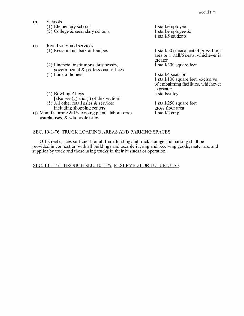
Zoning
(h) Schools(1) Elementary schools 1 stall/employee(2) College & secondary schools 1 stall/employee &
1 stall/5 students
(i) Retail sales and services(1) Restaurants, bars or lounges 1 stall/50 square feet of gross floor
area or 1 stall/6 seats, whichever isgreater
(2) Financial institutions, businesses, 1 stall/300 square feetgovernmental & professional offices
(3) Funeral homes 1 stall/4 seats or1 stall/100 square feet, exclusiveof embalming facilities, whicheveris greater
(4) Bowling Alleys 5 stalls/alley[also see (g) and (i) of this section]
(5) All other retail sales & services 1 stall/250 square feetincluding shopping centers gross floor area
(j) Manufacturing & Processing plants, laboratories, 1 stall/2 emp.warehouses, & wholesale sales.
SEC. 10-1-76 TRUCK LOADING AREAS AND PARKING SPACES.
Off-street spaces sufficient for all truck loading and truck storage and parking shall beprovided in connection with all buildings and uses delivering and receiving goods, materials, andsupplies by truck and those using trucks in their business or operation.
SEC. 10-1-77 THROUGH SEC. 10-1-79 RESERVED FOR FUTURE USE.
Zoning
ARTICLE G
Signs
SEC. 10-1-80 PURPOSE OF ARTICLE - SIGNS.
The purpose of this Article is to create the legal framework to regulate, administer, and enforceoutdoor sign advertising and display within the City of Neillsville. This Article recognizes the needto protect the safety and welfare of the public and the need for well maintained and attractive signdisplays within the community, and the need for adequate business identification, advertising andcommunication. This code authorizes the use of signs visible from public rights-of-way provided thesigns are:
(a) Compatible with the zoning regulations.(b) Designed, constructed, installed and maintained in such a manner that they do not endanger
public safety or traffic safety.(c) Legible, readable and visible in the circumstances in which they are used.(d) Respectful of the reasonable rights of other advertisers whose messages are displayed.
Recreated: Ord. 971, 08/22/00
SEC. 10-1-81 DEFINITIONS.
(a) In addition to those definitions contained in section 10-1-3, City Ordinances, the followingdefinitions shall apply to Article G. (1) ABANDONED SIGN. A sign which no longer correctly advertises a bonafide business,
lessee, owner, product or activity conducted, or product available on the premises wherethe sign is displayed or elsewhere.
(2) AREA OF COPY. The entire area within a single, continuous perimeter composed ofsquares or rectangles which encloses the extreme limits of advertising message,announcement, or decoration of a wall sign.
(3) AREA OF SIGN. The area of the largest single face of the sign within a perimeter whichforms the outside shape, but excluding the necessary supports or uprights on which thesign may be placed. If the sign consists of more than one section or module, all areaswill be totaled. Any irregularly shaped sign area shall be computed using the actual sign-face surface. In the case of wall signs, the area of copy will be used.
(4) BILLBOARD. See Section 10-1-3(a)(7) City Ordinances. (5) CHANGEABLE MESSAGE SIGN. A sign such as an electric controlled time and
temperature sign, message center or reader board where copy changes. (6) COPY AREA. The geometric area in square feet that encloses the actual copy of the
sign. (7) DIRECTIONAL SIGN. Any sign which serves to designate the location or direction of
any place or area. This includes, but is not limited to, such signs as those identifyingrestrooms, telephone, parking areas entrances and exits.
(8) ELECTRIC SIGN. Any sign containing internal electrical wiring which is attached orintended to be attached to an electrical energy source.
Zoning
(9) FLASHING SIGN. Any sign which contains an intermittent or flashing light source, orwhich includes the illusion of intermitten or flashing light by means of animation, or anexternally-mounted intermittent light source, not including changeable message signs.
(10) FRONTAGE. The length of the property line of any one premise parellel to and alongeach public right-of-way it borders.
(11) GRADE. The elevation or level of the street closest to the sign two which reference ismade, measured at the street's centerline.
(12) GROUND SIGN. A sign erected on one or more free-standing supports or uprights andnot attached to any building.
(13) GROSS AREA. The area of a sign is determined by using the outside perimeterdimensions of the sign. If the sign consists of more than one module or section theirareas will be totaled. If the modules are formed in the shape of letters or symbols, therules for "Area of Copy" apply.
(14) HEIGHT OF SIGN. The verticle distance measured from the grade at the street right-of-way line where the sign is located to the highest point of such sign.
(15) ILLUMINATED SIGN. A sign which is lighted by an artifical light source eitherdirected upon it or illuminated from an interior source.
(16) INTEGRATED SHOPPING CENTER. A shopping center in single ownership or underunified control, and containing three (3) or more separate businesses.
(17) LEGAL NONCONFORMING SIGN. A nonconforming sign that did meet regulationswhen it was originally installed.
(18) NONCONFORMING SIGN. A sign that does not meet code regulations.(19) OFF-PREMISE SIGN. See definition for "Billboard" at Section 10-1-3(a)(7), City
Ordinances.(20) ON-PREMISE SIGN. Any sign identifying or advertising a business, person, activity,
goods, products or services located on a premise where the sign is installed andmaintained.
(21) PORTABLE SIGN. Any sign not permanently attached to the ground or a building.(22) SIGN. See Section 10-1-3(a)(46), City Ordinances.(23) SIGN CONTRACTOR. Any person, partnership or corporation engaged in whole or in
part in the erection or maintenance of signs, excluding the business which the signadvertises.
(24) SIGN STRUCTURE. Any device or material which supports, has supported, or iscapable of supporting a sign in a stationary position, including decorative covers.
(25) SWINGING SIGN. A sign installed on an arm or mast or spar that is not, in addition,permanently fastened to an adjacent wall or upright pole.
(26) WALL SIGN. A sign attached to the wall of a building with the face in a parallel planeto the plane of the building wall. This includes signs painted directly on a wall.
(27) WINDOW SIGN. A sign affixed to, in contact with, painted upon, or placed within awindow, for the purpose of viewing from outside the premises; such sign must be placedonly on the interior of any window unless painted directly upon it. This does not includemerchandise located in a window.
(28) ZONING LOT. A parcel of land considered or treated as a single unit. A zoning lot mayor may not correspond with a lot of record.
Recreated: Ord. 1004, 6/22/04
SEC. 10-1-82 PERMITS, APPEALS, INDEMNIFICATION, INSURANCE.
(a) PERMITS REQUIRED. Except as set forth in subsection (b) herein, it shall be unlawful forany person to erect, construct, enlarge or structurally modify a sign or cause the same to be donein the City of Neillsville without first obtaining a sign permit for each such sign from theZoning Administrator as required by this section.
Zoning
Permits shall not be required for a change of copy of any sign, nor for the repainting, cleaning,and other normal maintenance and repair of the sign and sign structure.
(b) SIGNS NOT REQUIRING A PERMIT. Any of the following signs which are larger than six(6) square feet of gross area shall not be located within five (5) feet of the public right-of-way. Furthermore, the following signs shall not require a permit: (1) Construction Signs. Two (2) construction signs per construction site, not exceeding
sixty-four (64) square feet in area each, shall be confined to the site of construction, andshall be removed thirty (30) days after completion of construction or prior to occupancy,whichever is sooner.
(2) Directional and Instructional Non-electric Signs. Directional and instructional non-electric signs, which provide instruction or direction and are located entirely on aproperty to which they pertain and do not exceed ten (10) square feet each in area and donot in any way advertise a business. This includes, but is not limited to, such signs asthose identifying restrooms, telephone, parking areas, entrances and exits.
(3) Non-illuminated Emblems. Non-illuminated emblems, or insignia of any nation orpolitical subdivision, profit or non-profit organization.
(4) Government Signs. Government signs for control of traffic and other regulatorypurposes, danger signs, railroad crossing signs, and signs of public utilities indicatingdanger, and aids to service safety which are erected by or on the order of a public officerin the performance of his/her public duty.
(5) Home Occupation Signs. Signs associated with a home occupation as defined in theZoning Ordinance provided such signs are non-illuminated signs that do not exceed two(2) square feet in area. One (1) sign per home occupation is allowed.
(6) House Numbers and Name Plates. Name plates not exceeding one (1) square foot in areafor each residential building. House numbers not exceeding one (1) foot in height. Written house numbers not exceeding one (1) foot in height. Letters, when used toidentify individual multiple-family dwelling units, not to exceed one (1) foot in height.
(7) Interior Signs. Signs located within the interior of any building or structure which arenot visible from the public right-of-way.
(8) Memorial Signs and Plaques. Memorial signs or tablets, names of buildings and date oferection, which are cut into the masonry surface or inlaid so as to be a part of a buildingor when constructed of bronze or other noncombustible material not more than four (4)square feet in area.
(9) No Tresspassing or No Dumping Signs. No tresspassing and no dumping signs not toexceed one and one-half (1 1/2) square feet in area per sign.
(10) Public Notices. Official notices posted by public officers or employers in theperformance of their duties.
(11) Public Signs. Signs required as specifically authorized for a public purpose by any law,statute, ordinance.
(12) Campaign Signs. Campaign signs on behalf of candidates for public office provided thatsaid signs are subject to the following regulations:a. Said signs may be erected consistent with Wisconsin Administrative Code;
Transportation 201.16(2)(a)-(e).b. Each campaign sign shall not exceed thirty-two (32) square feet in residential and
nonresidential zoning districts.c. No sign shall be located in the public right-of-way.d. Campaign signs shall not be attached to public signs or utility poles.
(13) Real Estate Signs. One (1) real estate sign per agency on any lot or parcel provided suchsign is located entirely within the property to which the sign applies and is not directlyilluminated. Such signs shall be removed within thirty (30) days after the sale, rental orlease has been accomplished.
(14) On-Premise Symbols or Insignia. Religious symbols, commemorative plaques ofrecognized historic agencies, or indentification emblems of religious orders or historicagencies.
Zoning
(15) On-Premise Temporary Signs. Temporary signs not exceeding four (4) square feet inarea pertaining to drives or events of civic, philanthropic, educational, or religiousorganizations, provided such signs are posted not more than thirty days before said eventand removed within fifteen (15) days after the event.
(16) Vehiclar Signs. Truck, bus, trailer or other vehicles, while operating in the normalcourse of business, which is not primarily the display of signs.
(17) Interior Window Signs. Permanent signs located within the interior of any building orstructure which are visable from the public right-of-way provided the gross area of thesign does not exceed four (4) square feet. This does not include temporary advertising,special event, or sales types of signs.
(18) Other. Off-premise advertising signs as specifically allowed for limited purposes andperiods of time and as such exception is established by the Neillsville Common Councilby specific motion or resolution.
(c) APPLICATION FOR PERMIT. Application for a permit shall be filed with the City Clerkupon forms provided by the Zoning Administrator and shall contain the following information:(1) The name, address and telephone number of the sign owner, the property owner where
the sign is or will be located, and the sign contractor of the proposed sign.(2) Clear and legible drawings with description and nominal dimensions of the proposed
sign, the construction, size, dimensions and kind of materials to be used in suchstructure. The site plan shall show the buildings on the premises upon which thestructure is to be erected and maintained together with location, setbacks, size, and typesof existing signs on the premises where the proposed sign is to be located. Alldimensions shall be indicated for the sign and the site plan elements.
(3) Evidence of liability insurance policy or bond as required by Section 10-1-82(f).(4) Such other information as the Zoning Administrator may require to show full compliance
with this and all other applicable laws of the City of Neillsville.(5) Signature of the applicant.(6) No fee shall be required for application to the Zoning Administrator.
(d) PERMIT ISSUANCE AND DENIAL. The Zoning Administrator shall issue a permit for theerection, structural alteration, enlargement, or relocation of a sign within the City of Neillsvillewhen the permit application is properly made and the sign complies with the appropriate lawsand regulations of the City of Neillsville. If the sign permit is denied by the ZoningAdministrator, he/she shall give written notice of the denial to the applicant, together with abrief statement of the reasons for the denial.
(e) SIGN PERMIT APPEAL.(1) In the event any of the requirements herein contained cause undue or unnecessary
hardship on any person, firm or corporation, a variance from requirements may beapplied for pursuant to Section 10-1-98, City Ordinances.
(2) The decision of the Zoning Administrator either granting or denying a permit applicationmay be appealed to the Zoning Board of Appeals pursuant to Section 10-1-94, CityOrdinances.
(f) INDEMNIFICATION FOR SIGN INSTALLATION AND MAINTENANCE. All personsengaged in the business of installing or maintaining signs which involves in whole or in part,the erection, alteration, relocation, maintenance of a sign or other sign work in, over orimmediately adjacent to a public right-of-way or public property used or encroached upon bythe sign contractor, shall agree to hold harmless and idemnify the City of Neillsville, itsofficers, agents, employees, from any and all claims of negliegence resulting from the erection,alteration, maintenance of this sign or any other sign work insofar as this Ordinance has notspecifically directed the placement of the sign.
(g) INSURANCE. Every sign contractor erecting an on-premise or off-premise sign shall file withthe Zoning Administrator a Certificate of Insurance indicating the applicant holds a publicliability and property damage policy specifically to include the hold harmless clause with bodilyinjury limits of $300,000 per occurrence, and $300,000 aggregate, and property damageinsurance of at least $100,000 per occurrence, and $100,000 aggregate. Such insurance shallnot be cancelled or reduced without the insured first giving thirty (30) day notice in writing tothe City of Neillsville of such cancellation of reduction.
Zoning
(h) PENALTIES. Violation or failure to comply with the provisions of this Ordinance shall be andhereby is declared to be unlawful.(1) Any sign erected, altered, moved or structurally modified without a permit or altered
with a permit, but in violation with the provisions of this Ordinance shall be removed atthe owner's expense or brought into compliance within thirty (30) days of writtennotification by the Zoning Administrator. If the violation is failure to obtain a permit,a permit fee shall be required and the permit fee shall be five (5) times the normal fees. In the event that the owner does not remove or bring the sign into compliance, theZoning Administrator may order removal, the expenses of which will be assessed to thetax roll of the property on which the noncomplying sign is located.
(2) This section shall not preclude the City of Neillsville from maintaining any appropriateaction to prevent or remove a violation of this Ordinance.
Recreated: Ord. 1004, 6/22/04§10-1-82(b) - Amended: Ord. 1011, 2/14/06
SEC. 10-1-83 LEGAL NONCONFORMING SIGNS.
(a) NOTIFICATION OF NONCONFORMANCE. Upon determination that a sign isnonconforming, the Zoning Administrator shall use reasonable efforts to notify, eitherpersonally or in writing, the user or owner of the property on which the sign is located of thefollowing:(1) The sign's nonconformity.(2) Whether the sign is eligible for characterization as "legal nonconforming" or is unlawful.
(b) SIGNS ELIGIBLE FOR CHARACTERIZATION AS LEGAL NONCONFORMING. Anysign located within the City of Neillsville's city limits as of the date of adoption of thisordinance, or located in an area annexed to the City of Neillsville, hereafter which does notconform with the provisions of this Ordinance is eligible for characterization as a legalnonconforming sign and is permitted, providing it also meets the following requirements:(1) The sign was covered by a proper sign permit prior to the date of adoption of this
Ordinance.(2) If no permnit was required under applicable law for the sign in question and the sign was
in all respects in compliance with appplicable law on the date of adoption of thisOrdinance.
(c) LOSS OF LEGAL NONCONFORMING STATUS. A sign loses its nonconforming status ifone or more of the following occur:(1) The sign and/or display is structurally altered in any way, except for normal maintenance
or repair, which tends to or makes the sign less in compliance with requirements of thisOrdinance than it was before alteration.
(2) The sign and/or display is removed or relocated.(3) The sign and/or display fails to conform the the Ordinance regarding maintenance and
repair, abandonment, or dangerous or defective signs.(4) The sign and/or display is destroyed by any means to the extent of more than fifty (50%)
percent of its fair market value.(5) On the date of occurrence of any of the above, the sign and/or display shall be
immediately brought into compliance with this Ordinance.(d) LEGAL NONCONFORMING SIGN MAINTENANCE AND REPAIR. Nothing in this
Ordinance shall relieve the owner or user of a legal nonconforming sign or the owner of theproperty in which the sign is located from the provisions of this Ordinance regarding safety,maintenance, and repair of signs.
Recreated: Ord. 1004, 6/22/04
Zoning
SEC. 10-1-84 MAINTANCE, REMOVAL AND DISPOSITION OF SIGNS.
(a) MAINTENANCE AND REPAIR.(1) Every sign, including, but not limited to, those signs for which permits are required, shall
be maintained in a safe, presentable, and good structural condition at all times, includingreplacement of defective parts, painting (except when a weathered or natural surface isintended), repairing, cleaning and other acts required for the maintenance of said sign. A sign in disrepair shall be repaired within sixty (60) days after written notice to repair. Failure to perform the required repairs shall render the sign subject to removal pursuantto this section.
(2) The Zoning Administrator shall conduct an annual inspection of all signs located in theCity of Neillsville for the purpose of determining whether any sign is unlawful, that itendangers public safety by reasons of inadequate maintenance, dilapidation orabandonment, and shall require compliance with all standards of this Ordinance. Anysuch declaration shall be in writing and shall state the reason(s) of the ZoningAdministrator as to why any sign owned, kept displayed or maintained by any personwith the City is in violation of this chapter. If the sign is not modified to comply withsafety standards outlined in this Ordinance, the Zoning Administrator shall require itsremoval in accordance with this section.
(b) ABANDONED SIGNS. All signs or sign messages shall be removed by the owner or leseeupon which an on-premise sign is located when the business it advertises is no longerconducted or, for an off-premise sign, when lease payment and rental income are no longerprovided. If the owner or lessee fails to remove the sign, the Zoning Administrator shall givethe owner sixty (60) days written notice to remove said sign. Upon failure to comply with thisnotice, the City of Neillsville may cause removal to be executed, the expenses of which will beassessed to the tax roll of the property on which the abandoned sign is located.
(c) RESPONSIBILITY FOR DETERIORATED OR DILAPIDATED SIGNS. Responsibility forthe maintenance and removal of signs and structures rests first with the sign owner, secondlywith the installer of the sign and thirdly with the property owner. If any sign is in violation ofthis chapter or becomes so damaged or dilapidated as to offend the aesthetic character of theimmediate neighborhood or may contribute to the production of blight or deterioration, theZoning Administrator shall give written notice to the owner of the sign or the property owneron which the sign is located, in person or by mail, addressed to the last known post officeaddress of such owner, to repair or remove such sign. If such an order is not complied withwithin sixty (60) days of serving the notice, the Zoning Administrator shall cause the sign andstructure to be razed and the cost thereof assessed as a special charge against the property onwhich the sign is located.
Recreated: Ord. 1004, 6/22/04
SEC. 10-1-85 DISTRICT REGULATIONS.
The following signs are allowable providing a permit is acquired from the Zoning Administrator whenrequired:(a) RESIDENTIAL AND CONSERVANCY DISTRICTS. In the Residential and Conservancy
Districts, signs shall be regulated as follows:(1) MULTI-FAMILY DWELLINGS.
a. For each multiple-family dwelling, indentification signs indicating only the nameand address of the building and the name of the management not exceeding a totalof thirty-two (32) square feet in area. Such signs may not be closer than eight (8)feet to any other zoning lot. On a corner zoning lot, identification may be permittedon each side of the street.
b. No sign shall project higher than one (1) story or fifteen (15) feet above the curblevel, whichever is lower.
Zoning
(2) CHURCHES, CEMETERIES, EDUCATIONAL INSTITUTIONS, RECREATIONAND SOCIAL FACILITIES AND OTHER SIMILAR USES.a. Identification signs shall not exceed a total of sixty-four (64) square feet in area.
Such signs may not be closer than eight (8) feet to any other zoning lot. On a cornerlot, identification signs shall be permitted on each street side.
b. No sign when attached to the wall of a building or structure, shall project more thaneighteen (18) inches from the wall to which it is attached. No sign shall projecthigher than one (1) story or twenty (20) feet above the curb level, whichever islower.
(3) OTHER SIGNS. The following signs shall be allowed subject to the provisons containedin Section 10-1-82(b), and further subject to any provisions contained herein.a. House numbers and name plates.b. Real estate signs. No real estate sign shall exceed thirty-two (32) square feet in area
and shall not be placed closer than eight (8) feet to any other zoning lot.c. Home occupation signs.d. Construction signs.e. Interior signs.f. No tresspassing or no dumping signs.g. Campaign signs.h. Off-premise sign. A limit of one (1) free standing or wall off-premise sign may be
displayed per parcel. Whether free-standing or on a wall, such signs shall be limitedto six (6) square feet in sign area.
(b) COMMERCIAL DISTRICTS. In the Commercial Districts, signs shall be regulated as follows:(1) CL DISTRICTS. In the CL District, on-premise signs are permitted subject to the
following conditions:a. Residential Uses. The regulations covering the use of signs for residential buildings
in the CL District shall be the same as in the Residential District.b. Non-Residential Uses. In the CL District, nonflashing signs are permitted subject
to the following conditions:1. Area: The gross area in square feet of all business signs on a zoning lot shall not
exceed one (1) times the lineal feet of street frontage on such zoning lot, and notmore than fifty (50%) percent of this gross area shall be in a freestanding sign. Only one freestanding business sign shall be permitted for each street frontageof a zoning lot, except as provided in subsection (1)c. below.
2. Projection: No sign when attached to the wall of a building or structure shallproject more than thirty-six (36) inches from the face of the wall of suchbuilding or structure. No sign, when attached to the wall of a building orstructure, which is projected from the face of the wall or structure, shall be morethan sixty (60) inches in height.
3. Height: No sign shall project higher than twenty (20) feet above curb level.c. Integrated Shopping Center. For Integrated Shopping Centers in single ownership
or under unified control, one (1) additional sign, other than those regulated insubsection(1)b. above shall be permitted, subject to the following:1. Content: Such signs shall advertise only the name and location of such center,
and the names and type of business of each occupant of the center.2. Area: The gross surface area, in square feet, of all business signs on a zoning
lot shall not exceed one (1) times the lineal feet of street frontage on suchzoning lot. A corner lot shall be deemed to have a frontage equal to the lengthof those sides which abut a street.
3. Height: No sign shall project higher than twenty (20) feet above curb level.d. Off-Premise Signs. Off-premise signs shall be prohibited in the CL District.
(2) CG AND CH DISTRICTS. In the CG and CH Districts, on-premise and off-premisesigns are permitted subject to the following conditions:
Zoning
a. On-Premise Signs.1. The gross area in square feet of all business signs on a zoning lot shall not
exceed four (4) times the lineal feet of street frontage on such zoning lot.2. No more than seventy-five (75%) percent of the gross sign area, as indicated in
1. above shall be in a freestanding sign.3. Only one (1) freestanding sign shall be permitted per zoning lot except as
provided in 6. below.4. No sign when attached to the wall of a building or structure shall project more
than thirty-six (36) inches from the face of the wall of such building. No sign,when attached to the wall of a building, shall be more than sixty (60) inches inheight.
5. On-premise signs shall not project higher than thirty-five (35) feet above thegrade level.
6. Integrated Shopping Center. For Integrated Shopping Centers in singleownership or under unified control, one (1) additional sign, other than thoseregulated in subsection (2)a.1.-4. above shall be permitted, subject to thefollowing:(i) Content: Such signs shall advertise only the name and location of such
center, and the name and type of business of each occupant of thecenter.
(ii) Area: The gross surface area, in square feet, of all business signs on azoning lot shall not exceed three (3) times the lineal feet of streetfrontage on such zoning lot. A corner lot shall be deemed to havefrontage equal to the lenght of those sides which abut a street.
(iii) Height: Such freestanding sign shall not project more than thirty-five(35) feet above the curb level.
b. Off-Premise Signs.1. One (1) freestanding sign structure shall be permitted to be erected on a zoning
lot having fifty (50) feet or less of frontage provided that no such sign structureshall be permitted to be erected within two hundred (200) feet of an existingsign structure located on the same side of the right-of-way and facing the samedirection.
2. An off-premise sign shall not contain more than eight hundred (800) square feetof gross sign area per facing.
3. Off-premise signs shall not project higher than thirty-five (35) feet above gradelevel.
(c) INDUSTRIAL SIGNS. In the Industrial Districts, signs shall be regulated as follows:(1) IL DISTRICT. In the IL District, on-premise and off-premise signs are permitted subject
to the same conditions and regulations specified in the CG and CH Districts.(2) IG DISTRICT. In the IG District, on-premise and off-premise signs are permnitted
subject to the same conditions in the CG and CH Districts, except that such signs shallnot project higher than forty (40) feet above the curb level.
Recreated: Ord. 1004, 6/22/04
SEC. 10-1-86 SPECIAL SIGN PROVISIONS.
(a) In those districts where limitations are imposed by this chapter on the projection of signs fromthe face of any building or structure, such limitations shall not apply to identification marqueeor canopy signs indicating only the name of the building or the principal product or serviceavailable therein, provided that any identification sign located on a marquee or canopy shall beaffixed flat to the surface thereof or suspended within and below the outer marquee or canopylimits except that no such suspended sign shall be lower than nine (9) feet above
Zoning
the ground or surface over which the marquee or canopy is constructed. Further, no other sign shallextend beyond the limits of said marquee or canopy.(b) Signs on awnings shall be exempt from the limitations imposed by this chapter on the
projection of signs from the face of a wall of any building or structure, provided, that any signlocated on an awning shall be affixed flat to the surface thereof, and shall be non-illuminatedand shall indicate only the name, address, and/or the type of business of the establishment. further, no such sign shall extend vertically or horizontally beyond the limits of said awning.
(c) OFF-PREMISE SIGNS. The following provisions shall apply to all off-premise signs, exceptunder those very limited circumstances as permitted by the City of Neillsville Common Councilby specific motion or resolution for purpose of improvement or maintenance to City ofNeillsville property.1. No off-premise sign shall be permitted to be erected within two hundred (200) feet of any
other such sign on the same side of the road, unless separated by a building or otherobstruction.
2. No off-premise sign shall be permitted to be erected within three hundred (300) feet ofany public park or within five acres of a public park if facing such park and visabletherefrom.
3. No off-premise sign shall be permitted to be erected within seventy-five (75) feet of anyadjoining Residential District boundary line if the sign is to face such District.
4. All off-premise signs shall have a minimum setback for structural pylons and supportsequal to at least one-fourth (1/4) the required building setback of the zoning district.
5. No off-premise sign shall suspend lower than ten (10) feet above the grade.(d) ON-PREMISE SIGNS.
1. All on-premise signs shall have a minimum setback for structural pylons and supportsequal to a least one-fourth (1/4) the required building setback of the zoning district.
2. No on-premise sign shall suspend lower than ten (10) feet above grade.(e) No flashing sign of any type shall be permitted to be erected within one hundred fifty (150) feet
of an adjoining Residential District boundary line if such sign would be visable from suchDistrict.
(f) No sign shall be painted, pasted or similarly posted directly on the surface of any wall, nor shallany sign be permitted to be placed on any wall or fence facing the side of any adjoining lotlocated in a Residential District.
(g) All signs shall be erected within the property lines of the premises upon which they are located,except that signs attached to building facades in Commercial and Industrial Districts mayproject eighteen (18) inches from the face or wall of such building structure. Thirty-six (36)inches may be allowed providing that no more than fifty (50%) percent of the surface area ofthe sign extends to a distance from eighteen (18) to thirty-six (36) inches. All supportingmembers shall be concealed within the sign. No such sign shall suspend lower than ten (10)feet above the grade, except signs which project less than six (6) inches from the buildingfacade shall not suspend lower than seven (7) feet above grade. No sign located facing an alleyright-of-way shall suspend lower than fifteen and one-half (15 1/2) feet above the grade, exceptthose signs in alleys which project less than six (6) inches from the building facade which shallnot suspend lower than twelve (12) feet.
(h) Individual directional signs designating entrances, exits and conditions of use of parkingfacilities accessory to the main use of the premises may be maintained provided they are locatedwithin the property lines of the zoning lot and do not exceed twenty-four (24) square feet.
(i) Signs which may be in conflict with public traffic signals shall not be permitted. No personshall place, maintain or display any authorized sign, signal, marking or device which is animitation of or resembles an official traffic control device, emergency light, or railroad sign ordisplay any sign which hides from view or interferes with the movement of traffic or theeffectiveness of any traffic control device or any railroad sign or signal.
(j) Signs and sign structures attached to the wall of any building shall not extend more than six (6)feet above the roof line.
Recreated: Ord. 1004, 6/22/04§10-1-86(c) - Amended: Ord. 1011, 2/14/06

Zoning
SEC. 10-1-87 THROUGH SEC.10-1-89 RESERVED FOR FUTURE USE.
Zoning
ARTICLE H
Administration
SEC. 10-1-90 PURPOSE OF ARTICLE - ADMINISTRATION.
The purpose of this Article of the Zoning Code is to outline specific rules and procedureswhereby the provisions of this Chapter shall be administered and enforced.
SEC. 10-1-91 RESPONSIBILITIES OF ZONING ADMINISTRATOR.
The Zoning Administrator shall have the responsibility of administering and enforcing theprovisions of this Chapter.
SEC. 10-1-92 POWERS AND DUTIES OF ZONING ADMINISTRATOR.
The Zoning Administrator shall have the following powers to enforce the provisions of thisChapter:
(a) Examine and approve any application pertaining to the use of land, buildings or structures todetermine if the application conforms with the provisions of this Ordinance.
(b) Issue all zoning certificates and keep permanent records thereof.(c) Conduct inspections of buildings, structures and uses of land to determine their compliance
with this Chapter.(d) Receive, file and forward for action all applications for appeals, variations, special uses, and
amendments to this Chapter which are filed in the Zoning Office.(e) Initiate, direct, and review, from time to time, a study of the provisions of this Chapter, and
make reports of his recommendation to the Planning Commission and the City Council not lessfrequently than once a year.
(f) Revoke certificates of zoning compliance where provisions of this Chapter are being violated.(g) Maintain permanent and current records of this Zoning Ordinance, including all maps,
amendments, special uses, and variations.(i) Provide and maintain public information relative to all matters arising out of this Chapter.
SEC. 10-1-93 ZONING BOARD OF APPEALS.
(a) MEETING AND RULES. All meetings of the Board shall be held at the call of the chairmanand at such other times as the Board may determine. All hearings conducted by the said Boardshall be open to the public. The Board shall keep minutes of its proceedings, showing the voteof each member upon each question, or, if absent or failing to vote, indicating such fact, andshall keep records of its examination and other official actions, all of which shall beimmediately filed in the office of the board and shall be public record. The Board shall adoptits own rules of procedure not in conflict with this Ordinance or with the applicable WisconsinStatutes.
(b) OFFICES. The City Council shall provide suitable offices for the Board of Appeals for holdingfor hearings and the presentation of records, documents, and accounts.
Zoning
(c) APPROPRIATIONS. The City Council shall appropriate funds to carry out the duties of theBoard and the Board shall have the authority to expend, under regular procedure, all sumsappropriated to it for the purpose and activities authorized herein.
(d) JURISDICTION AND AUTHORITY. The Board of Appeals shall have the jurisdiction andauthority as specified in Section 2-4-5 of this Code of Ordinances.
SEC. 10-1-94 APPEALS TO THE ZONING BOARD OF APPEALS.
(a) SCOPE OF APPEALS. Appeals to the Board may be taken by any person aggrieved or by anyofficer, department, board or bureau of the City, affected by any decision of the administrativeofficer. Such appeal shall be taken within reasonable thirty (30) days of the alleged aggrievanceor judgment in question.
(b) STATE OF PROCEEDINGS. An appeal shall stay all legal proceedings in furtherance of theaction appealed from, unless the officer from whom the appeal is taken certified to the Boardthat by reason of facts stated in the certificate a stay would, in his opinion, cause immediateperil to life or property. In such cases, proceedings shall not be stayed otherwise than by arestraining order which may be granted by the Board of Appeals or by a court of record onapplication, on notice to the officer from whom the appeal is taken, and on due cause shown.
SEC. 10-1-95 HEARING OF APPEALS.
The Board shall fix a reasonable time, not more than thirty (30) days from the date of filing, forthe hearing of an appeal and shall give due notice thereof to all the parties involved. The Board or anyof its officers it shall designate shall cause such hearings to be published in the City's newspaper ornewspapers.
SEC. 10-1-96 CONDITIONAL USES.
(a) APPLICATION FOR CONDITIONAL USE PERMIT. An application for Conditional UsePermit shall be filed with the Zoning Office. The application shall contain the followinginformation:(1) Name and address of applicant.(2) Statement that the applicant is the owner or authorized agent of the owner of the property
for which the change in district boundary or use if proposed.(3) Address and description of property.(4) An accurate drawing of the site and surrounding area for a distance of at least three
hundred (300) feet from each boundary.(5) Name and address of adjacent property owners.(6) The application shall be accompanied with a filing fee of One Hundred Twenty-Five
($ 125.00) Dollars.(b) HEARING OF APPEAL. Upon receipt of application, the City Council shall hold at least one
(1) public hearing on the proposed conditional use. The hearing shall be recorded and filed inthe Zoning Office. Notice for hearing shall be published not more than thirty (30) days and notless than fifteen (15) days before the hearing in one of the newspapers in general circulation inthe City of Neillsville. Owners of the adjacent properties shall also be notified. Their failureto get the notice or attend the hearing shall not invalidate the proceedings.
§ 10-1-96(a)(6) - Amended: Ord. 912, 2/8/94
Zoning
(c) REFERRAL TO THE OFFICE OF THE PLANNING COMMISSION. The Zoning Officer orAdministrator shall refer the application for Conditional Use Permit to the City PlanningCommission at least ten (10) days before the public hearing. The Planning Commission shallsubmit a report and recommendation to the City Council. No application for a conditional useshall be granted unless all of the following conditions are present:(1) That the establishment, maintenance or operation of the conditional use will not be
detrimental to or endanger the public health, safety, morals, comfort or general welfare.(2) That the uses, values and enjoyment of other property in the neighborhood for purposes
already permitted shall be in no foreseeable manner substantially impaired or diminishedby the establishment, maintenance or operation of the conditional use and the proposeduse is compatible with the use of adjacent land.
(3) That the establishment of the conditional use will not impede the normal and orderlydevelopment and improvement of the surrounding property for uses permitted in thedistrict.
(4) That adequate utilities, access roads, drainage and other necessary site improvementshave been or are being provided.
(5) That adequate measures have been or will be taken to provide ingress and egress sodesigned as to minimize traffic congestion in the public streets.
(6) That the conditional use shall, except for yard requirements, conform to all applicableregulations of the district in which it is located.
(7) That the proposed use does not violate flood plain regulations governing the site.(8) That when applying the above standards to any new construction of a building or an
addition to an existing building the Planning Commission and Common Council shallbear in mind the statement of purpose for the zoning district such that the proposedbuilding or addition at its location does not defeat the purposes and objective of thezoning district.
(d) CONDITIONS AND GUARANTEES. Prior to the granting of any conditional use, thePlanning Commission may recommend and the Common Council may stipulate such conditionsand restrictions upon the establishment, location, construction, maintenance and operation ofthe conditional use as deemed necessary to promote the public health, safety and generalwelfare of the community, and to secure compliance with the standards and requirementsspecified in Subsection (c) above. In all cases in which conditional uses are granted, theCouncil shall require such evidence and guarantees as it may deem necessary as proof that theconditions stipulated in connection therewith are being and will be complied with. Suchconditions may include specifications for without limitation because of specific enumeration:(1) landscaping,(2) type of construction,(3) construction commencement and completion dates,(4) sureties,(5) lighting,(6) fencing,(7) operational control,(8) hours of operation,(9) traffic circulation,(10) deed restrictions,(11) access restrictions,(12) setbacks and yards,
Zoning
Council, modify existing conditions upon such use and impose additional reasonable conditions uponthe subject conditional use. In the event that no reasonable modification of such conditional use canbe made in order to assure that Subsections (1) and (2) in Section 10-1-96(c) will be met, the Common Council may revoke the subject conditional approval and direct the Building Inspector,Zoning Administrator and City Attorney to seek elimination of the subject use. Following any suchhearing, the decision of the Common Council shall be furnished the current owner of the conditionaluse in writing stating the reasons therefor.
SEC. 10-1-98 VARIATIONS.
(a) PURPOSE. The Board of Appeals shall determine and may vary the regulation of this Chapterin harmony with its general purpose and intent, only in specific instance where the Board ofAppeals makes a finding of fact based on the standards hereinafter prescribed. Any variationgranted by the Board of Appeals has to be referred to the Council for final approval. Variationfrom the provisions of this Chapter may be granted by the City Council on the recommendationof the Board of Appeals.(1) To permit any yard of less dimension than those required by the applicable regulations.(2) To permit any building to exceed the floor space provided by the Ordinance, but such
variation may not exceed ten (10%) percent.(3) To permit the use of lot prohibited solely because of insufficient area of the lot.
(b) APPLICATION FOR VARIATION. The application for variation shall be filed with theZoning Administrator. The application shall contain the following information:(1) Name and address of applicant.(2) Statement that the applicant is the owner or the authorized agent of the owner of the
property.(3) Address and description of the property.(4) An accurate scale drawing of the site and the surrounding areas for a distance at least
eight hundred (800) feet from each boundary of the site showing the location of streetsand property lines.
(5) The application shall be accompanied with a filing fee of One Hundred Twenty-Five($ 125.00) Dollars.
(c) PUBLIC HEARING OF APPLICATION. The Board of Appeals shall conduct at least one (1)public hearing on the proposed variation. Notice of such hearing shall be given not more thanthirty (30) days and not less than fifteen (15) days before the hearing in one or more of thenewspapers in general circulation in the City of Neillsville.
(d) REFERRAL TO THE OFFICE OF THE PLANNING COMMISSION. The ZoningAdministrator shall refer the application for variation to the chairman of the City PlanningCommission at least ten (10) days before the public hearing for consideration. The PlanningCommission shall submit a report and recommendation to the Board of Appeals on thevariation before the public hearing.
(e) RECOMMENDATION OF THE BOARD OF APPEALS. The Board shall make anaffirmative or negative recommendation to the City Council after the public hearing. For theBoard to make affirmative recommendation it must find that:(1) Denial of variation may result in hardship to the property owner due to physiographical
considerations.(2) The conditions upon which a petition for a variation is based are unique to the property
for which variation is being sought.(3) The purpose of the variation is not based exclusively upon a desire to increase the value
or income potential of the property.(4) The granting of the variation will not be detrimental to the public welfare or injurious to
the other property or improvements in the neighborhood in which the property is located.
Zoning
(5) The proposed variation will not undermine the spirit and general and specific purposesof this Ordinance.
(6) The concurring vote of four (4) members of the Board shall be necessary to recommendthe authorization of any variance in the Zoning Code.
(f) DISPOSITION BY THE CITY COUNCIL. After public hearing, the Board of Appeals shallforward its recommendations to the City Council and the City Council shall act within thirty(30) days to authorize variation in the Ordinance or may refer it back to the Board for furtherconsideration. Every variation shall be accompanied by a written finding of fact specifying thereason for making such variation. Any proposed variation which fails to receive the approvalof the Board shall not be passed by the City Council except by favorable vote of three-fourths(3/4) of the aldermen then holding office. A copy of the variation shall be supplied to theZoning Administrator within ten (10) days of passage.
§ 10-1-98(b)(5) - Created: Ord. 913, 2/8/94
SEC. 10-1-99 AMENDMENTS TO ZONING CODE.
(a) PURPOSE. The purpose of this Section is to provide a procedure for changing districtboundaries, district regulations, off-street parking and other provisions of this Zoning Code.
(b) APPLICATION FOR AMENDMENT. An application for an amendment shall be filed withthe Zoning Office. The application shall contain the following information:(1) Name and address of applicant.(2) Statement that the applicant is the owner or authorized agent of the owner of the property
for which the change in district boundary or use is proposed.(3) Address and description of property.(4) An accurate drawing of the site and surrounding area for a distance of at least three
hundred (300) feet from each boundary.(5) Name and address of adjacent property owners.(6) The application shall be accompanied with a filing fee of One Hundred Twenty-Five
($ 125.00) Dollars.(c) HEARING OF APPLICATION. Upon receipt of application, the City Council shall hold at
least one (1) public hearing on the proposed amendment. The hearing shall be recorded andfiled in the Zoning Office. Notice for hearing shall be published not more than thirty (30) daysand not less than fifteen (15) days before the hearing in one of the newspapers in generalcirculation in the City of Neillsville. Owners of the adjacent properties shall also be notified. Their failure to get the notice or attend the hearing shall not invalidate the proceedings.
(d) REFERRAL TO THE OFFICE OF THE PLANNING COMMISSION. The ZoningAdministrator or officer shall refer the application for amendment to the City PlanningCommission at least ten (10) days before the public hearing. The Planning Commission shallsubmit a report and recommendation to the City Council, recommending approval where itsfindings indicate that the conditional use will in no way endanger public health, safety, morals,comfort and general welfare; the conditional use will not be injurious to the enjoyment of otherproperty in the immediate vicinity; the establishment of conditional use will not impede theorderly development and improvement of other property for the use permitted in the district;and it shall conform to the applicable regulations of the district in which it is located.
(e) DISPOSITION BY CITY COUNCIL. An amendment shall be passed by a majority vote of theelected members of the City Council.
§ 10-1-99(b)(6) - Amended: Ord. 914, 2/8/94

Zoning
SEC. 10-1-100 PENALTIES.
Failure to comply with the provisions of this Chapter shall be regarded as violation and anyperson who commits such violation shall be liable to a forfeiture of not less than Twenty-five ($ 25.00)Dollars or not more than Five Hundred ($ 500.00) Dollars or ninety (90) days imprisonment in theClark County Jail. Each day a violation is continued shall be considered a separate offense.
SEC. 10-1-101 THROUGH SEC. 10-1-109 RESERVED FOR FUTURE USE.
Zoning
ARTICLE I
Zoning Permit and Certificate of Zoning Compliance
SEC. 10-1-110 PURPOSE OF ARTICLE - ZONING PERMIT.
This Article provides procedures under which any construction or alteration of a building orother structure and any new use of land or a building shall be cleared with the Zoning Administratorto make certain that it is in compliance with this Zoning Code. The purpose of this requirement is toassure effective enforcement of zoning and also to afford protection to owners and users of propertyby providing for an advance determination of whether a proposed development or use will be incompliance with this Chapter. In order to lessen the burden upon property owners and to avoidunnecessary administrative duplication, the procedures under this Article are, wherever possible,combined with already existing procedures.
SEC. 10-1-111 PERMIT DEFINITIONS.
(a) ZONING PERMIT. A zoning permit is a statement issued by the Zoning Administrator statingthe existing zoning provisions which apply to a given parcel or parcels of property. Thefollowing should be specifically stated in the zoning permit:(1) Zoning district(s) within which the property is located.(2) Any additional regulations which apply to the subject property such as those specified
by Conditional Use Permit, Variation or other action by the Board of Appeals or the CityCouncil also including judiciary action.
(3) Status of any nonconformities which exist on the subject property.(4) If a specific use is proposed and the extent of the proposed use is indicated and
accompanied by plans and additional information as necessary, then applicable parking,sign, and other regulations should be stipulated.
(b) CERTIFICATE OF ZONING COMPLIANCE. A certificate of zoning compliance is a writtenstatement issued by the Zoning Administrator stating to the best of his ability that the existingbuildings or structures and the proposed use of said building or structures and/or the proposeduse of subject property is in compliance with all of the provisions of this Zoning Ordinance andany amendments, variations, Conditional Use Permits granted, or any other Board of Appeals,City Council or court action related thereto.
SEC. 10-1-112 APPLICATION AND ISSUANCE OF A ZONING PERMIT.
(a) Application for a zoning permit shall be made on a form prescribed by the Zoning Board ofAppeals and shall be accompanied by plans and additional information as necessary, in theopinion of the Zoning Administrator, to demonstrate conformity with this Chapter. The ZoningAdministrator shall, upon receipt of all necessary information, check the application and alldata submitted with it to see that all provisions of this Chapter will be complied with.
(b) In the event a proposed development does not comply with the provisions of this Chapter, aZoning Permit shall not be issued; however, the aspects of the proposed development or usewhich do not comply shall be specified.
Zoning
SEC. 10-1-113 ISSUANCE OF CONSTRUCTION PERMITS.
Except as heretofore provided, no building permit or other permit pertaining to the constructionof buildings or the use of land or buildings shall be issued by an officer, department or employee ofthe City of Neillsville unless the application for such permit has been examined by the ZoningAdministrator and has affixed to it a Zoning Permit stating that the proposed building or structure anduse thereof complies with all the provisions of this Chapter.
SEC. 10-1-114 APPLICATIONS AND ISSUANCE OF A CERTIFICATE OF ZONING COMPLIANCE.
(a) Application for a certificate of zoning compliance shall be made on a form prescribed by theZoning Administrator and shall be accompanied by a plat and plot plan as specified below.
(b) No certificate of zoning compliance shall be issued until construction has been completed orthe use established but not operationalized and had been inspected and certified by the ZoningAdministrator to be in compliance with all provisions of this Chapter. A certificate of zoningcompliance shall be issued or written notice shall be given to the applicant stating the reasonswhy the Zoning Administrator will not issue a certificate of zoning compliance.
(c) No building or addition thereto, constructed after the effective date of this Ordinance, and noaddition to a previously existing building shall be occupied, and no land vacant on the effectivedate of this Ordinance shall be used for any purpose until a certificate of zoning compliance hasbeen issued by the Zoning Administrator. No change in use to the production, processing, orstorage of materials or goods and no change in use from the production, processing or storageof one kind of materials or goods to another kind shall be made until a certificate of zoningcompliance has been issued by the Zoning Administrator. Every certificate of zoningcompliance shall state that the use or occupancy complies with all the provisions of thisChapter.
SEC. 10-1-115 REQUIRED PLOT PLANS FOR CERTIFICATE OF ZONING COMPLIANCE.
Every application for a certificate of zoning compliance shall be accompanied by a plot plandrawn to scale in such form as may, from time to time, be prescribed by the Zoning Administrator. Such plot plan shall show the ground area, height and bulk of the building or structure; the buildingsetback lines in relation to lot lines; the use to be made of the building or structure or land; and suchother information as may be required by the Zoning Administrator for the proper enforcement of thisChapter.
SEC. 10-1-116 ISSUANCE OF A CERTIFICATE OF OCCUPANCY.
No certificate of occupancy as required in the building codes shall be issued by the BuildingOfficer until a certificate of zoning compliance has been issued.
SEC. 10-1-117 THROUGH SEC. 10-1-119 RESERVED FOR FUTURE USE.
Zoning
ARTICLE J
Separability
SEC. 10-1-20 SEPARABILITY.
(a) In the event of any section of this Chapter being declared illegal or invalid by any court of law,such decision shall only apply to that particular section.
(b) In the event of any court of competent jurisdiction declaring the application of the provisionsof this Chapter to any building, structure illegal or invalid such court decision shall not affector prevent the application of the particular provision or other provisions of this Chapter to otherbuildings and structures within the City of Neillsville.
Zoning
ARTICLE K
Annexation
SEC. 10-1-121 ANNEXED TERRITORY.
All territory annexed by the City of Neillsville shall become part of the A District until definiteboundaries and regulations are recommended by the Planning Commission and adopted by theCommon Council of the City of Neillsville, such adoption to be completed within ninety (90) days ofthe annexation.
CHAPTER 2
One- and Two-Family Dwelling Building Code
§ 10-2-1 Application of Provisions§ 10-2-2 State Uniform Dwelling Code Adopted§ 10-2-3 Definitions§ 10-2-4 Method of Enforcement§ 10-2-5 Enforcement Contract§ 10-2-6 Building Permits§ 10-2-7 Fees for Building Permits and Inspections§ 10-2-8 Violation and Penalties§ 10-2-9 Appeal to Board of Appeals§ 10-2-10 Liability for Damages§ 10-2-11 Severability
SEC. 10-2-1 APPLICATION OF PROVISIONS.
(a) TITLE. This Chapter shall be known as the one- and two-family dwelling code of the City ofNeillsville.
(b) PURPOSE. The purpose and intent of this Chapter is to:(1) Exercise jurisdiction over the construction and inspection of new one- and two-family
dwellings and additions to existing one- and two-family dwellings;(2) Provide plan review and on-site inspections of one- and two-family dwellings by
inspectors certified by the Department of Industry, Labor and Human Relations;(3) Establish and collect fees to defray administrative and enforcement costs;(4) Establish remedies and penalties for violations; and(5) Establish use of the Wisconsin uniform building permit as prescribed by the Department
of Industry, Labor and Human Relations.
SEC. 10-2-2 STATE UNIFORM DWELLING CODE ADOPTED.
The administrative code provisions describing and defining regulations with respect to one- andtwo-family dwellings in Chapters Ind 20-25 of the Wisconsin Administrative Code, whose effectivedates are generally June 1, 1980, are hereby adopted and by reference made a part of this Chapter asif fully set forth herein. Any act required to be performed or prohibited by an administrative codeprovision incorporated herein by reference is required or prohibited by this Chapter. Any futureamendments, revisions or modifications of the administrative code provisions incorporated herein areintended to be made part of this Chapter to secure uniform statewide regulation of one- and two-familydwellings in this City of the State of Wisconsin. A copy of these administrative code provisions andany future amendments shall be kept on file in the City Clerk-Treasurer's Office.
SEC. 10-2-3 DEFINITIONS.
(a) ADDITION. "Addition" means new construction performed on a dwelling which increases theoutside dimensions of the dwelling.
(b) ALTERATION. "Alteration" means a substantial change or modification other than an additionor minor repair to a dwelling or to systems involved within a dwelling.
(c) DEPARTMENT. "Department" means the Department of Industry, Labor and HumanRelations.
(d) DWELLING. "Dwelling" means:(1) any building, the initial construction of which is commenced on or after the effective date
of this Chapter, which contains one or two dwelling units, or(2) an existing structure, or that part of an existing structure, which is used or intended to be
used as a one- or two-family dwelling.
One- and Two-Family Dwelling Building Code
(e) MANUFACTURED DWELLING. "Manufactured Dwelling" means:(1) Any structure or component thereof which is intended for use as a dwelling, that:
a. Is of closed construction and fabricated or assembled on site or off site in manufacturing facilities for installation, connection or assembly and installation atthe building site; or
b. Is a building of open construction, which is made or assembled in mamufacturingfacilities away from the building site and for installation, conmnection, or asemblyand installation on the site and for which certification is sought by the manufacturer.
(2) The term manufactured dwelling does not include a building of open construction, whichis not subject tp par.(a)2. A single or double width manufactured (mobile) home is not considered a manufactured dwelling and is not subject to this code.
(f) MANUFACTURED HOME. "Manufactured Home" means a structure of structures certifiedand labeled as a mamufactured home under 42 U.S.C. secs. 5401 to 5406, built since June 15,1976, that bears a seal indicating it has met the mobile home construction and safety standards of the United States Department of Housing and Urban Development (HUD) standards, is usedas a permanent, single family residential dwelling, is installed in accordance with themanufacturer's instructions, is properly connected to all applicable utilities, and is set on anenclosed foundation in accordance with Sec. 10-3-3(c)(4), Neillsville Ordinances, 70.043(1).Wis. Stats. and subchpaters iii, iv and v of Comm. 21, Wis Admin. Code as certified by theBuilding Inspector prior to occupancy.
(g) MOBILE HOME. "Mobile Home" means a single family dwelling built on or before June 15,1976, designed to be towed or transported and use as a residential dwelling, does not includea manufactured home. Mobile home also means any coach, cabin, travel trailer. mobile home,house, car or other structure which is/was originally constructed or designed to be transportedby any motor vehicle upon a public highway and designed, equipped, or used for sleeping.eating or living quarters or as a place of business, or is intended to be so used, whether mountedupon wheels or supports or capable of being moved by its own power or tansported by anothervehicle, and included any additions, attachments, foundations annexed or appurtenancesthereto.
(h) MINOR REPAIR. "Minor repair" means repair performed for maintenance or replacementpurposes on any existing one- or two-family dwelling which does not affect room arrangement,light and ventilation, access to or efficiency of any exit stairways or exits, fire protection, orexterior aesthetic appearance, and which does not increase a given occupancy and use. Nobuilding permit is required for work to be performed which is deemed minor repair.
(i) ONE- OR TWO-FAMILY DWELLING. "A one- or two-family dwelling" means a buildingstructure which contains one or separate households intended to be used as a home, residenceor sleeping place by an individual or by two or more individuals maintaining a commonhousehold, to the exclusion of all others.
(j) PERSON. "Person" means an individual, partnership, firm or corporation.(k) UNIFORM DWELLING CODE. "Uniform Dwelling Code" means those administrative code
provisions, and any future amendments, revisions or modifications thereto, contained infollowing chapters of the Wisconsin Administrative Code:
Wis. Adm. Code Chapter Ind. 20 - Administration and EnforcementWis. Adm. Code Chapter Ind. 21 - Construction StandardsWis. Adm. Code Chapter Ind. 22 - Energy Conservation StandardsWis. Adm. Code Chapter Ind. 23 - Heating, Ventilating and Air Conditioning
StandardsWis. Adm. Code Chapter Ind. 24 - Electrical StandardsWis. Adm. Code Chapter Ind. 25 - Plumbing and Potable Water Standards
§ 10-2-3(e), (f) and (g) - Created: Ord. 973, 09/13/00
SEC. 10-2-4 METHOD OF ENFORCEMENT.
For the purpose of administering and enforcing the provisions of this Chapter and the UniformDwelling Code, the City shall contract with a certified individual inspector or an independentinspection agency or contract with the Department of Industry, Labor and Human Relations.

One- and Two-Family Dwelling Building Code
SEC. 10-2-5 ENFORCEMENT CONTRACT.
(a) CONTRACT. The City shall contract with an individual who is certified by the department ineach category specified under Sec. 26.06, Wisconsin Adm. Code, and by the Department ofHealth and Social Services in the category of plumbing or an independent inspection agencywhich is certified by the Department in each category specified under Sec. 26.06, WisconsinAdm. Code, and by the Department of Health and Social Services in the category of plumbingthe City of Neillsville for the purpose of administering and enforcing the provisions of thisChapter and the Uniform Dwelling Code. The City Clerk-Treasurer shall forward all buildingpermit applications and submitted plans to the certified inspector or independent inspectionagency with whom the City has contracted.
(b) "CERTIFIED INSPECTOR AND INDEPENDENT INSPECTION AGENCY." In the contextof this Ordinance, these terms "Certified Inspector and Independent Inspection Agency" shallbe deemed synonymous and interchangeable.
SEC. 10-2-6 BUILDING PERMITS.
(a) BUILDING PERMITS REQUIRED. No one- or two-family dwelling of which initialconstruction shall be commenced after June 1, 1980 shall be built, enlarged, altered, or repairedunless a building permit for that work shall first be obtained by the owner, or his agent, fromthe Building Inspector. Application for a building permit shall be made in writing upon thatform, designated as the Wisconsin Uniform Dwelling Permit Application, furnished by theDepartment of Industry, Labor and Human Relations.
(b) SUBMISSION OF PLANS. The applicant shall submit two (2) sets of plans for all new orrepairs or additions to existing one- or two-family dwellings at the time that the building permitapplication is filed.
(c) ISSUANCE OF PERMIT. If the Building Inspector finds that the proposed building or repairor addition complies with all City ordinances and the Uniform Dwelling Code, the Inspectorshall officially approve the application and a building permit shall be subsequently issued tothe applicant. The issued building permit shall be posted in a conspicuous place at the buildingsite. A copy of any issued building permit shall be kept on file with the City Clerk-Treasurer.
SEC. 10-2-7 BUILDING PERMIT FEE.
(a) For building permit, a flat fee of $ 30.00.(b) Failure to obtain building permit prior to commencement of work, a double fee or $ 60.00.(c) All rates above are in addition to inspection fees which are as follows:
(1) Residence one- and two-family Flat fee of $ 250.00(2) Failure to obtain permit prior to commencement of work Double fee or $ 500.00.
§ 10-2-7(a)&(b) - Amended: Ord. 915, 2/8/94
SEC. 10-2-8 VIOLATION AND PENALTIES.
(a) No person shall erect, use, occupy or maintain any one- or two-family dwelling in violation ofany provision of this Chapter or the Uniform Dwelling Code or cause to permit any suchviolation to be committed. Any person violating any of the provisions of this Chapter shall,upon conviction, be subject to a forfeiture of not less than Fifty ($ 50.00) Dollars nor more thanFive Hundred ($ 500.00) Dollars, together with the costs of prosecution and, if in default ofpayment thereof, shall be imprisoned for a period of not less than one (1) day or more than six(6) months or until such forfeiture and costs are paid.
(b) If an inspection reveals a noncompliance with this Chapter or the Uniform Dwelling Code, theBuilding Inspector shall notify the applicant and the owner, in writing, of the violation(s) to becorrected. All cited violations shall be corrected within thirty (30) days after written
One- and Two-Family Dwelling Building Code
notification unless an extension of time is granted pursuant to Sec. Ind 20.10(1)(c), WisconsinAdm. Code.
(c) If, after written notification, the violation is not corrected within thirty (30) days, a stop-workorder may be served on the owner or his or her representative and a copy thereof shall be postedat the construction site. Such stop-work order shall not be removed except by written noticeof the Building Inspector after satisfactory evidence has been supplied that the cited violationhas been corrected.
(d) Each day each violation continues after the thirty (30) day written notice period has run shallconstitute a separate offense. Nothing in this Chapter shall preclude the City from maintainingany appropriate action to prevent or remove a violation of any provision of this Chapter or theUniform Dwelling Code.
(e) If any construction or work governed by the provisions of this Chapter or the Uniform DwellingCode is commenced prior to the issuance of a permit, double fees shall be charged.
SEC. 10-2-9 APPEAL TO BOARD OF APPEALS.
Any person feeling aggrieved by an order or a determination of the Building Inspector mayappeal from such order or determination to the Board of Appeals. Those procedures customarily usedto effectuate an appeal to the Board of Appeals shall apply.
SEC. 10-2-10 LIABILITY FOR DAMAGES.
This Chapter shall not be construed as an assumption of liability by the City for damagesbecause of injuries sustained or property destroyed by any defect in any dwelling or equipment.
SEC. 10-2-11 SEVERABILITY.
If any section, clause, provision or portion of this Chapter or of Chapters Ind 20, 21, 22, 23, 24and 25, Wis. Adm. Code, is adjudged unconstitutional or invalid by a court of competent jurisdiction,the remaining provisions shall not be affected.
CHAPTER 3
Building Regulations
§ 10-3-1 Building Permits Generally§ 10-3-2 Building Permits and Inspection§ 10-3-3 Construction Standards§ 10-3-4 New Methods and Materials§ 10-3-5 Unsafe Buildings§ 10-3-6 Disclaimer on Inspections§ 10-3-7 Penalties and Violations
SEC. 10-3-1 BUILDING PERMITS GENERALLY.
(a) GENERAL PERMIT REQUIREMENTS. No building work shall be performed in the City ofNeillsville unless a permit therefor is obtained as required in the provisions of this Chapter.(1) MAINTENANCE. Defined as, general maintenance of a building or structure,including
but not limited to, painting a house, replacing shingles, replacing windows (the same sizeas original), repaving a driveway, (that was already paved), and siding a house. Maintenance is, an up-grade of a building, structure or the property for energy efficiencyand aesthetic appearance. With maintenance, a Building Permit is not required.
(2) ALTERATION. Defined as changing, enlarging or altering the original design, size ordimensions of a building or structure (interior or exterior), including but not limited to,construction or demolition of any walls, construction of a deck, adding a new room,constructing a new storage shed, building a garage or installing a new central heating orcentral air conditioning system. Construction or installation actions shall be consideredby the Building Inspector an alteration if they substantially increase the value of theproperty in excess of One Thousand dollars ($1,000). Demolition of a significant portionof a building or structure shall be considered an alteration and shall require a BuildingPermit. With alteration, a Building Permit is required, unless exempt under (b)(2).
(b) PAYMENT OF FEES. All fees shall be paid to the Building Inspector. No permit shall beissued to the owner, or his agent, until said fees are paid.(1) The City of Neillsville reserves the right to charge any engineering fees or costs incurred
by the City to the cost of a Building Permit (Commerial or Residential) if the Cityexercises its option of having its contracted engineering firm review any constructionprojects prior to issuance of a Building Permit.
(2) Any building or structure that costs or that will cost in labor and materials for alterationor demolition actions less than One Thousand dollars ($1,000) shall be exempt from theBuilding Permit requirement if the owner, occupant or agent of the owner or occupantcan demonstrate to the satisfaction of the Building Inspector that the total cost of materialand labor is or will total under One Thousand dollars ($1,000). For evaluation of thetotal expenditures, the cost of the materials will be presumed to equal the cost of labor. For example, if the applicant expends Five Hundred dollars ($500) on materials then thelabor cost is presumed to be Five Hundred dollars ($500) regardless of the person orpersons that perform the work. If the Building Inspector is not satisfied that the work isor will total less than One Thousand dollars ($1,000), the Building Inspector may requirea Building Permit. No time segmentation of the total work may be properly claimed orestablished by the owner, occupant or agent of the owner or occupant in order to simplyavoid obtaining a Building Permit.
Building Regulations
(3) Building Permit Fees.a. Fences........................................... $ 3.00b. Driveways...................................... $ 5.00c. Decks............................................ $ 5.00d. Building (residential)................... $ 20.00e. Building (commercial)................. $ 50.00f. New residential construction....... the actual cost of our
contracted independent inspector plus 10% of
the contracted cost.(4) PAYMENT OF CLAIMS AS CONDITION OF PERMIT. No permit shall be issused
or renewed to any person who is deliquent in payment of: 1) any taxes, assessments orother claims owed the City; or 2) any forfeiture resulting from a violation of any CityOrdinance. This section shall apply to permits issued pursuant to the provisions of Title 10 of this Code of Ordinances. An application for a permit or renewal of a permitsubject to this chapter shall be denied pursuant to the provisions herein only followingnotice and opportunity for hearing as provided by subsection (5) below.
(5) APPEALS, NOTICE AND HEARING. Prior to any denial of an application for orrenewal of a permit based on subsection (4) herein, the applicant shall be given noticeand opportunity for a hearing. The Common Council or its assignee shall notify theapplicant in writing of the City's intention not to grant or renew the permit and shallprovide the applicant with an opportunity for a hearing. The notice shall state thereasons for the intended action and shall establish a date, not less than three (3) days normore than ten (10) days after the date of notice on which the applicant shall appearbefore the Common Council. If the applicant shall fail to appear before the Council onthe date indicated on the notice, the Council shall deny the application or renewal. If theapplicant appears before the Council on the date indicated in the notice and denies thatthe reasons for denial or nonrenewal exist, the Common Council shall conduct a hearingwith respect to the matter. At the hearing, both the City and the applicant may producewitnesses, cross examine witnesses and be represented by counsel. The applicant shall,upon request be provided a written transcript of the hearing at the applicant's expense. If the Common Council determines the applicant shall not be entitled to a permit orrenewal pursuant to subsection (4), the applicant for renewal shall be denied.
(c) PERMIT LAPSES. A building permit shall lapse and be void unless operations under thepermit are commenced within sixty (60) days from the date of issuance thereof.
(d) DENIAL OF BUILDING PERMIT. If the Building Inspector shall deny the building permitor if the Building Inspector shall issue a building permit upon specific written conditions, thereasons for denial and the specific conditions for approval shall be in writing and provided tothe applicant by th Building Inspector, by personal service, or first class mail.
(e) REVOCATION. If the Building Inspector shall find at any time that the above mentionedordinances, laws, orders, plans and specifications are not being complied with, and that theholder of the permit refuses to conform after a written warning or instruction has been issuedto him, he shall revoke the building permit by written notice posted at the site of the work. When any such permit is revoked, it shall be unlawful to do any further work thereunder untilthe permit is reissued, excepting such work as the Building Inspector may order to be done asa condition precedent to the reissuance of the permit, or as he may require for the preservationof human life and safety or property.
(f) REPORT OF VIOLATIONS. It shall be the duty of all police officers to report at once to theBuilding Inspector any building work which is being carried on without a permit as requiredby this ordinance.
(g) RECORDS. The Building inspector shall keep a record of all permits, fees and inspections. He shall submit to the Common Council on the first of each month a report of permits, to whomissued, value of proposed building, fee, and inspections made during previous month.
Amended: Ord. 956, 4/28/98Amended: Ord. 977, 2/13/01§10-3-1(b)(4) and (5) - Created: Ord. 1003, 6/22/04
Building Regulations
SEC. 10-3-2 BUILDING PERMITS AND INSPECTION.
(a) PERMIT REQUIRED. No building or any part thereof shall hereafter be erected within theCity of Neillsville or ground broken for the same, except as hereinafter provided until a permittherefor shall first have been obtained from the Building Inspector by the owner, or hisauthorized agent. The term "building" as used in this section shall include any building orstructure, and any enlargement, alteration, heating or ventilating installation, moving ordemolishing, or anything affecting the fire hazards or safety of any building or structure.
(b) APPLICATION. Application for a building permit shall be made in writing upon a formfurnished by the Building Inspector and shall state the name and address of the owner of theland, and also the owner of the building, if different, the legal description of the land uponwhich the building is to be located, and shall contain such other information as the BuildingInspector may require for effective enforcement of this section.
(c) PLANS. With each application there shall be submitted two complete sets of plans andspecifications, including a plot plan showing the location of the proposed building with respectto adjoining streets, alleys, lot lines and buildings. The original plan must bear the approvalof the Building Inspector. Where water or sewer service will be required, must bear approvalof the Sewer and Water Utility. Plans for buildings required to comply with the State BuildingCode shall bear a stamp of approval from the State Department of Industry, Labor and HumanRelations. Such plans and specifications shall be submitted in duplicate; one set shall bereturned after approval as hereinafter provided; the other shall remain on file in the office ofthe Clerk-Treasurer. All plans and specifications shall be signed by the designer and bearcertification by the applicant that all electrical and plumbing work will be installed incompliance with Wisconsin Administrative Code.
(d) FEES. The fees for building permits under this Chapter shall be as established by resolutionof the Common Council and are incorporated herein by reference.
§ 10-3-2(d) - Recreated: Ord. 902, 8/13/91
SEC. 10-3-3 CONSTRUCTION STANDARDS.
(a) PORTIONS OF STATE CODE ADOPTED. Chapters Comm. 51 through Comm. 64, Wis.Admin. Code (Wisconsin State Building Code) are hereby adopted and made a part of thissection with respect to those classes of buildings to which this Code specifically appl;ies. Sections Ind. 52.10 through 52.19 (Fire Protection) of said Code are hereby adopted and made part of this section with respect to all dwellings hereafter erected within the City. ChaptersComm. 20 through Comm. 25 Uniform Dwelling Code are herby adopted and made a part ofthis section with repect to those classes of buildings to which this Code specifically applies.
(b) CONFLICTS. If, in the opinion of the Building Inspector and the Common Council, theprovisions of the State Building Code adopted by Subsection (b) of this Section shall conflictwith the provisions of the Federal Housing Administration standards in their application to anyproposed building or structure, the Inspector and/or the City shall apply the most stringentprovisions in determining whether or not the proposed building meets the requirements of thisSection.
(c) CONSTRUCTION STANDARDS.(1) All single family dwellings ahall have a minimum dwelling area of 1000 square feet. All
two-family dwellings shall have a minimum dwelling area of 1500 square feet. Allsingle- and two- family dwellings shall have a width of at least twenty-four (24) feet forthe main body of the house. The requirements for the dwelling area square footage andwidth shall be in addition to basements, porches (enclosed or unenclosed). garages. decksand other similar structural additions.
(2) All principal residential buildings shall have a roof with a minimum pitch of four (4)inches of vertical rise per foot of horizonal run (4:12).
(3) All principal residential buildings shall have a permanent foundation meeting therequirements of the state uniform dwelling code and approved by the Building Inspector,which surrounds the entire perimeter of the structure and completely encloses the space
Building Regulations
between siding and finished grade. This means the building must be completely placedon concrete, blocks, etc. No metal skirting will be allowed.
(4) All principal residential buildings shall have any wheels, axels and pulling apparatusremoved and shall be placed on, and be attached to, a permanently enclosed foundationin accordance with Section 70.043(1) of the Wis. Stats., as amended and subchapters III,IV and V of the Department of Commerce Administrative Code. The City BuildingInspector may require a plan certified by a registered architect or engineer to ensureproper support for the home.
(5) All principal residential buildings shall have a minimum roof overhang of twelve (12)inches measured from the verticle sides of the structure.
(6) The exterior walls of all principal residential buildings shall be covered by either wood,wood clapboards, wood shakes, vinyl steel or aluminum beveled siding, brick, stone orother masonry-type veneer material or other similar materials.
§ 10-3-3(a) - Amended: Ord. 973, 09/13/00§ 10-3-3(c) - Created: Ord. 973, 09/13/00
SEC. 10-3-4 NEW METHODS AND MATERIALS.
(a) All materials, methods of construction and devices designed for use in buildings or structurescovered by this section and not specifically mentioned in or permitted by this section shall notbe so used until approved in writing by the State Department of Industry, Labor and HumanRelations for use in buildings or structures covered by the Wisconsin State Building Code,except sanitary appliances, which shall be approved in accordance with the State PlumbingCode.
(b) Such materials, methods of construction and devices, when approved, must be installed or usedin strict compliance with the manufacturer's specifications and any rules or conditions of useestablished by the State Department of Industry, Labor and Human Relations. The data, testsand other evidence necessary to prove the merits of such material, method of construction ordevice shall be determined by the State Department of Industry, Labor and Human Relations.
SEC. 10-3-5 UNSAFE BUILDINGS.
Whenever the Building Inspector and Common Council find any building or part thereof withinthe City to be in their judgment so old, dilapidated or out of repair as to be dangerous, unsafe,unsanitary or otherwise unfit for human occupancy or use, and so that it would be unreasonable torepair the same, they shall order the owner to raze and remove such building or part thereof, or if itcan be made safe by repairs to repair and make safe and sanitary, or to raze and remove at the owner'soption. Such order and proceedings shall be as provided in Sec. 66.05, Wis. Stats.
SEC. 10-3-6 DISCLAIMER ON INSPECTIONS.
The purpose of the inspections under this Chapter is to improve the quality of housing in theCity. The inspections and the reports and findings issued after the inspections are not intended as, norare they to be construed, as a guarantee. In order to so advise owners and other interested persons, adisclaimer shall be included in each inspection report as follows: "The findings of inspectioncontained herein are intended to report conditions of noncompliance with code standards that arereadily apparent at the time of inspection. The inspection does not involve a detailed examination ofthe mechanical systems or the closed structural and nonstructural elements of the building andpremises. No warranty of the operation, use or durability of equipment and materials not specificallycited herein is expressed or implied."
Building Regulations
SEC. 10-3-7 PENALTIES AND VIOLATIONS.
Any building or structure hereafter erected, enlarged, altered or repaired, or any use hereafterestablished, in violation of the provisions of this Chapter shall be deemed an unlawful building,structure or use. The Building Inspector shall promptly report all such violations to the City Attorney,who shall bring an action to enjoin the erection, enlargement, alteration, repair or moving of suchbuilding or structure of the establishment of such use, or to cause such building, structure or use to beremoved and may also be subject to a penalty as provided in Section 1-1-7 of this Code. In any suchaction, the fact that a permit was issued shall not constitute a defense, nor shall any error, oversightor dereliction of duty on the part of the Building Inspector constitute a defense. Compliance with theprovisions of this Chapter may also be enforced by injunctional order at the suit of the owner orowners of any real estate within the jurisdiction of this Chapter.
CHAPTER 4
Subdivisions
§ 10-4-1 Introduction and Purpose§ 10-4-2 Definitions§ 10-4-3 General Provisions§ 10-4-4 Procedure for Submitting Subdivisions§ 10-4-5 Design Standards; Streets and Lots§ 10-4-6 Design Standards; Block Design§ 10-4-7 Improvements§ 10-4-8 Easements§ 10-4-9 Public Sites and Open Spaces§ 10-4-10 Variations and Exceptions§ 10-4-11 Enforcement, Penalties and Remedies
SEC. 10-4-1 INTRODUCTION AND PURPOSE.
(a) In accordance with the authority granted by section 236.45 of the Wisconsin Statutes and forthe purposes listed in Section 236.01 and 236.45 of the Wisconsin Statutes, the CommonCouncil of the City of Neillsville does hereby ordain as follows:(1) The provisions of this Chapter shall be held to be minimum requirements adopted to
promote the health, safety, morals, comfort, prosperity and general welfare of the City.(2) This Chapter shall not repeal, impair or modify private covenants or public ordinances,
except that it shall apply whenever it imposes stricter restrictions on land use.
SEC. 10-4-2 DEFINITIONS.
(a) ALLEY. A public right-of-way usually not less than thirty (30) feet in width which normallyaffords a secondary means of vehicular access to abutting property.
(b) ARTERIAL STREET. A street which provides for the movement of relatively heavy trafficto, from, or within the City. It has a secondary function of providing access to abutting land. An arterial street system may be designated on the City's master plan.
(c) COLLECTOR STREET. A street which collects and distributes internal traffic within an urbanarea such as a residential neighborhood, between arterial and local streets. It provides accessto abutting property.
(d) CUL-DE-SAC. A short street having but one end open to traffic and the other end beingpermanently terminated in a vehicular turnaround.
(e) LOCAL STREET. A street of little or no continuity designed to provide access to abuttingproperty and leading into collector streets.
(f) LOT. A piece, parcel or plot of land intended for building development or as a unit for transferof ownership.
(g) PLAT. The map, drawing or chart on which the subdivider's plan of subdivision is presentedto the Planning Commission for its recommendation to the Common Council for approval.
(h) SUBDIVISION. Any division of a parcel of land by the owner or his agent for the purpose ofsale or building development where:(1) The act of division creates two or more parcels of two (2) acres or less each.(2) Two or more parcels of two (2) acres or less each are created by successive divisions
within a five-year period.
Subdivisions
(3) Provided, however, that this Chapter shall not apply to:a. Transfer of interests in land by will or pursuant to court order;b. Leases for a term not to exceed ten years, mortgages or easements;c. The sale or exchange of parcels of land between owners of adjoining property if
additional lots are not thereby created and the lots resulting are not reduced belowthe minimum sizes required by this Chapter or other applicable laws or ordinances.
SEC. 10-4-3 GENERAL PROVISIONS.
(a) No division of land within the city or within its extra-territorial plat approval jurisdiction shallbe permitted if it results in a subdivision unless a plat of the subdivision is permitted andapproved in accordance with this Chapter and Chapter 236 of the Wisconsin Statutes.
(b) In addition to the provisions of this Chapter and Chapter 236 of the Wisconsin Statutes, allsubdivisions shall conform to the Zoning requirements and the Comprehensive Master plan forthe City of Neillsville and its extra-territorial planning area, or any future such zoningrequirements or Master Plan when adopted by the Common Council.
SEC. 10-4-4 PROCEDURE FOR SUBMITTING SUBDIVISIONS.
(a) SUBDIVISIONS.(1) Preliminary Meetings. Before filing a preliminary plat, the subdivider is encouraged to
consult with the Planning Commission and/or its consulting staff for advice regardinggeneral requirements affecting the proposed development. A sketch of the proposedsubdivision drawn on a topographic survey map should be submitted. The subdividershall also submit a location map showing the relationship of the proposed subdivisionsto traffic arteries and existing community facilities.
(2) Preliminary Plat.a. The subdivider shall submit to the Common Council and to those agencies having
the authority to object to plats under provisions in Chapter 236 of the WisconsinStatutes, a preliminary plat based upon an accurate exterior boundary survey by aregistered land surveyor which shall show clearly the proposed subdivision at a scaleof not more than one inch per 100 feet having two-foot contour intervals, shallidentify the improvements (grading, tree planting, paving, installation of facilitiesand dedications of land), easements which the subdivider proposes to make and shallindicate by accompanying letter when the improvements will be provided. Anyproposed restrictive covenants for the land involved shall be submitted.
b. The Planning Commission and Common Council may submit a copy of thepreliminary plat to the City Engineer and Land Planning Consultant for review andwritten report of their reaction to the proposed plat.
c. After review of the preliminary plat and negotiations with the subdivider on changesbeing advisable and the kind and extent of public improvements which will berequired, the Common Council shall reject or approve conditionally the preliminaryplat within forty (40) days, as provided by statute. The subdivider shall be informedof any conditions of approval or the reasons for rejection. Failure of the CommonCouncil to act within forty (40) days shall constitute approval of the preliminary platunless other authorized agencies object to the plat.
d. Approval of the preliminary plat shall entitle the subdivider to final approval of thelayout shown by such plat, provided the final plat conforms substantially to suchlayout and conditions of approval have been met.
Subdivisions
(3) Final Plat.a. Final Plats shall be submitted to the Planning Commission and Common Council
within six (6) months of preliminary plat acceptance unless this requirement iswaived in writing by the Common Council.
b. The final plat shall conform to the preliminary plat as approved and to therequirements of all applicable ordinances and state laws and shall be submitted forcertification of those agencies having the authority to object to the plat as providedby Section 236.12(2), Wisconsin Statutes.
c. The final plat shall be accompanied by detailed construction plans of all improve-ments.
d. The final plat shall be presented to the Common Council at least ten (10) work daysprior to the meeting at which it is to be considered and shall be accepted or rejectedby the Common Council within sixty (60) days of its submission, unless the time isextended by an agreement with the subdivider. Reasons for rejection shall be statedin the minutes of the Common Council meeting and a copy thereof or a writtenstatement of such reasons supplied to the subdivider. It the Common Council failsto act within sixty (60) days and the time has not been extended by agreement andif no unsatisfied objections have been filed within that period, the plat as certifiedby all necessary officials, the plat shall be recorded in accordance with therequirements of the Wisconsin Statutes. The plat shall be recorded prior to the timethat lots are offered for sale, reference is made to the map for sales purposes, or useis made of lot and block numbers on the plat.
e. If the original of the final plat has been filed with another approving authority, thesubdivider may file a true copy of such plat in lieu of the original. However, beforeapproval of the Planning Commission and Common Council will be inscribed on theoriginal of the final plat, the surveyor or subdivider shall certify the respects inwhich the original of the final plat differs from the true copy and all modificationsmust first be approved.
(b) MINOR SUBDIVISIONS(1) Certified Survey Required. When it is proposed to divide land into two parcels or
building sites, any one of which is less than five acres, or when it is proposed to dividea block, lot or outlot into not more than two parcels or building sites within a recordedsubdivision plat within changing the exterior boundaries of the block, lot, or outlot, thesubdivider shall subdivide by use of a certified survey map, prepared in accordance withSection 236.34, Wisconsin Statutes.
(2) Procedure.a. The subdivider shall first consult with the Planning Commission regarding the
requirements for minor subdivisional certified surveys before submission of the finalmap. Following consultation, a copy of the final map in the form of a certifiedsurvey map shall be submitted to the Common Council at least ten (10) days priorto the regular meeting of the Common Council.
b. The Common Council shall, within forty (40) days of the filing, approve condition-ally or reject the map and shall notify the subdivider of its decision.
c. The subdivider shall record the map with the applicable county register of deedswithin thirty (30) days of its approval by the Common Council and any otherapproving agencies. Failure to do so shall necessitate reapproval of the map by theCommon Council.
(3) Requirements. To the extent reasonably practicable, the certified survey/minorsubdivision plat shall comply with the provisions of this Chapter relating to generalrequirements, design standards and required improvements.
SEC. 10-4-5 DESIGN STANDARDS - STREETS AND LOTS.
(a) The subdivider shall dedicate land and improve streets as provided herein. Streets shall belocated with due regard for topographical conditions, natural features, existing and proposedstreets, utilities and land uses and public convenience and safety.
Subdivisions
(b) All lots shall have sufficient frontage on a public street to allow access by emergency andservice motor vehicles.
(c) Street locations shall be consistent with any street plans officially adopted by the City. Allstreet right-of-way widths, radii or curvature and grades shall conform to the followingrequirements:
Right-of-Way MaximumStreet Type Minimum Width Grade
Arterial or Highway Per Wisconsin Department of Transportation Requirements
Collector (carries traffic fromminor streets to arterials orhighways) 66 feet 7%
Minor (provides access to individual lots) 50 feet 10%
Streets located in the extraterritorial plat jurisdiction of the City of Neillsville must also comply withthe minimum town road standards of Section 86.26, Wisconsin Statutes.(d) Streets shall be laid out to provide for possible continuation wherever topographic and other
physical conditions permit.(e) Minor streets shall be so laid out so as to discourage their use by through traffic.(f) The number of intersections of minor streets with major streets shall be reduced to the practical
minimum consistent with circulation needs and safety requirements.(g) Where a subdivision abuts or contains an existing or proposed arterial highway, the Common
Council may require a frontage road, nonaccess reservation along the rear of the propertycontiguous to such highway, or such other treatment as may be necessary to ensure safe,efficient traffic flow and adequate protection of residential properties.
(h) Reserve strips controlling access to streets shall be provided.(i) A tangent at least 100 feet long shall be required between reverse curves on arterial and
collector streets.(j) Streets shall afford maximum visibility and safety and shall intersect at right angles, where
practicable.(k) Where, on the date of enactment of this Chapter, an existing dedicated or platted half-street is
adjacent to the tract being subdivided, the other half of the street shall be dedicated by thesubdivider. The platting of new half-streets is prohibited.
(l) Permanent dead-end streets or cul-de-sacs shall not be longer than 1,000 feet, shall have aminimum width of 50 feet and terminate with a turnaround having minimum radii of 30 feetfor roadway and 40 feet for a street line.
(m) Where possible, lot lines shall be perpendicular to straight street lines and radial to curved streetlines.
(n) Lots shall follow, rather than cross, municipal boundary lines whenever practicable.(o) No street names shall be used which will duplicate or may be confused with the names of
existing streets. Street names shall be subject to the approval of the Common Council.(p) Subdivision lots in the City of Neillsville and the extraterritorial plat jurisdiction area shall be
in conformance with the area and width requirements of Clark County Zoning ordinances andDivision of Health, Department of Health and Social Services, Chapter H 65, WisconsinAdministrative Code.
(q) HARDSHIP TO OWNERS OF ADJOINING PROPERTY. The street arrangements shall notbe such as to cause hardship to owners of adjoining property in platting their own land andproviding convenient access to it.
(r) ALLEYS. Alleys shall be prohibited in residential areas unless special permission is grantedby the Common Council for their provision. Alley intersections and sharp changes in alignmentshall be avoided, but where necessary, corners may be cut off sufficiently to permit safe
Subdivisions
vehicular movement. Dead-end alleys shall be avoided, but if unavoidable, shall be providedwith adequate turnaround facilities at the dead end.
(s) MAINTENANCE. Streets included in approved subdivisions, except designated State, Federalor County roads, shall be maintained by the Municipality in which said streets are locatedunless other written arrangements are made prior to final Plat approval.
(t) LOT REMNANTS. Lot remnants which are below the minimum lot size must be added toadjacent or surrounding lots rather than be allowed to remain as an unusual outlot or parcelunless the owner can show plans for the future use of such remnant.
SEC. 10-4-6 DESIGN STANDARDS; BLOCK DESIGN.
(a) The lengths, widths and shapes of blocks shall be appropriate for the topography and the typeof development contemplated.
(b) Wherever possible, right angle street intersections should be encouraged.(c) To provide adequate access and circulation to community facilities, the Common Council may
require that sidewalks be provided, either along streets or through the center of blocks. Centercrosswalks shall not be less than ten (10) feet wide.
(d) The Common Council may require that certain species of trees be planted on both sides of allstreets.
SEC. 10-4-7 IMPROVEMENTS.
(a) GRADING. After the installation of temporary block corner monuments by the subdivider andestablishment of street grades by the Common Council, the subdivider shall grade the full widthof the right-of-way of all streets proposed to be dedicated in accordance with plans and standardspecifications approved by the Common Council. The subdivider shall grade the roadbeds inthe street right-of-way to subgrade.
(b) SURFACING. After the installation of all utility improvements, the subdivider shall surfaceall roadways in streets proposed to be dedicated to the widths prescribed by these regulationsof the City. Said surfacing shall be done in accordance with plans and standard specificationsapproved by the Common Council. The cost of surfacing maybe borne by the City, if it is feltto be in the best interest of the public.
(c) CURB AND GUTTER. After the installation of all utility improvements, the Common Councilshall require the subdivider to construct concrete curbs and gutters in accordance with plans andstandard specifications approved by the Common Council.
(d) SIDEWALKS.(1) The Common Council may require the subdivider to construct a concrete sidewalk on
one side of all frontage streets and both sides of all other streets within the subdivision. The Common Council may permit the construction of a concrete sidewalk on only oneside of minor streets that serve lots having an average width of one hundred (100) feetor more fronting on said street and may waive the construction of sidewalks on collectorand minor streets that serve lots having an average width of one hundred and fifty (150)feet or more fronting on said street. The construction of all sidewalks shall be inaccordance with plans and standard specifications approved by the Common Council.
(2) Wider than standard sidewalks may be required by the Common Council in the vicinityof schools, commercial areas and other places of public assemblage; and the CommonCouncil may require the construction of sidewalks in locations other than required underthe preceding provisions of this Chapter if such walks are necessary, in their opinion, forsafe and adequate pedestrian circulation.
(e) PUBLIC SANITARY SEWERAGE AND PRIVATE SEWAGE DISPOSAL SYSTEMS.(1) The subdivider shall construct sanitary sewers in such a manner as to make adequate
sanitary sewerage service available to each lot within the subdivision. If public sewer
Subdivisions
facilities are not available, the subdivider shall make provisions for adequate privatesewage disposal systems. The Common Council may require the installation of sewerlaterals to the street lot line. If, at the time of final platting, sanitary sewer facilities arenot available to the plat but will become available within a period of five (5) years fromthe date of plat recording, the subdivider shall install or cause to be installed sanitarysewers and sewer laterals to the street lot line in accordance with this section and shallcap all laterals as may be specified by the Common Council. The size, type andinstallation of all sanitary sewers proposed to be constructed shall be in accordance withplans and standard specifications approved by the Common Council.
(2) Subdivider shall assume the cost of installing all sanitary sewers eight (8) inches indiameter or less in size. If greater than eight (8) inch diameter sewers are required tohandle the contemplated sewage flows, the cost of such larger sewers shall be proratedin proportion to the ratio, which the total area of the proposed plat is to the total drainageareas to be served by such larger sewer and the excess cost either borne by the City orassessed against the total tributary drainage area.
(f) PUBLIC WATER SUPPLY FACILITIES.(1) The subdivider shall construct water mains in such a manner as to make adequate water
service available to each lot within the subdivision. If municipal water service is notavailable, the subdivider shall make provision for adequate private water systems asspecified by the City and other applicable State and County regulations. The CommonCouncil may require the installation of water laterals to the street lot line. The size, typeand installation of all public water mains proposed to be constructed shall be inaccordance with plans and standard specifications approved by the City Engineer.
(2) The subdivider shall assume the cost of installing all water mains six (6) inches indiameter or less in size. If greater than six (6) inch diameter water mains are required,the excess cost of such mains over and above the cost of a six (6) inch main shall beborne by the City.
(i) OTHER UTILITIES.(1) The subdivider shall cause gas, electrical power and telephone facilities to be installed
in such a manner as to make adequate service available to each lot in the subdivision. No such electrical or telephone service shall be located on overhead poles along the frontlot lines unless otherwise allowed due to exceptional topography or other physicalbarrier.
(2) Plans indicating the proposed location of all gas, electrical power and telephonedistribution and transmission lines required to serve the plat shall be approved by theCity Engineer.
(j) STREET LAMPS. The Common Council may require the subdivider to install street lampsalong all streets proposed to be dedicated of a design comparable with the neighborhood andtype of development proposed. Such lamps should be placed at each street intersection and atsuch interior block spacing as may be required by the Common Council.
(k) STREET SIGNS. The subdivider shall install at the intersection of all streets proposed to bededicated, a street sign of a design specified by the City Engineer.
(l) STREET TREES. The Common Council may require the subdivider to plant at least one (1)tree of a species acceptable to the Common Council and of at least six (6) feet in height for eachfifty (50) feet of frontage on all streets proposed to be dedicated. The required trees shall beplanted between the curb or edge of shoulder and right-of-way line.
(m) SPECIFICATIONS. Unless otherwise stated, all of the required improvements shall conformto engineering standards and specifications as required by the Common Council. Suchimprovements shall be made in sequence as determined by the City Engineer.
(n) FINANCING. Before a Final Plat is approved by the Common Council, the subdivider shallsubmit an agreement and performance bond equal too 100% of the engineer’s estimated costof the required improvements or cash escrow agreement to assure the following:(1) Guaranteed completion of the required improvements within a two-year period.
Subdivisions
(2) Payment by the subdivider for all costs incurred by the City for review and inspection. This would include preparation and review of plans and specifications by the Engineer,Planner and Attorney, as well as other costs of a similar nature.
(3) If the required improvements are not complete within the two-year period, all amountsheld under the escrow agreement or performance bond shall be turned over and deliveredto the City and applied to the cost of the required improvements. Any balance remainingafter such improvements have been made shall be returned to the owner or subdivider. The Common Council at its option, may extend the bond period for an additional periodnot to exceed two years.
(4) The developer may elect to have these improvements constructed in one of the twofollowing ways:a. The developer may construct the improvements through his own financing and
construction. In this case the developer will prepare utility plans with constructionestimates, which shall be submitted to the City for review and approval prior toconstruction. The construction shall be inspected as determined by the City to seethat it is in compliance with the City’s construction design requirements. Uponcompletion of these improvements, they shall be accepted by the City when foundto be in conformity with City standards as determined by the Director of PublicWorks.
b. The developer may elect to request the City to construct the improvements under theCity’s Capital Improvement Program. In this case the City will design and constructthe improvements under the next Public Works Program that it can be included in. The City will bill the developer for the design and the developer’s share of theseimprovements as per subsection (5) herein. Should the developer elect to have theCity make the improvements, such request shall be made prior to, but in no eventlater than October 1 of the year preceding construction.
(5) The subdivider can finance his share of the public improvements defined above by eitherof the following 2 methods:a. By requesting the City to finance these improvements under Wisconsin Statutes
§66.0703 pertaining to special assessments.1. The City will proceed under the special assessment methods of Wisconsin
Statutes §66.0703 for financing only for projects involving 1 block in distance. The council may waive this requirement upon the presentation of specificcircumstances which preclude the development to proceed in at least 1 blockunits.
2. Should the developer pursue financing through Wisconsin Statutes §66.0703(repayment in 10 equal installments) the remaining special assessment againstany lot plus accrued interest shall be payable upon the sale of such lot.
b. The developer may proceed to finance this project through its own private finances. In this case, the developer shall reimburse the City for its share of the actual costsof construction of the improvements as they are made upon presentation of a bill tothe developer by the City.
§10-4-7(n) - Amended: Ord. 1009, 7/26/05
SEC. 10-4-8 EASEMENTS.
(a) The Common Council may require easements for poles, wires, conduits, storm and sanitarysewers, gas, water and head mains or other utility lines to be provided and paid for by thesubdivider at the option of the Common Council. It is the interest of this Chapter to protect allestablished easements so as to assure proper grade, assure maintenance of the established grade,prohibit construction of permanent fences or retaining walls over underground installation andprevent the planting of trees in the easement area.
(b) The Common Council may require that easements or drainageways be provided by thesubdivider where a subdivision includes a segment or segments of watercourses, drainageways,channels or streams.
Subdivisions
SEC. 10-4-9 PUBLIC SITES AND OPEN SPACES.
(a) DEDICATION AND RESERVATION OF LANDS. Whenever a tract of land to be subdividedembraces all or any part of a street, drainageway or other public way which has been designatedin the master plan, comprehensive plan component or on the official map of the City, saidpublic way shall be made part of the plat and dedicated or reserved by the subdivider in thelocations and dimensions indicated on said plan or maps and in accordance with this Section.
(b) DETERMINATION. Whenever a proposed school site, park, playground, greenway, openspace or other public land, other than streets or drainageways, designated in the master plan,comprehensive plan component or on the official map of the City is embraced, all or in part,in a tract of land to be subdivided, these proposed public lands shall be made a part of the platand shall be dedicated to the public at the rate of one (1) acre for each twenty-five (25)proposed dwelling units; and said proposed public lands, other than streets or drainageways,in excess of the rate established herein shall be reserved for a period not to exceed one (1) yearfrom the date of final plat approval unless extended by mutual agreement for purchase by thepublic agency having jurisdiction, or unless extended by a mutual agreement for acquisition bythe City. The purchase price shall be the present fair market value of said lands in anundeveloped state as indicated by impartial appraisal. Costs for said appraisal are to be sharedequally between developer and City.
(c) PROPORTIONATE PAYMENTS IN LIEU OF DEDICATION.(1) a. If the amount of land required to be dedicated, other than for streets and
drainageways as indicated on the master plan, comprehensive plan component orofficial map of the City totals less than the ratio of one (1) acre for each twenty-five(25) proposed dwelling units, the subdivider shall pay to the City a fee equivalentto the fair market value of the amount of land representing the difference betweenthe amount of land required to be dedicated, other than the streets and drainageways,as indicated on said plans or maps and the rate of dedication established herein.
b. Said fees required in lieu of dedication shall be paid to the City Clerk-Treasurer atthe time of first application for approval of a final plat of said subdivision.
(2) Special Fund. All funds so collected by the City shall be deposited as "Special Fund forthe Acquisition and Development of Public Sites, Recreation Areas, Open Spaces andGreenways" and that said funds so levied and collected shall be used for such purposesat such places and in such manner as shall be approved, ordered and directed by the Cityupon recommendation by the Planning Commission. Any and all interest accumulatedupon such funds shall be added to the Special Fund and be used only for acquisition anddevelopments for said purposes.
(d) DEVELOPMENT OF DEDICATED AREA. It shall be the duty of the City to properlydevelop and maintain the dedicated areas and the owner who dedicated said land shall in noway be responsible for its development, maintenance or liability thereon except that said ownershall not develop the surrounding area in a manner which would unduly depreciate the purpose,use or value of the dedicated property and except if such owner shall reside on one of thesubdivided parcels, in which case he shall be responsible for the maintenance of adjacent publicproperty as may be required in other laws of the City.
SEC. 10-4-10 VARIATIONS AND EXCEPTIONS.
(a) Where the Common Council finds that extraordinary hardships or particular difficulties mayresult from strict compliance with these regulations, it may recommend to the CommonCouncil variations or exceptions to the regulations so that substantial justice may be done andthe public interest secured, provided that such variation or exception shall not have the effectof nullifying the intent and purpose of this Chapter.
Subdivisions
(b) The Common Council shall not recommend variations or exceptions to the regulations of thisChapter unless it shall make findings based upon the evidence presented to it in each specificcase that:(1) The granting of the variation will not be detrimental to the public safety, health, or
welfare or injurious to other property or improvements in the neighborhood in which theproperty is located;
(2) The conditions upon which the request for a variation is based are unique to the propertyfor which the variation is sought and are not applicable, generally to other property;
(3) Because of the particular physical surroundings, shape or topographical conditions of thespecific property involved, a particular hardship to the owner would result, asdistinguished from a mere inconvenience, if the strict letter of the regulations werecarried out.
SEC. 10-4-11 ENFORCEMENT, PENALTIES AND REMEDIES.
(a) The City Building Inspector and Zoning Officer shall have primary responsibility for enforcingthis Chapter. No building permit shall be issued for construction on any lot until the final platfor the subdivision has been duly recorded, or a certified survey map is recorded.
(b) Any person, firm or corporation who fails to comply with the provisions of this Chapter shall,upon conviction thereof, forfeit no less than Twenty-Five ($ 25.00) dollars nor more than FiveHundred ($ 500.00) dollars and the costs of prosecution for each violation and in default ofpayment of such forfeiture costs shall be imprisoned in the County jail until payment thereof,but not exceeding thirty (30) days. Each day a violation exists or continues shall constitute aseparate offense. In addition, the remedies provided by Sections 236.30 and 236.31 of theWisconsin Statutes shall be available to the City.
Height Limitations at Neillsville Municipal Airport
CHAPTER 5
Height Restrictions at Neillsville Municipal Airport
§ 10-5-1 Definitions§ 10-5-2 Zones§ 10-5-3 Height Limitation Zones§ 10-5-4 Exceptions§ 10-5-5 Nonconforming Uses§ 10-5-6 Administration§ 10-5-7 Permits§ 10-5-8 Board of Appeals§ 10-5-9 Appeals and Review§ 10-5-10 Penalties
SEC. 10-5-1 DEFINITIONS.
As used in this chapter, unless the context otherwise requires:
(a) "Airport" means the Neillsville Municipal Airport located in Section 16, Town 24N, Range1W, Clark County, Wisconsin.
(b) "Airport hazard" means any structure or object of natural growth, which obstructs the air spacerequired for the flight of aircraft in landing or taking off at an airport or is otherwise hazardousto such landing or taking off.
(c) "Nonconforming use" means any structure or tree which does not conform to a regulationprescribed in this ordinance or an amendment thereto, as of the effective date of suchregulation.
(d) "Person" means any individual, firm, partnership, corporation, company, association, joint stockassociation, or body politic, and includes any trustee, receiver, assignee, or other similarrepresentative thereof.
(e) "Structure" means any object constructed or installed by man.(f) "Trees" do not include shrubs, bushes or plants which do not grow to a height of more than
twenty (20) feet.(g) "Runway" means a level portion of an airport having a surface specially developed and
maintained for the landing and take-off of aircraft.
SEC. 10-5-2 ZONES.
All zones established by this section are as shown on the map dated February 11, 2008 entitled,"Height Limitation Zoning Map, Neillsville Municipal Airport, Neillsville, Wisconsin," which isattached hereto and adopted as part of this ordinance.
Amended: Ord. 1019, 3/11/08
SEC. 10-5-3 HEIGHT LIMITATION ZONES.
Except as otherwise provided in this ordinance, no structure shall be constructed, altered,located or permitted to remain after such construction, alteration or location, and no trees shall beallowed to grow, to a height in excess of the height limit indicated on the map referred to in Section10-5-2 hereof.
Height Limitations at Neillsville Municipal Airport
SEC. 10-5-4 EXCEPTIONS.
The restrictions contained in Section 10-5-3 shall not apply to objects which are less than thirty-five (35) feet in height above ground level at the object site within one-half (1/2) mile of the airportboundary or to structures less than fifty (50) feet in height above ground within the area beginningone-half (1/2) mile from the airport boundary and extending to one (1) mile from the airport boundaryor to structures less than one hundred (100) feet in height above the ground within the area beginningone (1) mile from the airport boundary and extending to three (3) miles from the airport boundary.
SEC. 10-5-5 NONCONFORMING USES.
(a) Not retroactive. The regulations prescribed in Section 10-5-2 and 10-5-3 of this ordinance shallnot be construed to require the removal, lowering or other change or alteration of anynonconforming use, or otherwise interfere with the continuance of any nonconforming use,except as otherwise provided by Section 10-5-7(b).
(b) Changes. Nothing herein contained shall require any change in the construction, alteration orintended use of any structure, if the construction or alteration of such was begun prior to theeffective date of this ordinance, and if such is diligently prosecuted.
(c) Removal. This section shall not interfere with the removal of nonconforming uses by purchaseor the use of eminent domain.
SEC. 10-5-6 ADMINISTRATION.
It shall be the duty of the Zoning Administrator to administer and enforce the regulationsprescribed herein. Applications for permits and variances shall be made to the Zoning Administratorupon a form furnished by him. Applications which are by this ordinance to be decided by the AirportCommittee shall be granted or denied within fifteen (15) days of the date of filing of the application,unless Federal Aviation Administration approval is requested. Applications for action by the Boardof Appeals shall be forthwith transmitted by the Airport Committee to the Board for hearing anddecision. There shall be no charge for applications or permits.
SEC. 10-5-7 PERMITS.
(a) Future Uses. No structure shall hereafter be constructed, erected or installed, or be permittedto remain in any zone created by Section 10-5-2 of this ordinance until the owner or his agentshall have applied in writing for a permit therefore and obtained such permit from the ZoningAdministrator, except structures less than thirty-five (35) feet in height above the ground andwithin one-half (1/2) mile of the airport boundary and structures less than fifty (50) feet inheight above the ground within the area beginning one-half (1/2) mile from the airport boundaryand extending to one (1) mile from the airport boundary, and structures less than one hundred(100) feet in height above the ground within the area beginning one (1) mile from the airportboundary and extending to three (3) miles from the airport boundary. Said permit shall beposted in a prominent place on the premises prior to and during the period of construction,erection, installation or establishment. Application for such permit shall indicate the use forwhich the permit is desired, and shall describe and locate the use with sufficient particularityto permit the Zoning Administrator to determine whether such use would conform to theregulations herein prescribed. If such determination is in the affirmative, the ZoningAdministrator shall issue the permit applied for.
Height Limitations at Neillsville Municipal Airport
(b) Existing Uses. Before any nonconforming structure may be replaced, altered, or rebuilt, apermit shall be applied for and secured in the manner prescribed by paragraph (a) authorizingsuch change, replacement or repair. No such permit shall be denied if the structure will notbecome a greater hazard to air navigation than it was on the effective date of this ordinance, orthan it was when the application for permit was made.
SEC. 10-5-8 BOARD OF APPEALS.
There is hereby created a Board of Appeals, consisting of three (3) members appointed by theMayor subject to confirmation by the City Council for terms of three years, excepting that of thosefirst appointed. One shall serve for one year; one for two years and one for three years. The membersof said Board of Appeals shall receive the said sum as established by the Common Council for eachmeeting attendance by them.
SEC. 10-5-9 APPEALS AND REVIEW.
(a) Variances. Upon appeal in special cases the Board of Appeals may, after investigation andpublic hearing, grant such variance from the terms of this ordinance as will not be contrary tothe public interest, where owing to special conditions, a literal enforcement of this ordinancewould result in unnecessary hardship, and such relief will do substantial justice and be in accordwith the spirit of this ordinance, and does not create a hazard to the safe, normal operation ofaircraft.
(b) Aggrieved Person. Any person aggrieved or affected by any decision or action of the ZoningAdministrator made in his administration of this ordinance may appeal such decision or actionto the Board of Appeals.
(c) Procedure. Any appeal taken pursuant to this section shall be in conformity with the procedureestablished by Section 62.23(7)(e) of the Wisconsin Statutes.
SEC. 10-5-10 PENALTIES.
Any person violating any of the provisions of this ordinance shall, upon conviction, forfeit notless than Twenty-five ($ 25.00) dollars nor more than Two Hundred Fifty ($ 250.00) dollars for suchoffense, together with the costs of prosecution, and in default of payment of such forfeiture and costsof prosecution, shall be imprisoned in the county jail until said forfeiture and costs are paid, but notto exceed thirty (30) days for each violation. Each day that a violation continues to exist shallconstitute a separate offense.
Chapter 5 recreated: Ord. 897, 8/14/90
CHAPTER 6
Floodplain and Shoreland - Wetland Zoning
Article A Introduction
§ 10-6-1 Statutory Authorization§ 10-6-2 Finding of Fact§ 10-6-3 Statement of Purpose§ 10-6-4 Title§ 10-6-5 through§ 10-6-9 Reserved for Future Use
Article B General Provisions
§ 10-6-10 Compliance - Other Permits§ 10-6-11 Municipalities and State Agencies Regulated§ 10-6-12 Abrogation and Greater Restrictions; Interpretation of Chapter§ 10-6-13 Warning and Disclaimer of Liability§ 10-6-14 Zoning Maps§ 10-6-15 through§ 10-6-19 Reserved for Future Use
Article C Shoreland-Wetland District
§ 10-6-20 District Boundaries of Shoreland-Wetlands§ 10-6-21 Permitted Uses in Shoreland-Wetlands§ 10-6-22 Prohibited Uses in Shoreland-Wetlands§ 10-6-23 Rezoning Shoreland-Wetlands§ 10-6-24 through§ 10-6-29 Reserved for Future Use
Article D General Provisions for All Floodplains
§ 10-6-30 Areas to be Regulated§ 10-6-31 Official Maps & Revisions; Establishment of Districts§ 10-6-32 Locating Floodplain Boundaries§ 10-6-33 Removal of Lands from Floodplain§ 10-6-34 Hydraulic and Hydrologic Analysis§ 10-6-35 Mobile Homes and Manufactured Homes§ 10-6-36 Watercourse Alterations§ 10-6-37 Floodproofing§ 10-6-38 Amendments§ 10-6-39 Chapter 30, 31 Wis. Stats., Development§ 10-6-40 Annexed Areas for Cities§ 10-6-41 General Development Standards§ 10-6-42 Public or Private Campgrounds
Floodplain and Shoreland-Wetland Zoning
§ 10-6-43 through§ 10-6-49 Reserved for Future Use
Article E Floodway District (FW)
§ 10-6-50 Applicability§ 10-6-51 Permitted Uses§ 10-6-52 Standards for Developments in Floodway Areas§ 10-6-53 Prohibited Uses§ 10-6-54 through§ 10-6-59 Reserved for Future Use
Article F Flood Fringe District (FF)
§ 10-6-60 Applicability§ 10-6-61 Permitted Uses§ 10-6-62 Standards for Development in Flood Fringe Areas§ 10-6-63 through§ 10-6-69 Reserved for Future Use
Article G General Floodplain District (GFP)
§ 10-6-70 Applicability§ 10-6-71 Permitted Uses§ 10-6-72 Standards for Development in the General Floodplain District§ 10-6-73 Determining Floodway and Flood Fringe Limits§ 10-6-74 through§ 10-6-79 Reserved for Future Use
Article H Nonconforming Uses
§ 10-6-80 General Provisions§ 10-6-81 Shoreland-Wetlands§ 10-6-82 General Provision for Shoreland-Wetlands and Floodplains§ 10-6-83 Floodway Areas§ 10-6-84 Flood Fringe Areas§ 10-6-85 through§ 10-6-89 Reserved for Future Use
Article I Administration
§ 10-6-90 Zoning Administrator§ 10-6-91 Administrative Procedures§ 10-6-92 Fees§ 10-6-93 Board of Appeals§ 10-6-94 Conditional Uses Permits§ 10-6-95 Review Appeals of Permit Denials§ 10-6-96 Public Information
Floodplain and Shoreland-Wetland Zoning
§ 10-6-97 through§ 10-6-99 Reserved for Future Use
Article J Amendments to Floodplain and Shoreland Wetland Zoning Regulations -Procedures
§ 10-6-100 Amendments Generally§ 10-6-101 through§ 10-6-109 Reserved for Future Use
Article K Enforcement and Penalties
§ 10-6-110 Enforcement and Penalties§ 10-6-111 through§ 10-6-119 Reserved for Future Use
Article L Definitions
§ 10-6-120 Definitions
Floodplain and Shoreland-Wetland Zoning
ARTICLE A
Introduction
SEC. 10-6-1 STATUTORY AUTHORIZATION.
This Chapter for floodplain protection is adopted pursuant to the authorization contained inSections and 61.35 and 62.23, Wis. Stats.
SEC. 10-6-2 FINDING OF FACT.
Uncontrolled development and use of the shoreland-wetlands, floodplains, river and streams, andthe pollution of the navigable waters of this municipality would adversely affect the public health, safety,convenience, and general welfare and impair the tax base. The Legislature of Wisconsin has delegatedresponsibility to all municipalities to further the maintenance of safe and healthful conditions; prevent andcontrol water pollution; protect spawning grounds, fish and aquatic life; control building sites, placement ofstructures and land uses; and preserve shore cover and natural beauty.
SEC. 10-6-3 STATEMENT OF PURPOSE.
The purpose of this chapter is to provide a uniform basis for the preparation, implementation andadministration of sound floodplain regulations for all floodplains within the City of Neillsville to:(a) Protect life, health and property;(b) Maintain the storm and flood water storage capacity of wetlands;(c) Prevent and control water pollution by preserving wetlands which filter or store sediments,
nutrients, heavy metals or organic compounds that would otherwise drain into navigable waters;(d) Protect fish spawning grounds, fish, aquatic life and wildlife by preserving wetlands and
other fish and aquatic habitat;(e) Prohibit certain uses detrimental to the shoreland-wetland area;(f) Preserve shore cover and natural beauty by restricting shoreland-wetland excavation, filling and
other earth moving activities;(g) Minimize expenditures of public monies for costly flood control projects;(h) Reduce rescue and relief efforts, generally undertaken at the expense of the tax paying public;(i) Prevent business interruptions which usually result in the loss of local income;(j) Reduce damage to public facilities such as utilities, municipal buildings, streets and bridges which
may be located in the floodplains;(k) Prevent the occurrence of future flood blight areas on floodplains;(l) Discourage the victimization of unwary land and home buyers; (m) Prevent increases in regional flood heights which could increase damage during floods and which may
result in conflicts or litigation between property owners; and(n) Discourage development in a floodplain if there is any practicable alternative to locate the activity, use
or structure outside of the floodplain.
§10-6-3(a) and (n) - Created: Ord. 1030, 5/25/10§10-6-3(b) through (m) - Re-lettered: Ord. 1030, 5/25/10

Floodplain and Shoreland-Wetland Zoning
SEC. 10-6-4 TITLE.
This chapter shall be known as the Floodplain and Shoreland-Wetland Zoning Ordinance for theCity of Neillsville, Wisconsin.
SECS. 10-6-5 THROUGH 10-6-9 RESERVED FOR FUTURE USE.
Floodplain and Shoreland-Wetland Zoning
ARTICLE B
General Provisions
SEC. 10-6-10 COMPLIANCE - OTHER PERMITS.
Any development, as defined in Sec. 10-6-90 in floodplains and shoreland-wetlands shall be in fullcompliance with the terms of this chapter. (However, see Article H, of this chapter, for the standards applicableto nonconforming uses.) It is the responsibility of the applicant to secure all other necessary permits fromappropriate federal, state, and local agencies, including those required by the U.S. Army Corps of Engineersunder Section 404 of the Federal Water Pollution Control Act amendments of 1972, 33 U.S.C. 1344.
SEC. 10-6-11 MUNICIPALITIES AND STATE AGENCIES REGULATED.
Unless specifically exempted by law, all cities, villages, towns and counties are required to complywith this chapter and obtain all necessary permits. State agencies are required to comply if Section13.48(13), Wis. Stats., applies. The construction, reconstruction, maintenance and repair of state highwaysand bridges by the Wisconsin Department of Transportation are exempt when Sec. 30.2022, Wis. Stats.,applies.
SEC. 10-6-12 ABROGATION AND GREATER RESTRICTIONS; INTERPRETATION OF CHAPTER.
(a) GREATER RESTRICTIONS. This chapter supersedes all the provisions of any municipal zoningordinance enacted under Sections 62.23 Wis. Stats., which relate to floodplains or shoreland-wetlands except that where another municipal zoning ordinance is more restrictive than theprovisions contained in this Chapter, that ordinance shall continue in full force and effect to theextent of the greater restrictions, but not otherwise. The more restrictive of either the Shoreland-Wetland District or Floodplain District regulations shall apply when a property is located in bothzoning districts.
(b) ABROGATION. It is not otherwise intended by this chapter to repeal, abrogate, or impair anyexisting easements, covenants or deed restrictions; however, where this chapter imposes greaterrestrictions, the provisions of this Chapter shall prevail.
(c) INTERPRETATION. In their interpretation and application, the provisions of this chapter shall beheld to be minimum requirements liberally construed in favor of the governing body, and shall notbe deemed a limitation on or repeal of any other powers granted by the Wisconsin Statutes. Wherea provision of this Chapter is required by a standard in Chapter NR 116, Wisconsin AdministrativeCode, and where the meaning of the Chapter provision is unclear, the provision shall be interpretedin light of the Chapter NR 116 standards in effect on the date of the adoption of this Chapter or ineffect on the date of the most recent text amendment to this chapter.
SEC. 10-6-13 WARNING AND DISCLAIMER OF LIABILITY.
The degree of flood protection intended to be provided by this chapter is considered reasonable forregulatory purposes and is based on engineering experience and scientific methods of study. Larger floodsmay occur or the flood height may be increased by manmade or natural causes, such as ice jams and bridge
Floodplain and Shoreland-Wetland Zoning
openings restricted by debris. This Chapter does not imply that areas outside of the delineated floodplain or permitted land uses within the floodplain will be totally free from flooding and associated flooddamages, nor does this Chapter create a liability on the part of, or a cause of action against, the City or anyofficer or employee thereof for any flood damage that may result from reliance on this Chapter.
SEC. 10-6-14 ZONING MAPS.
The maps designated below are hereby adopted and made part of this Chapter. They are onfile in the office of the City Public Works Department.
(a) OFFICIAL MAPS: Based on the FIS:Flood Insurance Rate Map (FIRM), panel number 55019C0678D, 55019C0679D, 55019C0686D,55019C068D and 55019C0691D dated July 6, 2010, with corresponding profiles that are base on theFlood Insurance Study (FIS) dated July 6, 2010, Volume number 55019CV000A.
(b) OFFICIAL MAPS: Based on other studies:None
Recreated: Ord. 1030, 5/25/10
SECS. 10-6-15 THROUGH 10-6-19 RESERVED FOR FUTURE USE.
Floodplain and Shoreland-Wetland Zoning
ARTICLE C
Shoreland-Wetland District
SEC. 10-6-20 DISTRICT BOUNDARIES OF SHORELAND-WETLANDS.
(a) The Shoreland-Wetland Zoning District includes all wetlands in the City which are five (5) acres ormore in size and are shown on the final Wetland Inventory map that has been adopted and made apart of this chapter in Sec. 10-6-14 and which are:(1) Within one thousand (1,000) feet of the ordinary highwater mark of navigable lakes, ponds
or flowages. Lakes, ponds or flowages in the City shall be presumed to be navigableif they are listed in the Department publication "Surface Water Resources of ClarkCounty" or shown on the United States Geological Water Survey quadrangle maps orother zoning base maps which have been made a part of this chapter in Sec. 10-6-14.
(2) Within three hundred (300) feet of the ordinary highwater mark of navigable riversor streams, or to the landward side of the floodplain, whichever distance is greater. Rivers and streams shall be presumed to be navigable if they are designated as eithercontinuous or intermittent waterways on the United States Geological Surveyquadrangle maps or other zoning base maps which have been incorporated byreference and made a part of this chapter in Sec. 10-6-14. Floodplain zoning mapsadopted in Sec. 10-6-14 shall be used to determine the extent of floodplain areas.
(b) Determinations of navigability and ordinary highwater mark location shall initially be madeby the Zoning Administrator. When questions arise, the Zoning Administrator shall contact theappropriate district office of the Department for a final determination of navigability orordinary highwater mark.
(c) When an apparent discrepancy exists between the shoreland-wetland district boundary shown on the official zoning maps and the actual field conditions at the time the maps were adopted, theZoning Administrator shall contact the appropriate district office of the Department to determine ifthe shoreland-wetland district boundary, as mapped, is in error. If Department staff concur with theZoning Administrator that a particular area was incorrectly mapped as a wetland, the ZoningAdministrator shall have the authority to immediately grant or deny a land use or building permit inaccordance with the regulations applicable to the correct zoning district. In order to correct wetlandmapping errors shown on the official zoning maps, the Zoning Administrator shall be responsiblefor initiating a map amendment within a reasonable period.
(d) Under Sec. 144.26(?-m), Wis. Stats., notwithstanding any other provision of law or administrativerule, wetland zoning ordinances required under Sec. 61.351 for villages or 62.231 for cities, WIS.Stats., and Ch. NR 117, Wis. Adm. Code, do not apply to lands adjacent to farm drainageditches if:(1) Such lands are not adjacent to a natural navigable stream or river,(2) Those parts of the drainage ditches adjacent to such lands were not navigable streams
before ditching; and(3) Such lands are maintained in nonstructural agricultural use.
Floodplain and Shoreland-Wetland Zoning
SEC. 10-6-21 PERMITTED USES IN SHORELAND-WETLANDS.
(NOTE: Under NR 117.05(2), Wis. Adm. Code, cities and villages may permit, authorize as aconditional use or prohibit the following uses of shoreland-wetlands.)
The following uses are permitted subject to the provisions of Chs. 30 and 31, Wis. Stats., and theprovisions of other local, state and federal laws, if applicable:(a) Activities and uses which do not require the issuance of a zoning permit, provided that no
wetland alteration occurs, such as:(1) Hiking, fishing, trapping, hunting, swimming, snowmobiling and boating;(2) The harvesting of wild crops, such as marsh hay, ferns, moss, wild rice, berries, tree fruits
and tree seeds, in a manner that is not injurious to the natural reproduction of such crops;(3) The practice of silviculture, including the planting, thinning and harvesting of timber;(4) The pasturing of livestock;(5) The cultivation of agricultural crops; and(6) The construction and maintenance of duck blinds.
(b) Uses which do not require the issuance of a zoning permit and which may involve wetlandalterations only to the extent specifically provided below:(1) The practice of silviculture, including limited temporary water level stabilization measures
which are necessary to alleviate abnormally wet or dry conditions that would have anadverse impact on the conduct of silvicultural activities if not corrected;
(2) The cultivation of cranberries, including limited wetland alterations necessary for the purposeof growing and harvesting cranberries;
(3) The maintenance and repair of existing drainage systems, where permissible under Sec.30.20, Wis. Stats., to restore pre-existing levels of drainage, including the minimumamount of filling necessary to dispose of dredged spoil, provided that the filling ispermissible under Ch. 30, Wis. Stats., and that dredged spoil is placed on existing spoilbanks where possible;
(4) The construction and maintenance of fences for the pasturing of livestock, includinglimited excavating and filling necessary for such construction or maintenance;
(5) The construction and maintenance of piers, docks and walkways, observation decks andtrail bridges built on pilings, including limited excavating and filling necessary for suchconstruction or maintenance;
(6) The installation and maintenance of sealed tiles for the purpose of draining lands outsidethe shoreland-wetland zoning district provided that such installation or maintenance isdone in a manner designed to minimize the adverse impact upon the natural functions ofthe shoreland-wetland listed in Sec. 10-6-23(a) of this chapter; and
(7) The maintenance, repair, replacement and reconstruction of existing highways and bridges, including limited excavating and filling necessary for such maintenance, repair,
replacement or reconstruction.(c) Uses which are allowed upon the issuance of a conditional use permit and which may include
wetland alterations only to the extent specifically provided below:(1) The construction and maintenance of roads which are necessary for the continuity of the
municipal street system, the provision of essential utility and emergency services or toprovide access to uses permitted under Sec. 10-6-21(a) and (b) provided:a. The road cannot, as a practical matter, be located outside the wetland;b. The road is designed and constructed to minimize the adverse impact upon the
natural functions of the wetland listed in Sec. 10-6-23(a) of this chapter;c. The road is designed and constructed with the minimum cross-sectional area
practical to serve the intended use;
Floodplain and Shoreland-Wetland Zoning
d. Road construction and activities are carried out in the immediate area of the roadbed only; and
e. Any wetland alteration must be necessary for the construction or maintenance of any road.
(2) The construction and maintenance of nonresidential buildings provided that:a. The building is used solely in conjunction with a use permitted in the shoreland-wetland
district or for the raising of waterfowl, minnows or other wetland or aquatic animals; b. The building cannot, as a practical matter, be located outside the wetland; c. The building does not exceed 500 square feet in flow area; and d. Only limited filling and excavating necessary to provide structural support for the
building is allowed.(3) The establishment and development of public and private parks and recreation areas,
outdoor education areas, historic, natural and scientific areas, game refuges and closedareas, fish and wildlife habitat improvement projects, game bird and animal farms, wildlifepreserves and public boat launching ramps, provided that:a. Any private development allowed under this paragraph shall be used exclusively
for the permitted purpose; b. Only limited filling and excavating necessary for the development of public boat
launching ramps, swimming beaches or the construction of park shelters or similar structures is allowed;
c. The construction and maintenance of roads necessary for the uses permitted under this this paragraph are allowed only where such construction and maintenance meets the
criteria in Subsection (c)(1) above; and d. Wetland alterations in game refuges and closed areas, fish and wildlife habitat
improvement projects, game bird and animal farms, and wildlife preserves shall for the purpose of improving wildlife habitat or to otherwise enhance wetland values. (4) The construction and maintenance of electric and telephone transmission lines and water, gas and sewer lines, and related facilities and the construction and maintenance of railroad lines provided that:
a The transmission and distribution lines and related facilities and railroad linescannot, as a practical matter, be located outside the wetland;
b. Only limited filing or excavating necessary for such construction or maintenance is allowed; and
c. Such construction or maintenance is done in a manner designed to minimize theadverse impact upon the natural functions of the wetland listed in Sec. 10-6-23(a).
SEC. 10-6-22 PROHIBITED USES IN SHORELAND-WETLANDS,
(a) Any use not listed in Sec. 10-6-21 is prohibited unless the wetland or a portion of the wetland hasbeen rezoned by amendment of this Chapter in accordance with Sec. 10-6-23 and Article I.
(b) The use of a boathouse for human habitation and the construction or placement of a boathouse or afixed houseboat below the ordinary highwater mark of any navigable waters are prohibited.
SEC. 10-6-23 REZONING SHORELAND-WETLANDS.
(a) Rezoning of a shoreland-wetland shall require amendment of the Final Wisconsin Wetland Inventorymap adopted with Sec. 10-6-14 of this chapter pursuant to procedures established in Article J. Inorder to insure that any amendment will be consistent with the shoreland protection objectives ofSec. 144.26, Wis. Stats., the City shall not rezone a wetland in a shoreland-wetland zoning district,
Floodplain and Shoreland-Wetland Zoning
or any portion thereof, where the proposed rezoning may result in a significant adverse impact upon any of the following:
(1) Storm and flood water storage capacity; (2) Maintenance of dry season stream flow or the discharge of groundwater to a wetland, the
recharge of groundwater from a wetland to another area or the flow of ground waterthrough a wetland;
(3) Filtering or storage of sediments, nutrients, heavy metals or organic compounds that wouldotherwise drain into navigable waters;
(4) Shoreline protection against soil erosion;(5) Fish spawning, breeding, nursery or feeding grounds;(6) Wildlife habitat; or
(7) Areas of special recreational, scenic or scientific interest, including scarce wetland typesand habitat of endangered species.
(b) Upon notification of a proposed amendment as required by Article J, ff the district office of theDepartment determines that a proposed rezoning may have a significant adverse impact upon anyof the criteria listed in Sec. 10-6-23(a) of this Chapter, the Department shall so notify the City of itsdetermination either prior to or during the public hearing held on the proposed amendment.
(c) If the Department notifies the municipal planning agency in writing that a proposed amendment may have a significant adverse impact upon any of the criteria listed in Sec. 10-6-23(a), that proposed amendment, if approved by the City shall not become effective until more than thirty (30) days have elapsed since written notice of the Council or Board approval was mailed to the Department, as required by Article J. If Department intends to adopt a superseding shoreland- wetland zoning ordinance for the City under Sections 62.231(5) or 61.351(6), Wis. Stats., the proposed amendment shall not become effective until that ordinance adoption procedure is completed or otherwise terminated. The record of the Council decision on the proposed amend- ment shall advise the petitioner of the provisions of this section.
SEC. 10-6-24 THROUGH 10-6-29 RESERVED FOR FUTURE USE.
Floodplain and Shoreland-Wetland Zoning
ARTICLE D
General Provisions for All Floodplains
SEC. 10-6-30 AREAS TO BE REGULATED.
This ordinance regulates all areas that would be covered by the regional flood or base flood. Note: Base flood elevations are derived from the flood profiles in the Flood Insurance Study. Regional flood elevations may be derived from other studies. Areas covered by the base flood are identified as A-Zoneson the Flood Insurance Rate Map.
SEC. 10-6-31 OFFICIAL MAPS & REVISIONS; ESTABLISHMENT OF DISTRICTS.
(a) OFFICIAL MAPS & REVISIONS
The boundaries of all floodplain districts are designated as floodplains or A-Zones on the mapslisted below and the revisions in the Neillsville Floodplain Appendix. Any changes to the baseflood elevations (BFE) in the Flood Insurance Study (FIS) or on the Flood Insurance Rate Map(FIRM) must be reviewed and approved by the DNR and FEMA before it is effective. No changesto regional flood elevations (RFE’s) on non-FEMA maps shall be effective until approved by theDNR. These maps and revisions are on file in the office of the Public Works Director, City ofNeillsville, If more than one map or revision is referenced, the most restrictive information shallapply.
(1) OFFICIAL MAPS: Based on the FIS:a. Flood Insurance Rate Map (FIRM), panel number 55019C0678D, 55019C0679D,
55019C0686D, 55019C0687D and 55019C0691D dated July 6, 2010, withcorresponding profiles that are based on the Flood Insurance Study (FIS) datedJuly 6, 2010, Volume number 55019CV000A.
(2) OFFICIAL MAPS: Based on other studies:a. None
(b) ESTABLISHMENT OF DISTRICTS
The regional floodplain areas are divided into three districts as follows:(1) The Floodway District (FW) is the channel of a river or stream and those portions of the
floodplain adjoining the channel required to carry the regional flood waters.(2) The Floodfringe District (FF) is that portion of the floodplain between the regional flood
limits and the floodway.(3) The General Floodplain District (GFP) is those areas that have been or may be covered by flood water during the regional flood.
Amended: Ord. 1030, 5/25/10
Floodplain and Shoreland-Wetland Zoning
SEC. 10-6-32 LOCATING FLOODPLAIN BOUNDARIES.
Discrepancies between boundaries on the official floodplain zoning map and actual field conditions shallbe resolved using the criteria in paragraphs (a) or (b) below. If a significant difference exists, the map shallbe amended according to s. 10-6-100. The zoning administrator can rely on a boundary derived from aprofile elevation to grant or deny a land use permit, whether or not a map amendment is required. Thezoning administrator shall be responsible for documenting actual pre-development field conditions and thebasis upon which the district boundary was determined and for initiating any map amendments requiredunder this section. Disputes between the zoning administrator and an applicant over the district boundaryline shall be settled according to s. 10-6-93(e) and the criteria in (a) and (b) below.
(a) If flood profiles exist, the map scale and the profile elevations shall determine the districtboundary. The regional or base flood elevations shall govern if there are any discrepancies.
(b) Where flood profiles do not exist, the location of the boundary shall be determined by themap scale, visual on-site inspection and any information provided by the Department.
Note: Where the flood profiles are based on established base flood elevations from a FIRM, FEMA mustalso approve any map amendment pursuant to s. 10-6-100(d).
SEC. 10-6-33 REMOVAL OF LANDS FROM FLOODPLAIN.
Compliance with the provisions of this ordinance shall not be grounds for removing land from the floodplain unless it is filled at least two feet above the regional or base flood elevation, the fill iscontiguous to land outside the floodplain, and the map is amended pursuant to s. 10-6-100.
Note: This procedure does not remove the requirements for the mandatory purchase of flood insurance. The property owner must contact FEMA to request a Letter of Map Change (LOMC).
SEC. 10-6-34 HYDRAULIC AND HYDROLOGIC ANALYSIS.
(a) No development shall be allowed in floodplain areas which will:(1) Cause an obstruction to flow, defined in Sec. 10-6-120 as any development which
physically blocks the conveyance of flood waters by itself or in conjunction with futuresimilar development causing an increase in regional flood height; or
(2) Cause an increase in regional flood height due to floodplain storage area lost, which isequal to or exceeding 0.01 foot except as provided in paragraph (b) below.
(b) Obstruction or increases equal to or greater than 0.01 foot may only be permitted if amendmentsmade to this ordinance, the official floodplain zoning maps, including floodway lines and watersurface profiles, according to Sec. 10-6-38 and Article J.
(c) The Zoning Administrator shall deny permits where it is determined the proposed development will cause an obstruction to flow or increase in regional flood height of 0.01 foot or greater.
SEC. 10-6-35 MOBILE HOMES AND MANUFACTURED HOMES.(a) Owners or operators of all manufactured home parks and subdivisions shall provide adequate surface
drainage to minimize flood damage, and prepare, secure approval and file an evacuation plan, indicating vehicular access and escape routes, with local emergency management authorities.
(b) In existing manufactured home parks, all new homes, replacement homes on existing pads, and substantially improved homes shall:
Floodplain and Shoreland-Wetland Zoning
(1) have the lowest floor elevated to the flood protection elevation; and(2) be anchored so they do not float, collapse or move laterally during a flood.
(c) Outside of existing manufactured home parks, including new manufactured home parks and all singleunits outside of existing parks, all new, replacement and substantially improved manufactured homesshall meet the residential development standards for the floodfringe in s. 10-6-62(b).
SEC. 10-6-36 WATERCOURSE ALTERATIONS.
Prior to any alteration or relocation of a watercourse, and prior to the issuance of any land usepermit which may be required for the alteration or relocation of a watercourse, the local zoning official shallnotify adjacent municipalities, regional office of the Department and the appropriate office of FEMA andshall require the applicant to secure all necessary state and federal permits. The flood carrying capacitywithin the altered or relocated portion of any watercourse shall be maintained. As soon as is practicable, butnot later than six months after the date of the watercourse alteration or relocation, the zoning administratorshall notify FEMA of the changes by submitting appropriate technical or scientific data in accordance withNFIP guidelines that shall be used to revise the FIRM, risk premium rates and floodplain managementregulations as required
SEC. 10-6-37 FLOODPROOFING.
No permit or variance shall be issued until the applicant submits a plan certified by a registeredprofessional engineer or architect that the floodproofing measures will protect the structure or developmentto the flood protection elevation.
(a) Floodproofing measures shall be designed to:(1) Withstand flood pressures, depths, velocities, uplift and impact forces and other regional flood
factors;(2) Protect structures to the flood protection elevation;(3) Anchor structures to foundations to resist flotation and lateral movement; and(4) Insure that structural walls and floors are watertight to the flood protection elevation, and the
interior remains completely dry during flooding without human intervention.(b) Floodproofing measures could include:
(1) Reinforcing walls and floors to resist rupture or collapse caused by water pressure or(2) Adding mass or weight to prevent flotation.(3) Placing essential utilities above the flood protection elevation.(4) Installing surface or subsurface drainage systems to relieve foundation wall and basement floor
pressures.(5) Constructing water supply wells and waste treatment systems to prevent the entry of flood
waters.(6) Putting cutoff valves on sewer lines or eliminating gravity flow basement drains.
SEC. 10-6-38 AMENDMENTS.
(a) When amendments are required, the procedures in Article F shall apply. Actions which requirean amendment include, but are not limited to the following:(1) Any change to the official floodplain map including the floodway line or boundary of the
floodplain area;(2) Correction of significant discrepancies between the water surface profiles and floodplain
zoning maps;
Floodplain and Shoreland-Wetland Zoning
(3) Any fill in the floodplain which raises the elevation of the filled area to a height at or abovethe flood protection elevation and is contiguous to land lying outside the floodplain;
(4) Any fill or encroachment into the floodplain that will obstruct flow or cause an increase of 0.01 foot or more in the height of the regional flood; and
(5) Any upgrading of floodplain zoning ordinances required by NR 116.05, Wis. Adm. Code,or otherwise required by law, or for changes by the City.
(b) No amendment to the maps or text of this chapter shall become effective until reviewed andapproved by the Department of Natural Resources and FEMA.
(c) All persons petitioning for a map amendment which involves an obstruction to flow causing an increasein the height of the regional flood of 0.01 foot or more shall obtain flooding easements, or otherappropriate legal arrangements, from all affected local units of government and property owners beforethe municipality may approve an amendment which would result in such an increase to the regionalflood elevation.
(d) When considering amendments to the official floodplain zoning map, in areas where no watersurface profiles exist, the zoning agency shall consider data submitted by the Department, theZoning Administrator's visual on-site inspections and other available information.
SEC. 10-6-39 CHAPTER 30, 31 WIS. STATS., DEVELOPMENT
Development which requires a permit from the Department, under chs. 30 and 31, Wis. Stats., such asdocks, piers, wharves, bridges, culverts, dams and navigational aids, may be allowed if the necessary permitsare obtained and amendments to the floodway lines, water surface profiles, BFE’s established in the FIS, orother data from the officially adopted FIRM, or other floodplain zoning maps or the floodplain zoning ordinanceare made according to section 10-6-100.
SEC. 10-6-40 ANNEXED AREAS FOR CITIES
The Clark County floodplain zoning provisions in effect on the date of annexation shall remain ineffect and shall be enforced by the municipality for all annexed areas until the municipality adopts andenforces an ordinance which meets the requirements of ch. NR 116, Wis. Adm. Code and the NationalFlood Insurance Program (NFIP). These annexed lands are described on the municipality’s official zoningmap. County floodplain zoning provisions are incorporated by reference for the purpose of administeringthis section and are on file in the office of the municipal zoning administrator. All plats or maps ofannexation shall show the regional flood elevation and the location of the floodway.
SEC. 10-6-41 GENERAL DEVELOPMENT STANDARDS
The community shall review all permit applications to determine whether proposed building siteswill be reasonably safe from flooding. If a proposed building site is in a flood-prone area, all newconstruction and substantial improvements shall be designed or modified and adequately anchored toprevent flotation, collapse, or lateral movement of the structure resulting from hydrodynamic and hydro-static loads; be constructed with materials resistant to flood damage; be constructed by methods andpractices that minimize flood damages; and be constructed with electrical, heating, ventilation, plumbing,and air conditioning equipment and other service facilities designed and/or located so as to prevent waterfrom entering or accumulating within the components during conditions of flooding. Subdivisions shall bereviewed for compliance with the above standards. All subdivision proposals (including manufacturedhome parks) shall include regional flood elevation and floodway data for any development that meets thesubdivision definition of this ordinance.
Floodplain and Shoreland-Wetland Zoning
SEC. 10-6-42 PUBLIC OR PRIVATE CAMPGROUNDS
Public or private campgrounds shall have a low flood damage potential and shall meet the following provisions:
(a) The campground is approved by the Department of Health Services. (b) A land use permit for the campground is issued by the zoning administrator.(c) The character of the river system and the elevation of the campground is such that a 72-hour
warning of an impending flood can be given to all campground occupants.(d) There is an adequate flood warning procedure for the campground that offers the minimum notice
required under this section to all persons in the campground. This procedure shall include a writtenagreement between the campground owner, the municipal emergency government coordinator andthe chief law enforcement official which specifies the flood elevation at which evacuation shalloccur, personnel responsible for monitoring flood elevations, types of warning systems to be usedand the procedures for notifying at-risk parties, and the methods and personnel responsible forconducting the evacuation.
(e) This agreement shall be for no more than one calendar year, at which time the agreement shall bereviewed and updated – by the officials identified in sub. (4) – to remain in compliance with allapplicable regulations, including those of the state department of health and family services and allother applicable regulations.
(f) Only camping units are allowed.(g) The camping units may not occupy any site in the campground for more than 180 consecutive days, at
which time the camping unit must be removed from the floodplain for a minimum of 24 hours.(h) All camping units that remain on site for more than 30 days shall be issued a limited authorization by
the campground operator, a written copy of which is kept on file at the campground. Such authorizationshall allow placement of a camping unit for a period not to exceed 180 days and shall ensurecompliance with all the provisions of this section.
(i) The municipality shall monitor the limited authorizations issued by the campground operator to assurecompliance with the terms of this section.
(j) All camping units that remain in place for more than 180 consecutive days must meet the applicablerequirements in either Article E or Article F for the floodplain district in which the structure is located.
(k) The campground shall have signs clearly posted at all entrances warning of the flood hazard and theprocedures for evacuation when a flood warning is issued.
(l) All service facilities, including but not limited to refuse collection, electrical service, natural gas lines,propane tanks, sewage systems and wells shall be properly anchored and placed at or flood proofed tothe flood protection elevation.
§10-6-42(a) - Amended: Ord. 1030, 5/25/10
SEC. 10-6-43 THROUGH 10-6-49 RESERVED FOR FUTURE USE.
Floodplain and Shoreland-Wetland Zoning
ARTICLE E
Floodway District (FW)
SEC.10-6-50 APPLICABILITY.
The provisions of this Article shall apply to all areas within the Floodway District, as shown on theofficial floodplain zoning maps, and to the floodway portion of the General Floodplain District.
SEC.10-6-51 PERMITTED USES.
The following open space uses are permitted within the Floodway District, and in the floodwayportion of the General Floodplain District, provided that they are not prohibited by any other regulations,and provided further that they meet all of the standards contained in Section 10-6-22. and all permits orcertificates required under this Chapter have been issued:(a) Agricultural uses, such as: general farming, pasturing, outdoor plant nurseries, horticulture,
viticulture, truck farming, forestry, sod fanning and wild crop harvesting.(b) Nonstructural industrial and commercial uses, such as: loading areas, parking areas, and airport
landing strips.(c) Nonstructural private and public recreational uses, such as: golf courses, tennis courts, driving
ranges, archery ranges, picnic grounds, boat launching ramps, swimming areas, parks, wildlife andnature preserves, game farms, fish hatcheries, shooting preserves, target ranges, trap and skeetranges, hunting and fishing areas, hiking and horseback riding trails.
(d) Uses or structures accessory to open space uses, or essential for historical areas, providing they arenot in conflict with the provisions in Sections 10-6-52 and 10-6-53.
(e) Extraction of sand, gravel or other materials pursuant to Sec. 10-6-52(d).(f) Functionally water-dependent uses such as docks, piers or wharves, including those used as part of a
marina; other water related uses such as dams, flowage areas, culverts, navigational aids and rivercrossings of transmission lines and pipelines may be allowed if all other necessary local, state andfederal permits are secured including Ch. 30 or 31, Wis. Stats., permits for the Department.
(g) Public utilities, streets and bridges, according to Sec. 10-6-22(c).
SEC. 10-6-52 STANDARDS FOR DEVELOPMENTS IN FLOODWAY AREAS.
(a) GENERAL REQUIREMENTS.(1) Any development in floodway areas shall:
a. Meet all of the provisions of Article D; andb. Have a low flood damage potential.
(2) Applicants shall provide the following data for the Zoning Administrator to determine the effects of the proposal according to Sec. 10-6-34:
a. A cross-section elevation view of the proposal, perpendicular to the watercourse, indicating whether the proposed development will obstruct flow; or
b. An analysis calculating the effects of this proposal on regional flood height.(3) The Zoning Administrator shall deny the permit application where it is determined the
project will increase flood elevations upstream or downstream 0.01 foot or more, basedon the data submitted for Subsection 10-6-52(a)(2) above.
Floodplain and Shoreland-Wetland Zoning
(b) STRUCTURES. Only structures which are accessory to permitted open space uses, or areessential for historical areas, or are functionally dependent on a waterfront location, may beallowed by permit, providing the structures meet all of the following criteria:(1) The structures are not designed for human habitation;
(2) The structures are constructed and placed on the building site so as to cause an increase lessthan 0.01 foot in flood height and offer minimum obstruction to the flow of flood waters.Structures shall be constructed with the longitudinal axis parallel to the direction of flow offlood waters, and approximately on the same line as those of adjoining structures;
(3) The structures are firmly anchored to prevent them from floating away and restrictingbridge openings or other restricted sections of the stream or river; and
(4) The structures have all service facilities, such as electrical and heating equipment at or above the flood protection elevation for the particular area.
(c) UTILITIES. Public utilities, streets and bridges provided that:(1) Adequate floodproofing measures are provided to the flood protection elevation;(2) Construction does not cause an increase in the regional flood height according to Sec.
10-6-34, except where the water surface profiles, floodplain zoning maps and floodplain zoning ordinance are amended as needed, to reflect any changes resulting from such construction.(d) FILLS. Fills or deposition of materials may be allowed by permit provided that:
(1) The requirements of Section 10-6-34 are met;(2) The fill or deposition of materials does not encroach on the channel area between the
ordinary high water mark on each bank of the stream unless a permit has been granted bythe Department of Natural Resources pursuant to Chapter 30, Wis. Stats., and a permitpursuant to Section 404 of the Federal Water Pollution Control Act, Amendments of 1972,33 U.S.C. 1344 has been issued, if applicable, and the other requirements of this Section aremet;
(3) The fill or other materials will be protected against erosion by riprap, vegetative cover,sheet piling and/or bulkheading sufficient to prevent erosion; and provided that
(4) Such fills are not associated with private, public or hazardous solid waste disposal.
SEC. 10-6-53 PROHIBITED USES.
All uses not listed as permitted uses in Sec. 10-6-51 are prohibited within the floodway district andin the floodway portion of the general floodplain district including the following uses which are alwaysprohibited in the floodway:
(a) Storage of any materials that are buoyant, flammable, explosive, or injurious to property, waterquality, or human, animal, plant, fish or other aquatic life;
(b) Any uses which are not in harmony with, or which may be detrimental to, the uses permitted in theadjoining districts;
(c) All private or public on-site sewage disposal systems, except portable latrines that are removed priorto flooding, and systems associated with recreational areas and Department approved campgrounds,that meet the applicable provisions of local ordinances and Chapter COMM 83, WisconsinAdministrative Code;
(d) All public or private wells which are used to obtain water for ultimate human consumption; exceptthose for recreational areas that meet the requirements of local ordinances and Chapters NR 811 andNR 812, Wis. Adm. Code;
(e) All solid and hazardous waste disposal sites, whether public or private(f) All wastewater treatment ponds or facilities except those permitted under Sec. NR 110.15(3)(b),
Wis. Adm. Code;(g) All sanitary sewer or water lines except those to service existing or proposed development
outside the floodway which complies with the regulations for the floodplain area occupied.

Floodplain and Shoreland-Wetland Zoning
(h) Habitable structures, structures with high flood damage potential, or those not associated with permanent open-space uses.
SEC. 10-6-54 THROUGH 10-6-59 RESERVED FOR FUTURE USE.
Floodplain and Shoreland-Wetland Zoning
ARTICLE F
Flood Fringe District (FF)
SEC. 10-6-60 APPLICABILITY.
The provisions of this Article shall apply to all areas within the Flood Fringe District, as shown onthe official floodplain zoning maps, and to those portions of the General Floodplain District that aredetermined to be in the flood fringe area.
SEC. 10-6-61 PERMITTED USES.
Any structures, land use, or development, including accessory structures and uses, are allowedwithin the Flood Fringe District and flood fringe portions of the General Floodplain District, provided thatthe standards contained in Article D and in Section 10-6-62 are met, that the use is not prohibited by this orany other ordinance or any other local, state or federal regulation and that all permits or certificates requiredby this Chapter have been issued.
SEC. 10-6-62 STANDARDS FOR DEVELOPMENT IN FLOOD FRINGE AREAS.
(a) STANDARDS. All of the provisions of Article D shall apply hereto.(b) RESIDENTIAL USES. Any structure or building used for human habitation, which is to be
erected, constructed, reconstructed, altered, or moved into the flood fringe area shall meet orexceed the following standards:(1) The lowest flood excluding the basement or crawlway, shall be placed, on fill, at or above
the flood protection elevation (which is a point two (2) feet above the regional flood
elevation) except where Subsection (b)(2) below is applicable. The fill elevation shall beone foot or more above the regional flood elevation extending at least fifteen (15) feetbeyond the limits of the structure. The Department may authorize other floodproofingmeasures where existing streets or sewer lines are at elevations which make complianceimpractical provided the Board of Appeals grants a variance due to dimensional restrictions;
(2) The basement or crawlway floor may be placed at the regional flood elevation providing itis flood proofed to the flood protection elevation. No permit or variance shall allow anyfloor, basement or crawlway below the regional flood elevation;
(3) Contiguous dryland access, defined in Sec. 10-6-120, as a vehicle access route aboveregional flood elevation, shall be provided from a structure or building to land which isoutside of the floodplain, except as provided in Subsection (4);
(4) In existing developments where existing streets or sewer lines are at elevations which makecompliance with Subsection (3) impractical, the City may permit new development andsubstantial improvements where access roads are at or below the regional flood elevation,provided:a. The City has written assurance from the appropriate local units of police, fire and
emergency services that rescue and relief will be provided to the structure(s) bywheeled vehicles, considering the anticipated depth, duration and velocity of theregional flood event; or
b. The City has an adequate natural disaster plan concurred with the Wisconsin EmergencyManagement and approved by the Department.
Floodplain and Shoreland-Wetland Zoning
(5) An accessory structure which is not connected to the principal structure and which is lessthan 600 square feet in size and valued at less than $10,000 may be constructed with itslowest floor no more than two feet below the regional flood elevation if it is subject to floodvelocities of no more than two feet per second and it meets all of the provisions of Sections10-6-52(a) and 10-6-62(f) below.
(c) ACCESSORY STRUCTURES OR USES. (1) Except as provided in par. (2), an accessory structure which is not connected to a principal
structure may be constructed with its lowest floor at or above the regional flood elevation.(2) An accessory structure which is not connected to the principal structure and which is less
than 600 square feet in size and valued at less than $10,000 may be constructed with itslowest floor no more than two feet below the regional flood elevation if it is subject to floodvelocities of no more than two feet per second and it meets all of the provisions of Sections10-6-52(a), (b) and (d) and 10-5-53.
(d) COMMERCIAL USES. Any commercial structure or building which is to be erected, constructedreconstructed, altered or moved into the flood fringe area shall meet the requirements of Section 10-6-52(b) above. Storage yards, parking lots and other accessory land uses may be at lower elevations,subject to the requirements of Subsection (f). However, no such area in general use by the publicshall be inundated to a depth greater than two (2) feet or subjected to flood velocities greater thantwo (2) feet per second upon the occurrence of the regional flood. Inundation of such yards orparking areas exceeding two (2) feet may be allowed provided an adequate warning system exists toprotect life and property.
(e) MANUFACTURING, AGRICULTURAL AND INDUSTRIAL USES. Any manufacturing, agricultural or industrial structure or building which is to be erected, constructed, reconstructed,altered or moved into the flood fringe area shall be protected to the flood protection elevation utilizing fill, levees, flood walls, adequate floodproofing measures in accordance with Section 10-6- 37, or any combination thereof. Subject to the requirements of s.4.3(5), storage yards, surface parking lots and other such uses may be placed at lower elevations if an adequate warning system exists to protect life and property. On streams or rivers having prolonged flood durations, greaterprotection may be required to minimize interference with normal plant operations. A lesser degreeof protection, compatible with the criteria in Subsections (d) and (f) may be permissible for storageyards, parking lots and other similar uses.
(f) STORAGE OR PROCESSING OF MATERIALS. The storage or processing of materials thatare buoyant, flammable, explosive, or which in times of flooding could be injurious to property,water quality or human, animal, fish, plant or aquatic life, shall be at or above the floodprotection elevation for the particular area or flood proofed in compliance with Section 10-6-37.Adequate measures shall be taken to assure that said materials will not enter the river or streamduring flooding.
(g) PUBLIC UTILITIES, STREETS AND BRIDGES. All utilities, streets and bridges should bedesigned to be compatible with the local comprehensive floodplain development plans; and(1) When failure or interruption of public utilities, streets and bridges-would result in danger
to the public health or safety or where such facilities are essential to the orderlyfunctioning of the area, construction of and substantial improvements to such facilitiesmay only be permitted if they are flood proofed to the flood protection elevation incompliance with Sec. 10-6-37;
(2) Minor or auxiliary roads or nonessential utilities may be constructed at lower elevationsproviding they withstand flood forces to the regional flood elevation.
(h) SEWAGE SYSTEMS. All on-site sewage disposal systems shall be flood proofed to the floodprotection elevation and shall meet the applicable provisions of all local ordinances andChapter COMM 83 Wisconsin Administrative Code.
(i) WELLS. All wells, whether public or private, shall be flood proofed to the flood protectionelevation, pursuant to Section 10-6-37, and shall meet the applicable provisions of ChaptersNR 811 and NR 812, Wis. Adm. Code.
Floodplain and Shoreland-Wetland Zoning
(j) SOLID WASTE DISPOSAL SITES. All solid or hazardous waste disposal sites, whether public orprivate, are prohibited in flood fringe area.
(k) DEPOSITION OF MATERIALS. Any materials deposited for any purpose may only beallowed if all the provisions of this chapter are met.
(l) MOBILE RECREATIONAL VEHICLES. All mobile recreational vehicles that are on site for 180consecutive days or more or are not fully licensed and ready for highway use shall meet theelevation and anchoring requirements in s. 10-6-62(l)(2) and (3). A mobile recreational vehicle isready for highway use if it is on its wheels or jacking system, is attached to the site only be quick-disconnect utilities and security devices and has no permanently attached additions.
§10-6-62(c) - Recreated: Ord. 1030, 5/25/10
SEC. 10-6-63 THROUGH 10-6-69 RESERVED FOR FUTURE USE.
Floodplain and Shoreland-Wetland Zoning
ARTICLE G
General Floodplain District (GFP)
SEC. 10-6-70 APPLICABILITY.
The provisions for this district shall apply to all floodplains in the City for which "regional flood"data is not available, or where regional flood data is available but floodways have not been delineated. Asadequate regional flood data becomes available and floodways are delineated for portions of this district,such portions shall be placed in the Flood Fringe or Floodway District, as appropriate.
SEC. 10-6-71 PERMITTED USES.
The General Floodplain District encompasses both floodway and flood fringe areas. Therefore, adetermination shall be made pursuant to Section 10-6-73, to determine whether the proposed use is locatedwithin a floodway or flood fringe area. Those uses permitted in floodways and flood fringe areas areallowed within the general floodplain district, according to the standards of Sec. 10-6-72 and provided thatall permits or certificates required under this chapter have been issued.
SEC. 10-6-72 STANDARDS FOR DEVELOPMENT IN THE GENERAL FLOODPLAIN DISTRICT.
Once it is determined according to Sec. 10-6-73 that a proposed use is located within a floodway,the provisions of Article E shall apply. Once determined that the proposed use is located within the floodfringe, the provisions of Article F shall apply. All provisions of the remainder of this chapter apply to eitherdistrict.
SEC. 10-6-73 DETERMINING FLOODWAY AND FLOOD FRINGE LIMITS.
Upon receiving an application for development within the general floodplain district, the ZoningAdministrator shall:(a) Require the applicant to submit, at the time of application, two (2) copies of an aerial photograph, or
a plan which accurately locates the proposed development with respect to the general flood plaindistrict limits, channel of stream, existing floodplain developments, together with all pertinentinformation such as the nature of the proposal, legal description of the property, fill limits andelevations, building floor elevations and flood proofing measures.
(b) Require the applicant to furnish any of the following additional information as is deemed necessary by the Department for evaluation of the effects of the proposal upon flood height and flood flows, the regional flood elevation and where applicable to determine the boundaries of the floodway:
(1) A typical valley cross-section showing the channel of the stream, the floodplain adjoiningeach side of the channel, the cross-sectional area to be occupied by the proposeddevelopment, and all historic high water information.
(2) Plan (surface view) showing: elevations or contours of the ground; pertinent structure,fill or storage elevations; size, location and spatial arrangement of all proposed andexisting structures on the site; location and elevations of streets, water supply, andsanitary facilities; soil types and other pertinent information.
(3) Profile showing the slope of the bottom of the channel or flow line of the stream.
Floodplain and Shoreland-Wetland Zoning
(4) Specifications for building construction and materials, flood proofing, filling, dredging,channel improvement, storage of materials, water supply and sanitary facilities.
(c) Transmit one (1) copy of the information described in Subsections (a) and (b) to the Departmentregional office along with a written request for technical assistance to establish regional floodelevations and, where applicable, floodway data. Where the provisions of Sec. 10-6-91(a)(3) apply,the applicant shall provide all required information and computations, to delineate floodwayboundaries and the effects of the project on flood elevations.
SECS. 10-6-74 THROUGH 10-6-79 RESERVED FOR FUTURE USE.
Floodplain and Shoreland-Wetland Zoning
ARTICLE H
Nonconforming Uses
SEC. 10-6-80 GENERAL PROVISIONS.
The lawful use of a building, structure or property which existed at the time this Chapter, or anapplicable amendment to this Chapter, took effect and which is not in conformity with the provisions of thisChapter, including the routine maintenance of such a building or structure, may be continued, subject to thefollowing conditions:(a) No modification or additions to a nonconforming use or structure shall be permitted unless they
comply with this ordinance. The words “modification” and “addition” include, but are not limitedto, any alteration, addition, modification, structural repair, rebuilding or replacement of any suchexisting use, structure or accessory structure or use. Ordinary maintenance repairs are not consid-ered an extension, modification or addition; these include painting, decorating, paneling and thereplacement of doors, windows and other nonstructural components and the maintenance, repair orreplacement of existing private sewage or water supply systems or connections to public utilities. Ordinary maintenance repairs do not include any costs associated with the repair of a damagedstructure. The construction of a deck that does not exceed 200 square feet and that is adjacent to theexterior wall of a principal structure is not an extension, modification or addition. The roof of thestructure may extend over a portion of the deck in order to provide safe ingress and egress to theprincipal structure.
(b) If a nonconforming use or the use of a nonconforming structure is discontinued for twelve (12)consecutive months, any future use of the building, structure or property shall conform to theappropriate provisions of this chapter.
(c) Any legal nonconforming use of property which does not involve the use of a structure and whichexisted at the time of the adoption or subsequent amendment of this Chapter adopted under Section62.23(7)(h), Wis. Stats., may be continued although such use does not conform with the provisionsof the Chapter. However, such nonconforming use may not be extended or increased.
(d) The maintenance and repair of nonconforming boathouses which are located below the ordinaryhighwater mark of any navigable waters shall comply with the requirements of Sec. 30.121, Wis.Stats.
(e) Uses which are nuisances under common law shall not be permitted to continue asnonconforming uses.
SEC. 10-6-81 SHORELAND-WETLANDS.
Notwithstanding See. 62.23(7)(h), Wis. Stats., the repair, reconstruction, renovation, remodeling orexpansion of a legal nonconforming structure in existence at the time of adoption or subsequent amendmentof this Chapter adopted under Sec. 62.231, Wis. Stats., or of an environmental control facility in existenceon May 7, 1982, related to that structure, is permitted under See. 62.231(5), Wis. Stats. Section 62.23(7)(h),Wis. Stats., applies to any environmental control facility that was not in existence on May 7, 1982, but wasin existence on the effective date of this Chapter or amendment.
SEC. 10-6-82 GENERAL PROVISION FOR SHORELAND-WETLANDS AND FLOODPLAINS.
(a) No modifications or additions to a nonconforming use or a nonconforming structure shall bepermitted unless they are made in conformity with the provisions of this Chapter for the area of thefloodplain it occupies. For the purpose of this Section, the words "modification" and "addition"
Floodplain and Shoreland-Wetland Zoning
shall include, but not be limited to, any alteration, addition, modification, structural repair,rebuilding or replacement of any such existing use, structure or accessory structure or use. Ordinarymaintenance repairs are not considered modifications or additions; such ordinary maintenancerepairs include internal and external painting, decorating, paneling and the replacement of doors,windows and other nonstructural components; and the maintenance, repair or replacement ofexisting private sewage or water supply systems, or connections to public utilities.
(b) No modification or addition to any nonconforming structure or any structure with a nonconforminguse, which over the life of the structure would equal or exceed fifty percent (50%) of its presentequalized assessed value, shall be allowed unless the entire structure is permanently changed to aconforming structure with a conforming use in compliance with the applicable requirements of thisChapter and contiguous dry land access is provided in compliance with Sec. 10-6-62(b). The costsof elevating a nonconforming building or a building with a nonconforming use to the floodprotection elevation are excluded from the 50% provisions of this paragraph.
(c) 1. Except as provided in subd. 2., if any nonconforming structure or any structure with a nonconforming use is destroyed or is substantially damaged, it cannot be replaced, recon-
structed or rebuilt unless the use and the structure meet the current ordinance requirements. A structure is considered substantially damaged if the total cost to restore the structure to itspre-damaged condition equals or exceeds 50% of the structure’s present equalized assessedvalue.
2. For nonconforming buildings that are damaged or destroyed by a nonflood disaster, the repairor reconstruction of any such nonconforming building may be permitted in order to restore itafter the nonflood disaster, provided that the nonconforming building will meet all of theminimum requirements under applicable FEMA regulations (44 CFR Part 60), or theregulations promulgated thereunder.
(d) A nonconforming historic structure may be altered if the alteration will not preclude the structurescontinued designation as a historic structure, the alteration will comply with s. 10-6-52(a), floodresistant materials are used, and construction practices and floodproofing methods that comply with s. 10-6-97 are used.
(e) As requests are received for modifications or additions to nonconforming uses or nonconformingstructures in the floodplain, a record shall be kept which lists the nonconforming uses andnonconforming structures, their present equalized assess value, and the cost of those additions ormodifications which have been permitted.
(f) If any nonconforming structure or any structure with a nonconforming use is destroyed or is so badly damaged that it cannot be practically restored, it cannot be replaced, reconstructed or rebuilt unless the provisions of Article E are met. For the purpose of this subsection, restoration is deemed impractical where the total cost of such restoration would equal or exceed fifty percent (50%) of the
present equalized assessed value of the structure.
Amended: Ord. 1030, 5/25/10
SEC. 10-6-83 FLOODWAY AREAS.
(a) No modifications or additions shall be allowed to any nonconforming structure or any structurewith a nonconforming use in a floodway area, unless such modification or addition:(1) Has been granted a permit or variance; and(2) Meets the requirements of Sec. 10-6-82; and(3) Will not increase the obstruction to flood flows or regional flood height; and
(4) Any addition to the existing structure shall be flood proofed, pursuant to Sec. 10-6-37, bymeans other than the use of fill, to the flood protection elevation.
(5) If any part of the foundation below the flood protection elevation is enclosed, the following standards shall apply:
Floodplain and Shoreland-Wetland Zoning
a. The enclosed area shall be designed by a registered architect or engineer to allowfor the efficient entry and exit of flood waters without human intervention. Aminimum of two openings must be provided with a minimum net area of at least onesquare inch for every one square foot of the enclosed area. The lowest part of theopening can be no more than 12 inches above the adjacent grade;
b. The parts of the foundation located below the flood protection elevation must be constructed of flood-resistant materials;
c. Mechanical and utility equipment must be elevated or flood proofed to or above theflood protection elevation; and
d. The use must be limited to parking or limited storage.(b) No new on-site sewage disposal system, or addition to an existing on-site sewage disposal system, except where an addition has been ordered by a government agency to correct a hazard to public health, shall be allowed in a floodway area. Any replacement, repair or maintenance of an
existing on-site sewage disposal system in a floodway shall meet the applicable provisions of localordinances and Chapter COMM 83, Wis. Admin. Code.
(c) No new well used to obtain water for ultimate human consumption~ or modifications to an existingwell, shall be allowed in a floodway area. Any replacement, repair or maintenance of an existing
well in a floodway area shall meet the applicable provisions of all municipal ordinances and Chapters NR 811 and NR 812, Wis. Admin. Code.
SEC. 10-6-84 FLOOD FRINGE AREAS.
(a) No modification or addition shall be allowed to any nonconforming structure or any structure with a nonconforming use in the flood fringe area unless such modification or addition has been granted apermit or variance and, except where subsection (b) below is applicable, the modification oraddition is placed on fill or if flood proofed to the flood protection elevation in compliance with theapplicable regulations for that particular use in a flood fringe area in Article F.
(b) Where compliance with the provisions of Subsection (a) above would result in unnecessaryhardship, and only where the structure will not be either used for human habitation or beassociated with a high flood damage potential, the Board of Appeals, using the procedure inSection 10-6-93 and 10-6-94, may grant a variance from those provisions of subsection (a) formodifications or additions, using the criteria listed below. Modifications or additions which areprotected to elevations lower than the flood protection elevation may be permitted if:(1) No flood is allowed below the regional flood elevation for residential or commercial structures;(2) Human lives are not endangered;(3) Public facilities, such as water or sewer, will not be installed;(4) Flood depths will not exceed two (2) feet;(5) Flood velocities will not exceed two (2) feet per second; and(6) The structure will not be used for storage of materials described in Section 10-6-32(0.
(c) If neither the provisions of par (a) or (b) above can be met, one addition to an existing room in anonconforming building or a building with a nonconforming use may be allowed in the flood fringeon a one-time basis only, if the addition:(1) Has been granted by permit or variance;(2) Does not exceed sixty (60) square feet in area; and(3) In combination with other previous modifications or additions to the building, does not equal
or exceed fifty percent (50%) of the present equalized assessed value of the building.(d) All new on-site sewage disposal systems, or addition to, replacement, repair or maintenance of an on-site sewage disposal system shall meet all the applicable provisions of all local ordinances and Chapter COMM 83, Wis. Adm. Code.
Floodplain and Shoreland-Wetland Zoning
(e) All new wells, or addition to, replacement, repair or maintenance of a well shall meet the applicable provisions of this Chapter and C. NR 811 and NR 812, Wis. Adm. Code.
Amended: Ord. 1030, 5/25/10
SECS. 10-6-85 THROUGH 10-6-89 RESERVED FOR FUTURE USE.
Floodplain and Shoreland-Wetland Zoning
ARTICLE I
Administration
(NOTE: This Article provides for the appointment of appropriate boards and staff, and the development ofnecessary policies and procedures, to administer the floodplain zoning ordinance in accordance with thisArticle. Where a Zoning Administrator, planning agency or a board of adjustment/appeals has already beenappointed to administer a zoning ordinance adopted under Section 62.23(7), Wis. Stats., these officials shallalso administer the floodplain zoning ordinance.)
SEC. 10-6-90 ZONING ADMINISTRATOR.
The City Zoning Administrator is hereby authorized to administer the provisions of this Chapter.The Zoning Administrator shall have the following duties and powers:
(a) Advise applicants as to the provisions of this Chapter, assist them in preparing permitapplications and appeal forms, and assure that the regional flood elevation proposeddevelopment is shown on all permit applications where appropriate.
(b) Issue permits and inspect properties for compliance with this Chapter and issue Certificates ofCompliance when appropriate.
(bm) Inspect all damaged floodplain structures and perform a substantial damage assessment to determine if substantial damage to the structures has occurred.(c) Keep records of all official actions such as:
(1) All permits issued.(2) Inspections made.(3) Work approved.(4) Documentation of certified lowest floor and regional flood elevations for floodplain
development.(5) Records of water surface profiles, floodplain zoning maps and ordinances, nonconforming
uses and structures including changes, appeals, variances and amendments.(6) All substantial damage assessment reports for floodplain structures.
(d) Have access to any structure or premises between the hours of 8:00 a.m. and 6:00 p.m. for thepurpose of performing these duties.
(e) Submit copies of the following items to the Department regional office:(1) Within 10 days of the decision, a copy of any decisions on variances, appeals for map or text
interpretations, and map or text amendments.(2) Copies of any case-by-case analyses, and any other information required by the Department including an annual summary of the number and types of floodplain zoning actions taken.(3) Copies of substantial damage assessments performed and all related correspondence concerning the assessments.
(f) Investigate, prepare reports and report violations of this Chapter to the appropriate City committeeand to the municipal attorney, for prosecution. Copies of the violation reports shall also be sent tothe appropriate district office of the Department of Natural Resources.
(g) Submit copies of map and text amendments and biannual reports to the Regional Office of FEMA.
SEC. 10-6-91 ADMINISTRATIVE PROCEDURES.
(a) LAND USE PERMIT. Unless another section of this Chapter specifically exempts certain types of development from this requirement, a building or zoning permit shall be obtained from the
Floodplain and Shoreland-Wetland Zoning
Zoning Administrator before any "development," as defined in Section 10-6-120(a), including any change in the use of an existing building or structure may be initiated. Application for a permit shall be made to the Zoning Administrator upon forms furnished and shall include, for the purpose
of proper enforcement of these regulations, the following data: (1) General Information: a. Name and address of the applicant, property owner, and contractor-builder; b. Legal description of the property and a general description of the proposed use or
development indicating new construction or modification to existing structures.(2) Site Development Plan: The site development plan shall be drawn to scale and submitted as
a part of the permit application form and shall contain the following information: a. Location, dimensions, area and elevation of the lot noted on a copy of the Wetland
Inventory Map, if applicable; b. Location of the ordinary highwater mark of any abutting navigable waterways; c. Location of any structures with distances measured from the lot lines and centerline of all abutting streets or highways; d. Location of any existing or proposed on-site sewage systems or private water
supply systems; e. Location and elevation of existing or future access roads; f. Location of floodplain and floodway limits on the property as determined from the official floodplain zoning maps used to delineate floodplain areas; g. The elevation of the lowest floor of proposed buildings and any fill using National Geodetic and Vertical Datum (NGVD) or North American Vertical Datum
(NAVD);h. Data sufficient to determine the regional flood elevation at the location of the
development and to determine whether or not the requirements of Article C orArticle D of this Chapter are met. This may include any of the information noted inSec. 10-6-73;
i. Data sufficient to determine if the proposed development will cause either anobstruction to flow or an increase in regional flood height or discharge according toSec. 10-6-14(a). This may include any of the information noted in See. 10-6-22(a);
j. Specifications and dimensions for areas of proposed wetland alteration; k. Existing and proposed topographic and drainage features and vegetative cover.
(3) Data Requirement To Analyze Developments: a. The applicant shall provide all computations and survey data required to show the
effects of the project on flood heights, velocities and floodplain storage, for allsubdivision proposals, as “subdivision" is defined in Sec. 236.02(3), Wis. Stats.,and other proposed developments exceeding five (5) acres in area or where theestimated cost exceeds One Hundred Twenty-Five Thousand ($ 125,000.00)Dollars. The applicant shall provide:
1. An analysis of the effect of the development on the regional flood profile,velocity of flow and floodplain storage capacity.
2. A map showing location and details of vehicular access to lands outside thefloodplain.
3. A surface drainage plan with adequate details showing how flood damagewill be rninimized. The estimated cost of the proposal shall include allstructural development, landscaping improvements, access and road devel-opment, electrical and plumbing, and similar items reasonably applied tothe overall development costs, but need not include land costs.
(4) Expiration: All permits issued under the authority of this Chapter shall expire one (1)year from the date of issuance.
Floodplain and Shoreland-Wetland Zoning
(b) CERTIFICATE OF COMPLIANCE.(1) No land shall be occupied or used, and no building which is hereafter constructed,
altered, added to, modified, rebuilt or replaced shall be occupied, until a certificate ofcompliance is issued by the Zoning Administrator, except where no building, zoning or
conditional use permit is required subject to the following provisions: a. The certificate of compliance shall show that the building or premises or part thereof,
and the proposed use, conform to the provisions of this Chapter. b. Application for such certificate shall be concurrent with the application for a permit. c. The certificate of compliance shall be issued within ten (10) days after notification of
completion of the work specified in the permit, providing the building or premises or proposed use conforms with all the provisions of this Chapter.
d. For floodplain development, the applicant shall submit a certification signed by a registered professional engineer or registered land surveyor that the fill and lowestfloor elevations are in compliance with the permit issued, including any requiredfloodproofing. Floodproofing adequacy may also be certified by a registeredarchitect.
(2) Upon written request from the owner, the Zoning Administrator shall issue acertificate of compliance for the building or premises existing at the time of adoptionof this Chapter, certifying after inspection the extent and type of use made of the building
on premises and whether or not such use conforms to the provisions of this Chapter.(c) OTHER PERMITS.
The applicant must secure all necessary permits from federal, state, and local agencies, including thoserequired by the U.S. Army Corps of Engineers under s. 404 of the Federal Water Pollution Control Act,Amendments of 1972, 33 U.S.C. 1344.
Amended: Ord. 1030, 5/25/10
SEC. 10-6-92 FEES.
The City Council may, by resolution, adopt fees for the following:
(a) Building zoning permits.(b) Certificates of compliance.(c) Public hearings.(d) Legal notice publications.(e) Conditional use permits.
SEC. 10-6-93 BOARD OF APPEALS.
(a) STATUTORY AUTHORIZATION. The appropriate board created under Chapter 62.23(7)(e),Wis. Stats., is hereby authorized to act as Board of Appeals for the purposes of this Chapter.The Board of Appeals shall exercise the powers conferred by Wisconsin Statutes, and adoptrules for the conduct of business. The Zoning Administrator may not be the secretary of the Board.
(b) POWERS AND DUTIES. The Board of Appeals shall:(1) Appeals. Hear and decide appeals where it is alleged there is error in any order,
requirement, decision or determination made by an administrative official in theenforcement or administration of this Chapter.
(2) Boundary Disputes. Hear and decide disputes concerning the district boundaries shown on theofficial floodplain zoning map
Floodplain and Shoreland-Wetland Zoning
(3) Variances. Hear and decide, upon appeal, variances from the dimensional standards ofthis Chapter.
(c) APPEALS TO THE BOARD. Appeals to the Board of Appeals may be taken by any personaggrieved or by an officer, department, board or bureau of the municipality affected by anydecision, order, requirement or determination of the official whose decision is in question. Such appealshall be taken within thirty (30) days, as provided by the rules of the Board, by filing with the ZoningAdministrator, and with the Board of Appeals, a notice of appeal specifying the reasons' for appeal. Theofficial whose decision is in question shall transmit to the Board all the papers constituting the recordconcerning the matter appealed.
(d) NOTICE AND HEARING FOR APPEALS INCLUDING VARIANCES.(1) Notice. The Board shall:
a. Fix a reasonable time for the hearing:b. Publish adequate Class I or 2 notice pursuant to Wisconsin Statutes, specifying the
date, time, place and subject of the hearing.c. Mail notice to the parties in interest.d. Give written notice to the appropriate regional office of the Department at least ten
(10) days prior to hearings on proposed variances, conditional uses, and appeals formap or text interpretations. At the public hearing, any party may appear in personor by agent or attorney.
(2) Hearing. Any party may appear in person or by agent or attorney. The Board shall: a. Resolve boundary disputes according to subsection (d); b. Decide variance applications according to subsection (e); c. Decide appeals of permit denials according to Sec. 10-6-95.(3) Decision. A decision regarding the appeal or application shall be made as soon as practical.
Copies of all decisions on variances, conditional uses, and appeals for map or text interpreta-tions shall be submitted to the appropriate regional office of the Department within ten (10)days after they are granted or denied. The final disposition of an appeal or application to theBoard of Appeals shall be in the form of a written resolution or order signed by the Chairmanand Secretary of the Board. Such resolution shall state the specific facts which are the basis ofthe Board's determination and shall either affirm, reverse, vary or modify the order,requirement, decision or determination appealed, in whole or in part, dismiss the appeal forlack of jurisdiction or prosecution or grant the application.
(e) BOUNDARY DISPUTES. The following procedure shall be used by the Board of Appeals in hearingdisputes concerning the district boundaries shown on the official floodplain zoning map:(1) Where a floodplain district boundary is established by approximate or detailed floodplain
studies, the regional flood elevations or profiles for the point ,in question shall be thegoverning factor in locating the district boundary. If no regional flood elevations or profilesare available to the Board, other available evidence may be examined.
(2) In all cases, the person contesting the location of the district boundary shall be given a reasonable opportunity to present arguments and technical evidence to the Board of Appeals.(3) Where it is determined that the district boundary is incorrectly mapped, the Board should
either inform the planning agency to the petition the City or inform the person contesting thelocation of the boundary to petition the City for a map amendment.
(f) VARIANCE. (1) The Board of Appeals may, upon appeal, grant a variance from the dimensional
standards of this Chapter where an applicant convincingly demonstrates that: a. Literal enforcement of the provisions of the Chapter will result in unnecessary hardship
on the applicant; b. The hardship is due to adoption of this Chapter and specific conditions unique to the property; and not common to a group of adjacent lots or premises (in such case the
Chapter or map must be amended);
Floodplain and Shoreland-Wetland Zoning
c. Such variance is not contrary to the public interest; d. Such variance is consistent with the purpose of this Chapter;
(2) A variance shall not: a. Grant or increase any use of property prohibited in the zoning district; b. Be granted for a hardship based solely on an economic gain or loss; c. Be granted for a hardship which is self-created; d. Damage the fights or property values of other persons in the area;
e. Permit a lower degree of flood protection in the floodplain than the flood protection elevation. In the flood fringe area, a lower degree of flood protection elevation may only be allowed pursuant to Sec. 10-6-84(b).
f. Allow any floor, basement or crawlway below the regional flood elevation forresidential or commercial structures.
g. Allow actions without the amendments to this ordinance or map(s) required in s. 10-6-100.
h. Allow any alteration of an historic structure, including its use, which would precludeits continued designation as an historic structure.
(3) In addition to the criteria in par. (1), to qualify for a variance under FEMA regulations, the following criteria must be met:
a. The variance may not cause any increase in the regional flood elevation;b. Variances can only be granted for lots that are less than one-half acre and are
contiguous to existing structures constructed below the RFE;c. Variances shall only be granted upon a showing of good and sufficient cause, shall be
the minimum relief necessary, shall not cause increased risks to public safety ornuisances, shall not increase costs for rescue and relief efforts and shall not be contraryto the purpose of the ordinance.
(g) When a variance is granted in a floodplain area, the Board shall notify the applicant in writingthat increased flood insurance premiums may result. A copy of this notification shall bemaintained with the variance appeal record.
Amended: Ord. 1030, 5/25/10
SEC. 10-6-94 CONDITIONAL USES PERMITS.
(a) Any use listed as a conditional use in the Chapter shall be permitted only after an application has been submitted to the Zoning Administrator and a conditional use permit has been granted by the Board of Appeals, following the procedures. To secure information upon which to base its determination, the Board of Appeals may require the applicant to furnish, in addition to the information required for a building/zoning permit, other pertinent information which is necessary to determine ff the proposed use is consistent with the purpose of this Chapter.(b) CONDITIONS. Upon consideration of the permit application and the standards applicable to the
permitted uses in this Chapter, the Board of Appeals shall attach such conditions to a conditional usepermit, in addition to those required elsewhere in this Chapter, as are necessary to further the purposesof this Chapter as listed in Sec. 10-6-3. Such conditions may include specifications for, without limitationbecause of specific enumeration: Type of shore cover; erosion protection measures; increase side yardsetbacks, specific sewage disposal and water supply facilities; landscaping and planting screens; periodof operation; operational control; sureties; deed restrictions; locations of piers, docks, parking areas andsigns; and type of construction.
Floodplain and Shoreland-Wetland Zoning
SEC. 10-6-95 REVIEW APPEALS OF PERMIT DENIALS.
(a) The Board of Appeals shall review all data constituting the basis for-the appeal of permitdenial. This data may include (where appropriate):(1) Permit application data listed in Sec. 10-67-91(a);(2) Floodway/flood fringe determination data in Sec. 10-6-73;(3) Data listed in Sec. 10-6-52(a) where the applicant has not submitted this information to the
Zoning Administrator;(4) Other data submitted to the Zoning Administrator with the permit application, or submitted to
the Board with the appeal.(b) For appeals of all denied permits the Board shall:
(1) Follow the procedures of Sec. 10-6-93; (2) Consider Zoning Agency recommendation; (3) Either uphold the denial or grant the appeal.
(c) For appeals concerning increases in regional flood elevation the Board shall:(1) Uphold the denial where the Board agrees with the data showing an increase in flood
elevation. Increases equal to or greater than 0.01 foot may only be allowed afteramending the flood profile and map and any appropriate legal arrangements are madewith all adversely affected property owners.
(2) Grant the appear where the Board agrees that the data properly demonstrates that theproject does not cause an increase equal to or greater than 0.01 foot provided no otherreasons for denial exist.
SEC. 10-6-96 PUBLIC INFORMATION.
(a) Where useful, marks on bridges or buildings or other markers may be set to show the depth of inundation during the regional flood at appropriate locations within the flood plain.
(b) All available information in the form of maps, engineering data and regulations shall be readily available and should be widely distributed.(c) All legal descriptions of property in the floodplain should include information relative to the
floodplain zoning classification when such property is transferred.
SECS. 10-6-97 THROUGH 10-6-99 RESERVED FOR FUTURE USE.
Floodplain and Shoreland-Wetland Zoning
ARTICLE J
Amendments to Floodplain and Shoreland WetlandZoning Regulations - Procedures
SEC. 10-6-100 AMENDMENTS GENERALLY.
The Common Council may supplement or change the district boundaries and the regulations containedin this Chapter according to See. 62.23(7)(d)2., Wis. Stats., NR 116 and 117, Wis. Adm. Code, and thefollowing:
(a) The Shoreland-Wetland District amendment provisions of Sec. 3.4 and the Floodplain Districtamendment provisions of Sec. 10-6-60 apply;
(b) A copy of each proposed text or map amendment shall be submitted to the appropriate district office of the Department within 5 days of the submission of the proposed amendment to the municipal
planning agency;(c) All proposed text and map amendments shall be referred to the municipal planning agency, and a public
hearing shall be held as required by Sec. 62.23(7)(d)2, Wis. Stats., following publication of a Class 2notice as defined in Sec. 9.2. The appropriate district office of the Department shall be provided withwritten notice of the public hearing at least ten (10) days of the decision.
(d) All channel relocations and changes to the maps to alter floodway lines or to remove an area from thefloodway or the floodfringe that is based on a bse flood elevation from a FIRM requires prior approvalby FEMA.
SECS. 10-6-101 THROUGH 10-6-109 RESERVED FOR FUTURE USE.
Floodplain and Shoreland-Wetland Zoning
ARTICLE K
Enforcement and Penalties
SEC. 10-6-110 ENFORCEMENT AND PENALTIES.
Any development as defined in Sec. 10-6-120 or use established after the effective date of this Chapterin violation of this ordinance, by any person, firm, association, corporation (including building contractors ortheir agents) shall be deemed a violation. The zoning administration shall refer violations to the planning agencyand the municipal attorney who shall prosecute such violations. Any person, firm, association, or corporationwho violates or refuses to comply with any of the provisions of this Chapter shall be subject to a forfeiture ofnot less than Twenty ($ 20.00) Dollars nor more than Fifty ($ 50.00) Dollars per offense, together with thetaxable costs of such action. Each day of continued violation shall constitute a separate offense. Every violationof this Chapter is a public nuisance and the creation thereof may be enjoined and the maintenance thereof maybe abated by action at suit of the City, the state, or any citizen thereof pursuant to Sec. 87.30(2), Wis. Stats.
Amended: Ord. 1030, 5/25/10 SECS 10-6-111 THROUGH 10-6-119 RESERVED FOR FUTURE USE.
Floodplain and Shoreland-Wetland Zoning
ARTICLE L
Definitions
SEC. 10-6-120 DEFINITIONS.
(a) Unless specifically defined below, words or phrases used in this Chapter shall be interpreted so as togive them the same meaning as they have at common law and to give this Chapter its most reasonableapplication. Words used in the present tense include the future. Words used in the singular numberinclude the plural and words in the plural number include the singular. The word "may" is permissive.The word "shall" is mandatory and not discretionary.(1) A Zones - These areas shown on a municipality's "Official Floodplain Zoning Map" which
would be inundated by the "regional flood" as defined herein. These areas may be numberedor unnumbered A Zones. The A Zones may or may not be reflective of flood profiles,depending on the availability of data for a given area
(2) Accessory Structure or Use - A detached subordinate structure or a use which is clearlyincidental to and customarily found in connection with the principal structure or use to it isrelated, and which is located on the same lot as that of the principal structure or use.
(2m) Base Flood - The flood having a one percent chance of being equaled or exceeded in any givenyear, as published by FEMA as part of a FIS and depicted on a FIRM.
(2p) Basement - Any enclosed area of a building having its floor sub-grade, i.e., below ground level,on all sides.
(3) Boathouse - As defined in Sec. 30.121(1), Wis. Stats., means a permanent structure used forthe storage of water craft and associated materials and includes all such structures which aretotally enclosed, have roofs or walls or any combination of structural parts.
(4) Board of Appeals/Adjustment - The body established under Chapter 62.23, Wis. Stats., forcities or city and designated "board of appeals," or as established under Chapter 59.99, Wis.Stats., for counties and designated "board of adjustment."
(4m) Building - See Structure.(5) Bulkhead Line - A geographic line along a reach of navigable body of water that has been
adopted by a municipal ordinance and approved by the Department of Natural Resourcespursuant to Section 30.11, WIS. Stats., and which allows limited filling between this bulkheadline and the original ordinary highwater mark, except where such filling is prohibited by thefloodway provisions of this Chapter.
(5m) Campground - Any parcel of land which is designed, maintained, intended or used for thepurpose of providing sites for nonpermanent overnight use by 4 or more camping units, orwhich is advertised or represented as a camping area.
(5r) Camping Unit - Any portable device, no more than 400 square feet in area, used as a temporaryshelter, including but not limited to a camping trailer, motor home, bus, van, pick-up truck, tentor other mobile recreational vehicle.
(6) Certificate of Compliance - A certification by the Zoning Administrator stating that theconstruction and the use of land or a building, the elevation of fill or the lowest floor of astructure is in compliance with all of the provisions of this Chapter.
(7) Channel - A natural or artificial watercourse with definite bed and banks to confine andconduct the normal flow of water.
(8) Conditional Use - A use which is permitted by this Chapter provided that certain conditionsspecified in the Chapter are met and that a permit is granted by the Board of Appeals or, wheredesignated, the planning or zoning agency.
(8g) Crawlways/Crawl Space - An enclosed area below the first usable floor of a building, generallyless than five feet in height, used for access to plumbing and electrical utilities.
Floodplain and Shoreland-Wetland Zoning
(8m) Deck - An unenclosed exterior structure that has no roof or sides, but has a permeable floorwhich allows the infiltration of precipitation.
(9) Department - The Wisconsin Department of Natural Resources.(10) Development - Any artificial change to improved or unimproved real estate, including but not
limited to construction of buildings, structures or accessory structures; the construction ofadditions or substantial improvements to buildings, structures or accessory structures; the repairof any damaged structure or the improvement or renovation of any structure, regardless of percentage of damage or improvement; the placement of buildings orstructures; subdivision layout and site preparation; mining, dredging, filling, grading, paving, excavation or drilling operations; and the storage, deposition or extraction of materials, repair or removal of public or private sewage disposal systems or water supply facilities
(11) Drainage System - One or more artificial ditches, tile drains or similar devices which collect surface runoff or groundwater and convey it to a point of discharge.
(12) Dryland Access - A vehicular access route which is above the regional flood elevation and which connects land located in the floodplain to land outside the floodplain, such as a road with its surface above regional flood elevation and wide enough for wheeled rescue and relief vehicles.(13) Encroachment - Any fill, structure, building, use or development in the floodway.(14) Environmental Control Facility - Any facility, temporary or permanent, which is
reasonably expected to abate, reduce or aid in the prevention, measurement, control ormonitoring of noise, air or water pollutants, solid waste and thermal pollution, radiation orother pollutants, including facilities installed principally to supplement or to replace existingproperty or equipment not meeting or allegedly not meeting acceptable pollution controlstandards or which are to be supplemented or replaced by other pollution control facilities.
(15) Existing Mobile Home Park or Mobile Home Subdivision - A parcel (or contiguous parcels) of land divided into two (2) or more mobile home lots for rent or sale for which theconstruction of facilities for servicing the lots (including, at a minimum, the installation ofutilities, either final site grading or the pouring of concrete pads, and the construction ofstreets) is completed before the effective date of this Chapter.
(15m) Expansion to Existing Mobile/Manufactured Home Park - The preparation of additional sitesby the construction of facilities for servicing the lots on which the manufactured homes are tobe affixed. This includes installation of utilities, construction of streets and either final sitegrading, or the pouring of concrete pads.
(16) Federal Emergency Management Agency (FEMA) - The federal agency that administers theNational Flood Insurance Program. This agency was previously known as the Federal InsuranceAdministration (FIA), or the Department of Housing and Urban Development (HUD).
(17) Fixed Houseboat - As defined in Sec. 30.121(1), Wis. Stats., means a structure not actually usedfor navigation which extends beyond the ordinary highwater mark of a navigable waterway andis retained in place either by cables to the shoreline or by anchors or spudholes attached to thebed of the waterway.
(18) Flood or Flooding - A general and temporary condition of partial or complete inundation ofnormally dry land areas caused by:
a. The overflow or rise of inland watersb. The rapid accumulation or runoff of surface waters from any source;c. The inundation caused by waves or currents of water exceeding anticipated cyclical
levels along the shore of Lake Michigan or Lake Superior; andd. The sudden increase caused by an unusually high water level in a natural body of water, accompanied by a severe storm, or by an unanticipated force of nature, such
as a seiche, or by some similarly unusual event.(19) Flood Frequency - The probability of a flood occurrence. A flood frequency is generally
determined from statistical analyses. The frequency of g particular flood event is usually
Floodplain and Shoreland-Wetland Zoning
expressed as occurring, on the average, once in a specified number of ears or as a percent (%) chance of occurring in any given year.
(20) Flood Fringe - That portion of the floodplain outside of the floodway, which is covered byflood waters during the regional flood; and generally associated with standing water rather thanflowing water.
(21) Flood Hazard Boundary Map - A map prepared by FEMA. designating approximate floodhazard areas. Flood hazard areas are designated as unnumbered A Zones and do not containfloodway lines or regional flood elevations. Said map forms the basis for both the regulatoryand insurance aspects of the National Flood Insurance program.
(21m) Flood Insurance Rate Map (FIRM) - A map of a community on which the Federal Insurance Administration has delineated both special flood hazard areas (the floodplain)and the riskpremium zones applicable to the community. This map can only be amended by the FederalEmergency Management Agency.
(22) Flood Insurance Study - A technical engineering examination, evaluation, and determination of the City flood hazard areas. It provides maps designating those areas affected by the regional flood and provides both flood insurance rate zones and regional flood elevations and may provide floodway lines. The flood hazard areas are designated as unnumbered and numbered A Zones. Flood insurance study maps form the basis for both the regulatory and the insurance aspects of the National Flood Insurance Program.
(23) Floodplain - That land which has been or may be hereafter covered by flood water during theregional flood. The floodplain includes the floodway and the flood fringe, and may includeother designated floodplain areas for regulatory purposes.
(24) Floodplain Island - A natural geologic land formation within the floodplain that is surrounded,but not covered, by flood water during the regional flood.
(25) Floodplain Management - The full range of public policy and action for insuring wise use of floodplains. It includes everything from the collection and dissemination of flooddata to the acquisition of floodplain lands and the enactment and administration of codes,ordinances and statutes for land use in the floodplain.
(26) Flood Profile - A graph or a longitudinal profile line showing the relationship of the watersurface elevation of a flood event to locations of land surface elevations along a stream or river.
(27) Floodproofing - Any combination of structural provisions, changes or adjustments toproperties and structures, water and sanitary facilities and contents of buildings subject toflooding for the purpose of reducing or eliminating flood damage.
(28) Flood Protection Elevation - An elevation of two (2) feet of freeboard above the watersurface profile associated with the regional flood. (Also see: Freeboard.)
(29) Floodway - The channel of a river or stream and those portions of the floodplain adjoining thechannel required to carry the regional flood discharge.
(30) Floodway Encroachment Lines - Represent the limits of obstruction to flood flows. These linesare designated on both sides of, and generally parallel to, the channel of a river or stream. Theyare established by assuming that the area landward (outside of the encroachment lines) willultimately be developed in such a way that it will not convey flood flows, but the developmentwill not cause an increase to regional flood elevations upstream. It is assumed that anydevelopment riverward of these lines will cause an obstruction and will require a detailedanalysis to determine its effect on the regional flood elevations upstream.
(31) Freeboard - Represents a factor of safety usually expressed in terms of a certain amount of feedabove a calculated flood level, factors that contribute to flood heights greater than the heightcalculated. These unknown factors include, but are not limited to, ice jams, debris accumula-tion, wave action, obstruction of bridge openings and floodways, the effects of urbanization onthe hydrology of the watershed, loss of flood storage areas due to development and aggradationof the river or stream bed.
(31m) Habitable Structure - Any structure or portion thereof used or designed for human habitation.
Floodplain and Shoreland-Wetland Zoning
(32) Hearing Notice - Publication or posting meeting the requirements of Ch. 985, Wis. Stats., Class1 notice is the minimum required for appeals: published once at least one week (7 days) beforethe hearing. Class 2 notice is the minimum required for all zoning ordinances and amendmentsincluding map amendments: published twice, once each week consecutively, the last at leastone week (7 days) before the hearing. Local ordinances or bylaws may require additionalnotice, exceeding these minimums.
(33) High Flood Damage Potential - Damage that could result from flooding that includes anydanger to life or health or any significant economic loss to a structure or building and itscontents.
(33m) Historic Structure - Any structure that is either:a. Listed individually in the National Register of Historic Places or preliminarily
determined by the Secretary of the Interior as meeting the requirements for individuallisting on the National Register.
b. Certified or preliminarily determined by the Secretary of the Interior as contributingto the historical significance of a registered historic district preliminarily determinedby the Secretary to qualify as a registered historic district;
c. Individually listed on a state inventory of historic places in states with historicpreservation programs which have been approved by the Secretary of the Interior, or;
d. Individually listed on a local inventory of historic places in communities with historicpreservation programs that have been certified either by an approved state program, asdetermined by the Secretary of the Interior; or by the Secretary of the Interior in stateswithout approved programs.
(34) Human Habitation - A human residence or dwelling.(35) Increase in Regional Flood Height - A calculated upward rise in the regional flood elevation,
equal to or greater than 0.01 foot, resulting in comparison of existing conditions and proposedconditions which is directly attributable to development in the floodplain but not attributableto manipulation of mathematical variables such as roughness factors, expansion and contractioncoefficients and discharge.
(36) Land Use - Any nonstructural use made of unimproved or improved real estate. (Also seeDevelopment.)
(37) Mobile Home or Manufactured Home - A structure transportable in one or more sections,which is built on a permanent chassis and designed to be used with or without a permanentfoundation when connected to the required utilities. For the purpose of this Chapter it does notinclude recreational vehicles or travel trailers.
(37m) Mobile Recreational Vehicle - A vehicle which is built on a single chassis, 400 square feet orless when measured at the largest horizontal projection, designed to be self-propelled, carriedor permanently towable by a licensed, light-duty vehicle, is licensed for highway use ifregistration is required and is designed primarily not for use as a permanent dwelling, but astemporary living quarters for recreational, camping, travel or seasonal use. Manufacturedhomes that are towed or carried onto a parcel of land, but do not remain capable of being towedor carried, including park model homes, do not fall within the definition of “mobile recreationalvehicles.”
(38) Municipality or Municipal - The City governmental units enacting, administering andenforcing this zoning Ordinance/Chapter.
(39) Navigable Waters - Lake Superior, Lake Michigan, all natural inland lakes withinWisconsin, and all streams, ponds, sloughs, flowages and other waters within theterritorial limits of this state, including the Wisconsin portion of boundary waters, whichare navigable under the laws of this state. The Wisconsin Supreme Court has declarednavigable bodies of water with a bed differentiated from adjacent uplands and with levelsor flow sufficient to support navigation by a recreational craft of the shallowest draft on
Floodplain and Shoreland-Wetland Zoning
an annually recurring basis. [Muench v. Public Service Commission, 261 Wis. 492(1952)& DeGayner and Co., Inc. v. Department of Natural Resources, 70 Wis. 2d 936 (1975)].
(39g) NAVD or North American Vertical Datum – Elevations referenced to mean sea level datum,1988 adjustment.
(39m) New Construction - For floodplain management purposes, “new construction” means structuresfor which the start of construction commenced on or after the effective date of floodplainzoning regulations adopted by this community and includes any subsequent improvements tosuch structures. For purpose of determining flood insurance rates, it includes any structuresfor which the “start of construction” commenced on or after the effective date of an initialFIRM or after December 31, 1974, whichever is later, and includes any subsequentimprovements to such structures.
(40) NGVD or National Geodetic Vertical Datum - Elevations referenced to mean sea leveldatum, 1929 adjustment.
(41) Nonconforming Structure - An existing lawful structure or building which is not in conformitywith the dimensional or structural requirements of this Chapter for the area of floodplain whichit occupies. (For example, an existing residential structure in the flood fringe district is aconforming use. However, if the first floor is lower than the flood protection elevation, thestructure is nonconforming.)
(42) Nonconforming Use - A nonconforming use is an existing lawful use or accessory use of astructure, building which is not in conformity with the provisions of this Chapter for the areaof the floodplain which it occupies. (Such as a residence in the floodway.)
(43) Obstruction to Flow - Any development which physically blocks the conveyance of floodwaters such that this development by itself or in conjunction with any future similar development will cause an increase in regional flood height.
(44) Official Floodplain Zoning Map - That map, adopted and made part of this Chapter, which hasbeen approved by the Department of Natural Resources and FEMA.
(45) Open Space Use - Those uses having a relatively low flood damage potential and notinvolving structures.
(46) Ordinary Highwater Mark - The point on the bank or shore up to which the presence andaction of surface water is so continuous as to leave a distinctive mark such as by erosion,destruction or prevention of terrestrial vegetation, predominance of aquatic vegetation, orother easily recognized characteristic.
(47) Person - An individual, or group of individuals, corporation, partnership, association, municipality or state agency.
(48) Planning Agency - The municipal planning commission, agency, committee or a board ofpublic land commissioners of the municipality's governing body created under Sec.62.23(1), Wis. Stats., which acts on matters pertaining to planning and zoning.
(49) Private Sewage System - A sewage, treatment and disposal system serving a single structure with a septic tank and soft absorption field located on the same parcel as thestructure. This term also means an alternative sewage system approved by theDepartment of Commerce including a substitute for the septic tank or soil absorption field, aholding tank, a system serving more than one structure or a system located on a differentparcel than the structure.
(50) Public Utilities - Those utilities using underground or overhead transmission lines such aselectric, telephone and telegraph, and distribution and collection systems such as water,sanitary sewer and storm sewer.
(50m) Reasonably Safe From Flooding - Means base flood waters will not inundate the land ordamage structures to be removed from the special flood hazard area and that any subsurfacewaters related to the base flood will not damage existing or proposed buildings.
(51) Regional Flood - A flood determined to be representative of large floods known to havegenerally occurred in Wisconsin and which may be expected to occur on a particular stream
Floodplain and Shoreland-Wetland Zoning
because of like physical characteristics. The flood frequency of the regional flood is once inevery 100 years. This means that in any given year, there is a 1% chance that the regionalflood may occur or be exceeded in any given year, and if depicted on the FIRM, the RFE isequivalent to the BFE. During a typical 30-year mortgage period, the regional flood has a26% chance of occurrence. The regional flood is based upon a statistical analysis of streamflow records available for the watershed or an analysis of rainfall and runoff characteristicsin the general watershed region or both. FEMA uses the term "base flood" which means theregional flood.
(52) Shorelands - Lands within the following distances from the ordinary highwater mark ofnavigable waters; 1,000 feet from a lake, pond or flowage; and 300 feet from a river orstream or to the landward side of the floodplain, whichever distance is greater.
(53) Shoreland-Wetland District - The zoning district, created in this zoning Chapter, comprisedof shorelands that are designated as wetlands on the wetlands inventory maps which havebeen adopted and made a part of this Chapter.
(53m) Start of Construction - The date the building permit was issued, provided the actual start ofconstruction, repair, reconstruction, rehabilitation, addition, placement, or other improve-ment was within 180 days of the permit date. The actual start means either the firstplacement of permanent construction on a site, such as the pouring of slab or footings, theinstallation of piles, the construction of columns, or any work beyond initial excavation, orthe placement of a manufactured home on a foundation. Permanent construction does notinclude land preparation, such as clearing, grading and filling, nor does it include theinstallation of streets and/or walkways, nor does it include excavation for a basement,footings, piers or foundations or the erection of temporary forms, nor does it include theinstallation on the property of accessory buildings, such as garages or sheds not occupied asdwelling units or not part of the main structure. For an alteration, the actual start ofconstruction means the first alteration of any wall, ceiling, floor or other structural part of abuilding, whether or not that alteration affects the external dimensions of the building.
(54) Storage Capacity of a Floodplain - The volume of space above an area of floodplain that canbe occupied by flood water of a given stage at a given time, regardless of whether the wateris moving.
(55) Structure - Any man-made object with form, shape and utility, either permanently or temporarily attached to, placed upon or set into the ground, stream bed or lake bed, which
includes, but is not limited to, such objects as roofed and walled buildings, gas or liquidstorage tanks, bridges, dams and culverts.
(55m) Subdivision - Has the meaning given in s. 236.02(12, Wis. Stats.(55r) Substantial Damage - Damage of any origin sustained by a structure, whereby the cost of
restoring the structure to its pre-damaged condition would equal or exceed 50 percent of theequalized assessed value of the structure before the damage occurred.
(56) Substantial Improvement - Any repair, reconstruction, or improvement of a structure, thecost of which equals or exceeds fifty (50%) percent of the present equalized assessed valueof the structure either before the improvement or repair is started, or if the structure hasbeen damaged, and is being restored, before the damage occurred. The term does not,however, include either:a. any project for improvement of a structure to comply with existing state or local health,
sanitary or safety code specifications which are solely necessary to assure safe livingconditions, or
b. any alteration of a structure or site documented as deserving preservation by theWisconsin State Historical Society or listed on the National Register of Historic Places. Ordinary maintenance repairs are not considered structural repairs, modifi-cations or additions; such ordinary maintenance repairs include internal andexternal painting, decorating, paneling and the replacement of doors, windows
Floodplain and Shoreland-Wetland Zoning
and other nonstructural components. (For purposes of this definition, "substantial improvement” is considered to occur when the first alteration of any wall, ceiling, floor, orother structural part of the building commences, whether or not that alteration affects theexternal dimensions of the structure.)
(57) Unnecessary Hardship - That circumstance where special conditions, which were notself-created, affect a particular property and make strict conformity with the restrictionsgoverning dimensional standards (such as area, setbacks, frontage, or height) unnecessarilyburdensome or unreasonable in light of the purpose of this Chapter. Unnecessary hardship ispresent only where, in the absence of a variance, no feasible use can be made of theproperty.
(58) Variance - An authorization granted by the Board of Appeals to construct, alter or use abuilding or structure in a manner that deviates from the dimensional standards of thisChapter. A variance may not permit a use of property otherwise prohibited by the Chapteror allow construction not protected to the flood protection elevation.
(58m) Violation - The failure of a structure or other development to be fully compliant with thefloodplain zoning ordinance. A structure or other development without required permits,lowest floor elevation documentation, floodproofing, certificates or required floodwayencroachment calculations is presumed to be in violation until such time as that documentation is provided.
(59) Watershed - The entire region or area contributing runoff or surface water to a particularwatercourse or body of water.
(60) Water Surface Profile - A graphical representation showing the elevation of the watersurface of a watercourse for each position along a reach of river or stream at a certain floodflow. A water surface profile of the regional flood is used in regulating floodplain areas.
(60m) Well - An excavation opening in the ground made by digging, boring, drilling, driving orother methods, to obtain groundwater regardless of its intended use.
(61) Wetlands - Those areas where water is at, near or above the land surface long enough tosupport aquatic or hydrophytic vegetation and which have soils indicative of wet condi-tions.
(62) Wetland Alteration - Any construction filling, flooding, draining, dredging, ditching, tiling,excavating, temporary water level stabilization measures or dike and dam construction in awetland area.
§10-6-120 (2m), (2p), (4m), (8g), (15m), (31m), (33m), (60m) - Created: Ord. 1030, 5/25/10Chapter 6 Recreated: Ord. 1014, 5/8/07
One-and-Two Family Dwellings Energy Conservation
CHAPTER 7
One- and Two-Family Dwellings Energy Conservation
§ 10-7-1 Purpose of Chapter§ 10-7-2 State Energy Conservation Code Adopted§ 10-7-3 Building Code Department§ 10-7-4 Building Inspector§ 10-7-5 Building Permit Required§ 10-7-6 Building Permit Fees§ 10-7-7 Penalties§ 10-7-8 Severability
SEC. 10-7-1 PURPOSES OF CHAPTER.
(a) To exercise jurisdiction over the construction and inspection of new dwellings in regard toenergy conservation.
(b) To provide on-site inspection performed by persons certified by Department of Industry,Labor and Human Relations (DILHR).
(c) To establish and collect fees to defray cost; and(d) To provide remedies and penalties for violations.
SEC. 10-7-2 STATE ENERGY CONSERVATION CODE ADOPTED.
Title 10, Chapter 7 of the City Code of General Ordinances is hereby created to read asfollows: Chapter Ind 22, Wisconsin Administrative Code, Energy Conservation Standards Chapterof the One- and Two-Family Dwelling Code, as adopted and effective December 1, 1978, and allamendments thereto, is adopted and incorporated in this Municipal Code by reference.
SEC. 10-7-3 BUILDING CODE DEPARTMENT.
(a) The Building Code Department of the City shall be created by the Mayor. The administra-tive authority shall be a State certified building inspector so designated by the appointingauthority subject to confirmation.
(b) The appointing authority shall be the Mayor of the City subject to confirmation by theCommon Council.
SEC. 10-7-4 BUILDING INSPECTOR.
There is hereby created the position of Building Inspector who shall administer and enforcethis Chapter (Energy Conservation Code) who shall be certified by DILHR as specified by Section101.66(2), Wis. Stats. This appointment is subject to confirmation by City Council.
Cross-reference: Section 2-3-10.
One-and-Two Family Dwellings Energy Conservation
SEC. 10-7-5 BUILDING PERMIT REQUIRED.
No person shall build or cause to be built any one- or two-family dwelling without firstobtaining a building permit for such dwelling. Such building permit shall be of the form prescribedand furnished by the City. A copy of each permit issued shall be filed with the Building Inspector.
SEC. 10-7-6 BUILDING PERMIT FEES.
The fees shall be determined by City Council.
SEC. 10-7-7 PENALTIES.
The Council shall provide for the enforcement of the Chapter and all other laws andordinances relating to buildings by means of the withholding of building permits, imposition offorfeitures and injuncture action. Any person violating this Code shall be subject to a forfeiture inthe amount of One Thousand ($ 1,000.00) Dollars and injunctive relief in accordance with Chapter62.23(9), Wis. Stats.
SEC. 10-7-8 SEVERABILITY.
If any section, clause, provision or portion of this ordinance or Wisconsin AdministrativeCode Chapter Ind 22 is adjudged unconstitutional or invalid by a court of competent jurisdiction,the remaining provisions shall not be affected thereby.
CHAPTER 8
Fences
§ 10-8-1 Prohibited Fences§ 10-8-2 Fence Permit; Fee§ 10-8-3 Restrictions; Conditions§ 10-8-4 Special Purpose Fences§ 10-8-5 Height Determination§ 10-8-6 Nonconforming Fences§ 10-8-7 Swimming Pool Fences Regulated
SEC. 10-8-1 PROHIBITED FENCES.
(a) No fence shall be constructed, erected, reconstructed, rebuilt or replaced which exceedsseven (7) feet in height.
(b) No electrically charged or other inherently dangerous fence shall be permitted, no anybarbed wire or chicken wire fence in a non-industrial area.
SEC. 10-8-2 FENCE PERMIT; FEE.
No fence shall be constructed, erected, reconstructed, rebuilt or replaced without firstobtaining a permit therefor from the Building Inspector. The fee for such permit shall be Three ($ 3.00) Dollars.
SEC. 10-8-3 RESTRICTIONS; CONDITIONS.
(a) Within a residential district lying adjacent to or abutting another residential district, no fenceexceeding six (6) feet in height shall be erected, constructed or maintained except as setforth in Section 10-8-63 below.
(b) Where a residential district lies adjacent to or abuts a non-residential district, no fenceexceeding seven (7) feet in height shall be erected, constructed or maintained along thatportion of the lot line lying adjacent to or abutting a non-residential district. Any district notdesignated as a residential district shall be considered a non-residential district, includingschools, churches, institutions and the like.
(c) In any non-residential area, fences shall be of such type and construction that shall allowpeople outside the fence to see through it without hindrance. In an industrial area wherebarbed wire is used, the lowest strand shall be a minimum of six (6) feet above the grade.
(d) In the public interest and for snow plowing purposes, no fence, barrier or other structureshall be erected, built or placed nearer than three (3) feet from any alley lot line. Thisprovision shall not apply to structures which have a different setback as established by thezoning code.
(e) All fences hereafter erected or constructed shall provide openings for a passage of airequivalent to twenty-five (25%) percent of the surface area of the fence and shall have thestructural components thereof facing the side of the property for and on which the same areerected. In residential areas where privacy is desired, fences with less than such twenty-five(25%) percent open spacing may be erected provided such fences may not extend fartherforward than the main rear line of such residence.
(f) On any corner lot where a front or side yard is required or provided, no building, fence,hedge or other obstruction more than two (2) feet in height shall be placed so as to interferewith clear vision from one street to another or alley across the corner.
(g) In any residential district or area or on any lot or premises the principal use of which is forresidential purposes, no fence shall extend nearer to the street than the front line of thebuilding or the front setback line as set forth in the zoning code for residential districts,whichever is nearer.
(h) In any residential district or area or on any lot or premises the principal use of which is forresidential purposes, no lengthwise fence or other lengthwise barrier or obstruction shall beerected, placed, installed or re-installed in any area where there is a distance between mainresidential buildings of ten (10) feet or less.
§10-8-3(a) - Amended: Ord. 986, 07/24/01
SEC. 10-8-4 SPECIAL PURPOSE FENCES.
Fences for swimming pools, confining dogs, etc. shall not exceed six (6) feet in height, andshall be no larger than necessary for such purpose and shall conform to the building setbacks of thisTitle.
SEC. 10-8-5 HEIGHT DETERMINATION.
The height of any fence erected under this Chapter shall be determined by the measurementfrom the uppermost point of the fence to the existing ground level of the property.
SEC. 10-8-6 NONCONFORMING FENCES.
Any fence which existed at the time of adoption of this Code of Ordinances, which does notconform with the provisions thereof, shall not be altered or enlarged without making the entirefence conform with the provisions of this Chapter.
SEC. 10-8-7 SWIMMING POOL FENCES REGULATED.
(a) FENCING REQUIRED. No swimming pool shall be used, constructed, erected or main-tained in any district unless the said swimming pool, or the property on which it is located,shall be surrounded by a fence or a wall not less than four (4) feet in height above the groundwhich shall have a gate with a lock so as to prevent uncontrolled access by children to thepool water.
(b) DEFINITION. A swimming pool is defined as any below ground enclosure of water toinclude, but not be limited to, a natural or man-made tank or pool of sufficient size, depth orheight to enclose water at any point of greater than 1-1/2 feet in depth.
Fair and Open Housing
CHAPTER 9
Fair and Open Housing
§ 10-9-1 Declaration of Policy
Sec. 10-9-1 DECLARATION OF POLICY.
The Common Council of the City of Neillsville recognizes its responsibilities under Section106.50, Wisconsin Statutes, as amended, and endorses the concepts of fair and open housing for allpersons and prohibition of discrimination therein.
(a) The Common Council of the City of Neillsville hereby adopts Section 106.50, WisconsinStatutes and all subsequent amendments thereto.
(b) The officials and employees of the City of Neillsville shall assist in the orderly preventionand removal of all discrimination in housing within the City of Neillsville by implementingthe authority and enforcement procedures set forth in Section 106.50, Wisconsin Statutes, asamended.
(c) The Municipal Clerk shall maintain forms for complaints to be filed under Section 106.50,Wisconsin Statutes, as amended, and shall assist any person alleging a violation thereof inthe City of Neillsville to file a complaint thereunder with the Wisconsin Department ofWork Force Development, Equal Rights Division, for enforcement of Section 106.50,Wisconsin Statutes, as amended.
Chapter 9-Amended: Ord. 1010, 8/23/05