Embed Size (px)
Citation preview
C A T E N A VOL. 6, 235 - 244 BRAUNSCHWEIG 1979
TIN STREAMING AND CHANNEL CHANGES SOME PRELIMINARY OBSERVATIONS FROM DARTMOOR, ENGLAND
Chris. C. Park Department of Geography, University of Lancaster,
Bailrigg, Lancaster, LA1 4YW. United Kingdom
SUMMARY
The valley floor of the North Teign River on Dartmoor has been much modified by t in streaming act ivi ty, particularly during the nineteenth century. Field measure- ments of channel size at sample sites along the river were collected, to asses whether the tin streamed reaches had undergone observable channel changes. Close similarit ies in the relationships between channel size and drainage area for both natural and streamed sites suggest that no real channel changes are apparent at the present time, but differences in the relationships between channel size and total stream length for the natural and streamed sites show that the uppermost natural sites are considerably larger than the streamed sites at similar locations Integration of the relationships between channel size and total stream length al- lows a comparison of estimated total network volumes for the streamed and natural sites, and the estimated volume for the streamed river is about 18 % smaller than that of the natural channel over the same reach. Channel change is believed to be related to changes in the size composition of sediment load in the stream, occa- sioned by the modified distribution of valley floor sediments brought about by the streaming activi t ies.
ZUSA~,ENFASSUNG
Der Talboden des North Teign River in Dartmoor wurde durch die Zinnerzgewinnung stark ver~ndert, und zwar besonders im neunzehnten Jahrhundert. Es wurden Messun- gender FluBbreite im Gel~nde durchgefUhrt, um absch~tzen zu k~nnen, ob die durch Abbau ver~nderten FluBstrecken meBbare Unterschiede aufweisen. GroBe Ahnlichkei- ten im Verh~Itnis zwischen Bettbreite und Einzugsgebiet zeigen, dab gegenw~rtig keine auff~ll igen Unterschiede vorhanden sind, aber Unterschiede zwischen Bett- breite und gesamter FluBl~nge zeigen, dab die obersten nicht ver~nderten FluBab- schnitte betr~chtlich l~nger sind als die ver~nderten bei sonst gleichen Bedin- gungen. Wenn man die Befunde Uber Bettbreite und FluBl~nge zusammenfaBt, ergibt sich, dab das Volumen der ver~nderten FluBabschnitte 18 % kleiner ist als das ent- sprechender natUrlicher FluBabschnitte. Diese Ver~nderung des FluBbettes ist ver- mutlich abh~ngig von Ver~nderungen in der Korngr~Benverteilung der FluBsedimente, die vom Abbau hervorgerufen wurden.
235
1. INTRODUCTION
Geomorphologists have devoted much attent ion in recent years to evaluating the nature and extent of man-induced landform and landscape changes. Such changes, brought about by d i rect action or by indi rect s ide-ef fects, are commonly of in te r - est because they can shed l igh t on the nature and controls of natural landform changes, and they also of fer a valuable applied area of qeomorphological research. The present study was designed to throw some l ight on the nature of channel changes associated with tin-streaming ac t i v i t ies o~ Dartmoor throughout the h is tor ic per i - od.
2. TIN STREAMING ON DARTMOOR
Dartmoor has yielded mineral resources of considerable commercial value for many centuries. The most important of the mineral ores is t i n , in the form of cassi t - e r i te (BRUNSDEN 1964). The date of discovery of t in in South West England is not known, but DINES (1956) notes that t in was probably being produced in Devon and Cornwall over 2500 years ago.
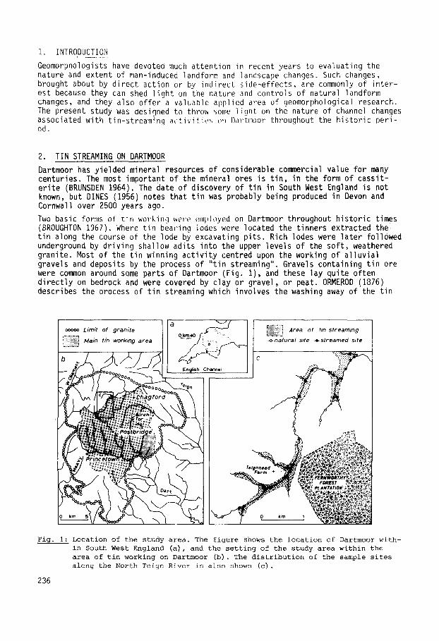
Two basic forms of t in work i~ were employed on Dartn~or throughout h is tor ic times (BROUGHTON 1967). Where t in bearing lodes were located the t inners extracted the t in along the course of the lode by excavating p i ts . Rich lodes were la te r followed underground by driving shallow adits into the upper levels of the sof t , weathered granite. Most of the t in winning ac t i v i t y centred upon the working of a l luv ia l gravels and deposits by the process of " t in streaming". Gravels containing t in ore were common around some parts of Dartmoor (Fig. I ) , and these lay quite often d i rec t l y on bedrock and were covered by clay or gravel, or peat. ORMEROD (1876) describes the process of t in streaming which involves the washing away of the t in
S
Chann¢~
.: : i Area of hn strearmng
-o -na tu ra l si te - , . s t r e a m e d s i te
Fig. I: Location of the study area. The figure shows the location of Dartmoor with- in South West England (a), and the setting of the study area within the area of tin working on Dartmoor (b). The distribution of the sample sites along the North Teign River is also shown (c).
236
by agitating the f luv ia l gravel down an inclined plane down which a rapid stream of water is taken (generally the diverted "natural stream" of the valley f loor) . Although archaeological evidence of the process of t in streaming is rather scanty, one approach used on Dartmoor appears to have involved increasing the speed of flow of the water by a r t i f i c i a l l y narrowing the channel width. This could be done either by constructing r ig id banks along the reach in question, or by forcing the "stream" to flow along a newly defined course, excavated in the valley gravels, with a channel width narrower than the or ig inal . The period of intensive t in streaming on Dartmoor apparently began in the twelfth century A.D., and i t is be- lieved to be responsible for the f inal depletion of forest remnants because the wood was used for charcoal in smelting the ore, and al l r iverine woodland would have been destroyed by the streaming process of reworking al luvial gravels (SIM- MONS 1964). The major periods of t in production appear to have been the early se- venteenth to mid-eighteenth centuries, and the late nineteenth century (DINES 1956). The large scale streaming ac t iv i t ies of the late nineteenth century are reflected in contemporary accounts of rapid rates of s i l t i ng in the estuaries and harbours of South West England (SYMONS 1874, WHITLEY 1877) because of the massive quantit ies of s i l t and sand introduced into the t r ibutary streams by both t in streaming and china clay working.
One of the most important areas of Dartmoor for t in streaming was around Chagford in the north west (Fig. lb), close to the metamorphic aureole around the granite, and BROUGHTON (1967) comments that "these may be among the oldest workings in De- von". The history of t in production in the period 1480 to 1597 around Chagford and the headwaters of the River Teign has been traced from parish records by ORME- ROD (1876), and BROUGHTON (1967) suggests that most workings were abandoned by the late seventeenth century. Some, however, were later to be reworked from the late nineteenth century unt i l the early years of the present century. Further south, around Birch Tor (Fig. Ib) and Bennett's Cross, the t in bearing lodes were worked mainly between 1852 and 1907 (V~CALISTER 1909).
The present study centres upon the North Teign River (Fig. i c ) , which flows through Chagford, because of the long history of t in streaming ac t i v i t y in that area, and because the reaches of the val ley- f loor which were streamed are clearly v is ib le today because of the abundance of heaps of rock waste and series of shallow explo- ratory trenches driven into the floodplain gravels (BROUGHTON 1968). Aerial photo- graphs show many of the features of former streaming ac t iv i t ies along the flood- plain of the North Teign, but these could not be used as a date source in the pre- sent study because of their small scale.
3. ANTICIPATED CHANNEL CHANGES
The aim of the study was to test for signif icant differences in channel form be- tween those sites along the North Teign which have been subjected to t in stream- ing, and those which have not. Identi f iable channel changes might be anticipated because of either direct or indirect effects.
3.1. g ! ~ S _ ~ f f ~ . ~ f _ ~ m ! ~ 9 These would arise because of the intentional transfer and movement of tin-bearing gravels across the valley f loor si tuat ion, as part of the streaming process. This could lead to a direct modification of channel form either because the stream would have been l e f t to find i ts own course through l inear heaps of waste material thrown to one side after the i n i t i a l stages of streaming (BROUGHTON 1968), or be- cause in some reaches the channel i t se l f was confined within a re la t ive ly narrow, boulder-lined course to increase velocity and hence remove waste sediment from the sites of the streaming operations.
237
3.2. !~i~_~!~§_Q~_~miag These might resul t from the release of large quanti t ies of f ine sediment from the valley f loor deposits into the stream d i rec t ly as a resul t of the streaming and washing of the stream gravels. This could a l te r the balance between sediment trans- port and channel form, and so promote channel adjustment (SCHUMM 1969). Alterna- t i ve l y , the removal of the forest cover from the area during the early h is tor ic times could have markedly affected the ent i re sediment balance of the stream sys- tem. This l a t t e r e f fect would probably only have been transient, however, and re- covery of the f luv ia l system would not have taken a number of centuries.
4. THE APPROACH
A spatial interpolat ion approach was adopted to evaluate the anticipated d i f feren- ces in channel form between streamed and natural reaches of the study r iver . This approach centres on col lect ing f i e l d measurements of channel form properties at a sample of "natural" (non-streamed) s i tes, and then examining the regular i ty of va- r ia t ion of these channel form character ist ics re la t ive to some measure of location within the channel network. Because of the cont inui ty of f luv ia l processes within a channel network, the channel form variables (capactiy, width and depth at the bankfull stage) often demonstrate well defined relat ionships with measures of re- la t ive location such as distance downstream (HACK 1965), total stream length (GREGORY 1977) and drainage area (PARK 1976) in natural streams, and these rela- tionships can be used as diagnostic of the natural pattern of channel changes along a stream. I f similar data are collected in the same way for non-natural si tes (in this case t in streamed s i tes) , these data can be plotted on the same graphs, and the nature, magnitude and di rect ion of differences between the natural and mo- d i f ied si tes can be ident i f ied . Whilst a spatial interpolat ion a p p r o a c h ~ e reveals l i t t l e about the processes by which the induced channel changes en brought about, the approach is valuable in recognizing the nature and scale of the changes.
Field n~asurements of channel size were collected from a total of 34 sites through- out the upper network of the North Teign on Dartmoor (Fig. Ic) . Each of the obser- vations relates to the bankfull stage, ident i f ied in the f i e ld on the basis of do- minant, and la te ra l l y continuous, breaks of slope, and vegetation l imi ts . Cross- sections were surveyed by placing a horizontal datum l ine across the channel, nor- mal to the dominant flow d i rect ion, and the inferred bankfull level . Depth read- ings from this datum to the channel perimeter were taken at about 20 points across the cross-section. Scale cross-section could then be plotted from these co-ordinates, and channel capacity (bankfull cross-sectional ~rea) was measured from these with a polar planimeter (the data are expressed in mC). Bankfull channel widths (m) were measured with a ru ler , and bankfull mean depths calculated by dividing capa- c i ty by width. Ten of the sample si tes were located in reaches which were not d i - rect ly affected by the t in streaming operations; and the others were located on streamed reaches. Drainage area was chosen as a suitable independent variable against which to relate variations in channel form because i t is less ambiguous than stream order, i t takes account of the total area providing discharge to the sample s i te , and i t is less dependent on map accuracy than stream length measure- ments. The drainage area t r ibutary to each sample s i te was measured from the 1:25,000 scal~ Ordnance Survey maps with a polar planimeter, and the data are ex- pressed in km L.
5. ANALYSIS AND RESULTS
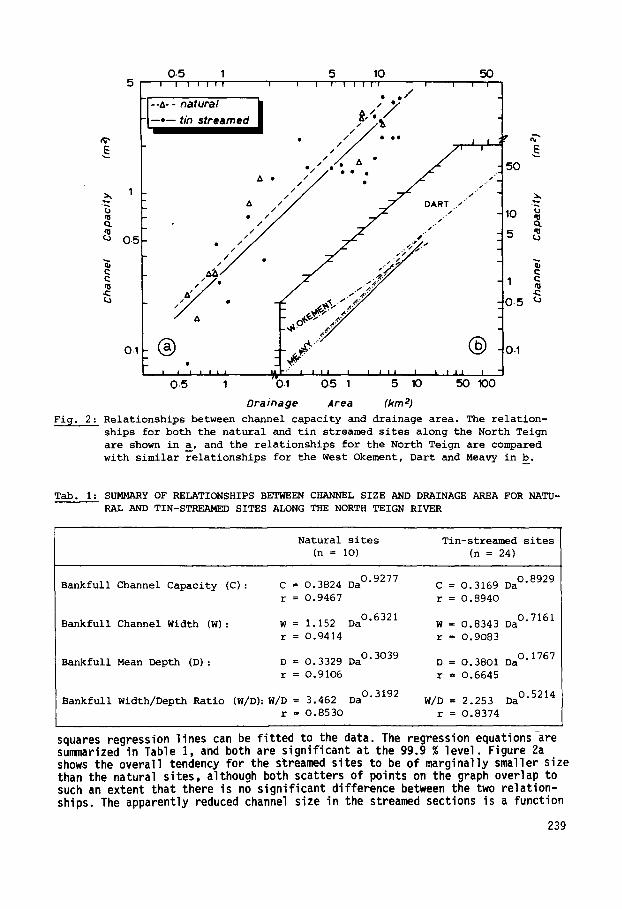
The relat ionships between channel capacity and drainage area for both the streamed and the natural sites are plotted in Figure 2a. Clearly in both groups of si tes channel capacity increases with increasing drainage area, and best f i t , least
238
0.5 1 5 10 50 5 i i i i i i ! i i i i ! i i i i i i i i
• e / ;L::: °"°" ' ' " "
• / / / / OO oe E 0/I • , , • - 50
A • ////
1 / / /
. . . . / / -
1"/ • ~ ~,~!-" , Y o. ~ f' k ~ o =- ,..:/
• . . . / ~ 0.1 ~ 0-1
0.5 1 0-1 0.5 1 5 10 50 100
Drainage Area (kin 2) Fig. 2 : Relationships between channel capacity and drainage area. The relation-
ships for both the natural and tin streamed sites along the North Teign
are shown in a, and the relationships for the North Teign are compared
with similar relationships for the West Okement, Dart and Meavy in b.
Tab. I: SUMMARY OF RELATIONSHIPS BETWEEN CHANNEL SIZE AND DRAINAGE AREA FOR NATU-
RAL AND TIN-STREAMED SITES ALONG THE NORTH TEIGN RIVER
Natural sites Tin-streamed sites
(n = 10) (n = 24)
Bankfull Channel Capacity (C): C = 0.3824 Da O'9277
r = 0.9467
Bankfull Channel Width (W): W = 1.152 Da 0"6321
r = O.9414
Bankfull Mean Depth (D): D = 0.3329 Da O'3039
r = O.9106
Bankfull Width/Depth Ratio (W/D): W/D = 3.462 Da O'3192
r = 0.853O
C = 0.3169 Da 0"8929
r = 0.8940
W = 0.8343 Da 0"7161
r = 0.9083
D = O.3801Da 0"1767
r = 0.6645
W/D = 2.253 Da 0"5214
r = 0.8374
squares regression lines can be f i t ted to the data. The regression equations are summarized in Table I, and both are significant at the 99.9 % level. Figure 2a shows the overall tendency for the sgreamed sites to be of marginally smaller size than the natural sites, although both scatters of points on the graph overlap to such an extent that there is no significant difference between the two relation- ships. The apparently reduced channel size in the streamed sections is a function
239
largely of reduced channel widths (Table i ) , and so the channel shape varies to some extent between the streamed and natural s i tes. This evidence suggests that there are no real differences between the streamed and natural s i tes, despite the long history of man-induced changes in the val ley f loor at the streamed si tes. At least three a l ternat ive explanations of this apparent lack of ident i f iab le impact seem possible:
a. There have either been no direct or indirect effects of streaming operations, or the effects fa i led to reach a threshold which would t r igger o f f marked and iden- t i f i a b l e channel changes.
b. There were perhaps channel changes associated with the t in streaming a c t i v i t i e s , but the f l uv ia l system has a relaxation time su f f i c i en t l y rapid for the evidence to have been removed, and for a more contemporary dynamic equil ibrium channel form to have become established.
c. The approach adopted was unsuitable for ident i fy ing channel changes. The morpho- metric approach adopted assumes that the sites which were not themselves streamed represent 'natural ' channels in the area. In many respects this might well not be true, because the spatial cont inui ty of response of channel changes to altered en- vironmental conditions means that even the sites along non-streamed reaches w i l l have been exposed to the indirect effects transmitted down from upstream.
The f i r s t interpretat ion cannot be tested in the absence of present day t in stream- ing operations in the area, and the evaluation of the second explanation would de- mand information on recent rates of channel change and adjustment in the study area which are not avai lable. I t was possible to consider the th i rd interpretat ion by means of two complementary analyses.
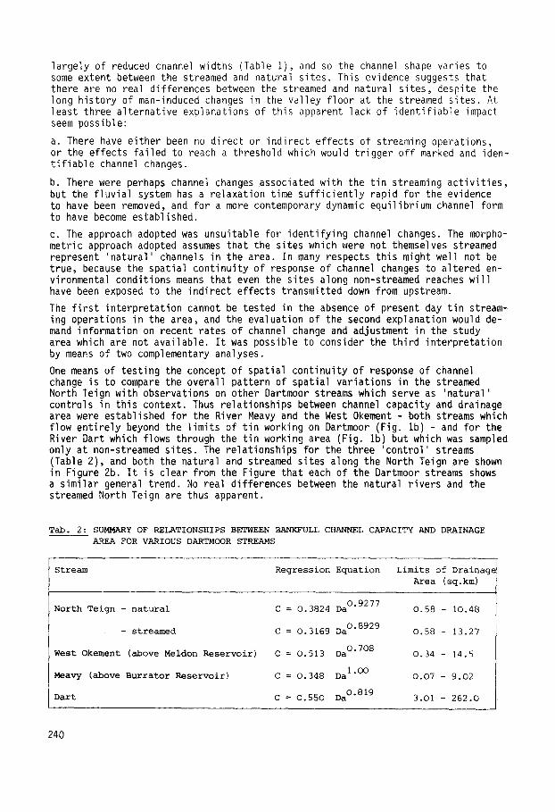
One means of testing the concept of spatial cont inui ty of response of channel change is to compare the overall pattern of spatial variat ions in the streamed North Teign with observations on other Dartmoor streams which serve as 'natural ' controls in this context, Thus relationships between channel capacity and drainage area were established for the River Meavy and the West Okement - both streams which flow en t i re ly beyond the l im i ts of t in working on Dartmoor (Fig. Ib) - and for the River Dart which flows through the t in working area (Fig. Ib) but which was sampled only at non-streamed s i tes. The relationships for the three 'control ' streams (Table 2), and both the natural and streamed sites along the North Teign are shown in Figure 2b. I t is clear from the Figure that each of the Dartmoor streams shows a s imi lar general trend. No real differences between the natural r ivers and the streamed North Teign are thus apparent.
Tab. 2: SUMMARY OF RELATIONSHIPS BETWEEN BANKFULL CHANNEL CAPACITY AND DRAINAGE
AREA FOR VARIOUS DARTMOOR STREAMS
Stream Regression Equation Limits of Drainage
Area (sq.km)
North Teign - natural
- streamed
West Okement (above Meldon Reservoir)
Meavy (above Burrator Reservoir)
Dart
C = 0.3824 Da O'9277 0.58 - 10.48
C = O.3169 Da O'8929 0.58 - 13.27
C = 0.513 Da O'708 0.34 - 14.5
I.OO C = 0.348 Da 0.07 - 9.02
C = 0.550 Da O'819 3.O1 - 262.0
240
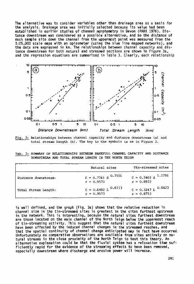
The alternative was to consider variables other than drainage area as a basis for the analysis. Drainage area was in i t ia l l y selected because its value had been established in earlier studies of channel morphometry in Devon (PARK 1976). Dis- tance downstream was considered as a possible alternative, and so the distance of each sample site down the channel from the uppermost point was measured from the 1:25,000 scale maps with an opisometer (using the blue line mapped networks), and the data are expressed in km. The relationships between channel capacity and dis- tance downstream for both natural and streamed sections are shown in Figure 3a, and the regression equations are summarised in Table 3. Clearly, each relationship
,00 !® ................... ® ................... ,0 %"/, . ;,/ 5 c ' }
~'~" . .- £".~
1 .=" ~ / j / / 1
0"5 /" • 0.5
As • &!1" ~"
o.1 o.1 • ._~
0 " 0 ~ l l l l i i I l l J J l l I I I ~ l l l l l i i j J l l a l l l l I J i J i l l l l l 0 , 0 5
o.1 o.5 ~ 5 ~o o-~ o-5 ~ 5 ~o
Distance Downstream (kin) Total Stream Length (kin)
Fig. 3: Relationships between channel capacity and distance downstream (a) and
total stream length (b). The key to the symbols is as in Figure 2.
Tab. 3: SUMMARY OF RELATIONSHIPS BETWEEN BANKFULL CHANNEL CAPACITY AND DISTANCE
DOWNSTREAM AND TOTAL STREAM LENGTH IN THE NORTH TEIGN
Distance downstream:
Total Stream Length:
Natural sites Tin-streamed sites
0.7556 1.1791 C = O.7741 d C = 0.3403 d
r = 0.9573 r = 0.8833
O.6113 0.8423 C = 0.6482 L C = 0.3247 L
r = 0.9573 r = 0.8753
is well defined, and the graph (Fig. 3a) shows that the relative reduction in channel size in the tin-streamed sites is greatest in the sites furthest upstream in the network. This is interesting, because the natural sites furthest downstream are those located on the main channel of the North Teign below the uppermost reach of tin-streaming activity. This suggest that the natural sites furthest downstream have been affected by the induced channel changes in the streamed reaches, and that the spatial continuity of channel change anticipated may in fact have occurred Unfortunately no comparative observations are available from sites entirely on na- tural streams in the close proximity of the North Teign to test this theory. An alternative explanation could be that the fluvial system has a relaxation time suf- f iciently rapid for the evidence of the streaming effects to have been removed, especiall~ downstream where discharge and erosive power will increase.
241
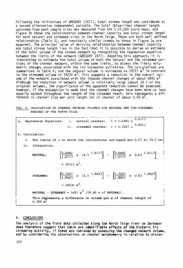
Following the init iat ives of GREGORY (1977), total stream length was considered as a second alternative independent variable. The total (blue-line) channel length upstream from each sample sites was measured from the 1:25,000 scale maps, and Figure 3b shows the relationships between channel capacity and total stream length for both natural and streamed sites in the North Teign. These are both well defined relationships (Table 3), and inevitably similar trends to those in Figure 3a are apparent. The principal value of deriving relationships betweenchannel capacity and total stream length lies in the fact that i t is possible to derive an estimate of the total volume of the stream network by integrating the regression equation between the limits of the network (GREGORY 1977). Adopting this approach, i t is interesting to estimate the total volume of both the natural and the streamed por- tions of the channel network, within the same limits, to assess the l ikely volu- metric changes associated with the tin streaminq activit ies. The calculations are summarized in Table 4; and the natural volume is estimated as 29721 m ° in contrast to the streamed volume of 24230 m e. This suggests a reduction in the overall v~l- ume of the network associated with the induced channel changes of about 5491 m . Although the reduction in network volume is relatively large (about 18 % of the original volume), the significance of the apparent reduction cannot be assessed. However, i f the assumption is made that the channel changes have been more or less equally spread throughout the length of the streamed reach, this repre§ents a di f- ference in channel size per unit length (m) of channel of about 0.40 m ~.
Tab. 4: CALCULATION OF CHANNEL NETWORK VOLUMES FOR NATURAL AND TIN-STREAMED
REACHES OF THE NORTH TEIGN
O.6113 a. Regression Equations: i. natural reaches: C = 0.6482 L
0.8423 ii. streamed reaches: C = 0.3247 L
b. Calculation:
i. The limits of L on which the calculations are based are 0.63 to 14.5 km.
ii. Integration:
NATURAL:
STREAMED :
[_7.048 ro..008 x .6113 x 14.5 [1.6113
= 29721 m 3.
7"3247 1 8423] r 0.3247 x 0.63 1.8423] .8423 x 14.5 • [1.8423
= 24230 m 3.
NATURAL - STREAMED= 5491 m 3 (18.48 % of NATURAL).
This represents a difference in volume per m of channel length of 0.395 m ~
6. CONCLUSIONS
The ana|ysis of the f ield data collected along the North Teign river on Dartmoor does therefore suggest that there are identifiable effects of the historic t in streaming act iv i ty, i f thee are isolated byassessing the changed network volume, and by considering the observations on channel morphometry in relation to distan-
242
ces along the channel network. I t is d i f f icu l t to assess the significance (in a statistical sense) of the apparent induced channel changes, but the net outcome is an apparent reduction in channel size in the t in streamed reaches in relation to natural reaches and the changes appear to have been brought about principally in the channel width dimension. Two possible explanations for this reduction in size can be envisaged. One would assume that the channel changes were a direct effect of the streaming activit ies, brought about by intentionally constricting channel widths in the streamed reaches to wash out tin from the valley-floor gra- vels by increasing the flow velocities in the streams (ORMEROD 1876). Such an ex- planation, however, would not allow for subsequent channel adjustment, or relaxa- tion of the constrained situation, which would appear to be unlikely given the periods of time involved. The evidence suggests that tin streaming activities along the North Teign ceased at the turn of the century, so this provides a pe- riod of at least 80 years for channel adjustment to have occurred. Inevitably the nature and speed of the adjustment will depend upon the magnitude and frequency of floodflows in the channel system, and on sediment supplied from upstream, al- though in the absence of long-term observations on both of these, i t is d i f f icu l t to reach any firm conclusions regarding recent channel adjustments. The alterna- tive explanation centres around the changes in sediment load and size which must logically have accompanied the tin streaming operations, and which could quite possibly have been perpetuated long after the direct effects of the streaming stopped. A reduction in channel width could be brought about by a decrease in the ratio of bed material load to total sediment load, or in the percentage of bed material which is carried (SCHUMM 1969), and these could readily have occurred with the washing out of the alluvial gravels during the streaming operations. The large scale deposition of fine alluvium in estuaries around south Devon and Corn- wall during the last century would tend to substantiate this possibility. I t is also possible that the changes in sediment loads and sizes could have been contin- ued after the main streaming ceased, because of the vast accumulations of worked fluvial gravel deposits which l ie unconformably on the valley bottom.
ACKNOWLEDGEMENTS
I am grateful to the British Geomorphological Research Group, and to the Pantyfedwen Fund of St. David's University College, Lampeter, for providing small research grants to cover the costs of field-work on Dartmoor. Graham Sumner kindly enlight- ened me on the subtleties of integration; and Ken Gregory was kind enough to offer advice and encouragement. Two anonymous referees also offered valuable comments on an early draft of the paper.
BIBLIOGRAPHY
BROUGHTON, D.G. (1967): Tin working in the eastern distr ict of the Parish of Chag- ford, Devon. Proceedings of the Geologists' Association 78, 447-62.
BROUGHTON, D.G. (1968): Dartmoor t in working - i ts Effects upon sc---enery and land use. The Kingston Geographer, 1, 31-9.
BRUNSDEN, D. (1964): The origin of the-decomposed granite. In: Dartmoor Essays, ed. I.G. SII~MONS, Devonshire Association, 97 - 116.
DINES, H.G. (1956): The metalliferous mining regions of South West England. Memoirs of the Geological Survey of Great Britain, H.M.S.O. London. 508 pp.
GREGORY, K.J. (1977): Stream network volume - an index of channel morphometry. Geological Society of America Bulletin, 88, 1075-80.
HACK, J.T. (1965): Postglacial drainage evolutio~'-and stream geometry in the On- tonagon area, Michigan. United States Geological Survey Professional Pa- per 504-B, 1-40.
MACALISTER, l)]'A~-. (1909): Note on the association of cassiterite and specular iron in the lodes of Dartmoor. Geological Magazine 402-9.
243
ORMEROD, G.W. (1876): On the traces of t in streaming in the v i c in i t y of Chagford Transactions of the Devonshire Association, 1, 110-5.
PARK, C.C. (1976): Variations and controls of stream-channel morphometry. Unpub- lished Ph.D. thesis, University of Exeter. 366 pp.
SCHUMM, S.A. (1969): River metamorphosis. American Society of Civi l Engineers, Proceedings. Journal of the Hydraulics Divisions, 95, 255-73.
SIMMONS, I.G. (1964): An ecological history of Dartmoor. In-T Dartmoor Essays, ed I.G. SIMMONS, Devonshire Association.
SYMONS, R. (1874): Alluvium in the Par Valley. Journal of the Royal Ins t i tu te of Cornwall, 16, 332-4.
WHITLEY, H.M. (1877-~: The s i l t i ng up of the creeks of the Fal, Journal of the Royal Ins t i tu te of Cornwall, 5, 382-4.
244