Embed Size (px)
Citation preview
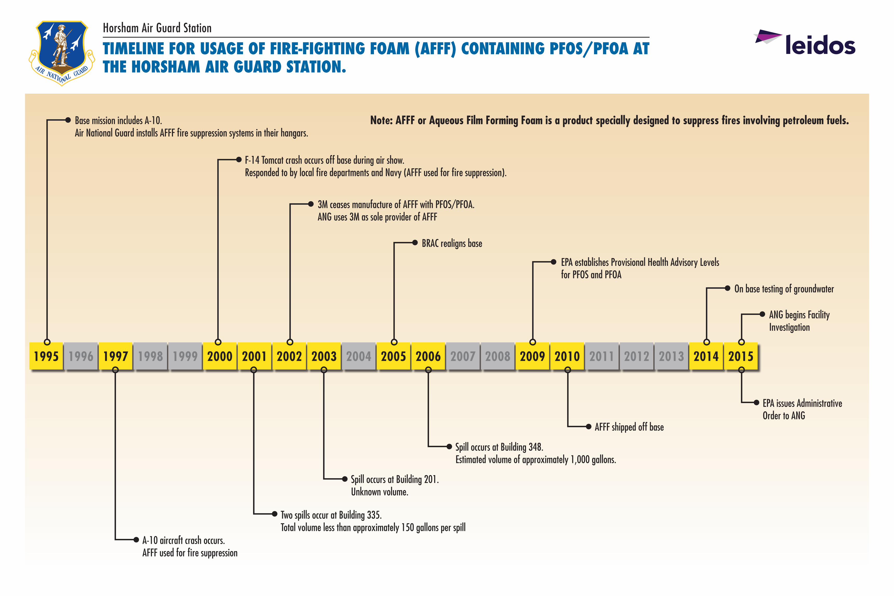
1995 1996 1997 1998 1999 2000 2001 2002 2003 2004 2005 2006 2007 2008 2009 2010 2011 2012 2013 2014 2015
Horsham Air Guard Station
Note: AFFF or Aqueous Film Forming Foam is a product specially designed to suppress fires involving petroleum fuels.
TIMELINE FOR USAGE OF FIRE-FIGHTING FOAM (AFFF) CONTAINING PFOS/PFOA AT THE HORSHAM AIR GUARD STATION.
Base mission includes A-10. Air National Guard installs AFFF fire suppression systems in their hangars.
F-14 Tomcat crash occurs off base during air show. Responded to by local fire departments and Navy (AFFF used for fire suppression).
3M ceases manufacture of AFFF with PFOS/PFOA. ANG uses 3M as sole provider of AFFF
EPA establishes Provisional Health Advisory Levels for PFOS and PFOA
BRAC realigns base
On base testing of groundwater
ANG begins Facility Investigation
Two spills occur at Building 335. Total volume less than approximately 150 gallons per spill
A-10 aircraft crash occurs. AFFF used for fire suppression
Spill occurs at Building 201. Unknown volume.
Spill occurs at Building 348. Estimated volume of approximately 1,000 gallons.
AFFF shipped off base
EPA issues Administrative Order to ANG
Horsham Air Guard Station
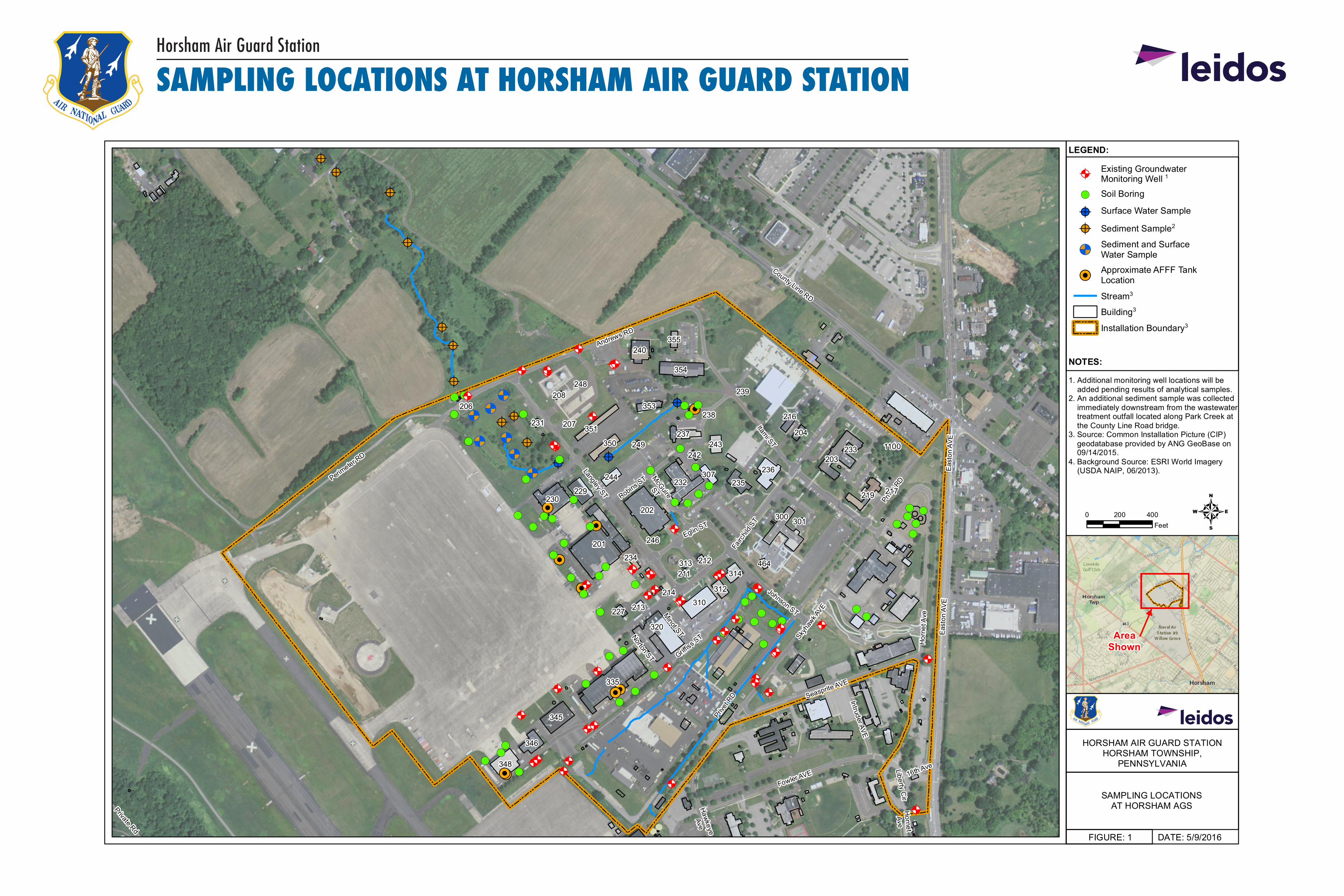
SAMPLING LOCATIONS AT HORSHAM AIR GUARD STATION
DATE: 5/9/2016FIGURE: 1PROJECT: \ANG_Horsham_PFCs\0_GIS\Projects|\FIWP\Actual_Location\Figure 1 Horsham Sample Locations_11x17.mxd
SAMPLING LOCATIONSAT HORSHAM AGS
HORSHAM AIR GUARD STATIONHORSHAM TOWNSHIP,
PENNSYLVANIA
&(
&(
&(
&(
&(
&(&(
&(&(
&<&<
&<
&< &<&<
&<
@?@?
@?
@?
@?
@?
@?
@?@?
@?
@? @?
@?
!(
!(
!(!(
!(
!(
!(
!(
!(!(!(
!(
!(!(
!(
!(
!(
!(
!(
!(!(
!(!(
!(
!(!(
!(!(
!(!(
!(
!(
!(
!(!(
!(!( !(!(
!(
!(!(
!(!(
!(!(
!(!(
!( !(!(!(
!(!(
!(
!(!( !(
@A @A@A @A@A
@A@A@A@A
@A@A
@A
@A
@A@A
@A@A
@A
@A@A@A
@A@A
@A
@A@A@A
@A
@A
@A@A
@A
@A @A@A
@A@A@A
@A
@A
@A@A
@A
@A
@A@A
@A
@A
Hawkeye
Ave
HornetAve
Prive
t RD
16th Ave
Privet
RD
Private Rd
Liberty Cir
Minot STNorton STMcGuire
ST
Intruder AVE
Robins ST
Eglin ST
Johnson ST
Eas
ton
AVE
Seasprite AVE
Fowler AVE
Griffiss S
T
Perimeter R
D
Langley ST
Andrews RD
Hor
net A
ve
Itami ST
Eas
ton
AVE
Fairc
hild S
T
Skyh
awk A
VE
County Line RD
207
314464
211
212234313
246
232
310227
301
213
307
320
345
230229 219
312
244
300
346
201
348
236
202
242
217235
335
214
350
216
239
237
240
351
1100
208
204
353
233203
355
243
248
249
231
354
AreaShown
NOTES:
LEGEND:
1. Additional monitoring well locations will be added pending results of analytical samples.2. An additional sediment sample was collected immediately downstream from the wastewater treatment outfall located along Park Creek at the County Line Road bridge.3. Source: Common Installation Picture (CIP) geodatabase provided by ANG GeoBase on 09/14/2015.4. Background Source: ESRI World Imagery (USDA NAIP, 06/2013).
40 200 400Feet
@AExisting GroundwaterMonitoring Well 1
!( Soil Boring
@? Surface Water Sample
@? Sediment Sample2
&<Sediment and SurfaceWater Sample
&(Approximate AFFF TankLocation
Stream3
Building3
Installation Boundary3
206238
Horsham Air Guard Station
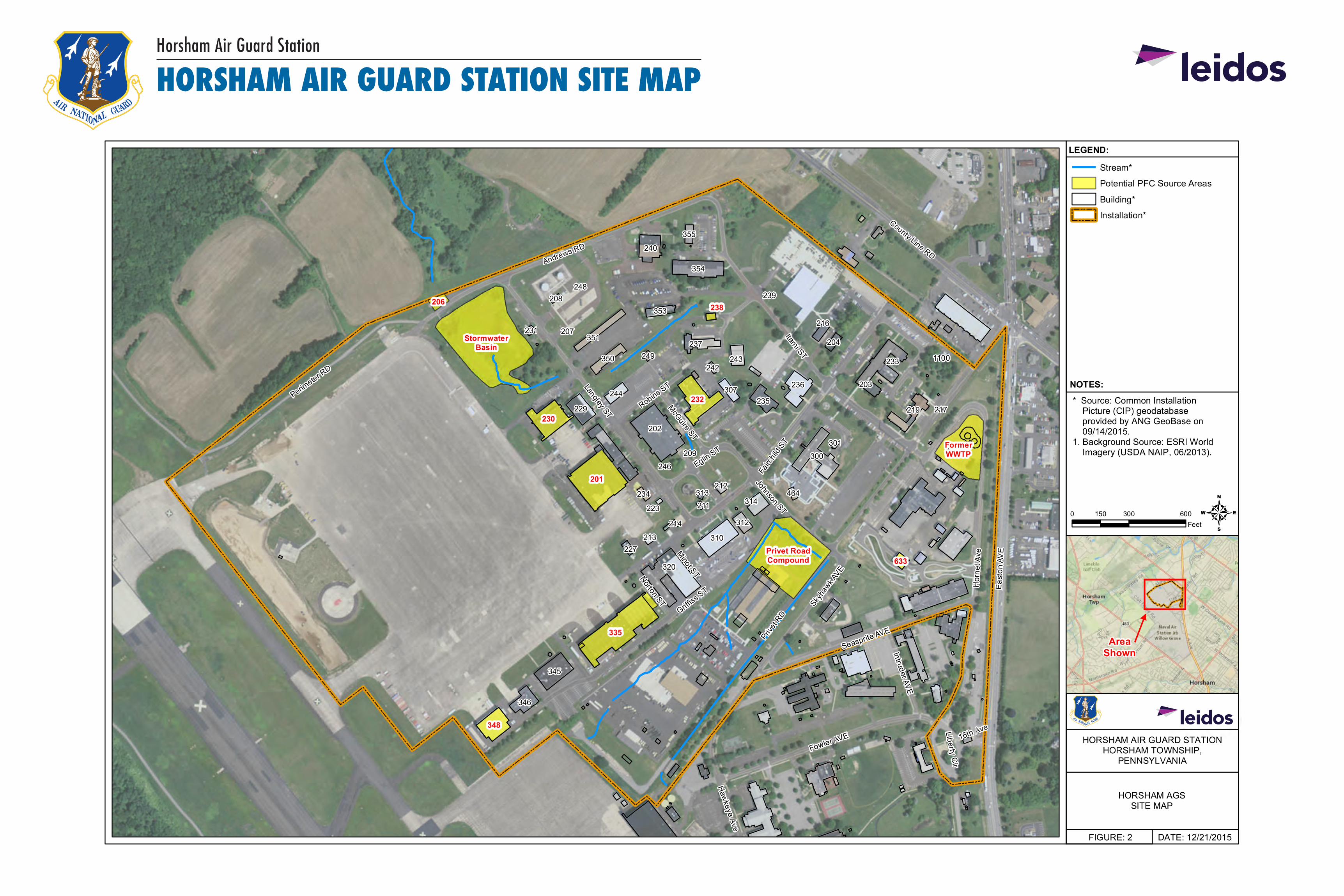
HORSHAM AIR GUARD STATION SITE MAP
DATE: 12/21/2015FIGURE: 2PROJECT: \ANG_Horsham_PFCs\0_GIS\Projects|\FIWP\UFPQAPP\Figure 2 Site Map_11x17.mxd
HORSHAM AGSSITE MAP
HORSHAM AIR GUARD STATIONHORSHAM TOWNSHIP,
PENNSYLVANIA
207
209
314464
211
212234 313
246
310227
301
213
307
320
345
229 219
312
223
244
300
346
236
202
242
217235
214
350
216
239
237
240
351
1100
208
204
353
233
203
355
243
248
249
231
354
Prive
t RD
16th AveLiberty Cir
Haw
keye Ave
Minot STNorton ST
McGuire ST
Intruder AVE
Robins ST
Eglin ST
Johnson ST
Seasprite AVE
Fowler AVE
Griffiss
ST
Perimeter R
D
County Line RD
Langley ST
Andrews RD
Hor
net A
ve
Itami ST
Fairc
hild
ST
Eas
ton
AVE
Skyh
awk A
VE
206
StormwaterBasin
230
201
348
Privet RoadCompound 633
FormerWWTP
232
AreaShown
NOTES:
LEGEND:
* Source: Common Installation Picture (CIP) geodatabase provided by ANG GeoBase on 09/14/2015.1. Background Source: ESRI World Imagery (USDA NAIP, 06/2013).
40 300 600150Feet
Stream*
Potential PFC Source Areas
Building*
Installation*
335
238
18