Embed Size (px)
Citation preview

Procedia - Social and Behavioral Sciences 35 ( 2012 ) 440 – 448
1877-0428 © 2012 Published by Elsevier B.V. Selection and/or peer-review under responsibility of Centre for Environment-Behaviour Studies(cE-Bs), Faculty of Architecture, Planning & Surveying, Universiti Teknologi MARA, Malaysiadoi: 10.1016/j.sbspro.2012.02.109
AicE-Bs 2011 Famagusta
Asia Pacific International Conference on Environment-Behaviour Studies, Salamis Bay Conti Resort Hotel, Famagusta, North Cyprus, 7-9 December 2011
Time Constraints in Emergencies Affecting the Use of Information Signs in Wayfinding Behavior
Meng-Cong Zheng* Department of Industrial Design, National Taipei University of Technology, Taiwan
Abstract
The purpose of this study is to understand how time constraints affect users’ wayfinding behavior corresponding to information signs. Experiments on subjects with non-wandering priority wayfinding with time constraints and wandering priority wayfinding without any time constraints were conducted to simulate the actual situation of people in above-ground and under-ground spaces. Results showed that directional signs are used to help the users follow instructions and to direct people to move straight ahead. Orientation signs like maps force the users to memorize the information and confirm the destination shown on them. © 2011 Published by Elsevier Ltd. Selection and peer-review under responsibility of Centre for Environment-Behaviour Studies (cE-Bs), Faculty of Architecture, Planning & Surveying, Universiti Teknologi MARA, Malaysia
Keywords: Time constraint; information signs; wayfinding behaviour; public space.
1. Introduction
The design of the public environment must fulfill everyone’s needs. The public sign system is designed for people to move freely. It helps people to find the right way and to engage in various activities. Since we have ample time, we can enjoy the process of wayfinding in the fine design of the public environment. It is already known that landmarks or buildings above-ground can provide
* Meng Cong Zheng. Tel.: +886-2-27712171; fax: +886-2-2731-7183. E-mail address:[email protected]
Available online at www.sciencedirect.com
© 2012 Published by Elsevier B.V. Selection and/or peer-review under responsibility of Centre for Environment-Behaviour Studies(cE-Bs), Faculty of Architecture, Planning & Surveying, Universiti Teknologi MARA, MalaysiaOpen access under CC BY-NC-ND license.
Open access under CC BY-NC-ND license.

441 Meng-Cong Zheng / Procedia - Social and Behavioral Sciences 35 ( 2012 ) 440 – 448
wayfinding clues, and are more useful than man-made information signs. One of the aims of this study is to try and determine the natural wayfinding behavior of people when they travel between two places, that is, how people find their destination without help from other people, and what wayfinding problems they face in man-made surroundings. Previous studies show that most of the signs installed above-ground to assist in navigation are maps whereas in underground spaces, directional signs are more often installed.
These two signs are the most commonly used signs to assist in wayfinding. People’s wayfinding behavior changes corresponding to the wayfinding distance. There are two strategies for wayfinding- floor wayfinding strategy and direction wayfinding strategy. When they are in a new space, people use the wayfinding strategy that best relates to their personality or wayfinding experiences. They tend to have either a non-wandering priority or a wandering priority during their wayfinding (Zheng, 2009). People tend not to have a wandering priority for short distance wayfinding. However, in case of disasters such as earthquakes and tsunamis, where one needs to find shelter promptly, signs supporting wayfinding should be inspected more closely. Many studies focus on individual differences in simulated wayfinding, but very few focus on the relationship between different spaces and the manner of installation of such signs, especially under time constraints. This study simulated time pressure wayfinding experiments by comparing existing public signs in different spaces to understand how different spaces and signs affect behavior and how information signs should be designed in order to satisfy people’s wayfinding needs.
2. Method
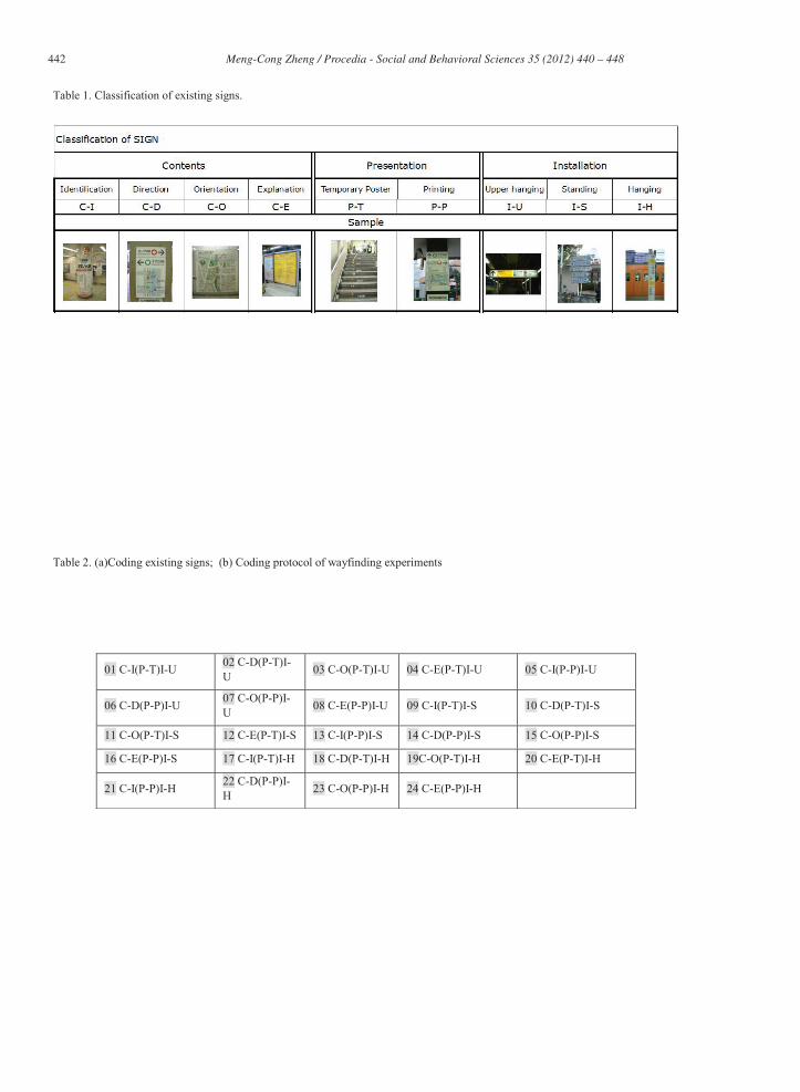
The public sign system is designed so that people may go from one place to another without having to depend on directions from other people. This wayfinding experiment is a method to evaluate the effect of this sign system. The purpose of this study is to understand how pressure and emergencies affect wayfinding behavior with regard to the use of signs, and to improve the quality of public environments for pedestrians, enhance the effectiveness of the signs in emergencies, and set the wayfinding time needed to move from one station to another on foot for routes above ground and underground. In this study, wayfinding experiments were conducted for above-ground and underground spaces. The varied behavior of users when they change stations and how information signs should help them can be identified by studying these elements in a real environment. Comparing the results of the experiment will help us understand how information signs correspond to users’ varied wayfinding behavior. In this study, the information signs that are presently installed above ground and underground were examined and classified by content, presentation, and installation. Each was marked with a specific number before the experiment was conducted. It is very useful to mark the location of a sign with a specific number. For example, the sign content was classified in terms of identification, direction, orientation, and explanation (Tables 1 and 2). People tend to have either a non-wandering priority or a wandering priority during their wayfinding (Zheng, 2008). The experiments in this study were conducted on subjects with non-wandering priority wayfinding with time constraints and wandering priority wayfinding without time constraints to simulate the actual situation of people moving between stations above ground and underground.
442 Meng-Cong Zheng / Procedia - Social and Behavioral Sciences 35 ( 2012 ) 440 – 448
Table 1. Classification of existing signs.
Table 2. (a)Coding existing signs; (b) Coding protocol of wayfinding experiments
01 C-I(P-T)I-U 02 C-D(P-T)I-U 03 C-O(P-T)I-U 04 C-E(P-T)I-U 05 C-I(P-P)I-U
06 C-D(P-P)I-U 07 C-O(P-P)I-U 08 C-E(P-P)I-U 09 C-I(P-T)I-S 10 C-D(P-T)I-S
11 C-O(P-T)I-S 12 C-E(P-T)I-S 13 C-I(P-P)I-S 14 C-D(P-P)I-S 15 C-O(P-P)I-S
16 C-E(P-P)I-S 17 C-I(P-T)I-H 18 C-D(P-T)I-H 19C-O(P-T)I-H 20 C-E(P-T)I-H
21 C-I(P-P)I-H 22 C-D(P-P)I-H 23 C-O(P-P)I-H 24 C-E(P-P)I-H

443 Meng-Cong Zheng / Procedia - Social and Behavioral Sciences 35 ( 2012 ) 440 – 448
Think-aloud protocol (TAP) is a data accumulation method used in usability testing in design, psychology, and a range of social sciences. Conversations with the subjects of the experiment were recorded and then coded and categorized into three parts according to their wayfinding process and the category proposed by the references. The subjects’ navigation time, location, and mood were also recorded (Fig 1).
There are two experiments implemented in above ground and underground spaces, including two fifty- minute routes. Experiment 1: Wandering priority wayfinding without time constraints
The wandering priority aspect was addressed with four subjects who were clearly told that there would be no time constraint and they could move freely toward their destination. For the wandering priority experiment, four subjects were asked to move from Jinbocho Station to Ochanomizu Station. In underground space, four subjects were also asked to finish their transfer from Keiyosen to Sobusen at Tokyo Station. Experiment 2: Non-wandering priority wayfinding with time constraints
For the non-wandering priority experiment, four subjects were asked to finish their transfer from Jinbocho Station to Ochanomizu Station within 12 minutes.
In the underground space, four subjects were asked to finish their transfer from Keiyosen to Sobusen at Tokyo Station within 12 minutes.
Fig. 1. Method of categorizing protocol in wayfinding experiments.
3. Results of wayfinding experiments
3.1. Wayfinding in above-ground space
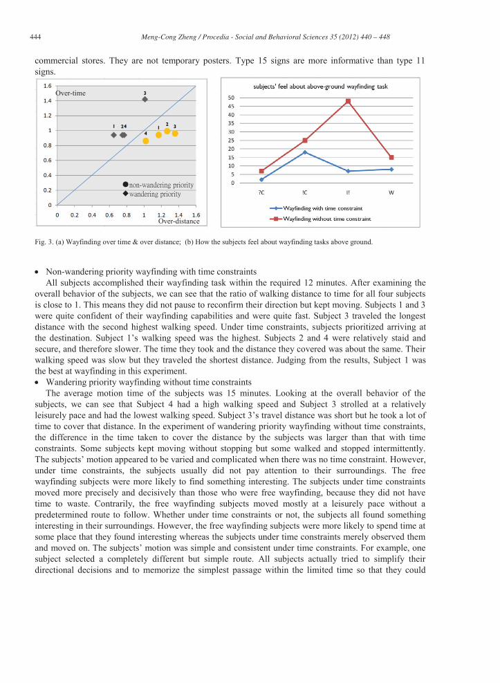
The existing signs at the underground site are located at regular intervals between Jinbocho Station and Ochanomizu Station, especially on the main route. The majority of the signs were type 11 (Table 2) signs, followed by type 15 signs. Type 11 signs provide printed information to orient people and are standing signs. Their purpose is to explain the legal conditions for parking bicycles and to help people identify no-smoking zones instead of giving wayfinding information. For this reason, a large number of the same signs were set up along the main road. Type 15 signs are maps that are installed by the public or by
444 Meng-Cong Zheng / Procedia - Social and Behavioral Sciences 35 ( 2012 ) 440 – 448
commercial stores. They are not temporary posters. Type 15 signs are more informative than type 11 signs.
Fig. 3. (a) Wayfinding over time & over distance; (b) How the subjects feel about wayfinding tasks above ground.
Non-wandering priority wayfinding with time constraints
All subjects accomplished their wayfinding task within the required 12 minutes. After examining the overall behavior of the subjects, we can see that the ratio of walking distance to time for all four subjects is close to 1. This means they did not pause to reconfirm their direction but kept moving. Subjects 1 and 3 were quite confident of their wayfinding capabilities and were quite fast. Subject 3 traveled the longest distance with the second highest walking speed. Under time constraints, subjects prioritized arriving at the destination. Subject 1’s walking speed was the highest. Subjects 2 and 4 were relatively staid and secure, and therefore slower. The time they took and the distance they covered was about the same. Their walking speed was slow but they traveled the shortest distance. Judging from the results, Subject 1 was the best at wayfinding in this experiment. Wandering priority wayfinding without time constraints
The average motion time of the subjects was 15 minutes. Looking at the overall behavior of the subjects, we can see that Subject 4 had a high walking speed and Subject 3 strolled at a relatively leisurely pace and had the lowest walking speed. Subject 3’s travel distance was short but he took a lot of time to cover that distance. In the experiment of wandering priority wayfinding without time constraints, the difference in the time taken to cover the distance by the subjects was larger than that with time constraints. Some subjects kept moving without stopping but some walked and stopped intermittently. The subjects’ motion appeared to be varied and complicated when there was no time constraint. However, under time constraints, the subjects usually did not pay attention to their surroundings. The free wayfinding subjects were more likely to find something interesting. The subjects under time constraints moved more precisely and decisively than those who were free wayfinding, because they did not have time to waste. Contrarily, the free wayfinding subjects moved mostly at a leisurely pace without a predetermined route to follow. Whether under time constraints or not, the subjects all found something interesting in their surroundings. However, the free wayfinding subjects were more likely to spend time at some place that they found interesting whereas the subjects under time constraints merely observed them and moved on. The subjects’ motion was simple and consistent under time constraints. For example, one subject selected a completely different but simple route. All subjects actually tried to simplify their directional decisions and to memorize the simplest passage within the limited time so that they could
Over-distance
Over-time

445 Meng-Cong Zheng / Procedia - Social and Behavioral Sciences 35 ( 2012 ) 440 – 448
move quickly (Fig 3a). The free wayfinding subjects’ paths were rather scattered. They stopped from time to time on the way. They were courageous enough to try new routes even though they were not sure if they would lead them to their destination. Since they had no time constraints, the subjects had enough time to reconfirm their direction and routes. The subjects under time constraints appeared quite decisive and positive when they were on the straight route. Although they might have been distracted and confused at the turns, their intention to reach their destination straight away was not affected. The free wayfinding subjects were in a better mood and had the spare time to explore interesting things during the whole process. They too were confused at the turns, but for them, wayfinding was an easy and pleasurable process (Fig. 3b).
3.2. Wayfinding in underground spaces
Type 06 (Table 2) is the most popular in terms of quantity for the existing sign system at underground sites. For effective use of space, a station needs as much spare floor room as possible for people to walk. Therefore, an I-U (upper hanging) installation is preferred and its content is usually presented by C-D (content-direction). Compared to C-O (content-orientation), C-D allows people to grasp directions quickly and move fast.
Non-wandering priority wayfinding with time constraints: Subjects 1, 2, and 3 had almost the same walking speed. They hardly stopped. Subject 4 was slower and more cautious than others. He did not change his route unless he was certain that the change would save him time. Therefore, he spent more time than others, but his motion distance was not longer.
Wandering priority wayfinding without time constraints: Subject 1 had the fastest walking speed. Subjects 1 and 4 were both fast, whereas Subjects 2 and 3 were comparatively slow. The subject who really had a problem with wayfinding was Subject 3; he stepped onto the wrong platform (Fig 4a).
The subjects under time constraints mostly found the signs first, confirmed the information on them, and then decided to move. They were confident at the beginning, but gradually lost their assurance as they moved on. If something went wrong during the wayfinding, they backtracked to look for a sign. Changes in their mood were about the same. Normally, the subjects followed a pattern of finding a sign, understanding it, and then deciding to move.
Fig. 4. (a) Wayfinding over time & over distance; (b) How the subjects feel about underground wayfinding tasks
Their mood changed mainly when they found something interesting. At times, they got worried or confused. If they had sufficient time, the subjects tried to explore their surroundings before proceeding straight to the next passage (Fig4b). Most subjects found a sign, recognized the direction shown on the
Over-distance
Over-time

446 Meng-Cong Zheng / Procedia - Social and Behavioral Sciences 35 ( 2012 ) 440 – 448
sign, determined their direction, moved along the decided route, and then looked for the next sign. The basic requirements for the subjects to understand the directions were all satisfied by the signs installed in the station. The subjects under time constraints moved more precisely and decisively than those who were free wayfinding, because they did not have time to waste. Contrarily, the free wayfinding subjects moved mostly at a leisurely pace without a predetermined route to follow. The space was confined to the station. All the subjects’ movements were quite similar after they had read the sign. Under time constraints, the subjects tended to make mistakes when they were nervous, but usually corrected their mistakes in a brief amount of time. Subjects with sufficient time moved freely and widely. If they had problems wayfinding, they still looked for signs without getting worried or then simply followed the route they were on to see if there were other signs. The shops along the route are mostly installed against the wall to avoid interfering with pedestrian traffic flow. Most are gift shops, convenience stores, and bookstores. Some of them are well known. The subjects showed interest in these shops. Subjects under time constraints normally paid attention to the signs installed along the passage, but those with sufficient time observed their surroundings. Subjects with time constraints had wayfinding problems at several places at the station. For example, they either could not find a sign or misread the sign and stepped onto the wrong platform. They appeared more confident when they were on the correct route; only once in a while would their attention wander to the shops arround them. On the contrary, free wayfinding subjects paid attention to the change in their surroundings and not only to the signs. Their mood changed more signiificantly—they had much more time to get either bored or interested than did the subjects under time constraints. Most of the time, they were satisfied with wayfinding and exploring the environment at the same time, although sometimes they did have problems with the wayfinding.
4. Discussions
Many map signs were installed above ground. The subjects memorized the route they chose, engaged in wayfinding, and kept confirming the information in their minds. In underground spaces, the subjects did not memorize the route because there were many direction signs to aid them in confirming their next step. This helps to route the flow of people smoothly (Fig.6a). Regardless of subjects wayfinding with or without time constraints, they were more inclined to stop in underground spaces than in above-ground spaces (Fig.6b). Subjects who were wayfinding in spaces above ground stopped to change routes. However, subjects who were wayfinding in underground spaces stopped to read the directional signs or to change routes. Different spaces had different types of signs, which affected people’s wayfinding behavior.
Fig. 6.(a) Codes & Wayfinding processes; (b) Stop times & Time constraints

447 Meng-Cong Zheng / Procedia - Social and Behavioral Sciences 35 ( 2012 ) 440 – 448
5. Conclusions
Most wayfinding studies focus on the memory of wayfinding, or use computer simulation experiments to measure the efficiency of wayfinding. This study investigated the wayfinding capabilities of subjects in different spaces under time constraints and evaluated sign systems in order to create better public surroundings. The following are the findings:
Under the same conditions, some subjects would proceed actively but some others would stroll at a leisurely pace to their destination. Individual differences such as gender and age can be clues to help design a wayfinding system for poor wayfinding users moving in public spaces. This study indicated that the wayfinding behavior of people is influenced by space and time constraints. There was no room for mistakes for subjects under time constraints. The most important thing was for them to reach their destination correctly and in time. They knew certain shortcuts might help them save time, but unless they were absolutely sure, most of them felt more comfortable following the main route.
The main purpose of signs is to allow users to move freely and independently in a space. These different demands require the support of both directional and orientation signs. Directional signs are suitable for crowds moving fast in a single direction, but their effectiveness is limited if they are used for understanding the immediate surroundings. However, if orientation signs can provide the user with information that is easy to understand and memorize, and is in line with the landmarks in the surrounding areas, then traveling and confirming routes of travel can be parallel processes to save time. Directional signs in underground stations could have been installed considering people’s behavior in totality. This would have been helpful to the stream of people moving within the station. However, the surroundings rendered this idea near-impossible. For example, most subjects encountered wayfinding problems at the first entrance. This was because it was not easy to find the sign since it was behind them. The directional signs that were used directed people to move straight ahead, but the people had to see the sign first before they could make a judgment. If a certain situational constraint made it difficult to find the directional signs, wayfinding problems would arise. Contrarily, memorizing directional information and then looking for other information that could confirm these directions may be a better way of verifying the information that signs provide. It may be more effective to provide a variety of signs with different content at the right places to suit different situations. We also found that time was key in judging which path should be used. Information such as “how much further” was quite important to them. This information was used to evaluate how much time they still needed to reach their destination. Under time constraints, frequently checking the remaining time was common among the subjects. Information that allowed them to confirm distance and time was very important for wayfinding in emergencies.
The first sign you see when you start wayfinding is the most important. If subjects read this sign incorrectly, wayfinding will be very difficult. The “You Are Here” format is currently widely used in maps. Information such as a large building’s name, road’s name, an institute, and other landmarks is usually shown on above-ground maps. However, on maps installed inside stations, subjects can only see the positions of all the train lines. It is quite difficult for users to memorize, move, and reconfirm a route owing to the lack of confirmation clues. Accordingly, the map as a sign is almost a waste. In addition, the subjects pointed out that it is difficult to identify the correct sign due to the large number of signs installed underground. Advertisements and lights within the station also increase the difficulty level of identification. Installing more signs is not the solution to fulfilling the requirements of wayfinding in public spaces. It was also found that the straight walking path underground made the subjects bored of the experiment. The surroundings were always cold and boring unless measures were taken to ensure otherwise, and the air was stale. Previous study indicated what feels good about places may include users can see and hide but not be seen, especially overview in safety and escape to safety. Besides, some mystery is always exciting, but too much of it can be confusing. People enjoy shopping all the more since
448 Meng-Cong Zheng / Procedia - Social and Behavioral Sciences 35 ( 2012 ) 440 – 448
they spend less time wayfinding (JC Chebat, 2008). A number of signs were installed to guide the travelers so that they could maintain a smoothly moving path; all they had to do is follow the signs. It was also found that some subjects referred to the maps installed inside the station. However, in contrast to the maps installed above ground, the maps inside the station had no distinct objects for people to memorize. The current underground station’s layout cannot confirm directions with the help of buildings or other landmarks like the above-ground layout. Layout or landmark information is sufficient only for orienting wayfinding. Besides, some subjects mentioned that when there was less time left and they were not sure which way to go next, they thought of asking other people for help. As a matter of fact, it is not easy to ask people for help in such a complicated and crowded place as Tokyo Station. Language was another hindrance. Even though the personnel at the information desk would answer inquiries, the system of signs is meant to help people to move independently. It also reveals that under time constraints, users require more information from the signs than what they currently provide. Whether it is above ground or underground, there are still connecting paths between different stations where the issue of whom the signs in the transfer areas belong to has always been ambiguous. A graphic design of the surroundings that integrates the sign systems is a good way to present landmarks in a limited space. Therefore, key spots with landmarks, which are good clues for orientating oneself, must be shown on maps, and the information must be constantly updated. We can see from the above that the contents of signs need to be reassessed and reworked so that wayfinding is made easy in times of disasters. We must also understand the importance of ensuring ease of wayfinding in any environment. In addition, designers should elevate the quality of life by ensuring that these signs create a friendlier environment.
References
Miyagishi Yukimasa, A Study on Way-finding from the Underground to the Surface Goal According to Thinking-aloud Protocol Analysis. Papers on City Planning, Vol. 37, pp.19-24 (2002)
Wayfinding-oriented Design for Passenger Guidance Signs in Large-scale Transit Center in China, Transportation Research Board of the National Academies, Journal of the Transportation Research Board, Vol. 2144, pp.150-160 (2010)
Meng-Cong Zheng, Ming-Shih Chen, Pei-Ying Li, Post-occupancy Evaluation of Information Signs and Pre-Boarding Behavior in a Historic Railroad Station. Journal of Asian Architecture and Building Engineering, Vol. 9, No. 1, pp.177-184 (2010)
Ivan Chermayeff, Chris Calori, Signage And Wayfinding Design: A Complete Guide to Creating Environmental Graphic Design Systems, p.124 (2007)
Meng-cong Zheng, Tadao Shimizu, Kiminobu Sato, Information Signs Based on Users’ Wayfinding Behavior in Transfer between Above-ground Stations, Bulletin of Japanese Society for the Science of Design,Vol. 55, No. 6, p.1-10 (2009)
D. Chang, Spatial Choice and Preference in Multilevel Movement, Environment and Behavior, Vol.34, No.5, p.582-615 (2002) E. Pontikakis, F. Twaroch, ‘Schematic maps as an alternative to point coverages when topographic maps are not available’,
Proceedings of 10th International Conference on Information Visualization (IV’06), ed. by Banissi, E., pp. 297-303, IEEE Computer Society, London (2006)
Jean-Charles Chebat, Claire Gélinas-Chebat and Karina Therrien, Gender-related wayfinding time of mall shoppers, Journal of Business Research, Volume 61, Issue 10, pp.1076-1082 (2008)