Embed Size (px)
Citation preview

DOCKRILL ET AL: A NEW BROCH CHRONOLOGY | 89Proc Soc Antiq Scot, 136 (2006), 89–110
Time and place: a new chronology for the origin of the broch based on the scientific dating programme at the Old Scatness Broch, Shetland
S J Dockrill*, Z Outram* & C M Batt*
ABSTRACT
Iron Age studies in northern Britain have been dominated by one monument form, the broch. This focus on these monumental towers of the Atlantic Scotland, perhaps at the expense of other archaeological evidence, has brought about a strong division in the archaeological community. MacKie and Armit have both recently summarized the development of broch studies detailing the opposing arguments for the date of construction. In recent years archaeological evidence for these monuments has indicated an indigenous development rather than being associated with the movement of Iron Age peoples. This paper presents new chronological data for the construction of a Shetland broch and examines the archaeological repercussions for the ‘early’ chronology provided by these dates. Excavations at Old Scatness in the South Mainland of Shetland have revealed new evidence for a broch and defended Iron Age Village.
INTRODUCTION
The broch tower has recently been defined by MacKie (2005, 12–13) within a specific architectural framework as formed by a hollowed wall construction (either with ground galleries or with a solid base construction) whose features include: raised intermural galleries, scarcement ledge and a narrow lintelled entrance passage with strong door checks. This developed architectural form of the broch tower is seen by Armit as being a subset of a larger group of Iron Age buildings he has termed Complex Roundhouses, which in turn is a subset of Atlantic Roundhouses (Armit 1990, 435–45; 2005, 5–10). The development of these monumental towers is seen by both Armit and Gilmour as being part of a sequence of building forms with a probable construction date much earlier than that advocated by the traditional
* North Atlantic Research Unit, Archaeological Sciences, Phoenix South-West, University of Bradford, Bradford BD7 1DP
models. Armit (1991) provides a chronological model based on the introduction of the rotary quern. Gilmour (2005, 81) argues for a model with an extended period of broch construction that has the first brochs dating probably ‘from anytime circa 400 cal BC to the end of the first century cal BC’. It is within this framework that the new chronological evidence from Old Scatness is explored in the paper below.
The monumentality of construction and the defensive traits of the brochs provide a tangible sign of perceived strength and power, as with the hill-forts of Southern Britain. This monumentality can be seen as representing a visible symbol of strength and power that would be conveyed to contemporary onlookers such as incoming visitors, friend or foe, and would act to reinforce the social order with the client population. The location of the brochs, looking out over the natural routeways (both to land and

90 | SOCIETY OF ANTIQUARIES OF SCOTLAND, 2006
perhaps, more importantly, to sea) could be seen from those approaches as centres of power and strength providing a visible symbolic deterrent to a potential raiding force.
One central problem in past discussion of the origins of the broch has been the lack of a reliable dating sequence for the construction of a broch tower in its developed form. The lack of secure samples from primary contexts dating to the construction of the broch has cursed recent excavations. Recently excavated broch structures – Scalloway (Sharples 1998) and Dun Vulan (Parker Pearson & Sharples 1999)
– could only be dated by material associated with the occupational sequence rather than the construction event. It must be stressed here that evidence derived from these early occupational sequences can only reflect usage rather than construction and, in the event that this primary occupation event is a longer-lived sequence than expected, such a chronology may be further than expected from the date of construction. In addition to this problem, earlier excavations such as those at the multi-period site at Jarlshof have been hampered in their interpretation (Hamilton 1956) by the lack of the scientific
ILLUS 1 Location of the Old Scatness Broch site, Shetland (© Bashford)

DOCKRILL ET AL: A NEW BROCH CHRONOLOGY | 91
dating and environmental analyses that are now available to today’s excavator.
The research excavation programme at the broch site of Old Scatness (OS Grid reference HU 390 111), on the southern tip of Mainland Shetland (illus 1) has had at its heart the issue of establishing an accurate scientific chronology (Dockrill & Batt 2004, 128). This new research has now provided clear evidence for the construction event for the broch tower. Whilst a variety of dating methods have been employed at Old Scatness, this paper focuses on radiocarbon dating as the most frequently used and widely accepted method. The chronology provided by the radiocarbon dating programme at Old Scatness clearly indicates an earlier date range than expected for the building of this broch. Unlike other early complex roundhouses such as Crosskirk, Caithness (Fairhurst 1984) and St Boniface, Papa Westray, Orkney (Lowe 1998), the Old Scatness broch reflects a fully-fledged
broch tower. Such an early date in turn provides support for the indigenous origins argument in the debate regarding the origin of the brochs. This paper suggests that a full reassessment of the social and economic origins and function of the broch is now required, in which the broch is seen as part of the British Iron Age mainstream rather than a late regional anomaly.
OLD SCATNESS AND JARLSHOF
Old Scatness broch was discovered during road construction at Sumburgh Airport in 1975. In 1995 an excavation programme commenced, directed by the principal author, as part of a larger heritage project managed by the Shetland Amenity Trust. Evidence gathered in 1975 when the roadworks bisected the mound at Old Scatness and indicated that the site was a multi-period occupation centred on a broch tower
ILLUS 2 Detail of the broch and surrounding village at Old Scatness, showing the secondary and tertiary structures that reused the shell of the broch tower. The locations of the dated deposits from the north section discussed within this paper have also been highlighted (© S J Dockrill)
92 | SOCIETY OF ANTIQUARIES OF SCOTLAND, 2006
(illus 2), which might be expected to duplicate much of the important archaeological sequence from the nearby site at Jarlshof. The subsequent ten years of excavation at Old Scatness have focused on understanding the structural, social, cultural and economic development of the site. In order to understand these important themes, the development of a scientific chronology was seen as central to the research programme.
Jarlshof, despite being excavated in the earlier part of the 20th century, still represents a key type-site for Bronze Age, Iron Age and Viking/Norse periods in the Northern Isles. The various programmes of excavation at Jarlshof were drawn together by Hamilton in the years after the Second World War and published as a site monograph (Hamilton 1956). This synthesis represented a landmark in British archaeology and its importance was highlighted in the pages of Antiquity by Sir Mortimer Wheeler (1957, 234–6). Unfortunately, as already noted, Jarlshof lacked the scientific approaches and data collection methodologies now available to a modern excavation. The research design at Old Scatness had two key elements intended to provide data missing from Jarlshof. These were to provide an absolute chronology for the development of the site, and to reconstruct both the local environment and economy. Although these investigative themes are mainstream in the archaeology of today, this form of scientific approach to archaeology was unavailable to Hamilton. Using these two key elements to steer the Old Scatness excavations, it has been possible to examine a reliable stratigraphic sequence tied within an absolute chronological sequence, allowing the site’s development to be interpreted in terms of structural, cultural, economic and environmental change.
THE BROCH CHRONOLOGY AND THE ORIGINS DEBATE
In order to examine the importance of the Old Scatness broch structural and dating evidence,
a brief review of the central arguments for the origin of the brochs must be outlined. This debate has dominated Atlantic Scottish Iron Age studies in the latter half of the 20th century, with two polarized camps: those seeing a diffusionistic origin and those who interpret the structures as an indigenous development. To provide a context for this paper, an outline of the debate is provided here, selected for its relevance to the Old Scatness data.
Within his developmental sequence for the Iron Age structures at Jarlshof, Hamilton (1956, 42) suggested that broch construction took place in the first century AD and connected the construction of the Jarlshof broch to an incoming elite. This interpretation was based mainly on changes within the ceramic evidence, which Hamilton (1956, 40, 46–8) linked to a time of unrest and movement of peoples that formed the catalyst for broch construction.
The re-excavation of the broch at Clickhimin by Hamilton between 1953 and 1957 provided him with enough data to define a revised (relative) chronology (Hamilton 1968, 8). Within this chronology, Hamilton still interpreted the Shetland brochs as being constructed and occupied within the early first century AD and as the result of new concepts brought in by a new aristocratic order ruling over the indigenous native population. Hamilton saw this as a movement that came via Orkney; this model was based on ceramic evidence recovered both at Jarlshof and Clickhimin, which shared a similarity in ceramic style with the brochs of the Scapa Flow area of Orkney (Hamilton 1956, 90; 1968, 98). At the other end of the chronological spectrum, the demise of the broch as a functional defensive tower structure was seen by Hamilton as coinciding with ‘Roman retrenchment from AD 100–143’ (1968, 107).
This idea of an external catalyst for broch construction was not new and forms the core for Childe’s model for broch construction. In Childe’s synthesis of Scottish prehistory published in 1935, he stated:

DOCKRILL ET AL: A NEW BROCH CHRONOLOGY | 93
I prefer to explain them as the castles of a conquering aristocracy designed, like the Norman keeps to overawe a subject population . . . and perhaps their builders were in fact splinters of larger units, shattered by the Roman conquest in Gaul and Britain and the disturbance thereby created (Childe 1935, 205–6).
Childe placed their construction (based on the relics) to the first century AD (1935, 204). In his Rhind Lecture series for 1944, Childe stated that:
in the brochs men and women used for the first time in Scotland a whole series of devices – textile appliances, triangular crucibles, dice, ornaments – that had been familiar in south-western England for a century or two (Childe 1946, 94).
Childe explained this appearance as being the result of a ‘real invasion of warlike chieftains and their retainers’ (ibid ).
Childe compared this artefact assemblage to that of Southern Britain, placing a date onto the Scottish examples several centuries after their introduction to the south, which was explained as the result of the immigration of a southern elite northwards. The problem now accepted with the artefact data collected from the excavations of the 19th and early part of the 20th century on which Childe based his model is one of reliability of context. Excavation methods available to the early broch excavators precluded the detailed analysis of stratigraphy and the processes of site formation that might be identified at a modern excavation such as that of Old Scatness. As such, the context for the artefact assemblages recovered from early broch excavations must be regarded as being stratigraphically loose or inaccurate by modern standards.
More recently excavated evidence from Dun Mor Vaul, Tiree in the 1960s was seen by Euan MacKie to reinforce an immigration model in which:
. . . political events in the late 2nd and 1st centuries BC caused a migration northwards of dispossessed
southern English chiefs and their followers who settled, among other places, in the Western Isles and galvanized the local cultures to produce the brochs and their associated technology and economy (MacKie 2002a, 44).
This movement of a dislodged people was seen by MacKie to explain the appearance of the galleried broch associated with other cultural indicators: the appearance of Clettraval pottery, rotary querns and ring-headed pins (MacKie 2002b, 289). In his research MacKie divided the broch into three main forms: ground-galleried, solid-based and transitional (MacKie 1965, 105). In this analysis the Shetland brochs appeared to stand out due to their larger wall proportions (ibid). This study led MacKie (1965, 125) to suggest that the initial development of the broch had possibly originated in Skye with the semi-broch.
Sir Lindsay Scott suggested a very different interpretation for the broch. His 1947 paper ‘The Problem of Brochs’ argued that many of the broch forms were not the tall ‘Mousa-like’ tower often thought to characterize the phenomenon. Scott (1947, 10–15) suggested that many of the brochs were in fact less than 17ft (5.5m) to the wall head; some such as Midhowe (Rousay, Orkney) would have been 15–16ft (4.8–5.2m) at the wall head. In terms of function, Scott saw these brochs as representing farms rather than ‘wisely spaced castles for holding down a treacherous subject race’ (1947, 15). Scott argued that it would seem:
better to consider whether the enemies against whom the broch dwellers prepared their defence were not rather raiders from neighbouring lands and islands, if indeed they were not the broch people themselves (ibid).
The excavation of a number of Early Iron Age roundhouses in Orkney in the 1970s and 1980s – Quanterness (Renfrew 1979), Pierowall (Sharples 1984) and Bu (Hedges 1987) – provided an argument for these buildings being the architectural precursors to the more
94 | SOCIETY OF ANTIQUARIES OF SCOTLAND, 2006
complex forms of roundhouse (which includes the broch).
Subsequent excavations in Orkney at Howe and St Boniface and the publication of Crosskirk in Caithness supported Scott’s observations and have provided a different model for broch construction. These substantial thick-walled structures had some broch-like characteristics, but they did not meet the strict definitions for the developed tall broch suggested by MacKie (1965, 100). Perhaps of equal significance are the radiocarbon dates, which date these structures to the mid first millennium BC and are discussed in more detail below.
Hedges (1990, 21–2) and Armit (2003, 17) found the strict typological definition of the term ‘broch’ inadequate to deal with the emerging variety of sites. Armit has suggested that a broader category of the monument form, the ‘Complex Atlantic Roundhouse’, should be used to describe these sites. In this scheme the strict typologically defined broch tower is regarded as a subset of the ‘Complex Atlantic Roundhouse’, which in turn Armit argues should be seen as a subset of a broader category of dry stone roundhouses termed the ‘Atlantic Roundhouse’ (ibid). Importantly for the context of this paper both Armit and Hedges saw the developed broch originating from these substantial mid first millennium buildings. These buildings provide an argument for an indigenous development of the broch from the earlier roundhouse forms belonging to the mid first millennium BC within North Atlantic Britain (Harding 2004, 122). If this argument is continued then the origins of the broch must occur after these Early Iron Age roundhouses of the first millennia BC.
Harding (1990, 5–16) in his chapter ‘Changing perspectives’ has emphasized the inadequacies of the ‘architectural typology model’ and suggests that southern influences or diffusion is misplaced and could not be readily supported by the artefact assemblages. Harding emphasized an Atlantic Iron Age based on a ‘broad cultural continuum albeit with significant local divergences’ rather than a model of
diffusion, perhaps indicating continuity with the Neolithic (ibid, 16). Significantly, in his argument, Harding regarded the North Atlantic zone as being neither peripheral nor marginal within an Iron Age context and without the social and political constraints of the historic period (ibid ).
In his review of the chronology of the Atlantic Scottish Iron Age, Armit argued the case for roundhouse forms containing features associated with broch architecture to appear by 300 BC; however, he still saw the increase of structural complexity of the complex roundhouses occurring between 200 BC and AD 100 (Armit 1991, 190). Armit, in re-dating the introduction of the rotary quern to 200 BC, suggested that the occurrence of a rotary quern in the aisled roundhouse at Jarlshof (which postdates the broch) may infer a pre-200 BC date for the Jarlshof broch structure (Armit 1991, 193). This proposed chronology supposes both that this quern transition was taken up wholesale and that the aisled roundhouse dates from this transition period and not after it.
The structural sequence of roundhouse, ‘Broch 1’ and ‘Broch 2’ presented by the exca-vations at Howe (Ballin-Smith 1994), was used to argue for an indigenous development for the broch tower (Shepherd 1994, 273–6). The radiocarbon chronology, discussed by Carter (1994, 264–6), is based only on a one-sigma date range. Based on this he suggests a chronological sequence of roundhouse (Phase V) belonging to the fourth and third centuries BC, the first broch (complex roundhouse) belonging to perhaps to the second and first century BC and Broch 2 (the broch tower) dating from the first to fourth centuries AD (Carter 1994, 266). Shepherd, in her discussion of Howe based on Armit’s 1991 paper, ascribes the Phase VI structure to a period of 400–200 cal BC and interprets the rebuilt Phase VII structure as having been constructed 200 cal BC–cal AD 100 (Shepherd 1994, 273). The authors of this paper see a major problem with this chronological sequence, as the actual construction events for these buildings cannot

DOCKRILL ET AL: A NEW BROCH CHRONOLOGY | 95
be dated within an absolute chronology. The samples collected from each of the phases are representive of later use rather than construction.
Shepherd’s arguments for indigenous development based on the Howe sequence have been countered by MacKie. MacKie argued that:
. . . the evidence for a direct link with the true hollow-walled brochs is very tenuous; these [the brochs] still seem most likely to the writer [MacKie] to have originated in the Western Isles and therefore to have arrived as an entirely new phenomenon in Orkney, perhaps in the first centuries BC or AD’ (MacKie 1998, 36).
MacKie, in his recent publication of a corpus of brochs in Orkney and Shetland, reviewed the development of broch studies and reaffirmed his belief that ‘the evolution of the hollow or double dry stone wall’ has its likely origins in the Western Isles (MacKie 2002a, 43). As far as the construction date for the true broch tower is concerned, MacKie argues that the:
. . . increasing number of reliable radiocarbon dates for the vast majority of these sites have refused to extend the chronology convincingly before about the second century BC at the earliest’ (2002a, 42).
Two excavations in the 1990s at the brochs of Scalloway in Shetland (Sharples 1998) and Dun Vulan in South Uist (Parker Pearson & Sharples 1999) have provided additional radiocarbon dates. The rescue excavation of a broch site in Scalloway suggested that the broch was constructed during ‘the first centuries BC/AD’. This related to a radiocarbon date from a cattle bone (sample ut-1655) collected from the primary infill of the ditch, thought to be contemporary with the occupation of the broch (Sharples 1998, 204). The radiocarbon samples from within the broch tower could not be directly linked to construction, and were associated with the Phase II deposition sequence spanning a period between AD 250 and 500 (Sharples 1998,
86). There is a discrepancy between the dates of the deposits within the broch and deposits infilling the ditch, which Sharples (1998, 87) explained as being associated with the regular cleaning of the broch floor surfaces.
In their discussion of Dun Vulan, Parker Pearson & Sharples (1999, 360) agreed with MacKie’s chronology but dismissed his ideas of elite incomers. Parker Pearson & Sharples state that the dates for Dun Vulan and Scalloway suggest:
. . . that both these sites began no earlier than the second century BC and were probably constructed no earlier than the first century BC. Both structures fit MacKie’s definition of brochs and support the evidence from Howe and Crosskirk that architecturally sophisticated broch towers only appear in the first century BC (Parker Pearson & Sharples 1999, 359).
Key to the Dun Vulan chronology is Context 606, a dark sand sealed by a revetment containing a collection of deer ribs providing a radiocarbon date (AA-14004), calibrated to 188–43 cal BC at 68% confidence, and recalibrated to 190–40 cal BC at 68% confidence using the most recent calibration curve, summarized in Table 1 (ibid, 40). The revetment was thought to have been added to deal with instability of the broch during construction and its date is seen by the excavators as a date reflecting the construction of the broch (ibid, 39–40).
The current dating evidence for Scalloway cannot be seen to provide clear evidence for the date of broch construction. In addition to this, reports for both Scalloway and Dun Vulan quote the radiocarbon dates to the one-sigma level of confidence (68%) rather than the usual two-sigma range (95%) used within scientific dating, which can be potentially misleading: the one-sigma age range only encompasses 68% of the data, resulting in a 32% chance that the true age of the measured sample may lie outside of this range. The use of the two-sigma age range affects the dating of the broch construction by pushing the calibrated date range of the primary

96 | SOCIETY OF ANTIQUARIES OF SCOTLAND, 2006
TAB
LE 1
Sum
mar
y of
the
radi
ocar
bon
date
s fr
om th
e pr
inci
pal b
roch
site
s in
the
Scot
tish
Nor
ther
n A
tlant
ic a
rea.
All
of th
e da
tes
have
bee
n re
calib
rate
d us
ing
OxC
al v
3.1
0 (B
ronk
R
amse
y 20
05)
whi
ch u
tiliz
ed th
e m
ost r
ecen
t cal
ibra
tion
curv
e pr
oduc
ed b
y R
eim
er e
t al (
2004
)
Site
Sa
mpl
e M
ater
ial
Con
text
D
escr
iptio
n/ P
hase
D
epos
ition
al
Unc
alib
rate
d C
alib
rate
d C
alib
rate
d D
elta
- R
efer
ence
cont
ext
13
C
B
P
1-si
gma
2-si
gma
‰
A
D 2
5–40
(9.
1%);
G
U-1
2034
C
harr
ed b
arle
y 51
75
Prim
ary
aban
donm
ent o
f th
e br
och
Seco
ndar
y 19
30 ±
35
AD
45–
90 (
40.3
%);
40
BC-A
D 1
40
–25
AD
95–
125
(18.
8%)
AD
20–
90 (
54.3
%);
GU
-120
33
Cha
rred
bar
ley
5172
Pr
imar
y ab
ando
nmen
t of
the
broc
h Se
cond
ary
1935
± 3
5 A
D 1
00–1
25 (
13.9
%)
40 B
C-A
D 1
40
–23.
4
390–
350
BC (
21.9
%);
GU
-986
1 C
harr
ed b
arle
y 31
82
Post
-bro
ch d
epos
its
Seco
ndar
y 22
45 ±
40
300–
210
BC (
46.3
%)
400–
200
BC
–23.
8
360–
280
BC (
40.1
%);
38
0–15
0 B
C (
92.2
%);
G
U-9
865
Cha
rred
bar
ley
3196
Po
st-b
roch
dep
osits
Se
cond
ary
2180
± 4
0 24
0–17
0 B
C (
28.1
%)
140–
110
BC (
3.2%
) –2
4.7
GU
-986
3 C
harr
ed b
arle
y 32
08
Shill
et la
yer
asso
ciat
ed to
the
Se
cond
ary
2220
± 5
5 38
0–34
0 B
C (
12.2
%);
40
0–16
0 B
C
–23.
5
con
stru
ctio
n of
the
broc
h
32
0–20
0 B
C (
56%
)
Sh
illet
laye
r as
soci
ated
73
0–69
0 B
C (
10.6
%);
76
0–68
0 B
C (
18.4
%);
G
U-9
864
Cha
rred
bar
ley
3249
to
the
cons
truc
tion
of
the
broc
h Te
rtia
ry?
2420
± 4
5 54
0–40
0 B
C (
57.6
%)
670
–610
BC (
8.8%
);
–22
6
00–3
90 B
C (
68.2
%)
Sh
illet
laye
r as
soci
ated
41
0–35
0 B
C (
49.8
%);
51
0–43
0 B
C (
4.8%
);
GU
-986
0 C
harr
ed b
arle
y 32
02
to th
e co
nstr
uctio
n of
the
broc
h Se
cond
ary
2305
± 4
5 29
0–23
0 B
C (
18.4
%)
420
–340
BC (
54.8
%);
–2
4.8
3
30–2
00 B
C (
35.8
%)
GU
-115
34
Shee
p (o
vis)
52
65
Dep
osite
d im
med
iate
ly p
rior
to th
e
Prim
ary
2225
± 4
0 37
0–34
0 B
C (
11.3
%);
39
0–20
0 B
C
–21
m
etat
arsa
l
cons
truc
tion
of th
e br
och
310–
200
BC (
56.9
%)
GU
-111
05
Cha
rred
bar
ley
5202
Pr
e-br
och
depo
sits
Se
cond
ary
2200
± 6
0 37
0–19
0 B
C
400–
100
BC
–23.
2
GU
-986
6 C
harr
ed b
arle
y 31
97
Pre-
broc
h de
posi
ts
Seco
ndar
y 22
95 ±
40
410–
350
BC (
51.3
%);
41
0–34
0 B
C (
55.7
%);
–2
3.8
280–
230
BC (
16.9
%)
320–
200
BC (
39.7
%)
800–
740
BC (
34.4
%);
GU
-986
2 C
harr
ed b
arle
y 31
77
Pre-
broc
h de
posi
ts
Seco
ndar
y 25
55 ±
45
690–
660
BC (
12.1
%);
81
0–53
0 B
C
–22.
9
58
0–57
0 B
C (
1.8%
)
S D
ockr
ill
pers
com
m
Old
Sc
atne
ss
Bro
ch,
Shet
land
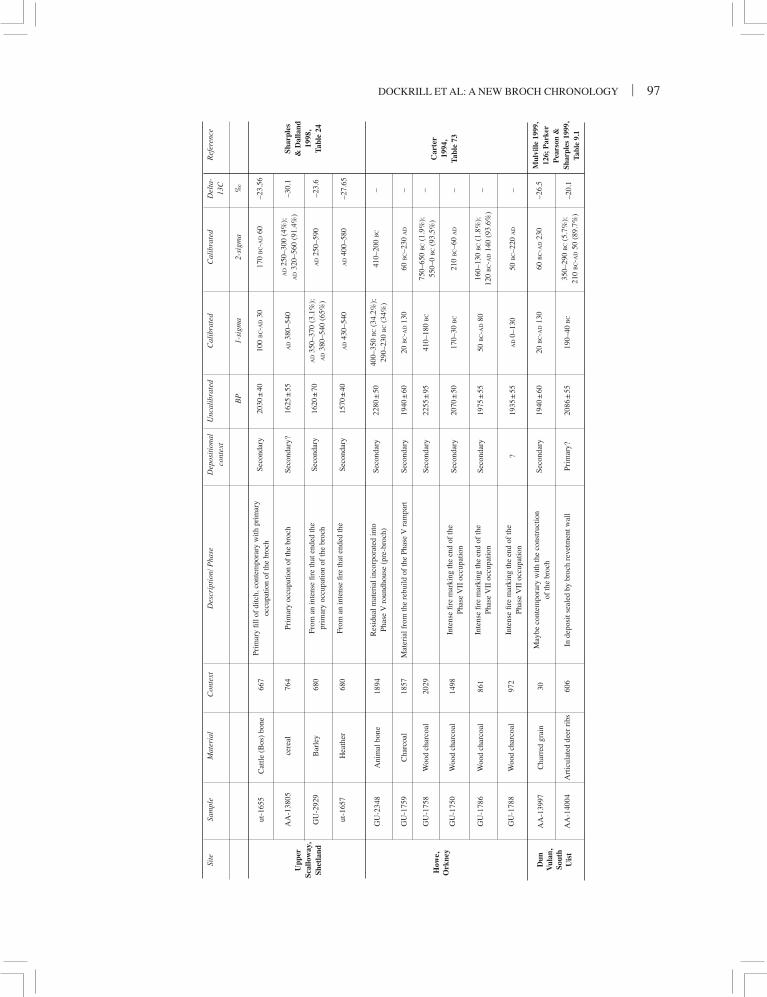
DOCKRILL ET AL: A NEW BROCH CHRONOLOGY | 97
Shar
ples
&
Dal
land
19
98,
Tabl
e 24
Upp
er
Scal
low
ay,
Shet
land
Site
Sa
mpl
e M
ater
ial
Con
text
D
escr
iptio
n/ P
hase
D
epos
ition
al
Unc
alib
rate
d
Cal
ibra
ted
Cal
ibra
ted
Del
ta-
Ref
eren
ce
co
ntex
t
13C
B
P
1-si
gma
2-si
gma
‰
GU
-234
8 A
nim
al b
one
1894
R
esid
ual m
ater
ial i
ncor
pora
ted
into
Se
cond
ary
2280
± 5
0 40
0–35
0 B
C (
34.2
%);
41
0–20
0 B
C
–
Phas
e V
rou
ndho
use
(pre
-bro
ch)
290–
230
BC (
34%
)
GU
-175
9 C
harc
oal
1857
M
ater
ial f
rom
the
rebu
ild o
f th
e Ph
ase
V r
ampa
rt
Seco
ndar
y 19
40 ±
60
20 B
C-A
D 1
30
60 B
C–2
30 A
D
–
GU
-175
8 W
ood
char
coal
20
29
Se
cond
ary
2255
± 9
5 41
0–18
0 B
C
750–
650
BC (
1.9%
);
–
550–
0 B
C (
93.5
%)
GU
-175
0 W
ood
char
coal
14
98
Inte
nse
fire
mar
king
the
end
of th
e
Seco
ndar
y 20
70 ±
50
170–
30 B
C
210
BC–6
0 A
D
–
Phas
e V
II o
ccup
atio
n
GU
-178
6 W
ood
char
coal
86
1 In
tens
e fir
e m
arki
ng th
e en
d of
the
Se
cond
ary
1975
± 5
5 50
BC-A
D 8
0 16
0–13
0 B
C (
1.8%
);
–
Phas
e V
II o
ccup
atio
n
120
BC-A
D 1
40 (
93.6
%)
GU
-178
8 W
ood
char
coal
97
2 In
tens
e fir
e m
arki
ng th
e en
d of
the
?
1935
± 5
5 A
D 0
–130
50
BC–2
20 A
D
–
Phas
e V
II o
ccup
atio
n
AA
-139
97
Cha
rred
gra
in
30
May
be c
onte
mpo
rary
with
the
cons
truc
tion
Se
cond
ary
1940
± 6
0 20
BC-A
D 1
30
60 B
C-A
D 2
30
–26.
5
of th
e br
och
AA
-140
04
Art
icul
ated
dee
r ri
bs
606
In d
epos
it se
aled
by
broc
h re
vetm
ent w
all
Prim
ary?
20
86 ±
55
190–
40 B
C
350–
290
BC (
5.7%
);
–20.
1
210
BC-A
D 5
0 (8
9.7%
)
Car
ter
1994
, Ta
ble
73
Mul
ville
199
9,
126;
Par
ker
Pea
rson
&
Shar
ples
199
9,
Tabl
e 9.
1
Dun
V
ulan
, So
uth
Uis
t
How
e,
Ork
ney
ut-1
655
Cat
tle (
Bos
) bo
ne
667
Prim
ary
fill o
f di
tch,
con
tem
pora
ry w
ith p
rim
ary
Se
cond
ary
2030
± 4
0 10
0 B
C-A
D 3
0 17
0 B
C-A
D 6
0 –2
3.56
oc
cupa
tion
of th
e br
och
AA
-138
05
cere
al
764
Prim
ary
occu
patio
n of
the
broc
h Se
cond
ary?
16
25 ±
55
AD
380
–540
A
D 2
50–3
00 (
4%);
–3
0.1
A
D 3
20–5
60 (
91.4
%)
GU
-292
9 B
arle
y 68
0 Fr
om a
n in
tens
e fir
e th
at e
nded
the
Se
cond
ary
1620
± 7
0 A
D 3
50–3
70 (
3.1%
);
AD
250
–590
–2
3.6
pr
imar
y oc
cupa
tion
of th
e br
och
AD
380
–540
(65
%)
ut-1
657
Hea
ther
68
0 Fr
om a
n in
tens
e fir
e th
at e
nded
the
Se
cond
ary
1570
± 4
0 A
D 4
30–5
40
AD
400
–580
–2
7.65
98 | SOCIETY OF ANTIQUARIES OF SCOTLAND, 2006
ditch infill at Scalloway to between 170 cal BC and cal AD 30, and the date of Context 606 at Dun Vulan to 350–290 cal BC (5.7%) and 210 cal BC– cal AD 50 (89.7%). It is also worth noting that the date for Scalloway provides a terminus ante quem for the construction of the brochs, dating events that occurred secondary to the archaeological event in question. This is an important point to consider, and is discussed in more detail below.
THE RADIOCARBON DATES
The radiocarbon dates for key sites within the Scottish North Atlantic have been recalibrated using the most recent calibration curve (Reimer et al 2004), producing dates that are directly comparable (see Table 1). In order to assess the chronology assigned to the roundhouses and the brochs it was important first to consider the confidence that should be held in the existing corpus of dates. Several issues were identified from the dates listed in Table 1, relating to the shape of the calibration curve, the material sampled and the information relating to the isotopic ratios of carbon recorded in the samples (the δ13C values), as well as the formation of the archaeological deposits. Each of these factors
will be discussed in turn, highlighting their relevance to the dates in question.
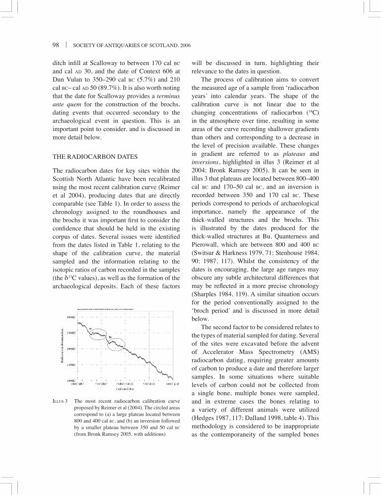
The process of calibration aims to convert the measured age of a sample from ‘radiocarbon years’ into calendar years. The shape of the calibration curve is not linear due to the changing concentrations of radiocarbon (14C) in the atmosphere over time, resulting in some areas of the curve recording shallower gradients than others and corresponding to a decrease in the level of precision available. These changes in gradient are referred to as plateaus and inversions, highlighted in illus 3 (Reimer et al 2004; Bronk Ramsey 2005). It can be seen in illus 3 that plateaus are located between 800–400 cal BC and 170–50 cal BC, and an inversion is recorded between 350 and 170 cal BC. These periods correspond to periods of archaeological importance, namely the appearance of the thick-walled structures and the brochs. This is illustrated by the dates produced for the thick-walled structures at Bu, Quanterness and Pierowall, which are between 800 and 400 BC (Switsur & Harkness 1979, 71; Stenhouse 1984, 90; 1987, 117). Whilst the consistency of the dates is encouraging, the large age ranges may obscure any subtle architectural differences that may be reflected in a more precise chronology (Sharples 1984, 119). A similar situation occurs for the period conventionally assigned to the ‘broch period’ and is discussed in more detail below.
The second factor to be considered relates to the types of material sampled for dating. Several of the sites were excavated before the advent of Accelerator Mass Spectrometry (AMS) radiocarbon dating, requiring greater amounts of carbon to produce a date and therefore larger samples. In some situations where suitable levels of carbon could not be collected from a single bone, multiple bones were sampled, and in extreme cases the bones relating to a variety of different animals were utilized (Hedges 1987, 117; Dalland 1998, table 4). This methodology is considered to be inappropriate as the contemporaneity of the sampled bones
ILLUS 3 The most recent radiocarbon calibration curve proposed by Reimer et al (2004). The circled areas correspond to (a) a large plateau located between 800 and 400 cal BC, and (b) an inversion followed by a smaller plateau between 350 and 50 cal BC (from Bronk Ramsey 2005, with additions)

DOCKRILL ET AL: A NEW BROCH CHRONOLOGY | 99
needs to be determined rather than assumed. A similar argument can be put forward for the use of ‘soil rich in organic material’ (Switsur & Harkness 1979, 71) or ‘organic detritus’ (Harkness 1984, 162) as it is not clear how the material became incorporated into the archaeological record. Modern standards of radiocarbon dating demand that the material sampled corresponds to a single entity that can be related to a discrete and deliberate deposition event (Ashmore 1999, 124).
Charcoal has also proved problematic for radiocarbon dating sites in Atlantic Scotland. A thorough explanation as to the type of charcoal sampled and its possible source was not always provided for several of the samples listed in Table 1. This is an important point considering that the landscapes in this region were largely treeless (Whittington & Edwards 2003, 17). The sampled wood may relate to either locally derived sources or driftwood, both of which may have been reused several times before being buried. The presence of driftwood or old wood means that the time between the felling of the tree and its incorporation into the archaeological record cannot be known with any certainty and this in turn affects the chronological significance of the date produced (Schiffer 1986, 27).
Since the development of AMS techniques in radiocarbon dating, an assessment of the δ13C value for samples has become a standard part of the measurement procedure. This value provides information regarding the proportion of marine-based items in an animal’s diet and highlights the differential uptake of the light and heavy isotopes by a plant (fractionation). Both of these factors affect the concentration of radiocarbon (14C) within a sample, as they can decrease the measured levels by processes other than radioactive decay, causing the samples to appear older (Bowman 1990, 21). Any processes that affect the validity or chronological significance of the dates produced need to be identified. However, as some of the dates listed in Table 1 were produced before the routine assessment
of the δ13C values, this information was not available (Carter 1994, table 73).
The formation processes that result in the archaeological deposits from which the sample was collected are crucial issues in both sample selection and interpretation. A radiocarbon date relates to the death of an organism, the dated event does not coincide with the incorporation of the material into the archaeological context, which in turn affects the chronological significance of the date (Dean 1978, 238; Outram 2005, 104). This has been addressed by first looking at the material sampled and by considering how the deposit was formed. Schiffer (1987) defines two different types of deposits: a primary context related to material that was recovered in situ, such as a hearth or a floor surface; a secondary deposit included material that had been moved on at least one occasion, such as the accumulation of midden, which would increase the time between the dated and archaeological events in question (Schiffer 1987, 58).
The definition of contexts was extended further during the excavation of Old Scatness as it was possible to differentiate between deposits by assessing how homogenized they were and the state of the boundaries recorded between adjacent contexts. At Old Scatness, a secondary deposit was based on material that was deposited rapidly after it was formed, such as the rake-out from the hearths, and could be identified through the presence of distinct tip lines within a midden with clear boundaries separating the contexts. In chronological terms there would be only one degree of separation between the accumulation of the material that was sampled and the event that incorporated the material into the archaeological record. Material that was homogenized with diffuse boundaries separating the contexts suggested the material had been moved on more than one occasion, and was referred to as a tertiary context. A tertiary context could have been formed for several reasons, such as the clearing of an area to construct new buildings, or the use of midden material to level

100 | SOCIETY OF ANTIQUARIES OF SCOTLAND, 2006
an area (Needham & Sørenson 1988, 125). In the case of tertiary material, it is not clear how many times the material would have been moved or how much time elapsed before the material was deposited on the final occasion.
The identification of primary, secondary and tertiary deposits is therefore crucial when selecting material for dating purposes so as to aim to select material with a minimal time difference between the death of the organism and its incorporation into the archaeological record. An attempt has been made to identify the nature of the deposits sampled for radiocarbon dating in Table 1 under the heading ‘depositional context’. It was only possible to distinguish between secondary and tertiary contexts at Old Scatness, as information relating to the boundaries between the deposits was available.
Therefore, the remaining dates summarized in Table 1, with the exception of Dun Vulan Sample AA-14004, are listed as secondary.
The reassessment of the dating evidence in Table 1 is problematic as the dates are prone to the limitations discussed above. Whilst this is in part due to when the samples were processed and the degree to which scientific techniques and methodologies have moved on, an awareness of the limitations of these dates and the consequences for the significance placed on them cannot be overstated.
THE OLD SCATNESS BROCH TOWER
The broch at Old Scatness occupies a central position within the ditched enclosure that
ILLUS 4 Plan of the broch showing the detail of the main surviving architectural features (© Bashford)

DOCKRILL ET AL: A NEW BROCH CHRONOLOGY | 101
surrounds the Iron Age village (illus 2). The broch survives to over a metre above first floor level (indicated by both the scarcement ledge and the flagged passage over the entrance leading to an intramural staircase), producing a height of approximately 3m, with an overall diameter of some 18m and an internal diameter of 10.5m (see illus 4). The broch has an entrance passage facing west and is surmounted by a large triangular lintel. This not only provides an image of monumentality but is also an intelligent form of stress relief for the weight of the tower over the entrance passage. The broch wall contained evidence for corbelled galleries; one intramural cell to the north contained a staircase leading from ground level up to a first floor level. Both staircases ran clockwise from west to north, in what would have been the upper levels of the broch. Investigation of the ground floor entrance passage revealed no evidence for guard cells but indicated two sets of doors, an outer door with in situ door pivot and an inner door represented by door jambs and a bar hole.
The broch appears to have remained a free-standing monument which would have
dominated the settlement throughout the Iron Age. A major demolition event occurred that could be stratigraphically linked to the Norse period as part of a general levelling and restructuring of the site; it is this event that is responsible for the lowering of the tower to its present height. The tower certainly provided a focal point for the site in the Pictish period, as represented by the presence of a tertiary building within the broch. The date for the occupation of this structure was based on the archaeomagnetic sample AM48, and the radiocarbon date GU-8876, producing an age range between cal AD 300 and 800 (S Dockrill, pers comm; Outram 2005, table 6.33). The tertiary cellular building within the broch at Old Scatness is being consolidated for public display and limits the potential for the investigation of the central area of this broch. The reuse of the central zone is a common feature to many of the Northern Isle brochs and has frustrated the investigation of in situ furniture and floor deposits (Sharples 1998, 78).
The destruction of the northern part of the Old Scatness mound by the 1975 road construction
ILLUS 5 The north section highlighting the flag raft and the deposits pre-dating the construction of the broch, together with those deposited against the wall during the use of the broch (© S J Dockrill)
102 | SOCIETY OF ANTIQUARIES OF SCOTLAND, 2006
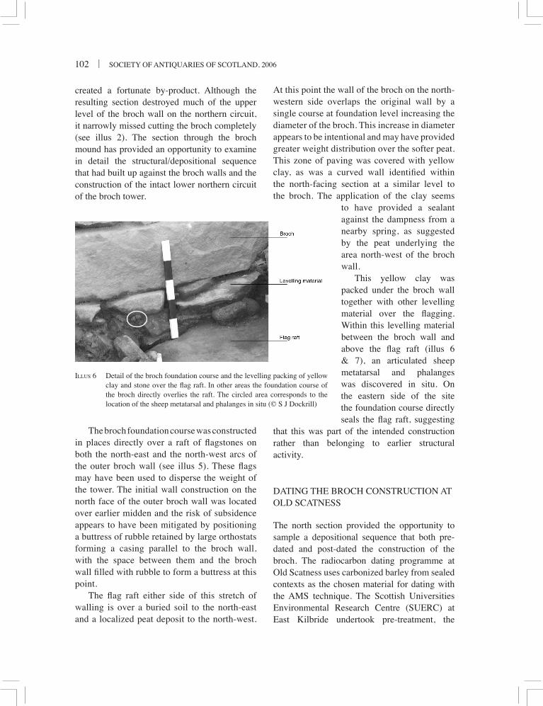
created a fortunate by-product. Although the resulting section destroyed much of the upper level of the broch wall on the northern circuit, it narrowly missed cutting the broch completely (see illus 2). The section through the broch mound has provided an opportunity to examine in detail the structural/depositional sequence that had built up against the broch walls and the construction of the intact lower northern circuit of the broch tower.
The broch foundation course was constructed in places directly over a raft of flagstones on both the north-east and the north-west arcs of the outer broch wall (see illus 5). These flags may have been used to disperse the weight of the tower. The initial wall construction on the north face of the outer broch wall was located over earlier midden and the risk of subsidence appears to have been mitigated by positioning a buttress of rubble retained by large orthostats forming a casing parallel to the broch wall, with the space between them and the broch wall filled with rubble to form a buttress at this point.
The flag raft either side of this stretch of walling is over a buried soil to the north-east and a localized peat deposit to the north-west.
At this point the wall of the broch on the north-western side overlaps the original wall by a single course at foundation level increasing the diameter of the broch. This increase in diameter appears to be intentional and may have provided greater weight distribution over the softer peat. This zone of paving was covered with yellow clay, as was a curved wall identified within the north-facing section at a similar level to the broch. The application of the clay seems
to have provided a sealant against the dampness from a nearby spring, as suggested by the peat underlying the area north-west of the broch wall.
This yellow clay was packed under the broch wall together with other levelling material over the flagging. Within this levelling material between the broch wall and above the flag raft (illus 6 & 7), an articulated sheep metatarsal and phalanges was discovered in situ. On the eastern side of the site the foundation course directly seals the flag raft, suggesting
that this was part of the intended construction rather than belonging to earlier structural activity.
DATING THE BROCH CONSTRUCTION AT OLD SCATNESS
The north section provided the opportunity to sample a depositional sequence that both pre-dated and post-dated the construction of the broch. The radiocarbon dating programme at Old Scatness uses carbonized barley from sealed contexts as the chosen material for dating with the AMS technique. The Scottish Universities Environmental Research Centre (SUERC) at East Kilbride undertook pre-treatment, the
ILLUS 6 Detail of the broch foundation course and the levelling packing of yellow clay and stone over the flag raft. In other areas the foundation course of the broch directly overlies the raft. The circled area corresponds to the location of the sheep metatarsal and phalanges in situ (© S J Dockrill)

DOCKRILL ET AL: A NEW BROCH CHRONOLOGY | 103
Arizona University Laboratory undertook the measurements and the dates were calibrated using OxCal v.3.10 (Bronk Ramsey 2005). All dates are quoted at two-sigma (95% confidence) levels. Carbonized barley was selected as it occurred frequently, was well preserved, short-lived, easily recovered with flotation and did not require a marine correction. Great care was taken to choose contexts that were sealed and to date several stratigraphically related contexts, to reduce or at least reveal any movement of the grain from its original depositional environment.
The carbonized grain was selected from part of a larger collection of carbonized seed material. To mitigate against possible taphonomic movement of the material used for dating, multiple contexts were sampled from a stratigraphic sequence. In such a sequence it is a possibility that older material may have been moved to a tertiary location; however, the use of multiple samples from an extensive sequence of contexts allows this issue to be addressed. In terms of how the carbonized barley grains came to be incorporated into the secondary deposits abutting the broch wall, it has been argued elsewhere that midden deposits formed a useful resource in many aspects of the daily life of a site (Needham & Sørenson 1988, 125). At Old
Scatness the midden material contains a high amount of hearth residue. This material seems to have been stored in dumps within the site, little being placed within the cultivated fields. Here, unburnt organic middens appear to provide the bulk of the added manure to the infield system. It is therefore not surprising that charred barley grains, resulting from hearth waste and accidental burning of material in crop drying, were recovered from the ash middens.
During the excavation of the north section an articulated sheep metatarsal and phalanges were recovered (see illus 6) and are discussed in more detail below (Dockrill & Bond 2004, 25). The metatarsal was sampled for radiocarbon dating and so it was important to consider if any marine plants had been used as fodder for the sheep, as this will introduce ‘old’ carbon into the animal’s system (Ambers 1990, 251). In terms of the sampled bones, there did not appear to be a significant marine component to the diet, as indicated by the δ13C value, and this was supported by recent work carried out on the diets of the sheep at Old Scatness (J Outram 2004, 58; Z Outram 2005, 233).
The AMS radiocarbon dates suggested a date of construction for the broch between the fourth and second centuries BC, based on the depositional sequence from the north section
ILLUS 7 The articulated sheep metatarsal and phalanges recovered in situ between the flag raft and the broch foundation stones (©Brown)

104 | SOCIETY OF ANTIQUARIES OF SCOTLAND, 2006
butting the north-east wall of the broch (see illus 5). Carbonized barley was obtained from secure samples taken from the buried soil below the flag raft, which produced a calibrated date of 410–200 cal BC (GU-9866), and on the western side from the buried peat, which provided a wider date range of 400–100 cal BC (GU-11105).
Samples were also taken from stratigraphic contexts above this flag raft, which were clearly deposited after the broch wall had been constructed. These contexts included a layer of small angular stones thought to be the trimmings of stone and discard of packing stones that would have occurred during the construction of the higher levels of the outer broch wall face.
security for this argument. One sample (see illus 8, lab no GU-9864) clearly shows tertiary deposition of pre-broch material. This is an inherent problem when sampling deposits that are clearly secondary in character, highlighting the value of using samples from multiple contexts forming a stratigraphic sequence.
The stratigraphic sequence above this layer of angular rubble contained a series of midden dumps that are clearly secondary to the broch construction and appear to relate to the use of the tower. Two samples from these secondary middens produced the radiocarbon dates GU-9861 at 400–200 cal BC and GU-9865 at 380–110 cal BC. It is important to note that these dates overlap with the suggested date range for construction of the broch.
In 2003 the foundations of the broch on the western section were excavated in detail, with the aim of providing stronger corroborative evidence that might date the construction event with a material other than barley. The articulated sheep metatarsal and phalanges were securely located between the broch foundation stone and the underlying flag raft, and are suggested by the authors to date the construction event of the broch. This sample is highly significant, as the articulation indicates that ligament attachments were present so the bone was relatively fresh at the time of deposition. This sample is clearly in situ; it represents a primary deposition and reflects the construction of the Old Scatness broch, producing a date of 390–200 cal BC (GU-11534). If this interpretation is incorrect the sheep metatarsal still represents a terminus post quem for the construction of the broch.
To reiterate, the date of the construction of the Old Scatness broch, as suggested by the sheep metatarsal, is 390–200 cal BC. This is supported by radiocarbon dates from the angular rubble interpreted as an immediate post-construction horizon. Samples from the pre-broch and post-broch stratigraphic sequence are consistent with this interpretation.
The broch appears to have been abandoned some time after 40 cal BC–cal AD 140 (lab nos
ILLUS 8 The radiocarbon dates for the construction of the broch, arranged in stratigraphic order using OxCal v 3.10 (© Z Outram)
The voids within this layer of angular stone were partly infilled by the percolation of overlying midden material. Thus the dates attained by the angular stone construction layer (lab nos GU-9863, GU-9864, and GU-9860) represent a terminus ante quem for the construction of the broch, ie before the period between 510 and 160 BC (GU-9860 and GU-9863 in Table 1). The authors believe the multiple dates provide

DOCKRILL ET AL: A NEW BROCH CHRONOLOGY | 105
GU-12034 and GU-12033, see table 1). These dates are based upon material sealed by a blocking wall to the entrance to the broch and later material abutting this wall. The shortest possible occupation time suggested by this evidence is 160 years. The usage of the broch is suggested by these data to span a period between 160 and 530 years.
DISCUSSION
REPOSITIONING THE BROCH IN THE IRON AGE
Despite problems of a plateau in the calibration curve between 350 and 50 cal BC, we would argue that the radiocarbon evidence has addressed the origins debate in favour of an earlier origin for the fully-fledged broch probably taking place between the fourth and late second centuries BC. Later midden deposits in the stratigraphic sequence above the construction layer are still within the plateau range, suggesting that construction may be well within this period. This date range supports the indigenous model of Atlantic roundhouse development suggested by Gilmour (2005, 79). The evidence at Old Scatness suggests a construction date for a broch tower between 390 and 200 BC. This indicates a longer phase of primary usage than has been supposed and that the overall construction event for brochs was not a short-lived response to a single situation, but may have had a longer evolution. Further excavation elsewhere, however, with comparable dating evidence for the constructional event, is needed to investigate this aspect of the origins of the broch.
This new chronological evidence means there is now a need to review the archaeological context of the broch fully. The monumentality in construction of brochs (both tower and defences or defensible location), albeit at a smaller scale, parallels the role of the hill-fort as centres of power for an aristocratic elite. The social structure for the elite in the North Atlantic zone might be seen as a scaled down version of a hill-fort power model, with the broch representing
the centres for minor chieftains/rich farmers. Brochs with surrounding villages are common in Orkney (eg Gurness and Midhowe), and Old Scatness and Jarlshof fit within this model. Brochs appearing as singular monuments (such as Dun Carloway, Lewis), or with perhaps a small number of associated structures, are sometimes to be found in remote and defendable locations and have a greater, more dispersed territory (Fojut 1982, 40–52).
In 1881, Anderson (1883, 205) found a correlation between broch location and land of arable potential. More recent research in Shetland by Fojut (1982, 46–52) has re-evaluated this correlation using geographic techniques to provide a model for brochs and associated territories containing land capable of providing a reasonable agricultural potential. Evidence for intensive infield agriculture from as early as the Neolithic through to the Iron Age has been found in both Orkney and Shetland (Dockrill & Simpson 1994). Such intensively managed soils in small infield plots may provide high yields of six-row barley, providing the calorific backbone of a mixed subsistence economy (Dockrill 2002, 156–8). Investigation around the site at Old Scatness has produced evidence for an extensive manured infield system (Simpson et al 1998). The earliest ard-cultivated soil is constructed on sand and is sealed by the broch wall on its north-western circuit. This reddish soil is distinctive both as a stratigraphic marker on the site and because of its composition, being derived mainly from ash midden. An exposure of this soil in a dated sequence south of the ditch enclosing the broch village (Area L) provided a radiocarbon date for charred grain of 400–160 cal BC (GU-9874). The changes in soil texture and colour in the lower metre of the Area L sequence provides an important record of changes in manure amendments and management dating to the Early and Middle Iron Age. This sequence at Old Scatness provides a clear linkage between the early broch and an intensively manured arable system ideal for high yield cultivation of six-row barley.

106 | SOCIETY OF ANTIQUARIES OF SCOTLAND, 2006
The human creation of this resource immediately before and during the broch period on what had previously been a machair land surface indicates a vast amount of organized effort. This soil has been identified by excavation as continuing beyond a point some 150m east of the ditch-bounded settlement, and to the west the soil is visible at points in the low cliff section. Such invested effort in creation of this arable soil reflects the economic importance of barley production in the Early and Middle Iron Age at Old Scatness.
The economic evidence at Old Scatness is not just dominated by the arable resource but rather is reflective of a mixed agricultural strategy. Another signature of wealth observed from the Early and Middle Iron Age contexts at Old Scatness is the presence of beef cattle as opposed to a dairy-based economy. A heavy iron cleaver (not represented in the surviving material culture) has been used to butcher the beef-age cattle at Old Scatness (Nicholson & Bond 2002, 70). Feasting on an economically costly product is indicative of a chiefdom society where the grazing and fodder costs for beef cattle are disproportionate to the economic investments. Cunliffe regards cattle in Southern Iron Age Britain as a signature of wealth, and the accumulation of herds would act to ‘encourage raiding thus adding to the active aggressive trends already present in society’ (Cunliffe 1971, 63).
It is interesting to look back at Anderson’s interpretation for the broch, where he states:
. . . they are therefore the defensive strongholds of a population located upon the arable lands . . . against such oft-recurring but transient dangers to the cultivators and to the produce of their soil there could be no more effective system of defence than a multitude of safes’ (Anderson 1883, 205).
Communal or central storage of grain (a major function of the hill-fort of Southern Britain) might be viewed as a vital economic strategy in a raiding/warring society. Given the apparent correlation of some brochs to territories
containing pockets of managed soil capable of providing high yields of barley, a case for central storage of grain surplus in good years as a protective insurance against crop failure as well as a means of accumulating wealth has been set within an economic model by the first author (Dockrill 1998, 76–8; 2002, 153–62; Dockrill & Batt 2004, 135).
Excavation of the Upper Scalloway broch (Sharples 1998) has provided perhaps the clearest evidence so far available to support a central storage model found within the archaeological record. Here a major fire and the collapse of the upper floors of the broch provide evidence to support a model for central storage in a raiding society. Within the resulting debris of this fire, the carbonized remains of a substantial quantity of grain was discovered. Holden, the archaeobotanist who examined this material, was unable to estimate the number of grains that were not carbonized and were ashed in the fire but remarks that the 10,000 barley grains from 200 litres of sample ‘represents a substantial store’ and suggests that such bulk storage is likely ‘only where cereals were being traded or given in the form of rent or tribute’ (Holden 1998, 126).
The chronology for the construction of the Old Scatness Broch clearly takes the broch origins debate away from the older ideas linked to the expansion of Rome and the domino effect for tribal movement as advocated by Childe (1946, 129) and followed by Hamilton and MacKie. These earlier dates place the broch securely within the cultural, political and economic frameworks of the British Iron Age. Childe’s (1946, 94, 129) observations on the appearance of material culture linking the brochs with sites such as Glastonbury Lake village should now be seen as the swift advance of cultural fashion and ideas within an inclusive Iron Age material culture fostered by contact through trade with Southern Britain, rather than the late movement of émigré aristocrats. Within this new timeframe for the brochs, a review of the artefact evidence should be based on a new
DOCKRILL ET AL: A NEW BROCH CHRONOLOGY | 107
model for swift communication links based on trade networks shared with Southern Iron Age Britain. The on-site production of steatite and serpentine bracelets in one of the post-broch aisled wheelhouses at Old Scatness in the first century BC provides a parallel in locally available material to the Kimmeridge shale production of similar arm rings in Pool Bay (Cunliffe 2005, 506–8).
In terms of material culture, Old Scatness has not provided any evidence of rotary querns dating to the broch or the immediate post-broch period. Here, saddle querns dominate the assemblage and it is not until the Pictish phase of the site (post-sixth century AD) that rotary querns appear to replace the earlier saddle quern. Long-handled weaving combs are present from deposits from an aisled wheelhouse, which is clearly secondary to the broch. Much of the archaeological evidence for material culture in buildings secondary to the broch comes from micro-refuse trodden into floor surfaces. These include fragments of Roman glass vessels, amber beads and composite glass bangle fragments. This material is stratigraphically associated with buildings that clearly post-date the construction of the broch, although they share contemporaneity to the usage of the broch.
Childe’s interpretation of Orosius and the Orcadian envoys sent after Claudius’ annexa-tion of Southern Britain in AD 43 might now be viewed in a new light. Childe (1946, 129) explained this reported event as occurring because of the familiarity of the broch builders with the Roman system of alliances, due to their recent arrival from ‘some region on the Empire’s fringe’. This delegation (if accurately reported) supports a view that the chiefdom power base in North Atlantic Britain was aware of the politics of Southern Britain. Such a position could be readily achieved within an established framework for contact based on trade networks. A reassessment of existing assemblages, in terms of archaeological context and site formation, might help to strengthen the visibility of contact in the light of this new evidence.
CONCLUSIONS
The considered use of AMS radiocarbon dating within the research framework of the Old Scatness project has produced a scientific chronology for the structural development of the site spanning over two millennia. This paper has concentrated on the impact of one element in the chronological sequence – that of the construction of the broch tower, dated to the fourth to second centuries BC. The detailed examination of stratigraphic deposits sealed by and abutting the broch wall has been used to date the construction of the broch tower. The dating of the broch required the careful consideration of the contexts and the provision of enough samples to allow the assessment of the possibility of re-deposition of older material, therefore reflecting secondary deposition. Verification of this date has been made possible by the discovery of an articulated sheep metatarsal and phalanges in a primary depositional context sandwiched between the flag raft and foundation course of the broch.
Sample selection is a crucial element within this programme and has been enhanced by the multidisciplinary nature of the project, in addition to the integration of specialists (dating and environmental), both in the planning stages and at the point of sampling on site. The detailed on-site examination of stratigraphy and subsequent sampling by the specialist together with the excavator, rather than discussion and selection at a later point in the post-excavation programme, have enabled the full dating potential of the site to be realised.
This intensive investigation of what is sometimes regarded as a provincial structural form has provided a chronological context supporting the indigenous model for development. The implication of this new chronology calls for the reconsideration of the broch in the context of Iron Age Britain. The broch should not be seen as a provincial deviation of the Iron Age, but as a regional adaptation providing the defended homestead of an elite group of the Atlantic

108 | SOCIETY OF ANTIQUARIES OF SCOTLAND, 2006
Iron Age population. As with the hill-fort of the Southern Iron Age, it is the multi-strand function of the broch that is of importance. The broch is seen to serve a multitude of functions as the administrative centre of an elite family group within a ranked society with power over a supporting client population living within the village. The wealth of the elite at Old Scatness in this model is coupled with control of the mixed agricultural economy. Construction of monumental architecture (the ditch and rampart as well as the broch tower), together with the creation of the arable infield, is indicative of social control of the client population. Brochs and their associated defences may be seen in this model as symbols of wealth, power and strength within an aggressive raiding society. In many instances the broch provides a practical defendable centre controlling route-ways within a society faced by small-scale hit and run raiding. The juxtaposed locations of a number of brochs across marine straits may reflect a model of strongholds at the edge of territories either acting together or in collaboration, independently guarding the sea-lanes or valley floors. The sea-lanes provide natural route-ways and the fertile coastal strip and valley floors provide an important agricultural resource (Fojut 1982, 41). The monumentality of these sites should be viewed as representing symbols of power looking out, and perhaps more importantly being seen from the sea-lanes and route-ways and providing a visible deterring force within the landscape and seascapes to potential raiders.
It is in this context that this new chronology for broch construction should be viewed. It provides a social and economic context not dissimilar from that outlined for Southern Britain (Cunliffe 1971; Bradley 1971). Childe’s (1946, 94) early observations on the material culture no longer require the migration of people to explain the 200-year discrepancy seen in the artefact assemblage. Instead we need to re-examine the assemblages in a context of regional adaptation that embraces the swift movement of ideas through contact and trade.
ACKNOWLEDGEMENTS
This project is funded by the BP Exploration Operating Company Ltd, British Academy, DITT, Dunrossness Community Council, EC Objective 1 Programme, European Regional Development Fund, European Union (European Agricultural Guidance and Guarantee Fund), Farquahar and Jamieson, Heritage Lottery Fund, Highlands and Islands Partnership Programme, Historic Scotland, Pilgrim Trust, Robert Kiln Trust, Shetland Amenity Trust, Shetland Enterprise Company, Scottish Hydro Electric plc, Scottish Natural Heritage, Shetland Islands Council, Shetland Islands Coucil (Charitable Trust), Shetland Islands Council Development Trust, University of Bradford, Wackenhut Uk Ltd. Part of this work was funded as a PhD from the Arts and Humanities Research Board, AHRB (now known as the Arts and Humanities Research Council, AHRC).
Special thanks are also given to Dr J Bond,J McKinley, A R Braby, L D Brown, and also toV Turner and the staff of Shetland Amenity Trust for their support, enthusiasm and continued effort to source funding for this project. Finally, we would like to thank the referees for their constructive comments.
REFERENCES
Ambers, J 1990 ‘Identification of the use of marine plant materials as animal fodder by stable isotope ratios’, in Mook, W G & Waterbolk, H T (eds) Proceedings of the Second International Symposium for 14C and Archaeology, PACT 29, 251–8.
Anderson, J 1883 Scotland in Pagan Times: the Iron Age. The Rhind Lectures in Archaeology for 1881. David Douglas, Edinburgh.
Armit, I 1990 ‘Broch-building in Northern Scotland: the context of innovation’, World Archaeology 21 (3), 435–45.
Armit, I 1991 ‘The Atlantic Scottish Iron Age: five levels of chronology’, Proc Soc Antiq Scot 121, 181–214.
Armit, I 2003 Towers in the North The Brochs of Scotland. Tempus, Stroud.
Armit, I 2005 ‘The Atlantic Roundhouse: a beginner’s guide’, in Turner, V E, Nicholson R, Dockrill, S J & Bond, J M (eds) Tall Stories: 2 Millennia of Brochs, 5–10. Shetland Amenity Trust, Lerwick.

DOCKRILL ET AL: A NEW BROCH CHRONOLOGY | 109
Ashmore, P J 1999 ‘Radiocarbon dating: avoiding errors by avoiding mixed samples’, Antiquity 73, 124–30.
Ballin-Smith, B 1994 Howe: Four Millennia of Orkney Prehistory. Excavations 1978–1982. Edinburgh (= Soc Antiq Scot monogr 9).
Bowman, S 1990 Radiocarbon Dating. British Museum Publications, London.
Bradley, R 1971 ‘Economic change in the growth of early hill-forts’, in Jesson, M & Hill, D (eds) The Iron Age and its Hill-Forts, 71–84. Southampton (= Univ Southampton monogr 1).
Bronk Ramsey, C 2005 The OxCal Radiocarbon Calibration Software, Version 3.10. http://www.rlaha.ox.ac.uk/O/oxcal.php. Last accessed 30/11/05.
Carter, S 1994 ‘The radiocarbon dates’, in Ballin-Smith, B (ed) 1994, 264–6.
Childe, V G 1935 The Prehistory of Scotland. Kegan Paul, London.
Childe, V G 1946 Scotland Before the Scots. Methuen & Co, London.
Cunliffe, B 2005 Iron Age Communities in Britain: an Account of England, Scotland and Wales from the Seventh Century BC until the Roman Conquest. Routledge, Abingdon.
Cunliffe, B W 1971 ‘Some aspects of hill-forts and their cultural environments’, in Jesson, M & Hill, D (eds) The Iron Age and its Hill-Forts, 53–69. Southampton (= Univ Southampton monogr 1).
Dalland, M 1998 ‘Radiocarbon dating, calibration and statistical analysis’, in Lowe, C (ed) 1998, 97–107.
Dean, J S 1978 ‘Independent dating in archaeological analysis’, in Schiffer, M B (ed) Advances in Archaeological Method and Theory Volume 1, 223–55. Academic Press, New York.
Dockrill, S J 1998 ‘Northern exposure: Phase I of the Old Scatness Excavations 1995–8’, in Nicholson, R A & Dockrill, S J (eds) Old Scatness Broch, Shetland: Retrospect and Prospect, 59–80. Bradford Archaeological Sciences Research 5/ Shetland Amenity Trust/ North Atlantic Biocultural Organisation, Bradford.
Dockrill, S J 2002 ‘Brochs, economy and power’, in Ballin-Smith, B & Banks, I (eds) In the Shadow of the Brochs: The Iron Age in Scotland, 153–62. Tempus, Stroud.
Dockrill, S J & Batt, C M 2004 ‘Power over time: an overview of the Old Scatness broch excavations’, in Housley, R A & Coles, G (eds)
Atlantic Connections and Adaptations: Economic Environments and Subsistence in the Lands Bordering the North Atlantic, 128–37. Oxbow Books, Oxford.
Dockrill, S J & Bond, J M 2004 ‘The research excavations at Old Scatness in 2003’, in Dockrill, S J, Bond, J M & Turner, V E (eds) Old Scatness Broch & Jarlshof Environs Project: Field Season 2003. Interim Report No. 9 (Data Structure Report), 15–68. Bradford Archaeological Sciences Research Report 13. University of Bradford/ Shetland Amenity Trust, Bradford.
Dockrill, S J & Simpson, I A 1994 ‘The identification of prehistoric anthropogenic soils in the Northern Isles using an integrated sampling methodology’, Archaeol Prospection 1, 75–92.
Fairhurst, H 1984 ‘Excavations at Crosskirk Broch, Caithness’. Edinburgh (= Soc Antiq Scot monogr 3).
Fojut, N 1982 ‘Towards a geography of Shetland brochs’. Glasgow Archaeol J 9, 38–59.
Gilmour, S 2005 ‘Complex Atlantic Roundhouses: chronology and complexity’, in Turner, V E, Nicholson R, Dockrill, S J & Bond, J M (eds) Tall Stories: 2 Millennia of Brochs, 78–96. Shetland Amenity Trust, Lerwick.
Hamilton, J R C 1956 Excavations at Jarlshof, Shetland. HMSO, Edinburgh.
Hamilton, J R C 1968 Excavations at Clickhimin, Shetland. HMSO, Edinburgh.
Harding, D W 1990 ‘Changing perspectives in the Atlantic Iron Age’, in Armit, I (ed) Beyond the Brochs: Changing Perspectives on the Atlantic Scottish Iron Age, 5–16. Edinburgh University Press, Edinburgh.
Harding, D W 2004 The Iron Age in Northern Britain, Celts and Romans, Natives and Invaders. Routledge, Oxford.
Harkness, D D 1984 ‘An evaluation of the radio-carbon dates measured for the Crosskirk broch investigation’, in Fairhurst, H (ed) 1994, 160–3.
Hedges, J W 1987 Bu, Gurness and the Brochs of Orkney. Part I: Bu. Oxford (= Br Archaeol Rep, Br Ser 163).
Hedges, J W 1990 ‘Surveying the foundations: life after brochs’, in Armit, I (ed) Beyond the Brochs: Changing Perspectives on the Atlantic Scottish Iron Age, 17–31. Edinburgh University Press, Edinburgh.
Holden, T 1998 ‘Carbonised plant’, in Sharples, N (ed) Scalloway: A Broch, Late Iron Age

110 | SOCIETY OF ANTIQUARIES OF SCOTLAND, 2006
Settlement and Medieval Cemetery in Shetland, 125–7. Oxford (= Oxbow monogr 82).
Lowe, C 1998 Coastal Erosion and the Archaeological Assessment of an Eroding Shoreline at St Boniface Church, Papa Westray, Orkney. Sutton Publishing/Historic Scotland, Stroud.
MacKie, E W 1965 ‘The origin and development of the broch- and wheelhouse-building cultures of the Scottish Iron Age’, Proc Prehist Soc 31, 93–143.
MacKie, E W 1998 ‘Continuity over three thousand years of northern prehistory: the “Tell” at Howe, Orkney’, Antiquaries J 78, 1–42.
MacKie, E W 2002a The Roundhouses, Brochs and Wheelhouses of Atlantic Scotland c 700 BC–AD 500: Architecture and Material Culture. Part 1: Orkney & Shetland Isles. Oxford (= Br Archaeol Rep, Br Ser 342).
MacKie, E W 2002b ‘Brochs and the Hebridean Iron Age’, in Carr, G & Stoddart, S (eds) Celts from Antiquity, 277–92. Antiquity Papers 2, Antiquity Publications, Cambridge. [first published in Antiquity 36 (156), 1965.]
Mackie, E W 2005 ‘Scottish brochs at the start of the new millennium’, in Turner, V E, Nicholson R, Dockrill, S J & Bond, J M (eds) Tall Stories: 2 Millennia of Brochs, 11–31. Shetland Amenity Trust, Lerwick.
Mulville, J 1999 ‘The mammal bones’, in Parker Pearson, M & Sharples, N (eds) 1999, 126–7.
Needham, S P & Sørenson, M L S 1988 ‘Runneymede refuse tip: a consideration of midden deposits and their formation’, in Barret, J C & Kinnes, I A (eds) The Archaeology of Context in the Neolithic and Bronze Age Recent Trends, 113–26. Department of Archaeology and Prehistory, University of Sheffield, Huddersfield.
Nicholson, R & Bond, J M 2002 ‘Larger mammal bones’, in Dockrill, S J, Bond, J M & Turner, V E (eds) Old Scatness Broch & Jarlshof Environs Project Field Season 2001, Interim Report 7/Data Structure Report, 69–70. Bradford Archaeological Sciences Research 11, University of Bradford/ Shetland Amenity Trust, Bradford.
Outram, J 2004 Recognising Changes in Sheep Diet using an Integrated Methodology. Unpublished Masters Thesis, Department of Archaeological Sciences, University of Bradford.
Outram, Z 2005 A Reassessment of the Iron Age Chronology of the Northern Isles: a Pilot Study
at Old Scatness Broch, Shetland. Unpublished PhD Thesis, University of Bradford.
Parker Pearson, M & Sharples, N 1999 Between Land and Sea: Excavations at Dun Vulan, South Uist. Sheffield Academic Press, Sheffield.
Reimer, P J, Baille, M G L, Bard, E, et al 2004 ‘IntCal04 terrestrial Radiocarbon age calibration, 0–26 Cal Kyr BP’, Radiocarbon 46 (3), 1029–58.
Renfrew, C 1979 Investigations in Orkney. Society of Antiquaries of London, London.
Schiffer, M B 1986 ‘Radiocarbon dating and the “old wood” problem: the case study of the Hohokam chronology’, J Archaeol Sci 13, 13–30.
Schiffer, M B 1987 Formation Processes of the Archaeological Record. University of New Mexico, Albuquerque.
Scott, W L 1947 ‘The problem of the brochs’, Proc Prehist Soc 13, 1–36.
Sharples, N 1984 ‘Excavations at Pierowall Quarry, Westray, Orkney’, Proc Soc Antiq Scot 114, 75–125.
Sharples, N 1998 Scalloway: A Broch, Late Iron Age Settlement and Medieval Cemetery in Shetland. Oxford (= Oxbow monogr 82).
Shepherd, A 1994 ‘Howe: a review of the sequence’, in Ballin-Smith, B (ed) 1994, 267–90.
Simpson, I A, Dockrill, S J & Lancaster, S J 1998 ‘Making arable soils: anthropogenic soil formation in a multi-period landscape’, in Nicholson, R A & Dockrill, S J (eds) Old Scatness Broch, Shetland: Retrospect and Prospect, 111–26. Bradford Archaeological Sciences Research 5/Shetland Amenity Trust/North Atlantic Biocultural Organisation, Bradford.
Stenhouse, M J 1984 ‘The radiocarbon dates’, in Sharples, N (ed) 1984, 75–125.
Stenhouse, M J 1987 ‘The radiocarbon dates’, in Hedges, J W (ed) 1987, 117.
Switsur, V R & Harkness, D D 1979 ‘The radiocarbon dates’, in Renfrew, C (ed) Investigations in Orkney, 70–2. Society of the Antiquaries of Scotland, Edinburgh.
Wheeler, R M 1957 ‘Civil Service archaeology: a review’, Antiquity XXXI (124), 234–6.
Whittington, G & Edwards, K J 2003 ‘Climate change’, in Edwards, K & Ralston, I B M (eds) Scotland After the Ice Age: Environment, Archaeology and History, 8000 BC–AD 1000, 11–22. Edinburgh University Press, Edinburgh.