Embed Size (px)
Citation preview

Tim Horner
CSUS Geology Department
Streams and Floods
Physical Geology, Chapter 10

Running Water
• Running water is the most important geologic agent in eroding, transporting and depositing sediment
• Nearly every landscape on Earth shows the results of stream erosion or deposition

Hydrologic Cycle• Hydrologic cycle - the movement and interchange of water
between the sea, air, and land
– Evaporation• Solar radiation provides energy
– Precipitation• Rain or snow
– Transpiration• Evaporation from plants
– Runoff• Water flowing over land surface
– Infiltration• Water soaking into the ground

Running Water• Stream - a body of running water, confined
to a channel, that runs downhill under the influence of gravity– Headwaters - upper part of stream near its source
in the mountains
– Mouth - place where a stream enters sea, lake or larger stream
– Channel - a long, narrow depression eroded by a stream into rock or sediment
• Stream banks - sides of channel
• Streambed - bottom of the channel
– Floodplain - flat valley floor composed of sediment deposited by the stream

Drainage Basins
• Drainage basin - the total area drained by a stream and its tributaries– Tributary - a small stream flowing into
a larger one
• Divide - ridge or high ground that divides one drainage basin from another– Continental Divide separates the streams
that flow into the Pacific from those that flow into the Atlantic and Gulf of Mexico

Drainage Patterns
• Drainage pattern - the arrangement, in map view, of a stream and its tributaries– Most tributaries join the main stream at an acute
angle, forming a V or Y pointing downstream– Dendritic - drainage pattern resembling the
branches of a tree– Radial pattern - streams diverge outward like the
spokes of a wheel• Typically form on conical mountains (volcanoes)
– Rectangular pattern - tributaries have frequent 90° bends and join other streams at right angles
– Trellis pattern - parallel streams with short tributaries meeting at right angles

Stream Erosion• Stream erosion (and deposition) controlled by
flow velocity and discharge– Stream velocity controlled by stream gradient
(slope), channel shape and channel roughness• Maximum velocity near center of channel
– Floods involve increased velocity and discharge (volume of water passing a particular point in a stream over time)
• Higher stream velocities promote erosion and transport of coarser sediments– Erosion of very small particles difficult due to
molecular binding forces
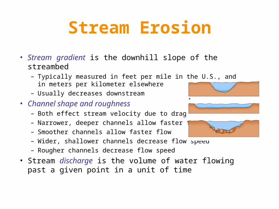
Stream Erosion
• Stream gradient is the downhill slope of the streambed– Typically measured in feet per mile in the U.S., and in meters per
kilometer elsewhere– Usually decreases downstream
• Channel shape and roughness – Both effect stream velocity due to drag – Narrower, deeper channels allow faster flow– Smoother channels allow faster flow– Wider, shallower channels decrease flow speed– Rougher channels decrease flow speed
• Stream discharge is the volume of water flowing past a given point in a unit of time

Stream Erosion
• Streams cut their own valleys, deepening and widening them over time and carrying away the sediment
• Stream erosion occurs by three mechanisms: hydraulic action, solution, and abrasion– Hydraulic action - ability of flowing water to pick
up and move rock and sediment
– Solution - dissolving of rocks (e.g., limestone)
– Abrasion - grinding away of stream channel by the friction and impact of the sediment load
• Potholes are eroded into streambed by the abrasive action of the sediment load in the stream

Sediment Deposition
• Sediments are temporarily deposited along stream course as bars and floodplain deposits
• Bars - ridges of sediment (usually sand or gravel) deposited in the middle or along the sides of a stream– Braided streams contain sediment deposited
as numerous bars around which water flows in highly interconnected rivulets

Sediment Deposition
• Meandering streams flow faster along the outside of bends and more slowly along the inside, depositing point bars on the insides of the meanders
• Meander cutoffs may form when a new, shorter channel is cut through the narrow neck of a meander (as during a flood)

Sediment Deposition
• Floodplains are broad strips of land built up by sedimentation on either side of a stream channel– Floodplain sediments are left behind
as flood waters slow and recede at the end of flood events
– Main channel has slightly raised banks with respect to the floodplain known as natural levees

Flooding• When water levels rise and overtop the banks
of a river, flooding occurs– Natural process on all rivers – Described by recurrence intervals
• A 100-year flood is, on average, the size of the largest flood within a 100-year period of time
– Can cause great damage in heavily populated areas
– High velocity and large volume of water causes flood erosion
– Slowing of waters as flood ends causes flood deposits (usually of silt or clay-sized particles) to be deposited in the floodplain

Flooding• Urban flooding
– Paved areas and storm sewers increase runoff by inhibiting infiltration
– Rapid delivery of water to streams increases peak discharge and hastens occurrence of flood
• Flash floods– Local, sudden floods of large volume and
short duration– Typically triggered by heavy thunderstorms
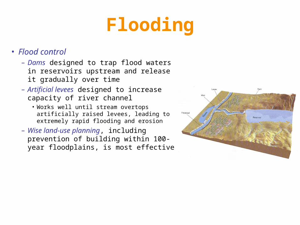
Flooding• Flood control
– Dams designed to trap flood waters in reservoirs upstream and release it gradually over time
– Artificial levees designed to increase capacity of river channel
• Works well until stream overtops artificially raised levees, leading to extremely rapid flooding and erosion
– Wise land-use planning, including prevention of building within 100-year floodplains, is most effective
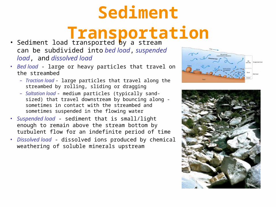
Sediment Transportation• Sediment load transported by a stream can be
subdivided into bed load, suspended load, and dissolved load
• Bed load - large or heavy particles that travel on the streambed– Traction load - large particles that travel along the streambed by
rolling, sliding or dragging– Saltation load - medium particles (typically sand-sized) that travel
downstream by bouncing along - sometimes in contact with the streambed and sometimes suspended in the flowing water
• Suspended load - sediment that is small/light enough to remain above the stream bottom by turbulent flow for an indefinite period of time
• Dissolved load - dissolved ions produced by chemical weathering of soluble minerals upstream

Sediment Deposition
• Delta - body of sediment deposited at the mouth of a river when flow velocity decreases– Surface marked by shifting
distributary channels
– Shape of a delta depends on whether its wave-dominated, tide-dominated, or stream-dominated

Sediment Deposition
• Alluvial fan - large, fan- or cone-shaped pile of sediment that forms where stream velocity decreases as it emerges from a narrow mountain canyon onto a flat plain – Well-developed in desert regions, such as the southwestern U.S.
– Larger fans show grading from large sediments nearest the mountains to finer sediments farther away
Stream Valley Development
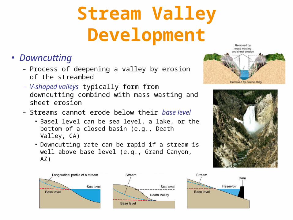
• Downcutting– Process of deepening a valley by erosion of the
streambed
– V-shaped valleys typically form from downcutting combined with mass wasting and sheet erosion
– Streams cannot erode below their base level• Basel level can be sea level, a lake, or the bottom
of a closed basin (e.g., Death Valley, CA)
• Downcutting rate can be rapid if a stream is well above base level (e.g., Grand Canyon, AZ)

Stream Valley Development• Graded streams
– Characteristic concave-up longitudinal profile– Rapids and waterfalls have been smoothed out by extensive
erosion over a long period of time– Delicate balance between available sediment load and transport
capacity
• Lateral erosion widens stream valleys by undercutting of stream banks and valley walls as stream swings from side to side across the valley floor
• Headward erosion is the slow uphill growth of a valley above its original source by gullying, mass wasting, and sheet erosion

Stream Valley Development
• Stream terraces– Step-like landforms found above a
stream and its floodplain– Occurs when river rapidly cuts
downward into its own floodplain– Represents relatively sudden change
from deposition to erosion– Can be caused by rapid uplift, drops
in base level, or climate changes
Stream Valley Development
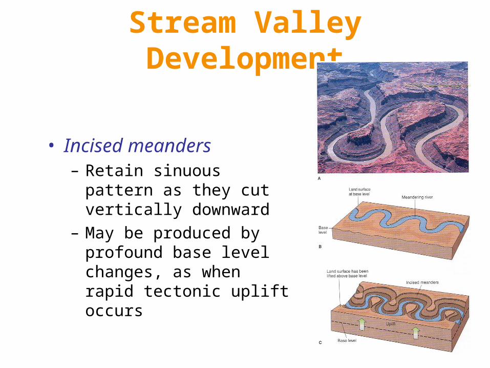
• Incised meanders– Retain sinuous pattern as they
cut vertically downward
– May be produced by profound base level changes, as when rapid tectonic uplift occurs

Stream Valleys on Mars• Evidence of different climate in past
– Liquid water not stable on surface of Mars under present conditions
• Too cold• Atmospheric pressure too low
– Stream channels and terraces suggest long-term erosion by flowing water
– Lack of smaller tributaries is puzzling, but these do exist for channels networks in more ancient terrains on Mars
– Requires warmer, wetter Mars– NASA missions targeting such locations


![[PPT]PowerPoint Presentation - California State University ... · Web viewGeologic Time Physical Geology Chapter 8 Tim Horner, CSUS Geology Department Dating rocks: Relative dating:](https://img.pdfslide.us/doc/110x75/5ab80ecc7f8b9ac1058c3b1a/pptpowerpoint-presentation-california-state-university-viewgeologic-time.jpg)
![[PPT]Powerpoint Presentation Physical Geology, 10/e · Web viewSediment and Sedimentary Rocks Physical Geology, Chapter 6 Tim Horner, CSUS Geology Department Intro to Sedimentary Rocks](https://img.pdfslide.us/doc/110x75/5abe02fd7f8b9a3a428c7739/pptpowerpoint-presentation-physical-geology-10e-viewsediment-and-sedimentary.jpg)