Embed Size (px)
Citation preview

TIGERS, RICE, SILK,AND SILT
Robert B. Marks
Whittier College
Z
P 9/11/97 4:18 P Page v

The Pitt Building, Trumpington Street, Cambridge , United Kingdom
The Edinburgh Building, Cambridge , United Kingdom West th Street, New York, -, Stamford Road, Oakleigh, Melbourne , Australia
© Robert B. Marks
This book is in copyright. Subject to statutory exceptionand to the provisions of relevant collective licensing agreements,no reproduction of any part may take place withoutthe written permission of Cambridge University Press.
First published
Printed in the United States of America
Typeset in Baskerville
A catalog record for this book is available from the British Library
Library of Congress Cataloging-in-Publication Data
Marks, Robert B., –
◊◊◊◊Tigers, rice, silk, and silt: environment and economy in late imperial south◊◊China/Robert B. Marks.
◊◊◊◊◊◊p.◊◊cm. – (Studies in environment and history)◊◊◊◊Includes bibliographical references and index.
◊◊◊◊ --- (hb)
◊◊◊◊.◊Economic development – Environmental aspects – China – History.◊◊.◊Nature – Effect of human beings on – China – History.◊◊.◊Human beings –◊◊Effect of environment on – China – History.◊◊.◊Kwangtung Province (China) –◊◊Economic conditions.◊◊.◊Kwangsi Chuang Autonomous Region (China) –◊◊Economic conditions.◊◊.◊China – History – Ming dynasty, –.◊◊◊◊.◊China – History – Ch’ing dynasty, –.◊◊I.◊Title.◊◊II.◊Series.◊◊HC..M◊◊ -◊◊.99 – dc CIPZ
P 9/11/97 4:18 P Page vi

CONTENTS
Z
v
List of Maps, Figures, and Tables page viiDynasties, Qing Dynasty Emperors’ Reign Dates,and Weights and Measures xiAcknowledgments xiii
Introduction
◊1◊◊“Firs and Pines a Hundred Spans Round”:The Natural Environment of Lingnan
◊2◊◊“All Deeply Forested and Wild Places Are Not Malarious”:Human Settlement and Ecological Change in Lingnan,–
◊3◊◊“Agriculture Is the Foundation”:Economic Recovery and Development of Lingnan during the Ming Dynasty, –
◊4◊◊“All the People Have Fled”:War and the Environment in the Mid-Seventeenth-Century Crisis, –
◊5◊◊“Rich Households Compete to Build Ships”:Overseas Trade and Economic Recovery
◊6◊◊“It Never Used to Snow”:Climatic Change and Agricultural Productivity
◊7◊◊“There Is Only a Certain Amount of Grain Produced”:Granaries and the Role of the State in the Food Supply System
◊8◊◊“Trade in Rice Is Brisk”:Market Integration and the Environment
P 9/11/97 4:18 P Page vii

◊9◊◊“Population Increases Daily, but the Land Does Not”:Land Clearance in the Eighteenth Century
10◊◊“People Said that Extinction Was Not Possible”:The Ecological Consequences of Land Clearance
Conclusion
Bibliography Index
vi Contents
Z
P 9/11/97 4:18 P Page viii
MAPS,◊FIGURES,◊AND◊TABLES
Z
Maps
Lingnan prefectures, ca. page xviiLingnan counties, ca. xix
.a South China, ca. .b South China, ca. . Guangdong land cover, ca. .a–d Population densities, ca. , , , and . The Pearl River Delta, ca. , , , and . Levees on the West River, Tang–Ming dynasties . Population density, ca. . Cultivated land, ca. .a–b Density of waterworks, ca. and .a–b Markets, ca. and . The Nanyang .a–b Markets, ca. and . Grain-deficit prefectures, ca. . Grain trade flows, ca. . Mean price of rice, – . Structure of the Lingnan rice market .a–b Density of waterworks, ca. and
Figures
. The Meiling Pass, . . Mean monthly temperature and rainfall at Guangzhou. . Pinus massoniana. . Water pine (shui song). . Temperature changes in China, – . . Population (recorded) of Lingnan, –. . South China Sea. . Lingnan population, –.
vii
P 9/11/97 4:18 P Page ix

. Number of counties reporting frost or snow, –. . Dearth in Guangdong province in the seventeenth century. . Chinese maritime customs revenue, –, by province. . Foreign trade at Guangzhou, –. . Value of Indian raw cotton imports, –. . China’s foreign trade balances, five-year averages, –. . Silver flows at Guangzhou, –. . Exports of Pearl River delta silk from Guangzhou, –. . Percentile distribution of market density in Lingnan counties,
–. . Market increase in selected counties, –. . Three patterns of market systems in Lingnan
(Luo Yixing’s model). . Temperature fluctuations, –. . Northern hemisphere temperatures, –. . Guangzhou wetness index, –. . Annual cropping cycle. . Rice prices in cold and warm years at Guilin. . Annual temperatures, –. . Frost, harvest ratings, and monthly rice prices in the
Pearl River delta, –. . Northern hemisphere temperatures, –. . Number of counties reporting pestilence, –. . Guangdong province harvest ratings, –. . Adverse climatic conditions in Guangdong, –. . Price spread between Guangzhou and Wuzhou, –. . Harvest ratings and rice prices, –. . Estimated population of Lingnan, –. . Counties afflicted with floods, –. . Counties afflicted with droughts, –.
Tables
. The Pearl River drainage basin . Population densities, by prefecture, – . Early Ming population returns for Hainan Island . Waterworks in Guangdong, ca. . Markets in Guangdong, and . Population and land totals, – . Land laid waste, ca. , by prefecture . Market density, ca. 1731 . Climatic changes in Lingnan, – . Deficient harvests in Guangdong province
viii Maps, Figures, and Tables
Z
P 9/11/97 4:18 P Page x

. Frequency of adverse climatic conditions, – . Food needs for Guangdong province, ca. . Supply of food in Guangdong province . Variation of monthly rice prices . Regression of prefectural mean price on Guangzhou mean . Estimated merchant profits at Guangzhou . Correlation of harvest rating with rice price . King’s law . Price changes following abundant or deficient harvests . Population and cultivated land estimates, – . Prefectural population changes, –
. Land reported reclaimed, by province, –
Maps, Figures, and Tables ix
Z
P 9/11/97 4:18 P Page xi

Z
1
“FIRS◊AND◊PINES◊A◊HUNDRED◊SPANS◊ROUND”:◊◊◊◊
To begin this study with a chapter subtitled “the natural environment” fol-lowed by one on “human settlement” presents something of a false dichotomybetween nature on the one hand and people on the other, for as ecologists haveinsisted, human beings are a part of a broader ecosystem. Moreover, peopleare “in” the environment in another sense as well: as the observers. To describethe natural environment of south China requires looking through two lenses,one of which has been crafted in our times, the other of which is provided byChinese sources. Our times focus the description in a particular way. Histori-ans have only lately begun to locate their work within the context of “envi-ronmental history,” and with good reason, for it was in the s and sthat scientists’ warning bells about the dangers of environmental degradationbegan to be heard. Historians cannot be blamed too much for creating thefield of environmental history only in the context of these contemporary con-cerns about pollution of the land and air, depletion of energy sources, defor-estation of the tropics, and global warming. Given this context, the kinds ofquestions environmental historians have been asking about the past have beenconditioned by these contemporary concerns. I too have been concerned aboutglobal warming, the destruction of forests and wetlands, and the fate of thelarge cats, and these concerns have found their way into this book, certainlyopening up some avenues of investigation, but just as surely closing downothers.
Just as the issues of our times filter the ways in which we perceive the envi-ronment, so too did the concerns and views of the people who left writtenrecords select out what they saw and reported in their documents, whetherthese observers lived in the tenth or the eighteenth century. For better or worse,these observers were mostly Chinese, with all of the literary and organizationalskills they possessed, but also with beliefs, biases, and prejudices about other peoples and about nature. Thus, even if we want to know more aboutforests and the way of life of non-Chinese inhabitants, for instance, we haveto do so through the eyes of people who placed the highest value on settledagriculture. Sometimes we might learn what we want to know, but at othertimes the Chinese observers may have been blinded by their value system
RSS1 9/11/97 4:21 PM Page 16

and so failed to report about phenomena we might think were interesting orrelevant.
The limitations of traditional historical sources can be augmented, at leastwith respect to significant aspects of the environment, by more recent obser-vations and by scientific studies. To see the mountains and the delta, to sensethe amount and timing of the rains, to see the rice grow, or to hear the snarlof the tiger outside a village wall, we need not rely solely upon sources fromthe period under consideration, but may without too many caveats draw uponsources from other times and places.
The purpose of this section on the environment thus neither is intended tobe, nor could it be, a description of all of the interlocking ecosystems that his-torically comprised the south China environment. The task would be too gar-gantuan, even if I wanted to do it. I am a historian, not an ecologist, and theapproach taken here is open to the charge of being anthropocentric, for I amindeed interested here in the environment insofar as it related to the humanactivity of securing a livelihood from the soil. With that caveat in mind, let usturn our attention to the south of China.
Physical Landscape
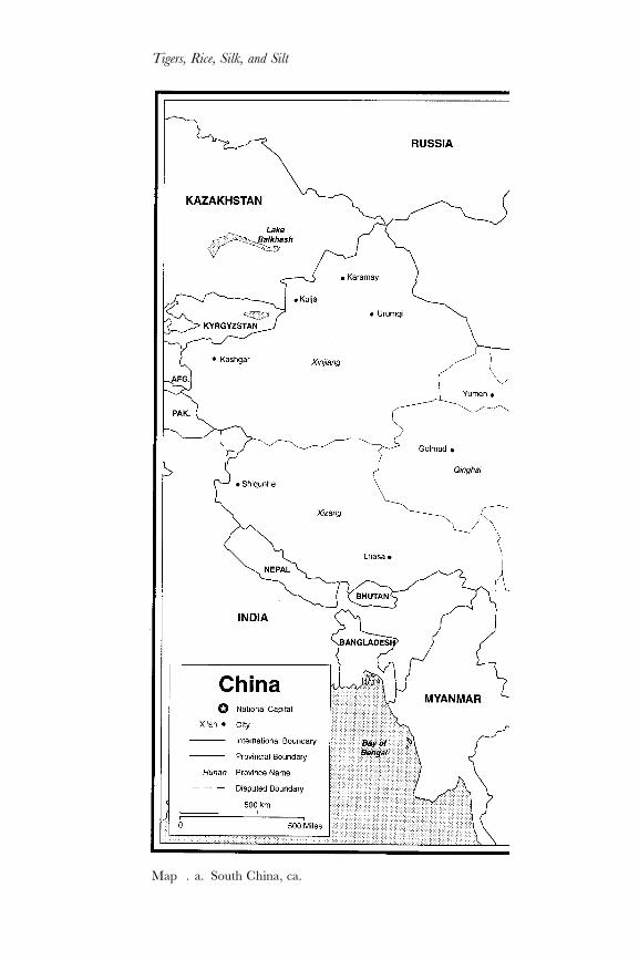
Braudel entitled the first section of his book on the Mediterranean in the Ageof Philip II, “Mountains Come First.”1 That holds for us too, not just becauseit makes geologic or historical sense, but also because it causes us to changethe perspective from which we view south China. For if we first examine astandard map of China and locate the space now occupied by the twoprovinces of Guangdong and Guangxi, we see that the region of our concernis coastal, straddling the Tropic of Cancer. Indeed, most Americans and Euro-peans looking at a map of China will read it first from the east or southeastlooking toward the west or northwest, as if on a plane flying westward toChina. This reading of the map conforms both to the direction most Ameri-cans read and tell their own history – from the east looking west2 – and to theway in which Europeans first encountered China. From this perspective, thefirst elements we see are the coasts and the coastal cities, and only later, aftersome exploration of this fringe, do our eyes move inland to the great riversystems and mountain ranges of China.
But if instead of the usual east-to-west reading of China, we adopt aChinese reading of their own geography, then we will begin to see it from thenorth looking toward the south. Chinese civilization originated north of the
The Natural Environment of Lingnan
Z
1◊Fernand Braudel, The Mediterranean and the Mediterranean World in the Age of Philip II, Siân Reynolds,trans. (New York: Harper and Row, ), vol. : –.
2◊Dee Brown made this point elegantly in Bury My Heart at Wounded Knee (New York: Holt, Rine-hart, & Winston, ), xvi.
RSS1 9/11/97 4:21 PM Page 17
Tigers, Rice, Silk, and Silt
Z
Map .a.◊South China, ca.
RSS1 9/11/97 4:21 PM Page 18

The Natural Environment of Lingnan
Z
RSS1 9/11/97 4:21 PM Page 19

Tigers, Rice, Silk, and Silt
Z
Qinling Mountains, gradually spreading south into the Yangzi River valleyaround Suzhou and Hangzhou in the region more generally known as Jiang-nan, or “south of the river.” By Tang times (– ), when a material andcultural civilization centered in Jiangnan arose and flourished, the southernextent of its world was marked by a low mountain range the Chinese at thetime called the Nanling, the “southern ranges,” or “southern mountains.” Tothe south of the Nanling Range was the region known as Lingnan, the area“south of the mountains,” which was more backward and less culturallyrefined than Jiangnan. While not uninhabited and having been governed aspart of the Chinese empire since the First Emperor, Qin Shi Huang Di, firstconquered it around , still, in Song times, the authorities consideredLingnan sufficiently far from the cultured center of Chinese civilization to bean appropriate place to banish political enemies.
Among the most famous – if not the first3 – of political exiles to Lingnanwas the renowned Song poet Su Dongbo. Sent in to serve as a countymagistrate in Lingnan as punishment for some politically incorrect commen-taries on the emperor, Su headed south from the capital in Kaifeng, pausingfirst around Nanjing and then continuing up the Yangzi River to Poyang Lakein Jiangxi. From Poyang Lake, Su headed south, up the Gan River toward theNanling Mountains. From the base of the Nanling Range at the headwatersof the Gan River in Nan’an prefecture could be seen a saddle between thehigher peaks of the Nanling, marking the Meiling Pass through the DayuMountains. According to his biographer, Lin Yutang, Su stopped to rest whenhe reached the pass: “It was a sentimental place where many travelers scrib-bled poems on the rocks. Standing there on the peak of the mountain, so closeto the sky and the clouds, Su [Dongbo] felt that he was living in a dream world”(see Map. .a).4
Centuries later, in , Sir George Staunton and the rest of the Mac-Cartney Mission to Beijing were among the first Westerners to follow the route south from Beijing, like Su Dongbo passing through Nanjing and up the Gan River to the Meiling Pass.5 In his book about the MacCartney Mission, Staunton described the view from the Meiling Pass looking south intoLingnan:
The mountain is clothed [on the Jiangxi side] with plantations of trees to itsutmost height, from whence an extensive and rich prospect opens at once to
3◊For a description of the political exiles in Tang Lingnan, see Schafer, The Vermilion Bird, ch. .4◊Lin Yutang, The Gay Genius: The Life and Times of Su Tungpo (New York: John Day, ), .5◊The MacCartney Mission was not the first group of Westerners to travel up the Gan River
to the Meiling Pass. In , several Portuguese were taken prisoner in Fujian and transportedoverland to Guilin, probably traveling over the Meiling Pass. See the chronicle of Galeote Pereira in Charles R. Boxer, South China in the Sixteenth Century (London: Hakluyt Society, ),esp. –.
RSS1 9/11/97 4:21 PM Page 20

the eye. A gentle and uniform descent of several miles on every side, almostentirely clothed with lively verdure, and crowned with towns, villages, andfarm-houses, is, as it were . . . “laid at the feet of the spectator,” whilst distantplains of unbounded extent, with mountains rising out of the horizon, ter-minate the view. Towards the southerly point of the compass appeared,however, a tract of waste and barren ground. The hills scattered over theplain appeared, comparatively to the vast eminence from whence they wereviewed, like so many hay-ricks;6 as is, indeed, the distant appearance of manyother Chinese hills. The town of [Nan’an], which the travelers had lately left,from their present situation, seemed merely to be a heap of tiles, while theriver that passed by it was like a shining line. The mountain, so superior tothe surrounding objects, must be of much higher elevation above the surfaceof the sea. It cannot be less than one thousand feet higher than the sourceof the [Gan River] . . . up which the party had navigated.7
From the Meiling Pass, both Su Dongbo and George Staunton looked southinto Lingnan and commented upon the natural environment – the peak of themountain, the verdant hills, the rivers – as well as the human elements in theenvironment: the villages, the farmhouses, and the path leading up to the pass.Their views of the south raise questions for us not only about the environmentthey saw – what were the forests like? What kind of animals lived in the forests?What was the climate like? – but also about the relationship between the peopleliving there and the environment, for as perceived by these two observers, theenvironment was not purely “natural,” if by that we mean the absence ofhuman influence, but included people in the landscape. Indeed, the very placefrom which they recorded their first views of China “south of the mountains”was in fact a human creation: the Meiling Pass.
The Meiling Pass had been “chiseled” (zao) by human labor during the Tangdynasty (in ) under the leadership of the engineer and state minister,Zhang Jiuling. A native of Shaozhou in northern Lingnan, a place some miles southwest of the pass, Zhang ascended the ranks of the Tang bureau-cracy and ultimately found himself positioned to be able to “improve” the pass,the main link between the Yangzi River valley and Lingnan. As might be imag-ined, the path over the Meiling Pass originally had been a single, rugged mountain trail winding over steep precipices. As Zhang Jiuling described it,Meiling was
Formerly, an abandoned road in the east of the pass,Forbidding in the extreme, a hardship for men.An unswerving course; you clambered aloft
The Natural Environment of Lingnan
Z
6◊In Chinese, this section of the Nanling Range is called the Dayu Ling, or “Big Grain-StackMountains,” a name conveying a similar image.
7◊Sir George L. Staunton, An Authentic Account of an Embassy from the King of Great Britain to the Emperor
of China (Philadelphia, ), vol. : –.
RSS1 9/11/97 4:21 PM Page 21

On the outskirts of several miles of heavy forest,With flying bridges, clinging to the brinkHalfway up a thousand fathoms of layered cliffs.8
As trade between Lingnan and areas to the north picked up after the Tangreestablished political unity and stability in the seventh century, the amount ofsilk and porcelain flowing into Lingnan increased, as did exports of furs, pelts,incense, and medicinal herbs. With more trade, the need to improve the routeover the Meiling Pass arose, and in state minister Zhang Jiuling beganto cut a less steep, broader gradient over the Meiling Pass, lowering the solidrock by some yards to create a pass about yards wide (Figure .). Notonly did Zhang chisel the pass through solid rock, he paved the road on eitherside with small stones. The pass effectively linked the Gan River in Jiangxi withthe North River in Lingnan. According to Ye Xian’en, the Tang opening ofthe Meiling Pass reoriented shipping routes in Lingnan: the North Riverbecame increasingly busy, while the former route through Guangxi fell intodisuse.9 Singing the praises of his own work, Zhang Jiuling boasted after hecut the pass:
The several nations from beyond the seaUse it daily for commercial intercourse;Opulence of teeth, hides, feathers, and furs;Profits in fish, salt, clams, and cockles.10
Thus, to Chinese and even the first Western travelers overland from theYangzi valley into south China, the Nanling Mountains do come first, if I mayparaphrase Braudel. For at least a millennia, all of China “south of the moun-tains” was called Lingnan, an area stretching from westernmost Guangxiprovince into Fujian province on the east, and culminating in the sea or intributary countries “beyond the south sea.” But the Nanling Mountains definedLingnan not just in the Chinese sense we have been discussing so far, but alsoin terms of its physical geography.
Mountains and highlands
Three distinct ranges define the northern, western, and southwestern bound-aries of Lingnan: the Nanling Mountains in the north, the Yunnan–GuizhouPlateau to the west, and the low coastal Yunkai Range in the south and southwest.
Tigers, Rice, Silk, and Silt
Z
8◊Translated and quoted in Schafer, The Vermilion Bird, .9◊Ye Xian’en, Tan Dihua, and Luo Yixing, Guangdong hang yun shi (Beijing: Renmin jiaotong
chuban she, ), –.10◊Translated and quoted in Schafer, The Vermilion Bird, .
RSS1 9/11/97 4:21 PM Page 22

The Natural Environment of Lingnan
Z
Figure ..◊The Meiling Pass, .
The Nanling Mountains, a sinuous belt of several ranges the Chinese some-times called the “Five Ranges” (Wu Ling) because of the names of five sec-tions of the range, divides the Yangzi valley from Lingnan in a generallyeast–west alignment between latitudes ° and ° N. Today, weathered androunded or gullied, the Nanling Range averages about , feet above sealevel, with some of the peaks rising to , feet. These mountains are,
RSS1 9/11/97 4:21 PM Page 23

however, fairly old and in terms of internal structure and genesis can be com-pared with the Appalachians in eastern North America.11 Thus, as mountainsthey are not large or rugged, and they have served less as a barrier and moreas an obstacle to commerce between central and south China.
In the grand scope of geological time, the area that is now south China wasstill covered with ocean some million years ago when north China alreadyhad become continental land. When the uplift of south China began in theearly to middle Jurassic, hundreds of millions of years of sediment had beendeposited and formed into sandstone or limestone, and then tectonic pressuresfolded and refolded the sedimentary rocks into low mountains in a generallyeast-to-west configuration. The geological processes that created the NanlingRange were complex (and still not fully understood), resulting in three sepa-rate regions in the range. The western Nanling, separating the GuizhouPlateau from the Guangxi Basin, follows a mainly east–west orientation. In thecentral section, roughly from the border of eastern Guangxi westward to theGuangdong–Jiangxi border, the range zigzags southward and then northwardagain before resuming in its eastern section an irregular east–west alignmentto the junction with the southeastern uplands.
Delineating the eastern edge of the Nanling Range, the southeastern uplandscomprise a separate geologic formation and follow a southwest–northeast direc-tion covering southern Jiangxi, the whole of Fujian, and eastern Guangdongprovince. Topographically distinct from the rest of Lingnan, the rivers of thesoutheastern upland have a distinctive pattern, flowing southeasterly in trellis-tributary patterns to the sea. Included in this region are Chaozhou and Jiayingprefecture in eastern Guangdong province. The border between the two regionsis defined by the watershed between the Han River, which flows directly into thesea like the other river systems in the southeast coastal region, and the East River,which has its outlet in the Pearl River delta. To the Chinese, Lingnan thusincluded the area occupied by easternmost Guangdong province and all ofFujian province. Geologically and physiographically, though, that part of southChina is distinct from the rest of Lingnan. To give the term “Lingnan” moregeographic rigor than that used by Chinese observers, we will restrict it here tomean the Nanling Range and the three other physiographic subregions south ofthe mountains that for the most part lie within Guangdong and Guangxiprovinces. Thus excluded from Lingnan proper are the Qing-era Guangdongprefectures of Chaozhou and Jiaying.12
Tigers, Rice, Silk, and Silt
Z
11◊K. J. Hsü, “Origin of Sedimentary Basins of China,” in X. Zhu, ed., Chinese Sedimentary Basins
(Amsterdam: Elsevier, ), caption to Fig. . on p. .12◊This definition of Lingnan follows that developed by G. William Skinner in two articles,
“Regional Urbanization in Nineteenth-Century China,” and “Cities and the Hierarchy ofLocal Systems,” both in G. William Skinner, ed., The City in Late Imperial China (Stanford: Stan-ford University Press, ), .
RSS1 9/11/97 4:21 PM Page 24

The Natural Environment of Lingnan
Z
The Yunnan–Guizhou plateau rises in the western part of Guangxiprovince, and to the south a low coastal range of mountains arc from present-day Vietnam through the border with Guangdong, enclosing the GuangxiBasin. Most of the surface of the basin is a tableland with an average eleva-tion of about , feet, although in the western part of the basin a sharp stepup in elevation toward the Yun–Gui plateau is marked by the Yao Hills, whichrun north-northeast on a line just to the west of the cities of Nanning andLiuzhou. The Guangxi Basin is essentially the drainage basin for the WestRiver, with the tributaries all ultimately converging at the city of Wuzhou intoa single trunk. The West River basin constitutes a well-defined subphysio-graphic region, connected to Guangdong province through the single point inWuzhou where the West River flows out of Guangxi and into Guangdong (seeMap .b).
The southern border of Lingnan is a long coastal zone of varying width running southwest from the Pearl River delta to the Vietnam border,separated from the rest of Lingnan by a range of low folded sandstone rocks metamorphosed by granitic or igneous intrusions. The coastal belt, largely the Leizhou Peninsula, contains considerable lowlands drained by short rivers flowing into the South China Sea or the Gulf of Tonkin.Some miles offshore lies Hainan Island, an essentially mountainous continuation of the same geological structure as the southeastern coastalregion, with peaks in the central range reaching , feet. Narrow alluvial lowlands, mostly in the north facing the Leizhou Peninsula, ring theisland.
As a physiographic unit, then, Lingnan is composed of subregions that more or less fit together. I say “more or less” because the region is notsimply a basin surrounded by mountains, as one might conceive of Sichuanprovince or a single river valley. Rather, two features constrain the physicalunity of Lingnan. First, the low coastal range that forms the southern rim of the Guangxi basin forms a watershed, forcing the West River drainagesystem to remain within Guangxi and dividing southwestern Guangdong from the rest of Lingnan. Without this low range, the West River drainagesystem might well have flowed directly into the Gulf of Tonkin. While denied a coastal outlet by the low hills, the West River constituted the mostimportant linkage of Guangxi to Guangdong. Physiographically, this singleconnection between the Guangxi Basin and the Pearl River delta may be seen as a weak link, formed only because of the flow of water into the WestRiver drainage system. One might think of the West River basin as being precariously stuck to western Guangdong with a single pin near the city ofWuzhou. Without sufficient amounts of water, the Guangxi Basin may wellnot have been connected to the rest of Lingnan at all. And the reason thereis plenty of water to fill the rivers – usually, that is – is because of the climateof south China.
RSS1 9/11/97 4:21 PM Page 25

Tigers, Rice, Silk, and Silt
Z
Map .b.◊South China, ca.
RSS1 9/11/97 4:21 PM Page 26

The Natural Environment of Lingnan
Z
RSS1 9/11/97 4:21 PM Page 27

Climate
The present climate of Lingnan is classified broadly as subtropical to tropical;Guangdong and Guangxi provinces straddle the Tropic of Cancer, while the more southerly positioned Leizhou Peninsula and Hainan Island have atropical climate.13 Current monthly mean temperatures throughout the region range from about to °C, and plentiful rainfall (about ,mmannually) falls mostly during the agricultural growing season. Although the region is not frost free, the growing season ranges from to days (°C is the minimum temperature for growing rice).14 Figure .summarizes present climatological data (temperature and rainfall) for the cityof Guangzhou.
While the Nanling Mountains separate Lingnan from central China, toomuch emphasis should not be placed on the mountains as a climatic dividingline, for the dominant feature of climate throughout China, and not justLingnan, is the summer and winter monsoons. As we have seen, the NanlingRange actually is not very high, allowing for a significant exchange of air
Tigers, Rice, Silk, and Silt
Z
Tem
per
atu
re (
˚C)
0
5
10
15
20
25
30
Jan. Feb. Mar. Apr. May June July Aug. Sept. Oct. Nov. Dec.
0
50
100
150
200
250
300R
ainfall (m
m)
Temperature ˚C
Rainfall (mm)
Figure ..◊Mean monthly temperature and rainfall at Guangzhou.Source:◊International Rice Research Institute, Rice Research and Production in
China (Los Banos, Philippines: IRRI, ), .
13◊For a classification of China’s climatic zones, see Zhang Jiacheng and Lin Zhiguang, Climate of
China, Ding Tan, trans. (New York: Wiley, ), .14◊In northern Guangdong province, because of higher altitudes and exposure to cold currents in
the winter, there are only about frost-free days, and the growing season is hence shorter.See International Rice Research Institute, Rice Research and Production in China (Los Banos, Philip-pines: IRRI, ), .
RSS1 9/11/97 4:21 PM Page 28

masses from north to south over the mountains and vice versa. Not highenough to be a climatic barrier, the low-lying Nanling Range enables monsoonwinds to flow north into central China instead of being blocked or directedelsewhere. Each winter, a continental air mass located in Siberia sends cold, dry winds from the north, while in the early summer through autumnwinds from the south and southeast bring moisture-laden air from the Pacific Ocean over the Asian landmass, defining China’s monsoonal climate.15
The summer monsoon has a definite annual cycle and brings percent ofChina’s rain, nearly all of it in the summer months. In the winter months, acold polar front with dominant winds blowing from the inland northwest blocksthe moisture-laden southeasterly winds from reaching China. China’s rainyseason begins in the spring as the polar front recedes northward with warmertemperatures. In late spring, the clockwise circulation of air around the highpressure system brings rains to south China, and in early summer the highdirects rain toward central China and the Yangzi Valley. By July and August,the northernmost retreat of the subtropical high brings rain to north China.With cooling northern hemisphere temperatures in the fall, the advancingpolar front pushes the Pacific subtropical high southward, and in Septemberand October typhoon rains hit south and southwest China. As the polar frontadvances further in the winter months, nearly all of China is rain free (exceptfor drizzle in the Yangzi Valley).16
When the North Pacific subtropical high moves in this regular annual cycle,“normal” and predictable rainfall patterns appear. For Lingnan, the monsoonbrings a considerable amount of rain, ranging from over inches in HongKong on the coast to inches in Wuzhou and inches in Guangzhou. Byany standards, that is a lot of precipitation. Not only is there a lot of rain, itis concentrated in just five or six months of the year, from April throughOctober. Since neither evaporation nor soil permeability or retention couldcontain the vast quantities of water that falls upon Lingnan, it runs off thesurface and fills the natural lines of drainage. As Fenzel succinctly and aptlyconcluded, “consequently, extended river systems had to develop themselvesin order to ensure the removal of the water.”17
The Natural Environment of Lingnan
Z
15◊A monsoon is defined as “alternating winds between winter and summer, the direction of whichvaries more than °.” Manfred Domrös and Peng Gongping, The Climate of China (Berlin:Springer, ), .
16◊This paragraph is based on Zhang Jiacheng and Thomas B. Crowley, “Historical ClimateRecords in China and the Reconstruction of Past Climates,” Journal of Climate (Aug. ):. See also Zhu Kezhen and Zhang Baogun, Zhongguo zhi yuliang (Beijing: Ziyuan weiyuanhui, ), –.
17◊G. Fenzel, “On the Natural Conditions Affecting the Introduction of Forestry as a Branch ofRural Economy in the Province of Kwangtung, Especially in North Kwangtung,” Lingnan Science
Journal ( June ): .
RSS1 9/11/97 4:21 PM Page 29

Rivers and Soils
Lingnan’s “extended river systems” consist primarily of three rivers – the East,the North, and the West – which converge in the Pearl River delta and thenempty into the South China Sea. As can be readily seen from Map .b, thedrainage basin of the West River is the largest and most important, followedby those of the North and the East Rivers. The catchment basins and the structure of these major river systems conform to the topography of Lingnan,with most of the river systems contributing to the flow of water into the PearlRiver. Shorter, smaller rivers in southwest Lingnan flow directly into either the South China Sea or the Gulf of Tonkin. While the West River system con-stitutes the largest drainage in Lingnan, in comparison with other drainagesystems in the rest of China, it ranks third behind the Yellow River and YangziRiver systems.
Besides the length of its rivers and area of its drainage basins, the Lingnansystem exhibits three other characteristics that differentiate it from the Yellowand Yangzi Rivers. First, the amount of water flowing into Lingnan’s riversystems fluctuates wildly with the monsoon, rising rapidly in the rainy seasonand falling equally dramatically in the dry season.18 A sense of how dramaticthe swings are can be seen in the West River water level at Wuzhou. As willbe recalled, by the time the West River reaches Wuzhou, the water from all itstributaries in Guangxi has entered the stream; from Wuzhou, the West Riverspills into Guangdong province. At flood stage, up to million cubic feet persecond flow past Wuzhou, with the water level an average of feet above thedry-season level. In extremely wet years, the West River could rise even higher;
Tigers, Rice, Silk, and Silt
Z
Table 1.1.◊The Pearl River drainage basin, compared with the Yangzi and Yellow Rivers
Drainage area Flow Suspended Silt carried Silt carriedRiver (sq. km) (cu. m/sec.) (kg/cu. m) (kg/sec.) (ton/sq. km/yr.)
Yangzi River 1,705,383 28,500 0.575 16,388 1,686Yellow River 687,869 1,350 37.700 50,895 293
West River 329,705 6,294 0.321 2,020 201North River 38,363 1,280 0.126 161 n.a.East River 25,325 697 0.136 95 n.a.
Pearl River system 393,393 8,271 ,0.321 2,276 .201
Source:◊Chen, Zhongguo ziran dili, vol. , Dibiao shui: 71–75, 108–11.
18◊For the comparative data, see Chen Binyi, editor in chief, Zhongguo ziran dili, vol. , Dibiao shui
(Beijing: Kexue chuban she, ), –.
RSS1 9/11/97 4:21 PM Page 30

in , for instance, the water rose to . feet above the dry-season level, andwhen the West River spilled into Guangdong province that year, massive flood-ing occurred.19
Second, the Lingnan rivers carry (and have carried) the least amount of siltof any major river system in China (see Table .). Although the Pearl Riverdrainage system (which includes the West, North, and East Rivers) is the thirdlargest in China, it carries but percent of the amount of silt in the YangziRiver, though this is partly because of the greater flow of the Yangzi system.20
Before the forest cover of Lingnan was removed (a story I take up in later chap-ters), anecdotal evidence from the Tang era indicates that the rivers ran clear.21
But even in the nineteenth and twentieth centuries, after the forests had beenremoved, the hills were not barren, but covered with a tough grass that heldmuch of the soil in place. Comparatively, then, the Pearl River drainage systemwashed less soil to the ocean than the Yellow and Yangzi Rivers, but it carriedenough silt that it settled out and began forming a delta.
Indeed, during the summer monsoon, enough soil was washed into therivers, especially the West, to lend them a muddy appearance. “So,” in thewords of a twentieth-century observer,
during the summer months, the swelled rivers carry along with their brown,turbid waters enormous quantities of sedimentary materials and, in the lowercourses, where the rivers transverse the delta at a much slower speed,and split up into a network of channels, these materials are deposited quickly.In this deposition, however, though it leads to a steady growth of the land atthe cost of the rivers and the back waters of the bays, which gradually lead over to the open sea, a strict boundary between the firm land and thewater is lacking nearly everywhere, and extremely high waters inundate evenareas which have long since been regarded as finally dry and secure fromfloods.22
The amount of silt carried by these rivers thus was significantly less thanthat carried by the Yellow River, but the Pearl River system nonetheless didcarry enough silt to be deposited at the mouths of the rivers to form a delta.Moreover, the amount of silt varied from one historical epoch to another aspeople settled and cleared the land. Indeed, the pace by which the Pearl Riverdelta formed, as I will discuss in more detail in the next chapter, hastened con-current with the clearance of land in the upper reaches of the North and WestRivers, which increased the amount of silt flowing downstream.
The Natural Environment of Lingnan
Z
19◊G. W. Olivercrona, “The Flood Problem of Kwangtung,” Lingnan Science Journal , no. ():–.
20◊Chen, Zhongguo ziran dili, vol. , .21◊Zeng Zhaoxian, “Cong lishi dimaoxue kan Guangzhou cheng fazhan wenti,” Lishi dili ():
.22◊Fenzel, “On the Natural Conditions Affecting the Introduction of Forestry,” .
RSS1 9/11/97 4:21 PM Page 31

A third difference with the Yellow and Yangzi Rivers is that because of theamount and concentration of the rain in just a few months, the river beds oftenlie in valleys with sides cut too steep for cultivation, a characteristic particu-larly evident throughout much of the West River drainage system inGuangxi,23 in the upper reaches of the North River, and in the East River eastof Huizhou. Had the climate provided a more even or less intensive rainfall,the rivers of Lingnan might have eroded the old hills and mountains at a more leisurely pace, creating wider, more level valleys. But the particular combination of Lingnan’s topography with the climatic patterns conspired onthe one hand to leave little valley land in Lingnan fit for cultivation, but on the other to create the alluvial soils that have been captured to create thePearl River delta.
The Pearl River Delta.◊Carrying considerably less silt than China’s othermajor rivers, the West, North, and East Rivers nonetheless converged to createa common delta in central Guangdong. These three rivers at one time hadindependent outlets, but subsidence of the coastal region after the Jurassiclifting created a common bay into which they all emptied. The subsidence leftthe tops of many of the original hills above sea level, now at most a thousandfeet, but the alluvium brought down by the rivers slowly filled in the bay, cre-ating the delta. With its “curious combination,” as the British Naval Intelli-gence termed it, of alluvium, hills, islands, and bay, the Pearl River delta is nota true or pure delta, but a rather unique structure.24 Indeed, in terms of geo-logic time, the Pearl River delta is a very recent creation. Just , years ago,the delta was perhaps half its current size and even , years ago had notincreased much beyond that; in the past millennium, though, the Pearl Riverdelta has doubled in size, largely as a result of human action. How that hap-pened is an interesting story that will be told in the next chapter; suffice it tosay here that the Pearl River drainage system carried so little silt that the deltaoriginally formed very slowly, with the pace quickening only when the lowerreaches of the West, North, and East Rivers were altered to meet human needs,and pioneers began to settle in the delta.
Navigation.◊Lingnan’s rivers not only carried sediment to be depositedin the alluvial plains; they also carried boats. Navigation on the extensive riversystem provided the basic means of communication, travel, and trade throughthe otherwise impassable folded hills of the Lingnan interior. Each of the
Tigers, Rice, Silk, and Silt
Z
23◊Zhao Songqiao, Geography of China: Environment, Resources, Population, and Development (New York:Wiley, ), .
24◊Great Britain Naval Intelligence Division, China Proper, vol. , Physical Geography, History, and
Peoples, Geographical Handbook Series (London, ), –. Because it is a filled-in bayrather than a true delta, this source calls the Pearl River delta an “embayment.”
RSS1 9/11/97 4:21 PM Page 32

major rivers was navigable, if by that we mean that small dugouts or rafts couldfloat downstream until the river widened and deepened to accommodate boatsof deeper draft. The MacCartney Mission, for instance, took small boats fromNanxiong downriver to Shaozhou, where they boarded larger boats to com-plete the journey to Guangzhou, passing through some stretches of narrowswhere the North River coursed over rapids. Rapids and shallower water couldbe found on the East River above Huizhou and on many of the tributaries tothe West River in Guangxi.
It was of course easier going downstream than up. Sailing junks couldmaneuver in the Pearl River estuary and up the West River most of the wayto Wuzhou, but after that poles and pullers were needed. The same was truefor the North River. Likewise, to take the Gui River upstream from Wuzhouto Guilin was not impossible, but it was “inconvenient,” if I may borrow aphrase from current Chinese bureaucratic usage. In , for instance, whenthe Manchu governor-general of Yunnan and Guizhou provinces, E-er-tai,toured Guangxi soon after it was added to his bailiwick and wanted to travelfrom Yunnan to Guilin, his route took him from the Yunnan–Guangxi borderdownstream through Bose to Nanning, where he crossed overland throughLiuzhou to Guilin. “Large boats (da chuan) can travel from Bose throughNanning to Wuzhou and [upriver] through Pingle to Guizhou,” he said. “Butthe route is rather roundabout.”25
The monsoons also regulated the shipping calendar. Clearly, when the riverswere at flood stage in the spring and summer with million cubic feet persecond flowing through Wuzhou, travel either up- or downstream was difficultand dangerous. But the dry season also posed its challenges, as water levels inthe channels dropped, sometimes to levels too low for boats. And when thoseboats carried rice down the rivers to markets, low water levels affected riceprices: “Grain prices are rising,” an official reported in early . “Investiga-tion shows that with clear days in the winter, the rivers are dry or shallow, andoutside trade is minimal. Also, it is difficult to transport and sell rice . . . In thespring when rains raise the rivers, [prices] for rice in the cities and villages alikewill fall uniformly.”26
Linkages to the Yangzi River System.◊The Lingnan river system was suchan important part of the transportation system of the entire Chinese empirethat from very early times links were established between it and the YangziRiver valley. The earliest was the construction of the Ling Qu Canal con-necting the upper reaches of the southward-flowing Li River above Guilin with
The Natural Environment of Lingnan
Z
25◊Memorial dated YZ.. in Gongzhongdang Yongzheng chao zouzhe, Gugong bowuyuan, comp.(Taibei: Guoli gugong bowuyuan, –), vol. : –. Hereafter cited as YZCZZ.
26◊Memorial dated QL.. Gongzhongdang Qianlong chao zouzhe, Gugong bowuyuan, comp.(Taibei: Guoli gugong bowuyuan, –), vol. : –. Hereafter cited as QLCZZ.
RSS1 9/11/97 4:21 PM Page 33

the Xiang River, which flowed north through Hunan province and into theYangzi River. Built initially around by Shi Lu, an engineer in Qin Shi Huang Di’s army, the Ling Qu was (and remains) a masterpiece of inge-nuity. Even an extended description of the Ling Qu Canal cannot do justiceto the way in which the Xiang and Li Rivers were connected, so suffice it tosay that Joseph Needham translated the character in its name (Ling) as“magic,” rather than the less grandiose but still apt “ingenious.” Used first totransport Qin troops and warships into Lingnan, the Ling Qu was later usedto transport goods to and from Lingnan from north China via the YangziRiver.27
Natural processes could do only so much with the raw material of Lingnanin providing a river system adaptable to human use. The natural river systemsendowed Lingnan with a transport network upon which to move goods fromone part of the region to another, facilitating agricultural specialization andthe shipment of bulk items like grain down the West River to the city ofGuangzhou, with accessible sources of water for irrigation and with a mech-anism for creating rich soils, all of which could be considered advantageousto human settlement of the region. Over the millennia the vast amount ofwater flowing into the West River basin found an outlet through a fault in hillsnear the city of Wuzhou, thereby not only draining the basin, but establishinga water link between the two major parts of Lingnan. But for the people inhab-iting Lingnan, these natural processes proved insufficient in linking Lingnanto the rest of China, and so people created two additional links: the Ling QuCanal and the Meiling Pass.
The Lingnan river system thus was not ideal. Besides not connectingLingnan with the Yangzi River valley to the north, the rivers cut mostly deepravines into the hills, leaving little level space for alluvial valleys to spread out,thereby limiting the amount of land that could be given over to agricultureand challenging those who would attempt to inhabit the flood plains. The gushof water through the system brought by the summer monsoon virtuallyensured flooding wherever the rivers could overflow their banks, therebydepositing their alluvium, a potentially fertile and rich soil.
Soils.◊Soil is composed of a mixture of varying proportions of de-composed rock, decaying organic matter, and living organisms, which theninteract to form various chemical compounds.28 But despite the fact that,in Lingnan, rocks of various kinds – mostly granites, sandstone, limestone –
Tigers, Rice, Silk, and Silt
Z
27◊Joseph Needham, Science and Civilization in China, vol. , part , Physics and Physical Technology: Civil
Engineering and Nautics (Cambridge University Press, ), –.28◊This section is woefully brief and does not do justice to the complexity of soils. As Edward O.
Wilson recently observed: “The very soils of the world are created by organisms. Plant rootsshatter rocks to form much of the grit and pebbles of the basic substrate. But soils are much
RSS1 9/11/97 4:21 PM Page 34

contribute different bases for the soils, the rainfall and humidity exercise thegreatest influence on the kind of soil that predominates. Because of the largeamount of rainfall, soluble materials in the upper layers of the soil leachedinto lower levels, leaving slightly acidic soils that are red or brown in color.When exposed to the air, these soils either develop a hard crust upon which little vegetation can grow, or contain a hardpan called “laterite” justbelow the surface that can be exposed by erosion; this may have been whatStaunton saw from the Meiling Pass when looking south he described “a tractof waste and barren ground.” The original vegetation probably had beenburned off, exposing the earth to the rains and eroding the topsoil down to thehardpan.
The soil covering the hardpan was generally yellow or red podzolized earth,a soil type found throughout south China, including Lingnan. None are particularly fertile and, with the hardpan, are at best difficult to work.Tropical soils generally are poor, and those in Lingnan were no different.The reason for the infertility is that most of the organic matter in tropicalecosystems is tied up in the trees that constitute the tropical forest, and thenutrients from decaying matter are quickly leached from the soil by the heavyrainfall.
Forests and Wildlife
In the s, according to estimates made at the time by Chinese and Westernbotanists, cultivated land took up about – percent of the land surface ofLingnan, while most of the rest of Lingnan – being hills or mountains – wassavanna, and only a very small proportion, maybe as little as percent butperhaps as much as percent of the land, was forested. However much forestdid exist in the s, the scientists agree that most was a secondary growth of pine forests – the scrubby-looking Mason’s pine (Pinus massoniana, see Figure.) – sometimes intermixed with some broadleafs.29 To those in the slooking at the vast expanse of treeless hills, the question was whether the
The Natural Environment of Lingnan
Z
more than fragmented rock. They are complex ecosystems with vast arrays of plants, tinyanimals, fungi, and microorganisms assembled in delicate balance, circulating nutrients in theform of solutions and tiny particles. A healthy soil literally breathes and moves. Its microscopicequilibrium sustains natural ecosystems and croplands alike.” Edward O. Wilson, The Diversity
of Life (Cambridge, MA: Harvard University Press, ), . Similarly, Donald Worster haswritten, “Few . . . would deny that a topsoil is an organization of life, fundamentally akin to amountain forest, a coral reef, or a school of minnows.” Donald Worster, “A Sense of the Soil,”in Worster, The Wealth of Nature, . For an extended argument about the centrality of soil con-servation in the rise and fall of civilizations, see Edward Hyams, Soil and Civilization (New York:Harper Colophon, ). The brief summary provided here of the soils of Lingnan is basedupon: Great Britain Naval Intelligence, China Proper, vol. : ch. , and to a lesser degree uponFenzel, “On the Natural Conditions Affecting the Introduction of Forestry,” –.
29◊Ling Daxie, “Wo guo senlin ziyuan de bianqian,” Zhongguo nongshi (): –.
RSS1 9/11/97 4:21 PM Page 35