Embed Size (px)
Citation preview
Tibet Revisited—TIPMEX-86 Elmar R. Reiter,1 J. D. Sheaffer,1 J. E. Bossert,1
Eric A. Smith,2 Greg Stone,3 Robert McBeth,4
and Qinglin Zheng5
Abstract
A long-planned field-measurement program to determine surface-energy budgets at two sites in Tibet was carried out during June 1986 in collaboration with scientists from the State Meteorological Ad-ministration, Academy of Meteorological Sciences, People's Repub-lic of China. The data set obtained in Tibet is unique for this remote region of the world. The present report describes some of the expe-riences of the United States scientific team and its medical officer, M. Otteman of Ft. Collins, Colorado. The data are presently being ar-chived on computer tapes. Preliminary analysis results are presented as typical examples of the conditions encountered at the two experi-mental sites near Lhasa (3635 m) and Nagqu (4500 m).
1. Return to Tibet
For most of the United States team (i.e. the authors of this report and Merlin Otteman, a Ft. Collins surgeon and the expedition's medical officer) the 7000-m peaks and glaciers of eastern Tibet were a formidable barrier between Chengdu, Sichuan, and an unknown land of adventure, described by travelers such as Harrer, Sven Hedin, and Han Suyin. For the senior author the view spreading underneath the vintage Boeing 707 evoked memories of a previous journey into the unknown (Reiter and Reiter, 1981). Would Tibet still be the same, with dusty roads, a few old Chinese "Liberation" trucks among pedestrians and donkey carts, curious natives swinging prayer wheels, spartan accommodations with the pervasive smell of burning yak dung and rancid yak butter candles?
Stepping into bright sunshine and brisk mountain air at Lhasa Airport was a welcome relief after the muggy heat of Beijing and Chengdu. It was 1 June 1986, and the monsoonal rains were expected soon. The old outhouse near the runway offered a familiar sight, but the "fragrant" adobe structure of years past had yielded to a concrete edifice of similar design and unadorned functionality. There, again, were a few Tibe-tan girls giggling at the new arrivals and coyly disappearing into the outhouse if a camera was raised to the eye. But a new hotel or dormitory structure near the gate of the air field fore-boded changes. We did not have to worry about luggage. There now was a downtown airline office where baggage could be retrieved conveniently later during the day. We were whisked along the 60-mile road to Lhasa, now black-topped but still bumpy. The better tire traction offered by tar as
1 Colorado State University, Fort Collins, Colo. 2 Florida State University, Tallahassee, Fla. 3 Los Alamos National Laboratory, Los Alamos, N. Mex. 4 National Center for Atmospheric Research, Boulder, Colo. 5 Academy of Meteorological Sciences, State Meteorological Ad-
ministration, Beijing, People's Republic of China. © 1987 American Meteorological Society
compared to dust, sand, and gravel, invited the drivers to demonstrate their daring, especially during passing maneu-vers at breakneck speeds around curves, along precipices and over hill crests.
Peasants in sheepskin coats, carrying bundles of food, hay, firewood, and even an occasional yak-skin boat, still popu-lated the highways. So did pony or donkey carts. But gleam-ing bicycles with well-dressed ladies and gentlemen pedaling at leisurely pace, new Isuzu trucks, Nissan, and Toyota lim-ousines and 4-wheelers started to clog the roads as we neared Lhasa, the imposing capital of Xizang Autonomous Region. The air was filled with the constant blaring of automobile horns to disperse the throngs of bicyclists, pedestrians, cattle, and sheep. The Potala palace on its majestic perch on top of a dominating hill still gleamed with its gilt roofs, but a huge TV antenna with its Eiffel Tower shaped struts and girders now competes as a new landmark on a smaller hill that formerly carried the lamaist medical college. Watching television has become one of the foremost communal evening pleasures in Lhasa.
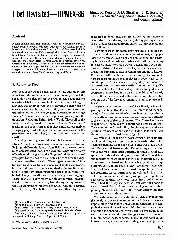
We gaped as we drove by the new Lhasa Hotel, replete with gushing fountain, Holiday Inn architecture (and manage-ment) and a parking lot full of modern buses, taxis, and wait-ing chauffeurs. We were even more surprised as we pulled up to the entrance of the spanking new Tibet Guest House (Xi-zang Binguan), bedecked with bunting and Chinese lanterns. The senior author's credibility, after having warned the ex-pedition members about spartan living conditions, was about to receive its final blow. (Fig. 1).
We were still unpacking suitcases when a din from fire-crackers, drums, and cymbals made us rush outside. The opening ceremony for the new guest house was in full swing, with Party Vice-Chairman Mao Rubo cutting a red ribbon and a swarm of dignitaries suffering through interminable speeches and then descending on a beautiful buffet of delica-cies to which we were graciously invited. Mao turned out to be an ex-meteorologist and became a highly interested sup-porter of our scientific goals. Pretty Tibetan waitresses with long, dark hair, decked out in touristic adaptations of Tibe-tan costumes, served warm beer and cola and—lo and be-hold—ice cubes, which did not prompt rapid trips to the bathroom, because they were made from boiled water. Where had the dusty maidens of 1980 with their tangled hairdos gone? (We still found them roaming around the bur-geoning "free markets" and in the remote villages, but they appear to be a vanishing breed.)
We ventured out into the old part of Lhasa, by taxi from the hotel, but per pedes apostolorum back, because cabs are impossible to find once you have abandoned them. The tem-ple in the heart of town does as brisk a business as ever, but a new, wide and open square in front, flanked by new buildings with traditional architecture, brings its role as communal hub into better focus. Whereas in 1980 tourist were an un-known species, hence souvenir trading was an art yet to be
Bulletin American Meteorological Society 607
Unauthenticated | Downloaded 02/23/22 12:25 PM UTC
608 Vol. 68, No. 6, June 1987 learned, and souvenir hunters could hardly bag a single, overpriced item of dubious quality, now hawkers with layers of turquoise and coral jewelry around their necks descend on flocks of tourists and follow them, thrusting out their wares, quoting prices in English or punching them into their pocket calculators, inviting response bids by asking "How much?" or by holding the calculator keyboard under your nose. There are no fixed prices and lively bargaining with a street vendor immediately attracts an interested audience and competitive "merchants."
Lamas selling printed prayer flags, penitents prostrating themselves in a muscle-wrenching, clockwise procession around the temple, sage brush "incense" smoldering in in-cinerators attest to the religious presence in Tibet. As in other cities in China, there now are thriving "free markets" where anything from yak butter, meat, vegetables, and clothing is sold from open stalls. These markets, not present in 1980, can now be found even in the back country, however sanitary conditions as well as quality of lodging and food decreases in proportion to the distance from Lhasa.
Our second field station at Nagqu, a small town of about 3 000 population that spreads out on the high (4500 m) and windy plateau about 300 km to the north of Lhasa gave our team a glimpse of Tibet before the tourist invasion. This settlement lies on the (now paved) Lhasa-Golmud-Xining highway, has a newly built hotel (without amenities) and is as bleak as the surrounding hills. The frequent hail squalls do nothing to cheer up the traveler. The trip between Lhasa and Nagqu is not without rewards. It leads through the Trans-himalayas (Nyainqentanglha Shan) with spectacular vistas of glacier-capped peaks, some in excess of 7 000 m, and fol-lows the upper reaches of the Lhasa River. The breakneck speed with which our drivers negotiated the bumpy road made the journey less enjoyable and caused damage to some of our instruments. Working at 4 500 m is no picnic either. Sleep is difficult for lack of oxygen, and loss of appetite is as much due to high-altitude syndrome as to the limited re-sources available to the cooks. The United States and Chi-nese teams took shifts in manning the Nagqu station. Seeing the Nagqu relief team take off from Lhasa resembled watch-ing a "chain gang" being marched off to labor. The relieved team, on the other hand, descended on Lhasa with the same enthusiasm that a submarine crew would show upon a port call.
2. The measurement program
Two 20-m meteorological towers, made available by the Los Alamos National Laboratory, were shipped in two large crates from Ft. Collins to Lhasa by boat, rail, and truck, in November 1985. The space in these crates was filled with sounding balloons and various unbreakable supplies. The United States team arrived by air in Beijing on 27 May 1986, inundating customs with a flood of 26 suitcases and instru-ment crates. Red tape in China is no less a test of patience than in the United States. The State Meteorological Admin-istration finally ended up posting a large bond to pry our equipment loose from customs, to be refunded upon our leaving the country. The same baggage flood baffled Chinese-
FIG. 1. TIPMEX team (McBeth and Stone had already left for the U.S.). Front row: Ring Wang, Changhan Zhu, Pengju Wang, Yijun Liu, James Bossert, Shuhua Li, Xiepong Zhao, Yu Uang; Back row: Eric Smith, Elmar Reiter, Merlin Otteman, John Sheaffer, Wanlong Chen.
airline officials between Beijing, Chengdu, and Lhasa, but eventually everything showed up intact at our point of destination.
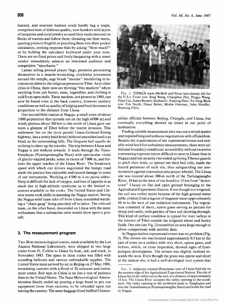
Finding suitable measurement sites was not a trivial matter and required long and arduous negotiations with officialdom. Besides the requirements of site representativeness and suit-able wind fetch for turbulence measurements, there were ad-ditional boundary conditions: accessibility without excessive commuting expenses (more difficult to meet in Lhasa than in Nagqu) and site security (we ended up hiring Tibetan guards to pitch their tents, or spread out their bed rolls, inside the fenced perimeter of each site, thus safeguarding our ane-mometers against conversion into prayer wheels). The Lhasa site was located about 300-m north of the Yarlungzangbo River, 10 km to the west of our hotel (or 15 km from "down-town" Lhasa) on flat and open ground belonging to the Agricultural Experiment Station. Even though not irrigated, the soil was rather moist because of the high ground-water table, evident from a lagoon of stagnant water approximately 10 m to the west of our radiation instruments. The vegeta-tion consisted of short, native grass serving as pasture for sheep and cattle, with patches of bare soil showing through. This kind of surface condition is typical for river valleys in the interior of Tibet outside the irrigated wheat and barley fields. Our site (see Fig. 2) resembled an area large enough to allow comparisons with satellite data.
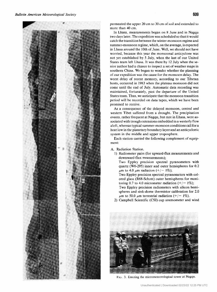
At Nagqu station representativeness was no problem (Fig. 3). The chosen site was located approximately 0.5 km to the east of town on a surface with very short, sparse grass, and lichens, which, on close inspection, showed signs of frost-polygon development. The terrain was slightly inclined to-wards the west. Even though the grass was sparse and short at the station site, it had a well-developed root system that
FIG. 2. (adjacent column) Panoramic view of Lhasa field site on the western edge of the Agricultural Experiment Station. The city of Lhasa lies in the valley cut to the east, at a distance of approximately 15 km. The Lhasa River occupies the valley opening to the south-west. The valley opening to the northwest leads to Yangbajian and into the Transhimalaya (Nyainqentanglha Shan) and holds the road to Nagqu.
Unauthenticated | Downloaded 02/23/22 12:25 PM UTC
Bulletin American Meteorological Society 609
permeated the upper 20 cm to 30 cm of soil and extended to more than 40 cm.
In Lhasa, measurements began on 8 June and in Nagqu two days later. The expedition was scheduled so that it would catch the transition between the winter-monsoon regime and summer-monsoon regime, which, on the average, is expected in Lhasa around the 10th of June. Well, we should not have worried, because this year the monsoonal anticyclone was not yet established by 5 July, when the last of our United States team left Lhasa. It was there by 12 July when the se-nior author had a chance to inspect a set of weather maps in southern China. We began to wonder whether the planning of our expedition was the cause for the monsoon delay. The worst delay of recent memory, according to our Tibetan hosts, occurred in 1983 when the plateau monsoon did not come until the end of July. Automatic data recording was maintained, fortunately, past the departure of the United States team. Thus, we anticipate that the monsoon transition period will be recorded on data tapes, which we have been promised to receive.
As a consequence of the delayed monsoon, central and western Tibet suffered from a drought. The precipitation events, rather frequent at Nagqu, but rare in Lhasa, were as-sociated with trough extensions embedded in a westerly flow aloft, whereas typical summer-monsoon conditions call for a heat low in the planetary boundary layer and an anticyclonic system in the middle and upper troposphere.
Each station carried the following complement of equip-ment: A. Radiation Station.
1) Radiometer pairs (for up ward-flux measurements and downward-flux measurements); Two Eppley precision spectral pyranometers with quartz (W6-295) inner and outer hemispheres for 0.2 jum to 4.0 jum radiation (+/ — 1%); Two Eppley precision spectral pyranometers with col-ored glass (R68-Schott) outer hemispheres for moni-toring 0.7 to 4.0 micrometer radiation (+/— 1%); Two Eppley precision radiometers with silicon hemi-spheres and sink-dome thermistor calibration for 2.0 /jim to 50.0 jum terrestrial radiation (+/— 1%).
2) Campbell Scientific (CSI) cup anemometer and wind
FIG. 3. Erecting the micrometeorological tower at Nagqu. Unauthenticated | Downloaded 02/23/22 12:25 PM UTC
610 Vol. 68, No. 6, June 1987
vane (model 014A and 024A) for wind speed and direc-tion at 3-m above surface (+/— 0.25 m* s - 1 , +/— 5°).
3) CSI 207 thermistor and hygristor at 3 m ( + / - 0.2°C, 5% RH).
4) Six CSI soil thermistors at 0.01, 0.02, 0.05, 0.10, 0.20, and 0.40 m below surface for soil-temperature mea-surements ( + / - 0.2°C).
5) Six CSI CEL-WDF-7 ceramic soil-moisture probes at the same depth level as the temperature probes.
6) CSI tipping rain gauge (0.1-mm sensitivity). 7) CSI CR-7 data logger to compute 15-min average
values from 5-s scan intervals and to record maxi-mum and minimum values and average data on magnetic tape. (Some data loss occurred at Nagqu because of a sensor-excitation board that had shaken loose during the kamikaze ride from Lhasa).
B. Micrometeorological tower station. 1) R. M. Young 27005J-Gill u-v-w propeller anemome-
ters at 5, 10, and 20 m. (Accuracy varies with angle of attack, cosine corrections required).
2) CSI 207 thermistors and hygristors at 0.1, 5, 10, and 2Q m ( + / - 2°C, + / - 5% RH).
3) CSI CR-7 data logger to compute 5-min-average values, correlation statistics, variances, etc. from 2-s-scan-interval data and to record all parameters on magnetic tape. (The bumpy road conditions between Lhasa and Nagqu caused the data logger at Nagqu to malfunction. Data had to be dumped from computer memory by manual interrogation and had to be hand-copied).
C. NCAR-ADAS radiosonde system with theodolite track-ing of balloons. (There also was a major data loss at Nagqu due to computer-hardware damage incurred dur-ing transit).
D. At the Lhasa station atmospheric-turbidity measure-ments were carried out with a University of Arizona Solar Photometer measuring in 10 wave-length bands centered at 0.3703,0.3996,0.4409,0.5196,0.6105,0.6703, 0.7790, 0.8703, 0.9385, and 1.0291
E. Teletemp portable infrared thermometers were used to survey local variations of the surface "skin" tempera-tures in the vicinity of each measurement site and to ob-tain typical readings along mountain slopes during climbing excursions.
3. Preliminary data sample
According to an agreement between the National Science Foundation and the State Meteorological Administration, the data collected in the field will be transferred to 9-track "computer tape" to be analyzed by the United States team and the Chinese team. Copies of the data tapes will also be placed in the public domain at NCAR. The field data will be augmented by regional radiosonde and satellite data. Initial-analysis efforts will follow procedures outlined by Chen et al. (1985), Smith (1986 a,b), Smith and Reiter (1986), Smith et al. (1986) and Sheaffer and Reiter (1987). The following
concerns will be addressed during the forthcoming data-analysis phase of our project: a) What is the variability of surface-energy budgets and fluxes dependence on synoptic condition and location? b) How representative are the two measurement sites in terms of regional climates? c) Can our observed surface-radiation budgets be used to establish ground truth for satellite observations? d) How do our mea-surements compare to others taken in similar and dissimilar environments? e) Can our measurement results be parame-terized to benefit numerical-model applications?
The question of data representativeness is one that obfus-cates many field-measurement programs, notably those car-ried out in complex terrain. The downward-pointing radiom-eters "see" within their cone of sensitivity only a rather-small surface area that we chose to carry "typical" vegetation. However, the radiative characteristics of a vegetated surface have to be presumed variable, even if no drastic changes ap-pear to the naked eye. The Nagqu site showed rather uniform and time-invariant ground-cover characteristics. Effects of varying density of grass or lichens were monitored frequently with hand-held infrared Teletemp thermometers. On sunny days these dark-colored lichen crusts were often 10°C to 15°C warmer than nearby patches of grass, thus can be deemed to contribute significantly to the local surface-energy budget. Underneath the radiation "monitors," grass pre-vailed over lichens with an approximate ratio of 7:3.
At Lhasa a tribe of voles invaded the area around our ra-diometers and had to be discouraged by pouring kerosene down their burrows. The damaged surface area was small enough to be of negligible consequence to our data. The vi-cinity of that site included open water, marsh grass, bare soil, willow trees, and a wheat field, whose surface-temperature characteristics were also monitored with an infrared ther-mometer. In addition, team members climbed the south-and north-facing mountain sited near Lhasa (the latter after ford-ing the Lhasa River in a yak-skin boat) to obtain surface "skin" temperature readings by infrared thermometry of typical surfaces under varying sun angles. The highest temperatures (in excess of 60°C) were encountered over sand dunes.
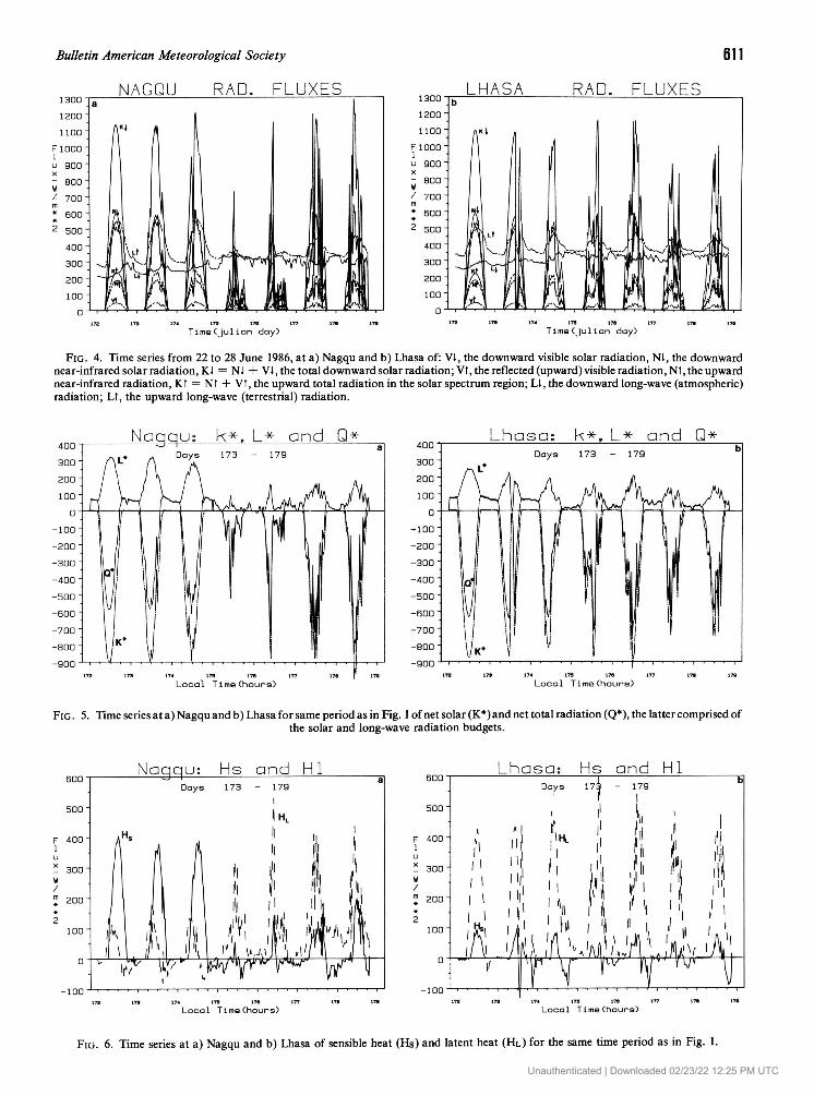
Typical data output for the period 22-28 June at Nagqu and Lhasa is shown in Fig. 4. Plotted are diurnal cycles of downward fluxes and upward fluxes of shortwave (V), near-infrared radiation (N), their sum (K), and longwave atmos-pheric and terrestrial radiation (L). Peak values of K at both sites can excede 1100 W • m~2 and at Nagqu surpassed those observed by Smith (1986a) on clear days in the Saudi Ara-bian "Empty Quarter" by about 10 percent. Values of close to 1300 W • m~2 at Nagqu are caused by direct transmission through the highly transmissive (thin) atmosphere with an additional scattering source from cumulus clouds. The bal-ances between incoming and outgoing fluxes in the solar shortwave and near-infrared spectral regions (K*), in the longwave-radiation bands (L*), and the sum of the two are depicted in Fig. 5. In these diagrams we have subscribed to the convention of plotting fluxes received by the soil surface as negative quantities, and fluxes emitted by the soil as posi-tive quantities. The high values of L* at Nagqu during the first three days (22-24 June) of the sample shown here are due to a very warm soil surface and a thin, cold, and dry at-mosphere. These values which excede 300 w m ~ 2 on days
Unauthenticated | Downloaded 02/23/22 12:25 PM UTC
Bulletin American Meteorological Society 611
FIG. 4. Time series from 22 to 28 June 1986, at a) Nagqu and b) Lhasa of: Vi, the downward visible solar radiation, Ni, the downward near-infrared solar radiation, Ki = Nl + VI, the total downward solar radiation; Vt, the reflected (upward) visible radiation, Nt, the upward near-infrared radiation, Kt = Nt + Vt, the upward total radiation in the solar spectrum region; LI, the downward long-wave (atmospheric) radiation; Lt, the upward long-wave (terrestrial) radiation.
FIG. 5. Time series at a) Nagqu and b) Lhasa for same period as in Fig. 1 of net solar (K*)and net total radiation (Q*), the latter comprised of the solar and long-wave radiation budgets.
FIG. 6. Time series at a) Nagqu and b) Lhasa of sensible heat (H S) and latent heat (HL) for the same time period as in Fig. 1. Unauthenticated | Downloaded 02/23/22 12:25 PM UTC
612 Vol. 68, No. 6, June 1987
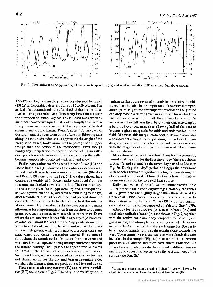
FIG. 7. Time series at a) Nagqu and b) Lhasa of air temperature (T a) and relative humidity (RH) measured 3-m above ground.
172-173 are higher than the peak values observed by Smith (1986a) in the Arabian desert in June by 10 to 20 percent. The arrival of clouds and moisture after the 24th damps the radia-tive heat loss quite effectively. The disruption of the fluxes in the afternoon of Julian Day No. 173 at Lhasa was caused by an intense convective squall that broke abruptly from a rela-tively warm and clear day and kicked up a veritable dust storm in and around Lhasa. (Reiter's notes: "A heavy wind, dust, rain and thunderstorm in the afternoon [blowing dust along the mountain sides lets us appreciate the origin of the many sand dunes] looks more like the passage of an upper trough than the action of the monsoon"). Even though hardly any precipitation reached the bottom of Lhasa valley during such squalls, mountain tops surrounding the valley became temporarily blanketed with hail and snow.
Preliminary estimates of the sensible-heat fluxes (H s) and latent-heat fluxes (Hi) derived at the radiation stations with the aid of a bulk aerodynamic-computation scheme (Sheaffer and Reiter, 1987) are given in Fig. 6. The values shown here compare favorably with Bowen ratios computed from the micrometeorological-tower station data. The first three days in the sample given for Nagqu were dry and, consequently, showed a prevalence of H s , whereas the remaining four days, after a frontal rain squall on 25 June, had precipitation (1.5 cm on the 25th), shifting the burden of total heat flux into the atmosphere to Hi. Even during the dry days one has to make allowances for evapotranspiration from the short and sparse grass, because its root system extends to more than 40 cm where the soil moisture is near "field capacity." (A hand-ex-cavated well about 0.5 km from the Nagqu site showed the water table to be at least 10 m from the surface.) At the Lhasa site the high ground-water table next to a lagoon with stag-nant water and denser vegetation caused Hi to prevail throughout the sample period. Moisture from the warm and wet subsoil moved upward during the night and condensed at the surface, causing "wet" patches to appear even on barren soil areas in the absence of any measurable precipitation. Such conditions, while encountered in the river valley, are not characteristic for the dry and barren mountain sides which, in the Lhasa region, are partly covered by sand dunes.
Time series of air temperatures (T a) and relative humidi-ties (RH) are shown in Fig. 7. The "dry" and "wet" synoptic
regimes at Nagqu are revealed not only in the relative-humid-ity regimes, but also in the amplitudes of the diurnal temper-ature cycles. Nighttime air temperatures close to the ground can drop to below freezing even in summer. This is why Tibe-tan herdsmen never mothball their sheepskin coats. On warm days they still wear them below their waists, held up by a belt, and over one arm, thus allowing half of the coat to become a giant receptacle for odds and ends needed in the field. Of course, this furry climate-control device also exudes a characteristic fragrance of yak-dung fire, yak-butter can-dles, and perspiration, which all of us will forever associate with the magnificent and mystic ambience of Tibetan tem-ples and shrines.
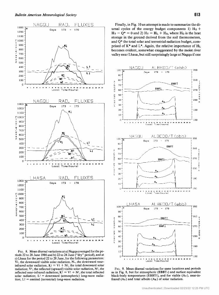
Mean diurnal cycles of radiation fluxes for the seven-day period at Nagqu and for the first three "dry" days are shown in Figs. 8a and 8b, and for the seven-day period at Lhasa in Fig. 8c. During the "dry" period at Nagqu the downward surface solar fluxes are significantly higher than during the cloudy and wet period. Ultimately this is how the plateau monsoon shuts off the elevated heat source.
Daily mean values of these fluxes are summarized in Table 1, together with their seven-day averages. Notably, the values of H t given here are slightly larger than those derived by Chen et al. (1985) from precipitation data, are similar to those estimated by Luo and Yanai (1984), but fall signifi-cantly short of the values reported by Yeh and Gao (1979).
Albedos for the shortwave (AV), near-infrared (AN) and total solar-radiation bands (Ak) are shown in Fig. 9, together with the equivalent black-body temperatures of soil (out-going arrow) and atmosphere (incoming arrow). The asym-metry in the AN curve for clear days at Nagqu (Fig. 9b) has to be attributed mainly to the slight terrain slope towards the west. The asymmetry reverses its shape when cloudy days are included in the sample (Fig. 6a) because of the afternoon prevalence of diffuse radiation over direct radiation. At Lhasa the asymmetry can also be ascribed to different terrain and ground cover characteristics to the east and west of the station (see Fig. 2).6
6 Most of the morning and evening "spikes" in AN will have to be attributed to instrument characteristics at low sun angles.
Unauthenticated | Downloaded 02/23/22 12:25 PM UTC
Bulletin American Meteorological Society 613
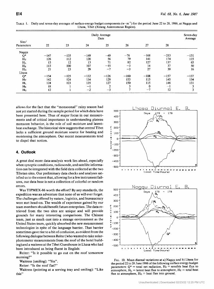
Finally, in Fig. 10 an attempt is made to summarize the di-urnal cycles of the energy budget components 1) HG + HT - Q* = 0 and 2) HT — HL H~ H s , where HG is the heat storage in the ground derived f rom the soil thermometers, and Q* the total solar and terrestrial radiation budget, com-prised of K* and L*. Again, the relative importance of HL becomes evident, somewhat exaggerated by the moist river valley near Lhasa, but still surprisingly large at Nagqu if one
FIG . 8. Mean diurnal variations at a) Nagqu averaged for the pe-riods 22 to 28 June 1986 and b) 22 to 24 June ("dry" period), and at c) Lhasa for the period 22 to 28 June, for the following parameters: VI, the downward visible solar radiation, Ni, the downward near-infrared solar radiation, Ki = VI + Ni, the total downward solar radiation; Vt, the reflected (upward) visible solar radiation, Nt, the reflected near-infrared radiation; Kt = Vt + Nt, the total reflected solar radiation; Lt = downward (atmospheric) long-wave radia-tion; Lt = emitted (terrestrial) long-wave radiation.
FIG. 9. Mean diurnal variations for same locations and periods as in Fig. 8, but for atmospheric (EBBT1) and surface equivalent black-body temperatures (EBBTt), and for visible (Av), near-in-frared (AN) and total albedo (AK) of solar radiation.
Unauthenticated | Downloaded 02/23/22 12:25 PM UTC
614 Vol. 68, No. 6, June 1987
TABLE 1. Daily and seven-day averages of surface-energy budget components (w • m 2 ) for the period June 22 to 28, 1986, at Nagqu and Lhasa, Tibet (Xizang Autonomous Region).
Daily Average Seven-day Date Average
Site/ Parameters 22 23 24 25 26 27 28
Nagqu Q* -147 -135 H T 126 112 H L 13 12 Hs 113 100 Ho 21 23
Lhasa Q* -154 -125 H T 142 124 H L 124 123 Hs 18 1 Hg 12 1
-149 - 4 9 - 7 6 120 56 79 13 71 82
107 - 1 5 - 3 29 - 7 - 3
-132 -126 -160 134 129 153 135 127 150 - 1 2 3 - 2 - 3 7
-168 -213 -131 141 174 115 127 137 65 14 37 50 27 39 16
-108 -157 -137 115 145 134 115 146 131
0 - 1 3 - 7 12 3
allows for the fact that the "monsoonal" rainy season had not yet started during the sample period for which data have been presented here. Thus of major focus in our measure-ments and of critical importance in understanding plateau monsoon behavior, is the role of soil moisture and latent-heat exchange. The historical view suggests that central Tibet lacks a sufficient ground moisture source for heating and moistening the atmosphere. Our recent measurements tend to dispel that notion.
4. Outlook
A great deal more data-analysis work lies ahead, especially when synoptic conditions, radiosonde, and satellite informa-tion can be integrated with the field data collected at the two Tibetan sites. Our preliminary data checks and analyses sat-isfied us to the extent that, allowing for a few instrument fail-ures, our data base is not a collection of colorful or random errors.
Was TIPMEX-86 worth the effort? By any standards, the expedition was an adventure that none of us will ever forget. The challenges offered by nature, logistics, and bureaucracy were met head-on. The wealth of experience gained by our team members should benefit future enterprises. The data re-trieved from the two sites are unique and will provide grounds for many interesting comparisons. The Chinese team, just as much cast into a strange environment as the United States team, quickly absorbed the new measurement technologies in spite of the language barrier. That barrier sometimes gave rise to a bit of confusion, as evident from the following dialogue between Reiter (who wanted to take solar-photometer measurements from the roof of the hotel build-ing) and a waitress at the Tibet Guesthouse in Lhasa who had been introduced as being fluent in English:
Reiter: "Is it possible to go out on the roof tomorrow morning?"
Waitress (smiling): "Yes". Reiter: "Is the roof flat?" Waitress (pointing at a serving tray and smiling): "Like
this"
FIG. 10. Mean diurnal variations at a) Nagqu and b) Lhasa for the period 22 to 28 June 1986 of the following surface energy budget parameters: Q* = total net radiation, Hs = sensible heat flux to atmosphere, HL = latent heat flux to atmosphere, HT = total heat flux to atmosphere, Ho = heat flux into ground.
Unauthenticated | Downloaded 02/23/22 12:25 PM UTC
Bulletin American Meteorological Society 615
Reiter: "Yes. Can I go to the roof tomorrow morning?" Waitress (smiling): "How many persons?" Reiter: "Two". Waitress (smiling): "Chinese breakfast or western break-
fast?"
Acknowledgments. The project described here was supported by NSF Grants ATM 83-13270 and ATM 84-17878 and U.S. Air Force Grant AFSOR F49620-86-6-0080.
References
Chen, Longxun, Elmar R. Reiter, and Zhiqiang Feng, 1985: The at-mospheric heat source over the Tibetan Plateau: May-August 1979. Mon. Wea. Rev., 113, 1771-1790.
Luo, R. H., and M. Yanai, 1984: The large-scale circulation and heat source over the Tibetan Plateau and surrounding areas during the
early summer of 1979. Part II: Heat and moisture budgets. Mon. Wea. Rev., 112, 966-989.
Reiter, Elmar R., and Gabriella J. Reiter, 1981: Tibet—The last frontier. Bull. Amer. Meteor. Soc., 62, 4-13.
Sheaffer, John D., and Elmar R. Reiter, 1987: Measurements of sur-face energy budgets in the Rocky Mountains of Colorado. J. Geoph. Res., 91.
Smith, Eric A., 1986a: The structure of the Arabian heat low. Part I: Surface energy budget. Mon. Wea. Rev., 114, 1067-1083.
Smith, Eric A., 1986b: The structure of the Arabian heat low. Part II: Bulk tropospheric heat budget and implications. Mon. Wea. Rev., 114, 1084-1102.
Smith, Eric A., and Elmar R. Reiter, 1986: Monitoring the spring-summer surface energy budget transition in the Gobi Desert using AVHRR GAC data. Preprint Volume of 2nd AMS Conference on Satellite Meteorology/Remote Sensing and Application, 12-16 May 1986, 286-290.
Smith, Eric A., Elmar R. Reiter, and Youxi Gao, 1987: Transition of the surface energy budget in the Gobi Desert between spring and summer seasons. J. Climate Appl. Meteor., 26.
Yeh, T. C., and Y. X. Gao, 1979: The meteorology of the Qinghai-Xizang Plateau. Science Press, Beijing, 278 pp. (in Chinese). •
Unauthenticated | Downloaded 02/23/22 12:25 PM UTC