Embed Size (px)
Citation preview
THURSTON COUNTY
COMPREHENSIVE PLAN UPDATEBOARD OF COUNTY COMMISSIONERS – MAY 15, 2018
Lan
d U
se
Nat
ura
l R
eso
urc
es
Housi
ng
Tra
nsp
ort
atio
n
Utilit
ies
Eco
nom
ic D
eve
lopm
ent
Envi
ronm
ent
Cap
ital
Fac
ilities
Heal
th
Mineral Resource Lands:
Designation Options
OVERVIEW
Staff are requesting a decision from the BoCC on the SCOPE of the Mineral Lands
Designation Criteria and associated Map.
This is not the final say on Mineral Lands. Policies will be covered as part of Chapter
3 of the Comprehensive Plan Update.
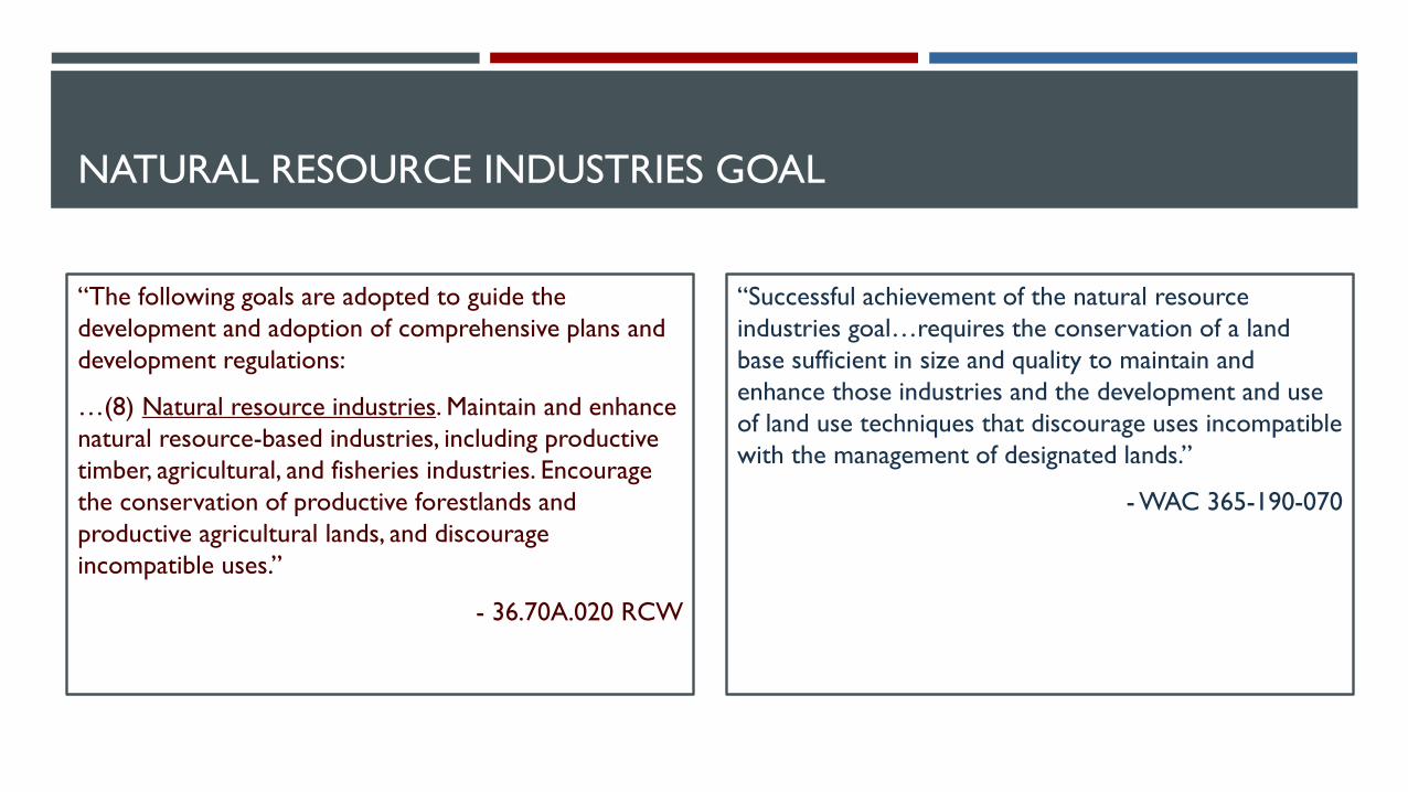
NATURAL RESOURCE INDUSTRIES GOAL
“The following goals are adopted to guide the
development and adoption of comprehensive plans and
development regulations:
…(8) Natural resource industries. Maintain and enhance
natural resource-based industries, including productive
timber, agricultural, and fisheries industries. Encourage
the conservation of productive forestlands and
productive agricultural lands, and discourage
incompatible uses.”
- 36.70A.020 RCW
“Successful achievement of the natural resource
industries goal…requires the conservation of a land
base sufficient in size and quality to maintain and
enhance those industries and the development and use
of land use techniques that discourage uses incompatible
with the management of designated lands.”
- WAC 365-190-070

MINERAL RESOURCE LANDS
Project Steps for Mineral Resource Lands
1. Identify and classify Develop a countywide inventory based on geologic data on the location and
extent of mineral deposits, existing land uses, and other factors. These areas are
categorized based on their quality, using available data from DNR, USGS, and
others
2. Designate
Identify priority areas where high quality mineral resources are available and
compatible with existing land use patterns and other criteria.
3. Conserve Establish policies that ensure future land uses will be compatible with mineral
extraction in designated areas.
4. Permit New mining operations planned in areas designated as mineral resource lands
will still need to be reviewed before they are permitted to operate. Mining
activities must abide by all relevant state and local regulations, including
environmental rules.
Com
p P
lan U
pdate
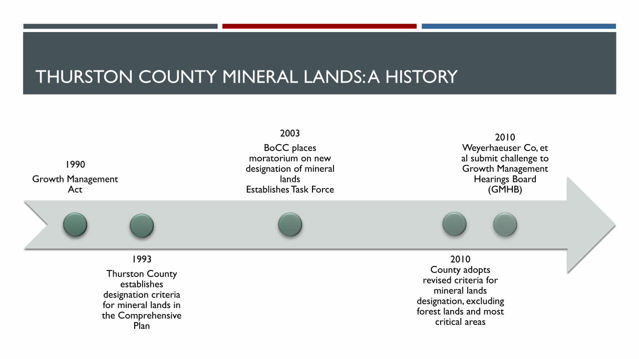
THURSTON COUNTY MINERAL LANDS: A HISTORY
1990
Growth Management Act
1993
Thurston County establishes
designation criteria for mineral lands in the Comprehensive
Plan
2003
BoCC places moratorium on new
designation of mineral lands
Establishes Task Force
2010County adopts
revised criteria for mineral lands
designation, excluding forest lands and most
critical areas
2010Weyerhaeuser Co, et al submit challenge to Growth Management
Hearings Board (GMHB)
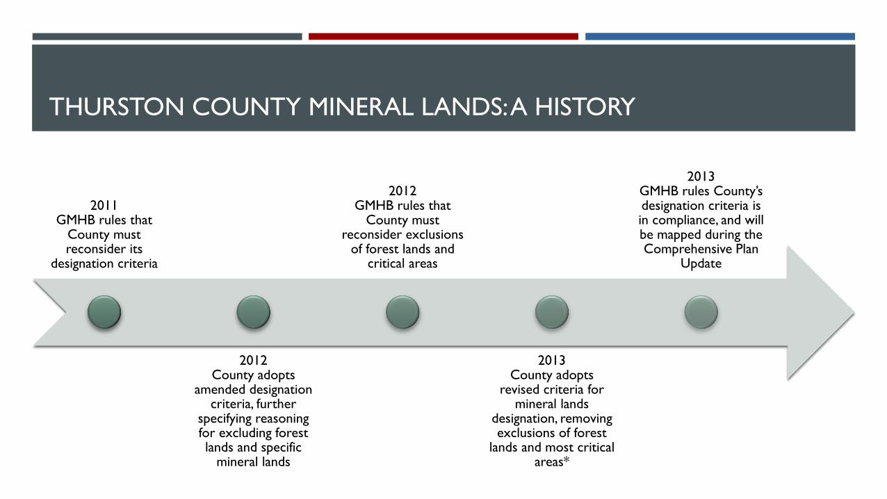
THURSTON COUNTY MINERAL LANDS: A HISTORY
2011GMHB rules that
County must reconsider its
designation criteria
2012County adopts
amended designation criteria, further
specifying reasoning for excluding forest lands and specific
mineral lands
2012GMHB rules that
County must reconsider exclusions
of forest lands and critical areas
2013County adopts
revised criteria for mineral lands
designation, removing exclusions of forest
lands and most critical areas*
2013GMHB rules County’s designation criteria is in compliance, and will be mapped during the Comprehensive Plan
Update
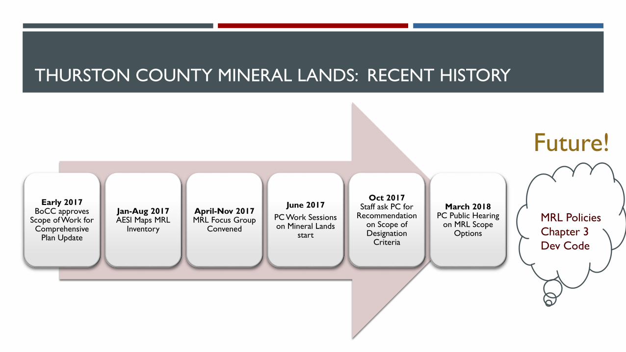
THURSTON COUNTY MINERAL LANDS: RECENT HISTORY
Early 2017BoCC approves
Scope of Work for Comprehensive
Plan Update
Jan-Aug 2017AESI Maps MRL
Inventory
April-Nov 2017MRL Focus Group
Convened
June 2017
PC Work Sessions on Mineral Lands
start
Oct 2017Staff ask PC for
Recommendation on Scope of Designation
Criteria
March 2018PC Public Hearing
on MRL Scope Options
Future!
MRL Policies
Chapter 3
Dev Code
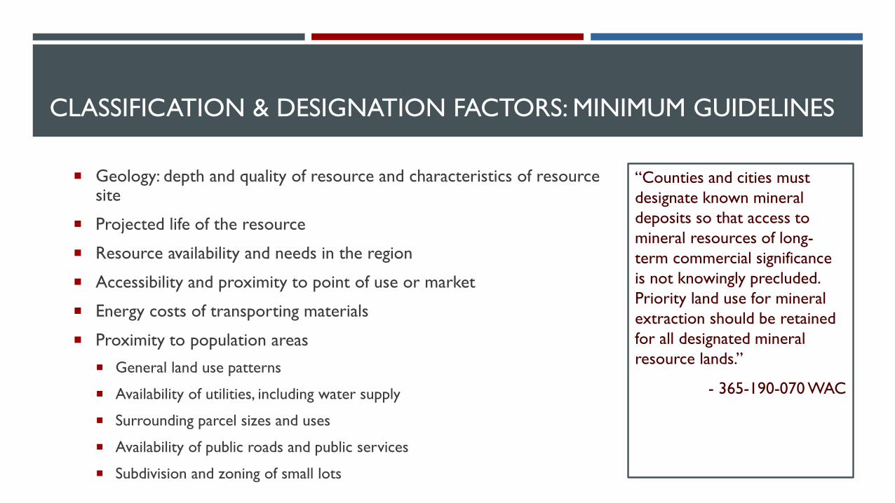
CLASSIFICATION & DESIGNATION FACTORS: MINIMUM GUIDELINES
Geology: depth and quality of resource and characteristics of resource site
Projected life of the resource
Resource availability and needs in the region
Accessibility and proximity to point of use or market
Energy costs of transporting materials
Proximity to population areas
General land use patterns
Availability of utilities, including water supply
Surrounding parcel sizes and uses
Availability of public roads and public services
Subdivision and zoning of small lots
“Counties and cities must
designate known mineral
deposits so that access to
mineral resources of long-
term commercial significance
is not knowingly precluded.
Priority land use for mineral
extraction should be retained
for all designated mineral
resource lands.”
- 365-190-070 WAC

DESIGNATION: KEEP IN MIND
WAC 365-190-040: Overlapping designations. The designation process may result in critical area designations that overlay other critical area or natural resource land classifications. Overlapping designations should not necessarily be considered inconsistent. If two or more critical area designations apply to a given parcel, or portion of a given parcel, both or all designations apply.
If a critical area designation overlies a natural resource land designation, both designations apply. For counties and cities required or opting to plan under the act, reconciling these multiple designations will be the subject of local development regulations.
If two or more natural resource land designations apply, counties and cities must determine if these designations are incompatible. If they are incompatible, counties and cities should examine the criteria to determine which use has the greatest long-term commercial significance, and that resource use should be assigned to the lands being designated.
WAC 365-190-070 (4)(d): In designating mineral resource lands, counties and cities must also consider that mining may be a temporary use at any given mine, depending on the amount of minerals available and the consumption rate, and that other land uses can occur on the mine site after mining is completed, subject to approval.
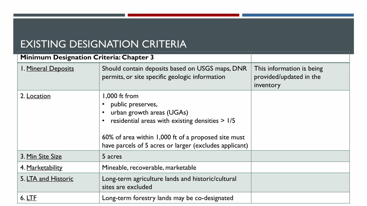
EXISTING DESIGNATION CRITERIAMinimum Designation Criteria: Chapter 3
1. Mineral Deposits Should contain deposits based on USGS maps, DNR
permits, or site specific geologic information
This information is being
provided/updated in the
inventory
2. Location 1,000 ft from
• public preserves,
• urban growth areas (UGAs)
• residential areas with existing densities > 1/5
60% of area within 1,000 ft of a proposed site must
have parcels of 5 acres or larger (excludes applicant)
3. Min Site Size 5 acres
4. Marketability Mineable, recoverable, marketable
5. LTA and Historic Long-term agriculture lands and historic/cultural
sites are excluded
6. LTF Long-term forestry lands may be co-designated
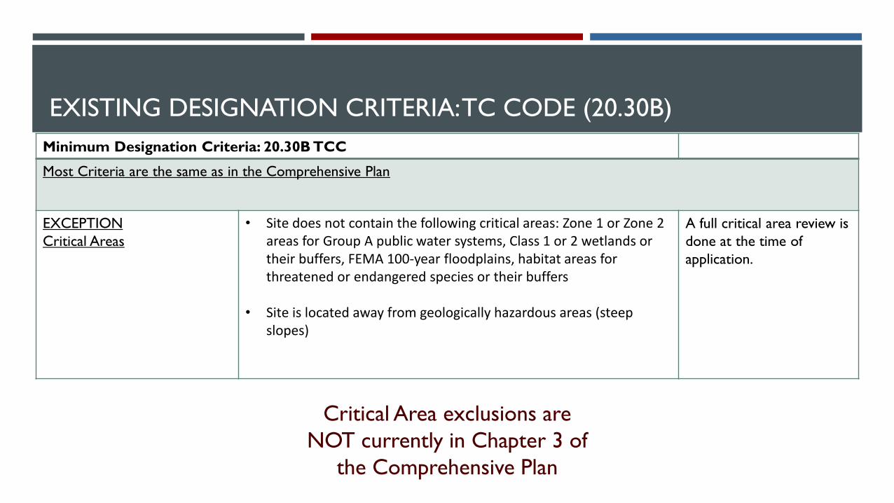
EXISTING DESIGNATION CRITERIA: TC CODE (20.30B)
Minimum Designation Criteria: 20.30B TCC
Most Criteria are the same as in the Comprehensive Plan
EXCEPTION
Critical Areas
• Site does not contain the following critical areas: Zone 1 or Zone 2 areas for Group A public water systems, Class 1 or 2 wetlands or their buffers, FEMA 100-year floodplains, habitat areas for threatened or endangered species or their buffers
• Site is located away from geologically hazardous areas (steep slopes)
A full critical area review is
done at the time of
application.
Critical Area exclusions are
NOT currently in Chapter 3 of
the Comprehensive Plan

PLANNING COMMISSION DESIGNATION CRITERIA SCOPE OPTIONS
Option 1. Adopted Current Designation Criteria
Option 1 reflects the Current Criteria in Chapter 3 of the Comprehensive Plan
Map 1a. Does NOT co-designate agricultural lands
o At some point, may require that the county do an economic study to determine what resource
designation to apply where LTA overlaps with MRL
Map 1b. Co-designates Agricultural Lands
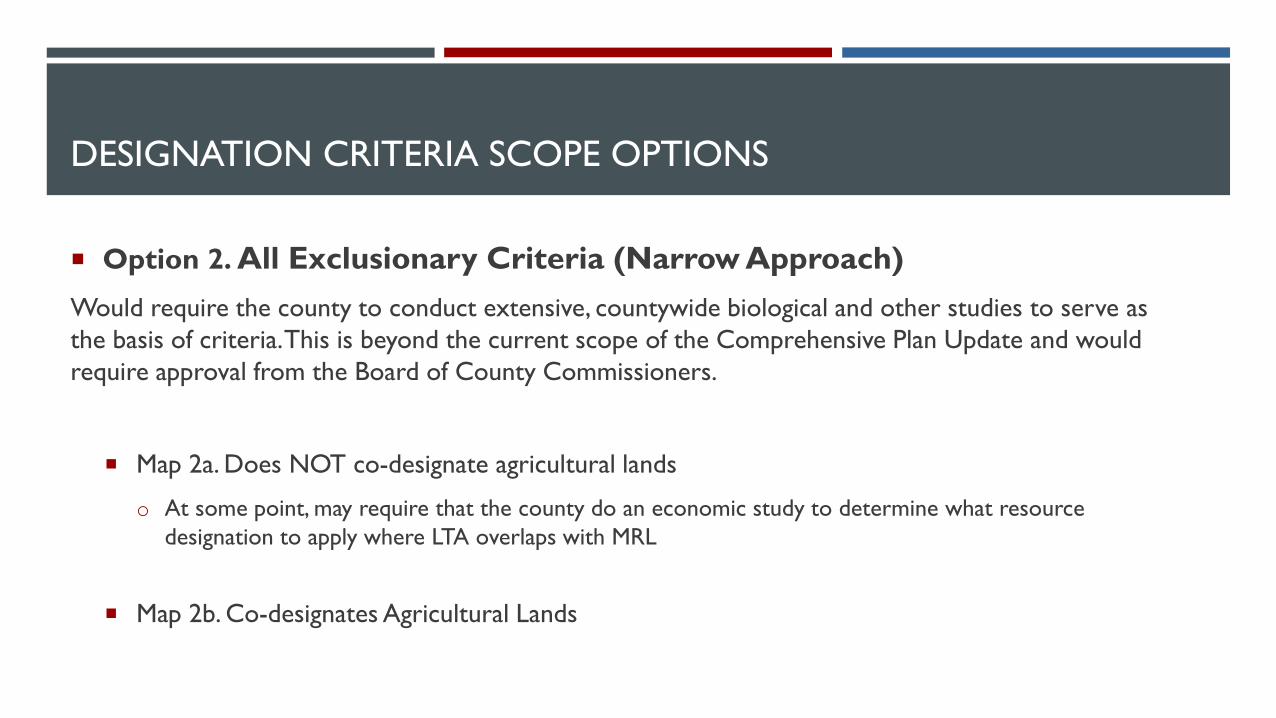
DESIGNATION CRITERIA SCOPE OPTIONS
Option 2. All Exclusionary Criteria (Narrow Approach)
Would require the county to conduct extensive, countywide biological and other studies to serve as
the basis of criteria. This is beyond the current scope of the Comprehensive Plan Update and would
require approval from the Board of County Commissioners.
Map 2a. Does NOT co-designate agricultural lands
o At some point, may require that the county do an economic study to determine what resource
designation to apply where LTA overlaps with MRL
Map 2b. Co-designates Agricultural Lands

DESIGNATION CRITERIA SCOPE OPTIONS
Option 3. Blended Criteria
Limits exclusionary criteria to current, adopted criteria and to those additional criteria for which the
county has high-quality, countywide data (i.e., Flood Zones, Marine Shoreline Hazard Areas, and Mima
Mounds).
Map 3a. Does NOT co-designate agricultural lands
o At some point, may require that the county do an economic study to determine what resource
designation to apply where LTA overlaps with MRL
Map 3b. Co-designates Agricultural Lands
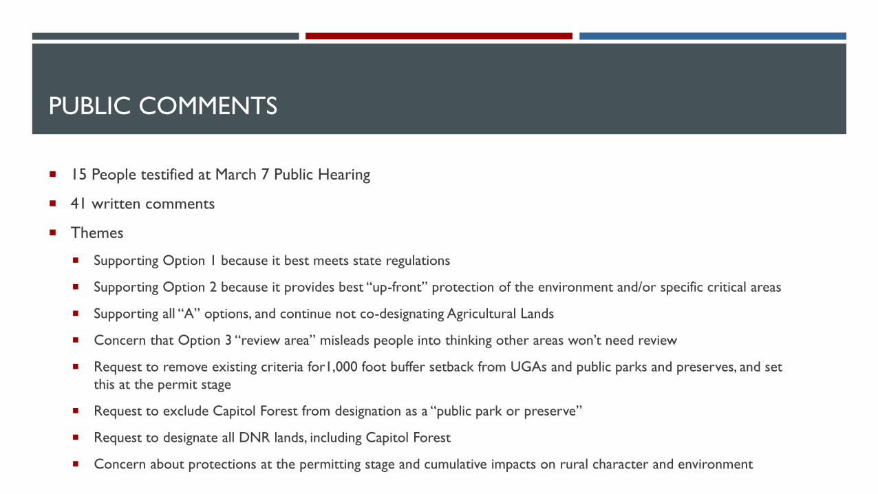
PUBLIC COMMENTS
15 People testified at March 7 Public Hearing
41 written comments
Themes
Supporting Option 1 because it best meets state regulations
Supporting Option 2 because it provides best “up-front” protection of the environment and/or specific critical areas
Supporting all “A” options, and continue not co-designating Agricultural Lands
Concern that Option 3 “review area” misleads people into thinking other areas won’t need review
Request to remove existing criteria for1,000 foot buffer setback from UGAs and public parks and preserves, and set
this at the permit stage
Request to exclude Capitol Forest from designation as a “public park or preserve”
Request to designate all DNR lands, including Capitol Forest
Concern about protections at the permitting stage and cumulative impacts on rural character and environment

BOCC DECISION
1. Direct staff to move forward with Mineral Lands Policies based on Planning Commission
Recommended Designation
Policies and Mineral Lands map will get a public hearing and comment period as part of Comprehensive Plan
Update Chapter 3
2. Request additional analysis to support different criteria (Option 2 or other)
Beyond the current scope of work; would require additional funding, and delay adoption of the
Comprehensive Plan Update
3. Hold a public hearing, similar to Planning Commission
Would delay adoption of the Comprehensive Plan Update beyond 2018
Lan
d U
se
Nat
ura
l R
eso
urc
es
Housi
ng
Tra
nsp
ort
atio
n
Utilit
ies
Eco
nom
ic D
eve
lopm
ent
Envi
ronm
ent
Cap
ital
Fac
ilities
Heal
th
Questions?
Staff Contact:
Allison Osterberg, Senior Planner
360-867-2102
Maya Teeple, Associate Planner
360-786-5578
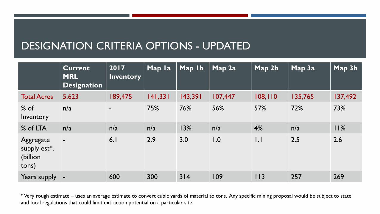
DESIGNATION CRITERIA OPTIONS - UPDATED
Current
MRL
Designation
2017
Inventory
Map 1a Map 1b Map 2a Map 2b Map 3a Map 3b
Total Acres 5,623 189,475 141,331 143,391 107,447 108,110 135,765 137,492
% of
Inventory
n/a - 75% 76% 56% 57% 72% 73%
% of LTA n/a n/a n/a 13% n/a 4% n/a 11%
Aggregate
supply est*.
(billion
tons)
- 6.1 2.9 3.0 1.0 1.1 2.5 2.6
Years supply - 600 300 314 109 113 257 269
* Very rough estimate – uses an average estimate to convert cubic yards of material to tons. Any specific mining proposal would be subject to state
and local regulations that could limit extraction potential on a particular site.