Embed Size (px)
Citation preview

SCRS/2008/092
PRELIMINARY RESULTS FROM ELECTRONIC TAGGING OF BLUEFIN TUNA (THUNNUS THYNNUS) IN THE GULF OF ST. LAWRENCE, CANADA
Barbara A. Block1, Gareth L. Lawson1, Andre M. Boustany2, Michael J.W. Stokesbury3,
Michael Castleton1, Aaron Spares3, John D. Neilson4, and Steven E. Campana5
SUMMARY
Fifteen bluefin tuna were satellite and archival tagged in the Gulf of St. Lawrence, Canada, during October of 2007. The objective was to examine the movements and spawning migrations of bluefin tuna from this Autumn foraging assemblage. Preliminary results from this experiment are presented. All bluefin tuna were brought onboard the vessel, irrigated, tagged, measured and released. Bluefin tuna ranged in size from 235 to 302 cm curved fork length. Three tags were programmed to pop-up shortly post-release, after 3, 30, and 60 day intervals, to demonstrate survivorship and short-term success of the tagging operations. The remaining tags were set for longer durations in order to examine where the tuna were during the breeding season. To date, of the six tags that remained on fish beyond the onset of the breeding season, three have popped up in the Gulf of Mexico and three in the western North Atlantic. A single fish that carried a long-term tag had a premature release program activated suggesting the fish died shortly after release. The tagging data support the hypothesis that strong linkages exist between the Gulf of St. Lawrence fish, the North Carolina foraging grounds and the Gulf of Mexico spawning grounds. To date, none of the fish has a geoposition in the eastern Atlantic management unit.
KEYWORDS
Bluefin tuna, Thunnus thynnus, electronic tagging, Gulf of St. Lawrence 1 Tuna Research and Conservation Center, Hopkins Marine Station of Stanford University, 120 Oceanview
Blvd, Pacific Grove, CA, 93950, USA 2 Nicholas School of the Environment, Duke University, Box 90328, Durham, NC, 27708, USA 3 Faculty of Science, Dalhousie University, Halifax, Nova Scotia, B3H 4J1, Canada 4 Department of Fisheries and Oceans Canada, Biological Station, 431 Brandy Cove Rd, St. Andrews, New
Brunswick, E5B 2L9, Canada 5 Department of Fisheries and Oceans, Bedford Institute of Oceanography, Dartmouth, Nova Scotia, B2Y
4A2, Canada

1. Introduction Electronic and conventional tag data together with genetic and microconstituent data sets have demonstrated conclusively that there are at least two stocks of Atlantic bluefin tuna (Thunnus thynnus) in the North Atlantic Ocean, one breeding in the Gulf of Mexico, and the other in the Mediterranean Sea (Block et al., 2001, 2005; Stokesbury et al., 2004; Rooker et al., 2003, 2007; Boustany et al., 2006; Carlsson et al. 2007). Tagging data indicate that bluefin tuna from both stocks overlap on North Atlantic foraging grounds, and that the U.S. and Canadian summer and fall fisheries in the Gulf of Maine and Scotian Shelf target a mixture of both stocks (Block et al., 2005). Less is known about the large bluefin tuna found in the Gulf of St. Lawrence as the size of these fish along with the difficulty of their capture in cold waters has made tag and release challenging. This region is of critical importance, since catches and CPUE in the Gulf of St. Lawrence have been increasing since 1997, even as catches in the U.S. fishery have decreased dramatically (Neilson et al., 2007). This document summarizes the results available to date from electronic tagging research conducted in the Gulf of St. Lawrence during the fall of 2007. The overall project goals are to study the seasonal movements and behaviors of Gulf of St. Lawrence bluefin tuna, and particularly to discern their breeding areas, spawning migration routes, and population origin, via a combination of tagging, genetic and microconstituent analyses. Visitation to a spawning ground by tagged fish will allow the identification of spawning habitat and preferences, and residency time on the spawning ground. Overall, these deployments provide an improved characterization of the bluefin tuna foraging assemblage present in the Gulf of St. Lawrence region in the late summer and fall. 2. Methods Eighteen pop-up satellite archival (PAT) tags and one archival tag were deployed on fifteen giant bluefin tuna in the Gulf of St. Lawrence using methods established previously by the TAG-A-GIANT (TAG) program (Block et al., 2001, 2005). Commercial rod and reel vessels were chartered to conduct the tagging. One vessel outfitted with a large transom door served as the tagging vessel, with additional vessels serving as ‘catcher’ vessels to increase the likelihood of encountering tuna in the five days of fishing. All tagging occurred off Port Hood, Nova Scotia, Canada, in the vicinity of 46.2°N, 61.5°W, from October 18, 2007 to October 25, 2007. Fish were caught on 59-136 kg monofilament line with 68-227 kg leader and Owner J-hooks. Bluefin were brought onboard the tagging vessel by placing a titanium lip-hook through the lower jaw and pulling the fish through the transom door onto a vinyl mat. A saltwater hose was used to oxygenate the gills, and a wet blindfold was placed over the eyes. Fish were measured to the nearest 0.25 cm for curved fork length (CFL), tagged, and released. The PAT tags were attached externally using titanium darts and shrink-wrap covered monofilament leaders (Block et al. 2005). PAT tags were additionally secured with 18 kg shrink-wrapped monofilament loops with Floy-type nylon heads to
2

hold the tag closer to the tuna’s body. Fin clip samples were also taken for genetic analyses. Archival tag insertion techniques were as in Block et al. (2005). Fifteen bluefin tuna ranging in length from 235 to 302 cm were tagged with a single Wildlife Computers Mk10-PAT, and in some cases bluefin were double tagged (Table 1; Figure 1). The “long-term” PAT tags were programmed to release after 240, 270, or 300 days, corresponding to pop-up dates between mid-June and mid-August 2008. Durations were chosen to allow the fish sufficient time to undergo spawning migrations, as spawning in the Gulf of Mexico occurs between mid-April and mid-June and in the Mediterranean between June and August (National Research Council, 1994; Block et al. 2005; Teo et al. 2007). Three fish were double-tagged with additional “short-term” satellite tags, and one fish was double-tagged with a surgically-implanted Lotek 2310 D-series archival tag. The short-term satellite tags were programmed to release after 3, 30, and 60 days, in order to provide early indications of the survivorship and status of the tagged fish. All tags were equipped with premature release detection software, such that tags detaching from the fish before the programmed date transmitted to satellite after 4 days. Tags were programmed to measure and archive ambient temperature, pressure, and light intensity at 2 or 10 second intervals, depending on the programmed deployment duration. Satellite tag end-point positions were determined upon release based on the Doppler shift of radio transmissions to ARGOS satellites. Daily estimates of longitude were derived from algorithms based on light levels, while daily estimates of latitude were based on longitude estimates and sea surface temperatures (Wilson et al., 1992; Teo et al., 2004). Comparisons of geo-locations estimated in this manner for PAT tags deployed on Atlantic bluefin tuna to ARGOS end-point positions have found root mean square errors of 1.30 and 1.89° for longitude and latitude, respectively (Teo et al., 2004). Data transmitted to ARGOS satellites also included depth and temperature information summarized onboard the tag at daily intervals into histograms and temperature vs. depth profiles. 3. Results and Discussion To date, eleven of the eighteen PAT tags deployed have released from the fish and successfully transmitted data (Figure 2). Of the three short-term tags, data were recovered on-schedule from the 3- and 30-day tags but not the 60-day tag. One of the long-term tags popped up prematurely after 45 days near the Bahamas, and was added to the short-term tag group. While the 60-day tag failed to report, the long-term tag on this fish did pop-up successfully after 160 days, suggesting that the fish was in good health and that the short-term tag had failed (e.g. battery). A single tag programmed to release in June popped up at the tagging site after ten days and the depth and temperature data suggested the fish most likely had a mortality event within a day of tagging. This fish was noted to have been deep-hooked during capture and was released with some concern for survivorship.
3

Three of the long-term tags popped up in the Gulf of Mexico on 3/21/2008, 4/1/2008 and 4/24/2008 (Figures 2 and 3). These fish were measured at 302 cm, 272 cm and 261 cm at tagging, corresponding to 17.1, 13.7, and 12.7 years of age, respectively, as estimated from the Turner and Restrepo (1994) length-age curve for western bluefin (although note that recent work suggests that the ages predicted from that curve are likely to be under-estimates; Neilson and Campana, in press). These three tags indicate that at least a portion of the Gulf of St. Lawrence-tagged fish show a strong association with the Gulf of Mexico spawning ground, consistent with the hypothesis that the fish in the Gulf of St. Lawrence are from the western population (Rooker et al., in submission). Four additional long-term tags popped up at various locations in the northwestern Atlantic Ocean off the U.S. east coast (Figure 2). These tags popped up during the period from February to June and showed no indication of movements into the Gulf of Mexico (Figure 3). These four bluefin tuna had the smallest measured lengths of the Gulf of St. Lawrence tagged fish for which the tags have released thus far (244 - 255 cm). Such lengths correspond to ages of 11.2 - 12.1 years, and these fish may or may not have been mature. Block et al. (2005) reported a mean length of 241 ± 28 cm CFL corresponding to approximately 11 years of age for fish entering the Gulf of Mexico. The February pop-up event (246 cm) occurred before the likely start of the western spawning season. Additionally, it remains possible that all of these fish may have moved into the Gulf of Mexico, had retention of the tags been longer. To date, none of the geolocations from these Gulf of St. Lawrence-tagged fish were east of 45°W, and so no evidence was found of movement into the eastern Atlantic management zone. The tags also measured the oceanographic conditions experienced by the bluefin tuna, and their behavioral preferences. During their exit from the Gulf of St. Lawrence the tags recorded that the fish occupied shallow depths and extremely cold water column temperatures, ranging from as low as 7.8°C at the surface to 2.0°C at depth (e.g., Figure 4). After exiting the Gulf, the bluefin tuna spent a variable amount of time (ranging between individuals from 4 to 70 days) along the edge of the Scotian Shelf and Georges Bank, where they occupied cold temperatures and depths of up to 700 m, before moving south into warmer regions. The three fish that entered the Gulf of Mexico experienced warm temperatures, up to 26.4°C, and mostly occupied depths shallower than 300 m while in this region. In migrating south from Canadian waters, the fish either followed the North American shelf break quite closely or took a more off-shore route (Figure 3). Three of the fish associated with the shelf-break route (244 - 302 cm) showed evidence of prolonged occupancy of the waters off of North Carolina during December-February, linking the Gulf of St. Lawrence fish to this area known for its U.S. winter fishery. This region and time period has been targeted annually by the TAG program for electronic tagging since 1996. Remarkably, the November pop-up satellite end point from a single bluefin in the present experiment occurred in the slope waters of North Carolina within several miles of a November-reporting tag deployed off North Carolina in January 2007 (a 9.5 month deployment; Figure 5), further indicating the mixing of fish from these two regions. Additional evidence of the direct linkages between the North Carolina foraging
4

assemblage and the Gulf of St. Lawrence fish comes from the recapture of a 293 cm (CFL) archival tagged fish in September 2007 in the Gulf of St. Lawrence. This fish was tagged off North Carolina in February 1997, at which time it was measured at 193 cm (CFL). This recapture corroborates the hypothesis that fish that were abundant for tagging in the mid-1990s off North Carolina may have expanded their niche into Canadian waters as they have aged. The serendipitous recapture of the tuna electronically tagged 10 years previously in North Carolina (described above) provided an unexpected and rare opportunity to compare the expected age of the fish with the age based on otolith interpretation. An enhanced image of a longitudinal section of the sagittal otolith was prepared and interpreted as per Neilson and Campana (in press). Although the long otolith lobe generally preferred for age interpretation was somewhat unclear, the shorter lobe suggested a definitive minimum age of 16 for this fish and a likely age of about 18 ± 2 years. Based on the length at age relationship of either Turner and Restrepo (1994) or Neilson and Campana (in press), the tuna was roughly 8 years of age at tagging, which would make it about 18 on recapture. Thus the expected age matches the otolith-based age, and the length at age lies between that predicted by the tag-based Turner and Restrepo (1994) and the otolith-based Neilson and Campana (in press) growth models (Figure 6). Uncertainty in the exact age at tagging implies that this recapture cannot be used to test the relative accuracy of the two growth models. Nevertheless, this tuna was relatively young compared to other giant bluefin tuna of similar size from the western Atlantic (Neilson and Campana, in press). At present, six tags are still due to pop-up in the next few months and report. Once all of the data are available, a more detailed analysis will be conducted of the migratory routes taken in relation to environmental conditions and fish size and age. The oceanographic conditions experienced by tuna on their spawning grounds will be examined via a combination of tag measurements and remotely-sensed or buoy-collected data, in order to quantify spawning habitat and preferences. 4. Acknowledgements We greatly appreciate the efforts of the captains and crews of the Canadian fishing fleet, especially Captain D. Cameron and First Mate S. Gillis of the Bay Queen IV tagging vessel, and Captains R. Keus, B. Keus, K. Bruce, M. Jenkins, S. MacInnis, and B. Chisholm. The Port Hood wharf monitors, ice house staff, and Cheticamp Monitoring are also thanked for their hospitality and cooperation. We thank S. Miller, C. Farwell and J. Nogueira for logistical support. This work was funded by NOAA, Tag-A-Giant Foundation and the Monterey Bay Aquarium Foundation.
5

5. References Block, B.A., Dewar, H., Blackwell, S.B., Williams, T.D., Prince, E.D., Farwell, C.J., Boustany,
A., Teo, S.L.H., Seitz, A., Walli A., and Fudge, D. 2001. Migratory movements, depth preferences, and thermal biology of Atlantic bluefin tuna. Science 293:1310-1314.
Block, B.A., Teo, SLH, Walli, A., Boustany, A., Stokesbury, M.J.W., Farwell, C.J., Weng., K.C., Dewar, H., and Williams, T.D. 2005. Electronic tagging and population structure of Atlantic bluefin tuna. Nature 434:1121-1127.
Boustany, A., Reeb, C., Teo, S.L.H., DeMetrio, G., and Block, B.A. 2006. Genetic data and electronic tagging indicate that the Gulf of Mexico and Mediterranean Sea are reproductively isolated stocks of bluefin tuna (Thunnus thynnus). ICCAT Col. Vol. Sci. Pap. SCRS/2006/089.
Carlsson J., McDowell J.R., Carlsson J.E..L, and Graves J.E. 2007. Genetic identity of YOY bluefin tuna from the eastern and Western Atlantic spawning areas. Journal of Heredity 98(1): 23-28
National Research Council 1994. An assessment of Atlantic bluefin tuna. Natl. Acad. Press., Washington, DC. 148 pp.
Neilson, J.D., Paul, S.D., and Ortiz M. 2007. Indices of stock status obtained from the Canadian bluefin tuna fishery. Col. Vol. Sci. Pap. ICCAT, 60(3): 976-1000.
Neilson, J.D. and S.E. Campana. In press. A validated description of age and growth of Western Atlantic bluefin tuna (Thunnus thynnus L.). Can. J. Fish. Aquat. Sci.
Rooker, J.R., Secor, D.H., Zdanowicz, V.S. DeMetrio, G., and Relini, L.O. 2003. Identification of Atlantic bluefin tuna (Thunnus thynnus) stocks from putative nurseries using otolith chemistry. Fish Oceanogr 12:75-84.
Rooker, J.R., Alvarado Bremer, J.R., Block, B.A., Dewar, H., deMetrio, G., Corriero, A., Kraus, R.T., Prince, E.D., Rodriguez-Marin, E., and Secor, D.H. 2007. Life History and Stock Structure of Atlantic Bluefin Tuna (Thunnus thynnus). Reviews in Fisheries Science, 15:265-310.
Rooker, J.R., Secor, D.H., deMetrio, G., Schloesser, R., Block, B.A., and Neilson, J.D. In submission. Natal homing and connectivity in Atlantic Bluefin Tuna populations. Science.
Stokesbury, M.J.W., Teo, S.L.H., Seitz, A., O’Dor, R. K., and Block, B. A. 2004. Movement of Atlantic bluefin tuna (Thunnus thynnus) as determined by satellite tagging experiments initiated off New England. Canadian Journal of Fisheries and Aquatic Sciences 61: 1976-1987.
Teo S.L.H., Boustany A., Blackwell S., Walli A., Weng K.C., and Block B.A. 2004. Validation of geolocation estimates based on light level and sea surface temperature from electronic tags. Mar Ecol Prog Ser 283:81-98.
Teo S.L.H., Boustany, A. Dewar, H., Stokesbury, M.J.W., Weng, K.C., Beemer, S., Seitz, A.C., Farwell, C.J., Prince, E.D., and Block, B.A. 2007. Annual migrations, diving behavior, and thermal biology of Atlantic bluefin tuna, Thunnus thynnus, on their Gulf of Mexico breeding grounds. Marine Biology 151:1-18.
Turner, S.C., and Restrepo, V.R. 1994. A review of the growth rate of west Atlantic bluefin tuna, Thunnus thynnus, estimated from marked and recaptured fish. Col. Vol. Sci. Pap. ICCAT SCRS. 93/65: 170-172.
Wilson R.P., Ducamp J.J., Rees G.W., Culik B.M., and Niekamp K. 1992. Estimation of location: global coverage using light intensity. In: Priede IG, Swift SM (eds) Wildlife telemetry: remote monitoring and tracking of animals. Ellis Horwood, London, p 131–134.
6

Table 1. Tag and release information for the eleven PAT tags that have popped-up to date. Pop-up satellite endpoint locations are denoted as GSL (Gulf of St. Lawrence), GOM (Gulf of Mexico) or WATL (Western Atlantic). All lengths were directly measured on the deck of the vessel to the nearest 0.25 cm. Ages are estimated based on Turner and Restrepo (1994). + indicates a short-term tag deployed on a double-tagged fish where the long-term tag has yet to pop-up. * indicates the one tag where the data transmitted were indicative of a mortality. ° indicates the short-term and long-term tags deployed on the same double-tagged fish.
Tag number
Release Date
Length (CFL, cm)
Estimated Age
Pop-Up Date
Days at Liberty
Pop-Up Location
05P0155+ 10/18/2007 272 13.7 10/21/2007 3 GSL 06A0837* 10/24/2007 274 13.9 11/3/2007 10 GSL 05P0083° 10/24/2007 244 11.2 11/23/2007 30 WATL 06A0838 10/25/2007 275 14.0 12/9/2007 45 WATL 06A0417 10/25/2007 246 11.4 2/7/2008 105 WATL 07A0338 10/19/2007 302 17.1 3/21/2008 154 GOM 07A0416 10/24/2007 272 13.7 4/1/2008 160 GOM 07A0144 10/19/2007 244 11.2 4/8/2008 172 WATL 06A0438 10/25/2007 261 12.7 4/24/2008 182 GOM 07A0389 10/19/2007 255 12.1 5/4/2008 198 WATL 07A0417° 10/24/2007 244 11.2 6/1/2008 221 WATL
7

Figure 1. Average lengths of fish tagged with pop-up satellite archival tags in the present deployment (Canada 2007) and a pilot tagging effort conducted in 2005. For comparison, lengths in recent years at the North Carolina location targeted annually by the TAG program are also shown. Fish in the Gulf of St. Lawrence fishery are significantly larger than fish available for tagging in the North Carolina winter fishery.
8

Figure 2. Pop-off locations to date of fish tagged in the Gulf of St. Lawrence in October 2007, excluding the one tag indicative of a mortality event.
9

4/1/2008 Pop-Up
4/24/2008 Pop-Up
3/21/2008 Pop-Up
4/8/2008 Pop-Up
5/4/2008 Pop-Up
2/7/2008 Pop-Up
Figure 3. Tracks for the 3 tags that popped up in the Gulf of Mexico, and for 3 of the 4 tags that popped up in the Western Atlantic. At the time of writing, a track was not yet available for the June 1, 2008, Western Atlantic pop-up, as the tag had not finished transmitting data to satellite. Geo-positions along the tracks are limited in some cases due to failed satellite transmissions or deep diving behavior.
10
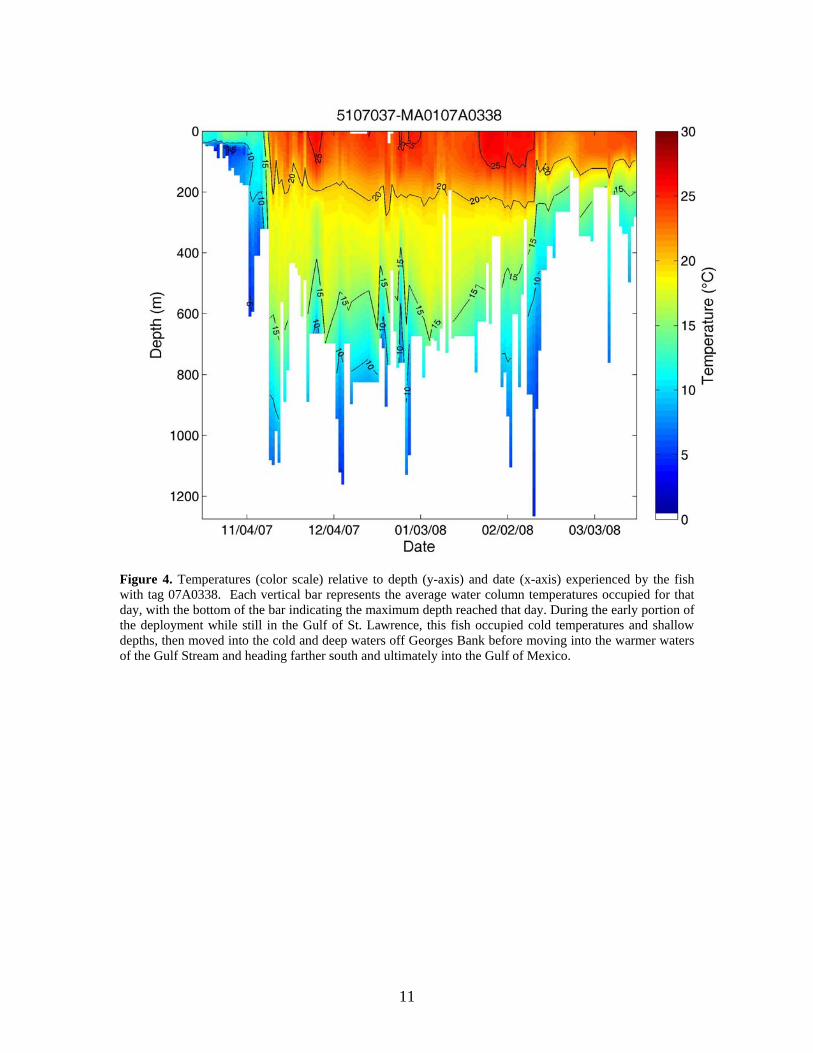
Figure 4. Temperatures (color scale) relative to depth (y-axis) and date (x-axis) experienced by the fish with tag 07A0338. Each vertical bar represents the average water column temperatures occupied for that day, with the bottom of the bar indicating the maximum depth reached that day. During the early portion of the deployment while still in the Gulf of St. Lawrence, this fish occupied cold temperatures and shallow depths, then moved into the cold and deep waters off Georges Bank before moving into the warmer waters of the Gulf Stream and heading farther south and ultimately into the Gulf of Mexico.
11

Nov 23 2007
Nov 2 2007
Oct 24 2007
Jan 13 2007
Figure 5. Deployment and pop-up locations for the 30-day PAT tag from the Gulf of St. Lawrence tagging effort described in the present document, and for a 293-day PAT tag deployed off North Carolina in January 2007.
12

Age (yr)
3020100
Cur
ved
fork
leng
th (c
m) 400
300
200
100
0
Figure 6.. Otolith-based age estimate and associated uncertainty for a giant bluefin tuna recaptured after 10 years at liberty (closed circle). The assumed age at tagging is also shown (closed circle). Length at age predicted from the Turner and Restrepo (1994) (solid line) and the Neilson and Campana (in press) (dashed line) growth models is shown for reference.
13