Embed Size (px)
Citation preview
THREE RURALSITES AT BAESAMLESBURY,BALDERSTONE,LANCASHIRE
Archaeological Post-Excavation AssessmentReport
Oxford Archaeology North
May 2010
BAE Systems
Issue No: 2010-11/920Grid Reference: SD 626 314OA North Job No: L9937
Three Rural Sites at BAE Samlesbury, Balderstone, Lancashire: Post-Excavation Assessment Report 1
For the use of BAE Systems © OA North: May 2010
CONTENTS
LIST OF TABLES............................................................................................................3
SUMMARY .....................................................................................................................4
ACKNOWLEDGEMENTS.................................................................................................6
1 INTRODUCTION .........................................................................................................7
1.1 Circumstances of the Project ............................................................................71.2 Location, Topography and Geology .................................................................81.3 Historical and Archaeological Background ......................................................8
2 RESEARCH AIMS AND OBJECTIVES FOR EXCAVATION AND ASSESSMENT ...........14
2.1 Introduction.....................................................................................................142.2 Research Context ............................................................................................142.3 Research Aims ................................................................................................172.4 Research Objectives........................................................................................18
3 METHODOLOGY......................................................................................................20
3.1 Project Design.................................................................................................203.2 Fieldwork Methodology..................................................................................203.3 Post-Excavation Assessment Methodology....................................................213.4 Archive............................................................................................................22
4 SUMMARY OF FIELDWORK RESULTS .....................................................................23
4.1 Introduction.....................................................................................................234.2 Phasing............................................................................................................234.3 Pepper Hill ......................................................................................................234.4 College Croft...................................................................................................294.5 College Farm...................................................................................................34
5 RESULTS OF THE ASSESSMENT...............................................................................38
5.1 Introduction.....................................................................................................385.2 Stratigraphic Assessment ................................................................................385.3 Artefact Assessment........................................................................................405.4 Ceramic Finds .................................................................................................415.5 The Metalwork................................................................................................435.6 Glass and Other Small Material Groups .........................................................455.7 Animal Bone and Shell ...................................................................................465.8 Charred and Waterlogged Plant Remains .......................................................465.9 Conservation and Packaging...........................................................................47
Three Rural Sites at BAE Samlesbury, Balderstone, Lancashire: Post-Excavation Assessment Report 2
For the use of BAE Systems © OA North: May 2010
6 STATEMENT OF POTENTIAL FOR ANALYSIS ..........................................................48
6.1 Introduction.....................................................................................................486.2 Archaeological and Historical Context ...........................................................486.3 Potential for Further Analysis.........................................................................526.4 Updated Aims and Objectives for Analysis....................................................54
7 DESIGN FOR PROJECT STAGE 3: ANALYSIS AND PUBLICATION ...........................58
7.1 Method Statement ...........................................................................................587.2 PAT1, Management ........................................................................................607.3 PAT2, Documentary Research........................................................................617.4 PAT3, Stratigraphic Analysis .........................................................................627.5 PAT4, Artefact Analysis.................................................................................627.6 PAT 5, Integrated Analysis.............................................................................637.7 PAT6, Report Production and Archive Deposition ........................................637.8 Project Team ...................................................................................................677.9 Health and Safety............................................................................................67
8 BIBLIOGRAPHY .......................................................................................................69
8.1 Cartographic Sources ......................................................................................698.2 Secondary Sources ..........................................................................................69
ILLUSTRATIONS ........................................................................................................136
Figures.......................................................................................................................136Plates .......................................................................................................................136
APPENDIX 1: PROJECT DESIGN..................................................................................74
APPENDIX 2: SUMMARY CONTEXT LIST....................................................................82
APPENDIX 3: SUMMARY FINDS CATALOGUE...........................................................113
COLLEGE CROFT ......................................................................................................113
PEPPER HILL ............................................................................................................119
COLLEGE FARM........................................................................................................130
APPENDIX 4: TIMETABLE FOR PROJECT STAGE 3, ANALYSIS, PUBLICATION ANDARCHIVING ...............................................................................................................135
Three Rural Sites at BAE Samlesbury, Balderstone, Lancashire: Post-Excavation Assessment Report 3
For the use of BAE Systems © OA North: May 2010
LIST OF TABLES
Table 1: Internal room sizes within Building B, Phases 2 and 3
Table 2: Internal room sizes within Building C, Phase 4
Table 3: Internal room dimensions within Building D
Table 4: College Croft Phase 6; Building J internal room dimensions and externaloutbuilding dimensions
Table 5: College Farm; internal room dimensions
Table 6: Stratigraphic archive from the excavation and selected evaluation trenches
Table 7: Summary distribution of finds between site (by fragment count)
Table 8: Quantification of ceramic materials from the three sites (by fragment count)
Table 9: Quantification of metalwork from the three sites (by fragment count)
Table 10: Quantification and distribution of glass between the three sites (by fragmentcount)
Table 11: Quantification and distribution of miscellaneous materials between the threesites (by fragment count)
Table 12: Summary of samples assessed from the Samlesbury sites
Table 13: Assessment of charred and waterlogged plant remains from Pepper Hill andCollege Croft. Plants recorded on a scale of 1-4, where 1 is rare (up to five items) and4 is abundant (>100 items). WPR = waterlogged plant remains, CPR = charred plantremains.
Table 14: Task list for production of project design for further analysis andpublication
Table 15: Summary of the project team
Three Rural Sites at BAE Samlesbury, Balderstone, Lancashire: Post-Excavation Assessment Report 4
For the use of BAE Systems © OA North: May 2010
SUMMARY
BAE Systems has submitted proposals for a large-scale development at SamlesburyAerodrome, Myerscough Smithy Road, Balderstone, Lancashire (SD 626 314).Information collated within a desk-based assessment indicated that the developmentwas likely to impact on the below-ground remains of several sites of archaeologicalsignificance and, consequently, Lancashire County Archaeology Service (LCAS)advised both Ribble Valley and South Ribble Borough Councils that, in accordancewith PPG16, a planning condition of the development should be the undertaking of anassociated programme of archaeological mitigation. This mitigation was to comprisethree separate stages: open-area excavation; post-excavation assessment and, thirdly,analysis and publication. BAE Systems duly commissioned Oxford ArchaeologyNorth (OA North) to undertake this programme at each of three sites of former post-medieval rural settlements within the zone of impact. These sites, Pepper Hill, CollegeCroft and College Farm, were investigated between November 2007 and September2008. All are shown on Yates’ map of 1786 and can be traced through successiveeditions of the Ordnance Survey map of the area, before their demolition in advanceof the construction of the military aerodrome in 1939.
This report provides a summary of the excavation (Project Stage 1) and, in accordancewith English Heritage guidelines, documents the post-excavation assessment (ProjectStage 2) of the results of the fieldwork, in order to establish their potential to addressresearch question through detailed analysis. The final part of this document presents aproject design for a proposed programme of analysis (Project Stage 3) to take placeimmediately following acceptance of the present document. During the assessment,the excavated remains were attributed to eight provisional activity phases, althoughnot all were represented at every site. Limited evidence of medieval to early post-medieval activity was identified at College Farm and, more frequently, at Pepper Hill,although no structural features pertaining to this early phase could be identified.Pottery, a coin and a photograph (College Farm) dated the earliest definable structuralactivity to the seventeenth century, when all three sites would appear to have beenbuilt, or rebuilt, in stone. Thereafter, the historical development of each of the threesites took very different courses, although in each case, multi-phase buildingcomplexes were identified.
At Pepper Hill, the best preserved of the sites, the seventeenth-century farmhouse,with its internal cross-passage, was later refaced and reorganised in symmetricalGeorgian style. A number of external and internal features were identified, as well asassociated outbuildings, one of which saw considerable modification, whilst the otherswere demolished as the farm was reorganised through time. Very little remained of theearliest building at College Croft, although it may have been associated with small-scale metalworking. It was replaced by a substantial stone-built house, sparselyrepresented by a few foundations (one containing a coin dated 1692), robber cuts,cobbled surfaces, and a possible remnant of its formal garden. Cartographic evidencesuggests this house was largely demolished by 1893, leaving only the south-west endintact. By 1913, College Croft had been rebuilt as a terrace of three houses in a typicalEdwardian style, the ground plan of which was well preserved.
The earliest remains of College Farm, and of a possible tenement to the north-west,were heavily truncated, and none of the associated small outbuildings recognised from
Three Rural Sites at BAE Samlesbury, Balderstone, Lancashire: Post-Excavation Assessment Report 5
For the use of BAE Systems © OA North: May 2010
cartographic sources could be identified. Photographic evidence suggests that thefarmhouse endured little significant modification until its demolition in 1939 but, bythe second half of the nineteenth century, the steading had been augmentedsubstantially, with the addition of a barn and other outbuildings.
The assessment has indicated that the data recovered during the fieldwork have goodpotential for further analysis, particularly if it can be integrated with detaileddocumentary research. Within the better-preserved phases, this should allow a greaterunderstanding of the activity undertaken at each site, the division and use of internaland external space, their economic basis, specialisation and diversification, and themanner in which they interacted with their field systems and the wider rural and urbanhinterland. These site-specific findings need to be tied into the context of the historiclandscape, and with wider regional and national themes associated with thedevelopment of rural settlements, landscapes and economies as they changed with theimpact of the ‘Agricultural Revolution,’ the ‘Great Rebuilding’ and, latterly, to meetthe demands of an expanding and increasingly industrialised urban population.
The excavation of Pepper Hill, College Croft and Pepper Hill means that allarchaeological site investigation activities associated with the present development(Project 05S0035/035) have been completed. A fourth archaeological site, LanesideFarm, lies just outside the present zone of impact, and has been demarcated by BAESystems as an area of high archaeological potential, so that it can be investigatedappropriately should it be affected by any future developments on the site.
Three Rural Sites at BAE Samlesbury, Balderstone, Lancashire: Post-Excavation Assessment Report 6
For the use of BAE Systems © OA North: May 2010
ACKNOWLEDGEMENTS
Oxford Archaeology North would like to express thanks to BAE Systems forcommissioning the project and, in particular, to Ian Bradley, Matt Aspden, SteveGale, Gordon Lee, Keith Hatton, Carl Forshaw and Nigel Aspin. Thanks are also dueto Sarah Payne, George Smith and George Kinkla of Bam and, in particular to MickSlater of D&S Engineering. OA North is also grateful to Doug Moir and Peter Iles ofLancashire County Archaeology Service for their advice and support, and to DorothyMacCleod of Lancashire County Library Service.
The fieldwork was directed by Richard Lee, Kelly Clapperton, Christina Robinsonand Jeremy Bradley, with assistance from Alex Beben, Fiona Birchall, Rick Buckle,Ged Callaghan, Tim Christian, Steve Clarke, Pascal Eloy, Vicky Fackrell, EllerayFarley, John Griffiths, Joanne Hawkins, Pip Haworth, Vix Hughes, Gemma Jones,Harriet Lock, Tom Mace, Liz Murray, Ellen McInnes, Mark Oldham, Des O’Leary,Aiden Parker, Kieran Power, Rebekah Pressler, Steve Tamburello, Daniel Taylor,Julian Thorley and Becky Wegiel. The report was compiled by Jeremy Bradley,Christina Robinson, and Richard Lee, with assistance from Kelly Clapperton andStephen Rowland; the drawings were produced by Marie Rowland and Alix Sperrwith Christina Robinson. The finds were assessed and reported upon by ChristineHoward-Davis, whilst the palaeoenvironmental samples were processed and assessedby Sandra Bonsall and Elizabeth Huckerby. Stephen Rowland managed the projectand edited the report, which was quality-assured by Rachel Newman.
Three Rural Sites at BAE Samlesbury, Balderstone, Lancashire: Post-Excavation Assessment Report 7
For the use of BAE Systems © OA North: May 2010
1 INTRODUCTION
1.1 CIRCUMSTANCES OF THE PROJECT
1.1.1 BAE Systems has submitted proposals for a large-scale development atSamlesbury Aerodrome, Myerscough Smithy Road, Balderstone, Lancashire(Project 05S0035/035; SD 626 314; Fig 1). Information collated within a desk-based assessment of the site (RSK 2007) indicated that the proposeddevelopment was likely to have a severe negative impact on the below-groundremains of several sites of archaeological significance. Consequently,Lancashire County Archaeology Service (LCAS) advised both Ribble Valleyand South Ribble Borough Councils that, in accordance with PPG16 (DoE1990), a planning condition of the development should be the undertaking ofan associated programme of archaeological mitigation. Four sites forinvestigation were highlighted initially by LCAS, comprising Pepper Hill Farm(NGR 647 410), close to the route of the A59 at the northern edge of theaerodrome; College Croft (NGR 636 409) and College Farm (NGR 635 407),which lay opposite each other across the former route of Myerscough SmithyRoad, towards the centre of the aerodrome; and Laneside, which lay on thesame road, some 200m to the east. All had been demolished in 1939 to makeway for the aerodrome (RSK 2007).
1.1.2 LCAS required that the mitigative preservation by record at each heritage siteshould comprise several project stages. Stage 1, the fieldwork, was to includethe monitored removal of topsoil and overburden deposits across the extent ofthe archaeological remains, followed by detailed investigation and recording.Stage 2 was to be an assessment of the data generated by the fieldwork, whilstStage 3 was to encompass any appropriate detailed analysis, publication anddeposition with the Lancashire Record Office (LRO) and Lancashire MuseumService (LMS) of the entire project archive. In order to meet this planningcondition, BAE Systems commissioned Oxford Archaeology North (OANorth) to undertake the full programme of archaeological works in accordancewith an LCAS-approved project design (Appendix 1). Project Stage 1 (thefieldwork data collection) was undertaken at College Croft between Novemberand December 2007, at Pepper Hill between March and April 2008, and atCollege Farm between August and September 2008. Changes to thedevelopment plans meant that Laneside could be preserved in situ and thus didnot need to be investigated. Thus, all those archaeological site investigationworks that were requested by LCAS and associated with Project 05S0035/035,were completed.
1.1.3 This report provides a summary of Project Stage 1 and documents the results ofProject Stage 2, pertaining to a programme of post-excavation assessment ofthe results of the fieldwork, in accordance with the guidance of EnglishHeritage’s Management of Archaeological Projects, Second Edition (MAP2;EH 1991) and Management of Research Projects in the Historic Environment(MoRPHE; EH 2006a). As such, this stage of the project seeks to process andassess each of the forms of raw data recovered during the fieldwork in order toestablish their potential, through detailed analysis, to address the research
Three Rural Sites at BAE Samlesbury, Balderstone, Lancashire: Post-Excavation Assessment Report 8
For the use of BAE Systems © OA North: May 2010
questions outlined in Section 3.2. The final part of this document presents aproject design for that further analysis (Project Stage 3). Although this report isa quality-assured and academically valid document suitable for submission tothe LRO and Historic Environment Record (HER), it is not suitable forpublication. Similarly, although many of the tasks that contribute to thisassessment will facilitate the production of the final archive, in itself part of thewider objectives of the project, the specific production of the final archive forsubmission to the LRO falls outside the present programme of work for thisstage of the project.
1.1.4 Throughout the report, and for ease of recognition, the three sites investigatedare referred to by the titles they held in 1939 (Pepper Hill, College Croft, andCollege Farm), despite evidence that the names of most changed through time.Collectively, they are referred to as ‘the Samlesbury sites.’
1.2 LOCATION, TOPOGRAPHY AND GEOLOGY
1.2.1 Location: the present development site lies on the former RAF SamlesburyAerodrome, now the site of BAE Samlesbury (Fig 1). The College Croft andCollege Farm excavation areas occupied a central position within theaerodrome, to the immediate west of Runway 17, whilst that for Pepper Hillwas placed some 350m to the north, close to the aerodrome’s perimeter withthe A59. Samlesbury Aerodrome lies in the Ribble Valley, surrounded by thevillages and hamlets of Balderstone, Osbaldeston, Samlesbury and Mellor, withPreston some 9km to the west and Blackburn about 6km to the south-east.
1.2.2 Topography: the topography of each of the sites is likely to have undergonesome modification during the construction of the aerodrome. College Croftand College Farm occupied generally flat and rather boggy land that slopedgently to the south. Pepper Hill lay within an area of rough, formerly wooded,ground immediately adjacent to the A59, on the edge of a valley overlookingthe Mellor Brook. The landscape immediately surrounding SamlesburyAerodrome is typical of the Lancashire Valleys Joint Character Area, withdispersed settlement, substantial farmsteads and farmhouses and irregular pre-seventeenth-century enclosure (EH 2006b, 36-37; Ede and Darlington 2002,97).
1.2.3 Geology: the solid geology of the area consists of red and green mudstonescovered by glacial drift, which consists of boulder clays (CountrysideCommission 1998). The soil is generally of the Salop series, which is typicalstagnogley (Lawes Agricultural Trust 1983).
1.3 HISTORICAL AND ARCHAEOLOGICAL BACKGROUND
1.3.1 Introduction: the historical and archaeological background presented below isnot intended to be an exhaustive account, but rather to place the sites withintheir historical context. Further information can be found in the RSK desk-based assessment (2007).
Three Rural Sites at BAE Samlesbury, Balderstone, Lancashire: Post-Excavation Assessment Report 9
For the use of BAE Systems © OA North: May 2010
1.3.2 Prehistoric period: the Ribble Valley has been the focus of human activitysince prehistoric times. The earliest evidence dates to the Mesolithic period(when people practised an economy based generally on nomadic hunting,fishing and gathering) and includes a mattock fashioned from red deer antlerand dated to c 5400 BC, which was found on the banks of the Ribble inPreston (Hunt 2003, 15). Although traditionally the Neolithic period is definedby the introduction of agriculture and more permanent settlement, inLancashire, the Neolithic economy appears little different from that of theMesolithic (Middleton 1996, 36–9). The closest Neolithic activity to theSamlesbury site comprises finds of single polished axes from the RibbleValley at Penwortham and Samlesbury Bottoms, 11km and 3km, respectively,from the site (op cit, 44). Depositions of Bronze Age material are representedwithin the broader environs of the site, particularly in areas fringing the Ribbleand its estuary. A large assemblage of artefacts was recovered during theconstruction of Preston Dock, some 11km to the west, which included humanskulls, animal remains, two dugout canoes and a possible structure (Crosby2000, 10–11; Middleton 1996, 46).
1.3.3 The Iron Age is notoriously under-represented in Lancashire (Hodgson andBrennand 2006, 51; Haselgrove 1996, 61). This reflects the poor survival andidentification of material of this date and the inherent difficulty of recognisingpotentially subtle regional site types (Hodgson and Brennand 2006, 53;Cowell 2005, 75; Haselgrove 1996, 64), as much, if not more than, the often-quoted suggestion of a low population density (Haselgrove 1996, 64). Theclosest known Iron Age site to the excavation area lies approximately 11.5kmto the north-east, at Portfield Camp in Whalley (Cowell 2005, 68–72), whilstan evaluation at Roman Way, Red Scar, some 6km to the north-east, revealedpossibly pre-Roman ditches (Earthworks Archaeological Services 2001).
1.3.4 Romano-British period: Lancashire lies within the Roman military hinterlandto the rear of the Hadrianic frontier. The Samlesbury site is located in an areathat was linked by the Roman roads that pass between the late first-centuryfort at Ribchester and the site at Kirkham (Buxton and Howard-Davis 2000;Howard-Davis and Buxton 2000), and between Wigan and Preston. The firstof these roads passes within 3km of the site (Margary 1973, 106, Road 703),and was evaluated archaeologically in the area of the Red Scar IndustrialEstate (LUAU 1995). The road comprised a 9m-wide cambered surfaceconsisting of sub-rounded stones and cobbles overlain by fine gravels (ibid).The postulated route of the Roman road between Wigan and Preston (Margary1973, 359, Road 70a) is likely to have passed through or close to Walton-le-Dale, approximately 7km downstream from the Aerodrome, close to theposition of the current A6 (Philpott 2006, 60). Walton-le-Dale was asignificant industrial centre during the Romano-British period and, consideringits position within the riverine and road network, may have functioned as apart of a system of supply bases (op cit, 70; 75).
1.3.5 Early medieval period: archaeological evidence for early medieval activity inthe wider locale is not particularly extensive, but is extremely significant: thelargest Scandinavian hoard in north-west Europe was found at Cuerdale, 6kmto the west of the proposed development area (RM Newman 1996, 103). The
Three Rural Sites at BAE Samlesbury, Balderstone, Lancashire: Post-Excavation Assessment Report 10
For the use of BAE Systems © OA North: May 2010
40kg hoard, dated to c AD 905, comprised 75% hack silver, together with over7250 coins, many minted in York (ibid; Newman 2006, 111). It has beensuggested that the hoard, given its location so close to the Ribble, may haverepresented funds being gathered to finance a reinvasion of Ireland, followingthe expulsion of the Norsemen in AD 902 from the settlements they hadfounded there (op cit, 112). Despite their Old English names, there is no firmevidence that any of the surrounding smaller settlements (such as Osbaldeston,Balderstone and Samlesbury) have early medieval origins, although bothBlackburn and Preston seem to have been the focus of activity prior to theNorman Conquest. Blackburn is named in the fourteenth century as the site ofone of three early churches in east Lancashire, and was traditionally thought tohave been founded in AD 598 (LCC 2005, 17), whilst the archbishop of Yorkis reputed to have established a church at Preston as early as the tenth century(LCC 2006a, 18). The place-name Preston derives from the Old EnglishPreosta and -tun, meaning ‘the priest’s homestead’. By Domesday, Prestonwas the principal land holding (caput) within the area now know as the Fylde,whilst Blackburn was the centre of a hundred, thought to derive from a majorearly territorial division (LCC 2005).
1.3.6 Medieval period: both Preston and Blackburn are mentioned in DomesdayBook and were important urban centres during the medieval period, withPreston becoming a chartered town by the thirteenth century (White 1996,129) and Blackburn, perhaps some time later, given that the earliest referenceto its market dates to 1498 (LCC 2005, 18). Samlesbury Aerodrome fallspartially within the parishes of Balderstone and Samlesbury (Farrer andBrownbill 1911, 313-19), with the old route of Myerscough Smithy Road(since supplanted by the modern A59 as the principal route between Prestonand Blackburn) forming the parish boundary. As such, Pepper Hill falls withinBalderstone, as does College Croft, whilst, despite its proximity to the latter,College Farm lies within Samlesbury parish.
1.3.7 Away from the urban centres ‘there is little evidence for the nature andmorphology of Lancashire’s rural settlement before the thirteenth century’ (RNewman 1996, 114-16). From this date, it would appear that settlement to thenorth-west, within the lowlands of Amounderness, tended to be morenucleated, whilst upland settlement remained dispersed. SamlesburyAerodrome lies at the interface of these zones and, although settlement sincethe medieval period has intensified, the distribution and character of thesurrounding scattered hamlets, farmsteads and occasional village, is unlikelyto have changed greatly. The area surrounding the development site ischaracterised as an area of ancient enclosure, which denotes field systemsdatable to before AD 1600 (Ede and Darlington 2002, 97). Areas of formerridge and furrow between Pepper Hill and College Croft are evident fromaerial photographs (mario.lancashire.gov.uk), whilst aratral earthworkspreserved by field boundaries can be seen on the Ordnance Survey (OS) mapof 1849. Such aratral field boundaries are usually thought to representploughing with a team of oxen, the traditional method, as seen in thefourteenth-century Luttrell Psalter for instance, rather than typically post-medieval horse traction (Backhouse 2000, 16-18). Within the manor ofBalderstone, enclosed areas of pasture were mentioned in the thirteenth
Three Rural Sites at BAE Samlesbury, Balderstone, Lancashire: Post-Excavation Assessment Report 11
For the use of BAE Systems © OA North: May 2010
century (Farrer and Brownbill 1911, 313-19). Virtually nothing is known oftype of buildings used in this part of Lancashire during the medieval period.Higham suggests that, whilst timber construction was the norm, even for somehigher-status buildings, the vernacular building tradition might well haverelied on turf- or clay-walled structures, which would leave little or noarchaeological trace (Higham 2004, 136-7).
1.3.8 If little evidence survives of the farmers and their steadings, more ampleevidence of higher-status sites does exist. Samlesbury Old Hall, to the south ofthe development area, is, along with Rufford and Smithills, one of the finest ofthe Lancashire halls (Pevsner 2002, 18, 216). The origins of Samlesbury Hall,which forms the centre of the manor of Samlesbury, are believed to lie in thefourteenth century (ibid).
1.3.9 The development of the Samlesbury sites in the post-medieval period: therural nature of the locale, with its mixture of small nucleated hamlets anddispersed farms, is reflected in the historical cartographic sources and is likelyto show some continuity from the medieval period. The full extent of thehistorical record pertaining to the Samlesbury sites is, however, not known,although it is possible that more information, certainly for the later post-medieval period, could be gained from detailed examination of historicalsources, such as trade directories, Census returns and tithe awards. Theirnames provide some clues, although the fact that these can change may meanthat no great reliance can be placed on such evidence without further research.The ‘College’ element within two of the sites is reasonably common and, attimes, can indicate a farm once held by an ecclesiastical institution, or a formof collective enterprise. The origin of the name Pepper Hill is somewhatobscure, although it may imply that it was held for a nominal or ‘peppercorn’rent (Field 1972, 164).
1.3.10 The earliest cartographic source is Speed’s map of 1610, which indicatestopographical features, the main settlements, such as Osbaldeston (althoughnot nearby Mellor or Balderstone), churches and, particularly, the numeroushalls, presumably indicating their status within the landscape. The nearestfeatures depicted to the Samlesbury sites are Samlesbury Old Hall andOsbaldeston, although the cartographer appears to have confused theirlocations. The map does not show the Samlesbury sites, which implies eitherthat they did not exist at that date, or, that common isolated farms were notconsidered important enough to warrant inclusion on the map. A survivingphotograph held by the LRO and purported to be of College Farm (there issome doubt over the veracity of this attribution) shows a building seemingly ofseventeenth-century date (Plate 1) and thus likely to be contemporary with anumber of surrounding farms, such as Intack Cottage, Lower Intack Farm,Goose Green and Sykes Holt, which have seventeenth-century buildingssurviving in varying states of occupation and dereliction (RSK 2007).
1.3.11 Yates’ map of 1786 (Fig 2) adds much more detail to the picture, depicting notonly more nucleated settlements, such as Mellor and Balderstone, minortopographic elements, such as the Mellor Brook (although un-named), butalso, more relevantly, it names many (but not all) of the dispersed settlements.Though not named, all three of the Samlesbury sites are shown as single black
Three Rural Sites at BAE Samlesbury, Balderstone, Lancashire: Post-Excavation Assessment Report 12
For the use of BAE Systems © OA North: May 2010
squares, indicating that all were in existence by the later eighteenth century.Although the size or number of their constituent buildings cannot be deduced,the interconnecting road network, including Mascow [sic] Smithy Road, isdepicted clearly. The sinuous nature of these roads, and the fact thatMyerscough Smithy Road forms the parish boundary, would indicate thatthese routes are likely to be ancient elements of the landscape. By comparison,Greenwood’s map of 1818, shows much less detail than the Yates map.Although the same communication routes are indicated, in common with mostof the surrounding dispersed settlements, none of the Samlesbury sites aredepicted.
1.3.12 The settlement pattern depicted by Yates is mirrored, albeit in more detail, onthe first edition OS map of 1849 (Fig 3). This shows a mixture of ancientenclosure, typified by irregular fields with sinuous boundaries (Rackham1986, 1-5), and more regular eighteenth- and nineteenth-century Parliamentaryenclosure. The countryside is shown to be populated by hamlets and dispersedsettlements, of which the Samlesbury sites are exemplars. The map showsCollege Farm (though not named) to comprise a large east/west-alignedbuilding with a rear porch/projection, and two associated outbuildings.Bounded separately to the south-west, and thus unlikely to be part of thefarmstead in 1849, is a second building on an altogether different alignment,furnished with a single outbuilding. Higher College, as College Croft wasknown in 1849 (it is of interest to note that a smaller site to the north-west islabelled as ‘Lower College’), was an imposing E-shaped house, with theasymmetrical projecting wings pointing north. To the rear (north) of CollegeCroft was an area laid out as formal garden with several circular plantings,although it is uncertain whether these reflect reality or merely an artisticconvention. Pepper Hill is shown with three fairly evenly sized buildings andtwo smaller ones straddling an eastward offshoot of the road network, whichcontinues as an unenclosed road, or track, to the east of the farm. The mostwesterly of the larger buildings is likely to be the house shown on Plate 2, atypically simple Georgian building with an outshut to the west. A farm onMyerscough Smithy Road to the south-east is shown as ‘Part of Pepper Hill.’
1.3.13 College Farm appears on the 1849 Tithe Map for Samlesbury parish(PR2883/25) and, although the relative chronologies of the Tithe and OSsurveys are uncertain, there are several differences. The principal east/west-aligned structure is isolated and referred to as Haydocks on the Tithe Map,whilst the neighbouring building to the south-west is divided into two separateproperties and set within different boundaries from those depicted on the 1849OS map. No tithe map exists for the neighbouring parish of Balderstone,which contained both Pepper Hill and College Croft.
1.3.14 The 1893 OS map (Fig 4) indicates that there had been some reorganisation ofthe landscape, notably the construction of Inglewood and its landscaped andplanted gardens, whilst there had also been significant changes to theSamlesbury sites. The small outbuildings at College Farm were by this periodreplaced by two much larger and more regular buildings, whilst the north-east/south-west-aligned building to the west had been demolished, leavingmuch of the plot it was set within vacant. College Croft appears to have been

Three Rural Sites at BAE Samlesbury, Balderstone, Lancashire: Post-Excavation Assessment Report 13
For the use of BAE Systems © OA North: May 2010
partly demolished, leaving only the west wing and a small part of the centralsection, and there is no longer any sign of its formal gardens. Pepper Hill hadalso undergone some changes, with the demolition of most of the largerbuildings on the southern side of the track and the modest extension of that tothe north. The farm formerly ‘Part of Pepper Hill’ is now called ‘Laneside’and may have been modified to form a ‘semi-detached’ arrangement.
1.3.15 By 1913, all the outbuildings on the south side of the trackway at Pepper Hillhad been demolished, whilst that to the north was further extended, forming anarrangement of contiguous rooms (Fig 5). College Croft, which is named assuch for the first time, had been rebuilt as a large structure divided into threedwellings, with four small outbuildings to the north. The surviving photographtaken on the eve of the Second World War (lantern images.lancashire.gov.uk;Plate 3) shows quite a handsome stone terrace, with gablets, one of whichexhibits mock timber framing, and protruding purlins or possibly barge-boards. The house at College Farm, labelled simply as ‘College,’ seems tohave been reduced to the west, whilst the large building to the south nowappears to be rectangular, with a commensurate change to the farmboundaries.
1.3.16 The final map in the sequence was produced in about 1925 to show the courseof the redirected Myerscough Smithy Road (the A59) around the northernedge of, rather than through, the aerodrome (Fig 6; Highways Ministry c1925). Very little change was noted, other than the possible subdivision ofCollege Farm into two dwellings and the demolition of two of the outbuildingsat College Croft.
1.3.17 College Croft, College Farm and Pepper Hill, along with Laneside, Inglewoodand other sites, together with the adjoining roads and surrounding fieldsystems, were removed to make way for the construction of SamlesburyAerodrome. Although initially conceived in 1922 as a municipal airfield forBlackburn and Preston, building of the aerodrome did not commence until1939, after the site had been requisitioned by the Air Ministry for themanufacture of bomber planes. The site was expanded in 1940 with theaddition of the existing runway and, by the end of hostilities, there were fivehangars, approximately 20 other ancillary structures, and three runways. Thesite continued as a manufactory into the jet age, with further structures addedto the complex throughout its usage (RSK 2007).
Three Rural Sites at BAE Samlesbury, Balderstone, Lancashire: Post-Excavation Assessment Report 14
For the use of BAE Systems © OA North: May 2010
2 RESEARCH AIMS AND OBJECTIVES FOR EXCAVATION ANDASSESSMENT
2.1 INTRODUCTION
2.1.1 To maximise the potential of the heritage resource, archaeologicalinvestigations are strategic in nature, with a series of clearly defined aims,often posed as research questions, and objectives, the practical means bywhich research questions are addressed; both are modified and developed tomeet the requirements of the project and the confines of the available data.However, the impetus for the investigation is provided by a ‘primary driver’(EH 2006a), which, in the case of the majority of archaeological projects, isdictated by the negative impact of a development. In consideration of the factthat elements of the heritage resource were to be destroyed by the proposeddevelopment, the basic rationale, or primary driver, of the excavation was thecharacterisation and preservation by record of any significant remains ofarchaeological interest. The many forms of data generated, together with anyfurther research undertaken, could be analysed to reconstruct a chronologicalnarrative of the site. Following exposure of the archaeological remains at thestart of each excavation, it was then possible to establish the specific researchaims and objectives, as outlined below; not all can be addressed at the presentassessment stage, but they need to be considered when assessing the potentialof each category of data for analysis (Project Stage 3).
2.2 RESEARCH CONTEXT
2.2.1 Introduction: in order to formulate the aims and objectives of the project, thesites need to be placed within the context of the pertinent national, regionaland local research frameworks. These documents have been formulated byrecognised experts in order to guide research, provide a cogent basis forplanning decisions pertaining to archaeology, and to encourage the focusedrecovery and analysis of meaningful data that can contribute to genuineresearch themes.
2.2.2 National research themes: in 1988, the Society for Post-MedievalArchaeology (SPMA) compiled a research agenda (SPMA 1988), which hasbeen recently revised by Richard Newman (2005). Amongst the themes theSPMA identified as requiring urgent attention were the investigation ofsettlements other than villages, and an extension of our understanding ofdifference at a regional level. The latter point is addressed by Newman asbeing especially important, given that local building styles and farmingpractices have adapted to local social and physical conditions (ibid).
2.2.3 On a broader scale, although technically superseded by EH’s 2003 ExploringOur Past Implementation Plan, their draft Research Agenda (EH 1997)remains pertinent, and includes a recognition that post-medieval rurallandscapes urgently require archaeological research: ‘The components of ruralsettlement, and how these vary or change, need to be examined: economic and
Three Rural Sites at BAE Samlesbury, Balderstone, Lancashire: Post-Excavation Assessment Report 15
For the use of BAE Systems © OA North: May 2010
functional specialisation, the extent to which artefact assemblages vary orchange, and their interaction with settlement hierarchies require much morework’ (EH 1997, 52).
2.2.4 The same document highlights the importance of a better understanding andcharacterisation of the transition of the rural settlement and economy betweenthe medieval and post-medieval periods: ‘More work is required to enablearchaeology to contribute to important debates and controversies whichhitherto have been largely the preserve of economic historians, mostimportantly the role and extent of capitalism in the changes. Substantivechanges in the condition of the urban and rural poor, the nature of housing,and the changes in urbanism, merit detailed attention’ (op cit, 45).
2.2.5 Newman’s 2005 re-evaluation of the post-medieval rural research agendaposited a number of further angles of research that have some relevance to thepresent study:
• the impact on society and the environment of the great estates andimproving landlord, not just in relation to agricultural techniques, butstatus-competition, emulation, adoption of new technology and socialengineering (Newman 2005, 208);
• excavations of abandoned farmsteads, especially where the ownership ortenancy is documented, in order to study the material culture of individualhouseholds (ibid).
2.2.6 Further themes that run through Newman’s reassessment include theintegration of the structural and archaeological remains of farmsteads and theirassociated material culture within the landscape as a means of understandingsocial and cultural change, and so provide alternative interpretative modelsbeyond those purely based on economics (op cit, 210-11); the furtherance ofan understanding of the lives and culture of the lower agricultural classes (opcit, 211); and an interpretation of fieldwork relating to post-medieval ruralsettlement that attempts to address general or wider issues beyond theindividual sites investigated (op cit, 210). Also of importance is theunderstanding that the roots of the post-medieval agricultural landscape laywithin the medieval period (ibid).
2.2.7 Regional research themes: the recent publication of the two-volume ResearchFramework for North West England (Brennand 2006; 2007) has provided aspecifically regional research agenda for what therein are termed the post-medieval (1538-1750) and industrial (1750-1905) periods. These include anumber of specific research topics that can be used to direct the study of theSamlesbury sites and their environs.
2.2.8 The agenda has highlighted the apparent bias in post-medieval archaeologytoward the perceived champion areas of southern England and the Midlands,in terms of the extant resources and their greater influence on the evolution ofthe agrarian landscape. They note a perception that post-medieval archaeologyin the North West is concerned with industrial and more visible remains at theexpense of agricultural remains, despite the latter being the most significantindustry in the region during this period (Newman and McNeil 2007a, 115,
Three Rural Sites at BAE Samlesbury, Balderstone, Lancashire: Post-Excavation Assessment Report 16
For the use of BAE Systems © OA North: May 2010
119). These concerns have led to the re-examination of the agrarianarchaeology of the North West, highlighting the variations found within thelandscape of the region and the impact this had on its agriculture and farms, aswell as the populace (ibid). Furthermore, enclosure, which in both itsParliamentary and earlier forms had a highly significant effect on both thelandscape and economy, is imperfectly understood (op cit, 119). The authorsgo on to propose the need for excavation of deserted farmsteads and otherrural buildings to further the study of material culture, particularly pottery,which they assess as central to the construction of regional frameworks for thewhole period (op cit, 115, 119).
2.2.9 A number of initiatives have been proposed by Newman and McNeil that aredirectly relevant to the study of the Samlesbury sites and their landscape:
• Examination and mapping of pre-eighteenth-century enclosure across theregion using the county Historic Landscape Characterisation (HLC) as astarting point (Newman and McNeil 2007a, 120);
• Regional survey of farmstead creation and abandonment would help torefine the regional settlement pattern identified by Roberts and Wrathmell(2002), as well as improve the county-based characterisation programmes(op cit, 121);
• Excavations of abandoned farms and cottages should be a high priority,especially where the ownership or tenancy is documented, in order tostudy the material culture of individual households (op cit, 121-2);
• Improvement of the regional knowledge of ceramic vessel form and fabrictype chronologies (op cit, 130);
• The relationship between enclosure, settlement and industry needs to bemore closely examined (Newman and McNeil 2007b, 142);
• The study of the development of the agrarian landscape in those parts ofthe region that have previously attracted little attention (ibid);
• In part using existing data contained in the HLCs and building upon theRCHME’s study of farmsteads (Barnwell and Giles 1997), production of aregional study of farming in the period 1750-1950 that examines areas ofcontinuity and change and highlights areas of rare, regionally specific andinnovative practices (Newman and McNeil 2007b, 142);
• Investigation of the development of the industrialised farm and the impactof technological change on farm layout and building types. Adopting anapproach to identification and classification of monument types as used bythe International Committee for the Conservation of the IndustrialHeritage may be useful in such research (ibid);
• Mapping of settlement change across the region from 1770 to the presentday, to promote an understanding of the relationship of the current ruralsettlement pattern to that of the eighteenth century, and to provide a moresecure basis for regressive projections of earlier settlement patterns (opcit, 143);
Three Rural Sites at BAE Samlesbury, Balderstone, Lancashire: Post-Excavation Assessment Report 17
For the use of BAE Systems © OA North: May 2010
2.2.10 Two further important regional studies have been published recently. The firstof these, EH’s survey of historic farmsteads in the North West (2006b),summarises many aspects of rural settlement and farmstead types, constructionmaterials and types of buildings, to be found in the region, assessing theircharacter and regional patterns alongside a national framework. This is aninvaluable tool in the study of the North Western farmstead in all its regionalvariations. Although the document does not present any explicit researchthemes, it does present data upon which research aims can be based (Section2.3). Secondly, The Lancashire Historical Landscape CharacterisationProgramme (Ede and Darlington 2002, iv, 4), aimed to characterise thedistinctive, historical dimension of the rural environment in the county,assessing it in ‘terms of the historical processes from which it derives, as wellas the historical and archaeological components’ (ibid). This document can beused to examine the type of field systems that have survived around theSamlesbury sites and to formulate further research aims concerning land usageand division (Section 2.3).
2.2.11 Local: various local borough plans exist, but these are general and, whilst theyhighlight the importance of the archaeological resource, they provide littleadditional research contextualisation. Instead, many of the themes that runthrough the national and regional agendas, particularly EH’s, HistoricFarmsteads (2006b), and the Lancashire Historic Landscape Characterisation(Ede and Darlington 2002) are relevant to the Samlesbury sites within theirlocal context. At the lowest level, such themes include identification of theownership and/or occupancy in order to contextualise the material culture ofindividual households (Newman and McNeil 2007a, 121-2), and anexploration of specific aspects of the lifestyles of the inhabitants and theirrelationships with the wider landscape and the local economic framework. Ofparticular interest here would be any evidence of relationships between thedevelopment of the site and the economic and industrial development ofPreston and Blackburn, which are likely to have been the main consumers ofthe produce provided by the farmsteads. Locally, the Samlesbury sites areamongst a growing corpus of post-medieval farmsteads excavated inLancashire. These include Rough Hey Farm, some 5km to the north-east (OANorth forthcoming a), and four post-medieval buildings excavated along thecourse of the Samlesbury to Helmshore natural gas pipeline (NAA 2004). It islikely that there are examples of similar vernacular farmsteads within theRibble Valley that could be used as comparisons for the Samlesbury sites, andthus it would be appropriate to examine the HER and local vernaculararchitecture societies for relevant sites.
2.3 RESEARCH AIMS
2.3.1 By considering the above themes and initiatives, it is possible to pose thefollowing research questions (RQ) that are specific to the archaeologicalinvestigation of the Samlesbury sites:
RQ1 Within the defined excavation areas, can the structural remains shownon the historical mapping be identified, excavated and understood?
Three Rural Sites at BAE Samlesbury, Balderstone, Lancashire: Post-Excavation Assessment Report 18
For the use of BAE Systems © OA North: May 2010
RQ2 Can earlier structural remains and features associated with activity onthe sites, but not shown on the maps, be identified, excavated andunderstood?
RQ3 Is it possible to provide a close chronology for any identifiedarchaeological remains, including the date of the sites’ inception, andattribute them to meaningful activity phases?
RQ4 Is it possible to identify the social status of those who inhabited thesites?
RQ5 Is it possible to identify zones and patterns of activity at each site, andso establish the function and the diversity or specialisation of theeconomic basis of each site?
RQ6 Is it possible to trace, interpret and understand the historicaldevelopment of the sites and their surroundings?
RQ7 Is it possible to identify and understand how the sites interacted withthe surrounding landscape and the wider economic systems of theRibble Valley and the Preston and Blackburn consumer catchmentzones?
RQ8 Can data from chronologically and functionally comparative sites beidentified and used to analyse those from Samlesbury?
RQ9 Can the site supply sufficient analytical data to contribute to a greaterunderstanding of rural settlement in Lancashire, particularly in terms ofcharacterisation of dispersed settlement and definition of inter-relationships between dispersed and more nucleated settlements withinthe wider settlement system?
RQ10 How can the results of the investigation be made available to the widerpublic in an accessible form, whilst undertaking appropriate archivingof the artefacts and primary data?
2.4 RESEARCH OBJECTIVES
2.4.1 Overall Research Objectives: the following overarching objectives (RO) havebeen formulated with reference to the research questions (Section 2.3).
ROa Conduct a programme of targeted archaeological excavation andrecording within the three historical farmsteads (RQ1 and 2).
ROb Process the written, drawn, survey and photographic record throughcompilation of a digital database, Harris matrix and computerisedillustrations, so that an assessment, and then any appropriate detailedanalysis, of the on-site stratigraphy can be undertaken. This will permitthe best possible understanding of the physical form of, andrelationships between, the different elements of the site, provision of achronological framework and also the formulation of a holisticnarrative of the sites (RQ1, 2, 5, 6 and 8).
ROc Undertake collection, processing, assessment and then any appropriateanalysis of the artefacts and environmental remains from the three
Three Rural Sites at BAE Samlesbury, Balderstone, Lancashire: Post-Excavation Assessment Report 19
For the use of BAE Systems © OA North: May 2010
Samlesbury sites, in terms of date, origin, function, quality, spatialdistribution, residuality and provenance (RQ3, 4, 6, 7 and 8).
ROd Undertake a detailed, but targeted, search, collation and interrogationof available documentary, cartographic and pictorial sources on thethree Samlesbury sites, the surrounding landscape and for comparablesites, at the LRO, Lancashire HER, local and university libraries,including liaison with local historical and vernacular architecturesocieties (RQ3, 4, 5, 6, 7, 8 and 9).
ROe Establish provisional phasing (RQ3, 6 and 8).
ROf Undertake an analysis of the surrounding historical landscape, throughcartographic and documentary research, to understand better the site inits wider environment (RQ6, 7, 8 and 9).
ROg Undertake a comparative analysis of the ground plans of farmsteadsand of individual buildings from selected contemporary post-medievalsites that may aid in the interpretation of those identified at the threeSamlesbury sites (RQ4, 5, 7, 9 and 10).
ROh Collate results of the above objectives, publish the results and submitthe final archive (RQ10).
Three Rural Sites at BAE Samlesbury, Balderstone, Lancashire: Post-Excavation Assessment Report 20
For the use of BAE Systems © OA North: May 2010
3 METHODOLOGY
3.1 PROJECT DESIGN
3.1.1 The LCAS-approved OA North project design (Appendix 1) was followed infull throughout the investigation; all work was consistent with the relevantstandards and procedures of the Institute of Field Archaeologists (IFA), andgenerally accepted best practice. The most significant departure from theproject design was that the site known as ‘Laneside’ was not investigated,because BAE Systems indicated to LCAS that the site could be preserved insitu, outside a revised zone of development impact. LCAS and representativesof BAE Systems were closely involved throughout the fieldwork stage of theproject, and all variations from the project design, including the expansion orcontraction of areas of excavation, were agreed verbally with LCAS, generallyduring regular site meetings.
3.2 FIELDWORK METHODOLOGY
3.2.1 Excavation areas: prior to the commencement of the fieldwork, each of theexcavation areas was defined using a regression of historical map sources, andmarked out on the ground with due regard to services and existing constraints.At Pepper Hill, setting-out was undertaken by OA North, whilst this role atCollege Croft and College Farm was performed by representatives of BAESystems. At College Croft, the excavation area measured approximately 0.3ha,and was expanded slightly to the west following the discovery of significantarchaeological remains extending beyond the original excavation area. AtPepper Hill, initial excavation was concentrated on the northern side of theinner security fence (Area 1, 0.15ha), with Area 2 (Fig. 2), of similar size,excavated subsequently on the southern side of the fence. The excavation areafor College Farm measured 3.3ha.
3.2.2 Methodology: the initial methodology for investigation and overburdenremoval differed slightly at each farm, although subsequent to the exposure ofarchaeological remains, OA North was given full control of the mechanicalstripping. At College Croft, the initial strip was undertaken as a watching brief,whilst at Pepper Hill, works were preceded by the excavation of three trialtrenches within areas thought likely to contain structural remains. At CollegeFarm, mechanical stripping was directed by OA North throughout.
3.2.3 Removal of the uppermost levels of modern topsoil and subsoil down to the topof the first significant archaeological horizon/natural geology was undertakenby a suitable machine (13 tons at College Croft and College Farm, 5 tons atPepper Hill, where the nature of the access precluded a larger machine), fittedwith a toothless ditching bucket and operating under archaeologicalsupervision. A smaller machine was often used to define carefully the extent ofany surviving walls, foundations, or to remove demolition debris or otherhomogeneous deposits, whilst a dumper made spoil handling more efficient.Thereafter, structural remains and any other features were cleaned and
Three Rural Sites at BAE Samlesbury, Balderstone, Lancashire: Post-Excavation Assessment Report 21
For the use of BAE Systems © OA North: May 2010
investigated manually to define their extent, nature, form and, where possible,date.
3.2.4 Recording: a comprehensive written, drawn, and photographic record wasmade in accordance with the Standard and Guidance for ArchaeologicalExcavation (IFA 2001). All information identified during the excavation wasrecorded stratigraphicly, using a system adapted from that used by the EnglishHeritage Research Department, Fort Cumberland. The results of the excavationwere recorded on pro-forma context sheets, with a continuous uniquenumbering system for all features and deposits in operation. An indexedphotographic and drawn record of individual features, working shots andgeneral views was maintained. Photography was undertaken using 35mmcolour slide and monochrome print film, together with high-quality digitalphotography for the purposes of presentation. All levels recorded on-site weretied into the Ordnance Datum, with the positions of planned features beingestablished using a total station theodolite (TST) and/or a Leica DGPS. Asummary of the results of the fieldwork is presented in Section 4.
3.3 POST-EXCAVATION ASSESSMENT METHODOLOGY
3.3.1 Introduction: the data recovered during the fieldwork were assessed inconsideration of the project research questions and in accordance with theproject objectives (Sections 2.3-4). Thus, the overarching objective of theassessment was to evaluate all classes of recovered data in order to determinethe potential of the dataset for further analysis.
3.3.2 Material assessed: the entire paper, digital, photographic and material archivederiving from the excavation was examined for the purposes of thisassessment. This included the stratigraphic records (context sheets, plans andsections), the photographs and the survey data, as well as the finds and thepalaeoenvironmental samples.
3.3.3 Methodology: the method of assessment used varied with the class ofinformation examined, although in each case it was undertaken in accordancewith guidance provided by MAP2 (EH 1991). During the assessment, thequantity, range, variety, provenance and condition of all classes of data wereevaluated within the framework of the project research questions andobjectives. Section 5 summarises the raw data and results of the assessment ofeach data category, but full details and raw data reside within the projectarchive.
3.3.4 Stratigraphy: the assessment of the stratigraphy was facilitated by thedigitisation of selected site drawings and their integration with the digitalsurvey data; all of the context records completed during the excavation wereentered into a specially designed Access database. The assessment of thestratigraphy comprised a quantification and qualitative appraisal of therecorded data, a brief interrogation of the complexity of each site and itscomponents, and a consideration of those research questions that might beaddressed, fully or in part, by the recovered stratigraphic data.
Three Rural Sites at BAE Samlesbury, Balderstone, Lancashire: Post-Excavation Assessment Report 22
For the use of BAE Systems © OA North: May 2010
3.3.5 Finds: all finds and artefacts from each phase of the fieldwork were retainedand were treated in accordance with the guidelines set out by the UK Institutefor Conservation (UKIC 1998) and those of the Museums and GalleriesCommission (1992). All artefact fragments were examined by visualinspection and an outline computer record was created using MicrosoftAccess. Data were recorded in a standardised format, noting provenance, typeof object, material, period, and a brief written description, and all pottery wasrecorded by digital photograph, in the form of a single record shot per context.This database will form the basis for any further work recommended, or willcomprise the archive record, as appropriate. A summary catalogue of allartefacts recovered can be found in Appendix 3.
3.3.6 Bulk sediment samples: during the excavations, bulk samples were taken froma limited number of sealed deposits for the purposes of assessing the analyticalpotential of any preserved plant remains, and for the recovery of smallartefacts and cultural residues. Ten litres of each sample were disaggregated inwater by hand, with the light fraction (flot) collected on a 250 micron meshand the dense residue collected within a series of graded sieves; both fractionswere allowed to dry. The flot was scanned with a Leica MZ6 stereomicroscope and the plant material was provisionally identified and recorded;botanical nomenclature followed Stace (2001). Plant remains were scored on ascale of abundance of 1-4, where 1 is rare (up to five items) and 4 is abundant(>100 items); the components of the matrix were also noted and scored on asimilar scale.
3.4 ARCHIVE
3.4.1 Several tasks facilitating both assessment and the completion of the archive,such as marking of photographs, were undertaken. The full preparation anddeposition of the archive is, however, a task that falls beyond the scope of theassessment, and is treated in more detail within the updated project design foranalysis, publication and archiving (Section 7.9). A copy of this, and allsubsequent reports, will be lodged with the Lancashire HER. An OASIS formhas been filed and the ultimate place of deposition for the documentary andmaterial archives will be respectively the Lancashire Record Office and theMuseum of Lancashire, both in Preston (Section 7.9.5).
3.4.2 Artefact conservation and storage: the processed artefact assemblage is well-packaged according to the Museum of Lancashire’s specifications, in eitheracid-free cardboard boxes, or, for otherwise unstable material, in airtightplastic boxes. As such, the finds are stored in such a manner that they are in astable condition, and require no specialist conservation work. Box lists havebeen prepared and are updated when appropriate.
Three Rural Sites at BAE Samlesbury, Balderstone, Lancashire: Post-Excavation Assessment Report 23
For the use of BAE Systems © OA North: May 2010
4 SUMMARY OF FIELDWORK RESULTS
4.1 INTRODUCTION
4.1.1 As far as possible, the summarised results of the fieldwork have been providedchronologically by phase through examining each site as a separate entity.However, the slightly more complex remains at Pepper Hill are more readilyconveyed by tracing the chronological development of each building. For thesake of brevity and clarity, individual context descriptions are summarisedwithin Appendix 2.
4.2 PHASING
4.2.1 During the excavation of the three Samlesbury sites, finds and features wereencountered dating from the medieval period until the construction of theaerodrome in 1939. In order to characterise these findings and understandthree quite distinct sites in a sequential framework, eight provisionalchronological phases have been proposed.
• Phase 1: Medieval• Phase 2: Early post-medieval (undated)• Phase 3: Seventeenth to eighteenth century• Phase 4: Eighteenth century to c 1849• Phase 5: c 1849 to c 1893• Phase 6: c 1893 to c 1913• Phase 7: c 1913 to c 1939• Phase 8: c 1939 to the present day
4.2.2 The definition of these phases is determined by two factors: the nature anddate of the archaeological remains themselves and, particularly in the case ofPhases 5-7, regression of historical cartographic sources. Although these mapsillustrate the broad, external, development of the three sites through the lastfew centuries, they can be considered only to provide a guide, and theexcavated remains revealed a greater degree of complexity. Thus, features ateach of the sites have been attributed to a phase on the basis of their equationwith mapped features, through the presence of datable artefacts, and throughstratigraphic relationships. Occasionally, to aid the further understanding ofthe development of the individual sites, and in some cases individual buildingswithin the habitation complexes, the phases have been sub-divided.
4.3 PEPPER HILL
4.3.1 Phase 1: although there were no features or deposits that were incontrovertiblymedieval in origin, activity of this date was indicated by a small assemblage ofresidual pottery dating from the thirteenth to fourteenth century and later. Thisassemblage also included Northern reduced greenware, the production ofwhich persisted until the seventeenth century (Section 5.4).
Three Rural Sites at BAE Samlesbury, Balderstone, Lancashire: Post-Excavation Assessment Report 24
For the use of BAE Systems © OA North: May 2010
4.3.2 Phase 2, Building A: the earliest structural activity at Pepper Hill was found inArea 2 and was represented by the remains of rectangular Building A (Fig 7;Plate 4), measuring 13m north-west/south-east by 5m. Much survived only asa robber trench, 2258, cut into the underlying natural geology, 2260. However,the eastern corner of Building A retained a small area of stone walling, 2257.There were no surviving floor surfaces or internal features, nor any associatedfinds.
4.3.3 Phase 3, Building B: lying in the north-west corner of Area 1, the extantremains of Building B suggested a sub-rectangular east/west-aligned housemeasuring 7.25m wide by greater than 16m long, continuing beyond thewestern limit of excavation (Fig 7). The internal and external walls, thoughoften robbed-out, were constructed of mortar-bonded stone set withinconstruction trenches cutting the natural geology (2002, Fig 8). Thefoundations of eastern wall 2067 were well preserved, whilst southern wall2024 was represented by robber trench 2137 for much of its length. To thewest, the presence of short northward wall 2025 indicated that the buildingstepped-in slightly before continuing beyond the limit of excavation with wall2123. The north wall had been truncated along most of its length by lateractivity, surviving only as walls 2001, 2005 and 2104.
4.3.4 Internally, Building B was divided into a row of three rooms and an L-shapedcorridor (Table 1; Fig 8, Plate 5). Central Room 2/3 was the largest, and wasseparated from Room 6, to the east, by wall 2075. Room 2/3 was boundedalong its entire southern edge by 1.5m-wide east/west-aligned Passage/Room8, which was demarcated by fragmentary wall 2207 and intermittent robbercuts 2019 and 2021. At its western end, Passage 8 turned northward, and ranthe width of the house as Passage 1, which was bound to the west and east bywalls 2006 and 2008, respectively. Passage 1 separated Room 2/3 from Room4, which comprised the narrower westward extension of Building B.
Room Dimensions Defined by (walls)Room 1 (cross-passage ) 4.5m x c 1m 2005, 2006, 2008, 2024Room 4 4.65m x <2.5m 2001, 2006, 2123Room 2/3 c 6.75m x c4.25m 2008, 2020, 2075, 2099, 2104, 2207Room 6 4.15m x 5.9m 2024, 2067, 2104, 2188Room 8 (Long passage) c 8.5m x c 1.35m 2020, 2024, 2207, 2137
Table 1: Internal room sizes within Building B, Phases 2 and 3
4.3.5 Later truncation and the extensive robbing-out of features belonging toBuilding B meant that it was not possible to define the exact location ofdoorways into the house or between each of these rooms, although in mostcases logical positions can be surmised. Evidence of internal features, albeitincomplete, survived in places, however. These included several floors,comprising cobbled surface 2023 (associated with an assemblage of over 50late seventeenth- to eighteenth-century artefacts), at the western end ofPassage 8; stone-flagged floor 2018 within Passage 1; cobbled surface 2095within the south-east corner of Passage 8 (from which was recovered medieval
Three Rural Sites at BAE Samlesbury, Balderstone, Lancashire: Post-Excavation Assessment Report 25
For the use of BAE Systems © OA North: May 2010
and seventeenth-century ceramics); and stone floors 2014 and 2015 withinRoom 4. Evidence for hearths was identified in Room 4, where fireplace 2013(Plate 6) had been built against wall 2006, and also in Room 2/3, where thefireplace may largely have been robbed-out, leaving only ash-filled pit 2085and scorched stones on the adjacent face of wall 2075/2076. Stone wall 2077,keyed into wall 2075/2076, may have been part of this feature.
4.3.6 Evidence of subsequent remodelling of this building included the addition ofnorth/south-aligned brick structure 2079, perhaps a threshold, just east of thecentre of Passage 8. Finds from Building B included Northern reducedgreenware and slipware, as well as the more usual Blackwares dating to theeighteenth century and later. Glass, including late seventeenth-century vesselfragments and late seventeenth- to eighteenth-century window shards, wasalso present (Section 5.6).
4.3.7 Building C, Phase 4: in this phase, Building B was extensively remodelled, ifnot entirely rebuilt, as Building C (Fig 8). Although the alignment and, indeed,some of the components, of the Phase 3 structure were retained (including thewestward extension encompassing Room 4), the Phase 4 building wascontracted to the east. The structure thus measured over 12.5m east/west, and c7.5m wide, extended a further 4m to the north by a cellared room. The Phase 4external walls were built in similar style to those of Phase 3. Southern wall2028 was built immediately to the south of its robbed-out predecessor, whichhad been cut to the east by newly-built north/south-aligned end wall 2069. It isassumed that the northern wall reused/retained Phase 3 foundations 2001,2005 and 2104. The cellar (Plate 7) abutted these foundations, with an outerskin composed of stone (walls 2009, 2010 and 2012) and an inner skin ofhandmade brick (2097). Access to the cellar was indicated by brick staircaseabutment 2135, although concrete steps 2011 and concrete floor 2103 arelikely to be later replacements of earlier features.
Room Dimensions Defined by (walls)Room 2 4.05m x 6.1m 2006, 2028, 2099, 2102Room 3 6.65m x 5.6m 2028, 2069, 2104, 2102Room 4 4.7m x <2.7m 2001, 2006, 2123Room 5 2.55m x 2.55m 2028, 2075, 2077, 2080Room 9 2.5m x 1.1m 2028, 2078, 2080, 2081Cellar 4m x 3.5m 2010, 2011, 2135, 2097
Table 2: Internal room sizes within Building C, Phase 4
4.3.8 Internally, the main body of Building C was sub-divided by a series of brickwalls bonded with lime mortar (Table 2). Walls 2081 and 2082 (the latter ofwhich had a foundation cut, unlike 2081, perhaps indicating that the origin ofthese features was not contemporaneous, even if their subsequent use was),divided the building into Rooms 2 and 3, to the west and east, respectively,with an intervening gap that could have accommodated a doorway. Further,and perhaps later, sub-division was achieved by the addition of a number ofother brick walls. Construction of wall 2080, to the east of 2081, formed apossible entrance vestibule (Room 9), which was abutted by wall 2078. This
Three Rural Sites at BAE Samlesbury, Balderstone, Lancashire: Post-Excavation Assessment Report 26
For the use of BAE Systems © OA North: May 2010
adjoined Phase 3 wall 2077 in a manner that suggested elements of the earlierfeature had been incorporated into the Phase 4 structure, and these togetherformed Room 5. Few internal details survived; a hearth in Room 3 wasintegral to wall 2069, whilst ashy mortar demolition layer 2003 sealed theearlier stone floors in Room 4 and was likely to be bedding for a robbed-outfloor. Finds from Phase 4 deposits dated from the mid- to late eighteenth totwentieth centuries and included fabrics and forms representing a range ofcommon domestic wares, both kitchenwares and fine tablewares.
4.3.9 Building D: Building D (Fig 7) was located in the north-east corner of thefarmstead and, although extensively modified over time, contained severalearly structural components (Fig 9; Plate 8). An absence of domestic featuressuch as hearths suggested that Building D was almost certainly a barn.Unfortunately, the lack of stratified finds meant that it was not possible to dateaccurately the origins of this building.
4.3.10 Building D, Phase 3/4: the original core of Building D comprised an L-shapedstructure some 15m east/west by a maximum of 9.4m wide at the eastern endand without evidence for internal division. The quoin-constructed walls werebuilt from unmortared, roughly faced sandstone and generally flush against thesides of their associated construction trenches; that of northern wall 2192(Plate 9) was noticeably deeper than those of west wall 2180 and east wall2338. At the building’s eastern end, south wall 2201 ran for some 6m beforeturning northward as wall 2198, which terminated with a large stone, perhapsa pad for a timber upright for a south-facing entrance. No corresponding padstone was noted on the opposite side of this putative entrance, and there was aconsiderable gap of 4.6m before the southern wall resumed as wall 2113.There were no contemporary features or deposits within this phase of thebuilding, although the gap at the western junction of walls 2113 and 2180 mayhave accommodated an entranceway. Extending some 2.75m from wall 2180was a short expanse of east/west-aligned wall (2341) composed of largerounded boulders, thought to be part of a boundary wall contiguous with thebuilding.
4.3.11 Building D, Phase 5a: Building D was extended to the west in a rather piecemealfashion that probably incorporated elements of boundary wall 2341.Cartographic evidence that this occurred during the second half of thenineteenth century. The principal addition, constructed using mortar-bondedstone within foundation trenches, was a 5.55m by 6.05m block of four pairedcells, perhaps pens or pigsties (Rooms 14-17; Plate 10), c 4m from the originalwestern limit of Building D. The intervening space was occupied by Room 13(Table 3), although there were no traces of that room’s original function.
4.3.12 Building D, Phase 5b: extensive alterations took place within this phase, partiallyin stone, but with a noticeable use of handmade brick, amongst which werewasters, suggesting local production of these building materials. Modificationsto the interior and western end of the building proceeded in stone with theconstruction of wall 2372/2380 (which contained a reused pivot stone; Plate11), which extended southern wall 2113 to the pigsties, and the rebuilding ofPhase 3/4 west wall 2180 as wall 2422. A series of handmade brick walls werethen added, including northerly wall 2177, built over earlier wall foundation
Three Rural Sites at BAE Samlesbury, Balderstone, Lancashire: Post-Excavation Assessment Report 27
For the use of BAE Systems © OA North: May 2010
2341, and walls 2195 and 2364, which collectively subdivided the original andextended elements of Building D into several smaller rooms (Rooms 10-13).Animal pens/pigsty 2363 and 2112 (Rooms 18 and 19; Table 3) were alsolikely to have been appended to the western end of Room 16 during this phase.No internal features were identified relating to this phase of activity, althoughdrainage features were inserted, including brick (including wasters) and stoneculvert 2385 alongside northern wall 2192 and through east wall 2338, andbrick drain 2183, between Rooms 12 and 13. It seems likely that many of therooms were inter-accessible, although an interpretation of the location ofdoorways is limited to the positions of gaps within walls.
4.3.13 Building D, Phase 6: this phase witnessed significant and organised expansion ofBuilding D, with the construction of several mortar-bonded stone extensions,presumably in two separate spells. The northward extension, built withinfoundation trenches, included two rooms. Room 20, some 5m across, wasformed by the abutment of outer walls 2245 and 2251 and internal wall 2248against principal wall 2192; the corresponding northern wall lay beyond thelimit of excavation. Room 22 lay to the west and mostly outside of theexcavation area, but wall stub 2189 indicated the western limit of this c 8m-wide space. The walls of the eastern extension, forming Room 21, had beenbuilt directly onto the surface of the natural geology and were truncatedheavily. Room 21 was bound to the north by wall 2386, which abutted theterminus of wall 2192, and to the east and south by walls 2332 and 2335. Awide exterior doorway was suggested at the western end of wall 2335, whichcontinued to the east beyond the limit of excavation, probably as a boundary.No internal doorways or features pertaining to these extensions survived,although concrete surface 2423, to the west of wall 2189, was likely to havebeen the contemporary yard surface.
Room Dimensions Defined by (walls)Room 10 11.4m x 8.2m 2113, 2192, 2195, 2198, 2201, 2338Room 11 2.2m x 6.2m 2113, 2180, 2422, 2192, 2195Room 12 3.65m x 1.75m 2113, 2183, 2364, 2380Room 13 3.5m x 3.35m 2171, 2174, 2177, 2180/2422, 2183Room 14 2.45m x 2.7m 2115, 2116, 2118, 2171, 2174Room 15 2.45m x 2.65m 2115, 2116, 2362, 2372Room 16 1.5m x 1.4m 2114, 2115, 2116, 2117Room 17 1.75m x 2.7m 2114, 2115, 2116Room 18 2.4m x 0.9m 2112, 2114, 2363, 2378Room 19 0.85m x 1.35m 2112, 2114Room 20 3.45m x <4m 2192, 2245, 2251Room 21 7.6m x 5m 2332, 2338, 2386, 2335Room 22 8m x 7.4m 2245, 2189, 2192
Table 3: Internal room dimensions within Building D
4.3.14 Building E, Phase 4: Building E was built towards the centre of the farmstead(Fig 7) within an area that had been the focus of earlier activity (Section4.3.16). In preparation for construction, these earlier remains were sealed by a0.64m-thick levelling layer of redeposited natural clay, 2002, into whichBuilding E was founded (Plate 12). The structure measured at least 7.5m
Three Rural Sites at BAE Samlesbury, Balderstone, Lancashire: Post-Excavation Assessment Report 28
For the use of BAE Systems © OA North: May 2010
north/south (continuing beyond the southern limit of excavation) andapproximately 4m wide (Fig 10). The stone walls had been built withinfoundation cuts and comprised west wall 2225, north wall 2228 and twostaggered sections of east wall, 2231 and 2238. A possible entrance within thenorthern wall accessed an axial trackway (Section 4.3.17), whilst the east wallcould have accommodated another. Stone trough 2234/2235 was closelyassociated with the north-east corner of the building and was linked to a stone-capped drain (2331) that emanated from the corner of the trough and curvedaround to the north-west to link with the wider network of drain 2222 (Section4.3.18). Also likely to be closely associated with Building E, and lying just toits east, was a wooden trough-like structure (2241; Plate 13), composed of twoc 1m-wide wooden boxes (2241a and 2241b) bedded within a layer of sand.Box a appeared prefabricated, whilst better-preserved Box b included a stoneupright, perhaps part of a stone surround.
4.3.15 Building F, Phase 3/4: Building F (Fig 7) was located at the eastern edge ofthe farmstead, just to the south-east of Building E, and lay mostly below thebaulk separating excavation Areas 1 and 2 (Fig 10). The north/south-alignedstructure measured 13m by 7.25m. The extant features, comprising south wall2327 (Plate 14) and north-west corner wall 2305, were constructed frommortared stone within foundation trenches. There was no evidence to suggestthe function of the structure, which has been interpreted as an outbuilding.
4.3.16 External features: several features were identified around, and occasionallyinteracting with, the buildings comprising the farmstead; for the sake ofcoherency, they are described here in a thematic way. Amongst the earliest ofthese is feature 2083/2087 (Fig 8) which appears to pre-date Building B, but islikely to represent root disturbance rather than some structural feature. Sealedby Building E levelling deposit 2002, and truncated by boundary ditch 2045(Section 4.3.18), a poorly preserved bedding layer (2323) and floor (2224) laywithin shallow cut 2223 (Fig 10). Together with a scatter of stones to thesouth-east, these may represent the very fragmentary remains of a building.Similarly-sized, rectilinear pits 2215 and 2217 were located just to the west ofthese features and, from their stratigraphic position, may even have beencontemporary with this putative structure; the only datable artefact recoveredfrom them was a single sherd of eighteenth-century pottery. Cinder-filled pits2070 and 2072, cut into the area occupied formerly by Room 6 of Building B(Fig 8), contained artefacts dating to the late nineteenth century. Sub-circularcess pit 2328, constructed from machine-made, frogged bricks, was likely tobe a very late addition (Phase 8) and had been inserted through the demolishedremains of Phase 6 wall 2386 of Building D (Fig 9).
4.3.17 The trackway, external surfaces and drainage network: a trackwaytransected the farmstead from west to east, with Building D adjacent to thenorth and Buildings B/C, E and F to the south (Figs 8 and 9). In its earliestrecognisable form, the trackway was attributed to Phase 3, and was preservedbest between Building B/C and the western end of Building D and wascomposed of a series of metalled surfaces (2074, 2109, 2110, 2111, 2107 and2205), representing episodes of re-surfacing and repair. To the south ofBuildings B and C was a similar series of scattered and fragmented cobbled
Three Rural Sites at BAE Samlesbury, Balderstone, Lancashire: Post-Excavation Assessment Report 29
For the use of BAE Systems © OA North: May 2010
surfaces (2029, 2030, 2057, 2058, 2063 and 2064), which occasionally(surfaces 2057, 2058 and 2063, for instance) overlay each other. A muchlarger, but equally frequently repaired, roughly rectangular area of cobbling,measuring some 15m by 6m (2212, 2214 and 2074) lay between Building Band the axial trackway.
4.3.18 These surfaces were cut by the insertion of a drainage network, amongst whichthe earliest element was likely to be drain 2222 (Fig 9), which was observedrunning north/south to the west of Building E and passing beneath Building D.To the south of Building B/C, drains such as 2056 and 2090 (Fig 8) were againlikely to date to Phases 3 and 4. Others are likely to belong to Phase 5,including north/south-aligned drain 2342, which extended southwards fromwall 2335 at the eastern-most end of Building D, and terminated in a smallstone structure, possibly a junction with a further drain lost through moderndisturbance. The drains and earlier surfaces were then overlain by slightlycambered surface 2109, composed mainly of cinder. Drain 2271/2284 curvedthrough the northern end of Area 2 (Fig 7) and was difficult to date, butseemed to have been lined with stone only at the western end; it may well haveutilised a long-standing boundary demarcating the southern edge of thefarmyard. The latest drainage feature was north/south-aligned rectangularcomposite brick and concrete cistern 2031/2032, that probably once receivedwater from drains 2037 and 2046 (Fig 8).
4.3.18 Boundary features: Area 2 was subdivided by a rather sinuous, 4.2m-widenorth-west/south-east-aligned feature, 2264, which may potentially have beena hollow way (Fig 7). Pottery from the fill would indicate that the feature wasunlikely to have gone out of use before the eighteenth century (Phase 3), butits inception may have been quite early. Ditch 2045, which contained lateseventeenth- to eighteenth-century pottery within its fill (2046), ran east/westto the south of Building B/C and cut Building E levelling layer 2002 (Fig 8). Iteither formed the Phase 3 or 4 boundary between the house and the fields tothe south, or an internal division of the farmyard. Although truncation in thisarea meant that ditch 2045 shared no clear relationship with hollow way 2264,they are unlikely to have been contemporary. Internal divisions within thefarmstead included east/west-aligned stone wall 2068 which, althoughemanating from Phase 3 wall 2067 (the east wall of Building B), would appearfrom cartographic sources to have been reinstated in Phase 5.
4.4 COLLEGE CROFT
4.4.1 Phase 1: no activity relating to this period was identified.
4.4.2 Phase 2: the earliest identified activity comprised the vestiges of the corner ofa north/south-aligned structure (Building G; Fig 11), located within the south-western part of the excavation area. The extant remains consisted of twoshallow 3-5m-long perpendicular robber trenches, 1163 and 1207 (Fig 12), thebackfilling of which was dated by a single sherd of eighteenth-century mottledware. No internal elements of this building survived although, on the basis oftheir alignment, two discrete features located some 20m to the north-east mayhave been contemporary. Wall 1104 was 2m long and was aligned north/south,
Three Rural Sites at BAE Samlesbury, Balderstone, Lancashire: Post-Excavation Assessment Report 30
For the use of BAE Systems © OA North: May 2010
while its near neighbour, 1103, was shorter and was aligned more to the north-east. Both structures were bedded directly onto the surface of the natural clay(1001).
4.4.4 Phase 3-4: Building G would appear to have been replaced, and at least partlyoverlain, by Building H, which occupied a distinct north-east/south-westalignment (Fig 11). Very few features could be attributed to this structure atthis assessment stage, although the fact that some components had formed thefootings for later buildings may mean further elements may be identifiedduring analysis. The remains of this structure comprised a series of wallsconstructed directly onto natural clay 1001 without the aid of foundationtrenches, together with several robbing cuts. Located towards the south of theexcavation area, 0.6-0.7m-wide parallel walls 1119 and 1085 (Plate 15; Fig12; which was 9.5m long and contained an Irish coin of William and Mary,dating to 1692), were well preserved; given their proximity, at least one ofthese was likely to have represented an internal division. Further structuralevidence currently attributed to this phase was identified at the south-west endof the excavation area and included shallow and rather narrow north-east/south-west-aligned robber trench 1041 (Plate 16), with two shorter,perpendicular, adjuncts 1189 and 1190. Cut 1041 straddled the line of stonewall 1040/1197, which, though noticeably less substantial than 1085 and 1119,possibly may have formed, or perhaps preserved the alignment, of a wall ofBuilding H. One further robbing cut, 1186, this time aligned north-east/south-west, was identified in the south-east part of the excavation area, although itwas quite narrow and might equally represent a roadside boundary.
4.4.5 Cobbled surface 1146, towards the east of cut 1041, is thought to have beenassociated with Building H, as might have been surface 1147 (Plate 18),although it is uncertain whether these lay within or outside the building.Conversely, fragmentary surface 1132, just to the south, almost certainlywould have lain within the building. Shallow circular pit 1045 (Plate 19), tothe north-east of surface 1147, was identified as a probable flower bed orgarden feature, whilst evidence of a possible garden wall was identifiedrunning south-eastwards at the eastern end of the excavation area (with anassociated stone surface, 1168). Drains thought to belong to Building H wererepresented by much modified L-shaped stone-built culvert 1046, to the westof wall/surface 1168 (Fig 12). The culvert had been sealed by redeposited clay1048, which produced three sherds of pottery, including eighteenth-centurytrailed slipware.
4.4.6 Phase 5: in the second half of the nineteenth century, the majority of the Phase4 house was demolished, leaving the L-shaped south-western wing as the onlysurviving area of habitation (Building I; Fig 4). It follows that thecorresponding structural components first built in Phase 4 (ie, thoserepresented by robber cut 1041, and by wall 1040/1197) must have remainedin use, as did surfaces 1146 and 1147. The lower courses of wall 1085 seemalso to have been retained, in order to bound a paddock at the east end ofBuilding I, whilst a north-west/south-east-aligned rough stone path (1137;Plate 20), flanked by two lines of handmade brick, may have been built in thisphase to adjoin the northern wall of Building I (Room 18). Pits 1121, 1123 and
Three Rural Sites at BAE Samlesbury, Balderstone, Lancashire: Post-Excavation Assessment Report 31
For the use of BAE Systems © OA North: May 2010
1125, which all appeared to be connected with metal-working and containedslag and clinker, were located close to the south-western end of wall 1085. Pit1123 contained a possible furnace bottom, whilst pit 1121 contained theremains of a small brick structure, possibly for quenching, and was dated bythe presence of nineteenth-century pottery. The only other feature thatpresently can be attributed to this phase of activity, was straight north-west/south-east-aligned metalled surface 1000/1030. This was identified at theeastern end of the excavation area and was flanked by ditch 1035 to the east,and ditch 1034 to the west (Fig 11).
4.4.7 Phase 6: this phase saw the demolition of the reduced wing of Building I andthe complete remodelling of the site. Newly constructed Building J retainedthe north-east/south-west alignment and stood within a footprint similar to thatof Building H, even incorporating elements of that earlier structure. Building Jcomprised a more or less uninterrupted rectangular main block, 27m by 9m,with 0.4-0.5m-wide foundations of mortar-bonded undressed sandstone andoccasional handmade brick fragments placed directly onto the surface of thenatural clay. These formed a double-depth, five-bay building, which wasdivided laterally into three, slightly unevenly proportioned, separate dwellingsthat had been built as a series of continuous cellular wall circuits. On the northelevation, the central dwelling had a projecting bay, whilst those on either sidehad L-shaped outshuts (Fig 11). Although these outshuts could not be seen tohave been keyed-in to the north wall of the house, the similarity of theirconstruction indicated that they were likely to have been original components.
4.4.8 The north-eastern dwelling was 9m wide and contained nine ground floorrooms, three in the outshut (Rooms 1-3) and six within the main dwelling(Rooms 4-9; Table 4). The west half of the dwelling was divided into equal-sized rooms (Rooms 8 and 9; Fig 12), each with brick hearths (1071 (Plate 21)and 1213) built into stone surrounds that were integral with west wall1073/1051. On the south-eastern side of the dwelling, front wall 1052 seems tohave contained a slightly projecting entrance porch, 1194, which led intoRoom 7. Originally, this room may have taken up most of this side of thedwelling, with concrete-floored Room 5, perhaps a larder or scullery, withinthe northern corner. However, this large room appears subsequently to havebeen subdivided by brick and stone walls 1054 and 1066 to form Rooms 4 and6 (Plate 22). Insertion of these walls may have led to some remodelling; forexample, the addition of wall 1054, incorporating a brick threshold betweenRooms 6 and 7, may have precipitated the reduction of the original fireplaceon north-east wall 1053 to a triangular pedestal of sandstone blocks (1061).There was sparse evidence for internal features, fixtures or fitting elsewhere inthe main dwelling space, although preserved in Room 8 was a vestigial stonefloor, 1047, bedded on redeposited clay 1048. Elements of the drainagenetwork were preserved, including evidence that earlier stone-built culvert1046 (Rooms 4 and 8) had been incorporated within the Phase 6 drainagenetwork represented by culvert 1032, which seems to have been integral withinternal walls 1070 and 1050.
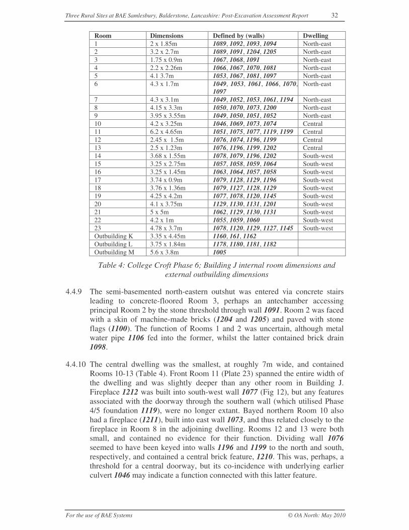
Three Rural Sites at BAE Samlesbury, Balderstone, Lancashire: Post-Excavation Assessment Report 32
For the use of BAE Systems © OA North: May 2010
Room Dimensions Defined by (walls) Dwelling1 2 x 1.85m 1089, 1092, 1093, 1094 North-east2 3.2 x 2.7m 1089, 1091, 1204, 1205 North-east3 1.75 x 0.9m 1067, 1068, 1091 North-east4 2.2 x 2.26m 1066, 1067, 1070, 1081 North-east5 4.1 3.7m 1053, 1067, 1081, 1097 North-east6 4.3 x 1.7m 1049, 1053, 1061, 1066, 1070,
1097North-east
7 4.3 x 3.1m 1049, 1052, 1053, 1061, 1194 North-east8 4.15 x 3.3m 1050, 1070, 1073, 1200 North-east9 3.95 x 3.55m 1049, 1050, 1051, 1052 North-east10 4.2 x 3.25m 1046, 1069, 1073, 1074 Central11 6.2 x 4.65m 1051, 1075, 1077, 1119, 1199 Central12 2.45 x 1.5m 1076, 1074, 1196, 1199 Central13 2.5 x 1.23m 1076, 1196, 1199, 1202 Central14 3.68 x 1.55m 1078, 1079, 1196, 1202 South-west15 3.25 x 2.75m 1057, 1058, 1059, 1064 South-west16 3.25 x 1.45m 1063, 1064, 1057, 1058 South-west17 3.74 x 0.9m 1079, 1128, 1129, 1196 South-west18 3.76 x 1.36m 1079, 1127, 1128, 1129 South-west19 4.25 x 4.2m 1077, 1078, 1120, 1145 South-west20 4.1 x 3.75m 1129, 1130, 1131, 1201 South-west21 5 x 5m 1062, 1129, 1130, 1131 South-west22 4.2 x 1m 1055, 1059, 1060 South-west23 4.78 x 3.7m 1078, 1120, 1129, 1127, 1145 South-westOutbuilding K 3.35 x 4.45m 1160, 161, 1162Outbuilding L 3.75 x 1.84m 1178, 1180, 1181, 1182Outbuilding M 5.6 x 3.8m 1005
Table 4: College Croft Phase 6; Building J internal room dimensions andexternal outbuilding dimensions
4.4.9 The semi-basemented north-eastern outshut was entered via concrete stairsleading to concrete-floored Room 3, perhaps an antechamber accessingprincipal Room 2 by the stone threshold through wall 1091. Room 2 was facedwith a skin of machine-made bricks (1204 and 1205) and paved with stoneflags (1100). The function of Rooms 1 and 2 was uncertain, although metalwater pipe 1106 fed into the former, whilst the latter contained brick drain1098.
4.4.10 The central dwelling was the smallest, at roughly 7m wide, and containedRooms 10-13 (Table 4). Front Room 11 (Plate 23) spanned the entire width ofthe dwelling and was slightly deeper than any other room in Building J.Fireplace 1212 was built into south-west wall 1077 (Fig 12), but any featuresassociated with the doorway through the southern wall (which utilised Phase4/5 foundation 1119), were no longer extant. Bayed northern Room 10 alsohad a fireplace (1211), built into east wall 1073, and thus related closely to thefireplace in Room 8 in the adjoining dwelling. Rooms 12 and 13 were bothsmall, and contained no evidence for their function. Dividing wall 1076seemed to have been keyed into walls 1196 and 1199 to the north and south,respectively, and contained a central brick feature, 1210. This was, perhaps, athreshold for a central doorway, but its co-incidence with underlying earlierculvert 1046 may indicate a function connected with this latter feature.
Three Rural Sites at BAE Samlesbury, Balderstone, Lancashire: Post-Excavation Assessment Report 33
For the use of BAE Systems © OA North: May 2010
4.4.11 The south-western dwelling was the largest, at 10m across, and containedseven rooms (Rooms 14 and 17-21; Table 4) within the main block, and threemore (Rooms 15, 16 and 22) within the northern outshut. Although the groundplan of this dwelling shared a number of similarities with that to the north-east(for instance, the dimensions of Rooms 20 and 21 were very similar to Rooms8 and 9), it was the only one to have a hallway (Room 23), running from theputative position of the central front door. The northern corner of the dwellingwas occupied by three small rooms, separated by internal walls 1127 and1128. These probably supported a staircase, with which the remains of twowooden posts (1208-1209), found at the south-west end of Room 17, mayhave been associated. There were few surviving internal elements thatindicated how each of the rooms had been accessed, or the nature of activitiesundertaken therein. Room 14 had a concrete floor (1116), whilst Room 19contained a fireplace built into north-east wall 1077 and almost directlyopposite fireplace 1212 in Room 11 in the adjoining central dwelling. Theoutshut was of similar construction as that to the north-east, with an internalbrick lining, although there was a possibility that part of the unusually widenorth-east wall, 1055 and 1206, may have used much older foundations. Theoutshut was divided internally by brick walls 1058 and 1059 into three rooms,of which Room 22 formed a paved (1060) alley to the others. Room 16retained no internal features, but the stone flagged floor (1038) of Room 15was well preserved.
4.4.12 Outbuildings and external features: to the north of Building J, the remains ofthree outbuildings were identified (Fig 11). Building K was located 10mnorth-west of Room 10 and, although mostly robbed-out and partially within abaulk left for services, the building had a simple north-west/south-east-alignedarrangement of stone walls (1160 and 1161), with an internal division (Fig13). The structure was flanked by two partially stone-lined pits (1169 to theeast and 1166 to the west), which were either garden features or rubbish pits.Building L, to the north-west, was an east/west-aligned stone-built structuremeasuring 3.75 x 1.84m and divided into two distinct parts. That to the southwas rectangular, comprising a small enclosed room with stone paving (1179;Plate 24) adjoined to the east by a square cell that opened onto the northernpart of the structure. This latter element comprised a curious curving circuit ofwalls (1183, 1184 and 1185), which swung round to the east. Building M waslocated to the north-east of Building L and comprised a rectangular, north-east/south-west-aligned structure with a continuous circuit of stone walls(1005), an opening to the north-west and an inner partition.
4.4.13 There were a number of external features thought to be associated with thesebuildings. Located to the north-east of Building M were the remains of north-east/south-west-aligned closely spaced parallel garden walls (Group Numbers1012 and 1017), which had been built on top of relict soil horizons 1020 and1027. Collectively, they are likely to represent features associated with a pathor trackway shown on the 1913 OS map (Fig 5). North-west/south-east-aligned drain 1021 was probably contemporary and cut into deposit 1020.
4.4.14 Phase 7: no new structural activity pertaining to this phase could be identified,although the fact that fill 1170 of pit 1169 (adjacent to Building K) produced
Three Rural Sites at BAE Samlesbury, Balderstone, Lancashire: Post-Excavation Assessment Report 34
For the use of BAE Systems © OA North: May 2010
pottery dating to the mid-twentieth century would date the backfilling of thesefeatures, if not necessarily their inception, to this period.
4.4.15 Phase 8: this phase saw the fairly thorough demolition of Building J in orderto make way for the aerodrome. Directly above the levelled remains of thesouth-west corner of the house, a surface had been laid of reused bricks of avariety of dates, forming two parallel trackways (1035 and 1134; Fig 12) on awest-north-west/east-south-east orientation dimensions (Plate 25). Thiscontinued beyond the limit of excavation, and could be observed during latertopsoil stripping outside of the excavation area as forming a much widerexpanse, at least 30m square. It is assumed that this surface served the SecondWorld War aerodrome, given its juxtaposition to the aircraft hangars.
4.5 COLLEGE FARM
4.5.1 Phases 1 and 2: no structural features were identified at College Farm thatcould be attributed to these phases. However, fill 3036 of shallow ditch 3037,located towards the south-eastern end of the excavation area (Fig 14),contained a single sherd of medieval pottery (but no other artefacts). Thoughlargely truncated, ditch 3037 appeared to run roughly north/south, but curvedsharply to the north-east. Whilst this pottery may be residual, it does indicatemedieval activity in the vicinity, even though that activity cannot be definedclosely.
4.5.2 Phase 3/4: on the basis of cartographic sources (Sections 1.3.9-16) and alimited artefact assemblage, the principal remains attributed to this period ofactivity are those of Buildings N and P (Fig 14). A possible boundary/drainageditch, 3028, and a stone-lined drain, 3044, were also identified.
4.5.3 Structural remains pertaining to the southern frontage of Building N (Plate 26)were revealed only partially at the northern limit of excavation (Fig 14). Asufficient area was exposed and investigated to indicate that the majority ofstructural components had been truncated completely, whilst the remainderwere poorly preserved. The extant remains comprised a series of single-coursed, c 0.5m-wide, wall footings constructed of roughly-hewn sandstoneslabs of varying sizes, bonded with lime mortar and laid, without foundationcuts, upon the natural clay (3008). Structure 3022, the oldest surviving part ofBuilding N, represented the main accommodation block of the north-east/south-west-aligned house, and comprised an 8.1m-long section of thesouthern wall (3056), with its respective northward return, 3059, the eastcorner, 3057, and also internal wall 3058. Collectively, these remainsindicated a structure 15.95m long by at least 3.5m wide. Structure 3022 wasabutted to the south by porch 3021, which measured 5.79m north-east/south-west by 3.39m. Apparently constructed in a single phase, the porch wallcontinued to the south-west, probably forming a garden boundary, whilst adeliberate gap of 0.75m in the north-west corner of the porch may haveaccommodated an entranceway. This gap had also been utilised for theinsertion of a brick-built drain, 3038, which ran from the building and could betraced continuing on a north-east/south-west alignment to link with the widerdrainage network (Section 4.5.5). Sandstone drain 3039 was placed centrally
Three Rural Sites at BAE Samlesbury, Balderstone, Lancashire: Post-Excavation Assessment Report 35
For the use of BAE Systems © OA North: May 2010
within the porch to link at right angles with drain 3038 and with its oppositeend curving through the southern wall of the porch, which had been modifiedaccordingly. Drain 3039 was well preserved and contained late post-medievalpottery within its fill (3040). No other internal features were preserved.
4.5.4 Building P (Fig 14; Plate 27) was located at the western end of the excavationarea and comprised the vestiges of a north/south-aligned stone-built structure.The extant remains measured 13m north/south by 9m, but had been truncatedto the north and east by a large modern pit filled with demolition debris, whilstthe southern end lay just beyond the corresponding limit of excavation. Thepartial remains formed two cells (3042 and 3043; Table 5), bound to the eastby 0.54m-wide yellow sandstone wall 3041, but otherwise defined by a seriesof very shallow, c 0.7m-wide robber trenches cutting the natural clay, 3008.No internal features survived, although a 7m stretch of stone-built and cobble-lined drain, 3044 (Plate 28), lay to the immediate west, and presumably ranfrom the building before turning northwards towards a putative road-sideditch.
4.5.5 Ditch 3028, to the immediate west of Building N, is likely to be an earlyboundary feature relating to this period (Fig 14). It was 1.16m wide andaligned north/south, separating Building N from Building P, whilst itsdrainage function was emphasised by its union with the robbed-out portion ofdrain 3038 associated with Building N. Its southern extent was truncated bylater building activity, but to the north it was likely to have connected with aputative road-side ditch. Its southern terminus had been backfilled, with aconsiderable quantity of eighteenth-century refuse, including an apparentsmithing bun.
Building Room number DimensionsN 3021 5.79m x 3.39mN 3022 16m x 3.72mO 3011 4.85m x 14.55mO 3013 9.6m x 7.6mO 3014 4.52m x 3.96mO 3015 3.6m x 3.45mP 3043 8m x 5.8mP 3042 5m x 6mO 3012 11.62m x 4.97mQ 3024a 2.41m x 1.85mQ 3024b 2.41m x 2mQ 3024c 1.26m x 1.85mQ 3024d 1.26m x 3.4mQ 3025a 2.1m x <2mQ 3025b 2.89m x <2mQ 3026 2.55m 1.26m
Table 5: College Farm; internal room dimensions
4.5.6 Phase 5, Building O: Building O (Fig 14; Plate 29) lay at the centre of thefarmstead and comprised an L-shaped structure, 18m north-east/south-west by15.2m and originally divided into four rooms (3011 and 3013-3015; Fig 15).The extant remains consisted of a complete and seemingly contemporary
Three Rural Sites at BAE Samlesbury, Balderstone, Lancashire: Post-Excavation Assessment Report 36
For the use of BAE Systems © OA North: May 2010
circuit of lime mortar-bonded sandstone internal and external walls, 3010,built within a shallow foundation cut into natural clay 3008. These wallssurvived to a height of two courses and were c 0.44m wide. There were fewinternal features to indicate how these rooms were used, although it waspossible to determine how each room was accessed. Larger slabs, likely tohave formed wide thresholds, were present within the north-west walls ofRooms 3011 and 3013, the latter of which had a wide aperture within itssouth-eastern wall, which may again have marked an entrance in this position.A number of smaller gaps within the internal and external walls, presumablyfor doorways, suggested that most of the rooms were mutually accessible.Several drains were also present, including a small section of stone-lined drain3030 in Room 3013 and another, 3051, in the west corner of Room 3011, thatfed through the north wall and into ditch 3028. A small brick drain inlet wasalso observed in Room 3014. A small L-shaped stone structure, 3033, abuttedthe south-western wall of Building O, and is likely to have been the base for aflight of stairs providing access to the first floor.
4.5.7 Building Q lay at the eastern end of the excavation area and would appear torepresent the truncated foundations of a range of outbuildings, measuring14.92m north-east/south-west by 5.15m (Fig 14; Plate 30). Built in a stylesimilar to that of Building O, the single surviving course of lime mortar-bonded sandstone foundations formed a row of three small contemporarystructures. These backed onto a contiguous boundary wall (3023) that kinkedaround the southernmost structure before continuing to the south-east.Southern structure 3024 was the best preserved and was divided into fourroughly equal sub-rectangular cells (each c 2.4m by 1.8m) by cross-shapedstone wall 3053. It seems likely that these cells formed a pair of pigsties,accessed through the obvious gaps at the southern end, and divided intoexternal and internal portions that were entered through the 0.5-0.6m-widegaps left by the lateral arms of wall 3053. The pigsties were adjoined to thenorth by rectangular structure 3025. Although there was no evidence for astone wall on the western side, a small, c 2.17m², area of rough setts, 3029,survived, abutting the east corner. Very little remained of the northernmoststructure, which appeared to have been completely rebuilt (Section 4.5.10).
4.5.8 Two exterior surfaces were identified abutting the Phase 5 buildings, whichare thus likely to belong to this phase of the farmstead’s reorganisation.Cobbled surface 3017 had been laid in the angle of wall 3010 of Building Oand stair base 3033 to the west. The sub-rectangular cobbles covered an areaof 11.58m² and became progressively more irregular away from the building.Surface 3019 lay between Buildings O and Q (Fig 15) and, though truncated tothe north, terminated very abruptly along a line parallel with the southern edgeof Room 3014 and the southern boundary wall of the pigsties. The surfacecontained a wide range of materials, including cobbles, square setts and evenbricks.
4.5.9 Phase 6: the archaeological evidence would suggest changes were made toBuilding O during this period, although the method of construction wasidentical to that of Phase 5. Room 3012 was added to the south of Room 3013(Fig 15), with the addition walls 3060 and 3061, thus forming a large
Three Rural Sites at BAE Samlesbury, Balderstone, Lancashire: Post-Excavation Assessment Report 37
For the use of BAE Systems © OA North: May 2010
rectangular building. The presence of localised brick inserts into each of theinternal walls of Room 3015 may imply the blocking of existing entrances atthese locations, and it is thus possible that the 3.6m-wide north-easternexternal entrance into Room 3015 may also have been a later modification topermit the housing of a vehicle or machinery. External surface 3018 was laidto the east of Room 3012 and south of surface 3019. It covered an area of31.63m² between the southern ends of Buildings O and Q (Plate 31), andcomprised neatly lain stone setts bedded on a layer of black material. Asection of this surface, recorded as 3029, extended into the adjoining part ofRoom 3012. Surface 3029 was flanked by sandstone slabs set on bricks, butthe character of the setts and black levelling layer was identical to those of theexterior surface. Localised 5.7m² surface 3016 abutted the north wall ofBuilding O and was again bedded on a black levelling deposit (3034), thoughthe surface comprised water-worn pebbles.
4.5.10 Phase 7: few features have been assigned to this period and represent lateralterations to existing structures. No stratified artefacts were found inassociation with these features. Building Q was separated from Building Othrough the addition of machine-made and stamped brick wall 3035 (Fig 15),which created a c 1m-wide passageway running along the western edge of thebuilding; at its southern end there was evidence that this passage had beenpaved with rough cobbled surface 3054. As part of this process, several of thewalls of Pigsty 3024 were reduced, and concrete surface 3032, which was over4m wide and scored to appear as if it was tiled, was inserted in their place. Thenorthernmost structure of Building Q was rebuilt as tank 3026, which was2.5m-wide, with a 0.56m by 0.88m appendage to the north (Fig 15; Plate 32).Both elements had been dug 0.45m into the natural clay, but the appendagewas built of stone slabs, whilst the remains of the main tank comprised sixcourses of sandstone blocks.
4.5.11 Phase 8: demolition and abandonment features included large, debris-filled pit3046, which was over 300m² and had truncated most of the remains ofBuilding P (Fig 14), and the backfilling of tank 3026 with an array ofrelatively modern rubbish, including pottery, wallpaper, shoes, combs, glassand rubber items. The levelled remains of the farmstead were sealed by a 50mby 30m section of north-west/south-east trackway, 3002 (Plate 33), which wasanalogous to 1035/1134 identified at College Croft (Section 4.4.15).Comprising a 0.36m-0.5m deep layer of demolition debris, mainly bricks, thesurface is considered to relate to the use of the aerodrome. Cut 3009 and fills3003 and 3004 of redeposited clay (not illustrated) are considered to relate tothe construction of this feature, which at some point was resurfaced with alayer of hardcore, 3001.
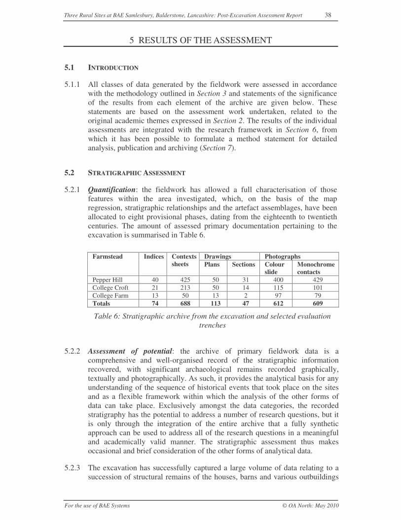
Three Rural Sites at BAE Samlesbury, Balderstone, Lancashire: Post-Excavation Assessment Report 38
For the use of BAE Systems © OA North: May 2010
5 RESULTS OF THE ASSESSMENT
5.1 INTRODUCTION
5.1.1 All classes of data generated by the fieldwork were assessed in accordancewith the methodology outlined in Section 3 and statements of the significanceof the results from each element of the archive are given below. Thesestatements are based on the assessment work undertaken, related to theoriginal academic themes expressed in Section 2. The results of the individualassessments are integrated with the research framework in Section 6, fromwhich it has been possible to formulate a method statement for detailedanalysis, publication and archiving (Section 7).
5.2 STRATIGRAPHIC ASSESSMENT
5.2.1 Quantification: the fieldwork has allowed a full characterisation of thosefeatures within the area investigated, which, on the basis of the mapregression, stratigraphic relationships and the artefact assemblages, have beenallocated to eight provisional phases, dating from the eighteenth to twentiethcenturies. The amount of assessed primary documentation pertaining to theexcavation is summarised in Table 6.
Drawings PhotographsFarmstead Indices Contextssheets Plans Sections Colour
slideMonochromecontacts
Pepper Hill 40 425 50 31 400 429College Croft 21 213 50 14 115 101College Farm 13 50 13 2 97 79Totals 74 688 113 47 612 609
Table 6: Stratigraphic archive from the excavation and selected evaluationtrenches
5.2.2 Assessment of potential: the archive of primary fieldwork data is acomprehensive and well-organised record of the stratigraphic informationrecovered, with significant archaeological remains recorded graphically,textually and photographically. As such, it provides the analytical basis for anyunderstanding of the sequence of historical events that took place on the sitesand as a flexible framework within which the analysis of the other forms ofdata can take place. Exclusively amongst the data categories, the recordedstratigraphy has the potential to address a number of research questions, but itis only through the integration of the entire archive that a fully syntheticapproach can be used to address all of the research questions in a meaningfuland academically valid manner. The stratigraphic assessment thus makesoccasional and brief consideration of the other forms of analytical data.
5.2.3 The excavation has successfully captured a large volume of data relating to asuccession of structural remains of the houses, barns and various outbuildings
Three Rural Sites at BAE Samlesbury, Balderstone, Lancashire: Post-Excavation Assessment Report 39
For the use of BAE Systems © OA North: May 2010
at each of the sites. Though varying in quantity from site to site, these records,together with the data relating to other elements pertaining to yards and tofeatures within the immediate surrounding area, have enormous potential fordetailed analysis. At each of the sites it has been possible to correlatestratigraphic records with cartographic depictions and present a summary ofthe basic elements of the sites (Section 4) and to identify earlier features,including buildings, for which no cartographic representations are known toexist. Moreover, the recorded data demonstrate a degree of complexity that isnot conveyed by the maps; much fine detail remains to be examined, and it isthe unravelling and understanding of these finer elements of the stratigraphicsequence, and their subsequent synthesis, that may allow some of the moresubtle details of the research aims to be addressed. In each case, the detailednature of the stratigraphic record means there is good potential to establishdated relative chronologies within and between the individual site elements andthus trace the development of each site through time.
5.2.4 Despite this, there are lacunae within the stratigraphic record: small quantitiesof medieval and early post-medieval pottery were recovered from Pepper Hilland, to a lesser extent, from College Farm (Section 5.4), but they had beenredeposited from their original context. As such, it is not possible to undertakeany meaningful stratigraphic analysis of Phase 1 deposits, nor to identify theexact nature of medieval or early post-medieval activity on the site. These,however, do not limit the scale of the analysis that can be undertaken, merelythe chronological range. Realistically, this is limited to Phases 3-7 at CollegeFarm, and Phases 2-7 at Pepper Hill and College Croft.
5.2.5 At a broad level, a greater understanding of the sites in most phases can beachieved by considering their components collectively. Whilst relying in parton the cartographic sources, the captured ground plans of the majority ofbuildings can be established, as can the techniques and materials of theirconstruction (with, in both instances, the notable exception of Building G atCollege Croft). Thus, these buildings can be considered in terms of theprevailing architectural style, although a full three-dimensional‘reconstruction’ of the majority is dependent upon comparison with extantstructures in the locale. These plans, and a consideration of how the buildingsand other features relate to one another, have great potential for integrationwith other data forms and so permit greater interpretation of function,organisation and use of space across the site as a whole. Such informationallows the categorisation of their form (EH 2006b), but also provides the basisof comparative analysis with other sites in the region (and, of course, betweeneach of the Samlesbury sites) and of an understanding of the changing role ofeach site within the wider historic landscape.
5.2.6 Questions concerning the use and spatial or functional division of each site’scomponents, and of the status of the inhabitants, are harder to address and, inmost cases, will require varying degrees of integration with other data forms.Certainly, in the case of Buildings B-D at Pepper Hill, and to a lesser extent atBuildings J-M at College Croft and Buildings O and Q at College Farm, thereis some, albeit generally sparse, data to examine the nature and accessibility ofindividual rooms within these buildings and occasional internal elements to
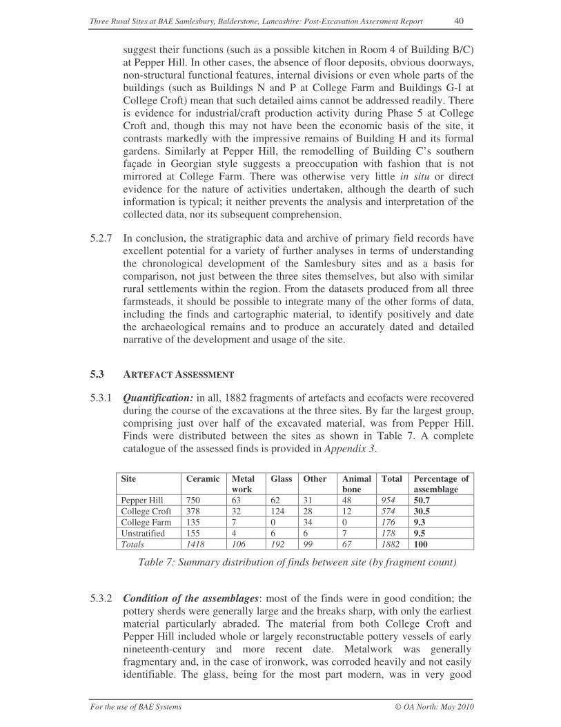
Three Rural Sites at BAE Samlesbury, Balderstone, Lancashire: Post-Excavation Assessment Report 40
For the use of BAE Systems © OA North: May 2010
suggest their functions (such as a possible kitchen in Room 4 of Building B/C)at Pepper Hill. In other cases, the absence of floor deposits, obvious doorways,non-structural functional features, internal divisions or even whole parts of thebuildings (such as Buildings N and P at College Farm and Buildings G-I atCollege Croft) mean that such detailed aims cannot be addressed readily. Thereis evidence for industrial/craft production activity during Phase 5 at CollegeCroft and, though this may not have been the economic basis of the site, itcontrasts markedly with the impressive remains of Building H and its formalgardens. Similarly at Pepper Hill, the remodelling of Building C’s southernfaçade in Georgian style suggests a preoccupation with fashion that is notmirrored at College Farm. There was otherwise very little in situ or directevidence for the nature of activities undertaken, although the dearth of suchinformation is typical; it neither prevents the analysis and interpretation of thecollected data, nor its subsequent comprehension.
5.2.7 In conclusion, the stratigraphic data and archive of primary field records haveexcellent potential for a variety of further analyses in terms of understandingthe chronological development of the Samlesbury sites and as a basis forcomparison, not just between the three sites themselves, but also with similarrural settlements within the region. From the datasets produced from all threefarmsteads, it should be possible to integrate many of the other forms of data,including the finds and cartographic material, to identify positively and datethe archaeological remains and to produce an accurately dated and detailednarrative of the development and usage of the site.
5.3 ARTEFACT ASSESSMENT
5.3.1 Quantification: in all, 1882 fragments of artefacts and ecofacts were recoveredduring the course of the excavations at the three sites. By far the largest group,comprising just over half of the excavated material, was from Pepper Hill.Finds were distributed between the sites as shown in Table 7. A completecatalogue of the assessed finds is provided in Appendix 3.
Site Ceramic Metalwork
Glass Other Animalbone
Total Percentage ofassemblage
Pepper Hill 750 63 62 31 48 954 50.7College Croft 378 32 124 28 12 574 30.5College Farm 135 7 0 34 0 176 9.3Unstratified 155 4 6 6 7 178 9.5Totals 1418 106 192 99 67 1882 100
Table 7: Summary distribution of finds between site (by fragment count)
5.3.2 Condition of the assemblages: most of the finds were in good condition; thepottery sherds were generally large and the breaks sharp, with only the earliestmaterial particularly abraded. The material from both College Croft andPepper Hill included whole or largely reconstructable pottery vessels of earlynineteenth-century and more recent date. Metalwork was generallyfragmentary and, in the case of ironwork, was corroded heavily and not easilyidentifiable. The glass, being for the most part modern, was in very good
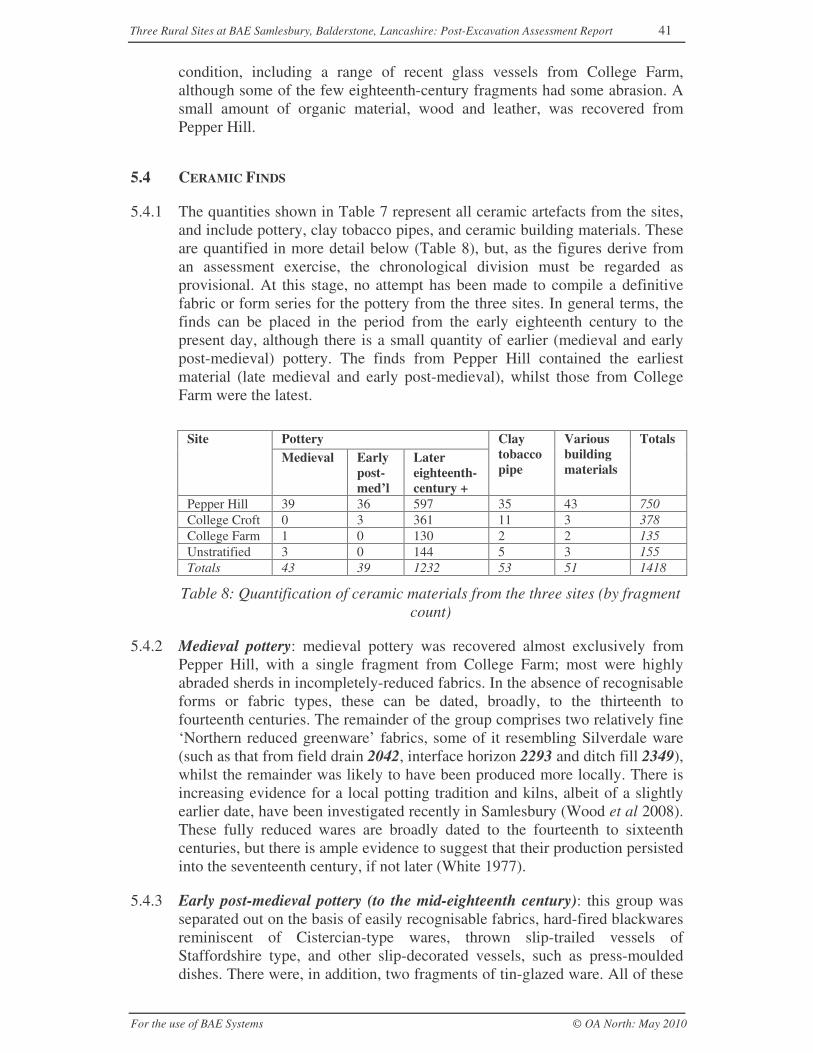
Three Rural Sites at BAE Samlesbury, Balderstone, Lancashire: Post-Excavation Assessment Report 41
For the use of BAE Systems © OA North: May 2010
condition, including a range of recent glass vessels from College Farm,although some of the few eighteenth-century fragments had some abrasion. Asmall amount of organic material, wood and leather, was recovered fromPepper Hill.
5.4 CERAMIC FINDS
5.4.1 The quantities shown in Table 7 represent all ceramic artefacts from the sites,and include pottery, clay tobacco pipes, and ceramic building materials. Theseare quantified in more detail below (Table 8), but, as the figures derive froman assessment exercise, the chronological division must be regarded asprovisional. At this stage, no attempt has been made to compile a definitivefabric or form series for the pottery from the three sites. In general terms, thefinds can be placed in the period from the early eighteenth century to thepresent day, although there is a small quantity of earlier (medieval and earlypost-medieval) pottery. The finds from Pepper Hill contained the earliestmaterial (late medieval and early post-medieval), whilst those from CollegeFarm were the latest.
PotterySiteMedieval Early
post-med’l
Latereighteenth-century +
Claytobaccopipe
Variousbuildingmaterials
Totals
Pepper Hill 39 36 597 35 43 750College Croft 0 3 361 11 3 378College Farm 1 0 130 2 2 135Unstratified 3 0 144 5 3 155Totals 43 39 1232 53 51 1418
Table 8: Quantification of ceramic materials from the three sites (by fragmentcount)
5.4.2 Medieval pottery: medieval pottery was recovered almost exclusively fromPepper Hill, with a single fragment from College Farm; most were highlyabraded sherds in incompletely-reduced fabrics. In the absence of recognisableforms or fabric types, these can be dated, broadly, to the thirteenth tofourteenth centuries. The remainder of the group comprises two relatively fine‘Northern reduced greenware’ fabrics, some of it resembling Silverdale ware(such as that from field drain 2042, interface horizon 2293 and ditch fill 2349),whilst the remainder was likely to have been produced more locally. There isincreasing evidence for a local potting tradition and kilns, albeit of a slightlyearlier date, have been investigated recently in Samlesbury (Wood et al 2008).These fully reduced wares are broadly dated to the fourteenth to sixteenthcenturies, but there is ample evidence to suggest that their production persistedinto the seventeenth century, if not later (White 1977).
5.4.3 Early post-medieval pottery (to the mid-eighteenth century): this group wasseparated out on the basis of easily recognisable fabrics, hard-fired blackwaresreminiscent of Cistercian-type wares, thrown slip-trailed vessels ofStaffordshire type, and other slip-decorated vessels, such as press-mouldeddishes. There were, in addition, two fragments of tin-glazed ware. All of these
Three Rural Sites at BAE Samlesbury, Balderstone, Lancashire: Post-Excavation Assessment Report 42
For the use of BAE Systems © OA North: May 2010
can be dated from the late seventeenth to the mid-eighteenth centuries. Theseprovide an approximate indication of the presence of early post-medievalmaterial, but further analysis will be required before the divisions can befinalised.
5.4.4 Again, this earlier material was recovered mainly from the Pepper Hill site,and it gives some suggestion of continuity of occupation there from the latemedieval period. There is not a great quantity of sherds, although this is likelyto represent almost as many vessels as there are sherds. In addition, it is quitelikely that the dating of the later Blackwares will be revised, and the numberand range of early fabrics or forms thereby possibly increased.
5.4.5 Later eighteenth-century and later pottery: most of the pottery recovered canbe dated from the late eighteenth to the early nineteenth centuries or later, andevidence suggests that deposition may well have ceased by the mid-twentiethcentury, with the latest material recovered from College Croft and CollegeFarm. The assemblages from College Croft and Pepper Hill overlapconsiderably, both being strong in nineteenth-century material, and it is notimpossible that deposition ceased first at Pepper Hill. The fabrics and formspresent on all three sites represent a range of common domestic wares, bothkitchenwares and fine tablewares. Later vessels are often complete, with morerobust stoneware bottles and jars surviving undamaged, whilst earlier andmore fragile vessels, such as pearlware plates and dishes, and late industrialslipware bowls, were recovered smashed, but largely reconstructable.
5.4.6 Kitchenwares are represented mainly by large black-glazed storage vessels,some of which are undoubtedly eighteenth-century in date, but whoseproduction at local potteries is likely to have continued into the twentiethcentury. There is also a range of late stoneware vessels, many of them grey 1lbjam jars, stamped underneath with a tower and the words ‘Liverpool andLondon.’ These can be dated to the late nineteenth century, and were probablymanufactured by WH Hartley of Liverpool (Cotter 2000, 254).
5.4.7 A range of brown stoneware cooking and storage vessels was also noted, theearliest of them probably eighteenth-century, although most are later; ablacking bottle from pigsty 2112, bearing the backstamp ‘Doulton, Lambeth’,can be dated to the period 1858-91 (Tyler 2008, fig 55). A small number ofother forms, including teapots, also appear as black-glazed wares, but on thewhole teaware and other finewares are in the cream or white earthenwarestypical of the late eighteenth and early nineteenth centuries, or the transfer-printed earthenwares, which were common from the nineteenth century. Thereis a particular prevalence of blue feather-edged plates and dishes, a style ofdecoration coming into fashion in the late eighteenth century and remainingpopular into the early nineteenth. A range of common patterns is presentamongst the transfer-printed material and can be dated with relative precision.Other fine tablewares include china eggcups, teacups and saucers, teapots, andmore decorative items. An eggcup from bedding layer 1173 in Building L atCollege Croft is transfer-printed with a depiction of the Manchester AssizeCourt.
Three Rural Sites at BAE Samlesbury, Balderstone, Lancashire: Post-Excavation Assessment Report 43
For the use of BAE Systems © OA North: May 2010
5.4.8 Potential of the pottery: the pottery from the three sites is largely well-stratified and comprises a range of datable fabrics and forms covering thelifetime of the sites; it can thus be seen as providing a sound basis for datingthe stratigraphic succession in each case. It also provides a chance to makesynchronous links across all three sites, thus aiding an understanding of theirrelative development. In addition, the assemblage from Pepper Hill has fairpotential to illustrate the duration and nature of pottery usage on the site, andwill add to an understanding of the socio-economic development of the siteand its inhabitants, adding to any discussion of status, and sources of supply.The 28 sherds in the ‘Northern reduced greenware’ tradition from Pepper Hillhave the potential to shed light on the development of late medieval/earlypost-medieval pottery in the region and can be compared with other nearbypost-medieval farmsteads, such as those excavated on the Samlesbury toHelmshore natural gas pipeline (Northern Archaeological Associates 2004).The lack of any typical late medieval Midlands Purple ware may also besignificant.
5.4.9 In addition, there are one or two assemblages from several features that maywarrant special attention. At Pepper Hill, an assemblage of some 14 sherdsfrom cobbled surface 2095 within Building B included mainly seventeenth-century pottery and residual medieval material. Further analysis of this groupmay shed light on the foundation of this building. A further group, mainlyeighteenth-century in origin, was identified from the fill of field boundary3028 at College Farm. This included 50 sherds of blackware, which shouldallow not only an examination of forms, but also a comparison with otherblackware pottery, both from the three BAE Samlesbury sites and elsewhere.
5.4.10 Clay tobacco pipe: a total of 53 fragments of clay pipe was recovered, mostbeing small and largely undiagnostic fragments of stem. Only seven bowlswere recognised, the earliest (a stamped bowl, probably late seventeenth-century, from cobbled surface 2095) coming, as might be expected, fromPepper Hill.
5.4.11 Potential: the potential of the clay tobacco pipe to add to the understanding ofthe three sites is limited by its size. It can, however, contribute to a refinementof the dating.
5.4.12 Building materials: between them, the three sites produced 51 smallfragments of ceramic building material. The group is disparate, comprisingvery small fragments of brick, some ceramic wall tile, roof tile, and stonewaredrain fragments. Cross-context joins were noted amongst the wall tile, butotherwise there was little of interest in the group.
5.4.13 Potential: the potential of the ceramic building material to add to theunderstanding of the three sites is negligible, although cross-context joinsnoted in the tile will add to a clarification of stratigraphic relationships.
5.5 THE METALWORK
5.5.1 The distribution of objects of specific metals is shown below in Table 9.Industrial residues are included within this group, as those which can be
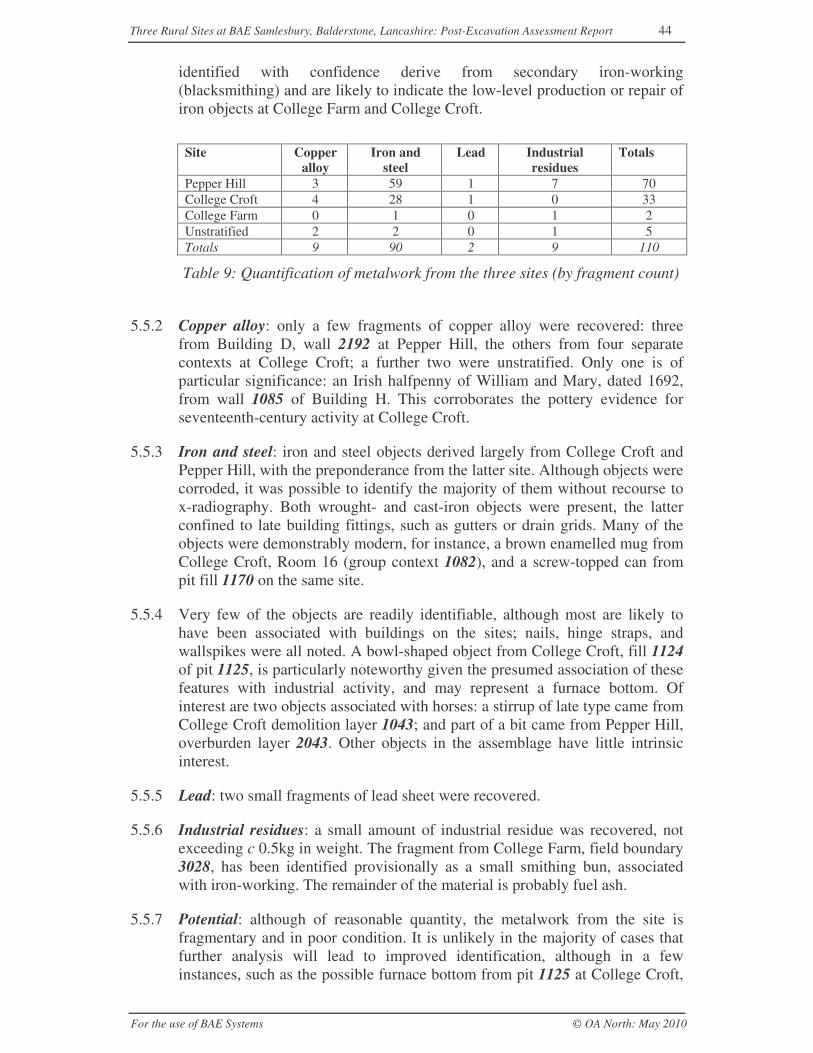
Three Rural Sites at BAE Samlesbury, Balderstone, Lancashire: Post-Excavation Assessment Report 44
For the use of BAE Systems © OA North: May 2010
identified with confidence derive from secondary iron-working(blacksmithing) and are likely to indicate the low-level production or repair ofiron objects at College Farm and College Croft.
Site Copperalloy
Iron andsteel
Lead Industrialresidues
Totals
Pepper Hill 3 59 1 7 70College Croft 4 28 1 0 33College Farm 0 1 0 1 2Unstratified 2 2 0 1 5Totals 9 90 2 9 110
Table 9: Quantification of metalwork from the three sites (by fragment count)
5.5.2 Copper alloy: only a few fragments of copper alloy were recovered: threefrom Building D, wall 2192 at Pepper Hill, the others from four separatecontexts at College Croft; a further two were unstratified. Only one is ofparticular significance: an Irish halfpenny of William and Mary, dated 1692,from wall 1085 of Building H. This corroborates the pottery evidence forseventeenth-century activity at College Croft.
5.5.3 Iron and steel: iron and steel objects derived largely from College Croft andPepper Hill, with the preponderance from the latter site. Although objects werecorroded, it was possible to identify the majority of them without recourse tox-radiography. Both wrought- and cast-iron objects were present, the latterconfined to late building fittings, such as gutters or drain grids. Many of theobjects were demonstrably modern, for instance, a brown enamelled mug fromCollege Croft, Room 16 (group context 1082), and a screw-topped can frompit fill 1170 on the same site.
5.5.4 Very few of the objects are readily identifiable, although most are likely tohave been associated with buildings on the sites; nails, hinge straps, andwallspikes were all noted. A bowl-shaped object from College Croft, fill 1124of pit 1125, is particularly noteworthy given the presumed association of thesefeatures with industrial activity, and may represent a furnace bottom. Ofinterest are two objects associated with horses: a stirrup of late type came fromCollege Croft demolition layer 1043; and part of a bit came from Pepper Hill,overburden layer 2043. Other objects in the assemblage have little intrinsicinterest.
5.5.5 Lead: two small fragments of lead sheet were recovered.
5.5.6 Industrial residues: a small amount of industrial residue was recovered, notexceeding c 0.5kg in weight. The fragment from College Farm, field boundary3028, has been identified provisionally as a small smithing bun, associatedwith iron-working. The remainder of the material is probably fuel ash.
5.5.7 Potential: although of reasonable quantity, the metalwork from the site isfragmentary and in poor condition. It is unlikely in the majority of cases thatfurther analysis will lead to improved identification, although in a fewinstances, such as the possible furnace bottom from pit 1125 at College Croft,
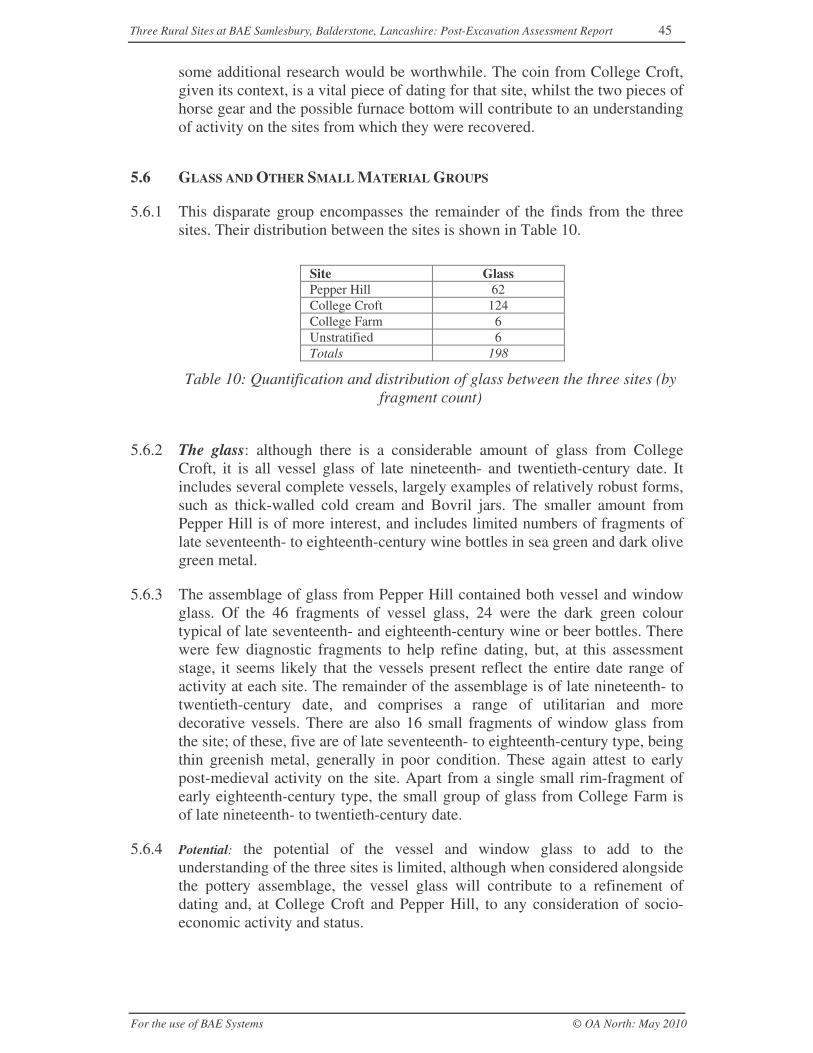
Three Rural Sites at BAE Samlesbury, Balderstone, Lancashire: Post-Excavation Assessment Report 45
For the use of BAE Systems © OA North: May 2010
some additional research would be worthwhile. The coin from College Croft,given its context, is a vital piece of dating for that site, whilst the two pieces ofhorse gear and the possible furnace bottom will contribute to an understandingof activity on the sites from which they were recovered.
5.6 GLASS AND OTHER SMALL MATERIAL GROUPS
5.6.1 This disparate group encompasses the remainder of the finds from the threesites. Their distribution between the sites is shown in Table 10.
Site GlassPepper Hill 62College Croft 124College Farm 6Unstratified 6Totals 198
Table 10: Quantification and distribution of glass between the three sites (byfragment count)
5.6.2 The glass: although there is a considerable amount of glass from CollegeCroft, it is all vessel glass of late nineteenth- and twentieth-century date. Itincludes several complete vessels, largely examples of relatively robust forms,such as thick-walled cold cream and Bovril jars. The smaller amount fromPepper Hill is of more interest, and includes limited numbers of fragments oflate seventeenth- to eighteenth-century wine bottles in sea green and dark olivegreen metal.
5.6.3 The assemblage of glass from Pepper Hill contained both vessel and windowglass. Of the 46 fragments of vessel glass, 24 were the dark green colourtypical of late seventeenth- and eighteenth-century wine or beer bottles. Therewere few diagnostic fragments to help refine dating, but, at this assessmentstage, it seems likely that the vessels present reflect the entire date range ofactivity at each site. The remainder of the assemblage is of late nineteenth- totwentieth-century date, and comprises a range of utilitarian and moredecorative vessels. There are also 16 small fragments of window glass fromthe site; of these, five are of late seventeenth- to eighteenth-century type, beingthin greenish metal, generally in poor condition. These again attest to earlypost-medieval activity on the site. Apart from a single small rim-fragment ofearly eighteenth-century type, the small group of glass from College Farm isof late nineteenth- to twentieth-century date.
5.6.4 Potential: the potential of the vessel and window glass to add to theunderstanding of the three sites is limited, although when considered alongsidethe pottery assemblage, the vessel glass will contribute to a refinement ofdating and, at College Croft and Pepper Hill, to any consideration of socio-economic activity and status.
Three Rural Sites at BAE Samlesbury, Balderstone, Lancashire: Post-Excavation Assessment Report 46
For the use of BAE Systems © OA North: May 2010
5.6.5 Other material groups: although objects of wood, leather, paper, plastic, andrubber were recovered, none are of particular interest or relevance to theinterpretation of the sites.
Site Leather Wood Plastic etc TotalsPepper Hill 1 4 2 7College Croft 0 14 1 15College Farm 1 1 5 7Unstratified 0 0 1 1Totals 2 19 9 30
Table 11: Quantification and distribution of miscellaneous materials betweenthe three sites (by fragment count)
5.6.6 Potential: the potential of the organic and modern material groups to add to theunderstanding of the three sites is negligible, and they merit no furtheranalysis.
5.7 ANIMAL BONE AND SHELL
5.7.1 Small assemblages of animal bone (67 fragments) and marine mollusc shell(31 fragments) were recovered from the three sites. These reflect foodstuffsconsumed in the vicinity, but in neither case are the assemblages large enoughto have particular interpretative significance, nor do they derive fromconcentrations of primary refuse.
5.7.2 Potential: the animal bone and shell have no potential for further analysis.
5.8 CHARRED AND WATERLOGGED PLANT REMAINS
5.8.1 During the excavation, four bulk samples were taken from sealed, stratifiedcontexts (Table 12) and, in accordance with the methodology outlined inSection 3.3.6, were subsequently processed and assessed for the analyticalpotential of any preserved plant remains, and for the recovery of smallartefacts and cultural residues.
Sample Context Site Feature Processed volume(litres)
1 2017 Pepper Hill Fill of pit 2016 105 1124 College Croft Fill of sub-rectangular cut 106 1122 College Croft Fill of quenching pit 1121 107 1126 College Croft Fill of pit 1125 possibly
associated with furnace 11235
Table 12: Summary of samples assessed from the Samlesbury sites
5.8.2 Assessment: the results of the assessment are summarised in Table 13.Charcoal, coal and clinker were recorded in all the samples, but the quantity ofplant remains was low, with a few in 2017, 1122 and 1126 and none in 1124(Table 11). One charred cereal grain, together with fragments of bone, insectremains and a Prunus stone, was recorded in quenching pit fill 1122. The
Three Rural Sites at BAE Samlesbury, Balderstone, Lancashire: Post-Excavation Assessment Report 47
For the use of BAE Systems © OA North: May 2010
matrix of the samples was consistent with some industrial activity havingtaken place in the surrounding area.
Sample Context Flot vol(ml)
Flot description Plant Remains Potential
1 2017 1500 Charcoal >4mm (4),clinker (4), coal (2),ceramic buildingmaterial (1)
CPR (1)undifferentiatedplant fragmentsWPR (1) Sambucus
None
5 1124 1100 Coal (4), clinker (3),Charcoal 2-4mm (1-2),sand, ceramic buildingmaterial, powderywhite substance ??ash
None
6 1122 180 Charcoal >4mm (2),clinker (4), insectremains (1), industrialdebris (2), slag, modernwood? (1), bone(burnt) (1)
CPR (1) CerealiaindeterminateWPR (1) Prunusdomestica
None
7 1126 150 Coal (4), clinker (2),sand
WPR (1) Juncus None
Table 13: Assessment of charred and waterlogged plant remains from PepperHill and College Croft. Plants recorded on a scale of 1-4, where 1 is rare (up
to five items) and 4 is abundant (>100 items). WPR = waterlogged plantremains, CPR = charred plant remains.
5.8.3 Potential: the number of plant remains was low and provides no informationconcerning the economy and environment of the site; they have no potentialfor any further work. However, the presence of metalworking spheres(possible smithing activity) and slag lends further credence to the interpretedassociation of pits 1121, 1123 and 1125 at College Croft with small-scaleindustrial activity.
5.9 CONSERVATION AND PACKAGING
5.9.1 The artefact assemblage is well preserved and in good condition; thus nofurther conservation is required. The assemblage is currently well packed andwill require no further packaging. Box lists have been prepared and will beupdated from the database when any analysis of objects and the enaction of theretention policy (Sections 7.5 and 7.7) are complete.
Three Rural Sites at BAE Samlesbury, Balderstone, Lancashire: Post-Excavation Assessment Report 48
For the use of BAE Systems © OA North: May 2010
6 STATEMENT OF POTENTIAL FOR ANALYSIS
6.1 INTRODUCTION
6.1.1 The following section seeks to synthesise the results of the fieldwork and ofthe assessment (Sections 4 and 5) to establish the nature of detailed analysisthat can be undertaken on the recovered dataset once it has been integrated,and combined with documentary research. As such, it will determine thevalidity of the original research questions (Section 2.3.1) and, whereappropriate, adjust them as updated research questions (URQ) to be addressedby updated research objectives (URO; Section 6.4). It is these UROs that willform the basis of the updated project design for analysis (Section 7).
6.2 ARCHAEOLOGICAL AND HISTORICAL CONTEXT
6.2.1 The excavations at the three Samlesbury sites have demonstrated that each hasbeen the subject of a great deal of change during their centuries of occupation.Of the three, only Pepper Hill, despite many phases of reorganisation, seems tohave remained an intact, single, farmstead throughout its history, whilstCollege Farm appears to have been subdivided; College Croft might neverhave hosted agricultural activity, but rather, may have been an estate centre.As such, the sites are testaments to the large- and small-scale transformationsof patterns of land organisation, utilisation and ownership, to the technology ofagricultural practice and to the position of these rural sites within the widereconomic system; these changes are demonstrated overtly by the construction,modification and demolition of the constituent buildings at each site. In thelater post-medieval (industrial) period, such changes are likely to have beenstimulated by the growth of the urban population, in this case those of Prestonand Blackburn, with their increasing reliance on industrialised textileproduction. This period, between 1750 and 1880, has been described as the‘most important period of farm building development’ (EH 2006b, 6), forthese industrialising towns required a commensurate rise in food provision,which could be met only through reorganisation and specialisation of thesurrounding farms. Moreover, this was a period of increasing mechanisationand agricultural intensification and extensification, as farms reaped thebenefits of industrialised tools and machinery, albeit at the expense of hiredrural labour.
6.2.2 The date that each of the sites commenced as a focus of settlement is hard toascertain, but in the case of Pepper Hill, and perhaps also College Farm, it islikely to have been earlier than the oldest structural remains suggest. Such anhypothesis is based not so much upon the position of the sites within alandscape containing fossilised medieval and early post-medieval elements(LCC 2006a, 97), but upon several small, albeit largely residual, potteryassemblages. These ceramics, broadly dating to the medieval period(specifically the thirteenth to fourteenth centuries) and to the transitionbetween the later medieval and early post-medieval periods (Northern reducedgreenware of fourteenth- to sixteenth- or early seventeenth-century date), seem
Three Rural Sites at BAE Samlesbury, Balderstone, Lancashire: Post-Excavation Assessment Report 49
For the use of BAE Systems © OA North: May 2010
not to have been recovered from their original contexts of deposition, but theirpresence, given their overall rarity in the county (the Samlesbury kiln site notwithstanding; Wood et al 2008), can be considered significant. At CollegeFarm, the single sherd could be attributed to the common practice of manuringfields with domestic refuse, as might the abraded thirteenth- to fourteenth-century sherds at Pepper Hill. However, the concentration of some 28fragments of Northern reduced greenware from the latter site, including sherdsfrom the area of the later house (Building B/C), stands out, and may implyhabitation of the site, perhaps as early as the fifteenth century. One can explainthe absence of related buildings by the fact that shallow traces of typical sill-beam- or cob-built structures might be easily removed by later activity. A lessengaging interpretation is that the presence of Northern reduced greenwaremerely confirms the longevity of this type of pottery (White 1977, 102).Hollow way 2264 could have accessed this early farmstead, the alignment ofwhich may have been preserved by the singular orientation of Building A(which, seemingly built in stone, appears to have been a later addition to thishypothetical early steading; Fig 7). The possible structure preserved within cut2223 may also be part of this early steading. Conversely, at College Croft,where the vestigial remains of Building G might be interpreted as shallowbeam slots (Fig 11), the absence of Northern reduced greenware, coupled withthe efficiency of stone-robbing across the site, would suggest that thisstructure was unlikely to be especially early in date.
6.2.3 The earliest definable structural activity at each of the sites (Buildings A, Band D at Pepper Hill (Fig 7), Building G at College Croft (Fig 11) andBuildings N and perhaps P at College Farm (Fig 14)) is thus likely to date tothe second half of the seventeenth century, corroborated by the ceramicevidence from College Croft and Pepper Hill, and from the distinctiveappearance of the College Farm house (Building N; Plate 1). As such, eachfalls within a contemporary North West regional trend towards the large-scalerebuilding of farmsteads in stone, in itself part of the Great Rebuilding, thatperiod from the late sixteenth century to the early eighteenth century whenthose at the social level of the yeoman farmer built their houses in morepermanent materials (Brunskill 1992, 24). Other excavated sites in the areadated to the seventeenth century include Higher Farm and Top of MeadowFarm, whilst at nearby Tattersall Nook, eighteenth-century buildings werepreceded by late medieval activity (NAA 2004, 8-12). Although themotivation behind this move towards architectural permanence is likely to becomplex, in the North West it was aided, at least partly, by favourable terms oftenancy (EH 2006b, 7).
6.2.4 At Pepper Hill, the construction of the farmhouse, Building B, with its cross-passage and presumed fireplace backing onto it, is likely to have preservedelements of vernacular architecture dating back to the Middle Ages (Brunskill1992, 48-9). By the nineteenth century, if not before, the appearance ofBuilding B clearly was felt to be outmoded, and a considerable amount ofinternal reorganisation and external rebuilding was undertaken to reface thehouse in a more fashionable symmetrical Georgian style with a central entry(Plate 2). Though these elements are typical within the region after the 1750s,often at rebuilt steadings, Building C’s single row of rooms (rather than the
Three Rural Sites at BAE Samlesbury, Balderstone, Lancashire: Post-Excavation Assessment Report 50
For the use of BAE Systems © OA North: May 2010
double-depth characteristic of rebuilds; EH 2006b, 7) strongly suggests thatBuilding C was a modification of Building B, rather than a complete rebuild.
6.2.5 It is uncertain at this assessment stage whether this change was restricted tothe farmhouse, or affected the other farm buildings, although it is possible thatthe parallel plan of mid-nineteenth-century Pepper Hill, its buildings arrangedon either side of the axial trackway, may have developed from an earlier linearor even more haphazard plan (EH 2006b, 42). The quoin-constructed andpossibly unmortared heart of Building D is likely to have been at least as oldas Building B, and included large cobbles in several foundations, a commontechnique in the North West (op cit, 21). Although the lack of fireplaces wouldindicate that Building D was a purpose-built barn, the presence of similarlysized Building F within the farmyard may suggest that it was not always theprincipal outbuilding it became in the second half of the nineteenth century.Indeed, the discrepancy between the cartographic and excavated plans ofBuilding F may suggest that it had been remodelled or expanded during itshistory. A further, and possibly contemporary, outbuilding shown on the 1849OS map is likely to have lain within the unexcavated baulk between Areas 1and 2. These small barns might suggest a farm of 100-150 acres, an area thatappears to have changed little in the ensuing centuries (op cit 4; Wade-Martins1991, 160). Furthermore, the excavated remains of Building D lacked theopposing doors typical of a threshing barn (despite its characteristic alignment,almost perpendicular to the prevailing winds), suggesting that arablehusbandry was not the mainstay of the farm. Indeed, the North West’s wetclimate, local heavy clay soils and a documented decline in arable farmingfrom the seventeenth century onwards (EH 2006b, 8) would indicate thatlivestock, and cattle in particular, remained the more important source ofincome. Troughs 2234 and 2235 and, perhaps, also wooden trough 2241,associated with Building E, would certainly suggest a connection withlivestock.
6.2.6 Any preliminary discussion of the earliest remains of College Farm isprevented by their poor preservation: little remained of Building N and neitherof the two associated outbuildings depicted on the 1849 OS map could beidentified through excavation. The depicted arrangement can be described as‘haphazard’ (Brunskill 1987) or ‘dispersed’ (EH 2006b), a common (thoughundated) layout within the North West, especially for smaller lowland farmsengaged primarily with stock-rearing/dairying (ibid). Given this haphazardarrangement, the differing alignment of Building P means that, presently, it isuncertain whether it ever formed part of this organisation. It is clear, however,that when the Samlesbury tithe award was drawn up in 1849, Building P wasdistinct from College Farm, and may at that time have been a tenement ratherthan an agricultural building; the excavation yielded few clues of humanoccupation or of a former agricultural function. Interestingly, the tithe maprecords a ‘Barn Field’ (but shows no corresponding building) to the south,perhaps preserving the location of College Farm’s field barn. To date, thecollected evidence suggests that, during the mid-nineteenth century, CollegeFarm lacked a barn, although certain of the necessary functions could havebeen undertaken within the elongated west wing of Building N.
Three Rural Sites at BAE Samlesbury, Balderstone, Lancashire: Post-Excavation Assessment Report 51
For the use of BAE Systems © OA North: May 2010
6.2.7 The very sparse remains associated with Building G at College Croft and itsabsence from readily available cartographic sources means that it bears verylittle discussion at this assessment stage. Building H, built at College Croftaround the turn of the eighteenth century, appeared to lack detachedoutbuildings, ostensibly a similarity it shares with other dwellings on theBalderstone and Burscough Bridge Road, such as Cluff/Clough Gate and NewBuildings, Worsted Row, Cobblers, and Myerscough Smithy (OS 1849; 1893).However, its massive walls, large ground plan and formal gardens may implythat Building H was no mere farmstead. Alternatively, it is possible that thesize of Building H related to a linear-type farmstead plan (EH 2006b, fig 16),as demonstrated by a photograph of Myerscough Farm (lanternimages.lancashire.gov.uk; Record 918), also demolished in advance of theaerodrome’s construction.
6.2.8 Major changes took place at each of the sites over the course of the secondhalf of the nineteenth century, and only at College Farm could there be said tobe expansion, with the construction of Buildings O and Q, creating a courtyardor U-shaped pattern (Brunskill 1987, fig 78e, f; EH 2006b, 43), a formparticularly common among the mid-nineteenth-century farms of Cumberland(Dickinson, quoted in EH 2006b, 48). The loss of Buildings E and F at PepperHill, and the modest development of Building D, could perhaps relate to arationalisation, but it is tempting to see these changes as retrograde, similar tothe massive reduction at College Croft. The reasons for these changes cannotbe deduced at this assessment stage, but they may pertain to the developmentof Inglewood, first depicted on the OS map of 1893 (Fig 4). The house atInglewood was likely to have been a handsome symmetrical twin-bay-frontedstructure of double-depth design. Set within recently planted mixed deciduousand coniferous woodland and some distance from its ancillary structures, it hasa certain air of status. The proprietor of Inglewood may have acquired much ofthe land within the area, at the expense of Pepper Hill and College Croft, and itmay be significant that Laneside is no longer described on the maps as ‘part ofPepper Hill’ (OS 1849; 1893). It is also possible that the owners of CollegeCroft may have left their dilapidated former home in favour of the modernamenity of Inglewood, keeping only those best-preserved elements of BuildingI for their tenants. Alternatively, Building I at College Croft and College Farmcould have become functionally more closely linked, and it is of interest thatLower College, to the north-west, would also appear to have been rebuilt atthis time.
6.2.9 Although metal-working is likely to have been undertaken within the areaoccupied by Building I, the scale of this activity is uncertain. Evidence fromthe Lancashire Pennines would suggest a long history among many rural sites,including farmsteads, of adopting cottage industries in an attempt to diversifyand create an economically viable smallholding (EH 2006b, 8); about a quarterof eighteenth- and nineteenth-century Yeoman probate inventories in this arealist specialist rooms connected with weaving (RCHME 1985, 97). Possiblemetal-working activity was also seen at Rough Hey Farm, Preston (OA Northforthcoming a) and such cottage industries may have occurred at otherdwellings on the Balderstone and Burscough Bridge Road, such as WorstedRow, Cobblers, and Myerscough Smithy (OS 1849; 1893). Given the
Three Rural Sites at BAE Samlesbury, Balderstone, Lancashire: Post-Excavation Assessment Report 52
For the use of BAE Systems © OA North: May 2010
longevity of this practice, Building P might then have been involved withtextile processing, as might, on occasion, Building N.
6.2.10 Currently, it is uncertain whether these changes to Pepper Hill and CollegeFarm related to greater economic specialisation, but at both, in common withthe wider contemporary landscape, there is clear development of animalstalling, most obviously, though presumably not exclusively, for pigs (OS1893). Although not aligned to the prevailing wind, Building O in its earliestform was likely to have been fitted with opposed double doors (Room 3013),whilst its internal division suggested it housed a range of tasks associated withboth livestock (perhaps in Room 3011) and crops. The Phase 6 addition lackeddouble doors, but this subsequent modification may relate more to theadoption of mechanised threshing than to any particular polarisation towardsanimal husbandry. Room 3015, with its large, and possibly inserted, entrance,was likely to have been a cart/tool shed. It is of further interest that thisaddition perhaps coincided with the apparent reduction of the west wing ofBuilding N and the presumed relocation of the activities contained therein (OS1893; 1913).
6.2.10 During the early twentieth century, the most significant changes werewitnessed at College Croft, with the construction of Building J. The smartstyle, reminiscent of early twentieth-century urban developments, andgenerous dimensions, might imply that it had been built by a speculator forthose of a middling income. The threefold subdivision of Building I and itssurroundings clearly relates to ownership or tenancy, but the same may notnecessarily be true of College Farm, which may have been divided on morefunctional grounds. If College Farm was indeed subdivided, and the latestchanges to the Building Q pigsties appear unrelated to agriculture, this mightbe attributable to the long farming depression that occurred between the 1880sand 1940 (EH 2006b, 6).
6.3 POTENTIAL FOR FURTHER ANALYSIS
6.3.1 This section discusses whether, and how, any or all of the original researchquestions for excavation and assessment (Section 2.3.1) can be addressed bythe dataset, and thus remain appropriate aims for analysis (Project Stage 3).The research context for the present investigation, including appropriateframeworks and regional studies, has been outlined in Section 2, and will notbe reiterated here. Suffice it to note, the three sites at Samlesbury areimportant additions to the small but growing corpus of post-medievaldispersed rural sites excavated in the North West. They help not only toredress the limited investigation of such sites in general, but also to further anunderstanding of rural building evolution in Lancashire, which is lesscomplete than in neighbouring Cumbria, for example (EH 2006b). The largevolume of data captured from the Samlesbury sites relates to several phases ofchange within a relatively narrow, but potentially well-documented,timeframe, and means that there is excellent potential to shed light on thedevelopment of post-medieval rural settlement in Lancashire, tracing a numberof themes associated with the ‘Agricultural Revolution,’ the Great Rebuilding
Three Rural Sites at BAE Samlesbury, Balderstone, Lancashire: Post-Excavation Assessment Report 53
For the use of BAE Systems © OA North: May 2010
from the late seventeenth century, and the impact of industrialisation between1750 and 1900.
6.3.2 During the course of the fieldwork and this assessment, the most basicelements of several of the research questions have been addressed already inSections 4.1-6.2. Moreover, it is apparent that the majority of the researchquestions remain pertinent. Thus, it has been possible to identify and excavatearchaeological remains in various quantities and states of preservation andeither to equate them with the cartographic sources (RQ1), to establish thatthey are unmapped components of the sites (such as internal or non-structuralfeatures), or to demonstrate that some are of earlier date (RQ2). A fullcomprehension of these remains (as included within RQ1 and RQ2), togetherwith each of the remaining aims, is dependent upon the analysis stage of theproject.
6.3.3 Whilst generally it is conceived that the majority of the research questions canbe addressed through analysis of the dataset, further enhancement andintegration of the archive, coupled with targeted research, will be required tomeet fully that potential. For example, provision of a close chronology (RQ3),an identification of status (RQ4), and an understanding of the historicaldevelopment of the sites and their surroundings (RQ6) will require theintegration of the stratigraphic, cartographic, finds and documentary data if thepotential of the excavated data is to be met. Clearly, the greater volume of datarecovered from Pepper Hill means that an understanding of the chronologyand status of this site will be the most complete, but the combination of datafor the majority of phases at each of the other sites means that valuableinformation can be gained. Similarly, it is clearly possible to use thearchaeology and cartography to trace and interpret the historical developmentof each of the sites during the later post-medieval period and, to a lesserextent, those of the surroundings, but an actual understanding of this process ismore dependent on documentary research and an holistic overview of thewider landscape.
6.3.4 Research Questions 5 and 7, which deal with the functional and economicbasis of the sites, certainly can be addressed to some greater or lesser degreefor most of the phases at Pepper Hill and the latter ones at College Farm.However, to fulfil the potential of the excavated dataset and allow a morecomplete reconstruction of the use of space, economic practice, environmentalinteraction, and the position of the sites within the wider economic system ofthe region during these phases, considerable documentary and comparativeanalysis is required. Any pertinent information gained by this process willmaximise the potential of the data from the less well-representedarchaeological phases (ie, Phases 1 and 2 throughout, Phase 3 at College Farmand Phases 3-5 at College Croft), but these can never be expected to providethe same level of understanding.
6.3.5 Together with the more general and theoretical works (EH 2006b), severalrecent excavations of post-medieval farmsteads within historic Lancashire andits surroundings, such as at Rochdale, Cutacre and Chorlton Fold in GreaterManchester, Finch Farm in Merseyside, as well as more locally at Rough HeyFarm, near Preston and on the Samlesbury to Helmshore Natural Gas Pipeline
Three Rural Sites at BAE Samlesbury, Balderstone, Lancashire: Post-Excavation Assessment Report 54
For the use of BAE Systems © OA North: May 2010
(OA North 2005; OA North 2007; OA North 2008a; OA North 2006a; OANorth forthcoming a; NAA 2004), there is a growing body of potentialcomperanda available. This is particularly so when combined with historicalbuilding investigations and the work of vernacular building enthusiasts. Wherethe data from the three Samlesbury sites can be analysed with those from othersites in the region, there is excellent potential to further the interpretation ofthe Samlesbury sites themselves (RQ1, RQ2 and RQ4-8), and provide agreater understanding of rural settlement in Lancashire (RQ9).
6.4 UPDATED AIMS AND OBJECTIVES FOR ANALYSIS
6.4.1 Updated research aims: on the basis of the assessment results, the updatedresearch questions (URQ) are presented below. Questions that have beenpartly, or wholly, addressed are indicated in Section 6.3. As far as possible, toavoid confusion, the original numbering and wording of those researchquestions, set out in Section 2, have been retained. Modifications to thequestions have been made in italics, whilst completely new questions havebeen added at the end of the sequence.
URQ1 Within the defined excavation areas, can the structural remains shownon the historical mapping, and their associated internal and externalfeatures, be understood more fully?
URQ2 Can earlier structural remains and features associated with activity onthe site, but not shown on the maps, be understood more fully?
URQ3 Is it possible to provide a close chronology for any identifiedarchaeological remains, including the date of the sites’ inception andof subsequent changes and modification, then attribute these tomeaningful activity phases?
URQ4 Is it possible to identify the social status of those who inhabited thesites during any or each of the activity phases?
URQ5 Can those putative zones and patterns of activity that have beenidentified at assessment stage be augmented with further examples,then each defined and characterised to further an understanding ofthe function and the diversity or specialisation of the economic basisof each site?
URQ6 Is it possible to trace more fully, interpret, and understand better thehistorical development of each site and its surroundings?
URQ7 Is it possible to identify and understand, as fully as possible, howeach site interacted with the surrounding landscape and the widereconomic systems of the Ribble Valley and the Preston andBlackburn consumer catchment zones, and whether, how, and whythat relationship changed?
Three Rural Sites at BAE Samlesbury, Balderstone, Lancashire: Post-Excavation Assessment Report 55
For the use of BAE Systems © OA North: May 2010
URQ8 Can data from the identified chronologically and functionallycomparative sites, and from any further examples, be used to analysethat from the Samlesbury sites?
URQ9 What greater understanding of rural settlement in Lancashire can theanalysed data provide, particularly in terms of characterisation ofdispersed settlement and defining the relationship of such sites witheach other and the wider settlement system, including any nucleatedrural settlements, such as nearby Mellor?
URQ10 Can the results of the investigation be made available to the widerpublic in an accessible form, whilst undertaking appropriate archivingof the artefacts and primary data?
URQ11 Is it possible to identify the factors governing the construction of theSamlesbury sites, as well as others in the region, in the lateseventeenth or earlier eighteenth century, and the subsequentrebuilding of farmhouses at a late period, a characteristic seen bothat Samlesbury and elsewhere?
URQ12 What greater understanding of the production, trade and chronologyof ceramics in Lancashire can the analysed data provide?
6.4.2 Updated Objectives: the following over-arching objectives of the post-excavation programme were formulated with reference to the updated researchquestions (Section 6.4.1). Although some of the original objectives remain,many have changed quite substantially, whilst a number of new ones havebeen added. Unlike the URQ, the updated research objectives (URO) arepresented completely anew, coded in the most logical order.
UROa Undertake a detailed literature search, review and collation of availablerelevant primary and secondary, specific and general, modern andcontemporary sources at the LRO, HER, local and university libraries,including:
♦ tithe maps and awards, trade directories, census returns and otherpertinent documentation, such as details of trade and exchange, thatmight further an understanding of the history of the Samlesbury sites;
♦ primary, secondary and unpublished documentary and pictorial sourceson the history and archaeological investigation of contemporary ruralsites, both dispersed and nucleated;
♦ reports on archaeological excavations and historic buildinginvestigations, including those undertaken by vernacular buildingrecording societies.
Such literature will be used to provide:
♦ a greater understanding of the history of the social and economiccontext prevalent during each phase of activity at the Samlesbury sites;
♦ an understanding of the more general character and economic practicesof rural sites, preferably, albeit within the confines of the literature
Three Rural Sites at BAE Samlesbury, Balderstone, Lancashire: Post-Excavation Assessment Report 56
For the use of BAE Systems © OA North: May 2010
available, focused on those in the area and each of its geographicalzones;
♦ an examination of the structural composition and spatial arrangementof different types of rural site (including any associated field systems),as defined by their economic practices and their geographical position;
♦ an examination, but preferably a characterisation, of the form anddimensions of rural working buildings and the nature of the functionscarried out therein, together with a consideration of any indicativefeatures that might survive within the archaeological record (URQ1-11).
UROb Undertake an analysis of the surrounding historical landscape tounderstand the site better in its wider environment and, in particular,examine the relationship between the dispersed sites and the nearbynucleated settlements (URQ1, URQ2, URQ5-7 and URQ9).
UROc Using appropriate reference material, undertake full identification andany suitable analysis of the stratified and unstratified artefacts andecofacts in order to:
♦ establish as accurately as possible the frequency, date, geographicalorigin, quality and function of the individual components of the artefactassemblage;
♦ trace changes in status and access to goods over time;
♦ undertake any necessary comparative analysis of the assemblagesbetween each of the Samlesbury sites and with those fromcontemporary rural sites in the region;
♦ improve an understanding of the origin, date, trade and accessibility oflocally-produced pottery fabrics, especially those of late medieval andearly post-medieval date (URQ1-4, URQ7-9 and URQ12).
UROd Integrate the stratigraphic, cartographic, documentary and finds data to:
♦ aid the refined dating of the stratigraphic sequence and theestablishment of the date and duration of activity phases;
♦ identify artefact concentrations that may pertain to specific activityareas (URQ1-3 and URQ5-6);
UROe Undertake appropriate analysis of the on-site stratigraphic records(comprising context records, plans, sections and photographs) in orderto:
♦ define and understand better the relationships between individualdeposits and elements of the site, including the establishment of featuregroups and their relative sequencing;
♦ define and understand structures, groups of structures and their inter-relationships, within each site;
Three Rural Sites at BAE Samlesbury, Balderstone, Lancashire: Post-Excavation Assessment Report 57
For the use of BAE Systems © OA North: May 2010
♦ refine the site phasing and allocation of structures/structuralcomponents, internal and external features and deposits, as necessary;
♦ establish ground plans of each site in each phase to aid comparativeanalysis, functional interpretation and spatial understanding (URQ1-7and URQ9).
UROf Undertake a comparative analysis of the ground plans, materialcomponents, surviving internal details and juxtaposition of individualbuildings and groups of structures, from selected contemporary post-medieval sites (including both dispersed and nucleated examples) thatmay aid in the interpretation of those identified at Samlesbury in termsof characterising:
♦ the typicality of the Samlesbury sites;
♦ chronological development;
♦ activities, functions and economic practices, including specialisation ordiversity;
♦ relative status and size of exploitation zones (URQ1-2, URQ4, andURQ6-10).
UROg Undertake integrated analysis of the excavated data from theSamlesbury sites, the specific and general documentary research and thecomparative site data to:
♦ gain the fullest understanding of the nature of activity hosted by each ofthe Samlesbury sites during each analytical phase, including thefunction, organisation and the internal and external spatial relationshipsof the sites;
♦ gain the fullest understanding of the role of each site within a widerintegrated geographical and economic system;
♦ relate specific and datable changes at the Samlesbury sites todocumented changes and historical trends in the wider landscape andeconomic system;
♦ address the motivation behind the late seventeenth- or earliereighteenth-century inception/permanent construction of farmsteads inthe region, and their subsequent reorganisation in the nineteenth century(URQ1-2, URQ4-6, URQ8-9 and URQ11).
UROh Collate all results of the above objectives and publish themappropriately (URQ10).
UROi Collate and submit the project archive of original documents, specialistreports and stratigraphic narrative to the LRO and the finds to the LMS(URQ10).
Three Rural Sites at BAE Samlesbury, Balderstone, Lancashire: Post-Excavation Assessment Report 58
For the use of BAE Systems © OA North: May 2010
7 DESIGN FOR PROJECT STAGE 3: ANALYSIS ANDPUBLICATION
7.1 METHOD STATEMENT
7.1.1 Scope of the analysis: the proposed programme of analysis, Project Stage 3, isa vital step in achieving the full potential of the data generated during thefieldwork at the three Samlesbury sites, as assessed by the present document.It will seek to address the updated research aims (Section 6.4.2) as completelyas possible, in order to place the Samlesbury sites within a widerchronological, local and regional framework and make the fullest contributionfeasible to an understanding of historical rural settlement in the North West.Project Stage 3 will be undertaken in accordance with the guidance of MAP2(EH 1991) and MoRPHE (EH 2006a), and will have three outcomes,comprising:
• the preparation of a final archive report on the results of the analysis,including appendices of specialist information and summarised data(although this will be an academically valid document, it will not be in aformat suitable for publication);
• the preparation of a draft publication text on the salient results of theprogramme of analysis, with appropriate background, contextualisation,suitable discussion and conclusions;
• the completion and submission of the project archive of original records,and of the artefacts to the appropriate repository (see Section 7.9).
7.1.2 Stages, products and tasks: the tasks necessary to complete the post-excavation analysis (labelled ‘PAT’ – Post-excavation Analysis Tasks), thestaff by whom they will be undertaken, and the final product of each task, aresummarised in Table 14, and considered in more detail below, whilst theestimated duration, order and interdependencies of each task are illustratedwithin the accompanying gantt chart (Appendix 4). For the sake of clarity, thetasks within Table 14 have been grouped in thematic order, althoughpracticalities will dictate that a more integrated progression will be utilised fortheir enactment.
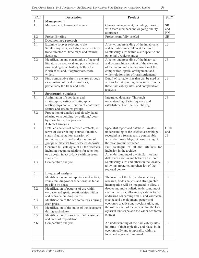
Three Rural Sites at BAE Samlesbury, Balderstone, Lancashire: Post-Excavation Assessment Report 59
For the use of BAE Systems © OA North: May 2010
PAT Description Product Staff1 Management1.1 Management, liaison and review General management, including, liaison
with team members and ongoing qualityassurance
SRandRN
1.2 Project Briefing Project team fully-briefed SR2 Documentary research2.1 Examine sources relevant to the
Samlesbury sites, including census returns,trade directories, tithe maps and awards,deeds etc
A better understanding of the inhabitantsand activities undertaken at the threeSamlesbury sites within a site specific andpotentially wider context
JB
2.2 Identification and consultation of generalliterature on medieval and post-medievalrural and agrarian history, both in theNorth West and, if appropriate, morewidely
A better understanding of the historicaland geographical context of the sites andof the nature and characterisation of thecomposition, spatial arrangement andwider relationships of rural settlements
JB
2.3 Find comparative sites in the area throughexamination of local repositories,particularly the HER and LRO
Detail of suitable sites that can be used asa basis for interpreting the results from thethree Samlesbury sites, and comparativeanalysis
JB
3 Stratigraphic analysis3.1 Assimilation of spot dates and
stratigraphy, testing of statigraphicrelationships and attribution of contexts tofeature and structures groups
Integrated database. Thoroughunderstanding of site sequence andestablishment of final site phasing
JB
3.2 Production of detailed and closely datedphasing on a building-by-building/room-by-room basis, if appropriate
4 Artefact analysis4.1 Detailed analysis of selected artefacts, in
terms of closer dating, source, function,status, fragmentation, abrasion ofindividual sherds and understanding ofgroups of material from selected deposits
Specialist report and database. Greaterunderstanding of the artefact assemblage,recorded in a format easily comparablewith other assemblages. Closer dating ofthe stratigraphic sequence
CHDandJB
4.2 Generate full catalogue of all the artefacts,including recommendations for retentionor disposal, in accordance with museumstandards
4.3 Comparative analysis
Full catalogue of all the artefacts forinclusion in the archiveAn understanding of the similarities anddifferences within and between the threeSamlesbury sites and others in the locality,allowing greater comprehension of theregional context
JB
5 Integrated analysis5.1 Identification and interpretation of activity
zones; building/room functions; as far aspossible by phase
5.2 Identification of patterns of use withineach site and spatial relationships withinand between buildings/yards
5.3 Identification of the economic basis duringeach phase
5.4 Identification of the status of the occupantsduring each phase
5.5 Identification of associated field systemsand areas of exploitation
The results of the further documentaryresearch, finds analysis and stratigraphicinterrogation will be integrated to allow adeeper and more holistic understanding ofeach of the sites, allowing questions to beaddressed concerning small- and widescalechange and development, patterns ofeconomic practice and specialisation, andthe role of each of the sites within the localagrarian landscape and the wider economiccontext
JB
5.6 Comparative analysis An understanding of the Samlesbury sitesin terms of their typicality and place, botheconomically and temporally, within alocal and regional framework
JB
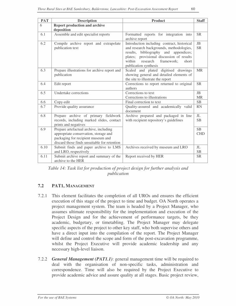
Three Rural Sites at BAE Samlesbury, Balderstone, Lancashire: Post-Excavation Assessment Report 60
For the use of BAE Systems © OA North: May 2010
PAT Description Product Staff6 Report production and archive
deposition6.1 Assemble and edit specialist reports Formatted reports for integration into
archive reportSR
6.2 Compile archive report and extrapolatepublication text
Introduction including contract, historicaland research backgrounds, methodologies,results, bibliography and appendices;plates; provisional discussion of resultswithin research framework; shortpublication synthesis
JBSR
6.3 Prepare illustrations for archive report andpublication
Scaled and plated digitised drawingsshowing general and detailed elements ofthe site to illustrate the report
MR
6.4 Edit report Corrections to report returned to originalauthors
SR
6.5 Undertake corrections Corrections to textCorrections to illustrations
JBMR
6.6 Copy-edit Final correction to text SB6.7 Provide quality assurance Quality-assured and academically valid
documentRN
6.8 Prepare archive of primary fieldworkrecords, including marked slides, contactprints and negatives
JLSB
6.9 Prepare artefactual archive, includingappropriate conservation, storage andpackaging for recipient museum anddiscard those finds unsuitable for retention
Archive prepared and packaged in linewith recipient repository’s guidelines
SBCHD
6.10 Submit finds and paper archive to LMSand LRO, respectively
Archives received by museum and LRO JLSB
6.11 Submit archive report and summary of thearchive to the HER
Report received by HER SR
Table 14: Task list for production of project design for further analysis andpublication
7.2 PAT1, MANAGEMENT
7.2.1 This element facilitates the completion of all UROs and ensures the efficientexecution of this stage of the project to time and budget. OA North operates aproject management system. The team is headed by a Project Manager, whoassumes ultimate responsibility for the implementation and execution of theProject Design and for the achievement of performance targets, be theyacademic, budgetary, or timetabling. The Project Manager may delegatespecific aspects of the project to other key staff, who both supervise others andhave a direct input into the compilation of the report. The Project Managerwill define and control the scope and form of the post-excavation programme,whilst the Project Executive will provide academic leadership and anynecessary high-level liaison.
7.2.2 General Management (PAT1.1): general management time will be required todeal with the organisation of non-specific tasks, administration andcorrespondence. Time will also be required by the Project Executive toprovide academic advice and assure quality at all stages. Basic project review,
Three Rural Sites at BAE Samlesbury, Balderstone, Lancashire: Post-Excavation Assessment Report 61
For the use of BAE Systems © OA North: May 2010
including the tracking of task completion and logging of resource expenditure,will be undertaken internally on a weekly basis.
7.2.3 Project Briefing (PAT1.2): it will be necessary to brief each member of theproject team concerning the aims and objectives of the project, expectedoutcomes, and their specific roles, responsibilities, products and timetable.Where possible, the briefing will be undertaken collectively. Following thecompletion of each task sub-division, the responsible staff member will informthe project manager, preferably through a brief email, with details of the workthat was undertaken, the time taken, and any positive or negative issues arisingthat may affect further works. Should any issues arise during the undertakingof a task, the responsible staff member will inform the project manager bywhatever convenient method guarantees that the information is transmitted andreceived.
7.2.4 Communication between all concerned in the post-excavation programme is ofparamount importance, and it is essential that all team members working ondifferent aspects of the project liaise closely in order that comparable data areobtained. To this end, regular meetings and reviews are envisaged between allproject staff and between particular groups of specialists.
7.3 PAT2, DOCUMENTARY RESEARCH
7.3.1 Further research is required to help contextualise and better understand thearchaeological remains in terms both of the individual sites, of theirinhabitants, and of their place within the wider landscape. To facilitate thecomparative and formal analysis of the physical remains recorded at the threeSamlesbury sites, it will be necessary to identify and draw together relevantsources that have the potential to provide the most informative comparanda.Specifically, further research is the crux of UROa, UROb and UROf, but willalso assist in the completion of UROd and UROg.
7.3.2 Documentary research (PAT2.1-3): as many repositories as possible will beconsulted for relevant documentation, including the HER, LRO and variouslocal and university libraries. This will comprise the examination and collationof all relevant primary documents pertaining to the Samlesbury sites, includinghistorical maps and any associated awards, censuses, trade directories, anddeeds, as well as trade, legal and any other such documents that might provideinformation about the lives, economic practices, holdings and tenurialrelationships of the inhabitants of these sites. General texts, including earlyworks on farm management and design, will be consulted also. A lot ofvaluable work on existing buildings contemporary with those that once stoodat Samlesbury has been undertaken by members of vernacular buildingsrecording groups; links with such groups will be forged, and liaisonmaintained to gain access to any relevant results. Extensive use will be madeof archaeological investigation reports, particularly those generated by OANorth over the course of numerous excavations and non-intrusiveinvestigations of such sites (including detailed desk-based research andhistoric building investigations).
Three Rural Sites at BAE Samlesbury, Balderstone, Lancashire: Post-Excavation Assessment Report 62
For the use of BAE Systems © OA North: May 2010
7.4 PAT3, STRATIGRAPHIC ANALYSIS
7.4.1 Basic collation of the stratigraphy has been undertaken as part of theproduction of the post-excavation assessment; however, to understand thatdata as fully as possible, to contextualise all other analyses, and in order tofacilitate the comparative and formal analysis of the datasets from theSamlesbury sites with other similar sites, a programme of further investigationof the recorded stratigraphy will be undertaken. This will ultimately contributeto UROh, but will specifically address UROd-g.
7.4.2 Analysis of three-dimensional stratigraphic sequence (PAT3.1 and 3.2): tohelp understand more fully the recorded stratigraphy, and break it down intocoherent analytical units (ie, feature and structure groups), it will be necessaryto review further the results of the fieldwork in some detail. Utilising theintegrated finds data (Section 7.4), this will examine specific groups of recordsin order to test/construct key relationships, enhance the existing matrices, andrefine and assign the final chronological phases. The process may require theallocation of new context numbers and the modification of the site database.Overall, it will use the available data to enable the formulation of anappropriate explanatory text, describing the chronological development of thecomponents of each site and the manner in which they relate to each otherduring each identifiable phase.
7.5 PAT4, ARTEFACT ANALYSIS
7.5.1 The present assessment has indicated the potential of the artefact assemblage,albeit to varying degrees, to enhance an understanding of each site. Analysisof this assemblage will assist in a range of post-excavation tasks, but mostspecifically will help to date more closely the stratigraphic sequence, provideclues concerning the status of the inhabitants and, in the case of the locally-produced pottery fabrics, will enable a greater understanding of theirproduction, date and distribution (UROc-g).
7.5.2 Detailed analysis of selected material (PAT4.1): the stratified pottery, claypipe, glass and metalwork assemblages, together with any appropriateunstratified sherds/fragments that can be attributed to a specific site, will beidentified using any necessary reference material and recorded fully, includingdetails of form, fabric, fragmentation, abrasion, and numbers ofvessels/objects. The results will be recorded within a database linked into thesite context database, and any appropriate and statistically valid analysis willbe undertaken and discussed in terms of dating, source, form, function, status,and spatial and temporal distribution. Significant objects will be illustrated,either by conventional measured drawing, or in the case of any completemodern objects, by photograph.
7.5.3 Generate catalogue (PAT3.2): the database formulated during PAT3.1 will beused to catalogue finds from each of the remaining categories (ie, theundiagnostic metalwork, industrial residues, leather, wood, plastic, Section5.4-7, and any unattributed unstratified matieral).
Three Rural Sites at BAE Samlesbury, Balderstone, Lancashire: Post-Excavation Assessment Report 63
For the use of BAE Systems © OA North: May 2010
7.5.4 Comparative analysis (PAT3.3): comparative analysis of the fully recordedassemblages from each site will be undertaken using a spreadsheet programmeto establish variations in general trends in date, status, etc between each of thethree Samlesbury sites. Such trends will then be compared with assemblagesrecorded from suitable rural sites identified during further research (Section7.3).
7.6 PAT 5, INTEGRATED ANALYSIS
7.6.1 The integrated analysis is the most important aspect of Project Stage 3. It willpull together each of the threads of research and processed data to form acoherent whole that will allow each of the sites to be understood on anindividual basis, but more significantly, to be placed within a wider historical,economic and geographical context. PAT5 will contribute to virtually all ofthe URO, but is particularly relevant to UROf-h.
7.6.2 Integrated analysis (PAT 5.1-5): the results of the documentary research,artefact analysis and stratigraphic interrogation will be integrated to allow adeeper and more holistic understanding of each of the sites, allowing questionsto be addressed concerning small- and widescale change and development,patterns of economic practice and specialisation, and the role of each of thesites within the local agrarian landscape and the wider economic context. Thiswill be achieved by establishing, as far as possible, the functional use of spaceand its mutual relationships, both within each site and within their landscapeand field systems, their economic practice, and the degree of specialisation anddiversification. Such analysis will attempt to correlate these findings with theevidence for occupant status and the role of each site within the widereconomic system.
7.6.3 Comparative analysis (PAT5.6): the processed data generated during theanalysis of the Samlesbury sites will be compared with that from identifiedpost-medieval rural sites. This will consider themes such as organisation andspatial arrangement (ie, ground plans, material components, surviving internaldetails and the juxtaposition of individual buildings and groups of structures),chronology of change and development, aspects of status, degree ofspecialisation or diversity in economic practices, and the manner in which theyare manifested. Where data are available, this will also consider relationshipswith the immediate landscape and wider economic system.
7.7 PAT6, REPORT PRODUCTION AND ARCHIVE DEPOSITION
7.7.1 One of the primary aims of the project (URQ10, fulfilled through UROh andUROi) is to make the results of the investigation available to the wider public,thus fulfilling the planning condition. This will be achieved through thecompilation and submission of an archive report and the deposition of the sitearchive with the LMS and the LRO. The deposition of a properly ordered andindexed project archive in an appropriate repository is considered an essentialand integral element of all archaeological projects by the IfA in thatorganisation's code of conduct (IFA 2001). The collated results of each stage
Three Rural Sites at BAE Samlesbury, Balderstone, Lancashire: Post-Excavation Assessment Report 64
For the use of BAE Systems © OA North: May 2010
of the project will form the basis of a full archive compiled to professionalstandards in accordance with EH and other guidelines (EH 1991; EH 2006a;Walker 1990). An OASIS form has been filed and, in the cases of the materialand documentary archives, the ultimate places of deposition are respectivelythe Museum of Lancashire, and the LRO, both in Preston. The archive reportwill comprise the collation of the detailed data deriving from each stage ofanalysis and will include a synthesised conclusion. It will be an excellentreference to any future researchers seeking a detailed account of the worksundertaken at the Samlesbury sites and the results achieved. Although thearchive report itself will not be suitable for publication, it would, at thecompletion of the project, form the basis for a text to be published in a journalarticle or within a synthetic volume. Such a publication would synthesise theresults of the completed project, and would aim to present a high degree ofintegration between the multi-thematic analyses and the wider economic andsocial history of the region.
7.7.2 Assemble and edit specialist reports (PAT6.1): each specialist report will beedited for consistency with the stratigraphic sequence, and in terms of styleand content. Liaison will be maintained with the specialists, who will receiveedited drafts for final comment. In this form, the specialist reports will beready for incorporation into the full archive report.
7.7.3 Compile full archive report (PAT6.2): the full archive report will present:
• an introduction, detailing the contract background, site location, historicaland research context, as well as the updated aims and objectives presentedin this document;
• a section presenting the methodologies employed on site, as well as those ofthe specialist analyses;
• a summary of the detailed documentary research undertaken and thesources examined;
• a stratigraphic narrative arranged by phase and site component;
• individual sections presenting details of specialist analyses;
• a synthetic discussion of the results of the investigation as a whole, and anappraisal of the extent to which the URQ and URO could be, and were,addressed by the project;
• a bibliography;
• appendices of raw data, together with key documents (the OA North projectdesigns for the fieldwork and for the programme of post-excavationanalysis);
• selected illustrative figures and plates.
7.7.4 Prepare illustrations (PAT6.3): suitable illustrations for the archive report willbe devised, and prepared in CAD or a similar computer package, at anappropriate scale, with additional digitisation of fine detail as required.Selected artefacts will be illustrated by hand, scanned-in, and enhanceddigitally using Adobe Illustrator or a similar such package.
Three Rural Sites at BAE Samlesbury, Balderstone, Lancashire: Post-Excavation Assessment Report 65
For the use of BAE Systems © OA North: May 2010
7.7.5 Editing and Quality Assurance (PAT6.4): the report text and illustrations willbe edited and QA’d by the project manager and project executive,respectively, with corrections returned to the original authors.
7.7.6 Preparation of primary archive (PAT6.5-6): the complete project archivegenerated during the fieldwork and post-excavation stages, which will includerecords, plans, both monochrome print and colour slide photographs, artefacts,and digital data, will be prepared following the guidelines set out inEnvironmental standards for the permanent storage of excavated materialfrom archaeological sites (UKIC 1990, Conservation Guidelines 3) andGuidelines for the preparation of excavation archive for long-term storage(Walker 1990). All photographic media, including slides, contact prints andnegatives, will be marked for identification, and digital photographs will bestored on CD. Paper records, including context sheets, field notes and thevarious indices, will be ordered and filed, as will original drawings andsections. The archive will also include printed documents and CDs containingASCii and other digital files (as appropriate). These records will be stored instandard acid-free cardboard archive boxes.
7.7.7 Conservation and storage: documents and finds will continue to be wellpacked according to the LRO’s and the LMS specifications, ensuring as far aspossible that they remain in a stable condition. For the majority of finds thiscomprises acid-free cardboard boxes, or, for otherwise unstable material,airtight plastic boxes. Metalwork constitutes the only category which ispotentially unstable and, although any such items to be retained will bepackaged in airtight plastic boxes, they will need to be stored in controlledconditions once deposited. Box lists are prepared and will be updated from thedatabase once the full cataloguing of the archive is complete.
7.7.8 Discard policy: in accordance with the LMS’s policy for finds’ retention, it islikely that all unstratified nineteenth- and twentieth-century pottery, glass,ceramic building material and undiagnostic metalwork will be discardedfollowing cataloguing and the completion of the project for publication. Thesame is likely to be true of the zooarchaeological and palaeoenvironmentalassemblages.
7.7.9 Submission of archive (PAT6.7-8): the Museum of Lancashire, and the LRO,both in Preston, will be the ultimate places of deposition for the paper, digitaland material archive, as these are the nearest repositories that meet theMuseums’ and Galleries’ Commission criteria for the long-term storage ofarchaeological material (MGC 1992):
Museum of LancashireStanley StreetPrestonPR1 4YP01772 534075
Lancashire Record OfficeBow LanePrestonPR1 2RE01772 533039
Three Rural Sites at BAE Samlesbury, Balderstone, Lancashire: Post-Excavation Assessment Report 66
For the use of BAE Systems © OA North: May 2010
A copy of all reports on the archaeological work undertaken at the site,together with the archive report and an index to the archive, will be depositedwith the Lancashire HER.
7.7.10 Preparation of text for publication: the assessment has indicated that,following the completion of the project, the results of the BAE Samlesburyproject would be worthy of publication. The publication text would be edited,quality-assured and supported by a number of illustrations, comprisingdrawings and photographs, tables to summarise data and, where appropriate,interpretative phase drawings. Rather than being published in a typical ‘sitereport’ format, it is envisaged that a text presenting the results of the fullanalysis of the data associated with the Samlesbury sites will form part of amonograph on the archaeology of rural Lancashire, within the LancasterImprint series produced by OA North. As such, these results are likely to beintegrated with those from contemporary rural sites in an exploration ofthemes such as seventeenth-century rural occupation, eighteenth-centurylandscape development and nineteenth-century economic evolution.
7.7.11 Alternative publication structure: if for any reason it is not possible to publishthe results within the rural Lancashire monograph, every attempt will be madeto publish the results within an appropriate journal; the following sectionrepresents a likely breakdown of such a publication. It should be noted,however, that this synopsis of the proposed publication can only be regardedas provisional, based on the current understanding of the archive. Such apublication is likely to include details of the following elements:
1. Introduction (500 words)
1.1 Site location
1.2 Circumstances of project
2. Background (1500 words)
2.1 Geographical and brief historical background
2.2 Summary history of the development of dispersed settlement in theNorth West
2.3 Documentary evidence for the three Samlesbury sites
3. The Archaeological Investigation (2000 words)
3.1 Phased description and interpretation of the principal structures andfeatures encountered during the archaeological investigations at eachsite
4. Finds’ Overview (1000 words)
4.1 Results of the typological and comparative analysis of the ceramics anda brief note on the other artefactual groups
5. Discussion (2000 words)
5.1 Chronological, economic and social discussion
Three Rural Sites at BAE Samlesbury, Balderstone, Lancashire: Post-Excavation Assessment Report 67
For the use of BAE Systems © OA North: May 2010
5.2 Thematic context and wider examples
Bibliography
Acknowledgements
Illustrations
7.8 PROJECT TEAM
7.8.1 The provisional project team to undertake the programme of post-excavationworks is detailed in Table 15.
Team member Responsibility Principal role and relevant experience
Rachel Newman(RN), BA (Hons),FSA
ProjectExecutive
OA North Senior Executive Officer: Research and Publications,responsible for quality assurance and academic leadership.Rachel has directed and managed numerous excavation andpost-excavation projects on sites in the north-west of England.Rachel is series editor for the Lancaster Imprints, and was aperiod group co-ordinator for the North West ArchaeologicalResearch Framework.
Stephen Rowland(SR), BSc(Hons), MSc
Project Manager Project organisation and budget management; liaison;preparation of management documents and editing of reports.Stephen has been a project manager for four years, and hasbeen involved with a number of excavation and post-excavationprojects.
Chris Howard-Davis (CHD), BA(Hons)
Finds Manager -Expert
Assessment and analysis of finds, conservation advice; detailedacademic input. Chris has worked and written extensively onnumerous post-medieval finds assemblages in the North West.
Jeremy Bradley(JB), BA (Hons)
Project Officer -Expert
Collation of the archives, interpretation of the results andcompilation of report text; assessment and analysis of medievalpottery. Jeremy is a highly experienced field archaeologist, andhas worked on a number of post-medieval excavations withinrural contexts in the North west. He has a particular specialismin medieval pottery.
Marie Rowland(MR), BA(Hons), AlixSperr (AS), BA,MA)
Illustrators -Team members
Presentation of site drawings and artefact illustration for reportsand publication. Marie and Alix are extremely experienced inartefact illustration and the use of computer packages for thepresentation of site drawings for reports and publications.
Joanne Levey(JL)
Archive Co-ordinator
Joanne is OA North’s archivist and will supervise thecompilation, organisation and submission of the projectarchive.
Sandra Bonsall(SB), BSc (Hons)
Finds co-ordination
Sandra will co-ordinate the submission of the finds archive andsupervise the undertaking of the discard policy.
Project Assistant(Ass)
Support tasks Project Assistants will undertake support tasks, including fillingin database records, marking photographs, bagging material,etc.
Table 15: Summary of the project team
7.9 HEALTH AND SAFETY
7.9.1 All OA North post-excavation work will be carried out under relevant Healthand Safety Legislation, including the Health and Safety at Work Act (1974). A
Three Rural Sites at BAE Samlesbury, Balderstone, Lancashire: Post-Excavation Assessment Report 68
For the use of BAE Systems © OA North: May 2010
copy of the Oxford Archaeology Health and Safety Policy can be supplied onrequest. The nature of the work means that the requirements of the followinglegislation are particularly relevant:
Workplace (Health, Safety and Welfare) Regulations (1992) – offices and findsprocessing areas;
Manual Handling Operations Regulations (1992) – transport of bulk finds andsamples;
Health and Safety (Display Screen Equipment) Regulations (1992) – use ofcomputers for word-processing and database work;
COSSH (1998)- finds conservation and environmental processing/analysis.
Three Rural Sites at BAE Samlesbury, Balderstone, Lancashire: Post-Excavation Assessment Report 69
For the use of BAE Systems © OA North: May 2010
8 BIBLIOGRAPHY
8.1 CARTOGRAPHIC SOURCES
Greenwood, CG, 1818 Map of Lancashire
Hennet, G, 1829 Map of Lancashire
Highways Ministry c 1925 Proposed Redirection of Myerscough Smithy Road atOsbaldstone
Ordnance Survey, 1849, 1:10, 560 County Series
Ordnance Survey, 1893, 1: 2500, Sheet 061-03, Lancashire and Furness
Ordnance Survey, 1913, 1:2500, County Series
Ordnance Survey, 1939, 1:2500, County Series
Samlesbury Tithe Apportionment and Map, 1849, LRO PR 288/25
Speed, J, 1610 Map of the County Palatine of Lancashire
Yates, W, 1786 Map of Lancashire
8.2 SECONDARY SOURCES
Backhouse, J, 2000 Medieval Life in the Luttrell Psalter, London
Barnwell, PS, and Giles, C, 1997 English Farmsteads: 1750-1914, RCHME, Swindon
Brennand, M (ed), 2006 An archaeological research framework for north-westEngland: volume 1, resource assessment, Archaeol North West, 8, Manchester
Brennand, M, (ed) 2007 An archaeological research framework for north-westEngland: volume 2, research agenda and strategy, Archaeol North West, 9,Manchester
Brunskill, RW, 1987 Traditional Farm Buildings of Britain, London
Brunskill, RW, 1992 Traditional Buildings of Britain, London
Buxton, K, and Howard-Davis, CLE, 2000 Bremetenacum: Excavations at RomanRibchester, 1980, 1989–90, Lancaster Imprints, 9, Lancaster
Cotter, JP, 2000 Post-Roman pottery from excavations in Colchester, 1971-85,Colchester Archaeolog Rep, 7, Colchester
Countryside Commission, 1998 Countryside Character; the Character of England’sNatural and Manmade Landscape, vol 2: the North West, Cheltenham
Cowell, RW, 1996 The Upper Palaeolithic and Mesolithic, in R Newman (ed), TheArchaeology of Lancashire: Present State and future priorities, Lancaster, 19–34
Cowell, RW, 2005 Late prehistoric lowland settlement in North-West England, in MNevell and N Redhead (eds), Mellor: Living on the Edge, Manchester, 65–76
Crosby, AG, 2000 Penwortham in the past, Preston
Three Rural Sites at BAE Samlesbury, Balderstone, Lancashire: Post-Excavation Assessment Report 70
For the use of BAE Systems © OA North: May 2010
Department of the Environment (DoE), 1990 Planning Policy Guidance Note 16,London
Earthworks Archaeological Services, 2001 Proposed Development on Land at RomanWay Employment Area, unpubl rep
Ede, J, and Darlington, J, 2002 Lancashire Historic Landscape CharacterisationProgramme, a Report on the Context Method and Results, Preston
Ekwall, E, 1922 The Place-Names of Lancashire, Chetham Soc, n ser 87, Manchester
English Heritage (EH), 1991 Management of Archaeological Projects, 2nd edn,London
EH, 1997 Draft Research Agenda, unpubl doc
EH, 2001 Guidelines for Environmental Archaeology, 2nd edn, London
EH, 2003 Exploring Our Past Implementation Plan, http://www.english-heritage.org.uk/upload/pdf/plan_eop_98.pdf
EH, 2006a Management of Research Projects in the Historic Environment (MoRPHE),London
EH, 2006b Historic Farmsteads. Preliminary Character Statement: North WestRegion, Gloucester
Faull, ML, and Stinson, M, 1986 Yorkshire, in J Morris (ed), Domesday Book, 30,Chichester
Farrer, W and Brownbill, J (eds), 1911 The Victoria History of the County ofLancaster: 6, www.british-history.ac.uk/ London
Farrer, W, and Brownbill, J, 1912 The Victoria History of the County of Lancaster, 7,London
Field, J, 1972 Field Names, Newton Abbot
Fishwick, H, 1900 The History of the Parish of Preston; in Amounderness in theCounty of Lancaster, London
Hall, AR, and Huntley, JP, 2007 A Review of the Evidence for Macrofossil PlantRemains from Archaeological Deposits in Northern England, Res Dept Rep Ser,87/2007, unpubl rep
Harvey, N, 1984 The History of Farm Buildings in England and Wales, NewtonAbbot
Haselgrove, C, 1996 The Iron Age, in R Newman (ed) The Archaeology ofLancashire: Present State and future priorities, Lancaster, 61–73
Health and Safety Executive, 1998 Control of Substances Hazardous to HealthRegulations, www.hse.gov.uk/coshh/
Health and Safety Executive, 1992 Workplace (Health, Safety and Welfare)Regulations, www.hse.gov.uk/pubns/indg244.pdf
Health and Safety Executive, 1992 Health and Safety (Display Screen Equipment)Regulations, www.hse.gov.uk/pubns/indg36.pdf
Higham, NJ, 2004 A Frontier Landscape, Macclesfield
Three Rural Sites at BAE Samlesbury, Balderstone, Lancashire: Post-Excavation Assessment Report 71
For the use of BAE Systems © OA North: May 2010
Hodgson, J, and Brennand, M, 2006 The prehistoric period resource assessment, inBrennand (2006), 23–58
Howard-Davis, CLE, and Buxton, K, 2000 Roman forts in the Fylde: Excavations atDowbridge, Kirkham 1994, Lancaster
Hunt, D, 2003 Preston: Centuries of Change, Derby
Institute of Field Archaeologists, 2001 Standard and Guidance for the Collection,Documentation, Conservation and Research of Archaeological Materials,www.archaeologists.net/modules/icontent/inPages/docs/codes/finds%20standard%202001.pdf
Institute of Place Studies, www.nottingham.ac.uk, accessed 2009
Jones, W, 1996 Dictionary of Industrial Archaeology, Stroud
Lancashire County Council (LCC) 2005 Blackburn: Historic Town AssessmentReport, Preston
LCC, 2006a Lancashire Historic Town Survey Programme: Preston with Walton-le-Dale and Penwortham, Historic Town Assessment Report, Preston
LCC, 2006b Joint Lancashire Structure Plan: Landscape and Heritage, AdoptedSPG, Preston
Lancaster University Archaeology Unit (LUAU), 1995 Red Scar, Preston,Lancashire, Archaeological Evaluation, unpubl rep
Lawes Agricultural Trust, 1983 Soils of Northern England, 1:250, 000, London
Margary, ID, 1973 Roman Roads in Britain, London
mario.lancashire.gov.uk (Maps And Related Information On-line); Historic LandscapeCharacter Map, accessed 2008-2009
McNeil, R, and Newman, R, 2006a The post-medieval period resource assessment, inBrennand (2006), 145-64
McNeil, R, and Newman, R, 2006b The industrial period resource assessment, inBrennand (2006), 165-94
Middleton, R, 1996 The Neolithic and Bronze Age, in R Newman (ed), TheArchaeology of Lancashire: Present State and future priorities, Lancaster, 35–60
Museums and Galleries Commissions, 1992 Standards in the Museum Care ofArchaeological Collections, London
Newman, R, 1996 Medieval Rural Settlement, in R Newman (ed), The Archaeology ofLancashire: Present State and future priorities, Lancaster, 109-24
Newman, R, 2005 Farmers and Fields: Developing a Research Agenda for Post-medieval Agrarian Society and Landscape, Post-Medieval Archaeol, 39/2, 205-14
Newman, R and McNeil, R, 2007a The post-medieval period research agenda, inBrennand (2007), 115-32
Newman, R and McNeil, R, 2007b The industrial period research agenda, inBrennand (2007), 133-58
Newman, RM, 1996 The Dark Ages, in R Newman (ed), The Archaeology ofLancashire: Present State and future priorities, Lancaster, 93-108
Three Rural Sites at BAE Samlesbury, Balderstone, Lancashire: Post-Excavation Assessment Report 72
For the use of BAE Systems © OA North: May 2010
Newman, RM, 2006 The early medieval resource assessment, in Brennand (2006),91–114
Northern Archaeological Associates, 2004 Samlesbury to Helmshore Natural GasPipeline: Post-Excavation Assessment, unpubl rep
Oxford Archaeology North (OA North), 2005 Kingsway, Rochdale, GreaterManchester: Archaeological Post-Excavation Assessment, unpubl rep
OA North, 2006a Everton Academy Training Ground, Finch Farm, Halewood,Merseyside: Archaeological Post-Excavation Assessment, unpubl rep
OA North, 2006b Townside Farm, Pilling: Archaeological Building Investigation,unpubl rep
OA North, 2007 Cutacre Surface Mine and Reclamation Facility, Salford, GreaterManchester Post-excavation Assessment, unpubl rep
OA North, 2008a Chorlton Fold, Eccles, Greater Manchester: Archaeological Post-Excavation Assessment, unpubl rep
OA North, 2008b Braides Farm: Archaeological Building Investigation, unpubl rep
OA North, forthcoming a Rough Hey Farm, Haighton, Preston: Archaeological Post-Excavation Assessment
OA North, forthcoming b Cutacre, Great Manchester: Archaeological Post-Excavation Assessment
Oxford Archaeology Unit, 2000 Environmental sampling guidelines and instructionmanual, unpubl doc
Pevsner, N, 2002 The Buildings of England: North Lancashire, New Haven andLondon
Philpott, R, 2006 The Romano-British period resource assessment, in Brennand(2006), 59–90
Rackham, O, 1986 The History of the Countryside, London
Roberts, BK, and Wrathmell, S, 2002 Region and Place. A Study of English RuralSettlement, London
Royal Commission for Historical Monuments England (RCHME), 1985 Rural Housesof the Lancashire Pennines 1560-1760, London
RSK Environment Ltd, 2007 BAE Samlesbury Archaeological Appraisal, Helsby
Standing Conference of Archaeological Unit Managers (SCAUM), 1997 Health andSafety Manual, Poole
Society for Post-Medieval Archaeology (SPMA), 1988 Research Priorities for Post-Medieval Archaeology, York
Stace, C, 2001 New Flora of the British Isles, Cambridge
Timmins, JG, 1977 Handloom Weavers Cottages in Central Lancashire, Lancaster
Tyler, K, 2008 The Doulton stoneware pothouse in Lambeth. Excavations at 9 AlbertEmbankment, London, MoLAS Archaeol Serv Archaeol Stud Ser, 15, London
United Kingdom Institute for Conservation (UKIC), 1990 Environmental Standardsfor the permanent storage of excavated material from archaeological sites, London
Three Rural Sites at BAE Samlesbury, Balderstone, Lancashire: Post-Excavation Assessment Report 73
For the use of BAE Systems © OA North: May 2010
UKIC, 1998 First Aid for Finds, London
Wade-Martins, S, 1991 Historic Farm Buildings, London
Walker, K, 1990 Guidelines for the Preparation of Archives for Long-Term Storage,London
Welsh, TC, 1991 Pers com, regarding possible defensive ditch on promontory, ClockHouse Farm, PRN19133
Welsh, TC, 1992 Fulwood Lane and Longsands Lane area, unpubl typescript withsketch plan
White, AJ, 1977 Silverdale, in PJ Davey, Medieval Pottery from Excavations in theNorth West, Liverpool, 102-3
White, A, 1996 Medieval Towns in R Newman (ed), 125-38
Wood, N, Bradley, J, and Miller, I, 2008 A Pottery Production Site at Samlesbury,near Preston, Lancashire, Medieval Ceramics, 30, 21-48
Three Rural Sites at BAE Samlesbury, Balderstone, Lancashire: Post-Excavation Assessment Report 74
For the use of BAE Systems © OA North: May 2010
APPENDIX 1: PROJECT DESIGN
BAESAMLESBURY,BALDERSTONE,
LANCASHIRE
ARCHAEOLOGICAL STRIP,MAP AND RECORD:
PROJECT DESIGN
Oxford Archaeology North
October 2007
BAE Systems
Planning Application:Grid Reference: SD 626 314OA North Reference: t3156
Three Rural Sites at BAE Samlesbury, Balderstone, Lancashire: Post-Excavation Assessment Report 75
For the use of BAE Systems © OA North: May 2010
1. INTRODUCTION
1.1 PROJECT BACKGROUND
1.1.1 BAE Systems has requested that Oxford Archaeology North (OA North), in accordance with averbal communication from Lancashire County Archaeology Section (LCAS), submit a designfor a programme of archaeological investigation and recording to be undertaken in advance ofa largescale development at BAE Samlesbury, Lancashire (SD 626 314). The developmentarea comprises brownfield land on the former RAF Samlesbury Aerodrome. Following theresults of previous desk-based assessment of the site (RSK 2007) LCAS stipulated that aprogramme of mitigation and further investigation should be undertaken at the site, the firststage of which should comprise an archaeological strip, map and record undertaken prior toany ground disturbing works within three parts of the site, together with an appropriateprogramme of post-excavation assessment and, if necessary, analysis and publication. Thesethree locations relate to the sites of three historic farms, namely Pepper Hill Farm (0.5425 ha)at the northern end of the proposed development area, Lane Side Farm to the east, and CollegeFarm (0.8393 ha) to the south. The following document outlines the fieldwork and post-excavation methodology for this specific phase of investigative works; any further works onsite would be covered by a separate project design.
1.2 ARCHAEOLOGICAL AND HISTORICAL BACKGROUND
1.2.1 The desk-based assessment (RSK 2007) identified that the area surrounding the proposeddevelopment contains a number of archaeological sites and findspots indicative of localactivity dating to the prehistoric, Roman, early medieval, medieval and post-medieval periods.In addition, a number of sites of cultural heritage interest were identified within thedevelopment area itself. The earliest are a series of farmsteads recorded on early cartographicsources and potentially dating from the early post-medieval period, like the nearby (butoutside the development area) extant seventeenth-century buildings at Old College, IntackCottage, Lower Intack farm, Goose Green and Sykes Holt, which survive in varying states ofoccupation and dereliction. These include Pepper Hill, College Croft and Laneside, which,together with the adjoining road and surrounding field systems, were removed to make wayfor the construction of Samlesbury Aerodrome. Although initially conceived in 1922 as amunicipal airfield for Blackburn and Preston, building of the aerodrome did not commenceuntil 1939 after the site had been requisitioned by the Air Ministry for the manufacture ofbomber planes. The site was expanded in 1940 with the addition of a second factory and theextension of the existing runway, and by the end of hostilities there were five hangars,approximately 20 other ancillary structures and three runways. The site continued as amanufactory into the jet age, with further structures added to the complex throughout itsusage.
1.3 OXFORD ARCHAEOLOGY NORTH
1.3.1 Oxford Archaeology North has considerable experience of sites of all periods, havingundertaken a great number of small and large scale projects throughout Northern Englandduring the past 25 years. Evaluations, assessments, watching briefs and excavations havetaken place within the planning process, to fulfil the requirements of clients and planningauthorities, to very rigorous timetables.
1.3.2 OA North has the professional expertise and resources to undertake the project detailed belowto a high level of quality and efficiency. OA North is an Institute of Field Archaeologists(IFA) registered organisation, registration number 17, and all its members of staff operatesubject to the IFA Code of Conduct.
Three Rural Sites at BAE Samlesbury, Balderstone, Lancashire: Post-Excavation Assessment Report 76
For the use of BAE Systems © OA North: May 2010
2. AIMS AND OBJECTIVES OF THE EXCAVATION
2.1 ACADEMIC AIMS
2.1.1 The main research aim of the archaeological investigation will be to identify the presence andexpose the extent of any archaeological remains within the specified areas. In particular, theworks will seek evidence of the farms known to have stood on the site prior to their demolitionin advance of construction of the aerodrome, together with any associated structures, surfacesand ancillary features, such as rubbish pits, wells, ponds and enclosure boundaries. Once theremains have been exposed and quantified, the aim of the fieldwork will be to identify, classifyand date these features, in order to produce an understanding of the historic development of thesite.
2.2 OBJECTIVES
2.2.1 The objectives of the project may be summarised as follows:
• to mechanically strip the selected areas of topsoil, modern overburden and disturbedploughsoil in order to expose and record the extent and character of any survivingarchaeological features on site;
• to generate an accurate plan of any features and to establish their intended function;
• to collect a well-stratified finds assemblage that would enable accurate dating of thefeatures and which would provide clues regarding the nature of activity undertaken onsite, the status of the inhabitants and also to create a dated site narrative, illustrating,where appropriate, phases of construction and occupation.
3 METHOD STATEMENT
3.1 The following work programme is submitted in line with the aims and objectives summarisedabove, and in accordance with a verbal communication with LCAS.
3.2 FIELDWORK
3.2.1 Excavation Area: within each area, it is proposed that the site be investigated via a singletrench, which will follow, as closely as possible, those areas outlined on the BAE Systemsdrawing. Following completion of the stripping works, it may prove possible to reduce the areaof archaeological investigation to match that of identified archaeological features together witha suitable margin for the determination of the presence of any adjoining field boundaries orroute-ways. The stripping of the entire area of topsoil and subsoil will make it possible todetermine the exact locations of the buildings and of associated features and then focus onthem for any detailed recording.
3.2.2 Methodology: excavation of the uppermost levels of modern topsoil and subsoil will beundertaken by a suitably large machine (at least 13 tons), fitted with a toothless ditchingbucket, to the top of the first significant archaeological level. The work will be supervised by asuitably experienced archaeologist. Spoil from the excavation will be stored at a safe distancefrom the trench and, if required, will be backfilled upon completion of the archaeologicalworks. Where practicable to do so, and in consultation with BAE Systems and their contractor,it may be more efficient to utilise one or more dumpers rather than have the machine doublehandle the spoil. Any requirement from BAE Systems for the taking-up and stock-piling of turfwould need to be arranged as an agreed variation, as an appropriate external contractor wouldneed to be commissioned to undertake such work. Plastic sheeting can be laid beneath the spoilheap at BAE Systems’ request, but OA North cannot be responsible of any deterioration of theturf in such circumstances. Following removal of the upper soil horizons, machine excavationwill then be used to define carefully the extent of any surviving walls, foundations, and otherremains.
Three Rural Sites at BAE Samlesbury, Balderstone, Lancashire: Post-Excavation Assessment Report 77
For the use of BAE Systems © OA North: May 2010
3.2.3 Site Meeting: following this initial stripping of the excavation trench down to the uppermostarchaeological horizon, a site meeting, involving LCAS, OA North and BAE Systems, shouldbe held to discuss the scope, programme and budget for recording of the revealedarchaeological remains. The purpose of this meeting is to demonstrate the state of preservationand extent of archaeological features within the excavation trench and to confirm that theappropriate site limits have been reached. Dependent upon the nature of these initial results, itis likely that LCAS would want to give advice on any modifications to the programme ofrecording presented in this project design. Any variation to the methodology presented in thisproject design, however, will not be undertaken without the agreement of LCAS and BAESystems.
3.2.4 Thereafter, structural remains and any other features will be cleaned manually to define theirextent, nature, form and, where possible, date, although a machine would also be used to liftany heavy blocks or to excavate large negative features (such as cellars or any deep ponds, forexample). If there is a requirement for the excavation to proceed below a depth of 1.2m, trenchand sondage sides will be stepped or battered back to a safe angle of repose.
3.2.5 Recording Strategy: all information identified in the course of the site works will be recordedstratigraphicly, using a system adapted from that used by the Centre for Archaeology Serviceof English Heritage. Results of the excavation will be recorded on pro-forma context sheets,and will be accompanied with sufficient pictorial record (plans, sections and both black andwhite and colour photographs) to identify and illustrate individual features. Primary recordswill be available for inspection at all times.
3.2.6 A full and detailed photographic record of individual contexts will be maintained and similarlygeneral views from standard view points of the overall site at all stages of the excavation willbe generated. Photography will be undertaken using 35mm cameras on archivable black andwhite print film as well as colour transparency, and all frames will include a visible, graduatedmetric scale. Extensive use of digital photography will also be undertaken throughout thecourse of the fieldwork for presentation purposes. Photographic records will be maintained onspecial pro-forma sheets.
3.2.7 The precise location of the trench, and the position of all archaeological structures and featuresencountered, will be surveyed by EDM tacheometry using a total station linked to a pencomputer data logger, or by using a Leica GPS. This process will generate scaled plans withinAutoCAD 2004, which will then be subject to manual survey enhancement. The drawings willbe generated at an accuracy appropriate for 1:20 scale, but can be output at any scale required.Sections will be manually drafted as appropriate at a scale of 1:10. All information will be tiedin to Ordnance Datum.
3.2.8 Negative features would be investigated and characterised through half-sectioning or, if linear,or covering a large area (for examples, any ponds) by the removal of sufficient samples atstrategic points (minimum 0.5m wide to a maximum of 10%). Deposits within cellars would beremoved by machine, leaving, where safe to do so, a half section which, for health and safetyreasons, would be recorded from outside the area of the cellar. In the likely event of the cellarhaving been backfilled with loose demolition debris, all such material will be removed bymachine, with recording restricted to a series of working shots taken at a safe distance,accompanied by a collection of appropriate finds from the spoil. Once the cellar has beenrecorded, unless it can be secured with heras fencing, it is likely to be backfilled for health andsafety reasons.
3.2.9 Human remains are not expected to be present, but if they are found they will, if possible, beleft in situ covered and protected. If removal is necessary, then the relevant Home Officepermission will be sought, and the removal of such remains will be carried out with due careand sensitivity as required by the Burials Act 1857.
3.2.10 Any gold and silver artefacts recovered during the course of the excavation will be removed toa safe place and reported to the local Coroner according to the procedures relating to theTreasure Act, 1996.
Three Rural Sites at BAE Samlesbury, Balderstone, Lancashire: Post-Excavation Assessment Report 78
For the use of BAE Systems © OA North: May 2010
3.2.11 Finds policy: finds recovery and sampling programmes will be in accordance with bestpractice (following current Institute of Field Archaeologists guidelines) and subject to expertadvice in order to minimise deterioration. OA North has close contact with AncientMonuments Laboratory staff at the University of Durham and, in addition, employs in-houseartefact and palaeoecology specialists, with considerable expertise in the investigation,excavation, and finds management of sites of all periods and types, who are readily availablefor consultation.
3.2.12 Finds storage during fieldwork and any site archive preparation will follow professionalguidelines (UKIC). Emergency access to conservation facilities is maintained by OA Northwith the Department of Archaeology, the University of Durham. Samples will also be collectedfor technological, pedological and chronological analysis as appropriate.
3.2.13 Reinstatement: it is assumed that there is no requirement for reinstatement of thearchaeological trench, although the costs for making the area safe or for backfilling can beincluded within the budget for the detailed investigation and recortding of any archaeologicalfeatures at the request of BAE Systems.
3.2.14 Fencing/hoarding requirements: it is assumed that BAE Systems will advise on thearrangements/requirements for the site to be protected from public access. Should there be arequirement for OA North to supply materials and staff for the erection and dismantling ofsuch elements, these ca be itemised within the budget for detailed investigation.
3.2.15 Contingency plan: a contingency costing may also be employed for unseen delays caused byprolonged periods of bad weather, vandalism, discovery of unforeseen complex deposits and/orartefacts which require specialist removal, use of shoring to excavate important features closeto the excavation sections etc. This would be included in the Costings document and would becharged in agreement with BAE Systems.
3.3 HEALTH AND SAFETY
3.3.1 OA North provides a Health and Safety Statement for all projects and maintains a SafetyPolicy. All site procedures are in accordance with the guidance set out in the Health and SafetyManual compiled by the Standing Conference of Archaeological Unit Managers (3rd Edition,1997). OA North will liase with BAE Systems /main contractor to ensure all current andrelevant health and safety regulations are met.
3.3.2 OA North has professional indemnity to a value of £2,000,000, employer's liability cover to avalue of £10,000,000 and public liability to a value of £15,000,000. Written details ofinsurance cover can be provided if required.
3.3.3 Normal OA North working hours are between 9.00 am and 5.00 pm, Monday to Friday, thoughadjustments to hours may be made to maximise daylight working time in winter and to meettravel requirements. It is not normal practice for OA North staff to be asked to work weekendsor bank holidays and should BAE Systems require such time to be worked during the course ofa project a contract variation to cover additional costs will be necessary.
3.4 OTHER MATTERS
3.4.1 Access to the site will be arranged via BAE Systems /main contractor.
3.4.2 BAE Systems /main contractor will be responsible for the provision of a secure enclosed areafor the archaeological work to take place within.
3.4.3 Unless informed otherwise (in which case, the appropriate contingency detailed in the costingdocument will be invoked), it is assumed that BAE Systems/main contractor will provideadequate welfare facilities on site.
Three Rural Sites at BAE Samlesbury, Balderstone, Lancashire: Post-Excavation Assessment Report 79
For the use of BAE Systems © OA North: May 2010
3.4.4 BAE Systems/ the main contractor is asked to provide OA North with information relating tothe position of live services on the site. OA North will use a cable detecting tool in advance ofany machine excavation.
3.5 POST-EXCAVATION AND REPORT PRODUCTION
3.5.1 Archive: the results of the fieldwork will form the basis of a full archive to professionalstandards, in accordance with current English Heritage guidelines (The Management ofArchaeological Projects, 2nd edition, 1991) and the Guidelines for the Preparation ofExcavation Archives for Long Term Storage (UKIC 1990). The project archive represents thecollation and indexing of all the data and material gathered during the course of the project.The deposition of a properly ordered and indexed project archive in an appropriate repositoryis considered an essential and integral element of all archaeological projects by the IFA in thatorganisation's code of conduct.
3.5.2 The paper and finds (if appropriate) archive for the archaeological work undertaken at the sitewill be deposited with the nearest museum which meets Museums’ and Galleries’ Commissioncriteria for the long term storage of archaeological material (MGC 1992). This archive can beprovided in the English Heritage Centre for Archaeology format, both as a printed documentand on computer disks as ASCii files (as appropriate). The archive will be deposited with theappropriate repository within six months of the completion of the fieldwork.
3.5.3 Except for items subject to the Treasure Act, all artefacts found during the course of the projectwill be donated to the receiving museum, where they meet that museum’s retention policy.
3.5.4 A synthesis (in the form of the index to the archive and a copy of the publication report) will bedeposited with the Lancashire SMR. A copy of the index to the archive will also be availablefor deposition in the National Archaeological Record in London.
3.5.5 Post-excavation assessment: subsequent to the completion of the fieldwork, it is probable that,following LCAS recommendations, it will be necessary to conduct a programme of post-excavation assessment in order to determine the size, complexity and potential of the sitearchive for further analysis. During the programme of post-excavation assessment, theexcavation and watching brief results will be collated and an assessment of the resourceimplications of the potential further analysis would be undertaken. The stratigraphic data andthe finds assemblage would be quantified and assessed, and any environmental samplesprocessed and a brief assessment of their potential for further analysis made. The assessmentwould, where appropriate, comprise:
• Quantification of all site records, including drawings
• Assessment of the stratigraphic sequence, in terms of complexity and, where possible,provisional chronology
• A summary description of the results of the excavation, including an identification offormation processes
• An assessment of the significance of any deposits from which dating evidence has beentaken and the selection of specific samples for submission for analysis
• Processing of a selection of any environmental samples in order to establish the potentialfor preservation and further analysis of ecofacts and palaeoenvironmental materials
• A quantification and preliminary classification of the artefact assemblage and assessmentof the potential of the assemblage for further analysis in terms of function, origin anddating.
3.5.6 Post-excavation assessment report: the assessment results would be presented within a post-excavation assessment report which would summarise the results of the excavation and
Three Rural Sites at BAE Samlesbury, Balderstone, Lancashire: Post-Excavation Assessment Report 80
For the use of BAE Systems © OA North: May 2010
watching brief together with any initial hypotheses that can be drawn from the assessment ofthe finds and environmental samples. Within the framework of these initial results, an attemptwould be made to place the data from the excavation within a regional context both in terms ofa chronological narrative and of significance. The assessment report would makerecommendations for a schedule, timescale and programme of analysis in accordance withMAP2 Appendix 4.
3.5.7 Analysis: a provisional programme of post-excavation analysis is anticipated. The extent of theprogramme, however, can only be reliably established on completion of the post-excavationassessment report, but it is likely that a full programme of analysis would be undertaken on allelements of the identified building (including production of detailed, phased plans andsections), of any associated features and of selected assemblages of material from well-stratified deposits (see Section 3.6.5, above). The costings document, below, contains aprovisional estimate for the cost of any analysis. The final cost of analysis, however, will bebased upon the results of the MAP2 assessment and will be outlined in further correspondence.The proposed programme anticipates both analysis of the site stratigraphy and theartefact/ecofactual evidence leading to the production of a final report. This will be completedwithin two years of the fieldwork. In addition, details of the final deposition of the projectarchive will also be made.
3.5.8 Analysis Report: depending upon the significance and extent of the excavation findings, theresults of the analysis will be presented either as a bound document or as a publication draft(Section 3.7). Three bound and one unbound copy of the report will be issued to BAE Systems,and further copies will also be deposited with the Lancashire SMR and the Lancashire CountyRecord Office when the fieldwork archive is deposited.
3.5.9 Confidentiality: the final report is designed as a document for the specific use of BAESystems, and should be treated as such; it is not suitable for publication as an academic report,or otherwise, without amendment or revision. Any requirement to revise or reorder the materialfor submission or presentation to third parties beyond the project brief and project design, orfor any other explicit purpose, can be fulfilled, but will require separate discussion andfunding.
3.6 PUBLICATION
3.6.1 It is anticipated that the results of the excavation will be worthy of publication. If possible, thepublication text will be prepared in a suitable form for inclusion in either a regional or nationaljournal.
4. WORK TIMETABLE
4.1 Fieldwork: it is estimated that about ten days will be required to strip the College Farm area ofabout 0.3m of topsoil and overburden, and about six days for the Pepper Hill site, but thistimescale would need to be modified according to the depth of such deposits, the size of themachine to be utilised, and the provision of a steady flow of dumpers. A programme for thedetailed investigation could only be established once the archaeological remains had been fullyrevealed, and would be based upon what was visible at the time: were there to be severalsuperimposed phases of activity hidden beneath the immediately visible surface remains, thenit may be necessary to extend the archaeological programme accordingly.
4.2 Interim report document: an interim report on the findings from the excavation can be madeavailable to BAE Systems and to LCAS in order to ensure that the required fieldwork isfulfilled and being completed in accordance with the planning conditions. This can beforwarded to BAE Systems within three working weeks of the completion of fieldwork. Shouldinformation be required sooner, an official letter summarising the results can be produced.
4.3 Post-excavation assessment: if required, the post-excavation assessment will be undertakenwithin sixteen weeks of completion of the fieldwork. Estimates for the cost of this element areincluded within the costing section, but the exact costs will be dependent upon the amount of
Three Rural Sites at BAE Samlesbury, Balderstone, Lancashire: Post-Excavation Assessment Report 81
For the use of BAE Systems © OA North: May 2010
data recovered from the site. The assessment report will present an overview of the results ofthe excavation and the scope of the post-excavation analysis required, a timetable for thatanalysis and the cost of further analysis, together with an index to the archive.
4.4 Post-excavation analysis: whether or not a post-excavation assessment is undertaken, a revisedproject design will also be submitted for the post-excavation detailed analysis which will beimplemented through to archive report within eight weeks of either the completion offieldwork or the post-excavation assessment, as appropriate, and summary publication withintwo years of the completion of the fieldwork.
4.5 OA North can execute projects at very short notice once an agreement has been signed withBAE Systems.
5. STAFFING PROPOSALS
5.1 The project will be under the overall charge of Stephen Rowland BSc, MSc (OA North ProjectManager) to whom all correspondence should be addressed. The excavation will be undertakenunder the direction of an OA North Project Officer, assisted by an appropriate sized team oftechnicians. All OA North Project Officers are highly experienced field archaeologists, capableof running sites of all sizes.
5.2 Assessment of any finds from the excavation will be undertaken by OA North's in-house findsspecialist Christine Howard-Davis BA (OA North Finds Manager). Christine has extensiveknowledge of all finds of all periods from archaeological sites in northern England, and is arecognised expert in the study of post-medieval artefacts. The processing, assessment andanalysis of any environmental samples would be undertaken under the auspices of ElizabethHuckerby BSc (OA North Environmental Manager). Elizabeth has unparalleled experience ofthe environmental archaeology of the North West.
6. MONITORING
6.1 Monitoring meetings will be established with BAE Systems and the archaeological curator atthe outset of the project. Monitoring of the project will be undertaken by LCAS, who will beafforded access to the site at all times.
7. BIBLIOGRAPHY
English Heritage, 1991 Management of Archaeological Projects, 2nd edition, London
Museums' and Galleries' Commission, 1992 Standards in the Museum Care of ArchaeologicalCollections, London
Standing Conference of Archaeological Unit Managers (SCAUM), 1997 Health and Safety forField Archaeologists Manual, 3rd Edition, Southampton
United Kingdom Institute for Conservation (UKIC), 1990 Guidelines for the preparation ofarchives for long-term storage, London
Three Rural Sites at BAE Samlesbury, Balderstone, Lancashire: Post-Excavation Assessment Report 82
For the use of BAE Systems © OA North: May 2010
APPENDIX 2: SUMMARY CONTEXT LIST
Cxt Interpretation DescriptionCollege Croft
1000 Road Foundation. North/south-aligned road foundation deposit of sub-rounded stones bondedwith black tarmac and concrete; 0.33m thick and 6.57m wide across theinvestigated area. Parallel drainage ditches lay either side of the road.
1001 Natural clay. Natural layer: homogeneous mid-brown sandy clay extending across thewhole of the investigated area.
1002 Building M. Group context for outhouse Building M; represented by a series of stone wallfoundations surviving to maximum dimensions of 0.14m in height, 5.53m inlength and 3.93m wide. Includes 1003, 1004, 1005, 1006 and 1007.
1003 Clay layer. A homogeneous grey clay with yellowish-green mottling, 5.29m in length by3.76m wide. Provided bedding for construction of Building M.
1004 Demolition deposit. Reddish-brown, dense, solid clay demolition deposit sealing Building M to adepth of 0.4m.
1005 Wall. East/west-aligned stone wall of Building M, 5.53m long by 3.93m wide;0.14m high with a single course of rough, irregular, naturally broken stonesplaced directly onto clay deposit 1003.
1006 Surface. Surface approximately 1.72m north/south by 0.74m east/west; composed offragmented frogged red bricks and roughly hewn stones bonded with a fine-grained rich organic soil.
1007 Field drain. Field drain aligned south-south-west/north-north-west; 3.32m long withininvestigated area and parallel to several similar features. The drain was 0.24mwide and lined with fragmented red bricks; some stamped with ‘CRO_TSPLASTIC'.
1008 Field drain cut. Cut for field drain 1007. U-shaped profile, 0.24m wide and 0.12m deep.1009 Backfill of field drain. Backfill of cut 1008. Brownish-grey, friable, gritty soil, with 30% small,
rounded pebble inclusions.1010 Not used.1011 Wall foundation. East/west alignment of five unbonded stones, collectively 1.12m long by
0.42m wide and bedded directly onto the natural clay.1012 Group context. Group context for series of east-north-east/west-south-west stone alignments;
includes 1013, 1014, 1015 and 1016. Together, 16.16m long and 0.76m wideand ran parallel to group context 1017.
1013 Garden wall or path. North-east/south-west-aligned, stone foundation/path, 2.91m long by 0.52mwide; stones placed directly onto the natural clay.
1014 Possible wall foundation. North-east/south-west-aligned stone wall foundation; 1.53m long by 0.71mwide with stones placed directly onto the natural clay surface.
1015 Possible wall foundation. Two north-east/south-west-aligned stone wall foundations separated by a0.33m gap; both 0.92m long by 0.83m wide. Placed directly on the naturalclay.
1016 Possible wall foundation. North-east/south-west-aligned wall foundation; 1.92m long by 0.57m wide,placed directly onto the natural clay surface.
1017 Group context. Group context for series of north-east/south-west-aligned stone foundations(1018 and 1019), 18.48m long by 0.62m wide; parallel to group context 1012.
1018 Possible wall foundation. Stone alignment orientated north-east/south-west; 1.73m long by 0.68m wide;placed directly onto the natural clay.
1019 Possible wall foundation. East-north-east/west-south-west stone alignment; 13.17m long by 2.07m wideand placed directly onto the natural clay surface.
1020 Layer. White/grey clay deposited by overflow of drain 1021; 3.04 x 0.32m.1021 Drain. North-east/south-west-aligned sandstone-lined drain; 3.04m long, 0.32m wide.1022 Drain cut. Drain cut aligned north-east/south-west. V-shaped profile, 1m deep, 0.32m
wide and 3.04m long.1023 Drain cut fill. Fill of drain cut 1022; fine-grained, pale grey homogeneous silt.1024 Field drain. Field drain aligned south-west/north-west, parallel to several similar features.
Lined with fragmented red bricks, some stamped ‘CRO_TS PLASTIC’.
Three Rural Sites at BAE Samlesbury, Balderstone, Lancashire: Post-Excavation Assessment Report 83
For the use of BAE Systems © OA North: May 2010
Cxt Interpretation Description1025 Field drain cut. Cut for field drain 1024; 5.52m long by 0.24m wide and 0.12m deep, with a
U-shaped profile.1026 Field drain fill. Fill of field drain cut 1025; brownish-grey, friable gritty soil, with 30%
rounded pebble inclusions.1027 Levelling deposit. Pale grey silt with 10% fragmented red brick inclusions; 6.52m in length by
4.27m wide.1028 Foundation or path. North/south-aligned stone structure, 1.64m long by 1.02m wide, placed
directly onto the natural clay.1029 Ditch fill. Fill of ditch 1034; mid-brown, silty alluvial clay.1030 Ditch fill. Fill of ditch 1035; 0.3m-thick deposit of mid-brown silty clay.1031 Road foundation layer. Bedding layer under north/south-aligned road 1000; 0.26m thick across a
width of 7m and 50m in length. Mid-brown clay.1032 Drain. Grey sandstone and fragmented red brick-lined drain. Aligned north/south for
0.7m and east/west for 4.8m with a maximum width of 0.34m.1033 Red brick trackway. Linear, north-east/south-west-aligned brick trackway. 36.2m in length and
1.5m wide. Parallel to trackway 1134 at a distance of 2.3m.1034 Ditch cut. North/south-aligned ditch running on west side of road 1000. 50m long, U-
shaped profile, 0.4m deep and 0.75m wide.1035 Ditch cut. North/south-aligned ditch running on east side of road 1000. 50m long, U-
shaped profile, 0.4m deep and 0.75m wide.1036 Modern manhole. Rectangular manhole, 1.37m long by 1.02m wide and 0.63m high, located at
the north-east corner of Building J, Room 15. Seven courses of frogged redbricks bonded with a pale pinkish-grey cement mortar.
1037 Manhole fill. Fill of manhole 1036; 0.63m-thick deposit of grey/brown, loose gritty silt with70% fragmented red brick inclusions.
1038 Floor. Floor in Building J, Room 15; 3.2m in length and 3m wide. Grey, workedsandstone slabs, tightly packed in an interlocking pattern.
1039 Drain conduit. Rectangular drainage channel, 0.89m by 0.3m, feeding into a brick-linedcircular drain, 0.44m in diameter. Stone-lined, bonded with black gritty silt.
1040 Wall. North/south-aligned wall; 14.4m long, 0.33m wide and 0.22m high. Built ofgrey, roughly hewn sandstone and fragmented red bricks, without mortar.
1041 Robber trench. Robber trench filled with a dark-brown homogeneous clay.1042 Not used.1043 Demolition Layer. Demolition layer filling Room 2, Building J; 70mm-thick deposit of
black/brown, gritty soil mixed with a pale white/grey, friable mortar andfragmented grey sandstone.
1044 Flowerbed fill. Fill of cut 1045. Dark grey/brown silty clay with 15% small, sub-roundedstone inclusions.
1045 Flower bed. Circular cut, 0.2m deep and 3.55m in diameter. U-shaped in profile withmoderately sloping concave sides and a flat base.
1046 Culvert. East/west-aligned culvert, lined with roughly hewn grey sandstone; 4.8m inlength and 0.39m wide, bedded directly onto natural clay 1001.
1047 Stone surface. Possible surface; 0.56m in length and 0.47m wide. Roughly hewn stonesbedded directly on to layer 1048. May be associated with culvert 1046 to thewest.
1048 Floor/levelling layer. Layer of redeposited natural clay within Room 8, Building J; 2.4m long by1.5m wide.
1049 Wall. North/south-aligned wall; 0.36m high and 4m in length by 0.4m wide. Twocourses of roughly hewn sandstone and occasional red brick fragments bondedwith an off-white lime mortar.
1050 Wall. East/west-aligned wall; 0.3m high and 4.1m in length by 0.4m wide. Threecourses of roughly hewn sandstone bonded with off-white lime mortar.
1051 Wall incorporating afoundation for a chimneybreast.
North/south-aligned wall; 0.3m high and 3.24m in length by 0.46m wide. Twocourses of roughly hewn sandstone and occasional red brick fragments bondedwith an off-white lime mortar. A proportion of the red bricks had been used tocreate a foundation for this wall and for an integral chimney breast.
Three Rural Sites at BAE Samlesbury, Balderstone, Lancashire: Post-Excavation Assessment Report 84
For the use of BAE Systems © OA North: May 2010
Cxt Interpretation Description1052 Wall. East/west-aligned wall; 5.8m in length, 0.4m wide and 0.4m high. One course
of pale grey and yellow/orange, roughly hewn sandstone blocks bonded with acreamish-yellow sandy mortar.
1053 Wall. North/south-aligned wall foundation; 0.1m high and 8.6m in length by 0.44mwide. Roughly hewn white sandstone blocks bonded by cream, sandy mortar.
1054 Wall. East/west-aligned wall; 0.2m high and 4.7m in length by 0.4m wide. Roughlyhewn sandstone and red bricks bonded by an off-white lime mortar.
1055 Wall. North/south-aligned wall parallel to wall 1056; 0.46m high and 4.7m in lengthby 0.56m wide. Four courses of roughly hewn, grey sandstone bonded by agrey/white, friable lime mortar.
1056 Wall with projectingchimney breast.
North/south-aligned wall; 0.45m in height and 3.2m in length by 0.4m wide.Red bricks bonded by a pale pink lime mortar. 1.4m from the northern end ofthe wall is a chimney breast 0.45m in length and 0.26m wide.
1057 Wall. East/west-aligned wall; 0.38m high and 3.97m in length by 0.38m wide. Grey,sub-angular sandstone bonded with a pale off-white, friable lime mortar withchalk inclusions. Heavily disturbed.
1058 Wall. North/south-aligned wall; 0.17m high and 3.29m long by 0.39m wide. Redbricks bonded by a pale pink lime mortar with areas of plaster on the east face.
1059 Wall. East/west-aligned wall; 0.42m high and 4.42m long by 0.32m wide. Redbricks bonded by a pale pink lime mortar. Evidence of plaster on the northface. Gap to west allowed access between Rooms 15 and 22 in Building J.
1060 Floor. Floor in Room 22, Building J; 3.93m in length and 95m wide. Grey, workedsandstone flags, tightly packed in an interlocking pattern. At the east side offloor is a drain, and to the west some brick steps.
1061 Floor. Surface in the north-west corner of Room 7, Building J; 1m square of 0.25m-thick, roughly hewn grey sandstone slabs bonded by a white lime mortar.
1062 Wall. East/west-aligned wall; 0.42m high and 14.72m in length by 0.42m wide. Sixcourses of angular stone blocks bonded by a pale off-white lime mortar.
1063 Wall. North/south-aligned wall; 0.31m in height and 0.36m wide by 3.2m in length.Composed of sandstone with a red-brick inner lining, both bonded with agrey/white lime mortar.
1064 Stone surface. Heavily truncated surface in the west side of Room 16, Building J; 3.2mnorth/south and 0.12m east/west. Stone slabs covered with a black sealingsubstance (possibly tar).
1065 Rubbish dump. Fill of cut 1115; black, silty sand with 10% gravel and 5% brick fragmentinclusions.
1066 Wall. East/west-aligned wall; 0.5m high and 4.35m in length by 0.4m wide. Roughlyhewn grey sandstone blocks and red bricks bonded by an off-white limemortar with 10% chalk inclusions.
1067 Wall. East/west-aligned wall in Room 4, Building J; 0.46m high, 10.1m in length by0.4m wide. Roughly hewn grey sandstone arranged so that the northern face isflat, whilst the southern is rough; bonded with a cream/white mortar.
1068 Wall. North/south-aligned wall; 0.48m high, 5.14m in length by 0.48m wide.Roughly hewn sandstone and red bricks bonded by an off-white lime mortarwith 20% chalk inclusions.
1069 Wall. East/west-aligned wall; 0.12m high, 3.3m in length by 0.42m wide with onecourse surviving. Roughly hewn sandstone and red bricks bonded by an off-white lime mortar.
1070 Wall. North/south-aligned wall; 0.25m high, 3.7m in length by 0.4m wide. Roughlyhewn grey sandstone bonded by an off-white sandy mortar bedded directlyonto the natural geology.
1071 Fireplace or hearth. Fireplace or hearth on the western wall, 1073, of Room 8, Building J; 0.48mhigh, 1.7m north/south by 0.81m east/west. Roughly hewn grey sandstone andred bricks bonded by a lime mortar.
1072 Not used.1073 Wall. North/south-aligned wall; 9m in length by 0.41m wide. Roughly hewn
sandstone and red brick fragments bonded by a lime mortar.
Three Rural Sites at BAE Samlesbury, Balderstone, Lancashire: Post-Excavation Assessment Report 85
For the use of BAE Systems © OA North: May 2010
Cxt Interpretation Description1074 Wall. East/west-aligned wall; 4.5m in length by 0.38m wide and 0.32m in height
with three courses of roughly hewn sandstone and occasional red brickfragments bonded by an off-white lime mortar.
1075 Wall. East/west-aligned wall; 6.42m in length by 0.48m wide and 0.28m in height.Two courses of roughly hewn sandstone and occasional red brick fragmentsbonded by an off-white lime mortar.
1076 Wall. North-west/south-east-aligned wall; 3.03m in length by 0.35m wide and0.35m high, with three to four courses surviving. Roughly hewn sandstone andoccasional red brick fragments bonded by a pale brown/white mortar.
1077 Wall. North-west/south-east-aligned wall; 7.79m in length by 0.37m wide and0.16m high, with two courses surviving. Roughly hewn sandstone bonded by apale brown/white mortar.
1078 Wall. North-east/south-west-aligned wall; 3.76m in length by 0.42m wide and 0.4mhigh, with two courses surviving. Roughly hewn sandstone bonded by a palebrown/white mortar.
1079 Wall. North-west/south-east-aligned wall; 4.04m in length by 0.38m wide and0.24m high, with two courses surviving. Roughly hewn sandstone andoccasional red brick fragments bonded by a pale brown/white mortar.
1080 Wall. North/south-aligned wall; 0.95m in length by 0.45m and 0.18m, high with twocourses of red bricks and occasional grey sandstone fragments bonded by apale yellow/white sandy mortar.
1081 Wall. North/south-aligned wall; 2.09m in length by 0.48m wide and 0.48m, highwith five courses surviving. Roughly hewn sandstone and handmade red brickbonded by a pale yellow/white, sandy mortar.
1082 Group context for Room16.
Group context for Room 16, Building J (1058, 1059, 1063 and 1064).Rectangular in shape, 3.85m north/south by 2.02m east/west. Evidence of afloor and an entranceway in the south wall to Room 22.
1083 Group context for Room15.
Group context for Room 15; includes 1058, 1057, 1036, 1038, 1056, and1059. Rectangular in shape, 3.2m in length, north/south, by 3m east/west. Theroom appears to have been built originally with a drain in the centre of floor1038, which was later filled in, 1039. Entranceway in the south wall to Room22. There was a fireplace within this room which was built into a cavitynetwork. The walls showed evidence of a number of layers of paint, with thefinal coat a white paint.
1084 Group context for Room22.
Group context for Room 22 (1055, 1059, 1060, and 1062); 4.9m east/west by1.53m north/south. Basement stairway provided access to Rooms 15 and 16and entrance from the west via two stone steps leading onto a flagstone floor(1060). At the east side of this room was a drain which was still operational.This room and the two adjoining rooms (15 and 16) formed an outshut.
1085 Wall. East/west-aligned wall; 9.3m in length by 0.68m wide and 0.2m high, withone course surviving. Roughly hewn sandstone bonded by a pale yellow/whitesandy mortar.
1086 Levelling deposit. Levelling deposit; 0.4m thick across the whole of Room 4, Building J, 2.26min length and 2.2m wide. Mid-brownish-orange clay.
1087 Wall. East/west-aligned wall; 3.8m in length by 0.56m wide and 0.5m high, withfive courses surviving. Roughly hewn sandstones and red handmade bricksbonded by a white mortar.
1088 Group context for Room4.
Group context for Room 4, Building J (includes 1066, 1070, 1067, 1080,1032, 1046, and 1081); 2.26m east/west by 2.2m north/south. Two culvertsran down the centre of the room aligned east/west, then turned north/southbeneath northern wall 1067. The easternmost wall was constructed of stoneand handmade red bricks and incorporated within its centre similarlyconstructed possible hearth base/pipe support 1080.
1089 Wall. North/south-aligned wall; 3.55m in length by 0.6m wide and 0.4m high, withfive courses surviving. Red bricks bonded by a white mortar.
Three Rural Sites at BAE Samlesbury, Balderstone, Lancashire: Post-Excavation Assessment Report 86
For the use of BAE Systems © OA North: May 2010
Cxt Interpretation Description1090 Group context for Room
8.Group context for Room 8, Building J (includes 1070, 1067, 1046, 1047,1071, 1073, 1048, and 1032); 4.1m north-east/south-west by 3.7m north-west/south-east; stone walls with occasional red brick inclusions. Through thecentre of the room ran an L-shaped culvert, whilst at the west end of the roomwas a stone and brick fireplace. In the north-west corner of the room was astone feature (1047).
1091 Wall. East/west-aligned wall; 2.8m in length by 0.25m and 0.3m high, with fivecourses surviving. Red bricks bonded by a white mortar.
1092 Wall. East/west-aligned wall; 2.4m in length by 0.4m wide and 0.45m high, withfour courses surviving. Roughly hewn sandstone bonded by a white mortar.
1093 Wall. East/west-aligned wall; 2.92m in length by 0.4m wide and 0.45m high, withfour courses surviving. Roughly hewn sandstone bonded by a white mortar.
1094 Wall. North/south-aligned wall, 2.94m in length by 0.4m wide and 0.45m high, withfour courses surviving. Roughly hewn sandstone bonded by white mortar.
1095 Concrete floor. Concrete floor in Room 3, Building J; 2.18m east/west, by 1.46m north/southand 0.2m thick. Two yellow stripes were painted on the north-east and north-west areas of the floor. The surface sat around a fragmented red brick rubblearea (1096) and upon natural clay (1001).
1096 Sunken feature. Sunken feature within Room 5, Building J, adjacent to wall 1081; 0.91m inlength by 0.26m wide and 30mm deep. Built of roughly hewn sandstonebonded by a gritty white lime mortar and concrete.
1097 Wall facing. Concrete facing on interior surface of walls in Room 5, Building J; 2mm thickacross an area 2.2m in length and 1.5m wide. Painted pink/red and yellow.
1098 Drain. North/south-aligned red brick drain; 1.46m long by 0.77m.1099 Drain fill. Fill of drain 1098. Dark grey clay with 80% red brick fragments.1100 Floor. Grey flagstone floor composed of sandstone slabs resting on layer 1101.1101 Bedding layer. Possible bedding layer for stone surface 1100; 3.26m in length by 2.78m wide.
Light brown silty clay.1102 Possible clay surface. Possible surface or natural deposit in Room 1, Building J; 2.11m in length by
2.1m wide. Mid-orange/brown clay.1103 Wall. North-east/south-west-aligned wall; 1m in length by 0.36m wide and 0.13m
high, with one course surviving. Roughly hewn sandstone. On top of naturalclay 1001, possibly a foundation related to an earlier building.
1104 Wall. North-east/south-west-aligned wall; 1m in length by 0.36m wide and 0.13mhigh, with one course surviving. Roughly hewn sandstone. On top of naturalclay 1001, possibly a foundation related to an earlier building.
1105 Service backfill. Backfill of service cut 1106. Dark brown loose silty clay. A corroded metalpipe was visible within the fill.
1106 Service trench. East/west-aligned service trench; 2.7m in length by 0.22m wide.1107 Group context for Room
1.Group context for Room 1, Building J (includes 1092, 1093, 1094, 1102 and1089). Consisted of northern elevation 1092, western elevation 1094, southernelevation 1093, and eastern elevation 1089, possibly a later addition. Therewas no visible entrance into the room and no evidence for a floor. Wall 1092butted against wall 1087 but these did not share the same build, perhapsrepresenting separate phases of construction.
1108 Group context for Room2.
Group context for Room 2, Building J. Includes eastern, 1068, northern, 1087,and western, 1089, elevations, all exterior, and southern elevation 1091.Internal brick lining, 1205, keyed into these walls. Wall 1089 (dividing Room1 from Room 2) included an alcove, which was bonded to wall 1112 at thesouthernmost point. This was presumably a fireplace although there was noevidence of burning. Flagstone floor 1100 capped a brick culvert in the south-west corner of this room, though did not survive in the rest of the room, whichwas covered by layer 1101. It is believed that the room would have beenentered via the stairway in Room 3.
Three Rural Sites at BAE Samlesbury, Balderstone, Lancashire: Post-Excavation Assessment Report 87
For the use of BAE Systems © OA North: May 2010
Cxt Interpretation Description1109 Group context for Room
3.Group context for Room 3, Building J (includes 1067, 1068, 1111, and 1091).Two stone concrete steps led to a concrete floor from the south-west/north-east side of this room. The room shared a wall, which may originally havebeen an exterior wall, with Rooms 4 and 5 to the south-east and a brick wall tothe north-west, with Room 2. A drain lay at the north-east end of the room.The north-east wall was built of roughly hewn sandstone. The function of thisroom is unknown, though presumably it was the main access point for Room2.
1110 Group context for Room5.
Group context for Room 5, Building J (includes 1067, 1066, 1053, 1081,1095, 1097,and 1096). The room had a concrete floor and concrete facing oneach of the internal walls, which consisted of roughly hewn sandstone and redbrick. Some yellow paint was present on the floor, and a pinkish-red paint wasalso visible on the internal walls. A sunken feature (1096) was set into thefloor against the south-west wall. Possibly a boiler room.
1111 Concrete surface. Grey concrete surface; 0.4m thick across an area 2.83m in length, south-east/north-west by 1.08m wide, north-east/south-west. Two concrete steps leddown to the floor; 0.3m-wide tread, 0.2m step, and 1.08m wide. A drain wasset into the surface.
1112 Wall. North/south-aligned wall; 1.4m in length by 0.22m wide and 0.53m high.Roughly hewn sandstone bonded by a pale grey/white, chalky mortar.
1113 Group context for Room6.
Group context for Room 6, Building J (includes 1049, 1070, 1066, 1054 and1053). Room 6 is of unknown function and consists of western elevation 1049and 1070, eastern elevation 1053, southern elevation 1054 and northernelevation 1066. The room contained a rubble fill (1004) before beingexcavated to yellow natural clay 1001.
1114 Group context for Room7.
Group context for Room 7 (1054, 1052, 1053, 1049, and 1061). The roomconsists of northern elevation 1054, southern elevation 1052, eastern elevation1053 and western elevation 1049. The room contains a triangular stonesurface/plinth base (1061) in the north-east corner.
1115 Pit cut. Sub-circular pit cut; 0.56m deep and 2.4-2.9m in diameter. U-shaped withsteep sides and a flat base.
1116 Concrete floor. Concrete floor surface in Room 14, Building J; 3.68m in length by 1.55mwide and covering 90% of the total room area.
1117 Group context for Room13.
Group context for Room 13, Building J (includes 1076, 1062, 1075, 1077, and1046). A rectangular room formed by four stone walls. Running through thecentre of the room on a north-east/south-west alignment is a stone culvert,which continues in Rooms 4, 8, 10 and 12. There is no evidence of anentranceway.
1118 Group context for Room14.
Group context for Room 14, Building J (includes 1077, 1078, 1062, 1079 and1116). Rectangular room aligned north-west/south-east; 3.68m in length by1.55m wide. Formed by four stone-built walls and a concrete floor. Arectangular area of floor 0.93m length, adjacent to disturbed wall 1079, wasnot concreted.
1119 Wall. East/west-aligned sandstone wall; 4.1m in length by 0.6m wide and 0.1m high.Roughly hewn sandstone bonded by an off-white, lime mortar.
1120 Wall. East/west-aligned sandstone wall; 3.9m in length by 0.5m wide and 0.4m high.Roughly hewn sandstone bonded by an off-white, lime mortar.
1121 Pit cut. Sub-rectangular cut for a possible quenching pit; 0.11m deep over an area0.6m diameter. Brick-lined on three sides with a flagstone base.
1122 Pit fill. Fill of cut 1121. Black/red/brown gritty deposit with 50% white mortar, redbrick fragments and slaggy material.
1123 Pit/furnace. East/west-aligned, sub-rectangular cut; 0.14m deep along an area 0.56m inlength and 0.34m wide. U-shaped profile with steep sides and a concave base.
1124 Pit/furnace fill. Fill of sub-rectangular cut 1123; 0.14m-thick deposit of dark black/brownsand with lenses of burnt clay and clinker, 20% small stones and a large burntferrous crucible.
1125 Pit cut. Irregular W-shaped cut; 50mm deep and 0.64m in length with graduallysloping sides and concave base with an internal ridge.
Three Rural Sites at BAE Samlesbury, Balderstone, Lancashire: Post-Excavation Assessment Report 88
For the use of BAE Systems © OA North: May 2010
Cxt Interpretation Description1126 Pit fill. Fill of W-shaped cut 1125; 50mm-thick deposit of dark black/brown sand with
40% clinker and 20% burnt metal.1127 Wall. North-east/south-west-aligned wall; 3.76m in length by 0.42m wide and
0.32m high. Roughly hewn sandstone and handmade red bricks bonded by apale pink/white mortar.
1128 Wall. North/south-aligned wall; 3.74m in length by 0.42m wide and 0.67m high.Roughly hewn sandstone and occasional red brick fragments bonded by a paleyellow/white mortar.
1129 Wall. North/south-aligned wall; 7.5m in length by 0.4m wide and 0.3m high.Roughly hewn sandstone and occasional red brick fragments.
1130 Wall. North-east/south-west-aligned wall; 4m in length by 0.5m wide and 0.35mhigh. Roughly hewn sandstone and occasional red brick fragments.
1131 Wall. North-west/south-east-aligned wall; 7.5m in length by 0.4m wide and 0.35mhigh. Roughly hewn sandstone and occasional red brick fragments bonded bymortar.
1132 Floor. Floor; 50mm thick across an area 1.8m north-west/south-east by 0.8m north-east/south-west. Worked grey sandstone slabs laid in an interlocking pattern.
1133 Deposit. Deposit of degraded plaster within Room 2, Building J.1134 Trackway. East/west-aligned red brick trackway; 15.52m in length and 1.5m wide.
Parallel to 1030 at a distance of 2.3m.1135 Group context for Room
18.Group context for Room 18, Building J (includes 1127, 1128, 1079, 1129, and1137). A small rectangular room 3.76m in length, south-west/north-east, by1.36m wide, predominant of stone construction. Two, parallel, low linear brickfeatures, 1137, ran across the width of the room with a deposit of stonesbetween them. It is thought that this feature, possibly a pathway, pre-dated thewalls of this room, as the brick features continued to the south-east. No floorwas found and the walls cut into the natural clay except where they cutpathway 1137.
1136 Group context for Room17.
Group context for Room 17, Building J (includes 1062, 1128, 1079 and 1129).A long thin north-east/south-west-aligned room, 3.73m long by 0.9m wide,formed by four stone-built walls. Two timbers were found at the south-western end adjacent to wall 1129.
1137 Pathway. North-west/south-east-aligned pathway; roughly hewn, angular sandstone withhandmade red brick edging. The structure appears to have been laid upon abedding layer of bright red sand.
1138 Group context for Room9.
Group context for Room 9, Building J (includes 1049, 1050 and 1051). Analmost square room, 4.1m in length by 4m wide, with walls predominantly ofsandstone construction. The southern elevation was almost completelymissing, truncated by a modern intrusion. The western elevation had theremnants of a fireplace, which appears to have been later repaired using redbricks. No floor was observed and all the walls were directly on the naturalclay, 1001, with no cuts observed. The remains of a culvert ran north/southacross the western end of the room, turning west at the southern-mostextremity; its northernmost extremity ran underneath wall 1050.
1139 Group context for Room11.
Group context for Room 11, Building J (includes 1119, 1077, 1085, and1051). A rectangular room, 6.5m in length by 2.9m wide, where the wallswere predominantly of sandstone construction. The remains of a modernintrusion heavily truncated the southern elevation. The western elevationcontained the remains of a fireplace, which seems to have been butted againstthe wall, rather than being keyed-in. The fireplace and wall 1077 seemedpartly built over wall 1085. Wall 1085 was an earlier construction and itsfoundation continued through to Room 19; its construction, includingnaturally eroded boulders, and width, was unlike any other wall in the wholebuilding and could possibly be an earlier outside wall. All the walls weredirectly on natural clay 1001.
Three Rural Sites at BAE Samlesbury, Balderstone, Lancashire: Post-Excavation Assessment Report 89
For the use of BAE Systems © OA North: May 2010
Cxt Interpretation Description1140 Group context for Room
19.Group context for Room 19, Building J (includes 1078, 1077, 1120, and1145). An almost square room, 4.25m in length by 4.2m wide, where the wallswere predominantly of sandstone construction. A later field drain truncated thesouthern and northern elevations. The eastern elevation contained a fireplacewhich had been keyed-in (part of which was formed of reused sandstone) anda possible window-frame segment. The foundation of wall 1085 appeared atthe northern end of the room, running alongside wall 1078. Several pits,showing evidence of iron working, were situated at the western end of theroom and likely to be earlier. All the walls were built directly onto natural clay1001.
1141 Group context for Room10..
Group context for Room 10, Building J (includes 1069, 1073, 1074, 1075, and1046). This was one of the larger rooms, 5m in length (north/south) and 3mwide. The room consisted of north-facing elevation 1075, south-facingelevation 1069, east-facing elevation 1074, and west-facing elevation 1073.The walls were constructed with a mixture of sandstone and some red brickinclusions, bonded with a light grey mortar. Running underneath the westernand eastern elevations was culvert 1046, which extended from Room 8,heading into Room 12. There was evidence for an entranceway at the southernend of this room, where there was a gap of about 0.5m. There was no evidenceof a floor.
1142 Group context for Room12.
Group context for Room 12, Building J (includes 1046, 1062, 1074, 1075, and1076). A small rectangular room between Rooms 10 and 13, 3m in lengthnorth-east/south-west and 2m wide. The room consisted of north-facingelevation 1075, south-facing elevation 1062, west-facing elevation 1074, andeast-facing elevation 1076. The walls were constructed with a mixture ofsandstone and some red brick inclusions, bonded with a light grey mortar, to adepth of three courses, though the southernmost wall appears to have beendisturbed and only one course survived. Running beneath the western andeastern elevations was culvert 1046, which extended into Rooms 10 and 13.There was no evidence of a floor or entranceway.
1143 Group context for Room20.
Group context for Room 20, Building J (includes 1120, 1129, 1130, and1131). This room consisted of north-facing elevation 1120, south-facingelevation 1130, west-facing elevation 1129, and east-facing elevation 1131. Itwas one of the larger rooms in the building complex, 5m in length east/west,and 4m wide. The walls were constructed of sandstone to a height of threecourses. A gap of 0.8m within elevation 1131 may be evidence of a possibleentrance. There were also the remains of an earlier paved surface to the westof this wall.
1144 Group context for Room21.
Group context for Room 21, Building J (includes 1130, 1129, 1131, 1062, and1146). This room consisted of north-facing elevation 1130, south-facingelevation 1062, east-facing elevation 1129 and west-facing elevation 1131.The room had similar dimensions to Room 20: 5m in length (north/south) and5m wide. The walls were constructed with sandstone. Elevation 1131extended out 1.6m (north/south), possibly indicating a bay window. At thenorthern end of the room there was an area of cobbles (1146) which continuedto the north, suggesting that wall 1062 cut them.
1145 Wall. North/south-aligned wall; 3.7m in length by 0.5m wide and 0.3m high, withtwo courses surviving. Roughly hewn, angular sandstone bonded by an off-white, lime mortar.
1146 Cobble and brick surface. Floor in Room 21 stretching between wall 1131 and wall 1129; 50mm thickacross an area 3.8m in length (east/west), by 1.2m wide. Smooth cobbles andred brick fragments.
1147 Cobble and brick surface. Floor; 50mm thick across an area 5.2m in length (east/west), by 3.8m wide.Smooth cobbles and red brick fragments. Appeared to be the same as 1146.
1148 Drain cut backfill. Backfill of drain cut 1149. Mid-orange/brown redeposited natural clay.1149 Drain cut. North-east/south-west-aligned drain cut; 3.9m and 0.44m wide.1150 Quenching pit. Same as 1125.
Three Rural Sites at BAE Samlesbury, Balderstone, Lancashire: Post-Excavation Assessment Report 90
For the use of BAE Systems © OA North: May 2010
Cxt Interpretation Description1151 Construction cut backfill. Backfill of construction cut 1152. Mid-yellow/brown clay with 15% rubble
and stone inclusions.1152 Construction cut. East/west-aligned cut for wall 1062; 4.84m in length. U-shaped profile with
steep sides and a flat base.1153 Group context for Room
23.Group context for Room 23, Building J (includes 1078, 1127, 1129, 1079,1137 and 1130). This was a narrow inverted L-shaped room formed by stone-built walls, 4.8m in length north/south and 3.8m wide. Within the room was abrick surface, 1137, belonging to an earlier phase of the building.
1154 Pit cut. Sub-rectangular/pentagonal pit; 3m by 3m.1155 Robber trench. East/west-aligned robber trench cut; 0.78m in length and 0.47m wide. U-
shaped in profile with vertical sides and a flat base.1156 Robber trench fill. Fill of robber trench 1155. Grey/brown mortar with 70% building rubble.1157 Drain cut. Linear drain cut; 5.14m long by 0.3m wide.1158 Fill of drain cut. Fill of drain cut 1157. Dark grey/brown sandy clay with 2% ceramic building
material fragments and 5% stone inclusion.1159 Group context for
Outhouse K.Group context for Outhouse K (includes 1160, 1161, and 1162). Isolatedbuilding bedded directly onto the natural clay (1001) with an internal dividingwall running north-east/south-west across the whole room. One of the roomswas brick-lined and a large stone slab surrounded by a black layer may haveformed a surface, though this was virtually impossible to see due to wateringress. There was a concrete floor base at the south end of room, but theposition of the entrance was unclear, as was the exact size of the building.
1160 Wall. North/south-aligned wall foundation in Outhouse K; 2.7m in length by 0.4mwide. Roughly hewn sandstone bedded directly onto the natural clay.
1161 Wall. North/south-aligned wall foundation in Outhouse K; 2.7m in length by 0.4mwide. Roughly hewn sandstone bedded directly onto natural clay.
1162 Wall. East/west-aligned wall foundation in Outhouse K; 2.8m in length by 0.4mwide. Roughly hewn sandstone bedded directly onto natural clay.
1163 Robber trench cut. North/south-aligned robber trench; 2.46m in length by 0.2m wide and 15mmdeep. U-shaped profile with gradually sloping sides and a flat bottom.
1164 Robber trench fill. Fill of robber trench 1163; mid-brown/grey sandy clay with 5% stoneinclusions.
1165 Levelling layer. Levelling layer; mid-orange/brown sand above 1164.1166 Pit cut. Rectangular rubbish pit; 2.7m in length by 2.2m wide. V-shaped in profile
with a flat, stone-lined base.1167 Pit fill. Fill of pit 1166; dark black/brown, friable silty clay with 20% stone
inclusions.1168 Pathway. North/south-aligned pathway; roughly hewn, sandstone and occasional
fragments of handmade red brick bedded directly onto the natural clay.1169 Pit. Rectangular rubbish pit; 2.7m in length by 2.07m wide. V-shaped in profile
with a flat, stone-lined base.1170 Pit fill. Fill of pit 1169; dark black/brown, friable silty clay with 20% stone
inclusions.1171 Concrete surface. Poured concrete surface, which covered an area 2.8m in length by 1.07m
wide.1172 Wall. East/west-aligned wall; 2.8m in length by 1.07m wide, with a single course of
frogged machine-made red bricks with occasional red sandstone fragmentsbonded by a creamy white friable mortar.
1173 Bedding layer. Bedding layer for surface 1179, within Room 24, Building J; 0.12m thickacross an area 6m in length by 3m wide. Dark grey, sandy silt with flecks ofmortar, 5% fragments of ceramic building material and 40% small stoneinclusions.
Three Rural Sites at BAE Samlesbury, Balderstone, Lancashire: Post-Excavation Assessment Report 91
For the use of BAE Systems © OA North: May 2010
Cxt Interpretation Description1174 Group context for
Building L.Group context for Building L (includes 1173, 1175, 1176, 1177, 1178, 1179,1180, 1181, 1182, 1183, 1184 and 1185). An irregular-shaped structure, whichformed the interior of an outhouse north-west of Building J. Formed by anumber of walls including long curvilinear wall 1185. It may be that this wasoriginally a boundary wall external to the building, as two possible quoinstones were located in the wall at the junction with 1175 and 1182, which mayhave at one time been linked by a further wall. Unfortunately, the room waspartly submerged and it was impossible to see if any associated features werepresent. Two drains were present; one, 1176, was a later field drain and theother was mostly submerged, although it was recorded within wall 1182. Acavity in wall 1180 may also have been associated with drainage. The south-west corner was enclosed by walls 1177 and 1181 and within the area was aflagged stone surface, 1179.
1175 Wall. North/south-aligned sandstone wall, Building L; 0.62m in length by 0.38mwide and 0.4m high, with three surviving courses of roughly hewn sandstonebonded by pale, pink/white, soft sandy mortar.
1176 Drain. Drainpipe in Building L surrounded by red brick packing; 1.74m in length by0.3m wide and 1.38m deep.
1177 Wall. East/west-aligned wall in Building L; 1.68m in length by 0.5m wide and 0.4mhigh, with five surviving courses of roughly hewn sandstone and machine-made red bricks bonded by a pale brown/pink/white, sand mortar.
1178 Wall. North/south-aligned wall in Building L; 1.68m in length by 0.35m wide and0.36m high, with four surviving courses of roughly hewn sandstone bondedwith a pale brown/pink/white sand mortar.
1179 Stone-flagged surface. Smooth stone-flagged surface in Building L; 1.54m by 0.9m and 40mm thickwith no bonding material.
1180 Wall. East/west-aligned sandstone and machine-made red brick wall in Building L;3.78m in length and 0.47m wide. Bonded by a pale pink/white mortar to adepth of 0.68m, with seven courses surviving.
1181 Wall. North/south-aligned wall in Building L; 1.3m in length by 0.24m wide and0.18m high, with three surviving courses. Roughly hewn sandstone andmachine-made red bricks.
1182 Wall. North/south-aligned wall in Building L; 2.3m in length by 0.4m wide and0.56m high, with three surviving courses of roughly hewn sandstone andmachine-made red bricks.
1183 Collapsed wall. North-east/south-west-aligned collapsed roughly hewn sandstone wall inBuilding L; 1.6m by 0.54m and 0.3m high.
1184 Wall. North-west/south-east-aligned wall in Building L; roughly hewn, angularsandstone with no bonding material visible; 1.16m in length by 0.43m wideand 0.42m high.
1185 Wall. North-east/south-west-aligned wall in Building L; roughly hewn, angularsandstone bonded by soft white mortar; 0.4m wide and 0.62m high with sixsurviving courses.
1186 Robber trench cut. East/west-aligned robber trench; 20m in length by 0.2m wide and 90mm deep.1187 Robber trench fill. Fill of robber trench 1186; black, soft silt with occasional small gravel
inclusions.1188 Not used.1189 Robber trench/scar. North-west/south-east-aligned robber trench, 1.5m long and 0.2m wide;
60mm-thick deposit of black/brown, silty clay.1190 Robber trench/scar. North-west/south-east-aligned robber trench branching off robber trench 1041;
90mm-thick deposit of black/brown silty clay, 0.9m long and 0.19m wide.1191 Not used.1192 Brick trackway. East/west-aligned brick trackway; 24m long by 1.5m wide and 0.12m thick.
Three Rural Sites at BAE Samlesbury, Balderstone, Lancashire: Post-Excavation Assessment Report 92
For the use of BAE Systems © OA North: May 2010
Cxt Interpretation Description1193 Group context. Group context for the area defined by walls 1085 and 1075, between Room 11
(south) and Rooms 13, 12 and 10 (north). This space had an active usealthough it was unclear what this was. The natural clay was at a higherelevation there than elsewhere within the building. At the west end, a smallquantity of broken stone slabs suggested a floor. A black silty-soil depositdiscoloured the upper surface of the clay.
1194 Window. Bay window within wall 1052.1195 Wall. Northern extent of wall 1040; north-west/south-east-aligned wall, 14.4m in
length, 0.33m wide and 0.22m in height. Built of grey, roughly hewnsandstone and fragmented red bricks with no mortar present.
1196 Wall. Rear (north-west) central wall of structure of Building J.1197 Wall. South-east extent of wall 1040; north/south-aligned wall, 14.4m in length,
0.33m wide and 0.22m in height. Built of grey, roughly hewn sandstone andfragmented red bricks with no mortar present.
1198 Group context. Group context for walls 1040, 1195 and 1197.1199 Wall. North-east/south-west-aligned stone wall butting 1075 to Building H, south-
west.1200 Wall. North-east/south-west-aligned stone wall butting 1067 and 1073.1201 Wall. North-east/south-west-aligned stone wall forming the south-east front wall of
Building J and forming the return of 1131. North-east extent truncated.1202 Wall. North-west extent of stone wall 1077.1203 Brickwork. Brickwork found at corner of walls 1067 and 1053.1204 Brick lining. Brick lining of wall 1087, Room 2, Building J. Contemporary with 1204.1205 Brick lining. Brick lining of wall 1068, Room 2, Building J. Contemporary with 1204.1206 Wall. North-west/south-east-aligned stone wall, forming north-east wall of Room
15, Building J. Wall was the return of 1057 and continued to south-east as1055.
1207 Robber trench cut. East-west-aligned robber trench located to west of Room 20. The trench andits near neighbour (1163) were on a different alignment to later phases.
1208 Timber upright. One of a pair of timber, probable staircase supports, located 0.5m apart,within Room 17, Building J.
1209 Timber upright. One of a pair of timber, probable staircase supports, located 0.5m apart,within Room 17, Building J.
1210 Threshold. Brick structure within wall 1076, between Rooms 12 and 13, Building J.1211 Fireplace. Fireplace cheeks attached and probably contemporary with wall 1073, Room
10, Building J.1212 Fireplace. Stone projections bonded to wall 1077, Room 11, Building J.1213 Repair to fireplace. Brick structure keyed into wall 1051, Room 9, Building J.
Pepper Hill2000 Cobbled surface. Surface in the northern corner of excavation area; 80% large cobbles in a
matrix of dark brown/grey friable sandy clay. Possibly a floor associated witha small north/south-aligned wall
2001 Wall. North-west/south-east-aligned wall of roughly hewn sandstone withoccasional red brick fragments, bonded with a light grey mortar withoccasional charcoal inclusions. Two visible courses, 0.18 high and 1.3m inlength by 0.5m wide. Truncated at the south-east end.
2002 Redepositedclay/levelling layer.
Extensive 0.3m-deep layer of light brown, redeposited clay with occasionalmedium-sized pebbles.
2003 Demolition debris. Layer west of 2006 in the vicinity of hearth 2013; 0.25m thick over an area2.4m in length and 1.4m wide. Mid-cream/brown gritty sandy clay with 75%mortar flecks, 10% brick, charcoal and cinder fragments.
2004 Floor. Layer in the northern corner of Area 1; 20mm thick across an area 1.3m inlength and 1m wide. Mid-grey/brown, sandy clay with 20% stone inclusions.Stone inclusions are pressed flat and would have formed an even surface.Heavily truncated.
Three Rural Sites at BAE Samlesbury, Balderstone, Lancashire: Post-Excavation Assessment Report 93
For the use of BAE Systems © OA North: May 2010
Cxt Interpretation Description2005 Wall. North-west/south-east-aligned wall of roughly hewn sandstone; 1.78m in
length by 0.42m wide and 0.23m high, bonded with a pale creamy yellowfriable, lime mortar. Belongs to one of the earlier phases of building, beingcontemporary with 2006. Truncated by the creation of the cellar to the west.May once have been keyed into 2008.
2006 Wall. North-east/south-west-aligned wall, 9m in length by 0.38m wide. Roughlyhewn stone bonded with a light brown lime mortar. There was evidence ofwhite paint on the west elevation. Abutted deposit 2005 and a wall at its north-east end, although it was not bonded to it. Also abutted hearth 2013, wall 2123and a large brick square 2124 at its south-west end. The floor flags, 2014, laywithin the internal face of the wall.
2007 Floor/bedding layer. Possible floor north-west of the cellar wall; 0.1m thick over an area 1.65m inlength by 0.95m wide. Mid-grey/brown sandy clay with 10% small/mediumsub-rounded stone inclusions. Similar to 2004. Abutted wall 2009.
2008 Wall. East/west-aligned wall of roughly hewn stone; 1.66m in length by 0.46m wideand 0.1m high, with one surviving course. No visible bonding material.Abutted wall 2005.
2009 Wall. Western cellar wall with a handmade red brick eastern-facing elevation andstone-clad western-facing elevation, with roughly hewn, possibly reusedstone; 4.3m in length by 0.42m wide and 0.7m in height, bonded in Englishstyle with a light pink/yellow lime mortar with frequent shell and limeinclusions. Either a brick wall with exterior stone cladding for aestheticreasons or a brick wall reusing an earlier wall.
2010 Wall. North-west/south-east wall of mould-made red brick and roughly hewn stone;4m in length by 0.39m wide and 0.52m in height, bonded in English style witha light cream lime mortar.
2011 Steps. Two concrete steps for the cellar, aligned north-east/south-west.Contemporary with 2009, 2010, 2012, 2135 and 2097.
2012 Wall. Eastern cellar wall with a handmade red brick eastern-facing elevation andstone-clad west-facing elevation with roughly hewn, possibly reused, stone;3.6m in length by 0.42m wide and 0.6m in height bonded in English style witha pale cream, friable mortar. Contemporary with 2010, 2009, 2135.
2013 Hearth. Hearth located on the west side of building; 1.3m in length by 0.77m wide and0.1m in height. Built from a mixture of 80% roughly hewn, limestone blocksand 20% handmade red bricks bonded with a cream lime mortar. The hearthwas built in a number of phases, partly into the wall. It was incorporated intoan earlier wall, 2006, and so may date to an earlier phase of the building.
2014 Floor. Limestone flagged floor within Building B; 1.68m in length by 1.3m wide and40mm thick. Bedded into a fine orange sand, 2025. It is most probablycontemporary with brick feature 2024 and flags 2015, but later than the hearthand associated features, 2013, although it seemed to abut wall 2006 and wall2123.
2015 Floor. Limestone flagged floor within Building B; 0.83m in length by 0.41m wideand 20mm thick. Bedded into a fine orange sand (2025). Probably the same as2014.
2016 Pit cut. Sub-circular pit; 0.44m in length by 0.37m wide. U-shaped profile with agradually sloping north-west side and a steeply sloping south-east side. Tooirregular in shape to be a straightforward rubbish pit. It was possibly originallycut for a stone associated with floor 2018, although the charcoal content couldbe indicative of a wooden post associated with the same structure.
2017 Pit fill. Fill of cut 2016. Dark grey/black gritty, ashy sand with 20% charcoalinclusions, 5% mortar and 1% brick inclusions.
2018 Floor. Limestone-flagged floor within Building B; 2.4m in length by 1.5m wide and40mm thick. Bedded into fine orange sand 2025. Probably from an early phaseas it respected walls 2008 and 2006, which were overlain by 2014.
2019 Foundation/robber trenchcut.
Sub-rectangular robber or foundation trench; 2m in length by 0.53m wide and0.2m deep. U-shaped profile with steep sides and an uneven base. Possiblecontamination by 2123.
Three Rural Sites at BAE Samlesbury, Balderstone, Lancashire: Post-Excavation Assessment Report 94
For the use of BAE Systems © OA North: May 2010
Cxt Interpretation Description2020 Foundation/robber trench
backfill.Fill of cut 2019. Dark brown/grey gritty sandy clay with 10% charcoalinclusions, 5% mortar flecks and 2% brick fragments. May be the same as, orcontemporary with, 2021.
2021 Foundation/robber trenchcut.
Sub-rectangular robber or foundation trench; 4m in length by 0.93m wide and0.2m deep. U-shaped in profile with steep sides and an uneven base.
2022 Foundation/robber trenchbackfill.
Backfill of robber or foundation trench 2021. Mid-pink/brown/grey gritty,sandy clay with 5% charcoal flecks, 5% small to medium pebbles, 20% mortarflecks and 10% brick fragment inclusions. Relates to an east/west-aligned wallrunning across the south part of the building.
2023 Cobbled surface. Surface of light grey rounded stone cobbles; 2.5m in length north-west/south-east, by 0.9m wide and 40mm thick, bedded into a light-coloured mortar withsome lime inclusions (2281). Respected wall 2079, cut by 2124 and partiallyoverlain by 2024.
2024 Wall. North-west/south-east-aligned exterior wall of Building B; roughly hewnlimestone bonded with a pale pink/cream friable lime mortar with some cinderinclusions; 11m in length by 0.51m wide and 0.14m in height, with onesurviving course. Truncated heavily to the east and replaced by 2028.
2025 Wall. East/west-aligned wall, Building B; roughly hewn limestone bonded by apink/white sandy mortar; 1.5m in length by 0.48m wide and 0.23m in heightwith two courses surviving. Wall perpendicular to 2024. Associated with brickstructures 2026 and 2124 although these are later.
2026 Drain. Small rectangular feature of handmade red bricks bonded by a pale cream,friable mortar; 0.53m in length by 0.35m wide and 70mm thick. Possibly adrain.
2027 Surface. Mid-grey compacted slate surface, bedded into a sandy clay; 1.73m long by2.3m wide and 0.28m thick.
2028 Wall. South-west/north-east-aligned wall; roughly hewn limestone bonded by a lightpink/cream, friable lime mortar; 11.19m in length by 0.47m wide and 0.39min height. Southern external wall of Building C. Truncated heavily to the northby later developments and tree disturbance.
2029 Cobbled surface. Remains of a surface of large, sub-rounded river cobbles covering an area3.6m in length by 0.9m wide and 60mm deep. Probably associated with 2031.Truncated to the east by later developments.
2030 Cobbled surface. Remains of a surface of large, sub-rounded river cobbles covering an area of1.2m in length by 0.86m wide.
2031 Water drainage tank. Four concrete slabs laid flat within stone foundation 2034 to form a waterdrainage tank; capped by a red brick structure 2032; 1m long by 0.92m wide.
2032 Drain. Rectangular structure of machine-made red brick bonded by mortar; 1.06m inlength by 1m wide and 0.38m in height. Surrounded concrete base 2031.Capped and sealed with concrete.
2033 Construction cut. Sub-rectangular cut for a drainage tank; 3.2m in length by 2.85m wide and U-shaped in profile. Contemporary with ceramic drain 2039.
2034 Construction cut backfill. Backfill of cut 2033 for drainage tank. Mid-grey sandy clay with 15% small(20-30mm), sub-rounded stones and 15% large slate fragments.
2035 Construction cut backfill. Upper backfill of cut 2033; line of medium, sub-rounded river cobblescovering an area of 1.28m in length by 0.12m wide and 80mm thick.
2036 Culvert cut. Linear cut for a stone culvert; 4.2m in length by 0.7m wide and U-shaped inprofile. Associated with ceramic drainpipe.
2037 Culvert capping. Sandstone covering of culvert 2036; 4.2m in length by 0.7m wide and 0.15mhigh; excavated to the height of one course, bedded directly onto fill 2038.
2038 Culvert fill. Fill of culvert cut 2036. Mid-grey silt with 5% medium, sub-rounded stoneinclusions.
2039 Drain cut. North-west/south-east-aligned drain cut; 0.22m deep along a length of 5m,becoming more shallow across a width of 0.4m. V-shaped with a flat base inprofile.
2040 French drain. Fill of drain cut 2039. Dark grey/brown silt with 25% medium, roundedcobble inclusions.
Three Rural Sites at BAE Samlesbury, Balderstone, Lancashire: Post-Excavation Assessment Report 95
For the use of BAE Systems © OA North: May 2010
Cxt Interpretation Description2041 Field drain. East/west-aligned cut of a field drain; 0.7m long by 0.5m wide and 0.24m
deep.2042 Field drain fill. Upper fill of field drain 2041; 40mm thick. Light orange/brown sandy clay
with 5% charcoal flecks and 15% small to medium, sub-rounded stoneinclusions.
2043 Modern overburden. Overburden covering Area 1; 65m in length, east/west, by 30m wide.Yellow/brown clay.
2044 Topsoil. Topsoil covering Area 1; dark grey/brown silty clay.2045 Ditch cut. East/west-aligned ditch; 0.5m deep along a length of 17m and a width of
0.8m. V-shaped in profile. Partially recut (see 2302).2046 Ditch fill. Upper fill of ditch 2045. Mid-brown soft silty clay with 2% small, angular
and sub-rounded stone inclusions.2047 Pit/tree bole. Sub-circular cut of pit or tree bole; 0.25m deep, 0.38 wide by 1.16m long.
Irregular V-shaped in profile. Same as 2351.2048 Pit/tree bowl fill. Fill of pit or tree bowl 2047. Dark brown, firm silty clay with 5% charcoal
flecks and 5% small sub-rounded stone inclusions. Same as 2053.2049 Gully? Cut for possible linear feature.2050 Not used.2051 Not used.2052 Not used.2053 Ditch recut. Recut of ditch 2045; 1.75m in length, east/west, by 1.12m wide. U-shaped in
profile with vertical sides and a flat base. Same as 2302.2054 Fill of ditch recut 2053. Fill of ditch recut 2053. Dark brown soft silty clay with 10% small to medium
stone inclusions.2055 Ditch cut. North-east/south-west-aligned ditch; 0.35m wide.2056 Ditch fill. Fill of ditch 2055. Dark grey/brown friable silty sand with 5% coarse
inclusions.2057 Cobbled surface. Cobbled surface; 0.21m thick over an area 2.73m in length by 1.4m wide.
Sub-rectangular sandstone slabs amongst small, sub-rounded pebbles. Externalsurface, probably to the south of walls 2024 and 2069.
2058 Metalled surface. Metalled surface to the south-west of Building B/C; 60mm thick over an area3.21m in length and 3m wide. Mid-grey/brown friable silty sand with 4% riverrounded stone inclusions. Associated with ditch 2045.
2059 Construction cut. East/west-aligned construction cut for cobbled surface 2059; 0.12m deep overan area 7.6m in length by 0.9m wide. U-shaped in profile with a verticalnorthern side and a flat base. The southern side has been truncated.
2060 Bedding layer. Bedding layer for cobbled surface 2029 within construction cut 2059; 0.12mthick over an area 7.6m in length and 0.9m wide. Dark grey/black silty claywith 20% river-rounded stone inclusions.
2061 Drainage gully cut. North-east/south-west-aligned drainage gully cut; 0.1m deep over an area6.6m in length by 0.22m wide. U-shaped in profile with steep sides and a flatbase. Similar to 2055 to the east.
2062 Drainage gully fill. Fill of drainage gully 2061. Mid-brown homogeneous silty clay.2063 Burnt deposit. Deposit to the south-south-west of Building B; 40mm thick over an area
1.86m in length by 0.65m wide. Dark brown /black friable sandy silt with 10%cinder and 10% ash inclusions. Represents a burning event. Possiblyassociated with surface 2058 adjacent to it.
2064 Metalled courtyardsurface.
Metalled surface exterior to the south-south-east corner of Building B; coversan area 1.44m in length by 0.94m wide. Mid-grey/brown, friable sandy siltwith 40% rounded river stone inclusions.
2065 Field drain cut. North/south-aligned modern field drain; 1.65m in length by 0.12m wide.2066 Fill of field drain. Fill of field drain 2065. Mid-brown, friable silty sand with 40% large rounded
pebble inclusions.2067 Wall. North-west/south-east-aligned exterior wall of Building B; roughly hewn
limestone; 5.25m in length by 0.5m wide, with one course surviving. Gardenwall 2068 extended from it.
Three Rural Sites at BAE Samlesbury, Balderstone, Lancashire: Post-Excavation Assessment Report 96
For the use of BAE Systems © OA North: May 2010
Cxt Interpretation Description2068 Wall. Fragmentary north-west/south-east-aligned wall of roughly hewn limestone,
5.5m in length by 0.4m wide and 0.3m in height. Unbonded, narrow and didnot seem to be associated with any other walls with which it might haveformed a room. Therefore, possibly a garden wall.
2069 Wall. North/south-aligned exterior wall of Building C; roughly hewn limestone;7.6m in length by 0.49m wide and 0.3m in height. Decoratively coursed. Onthe internal face on the wall there was evidence of scorching which suggeststhe possible existence of a fireplace. Formed the south-east-external wall ofBuilding C when wall 2067 was no longer in use.
2070 Pit cut. Sub-ovoid cut of a small pit; 0.21m deep, 0.42m in diameter. U-shaped inprofile with moderately sloping sides and an uneven base.
2071 Pit fill. Fill of pit 2070. Dark brown silty clay with 12% rounded stone inclusions.2072 Pit cut. Sub-circular pit cut; 70mm deep, becoming shallower over an area 0.46m in
length by 0.4m wide. V-shaped in profile with gradually sloping sides and aconcave base.
2073 Pit fill. Fill of pit 2072; 70mm-thick deposit of dark grey sandy clay with 30% sub-rounded stone inclusions and some coke/charcoal.
2074 Metalled stone surface. Metalled stone surface of 80% small to medium sub-rounded and roundedstones packed in mid-grey/orange clay with some brick rubble patches; 9.5min length north-west/south-east by 1.5m wide. The patches of brick rubble mayrepresent repairs to the surface.
2075 Internal wall of BuildingB.
East-south-east/west-north-west wall of roughly hewn limestone bonded by agrey/cream lime mortar; 5.9m in length by 0.49m wide and 0.3m in height,with one course surviving. Formed the eastern wall of Room 3 and the westwall of a possible corridor.
2076 Internal wall of BuildingB.
South-west/north-east-aligned wall of roughly hewn limestone bonded by apink/cream lime mortar; 2.17m in length by 0.41m wide and 0.17m in height,with two courses surviving. Formed the eastern wall of Room 5.
2077 Wall, Building B. North-west/south-east-aligned wall of roughly hewn limestone; 2.17m inlength by 0.31m wide and 80mm in height, with one course surviving. Formedthe northern elevation of Room 5. Keyed into wall 2076. The wall rested on anatural clay layer, 2002, with no sign of a foundation cut.
2078 Internal wall, Building B. North-west/south-east-aligned wall of handmade red brick; 2.17m in length by0.31m wide and 80mm in height with one course surviving. Belongs to a latephase. The wall rested on a natural clay layer, 2002, with no sign of afoundation cut.
2079 Wall, Building B. North-east/south-west-aligned wall of wire-cut, orange handmade brick inRoom 5; 1.26m in length by 0.22m wide and 0.11m in height. Consisted of arow of 18 bricks lying on edge, bedded without any bonding material.
2080 Internal wall, Building C. North-east/south-west-aligned wall of machine-made and wire-cut red bricks,bonded with a friable pink/cream lime mortar; 2.53m in length by 0.23m wideand 0.16m in height. Formed the western wall of Room 5.
2081 Internal wall, Building C. North/south-aligned wall of wire-cut, red bricks bonded with a friablepink/cream lime mortar; 1.37m in length by 0.29m wide and 0.13m in height,with two courses surviving. Probably contemporary with wall 2088. Formedthe western edge of Rooms 3 and 5 and the eastern edge of Room 8.
2082 Internal wall, Building C. North/south-aligned wall of wire-cut red bricks bonded with a light grey limemortar; 2.38m in length by 0.22m wide and two courses in height. The bricksweere placed directly on 2002, the natural clay, with no apparent foundationcut. Located between Rooms 2 and 3.
2083 Possible root activity;cut.
North-west/south-east-aligned cut; 0.11m deep, width 0.3m, length 0.95m. V-shaped in profile with gradually sloping concave sides and a concave base.
2084 Fill of 2083. Fill of 2083. Mid-grey silty clay with 30% irregular-shaped brick inclusions.2085 Construction cut. North-west/south-east-aligned, rectangular construction cut for hearth; U-
shaped profile with vertical sides and flat base. Located in Room 3, BuildingC.
Three Rural Sites at BAE Samlesbury, Balderstone, Lancashire: Post-Excavation Assessment Report 97
For the use of BAE Systems © OA North: May 2010
Cxt Interpretation Description2086 Hearth fill. Fill of cut 2085. Black sandy clay with a large amount of charcoal. Flat stones
laid on the base may be a continuation of wall 2075. Room 3, Building C.2087 Possible root activity. North-west/south-east-aligned cut, 0.15m deep at the south-west side, 0.7m
wide, and 0.95m long. V-shaped in profile with a vertical side to the south-west and a moderately sloping side to the north-east, and a concave base.
2088 Fill of cut 2087. Mid-grey silty clay with 20% irregular-shaped stone inclusions.2089 Hearth. Structure of handmade red bricks bonded by a loose, orange, sandy mortar;
0.48m in length, east/west, by 0.34m wide. Adjacent to wall 2075 in Room 3,Building C.
2090 Drainage gully. East/west-aligned cut, 7m long by 0.3m wide.2091 Gully fill. Fill of 2090. Dark brown silty clay.2092 Not used.2093 Not used.2094 Levelling layer. Make-up or levelling layer in Room 5; 1.95m in length by 0.8m wide.
Grey/black sandy silt with coke/charcoal, sub-rounded/sub-angular mortar andfragmented red brick inclusions. Overlay cobbled surface 2095.
2095 Cobbled surface. Remains of a cobbled surface, Room 5; 2.16m in length by 1m wide, 80%small, sub-rounded pebbles in a matrix of mid-dark brown sandy silt.
2096 Demolition layer. Layer related to the destruction of Building B; 0.22m thick over an area 2.16min length by 0.93m wide. Mottled red/orange and grey gritty sandy clay with50% mortar, 25% sand and 25% charcoal inclusions. Lay above flaggedsurface 2254 and may have been a collapsed internal wall. Similar to 2003.
2097 Cellar wall, Building C. East/west-aligned cellar wall of wire-cut red brick bonded by a beige/cream,friable lime mortar; 2.9m in length by 0.34m wide and 0.77m in height.
2098 Not used.2099 Construction cut. East/west-aligned construction cut for wall 2097. Divided Room 2 and the
cellar of Building C.2100 Construction cut backfill. Backfill of construction cut 2099 for wall 2097; brown firm silty clay with 15-
20% mortar inclusions.2101 Not used.2102 Not used.2103 Concrete cellar floor. Concrete surface in the cellar of Building C; 0.78m thick across an area 3.88m
in length by 3.72m wide.2104 External wall, Buildings
B and C.North-west/south-east-aligned wall of roughly hewn limestone bonded by alight pink/cream lime mortar; 8m in length by 0.54m wide and 0.18m inheight. Contemporary with 2067 and 2078. Northern wall of Building B butmay have been reused in Building C.
2105 Wall, Building B. North-east/south-west-aligned wall of roughly hewn limestone and sub-angular sandstone bonded by a light pink/grey lime mortar. Probably dates tothe earliest phase of building.
2106 Cobbled surface. Possible cobbled surface located in Room 7 of Building C; 0.1m thick over anarea 2.65m in length by 1.04m wide. 50% rounded river cobbles in a matrix ofmid-grey/brown, friable silty-clay.
2107 Metalled surface. Metalled surface; 4m in length by 2.5m wide. Small to large rounded and sub-rounded stones compacted into mid-brown/grey silty clay. East of wall 2104,with the larger stones concentrated adjacent to wall 2104. Very similar to2074. A component of the central track.
2108 Metalled surface. Remains of a metalled surface; 0.2m thick over an area 1.3m in length by1.1m wide. Dark brown/black silty sand with sub-angular stones set on end tocreate a levelled surface. Located at the south-east corner of Building B/C.
2109 Track. Dark brown/black cinder ash layer forming a trackway or surface; 29m inlength by 4m wide. Sealed a stone metalled surface. Ran north-west/south-eastthrough Area 1 between Buildings B/C and D, abutting the wall of Building E.The road had a slight camber to it. At the south end was a stony strip, on eitherside of which the road was slightly recessed. Parallel strips of brick infill mayhave been repairs of ruts in the road. The south end of the road had beentruncated by service cuts.
Three Rural Sites at BAE Samlesbury, Balderstone, Lancashire: Post-Excavation Assessment Report 98
For the use of BAE Systems © OA North: May 2010
Cxt Interpretation Description2110 Metalled surface. Metalled surface; 4m in length by 2.5m wide. Small to large rounded and sub-
rounded stones compacted into a matrix of mid-brown/grey silty clay. Locatedeast of track 2109.
2111 Metalled surface. Metalled surface; 0.11m thick over an area 4m in length by 1.15m wide. 75%medium, sub-rounded stones compacted into a matrix of mid-brown sandy silt.Located east of 2109 and south of 2110.
2112 Pigsty, Building D. Two-walled structure of red bricks, bonded with a lime mortar, with twocourses of unfrogged bricks topped by a course of frogged bricks; 0.24m inheight and 1.28m in length by 1.19m wide. Extension to Building D, as therewas no stone precursor.
2113 Wall, Building D. East/west-aligned wall; one course of roughly hewn stone blocks withoutbonding material. Constructed directly onto natural clay. Butted by late wall2380.
2114 Wall, Building D. North-east/south-west-aligned wall of roughly hewn white and grey stonebonded by a lime mortar; 4.28m in length by 0.43m wide and 0.38m in heightwith three courses. Most likely to belong to a late phase of building.
2115 Wall, Building D. North-east/south-west-aligned wall of roughly hewn, yellow/white stonebonded by a grey/white lime mortar; 2.57m in length by 0.45m wide.
2116 Wall, Building D. North-west/south-east-aligned stone wall; 2.05m long by 0.45m wide.2117 Wall, Building D. North-west/south-east-aligned stone wall, constructed from white/grey,
roughly hewn, squared and faced stone blocks bonded by lime mortar; 1.4m inlength by 0.46m wide and three courses in height.
2118 Wall, Building D. North-west/south-east-aligned, mid-grey, roughly hewn stone bonded by apink/white lime mortar; 1.4m in length by 0.46m wide.
2119 Floor, Building D. Internal floor located in Room 17; 2.54m in length by 1.9m wide. Darkbrown/grey, friable silty clay with 65% cinder fragments, 7% brick fragmentsand 2% pebble inclusions.
2120 Floor, Building D. Internal floor located in Room 15; 2.64m in length by 2.54m wide. Darkbrown/grey, friable silty clay with 70% cinder fragments, plus 5% brickfragments.
2121 Floor, Building D. Possible floor in Room 16; 2m in length by 1.47m wide. Dark brown/grey,friable sandy clay with 10% cinder fragments, 2% brick fragments and 6%pebble inclusions. Deposit accumulated over time or perhaps disturbedmaterial mixed with demolition debris.
2122 Beaten earth floor,Building D.
Mid-orange/brown sandy-clay with 15% small to medium sub-roundedpebbles (20mm), 10% mortar and 10% brick fragments. The deposit was 2.5mlong by 2.4m wide and located in Room 14. May have accumulated duringoccupation of the building or have been compressed during the demolitionprocess.
2123 Internal wall, BuildingB/C.
North-east/south-west-aligned wall of roughly hewn limestone bonded with alight cream/pink, lime mortar; 1.68m in length by 0.38m wide and 0.45m inheight. Extends beyond the limits of excavation. Keyed into wall 2025,abutted by bedding sand layer 2125, and floors 2014 and 2015 to the north.
2124 Structure/threshold,Building C.
North-east/south-west-aligned, sub-rectangular brick structure, perhapsforming threshold between Rooms 2 and 4 and Room 2 and exterior of house.
2125 Bedding Layer. Layer of bedding sand for flagstone floors 2014 and 2015; 40mm thick overan area 2.22m in length by 1.61m wide. Orange/red gritty sand with 20%small pebbles, 20% mortar flecks and 20% brick fragment inclusions. Similarto sand bedding layer 2268, which lies on the opposite side of wall 2006.
2126 Construction cut. North-east/south-west-aligned construction cut for cellar wall 2010.2127 Construction cut. North-west/south-east-aligned construction cut for wall 2001; 1.9m in length
by 0.55m wide.2128 Construction cut backfill. Backfill of construction cut 2127 for wall 2001. Mid-grey/brown friable sandy
clay with 20% mortar and 2% small brick fragments.2129 Construction cut,
Building B.North-west/south-east-aligned construction cut for wall 2005, Room 1; 1.22mlong by 0.1m wide.
2130 Construction cut backfill. Backfill of construction cut 2129; mid-grey/brown friable silty clay with 5%limestone inclusions.
Three Rural Sites at BAE Samlesbury, Balderstone, Lancashire: Post-Excavation Assessment Report 99
For the use of BAE Systems © OA North: May 2010
Cxt Interpretation Description2131 Construction cut,
Building B.North-east/south-west-aligned construction cut for wall 2006, Room 1; 6.2min length by 0.88m wide.
2132 Construction cut backfill. Backfill of construction cut 2131. Dark grey, friable sandy clay with 20%charcoal, 10% mortar flecks and 5% small stone inclusions.
2133 Construction cut,Building B.
North-east/south-west-aligned construction cut for wall 2008, Room 2; 2.66mlong by 0.36m wide. U-shaped in profile with vertical sides and a flat base.
2134 Construction cut backfill. Backfill of wall cut 2133. Mid-grey, friable silty clay with 10% mortar and 2%stone inclusions.
2135 Wall, Building C. North-west/south-east wall of wire-cut, red bricks bonded with a light pinkish-grey sandy mortar; 2.77m in length by 0.35m wide and 0.86m (11 courses) inheight. Supporting wall for cellar stairs 2011.
2136 Construction cut backfill. Backfill of construction cut 2137 for wall 2024. Dark grey/brown, friablesandy silt with 5% clay flecks.
2137 Construction cut,Building B.
North-west/south-east-aligned construction cut for wall 2024; 60mm deep,0.98m in length by 0.45m wide. Broad U-shape in profile with steep sides anda flat base. Truncated by wall 2069 and disturbed in the western corner by adrain.
2138 Construction cut. North-east/south-west-aligned construction cut for wall 2028; 4.55m in lengthby 0.55m wide.
2139 Construction cut backfill. Backfill of construction cut 2138 for wall 2028. Mid-brown silty clay with10% pebbles and brick fragments.
2140 Construction cut. Construction cut for wall 2069; 0.35m deep over an area 14.4m in length by7.9m wide. U-shaped in profile with vertical sides and a flat base.
2141 Construction cut backfill. Backfill of wall cut 2140. Dark brown silty sand with 10% brick fragmentsand small pebble inclusions.
2142 Construction cut. Linear cut for wall 2067; 7.08m in length by 3m wide. Belongs to an earlierphase of building. Cut by later construction cut 2140.
2143 Construction cut backfill. Backfill of construction cut 2142. Dark brown, silty sand with 10% smallpebbles and brick fragments.
2144 Construction cut. North-east/south-west construction cut for wall 2025; 2.1m in length by 0.52mwide. Truncated by wall 2124. Possibly a continuation of wall 2006 and itscut, 2151.
2145 Construction cut backfill. Backfill of wall cut 2144. Black/brown friable sandy clay with 1% small grittystones.
2146 Construction cut. North-west/south-east-aligned cut for wall 2068; 1.85m long by 0.3m wide.2147 Construction cut backfill. Backfill of wall cut 2146. Black/brown friable sandy clay with 5% small gritty
stones.2148 Construction cut. North-east/south-west-aligned cut for wall 2075; 6.06m long by 0.44m wide.2149 Construction cut backfill. Backfill of wall cut 2148; 6.06m long by 0.44m wide. Mid-brown friable silty
sand with 10% small stones and brick fragments. Below later wall 2076.2150 Construction cut. North-west/south-east-aligned cut for wall 2104; 4.8m long by 0.63m wide.2151 Construction cut backfill. Backfill of wall cut 2150. Black/brown friable sandy clay with 1% small gritty
stones.2152 Construction cut. North-west/south-east-aligned cut for wall 2105; 30mm deep over an area
1.76m in length and 0.38m wide. Shallow U-shaped profile.2153 Construction cut backfill. Backfill of wall cut 2152; 30mm thick over an area 1.76m in length and 0.38m
wide. Light grey/brown, friable sandy clay with 5% small stones.2154 Construction cut. L-shaped cut for wall 2112; east/west-aligned with a north/south return at the
west end; 1.28m in length by 0.39m wide.2155 Construction cut backfill. Backfill of wall cut 2154. Light brown friable sandy clay with 5% small
stones and brick fragments.2156 Construction cut. North/south-aligned cut for wall 2114; 4.28m in length by 0.48m wide.2157 Construction cut backfill. Backfill of wall cut 2156. Black/brown friable sandy clay with 5% small
stones and brick fragments.2158 Not used.2159 Not used.2160 Construction cut. Linear cut for wall 2115; 2.57m in length by 0.45m wide.
Three Rural Sites at BAE Samlesbury, Balderstone, Lancashire: Post-Excavation Assessment Report 100
For the use of BAE Systems © OA North: May 2010
Cxt Interpretation Description2161 Construction cut backfill. Backfill of wall cut 2160. Mid-brown, soft sandy silt.2162 Construction cut. Linear cut for wall 2116; 4.5m long by 0.4m wide.2163 Construction cut backfill. Backfill of cut 2162, for wall 2216. Mid-brown, firm silty sand.2164 Construction cut. Backfill of construction cut for wall 2117; 1.4m in length by 0.46m wide.2165 Construction cut backfill. Backfill of wall cut 2164. Mid-brown soft sandy silt.2166 Construction cut. Construction cut for wall 2118; 2.7m in length by 0.4m wide.2167 Construction cut backfill. Backfill of wall construction cut 2166. Mid-brown soft sandy silt.2168 Drain shaft. Drain shaft external to cellar wall 2010; 0.68 x 0.55 x 0.4m in height, but with
a central void 0.24 x 0.22m. Built of red bricks bonded by cement with sixcourses surviving and the majority of faces formed by headers.
2169 Irregular cut. Irregular, semi-ovoid cut adjacent to wall 2012; 0.3m deep, 0.5m wide, 1.2mlong. Possibly related to demolition processes but more likely to be part of theconstruction process for wall 2012.
2170 Cut, backfill. Backfill of cut 2169, possibly for wall 2012; 0.3m thick, 0.5m wide and 1.2mlong. Dark grey/brown, loose sandy silt with 95% broken brick, stone andslate inclusions.
2171 Pigsty wall, Building D. North/south-aligned wall of roughly hewn angular stone with some faces cutflat; 5.93m long by 0.62m wide and 0.22m in height with one coursesurviving. Formed division between Rooms 13 and 14 to the west and Rooms12 and 13 to the east. Later used as a foundation for brick walls 2178 and2364.
2172 Construction cut. Construction cut for north/south-aligned wall 2171. 5.93m long, 0.67m wide.2173 Construction cut backfill. Backfill of wall cut 2172. Mid-brown, friable silty sand with 5% small stone
and brick fragments.2174 Internal wall, Building D. North/south-aligned wall of roughly cut red bricks bonded by lime mortar;
1.2m in length by 0.24m wide and 0.21m in height, with three coursessurviving. Formed the boundary between Room 13 to the west and Room 14to the east.
2175 Not used.2176 Not used.2177 Internal wall. Building D. East/west-aligned wall of handmade wire-cut red bricks bonded by lime
mortar; 3.95m in length by 0.24m wide and 0.19m in height, with threecourses surviving with faces formed by stretchers. Formed the northernelevation of Room 13 but built on an older stone foundation, 2134,representing a repair or rebuild of this part of the room. It may also be anextension to Building D, as other rooms had very little brick in them.
2178 Construction cut. East/west-aligned construction cut for stone foundations 2341; 3.95m inlength by 0.63m wide.
2179 Construction cut backfill. Backfill of wall foundation cut 2178; dark brown, soft silty sand. Room 13,Building D.
2180 Wall. North/south-aligned wall of roughly hewn, angular stones with some faces cutflat; 4.37m long by 0.47m wide and 0.18m in height with one coursesurviving. Formed the eastern elevation of Room 13 and the north-west cornerof Room 11, Building D. Cut by a modern drain, 2183, at its southern end.
2181 Construction cut. North/south-aligned construction cut for wall 2180; 4.37m long, 0.55m wide.2182 Construction cut backfill. Backfill of wall cut 2181. Dark brown soft sandy silt with 5% small angular
stones and brick fragments.2183 Drain, Building D. Drain of roughly-cut red brick bonded by a lime mortar; 4.25m in length by
0.52m wide and 0.16m in height with two courses surviving. Divided Rooms13 and 12 and extended west into Room 15.
2184 Drain construction cut. East/west-aligned construction cut of brick drain 2183.2185 Drain fill. Fill of drain cut 2184. Light to mid-brown, friable silty sand with 1% brick
fragments and 1% small stones.2186 Levelling layer, Building
D.Layer of redeposited grey/blue soft clay in the south-west corner of Room 12;0.17m thick over an area 1.67m in length by 2.42m wide.
2187 Bedding layer, BuildingC.
Possible bedding layer for flagstones in Rooms 5 and 6; 50mm thick over anarea 5.2m in length by 3.44m wide. Orange, friable sand.
Three Rural Sites at BAE Samlesbury, Balderstone, Lancashire: Post-Excavation Assessment Report 101
For the use of BAE Systems © OA North: May 2010
Cxt Interpretation Description2188 Natural clay. Natural clay. Mid-grey/brown, firm, cohesive, silty clay with 10% small to
medium, sub-rounded stone inclusions.2189 Drain sump. Stone drain sump.2190 Construction cut. Cut for drain 2189.2191 Drain fill. Fill of drain cut 2190.2192 Wall, Building D. Northern east-west-aligned wall of Building D, appears to be contemporary
with 2338. Quoin-constructed against the south side of cut 2194 from roughlyhewn stone blocks, measuring between 0.6 x 0.21m; 0.29 x 0.2m; 0.17 x 0.1m.No bonding material was present.
2193 Construction cut. Construction cut for east-west-aligned wall 2192.2194 Construction cut backfill. Backfill of construction cut 2193; brown soft silty clay.2195 Internal wall, Building D. North/south-aligned internal brick wall butting 2113 and stopping short of
wall 2192, presumably indicating a doorway. Made of unfrogged handmadebricks, each approximately 0.22x0.1x0.7m. Coursing unclear.
2196 Construction cut. North/south-aligned construction cut for brick wall 2195 in Building D.2197 Construction cut backfill. Backfill of construction cut 2196.2198 Wall, Building D. North/south-aligned wall; roughly hewn stone without bonding material or
foundation cut. A square stone possible post pad at north end may have beenused for an upright wooden door post.
2199 Construction cut. North/south-aligned construction cut for stone wall 2198.2200 Construction cut backfill. Backfill of wall construction cut 2199.2201 Wall, Building D. East/west-aligned southern wall of Building D; roughly hewn stone blocks
with some rounded boulders, cobbles and rubble. Approximate size of blocksranged from 0.2 x 0.18 x 0.1m to a maximum of 0.4 x 0.4m. These existed to amaximum of two courses high, and without bonding material.
2202 Construction cut. Construction cut for wall 2201.2203 Construction cut backfill. Backfill of wall construction cut 2202; brown soft silty clay.2204 Cobbled surface. Metalled surface of small and medium, sub-rounded and rounded stones in a
matrix of mid-grey/brown, compact, sandy silt; 2.4m in length by 1.4m wide.Located to the south and west of wall 2113 and east of 2206. Cobbles morefrequent adjacent to wall 2113. Possibly the same as 2111, with the twoseparated by a ceramic drain. Probably associated with road 2109.
2205 Metalled surface. Metalled surface; 2.5m in length by 1.8m wide. The small to large sub-rounded pebbles with 5% brick fragments and 2% tile inclusions, were laid onmid-brown, firm silty clay.
2206 Cobble and flagstonesurface.
Possible surface in farmyard; 2.3m long by 1.3m wide. Mid-pink/greycompact clay with 75% small sub-rounded stones and large sub-rectangularstone flags. East and west of Building D and adjacent to road 2109. Cobbledsurface continued to the west as 2204.
2207 Wall, Building B. North-east/south-west-aligned wall of roughly hewn sandstone; 1.9m in lengthby 0.3m wide and 0.18m, two courses in height. Located in Room 5.
2208 Modern drain. North/south-aligned modern, ceramic drain; 5.02m in length by 0.13m indiameter. Extended south-west from structure 2032.
2209 Sand layer. Layer of mid-yellow/orange, friable sand; 60mm thick over an area 1m inlength by 0.6m wide. South of wall 2123 and west of wall 2025.
2210 Layer. Layer of very dark brown/black, friable sandy clay with 1% small stoneinclusions; 0.2m thick over an area 1.6m in length by 1.1m wide. South ofwall 2123 and west of wall 2025.
2211 Wall. North-east/south-west-aligned wall of roughly hewn, light grey stone bondedby mortar; 0.85m in length by 0.6m wide and 80mm, one course, in height.Earlier wall beneath 2123.
2212 Metalled surface. Blackened, metalled surface; 50mm thick across an area 5.36m in length by3.65m wide. Very dark black, friable sand with some stone and pebbleinclusions. Located west of surface 2213 and north of cobbled surface 2214.Heavily disturbed.
Three Rural Sites at BAE Samlesbury, Balderstone, Lancashire: Post-Excavation Assessment Report 102
For the use of BAE Systems © OA North: May 2010
Cxt Interpretation Description2213 Metalled surface. Metalled surface; 50mm thick across an area 3.75m in length by 2.62m wide.
Very dark black, friable sand with some stone and pebble inclusions. Locatedeast of surface 2213, north of cobbled surface 2214 and west of wall 2222.Heavily disturbed.
2214 Cobbled surface. Cobbled surface of small to large, rounded, grey stones; 30mm thick over anarea 7.2m in length by 4.2m wide. Located south of metalled surfaces 2213and 2213.
2215 Pit cut. Rectangular pit; 0.2m deep across a width of 1.4m along its investigatedlength. Wide, shallow U-shaped profile with steep sides and a flat base.Possibly stone-lined for refuse. Adjacent to similar pit 2217.
2216 Pit fill. Upper fill of pit 2215; dark red/brown, soft clay; 70mm thick over an area0.7m in length.
2217 Pit cut. North/south, sub-rectangular pit cut; 1.7m in length by 1.35m wide. ShallowU-shape in profile with vertical sides and a flat base. Located 1m to the westof 2215.
2218 Pit fill. Upper fill of sub-rectangular pit 2217; 0.2m-thick deposit of mid-purplish/brown compact sandy clay with 5% sub-rounded pebble inclusions.
2219 Culvert. North-east/south-west-aligned culvert; 9.95m in length by 0.44m wide and0.18m in height. Lined with machine-made, frogged red bricks and cappedwith roughly hewn sandstone slabs. Partially truncated wall 2222, an earlierstone-lined drain. The frogged bricks suggest a later nineteenth-century orearly twentieth-century date for the feature.
2220 Culvert construction cut. North-east/south-west-aligned construction cut for culvert 2219; 0.18m deepover an area 9.96m in length by 0.45m wide. U-shaped in profile with steepsides and a flat base.
2221 Culvert constructionbackfill.
Backfill of cut 2220 for culvert 2219; 0.18m-thick deposit of light brown,friable sandy clay with 1% small pebbles.
2222 Brick-lined, stone-cappedculvert.
North-east/south-west-aligned culvert; 10.4m in length by 0.5m wide and0.51m in height. Lined with three courses of machine-made red bricks andcapped with roughly hewn stone slabs.
2223 Cut. North/south-aligned, rectangular cut; 0.3m deep over an area 2m in length by1.7m wide. Only the west side of the cut remained, half U-shaped in profilewith steep sides and a flat base. Feature may represent the remains of astructure, with the stones along the east edge perhaps the remains of a robbed-out wall. Cut the underlying natural clay, 2188.
2224 Upper fill of cut 2223. Upper fill of cut 2223; 0.32m thick over an area 2m in length and 1.7m wide.Very dark grey, firm sandy silt with lenses of clay, 2% brick fragments and30% charcoal flecks. Cut by drain 2222; sealed below clay 2002.
2225 Wall. North-west/south-east-aligned wall of sub-angular, flat-faced limestonebonded by mortar; 3.1m in length by 0.72m wide and 0.32m, three courses, inheight. Part of Building E with walls 2228 and 2231.
2226 Construction cut. Construction cut for wall 2225; 0.32m deep along a length of 3.1m by 0.72mwide. U-shaped in profile with near-vertical sides and a flat base that slopeddown from north-east to south-west.
2227 Construction cut backfill. Backfill of wall construction cut 2226. Light blue/grey, friable sandy clay with10% small stones.
2228 Wall. North-west/south-east-aligned wall; two courses of sub-angular, flat-facedlimestone bonded by mortar; 5m in length by 0.58m wide and 0.22m in height.Part of Building E, with walls 2225 and 2231.
2229 Construction cut. North-west/south-east-aligned cut for wall 2228; 3.8m in length by 0.75mwide.
2230 Construction cut backfill. Backfill of wall construction cut 2229. Mid-brownish-grey firm silty clay with10% small, sub-angular stones.
2231 Wall. North-east/south-west-aligned wall. One course of sub-angular, flat-facedlimestone bonded by mortar; 1.09m in length by 0.66m wide and 0.2m inheight. Part of Building E, with walls 2225 and 2228.
2232 Construction cut. North-east/south-west-aligned cut for wall 2231; 0.3m deep along a length of1.4m by 0.65m wide. U-shaped in profile with vertical sides.
Three Rural Sites at BAE Samlesbury, Balderstone, Lancashire: Post-Excavation Assessment Report 103
For the use of BAE Systems © OA North: May 2010
Cxt Interpretation Description2233 Construction cut backfill. Backfill of wall construction cut 2232; 0.3m-thick deposit of dark brown clay.2234 Stone-flagged base. Base of water butt or drain overflow; 1.3m in length by 0.85m wide.
Limestone flags bonded by mortar and concrete. Where the flags met walls2231 and 2235, the gap was sealed with concrete.
2235 Stone-flagged edging. Internal edging around a void 2.7m in length by 0.8m wide and 0.24 in height,with floor 2234 forming the base for rectangular water butt or drain overflow.Edging formed by thin limestone flags, set on end flush with the clay, andmortared at joins between floor 2234 and wall 2408, presumably to makewatertight. Associated with drain 2231.
2236 Cut. Sub-rectangular cut for water butt or drain overflow 2235, wall 2408; 0.5mdeep across an area 1.5m in length by 1.2m wide. U-shaped in profile, withvertical sides and a flat base.
2237 Not used.2238 Wall. North-east/south-west-aligned wall. Three courses of roughly hewn, externally
flat-faced, limestone bonded by a light pink/grey, sandy mortar; 1.3m inlength by 0.54m wide and 0.4m high, built centrally within cut 2239. Part ofBuilding E; heavily truncated at south-west end by modern services.
2239 Construction cut. North-east/south-west-aligned cut for wall 2238; 0.4m deep along a length of1.8m by 0.6m wide.
2240 Construction cut backfill. Backfill of wall construction cut 2239. Mid-grey/brown, firm silty clay with15% mortar flecks and small, sub-angular stones.
2241 Wooden troughs/dips. Two box-like structures formed by flat and upright wooden planks with stoneedging. The bases were formed by planks laid north-east/south-west andnailed onto two wooden runners laid north-west/south-east. Surrounding eachtrough was a fine layer of coarse sand. Trough A was 1.4m in length by 1.05mwide with most of the base and all uprights missing. Trough B was 1.3m inlength by 1m wide; despite being truncated by a manhole, some of theuprights, one of stone, survived. Nails hammered through from both sidessuggest that each structure was built before being set into the ground. Woodpossibly reused as one piece was oval in section. Possibly food stores/troughsor animal dips. Neither had a definite fill.
2242 Same as 2302.2243 Same as 2303.2244 Metalled surface. Metalled surface.2245 Wall. North/south-aligned wall, dividing Rooms 20 and 22 within the northern
extension of Building D. Two courses of roughly hewn stone blocks, identicalto 2251.
2246 Construction cut. Construction cut for wall 2245; sharp U-shaped cut with vertical sides and aflat base.
2247 Construction cut backfill. Backfill of wall construction cut 2246.2248 Wall. Remains of a mostly robbed-out north/south-aligned stone wall within Room
20, Building D.2249 Construction cut. Construction cut for wall 2248.2250 Construction cut backfill. Backfill of wall construction cut 2249.2251 Wall. North/south-aligned wall, forming eastern side of the northern extension of
Building D. Two courses of roughly hewn, variably sized (0.1 x 0.09 x 0.09m;0.33 x 0.21 x 0.75m; 0.5 x 0.18 x 0.2m) stone blocks, bonded with pinkish-white sandy mortar.
2252 Construction cut. Construction cut for wall 2251; sharp U-shaped cut with vertical sides and aflat base.
2253 Construction cut backfill. Dark brown silty clay.2254 Flagged surface. Sandstone-flagged surface within Corridor 1, Building B; 20mm thick over an
area 1.57m in length by 0.89m wide and bedded on layer 2268.2255 Not used.2256 Drain. North-west/south-east-aligned drain built within cut 2045 and lined with
smooth limestone slabs; 50mm in height and 0.5m wide along its investigatedlength.
Three Rural Sites at BAE Samlesbury, Balderstone, Lancashire: Post-Excavation Assessment Report 104
For the use of BAE Systems © OA North: May 2010
Cxt Interpretation Description2257 Wall. South-east corner of a wall of roughly hewn, grey sandstone; 0.85m east/west,
and 1m by north/south return, by 0.45m wide and 0.1m (one course) in height.Building A.
2258 Construction cut. Construction cut for wall 2257/Building A; 5.3m in length east/west with2.7m- and 8.8m-long north/south returns at the east and west ends; 0.25m to0.45m wide and 0.12m deep. U-shaped profile with vertical sides and a flatbase.
2259 Construction cut backfill. Backfill of wall construction cut 2258. Dark brown/black, friable sandy claywith 15% small angular stones.
2260 Natural geology. Firm orange clay with 5% medium, sub-angular stones.2261 Topsoil. Dark brown, soft clay silt with 1% small sub-angular stones.2262 Subsoil. Subsoil; dark brownish-grey, soft clay silt.2263 Fill of hollow-way. Fill of hollow-way 2264; 0.24m thick firm grey clay.2264 Hollow-way. Irregular 4.2m-wide north-west/south-east-aligned cut of putative hollow-way.
Wide U-shape in profile, with gradually sloping sides and an irregular basedue to rooting.
2265 Field drain fill. Fill of field drain 2266. Mottled orange and grey firm sandy clay with 1%small stones.
2266 Field drain cut. North/south-aligned cut for field drain. U-shaped profile with vertical sides;0.2m wide.
2267 Wall. North/south-aligned wall. One course of rough grey stone and red brick; 1.4mlong by 2m wide and 0.06m high.
2268 Bedding layer. Levelling and bedding layer for flagged surface 2254; 60mm thick over anarea 1.78m in length by 0.9m wide. Orange/red, fine sand with 10% smallpebble inclusions.
2269 Stone-lined culvert. Culvert; 2.91m in length by 0.56m wide and placed within cut 2271 /2284.Lined and capped with roughly hewn brown stone slabs.
2270 Culvert construction cutbackfill.
Backfill construction cut 2271 for culvert 2269. Dark grey, friable sandy claywith 1% gravel inclusions.
2271 Culvert construction cut. South-east/north-west-aligned cut for culvert 2271; 2.9m in length by 0.39mwide.
2272 Not used.2273 Land drain fill. Fill of land drain 2274; blue/black friable sandy clay, 0.2m thick.2274 Land drain. East/west-aligned cut of land drain; 0.2m deep over a width of 0.77m along its
investigated length. V-shaped in profile with moderately sloping stepped sidesand a narrow concave base.
2275 Fill of culvert. Silting fill of culvert 2271; 0.15m-thick mid-brown, soft silty clay.2276 Metalled surface. Metalled surface; 1.49m in length by 1.05m wide. Dark grey/black compact
cinder and ash with small to medium pebbles.2277 Bedding layer. Possible bedding layer; 0.46m in length by 0.3m wide. Mid-red/brown,
compact silty clay with 10% mortar flecks.2278 Wall. North-east/south-west-aligned possible wall, with only a core of sub-angular
limestone and river-rounded stone rubble surviving; 0.91m in length by 0.46mwide. Heavily truncated.
2279 Bedding layer. Possible bedding or bonding layer for cobbled surface 2023; 1m in length by0.46m wide. Mid-brown/yellow compact clay with 5% small, sub-angular andriver-rounded stone. Similar to deposit 2280.
2280 Bedding layer. Possible bedding or bonding layer for cobbled surface 2023; 0.92 in length by0.81m wide. Mid-brown/yellow, compact clay, with 5% small, sub-angularand river-rounded stone. Similar to deposit 2279.
2281 Bedding layer. Bedding layer for cobbles 2023; 2.1m in length by 0.7m wide. Red/darkyellow/brown, loose silty sand with 5% small, river-rounded stone inclusions.
2282 Bedding layer. Bedding layer for cobbles 2023; 2.1m in length by 0.7m wide. Yellow/red,loose silty sand with 3% small, river-rounded stone inclusions.
2283 Drainage gully fill. Fill of curvilinear drainage gully 2284. Dark grey, soft silty clay, 90mm thickover its investigated area.
Three Rural Sites at BAE Samlesbury, Balderstone, Lancashire: Post-Excavation Assessment Report 105
For the use of BAE Systems © OA North: May 2010
Cxt Interpretation Description2284 Drainage gully cut. Curvilinear cut of a possible gully; 90mm deep. Perpendicular to and probably
contemporary with 2286.2285 Drainage gully fill. Fill of linear cut 2286. Dark grey, soft silty clay, 90mm thick.2286 Drain cut. Linear cut of a possible gully; 90mm deep. Probably contemporary with 2284.2287 Field drain fill. Upper fill of field drain 2041; 60mm-thick deposit of dark brown sandy silt
with 15%, small to medium, sub-angular stone, 5% charcoal flecks and 10%large rounded stone inclusions.
2288 Field drain fill. Lower fill of field drain 2041; 0.22m-thick deposit of mid- to lightorange/brown firm sandy clay with 10% small sub-rounded and sub-angularstone inclusions and 5% charcoal flecks.
2289 Gully cut. North-east/south-west-aligned cut of a possible gully; 0.13m deep across awidth of 0.3m along its investigated length. V-shaped profile with graduallysloping sides and a concave base. Truncated.
2290 Gully fill. Fill of linear cut 2289; 0.13m-thick deposit of dark brown sandy silt with 2%charcoal flecks and 15% small sub-rounded and sub-angular stone inclusions.May be the result of disturbance when the three surrounding drains were dug.
2291 Clay lens. Lens of mid-brown clay within topsoil; 40mm thick along a length of 0.63m.2292 Field drain. East/west-aligned ceramic field drain pipe; 0.1m wide, 15mm thick.2293 Interface horizon. Mixed interface horizon between subsoil and natural geology creating a
0.18m-thick mixed layer of mid-brown/orange firm sandy clay with 5%charcoal flecks and 20% small to medium sub-angular stone inclusions.
2294 Land drain cut. East/west-aligned cut of field or land drain; 0.16m deep across a width of0.58m along its investigated length. V-shaped in profile with a gradual slopeto the south side and a steep slope to the north side, converging at an off-centre concave base.
2295 Land drain fill. Upper fill of land drain 2294; 0.32m thick deposit of mottled blue/grey andbrown/grey friable sandy clay with 2% small stones.
2296 Land drain fill. Primary fill of land drain 2294; 0.15m thick deposit of mottled light grey andbrownish-orange friable sandy clay.
2297 Wall construction cut. North-east/south-west-aligned cut for wall 2081; 70mm deep over an area1.39m in length by 0.32m wide. U-shaped profile with vertical sides and a flatbase.
2298 Construction cut backfill. Backfill of wall construction cut 2297; 70mm-thick deposit of lightgrey/brown, soft, friable sandy clay with 5% charcoal and small stones.
2299 Levelling layer. Make-up or levelling layer of grey, firm silty clay with 10% small sub-rounded pebble inclusions; 0.15m thick.
2300 Dump of redepositednatural clay.
Dump of yellow/grey, firm sandy clay with 10% sub-rounded stones; possiblyredeposited natural geology.
2301 Same as 2106.2302 Pit cut. Rectangular pit cut into ditch 2045; 1.75m east/west by 1.12m wide and 0.11m
deep. U-shaped in profile with vertical sides and a flat base.2303 Pit fill. Fill of rectangular pit 2302; 0.11m-thick deposit of dark brown, soft silty clay
with 10% small to medium stone inclusions and a large amount of stone andbrick. Truncated by gully 2061.
2304 Burnt clay patches. Two areas of burnt clay north-west of wall 2006, Room 4, Building B/C;10mm thick across an area 2.62m in length and 1.51m wide. Red/brown softclay with 20% charcoal flecks, mortar flecks and small brick fragments.Possibly associated with hearth 2013 or with demolition.
2305 Wall. Corner of Building F; 0.59m wide and 90mm high, running 1.95m east/westand 1.4m north/south. One course of large roughly hewn grey sandstoneblocks bonded by lime mortar.
2306 Construction cut. L-shaped construction cut for wall 2305, 0.6m wide.2307 Construction cut backfill. Backfill of wall cut 2306. Mid- to dark brown friable sandy clay with 5%
mortar fragments and small stones.2308 Cut of possible
hedgerow.East/west-aligned cut of possible hedgerow; 0.1m deep, 1.15m wide andextant for some 12m. U-shaped profile with a gradually sloping north side,steeply sloping south side with a flat base.
Three Rural Sites at BAE Samlesbury, Balderstone, Lancashire: Post-Excavation Assessment Report 106
For the use of BAE Systems © OA North: May 2010
Cxt Interpretation Description2309 Hedgerow fill. Fill of possible hedgerow 2308; 0.1m-thick deposit of root-affected mottled
orange friable sandy clay and grey firm clay with 1% medium rounded stoneinclusions.
2310 Fill of tree bole. Fill of tree bole 2311; 60mm-thick dark grey soft clay silt deposit.2311 Tree bole. Sub-circular tree bole ‘cut’; 60mm deep, 0.15m long and 0.13m wide. U-
shaped profile with moderately sloping sides and a concave base.2312 Tree bole fill. Fill of tree bole 2313; 70mm thick dark grey, soft clay silt deposit.2313 Tree bole. Sub-circular ‘cut’ of a tree bole; 70mm deep, 0.26m long and 0.17m wide. U-
shaped profile with moderately sloping sides and a concave base. Cut pits2314 and 2216.
2314 Pit fill. Upper fill of pit cut 2315; up to 0.19m thick. Black soft sandy clay with 15%mortar fragments and 1% black rubble inclusions.
2315 Pit cut. Sub-circular pit; 0.19m deep, becoming more shallow across a length of0.64m and a width of 0.5m. Shallow U-shaped profile with gently slopingsides and an uneven concave base.
2316 Pit fill. Fill of pit/fence post 2315; 0.13m thick deposit of dark red/brown loose sandyclay.
2317 Pit backfill. Backfill of pit 2215; 0.11m thick deposit of grey/yellow soft clay silt with20% gravel inclusions.
2318 Pit fill. Primary fill of pit 2215; deposit of medium-sized stones over an area 0.7m inlength by 0.37m wide.
2319 Pit fill. Secondary fill of pit 2217; 0.2m-thick deposit of mid-grey/brown loose siltygravel. Similar to fill 2317 in pit 2215.
2320 Pit fill. Primary fill of pit 2217; 70mm-thick deposit of light yellow/brown loose siltygravel.
2321 Fill of cut. Fill of feature 2223; 90mm-thick deposit of dark brown/orange/red friableslightly sandy clay with 10% charcoal flecks, mortar flecks, small stones andbrick fragments.
2322 Pit cut. North-west/south-east-aligned, sub-ovoid pit; 90mm deep over an area 0.61min length by 0.42m wide. Shallow U-shaped profile with gradually slopingsides and a flat base.
2323 Floor deposit? Fill of cut 2223; 90mm thick deposit of mid-grey/brown firm sand across anarea 2m in length by 1.7m wide.
2324 Not used.2325 Construction cut backfill. Backfill of wall foundation cut 2326; mid-brown soft sandy silt.2326 Wall construction cut. L-shaped cut for wall 2327; 14m in length by 0.5m wide.2327 Wall. East/west-aligned wall with slight northward return at the western end; 14m in
length by 0.4m wide. Southern wall for Building F, formed from roughlyhewn large grey stones.
2328 Cess pit lining. Sub-circular wall of frogged red bricks bonded by a white lime mortar liningcess pit 2332; 6m in circumference, 2.5m in diameter by 0.48m wide.
2329 Pit fill. Fill of pit 2330; 50mm-thick deposit of light to mid-brown soft gritty clay with15% chalk, charcoal and brick fragments.
2330 Pit/trench cut. North-west/south-east-aligned cut; 0.13m deep over a length of 0.66m and0.49m wide with a rounded terminus. U-shaped profile with steep sides and aflat base that becomes concave at the rounded terminus.
2331 Drain. Drain with a lining of handmade bricks and capping of roughly hewnsandstone slabs (0.32m wide).
2332 Wall. North-east/south-west-aligned wall of eastern extension of Building D; 3.6min length by 0.49m wide. Built of squared white/grey stone bonded with whitemortar.
2333 Construction cut. Construction cut for wall 2332, 0.49m wide.2334 Construction cut backfill. Fill of wall construction cut 2333; mid-brown, firm sandy silt.2335 Wall. East/west-aligned wall, 4.9m in length by 0.45m wide and two courses high.
Lower course of brown sandstone, the upper of squared and faced grey/whitestone bonded by white mortar with black flecks. At the east end was a layer ofsandy mortar with a bracing/cross stone in situ.
Three Rural Sites at BAE Samlesbury, Balderstone, Lancashire: Post-Excavation Assessment Report 107
For the use of BAE Systems © OA North: May 2010
Cxt Interpretation Description2336 Construction cut. Construction cut for wall 2335, 0.45m wide.2337 Construction cut backfill. Backfill of wall foundation cut 2336; mid-brown firm silty clay.2338 Wall. North/south-aligned eastern wall of Building D. Maximum of two courses of
roughly hewn, variably sized stone blocks (0.34 x 0.25 x 0.15m; 0.6 x 0.3 x0.1m; 0.2 x 0.18 x 0.1m), of which approximately a third were rounded. Nobonding material.
2339 Construction cut. Linear construction cut for wall 2338; straight cut with vertical sides and flatbottom.
2340 Construction cut backfill. Backfill of wall construction cut 2339; brown soft silty clay.2341 Wall. East/west-aligned foundation below wall 2177, Room 13, Building D; 3.95m
long by 0.55m wide and 0.25m high. Comprised a single course of largeroughly hewn river-rounded stone boulders with small sandstone blocks.
2342 Drain. North/south-aligned drain, c 6m long, 0.44m wide and 0.22m deep. Squaredstones formed the lining and capping.
2343 Drain construction cut. Construction cut for drain 2342.2344 Drain fill. Fill of drain 23452/2343.2345 Drainage gully. North-east/south-west-aligned cut of drainage gully; 4m long, 0.2m deep by
0.33m wide. V-shaped profile with moderately sloping sides and a flat base.Cut drainage ditch 2348; same as 2061.
2346 Drainage gully primaryfill.
Primary fill of drainage gully 2345; 80mm-thick deposits of orange/brownfirm sandy clay with 15% charcoal flecks and fragments, 15% roots, 5%medium rounded stone and 5% medium sub-angular stone inclusions. Thestones were concentrated at the point where gully 2345 cut drainage ditch2348.
2347 Upper fill of drainagegully.
Upper fill of drainage gully 2345; 0.11m-thick deposit of dark brown loosesandy silt with occasional clay lenses and 20% charcoal fragments, 10% rootsand 5% small rounded stones.
2348 Drain cut. North-west/south-east-aligned ditch cut; 0.4m deep and 0.68m wide. U-shapedprofile with moderately sloping sides and a flat base. Truncated by drainagegully 2345.
2349 Primary fill of drainageditch.
Primary fill of drainage ditch 2348; 0.3m-thick deposit of mid-orange/brownfirm silty clay with 5% medium rounded stones, 5% charcoal and 1% smallrounded stones.
2350 Upper fill/backfill ofdrainage ditch.
Upper fill/backfill of drainage ditch 2348; 0.12m-thick deposit of dark brown,loose sandy silt, with 5% small rounded stones, 5% charcoal fragments, 5%roots and 5% large, flat angular stones concentrated at the point where gully2345 cut the fill.
2351 Pit/tree bole. Sub-circular cut of pit/tree bole; 0.25m deep, 0.38m wide and 1.16m long.Irregular V-shaped profile with gradually sloping sides and a concave base.
2352 Primary fill of pit/treebole.
Primary fill of pit/tree bole 2351; 50mm-thick deposit of light yellow/brown,firm silty sand, with 20% rounded, degraded sandstone and 10% small tomedium stones.
2353 Upper fill of pit/tree bole. Upper fill of pit/tree bole 2051; 0.15m-thick (maximum) deposit of darkbrown, firm silty clay with 5% charcoal flecks and 5% small sub-roundedstone inclusions.
2354 Cut for stone pad. North-east/south-west-aligned sub-rectangular cut for stone pad 2355; 0.11mdeep, 0.62m long and 0.34m wide. U-shaped profile with vertical sides and aflat base. Part of group 2363.
2355 Stone pad. Single large sub-rectangular grey stone laid horizontally in cut 2354; 70mm inheight, 0.5m in length and 0.27m wide.
2356 Construction cut backfill. Backfill of construction cut 2354; deposit of dark brown/red, loose sandy clay.2357 Cut for stone pad 2358. North-east/south-west-aligned sub-rectangular cut for stone pad 2358; 0.11m
deep, 0.47m long and 0.34m wide. U-shaped profile with vertical sides and aflat base. Part of group 2363.
2358 Stone pad. Single large, sub-rectangular, grey sandstone block laid horizontally in cut2357; 0.43m long and 0.3m wide.
2359 Construction cut backfill. Backfill of construction cut 2357; deposit of dark brown/red, loose sandy clay.
Three Rural Sites at BAE Samlesbury, Balderstone, Lancashire: Post-Excavation Assessment Report 108
For the use of BAE Systems © OA North: May 2010
Cxt Interpretation Description2360 Cut for stone pad 2361. North-east/south-west, sub-rectangular cut for stone pad 2361; 0.15m deep,
0.52m long by 0.43m wide. U-shaped profile with vertical sides and a flatbase.
2361 Sandstone block. Single large, sub-rectangular, grey sandstone block with an iron bar on top,laid horizontally in cut 2360; 0.15m in height, 0.52m in length and 0.43mwide.
2362 Construction cut backfill. Backfill of construction cut 2360; 0.15m-thick deposit of dark brown/red,loose sandy clay.
2363 Group context for threepost pads.
Group context for north-east/south-west alignment of three stone pads andassociated cuts and backfills. Includes 2354-2362.
2364 Wall. North/south-aligned wall, 3.29m long by 0.25m wide and 0.14m high. Twocourses of roughly cut handmade red brick bonded by lime mortar built onstone precursor 2171. Divided Rooms 12 and 15 in Building D.
2365 Wall. Wall comprising four courses of yellow/grey, squared, faced stone withoccasional brick rubble core; 2.08m long by 0.45m wide and 0.4m high.
2366 Construction cut backfill. Backfill of wall foundation cut 2367; deposit of mid-brown, soft silty clay.2367 Construction cut. Construction cut for wall 2365; 0.4m deep, 2.08m long and 0.45m wide.2368 Water butt foundation. Two courses of a roughly hewn sandstone foundation for water butt 2031;
2.7m long by 2.2m wide and 0.3m high. Redeposited natural clay wascompacted around the foundation as packing.
2369 Metalled surface. Metalled surface of densely packed rounded cobbles adjacent to wall 2335.2370 Cobbled surface. Surface, 1.94m long by 0.8m wide, of medium, river-smoothed cobbles within
eastern part of Room 14, Building D.2371 Construction cut. Construction cut for wall 2372; 0.6m wide.2372 Wall. North-west/south-east-aligned wall of Room 15, Building D; 2.26m long by
0.4m wide and 0.23m high. One course of roughly hewn, smooth-facedsandstone bonded by lime mortar.
2373 Construction cut backfill. Backfill of wall construction cut 2371. Mottled brown and yellow, firm sandyclay with 10% sub-rounded pebbles.
2374 Primary ditch fill. Primary fill of ditch 2045; 0.25m-thick deposit of mid-brown, soft silty claywith 7% small to medium stones.
2375 Gully fill. Fill of gully 2376; 90mm-thick deposit of dark brown/black, friable sandy claywith frequent large, angular stones.
2376 Gully cut. North-west/south-east-aligned gully; 90mm deep, 1.95m long and 0.5m wide.U-shaped profile with steep sides and a flat base that sloped down to the east.
2377 Cobbled surface. North/south-aligned metalled surface of rounded cobbles; 5m in length by0.5m wide.
2378 Drain fill. Fill of drain 2379. Dark brown, loose to friable, gritty sand with 5% medium-sized, angular stones.
2379 Drain cut. East/west-aligned drain cut; 1.26m in length by 0.33m wide.2380 Wall. East/west-aligned southern wall of Room 12, Building D. Three courses of
roughly hewn variably sized sandstone blocks (0.36 x 0.22 x 0.1m; 0.32 x 0.18x 0.15m; 0.5 x 0.23 x 0.15m) bonded with yellow/brown sandy mortar.
2381 Cess pit. Cess pit cut.2382 Cess pit backfill. Backfill of cess pit 2381. Mid-brown, firm silty clay.2383 Drain fill. Fill of stone-lined drain 2384; 0.17m thick deposit of mid-black/brown, firm
clay with 12% sub-angular stone inclusions.2384 Drain cut. North/south-aligned cut of drain; 4.17m in length by 0.63m wide. U-shaped
profile, moderately steep sloping sides and concave base.2385 Drain. East/west-aligned drain of grey stone slabs and waster bricks; 4.17m in length
by 0.63m wide.2386 Wall. East/west-aligned stone wall forming northern wall of Room 21, Building D.2387 Construction cut backfill. Backfill of wall foundation cut 2388.2388 Construction cut. Construction cut for wall 2386.2389 Layer. Layer below redeposited natural clay 2002; 0.13m thick, 3.4m long and 2.6m
wide within angle of drains 2222 and 2331. Mid-grey soft to hard, silty claywith 35% charcoal and 5% small, sub-rounded stones.
Three Rural Sites at BAE Samlesbury, Balderstone, Lancashire: Post-Excavation Assessment Report 109
For the use of BAE Systems © OA North: May 2010
Cxt Interpretation Description2390 Construction cut backfill. Backfill of wall construction cut 2391, a brown, firm, silty clay.2391 Construction cut. Construction cut for wall 2380; straight U-shaped cut with vertical sides and
flat base.2392 Wall. Short north/south-aligned stone wall within Room 10, Building D.2393 Construction cut backfill. Backfill of wall cut 2394.2394 Construction cut. Construction cut for wall 2392.2395 Pit fill. Fill of pit 2396; 80mm-thick deposit of grey/black, friable clay/silt with 65%
charcoal and 2% small sub-rounded stones.2396 Pit cut. Irregular-shaped pit; 80mm deep, 2.75m long by 0.84m wide. Wide U-shaped
profile with steeply sloping sides and an uneven base.2397 Drain cut. Cut for drain.2398 Drain fill. Fill of drain cut 2397.2399 Drain cut. Cut for drain.2400 Drain fill. Fill of drain cut 2399.2401 Posthole. Cut of posthole.2402 Posthole fill. Fill of posthole 2401.2403 Post packing. Stone packing in posthole 2401.2404 Linear feature. Cut of linear feature.2405 Fill of linear feature Fill of linear feature 2404.2406 Pit cut. Cut of possible pit.2407 Pit fill. Fill of possible pit cut 2406.2408 Trough. East/west-aligned structure for trough, 1.5m long by 0.25m wide and 0.45m
high. Built of roughly rectangular stone blocks bonded by clay around acemented flagstone watertight lining, 2235, and flush against construction cut2236. North wall survived to three courses, south wall was truncated, whilsteast and west walls gone completely.
2409 Group number for stonetrough.
Group number for stone trough. Comprised cut 2236, stone supporting walls2408, floor 2234, lining 2235.
2410 Construction cut. Construction cut for wooden stalls/structure 2241.2411 Layer. Layer of sand around wooden stalls/structure 2241, within cut 2410.2412 Construction cut. Cut for wall 2278.2413 Construction cut. Cut for wall 2123.2414 Construction cut backfill. Backfill of wall construction cut 2413.2415 Construction cut. Cut for brick structure 2124.2416 Wall. Truncated internal stone wall; built without foundation cut. Building E.2417 Wall. Stone wall forming a junction with wall 2231, Building E.2418 Construction cut. Cut for stone wall 2417.2419 Construction cut backfill. Backfill of wall foundation cut 2418.2420 Construction cut. Cut of culvert 2331.2421 Culvert fill. Fill of cut 2420 for culvert 2331.2422 Wall. North/south-aligned stone wall, 5m by 0.6m. Formed east wall of main body
of Building D and built as a replacement for wall 2180.2423 Concrete surface. Remnant of concrete surface adjacent to wall 2192 and 2189.2425 Group number, Building
D.Group number for Building D.
College Farm3000 Topsoil covering site. Topsoil; dark grey/brown soft and plastic clay soil. No natural coarse
component. Covered entirety of site, with an average depth of 0.3m.3001 Layer of hardcore. Grey/black tarred layer sealing trackway 3002, consisting of 100% small
stones, approximately 30mm2.3002 Trackway. North-west/south-east-aligned trackway, 3m wide and at least 50m in length,
extending beyond northern and southern limits of excavation. Composed ofmixed reused handmade, frogged and unfrogged bricks, rubble, ceramic fielddrains and pipes.
Three Rural Sites at BAE Samlesbury, Balderstone, Lancashire: Post-Excavation Assessment Report 110
For the use of BAE Systems © OA North: May 2010
Cxt Interpretation Description3003 Redeposited clay. Grey/yellow soft clay deposit with small brick rubble and grit component.
Flanked and followed trackway 3002 beyond the limit of excavation.3004 Same as 3003.3005 Sewer cut. Long thin north-east/south-west-aligned cut for sewer pipe 3007.3006 Sewer cut backfill. Backfill of service cut 3005.3007 Sewer pipe. Modern sewer pipe within cut 3005.3008 Natural clay. Orange/red hard/friable clay with 0.5% very small grit and stones (<5mm).3009 Cut Cut for clay deposit 3003.3010 Building O. Entire building (barn), containing rooms 3011, 3012, 3013, 3014, 3015,
cobbles 3029 and culvert 3030. Walls comprised generally one or two coursesof two skins of roughly hewn sandstone blocks, bonded with a lime mortar,faced on both sides and with smaller stones between.
3011 Room 3011. Long rectangular room with north/south orientation at west end of Building O.Doorways on southern and eastern elevations; no traces of flooring. Northernelevation consisted of very large sandstone blocks, which may represent athreshold or later blocking.
3012 Room 3023. Long rectangular room with east/west orientation at south-east corner ofBuilding O. North-east elevation survived to two courses, the remainder to oneonly. Part of a stone sett-edged cobbled surface survived within the easternhalf of the building.
3013 Room 3013. Large sub-square room central to northern half of Building O. Part of thenorthern elevation comprised larger sandstone blocks, perhaps representing athreshold or a blocked doorway. The north-east elevation had one course ofred brick on top of original wall, perhaps representing blocking of an earlierdoorway. Doorway in western elevation into Room 3010. No traces offlooring remained. Section of a north-east/south-west-aligned culvert withinwestern half of room.
3014 Room 3014. Small sub-square room within centre of eastern part of Building O. Northernelevation had one course of red bricks constructed on top of original stonewall. Possible external doorway in eastern elevation, and a brick drain in thewestern elevation.
3015 Room 3015. Small sub-square room at northern corner of Building O. Southern andwestern elevations incorporated red brick on top of a single course of stone,perhaps indicative of blocking of an earlier internal door. Large gap in easternelevation may have been for wagon door. No traces of flooring.
3016 Cobbled surface. Cobbled surface measuring 2.68m long by 3.24m wide and comprising water-worn sandstone cobbles with an average size of 90 x 140mm.
3017 Cobbled surface. Cobbled surface measuring 3.05m long by 3.88m wide and comprisingvariably sized water-worn and rough-hewn sandstone cobbles ranging from 60x 70mm to 0.11 x 0.36m.
3018 Cobbled surface. Cobbled surface measuring 5.83m long by 6.8m wide and comprising variablysized water-worn and rough-hewn sandstone cobbles ranging from 0.13m to0.28m across.
3019 Cobbled surface. Cobbled surface measuring 5.24m long by 5.52m wide and 0.11m deep.Comprised variably sized water-worn and rough-hewn sandstone cobblesranging from 0.13m to 0.3m across, together with red bricks.
3020 Building N. Group number for the farmhouse (Building N), comprising structures 3021and 3022, drain 3034 and walls 3056-9. Mostly constructed from rough-hewnsandstone blocks bonded with lime mortar and surviving to one or twocourses.
3021 Room 3021. Porch/rear projection of Building N, which appears to have been a lateraddition abutting the southern edge of Room 3022. Crossed by drains 3038and 3039, and there was a gap in the north-west corner which may relate to anentrance.
3022 Room 3022. The main body of Building N. It had suffered severe truncation, with onlylimited vestiges of the south, east and west walls, together with internal wall3058, surviving. Probably continued in a similar preservational state beyondthe northern limit of excavation.
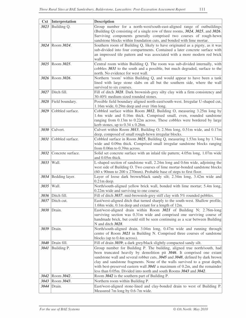
Three Rural Sites at BAE Samlesbury, Balderstone, Lancashire: Post-Excavation Assessment Report 111
For the use of BAE Systems © OA North: May 2010
Cxt Interpretation Description3023 Building Q. Group number for a north-west/south-east-aligned range of outbuildings
(Building Q) consisting of a single row of three rooms, 3024, 3025, and 3026.Surviving components generally comprised two courses of rough-hewnsandstone blocks within foundation cuts, and bonded with lime mortar.
3024 Room 3024. Southern room of Building Q, likely to have originated as a pigsty, as it wassub-divided into four compartments. Contained a later concrete surface withan impressed tile pattern and was associated with a more modern red brickwall.
3025 Room 3025. Central room within Building Q. The room was sub-divided internally, withcobbles 3031 to the south and a possible, but much degraded, surface to thenorth. No evidence for west wall.
3026 Room 3026. Northern ‘room’ within Building Q, and would appear to have been a tanklined with large stone slabs on all but the southern side, where the wallsurvived to six courses.
3027 Ditch fill. Fill of ditch 3028. Dark brownish-grey silty clay with a firm consistency and30-40% medium-sized rounded stones.
3028 Field boundary. Possible field boundary aligned north-east/south-west. Irregular U-shaped cut,1.16m wide, 0.29m deep and over 16m long.
3029 Cobbled surface. Cobbled surface within Room 3012, Building O, measuring 3.25m long by1.4m wide and 0.16m thick. Comprised small, even, rounded sandstoneranging from 0.13m to 0.22m across. These cobbles were bordered by largekerb stones, up to 0.34 x 0.26m.
3030 Culvert. Culvert within Room 3013, Building O; 2.56m long, 0.51m wide, and 0.17mdeep, composed of small rough-hewn irregular blocks.
3031 Cobbled surface. Cobbled surface in Room 3025, Building Q, measuring 1.53m long by 1.74mwide and 0.09m thick. Comprised small irregular sandstone blocks rangingfrom 0.06m to 0.39m across.
3032 Concrete surface. Solid set concrete surface with an inlaid tile pattern; 4.05m long, 1.07m wideand 0.05m thick.
3033 Wall. L-shaped section of sandstone wall, 2.24m long and 0.6m wide, adjoining thewest side of Building O. Two courses of lime mortar-bonded sandstone blocks(60 x 90mm to 200 x 270mm). Probable base of steps to first floor.
3034 Bedding layer. Layer of loose dark brown/black sandy silt; 2.34m long, 3.42m wide and0.21m deep.
3035 Wall. North/south-aligned yellow brick wall, bonded with lime mortar; 5.4m long,0.22m wide and surviving to one course.
3036 Ditch fill. Fill of ditch 3037; mid-brownish-grey stiff clay with 5% rounded pebbles.3037 Ditch cut. East/west-aligned ditch that turned sharply to the south-west. Shallow profile,
1.68m wide, 0.1m deep and extant for a length of 12m.3038 Drain. East/west-aligned drain within Room 3021 of Building N; 2.76m-long
surviving section was 0.31m wide and comprised one surviving course ofhandmade brick, but could still be seen continuing as a scar between BuildingN and ditch 3028.
3039 Drain. North/south-aligned drain, 3.04m long, 0.47m wide and running throughcentre of Room 3021 in Building N. Comprised three courses of sandstoneblocks (up to 0.4m across).
3040 Drain fill. Fill of drain 3039; a dark grey/black slightly compacted sandy silt.3041 Building P. Group number for Building P. The building, aligned true north/south, had
been truncated heavily by demolition pit 3046. It comprised one extantsandstone wall and several robber cuts, 3045 and 3048, defined by dark brownclay and sandstone fragments. None of the walls survived to a great depth,with best-preserved eastern wall 3041 a maximum of 0.2m, and the remainderless than 0.05m. Divided into north and south Rooms 3043 and 3042.
3042 Room 3042. Room 3042 is the southern part of Building P.3043 Room 3043. Northern room within Building P.3044 Drain. East/west-aligned stone-lined and clay-bonded drain to west of Building P.
Measured 7m long by 0.6-7m wide.
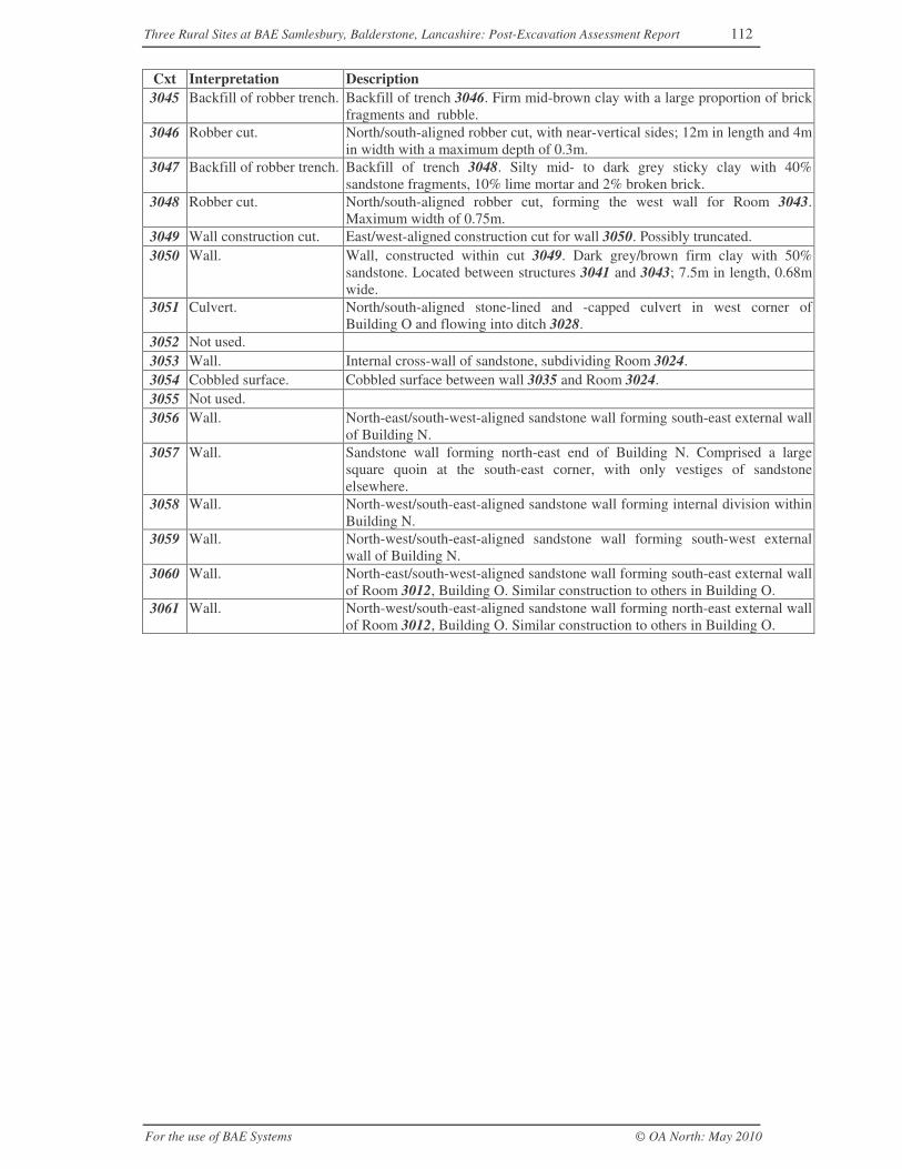
Three Rural Sites at BAE Samlesbury, Balderstone, Lancashire: Post-Excavation Assessment Report 112
For the use of BAE Systems © OA North: May 2010
Cxt Interpretation Description3045 Backfill of robber trench. Backfill of trench 3046. Firm mid-brown clay with a large proportion of brick
fragments and rubble.3046 Robber cut. North/south-aligned robber cut, with near-vertical sides; 12m in length and 4m
in width with a maximum depth of 0.3m.3047 Backfill of robber trench. Backfill of trench 3048. Silty mid- to dark grey sticky clay with 40%
sandstone fragments, 10% lime mortar and 2% broken brick.3048 Robber cut. North/south-aligned robber cut, forming the west wall for Room 3043.
Maximum width of 0.75m.3049 Wall construction cut. East/west-aligned construction cut for wall 3050. Possibly truncated.3050 Wall. Wall, constructed within cut 3049. Dark grey/brown firm clay with 50%
sandstone. Located between structures 3041 and 3043; 7.5m in length, 0.68mwide.
3051 Culvert. North/south-aligned stone-lined and -capped culvert in west corner ofBuilding O and flowing into ditch 3028.
3052 Not used.3053 Wall. Internal cross-wall of sandstone, subdividing Room 3024.3054 Cobbled surface. Cobbled surface between wall 3035 and Room 3024.3055 Not used.3056 Wall. North-east/south-west-aligned sandstone wall forming south-east external wall
of Building N.3057 Wall. Sandstone wall forming north-east end of Building N. Comprised a large
square quoin at the south-east corner, with only vestiges of sandstoneelsewhere.
3058 Wall. North-west/south-east-aligned sandstone wall forming internal division withinBuilding N.
3059 Wall. North-west/south-east-aligned sandstone wall forming south-west externalwall of Building N.
3060 Wall. North-east/south-west-aligned sandstone wall forming south-east external wallof Room 3012, Building O. Similar construction to others in Building O.
3061 Wall. North-west/south-east-aligned sandstone wall forming north-east external wallof Room 3012, Building O. Similar construction to others in Building O.
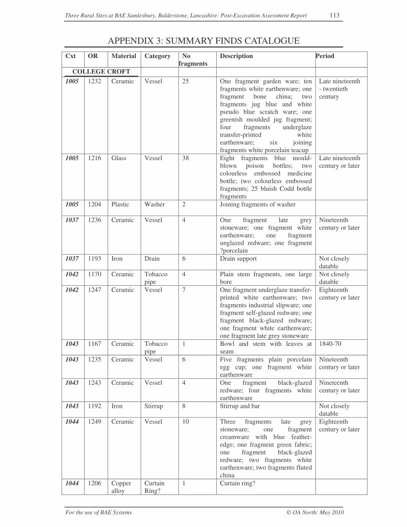
Three Rural Sites at BAE Samlesbury, Balderstone, Lancashire: Post-Excavation Assessment Report 113
For the use of BAE Systems © OA North: May 2010
APPENDIX 3: SUMMARY FINDS CATALOGUE
Cxt OR Material Category Nofragments
Description Period
COLLEGE CROFT1005 1232 Ceramic Vessel 25 One fragment garden ware; ten
fragments white earthenware; onefragment bone china; twofragments jug blue and whitepseudo blue scratch ware; onegreenish moulded jug fragment;four fragments underglazetransfer-printed whiteearthenware; six joiningfragments white porcelain teacup
Late nineteenth- twentiethcentury
1005 1216 Glass Vessel 38 Eight fragments blue mould-blown poison bottles; twocolourless embossed medicinebottle; two colourless embossedfragments; 25 bluish Codd bottlefragments
Late nineteenthcentury or later
1005 1204 Plastic Washer 2 Joining fragments of washer
1037 1236 Ceramic Vessel 4 One fragment late greystoneware; one fragment whiteearthenware; one fragmentunglazed redware; one fragment?porcelain
Nineteenthcentury or later
1037 1193 Iron Drain 6 Drain support Not closelydatable
1042 1170 Ceramic Tobaccopipe
4 Plain stem fragments, one largebore
Not closelydatable
1042 1247 Ceramic Vessel 7 One fragment underglaze transfer-printed white earthenware; twofragments industrial slipware; onefragment self-glazed redware; onefragment black-glazed redware;one fragment white earthenware;one fragment late grey stoneware
Eighteenthcentury or later
1043 1167 Ceramic Tobaccopipe
1 Bowl and stem with leaves atseam
1840-70
1043 1235 Ceramic Vessel 6 Five fragments plain porcelainegg cup; one fragment whiteearthenware
Nineteenthcentury or later
1043 1243 Ceramic Vessel 4 One fragment black-glazedredware; four fragments whiteearthenware
Nineteenthcentury or later
1043 1192 Iron Stirrup 8 Stirrup and bar Not closelydatable
1044 1249 Ceramic Vessel 10 Three fragments late greystoneware; one fragmentcreamware with blue feather-edge; one fragment green fabric;one fragment black-glazedredware; two fragments whiteearthenware; two fragments flutedchina
Eighteenthcentury or later
1044 1206 Copperalloy
CurtainRing?
1 Curtain ring?
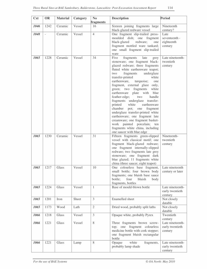
Three Rural Sites at BAE Samlesbury, Balderstone, Lancashire: Post-Excavation Assessment Report 114
For the use of BAE Systems © OA North: May 2010
Cxt OR Material Category Nofragments
Description Period
1046 1242 Ceramic Vessel 16 Sixteen joining fragments largeblack-glazed redware vessel
Nineteenthcentury?
1048 - Ceramic Vessel 4 One fragment slip-trailed press-moulded dish; one fragmentblack-glazed redware; onefragment mottled ware tankard;one small fragment slip-trailedware
Lateseventeenth -eighteenthcentury
1065 1228 Ceramic Vessel 34 Five fragments late greystoneware; one fragment black-glazed redware; three fragmentsfluted white earthenware teapot;two fragments underglazetransfer-printed whiteearthenware, turquoise; onefragment, external glaze only,green; two fragments whiteearthenware plate with bluefeather-edge; two handlefragments underglaze transfer-printed white earthenwarechamber pot; one fragmentunderglaze transfer-printed whiteearthenware; one fragment latecreamware; one fragment basket-work painted porcelain; tenfragments white china, includingone saucer with blue edge
Late nineteenth-twentiethcentury
1065 1230 Ceramic Vessel 31 Fifteen fragments green-slippedvessel with classical motif; onefragment black-glazed redware;one fragment internally-slippedredware; two fragments late greystoneware; one fragment darkblue glazed; 11 fragments whitechina (three saucer, eight teapot)
Nineteenth-twentiethcentury
1065 1217 Glass Vessel 10 One colourless base fragment,small bottle; four brown bodyfragments; one bluish base saucebottle; four bluish bodyfragments, bottles
Late nineteenthcentury or later
1065 1224 Glass Vessel 1 Base of mould-blown bottle Late nineteenth-early twentiethcentury
1065 1201 Iron Sheet 3 Enamelled sheet Not closelydatable
1065 1173 Wood Lath 2 Dried wood, probably split laths Not closelydatable
1066 1218 Glass Vessel 3 Opaque white, probably Pyrex Twentiethcentury
1066 1221 Glass Vessel 8 Three fragments brown screw-top; one fragment colourlessmedicine bottle with cork stopper;one fragment bluish rectangularbottle
Late nineteenth-early twentiethcentury
1066 1221 Glass Lamp 8 Opaque white fragments,probably lamp shade
Late nineteenth-early twentiethcentury
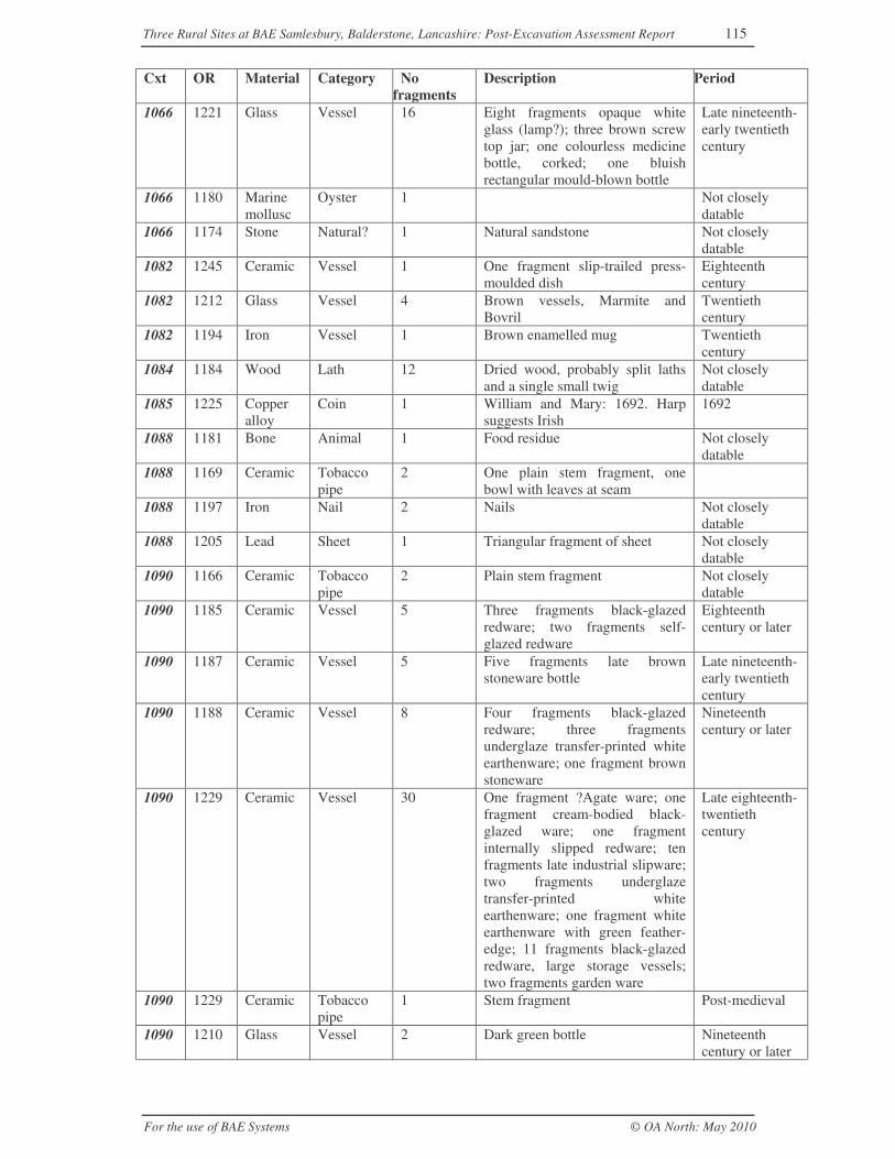
Three Rural Sites at BAE Samlesbury, Balderstone, Lancashire: Post-Excavation Assessment Report 115
For the use of BAE Systems © OA North: May 2010
Cxt OR Material Category Nofragments
Description Period
1066 1221 Glass Vessel 16 Eight fragments opaque whiteglass (lamp?); three brown screwtop jar; one colourless medicinebottle, corked; one bluishrectangular mould-blown bottle
Late nineteenth-early twentiethcentury
1066 1180 Marinemollusc
Oyster 1 Not closelydatable
1066 1174 Stone Natural? 1 Natural sandstone Not closelydatable
1082 1245 Ceramic Vessel 1 One fragment slip-trailed press-moulded dish
Eighteenthcentury
1082 1212 Glass Vessel 4 Brown vessels, Marmite andBovril
Twentiethcentury
1082 1194 Iron Vessel 1 Brown enamelled mug Twentiethcentury
1084 1184 Wood Lath 12 Dried wood, probably split lathsand a single small twig
Not closelydatable
1085 1225 Copperalloy
Coin 1 William and Mary: 1692. Harpsuggests Irish
1692
1088 1181 Bone Animal 1 Food residue Not closelydatable
1088 1169 Ceramic Tobaccopipe
2 One plain stem fragment, onebowl with leaves at seam
1088 1197 Iron Nail 2 Nails Not closelydatable
1088 1205 Lead Sheet 1 Triangular fragment of sheet Not closelydatable
1090 1166 Ceramic Tobaccopipe
2 Plain stem fragment Not closelydatable
1090 1185 Ceramic Vessel 5 Three fragments black-glazedredware; two fragments self-glazed redware
Eighteenthcentury or later
1090 1187 Ceramic Vessel 5 Five fragments late brownstoneware bottle
Late nineteenth-early twentiethcentury
1090 1188 Ceramic Vessel 8 Four fragments black-glazedredware; three fragmentsunderglaze transfer-printed whiteearthenware; one fragment brownstoneware
Nineteenthcentury or later
1090 1229 Ceramic Vessel 30 One fragment ?Agate ware; onefragment cream-bodied black-glazed ware; one fragmentinternally slipped redware; tenfragments late industrial slipware;two fragments underglazetransfer-printed whiteearthenware; one fragment whiteearthenware with green feather-edge; 11 fragments black-glazedredware, large storage vessels;two fragments garden ware
Late eighteenth-twentiethcentury
1090 1229 Ceramic Tobaccopipe
1 Stem fragment Post-medieval
1090 1210 Glass Vessel 2 Dark green bottle Nineteenthcentury or later
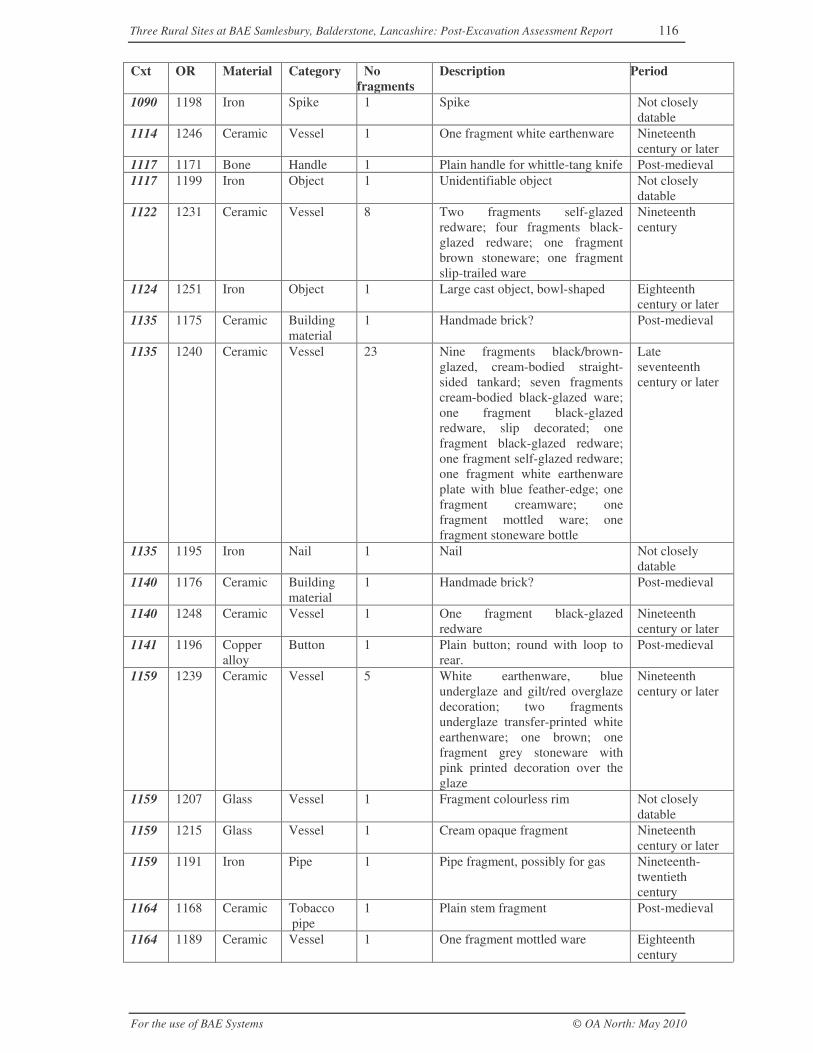
Three Rural Sites at BAE Samlesbury, Balderstone, Lancashire: Post-Excavation Assessment Report 116
For the use of BAE Systems © OA North: May 2010
Cxt OR Material Category Nofragments
Description Period
1090 1198 Iron Spike 1 Spike Not closelydatable
1114 1246 Ceramic Vessel 1 One fragment white earthenware Nineteenthcentury or later
1117 1171 Bone Handle 1 Plain handle for whittle-tang knife Post-medieval1117 1199 Iron Object 1 Unidentifiable object Not closely
datable1122 1231 Ceramic Vessel 8 Two fragments self-glazed
redware; four fragments black-glazed redware; one fragmentbrown stoneware; one fragmentslip-trailed ware
Nineteenthcentury
1124 1251 Iron Object 1 Large cast object, bowl-shaped Eighteenthcentury or later
1135 1175 Ceramic Buildingmaterial
1 Handmade brick? Post-medieval
1135 1240 Ceramic Vessel 23 Nine fragments black/brown-glazed, cream-bodied straight-sided tankard; seven fragmentscream-bodied black-glazed ware;one fragment black-glazedredware, slip decorated; onefragment black-glazed redware;one fragment self-glazed redware;one fragment white earthenwareplate with blue feather-edge; onefragment creamware; onefragment mottled ware; onefragment stoneware bottle
Lateseventeenthcentury or later
1135 1195 Iron Nail 1 Nail Not closelydatable
1140 1176 Ceramic Buildingmaterial
1 Handmade brick? Post-medieval
1140 1248 Ceramic Vessel 1 One fragment black-glazedredware
Nineteenthcentury or later
1141 1196 Copperalloy
Button 1 Plain button; round with loop torear.
Post-medieval
1159 1239 Ceramic Vessel 5 White earthenware, blueunderglaze and gilt/red overglazedecoration; two fragmentsunderglaze transfer-printed whiteearthenware; one brown; onefragment grey stoneware withpink printed decoration over theglaze
Nineteenthcentury or later
1159 1207 Glass Vessel 1 Fragment colourless rim Not closelydatable
1159 1215 Glass Vessel 1 Cream opaque fragment Nineteenthcentury or later
1159 1191 Iron Pipe 1 Pipe fragment, possibly for gas Nineteenth-twentiethcentury
1164 1168 Ceramic Tobacco pipe
1 Plain stem fragment Post-medieval
1164 1189 Ceramic Vessel 1 One fragment mottled ware Eighteenthcentury
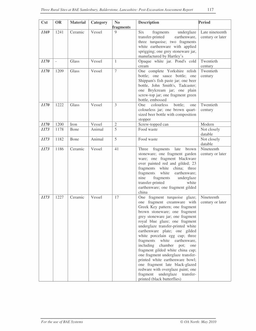
Three Rural Sites at BAE Samlesbury, Balderstone, Lancashire: Post-Excavation Assessment Report 117
For the use of BAE Systems © OA North: May 2010
Cxt OR Material Category Nofragments
Description Period
1169 1241 Ceramic Vessel 9 Six fragments underglazetransfer-printed earthenware,three turquoise; two fragmentswhite earthenware with appliedsprigging; one grey stoneware jar,manufactured by Hartley’s
Late nineteenthcentury or later
1170 - Glass Vessel 1 Opaque white jar. Pond's coldcream
Twentiethcentury
1170 1209 Glass Vessel 7 One complete Yorkshire relishbottle; one sauce bottle; oneShippam's fish paste jar; one beerbottle, John Smith's, Tadcaster;one Brylcream jar; one plainscrew-top jar; one fragment greenbottle, embossed
Twentiethcentury
1170 1222 Glass Vessel 3 One colourless bottle; onecolourless jar; one brown quart-sized beer bottle with compositionstopper
Twentiethcentury
1170 1200 Iron Vessel 2 Screw-topped can Modern1173 1178 Bone Animal 5 Food waste Not closely
datable1173 1182 Bone Animal 5 Food waste Not closely
datable1173 1186 Ceramic Vessel 41 Three fragments late brown
stoneware; one fragment gardenware; one fragment blackwareover painted red and gilded; 23fragments white china; threefragments white earthenware;nine fragments underglazetransfer-printed whiteearthenware; one fragment gildedchina
Nineteenthcentury or later
1173 1227 Ceramic Vessel 17 One fragment turquoise glaze;one fragment creamware withGreek Key pattern; one fragmentbrown stoneware; one fragmentgrey stoneware jar; one fragmentroyal blue glaze; one fragmentunderglaze transfer-printed whiteearthenware plate; one gildedwhite porcelain egg cup; threefragments white earthenware,including chamber pot; onefragment gilded white china cup;one fragment underglaze transfer-printed white earthenware bowl;one fragment late black-glazedredware with overglaze paint; onefragment underglaze transfer-printed (black butterflies)
Nineteenthcentury or later
Three Rural Sites at BAE Samlesbury, Balderstone, Lancashire: Post-Excavation Assessment Report 118
For the use of BAE Systems © OA North: May 2010
Cxt OR Material Category Nofragments
Description Period
1173 1234 Ceramic Vessel 64 Seven fragments white china; onefragment garden ware; 28fragments white earthenware,including bedroom vessels; onefragment white salt-glazestoneware; one fragment smallporcelain doll’s head; onestoneware bottle; four fragmentsstoneware jar; one fragmenttransfer-printed porcelain; twofragments industrial slip ware;one fragment blue-glazedearthenware; one fragment darkbrown-glazed earthenware; onefragment black-glazed redware;15 fragments underglaze transfer-printed white earthenware
Late nineteenthcentury or later
1173 1234 Ceramic Buildingmaterial
1 One fragment glazed sanitaryware
Twentiethcentury or later
1173 1203 Copperalloy
Lid 1 Screw-threaded top Nineteenth-twentiethcentury
1173 1208 Glass Vessel 11 Complete brown Bovril jar;complete colourless medicinebottle with gradations; completecolourless fish paste jar; completeHoe’s sauce bottle; almostcomplete Alkington's bleachingfluid; one brown neck fragment;one brown beer bottle; onecolourless body fragment; one lid;one complete bottle - JBaxendale, Blackburn
Twentiethcentury
1173 1213 Glass Vessel 4 Two small fragments colourlessbody, one colourless bottle Eiffeltower fruit juices, Foster Clark,Maidstone; one mould-blownbottle
Late nineteenthcentury or later
1173 1214 Glass Vessel 1 Fragment colourless bottle Twentiethcentury
1173 1219 Glass Vessel 1 Cased opaque white andcranberry pink
Nineteenthcentury
1173 1223 Glass Vessel 4 Three colourless fragments; oneamber fragment
Late nineteenthcentury or later
1173 1202 Iron Spike? 1 Spike? Not closelydatable
1173 1178 Marinemollusc
Cockle 5 Food refuse Not closelydatable
1173 1179 Marinemollusc
Cockle 3 Food refuse Not closelydatable
1173 1179 Marinemollusc
Mussel 1 Food refuse Not closelydatable
1191 1244 Ceramic Vessel 4 Four fragments underglazetransfer-printed whiteearthenware
Eighteenthcentury or later
Three Rural Sites at BAE Samlesbury, Balderstone, Lancashire: Post-Excavation Assessment Report 119
For the use of BAE Systems © OA North: May 2010
Cxt OR Material Category Nofragments
Description Period
PEPPER HILL2000 1088 Ceramic Vessel 10 Five fragments black-glazed
redware; five fragments self-glazed redware, includes handle
Post-medieval
2000 1153 Iron Nail 1 Nail Not closelydatable
2003 1141 AnimalBone
Animal 2 Not closelydatable
2003 1032 Ceramic Vessel 3 One fragment late greystoneware; two fragments whiteearthenware
Nineteenthcentury or later
2003 1121 Glass Window 1 Pale bluish thin mid-pane sheetfragments
Nineteenthcentury or later
2004 1100 Ceramic Tobaccopipe
1 Plain stem fragment, large bore Not closelydatable
2006 1020 Ceramic Vessel 5 Five fragments black-glazedredware
Eighteenthcentury or later
2009 1037 Ceramic Vessel 1 One fragment Staffordshire slip-trailed hollow ware
Lateseventeenth -eighteenthcentury
2010 1045 Ceramic Vessel 1 One fine black-glazed redwarerim
Eighteenth -nineteenthcentury
2010 1045 Ceramic Buildingmaterial
1 Salt-glazed sewage pipe Nineteenthcentury or later
2012 1077 Ceramic Vessel 1 One fragment black-glazedredware, refired
Eighteenth -nineteenthcentury
2020 1053 Ceramic Vessel 10 Five fragments black-glazedredware, large vessel; onefragment internally slippedredware; one fragment brown-glazed teapot spout; twofragments white salt-glazedstoneware (one rim); onefragment blue-painted tin-glazedware
Eighteenth -nineteenthcentury
2020 1086 Ceramic Vessel 10 Eight fragments black-glazedredware, including base; two rimfragments self-glazed redwares
Eighteenthcentury or later
2020 1090 Ceramic Vessel 3 Three fragments slip-trailed ware Lateseventeenth-eighteenthcentury
2020 1090 Ceramic Vessel 3 Three fragments fine ‘Northernreduced greenware’
Fourteenth-sixteenth/seventeenthcentury
2020 1119 Glass Vessel 1 Fragment of sea-green wine bottle Lateseventeenthcentury
2020 1144 Marinemollusc
Mussel 5 Food refuse Not closelydatable
2023 1136 Bone Animal 2 Food refuse Not closelydatable
Three Rural Sites at BAE Samlesbury, Balderstone, Lancashire: Post-Excavation Assessment Report 120
For the use of BAE Systems © OA North: May 2010
Cxt OR Material Category Nofragments
Description Period
2023 1161 Bone Animal 7 Food refuse Not closelydatable
2023 1162 Bone Animal 3 Food refuse Not closelydatable
2023 1063 Ceramic Vessel 43 Twenty-four fragments black-glazed redware, including earlyrims; eight fragments cream-bodied black-glazed ware; onefragment blue and white tin-glazeplate; four fragments self-glazedredware; two fragments slip-trailed ware, probablyStaffordshire; one fragment Agateware; three joining fragments finebrown?
Lateseventeenth-eighteenthcentury
2023 1063 Ceramic Vessel 1 One fragment green-glazed, sandyoxidised fabric (red)
Thirteenth-fourteenthcentury?
2023 1098 Ceramic Tobacco pipe
6 Plain stem fragments, three largebore
Not closelydatable
2023 1109 Glass Vessel 2 Two fragments sea-green winebottle
Lateseventeenth-early eighteenthcentury
2023 1163 Glass Vessel 1 Dark olive green wine bottle Eighteenthcentury
2023 1160 Marinemollusc
Cockle 1 Food refuse Not closelydatable
2023 1160 Marinemollusc
Mussel 3 Food refuse Not closelydatable
2024 0 Ceramic Vessel 21 Two fragments industrialslipware; 19 fragments black-glazed redware, one probablyearly
Lateseventeenthcentury or later
2024 1054 Glass Vessel 1 Base fragment, dark olive greenwine bottle
Eighteenthcentury
2034 1164 Ceramic Vessel 8 Two fragments industrialslipware; two fragmentsunderglaze transfer-printed whiteearthenware; two fragments slip-trailed ware; one fragment whiteearthenware; one fragment self-glazed redware with slipdecoration
Eighteenth-nineteenthcentury
2034 1165 Glass Vessel 1 Pale blue embossed bottlefragment
Late nineteenth-early twentiethcentury
2035 1018 Ceramic Vessel 9 Four fragments black-glazedredware; one fragment dishcream-bodied black-glazed ware;two fragments self-glazedredware; one fragment whiteearthenware; one fragmentunderglaze transfer-printed whiteearthenware
Eighteenthcentury or later
2038 1131 Bone Animal 2 Food refuse Not closelydatable
Three Rural Sites at BAE Samlesbury, Balderstone, Lancashire: Post-Excavation Assessment Report 121
For the use of BAE Systems © OA North: May 2010
Cxt OR Material Category Nofragments
Description Period
2038 1026 Ceramic Vessel 19 Three fragments self-glazedredware; three fragments black-glazed redware; nine fragmentsindustrial slip ware; one fragmentunderglaze transfer-printed whiteearthenware; two fragments whiteearthenware
Late eighteenthcentury or later
2038 1082 Ceramic Vessel 5 Four fragments black-glazedredware; one fragment self-glazedredware with slip
Nineteenthcentury or later
2038 1026 Glass Vessel 3 Three fragments dark olive greenwine bottle
Late eighteenthcentury
2038 1026 Glass Window 1 One mid-pane fragment, bluishsheet
Nineteenthcentury
2040 1060 Ceramic Vessel 2 Two fragments black-glazedredware
Eighteenthcentury or later
2042 1022 Ceramic Vessel 5 Five fragments fine ‘Northernreduced greenware’, Silverdaletype?
Fourteenth-sixteenth/seventeenthcentury
2043 1042 Ceramic Vessel 3 Two fragments black-glazedredware; one fragment yellowware
Eighteenthcentury?
2043 1045 Ceramic Vessel 24 Two fragments underglazetransfer-printed whiteearthenware chamber pot; fourfragments white earthenware; onefragment white earthenware bluefeather-edge dish; four joiningfragments underglaze transfer-printed white earthenware dish;13 joining fragments ?Pearlwareplate, blue feather-edge
Nineteenthcentury or later
2043 1058 Ceramic Vessel 10 Six fragments self-glazedredware; two fragments cream-bodied black-glazed ware, tankardand jug?; one fragmentcreamware; one fragment lategrey stoneware
Eighteenth-nineteenthcentury
2043 1058 Ceramic Vessel 1 Fragment fine ‘Northern reducedgreenware’
Fourteenth-sixteenth/seventeenthcentury
2043 1067 Ceramic Vessel 21 Eight small fragments black-glazed redware; two fragmentslate brown stoneware; onefragment internally slippedredware; two fragments self-glazed redware with simple slipdecoration; two fragmentsindustrial slipware; six fragmentsunderglaze transfer-printed whiteearthenware
Nineteenthcentury or later
2043 1067 Ceramic Buildingmaterial
2 Small abraded fragmentsundiagnostic tile/brick
Nineteenthcentury or later
2043 1067 Ceramic Buildingmaterial
3 Glazed wall tile, green and ochre Late nineteenthcentury or later
Three Rural Sites at BAE Samlesbury, Balderstone, Lancashire: Post-Excavation Assessment Report 122
For the use of BAE Systems © OA North: May 2010
Cxt OR Material Category Nofragments
Description Period
2043 1070 Ceramic Vessel 10 One fragment brown stonewaredish; seven fragments black-glazed redware; one fragment lategrey stoneware; one fragmentmottled ware
Nineteenthcentury or later
2043 1070 Ceramic Vessel 2 One fragment black-glazedredware; one fragment cream-bodied black-glazed ware
Eighteenthcentury?
2043 1080 Ceramic Vessel 11 One fragment Staffordshire slip-trailed ware; two fragments self-glazed redware; seven fragmentsblack-glazed redware; one chippearlware
Lateseventeenth-eighteenthcentury
2043 1115 Glass Vessel 6 Three fragments pale blue mould-blown bottle; one fragmentgreenish bottle; three fragmentsdark green bottle
Nineteenthcentury
2043 1125 Glass Window 1 Colourless mid-pane fragment Twentiethcentury or later
2043 1125 Glass Vessel 1 Colourless base, Dettol Twentiethcentury or later
2043 1147 Iron Horse bit 1 Horse bit Post-medieval2043 1148 Iron Nail 1 Nail Not closely
datable2045 1049 Ceramic Vessel 12 Three fragments self-glazed
redware; two fragments black-glazed redware; two fragmentscream-bodied black-glazed ware;one fragment late grey stoneware;one fragment creamware; onefragment ?pearlware; oneunglazed redware rim; onefragment slipped redware withunglazed red decoration
Nineteenthcentury or later
2045 1049 Glass Vessel 2 Two fragments white opaquepress-moulded
Nineteenthcentury or later
2045 1111 Glass Vessel 2 One dark green bottle fragment;one bluish bottle fragment
Nineteenthcentury or later
2045 1111 Glass Window 1 One mid-pane fragment greenishsheet
Nineteenthcentury or later
2046 1135 Bone Animal 4 Food waste Not closelydatable
2046 1065 Ceramic Vessel 35 Twenty-one fragments black-glazed redware; one fragmentcream-bodied black-glazed ware;one fragment pearlware; onefragment slip-decorated hollowware; four fragments creamware;three fragments mottled ware; twofragments self-glazed redware;two fragments redware
Lateseventeenth-eighteenthcentury
2046 1065 Ceramic Buildingmaterial
8 Small fragments undiagnostictile/brick
Not closelydatable
2046 1095 Ceramic Tobaccopipe
2 Plain stem fragment Post-medieval
2071 1139 Bone Animal 1 Not closelydatable
Three Rural Sites at BAE Samlesbury, Balderstone, Lancashire: Post-Excavation Assessment Report 123
For the use of BAE Systems © OA North: May 2010
Cxt OR Material Category Nofragments
Description Period
2071 1062 Ceramic Vessel 8 Two fragments black-glazedredware; one fragment self-glazedredware; one fragment creamwaredish with blue feather-edge; onefragment white earthenware; twofragments industrial slipware
Late eighteenth-nineteenthcentury
2071 1069 Ceramic Vessel 14 Two fragments black-glazedredware; one fragment self-glazedredware; one fragment gardenware; two fragments dark blueglaze; one fragment internallyslipped redware; four fragmentswhite earthenware; one fragmentwhite?
Late nineteenth-twentiethcentury
2071 1123 Glass Vessel 3 Two fragments of dark olivegreen wine bottle; one fragmentcolourless
Eighteenthcentury
2071 1010 Iron Bar? 2 Fragments of rectangular-sectioned bar
Post-medieval
2071 1010 Iron Washer 1 Washer Late nineteenth-twentiethcentury
2071 1010 Iron Nail 1 Nail Not closelydatable
2071 1010 Iron Object? 2 Unidentifiable Not closelydatable
2073 1079 Ceramic Vessel 2 Two fragments whiteearthenware; one with bluefeather-edge
Nineteenthcentury or later
2095 1021 Ceramic Vessel 3 Three fragments incompletelyreduced gritty fabric, green glazed
Thirteenth-fourteenthcentury
2095 1021 Ceramic Tobaccopipe
6 Two bowls and four stemfragments. One bowl stamped IB
Seventeenthcentury
2095 1021 Ceramic Vessel 1 One fragment early blackware Seventeenthcentury?
2095 1023 Ceramic Vessel 2 One fragment early blackwareposset; one fragment Staffordshirethrown slip-trailed dish
Seventeenthcentury?
2095 1023 Ceramic Tobaccopipe
2 Stem fragments Post-medieval
2104 1069 Ceramic Vessel 2 Redware, black-glazed, yellowslip
Nineteenthcentury or later
2104 1157 Ceramic Tobaccopipe
1 Plain stem fragment, large bore Post-medieval
2106 1052 Ceramic Vessel 2 Two fragments underglazetransfer-printed whiteearthenware, turquoise
Nineteenthcentury or later
2109 1007 Iron Horseshoe 1 Very large horseshoe Nineteenthcentury or later
2112 1130 Bone Animal 1 Food residue Not closelydatable
2112 1048 Ceramic Vessel 1 One complete stoneware bottlestamped Doulton, Lambeth
Mid-latenineteenthcentury
Three Rural Sites at BAE Samlesbury, Balderstone, Lancashire: Post-Excavation Assessment Report 124
For the use of BAE Systems © OA North: May 2010
Cxt OR Material Category Nofragments
Description Period
2112 1057 Ceramic Vessel 6 Five fragments white-glazedearthenware; one fragment lateNottingham stoneware
Nineteenthcentury or later
2112 1102 Ceramic Tobaccopipe
1 Plain stem fragment Post-medieval
2112 1116 Glass Vessel 2 Cased opaque white and multi-coloured-metallic finisheddecorative vessel
Twentiethcentury
2112 1151 Iron Object 3 Unidentifiable objects Not closelydatable
2113 1066 Ceramic Vessel 13 Two fragments whiteearthenware; two fragments slip-trailed ware, bowl and hollowware base; one fragmentNottingham stoneware; onefragment industrial slipware;seven fragments black-glazedredware, one over-fired
Lateseventeenth-eighteenthcentury or later
2113 1110 Glass Vessel 1 Dark olive green wine bottle Eighteenthcentury
2115 1127 Bone Animal 1 Horn core Not closelydatable
2115 1250 Ceramic Vessel 2 Two fragments black-glazedredware
Eighteenth-nineteenthcentury
2115 1014 Iron Adze? 1 Relatively small transverse blade,possibly an adze or plane blade
Post-medieval
2125 1126 Bone Animal 6 Food waste Not closelydatable
2125 1042 Ceramic Vessel 1 One fragment white salt-glazedstoneware plate
Mid-eighteenthcentury
2125 1091 Ceramic Tobaccopipe
1 Small bowl with spur and stem,leaves at seam
Post-medieval
2138 1092 Ceramic Tobaccopipe
1 Bowl with small flat spur,rouletted
Post-medieval
2138 1122 Glass Marble 1 Bluish marble Nineteenthcentury or later
2139 1077 Ceramic Vessel 7 One fragment self-glazedredware; one fragment?creamware; three fragmentsunderglaze transfer-printed whiteearthenware; one fragmentindustrial slipware; one fragmentblack-glazed redware
Late eighteenthcentury or later
2139 1114 Glass Vessel 1 Dark olive green wine bottle Eighteenthcentury
2139 1006 Iron Nail? 2 Nails? Not closelydatable
2142 1042 Ceramic Vessel 1 One fragment reduced sandyfabric, green-glazed
Fourteenth-sixteenth/seventeenthcentury
2192 1004 Copperalloy
Fragment 3 Small fragments Not closelydatable
2192 1004 Iron Nail 2 Nails Post-medieval
Three Rural Sites at BAE Samlesbury, Balderstone, Lancashire: Post-Excavation Assessment Report 125
For the use of BAE Systems © OA North: May 2010
Cxt OR Material Category Nofragments
Description Period
2192 1004 Iron Strap 1 Fragment of narrow strap,possibly for reinforcement
Post-medieval
2194 1078 Ceramicmaterial
Building 2 Small undiagnostic fragments Not closelydatable
2194 1087 Ceramic Vessel 5 Three fragments black-glazedredware; one fragment industrialslipware; one fragmentunderglaze transfer-printed whiteearthenware, brown
Nineteenthcentury or later
2194 1088 Ceramic Buildingmaterial
1 Glazed wall tile, green and ochre Late nineteenthcentury or later
2194 1088 Ceramic Vessel 1 One fragment underglaze transfer-printed white earthenware
Late eighteenthcentury or later
2194 - Glass Vessel 2 Embossed mould-blown bottle,greenish
Late nineteenthcentury/ earlytwentiethcentury
2194 1087 Glass Vessel 1 Opaque white glass Late nineteenthcentury or later
2194 1008 Iron Nail 1 Nail Post-medieval2194 1009 Iron Object 1 Large U-shaped object, probably
a boot cleanerNineteenthcentury-twentiethcentury
2200 1031 Ceramic Vessel 5 Four fragments black-glazedredware; one fragment gardenware
Nineteenthcentury or later
2201 1044 Ceramic Vessel 4 Three fragments fully reducedgreen-glazed ware; one fragmentincompletely reduced rimfragment, sandy fabric
Fourteenth-sixteenth/seventeenthcentury
2210 1015 Ceramic Vessel 18 Two fragments cream-bodiedblack -glazed ware; 11 fragmentsblack-glazed redware; onefragment mottled ware; twofragments underglaze transfer-printed white earthenware; onefragment ?transfer-printed whitestoneware?
Eighteenthcentury
2210 1016 Ceramic Vessel 8 Six fragments black-glazedredware; one fragment transfer-printed white earthenware; onefragment brown stoneware
Eighteenthcentury or later
2210 1036 Ceramic Vessel 47 Three fragments yellow ware;eight fragments mottled ware;four fragments Staffordshire slip-trailed ware; one fragment cream-bodied with brown glaze; twofragments late grey stoneware;two fragments cream-bodiedblack-glazed ware; 18 fragmentsblack-glazed redware; eightfragments large vessels in black-glazed redware; one fragmentself-glazed redware
Lateseventeenthcentury or later
2210 1096 Ceramic Tobaccopipe
1 Plain stem fragment Post-medieval

Three Rural Sites at BAE Samlesbury, Balderstone, Lancashire: Post-Excavation Assessment Report 126
For the use of BAE Systems © OA North: May 2010
Cxt OR Material Category Nofragments
Description Period
2210 1036 Glass Vessel 1 One fragment dark olive greenglass, short neck with appliedstring rim
Eighteenthcentury?
2210 1117 Glass Vessel 1 Dark olive green free-blownbottle base
Eighteenthcentury
2210 1156 Lead Object 1 Oval object cut from sheet Not closelydatable
2219 1056 Ceramic Vessel 2 One fragment late Nottinghamstoneware; one fragment self-glazed redware
Nineteenthcentury or later
2222 1071 Bone Animal 1 Food waste Not closelydatable
2222 1137 Bone Animal 1 Food waste Not closelydatable
2222 1071 Ceramic Vessel 12 Three fragments plain white chinasaucer; one fragment industrialslipware; one fragment self-glazed redware, one fragmentburnt underglaze transfer-printedwhite earthenware; one fragmentcream-bodied black-glazed ware;six fragments black-glazedredware
Late eighteenthcentury or later
2222 1103 Ceramic Tobaccopipe
2 Plain stem fragments Post-medieval
2222 1108 Glass Vessel 4 Three fragments dark olive greenwine bottle; one fragment bluishmould-blown bottle
Eighteenth-nineteenthcentury
2222 1146 Marinemollusc
1 Food waste Not closelydatable
2230 1133 Bone Animal 2 Horn core Not closelydatable
2241 1154 Ceramic Vessel 33 Nine fragments of creamwaredish with blue feather-edge; twofragments brown stoneware, bothsmall dishes; two fragmentscream-bodied black-glazed ware,one slip trailed; four fragmentswhite earthenware tankard withbrown decoration; 15 fragmentspearlware bowl with industrialslip decoration in brown andbeige
Late eighteenth-early nineteenthcentury
2241 1012 Iron Perforated 1 Fragment of perforated strip,possibly hinge strap
Post-medieval
2241 1152 Iron Object 18 Unidentifiable objects Not closelydatable
2261 1017 Ceramic Vessel 18 Two fragments underglazetransfer-printed whiteearthenware; one fragmentredware with sprigged decoration;one fragment mottled ware; onefragment self-glazed redware; onefragment cream-bodied black-glazed ware; 12 fragments black-glazed redware
Lateseventeenth-eighteenthcentury or later
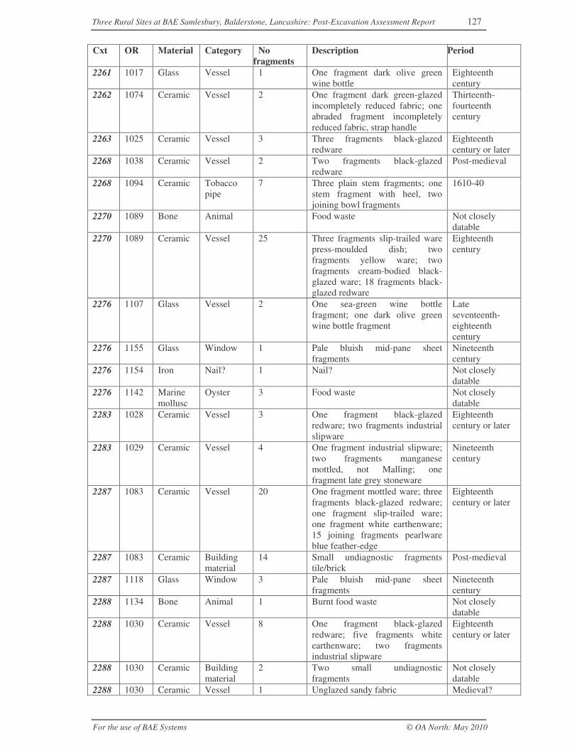
Three Rural Sites at BAE Samlesbury, Balderstone, Lancashire: Post-Excavation Assessment Report 127
For the use of BAE Systems © OA North: May 2010
Cxt OR Material Category Nofragments
Description Period
2261 1017 Glass Vessel 1 One fragment dark olive greenwine bottle
Eighteenthcentury
2262 1074 Ceramic Vessel 2 One fragment dark green-glazedincompletely reduced fabric; oneabraded fragment incompletelyreduced fabric, strap handle
Thirteenth-fourteenthcentury
2263 1025 Ceramic Vessel 3 Three fragments black-glazedredware
Eighteenthcentury or later
2268 1038 Ceramic Vessel 2 Two fragments black-glazedredware
Post-medieval
2268 1094 Ceramic Tobaccopipe
7 Three plain stem fragments; onestem fragment with heel, twojoining bowl fragments
1610-40
2270 1089 Bone Animal Food waste Not closelydatable
2270 1089 Ceramic Vessel 25 Three fragments slip-trailed warepress-moulded dish; twofragments yellow ware; twofragments cream-bodied black-glazed ware; 18 fragments black-glazed redware
Eighteenthcentury
2276 1107 Glass Vessel 2 One sea-green wine bottlefragment; one dark olive greenwine bottle fragment
Lateseventeenth-eighteenthcentury
2276 1155 Glass Window 1 Pale bluish mid-pane sheetfragments
Nineteenthcentury
2276 1154 Iron Nail? 1 Nail? Not closelydatable
2276 1142 Marinemollusc
Oyster 3 Food waste Not closelydatable
2283 1028 Ceramic Vessel 3 One fragment black-glazedredware; two fragments industrialslipware
Eighteenthcentury or later
2283 1029 Ceramic Vessel 4 One fragment industrial slipware;two fragments manganesemottled, not Malling; onefragment late grey stoneware
Nineteenthcentury
2287 1083 Ceramic Vessel 20 One fragment mottled ware; threefragments black-glazed redware;one fragment slip-trailed ware;one fragment white earthenware;15 joining fragments pearlwareblue feather-edge
Eighteenthcentury or later
2287 1083 Ceramic Buildingmaterial
14 Small undiagnostic fragmentstile/brick
Post-medieval
2287 1118 Glass Window 3 Pale bluish mid-pane sheetfragments
Nineteenthcentury
2288 1134 Bone Animal 1 Burnt food waste Not closelydatable
2288 1030 Ceramic Vessel 8 One fragment black-glazedredware; five fragments whiteearthenware; two fragmentsindustrial slipware
Eighteenthcentury or later
2288 1030 Ceramic Buildingmaterial
2 Two small undiagnosticfragments
Not closelydatable
2288 1030 Ceramic Vessel 1 Unglazed sandy fabric Medieval?
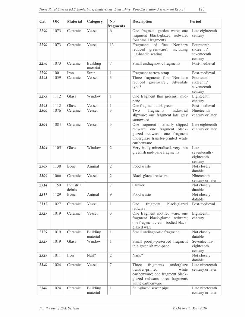
Three Rural Sites at BAE Samlesbury, Balderstone, Lancashire: Post-Excavation Assessment Report 128
For the use of BAE Systems © OA North: May 2010
Cxt OR Material Category Nofragments
Description Period
2290 1073 Ceramic Vessel 6 One fragment garden ware; onefragment black-glazed redware;four small fragments
Late eighteenthcentury
2290 1073 Ceramic Vessel 13 Fragments of fine ‘Northernreduced greenware’, includingjug-handle seating
Fourteenth-sixteenth/seventeenthcentury
2290 1073 Ceramic Buildingmaterial
7 Small undiagnostic fragments Post-medieval
2290 1001 Iron Strap 1 Fragment narrow strap Post-medieval2293 1059 Ceramic Vessel 3 Three fragments fine ‘Northern
reduced greenware’, Silverdaletype?
Fourteenth-sixteenth/seventeenthcentury
2293 1112 Glass Window 1 One fragment thin greenish mid-pane
Eighteenthcentury
2293 1112 Glass Vessel 1 One fragment dark green Post-medieval2300 1076 Ceramic Vessel 3 Two fragments industrial
slipware; one fragment late greystoneware
Nineteenthcentury or later
2304 1084 Ceramic Vessel 3 One fragment internally slippedredware; one fragment black-glazed redware; one fragmentunderglaze transfer-printed whiteearthenware
Late eighteenthcentury or later
2304 1105 Glass Window 2 Very badly mineralised, very thingreenish mid-pane fragments
Lateseventeenth -eighteenthcentury
2309 1138 Bone Animal 2 Food waste Not closelydatable
2309 1066 Ceramic Vessel 2 Black-glazed redware Nineteenthcentury or later
2314 1159 Industrialdebris
7 Clinker Not closelydatable
2317 1129 Bone Animal 9 Food waste Not closelydatable
2317 1027 Ceramic Vessel 1 One fragment black-glazedredware
Post-medieval
2329 1019 Ceramic Vessel 3 One fragment mottled ware; onefragment black-glazed redware;one fragment cream-bodied black-glazed ware
Eighteenthcentury
2329 1019 Ceramic Buildingmaterial
1 Small undiagnostic fragment Not closelydatable
2329 1019 Glass Window 1 Small poorly-preserved fragmentthin greenish mid-pane
Seventeenth-eighteenthcentury
2329 1011 Iron Nail? 2 Nails? Not closelydatable
2340 1024 Ceramic Vessel 7 Three fragments underglazetransfer-printed whiteearthenware; one fragment black-glazed redware; three fragmentswhite earthenware
Late nineteenthcentury or later
2340 1024 Ceramic Buildingmaterial
1 Salt-glazed sewer pipe Late nineteenthcentury or later
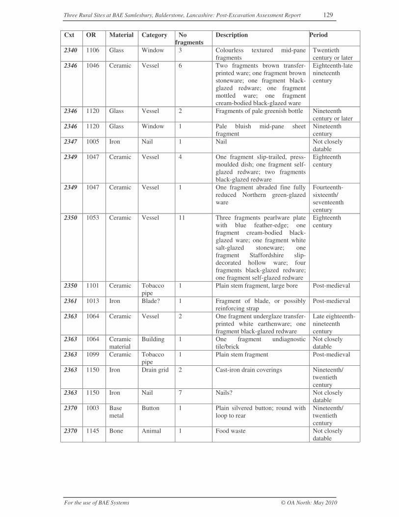
Three Rural Sites at BAE Samlesbury, Balderstone, Lancashire: Post-Excavation Assessment Report 129
For the use of BAE Systems © OA North: May 2010
Cxt OR Material Category Nofragments
Description Period
2340 1106 Glass Window 3 Colourless textured mid-panefragments
Twentiethcentury or later
2346 1046 Ceramic Vessel 6 Two fragments brown transfer-printed ware; one fragment brownstoneware; one fragment black-glazed redware; one fragmentmottled ware; one fragmentcream-bodied black-glazed ware
Eighteenth-latenineteenthcentury
2346 1120 Glass Vessel 2 Fragments of pale greenish bottle Nineteenthcentury or later
2346 1120 Glass Window 1 Pale bluish mid-pane sheetfragment
Nineteenthcentury
2347 1005 Iron Nail 1 Nail Not closelydatable
2349 1047 Ceramic Vessel 4 One fragment slip-trailed, press-moulded dish; one fragment self-glazed redware; two fragmentsblack-glazed redware
Eighteenthcentury
2349 1047 Ceramic Vessel 1 One fragment abraded fine fullyreduced Northern green-glazedware
Fourteenth-sixteenth/seventeenthcentury
2350 1053 Ceramic Vessel 11 Three fragments pearlware platewith blue feather-edge; onefragment cream-bodied black-glazed ware; one fragment whitesalt-glazed stoneware; onefragment Staffordshire slip-decorated hollow ware; fourfragments black-glazed redware;one fragment self-glazed redware
Eighteenthcentury
2350 1101 Ceramic Tobaccopipe
1 Plain stem fragment, large bore Post-medieval
2361 1013 Iron Blade? 1 Fragment of blade, or possiblyreinforcing strap
Post-medieval
2363 1064 Ceramic Vessel 2 One fragment underglaze transfer-printed white earthenware; onefragment black-glazed redware
Late eighteenth-nineteenthcentury
2363 1064 Ceramicmaterial
Building 1 One fragment undiagnostictile/brick
Not closelydatable
2363 1099 Ceramic Tobaccopipe
1 Plain stem fragment Post-medieval
2363 1150 Iron Drain grid 2 Cast-iron drain coverings Nineteenth/twentiethcentury
2363 1150 Iron Nail 7 Nails? Not closelydatable
2370 1003 Basemetal
Button 1 Plain silvered button; round withloop to rear
Nineteenth/twentiethcentury
2370 1145 Bone Animal 1 Food waste Not closelydatable
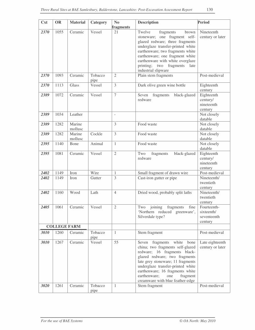
Three Rural Sites at BAE Samlesbury, Balderstone, Lancashire: Post-Excavation Assessment Report 130
For the use of BAE Systems © OA North: May 2010
Cxt OR Material Category Nofragments
Description Period
2370 1055 Ceramic Vessel 21 Twelve fragments brownstoneware; one fragment self-glazed redware; three fragmentsunderglaze transfer-printed whiteearthenware; two fragments whiteearthenware; one fragment whiteearthenware with white overglazeprinting; two fragments lateindustrial slipware
Nineteenthcentury or later
2370 1093 Ceramic Tobaccopipe
2 Plain stem fragments Post-medieval
2370 1113 Glass Vessel 3 Dark olive green wine bottle Eighteenthcentury
2389 1072 Ceramic Vessel 7 Seven fragments black-glazedredware
Eighteenthcentury/nineteenthcentury
2389 1034 Leather - Not closelydatable
2389 1282 Marinemollusc
3 Food waste Not closelydatable
2389 1282 Marinemollusc
Cockle 3 Food waste Not closelydatable
2395 1140 Bone Animal 1 Food waste Not closelydatable
2395 1081 Ceramic Vessel 2 Two fragments black-glazedredware
Eighteenthcentury/nineteenthcentury
2402 1149 Iron Wire 1 Small fragment of drawn wire Post-medieval2402 1149 Iron Gutter 3 Cast-iron gutter or pipe Nineteenth/
twentiethcentury
2402 1160 Wood Lath 4 Dried wood, probably split laths Nineteenth/twentiethcentury
2405 1061 Ceramic Vessel 2 Two joining fragments fine‘Northern reduced greenware’,Silverdale type?
Fourteenth-sixteenth/seventeenthcentury
COLLEGE FARM3010 1260 Ceramic Tobacco
pipe1 Stem fragment Post-medieval
3010 1267 Ceramic Vessel 55 Seven fragments white bonechina; two fragments self-glazedredware; 16 fragments black-glazed redware; two fragmentslate grey stoneware; 11 fragmentsunderglaze transfer-printed whiteearthenware; 16 fragments whiteearthenware; one fragmentcreamware with blue feather-edge
Late eighteenthcentury or later
3020 1261 Ceramic Tobaccopipe
1 Stem fragment Post-medieval
Three Rural Sites at BAE Samlesbury, Balderstone, Lancashire: Post-Excavation Assessment Report 131
For the use of BAE Systems © OA North: May 2010
Cxt OR Material Category Nofragments
Description Period
3020 1274 Ceramic Vessel 6 Three fragments of self-glazedredware; one fragment ?black-glazed redware; one fragmentwhite earthenware; one fragmentindustrial slipware
Nineteenthcentury or later
3020 1256 Glass Window 1 Colourless mid-pane fragment Nineteenthcentury or later
3024 - Ceramic Vessel 1 One fragment black-glazedredware
Late eighteenthcentury or later
3024 1258 Glass Stopper 1 One cast glass bottle stopper Late nineteenthcentury or later
3026 1253 Iron Scissors 1 Small pair scissors Late nineteenthcentury or later
3026 1266 Leather Shoe 1 Not closelydatable
3026 1263 Wood 1 Not closelydatable
3028 1268 Ceramic Vessel 53 Two fragments cream-bodiedblack-glazed ware; 50 fragmentsblack-glazed redware; onefragment creamware
Eighteenthcentury or later
3028 1276 Ceramic Vessel 1 One fragment black-glazedredware
Late eighteenthcentury or later
3028 1257 Glass Vessel 1 One fragment dark olive greenwine bottle with triangular stringrim
Eighteenthcentury
3028 1254 Industrialdebris
1 Small smithing bun?? Not closelydatable
3035 1252 Plastic Comb 1 Plastic folding comb Twentiethcentury
3036 1272 Ceramic Vessel 1 Incompletely reduced green-glazed ware?
Thirteenth-fourteenthcentury
3042 - Ceramic Vessel 2 One fragment black-glazedredware; one fragment self-glazedredware
Eighteenthcentury or later
3043 - Ceramic Vessel 1 One fragment white earthenware Nineteenthcentury or later
3045 1270 Ceramic Vessel 2 One fragment garden ware; onefragment black-glazed redware
Nineteenthcentury or later
3045 1271 Ceramic Vessel 9 Seven fragments whiteearthenware; one fragment whitechina; one fragment self-glazedredware
Nineteenthcentury or later
3045 1271 Ceramic Buildingmaterial
2 Small fragments Nineteenthcentury or later
3045 1255 Glass Vessel 3 One complete brown bottle withcrown cork rim, Northern BottlingCo Ltd, Blackburn; one completebrown bottle with screw threadand composition stopper; onecolourless base
Twentiethcentury
3055 1265 Linoleum
Surface 1 One fragment ?linoleum Twentiethcentury or later
3055 1262 Paper 28 Dry paper Twentiethcentury or later
3055 1264 Rubber Object 1 One fragment rubber - ball? Twentieth
Three Rural Sites at BAE Samlesbury, Balderstone, Lancashire: Post-Excavation Assessment Report 132
For the use of BAE Systems © OA North: May 2010
Cxt OR Material Category Nofragments
Description Period
century or later
Unstratified materialUs 1128 Bone Animal 2 Food waste Not closely
datableUs 1132 Bone Animal 2 Horn core Not closely
datableUs 1139 Bone Animal 1 Food waste Not closely
datableUs 1172 Bone Object 1 Probably bone handle plates for
scale-tang knifeNot closelydatable
Us 1183 Bone Animal 1 Food waste Not closelydatable
Us - Ceramic Buildingmaterial
2 Two fragments white glazed tile Nineteenthcentury or later
Us 1002 Ceramic Closure 1 Codd bottle stopper Late nineteenth-early twentiethcentury
Us 1035 Ceramic Vessel 1 One fragment self-glazed redware Eighteenthcentury or later
Us 1039 Ceramic Vessel 5 Three fragments underglazetransfer-printed whiteearthenware; two fragmentsblack-glazed ware
Eighteenthcentury or later
Us 1039 Ceramic Vessel 1 One fragment very abraded fullyreduced green-glazed ware
Medieval
Us 1040 Ceramic Vessel 5 One fragment cream-bodiedblack-glazed ware; one fragmentearly black-glazed redware; onefragment cream-slipped base; onefragment mottled ware; onefragment brown stoneware
Lateseventeenth-early eighteenthcentury
Us 1043 Ceramic Vessel 2 Two fragments self-glazedredware with slip decoration
Eighteenthcentury or later
Us 1050 Ceramic Vessel 18 Nine fragments black-glazedredware; one fragment cream-bodied black-glazed ware; onefragment garden ware; onefragment mottled ware; twofragments ?yellow ware; twofragments creamware, sponged;two fragments underglazetransfer-printed whiteearthenware
Eighteenthcentury or later
Us 1065 Ceramic Vessel 1 One fragment partially-reducedfine fabric
Thirteenth-fourteenthcentury
Us 1068 Ceramic Vessel 5 Four fragments black-glazedredware; one fragment slip-trailedhollow ware
Lateseventeenth-eighteenthcentury
Us 1068 Ceramic Buildingmaterial
1 One fragment undiagnostictile/brick
Not closelydatable
Us 1075 Ceramic Vessel 12 One fragment slip-trailed ware;six fragments mottled ware; fourfragments black-glazed redware;one fragment self-glazed redware
Eighteenthcentury?
Three Rural Sites at BAE Samlesbury, Balderstone, Lancashire: Post-Excavation Assessment Report 133
For the use of BAE Systems © OA North: May 2010
Cxt OR Material Category Nofragments
Description Period
Us 1075 Ceramic Vessel 2 Two fragments ‘Northern reducedgreenware’
Fourteenth-sixteenth/seventeenthcentury
Us 1085 Ceramic Vessel 8 Five fragments black-glazedredware; one fragment underglazetransfer-printed whiteearthenware; one fragmentpearlware blue feather-edge; onefragment blue and whiteware
Eighteenthcentury or later
Us 1097 Ceramic Tobaccopipe
2 Plain stem fragment Post-medieval
Us 1226 Ceramic Vessel 29 Six fragments green-slippedvessel, two fragments blue-bodiedvessel; seven fragments blue andwhite slip-decorated ware; fivefragments internally-slippedredware; nine fragmentsunderglaze transfer-printed whiteearthenware, Asiatic C pattern;one fragment white earthenwareplate with blue-feather edge; onefragment late grey stoneware; twofragments china, blue underglazedecoration with red-paintedoverglaze; two white earthenwarebases
Nineteenthcentury or later
Us 1233 Ceramic Vessel 18 Ten fragments self-glazedredware; two fragments black-glazed redware; four fragmentsunderglaze transfer-printed whiteearthenware; one fragmentindustrial slipware, one fragmentblue-painted white earthenware
Late eighteenth-nineteenthcentury
Us 1259 Ceramic Tobaccopipe
3 Stem fragments Post-medieval
Us 1269 Ceramic Vessel 39 Seven fragments black-glazedredware; one fragmenT cream-bodied black-glazed ware; onefragment self-glazed redware; twofragments late stoneware; onefragment creamware; threefragments china; 24 fragmentswhite earthenware, includingunderglaze transfer-printed
Late eighteenth-nineteenthcentury
Us 1002 Copperalloy
Sheet 1 Fragment of thin sheet Not closelydatable
Us 1177 Copperalloy
Tool? 1 Modern composition handle oncopper-alloy bar
Modern
Us 1124 Glass Vessel 1 Dark olive green wine bottle,neck fragment
Lateseventeenthcentury
Us 1158 Industrialdebris
1 Fuel-ash slag Not closelydatable
Us 1002 Iron Wire 1 Fragment of wire Not closelydatable
Three Rural Sites at BAE Samlesbury, Balderstone, Lancashire: Post-Excavation Assessment Report 134
For the use of BAE Systems © OA North: May 2010
Cxt OR Material Category Nofragments
Description Period
Us 1190 Iron Blade 1 Large semi-circular blade Not closelydatable
Us 1143 Marinemollusc
Oyster 2 Food waste Not closelydatable
Us - Mortar Buildingmatieral
2 Two small fragments paintedmortar
Nineteenthcentury or later
Three Rural Sites at BAE Samlesbury, Balderstone, Lancashire: Post-Excavation Assessment Report 135
For the use of BAE Systems © OA North: May 2010
APPENDIX 4: TIMETABLE FOR PROJECT STAGE 3, ANALYSIS,PUBLICATION AND ARCHIVING
The timetable for each of the tasks listed in Table 4 and explained in Section 7is presented on the following gantt chart.

ID Task Name Duration Start1 1 Management 149 days Mon 05/07/10
2 1.1 Management, liaison and review 149 days Mon 05/07/10
3 1.1 Management, liaison and review 149 days Mon 05/07/10
4 1.2 Project Briefing 1 day Mon 05/07/10
5
6 2 Documentary research 20 days Tue 06/07/10
7 2.1 Examine sources relevant to the Samlesbury sites 10 days Tue 06/07/10
8 2.2 Identification and consultation of general literature on medieval and post-medieval rural and agrarian history, 5 days Fri 23/07/10
9 2.3 Find comparative sites 5 days Tue 03/08/10
10
11 3 Stratigraphic analysis 25 days Wed 11/08/10
12 3.1 Assimilation of spot dates & strat, testing relationships, attribution of feature and structures groups20 days Wed 11/08/10
13 3.2 Production of detailed and closely dated phasing 5 days Tue 14/09/10
14
15 4 Artefactual analysis 15 days Wed 11/08/10
16 4.1 Detailed analysis of selected artefactual material 5 days Wed 11/08/10
17 4.2 Catalogue artefacts, retention or disposal 5 days Thu 19/08/10
18 4.3 Comparative analysis 5 days Fri 27/08/10
19
20 5 Integrated analysis 36 days Thu 23/09/10
21 5.1 Id & interpret activity zones; building/room functions 6 days Thu 23/09/10
22 5.2 Identification of patterns of use and spatial relationships within and between buildings/yards6 days Tue 05/10/10
23 5.3 Identification of the economic basis during each phase 6 days Fri 15/10/10
24 5.4 Identification of the status of the occupants during each phase 6 days Wed 27/10/10
25 5.5 Identification of associated field systems and areas of exploitation 6 days Thu 04/11/10
26 5.6 Comparative analysis 6 days Tue 16/11/10
27
28 6 Report production and archive submission 67 days Fri 26/11/10
29 6.1 Assemble and edit specialist reports 3 days Fri 26/11/10
30 6.2 Compile archive report 20 days Fri 26/11/10
31 6.3 Prepare illustrations for archive report 10 days Fri 26/11/10
32 6.4 Edit report 10 days Mon 10/01/11
33 6.5 Corrections 5 days Wed 26/01/11
34 6.5 Corrections 2 days Wed 26/01/11
35 6.6 Copy-editing 2 days Wed 26/01/11
36 6.7 QA 20 days Mon 31/01/11
37 6.8 Prepare archive of primary fieldwork records 5 days Mon 07/03/11
38 6.9 Prepare artefactual archive, dicard and retention 2 days Tue 15/03/11
39 6.9 Prepare artefactual archive, dicard and retention 2 days Fri 18/03/11
40 6.10 Submit finds and paper archive to museum 2 days Wed 23/03/11
41 6.10 Submit finds and paper archive to museum 2 days Fri 25/03/11
42 6.11 Submit archive report and summary of the archive to the HER and LRO2 days Wed 30/03/11
SR
RN
SR
JB
JB
JB
JB
JB
CHD
CHD
CHD
JB
JB
JB
JB
JB
JB
SR
JB
MR
SR
JB
MR
SB
RN
JL
SB
CHD
JL
SB
SR
31/05 14/06 28/06 12/07 26/07 09/08 23/08 06/09 20/09 04/10 18/10 01/11 15/11 29/11 13/12 27/12 10/01 24/01 07/02 21/02 07/03 21/03 04/04June July August September October November December January February March April
Task
Split
Progress
Milestone
Summary
Project Summary
External Tasks
External Milestone
Deadline
Page 1
Project: samlesbury analysis gantt2Date: Fri 28/05/10
Three Rural Sites at BAE Samlesbury, Balderstone, Lancashire: Post-Excavation Assessment Report 136
For the use of BAE Systems © OA North: May 2010
ILLUSTRATIONS
FIGURES
Figure 1: Site location
Figure 2: Yates’ map of 1786
Figure 3: Ordnance Survey first edition map, 1849 (1:10,560)
Figure 4: Ordnance Survey map, 1893 (1:2500)
Figure 5: Ordnance Survey map, 1913 (1:2500)
Figure 6: Map of proposed new road (A59), c 1925
Figure 7: Pepper Hill, overall plan
Figure 8: Pepper Hill, Buildings B and C
Figure 9: Pepper Hill, Building D
Figure 10: Pepper Hill, Buildings E and F
Figure 11: General plan of College Croft
Figure 12: College Croft, detailed plan of Buildings G, H, I and J
Figure 13: College Croft, detailed plan of Buildings K, L and M
Figure 14: College Croft, detailed building plan of College Farm
Figure 15: College Farm, detailed plan of Building O
PLATES
Plate 1: Photograph reputed to be of Building N at College Farm, taken c 1939(Reproduced by permission of Lancashire County Library and Information Service)
Plate 2: Pepper Hill photographed c 1939, showing Building C in the foreground andBuilding D in the background, to the right (Reproduced by permission of LancashireCounty Library and Information Service)
Plate 3: Photograph of Building J at College Croft, taken c 1939 (Reproduced bypermission of Lancashire County Library and Information Service)
Plate 4: The southern portion of Building A, Pepper Hill, viewed toward the north-west (Phase 2)
Plate 5: Buildings B and C at Pepper Hill, viewed toward the south-east
Three Rural Sites at BAE Samlesbury, Balderstone, Lancashire: Post-Excavation Assessment Report 137
For the use of BAE Systems © OA North: May 2010
Plate 6: Building B at Pepper Hill; Hearth 2013, to the left of wall 2006, the west wallof the cross-passage in the Phase 3 house
Plate 7: The cellar within Building C at Pepper Hill, viewed toward the north-east
Plate 8: The barn (Building D) at Pepper Hill, looking toward the north-east, with thePhase 3/4 remains in the foreground
Plate 9: Building D at Pepper Hill; Phase 3/4 foundations for wall 2192, viewedtoward the west
Plate 10: Building D, Pepper Hill; part of the Phase 5 western extension
Plate 11: Building D at Pepper Hill; reused pivot stone within wall 2380
Plate 12: Building E at Pepper Hill, looking toward the north-east
Plate 13: Wooden trough (2241) adjacent (east) to Building E at Pepper Hill, facingnorth-east
Plate 14: Wall 2327 of Building F at Pepper Hill, facing north-west
Plate 15: College Croft, Building H, Phase 3 wall (1085) looking south-west
Plate 16: Building H at College Croft; robber trench 1041 cut by later garden wall1195/1198, looking north-east (Phase 3/4)
Plate 17: Wall 1040/1195/1197/1198 originally formed the south-west wall ofBuilding H at College Croft, but was later used as the Phase 5 garden wall (facingsouth-east)
Plate 18: Phase 6 cobbled surface 1147 at College Croft, with the north-west wall(1062) of the house to the right (looking south-east)
Plate 19: Probable circular flower bed or garden feature 1045 at College Croft (Phase4)
Plate 20: Phase 5 brick pathway 1137, lying below later walls 1127 and 1128, withinRoom 18 at College Croft; looking south-west
Plate 21: Room 8 in Building J at College Croft, with fireplace 1071 in thebackground and earlier culverts 1032, right, and 1046; looking south-west
Plate 22: The north-east dwelling, Building J at College Croft, looking south-west andshowing Phase 6 Rooms 3, 5 and 6 in the foreground
Plate 23:Room 11 of Building J’s central dwelling at College Croft (foreground), andRooms 9 and 8, and 5-7 of the north-east dwelling (background). Walls 1055 and1085 of earlier Building H are to the right and left of the ranging rods
Plate 24: The outshut for the north-east dwelling of Building J at College Croft;looking west
Three Rural Sites at BAE Samlesbury, Balderstone, Lancashire: Post-Excavation Assessment Report 138
For the use of BAE Systems © OA North: May 2010
Plate 25: Phase 8 brick trackway 1035/1134, overlying the levelled remains ofCollege Croft
Plate 26: Remains of Building N at College Farm; 3020, to the left, with the porch,3021, to the right; viewed from the east
Plate 27: The heavily truncated remains of Building P at College Farm, withdemolition pit 3046 in the foreground, looking north-east
Plate 28: Stone-built drain 3044 at College Farm, looking west
Plate 29: Remains of Building O at College Farm, looking west
Plate 30: Building Q at College Farm, with Rooms 3024 (pigsty) and 3025, lookingsouth-west
Plate 31: Cobbled surface 3018 (foreground) and 3019 between Buildings O (left) andQ (right) at College Farm; looking north-east
Plate 32: Tank 3026 at the north-west end of Building Q at College Farm; looking east
Plate 33: Trackway 3002, over the demolished remains of College Farm; lookingnorth-west
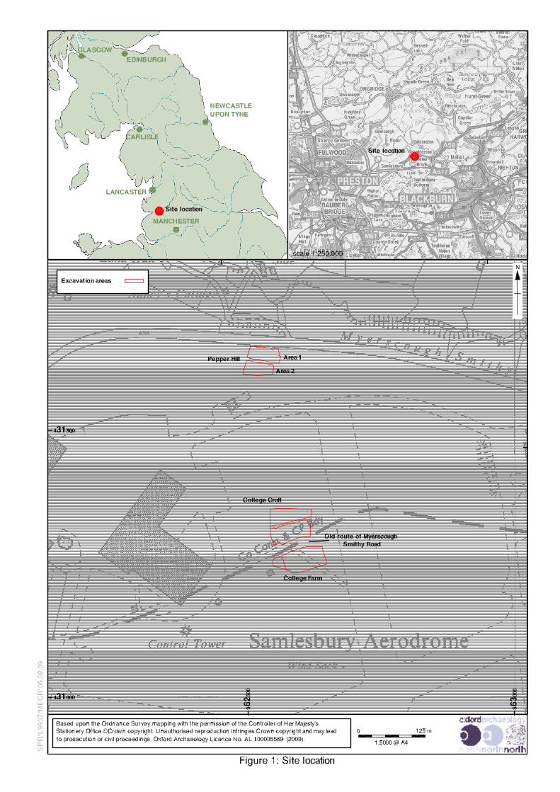
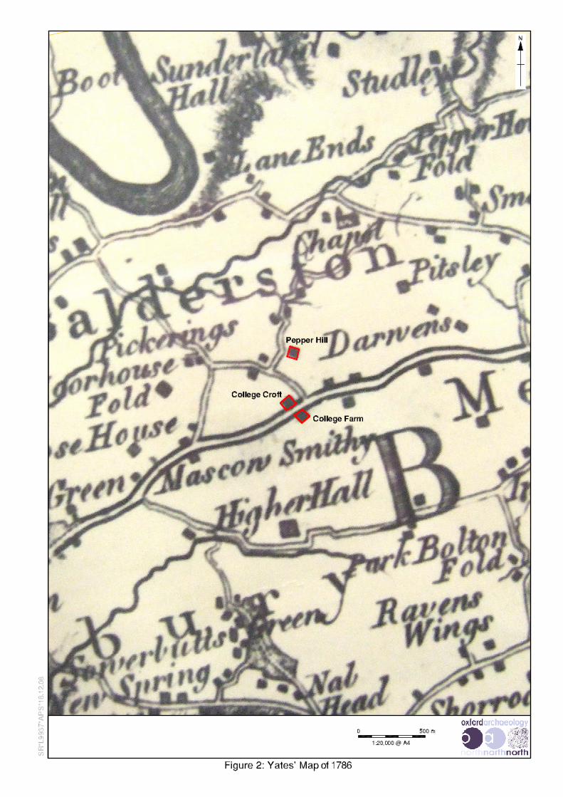
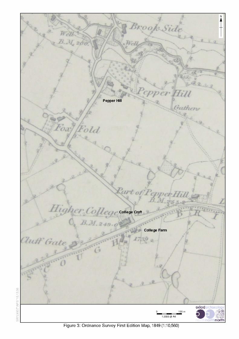
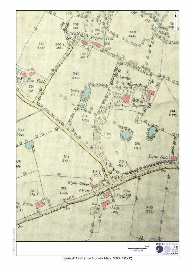


![1374 bae[1]](https://img.pdfslide.us/doc/110x75/5590c45a1a28ab9d718b45d3/1374-bae1.jpg)