Embed Size (px)
Citation preview

‘‘This is our land’’: collective violence, property law, andimagining the geography of Palestine
Gary Fields*
Department of Communication, University of California San Diego, USA
This study seeks to explain the origins of two types of violence
occurring on the Palestinian landscape, the erasure of Palestinian
farms and the demolition of Palestinian homes. Such violence has two
sources. One source derives from an enduring practice of meaning-
making about geographical places that has inspired groups with
territorial ambitions to seize control of the landscapes they covet and
is referred to by Edward Said as the crafting of ‘‘imaginative
geographies.’’ The second source focuses on changes in property
rights that follow when groups with territorial ambitions succeed in
seizing control of coveted land. It is the imagined geography of
Palestine as a homeland for the Jewish people, first framed by
Zionists of the late 19th century and absorbed into the practices of
Israeli state-building, and the changes in property rights inscribed
into the Palestinian landscape following Zionist and Israeli military
conquests in 1948 and 1967, that lie at the core of violence directed
against the Palestinian farm and home today. This process of
imagination, legal transformation, and violence is part of a long-
standing lineage of dispossession that includes the English enclosures
and the taking of land from Amerindians on the Anglo-American
colonial frontier.
Keywords: imaginative geography; property rights; violence;
Palestine; dispossession; landscape
In a seminal account of the origins and nature of property, Carol Rose
argues that rights to property derive fundamentally from powers of
persuasion, that is, the power of property owners to gain consent from the
general population on notions of possession and exclusion. According to
Rose, violence plays only a supporting role in upholding property rights
and occurs only when powers of persuasion about rights of possession and
exclusion become weakened and break down. Thus for Rose, ‘‘force and
violence are the nemesis of property,’’ their use signaling that the property
system itself is faltering (Rose 1994, p. 296).
*Gary Fields is Associate Professor in the Department of Communication,
University of California San Diego, 9600 Gilman Drive, La Jolla, CA 92093.
Phone: (858) 534-4410. Email: [email protected]
Journal of Cultural Geography
Vol. 00, No. 00, Month 2012, 1�25
ISSN 0887-3631 print/ISSN 1940-6320 online
# 2012 JCG Press, Oklahoma State University
http://dx.doi.org/10.1080/08873631.2012.726430
http://www.tandfonline.com

While this argument is convincing for describing the routines of
established property systems, it overlooks historical instances of property
formation marked by conflict in which the law enables one group of
people to seize control of land from another. When English estate owners
appealed to common law to enclose land used by their tenant farmers as acollective resource, the law operated not as means of persuasion but as a
blunt instrument preventing tenants from exercising their rights to graze
livestock and gather food and fuel on common property. By this measure,
the law performed violently not by meting out bodily punishment on
tenant farmers in the manner made famous by Foucault in the opening
pages of Discipline and Punish. Instead, the law unleashed its violence by
excluding tenants from use rights on common land thereby separating
tenants from their means of subsistence. Violence thus resulted in this casefrom the power of the law to reorder lines of ownership and trespass on
the land.
At the same time, there is a more bodily type of violence connected to
property law focusing on the law’s enforcement power. When English
commoners resisted the elimination of customary rights imposed by the
Black Act (1723) and continued to take wood for fuel and hunt small
game on common land, the law unleashed this more corporeal type of
force by empowering authorities to spirit resisters from the areas oftrespass into prisons (Thompson 1975). Such cases reveal how property
law inflicts violence directly on the person by enabling authorities to
remove trespassers from areas demarcated by the law as exclusionary. In
this sense, it is appropriate to link property law not only with violence
associated with a realignment of the landscape, but also with ‘‘corporeal
violence’’ (Blomley 2003, p. 123). In both cases, however, the law renders
its violent impacts on human actors by reordering geographical land-
scapes, that is, by redistributing people and partitioning territorial space.1
There is yet a very different way of conceiving the interplay of property
law and violence in which the latter emerges from a cultural environment
reshaped by a shift in the legal system of property ownership. One of the
most compelling examples of this culturally-mediated route from the law
to violence occurred in the aftermath of the landmark Supreme Court
decision in Johnson v. M’Intosh (1823) which abrogated notions of Indian
property ownership and transformed Indians into a new legal status as
‘‘tenants at will’’ (Robertson 2005). What emerged as a cultural artifact ofthe decision, however, helps explain some of the subsequent violence
against Indians, notably in Georgia where land conflict between settlers
and Indians was especially intense. By overturning a longstanding colonial
legal culture conceding Indian ownership of land (Banner 2005), and by
redefining Indians as transient occupants, the law enhanced a culture of
intolerance toward Indian property rights and presence on the landscape.
In this environment, ‘‘Indian-hating mobs’’ in Georgia engaged in
widespread vigilantism against Cherokees and Creeks, burning Indian
2 G. Fields

crops and homes while government officials looked the other way (Cave
2003, p. 1337). Though not inflicted directly on the body, this legally-
inspired violence reconfigured the geography of Indian bodies as
terrorized Indians removed themselves from the landscape and made
their way West. Thus, the legal environment post Johnson promoted aculture of entitlement among settlers seeking the land of Indians whose
continued presence and circulation on the landscape precluded settlers
from accessing what they believed was legally*and morally*theirs. In
this way, violence against Indian homes and crops functioned as a type of
‘‘spatial fix’’ realigning Indian bodies on the landscape in accordance with
the way settlers understood the landscape’s new legal geography.2
A model of law, culture, and violence
Drawing from this culturally-mediated route from property law to
violence, along with the violence of law in realigning landscapes, this
study seeks insight into a particularly macabre type of violence occurring
on the Palestinian landscape. On any given day, this landscape bears
witness to the organized demolition of Palestinian homes, and the
destruction of crops on Palestinian farms; violence that might otherwise
be considered depraved but is shocking only because it has become so
normal and routine (Munayyer 2012). By merging insights from criticallegal geography about the violence of property law with insights from
cultural geography about the way groups with territorial ambitions
imagine landscapes, this article uncovers two sources to explain the
motivations for the destruction of crops and the demolition of homes on
the Palestinian landscape today.
On the one hand, violence against Palestinian farms and homes
derives from a longstanding practice of meaning-making about geogra-
phical places that has enabled groups with territorial ambitions to takepossession of, and remake territorial landscapes. This practice of
constructing alternative representations of places is what Edward Said
referred to as the crafting of ‘‘imaginative geographies’’ (Said 2000).
According to Said, imagining geography is an ideological process initiated
by groups seeking territory who reinvent meanings about the landscapes
they covet, and frame arguments justifying why they are entitled to
assume sovereignty over the territorial landscapes they discursively
reinvent. For Said, this notion of inventing meanings about covetedlandscapes provided a theoretical starting point for understanding the
phenomenon of empire-building and the taking of land from others.
The second source of the violence directed at Palestinian farms and
homes derives from the way groups with territorial ambitions implement
their imagined geographical visions. Such groups use property law as an
instrument of force to assume control of the landscapes that they have
re-imagined. Changes in property law, however, have a dual set of impacts
Journal of Cultural Geography 3

on the landscape, one immediate and dramatic, the other more subtle and
cultural. The most immediate impact of a change in the system of
property law is to transfer land from one group to another by redrawing
the boundary lines of land ownership and enforcing those reconfigured
boundaries. Violence in this sense corresponds to dispossession thatoccurs when lines of ownership and trespass are redrawn on territorial
landscapes. At the same time, when landscapes are reordered by new
systems of property rights and land passes to different owners and
stewards, the legal environment facilitating this land transfer promotes
certain cultural understandings of who rightfully belongs on the land and
who are transgressors. In the Palestinian context, the new legal landscape,
born from Zionist domination on the land, reinforced the very same
Zionist imagined geography that gave rise to the seizure of land in the firstplace. Thus, the legal environment of property rights in Palestine reveals
two routes to the violence against Palestinian farms and homes. One route
is direct in which Palestinians have been separated from their farms and
homes by the redrawing of property lines on the landscape. The other
route is more subtle in which a changing set of property laws has spawned
a culture of hostility to Palestinian presence and circulation with the end
result assuming the form of assaults upon the anchors securing
Palestinians to the landscape.It is the imagined geography of Palestine as a Jewish landscape that is
the starting point for understanding the violence against Palestinian
homes and farms today. Although a recurrent theme in Jewish collective
memory, this imagined vision of the Palestinian landscape gathered
momentum from late 19th century Zionism but incorporated an older
legal discourse originating in the 16th century and later synthesized by
John Locke (1980 [1690]) about rights to land. Emphasizing how rights to
landed property accrue to those making improvements to land, thisdiscourse articulated by Locke rested on three propositions. First, Locke
insisted that rights to land derived not from the arbitrariness of inherited
social rank but instead from the rational notion of one’s capacity to
improve land through labor. Second, Locke argued that rights to land
corresponded to specific plots of ground thereby recasting land into a
thing capable of being possessed like other so-called ‘‘moveable’’ items.
Finally, Locke insisted that this improvement- and labor-driven right to
plots of the earth was part of divine intent since it was God whocommanded humans to work, improve, and take possession of land for
their livelihood and sustenance. Ultimately, however, Locke conceded that
taking possession of land through improvement depended on the land in
question being ‘‘empty,’’ in effect, terra nullius (Fitzmaurice 2007).
From this improvement-driven, territorially-based, and God-sanctified
notion of property rights, Zionists, in the spirit of English estate owners
and Anglo-American colonists influenced by legal notions of terra nullius,
uncovered arguments for staking claims on, and remaking seemingly
4 G. Fields

unimproved, ‘‘empty’’ territorial landscapes. Indeed, early Zionists
referred to Palestine as a barren land destined to be improved not just
by labor, but by Jewish labor, and thus forged links to the lineage of Locke
in which Locke’s improvement-driven cultivator found a kindred spirit in
the modern Zionist farmer-pioneer (Braverman 2009). As the Palestinianlandscape was being reinvented, Palestinians emerged in the Zionist
imagination as trespassers on land that they had cultivated for centuries.
Nevertheless, a gap persisted that separated the Zionist imagination from
what Zionists actually confronted*Palestinian presence on the land.
What emerged to reconcile and ‘‘fix’’ the imagined geography of Zionism
with the reality on the landscape was the power of law.
Following creation of Israel in 1948, Zionists used the law, both inside
the new state and later in the Occupied Territories, to reclassify andtransfer landed property from Palestinian to Jewish owners enabling the
landscape to conform to their vision of it as Hebrew land (Falah 2003;
Forman and Kedar 2004). This change in the system of property law,
however, not only expanded the inventory of land in Jewish hands. It
provoked a cultural shift among the Jewish population reinforcing the
imagined geography that motivated Zionists in the first place to covet and
seize Palestinian territory. At the core of this cultural shift was a hardened
antipathy for Palestinian presence on the supposedly Jewish landscape.It is this imagined vision of Palestine as Hebrew land, and the property
laws implemented from this vision, that have motivated the violence
targeted at the anchors*farms and homes*securing Palestinians to the
landscape both inside Israel and in the Palestinian West Bank. Such
violence, in turn, has a corporeal dimension. The aim of this violence is to
reorganize the patterns of Palestinian presence and mobility on the
landscape by seeking to convince the Palestinian cultivator and
the Palestinian homeowner that their tenure on the landscape throughthe planting of crops and the construction of homes is untenable. Similar
to the violence directed against Cherokees and Creeks, and English
commoners, the violence against Palestinian homes and farms aims at
reconstituting the spatial patterns of demography on the landscape. An
imagined geography of Palestine has thus enabled Zionists and their
descendants to conceive of Palestine as ‘‘our land,’’ and to remake it in
accordance with this imagined vision.
This article explains the route to the destruction of Palestinian homesand farms by focusing on the relationship of imagined landscapes to the
creation of new systems of property rights on land, and the cultural
environment created when laws of property change and land transfers to
new owners. It reveals how a venerable discourse about the virtues of
improving empty land converged with a Zionist discourse about God-
given rights to the land of Palestine that enabled Zionists to imagine
themselves as the legitimate masters and stewards of the Palestinian
landscape. The article goes on to show how this imagined geography was
Journal of Cultural Geography 5

embedded in Zionist efforts to recast laws of property in Palestine. This
shift in the system of property ownership not only enabled land to change
hands from Palestinians to Jewish owners. The legal landscape imple-
mented by Zionists helped reshape a Jewish cultural environment such
that Palestinian presence on, and belonging to the landscape wasde-legitimized. Built from imagined territorial visions, the legal environ-
ment of property rights and the cultural landscape deriving from it have
spawned the violence against key foundations of Palestine society, the
farm and the home.
What follows is a theoretically-informed empirical argument of how
the destruction of Palestinian farms and homes is part of a pattern of
imagination and dispossession in which groups seeking territory invent
meanings about the landscapes they covet, and enlist the law and overtforms of violence to make the landscape conform to their imagined
visions. It draws upon insights from critical legal geography about the
violence of property law but extends this literature in a new direction in
ascribing cultural spillovers to the implementation of new systems of
property rights, and linking violence to the cultural impacts of new legal
regimes.3 At the same time, this study seeks to explain the cultural origins
of new systems of property law by situating Edward Said’s concept of
imaginative geography into an empirical setting of dispossession on thePalestinian landscape. In effect, this study crafts an argument about the
violence of property law by exploring both its legal and cultural impacts in
seeking to explain a very visible phenomenon on the Palestinian landscape
today.
Methods
Methodologically, this article draws from author interviews with settlers
and Palestinians whose farms and homes have been damaged ordestroyed, and from direct observations of these incidents and their
imprints on the landscape from 2004�2012. Interviews for this article are
part of the fieldwork for a book in progress on dispossession in Palestine
and were conducted in accordance with provisions of the University of
California, San Diego Human Subjects Protocol. These interviews,
undertaken from 2004�2012, focus on the experiences of Palestinians
who have lost farmland or homes due to incursions by actors associated
with the state of Israel. Beginning in 2005 but mostly in the last two years,however, I have also interviewed Israeli settlers in the West Bank. Owing
to the challenges of doing this fieldwork in an environment riven with
conflict, it was necessary to cultivate networks of contacts for each
constituency in order to locate and gain access to potential interviewees. I
received help at the outset from two organizations, Faculty for Israeli
Palestinian Peace (FFIPP), and from the Applied Research Institute of
Jerusalem (ARIJ). Through subsequent visits to the region, I used the so-
6 G. Fields

called, ‘‘snowball’’ technique to expand the network of organizations and
individuals who were able to assist me in gaining access to interviewees.
On the Palestinian side, I obtained interviews in four major ways.
First, from the contacts I cultivated, I obtained introductions to mayors of
Palestinian towns who would tell me about constituents who had lostcrops, land, or homes. I would then interview these individuals usually for
one to two hours which would include visits to sites of the land in
question. Using this method, I interviewed individuals from Husan and
Marda described below. Second, on the recommendation of contacts, I
spent extended periods of time in particular villages where state or settler
violence was known as a daily occurrence. In these places, I met
individuals who told me of how they lost crops and land as was the
case for interviewees in this article from Iraq Burin and Jayyous. Third, asI travelled through West Bank villages, I heard stories about individuals
who lost land or a home and went into the town where they lived. I asked
people where I could find the person in question and people from the
town would take me there. In this way, I was able to interview Tony H.
from Beit Jala. Finally, I was able to interview Salim S. about the
demolitions of his home in Anata as a result of an introduction from the
Israeli Committee Against House Demolitions (ICAHD).
Almost all of these interviews with Palestinians were with men.Cultural factors account in large part for this imbalance. Most of these
interview subjects dealing with violence against crops and farms live in
remote agrarian areas where social customs are conservative and where it
would be awkward for a stranger (and a male) to speak directly with a
woman.
The settler interviews relied far less on the technique of snowballing
although it did prove helpful. The difficulty with settlers and the reason
that they are not given quite as a prominent a voice in this article is thatthey are often reluctant to speak with academics and foreigners. Never-
theless, I was successful in making a cold contact with Ron Nahman, the
mayor of Ariel who spoke with me for roughly four hours explaining his
views about Ariel and the settlement project. After Ron Nahman, I was
able to interview a very well-known settler from Kedemim, and this
contact enabled me to interview other settlers from Efrat, and the leader
of a settler organization in East Jerusalem. For the interviews in Yitzhar,
however, I was not able to rely on contacts nor was I able to rely on helpfrom the Yesha Council, the umbrella organization for Israeli settlers,
which claimed that it would be too dangerous for me to go there and
interview those residents. I therefore decided to go on my own. I found the
name of a resident there who had advertised on the Yesha Council website
and contacted her to see if she would talk to me. Mayyaan, the settler
from Yitzhar interviewed in this article, agreed. I interviewed her and her
family for an entire afternoon (They asked me at the very beginning
whether I was Jewish and I told them the truth that I was.). They assumed
Journal of Cultural Geography 7

a friendly demeanor toward me and insisted that I stay the afternoon for
lunch. When I tried to ask a question about settler violence from Yitzhar
against nearby Palestinians, she and the family were evasive and suggested
that any violence was precipitated by Palestinians, and that settlers were
simply defending themselves and their land. In sum, these interviews aimat documenting perceptions and experiences about land and belonging
from the perspective of both Israeli settlers and Palestinians.
Re-imagining the Palestinian landscape
In the late 1920s, the Jewish National Fund (JNF), the lead agency for
land purchases in Palestine for the Zionist movement, commissioned a
series of maps aimed at disseminating a representation of Palestine to its
own constituents and the rest of the world. In these maps, Palestine isrecast as an area of Jewish settlement in an otherwise empty geographical
space. In 1934, the JNF decided to use one of these maps on the most
recognizable symbol of Zionist efforts to raise money for the purchase of
land and promote Jewish settlement of Palestine, the celebrated ‘‘Blue
Box’’ (Figure 1). In representing Palestine as Jewish and erasing any
indication of an Arab presence from this territory, the map revealed how
Zionists imagined the land of Palestine. ‘‘This is our land’’ is the message
represented on the Blue Box (Bar-Gal 2003, p. 137). At the same time, themap provided a cartographic narrative of the Zionists’ core aim of
redeeming Palestine, that is, remaking a fundamentally Palestinian
landscape and replacing it with a landscape Jewish in character (Falah
1989).
As a project of land redemption, Zionism elevated the idea of
landscape in crafting an imagined vision of Palestine that equated the
landscape’s natural attributes with a Jewish identity (Eisenzweig 1981). By
associating the natural landscape with a historically longstanding Jewishattachment to the land, Zionists essentially remade Palestinians as
unnatural ‘‘others;’’ trespassers who did not belong on the land
(Abu El-Haj 2001). It was Theodor Herzl who played a pivotal role in
helping promote this imagined geography.
Insisting that only a state of their own would enable Jews to escape anti-
Semitic prejudice, Herzl nevertheless argued his case for a solution to the
Jewish question in a discourse of development and modernization while
deliberately diminishing Palestine’s existing inhabitants. In his mostcelebrated work, The Jewish State (1896), In his most celebrated work,
The Jewish State (1896), Herzl makes only a fleeting reference to Palestine’s
‘‘native population’’ despite a passage the previous year from his own
Diaries dated June 12, 1895 where he writes about the need to ‘‘spirit away
the penniless [Palestinian] population’’ to make way for the Jewish state
(Herzl 1960, p. 88). By the end of the decade, in an article entitled
‘‘Zionism’’ (1899), Herzl was emphasizing the uncultivated character of the
8 G. Fields

Palestinian landscape as the basis for Jewish statehood, depicting Palestine
as a land ‘‘poor and neglected; [where] the slopes of the hills are bare. . . and
the fields lie fallow’’ (quoted in Eisenzweig 1981, p. 282). For Herzl, the
commitment of Jewish settlers to improve a barren landscape conferred
upon Zionists a right to Palestinian land. This imagined space*uncultivated and emptied of otherness*became the embodiment of Jewish
aspirations. Yet, even with the large influx of Jewish immigrants in the
decades after Herzl, Palestine by the late 1930s still presented Zionists with
a fundamental dilemma. It was still 75% Arab.
What eventually emerged within Zionism for solving this problem
drew upon notions of force developed by the Zionist, Ze’ev Jabotinsky in
his Iron Wall (1923), coupled with the idea of removing the Arab
population from Palestine to make way for Jewish statehood (Shlaim
Figure 1. The Blue Box ca. 1936. Reproduced by permission of Sydney Jewish
Museum.
Journal of Cultural Geography 9

2001). In fusing the ideas of force and ‘‘transfer,’’ the figure of David
Ben-Gurion played a pivotal role. Initially opposed to the removal of
Arabs from Palestine, Ben-Gurion emerged by the late 1930s among a
cadre of Zionist leaders willing to support the idea to realize Jewish
sovereignty on Palestinian land (Morris 2001). Zionists thus came toembrace visions of a territory absent Palestinians that could be realized by
forcibly removing this population in order to promote the creation of a
Jewish state (Masalha 1992).
A landscape recast by law
Owing to the outcome of the war of 1948*what official Israeli history
refers to as the War of Independence when the state of Israel was born, and
what Palestinians refer to as the catastrophe or Naqba*the Jewishcommunity (Yishuv) was able to implement its vision of a Jewish
landscape on roughly 78% of historic Palestine. In the war’s aftermath,
the new state established a legal process for appropriating abandoned
Palestinian property and reallocating it for new Jewish settlement (Falah
2003; Forman and Kedar 2004). Central to this process was the creation
of state land from so-called ‘‘absentee property’’ which made permanent
the transfer to the state of privately-owned land and property belonging to
Palestinians before the conflict. In addition to targeting abandonedproperty for transformation into state land, Israel by the early 1960s was
also targeting the land of Palestinian villages that remained inside the new
state. The instrument used for this purpose was Article 78 of the Ottoman
Land Law of 1858 retained by the British in the Mandate period from
1917 to 1948 and kept in place by the new state after 1948 but
reinterpreted by Israeli authorities in a novel way.4 Under the Ottomans,
this law enabled Palestinian farmers to obtain title to the land they
cultivated but gave Ottoman rulers the right to tax it. Israeli lawyersinverted the logic of this law, however, in seeking the absence of cultivation
to seize land for state purposes, declaring land to be without ownership if
cultivation failed to cover 50% of the land surface. In this way, Israel used
a legal tool to create public land for Jewish settlement even when the land
was being cultivated by Palestinians inside Israel but judged by Israeli
authorities to be below the 50% threshold. From these legal practices of
creating state land where Palestinians once had ownership rights, some
700 new Jewish settlements were built reflecting the realization of animagined landscape evolving for decades within the Zionist movement
(Falah 1996).
Since 1967, the state of Israel has initiated a settlement program in
Occupied Palestine similar to its settlement project inside Israel in which
the law plays a decisive role (Shafir 1996). Unlike in Israel, however,
authorities in Occupied Palestine did not have an inventory of abandoned
property as a foundation for creating state land. For this reason, they
10 G. Fields

relied more heavily on Article 78 as a legal tool for registering land in
Occupied Palestine as ‘‘public,’’ and reallocating it for Israeli settlements
(Forman 2009). In effect, a legal doctrine imported from Israel enabled
Israeli authorities in Occupied Palestine to seize land owned and used by
Palestinians for transformation into state land and Israeli settlement.As an instrument for creation of state land and construction of Jewish
settlements both inside Israel and in the Occupied Territories, the law has
engendered violence by realigning lines of ownership and trespass on the
landscape, dispossessing Palestinians and separating them from their
means of earning a living. At the same time, this legal environment has
made possible a more brazenly violent assault on Palestinian homes and
farms under the guise of administrative routine. By promoting the
expansion of Jewish territorial spaces and restricting the territorial spacesof Palestinians, the law transforms ‘‘nonconforming’’ patterns of presence
and mobility on the landscape into enforcement problems. In this way, the
law has normalized the demolition of Palestinian homes and the
destruction of Palestinian farms and has empowered certain state
agencies*supported by the army and police*to act as actual demolition
crews in enforcing the law’s trespass provisions.
At the same time, this legally inspired violence against Palestinian
homes and farms has spawned a subtle but no less powerful form ofviolence against the anchors securing Palestinians to the landscape. What
has emerged from the legalized destruction of Palestinian farms and
homes is an institutionalized culture against Palestinian presence and
mobility on the landscape. It is the ‘‘legality’’ of dispossession, including
the demolition of Palestinian homes and the uprooting of Palestinian
crops, that creates cultural spillovers enabling private actors aligned with
the state of Israel to believe themselves entitled to undertake similar types
of actions against Palestinian property. If, in effect, an imagined landscapehas spawned a legal foundation for dispossession, this imagined geogra-
phy and the law deriving from it have together created a set of cultural
meanings about the land in which Palestinians have emerged as
trespassers, paving the way for a type of violence aimed at removing
Palestinians from the landscape.
This interplay of imagination, law, and culture is arguably most visible
among settlers in the Occupied Territories aiming to promote an
expansion of Jewish presence on the Palestinian landscape. ‘‘This is our
land,’’ explains Maayan A., a settler from Yitzhar near Nablus in pointing
to a number of Palestinian villages visible from her hilltop vista (author
interview, 23 March 2011).5 When asked if she knows the names of the
Palestinian towns in the valley below Yitzhar, she replies casually: ‘‘I don’t
know the names of those towns. Why should I?’’ Despite this indifference
toward Palestinians, Maayan is surprisingly scornful of the Israeli army
and police in the Occupied Territories whom she insists do not protect
Israeli settlers against what she argues are encroachments from nearby
Journal of Cultural Geography 11

Palestinian towns. ‘‘Yes, we received land from Israel’’ [for settlements],
she concedes, but then goes on to explain that ‘‘Palestinians have land that
is ours.’’ Maayan emphasizes that Joseph’s tomb inside the Palestinian
city of Nablus is the most blatant example of Jewish land usurped by
Palestinian ownership and then in a surprising admission, exclaims: ‘‘We
need our own Intifada to get our land back.’’ She does not explain what
she means by the term Intifada, but the widespread violence against
Palestinian crops originating from Yitzhar suggests that others in the
town harbor similar views. While such cultural understandings of the
landscape do not lead directly to the violence aimed at forcibly evicting
the Palestinian trespasser, such visions of the land seem a logical starting
point for understanding the violence against farms and homes so
prevalent on the Palestinian landscape today.
Erasing the farm
Settlement of Jewish Israelis in Occupied Palestine which began in 1967
but accelerated after 1972 virtually unabated (Table 1) is the primary
catalyst for the erasure of the Palestinian farm. The reason for this role of
settlements is that virtually all of the land taken by Israel for civilian
communities in the Occupied Territories is agrarian. In this process of
eradicating the Palestine farm, the violence of law as an instrument of
dispossession, and the violence of law as a cultural force have operated in
tandem.
From 1967 to 1978, the Israeli Government argued that settlements in
the occupied Territories were vital to Israel’s security and therefore the
‘‘legal’’ instrument used to create state land for settlements was military
order. From 1968 to 1978 military authorities in the West Bank (the ‘‘Civil
Administration’’) issued orders for the confiscation of roughly 47,000
dunums of privately-owned Palestinian land (16,000 acres) and its
transformation into state land for the construction of 13 settlements
(B’Tselem 2002).6 In this sense, the law operated in the guise of military
orders that dispossessed the Palestinian farmer and transferred land from
one group of people to another. In 1979, however, the Israeli High Court,
in the landmark case of Elon Moreh, rejected claims about security as the
justification for the settlement project, forcing the government to adopt a
new legal basis for securing land necessary for settlement construction.
Table 1. Israeli Settlement Population in Occupied Palestine
1972 1977 1986 1991 1999 2010
Total Settlers 8400 38,323 161,740 236,465 357,335 506,092
Source: Adapted from Foundation for Middle East Peace (2012).
12 G. Fields

In order to overcome the constraints of the Elon Moreh case, the
government of Israel used the Ottoman Land Law in two ways to uncover
‘‘empty’’ land for settlement construction.7 On the one hand, the Israeli
government undertook an elaborate survey of the Occupied Territories in
order to locate what had been public land belonging to the state of Jordanand even the Ottomans prior to Israeli occupation. These surveys enabled
the Occupation authorities to claim 9% of the West Bank as Israeli state
land. The problem for Palestinians is that many of them had been farming
this land for generations under the auspices of the Ottoman Land Law but
their claims had never been duly registered with the Ottomans or
Jordanians. While Palestinians insisted that they had rights of cultivation
under the law, they were being dispossessed by an Israeli interpretation of
this same law that privileged documentation as an affirmation ofownership rather than practices of cultivation. Second, Israel used its
interpretation of Article 78 of the Ottoman Land Law in determining
what it considered levels of cultivation sufficient to establish ownership.
This method proved more extensive as an instrument of dispossession and
settlement enabling 1.5 million dunums of land (40% of the West Bank) to
pass into the inventory of Israeli state land by 1984. On this land today
roughly 90% of the settlements are located (B’tselem 2002).8
This ‘‘legally’’ constituted settlement enterprise is endorsed forcefullyby Ron Nahman, mayor of the large Israeli settlement of Ariel. ‘‘When we
built this settlement, we never took one square inch of Palestinian land,’’
Nahman insists. In an echo of Locke, he emphasizes that the hilltops of
the Palestinian geography were empty and thus free for the taking. ‘‘Look
at the hills of this landscape,’’ he insists. ‘‘They [Palestinians] don’t plant!
They don’t cultivate. We made something here’’ (author interview, 5
August 2005). Nahmen’s views admit to deeply-rooted impulses of
Zionism about developing a barren geography and the moral if not legalright to take control of supposedly uncultivated land.
Quite a different perspective on the development of Ariel is offered by
Mohammed I., a farmer from the village of Marda in the valley below the
hilltop settlement (Figure 2). In 1978, Mohammed confronted an Israeli
army bulldozer on his land accompanied by an Israeli army unit. ‘‘The
commander told me that my 20 dunums (five acres) of olive trees were
being converted to Israeli state land and showed me an official order,’’
recounts Mohammed. ‘‘He told me that if I wanted, I could make a legalcase, but before I could do anything, the bulldozer began to uproot my
olive trees’’ (author interview, 16 August 2005). Here the law renders its
violence by reconfiguring lines of ownership and trespass on the landscape
supported by state institutions responsible for enforcing such lines
imprinted into the land.
While the law and its institutionalized power of enforcement inflict
violence upon the Palestinian farmer by reconfiguring lines on the
landscape, private Israeli actors*mostly settlers*are also involved in
Journal of Cultural Geography 13

violent activities aimed at spiriting Palestinian farmers from the land.
Mahmoud S. of Husan near Bethlehem is one farmer among countless
others throughout Palestine whose story is one of ongoing dispossession
perpetrated through the law, and through more brazen cultural forms of
violence perpetrated by settlers from the nearby settlement of Betar Illit
(Figure 3). ‘‘In 1985, my family lost 30 dunums of land for construction of
the settlement,’’ he explains. ‘‘Now houses from Bettar Illit sit on land that
was ours.’’9 Following the initial confiscation in 1985 he was left with 15
dunums of land directly next to the settlement. On any given day, however,
olive and fig trees from his land are burned by nearby settlers, while
branches are broken or shorn from their trunks in attacks clearly aimed at
the anchors of his livelihood. On July 24 2006, Mahmoud, upon
inspecting still-smoldering fires among his olive trees, confronted the
director of security at the settlement. ‘‘Why do you allow your residents to
vandalize and burn my land,’’ he demanded. ‘‘They are tending the land,’’
is the response Mahmoud receives from the security officer for the
settlement. In effect, burning Palestinian crops is a legitimate practice of
cultivation; an affirmation of both an imagined geography and a legal
geography that has delegitimized Palestinian presence on the landscape.
Overt forms of violence directed against the agrarian anchors of
Palestinian society are also the work of private actors in concert with
actors from state institutions as illustrated by the case of Izzat Q.,
a farmer from the village of Iraq Burin near Nablus.10 Izzat owned 20
dunums of land very close to the nearby settlement of Har Bracha another
Figure 2. Israeli settlement of Ariel, above and Marda, below. Photograph by the
author.
14 G. Fields

locale of very violent settlers. In March 2009 settlers from Har Bracha
descended from their hilltop settlement to Izzat’s land roughly 200 meters
from the settlement perimeter and proceeded to lay razor wire around the
land that he cultivated with wheat and olive trees. According to Izzat,
however, armed Israeli soldiers were also participants in the raid on his
land. ‘‘I saw five or six soldiers and they were the ones who threw
incendiary bombs into my land setting fires to my wheat field and
orchards,’’ he recounts. ‘‘They destroyed 20 dunums. When I went to the
DCO [local military command centers in the Occupied Territories], the
commander did nothing.’’ Izzat also revealed an extraordinary under-
standing of the symbolic dimensions of this incident. ‘‘My trees are the
settlers’ enemy,’’ he explains. ‘‘I planted trees to become rooted to the
land.’’
The fate suffered by Mahmoud S. and Izzat Q. also emphasizes the
role of violence as a cultural weapon for dislodging Palestinians from the
landscape when directed at olive-cultivated farmland. Because olive
cultivation occupies over 50% of the agricultural land area, olives and
olive trees permeate the economic and cultural life of Palestinians and
have a symbolic meaning as metaphors of the roots attaching Palestinians
to landscape (Meneley 2008; Braverman 2009). Especially poignant in this
regard is the case of Tawfiq S., an olive farmer from Jayyous in the
northwest part of the West Bank. ‘‘These trees have been a part of my
family for 200 years,’’ explained Tawfiq after settlers from the nearby
settlement of Zufim, protected by Israeli soldiers, uprooted and destroyed
Figure 3. Mahmoud S. inspecting his burnt olive trees with Bettar Illit settlement
in the background. Photograph by the author.
Journal of Cultural Geography 15

120 of his olive trees to make way for the expansion of the settlement
(author interview, 11 December 2004; Figure 4).11 Indeed, while settle-
ment expansion was the ostensible driver of this violence, the destruction
of olive trees left a demographic marker on the landscape consistent with
the Zionist ideal of redeeming the land. As a result of this violence, Tawfiq
decided to quit farming (author interview, 31 August 2007). In this way,
the destruction of olive trees eradicates those elements of material culture
that enable Palestinians to imagine their place on the landscape while
anchoring them to the land.
Demolishing the home
If destroying farms and uprooting olive trees have been ongoing
occurrences on the Palestinian landscape, so too is demolishing Palesti-
nian homes, a policy central to Israel’s approach to Palestinians since 1948
(Halper 2006). In contrast to the violence directed against farms, however,
home demolition is the work of state authorities, although settler groups
are far from uninvolved. In the case of home demolitions in Palestinian
East Jerusalem, it is settler groups aiming to move into Palestinian
neighborhoods that are the driving force behind the destruction of
Palestinian housing.
Figure 4. Tawfiq S. mourning the uprooting of his olive trees by settlers from
Zufim. Photograph by the author.
16 G. Fields

From 1967 to 2012, roughly 24,813 houses have been demolished in
the Occupied Territories while at any one time there are over 2,000
standing orders for demolition of Palestinian homes (ICAHD 2012).
Similar to land confiscation practices exported from Israel to the
Occupied Territories, home demolitions in Occupied Palestine have been
shaped by policies of Israeli planning authorities inside Israel itself.
Within Israel, demolition of homes belonging to Palestinian Israelis
occurs owing to their inability to obtain permits from district planning
authorities to expand their houses or to build anew. Consequently,
Palestinians in Israel are obliged to build housing ‘‘illegally,’’ that is,
without permits. If Israeli planning authorities discover such construction,
they can*and do*demolish the house (Yiftachel 1996).
In occupied Palestine, Israeli authorities have vested themselves with
the same discretion to determine what Palestinians can build, and what is
‘‘illegal,’’ enabling these authorities to shape the character of development
on the landscape. ‘‘They destroy your house to send you a message,’’ says
Salim S. whose home in Anata in the West Bank just beyond the
Jerusalem municipal boundary has been demolished four times. ‘‘They
don’t want you here.’’12 He goes on to emphasize how demolishing homes
is a form of transferring Palestinians from Palestine, and recounts how his
house was demolished on the first occasion. ‘‘I tried for five years to get a
building permit from the Israelis to build a house on my own land,’’ he
says. ‘‘I made three applications and spent $15,000 for the surveys, maps,
and plans. After the third application, they told me they lost my file. I
decided that they would never give me a permit and built the house
without it. I moved into my house in 1994.’’ Salim then recalls how four
years later Israeli authorities intervened.
On July 9 1998, I was eating lunch with my family when there was a loud
crash at the front door. I went to the door and saw my house surrounded by
50 Israeli soldiers. The Commander at the door asked me if this was my
home. I replied that it was indeed my home. He looked at me and told me that
it would be my home no longer . . .The soldiers then came into the house and
threw all of our furniture and belongings into the street. Then the bulldozers
began to demolish the house . . . In the next couple of years, we rebuilt the
house three times. And three times, the Israeli army came and destroyed it.
What makes the demolition of Salim’s house more shocking is how
routine such occurrences have become. His was the fifth house bulldozed
in the area that day in 1998 (Halper 2007).
Most recently, the issue of home demolitions has focused on East
Jerusalem where settler groups, assisted by the Israeli Government and the
Courts, are aiming to complete the redemption of the area begun in 1967
by resettling it with Jewish settlers.13 Since 1967, Israeli Authorities have
demolished roughly 2,000 houses in Palestinian East Jerusalem on the
Journal of Cultural Geography 17
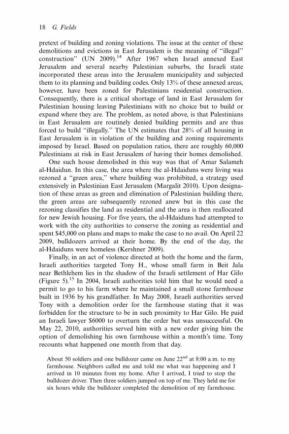
pretext of building and zoning violations. The issue at the center of these
demolitions and evictions in East Jerusalem is the meaning of ‘‘illegal’’
construction’’ (UN 2009).14 After 1967 when Israel annexed East
Jerusalem and several nearby Palestinian suburbs, the Israeli state
incorporated these areas into the Jerusalem municipality and subjected
them to its planning and building codes. Only 13% of these annexed areas,
however, have been zoned for Palestinians residential construction.
Consequently, there is a critical shortage of land in East Jerusalem for
Palestinian housing leaving Palestinians with no choice but to build or
expand where they are. The problem, as noted above, is that Palestinians
in East Jerusalem are routinely denied building permits and are thus
forced to build ‘‘illegally.’’ The UN estimates that 28% of all housing in
East Jerusalem is in violation of the building and zoning requirements
imposed by Israel. Based on population ratios, there are roughly 60,000
Palestinians at risk in East Jerusalem of having their homes demolished.
One such house demolished in this way was that of Amar Salameh
al-Hdaidun. In this case, the area where the al-Hdaiduns were living was
rezoned a ‘‘green area,’’ where building was prohibited, a strategy used
extensively in Palestinian East Jerusalem (Margalit 2010). Upon designa-
tion of these areas as green and elimination of Palestinian building there,
the green areas are subsequently rezoned anew but in this case the
rezoning classifies the land as residential and the area is then reallocated
for new Jewish housing. For five years, the al-Hdaiduns had attempted to
work with the city authorities to conserve the zoning as residential and
spent $45,000 on plans and maps to make the case to no avail. On April 22
2009, bulldozers arrived at their home. By the end of the day, the
al-Hdaiduns were homeless (Kershner 2009).
Finally, in an act of violence directed at both the home and the farm,
Israeli authorities targeted Tony H., whose small farm in Beit Jala
near Bethlehem lies in the shadow of the Israeli settlement of Har Gilo
(Figure 5).15 In 2004, Israeli authorities told him that he would need a
permit to go to his farm where he maintained a small stone farmhouse
built in 1936 by his grandfather. In May 2008, Israeli authorities served
Tony with a demolition order for the farmhouse stating that it was
forbidden for the structure to be in such proximity to Har Gilo. He paid
an Israeli lawyer $6000 to overturn the order but was unsuccessful. On
May 22, 2010, authorities served him with a new order giving him the
option of demolishing his own farmhouse within a month’s time. Tony
recounts what happened one month from that day.
About 50 soldiers and one bulldozer came on June 22nd at 8:00 a.m. to my
farmhouse. Neighbors called me and told me what was happening and I
arrived in 10 minutes from my home. After I arrived, I tried to stop the
bulldozer driver. Then three soldiers jumped on top of me. They held me for
six hours while the bulldozer completed the demolition of my farmhouse.
18 G. Fields

When the job was finished, the commander handed me a bill for $3,500 for
the cost of the demolition . . .When it was over, I did not go there for one
week. But then I went back. I know what they want. They want me to
leave*but I will not leave.
Concluding remarks
How is it possible to understand the violence perpetrated against Tony H.
and other Palestinians whose farms and homes are being targeted for
destruction and demolition by actors associated with the state of Israel?
This study locates the sources for this violence in Zionist visions about the
Palestinian landscape, and the legal geography of property inscribed into
this territory following the creation of Israel in 1948 and the conquest by
Israel of the remaining parts of Palestine after 1967. Two types of violence
against the Palestinian farm and home have emerged from this landscape
recast by the law. One type derives from the direct effects of the law in
reordering the lines of ownership and trespass on the landscape and
dispossessing Palestinians of farms and homes. The other type of violence
stems from the cultural effects of a shift in the system of property rights.
Such changes in the legal environment have emboldened private Israeli
actors, supported by agencies of the state of Israel itself, to target
Palestinian farms and homes as a way of ‘‘fixing’’ the landscape in
accordance with how these actors understand the landscape’s cultural
Figure 5. Tony H. standing beside his demolished farmhouse shortly after
demolition. Photograph by the author.
Journal of Cultural Geography 19
meaning and legal geography. In effect, the Palestinian farm and home
have become targets for removing Palestinians from what is conceived
both culturally and legally as Jewish land.
In making this argument about imagination, law, and violence, this
study places the Palestinian landscape in a broader historical context ofdispossession signaled in the opening of this article. What is occurring on
the Palestinian landscape has antecedents in the landscapes of enclosure
and dispossession in England and the Anglo-American colonial frontier. In
these three cases, a longstanding discourse about land improvement and
rights to property inspired estate owners, settler groups, and Zionists to
imagine the landscape as empty, and to re-imagine themselves as sovereigns
on that empty land. In all three cases, legal change in the system of property
rights followed an imagined geography that played a critical role in enablingthese groups to dispossess people already anchored to the landscape.
In England, land improvement had been evolving as justification for
rights to land since the 16th century and had assumed the specific meaning
of cultivating land and enclosing it from common uses (Thirsk 1983;
McCrae 1996). By the late 17th century, Locke had synthesized this
discourse of improvement tied to cultivation and enclosure into a
philosophical system of rights to landed property. For Locke, land absent
cultivation and enclosure was ‘‘waste,’’ and he argued forcefully thatindividuals who improved waste acquired a right of property in that land
(Locke 1980 [1690]; Seed 2001). By the 18th century, this discourse had
elevated the enclosure of unenclosed common land to a national campaign
that challenged the legitimacy of those still exercising common rights while
spawning an idealized vision of what the landscape should be (Tarlow
2007) In the outlook of those promoting enclosure of common land,
‘‘commoners’’ were trespassers opposed to improvement (Neeson 1993).
Not surprisingly, legal measures directed at opponents of enclosure focusedon removing them from the land illustrated by the Black Act (1723).
Originally passed to punish poaching in royal forests, the Act expanded the
violence of the English penal code by enforcing new rules of trespass on the
landscape and criminalizing activities once accepted as customary rights
on common land (Thompson 1975). The Black Act thus functioned as a
type of removal act in transforming the landscape’s spatial demography.
While the virtue of improving land lying empty proved a compelling
argument for reclaiming parts of the English landscape taken by commonuses, it was equally formidable as a rationale for England’s right to the land
of Amerindians (Edwards 2005). What justified rights to Indian land,
however, was a complementary discourse from English common law
focusing on the notion of empty land. From the 14th to the 16th century,
English common law was extending the ancient Roman notion of objects
without owners (res nullius) to land lying empty*terra nullius*in setting
forth conditions for rights to landed property (Seipp 1994). Similar to the
way Roman law enabled an object without an owner to become the property
20 G. Fields

of the so-called first taker, the doctrine of terra nullius suggested that the
improver of empty land was entitled to take possession of it. By the early
17th century, the improvement and property rights discourse had already
established conditions for identifying land lying empty. Such land was
uncultivated and unenclosed (McCrae 1996). In this way, despite Indiancultivation, the absence of fields enclosed by fences or other boundary
markers enabled English colonists to graft an imagined image of emptiness
onto the Indian landscape with all of its implications for appropriation and
dispossession (MacMillan 2006). Among the most vigorous defenders of
the right to such land was John Winthrop, the first Governor of New
England who in his General Considerations for Planting in New England
(1629) observed that Amerindian land was unenclosed and thus without
title thereby conferring on colonists the rights to such land (see Arneil1996). If Indians were left with sufficient land, Winthrop reasoned, ‘‘we may
lawfully take the rest’’ (from Koppes 1989, p. 231). What Winthrop had
outlined was a prescient vision that would become the basis of an imagined
geography of Indian dispossession and conquest of Indian land. Indeed, by
the early 19th century, ideologues for the new American nation, colonists
and political leaders alike, conceived of the American landscape as a
westward-expanding grid of property owners committed to improving land
through cultivation and hard work (Ostler 2004; Miller 2006). Removal ofthe Indians was never far from this imagined territorial vision.
Indeed, a campaign of removal did arise but what made the violent
transfer of Eastern Indians to the West possible was not only the Indian
Removal Act (1830) backed by President Andrew Jackson and the U.S.
Congress. What was critical in the removal of Indians from the landscape
was the cultural politics of violence against Indians following the
celebrated Johnson case (1823) that recast Indians into transient occu-
pants on the land. In the aftermath of Johnson, state and federallawmakers began open debate on removing Indians from areas coveted
by white settlers, most notably on land in Georgia held by Cherokees and
Creeks. In this legal and policy environment, some of these settlers formed
the front lines of vigilante groups that targeted Indian farms and homes
for destruction. Influenced by the longstanding idea of land to be God’s
gift to the enterprising, these settlers believed in the private appropriation
of land and pressed their claims for individual property rights on the vast
tracts of land in Indian country (Norgren 1996). The fact that theSupreme Court had essentially nullified Indian land rights only made it
easier for these settler groups to rationalize violent incursions against the
farms and homes of Cherokees and Creeks as a way of fixing the
landscape with what the law seemingly intended while the government
essentially looked the other way (Cave 2003). In this case, imagination and
the law conspired to create an environment intolerant of Indian presence
and mobility on the land that settlers exploited in seeking to clear the
landscape of trespassers by targeting Indian farms and homes.
Journal of Cultural Geography 21

In this sense, there is continuity in what transpired during the
enclosures in England, Anglo-American colonialism, and now the Israeli
violence targeting homes and farms in Palestine. In the three cases, groups
seeking land were dissatisfied with the structure of ownership rights on the
landscape. In re-imagining the landscape, these groups appealed to
ideologies of land improvement and laws of property in order to remake
rules of land ownership in accordance with their imagined visions,
dispossessing other groups in the process. Dispossession, however,
invariably encounters resistance. Faced with the efforts of subalterns to
remain steadfast, groups with territorial ambitions resort to ever more
harsh measures to fix the landscape. The spiriting of commoners to prison,
the burning of Indian crops and homes, and the uprooting and demolition
of Palestinian crops and homes reveal an ongoing pattern of imagination,
law, and violence aimed at creating a different configuration of human
presence and circulation on landscape. Whether from English enclosure,
Anglo-American colonialism, or Israeli settlement, dispossession and the
forms of violence that it engenders is an ongoing story. While the state of
Israel might find it unsettling to be part of this lineage, its actions reveal it
to be implicated in the politics of imagination, dispossession and violence
that has characterized much of the making of the early modern world.
Acknowledgements
The author would like to thank Nick Blomley, Val Hartouni, and Lisa Hajjar for
comments on earlier drafts of this article, and Alyson Greiner for extremely
insightful observations and criticisms throughout the entire process. The author
would also like to thank the Palestinian American Reserch Center (PARC) for
support in conducting fieldwork for this article.
Notes
1. In this sense, the violence of law is similar to Foucault’s idea of modern power.
Foucault argued that modern power resided in the capacity to partition space
and distribute human subjects within specific spatial environments (Foucault
1977).
2. The notion of ‘‘spatial fix’’ comes from Harvey (1981) who described how
capitalists resort to reshaping territory to overcome obstacles to profit-making.
3. For an excellent summary of this literature see Blomley (2003).
4. The remainder of this paragraph relies on Forman (2009).
5. Yitzhar is considered among the most violent of all Israeli settlements and is
implicated most frequently in crop burning incidents involving nearby
Palestinian villages (Munayyer 2012).
6. The settlements established in this way were Matitiyahu, Neve Zuf, Rimonim,
Bet El, Kokhav Hashahar, Alon Shvut, El’azar, Efrat, Har Gilo, Migdal Oz,
Gittit, Yitav and Qiryat Arba (B’tselem, 2002).
7. The remainder of this paragraph relies on B’tselem (2002).
22 G. Fields

8. Despite claims made by the state of Israel, private Palestinian property has
provided at least 40% of the land where Israeli settlements in Occupied
Palestine have been constructed based on data compiled by Israel’s own State
Prosecutor, Talya Sason (Peace Now 2006).
9. Information on Mahmoud S. comes from author interviews of 24 July 2006
and 10 September 2007.
10. Information in this paragraph on Izzat Q. comes from author interviews of 22
March 2011 and 27 March 2012.
11. I was actually with Salim when he discovered the uprooting of his trees.
12. The remainder of this paragraph comes from an author interview of 28 August
2007.
13. For home demolitions and evictions of Palestinians in East Jerusalem, see
Margalit (2010).
14. Statistics in this paragraph are from this UN Report.
15. Information in this paragraph is taken from an author interview with Tony H.
25 July 2010.
References
Abu El-Haj, N., 2001. Facts on the ground: archaeological practice and territorial
self-fashioning in Israeli society. Chicago: University of Chicago Press.
Arneil, B., 1996. John Locke and America: the defense of English colonialism.
Oxford: Clarendon Press.
Banner, S., 2005. How the Indians lost their land: law and power on the frontier.
Cambridge, MA: Harvard University Press.
Bar-Gal, Y., 2003. Propaganda and Zionist education: the Jewish National Fund,
1924�1947. Rochester: University of Rochester Press.
Blomley, N., 2003. Law, property and the geography of violence: the frontier, the
survey, and the grid. Annals of the Association of American Geographers, 93 (1),
121�141.
Braverman, I., 2009. Planted flags: trees, land and law in Israel/Palestine.
Cambridge: Cambridge University Press.
B’Tselem, 2002. Land grab: Israel’s policy of settlement in the West Bank [online].
Available from: http://www.btselem.org/Download/200205_Land_Grab_eng.
pdf [Accessed 10 July 2012].
Cave, A.A., 2003. Abuse of power: Andrew Jackson and the Indian Removal Act
of 1830. The Historian, 65 (6), 1330�1353.
Edwards, J., 2005. Between ‘‘Plain Wilderness’’ and ‘‘Goodly Corn Fields’’:
representing land use in early Virginia. In: R. Appelbaum and J.W. Sweet, eds.
Envisioning an empire: Jamestown and the making of the North Atlantic world.
Philadelphia: University of Pennsylvania Press, 217�235.
Eisenzweig, U., 1981. An imaginary territory: the problematic of space in Zionist
discourse. Dialectical Anthropology, 5, 261�285.
Falah, G., 1989. Israelization of Palestine human geography. Progress in Human
Geography, 13 (4), 535�550.
Falah, G., 1996. The 1948 Israeli-Palestinian war and its aftermath: the
transformation and designification of Palestine’s cultural landscape. Annals of
the Association of American Geographers, 86 (2), 256�285.
Journal of Cultural Geography 23

Falah, G.W., 2003. Dynamics and patterns of the shrinking of Arab lands in
Palestine. Political Geography, 22 (2), 179�209.
Fitzmaurice, A., 2007. The genealogy of terra nullius. Australian Historical Studies,
38, 1�15.
Forman, G., 2009. A Tale of Two Regions: Diffusion of the Israeli ‘‘50 Percent Rule’’
from the Galilee to the occupied West Bank. Law & Social Inquiry, 34 (3), 671�711.
Forman, G. and Kedar, A., 2004. From Arab land to ‘‘Israeli lands’’: the legal
dispossession of Palestinians displaced by Israel in the wake of 1948.
Environment and Planning, D 22 (6), 809�830.
Foucault, M., 1977. Discipline and punish: the birth of the prison: New York:
Pantheon.
Foundation for Middle East Peace, 2012. Comprehensive settlement population,
1972�2010 [online]. Available from: http://www.fmep.org/settlement_info/settle
ment-info-and-tables/stats-data/comprehensive-settlement-population-1972-2006.
[Accessed 2 August 2012].
Halper, J., 2006. The message of the bulldozers. Forced Migration Review, 26, 28�29.
Halper, J., 2007. From protest to resistance: the making of a critical Israeli. Journal
of Palestine Studies, 36 (3), 36�49.
Harvey, D., 1981. The spatial fix*Hegel, von Thunen, and Marx. Antipode, 13 (3),
1�12.
Herzl, T., 1896. The Jewish State: an attempt at a modern solution to the Jewish
question. 2nd ed. Translated by S. D’Avigdor, 1934. London: Central Office of
the Zionist Organization.
Herzl, T. 1960. Complete Diaries. Vol. 1. Translated by H. Zohn. New York: Herzl
Press.
Israeli Committee Against House Demolitions (ICAHD) [online]. Available from:
http://www.icahd.org/?page_id�76 [Accessed 12 July 2012].
Jabotinsky, Z., 1923. The iron wall: we and the Arabs [online]. Available from: http://
www.informationclearinghouse.info/article14801.htm [Accessed 10 July 2012].
Kershner, I., 2009. UN seeks end to razing of homes in East Jerusalem. New York
Times [online]. Available from: http://www.nytimes.com/2009/05/01/world/mid
dleeast/01jerusalem.html?_r�2&ref�world [Accessed 10 July 2012].
Koppes, C.R., 1989. Efficiency, equity, esthetics: shifting themes in American
conservation. In: D. Worster, ed. The ends of the earth: perspectives on modern
environmental history. Cambridge: Cambridge University Press, 230�251.
Locke, J., 1980 [1690]. The second treatise of government. Indianapolis: Hackett
Publishing.
MacMillan, K., 2006. Sovereignty and possession in the English new world: the legal
foundations of empire, 1570�1640. Cambridge: Cambridge University Press.
Margalit, M., 2010. Seizing control of space in East Jerusalem. Jerusalem: Sifrei
Aliat Gag.
Masalha, N., 1992. Expulsion of the Palestinians: the concept of ‘‘transfer’’ in Zionist
political thought, 1882�1948. Washington, DC: Institute for Palestine Studies.
McRae, A., 1996. God speed the plough: the representation of agrarian England,
1500�1660. Cambridge: Cambridge University Press.
Meneley, A., 2008. Time in a bottle: the uneasy circulation of Palestinian olive oil.
Middle East Report, 38 (3), 18�23.
Miller, R.J., 2006. Native America, discovered and conquered: Thomas Jefferson,
Lewis & Clark, and manifest destiny. Westport: Praeger.
24 G. Fields

Morris, B., 2001. Revisiting the Palestinian exodus of 1948. In: E. L. Rogan and
A. Shlaim, eds. The war for Palestine: rewriting the history of 1948. Cambridge:
Cambridge University Press, 37�59.
Munayyer, Y., 2012. When settlers attack. Washington, DC: Palestine Center
Jerusalem Fund for Education and Community Development [online]. Avail-
able from: http://www.thejerusalemfund.org/ht/a/GetDocumentAction/i/32678
[Accessed 10 July 2012].
Neeson, J.M., 1993. Commoners: common right, enclosure and social change in
England, 1700�1820. Cambridge: Cambridge University Press.
Norgren, J., 1996. The Cherokee cases: the confrontation of law and politics. New
York: McGraw-Hill.
Ostler, J., 2004. The Plains Sioux and U.S. colonialism from Lewis and Clark to
Wounded Knee. Cambridge: Cambridge University Press.
Peace Now, 2006. Breaking the law in the West Bank: Israeli settlement building on
private Palestinian property [online]. Available from: http://peacenow.org/
images/112106PNReport.pdf [Accessed 10 July 2012].
Robertson, L.G., 2005. Conquest by law: how the discovery of America dispossessed
indigenous peoples of their lands. Oxford: Oxford University Press.
Rose, C.M., 1994. Property and persuasion: essays on the history, theory, and
rhetoric of ownership. Boulder: Westview Press.
Said, E., 2000. Invention, memory and place. Critical Inquiry, 26 (2), 175�192.
Seed, P., 2001. American pentimento: the invention of Indians and the pursuit of
riches. Minneapolis: University of Minnesota Press.
Seipp, D.J., 1994. The concept of property in the English common law. Law and
History Review, 12 (1), 29�91.
Shafir, G., 1996. Zionism and colonialism: a comparative approach. In: M. N.
Barnett, ed. Israel in comparative perspective. New York: State University of
New York Press, 227�242.
Shlaim, A., 2001. The iron wall: Israel and the Arab world. New York: W.W.
Norton & Company.
Tarlow, S., 2007. The archaeology of improvement in Britain, 1750�1850. Cam-
bridge: Cambridge University Press.
Thirsk, J., 1983. Plough and pen: agricultural writers in the seventeenth century.
In: T.H. Aston, P.R. Cross, C. Dyer, and J. Thirsk, eds. Social relations and
ideas: essays in honour of R.H. Hilton. Cambridge: Cambridge University Press,
295�318.
Thompson, E.P., 1975. Whigs and hunters: the origin of the Black Act. New York:
Pantheon Books.
United Nations, Office for the Coordination of Humanitarian Affairs Occupied
Palestinian Territory, 2009. The planning crisis in East Jerusalem: under-
standing the phenomenon of ‘‘illegal’’ construction [online]. Available from:
http://www.ochaopt.org/documents/ocha_opt_planning_crisis_east_jerusalem_
april_2009_english.pdf [Accessed 12 September 2012].
United Nations, Office for the Coordination of Humanitarian Affairs Occupied
Palestinian Territory, 2012. The humanitarian impact of settlement policies
[online]. Available from: http://www.ochaopt.org/documents/ocha_opt_settle
ments_FactSheet_January_2012_english.pdf [Accessed 4 July 2012].
Yiftachel, O., 1996. The internal frontier: the territorial control of ethnic
minorities. Regional Studies, 30 (5), 493�508.
Journal of Cultural Geography 25