Embed Size (px)
Citation preview
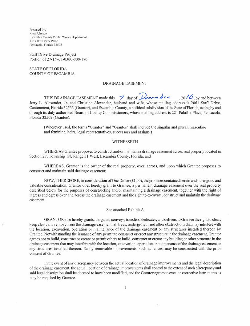
Prepared by:Kara Johnson
tscambi'a County Public Works Depannient3363 West Park Place
Pensacola, Florida 32505
Staff Drive Drainage ProjectPortion of27-lN-31-0300-000-170
STATE OF FLORIDA
COUNTY OF ESCAMI3IA
DRAINAGE EASEMENT
THIS DRAINAGE EASEMENT made this "7 day —' 20by and betweenJerry L. Alexander, Jr. and Christine Alexander, husband and wife, whose mailing address is 2061 Staff Drive,Cantonment,Florida 32533 (Grantor), and Escambia County,a political subdivision of theStateof Florida,actingby andthrough its duly authorized Board of County Commissioners, whose mailing address is 221 Palafox Place, Pensacola,Florida 32502 (Grantee).
(Wherever used, the terms "Grantor" and "Grantee" shall include the singular and plural, masculineand feminine, heirs, legal representatives, successors and assigns.)
WITNESSETH
WHEREAS Grantee proposes to construct and/or maintain a drainage easement across real property located inSection27, Township IN, Range 31 West, Escambia County, Florida; and
WHEREAS, Grantor is the owner of the real property, over, across, and upon which Grantee proposes toconstruct and maintain said drainage easement;
NOW, THEREFORE, in consideration ofOne Dollar ($1.00), the promises contained herein and other good andvaluable consideration. Grantor does hereby grant to Grantee, a permanent drainage easement over the real propertydescribed below for the purposes of constructing and/or maintaining a drainage easement, together with the right ofingress and egress over and across the drainage easement and the right to excavate, construct and maintain the drainageeasement.
See attached Exhibit A
GRANTOR also hereby grants, bargains, conveys, transfers, dedicates, and delivers to Grantee the right to clear,keep clear, and remove from the drainage easement, all trees, undergrowth and other obstructions that may interfere withthe location, excavation, operation or maintenance of the drainage easement or any structures installed thereon byGrantee. Notwithstanding the issuance of any pennit to construct or erect any structure in the drainage easement. Grantoragrees not to build, construct or create or permit others to build, construct or create any building or other structure in thedrainage easement that may interfere with the location, excavation, operation or maintenance ofthe drainage easement orany structures installed thereon. Easily removable improvements, such as fences, may be constructed with the priorconsent of Grantee.
In the event ofany discrepancy betweenthe actual locationofdrainage improvements and the legaldescriptionof the drainage easement, the actual location ofdrainage improvements shall control to the extent ofsuch discrepancy andsaid legal description shall be deemed to have been modified, and the Grantor agrees to execute corrective instruments asmay be required by Grantee.
1
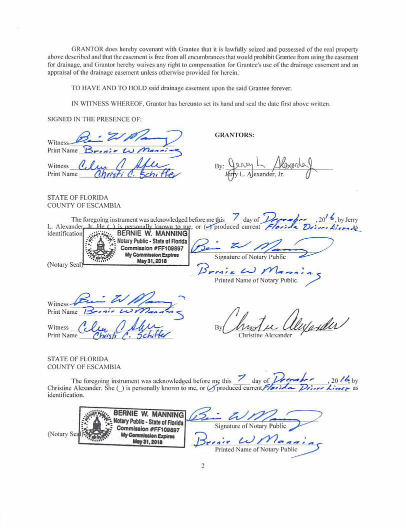
GRANTOR does hereby covenant with Grantee that it is lawfully seized and possessed of the real propertyabove described and that the easement is free from al! encumbrances that would prohibit Grantee from using the easementfor drainage, and Grantor hereby waives any right to compensation for Grantee's use ofthe drainage easement and anappraisal of the drainage casement unless otherwise provided for herein.
TO HAVn AND TO HOLD said drainage casement upon the said Grantee forever.
IN WITNESS WHEREOF, Grantor has hereunto set its hand and seal the date first above written.
SIGNED IN THE PRESENCE OF:
Print Name £.0
/) / 0Witness
Print Name
STATE OF FLORIDA
COUNTY OF ESCAMBIA
GRANTORS:
By:Jer/y L. Alexander, Jr.
The foregoing instrument was acknowledged before meUjjs ^ day ofL. AlpvanHfr .Tr Iq p.»rgnnally known to me or (;^f^oduced jj/.
B^RNIE W. MANNING'
by Jerry
identification
(Notary Seal
Witness ^Print Name
Witness
Print Name
sf-'A • Notary Public •Slate of FtoridaIJ JH Comml»ilon#FF109897
MyCommitftenEipirM•••rf.w' M>y3t.20ia
3By,
Christine Alexander
Signature of Notary Public
Printed Name of Notary Public
STATE OF FLORIDA
COUNTY OF ESCAMBIA
The foregoing instrument was acknowledged before rnj this ^ day 20 byChristine Alexander. She (_J is personally known to me, or(^Jproduced current/'̂ i»^J«^-»- asidentification.
'^1'% ®ERNIE w. manningA Notary Public-State of FlofWa
r? Commtesior) #FFt09897(Notary Se< f'Jj! MyCumnwiiiuiiByifw
Mtysi.aou
Signature of Notary Public
Printed Name of Notary Public

ACCEPTANCE
This Drainage Easement was accepted by Escambia County, Florida, on the day of, 20 , as authorized by the Board of County Commissioners of Escambia County,
Florida at its meeting held on the day of , 20 ,
ATTEST:
Deputy Clerk
Pam Chiiders
Clerk of the Court
BOARD OF COUNTY COMMISSIONERS
ESCAMBIA COUNTY, FLORIDA
D. B. Underbill, Chairman
This docuand lagaBy
Title
Date
ipproved as to form
r-
D-gc >/.T to
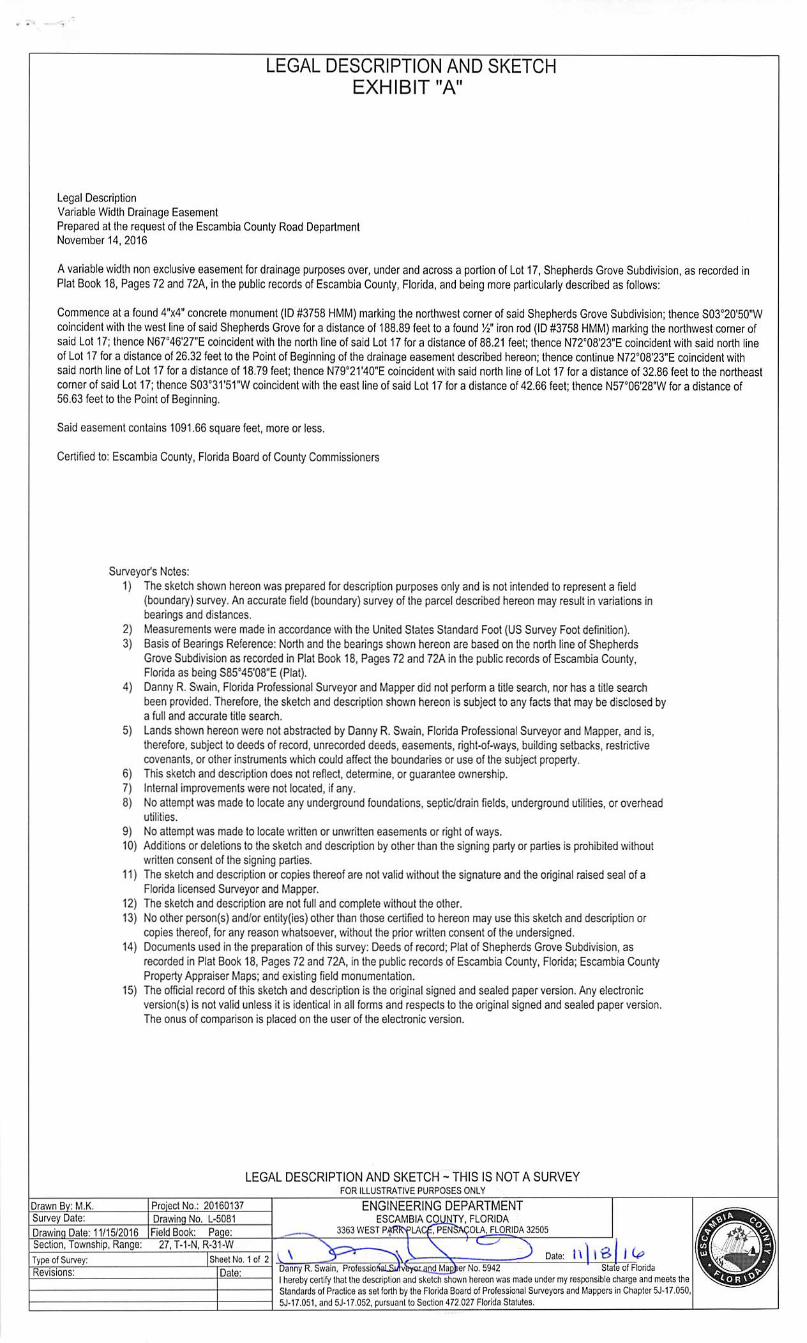
LEGAL DESCRIPTION AND SKETCHEXHIBIT "A"
Legal DescriptionVariable Width Drainage EasementPrepared at the requestof the Escambia County Road DepartmentNovember 14,2016
Avariable width non exclusive easement for drainage purposes over, under andacross a portion ofLot 17, Shepherds Grove Subdivision, as recorded inPlat Book 18, Pages72and72A, In the public records ofEscambia County, Florida, and being more particularly described as follows:
Commence at a found 4"x4" concrete monument (ID #3758 HMM) marking the northwest corner ofsaidShepherds Grove Subdivision; thenceS03''20'50"Wcoincident with the west line of said Shepherds Grove for a distance of 188,89 feet to a found Vi' iron rod (ID #3758 HIvIM) marking the northwest comer ofsaid Lot 17;thence N67°46'27"E coincident with the north lineofsaid Lot 17 fora distanceof88.21 feet; thence N72'08'23"E coincident with said north lineof Lot 17for a distance of26.32 feet tothe Point ofBeginning ofthedrainage easementdescribed hereon; thence continue N72°08'23"E coincident withsaid northline of Lot 17 fora distance of 18.79 feet; thence N79'21'40''E coincidentwith said north lineof Lot 17 fora distance of 32.86 feet to the nortiieastcornerofsaid Lot17; thenceS03°31'5rw coincident with the east lineofsaid Lot17 fora distanceof42.66feet; thence N57°06'28'W fora distanceof56.63 feet to the Pointof Beginning.
Said easement contains1091.66 square feet, moreor less.
Certified to: Escambia County, Florida Board ofCounty Commissioners
Drawn Bv: M.K,Survey Dale:
Surveyor's Notes:I) The sketch shownhereonwas preparedfor description purposes only and is not intended to representa field
(boundary) survey. An accurate field (boundary) survey ofthe parcel described hereon may result invariations inbearingsand distances.Measurements were made in accordance with the United StatesStandard Foot (US Survey Fool definition).Basisof Bearings Reference: North and the bearings shown hereon are basedonthe north line ofShepherdsGrove Subdivision as recorded in Plat Book 18,Pages 72and 72Ain the public records ofEscambia County,Florida as beingS85''45'08'E (Plat).Danny R. Swain, Florida Professional Sun/eyor and Mapper did not performa titlesearch, nor has a titlesearchbeenprovided. Therefore, thesketch and description shown hereon issubject toany factsthatmay be disclosed bya full and accurate title search.
Landsshownhereonwere not abstractedby Danny R. Swain. Florida Professional Surveyor and Mapper, and is,therefore, subjectto deeds of record, unrecorded deeds, easements, right-of-ways, building setbacks, restrictivecovenants,or other instruments which couldaffectthe boundariesor use of the subjectproperty.This sketchand descnption does not reilect, determine, orguarantee ownership.Internal improvements were notlocated,ifany.Noattempt was madeto locateany underground foundations, septic/drain fields, underground utilities, or overheadutilities.
No attempt was made to locate written or unwritten easements or rightof ways.10) Additions ordeletions to the sketch and description byother than the signing partyor partiesis prohibited without
written consent of the signing parties.II) The sketchand description or copiesthereofare notvalid without the signatureand the original raisedseal ofa
Florida licensed Sunreyorand Mapper.The sketch and descriptionare not full and complete withoutthe other.Noother person(s) and/or entity(ies)other than those certifiedto hereon may use this sketch and descriptionorcopiesthereof, for any reason whatsoever, without the prior written consent ofthe undersigned.Documents used in the preparation of this survey: Deeds of record; Plat of Shepherds Grove Subdivision, asrecorded in Plat Book 18. Pages 72 and 72A, inthe public recordsofEscambia County, Florida; Escambia CountyProperty Appraiser Maps; and existing field monumenlation.
15) Theofficial record ofthis sketch anddescription isthe original signed andsealedpaperverslon.Any electronicversion(s) is notvalid unless it is identical inallforms and respects to the original signedand sealed paper version.The onus of comparison is placed on the user of the electronic version.
2)3)
4)
5)
6)7)8)
9)
12)13)
14)
LEGAL DESCRIPTION AND SKETCH - THIS IS NOT A SURVEYFOR ILLUSTRATIVE PURPOSES ONLY
ENGINEERING DEPARTMENTESCAMBIA COUNTY. FLORIDA
33$3 WEST P«Ri?fLAC£; PENSACOLA. FLORIDA 32505
ProiectNo.: 20160137
Drawing No. 1-5081
Drawing Dale:11/1S/2016 IField Book: Page:Section, Township. Range: 27,T-1-N, R-31-W TTypeof Survey:
Revisions:
Sheel No. 1 of 2Danny R.Swain. Prolassioi _Iherebycertify that thodescription and sketchshownhereonwas made undermyresponsible chargeand meets theSlandards ofPractice as selforth bytheFlorida Board ofProfessional Surveyors and Mappers inChapter 53-17.050,5J-17.051.ahd 5J-17.052, pursuant fo SecUcki 472,027 Florida Statutes.
Date:anri Maeher No. 5941^
Dale:
Slats of Florida
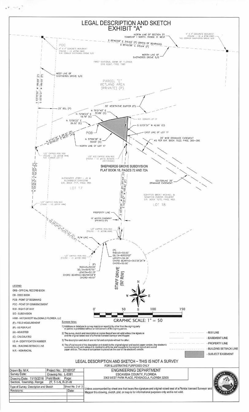
LEGAL DESCRIPTION AND SKETCHEXHIBIT "A"
NORTH LINE OF SECTION 27.TOWNSHIP 1 NOTTH, RANGE 31 WEST *
«• X 4* CCWCftETE MONUHEUT(FCUNO • r D « 375b MMU) •
HZ. COfl'tfR SHCPHEPOS CROVE S/D
X 4* CONCHCTg MCWl^MtNt
CfOUSO - l.D. #3758 MUM)*JW COftNER SHEPnEROS CflOvf S/D
NORTH UNE OF
SHEPHERDS GROVE S/0 *
u. 1^9' 1bto
COCD 1<D
1»o '•O 1 r«
b 1b•D
,
o ' Q
t/i 1 I/I
WEST LINE OF
SHEPHERDS GROVE S/D
25' eSL (P)
fIRST NATIONAL BANK OF FLORIDA0R9 6597, RAG? 1081
PARCEL "E"WETLAND AREA
(PRIVATE? (P)
30* VEGETAnVE BUFFER (P)L (P)
N 79 *2140 " e
H E CQRNE» LOT 17
5 03*3t'5r W 42.66* (C)
-EAST UNE of lot 17
1/2" C4BPED tflON SOD- (FOjnO - I 0 #3758 MMM)
N'rt CORNER Ldl 17
N 5706'28" W /56.63' (C)
NORTH UNE CF LOT 17
1/2" RED CAPPED iRON RCOjfiOuNO - «,D #611?. ff-'lLER) -
<RE**EPCNCE)
SHEPHERDS GROVE SUBDIVISION
PLATBOOK 18, PAGES 72 AND72A
.1^ I
20' WIDE DRAINAGEAS PER O.R, BOOK 7523.
ALEXANDER JERRY l JR &ALEXANDER CHRISTINE
0,R„ BOOK 7171. PACE 904
LOT T7
CENTERLINE 20*DRAINAGE EASEMENT
1/2" CABPEO IRON ROO* (FOUND • 1.0 #3758 MUU)
PROPERTY UNE
10' ACCESS CASEMENT(PRIVATE) (P)
SCHlFFtR BRENT MICHAEL iSGHIFFER CHRiSn COLBERTa.R BOOK 7270, PAGE 490
1
1/2* CAPPED 'RON RCO(FUUND - I D i»37jS mum]
R/W UNE .
•/
1/!' CAPPED iRCW RCO /.(FOUND • JD #3758 hUu) '
I (nHAOIUS-SO 00'
DELTA.59'57'5rLENGrH-52.jy
CWORD B6ARING=S63-28'59"WCH0fiD=»9 97'
(P) \RADIJS-SO.OO' \DELTA.60-00'00' XLe^GIH.52.J6'
CHORD e£ARlNC«S63-29'26"WCHORD.50 00'
LEGEND:
ORB - OFFICIALRECORD BOCK
D5-DEED BOOK
ROB-POINT OF BEGINNING
ROC - POINT OF COMMENCEMENT
R/W-RIGHTOF-WAY
Sro-SUBDIVISiCK
HMU - HATCH MOTTMacDONALD FLORIDA,IIC
(FI-FIELDMEASUREMENT >
(P)-AS PER PLAT '{A)-ADJUSTED ;
(C)-CALCULATED
ID. #- IDENTlFiCAKON NUMBER '
Ba- BUILDING SETOCK LINE '
N.R.-NON-RADIAL
GRAPHIC SCALE: 1" = SOSurvgygt_^08l •JrVMrni^
1)AMl^s or<t83e(ior$ to survoyniaD(s) orreport($] byolhertKan tl>e $igriir>9 partyor is pr<Xi'iDilM wilhoul wnTlon consentoftbe signirgparties.
2)The survey sketchanddascripiioiorcopiesthereofare notvalidwithout the signatureand the origin^ raised sealora Florida licensed Surveyor and flapper.
3)Thedescfiption and sketchare notlulland complele without the other.
4)The officiai record otthis dosaiption end sketch isthe orninal signed and sealed paper version. Any electronicver^on(s) isnot valid unless itisidentical In ell forms and'respeds tothe original sf^edand sealedpaperversion. The onusofcompanson is placedon the user of(heelectronic version.
LEGAL DESCRIPTION AND SKETCH - THIS IS NOT A SURVEYFOR ILLUSTRATtVE PURPOSES ONLY
Drawn By: M.K. ProlBclNo.: 20160137 ENGINEERING DEPARTMENTSurvey Date: Drawing No. L-5081 ESCAMBIA COUNTY, FLORIDADrawing Dale: 11/15/2016 Field Book: Page: 3363WESTPARKPLACE, PENSACOLA. FLORIDA32505Section, Township,Range: 27,T-1-N, R.31-W
EASEMENTPAGE 386-390
-RAVLINE
•EASEMENT LINE
-PROPERTY UNE
•BUILDING SETBACK UNE
•SUBJECT EASEMENT
Type of Survey: Dftsgiption and Sketch [Sheet No. 2of 2Revleions: IDale:
Unlessaccompanlad bysheet one that bears the signatureand orlg^alraised seal ofa Florida licensedSunreyor andMapper thisdrawing, sketch,plat,or map is for Inlormalional purposesonlyand Is notvalid.