Embed Size (px)
Citation preview
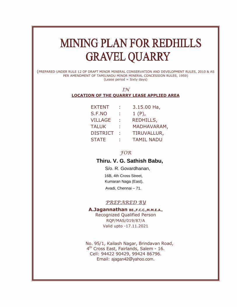
(PREPARED UNDER RULE 12 OF DRAFT MINOR MINERAL CONSERVATION AND DEVELOPMENT RULES, 2010 & AS
PER AMENDMENT OF TAMILNADU MINOR MINERAL CONCESSION RULES, 1959) (Lease period = Sixty days)
IN LOCATION OF THE QUARRY LEASE APPLIED AREA
EXTENT : 3.15.00 Ha,
S.F.NO : 1 (P),
VILLAGE : REDHILLS,
TALUK : MADHAVARAM,
DISTRICT : TIRUVALLUR,
STATE : TAMIL NADU
FOR
PREPARED BY
A.Jagannathan BE.,F.C.C.,M.M.E.A., Recognized Qualified Person
RQP/MAS/019/87/A
Valid upto -17.11.2021
No. 95/1, Kailash Nagar, Brindavan Road,
4th Cross East, Fairlands, Salem - 16. Cell: 94422 90429, 99424 86796.
Email: [email protected].
Thiru. V. G. Sathish Babu,S/o. R. Govardhanan,
16B, 4th Cross Street,
Kumaran Naga (East),
Avadi, Chennai – 71.
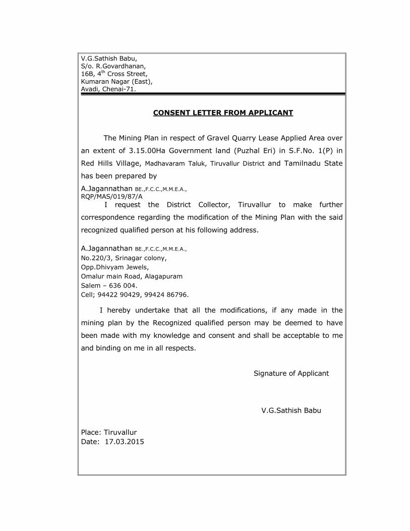
V.G.Sathish Babu,
S/o. R.Govardhanan,
16B, 4th Cross Street,
Kumaran Nagar (East), Avadi, Chenai-71.
CONSENT LETTER FROM APPLICANT
The Mining Plan in respect of Gravel Quarry Lease Applied Area over
an extent of 3.15.00Ha Government land (Puzhal Eri) in S.F.No. 1(P) in
Red Hills Village, Madhavaram Taluk, Tiruvallur District and Tamilnadu State
has been prepared by
A.Jagannathan BE.,F.C.C.,M.M.E.A., RQP/MAS/019/87/A I request the District Collector, Tiruvallur to make further
correspondence regarding the modification of the Mining Plan with the said
recognized qualified person at his following address.
A.Jagannathan BE.,F.C.C.,M.M.E.A.,
No.220/3, Srinagar colony,
Opp.Dhivyam Jewels,
Omalur main Road, Alagapuram
Salem – 636 004.
Cell; 94422 90429, 99424 86796.
I hereby undertake that all the modifications, if any made in the
mining plan by the Recognized qualified person may be deemed to have
been made with my knowledge and consent and shall be acceptable to me
and binding on me in all respects.
Signature of Applicant
V.G.Sathish Babu
Place: Tiruvallur
Date: 17.03.2015
V.G.Sathish Babu,
S/o. R.Govardhanan,
16B, 4th Cross Street,
Kumaran Nagar (East), Avadi, Chenai-71.
DECLARATION OF APPLICANT
The Mining Plan in respect of Gravel Quarry Lease Applied Area
over an extent of 3.15.00Ha Government land (Puzhal Eri) in S.F.No. 1(P)
in Red Hills Village, Madhavaram Taluk, Tiruvallur District and Tamilnadu State
has been prepared in full consultation with me.
A.Jagannathan BE.,F.C.C.,M.M.E.A.,
95/1, Kailash Nagar,
Brindhavan Road,
4th Cross East, Fairlands,
Salem-16.
Cell; 94422 90429, 99424 86796.
I have understood its contents and agree to implement the same
in accordance with Laws applicable to Quarry.
Signature of Applicant
V.G.Sathish Babu
Place: Tiruvallur
Date: 17.03.2015
A.Jagannathan BE.,F.C.C.,M.M.E.A.,
95/1, Kailash Nagar,
Brindhavan Road,
4th Cross East, Fairlands,
Salem-16.
CERTIFICATE FROM THE RECOGNIZED QUALIFIED PERSON
This is to certify that the Provisions of Rule 12 of Draft Minor Mineral
Conservation and Development Rules, 2010 & as per Amendment Rules of
Tamilnadu Minor Mineral Concession Rules, 1959 have been observed in the
preparation of Mining Plan for Gravel Quarry Lease Applied Area over an
extent of 3.15.00Ha Government land (Puzhal Eri) in S.F.No. 1 (P) in Red
Hils village, Madhavaram Taluk, Tiruvallur District and Tamilnadu State
has been prepared for
Thiru. V.G.Sathish Babu,
S/o. R.Govardhanan,
16B, 4th Cross Street,
Kumaran Nagar (East),
Avadi, Chenai-71.
Whenever specific permissions/exemptions/ relaxations and
approvals are required, the applicant will approach the concerned authorities
of the district Collectorate, Tiruvallur, Tamilnadu for such
permissions/exemptions/relaxations and approvals.
It is also certified that information furnished in the above Mining plan
are true and correct to the best of my knowledge.
RQP SIGNATURE
A.Jagannathan BE.,F.C.C.,M.M.E.A., RQP/MAS/019/87/A
Place: Salem
Date: 18.03.2015
Mining Plan Redhills Gravel Quarry
1
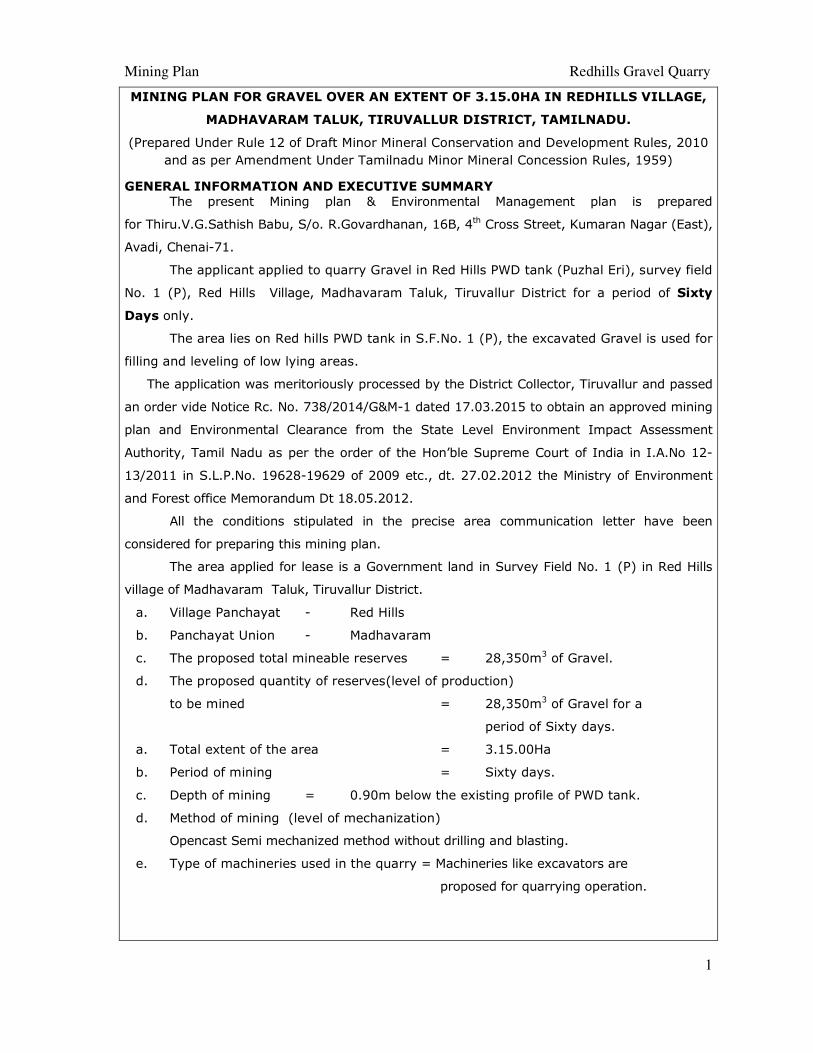
MINING PLAN FOR GRAVEL OVER AN EXTENT OF 3.15.0HA IN REDHILLS VILLAGE,
MADHAVARAM TALUK, TIRUVALLUR DISTRICT, TAMILNADU.
(Prepared Under Rule 12 of Draft Minor Mineral Conservation and Development Rules, 2010
and as per Amendment Under Tamilnadu Minor Mineral Concession Rules, 1959)
GENERAL INFORMATION AND EXECUTIVE SUMMARY
The present Mining plan & Environmental Management plan is prepared
for Thiru.V.G.Sathish Babu, S/o. R.Govardhanan, 16B, 4th Cross Street, Kumaran Nagar (East),
Avadi, Chenai-71.
The applicant applied to quarry Gravel in Red Hills PWD tank (Puzhal Eri), survey field
No. 1 (P), Red Hills Village, Madhavaram Taluk, Tiruvallur District for a period of Sixty
Days only.
The area lies on Red hills PWD tank in S.F.No. 1 (P), the excavated Gravel is used for
filling and leveling of low lying areas.
The application was meritoriously processed by the District Collector, Tiruvallur and passed
an order vide Notice Rc. No. 738/2014/G&M-1 dated 17.03.2015 to obtain an approved mining
plan and Environmental Clearance from the State Level Environment Impact Assessment
Authority, Tamil Nadu as per the order of the Hon’ble Supreme Court of India in I.A.No 12-
13/2011 in S.L.P.No. 19628-19629 of 2009 etc., dt. 27.02.2012 the Ministry of Environment
and Forest office Memorandum Dt 18.05.2012.
All the conditions stipulated in the precise area communication letter have been
considered for preparing this mining plan.
The area applied for lease is a Government land in Survey Field No. 1 (P) in Red Hills
village of Madhavaram Taluk, Tiruvallur District.
a. Village Panchayat - Red Hills
b. Panchayat Union - Madhavaram
c. The proposed total mineable reserves = 28,350m3 of Gravel.
d. The proposed quantity of reserves(level of production)
to be mined = 28,350m3 of Gravel for a
period of Sixty days.
a. Total extent of the area = 3.15.00Ha
b. Period of mining = Sixty days.
c. Depth of mining = 0.90m below the existing profile of PWD tank.
d. Method of mining (level of mechanization)
Opencast Semi mechanized method without drilling and blasting.
e. Type of machineries used in the quarry = Machineries like excavators are
proposed for quarrying operation.
Mining Plan Redhills Gravel Quarry
2
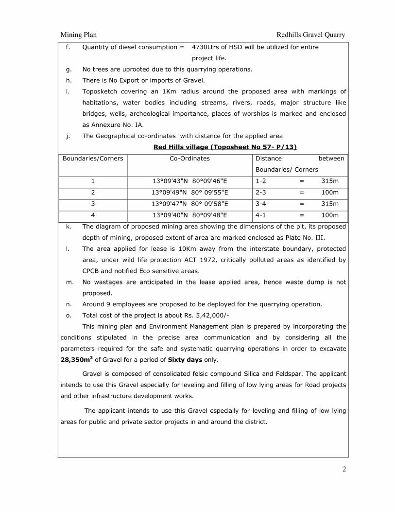
f. Quantity of diesel consumption = 4730Ltrs of HSD will be utilized for entire
project life.
g. No trees are uprooted due to this quarrying operations.
h. There is No Export or imports of Gravel.
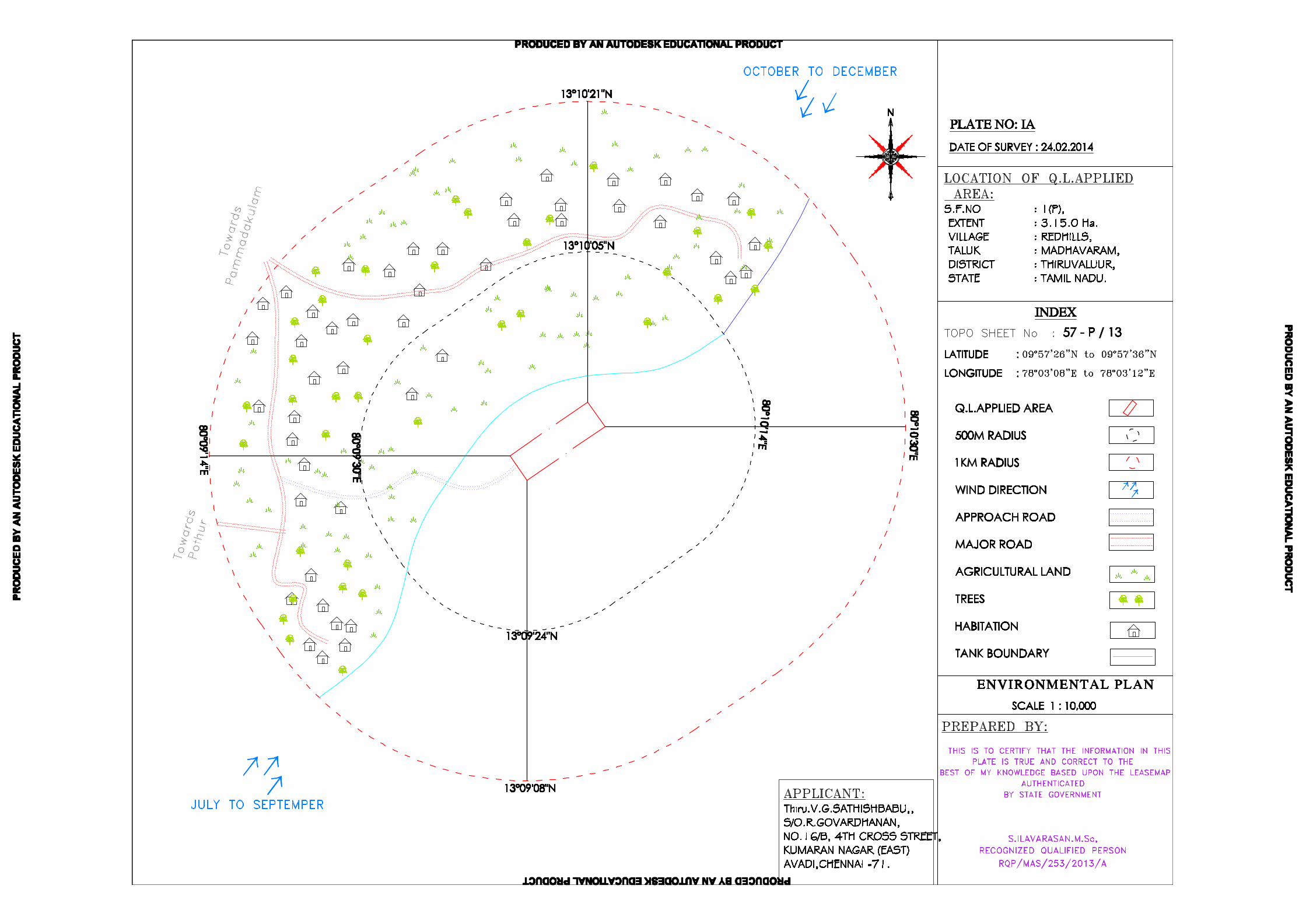
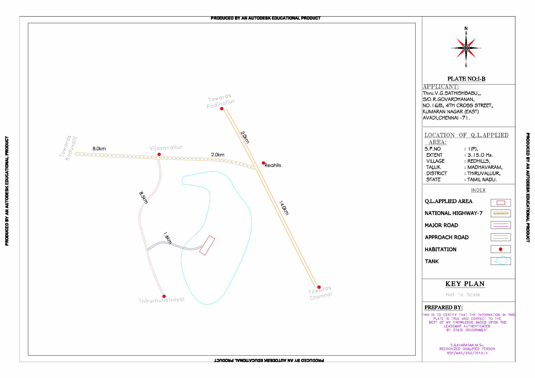
i. Toposketch covering an 1Km radius around the proposed area with markings of
habitations, water bodies including streams, rivers, roads, major structure like
bridges, wells, archeological importance, places of worships is marked and enclosed
as Annexure No. IA.
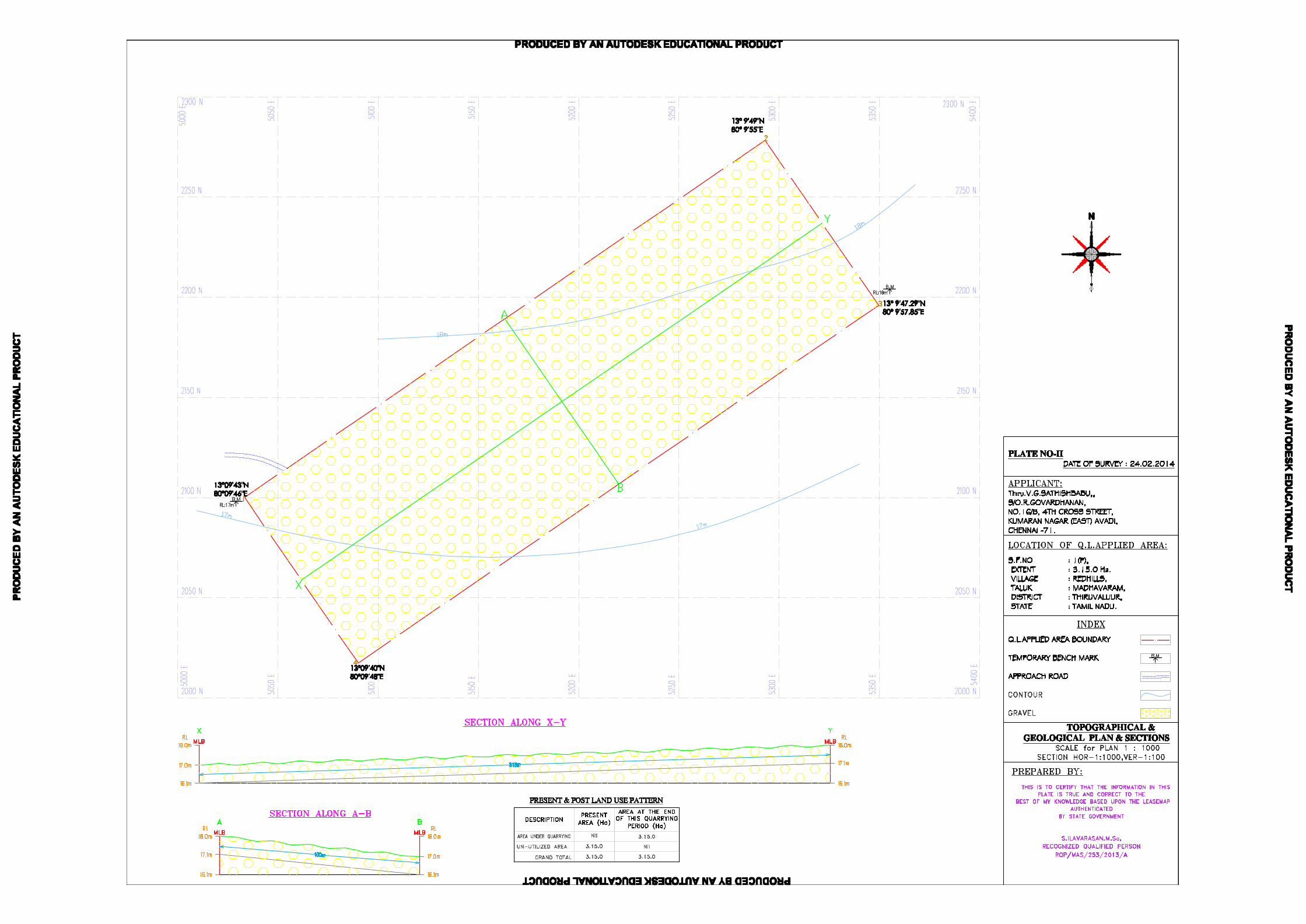
j. The Geographical co-ordinates with distance for the applied area
Red Hills village (Toposheet No 57- P/13)
Boundaries/Corners Co-Ordinates Distance between
Boundaries/ Corners
1 13°09'43"N 80°09'46"E 1-2 = 315m
2 13°09'49"N 80° 09'55"E 2-3 = 100m
3 13°09'47"N 80° 09'58"E 3-4 = 315m
4 13°09'40"N 80°09'48"E 4-1 = 100m
k. The diagram of proposed mining area showing the dimensions of the pit, its proposed
depth of mining, proposed extent of area are marked enclosed as Plate No. III.
l. The area applied for lease is 10Km away from the interstate boundary, protected
area, under wild life protection ACT 1972, critically polluted areas as identified by
CPCB and notified Eco sensitive areas.
m. No wastages are anticipated in the lease applied area, hence waste dump is not
proposed.
n. Around 9 employees are proposed to be deployed for the quarrying operation.
o. Total cost of the project is about Rs. 5,42,000/-
This mining plan and Environment Management plan is prepared by incorporating the
conditions stipulated in the precise area communication and by considering all the
parameters required for the safe and systematic quarrying operations in order to excavate
28,350m3 of Gravel for a period of Sixty days only.
Gravel is composed of consolidated felsic compound Silica and Feldspar. The applicant
intends to use this Gravel especially for leveling and filling of low lying areas for Road projects
and other infrastructure development works.
The applicant intends to use this Gravel especially for leveling and filling of low lying
areas for public and private sector projects in and around the district.
Mining Plan Redhills Gravel Quarry
3
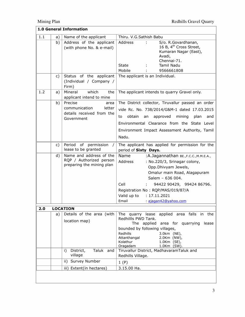
1.0 General Information
1.1 a) Name of the applicant Thiru. V.G.Sathish Babu
b) Address of the applicant
(with phone No. & e-mail)
Address : S/o. R.Govardhanan,
16 B, 4th Cross Street,
Kumaran Nagar (East),
Avadi,
Chennai-71. State : Tamil Nadu
Mobile : 9566661808
c) Status of the applicant
(Individual / Company /
Firm)
The applicant is an Individual.
1.2 a) Mineral which the
applicant intend to mine
The applicant intends to quarry Gravel only.
b) Precise area
communication letter
details received from the
Government
The District collector, Tiruvallur passed an order
vide Rc. No. 738/2014/G&M-1 dated 17.03.2015
to obtain an approved mining plan and
Environmental Clearance from the State Level
Environment Impact Assessment Authority, Tamil
Nadu.
c) Period of permission /
lease to be granted
The applicant has applied for permission for the
period of Sixty Days.
d) Name and address of the
RQP / Authorized person
preparing the mining plan
Name :A.Jagannathan BE.,F.C.C.,M.M.E.A.,
Address : No.220/3, Srinagar colony,
Opp.Dhivyam Jewels,
Omalur main Road, Alagapuram
Salem – 636 004.
Cell : 94422 90429, 99424 86796.
Registration No : RQP/MAS/019/87/A
Valid up to : 17.11.2021
Email : [email protected]
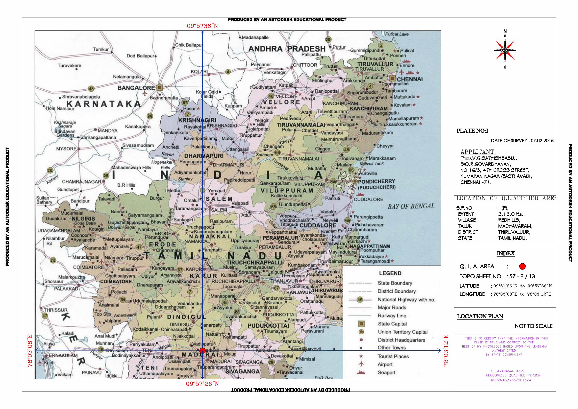
2.0 LOCATION
a) Details of the area (with
location map)
The quarry lease applied area falls in the
Redhillls PWD Tank.
The applied area for quarrying lease
bounded by following villages,
Redhills 3.0km (NE), Attanthangal 2.0Km (NW), Kolathur 1.0Km (SE), Oragadam 1.0Km (SW).
i) District, Taluk and
village
Tiruvallur District, MadhavaramTaluk and
Redhills Village.
ii) Survey Number 1 (P)
iii) Extent(in hectares) 3.15.00 Ha.
Mining Plan Redhills Gravel Quarry
4
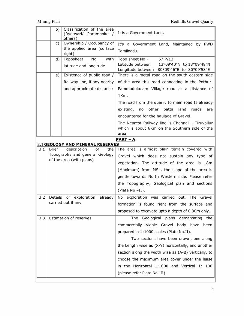
b) Classification of the area
(Ryotwari/ Poramboke /
others)
It is a Government Land.
c) Ownership / Occupancy of
the applied area (surface
right)
It’s a Government Land, Maintained by PWD
Tamilnadu.
d) Toposheet No. with
latitude and longitude
Topo sheet No - 57 P/13
Latitude between 13°09'40"N to 13°09'49"N
Longitude between 80°09'46"E to 80°09'58"E
e) Existence of public road /
Railway line, if any nearby
and approximate distance
There is a metal road on the south eastern side
of the area this road connecting in the Pothur-
Pammadukulam Village road at a distance of
1Km.
The road from the quarry to main road Is already
existing, no other patta land roads are
encountered for the haulage of Gravel.
The Nearest Railway line is Chennai – Tiruvallur
which is about 6Km on the Southern side of the
area.
PART – A
2.1 GEOLOGY AND MINERAL RESERVES
3.1 Brief description of the
Topography and general Geology
of the area (with plans)
The area is almost plain terrain covered with
Gravel which does not sustain any type of
vegetation. The attitude of the area is 18m
(Maximum) from MSL, the slope of the area is
gentle towards North Western side. Please refer
the Topography, Geological plan and sections
(Plate No –II).
3.2 Details of exploration already
carried out if any
No exploration was carried out. The Gravel
formation is found right from the surface and
proposed to excavate upto a depth of 0.90m only.
3.3 Estimation of reserves The Geological plans demarcating the
commercially viable Gravel body have been
prepared in 1:1000 scales (Plate No.II).
Two sections have been drawn, one along
the Length wise as (X-Y) horizontally, and another
section along the width wise as (A-B) vertically, to
choose the maximum area cover under the lease
in the Horizontal 1:1000 and Vertical 1: 100
(please refer Plate No- II).
Mining Plan Redhills Gravel Quarry
5
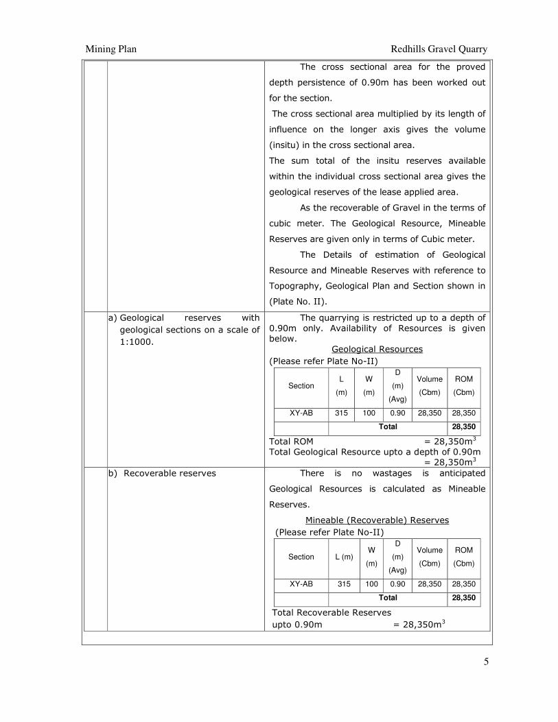
The cross sectional area for the proved
depth persistence of 0.90m has been worked out
for the section.
The cross sectional area multiplied by its length of
influence on the longer axis gives the volume
(insitu) in the cross sectional area.
The sum total of the insitu reserves available
within the individual cross sectional area gives the
geological reserves of the lease applied area.
As the recoverable of Gravel in the terms of
cubic meter. The Geological Resource, Mineable
Reserves are given only in terms of Cubic meter.
The Details of estimation of Geological
Resource and Mineable Reserves with reference to
Topography, Geological Plan and Section shown in
(Plate No. II).
a) Geological reserves with
geological sections on a scale of
1:1000.
The quarrying is restricted up to a depth of
0.90m only. Availability of Resources is given
below.
Geological Resources
(Please refer Plate No-II)
Section L
(m)
W
(m)
D
(m)
(Avg)
Volume
(Cbm)
ROM
(Cbm)
XY-AB 315 100 0.90 28,350 28,350
Total 28,350
Total ROM = 28,350m3
Total Geological Resource upto a depth of 0.90m
= 28,350m3
b) Recoverable reserves There is no wastages is anticipated
Geological Resources is calculated as Mineable
Reserves.
Mineable (Recoverable) Reserves
(Please refer Plate No-II)
Section L (m) W
(m)
D
(m)
(Avg)
Volume
(Cbm)
ROM
(Cbm)
XY-AB 315 100 0.90 28,350 28,350
Total 28,350
Total Recoverable Reserves
upto 0.90m = 28,350m3
Mining Plan Redhills Gravel Quarry
6
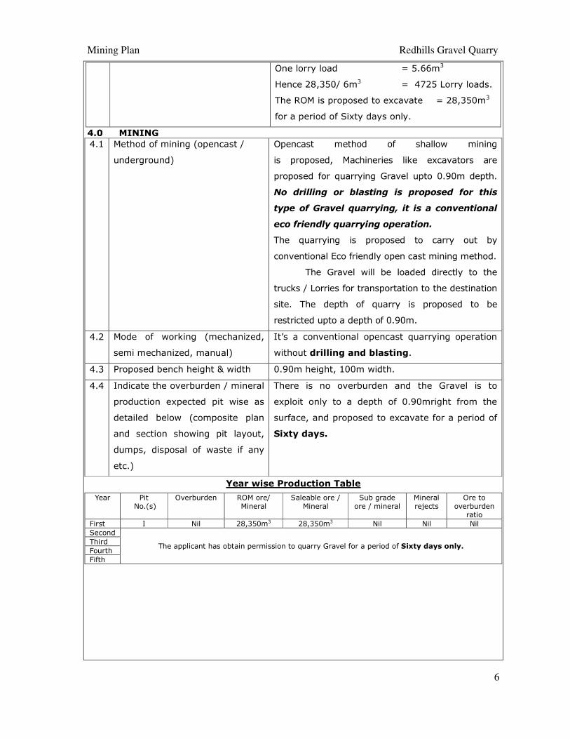
One lorry load = 5.66m3
Hence 28,350/ 6m3 = 4725 Lorry loads.
The ROM is proposed to excavate = 28,350m3
for a period of Sixty days only.
4.0 MINING
4.1 Method of mining (opencast /
underground)
Opencast method of shallow mining
is proposed, Machineries like excavators are
proposed for quarrying Gravel upto 0.90m depth.
No drilling or blasting is proposed for this
type of Gravel quarrying, it is a conventional
eco friendly quarrying operation.
The quarrying is proposed to carry out by
conventional Eco friendly open cast mining method.
The Gravel will be loaded directly to the
trucks / Lorries for transportation to the destination
site. The depth of quarry is proposed to be
restricted upto a depth of 0.90m.
4.2 Mode of working (mechanized,
semi mechanized, manual)
It’s a conventional opencast quarrying operation
without drilling and blasting.
4.3 Proposed bench height & width 0.90m height, 100m width.
4.4 Indicate the overburden / mineral
production expected pit wise as
detailed below (composite plan
and section showing pit layout,
dumps, disposal of waste if any
etc.)
There is no overburden and the Gravel is to
exploit only to a depth of 0.90mright from the
surface, and proposed to excavate for a period of
Sixty days.
Year wise Production Table
Year Pit
No.(s)
Overburden ROM ore/
Mineral
Saleable ore /
Mineral
Sub grade
ore / mineral
Mineral
rejects
Ore to
overburden ratio
First I Nil 28,350m3 28,350m3 Nil Nil Nil
Second
The applicant has obtain permission to quarry Gravel for a period of Sixty days only. Third
Fourth
Fifth
Mining Plan Redhills Gravel Quarry
7
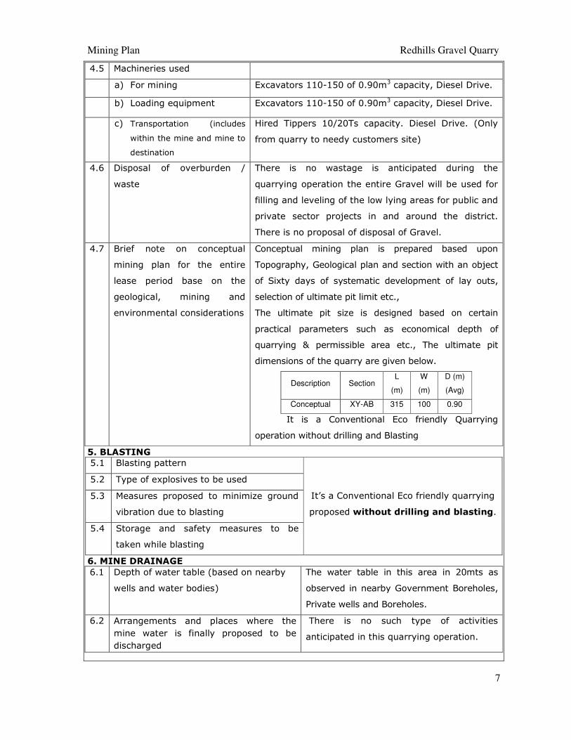
4.5 Machineries used
a) For mining Excavators 110-150 of 0.90m3 capacity, Diesel Drive.
b) Loading equipment Excavators 110-150 of 0.90m3 capacity, Diesel Drive.
c) Transportation (includes
within the mine and mine to
destination
Hired Tippers 10/20Ts capacity. Diesel Drive. (Only
from quarry to needy customers site)
4.6 Disposal of overburden /
waste
There is no wastage is anticipated during the
quarrying operation the entire Gravel will be used for
filling and leveling of the low lying areas for public and
private sector projects in and around the district.
There is no proposal of disposal of Gravel.
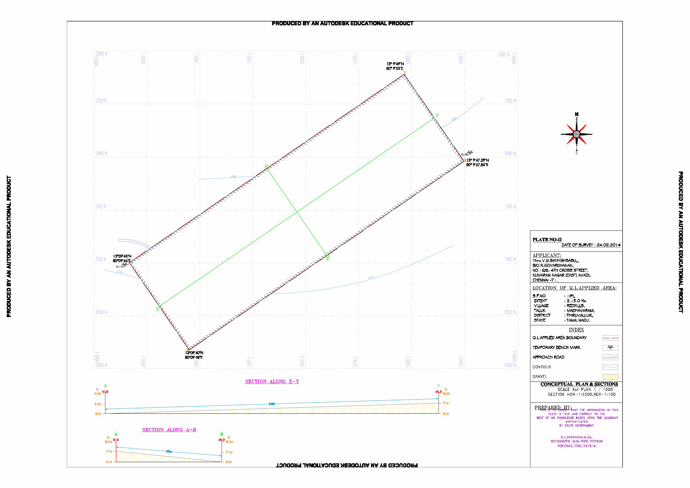
4.7 Brief note on conceptual
mining plan for the entire
lease period base on the
geological, mining and
environmental considerations
Conceptual mining plan is prepared based upon
Topography, Geological plan and section with an object
of Sixty days of systematic development of lay outs,
selection of ultimate pit limit etc.,
The ultimate pit size is designed based on certain
practical parameters such as economical depth of
quarrying & permissible area etc., The ultimate pit
dimensions of the quarry are given below.
Description Section L
(m)
W
(m)
D (m)
(Avg)
Conceptual XY-AB 315 100 0.90
It is a Conventional Eco friendly Quarrying
operation without drilling and Blasting
5. BLASTING
5.1 Blasting pattern
It’s a Conventional Eco friendly quarrying
proposed without drilling and blasting.
5.2 Type of explosives to be used
5.3 Measures proposed to minimize ground
vibration due to blasting
5.4 Storage and safety measures to be
taken while blasting
6. MINE DRAINAGE
6.1 Depth of water table (based on nearby
wells and water bodies)
The water table in this area in 20mts as
observed in nearby Government Boreholes,
Private wells and Boreholes.
6.2 Arrangements and places where the
mine water is finally proposed to be
discharged
There is no such type of activities
anticipated in this quarrying operation.
Mining Plan Redhills Gravel Quarry
8
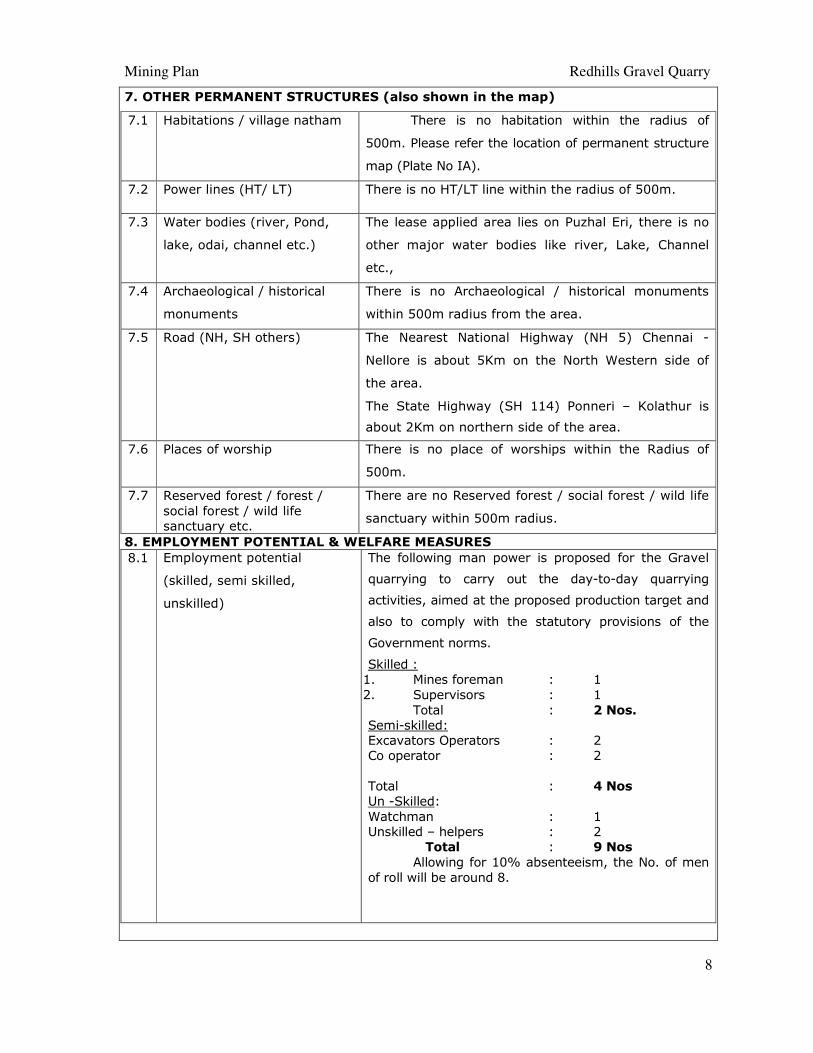
7. OTHER PERMANENT STRUCTURES (also shown in the map)
7.1 Habitations / village natham There is no habitation within the radius of
500m. Please refer the location of permanent structure
map (Plate No IA).
7.2 Power lines (HT/ LT) There is no HT/LT line within the radius of 500m.
7.3 Water bodies (river, Pond,
lake, odai, channel etc.)
The lease applied area lies on Puzhal Eri, there is no
other major water bodies like river, Lake, Channel
etc.,
7.4 Archaeological / historical
monuments
There is no Archaeological / historical monuments
within 500m radius from the area.
7.5 Road (NH, SH others) The Nearest National Highway (NH 5) Chennai -
Nellore is about 5Km on the North Western side of
the area.
The State Highway (SH 114) Ponneri – Kolathur is
about 2Km on northern side of the area.
7.6 Places of worship There is no place of worships within the Radius of
500m.
7.7 Reserved forest / forest /
social forest / wild life
sanctuary etc.
There are no Reserved forest / social forest / wild life
sanctuary within 500m radius.
8. EMPLOYMENT POTENTIAL & WELFARE MEASURES
8.1 Employment potential
(skilled, semi skilled,
unskilled)
The following man power is proposed for the Gravel
quarrying to carry out the day-to-day quarrying
activities, aimed at the proposed production target and
also to comply with the statutory provisions of the
Government norms.
Skilled :
1. Mines foreman : 1
2. Supervisors : 1
Total : 2 Nos.
Semi-skilled:
Excavators Operators : 2
Co operator : 2
Total : 4 Nos
Un -Skilled:
Watchman : 1
Unskilled – helpers : 2
Total : 9 Nos
Allowing for 10% absenteeism, the No. of men
of roll will be around 8.
Mining Plan Redhills Gravel Quarry
9
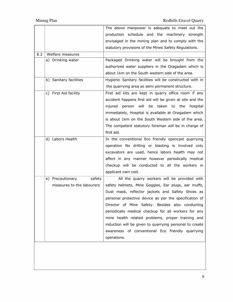
The above manpower is adequate to meet out the
production schedule and the machinery strength
envisaged in the mining plan and to comply with the
statutory provisions of the Mines Safety Regulations.
8.2 Welfare measures
a) Drinking water Packaged Drinking water will be brought from the
authorized water suppliers in the Oragadam which is
about 1km on the South western side of the area.
b) Sanitary facilities Hygienic Sanitary facilities will be constructed with in
the quarrying area as semi permanent structure.
c) First Aid facility First aid kits are kept in quarry office room if any
accident happens first aid will be given at site and the
injured person will be taken to the hospital
immediately, Hospital is available at Oragadam which
is about 1km on the South Western side of the area.
The competent statutory foreman will be in charge of
first aid.
d) Labors Health In the conventional Eco friendly opencast quarrying
operation No drilling or blasting is involved only
excavators are used, hence labors health may not
affect in any manner however periodically medical
checkup will be conducted to all the workers in
applicant own cost.
e) Precautionary safety
measures to the labourers
All the quarry workers will be provided with
safety helmets, Mine Goggles, Ear plugs, ear muffs,
Dust mask, reflector jackets and Safety Shoes as
personal protective device as per the specification of
Director of Mine Safety. Besides also conducting
periodically medical checkup for all workers for any
mine health related problems, proper training and
induction will be given to quarrying personal to create
awareness of conventional Eco friendly quarrying
operations.
Mining Plan Redhills Gravel Quarry
10
PART – B
9. ENVIRONMENT MANAGEMENT PLAN
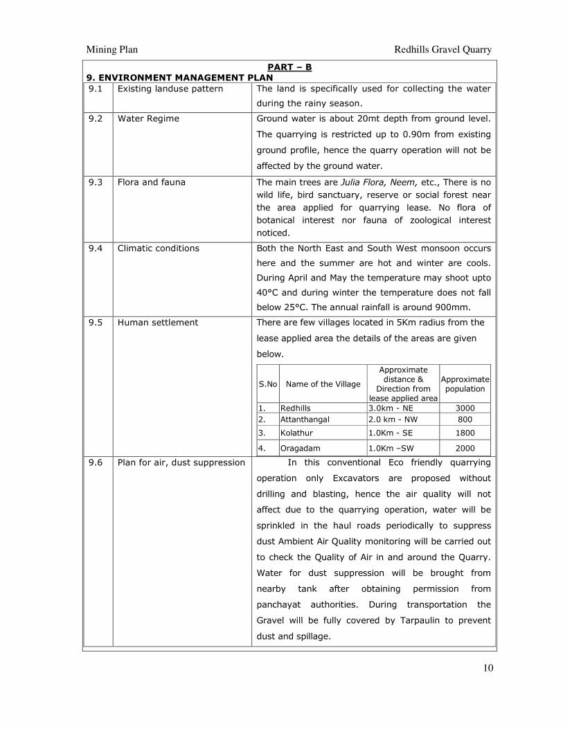
9.1 Existing landuse pattern The land is specifically used for collecting the water
during the rainy season.
9.2 Water Regime Ground water is about 20mt depth from ground level.
The quarrying is restricted up to 0.90m from existing
ground profile, hence the quarry operation will not be
affected by the ground water.
9.3 Flora and fauna The main trees are Julia Flora, Neem, etc., There is no
wild life, bird sanctuary, reserve or social forest near
the area applied for quarrying lease. No flora of
botanical interest nor fauna of zoological interest
noticed.
9.4 Climatic conditions Both the North East and South West monsoon occurs
here and the summer are hot and winter are cools.
During April and May the temperature may shoot upto
40°C and during winter the temperature does not fall
below 25°C. The annual rainfall is around 900mm.
9.5 Human settlement
There are few villages located in 5Km radius from the
lease applied area the details of the areas are given
below.
S.No Name of the Village
Approximate
distance &
Direction from
lease applied area
Approximate
population
1. Redhills 3.0km - NE 3000
2. Attanthangal 2.0 km - NW 800
3. Kolathur 1.0Km - SE 1800
4. Oragadam 1.0Km –SW 2000
9.6 Plan for air, dust suppression In this conventional Eco friendly quarrying
operation only Excavators are proposed without
drilling and blasting, hence the air quality will not
affect due to the quarrying operation, water will be
sprinkled in the haul roads periodically to suppress
dust Ambient Air Quality monitoring will be carried out
to check the Quality of Air in and around the Quarry.
Water for dust suppression will be brought from
nearby tank after obtaining permission from
panchayat authorities. During transportation the
Gravel will be fully covered by Tarpaulin to prevent
dust and spillage.
Mining Plan Redhills Gravel Quarry
11
9.7 Plan for noise level control This Conventional Eco Friendly quarrying
operation does not involve any blasting and drilling
methods, hence noise will be minimal and this is only
due to the movement of Excavators and Trucks.
Periodically Noise level monitoring will be carried out
to check the Noise level in and around the Quarry.
9.8 Environmental impact
assessment statement
describing impact of mining
on the next five years
The life span of the quarry is proposed for the
period of Sixty days only, the Proposed quarrying for a
small production of Gravel does not involve deep hole
drilling and blasting. Such limited mining activity is not
likely to cause any impact adversely on environment
as far as pollution of air, water and noise is concerned.
9.9 Proposal for waste
management
There are no wastages anticipated during the
quarrying operation. The entire Gravel will be
transported to the needy customers site.
9.10 Proposal for reclamation of
land affected during mining
activities and at the end of
mining (refilling / fencing
etc.)
The quarry operation is restricted up to a depth of
0.90m, after removing the Gravel there is no proposal
for backfilling or reclamation. The quarried out land
will be enhance the capacity of the tank. The applicant
ensures to level the floor of the area after quarrying,
The leveling cost would be around Rs.20,000/-.
9.11 Program of afforestation
(indicate extend, number,
name of species to be
afforested)
After the completion of the quarrying operation, the
land will be enhance the Capacity of the PWD Tank.
The applicant ensures to plant native species like
pungam, neem, causirina on the periphery of the tank
bund or nearby villages and village road after
consultation with the panchayat authorities. It is
proposed to plant around 10 trees. The cost estimate
for afforestation is around Rs. 3,000/-
9.12 Proposed financial estimate /
budget for (EMP)
environment management:
The proposed financial estimate budget for EMP is
around Rs. 29,000/- for the period of Sixty days
only.
Mining Plan Redhills Gravel Quarry
12
Project cost / investment
i) Land cost It’s a Government Land hence no cost is involved.
ii) Machinery to be used The excavators of 0.90m3 bucket capacity and
tippers of 10/20Ts capacity will be used.
The quantity of Diesel consumption is based on the
working hours of Excavators (Filling Factor and loading
Cycling), in the open cast quarry project Excavators
are proposed to quarry Gravel. Average Diesel
consumption of Hitachi Excavator model EX 110-150 is
10Ltrs/ Hr.
Total number of Excavator used
for quarrying Gravel = 1No
Average Diesel consumption
Tata Hitachi (Model Ex-110-150) = 10Ltr/Hr
Diesel Prize around = Rs. 60 (At present scenario)
Total Excavator running hours for the project
One excavator will excavate 60Cbm/Hour
= 28,350/60Cbm
= 473 Excavator hours
One Excavator will consume 10Ltrs/ hour
Hence 473 X10 = 4730 Ltrs of HSD will be
utilized for the entire project life.
The hired vehicle charges per hour inclusive of diesel
around Rupees 1000/hour
Total running hours = 473hours
=473 hours x Rs.1000
= Rs. 4,73,000/- for the entire project life.
Cost of the project,
For excavation = Rs. 4,73,000/-
Temporary rest shelter = Rs 20,000/-
Sanitary facilities = Rs. 20,000/-
Leveling after quarrying = Rs 20,000/-
Drinking water = Rs. 2,000/-
Sanitary Arrangements = Rs. 2,000/-
Safety kits = Rs 5,000/-
Total cost of the project = Rs. 5,42,000/-
The cost of the project is about (Rupees five lakhs
forty two thousand)
iii) Refilling / Fencing There is no proposal for Refilling, hence no cost is
involved.
Mining Plan Redhills Gravel Quarry
13
iv) Laborers shed No labours are proposed for quarrying Gravel. The
machine operators are from nearby local villages,
hence no cost is involved. Rest shelter will be
constructed as semi permanent structure at the cost
of Rs.20,000/-
v) Sanitary facility Sanitary facility will be constructed as semi-
permanent structure, the cost will be around
Rs.20,000/-
vi) Others items Leveling after quarrying = Rs. 20,000/-
(a) Expenditure
i) Drinking water facility for
the laborers
9 labours at the rate of Rs 1,000/ month for a period
of Sixty days, the cost will be around Rs.2,000/-
ii) Sanitary arrangement, Sanitary maintenance at the cost of Rs 1,000/ month
the cost will be around Rs.2,000/- for a period of
Sxity days.
iii) Safety kits, Rs.5,000 will be spent for the safety kits such as
Helmet, Goggles, Ear plugs, Ear mask, Safety shoes
and Reflector jackets.
iv) Water sprinkling
(if necessary)
Rs 3000/ month will be spent for sprinkling the water
on haul roads for Dust suppression; the cost will be
around Rs. 6,000/- for a period of Sixty days.
v) Afforestation etc. No Afforestation is proposed on periphery within the
lease applied area, plantation will be carried out in
the nearby village and village roads. The cost
estimate is around Rs.3,000/-
EMP cost
i. Water Sprinkling = Rs. 6,000/-
ii. Afforestation cost = Rs. 3,000/-
iii. Cost towards charity = Rs. 20,000/-
(schools, worship places etc.,)
Total = Rs. 29,000/-
Estimated cost of the project= Rs. 5,42,000/-
Estimated EMP cost = Rs. 29,000/-
Total quarrying Cost
+ EMP cost =Rs. 5,71,000/-
(The Project cost including EMP Cost is about
Rupees Five lakhs seventy one thousand only)
Mining Plan Redhills Gravel Quarry
14
10. MINE CLOSURE PLAN
10.1 Steps proposed for phased restoration,
reclamation of already mined out
areas
It’s a New quarrying project no quarried
out areas within the lease applied area.
10.2 Measures to be under taken on mine
closure as per Act & Rules
This conventional Eco – Friendly quarrying
for a depth of 0.90m does not require any
backfill, Reclamation and Rehabilitation, the
quarried out lands will be enhance the
capacity of the PWD tank, any how the
closure plan will be prepared after
removing the specify quantity.
10.3 Mitigation measure to be undertaken
for safety and restoration /
reclamation of the already mined out
area
This is a fresh Gravel quarry.
Mining Plan Redhills Gravel Quarry
15
11. ANY OTHER DETAILS INTEND TO FURNISH BY THE APPLICANT
This conventional Eco Friendly quarrying operation does not involve any drilling and
Blasting. Only Excavators are proposed to excavate the Gravel for a period of Sixty days
only, care will be taken in all steps to prevent any adverse eventualities. This is the B2
category quarry proposed for a short period of Sixty days only.
STATUTORY PROVISIONS
The mining plan for Gravel is prepared as per the Draft Minor Mineral Conservation
and Development Rules, 2010 and also by the Tamilnadu Minor Mineral Concession Rule,
1959. The provisions of the Mines Act, Rules and Reg ulations and orders made there under
shall be complied with, so that the safety of the mine, machinery and person will be
protected. Permission, relaxation or exemption wherever required for the safe and scientific
quarrying of the deposit will be obtained from the Consent Departments. Any violation
pointed out by the inspecting authorities shall be rectified as per the guidelines of the
Department.
Prepared by
A.Jagannathan BE.,F.C.C.,M.M.E.A., RQP/MAS/019/87/A
Place : Salem
Date : 18.03.2015