Embed Size (px)
Citation preview
Thirty year Time Series of Merged Raingauge Satellite Rainfall Data over EthiopiaThirty‐year Time Series of Merged Raingauge‐Satellite Rainfall Data over Ethiopiay y g g g p
T f Di k 1 St h C 1 D id G i 2 Ki f H il i 3 R M id t2 d El T k 2Tufa Dinku1, Stephen Connor1, David Grimes2, Kinfe Hailemariam3, Ross Maidement2, and Elena Tarnavsky2, p , , , , y
i l h i f li d i1. International Research Institute for Climate and Society, y,
h h i i ithe Earth Institute at Universityy
f l i i f di2. Department of Meteorology, University of Reading, UKp gy, y g,
i l l i l ddi b b hi i3. National Meteorological Agency, Addis Ababa, Ethiopiag g y, , p
Long term temporally homogeneous time series of rainfall data are of great importance in a number of applications TheLong-term, temporally homogeneous time series of rainfall data are of great importance in a number of applications. Theconventional source of climate data is weather stations. However, reliable climate information, particularly throughout ruralconventional source of climate data is weather stations. However, reliable climate information, particularly throughout ruralAf i i li it d Th il bl th t ti l di t ib t d ith t f th t ti l t d l th iAfrica, is very limited. The available weather stations are unevenly distributed, with most of the stations located along the main, y y , groads in cities and towns The alternative has been satellite rainfall estimates with the main advantage of excellent spatialroads in cities and towns. The alternative has been satellite rainfall estimates with the main advantage of excellent spatialconverge. But satellite rainfall estimates also suffer from a number of critical shortcomings that include heterogeneous timeconverge. But satellite rainfall estimates also suffer from a number of critical shortcomings that include heterogeneous time
i h t ti i d d ti l l t hi h t l d ti l l ti Th it k l t fseries, short time period, and poor accuracy particularly at higher temporal and spatial resolutions. Thus, it makes a lot of sense, p , p y p y g p p ,to combine the point accuracy of the raingauge measurements with the better spatial coverage of the satellite estimates Thisto combine the point accuracy of the raingauge measurements with the better spatial coverage of the satellite estimates. Thisposter describes the use of raingauges and satellite rainfall estimates to produce 30-year rainfall time series over Ethiopia atposter describes the use of raingauges and satellite rainfall estimates to produce 30 year rainfall time series over Ethiopia at
ti l l ti f 10k d t d il ti lspatial resolution of 10km and ten-daily time scale.p y
d1. Required 4 Outputs1. RequiredC l t h d hi l ti (10k ) ti i f t d il i f ll
4.OutputsComplete, homogenous, and hi‐resolution(10km) time series of ten‐daily rainfall 30‐year time series of gridded rainfall datadata going back 30‐years.
30 year time series of gridded rainfall datadata going back 30 years.
30‐year time series of satellite rainfall estimate30 year time series of satellite rainfall estimate i i f d i lli i f ll2 Problems 30‐year time series of merged raingauge‐satellite rainfall2. Problems 30 year time series of merged raingauge satellite rainfall
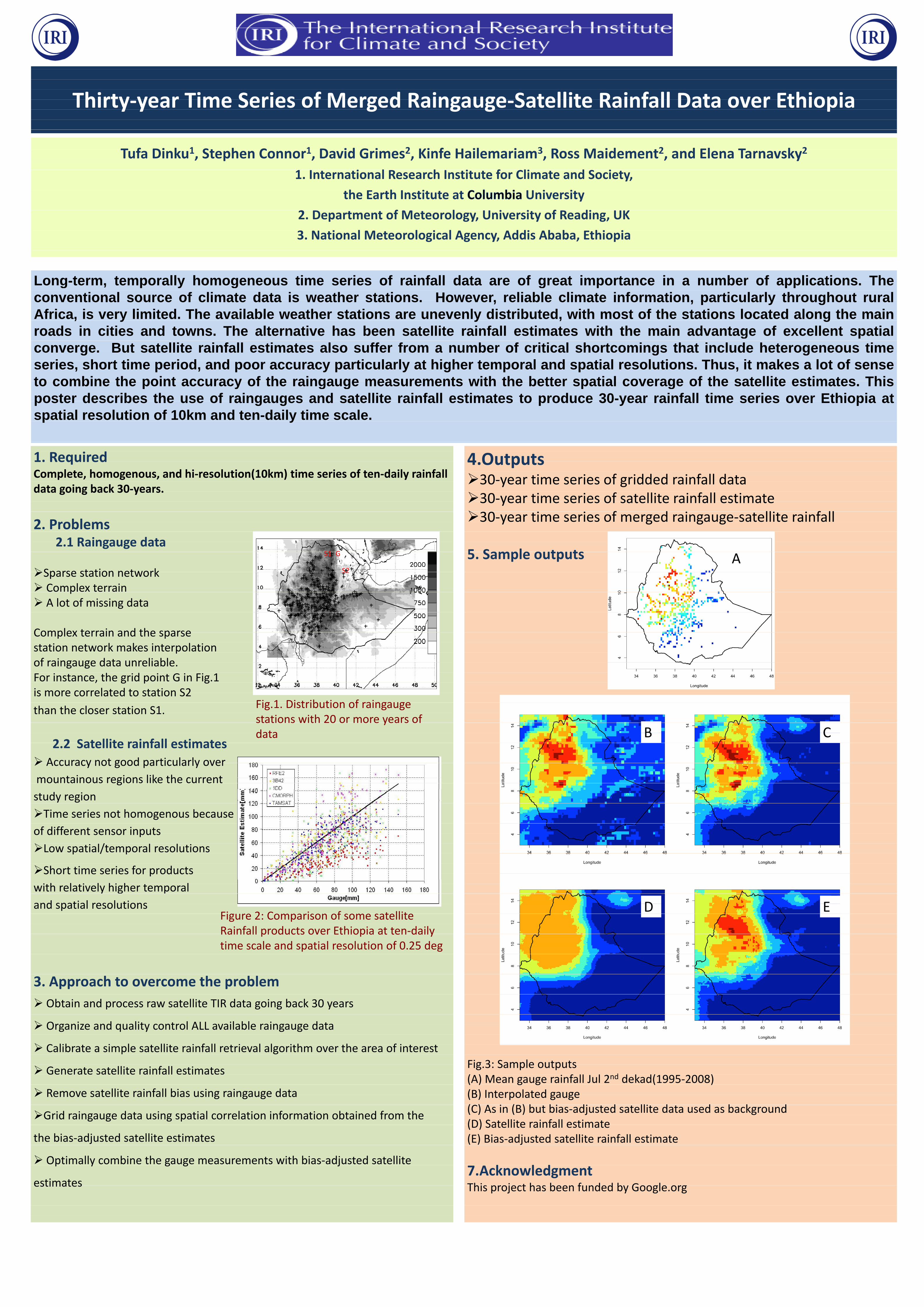
2 1 Raingauge data2.1 Raingauge data5 Sample outputsGS1 5. Sample outputsGS1 A
Sparse station network S2A
Sparse station network S2
Complex terrain p A lot of missing data A lot of missing data
Complex terrain and the sparseComplex terrain and the sparse station network makes interpolation pof raingauge data unreliableof raingauge data unreliable.For instance, the grid point G in Fig.1, g p gis more correlated to station S2is more correlated to station S2
Fig 1 Distribution of raingaugethan the closer station S1. Fig.1. Distribution of raingauge than the closer station S1.stations with 20 or more years ofstations with 20 or more years of data CB
2 2 Satellite rainfall estimatesdata CB
2.2 Satellite rainfall estimates
Accuracy not good particularly over Accuracy not good particularly over
mountainous regions like the current mountainous regions like the current
t d istudy region
Time series not homogenous becauseTime series not homogenous because
of different sensor inputsof different sensor inputs
/Low spatial/temporal resolutionsp / p
Short time series for productsShort time series for products
i h l i l hi h lwith relatively higher temporal
and spatial resolutions EDand spatial resolutionsFigure 2 Comparison of some satellite
EDFigure 2: Comparison of some satellite Rainfall products over Ethiopia at ten‐dailyRainfall products over Ethiopia at ten daily time scale and spatial resolution of 0 25 degtime scale and spatial resolution of 0.25 deg
3. Approach to overcome the problem3. Approach to overcome the problem
Obtain and process raw satellite TIR data going back 30 years Obtain and process raw satellite TIR data going back 30 years
Organize and quality control ALL available raingauge data Organize and quality control ALL available raingauge data
C lib i l lli i f ll i l l i h h f i Calibrate a simple satellite rainfall retrieval algorithm over the area of interest
Fig 3: Sample outputs Generate satellite rainfall estimatesFig.3: Sample outputs( ) f ll l d d k d( )(A) Mean gauge rainfall Jul 2nd dekad(1995‐2008)
Remove satellite rainfall bias using raingauge data( ) g g ( )(B) Interpolated gauge Remove satellite rainfall bias using raingauge data (B) Interpolated gauge(C) i ( ) b bi dj d lli d d b k dGrid raingauge data using spatial correlation information obtained from the(C) As in (B) but bias‐adjusted satellite data used as backgroundGrid raingauge data using spatial correlation information obtained from the ( ) ( ) j g(D) Satellite rainfall estimate
th bi dj t d t llit ti t(D) Satellite rainfall estimate(E) Bi dj d lli i f ll ithe bias‐adjusted satellite estimates (E) Bias‐adjusted satellite rainfall estimate
Optimally combine the gauge measurements with bias‐adjusted satellite k l d
p y g g j7.Acknowledgment
estimates7.AcknowledgmentThi j t h b f d d b G lestimates This project has been funded by Google.org