Embed Size (px)
Citation preview

The Pacific Historian§2.garterly Bulletin if the California History Foundation,
the Westerners Foundation, and the Jedediah Smith SocietyCOLLEGE OF THE PACIFIC STOCKTON 4, CALIFORNIA
Volume III AUGUST 1959 Number 3
How the Sacramento-SanJoaquin Deltawas Settled
By DR. JOHN THOMPSON
ExplorationIn the late 18th century, when the Spanish were first exploring this part of the
interior, the delta center and northwestern and southwestern margins were sparselypopulated compared to the wooded valleys and plains that extended eastward toward theSierra Nevada. The less populated areas, predominantly tule or grassland, offered lessrich and varied food-procuring opportunities to the Indians. The islands and eastern
The drainage from more than one-third of California arises in the basins of the Sacra-mento and San Joaquin rivers. The floodplains of these arterial streams merge about50 miles northeast of San Francisco, and the rivers pass through a complex network ofinterconnecting channels before discharging into the easternmost of the chain of bayswhich breaches the Coast Ranges. The segment of the Central Valley where the riversmerge and enter Suisun Bay is the Sacramento-San Joaquin Delta. Roughly delimitingthe region of tidal and river overflowed swamp are the cities of Sacramento, Stockton,Tracy, and Antioch. Over half of this region's 535,000 acres is at or below sea level;the remainder of the delta, where elevations do not exceed 10 feet, was subject to riveroverflow.
Before man started working in the Sacramento-San Joaquin Delta it had the surfacefeatures generally associated with deltas developed by low gradient rivers-upon enteringtidal water. There were meandering distributary channels, flanking banks or naturallevees that diminished in breadth and height seaward, and island or mainland tracts oftidal marsh. The delta is unusual compared to others in that an exceptionally largevolume of indigenous organic fill, peat, occupies its core. Most deltas are built up by thedeposition of fine rock particles. Here the rock particles have shared delta building withplants.
The peat is a capping layer to the delta; it is 50-60 feet thick in the west central areasand thins out to the north, east, and south. This peat and the ample water supply of thedelta are the basic resources. The peat makes exceptionally rich soil.
The Sacramento-San) oaquin Delta differs from most great deltas in that here theriver channels converge toward a narrow outlet whereas other deltas and delta channelsspread out toward the sea.
THE DELTA AND THE FRONTIER

The Pacific Historian
delta margin during the first two or three decades of the 19th century were a refugearea for Indians who chose to avoid or escape the alien European culture. Suggesting therefuge nature of the delta was the swelling of villages in the Sherman Island-StatenIsland area to 1,000 or 1,200 residents. Prior to this unsettled period a large villagewould have housed 200 souls.
The military and clerical explorers gained a reasonably comprehensive idea of thedelta's extent and of the nature of its land and waterways by 1817. Exploration hadbeen peaceful at first; but, after 1810, punitive forays were frequent. The pressuresof border warfare and of displaced peoples produced a breakdown in tribal areas andsociety. Nevertheless, the Indians remained sufficiently strong to parry raids from thecoast with their own forays against San Jose, Santa Clara, and Solano.
TrappersAt the time when the Indians were contesting with the Californians, the Rocky
Mountain men and Hudson's Bay company trappers entered the delta. Jedediah Smithand party arrived in 1827; and from 1828 to 1843 the Hudson's Bay Companybrigades trapped the fine peltries of the delta and San Francisco Bay. Customarily thebrigades camped for a few days on the lower Mokelumne, lower Calaveras, at FrenchCamp, and near the mouth of the Stanislaus. From these various camps canoe partieswould ply the waterways. Trapping was difficult; tides interfered and the beavers werewary. Moreover, the parties had to contend with horse-stealing Indians, swarms ofmosquitoes, and harassing by General Vallejo and Captain Sutter. Even GovernorAlvarado increased the hazards of trapping by inducing one brigade to join a raid uponan Indian settlement. Later, when the Governor agreed to the licensing of the trappersand to the establishment of a trading post, it may be presumed that he appreciated thevalue of strong, cooperative, trapping parties in an interior peopled by inflamed Indians,would-be empire builders, and' an unknown number of transient whites. The Hudson'sBay Company, reluctant to have its brigades diverted from their primary job, instructedtrappers to refrain from violence, to show sympathy for the government cause, but toavoid being identified with that cause. These were temporary matters for the Companyoperations in the delta ended in 1843 and the San Francisco post was closed twoyears later.
Land GrantsAlthough there was some interest in establishing missions in the interior, this type
of stabilizing or buffer-forming institution never materialized. However, such a bufferinstitution was developed later through the granting of frontier land to private parties.The grants of the delta periphery, awarded between 1835 and 1844, included LosMeganos ( 1835), in the undulating plains northwest of Byron; Los Medanos ( 1839),near Antioch; the rancho El Pescadero and Paso del Pescadero (1843), at the south-ern end of the delta; Campo de los Franceses (1844), largely to the south of theCalaveras and east of the San Joaquin; Los Ulpinos (1844), west of the Sacramentoand south of Cache Slough; and Sutter's New Helvetia (1839).
Ranching was initiated by Californians of Spanish extraction on the grants southwestof the delta, but it was the naturalized Californians (Marsh, Weber, all,d Sutter) whoultimately made a success of these enterprises. While the summer grazing value of the

MILES
EL
BYRON.
..:
DAVIS.
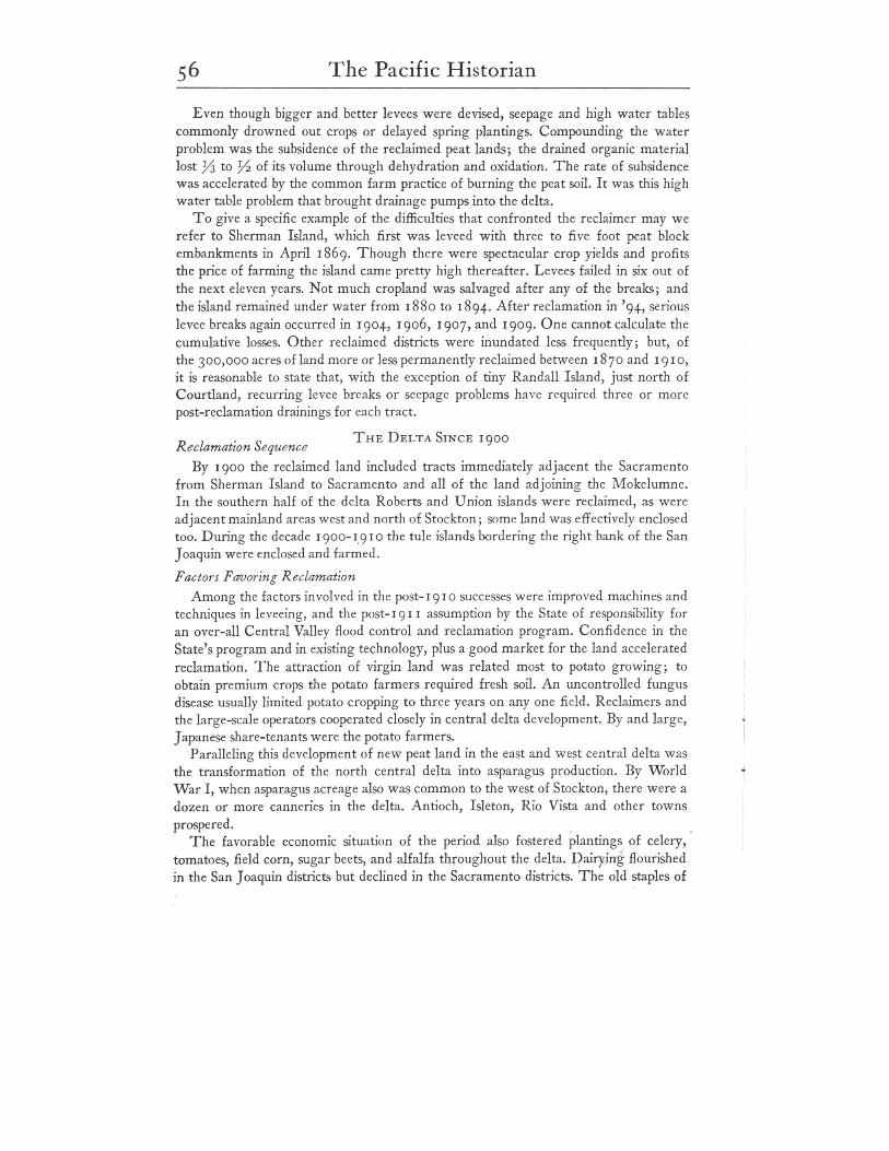
LAND GRANTS
LOS
CONTOI/RS
LOS MEGANOS
tN
o 2 4d'o",,/f by .flit/II R 1ft( Ltltlf/
LEGEND'
..........
'.
SACRAMENTO-SAN JOAQUIN DELTA
Elevations & Land GTants
52 The Pacific Historian
GOLD RUSH DEVELOPMENTS
tules appears to have been appreciated, the land grant areas generally did not embracetidal swamps.
Notably successful in maintaining friendly relations with the Californians and theinterior Indians, were Sutter and Weber. These squires who lived beyond the tules andbeyond effective reach of Mexican authority, were stabilizing factors as far as theIndian problem was concerned. While their behavior was largely apolitical, theirmotivations were not.
The delta vicinity grant holders believed in the growth potential of townsites situated.at the outlet to the Central Valley and on firm ground near year-round heads of naviga-tion. Colonies were developed in 1846 and 1847 at the present Pittsburg and nearCollinsville (Montezuma); at Rio Vista (Brazoria), Stockton, and Sacramento. Only·the Sacramento and Stockton experiments showed promise on the eve of the Gold Rush.At the time the delta remained essentially unoccupied except for a few Indians.
Traffic RoutesThe main delta channels became arterial thoroughfares during the Gold Rush but
the tules remained a barrier to land movement. The land routes to the mines from SanFrancisco skirted the delta, more or less establishing the lines followed by present high-ways from the Carquinez Straits to Sacramento (U. S. 40), from the Livermore Valleyto Stockton (U. S. 50), and between Stockton and Sacramento. The trails crossed theSacramento and San Joaquin flood plains where they were narrowest. To have crossedeither river downstream would have involved more channels to get over.
SettlementAfter the initial Gold Rush upheaval many men turned to working the soil rather
than gravel. umerous miners who entered the delta and adjacent bottomlands andbecame gardeners and wood choppers, first selected the tree-cloaked natural leveesfronting on the Sacramento or lying athwart the trails. The natural levees were attrac-tive because they afforded timber, friable soil, a year round supply of water, and easyaccess to the transient consumers. The location was good too for reaching Sacramento,the mines, and San Francisco. The tules, particularly to the northwest of Stockton andnorth of Rio Vista, were used for grazing and for resting stock driven in from the south.During summer the receding waters of the delta bared lush growth; at the time winterrange on the valley floor was drying up. The tules were burned each fall or early winterin the belief that the grazing resource was improved thereby.
In 1850 the most active area of delta settlement followed the narrow lines ofSacramento River natural levees between Freeport and Grand Island; also, there weregardens near Rio Vista, along the lower Calaveras, at French Camp and the San Joaquincrossing, and northeast of Antioch. Two years later the delta margins at the Mokel-umne, Calaveras, Stanislaus and San Joaquin rivers were entirely occupied. By 1857 theSacramento River east bank settlers had established a continuous corridor of farms fromSacramento to opposite Rio Vista. The west bank was occupied from about Clarksburgto lower Grand Island. South of Rio Vista, where natural levees were modest in height'and width, the gardens were small and thinly scattered. As far as has been learned,there was no significant amount of settlement in the San Joaquin part of the delta until
The Pacific Historian 53
THE ERA OF RECLAMATION
about 1869, when Chinese gardeners and whites had cleared a number of natural leveefarms along the San Joaquin between Rough and Ready Island and the crossing.Potatoes, onions, and beans, and a variety of more perishable vegetables were raised.
Among the earliest settlers there were those who intended to claim pre-emptionrights; others were merely taking up residence until such time as they could return tothe gold country or to the old country. In an average of one out of two years in the1850's high water threatened or ruined garden crops and other improvements, so theadvantage of placing a shanty on pilings or a cabin on an Indian mound was appreciatedearly. The houses and barns of the delta have become more elaborate since, but untilrecently they were almost always placed high enough to escape anticipated floods.Artificial and natural mounds, and piling-supported structures are common today.
Early Recla17WtionPerhaps earlier, and certainly by 1852, the settlers were throwing up low levees to
protect their lands. Such embankments, appropriately termed "shoestring levees," werefirst common on Grand, Tyler, and Merrit islands, and near where the Mokelumneand Calaveras rivers enter the delta. Many settlers hesitated to invest in the costlyimprovements which leveeing represented because the California legislature and theexecutive branches of both the State and Federal governments were laggard in clarifyingtitle to swamp and overflowed land. Besides, a good many people were convinced thatfloods could not be contained and that the delta's future would have to lie in naturalhay production.
The protection of the swamp and overflowed land with levees began as the independ-ent enterprise of owner-operators, but gradml1ly the farmers pooled their resources todevelop uniform river-front levees. Between 186 I and 1866 the individual reclaimersformed districts which, with the technical assistance of a State Board of ReclamationCommissioners, attempted the orderly enclosure of individual islands and delta margintracts. After 1866 the responsibility for reclamation was assumed by the various countyboards of supervisors. Then began an era of strongly competitive, frequently irrational,independent levee building by reclamation districts. Owners leveed along propertylines rather than cooperate in the leveeing of island units; some owners created inde-pendent districts within the larger districts in order to avoid assessments for the verylevees which were their neighbor's as well as their own protection.
The Land BoomAfter 1868, when a 640 acre ownership limit requirement was repealed by the
legislature, wealthy individuals and corporate speculators undertook extensive reclama-tions. As much as 25°,000 acres were held in the name of single individuals at onetime. The serious droughts of the period enhanced the attractiveness of the swamp lands,and the increment in land value that followed reclamation made it a lucrative business.The land, bought for 50C to $5.00 per acre, was worth $25 per acre drained, and $40to $60 per acre when broken. From the late 1860'S, then, land developers over-shadowed individual settlers as the moving force in bringing land into cultivation; theiroperations generally took place in island back-swamps or on islands where the naturallevees were small. Reclamation of such areas required labor, skills and equipment which

54 The Pacific Historian
only the capitalists could underwrite. The projects were undertaken usually with theintention of leasing reclaimed land, although some developers participated in farmingon a large scale and one or two sold property as family farms.
Reclamation EquipmentIn choosing to reclaim the Delta the entrepreneurs unwittingly assumed a long-term
task that was laborious, costly, and frequently disheartening. Many individuals wereruined by the delta. But the operators as a group invented or perfected successful steampowered mechanical devices for dredging, levee building, ditching, land clearing anddraining.
The early levee building was done by manual effort and horsepower on the firmnatural levee soils; in areas of peat, shovel and wheelbarrow gangs did the work. Theartificial levees usually rose 3- 17 feet above the surface of the natural levee ; they were3 or 4 to 20 feet wide at the crown; and the bases varied from 12 to 100 feet wide.Hand labor and horse-drawn scrapers and earth moving machines approached the limitof practicable utilization in the late 1870's. They were supplanted by steam dredgesand ditchers which for half the price moved twice the volume of fill onto a levee. Theclamshell dredge became the most successful type of machinery used in reclamation.The various types of mechanical earth moving equipment ultimately made reclamationand large scale farming possible. Without the big equipment there would not be muchto farm in the delta.
Delta ScenesIn the several decades after 1870 the average riverside scene along the Sacramento
and in the south delta downstream to about latitude of Stockton included a thinlywooded, often cropped or grazed natural levee face. Surmounting the levee was anartificial embankment that served as roadbed and flood defense; behind it on moundsor piling, stood houses and barns. Pump houses showed up on the levees here and there,and fruit or vegetable sheds and brush landings or small wharves marked the home-steads. Squalid waterside "Chinatowns" were especially numerous along the Sacra-mento, there was the occasional village with commercial houses and wharf, and hereand there were isolated school, church, or lodge buildings. From Rio Vista to Collins-ville clusters of fishermen's shacks might be seen among the tules.
Farm buildings varied from modest thatched sheds to striking frame mansions.The more elaborate homes were surrounded by cluttered gardens of subtropical andmiddle latitude flowers, shrubs, and trees. The Sacramento in particular offered aninteresting trip for the riverboat passenger. Houses, shanty towns, fields, orchards, andpastures were easily seen from the steamboats.
Within the delta an almost continuous strip of fields and orchards lay along thenatural levees of the Sacramento. Along the San Joaquin and Mokelumne, wherenatural levees were less well formed, settlement was more sparse. In all areas theriverside strips of row crops and orchards were gradually being broadened into the tulesthat occupied the island centers. The procedure for opening the virgin land was to dike, .ditch, then drain the swamp; roll or burn off the vegetation, and plow or burn the drytule sod. Once the four to ten inch bed of ashes cooled, a grain, usuaUy'wheat, wasbroadcast and brushed or harrowed in. Sometimes sheep were driven across the fields to
The Pacific Historian 55tramp in tl1e.'grain. Remaining tule swamps commonly were catde and swine feedingareas. As a matter of fact, on the less developed islands one could hunt or trap the feralswine. The captured young soon got used to man. Thus, in the last quarter of the 19thcentury an average island might be expected to have tule pasture in the lowest spot,large grain fields spreading over the recendy reclaimed areas, and row crops- potatoes,onion, and beans-on the higher lands of the island periphery. There, too, were theorchards.
Crops and MarketingDelta farmers, tenant and independent, had an advantageous situation for competing
in the San Francisco produce trade. The soils were fertile and easy to work; irrigation,if needed, was low cost; transportation was cheap and fast; and the delta crops ripenedearly. As far as commercial orchard development was concerned, only the SacramentoRiver district really prospered. The orchard district, from Freeport to Isleton, special-ized in deciduous fruits, with peaches apparendy dominant and plums, apples, and pearsin a lesser role. Although San Francisco was the first market, the opening of trans-continental rail service drew a good deal of fresh and dried fruit to Sacramento. At thetime when the Eastern market was opening up, recurring floods and persistendy highwater tables were harming the stone fruit orchards. Fortunately for local orchard men,pear trees did well in spite of the water and the fruit was enthusiastically received in theEast. The demand continues to the present; pears, chiefly Bartletts, dominate in thefruit trade of the Sacramento River district.
There tended to be a crop specialization among delta residents. Orchards wereowner-operated for the most part, chiefly by the pioneer families that had secured thepremium natural levee land. Riverside vegetable lands were worked by Chinese cash orshare tenants, although later on Italians, Portuguese and Japanese were important.Land rented for $10-$20 per acre; or for 25-50% of the crop when seed, equipment,and horses were furnished by the owner. The grain land was farmed by Caucasians,many of them tenants. Dairying was an aspect of the general farming pattern that char-acterized the Sacramento River islands. Asa rule it was the orchard operators, and Italianand Portuguese farmers near Freeport and Clarksburg, who maintained dairy herds.
Hazards of Delta SettlementThe fundamental hazard in reclaiming land for crops and in making a go of farming
was that for every acre of swamp enclosed there was an acre less of floodplain overwhich the winter and spring run-off might spread. Reclamation also reduced the areaof the delta tidal basin, thereby diminishing the scouring power of tidal water. The lossof tide scouring power was serious because great volumes of gold mining debris werepouring through the delta in the decades 1860 to 19 I O. Debris accumulations in theSacramento River were as much as 10 feet deep below the capital.
The hazards of debris-choked channels was worsened by the levee builders whobuilt their dikes hard by the river rather than set them back. It was a race betweendistricts to build the highest levee, for the higher and stronger one was, the surer hefelt that a levee break next door would save him. It is a curious thing; people leveedagainst each other as much as against the river. Since some people were thought to becapable of midnight levee cutting while under tension, there were times when menkept guns as well as shovels handy.
THE DELTA SINCE '9°°
The Pacific Historian
Even though bigger and better levees were devised, seepage and high water tablescommonly drowned out crops or delayed spring plantings. Compounding the waterproblem was the subsidence of the reclaimed peat lands; the drained organic materiallost YJ to y, of its volume through dehydration and oxidation. The rate of subsidencewas accelerated by the common farm practice of burning the peat soil. It was this highwater table problem that brought drainage pumps into the delta.
To give a specific example of the difficulties that confronted the reclaimer may werefer to Sherman Island, which first was leveed with three to five foot peat blockembankments in April, 869. Though there were spectacular crop yields and profitsthe price of farming the island came pretty high thereafter. Levees failed in six out ofthe next eleven years. Not much cropland was salvaged after any of the breaks; andthe island remained under water from, 880 to ,894. After reclamation in '94, seriouslevee breaks again occurred in '9°4, '9°6, '9°7, and '9°9. One cannot calculate thecumulative losses. Other reclaimed districts were inundated less frequently; but, ofthe 3°0,000 acres of land more or less permanently reclaimed between' 870 and, 9' 0,it is reasonable to state that, with the exception of tiny Randall Island, just north ofCourtland, recurring levee breaks or seepage problems have required three or morepost-reclamation drainings for each tract.
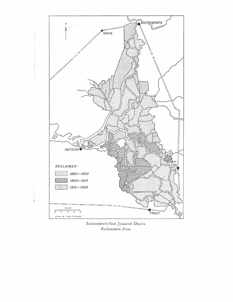
Reclamation SequenceBy '9°° the reclaimed land included tracts immediately adjacent the Sacramento
from Sherman Island to Sacramento and all of the land adjoining the Mokelumne.In the southern half of the delta Roberts and Union islands were reclaimed, as wereadjacent mainland areas west and north of Stockton; some land was effectively enclosedtoo. During the decade, 9°0-',9' ° the tule islands bordering the right bank of the SanJoaquin were enclosed and farmed.
Factors Favoring ReclamationAmong the factors involved in the post-, 9 10 successes were improved machines and
techniques in leveeing, and the post-, 9" assumption by the State of responsibility foran over-all Central Valley flood control and reclamation program. Confidence in theState's program and in existing technology, plus a good market for the land acceleratedreclamation. The attraction of virgin land was related most to potato growing; toobtain premium crops the potato farmers required fresh soil. An uncontrolled fungusdisease usually limited potato cropping to three years on anyone field. Reclaimers andthe large-scale operators cooperated closely in central delta development. By and large,Japanese share-tenants were the potato farmers.
Parane!ihg this developmental' n~wlJ~at lan-d in the east and west central delta wasthe transformation of the north central delta into asparagus production. By WorldWar I, when asparagus acreage also was common to the west of Stockton, there were adozen or more canneries in the delta. Antioch, Isleton, Rio Vista and other townsprospered. ,
The favorable economic situation of the period also fostered plantings of celery,tomatoes, field corn, sugar beets, and alfalfa throughout the delta. Dairying flourishedin the San Joaquin districts but declined in the Sacramento districts. The old staples of
N
RECLAIMED:
[::::::::::1 1860-1900_I 1900-1910
FiW?41NiiJ 1910- 1930
MILES
o
SACRAMENTO-SAN JOAQUIN DELTA
Reclamation Areas
The Pacific Historian
delta farming-potatoes, beans, onions, and wheat-were being supplemented (andafter the war supplanted) by new crops. The pattern of tenantry, and the use of manualand horse power changed also. What has been called the "new industrial farming" wasdeveloping. The tracked and wheeled tractor replaced the traction engine; the use offertilizers and of improved seeds was adopted. Between 19 I 0 and 1926 electric powerand telephone service, paved roads, and motor vehicles spread through the delta. Theimprovements in communications and transportation had a marked effect upon the oldway of doing things. It became attractive to replace tenant labor with wage earners;labor camps gradually lost their usefulness as operators chose to haul men to the fieldsfrom neighboring towns. The once numerous "mosquito fleets" of passenger launchesand the freight vessels gradually disappeared. Farmers became product-standards-conscious, and they became contract sellers rather than consignment shippers. Generalcrop interests and the areal distribution of particular crops, crop handling methods andthe nature of the labor force continue to change. These changes are reflected not onlyin the appearance of the fields but in the structures of the delta.
Landscape ChangesThe riverside asparagus canneries are all but gone, and the big frame barns and the
levee-top cribs are disappearing. Older sections of some delta towns are badly deterior-ated. On the other hand, one now sees the occasional new grain elevator, corrugatedmetal packing sheds, substantial single houses, and new residential sections through thearea. A striking feature of farm and home construction in the last quarter century hasbeen the tendency to build on the island floors. Earlier the orientation was clearly river-side and on high ground. Today's farmers do not have the ties with the river that theyhad when it was main street. However, there is a great deal of interest in the waterways.Boat liveries and vacationist camps have flourished in the past quarter-century. Theyshould prosper, along with the 'farmers, as the urban Bay Area grows.
ConclusionsTo conclude, may we state that the delta is essentially a "man-made" landscape.
Few rural regions have been so altered from the natural state as this Sacramento-San Joaquin Delta. The cultural imprint takes several forms. Depressed crop land hasreplaced the sea-level tule swamp of the pre-reclamation era. Natural hummocks andnatural levees are planed to flatten island floors. The major landmarks in the deltaare the massive earthworks that cloak the natural levees. Channels have been altered andeven created by dredging. The delta soils are essentially man made; they could not haveevolved without draining the tules. Neither would the incidence of mineral soil be whatit is without mining debris and peat subsidence. The atmosphere, too, occasionally cloudsup with evidence of man's impact upon the area; not only are we consuming the peat,but in draining the swamps we have interrupted the processes by which the very wealthof the delta was created. While this may sound bleak, I am confident that any societythat could produce a Sacramento-San Joaquin Delta is going to devise means toconserve it.
![SnUG at The SnugAlright - Supergrass SnUG @ The Snug –2nd Monday of each month at The Snug Micropub, Carnforth Railway Station, near Lancaster. We are [D] young, we run green Keep](https://img.pdfslide.us/doc/110x75/5e80552427ce7e5c5b78c707/snug-at-the-snug-alright-supergrass-snug-the-snug-a2nd-monday-of-each-month.jpg)


![TRANSICIONALES.ppt [Modo de compatibilidad] environments.pdf · with larger scale sedimentary structures •• Subaqueous levees grading upward into interdistriSubaqueous levees](https://img.pdfslide.us/doc/110x75/5abe003c7f8b9a8e3f8c7d16/modo-de-compatibilidad-environmentspdfwith-larger-scale-sedimentary-structures.jpg)