Embed Size (px)
Citation preview
Hindawi Publishing CorporationJournal of Geological ResearchVolume 2011, Article ID 946701, 18 pagesdoi:10.1155/2011/946701
Research Article
The Cretaceous Alkaline Dyke Swarm in the Central Segment ofthe Asuncion Rift, Eastern Paraguay: Its Regional Distribution,Mechanism of Emplacement, and Tectonic Significance
Victor F. Velazquez,1 Claudio Riccomini,2 Celso de Barros Gomes,2 and Jason Kirk2
1 Escola de Artes, Ciencias e Humanidades, Universidade de Sao Paulo, Rua Arlindo Bettio 1000, Ermelino Matarazzo,03828-000 Sao Paulo, SP, Brazil
2 Instituto de Geociencias, Universidade de Sao Paulo, Rua do Lago 562, 05508-080 Sao Paulo, SP, Brazil
Correspondence should be addressed to Victor F. Velazquez, [email protected]
Received 21 July 2010; Revised 16 November 2010; Accepted 19 February 2011
Academic Editor: Jan Veizer
Copyright © 2011 Victor F. Velazquez et al. This is an open access article distributed under the Creative Commons AttributionLicense, which permits unrestricted use, distribution, and reproduction in any medium, provided the original work is properlycited.
A structural analysis of Cretaceous alkaline dykes swarm associated with the central segment of the Asuncion Rift is reportedhere. Dykes are generally single near-vertical tabular bodies, less than 5 m wide, although multiple and composite intrusionsalso occur. Many of these small bodies have been emplaced into Paleozoic sedimentary rocks and exhibit a regional NW-SEorientation pattern. Petrographical and geochemical data allow recognition of two different lineages of potassic dykes: a silica-undersaturated suite ranging from basanite to phonolite (B-P) and a silica-saturated suite ranging from alkali basalt to trachyte(AB-T). The morphological features, the regional en-echelon distribution, and the NW-SE orientation pattern suggest that thedykes were injected along fractures and faults, under a transtensional tectonic regime with σ1 NW/horizontal, σ2/vertical, and σ3NE/horizontal. Detailed analysis, combining dyke petrography, orientation pattern, and relative chronology reveals a rotation fromWNW toward NNW during dyke emplacement. In terms of the paleostress field orientation, the evidence indicates that the dykeswere diachronically formed under a similar stress condition. Finally, the pattern of orientation documented for the Cretaceousalkaline dykes of the Asuncion Rift is consistent, temporally and spatially, with the phases of regional deformation that occurredduring the process of the Atlantic Ocean opening.
1. Introduction
In many volcanic systems, dyke intrusions of variable sizeand composition are often considered the main channelfeeders and represent one of the more important verticaltransfer routes of mantle-derived molten material throughthe lithosphere to the upper crust. In general, dykes occur indiverse geological times and tectonic settings; however, thevast majority of the dyke swarms on continental areas are ofthe Proterozoic or Late Phanerozoic age [1]. Although theirabundance in the crust is less expressive than continentalflood basalts and large granitic masses, dykes are excellenttracers for many geological processes. Over the last twodecades, numerous geochemical studies have been carriedout on these small vertical tabular-like bodies with thepurpose of better understanding the cause and nature of
partial melting and magmatic differentiation processes.Consequently, many of the predictions made about thethermodynamic behavior and the conditions that govern thelower and upper mantle are based on the isotope and traceelement signatures of dykes [2–4]. Dykes are largely usedto examine the relationship involving elastic brittle-fluid-host rocks and magma transport. These studies are mainlytargeted at determining the regional paleostress fields and theactive mechanism [4, 5]. A theoretical and applied approachabout the emplacement mechanism and propagation ofindividual dykes is well documented in the synoptic paperof Anderson [6].
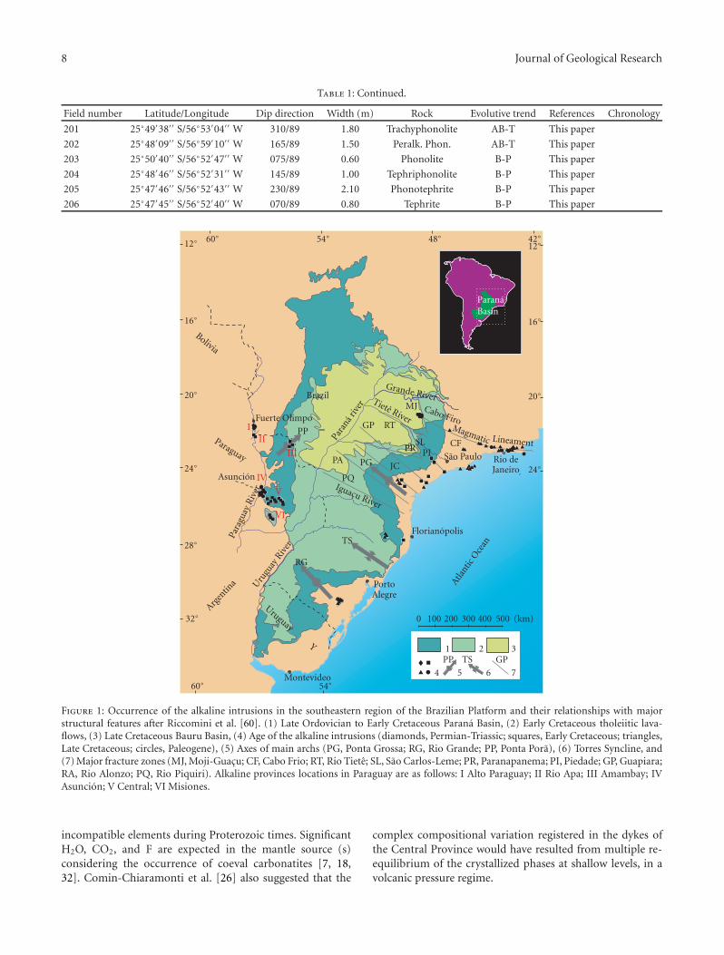
Eastern Paraguay is an intracratonic region situatedin the westernmost border of the Parana basin. DuringEarly to Late Cretaceous time, this region was affected byan important tectonomagmatic event, the Parana-Etendeka

2 Journal of Geological Research
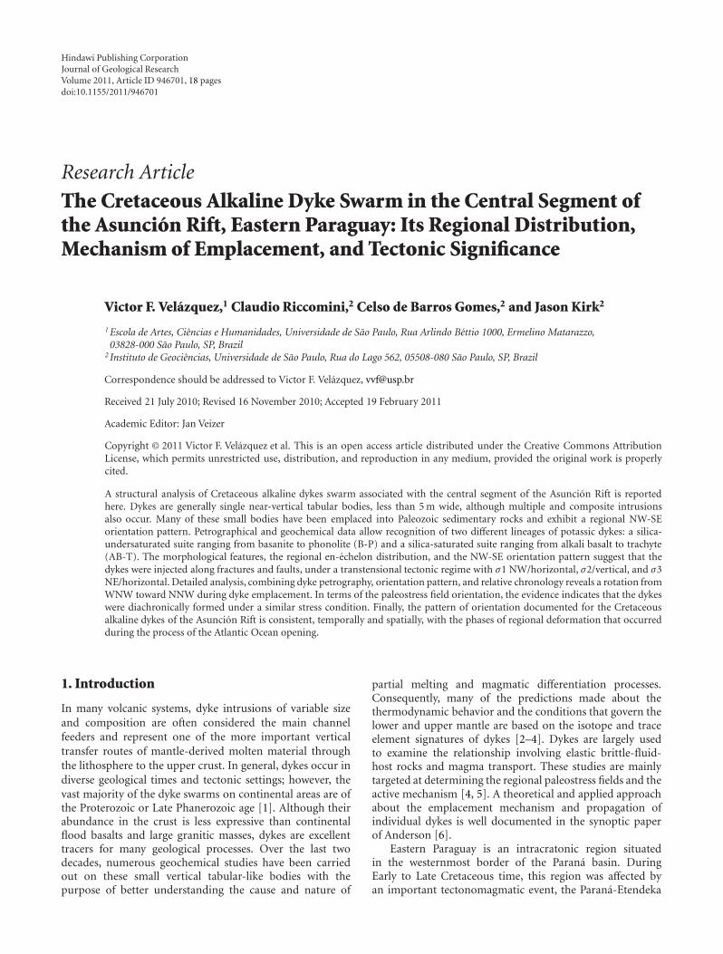
large igneous province (cf. [7]) related to the opening ofthe South Atlantic Ocean, which caused a series of alkalinemagmatic episodes [8, 9]. Although the distribution of thesealkaline bodies is quite widespread around the Parana basin(Figure 1), in the Eastern Paraguay region, they are confinedto distinct well-exposed areas. In the northern (Rio Apa)and northeastern (Amambay) provinces, the alkaline rocksshow similar ages of 138.9± 0.7 Ma (cf. [10]), predating thetholeiitic lavas of the Serra Geral Formation (133–130 Ma,cf. [11–15]). However, in the Central-Eastern (Central) andsouthern (Misiones) provinces, they are younger than thebasaltic rocks, 126.4±0.4 Ma and 118.3±1.6 Ma, respectively(cf. [10]).
One of the most conspicuous occurrences of alkalinerocks in Eastern Paraguay is represented by the CentralProvince. Geological and geophysical data indicate thatthe Asuncion Rift development, in Cretaceous time, wasresponsible for multiple diachronous events of potassicalkaline magmatism (Central Province, cf. [10, 16, 17]).The mode of occurrence of the numerous bodies is quitevariable. Intrusive formations are mainly represented bystocks of various dimensions; on the other hand, theextrusive units comprise essentially lava flows, domes, andplugs. Nevertheless, the most significant magmatic eventof the province is represented by the hypabyssal rocks,occurring largely as individual dykes, which exhibit a widevariation in composition, texture, and size.
The good exposure of the outcrops offers an excellentopportunity to examine in detail the contact relationships,the morphological feature of the walls surface, and theorientation pattern of the dykes. Based on these data, thispaper discusses the mechanism of emplacement, as well asthe regional distribution of the paleostress field at the time ofintrusion.
2. Geological Setting
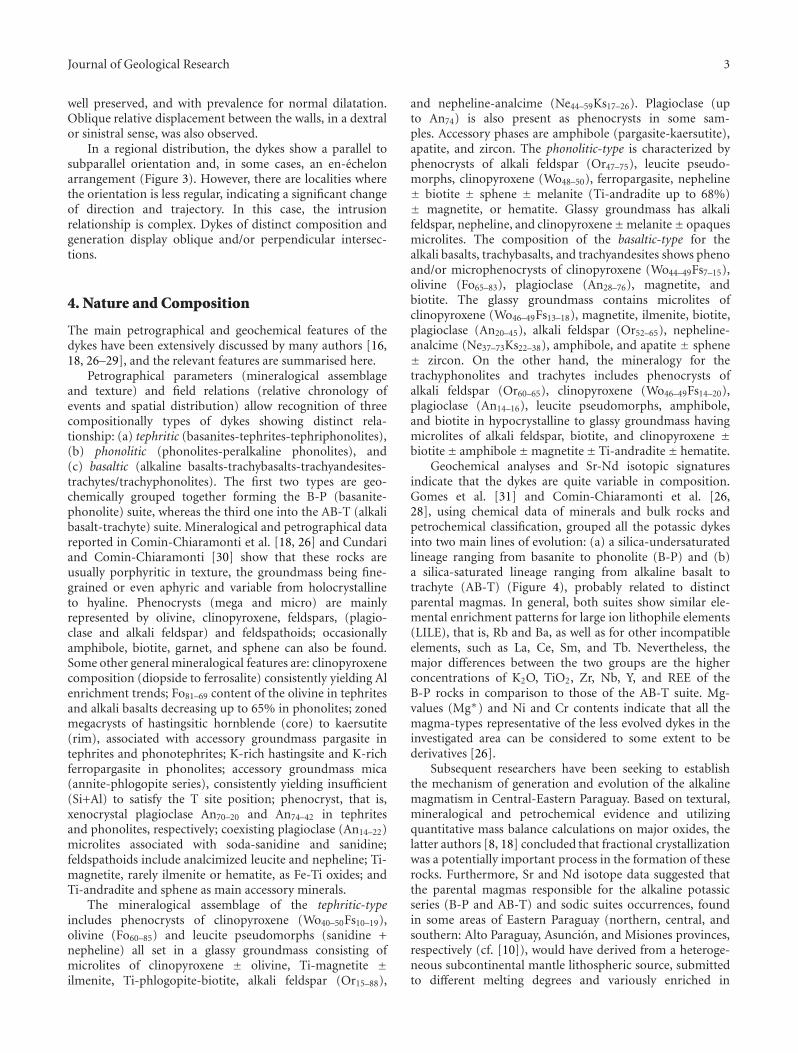
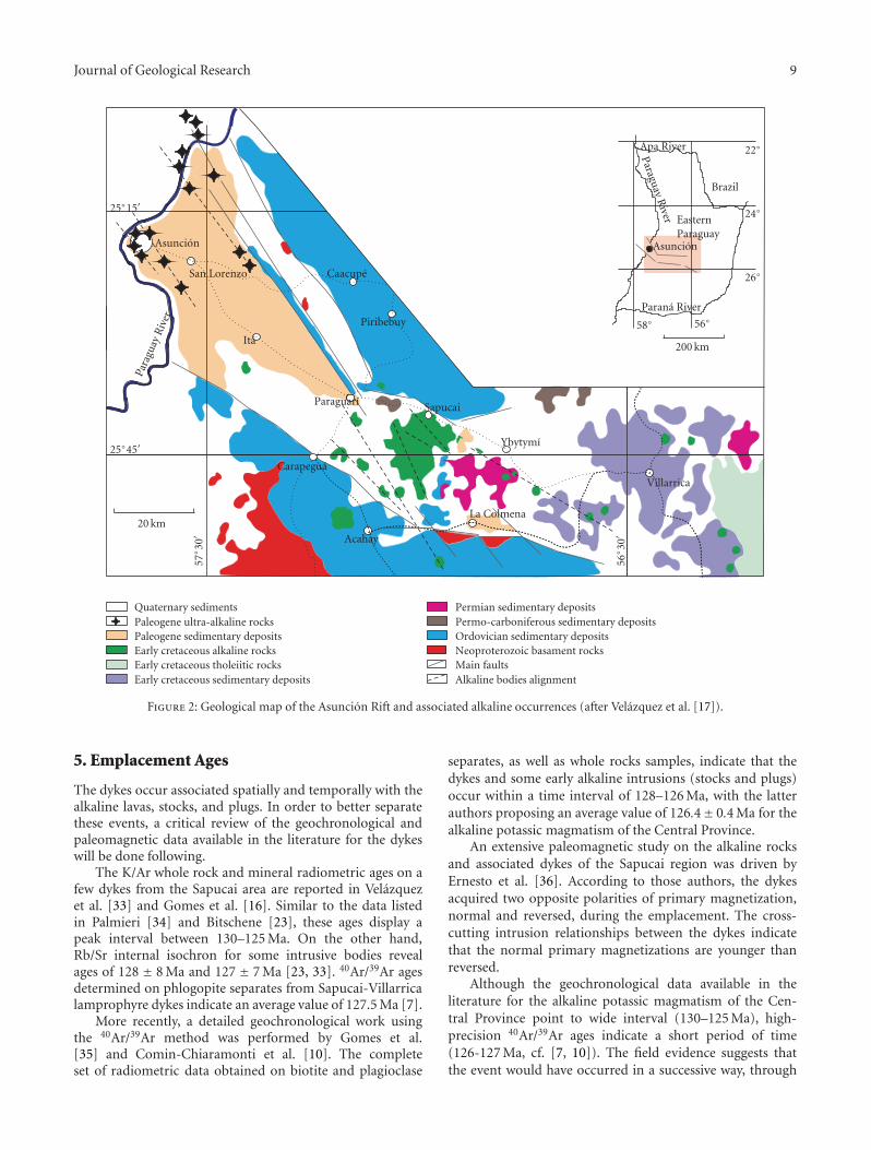
The central area of Eastern Paraguay is characterized byan important tectonomagmatic-sedimentary event of EarlyCretaceous age [18–20]. The major faulting zone is repre-sented by the Asuncion Rift [21], a tectonic feature of roughly200 km length and 25–45 km wide, with NW-SE generalorientation (Figure 2). According to Velazquez et al. [17]and Riccomini et al. [22], the rift consists of three differentsegments. The western segment, with a well-defined NW-SE-trend, extends more than 90 km between the localitiesof Benjamin Aceval and Paraguarı, and it comprises anextensive Cenozoic sedimentary deposit and several Tertiaryintrusive bodies of sodic ultra-alkaline rocks (AsuncionProvince, cf. [17, 20, 23]). The central E-W-trending segmentmeasures approximately 70 km, extends from the town ofParaguarı to the locality of Villarrica, and represents theregion of major potassic alkaline magmatism. Largely, thoserocks cut siliciclastic deposits of Silurian and Permianages and locally the Early Cretaceous aeolian deposits ofthe Misiones Formation. Finally, the less defined NW-SE-trending eastern segment, with about 40 km of extension, isdeveloped from the locality of Villarrica until the Ybytyruzu
mountains. In the last area, the potassic alkaline rocksintrude both the Cretaceous aeolian deposits of the MisionesFormation and the overlying tholeiitic flows of the Paranabasin volcanism.
From a geodynamic viewpoint, at least two tectonicepisodes of importance led to the current shape of therelief in the area. The first event, of Early Cretaceousage, which was induced by an NE-SW extensional tectonicregime, provoked major graben faulting and expressivepotassic alkaline magmatism. The second one was also ofextensional regime, with the major period of faulting takingplace in the Paleocene. However, it continues until todaycausing small seismic movements of low amplitude in theregion [24]. Possibly, a generalized lithospheric thinningand the emplacement of a hot mantle closer to the uppercrust were responsible for the significant changes of thegeothermic gradient occurred in this epoch. A detailed studyof fission tracks in Silurian deposits and Cretaceous alkalinerocks (cf. [25]) indicates two different periods of thermalactivity for the whole area, between 90–60 Ma and 60–10 Ma. These cooling ages are significantly younger than thetectonomagmatic event of the Central Province, but, in part,are consistent with the intrusion of the nephelinitic alkalinerocks of the Asuncion Province, which mainly formed at58.7 ± 2.4 Ma (cf. [10]). According to Riccomini et al. [20],the last period of time corresponds to an important tectonicphase, with generation of deep faulting that served as conduitfor the mantle material to migrate to the surface of the crust.
3. Morphology, Occurrence and Field Relations
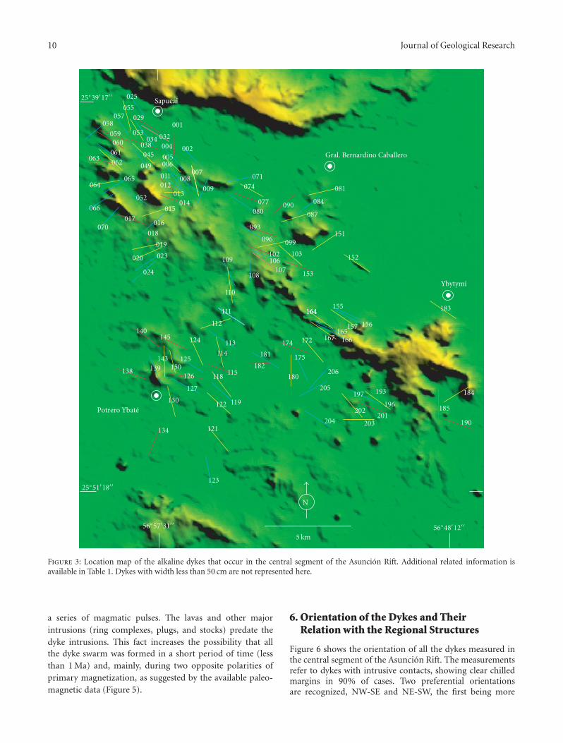
The potassic alkaline dyke intrusions are well exposedthroughout a large section of the central segment of theAsuncion Rift. More than 200 bodies of mafic, intermediate,and felsic dykes are randomly distributed in that region. Thelargest continuous exposures of individual dykes are foundin the Sapucai district [16, 26] (Figure 3). Other importantoutcrops are confined to near the villages of Potero Ybateand Gral. Bernardino Caballero is not so far from the townof Sapucai. Some dykes were also recorded in the Ybytymıregion.
Most of the dykes show a continuous tabular aspector are composed of several separate segments, resulting inan apparent sinuous intrusion. In both cases, they occuressentially as single intrusions, but multiple and compositeinjections are also present. Here, the multiple term is usedto characterize a repeated injection of dyke with the sameor similar compositions (alkaline basalt, trachybasalt, andtrachyandesite), and composite when the repeated injectionsare of different compositions (alkaline basalt, tephrite, andphonolite).
The width of the dykes can vary from 0.15 m to 10 m,but in most of the cases is between 0.30–3 m; in general,the length cannot be traced for more than a few kilometers.Regionally, the dykes cross-cut Paleozoic deposits. In theSapucai and Potrero Ybate regions, they are intruded intolavas and plugs of alkaline rocks. The dyke-wall rockcontact is usually vertical to subvertical, with chilled margins
Journal of Geological Research 3
well preserved, and with prevalence for normal dilatation.Oblique relative displacement between the walls, in a dextralor sinistral sense, was also observed.
In a regional distribution, the dykes show a parallel tosubparallel orientation and, in some cases, an en-echelonarrangement (Figure 3). However, there are localities wherethe orientation is less regular, indicating a significant changeof direction and trajectory. In this case, the intrusionrelationship is complex. Dykes of distinct composition andgeneration display oblique and/or perpendicular intersec-tions.
4. Nature and Composition
The main petrographical and geochemical features of thedykes have been extensively discussed by many authors [16,18, 26–29], and the relevant features are summarised here.
Petrographical parameters (mineralogical assemblageand texture) and field relations (relative chronology ofevents and spatial distribution) allow recognition of threecompositionally types of dykes showing distinct rela-tionship: (a) tephritic (basanites-tephrites-tephriphonolites),(b) phonolitic (phonolites-peralkaline phonolites), and(c) basaltic (alkaline basalts-trachybasalts-trachyandesites-trachytes/trachyphonolites). The first two types are geo-chemically grouped together forming the B-P (basanite-phonolite) suite, whereas the third one into the AB-T (alkalibasalt-trachyte) suite. Mineralogical and petrographical datareported in Comin-Chiaramonti et al. [18, 26] and Cundariand Comin-Chiaramonti [30] show that these rocks areusually porphyritic in texture, the groundmass being fine-grained or even aphyric and variable from holocrystallineto hyaline. Phenocrysts (mega and micro) are mainlyrepresented by olivine, clinopyroxene, feldspars, (plagio-clase and alkali feldspar) and feldspathoids; occasionallyamphibole, biotite, garnet, and sphene can also be found.Some other general mineralogical features are: clinopyroxenecomposition (diopside to ferrosalite) consistently yielding Alenrichment trends; Fo81–69 content of the olivine in tephritesand alkali basalts decreasing up to 65% in phonolites; zonedmegacrysts of hastingsitic hornblende (core) to kaersutite(rim), associated with accessory groundmass pargasite intephrites and phonotephrites; K-rich hastingsite and K-richferropargasite in phonolites; accessory groundmass mica(annite-phlogopite series), consistently yielding insufficient(Si+Al) to satisfy the T site position; phenocryst, that is,xenocrystal plagioclase An70–20 and An74–42 in tephritesand phonolites, respectively; coexisting plagioclase (An14–22)microlites associated with soda-sanidine and sanidine;feldspathoids include analcimized leucite and nepheline; Ti-magnetite, rarely ilmenite or hematite, as Fe-Ti oxides; andTi-andradite and sphene as main accessory minerals.
The mineralogical assemblage of the tephritic-typeincludes phenocrysts of clinopyroxene (Wo40–50Fs10–19),olivine (Fo60–85) and leucite pseudomorphs (sanidine +nepheline) all set in a glassy groundmass consisting ofmicrolites of clinopyroxene ± olivine, Ti-magnetite ±ilmenite, Ti-phlogopite-biotite, alkali feldspar (Or15–88),
and nepheline-analcime (Ne44–59Ks17–26). Plagioclase (upto An74) is also present as phenocrysts in some sam-ples. Accessory phases are amphibole (pargasite-kaersutite),apatite, and zircon. The phonolitic-type is characterized byphenocrysts of alkali feldspar (Or47–75), leucite pseudo-morphs, clinopyroxene (Wo48–50), ferropargasite, nepheline± biotite ± sphene ± melanite (Ti-andradite up to 68%)± magnetite, or hematite. Glassy groundmass has alkalifeldspar, nepheline, and clinopyroxene±melanite± opaquesmicrolites. The composition of the basaltic-type for thealkali basalts, trachybasalts, and trachyandesites shows phenoand/or microphenocrysts of clinopyroxene (Wo44–49Fs7–15),olivine (Fo65–83), plagioclase (An28–76), magnetite, andbiotite. The glassy groundmass contains microlites ofclinopyroxene (Wo46–49Fs13–18), magnetite, ilmenite, biotite,plagioclase (An20–45), alkali feldspar (Or52–65), nepheline-analcime (Ne37–73Ks22–38), amphibole, and apatite ± sphene± zircon. On the other hand, the mineralogy for thetrachyphonolites and trachytes includes phenocrysts ofalkali feldspar (Or60–65), clinopyroxene (Wo46–49Fs14–20),plagioclase (An14–16), leucite pseudomorphs, amphibole,and biotite in hypocrystalline to glassy groundmass havingmicrolites of alkali feldspar, biotite, and clinopyroxene ±biotite± amphibole±magnetite± Ti-andradite ± hematite.
Geochemical analyses and Sr-Nd isotopic signaturesindicate that the dykes are quite variable in composition.Gomes et al. [31] and Comin-Chiaramonti et al. [26,28], using chemical data of minerals and bulk rocks andpetrochemical classification, grouped all the potassic dykesinto two main lines of evolution: (a) a silica-undersaturatedlineage ranging from basanite to phonolite (B-P) and (b)a silica-saturated lineage ranging from alkaline basalt totrachyte (AB-T) (Figure 4), probably related to distinctparental magmas. In general, both suites show similar ele-mental enrichment patterns for large ion lithophile elements(LILE), that is, Rb and Ba, as well as for other incompatibleelements, such as La, Ce, Sm, and Tb. Nevertheless, themajor differences between the two groups are the higherconcentrations of K2O, TiO2, Zr, Nb, Y, and REE of theB-P rocks in comparison to those of the AB-T suite. Mg-values (Mg∗) and Ni and Cr contents indicate that all themagma-types representative of the less evolved dykes in theinvestigated area can be considered to some extent to bederivatives [26].
Subsequent researchers have been seeking to establishthe mechanism of generation and evolution of the alkalinemagmatism in Central-Eastern Paraguay. Based on textural,mineralogical and petrochemical evidence and utilizingquantitative mass balance calculations on major oxides, thelatter authors [8, 18] concluded that fractional crystallizationwas a potentially important process in the formation of theserocks. Furthermore, Sr and Nd isotope data suggested thatthe parental magmas responsible for the alkaline potassicseries (B-P and AB-T) and sodic suites occurrences, foundin some areas of Eastern Paraguay (northern, central, andsouthern: Alto Paraguay, Asuncion, and Misiones provinces,respectively (cf. [10]), would have derived from a heteroge-neous subcontinental mantle lithospheric source, submittedto different melting degrees and variously enriched in

4 Journal of Geological Research
Table 1: Additional information about the alkaline dykes that occur in the central segment of the Asuncion Rift.
Field number Latitude/Longitude Dip direction Width (m) Rock Evolutive trend References Chronology
001 25◦40′53′′ S/56◦56′36′′ W 355/89 1.30 Trachybasalt AB-T [8, 21, 36]
002 25◦41′31′′ S/56◦56′34′′ W 342/89 1.40 Tephriphonolite B-P This paper
003 25◦41′34′′ S/56◦56′32′′ W 150/89 0.40 Phonolite B-P This paper
004 25◦41′08′′ S/56◦56′41′′ W 320/89 1.00 Tephriphonolite B-P [8, 21, 36]
005 25◦41′34′′ S/56◦56′55′′ W 130/89 0.70 Phonolite B-P This paper
006 25◦41′40′′ S/56◦56′58′′ W 145/89 0.90 Phonotephrite B-P This paper
007 25◦41′58′′ S/56◦56′18′′ W 170/89 1.70 Phonolite B-P This paper
008 25◦41′50′′ S/56◦56′51′′ W 325/89 1.45 Tephrite B-P This paper
009 25◦42′14′′ S/56◦56′48′′ W 310/89 1.30 Phonotephrite AB-T This paper
010 25◦41′45′′ S/56◦56′19′′ W 305/89 0.45 Trachybasalt AB-T This paper 10 is cut by 11
011 25◦41′55′′ S/56◦56′19′′ W 130/89 0.80 Tephriphonolite B-P This paper
012 25◦41′58′′ S/56◦56′01′′ W 320/89 0.70 Trachyandesite AB-T [8, 21, 36]
013 25◦42′11′′ S/56◦57′04′′ W 092/89 0.60 Peralk. Phon. B-P This paper
014 25◦42′25′′ S/56◦57′06′′ W 290/89 1.00 Trachyte AB-T [8, 21, 36]
015 25◦42′39′′ S/56◦57′09′′ W 075/89 0.50 Peralk. Phonol. B-P [8, 21, 36]
016 25◦42′56′′ S/56◦57′11′′ W 042/89 1.20 Tephrite B-P [8, 21, 36]
017 25◦42′58′′ S/56◦57′19′′ W 287/89 0.80 Alkali basalt AB-T This paper
018 25◦42′58′′ S/56◦57′19′′ W 020/89 1.00 Trachyandesite AB-T This paper
019 25◦43′20′′ S/56◦57′15′′ W 075/89 0.50 Phonolite B-P This paper
020 25◦45′57′′ S/56◦57′27′′ W 065/89 0.90 Phonolite B-P This paper
021 25◦45′59′′ S/56◦57′30′′ W 325/89 0.35 Trachybasalt B-P [8, 21, 36]
022 25◦45′59′′ S/56◦57′30′′ W 340/89 0.20 Phonotephrite B-P This paper
023 25◦44′29′′ S/56◦57′36′′ W 055/89 0.70 Tephrite B-P This paper
024 25◦44′29′′ S/56◦57′36′′ W 045/89 0.80 Phonotephrite B-P This paper
025 25◦39′45′′ S/56◦58′11′ W 140/89 1.30 Tephriphonolite B-P This paper 25 is cut by 26
026 25◦39′50′′ S/56◦58′13′ W 310/89 0.25 Phonolite B-P [8, 21, 36]
027 25◦39′50′′ S/56◦57′40′ W 110/89 0.20 Trachyandesite AB-T [8, 21, 36]
028 25◦40′06′′ S/56◦57′44′′ W 130/89 0.40 Tephriphonolite B-P This paper
029 25◦40′05′′ S/56◦57′41′′ W 110/89 0.60 Trachybasalt B-P This paper
030 25◦40′09′′ S/56◦57′30′′ W 310/89 0.25 Tephrite B-P This paper
031 25◦40′10′′ S/56◦57′37′′ W 165/89 0.35 Peralk. Phon. B-P [8, 21, 36]
032 25◦40′17′′ S/56◦57′42′′ W 118/89 2.40 Trachy AB-T [8, 21, 36] 32 is cut by 31
033 25◦40′27′′ S/56◦57′40′′ W 140/89 0.35 Phonotephrite B-P [8, 21, 36]
034 25◦40′30′′ S/56◦57′46′′ W 330/89 1.20 Tephriphonolite B-P This paper
035 25◦40′32′′ S/56◦57′43′′ W 130/89 0.25 Tephrite B-P This paper
036 25◦40′35′′ S/56◦57′40′′ W 120/89 0.40 Trachyte AB-T This paper
037 25◦40′37′′ S/56◦57′39′′ W 140/89 0.15 Tephriphonolite B-P This paper
038 25◦40′39′′ S/56◦57′43′′ W 290/89 1.00 Trachyandesite AB-T This paper
039 25◦40′40′′ S/56◦57′35′′ W 310/89 0.35 Phonotephrite B-T This paper
040 25◦40′41′′ S/56◦57′30′′ W 165/89 0.40 Phonolite B-P [8, 21, 36]
041 25◦40′40′′ S/56◦57′50′′ W 310/89 0.15 Phonotephrite B-P [8, 21, 36]
042 25◦40′42′′ S/56◦57′55′′ W 290/89 0.25 Trachyandesite AB-T This paper
043 25◦40′53′′ S/56◦57′32′′ W 330/89 0.40 Tephriphonolite B-P This paper
044 25◦40′56′′ S/56◦57′30′′ W 130/89 0.20 Tephriphonolite B-P This paper 44 is cut by 45
045 25◦40′56′′ S/56◦57′30′′ W 320/89 1.50 Peralk. Phon. B-P This paper
046 25◦41′02′′ S/56◦57′40′′ W 330/89 0.35 Tephrite B-P This paper
047 25◦41′09′′ S/56◦57′30′′ W 320/89 0.15 Phonolite B-P This paper
048 25◦41′08′′ S/56◦57′47′′ W 160/89 0.40 Phonotephrite B-P This paper
049 25◦41′12′′ S/56◦57′52′′ W 145/89 2.00 Tephrite B-P [8, 21, 36]
050 25◦41′17′′ S/56◦57′42′′ W 300/89 0.45 Trachybasalt AB-T This paper
Journal of Geological Research 5
Table 1: Continued.
Field number Latitude/Longitude Dip direction Width (m) Rock Evolutive trend References Chronology
051 25◦42′23′′ S/56◦58′10′′ W 310/89 0.35 Peralk. Phon. B-T [8, 21, 36]
052 25◦42′26′′ S/56◦58′19′′ W 140/89 0.90 Tephriphonolite B-P This paper
053 25◦41′20′′ S/56◦58′25′′ W 070/89 2.30 Phonolite B-T [8, 21, 36]
054 25◦39′41′′ S/56◦58′35′′ W 130/89 0.45 Phonotephrite B-P [8, 21, 36]
055 25◦39′42′′ S/56◦58′30′′ W 165/89 0.70 Peralk. Phon. B-P [8, 21, 36]
056 25◦40′17′′ S/56◦57′31′′ W 130/89 0.35 Trachyandesite AB-T This paper
057 25◦39′55′′ S/56◦58′11′′ W 150/89 1.00 Tephrite B-P [8, 21, 36]
058 25◦39′35′′ S/56◦58′36′′ W 657/89 1.20 Tephriphonolite B-P [8, 21, 36]
059 25◦40′37′′ S/56◦58′34′′ W 285/89 0.60 Trachyte AB-T [8, 21, 36]
060 25◦40′43′′ S/56◦58′42′′ W 050/89 0.80 Trachy AB-T [8, 21, 36]
061 25◦41′10′′ S/56◦58′39′′ W 335/89 1.20 Phonotephrite B-P [8, 21, 36]
062 25◦41′10′′ S/56◦58′39′′ W 135/89 1.00 Peralk. Phon. B-P [8, 21, 36]
063 25◦41′24′′ S/56◦59′09′′ W 285/89 0.70 Trachyandesite AB-T [8, 21, 36] 63 is cut by 62
064 25◦41′49′′ S/56◦59′57′′ W 070/89 1.40 Phonolite B-P [8, 21, 36]
065 25◦41′24′′ S/56◦58′36′′ W 060/89 3.50 Tephrite B-P [8, 21, 36]
066 25◦42′48′′ S/56◦58′59′′ W 050/89 2.20 Tephrite B-P [8, 21, 36]
067 25◦42′50′′ S/56◦58′56′′ W 315/89 0.20 Phonolite B-P This paper
068 25◦42′53′′ S/56◦58′35′′ W 320/89 0.15 Trachyte AB-T This paper
069 25◦42′55′′ S/56◦58′45′′ W 330/89 0.40 Peralk. Phon. B-P [8, 21, 36]
070 25◦42′43′′ S/56◦58′53′′ W 230/89 1.00 Tephriphonolite B-P [8, 21, 36]
071 25◦41′22′′ S/56◦55′20′′ W 260/89 4.00 Phonotephrite B-P This paper
072 25◦41′25′′ S/56◦55′15′′ W 130/89 0.25 Peralk. Phon. B-T This paper
073 25◦41′36′′ S/56◦55′10′′ W 140/89 0.15 Tephrite B-P This paper
074 25◦41′39′′ S/56◦55′04′′ W 125/89 3.50 Phonolite B-P This paper
075 25◦41′42′′ S/56◦55′10′′ W 330/89 0.20 Tephriphonolite B-P [8, 21, 36]
076 25◦42′01′′ S/56◦54′59′′ W 340/89 0.35 Phonolite B-P [8, 21, 36]
077 25◦42′01′′ S/56◦54′59′′ W 110/89 1.40 Trachyte AB-T This paper
078 25◦42′06′′ S/56◦54′53′′ W 330/89 0.30 Phonolite B-P This paper
079 25◦42′37′′ S/56◦54′47′′ W 150/89 0.40 Tephriphonolite B-P This paper
080 25◦42′43′′ S/56◦55′03′′ W 335/89 3.20 Tephrite B-P This paper
081 25◦42′06′′ S/56◦52′26′′ W 075/89 2.30 Peralk. Phon. B-P This paper
082 25◦42′18′′ S/56◦56′03′′ W 305/89 0.25 Trachyte AB-T [8, 21, 36]
083 25◦42′20′′ S/56◦52′35′′ W 230/89 0.40 Tephriphonolite B-P [8, 21, 36]
084 25◦42′21′′ S/56◦52′37′′ W 050/89 5.00 Tephriphonolite B-P This paper
085 25◦42′40′′ S/56◦53′29′′ W 140/89 0.35 Tephrite B-P This paper
086 25◦42′57′′ S/56◦53′39′′ W 310/89 0.15 Tephrite B-P This paper
087 25◦43′02′′ S/56◦53′19′′ W 065/89 1.50 Phonolite B-P This paper
088 25◦42′22′′ S/56◦53′35′′ W 300/89 0.30 Tephriphonolite B-P This paper
089 25◦42′25′′ S/56◦53′33′′ W 345/89 0.25 Phonolite B-P This paper
090 25◦42′29′′ S/56◦53′39′′ W 230/89 10.0 Trachybasalt AB-T This paper 90 is cut by 91
091 25◦42′29′′ S/56◦54′39′′ W 330/89 0.35 Tephrite B-P This paper
092 25◦42′40′′ S/56◦54′12′′ W 150/89 0.25 Phonolite B-T This paper
093 25◦43′02′′ S/56◦54′20′′ W 110/89 2.20 Trachyandesite AB-T This paper
094 25◦43′02′′ S/56◦54′33′′ W 140/89 0.15 Phonotephrite B-P This paper
095 25◦43′004′′ S/56◦54′32′′ W 320/89 0.35 Tephriphonolite B-P [8, 21, 36]
096 25◦43′04′′ S/56◦54′36′′ W 320/89 3.00 Phonotephrite B-P This paper
097 25◦43′25′′ S/56◦56′40′′ W 300/89 0.20 Tephrite B-P [8, 21, 36]
098 25◦43′30′′ S/56◦56′41′′ W 310/89 0.35 Tephrite B-P [8, 21, 36]
099 25◦43′37′′ S/56◦56′43′′ W 250/89 0.80 Peralk. Phon. B-P This paper
100 25◦43′39′′ S/56◦56′40′′ W 130/89 0.35 Phonotephrite B-P This paper
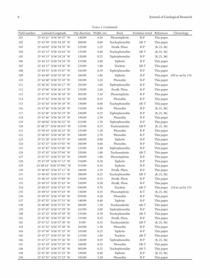
6 Journal of Geological Research
Table 1: Continued.
Field number Latitude/Longitude Dip direction Width (m) Rock Evolutive trend References Chronology
101 25◦43′41′′ S/56◦56′37′′ W 140/89 0.20 Phonotephrite B-P This paper
102 25◦43′59′′ S/56◦54′29′′ W 300/89 0.60 Trachyphonolite AB-T This paper
103 25◦44′02′′ S/56◦54′35′′ W 125/89 1.25 Peralk. Phon. B-P [8, 21, 36]
104 25◦43′13′′ S/56◦54′44′′ W 125/89 0.40 Trachyphonolite AB-T [8, 21, 36]
105 25◦44′13′′ S/56◦54′24′′ W 120/89 0.25 Tephriphonolite B-P [8, 21, 36]
106 25◦44′13′′ S/56◦54′24′′ W 155/89 2.00 Tephrite B-P This paper
107 25◦44′17′′ S/56◦54′36′′ W 125/89 1.80 Trachyte AB-T This paper
108 25◦44′35′′ S/56◦55′07′′ W 345/89 0.70 Tephriphonolite B-P This paper
109 25◦44′40′′ S/56◦55′10′′ W 160/89 1.00 Tephrite B-P This paper 109 is cut by 110
110 25◦44′40′′ S/56◦55′10′′ W 345/89 3.20 Phonolite B-P This paper
111 25◦46′26′′ S/56◦56′17′′ W 295/89 1.60 Tephriphonolite B-P This paper
112 25◦47′06′′ S/56◦56′14′′ W 170/89 2.60 Peralk. Phon. B-P This paper
113 25◦47′39′′ S/56◦56′18′′ W 305/89 3.20 Phonotephrite B-P This paper
114 25◦47′42′′ S/56◦56′16′′ W 345/89 0.55 Phonolite B-P This paper
115 25◦47′44′′ S/56◦56′18′′ W 130/89 8.00 Trachyphonolite AB-T This paper
116 25◦47′46′′ S/56◦56′20′′ W 155/89 0.40 Phonolite B-P [8, 21, 36]
117 25◦47′46′′ S/56◦56′19′′ W 330/89 0.25 Tephriphonolite B-P [8, 21, 36]
118 25◦47′46′′ S/56◦56′19′′ W 150/89 2.50 Phonolite B-P This paper
119 25◦48′04′′ S/56◦56′22′′ W 315/89 1.70 Tephriphonolite B-P This paper
120 25◦48′27′′ S/56◦56′0/5′′ W 125/89 0.35 Trachyandesite AB-T [8, 21, 36]
121 25◦50′43′′ S/56◦56′22′′ W 155/89 1.20 Phonolite B-P This paper
122 25◦48′45′′ S/56◦56′30′′ W 340/89 2.70 Phonolite B-T This paper
123 25◦51′28′′ S/56◦55′37′′ W 160/89 0.80 Tephrite B-P This paper
124 25◦47′37′′ S/56◦57′05′′ W 160/89 0.60 Phonolite B-P This paper
125 25◦47′45′′ S/56◦57′06′′ W 125/89 2.40 Tephriphonolite B-P This paper
126 25◦47′45′′ S/56◦57′04′′ W 320/89 1.80 Trachyandesite AB-T This paper
127 25◦47′57′′ S/56◦57′10′′ W 330/89 1.00 Phonotephrite B-P This paper
128 25◦47′59′′ S/56◦57′12′′ W 310/89 0.20 Tephrite B-P This paper
129 25◦48′43′′ S/56◦57′091′′ W 315/89 0.35 Tephrite B-P This paper
130 25◦48′45′′ S/56◦57′11′′ W 340/89 2.70 Peralk. Phon. B-P This paper
131 25◦48′45′′ S/56◦57′11′′ W 300/89 0.25 Trachyphonolite AB-T [8, 21, 36]
132 25◦48′43′′ S/56◦57′09′′ W 150/89 0.35 Peralk. Phon. B-P This paper
133 25◦49′53′′ S/56◦57′43′′ W 330/89 0.20 Peralk. Phon. B-P This paper
134 25◦49′53′′ S/56◦57′43′′ W 030/89 0.70 Trachyte AB-T This paper 134 is cut by 133
135 25◦49′53′′ S/56◦57′43′′ W 150/89 0.35 Phonotephrite B-T [8, 21, 36]
136 25◦49′55′′ S/56◦57′40′′ W 070/89 0.20 Phonolite B-P This paper
137 25◦47′55′′ S/56◦57′53′′ W 140/89 0.40 Tephrite B-P This paper
138 25◦48′00′′ S/56◦57′55′′ W 300/89 1.30 Trachyandesite AB-T This paper
139 25◦47′45′′ S/56◦57′29′′ W 165/89 3.00 Tephriphonolite B-P This paper
140 25◦47′25′′ S/56◦57′39′′ W 135/89 0.70 Trachyphonolite AB-T This paper
141 25◦47′30′′ S/56◦57′20′′ W 155/89 0.35 Peralk. Phon. B-P This paper
142 25◦47′32′′ S/56◦57′30′′ W 31/89 0.35 Trachyandesite AB-T [8, 21, 36]
143 25◦47′32′′ S/56◦57′28′′ W 165/89 1.50 Phonolite B-P This paper
144 25◦47′30′′ S/56◦57′25′′ W 335/89 0.25 Tephrite B-P This paper
145 25◦47′27′′ S/56◦57′26′′ W 115/89 1.60 Trachyte AB-T This paper
146 25◦47′27′′ S/56◦57′26′′ W 120/89 0.35 Tephriphonolite B-P [8, 21, 36]
147 25◦47′19′′ S/56◦57′35′′ W 160/89 0.35 Phonolite AB-T This paper
148 25◦47′29′′ S/56◦57′30′′ W 305/89 0.25 Trachyphonolite AB-T This paper
149 25◦47′30′′ S/56◦57′25′′ W 330/89 0.40 Tephrite B-P [8, 21, 36]
150 25◦47′35′′ S/56◦57′23′′ W 345/89 2.30 Phonolite B-P This paper

Journal of Geological Research 7
Table 1: Continued.
Field number Latitude/Longitude Dip direction Width (m) Rock Evolutive trend References Chronology
151 25◦43′37′′ S/56◦53′19′′ W 240/89 0.80 Phonolite B-P This paper
152 25◦44′26′′ S/56◦51′17′′ W 135/89 10.0 Phonolite B-P [8, 21, 36]
153 25◦44′28′′ S/56◦51′30′′ W 295/89 0.80 Trachyte AB-T [8, 21, 36]
154 25◦44′30′′ S/56◦51′25′′ W 330/89 0.45 Peralk. Phon. B-P This paper
155 25◦44′07′′ S/56◦52′08′′ W 120/89 3.00 Phonotephrite B-P This paper
156 25◦44′09′′ S/56◦52′10′′ W 310/89 2.70 Tephriphonolite B-P This paper
157 25◦44′11′′ S/56◦52′12′′ W 335/89 1.20 Peralk. Phon. B-P This paper
158 25◦44′09′′ S/56◦52′23′′ W 340/89 0.30 Peralk. Phon. B-P [8, 21, 36]
159 25◦44′10′′ S/56◦52′20′′ W 330/89 0.20 Phonotephrite B-P [8, 21, 36]
160 25◦44′15′′ S/56◦52′15′′ W 115/89 0.45 Trachyphonolite AB-T [8, 21, 36]
161 25◦44′16′′ S/56◦52′18′′ W 130/89 0.20 Phonotephrite B-P [8, 21, 36]
162 25◦44′17′′ S/56◦52′20′′ W 155/89 0.35 Phonolite B-P This paper
163 25◦45′17′′ S/56◦52′05′′ W 320/89 0.20 Tephrite B-P This paper
164 25◦46′01′′ S/56◦52′18′′ W 320/89 0.60 Phonolite B-P This paper
165 25◦46′01′′ S/56◦52′18′′ W 115/89 1.00 Tephrite B-P This paper 165 is cut by 164
166 25◦46′14′′ S/56◦52′25′′ W 125/89 2.30 Tephrite B-P This paper
167 25◦46′18′′ S/56◦52′19′′ W 330/89 0.90 Peralk. Phon. B-P This paper
168 25◦46′20′′ S/56◦52′23′′ W 320/89 0.40 Tephrite B-P [8, 21, 36]
169 25◦46′23′′ S/56◦52′36′′ W 120/89 0.30 Trachyte AB-T [8, 21, 36]
170 25◦46′25′′ S/56◦52′34′′ W 340/89 0.40 Phonolite B-P [8, 21, 36]
171 25◦46′55′′ S/56◦52′50′′ W 320/89 0.25 Tephriphonolite B-P [8, 21, 36]
172 25◦46′59′′ S/56◦52′53′′ W 165/89 1.30 Phonolite AB-T This paper
173 25◦47′05′′ S/56◦52′50′′ W 340/89 0.35 Phonotephrite B-P This paper
174 25◦46′47′′ S/56◦53′16′′ W 295/89 2.40 Trachyphonolite AB-T This paper
175 25◦47′04′′ S/56◦53′03′′ W 145/89 1.50 Tephriphonolite B-P This paper
176 25◦47′10′′ S/56◦53′09′′ W 170/89 0.20 Peralk. Phon. B-P This paper
178 25◦47′14′′ S/56◦54′01′′ W 125/89 0.30 Trachyte AB-T [8, 21, 36]
179 25◦46′47′′ S/56◦53′20′′ W 330/89 0.45 Tephrite B-P [8, 21, 36]
180 25◦46′49′′ S/56◦53′28′′ W 345/89 2.20 Phonolite B-P This paper
181 25◦46′44′′ S/56◦53′47′′ W 325/89 0.50 Tephrite B-P This paper
182 25◦46′44′′ S/56◦53′47′′ W 110/89 1.20 Trachyandesite AB-T This paper 182 is cut by 181
183 25◦45′41′′ S/56◦48′21′′ W 145/89 2.40 Peralk. Phon. B-P This paper
184 25◦48′56′′ S/56◦47′25′′ W 075/89 0.80 Phonolite B-P This paper
185 25◦48′29′′ S/56◦48′54′′ W 340/89 2.70 Tephriphonolite B-P This paper
186 25◦48′53′′ S/56◦47′05′′ W 135/89 0.25 Trachyandesite AB-T [8, 21, 36]
187 25◦48′55′′ S/56◦47′10′′ W 150/89 0.40 Tephrite B-P [8, 21, 36]
188 25◦48′58′′ S/56◦47′15′′ W 070/89 0.40 Phonolite B-P This paper
189 25◦49′10′′ S/56◦48′50′′ W 130/89 0.30 Tephriphonolite B-P [8, 21, 36]
190 25◦48′29′′ S/56◦48′54′′ W 115/89 1.80 Trachyte AB-T This paper
191 25◦48′32′′ S/56◦52′52′′ W 120/89 0.35 Tephrite B-P This paper
192 25◦48′49′′ S/56◦52′50′′ W 130/89 0.40 Phonolite B-T This paper
193 25◦48′59′′ S/56◦52′55′′ W 280/89 1.30 Trachyphonolite AB-T This paper
194 25◦49′02′′ S/56◦52′50′′ W 150/89 0.35 Phonolite B-P This paper
195 25◦49′15′′ S/56◦51′20′′ W 320/89 0.20 Phonotephrite B-P [8, 21, 36]
196 25◦49′18′′ S/56◦51′15′′ W 140/89 0.80 Phonolite B-P This paper
197 25◦49′14′′ S/56◦53′09′′ W 330/89 3.00 Tephrite B-P This paper
198 25◦49′10′′ S/56◦53′22′′ W 320/89 0.20 Phonolite B-P [8, 21, 36]
199 25◦48′40′′ S/56◦48′32′′ W 315/89 0.40 Trachyandesite AB-T [8, 21, 36]
200 25◦49′37′′ S/56◦53′24′′ W 160/89 0.25 Peralk. Phon. B-P This paper
8 Journal of Geological Research
Table 1: Continued.
Field number Latitude/Longitude Dip direction Width (m) Rock Evolutive trend References Chronology
201 25◦49′38′′ S/56◦53′04′′ W 310/89 1.80 Trachyphonolite AB-T This paper
202 25◦48′09′′ S/56◦59′10′′ W 165/89 1.50 Peralk. Phon. AB-T This paper
203 25◦50′40′′ S/56◦52′47′′ W 075/89 0.60 Phonolite B-P This paper
204 25◦48′46′′ S/56◦52′31′′ W 145/89 1.00 Tephriphonolite B-P This paper
205 25◦47′46′′ S/56◦52′43′′ W 230/89 2.10 Phonotephrite B-P This paper
206 25◦47′45′′ S/56◦52′40′′ W 070/89 0.80 Tephrite B-P This paper
Para
guay
Riv
er
Para
ná ri
ver
Uru
guay
Riv
er
Grande RiverTietê River
Iguaçu River
Brazil
Paraguay
Bolivia
Argen
tina
Uruguay
Y
III
III
Asunción
V
VI
ParanáBasin
IV
54◦60◦
32◦
28◦
24◦
20◦
16◦
12◦ 60◦ 54◦ 48◦ 42◦12◦
16◦
20◦
24◦
0 100 200 300 400 500 (km)
Fuerte Olimpo
PP
RG
TS
PQ
PA PG
GP RT
JC
PRSL
PI
MJ Cabo FiroMagmatic LineamentCF
Sao Paulo Rio deJaneiro
Florianopolis
Atlant
icO
cean
PortoAlegre
Montevideo
1 2 3
4 5 6 7
PP TS GP
Figure 1: Occurrence of the alkaline intrusions in the southeastern region of the Brazilian Platform and their relationships with majorstructural features after Riccomini et al. [60]. (1) Late Ordovician to Early Cretaceous Parana Basin, (2) Early Cretaceous tholeiitic lava-flows, (3) Late Cretaceous Bauru Basin, (4) Age of the alkaline intrusions (diamonds, Permian-Triassic; squares, Early Cretaceous; triangles,Late Cretaceous; circles, Paleogene), (5) Axes of main archs (PG, Ponta Grossa; RG, Rio Grande; PP, Ponta Pora), (6) Torres Syncline, and(7) Major fracture zones (MJ, Moji-Guacu; CF, Cabo Frio; RT, Rio Tiete; SL, Sao Carlos-Leme; PR, Paranapanema; PI, Piedade; GP, Guapiara;RA, Rio Alonzo; PQ, Rio Piquiri). Alkaline provinces locations in Paraguay are as follows: I Alto Paraguay; II Rio Apa; III Amambay; IVAsuncion; V Central; VI Misiones.
incompatible elements during Proterozoic times. SignificantH2O, CO2, and F are expected in the mantle source (s)considering the occurrence of coeval carbonatites [7, 18,32]. Comin-Chiaramonti et al. [26] also suggested that the
complex compositional variation registered in the dykes ofthe Central Province would have resulted from multiple re-equilibrium of the crystallized phases at shallow levels, in avolcanic pressure regime.
Journal of Geological Research 9
Asunción
San Lorenzo Caacupé
Piribebuy
Itá
Paraguarí
Ybytymí
Villarrica
La Colmena
Acahay
Para
guay
Riv
er
Carapeguá
Sapucai
Asunción
Brazil
Paraná River
Paraguay River
Apa River
EasternParaguay
Quaternary sedimentsPaleogene ultra-alkaline rocksPaleogene sedimentary depositsEarly cretaceous alkaline rocksEarly cretaceous tholeiitic rocksEarly cretaceous sedimentary deposits
Permian sedimentary depositsPermo-carboniferous sedimentary depositsOrdovician sedimentary depositsNeoproterozoic basament rocksMain faultsAlkaline bodies alignment
25◦15′
25◦45′
20 km
57◦ 3
0′
56◦ 3
0′
200 km
58◦ 56◦
26◦
24◦
22◦
Figure 2: Geological map of the Asuncion Rift and associated alkaline occurrences (after Velazquez et al. [17]).
5. Emplacement Ages
The dykes occur associated spatially and temporally with thealkaline lavas, stocks, and plugs. In order to better separatethese events, a critical review of the geochronological andpaleomagnetic data available in the literature for the dykeswill be done following.
The K/Ar whole rock and mineral radiometric ages on afew dykes from the Sapucai area are reported in Velazquezet al. [33] and Gomes et al. [16]. Similar to the data listedin Palmieri [34] and Bitschene [23], these ages display apeak interval between 130–125 Ma. On the other hand,Rb/Sr internal isochron for some intrusive bodies revealages of 128 ± 8 Ma and 127 ± 7 Ma [23, 33]. 40Ar/39Ar agesdetermined on phlogopite separates from Sapucai-Villarricalamprophyre dykes indicate an average value of 127.5 Ma [7].
More recently, a detailed geochronological work usingthe 40Ar/39Ar method was performed by Gomes et al.[35] and Comin-Chiaramonti et al. [10]. The completeset of radiometric data obtained on biotite and plagioclase
separates, as well as whole rocks samples, indicate that thedykes and some early alkaline intrusions (stocks and plugs)occur within a time interval of 128–126 Ma, with the latterauthors proposing an average value of 126.4± 0.4 Ma for thealkaline potassic magmatism of the Central Province.
An extensive paleomagnetic study on the alkaline rocksand associated dykes of the Sapucai region was driven byErnesto et al. [36]. According to those authors, the dykesacquired two opposite polarities of primary magnetization,normal and reversed, during the emplacement. The cross-cutting intrusion relationships between the dykes indicatethat the normal primary magnetizations are younger thanreversed.
Although the geochronological data available in theliterature for the alkaline potassic magmatism of the Cen-tral Province point to wide interval (130–125 Ma), high-precision 40Ar/39Ar ages indicate a short period of time(126-127 Ma, cf. [7, 10]). The field evidence suggests thatthe event would have occurred in a successive way, through
10 Journal of Geological Research
001
004
005006
007
002
008009
011012
013014
015
016017
018
019
020 023
024
025
029
032034038045
049
052
055057
059
058
061
053060
062063
064065
066
070
071074
077080
081
084
087090
093
096 099
102106
108107
109
110
111
112
113
114
115118
119122
121
123
124
125
126
127
130
134
138 139
140
143
145
150
151
152
155
156157
164164
165166167172174
175
180
181
182
183
184
185
190
193
196
197
201202
203204
205
206
Gral. Bernardino Caballero
Sapucai
Potrero Ybaté
Ybytymí153
103
25◦39′17′′
25◦51′18′′
56◦57′31′′
N
5 km56◦48′12′′
Figure 3: Location map of the alkaline dykes that occur in the central segment of the Asuncion Rift. Additional related information isavailable in Table 1. Dykes with width less than 50 cm are not represented here.
a series of magmatic pulses. The lavas and other majorintrusions (ring complexes, plugs, and stocks) predate thedyke intrusions. This fact increases the possibility that allthe dyke swarm was formed in a short period of time (lessthan 1 Ma) and, mainly, during two opposite polarities ofprimary magnetization, as suggested by the available paleo-magnetic data (Figure 5).
6. Orientation of the Dykes and TheirRelation with the Regional Structures
Figure 6 shows the orientation of all the dykes measured inthe central segment of the Asuncion Rift. The measurementsrefer to dykes with intrusive contacts, showing clear chilledmargins in 90% of cases. Two preferential orientationsare recognized, NW-SE and NE-SW, the first being more

Journal of Geological Research 11
Highlypotassic Potassic
Transit
ional
Sodic
Alkali basalt
Trachyandesite
Trachyte
Trachyphonolite
TrachybasaltTephrite
Phonotephrite
Tephriphonolite
PhonolitePeralkaline phonolite
200010000−1000−2000
1000
2000
R1
R2
1050
5
10
K2O
Na2O
Figure 4: Compositional variation in the diagram R1 (4Si-11Na + K-2Fe + Ti) − R2 (6Ca + 2Mg + 2Al) (De La Roche et al. [64]) for thealkaline dykes that occur in the central segment of the Asuncion Rift. Inset: K2O versus Na2O diagram showing the transition between thetwo series (fields according to [18]). Data source: [8, 26, 31].
Trachyandesite
Trachyphonolite
Trachyte
Trachybasalt
360
270
180
(a)
Phonotephrite
Phonolite
Peralkaline phonolite
Tephrite
360
180
90
(b)
Figure 5: Stereographic projection of the site mean paleomagnetic results for the alkaline dykes that occur in the central segment of theAsuncion Rift. Note that the majority of the dykes acquired their remanence during a reversed polarity. Data source: [36].
frequent. Interposed between the two main orientations,there are two other less common directions, N-S and E-W. On a regional scale, joint and fault systems of similarorientation also occur. The relative chronology betweenfaults and dykes is not always of easy distinction. In some
cases, because the interval between the events was relativelyshort and, in others, because there was an overlap ofevents, obliterating the former structure. However, in morefavorable outcrops, the structural relationships indicate thatthe dyke intrusion was preceded by synthetic normal and

12 Journal of Geological Research
N
N = 206
Figure 6: Structural full rose for the alkaline dykes that occur in the central segment of the Asuncion Rift.
703503570
N
N = 65
Phonolitic-type
(a)
10050050100
N
N = 94
Tephritic-type
(b)
502502550
N
N = 47
Basaltic-type
(c)
Figure 7: Rose diagrams illustrating the azimuthal orientation for the three main lithological types of alkaline dykes. Note that the mean ofthe preferential directions indicates a clockwise rotation.

Journal of Geological Research 13
(a) (b) (c)
Figure 8: Field relations illustrating the mechanism of emplacement of the dykes: (a) felsic dyke, with a vertical plane orientated accordingto N25W, evidencing a normal dilatation, (b) intermediate dyke, orientated according to N35W, showing a normal-oblique separation withslickenside surface on the walls of the dyke, and (c) mafic dyke, orientated according to N50W, showing a typical right-lateral opening withoblique movement between the walls.
some strike-slip faulting. Similarly, the determination of thetemporal relation of dyke intrusions was based mainly ontheir cross-cutting relationships. This correlation indicatesthat basaltic-type predate the tephritic-type and both are cutby phonolitic-type.
Detailed analysis, combining dyke petrography, ori-entation pattern, and relative chronology, reveals thatthe basaltic-type is orientated preferentially N50-70W, thetephritic-type N30-60W, and the phonolitic-type N20-45W(Figure 7). Such disposition shows clearly a rotation fromWNW toward NNW during the emplacement of the dykes,accompanied by a progressive compositional change of themagma. Field observations are consistent with continuousextensional deformation and right-lateral rotation, whichled to a dynamic interrelation between faulting and dykeinjection. The absence of internal solid-state deformationin the dykes and the nature of the kinematic indicatorspresent in the walls suggest that the fault generation and thedyke injection would have occurred simultaneously, underan extensional tectonic regime, followed by a short periodof progressive shearing, affecting the walls of the partiallysolidified dykes (Figure 8).
7. Discussion and Conclusion
The evolution of the regional stress field is frequentlydetermined by structural analyses of faults, fractures, cleav-ages, and other microtectonic evidence. Unfortunately, thesemethods do not permit the precise dating of the specificperiod in which the stress field has been acting. Igneousrocks, however, can be isotopically dated and frequentlydisplay distribution and internal structural patterns relatedto the crustal stress field at the time of magmatism.Therefore, it is possible to establish an absolute chronologyof the variation in the trajectory of the regional paleostress-fields [2–5]. This manner, volcanic features are frequentlyutilized as paleostress indicators, including alignments ofvolcanoes or ash cones and axes of elongation of volcanicedifices [37, 38].
Dykes are also very important kinematic indicators,considering that magma may invade coeval fractures under
the action of a regional paleostress-field [39, 40]. Becausemagma-driven fracturing is preferentially normal to theprincipal compressive stress σ1 (Anderson’s prediction), ver-tical dykes can only be generated when σ3 is horizontal, thatis, when the regional paleostress of the crust is dominantlyextensional [6, 41–45].
The Cretaceous alkaline dyke swarms of Central-EasternParaguay show a large compositional variation, petrographicfacies, and texture, offering important constraints on magmageneration and dyke intrusions. Field observations indicatethat the dykes represent majorly single vertical intrusions,but composite and multiple intrusions are also recognized.
The wide mineralogical variation and heterogeneousgeochemical composition of the dykes require a dynamicgeneration mechanism during their emplacement, with con-stant and progressive crystal-liquid fractionation from themagmatic chamber. Such rapid rates of magma generation,in short periods of time, argue that partial melting tookplace during an extensional tectonic regime and by adiabaticdecompression. Many of the dykes contain a significantproportion of primary hydrous minerals (biotite and/oramphibole) suggesting that hydrodynamic force (water-vapor pressure) played an important role in the magmageneration. As a result of a constant modification of thethermodynamic conditions, the absolute majority of thedykes presents a well-marked change in texture, ranging fromholocrystalline to hypocrystalline. In contrast to Komar’sprediction [46], no gradual concentration in phenocrystsfrom the walls to the center or internal structural zoning wasobserved in those dykes. This fact seems to confirm that flow-differentiation processes were not an important mechanismresponsible for their generation. Thus, it is reasonable toadmit that the dykes were emplaced in liquid state andconsolidated under very fast cooling rates. In this case,an unstable condition of the flow regime due to variablessuch as the velocity gradient across the fractures, width ofthe fractures, magma viscosity, cooling rates, and crystalsupply caused different effects on the crystals growth duringemplacement and broadly influenced textural variations.
Because thin dyke channels may only last for hoursto days (cf. [47]), liquids generated in the mantle andsubject to continuous removal toward the surface would

14 Journal of Geological Research
Sapucai
Ybytymí
Potrero Ybaté
σ3
P
T
Y
R
σ1
R′X
56◦48′12′′56◦57′31′′
25◦51′18′′
25◦39′17′′
N
5 km
Figure 9: Regional en-echelon distribution and a proposed for the emplacement mechanism of the swarm alkaline dykes (see text fordiscussion). Schematic Riedel shear model in inset shows theoretical distribution of shear fractures (R, R′, P, X and Y) and tensional fractures(T) in E-W dextral transtensional tectonic regime (cf. [53]). Red and blue arrows indicate shortening axis and extensional axis, respectively.The distinction of dykes is as in Figure 5.
be under the constant influence of the regional stressfields [48–52]. As previously stated, vertical dykes occur asa product of magma-filled fractures when the minimumcompressive stress, σ3, is perpendicular to the direction ofthe propagation plane. Such conditions seem to be shownby the field relations of the studied dykes. This assumptionis based on the careful examination of the chilled marginsof the dykes and their geochemical data, which indicate noobvious significant interaction with the country rocks duringmagma injection. The walls of the dykes usually displaynormal dilatation and planar morphology. Only a few bodiesshow oblique opening, in either a dextral or sinistral sense,with overall extension preferentially orthogonal to the main
propagation trajectory of the dykes. Additional evidence,such as the limited length (less than 3 km) and narrow width(average of 1–3 m) of the sheet-like bodies, the lack of aflux orientation of phenocrysts aligned parallel at the dykemargins, and the en-echelon regional distribution, indicatesthat vertical injection was more common than lateral magmainjection.
The regional N20-70W-trending of the Cretaceous alka-line dykes suggests that the opening fractures and the magmainjection were not perturbed significantly by pre-existinglines of weakness in the country rocks. Therefore, the well-expressed structural fingerprints of the dykes indicate anoverall remote stress regime characterized by a NW-trending
Journal of Geological Research 15
Equatorial fracture zone
South America
Africa
Colorado BasinSalado Basin
Asunción Rift
Camer
oon
Volca
nic l
ine
Walv
is Rid
ge
Rio Grande Rise
LDSZ
CFS
CASZ
Figure 10: Schematic map showing the main larger deformation areas that occurred during the phase of continental breakup. Dashed blackarrows: larger dextral shear zone (LDSZ), Gastre fault system (GFS), and central African sinestral shear zone (CASZ). Yellow arrows indicatethe plate motion according to Fairhead and Wilson [65]. Note that the Asuncion Rift is closely related to the LDSZ. Copyrights of the mapfor National Geophysical Data Center.
maximum horizontal shortening axis, an NE-oriented max-imum horizontal extension axis, and vertical intermediatestress. Slickenside lineation analysis on NNW-sinestral andWNW-dextral conjugate strike-slip faults plane that outlinethe central segment borders of Asuncion Rift (Figure 2) isalso compatible with this paleostress orientation [19, 20, 22].Basic criteria, such as the geometry, the orientation, anddistribution pattern and the relative chronology of the dykesand regional faults, are widely consistent with an E-W dextraltranstensional tectonic regime (Figure 9). In the context ofa simple Riedel shear model [53], the basaltic-type dykeswere preferentially injected along R fractures during theinitial stage of the deformation. Some tephitic-type dykesalso filled in part these fractures. With strain increase, R′
followed by P fractures were generated, which served asconduits for the tephitic-type dykes. Isolated occurrencesof phonolitic-type dykes display consistent orientation withthis phase of deformation. At an advanced stage of strain,finally, T fractures, perpendicular to the maximum extensionaxis, and Y fractures, parallel to the principal displacementzone direction, controlled the intrusion of the phonolitic-type dykes. Pattern orientation corresponding to X fracturesis relatively uncommon in the study area. Assuming thatthe dykes were injected during an event of progressivedeformation, the regional distribution in right- and left-stepping en-echelon corresponds to shear fractures (R,R′ and P) and tensional fractures (T). This frameworkstructural has significant implications with regard to theright-lateral global rotation during dyke intrusions. The localparallel orientation of composite and multiple dykes confirmthat the trajectory of the regional paleostress fields wasrelatively constant at the time of the dyke intrusion.
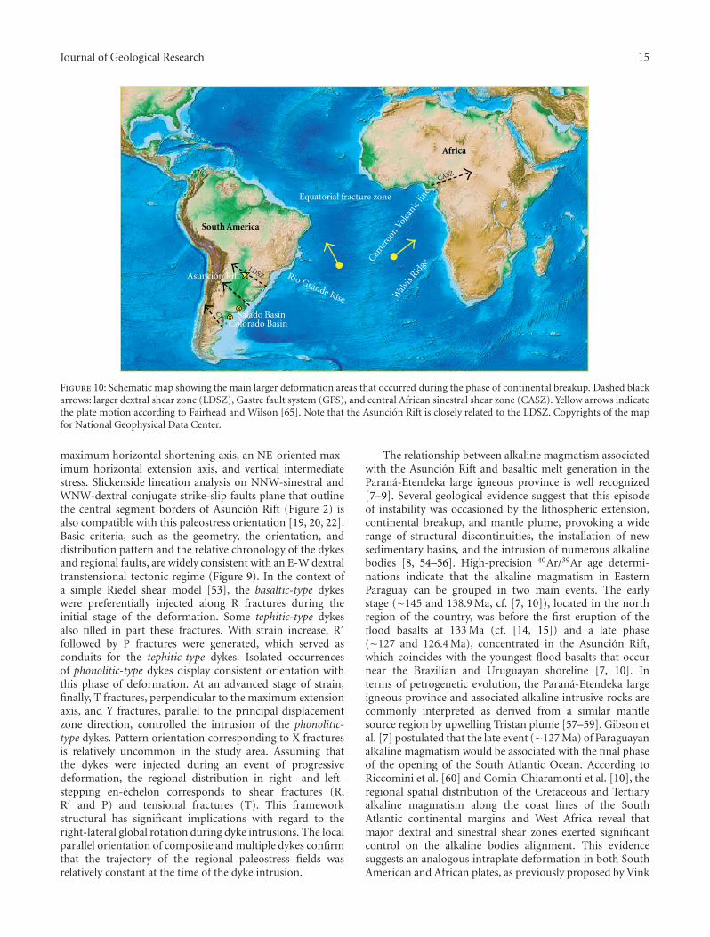
The relationship between alkaline magmatism associatedwith the Asuncion Rift and basaltic melt generation in theParana-Etendeka large igneous province is well recognized[7–9]. Several geological evidence suggest that this episodeof instability was occasioned by the lithospheric extension,continental breakup, and mantle plume, provoking a widerange of structural discontinuities, the installation of newsedimentary basins, and the intrusion of numerous alkalinebodies [8, 54–56]. High-precision 40Ar/39Ar age determi-nations indicate that the alkaline magmatism in EasternParaguay can be grouped in two main events. The earlystage (∼145 and 138.9 Ma, cf. [7, 10]), located in the northregion of the country, was before the first eruption of theflood basalts at 133 Ma (cf. [14, 15]) and a late phase(∼127 and 126.4 Ma), concentrated in the Asuncion Rift,which coincides with the youngest flood basalts that occurnear the Brazilian and Uruguayan shoreline [7, 10]. Interms of petrogenetic evolution, the Parana-Etendeka largeigneous province and associated alkaline intrusive rocks arecommonly interpreted as derived from a similar mantlesource region by upwelling Tristan plume [57–59]. Gibson etal. [7] postulated that the late event (∼127 Ma) of Paraguayanalkaline magmatism would be associated with the final phaseof the opening of the South Atlantic Ocean. According toRiccomini et al. [60] and Comin-Chiaramonti et al. [10], theregional spatial distribution of the Cretaceous and Tertiaryalkaline magmatism along the coast lines of the SouthAtlantic continental margins and West Africa reveal thatmajor dextral and sinestral shear zones exerted significantcontrol on the alkaline bodies alignment. This evidencesuggests an analogous intraplate deformation in both SouthAmerican and African plates, as previously proposed by Vink
16 Journal of Geological Research
[61] and Fairhead [39]. In this context, a lateral perturbationof the regional stress intensity induced by the differentialmotion of the plates at the time of continental breakupwould favor the propagation of brittle structures toward theinterior of the continents (Figure 10). Finally, the presenceof a dextral strike-slip motion along the South Americansecond-order plate boundary, proposed by Unternehr et al.[62] and N. Eyles and C. H. Eyles [63], the south-eastwardsmigration of Parana-Etendeka large igneous province andassociated alkaline rocks, suggested by Turner et al. [14] andGibson et al. [7], and the Cabo Frio magmatic lineament[60] are strongly indicative of a global motion towards WNWof the South American plate, consistent with the pattern oforientation documented for the Cretaceous alkaline dykes ofthe Asuncion Rift.
Acknowledgments
The authors thank Fapesp for financial support (Proc.:97/01210-4 and Proc. 07/57461-9). They also thank the twoanonymous reviewers for their constructive and perceptivecommentaries of the manuscript.
References
[1] H. C. Halls and W. F. Fahrig, “Dyke swarms and continentalrifting: some concluding remarks,” Geological Association ofCanada, vol. 34, pp. 483–492, 1987.
[2] A. J. Parker, P. C. Rickwood, and D. H. Tucker, MaficDykes and Emplacement Mechanisms, Balkema, Rotterdam,The Netherlands, 1990.
[3] A. Rubin and D. Pollard, “Dike-induced faulting in rift zonesin Iceland and Afar,” Geology, vol. 16, pp. 413–417, 1998.
[4] D. D. Pollard, “Elementary fracture mechanics applied to thestructural interpretation of dykes,” in Mafic Dykes Swarms, H.H. Halls and W. F. Fahrig, Eds., vol. 4, pp. 5–24, GeologicalAssociation of Canada, 1987.
[5] P. T. Delaney, D. D. Pollard, J. I. Ziony, and H. Mckee, “Fieldrelation between dykes and joints: emplacement processes andpaleostress analysis,” Journal of Geophysical Research, vol. 91,pp. 4920–4938, 1986.
[6] E. M. Anderson, The Dynamics of Faulting and Dyke Formationwith Applications to Britain, Oliver and Boyd, Edinburg, UK,1951.
[7] S. A. Gibson, R. N. Thompson, and J. A. Day, “Timescalesand mechanisms of plume-lithosphere interactions: 40Ar-39Argeochronology and geochemistry of alkaline igneous rocksfrom the Parana-Etendeka large igneous province,” Earth andPlanetary Science Letters, vol. 251, no. 1-2, pp. 1–17, 2006.
[8] P. Comin-Chiaramonti and C. B. Gomes, Eds., AlkalineMagmatism in Central-Eastern Paraguay. Relationships withCoeval Magmatism in Brazil, Edusp-Fapesp, Sao Paulo, Brazil,1996.
[9] P. Comin-Chiaramonti and C. B. Gomes, Eds., Mesozoicto Cenozoic Alkaline Magmatism in the Brazilian Platform,Edusp-Fapesp, Sao Paulo, Brazil, 2005.
[10] P. Comin-Chiaramonti, A. Marzoli, C. B. Gomes et al., “Theorigin of post-Paleozoic magmatism in Eastern Paraguay,”Special Paper of the Geological Society of America, no. 430, pp.603–633, 2007.
[11] P. R. Renne, M. Ernesto, I. G. Pacca et al., “The age of Paranaflood volcanism, rifting of gondwanaland, and the Jurassic-Cretaceous boundary,” Science, vol. 258, no. 5084, pp. 975–979, 1992.
[12] P. R. Renne, D. F. Mertz, W. Teixeira, H. Ens, and M. Richards,“Geochronologic constraints on magmatic and tectonic evo-lution of the Parana Province,” American Geophysical UnionAbstract, vol. 74, p. 553, 1993.
[13] P. R. Renne, K. Deckart, M. Ernesto, G. Feraud, and E. M.Piccirillo, “Age of the Ponta Grossa dike swarm (Brazil), andimplications to Parana flood volcanism,” Earth and PlanetaryScience Letters, vol. 144, no. 1-2, pp. 199–211, 1996.
[14] S. Turner, M. Regelous, S. Kelley, C. Hawkesworth, andM. Mantovani, “Magmatism and continental break-up inthe South Atlantic: high precision 40Ar-39Ar geochronology,”Earth and Planetary Science Letters, vol. 121, no. 3-4, pp. 333–348, 1994.
[15] K. Stewart, S. Turner, S. Kelley, C. Hawkesworth, L. Kirstein,and M. Mantovani, “3-D, 40Ar-39Ar geochronology in theParana continental flood basalt province,” Earth and PlanetaryScience Letters, vol. 143, no. 1–4, pp. 95–109, 1996.
[16] C. B. Gomes, P. Comin-Chiaramonti, V. F. Velazquez, and D.Orue, “Alkaline magmatism in Paraguay: a review,” in AlkalineMagmatism in Central-Eastern Paraguay. Relationships withCoeval Magmatism in Brazil, P. Comin-Chiaramonti and C.B. Gomes, Eds., pp. 31–56, Edusp-Fapesp, Sao Paulo, Brazil,1996.
[17] V. F. Velazquez, C. B. Gomes, D. Orue, and P. Comin-Chiaramonti, “Magmatismo alcalino do Paraguai: umarevisao e atualizacao das provıncias,” Boletim do Instituto deGeociencias, vol. 27, pp. 61–79, 1996.
[18] P. Comin-Chiaramonti, A. Cundari, E. M. Piccirillo et al.,“Potassic and sodic igneous rocks from Eastern Paraguay: theirorigin from the lithospheric mantle and genetic relationshipswith the associated Parana flood tholeiites,” Journal of Petrol-ogy, vol. 38, no. 4, pp. 495–528, 1997.
[19] V. F. Velazquez, C. Riccomini, C. B. Gomes, L. Figueredo, andC. Figueredo, “Relacoes tectonicas do magmatismo alcalinodo Paraguai Oriental,” Revista do Instituto Geologico, vol. 19,pp. 41–48, 1998.
[20] C. Riccomini, V. F. Velazquez, and C. B. Gomes, “Cenozoiclithospheric faulting in the Asuncion Rift, eastern Paraguay,”Journal of South American Earth Sciences, vol. 14, no. 6, pp.625–630, 2001.
[21] J. M. DeGraff, “Late Mesozoic crustal extension and rifting onthe western of the Parana Basin, Paraguay,” Geological Societyof America, vol. 17, p. 560, 1985.
[22] C. Riccomini, V. F. Velazquez, C. B. Gomes, A. Milan, and A.E. M. Sallun, “The tectonic evolution of the Asuncion Rift,Eastern Paraguay,” Anais da Academia Brasileira de Ciencias,vol. 74, p. 555, 2002.
[23] P. Bitschene, Mesozoischer und Kanozoischer anorogener mag-matismus in Ostparaguay: arbeiten zur geologie und petrologiezweier Alkaliprovinzen, Ph.D. Dissertation, Heidelberg Univer-sity, Heidelberg, Germany, 1987.
[24] J. Berrocal and C. Fernandes, “Seismicity in Paraguay andneighbouring regions,” in Alkaline Magmatism in Central-Eastern Paraguay, Relationships with Coeval Magmatism inBrazil, P. Comin-Chiaramonti and C. B. Gomes, Eds., pp. 57–66, Edusp-Fapesp, Sao Paulo, Brazil, 1996.
[25] K. L. Hegarty, I. R. Duddy, and P. F. Green, “The thermalhistory in around the Parana basin using apatite fissiontrack analysis—implications for hydrocarbon occurrences andbasin formation,” in Alkaline Magmatism in Central-Eastern
Journal of Geological Research 17
Paraguay, Relationships with Coeval Magmatism in Brazil,P. Comin-Chiaramonti and C. B. Gomes, Eds., pp. 67–84,Edusp-Fapesp, Sao Paulo, Brazil, 1996.
[26] P. Comin-Chiaramonti, A. Cundari, C. B. Gomes et al., “Potas-sic dyke swarm in the Sapucai Graben, eastern Paraguay: pet-rographical, mineralogical and geochemical outlines,” Lithos,vol. 28, no. 3–6, pp. 283–301, 1992.
[27] P. Comin-Chiramonti, A. Cundari, C. B. Gomes et al.,“Mineral chemistry and its genetic significance of major andaccessory mineral from a potassic dyke swarm in the SapucaiGraben, central-eastern Paraguay,” Geochimica Brasiliensis,vol. 4, pp. 175–206, 1990.
[28] P. Comin-Chiramonti, A. Cundari, A. De Min, C. B. Gomes,and V. F. Velazquez, “Magmatism in Eastern Paraguay: occur-rence and petrography,” in Alkaline Magmatism in Central-Eastern Paraguay. Relationships with Coeval Magmatism inBrazil, P. Comin-Chiaramonti and C. B. Gomes, Eds., pp. 103–122, Edusp-Fapesp, Sao Paulo, Brazil, 1996.
[29] M. D. Druecker and S. P. Gay Jr., “Mafic dyke swarmsassociated with Mesozoic rifting in eastern Paraguay, SouthAmerica,” Geological Association of Canada, vol. 34, pp. 187–193, 1987.
[30] A. Cundari and P. Comin-Chiaramonti, “Mineral chemistryof alkaline rocks from the Asuncion-Sapucai graben (Central-Eastern Paraguay),” in Alkaline Magmatism in Central-EasternParaguay. Relationships with Coeval Magmatism in Brazil, P.Comin-Chiaramonti and C. B. Gomes, Eds., pp. 181–193,Edusp-Fapesp, Sao Paulo, Brazil, 1996.
[31] C. B. Gomes, P. Comin-Chiaramonti, A. De Min et al., “Ativi-dade filoniana associada ao complexo alcalino de Sapukai,Paraguai Oriental,” Geochimica Brasiliensis, vol. 3, pp. 93–114,1989.
[32] A. Castorina, R. Petrini, P. Comin-Chiaramonti, G. Capaldi,and G. Pardini, “Potassic magmatism from the Asuncion-Sapucai graben, Eastern Paraguay: inferences on mantlesources by Sr-Nd isotopic systematics,” in Alkaline Magmatismin Central-Eastern Paraguay. Relationships with Coeval Mag-matism in Brazil, P. Comin-Chiaramonti and C. B. Gomes,Eds., pp. 195–206, Edusp-Fapesp, Sao Paulo, Brazil, 1996.
[33] V. F. Velazquez, C. B. Gomes, and G. Capaldi, “Magmatismoalcalino Mesozoico na porcao centro oriental do Paraguai:aspectos geocronologicos,” Geochimica Brasiliensis, vol. 6, pp.23–35, 1992.
[34] J. H. Palmieri, El complejo alcalino de Sapukai (ParaguayOriental), Ph.D. Dissertation, University of Salamanca, Sala-manca, Spain, 1973.
[35] C. B. Gomes, A. Milan, and V. F. Velazquez, “Magmatismoalcalino na porcao centro-oriental do Paraguai: novos dadosgeocronologicos para as rochas das Provıncias Central eAssuncao,” in Proceedings of the 7th Congresso de Geoquımicados paıses de lıngua portuguesa, vol. 1, pp. 179–183, Revistada Faculdade de Ciencias, Universidade Eduardo Mondlane,Maputo, Mocambique, 2003.
[36] M. Ernesto, P. Comin-Chiaramonti, C. B. Gomes, and J.C. Velazquez, “Paleomagnetic data from the central alka-line province, Eastern Paraguay,” in Alkaline Magmatism inCentral-Eastern Paraguay. Relationships with Coeval Magma-tism in Brazil, P. Comin-Chiaramonti and C. B. Gomes, Eds.,vol. 123, pp. 238–253, Edusp-Fapesp, Sao Paulo, Brazil, 1996.
[37] E. D. Jackson and H. R. Shaw, “Stress pattern in central portionof the pacific plate delineated in time by linear volcanicchains,” Journal of Geophysical Research, vol. 80, pp. 1816–1874, 1975.
[38] G. Feraud, C. Giannerini, and R. Camprendon, “Dyke swarmsas paleostress indicators in areas adjacent to continentalcollision zones: examples from the European and northwestArabian plates,” Geological Association of Canada, vol. 34, pp.273–278, 1987.
[39] J. D. Fairhead, “Mesozoic plate tectonic reconstructions of thecentral South Atlantic Ocean: the role of the West and CentralAfrican rift system,” Tectonophysics, vol. 155, no. 1–4, pp. 181–191, 1988.
[40] A. F. Glazner, J. M. Bartley, and B. S. Carl, “Oblique openingand noncoaxial emplacement of the Jurassic Independencedike swarm, California,” Journal of Structural Geology, vol. 21,no. 10, pp. 1275–1283, 1999.
[41] J. R. Lister, “Fluid-mechanical models of crack propagationand their application to magma transport in dykes,” Journalof Geophysical Research, vol. 96, no. 6, p. 10, 1991.
[42] W. F. Fahrig, K. W. Christie, E. H. Chown, D. Janes, andN. Machado, “The tectonic significance of some basic dykeswarms in the Canadian Superior province with specialreference to the geochemistry and paleomagnetism of theMistassini swarm, Quebec, Canada,” Canadian Journal ofEarth Sciences, vol. 23, no. 2, pp. 238–253, 1986.
[43] W. F. Fahrig, “The tectonic setting of continental mafic dykeswarms: failed arm and early passive margin,” GeologicalAssociation of Canada, vol. 34, pp. 331–348, 1987.
[44] R. E. Ernst, E. B. Grosfils, and D. Mege, “Giant dike swarms:earth, Venus, and Mars,” Annual Review of Earth and PlanetarySciences, vol. 29, pp. 489–534, 2001.
[45] G. Hou, T. M. Kusky, C. Wang, and Y. Wang, “Mechanics ofthe giant radiating Mackenzie dyke swarm: a paleostress fieldmodeling,” Journal of Geophysical Research, vol. 115, no. 2,Article ID B02402, pp. 1–14, 2010.
[46] P. D. Komar, “Phenocryst interactions and the velocity profileof magma flowing through dikes or sills,” Geological SocietyAmerican Bulletin, vol. 83, pp. 1336–1342, 1976.
[47] C. Cadman and J. Tarney, “Intrusion and crystallizationfeatures in Proterozoic dyke swarms,” in Mafic Dykes andEmplacement Mechanisms, A. J. Parker, P. C. Rickwood, andD. H. Tucker, Eds., pp. 13–24, Balkema, Rotterdam, TheNetherlands, 1990.
[48] A. Gudmundsson, “Dyke emplacement at divergent plateboundaries,” in Mafic Dykes and Emplacement Mechanisms, A.J. Parker, P. C. Rickwood, and D. H. Tucker, Eds., pp. 47–62,Balkema, Rotterdam, The Netherlands, 1990.
[49] H. C. Halls, “The importance and potential of mafic dykeswarms in studies of geodynamic processes,” GeoscienceCanada, vol. 9, no. 3, pp. 145–154, 1982.
[50] W. R. A. Baragar, R. E. Ernst, L. Hulbert, and T. Peterson,“Longitudinal petrochemical variation in the Mackenzie dykeswarm, Northwestern Canadian shield,” Journal of Petrology,vol. 37, no. 2, pp. 317–359, 1996.
[51] E. B. Grosfils and J. W. Head, “The global distribution of giantradiating dike swarms on Venus: implications for the globalstress state,” Geophysical Research Letters, vol. 21, no. 8, pp.701–704, 1994.
[52] A. Gudmundsson, “Surface stresses associated with arresteddykes in rift zones,” Bulletin of Volcanology, vol. 65, no. 8, pp.606–619, 2003.
[53] G. Dresen, “Stress distribution and the orientation of Riedelshears,” Tectonophysics, vol. 188, no. 3-4, pp. 239–247, 1991.
[54] F. F. M. D. Almeida, B. B. D. Brito Neves, and C. D. R. Carneiro,“The origin and evolution of the South American platform,”Earth Science Reviews, vol. 50, no. 1-2, pp. 77–111, 2000.
18 Journal of Geological Research
[55] D. Peate, “The Parana-Etendeka Province,” in Large IgneuosProvince: Continetal, Oceanic, Planetary Flood Volcanism, J.Mahoney and M. F. Coffin, Eds., pp. 217–245, AmericanGeophyscial Union, Washington, DC, USA, 1992.
[56] C. J. Hawkesworth, “Parana magmatism and the openingof the South Atlantic,” Geological Society of London SpecialPublication, vol. 68, pp. 221–240, 1992.
[57] A. Ewart, S. C. Milner, R. A. Armstrong, and A. R. Duncan,“Etendeka volcanism of the Goboboseb Mountains andMessum Igneous Complex, Namibia. Part I: geochemicalevidence of early cretaceous Tristan plume melts and therole of crustal contamination in the Parana-Etendeka CFB,”Journal of Petrology, vol. 39, no. 2, pp. 191–225, 1998.
[58] S. A. Gibson, R. N. Thompson, O. H. Leonardos, A. P.Dickin, and J. G. Mitchell, “The limited extent of plume-lithosphere interactions during continental flood-basalt gen-esis: geochemical evidence from Cretaceous magmatism insouthern Brazil,” Contributions to Mineralogy and Petrology,vol. 137, no. 1-2, pp. 147–169, 1999.
[59] R. N. Thompson, S. A. Gibson, A. P. Dickin, and P. M. Smith,“Early cretaceous basalt and picrite dykes of the SouthernEtendeka Region, NW Namibia: windows into the role ofthe Tristan mantle plume in Parana-Etendeka magmatism,”Journal of Petrology, vol. 42, no. 11, pp. 2049–2081, 2001.
[60] C. Riccomini, V. F. Velazquez, and C. B. Gomes, “Tectoniccontrols of the Mesozoic and Cenozoic alkaline magmatismin central-southeastern Brazilian Platform,” in Mesozoic toCenozoic Alkaline Magmatism in the Brazilian Platform, P.Comin-Chiaramonti and C. B. Gomes, Eds., vol. 123, pp. 31–56, Edusp-Fapesp, Sao Paulo, Brazil, 2005.
[61] G. E. Vink, “Continental rifting and the implications for platetectonic reconstructions,” Journal of Geophysical Research, vol.87, no. 13, pp. 10677–10688, 1982.
[62] P. Unternehr, D. Curie, J. L. Olivet, J. Goslin, and P. Beuzart,“South Atlantic fits and intraplate boundaries in Africa andSouth America,” Tectonophysics, vol. 155, no. 1–4, pp. 169–179,1988.
[63] N. Eyles and C. H. Eyles, “Glacial geologic confirmation of anintraplate boundary in the Parana basin of Brazil,” Geology,vol. 21, no. 5, pp. 459–462, 1993.
[64] H. De La Roche, J. Leterrier, P. Grancalude, and M. Marchal,“A classification of volcanic and plunotic rocks using R1-R2diagram and major elements analyses. Its relationship withcurrents nomenclature,” Chemical Geology, vol. 29, pp. 183–210, 1980.
[65] J. D. Fairhead and M. Wilson, “Sea-floor spreading and defor-mation processes in the South Atlantic Ocean: are hot spotsneeded?” 2004, http://www.mantleplumes.org/SAtlantic.html.


![µoıµ„o˚’ U „¡’ }’ „‰µ]ı˚ ı v] }’ ˚vı„˚ KªÙ˚ݪ°ªç ... · 2019. 2. 27. · µoıµ„o˚’ U „¡’ }’ ˙ „‰µ]ı˚ ı v] }’ ˚vı„˚](https://img.pdfslide.us/doc/110x75/6148f9779241b00fbd674270/oaoa-u-aa-a-aa-v-a-va-k.jpg)


![Geochemistry and Petrogenesis of Diabase Dykes in the ... · especially on the diabase dykes and mineralization episode [4]. In the present study, a few representative dykes occurring](https://img.pdfslide.us/doc/110x75/5e86f37100131427f470b86f/geochemistry-and-petrogenesis-of-diabase-dykes-in-the-especially-on-the-diabase.jpg)


Wl,ı\.~~rııl'I'S.....i ı\]J~~](https://img.pdfslide.us/doc/110x75/6063d0332f94ab26ab40ccdd/near-east-university-faculty-of-tableofcontents-cliwlrlisi.jpg)